on: a network of terrestrial cal zone observatories...
TRANSCRIPT
www.VadoseZoneJournal.org | 9552011, Vol. 10
A Network of Terrestrial Environmental Observatories in GermanyMulti compartment and multi scale long-term observati on and research are important pre-requisites to tackling the scienti fi c challenges resulti ng from climate and global change. Long-term monitoring programs are cost intensive and require high analyti cal standards, however, and the gain of knowledge o en requires longer observati on ti mes. Nevertheless, several environmental research networks have been established in recent years, focusing on the impact of climate and land use change on terrestrial ecosystems. From 2008 onward, a network of Terrestrial Environmental Observatories (TERENO) has been established in Germany as an interdisciplinary research program that aims to observe and explore the long-term ecological, social, and economic impacts of global change at the regional level. State-of-the-art methods from the fi eld of environmental monitoring, geophysics, and remote sensing will be used to record and analyze states and fl uxes for diff erent environ-mental compartments from groundwater through the vadose zone, surface water, and biosphere, up to the lower atmosphere.
Abbreviati ons: EDK, external dri kriging; TERENO, Terrestrial Environmental Observatories.
Climate change and land use change are key factors in global environmental change that have to be managed by society in the coming decades. Th e changes take place on diff erent spatial and temporal scales and the challenges for environmental research are immense. Many important ecosystem functions are expected to change, jeopardizing the life-sustaining resources and the future developmental options of mankind. Steady long-term trends in temperature, precipitation, and other climatic gradients aff ect most environmental niches, exhibiting very complex feedback mechanisms. Terrestrial envi-ronmental research has to tackle this challenge, using new research approaches based on integrated and long-term environmental data (National Research Council, 2008; Reid et al., 2009; Richter and Mobley, 2009; International Council for Science, 2010).
One of the key problems in recent environmental monitoring is the gap in temporal and spatial scales between measurement and management. Th e present understanding of water, energy, or matter fl uxes, as well as their biological and physical drivers and the interactions with and within the terrestrial system, are oft en based on investigations performed at scales not capable of explaining the system behavior. On the one hand, local system parameters strongly aff ect the overall system, and on the other hand, eff ective parameters at a large scale determine the processes and functioning of highly complex natural systems at a very local scale. A comprehensive consideration of multicompartment interactions and scale depen-dencies remains a major scientifi c challenge in current terrestrial environmental research to predict the behavior of the terrestrial system in response to changing environmental condi-tions. As a consequence, the development and implementation of large-scale, long-term, and integrated research infrastructure for environmental monitoring and research has been the subject of intense discussion during the past few years across all scientifi c disciplines (Quetin and Ross, 1992; National Research Council, 2000, 2003, 2006; Zoback, 2001; Lin, 2003, 2010; Parr et al., 2003; Reckhow et al., 2004; McDonnell et al., 2007; Montgomery et al., 2007; Nisbet, 2007; Willis et al., 2007; Burt et al., 2008; Keller et al., 2008).
Coupled with a growing awareness that holistic, synergistic approaches incorporating regional heterogeneities that fulfi ll the need for redundancy are urgently required, several initiatives toward environmental observatory networks have been initiated around the globe.
From 20 0 8 onward, Terres tr ia l Environmental Observatories (TERENO), a network of observatories for integrated environmental research focusing on the impact of climate change and land use change on the terrestrial ecosystems, has been established in Germany. The TERENO research concept in general and conceptual approaches for different environmental compartments and terrestrial fl uxes in par-ti cular are described and explained.
S. Zacharias, L. Samaniego, M. Frenzel, C. Baessler, P. Dietrich, S. Klotz, and G. Teutsch, UFZ Helmholtz Centre for Envi-ronmental Research, Permoserstraße 15, D-04318 Leipzig, Germany; H. Bogena, T. Pütz, U. Rosenbaum, and H. Ver-eecken, Research Centre Julich, Agrosphere Insti tute, 52425 Jülich, Germany; M. Mauder, K. Bu erbach-Bahl, R. Kiese, H. Kunstmann, H. Papen, H.P. Schmid, and R. Steinbrecher, Insti -tute for Meteorology and Climate Research, Atmospheric Environmental Research, Karlsruhe Insti tute of Technology, Kreuzeckbahnstraße 19, D-82467 Garmish-Partenkirchen, Germany; R. Fuß, J.C. Munch, and E. Priesack, Helmholtz Cen-tre Munich, Insti tute of Soil Ecology, Ingolstädter Landstraße 1, D-85764 Neuherberg, Germany; M. Schwank, O. Bens, A. Brauer, and G. Hello, GFZ German Research Centre for Geo-sciences, Telegrafenberg, 14473 Potsdam, Germany; E. Borg, German Aerospace Center, German Remote Sensing Data Center, Kalkhorstweg 53, D-17235 Neustrelitz, Germany; and I. Hajnsek, German Aerospace Centre, Microwaves and Radar Insti tute, 82234 Wessling, Germany. *Corresponding author (steff [email protected]).
Vadose Zone J. 10:955–973doi:10.2136/vzj2010.0139Received 8 Nov. 2010.Posted online 29 July 2011.Freely available online through the author-supported open access opti on.
© Soil Science Society of America5585 Guilford Rd., Madison, WI 53711 USA.All rights reserved. No part of this periodical may be reproduced or transmi ed in any form or by any means, electronic or mechanical, including photo-copying, recording, or any informati on storage and retrieval system, without permission in writi ng from the publisher.
Special Secti on: Criti cal Zone Observatories
Steff en Zacharias* Heye BogenaLuis SamaniegoMa hias MauderRoland FußThomas PützMark FrenzelMike SchwankCornelia BaesslerKlaus Bu erbach-BahlOliver BensErik BorgAchim BrauerPeter DietrichIrena HajnsekGerhard HelleRalf KieseHarald KunstmannStefan KlotzJean Charles MunchHans PapenEckart PriesackHans Peter SchmidRainer SteinbrecherUlrike RosenbaumGeorg TeutschHarry Vereecken
www.VadoseZoneJournal.org | 956
Accordingly, an integrated approach toward a better understand-ing of natural systems has to be able to capture (Lin, 2010)
• the external and internal forcing as well as their interconnection,
• the coupling of the diff erent environmental cycles,
• the most relevant interfaces of the system, and
• all relevant spatial and temporal scales adapted to the scale of system management.
An integrated framework combining monitoring, modeling, and regionalization is necessary to address the complex interactions and geographic aspects of natural systems (Parr et al., 2003; Paola et al., 2006; Ohl et al., 2007; Lin, 2010). Th e design of appropriate monitoring and research concepts and networks is challenging and expensive and requires input from diff erent scientifi c disciplines, both fundamental and applied. It is obvious that to implement a network of environmental observatories on a continental or even on the global scale, a community eff ort bringing together diff erent teams, organizations, and also funding is needed (Parr et al., 2002; Keeling, 2008; Lin, 2010).
To address these challenges, the German Helmholtz Association started the infrastructure activity Terrestrial Environmental Observatories (TERENO) in 2008 (Bogena et al., 2006). Th e TERENO observatories started to investigate the consequences of climate and land use change in Germany and will provide long-term observation data related to the so-called “critical zone,” including multiple spatial and temporal scales of the hydrosphere, biosphere, pedosphere, lower atmosphere, and anthroposphere. We describe here the methodological aspects and the interdisciplin-ary framework of observatory implementation and present the TERENO network as a community platform for research in ter-restrial science in general and critical-zone processes in particular.
Important elements of the TERENO monitoring concept, with specifi c focus on processes within the hydrosphere, lower atmo-sphere, pedosphere, and biosphere, are presented, and potential applications of the TERENO data are highlighted.
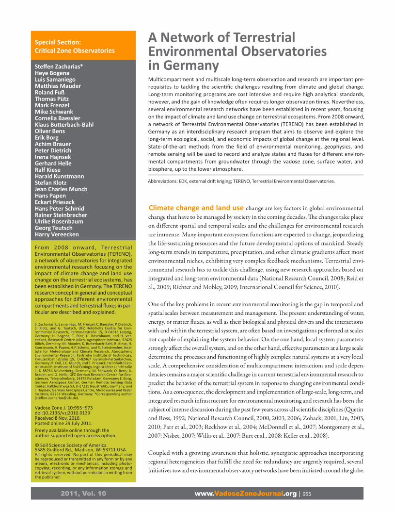
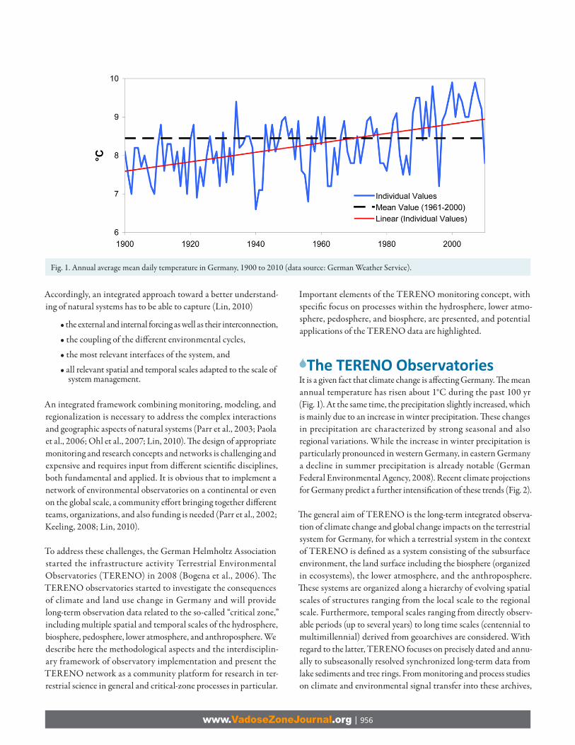
The TERENO ObservatoriesIt is a given fact that climate change is aff ecting Germany. Th e mean annual temperature has risen about 1°C during the past 100 yr (Fig. 1). At the same time, the precipitation slightly increased, which is mainly due to an increase in winter precipitation. Th ese changes in precipitation are characterized by strong seasonal and also regional variations. While the increase in winter precipitation is particularly pronounced in western Germany, in eastern Germany a decline in summer precipitation is already notable (German Federal Environmental Agency, 2008). Recent climate projections for Germany predict a further intensifi cation of these trends (Fig. 2).
Th e general aim of TERENO is the long-term integrated observa-tion of climate change and global change impacts on the terrestrial system for Germany, for which a terrestrial system in the context of TERENO is defi ned as a system consisting of the subsurface environment, the land surface including the biosphere (organized in ecosystems), the lower atmosphere, and the anthroposphere. Th ese systems are organized along a hierarchy of evolving spatial scales of structures ranging from the local scale to the regional scale. Furthermore, temporal scales ranging from directly observ-able periods (up to several years) to long time scales (centennial to multimillennial) derived from geoarchives are considered. With regard to the latter, TERENO focuses on precisely dated and annu-ally to subseasonally resolved synchronized long-term data from lake sediments and tree rings. From monitoring and process studies on climate and environmental signal transfer into these archives,
Fig. 1. Annual average mean daily temperature in Germany, 1900 to 2010 (data source: German Weather Service).
www.VadoseZoneJournal.org | 957
novel transfer functions will be developed. Data sets from these archives can then be generated for a direct calibration and verifi -cation against present-day instrumental data. Th e result will be a database of greatest precision on the natural background variability of climate and landscape evolution for multimillennial time scales.
Th e TERENO observatories aim at combining observation with ded-icated larger scale experiments and integrated modeling to increase our understanding of the functioning of terrestrial systems and the complex interactions and feedback mechanisms among their diff erent compartments. A geographically distributed framework combining monitoring with regionalization is mandatory for covering this range of spatial and temporal scales. To capture the given climatic gradients, terrestrial and atmospheric feedback, socioeconomic disparities, and demographic gradients, the spatial scale of a terrestrial observatory covers the landscape scale (>104 km2). By combining observatories within Germany, larger scale atmospheric feedbacks and impacts can be investigated, and thus a more pronounced general link to the atmospheric research community can be established.
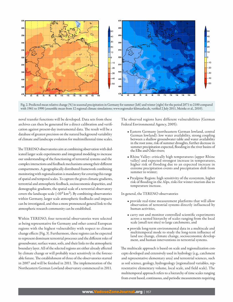
Within TERENO, four terrestrial observatories were selected as being representative for Germany and other central European regions with the highest vulnerability with respect to climate change eff ects (Fig. 3). Furthermore, these regions can be expected to represent dominant terrestrial processes and the diff erent roles of groundwater, surface water, soils, and their links to the atmospheric boundary layer. All of the selected regions are either already aff ected by climate change or will probably react sensitively in the foresee-able future. Th e establishment of three of the observatories started in 2007 and will be fi nished in 2011. Th e implementation of the Northeastern German Lowland observatory commenced in 2011.
The observed regions have different vulnerabilities (German Federal Environmental Agency, 2005):
• Eastern Germany (northeastern German lowland, central German lowland): low water availability, strong coupling between a shallow groundwater table and water availability in the root zone, risk of summer droughts, further decrease in summer precipitation expected, fl ooding in the river basins of the Elbe and Oder rivers;
• Rhine Valley: critically high temperatures (upper Rhine valley) and expected strongest increase in temperatures, higher risk of f looding due to an expected increase in extreme precipitation events and precipitation shift from summer to winter;
• Prealpine Region: high sensitivity of the ecosystem, higher risk of fl ooding in the Alps, risks for winter tourism due to temperature increase.
In general, the TERENO observatories
• provide real-time measurement platforms that will allow observation of terrestrial systems directly inf luenced by human activities,
• carry out and monitor controlled scientifi c experiments across a nested hierarchy of scales ranging from the local scale (small test sites) to large catchments, and
• provide long-term environmental data in a multiscale and multitemporal mode to study the long-term infl uence of land use change, climate change, socioeconomic develop-ment, and human interventions in terrestrial systems.
Th e multiscale approach is based on scale and regionalization con-cepts developed and extensively used in hydrology (e.g., catchment and representative elementary area) and terrestrial sciences, such as soil science, geology, hydrogeology (regionalized variables, rep-resentative elementary volume, local scale, and field scale). The multitemporal approach refers to a hierarchy of time scales ranging from event based, continuous, and periodic measurements requiring
Fig. 2. Predicted mean relative change (%) in seasonal precipitation in Germany for summer (left ) and winter (right) for the period 2071 to 2100 compared with 1961 to 1990 (ensemble mean from 12 regional climate simulations; www.regionaler-klimaatlas.de, verifi ed 2 July 2011, Meinke et al., 2010).
www.VadoseZoneJournal.org | 958
precisely dated geoarchives (annually layered lake sediments and tree rings) and technological platforms such as ground-based geo-physical, meteorologic, and remote sensing techniques, low-cost and dedicated fl ying platforms (small and large airplanes, zeppelins, or helicopters), up to satellite-based remote sensing. A detailed descrip-tion of the implementation framework, the implementation plan and a description of the single observatories can be found at the project website (teodoor.icg.kfa-juelich.de/overview-de; verifi ed 2 July 2011; in German and English). Th e implementation plan also contains detailed descriptions of data management and communica-tion strategy as well as a description of the integration of modeling activities and data assimilation approaches used in TERENO.
In this sense, TERENO is a initiative complementary to the exist-ing measurement networks in Germany and all over the world, such as the Critical Zone Observatory Program, FLUXNET, Long-Term Ecological Research (LTER) Network, or the Integrated Carbon Observation System (ICOS), and can be perfectly linked to the existing initiatives to
• study the impact of land use changes, climate change, socioeconomic development, and human intervention in the evolution of terrestrial systems and to analyze the interactions and feedback between the soil–vegetation and atmosphere compartments in these systems across scales;
• develop methods for upscaling of parameters, fl uxes and state variables (PFS) that describe processes controlling matter and energy fl uxes across the soil–plant–atmosphere systems
Fig. 3. Map of Germany, indicating the locations of the four selected TERENO observatories, including the experimental catchments and research stations.
www.VadoseZoneJournal.org | 959
at the selected scales based on theoretical and modeling concepts, especially the spatial variation of PFS at diff erent scales, which has up to now not been taken into account in most of the operational networks;
• provide high-quality data to validate existing and newly devel-oped model concepts (e.g., inverse modeling and stochastic data fusion approaches) and upscaling theories to estimate eff ective parameters, fl uxes, and state variables at various scales;
• bridge the gap between scales, measurement, and model-ing currently present in hydrologic and terrestrial sciences and to develop and improve decision support systems for environmental management in the view of sustainable development;
• determine the balances and spatial and temporal patterns in energy and matter fl uxes of the soil–vegetation–atmo-sphere system;
• improve continuously integrated models that predict the evolution of anthropogenic terrestrial systems;
• promote and support the development and use of early warn-ing systems (fl ooding, freshwater quality, etc.); and
• integrate diff erent disciplines to advance the analysis of the interactions between natural patterns and processes of landscapes with anthropogenic patterns and processes at diff erent scales.
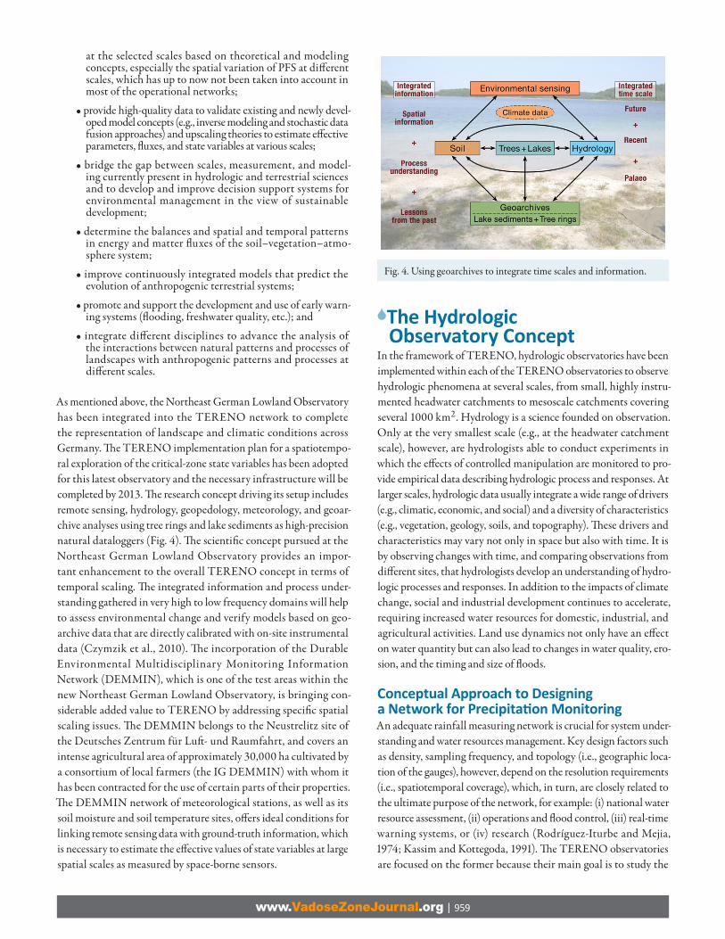
As mentioned above, the Northeast German Lowland Observatory has been integrated into the TERENO network to complete the representation of landscape and climatic conditions across Germany. Th e TERENO implementation plan for a spatiotempo-ral exploration of the critical-zone state variables has been adopted for this latest observatory and the necessary infrastructure will be completed by 2013. Th e research concept driving its setup includes remote sensing, hydrology, geopedology, meteorology, and geoar-chive analyses using tree rings and lake sediments as high-precision natural dataloggers (Fig. 4). Th e scientifi c concept pursued at the Northeast German Lowland Observatory provides an impor-tant enhancement to the overall TERENO concept in terms of temporal scaling. Th e integrated information and process under-standing gathered in very high to low frequency domains will help to assess environmental change and verify models based on geo-archive data that are directly calibrated with on-site instrumental data (Czymzik et al., 2010). Th e incorporation of the Durable Environmental Multidisciplinary Monitoring Information Network (DEMMIN), which is one of the test areas within the new Northeast German Lowland Observatory, is bringing con-siderable added value to TERENO by addressing specifi c spatial scaling issues. Th e DEMMIN belongs to the Neustrelitz site of the Deutsches Zentrum für Luft - und Raumfahrt, and covers an intense agricultural area of approximately 30,000 ha cultivated by a consortium of local farmers (the IG DEMMIN) with whom it has been contracted for the use of certain parts of their properties. Th e DEMMIN network of meteorological stations, as well as its soil moisture and soil temperature sites, off ers ideal conditions for linking remote sensing data with ground-truth information, which is necessary to estimate the eff ective values of state variables at large spatial scales as measured by space-borne sensors.
The Hydrologic Observatory Concept
In the framework of TERENO, hydrologic observatories have been implemented within each of the TERENO observatories to observe hydrologic phenomena at several scales, from small, highly instru-mented headwater catchments to mesoscale catchments covering several 1000 km2. Hydrology is a science founded on observation. Only at the very smallest scale (e.g., at the headwater catchment scale), however, are hydrologists able to conduct experiments in which the eff ects of controlled manipulation are monitored to pro-vide empirical data describing hydrologic process and responses. At larger scales, hydrologic data usually integrate a wide range of drivers (e.g., climatic, economic, and social) and a diversity of characteristics (e.g., vegetation, geology, soils, and topography). Th ese drivers and characteristics may vary not only in space but also with time. It is by observing changes with time, and comparing observations from diff erent sites, that hydrologists develop an understanding of hydro-logic processes and responses. In addition to the impacts of climate change, social and industrial development continues to accelerate, requiring increased water resources for domestic, industrial, and agricultural activities. Land use dynamics not only have an eff ect on water quantity but can also lead to changes in water quality, ero-sion, and the timing and size of fl oods.
Conceptual Approach to Designing a Network for Precipitati on MonitoringAn adequate rainfall measuring network is crucial for system under-standing and water resources management. Key design factors such as density, sampling frequency, and topology (i.e., geographic loca-tion of the gauges), however, depend on the resolution requirements (i.e., spatiotemporal coverage), which, in turn, are closely related to the ultimate purpose of the network, for example: (i) national water resource assessment, (ii) operations and fl ood control, (iii) real-time warning systems, or (iv) research (Rodríguez-Iturbe and Mejia, 1974; Kassim and Kottegoda, 1991). Th e TERENO observatories are focused on the former because their main goal is to study the
Fig. 4. Using geoarchives to integrate time scales and information.

www.VadoseZoneJournal.org | 960
long-term infl uence of anthropogenic activities on terrestrial systems and, in particular, to attempt to close as accurately as possible the water balance across a mesoscale catchment. Th ese ambitious goals require a robust precipitation network that should cope simultane-ously with a number of confl icting objectives. Th e conceptual design proposed in this study aims to determine the optimal precipitation network for the Bode River catchment and the Selke River subcatch-ment (Harz/Central German Lowland Observatory).
Experiences with rain-radar technology have shown that while the weather radar provides superior information about the spatial and temporal resolution of a rainfall event, estimates of rainfall accumu-lation may have phenomenal biases. Th e best results for streamfl ow prediction and forecast have been achieved with a combination of radar and rain gauges (James et al., 1993). For these reasons, the precipitation monitoring network in TERENO will be a combina-tion of various instruments, some already existing and some to be placed within the observatories. For the Bode catchment, in the fi rst category there are about 245 existing rain gauges operated by the German Meteorologic Service (DWD) having somewhat continu-ous daily readings since 1961 (Fig. 5), 25 hourly rain gauges (DWD), and one weather radar operated by the DWD. In the second category are included a rain scanner and a fi xed number of high sampling (15-min resolution) rain gauges (including weather observations).
Th e existing precipitation network (DWD) within the Bode River basin and surroundings (~25-km buff er) covers approximately 39 and 27 km2 per station within the Bode and Selke basins, respectively. Th ese coverages, although fully satisfy the World Meteorological Organization requirements (at most 100 km2 per station), are not suffi cient for solving fundamental scientifi c chal-lenges in surface water and groundwater hydrology or studying the spatiotemporal variability of rain due to the following reasons:
1. The spatial distribution of precipitation stations in eleva-tion bands is particularly heterogeneous; consequently, the
orographic eff ects cannot be assessed satisfactorily. In the eleva-tion band between 300 and 400 m above sea level, there is a remarkable shortage of stations (Fig. 5, right). Moreover, the degree of completeness (percentage of days with valid informa-tion) of the observation time series during the period 1961 to 2006 indicated that the information content of the existing records is particularly weak in the Selke River basin (Fig. 5, left ).
2. Th e spatio-temporal variability of precipitation in the Bode basin and its vicinity shows a marked directional anisotropy (e.g., the variogram in the north–south direction diff ers from that in the east–west direction) and a distinct yearly dynamics mainly due to its morphological settings (Fig. 6), as can be seen by the third and fourth eigenvectors of the correlation matrix of daily precipitation.
3. Th e actual rain gauge density and its sampling frequency do not allow identifi cation of convective precipitation events that occur mainly during the summer or adjusting the refl ectivity–rainfall rate relationships required to calibrate the rain scanner.
As a consequence of this defi cit analysis, it was evident that new instruments need to be located within the Bode basin to achieve the highly demanding TERENO goals. In this particular case, the overall utility should include measurement accuracy and, to a minor extent, maintenance costs (e.g., personnel). Th e accuracy of rainfall measurement is mainly aff ected by wind, the height of the gauge, and the exposure. It should be noted that an “optimum” design is not attainable for many reasons: (i) the uncertainty of existing observa-tions, (ii) the stochasticity of the rain, and (iii) logistics (planning regulations, lack of access roads, and private property rights, among others). Instead, a set of “good” and hence robust alternatives should be pursued. Th e term robust is to be understood in the sense that although the selected locations do not constitute an “optimum” from a numerical point of view, they still off er the best compromise under current conditions. Consequently, to carry out this concept, the fol-lowing objectives were selected: (i) minimize the total estimation variance of the rain fi elds, (ii) minimize the observation eff ort (i.e., the number of additional rain gauges), (iii) maximize the predictive effi ciency of the distributed mesoscale hydrologic model (Samaniego
Fig. 5. Degree of completeness of precipitation time series for the Bode River basin and surroundings from 1961 to 2006 (left ), and histogram of the density of rain gauges per 100 km2 of elevation zone within the Bode basin (right).

www.VadoseZoneJournal.org | 961
et al., 2010), and fi nally, (iv) maximize the observed spatio-temporal variability with a given number of additional rain gauges.
To fi nd suitable locations for the rain scanner, the following utility functions were used:
1. Th e rain scanner should cover as much as possible of the Bode basin but should be as far as possible from the Harz Mountains to avoid ref lections of the signal emitted by its antenna. Additionally, it should be located below 350 m above sea level, i.e., it should be in the lowlands.
2. Th e rain scanner should have a common coverage area with the DWD weather radar to minimize prediction errors (it is expected that DWD data would become available in the future).
In any case, however, it should be 50 km farther from this exist-ing weather radar at Ummendorf (Fig. 7).
3. Th e rain scanner should not be located in those areas exhibiting large sensitivity to the hydrologic model (Fig. 8).
4. Th e rain scanner should be located in areas with high precipita-tion predictability, which can be estimated with the existing rain gauge network.
Th ese utility functions were aggregated and weighted following the principles of compromised programming (Duckstein and Opricovic, 1980). Equal weights were selected.
Fig. 6. Eigenvectors of the daily precipitation correlation matrix, indicating the main precipitation mechanisms that explain approximately 83% of the total variance (left ), and annual cycle of daily average precipitation for two stations in the Bode River basin, one located in the Harz Mountains (mostly orographic) and the other on the lowlands near the Saale River (mostly convective) (right).
Fig. 7. Jackknifed r at every rain gauge interpolated across the domain based on daily records from 1961 to 2006 in summer, predicted at each station with exter-nal drift kriging and a spherical variogram, and possible locations of the rain scanner and additional rain gauges also shown (right), and empirical variograms of daily precipitation network for the period 1961 to 2006 along the directions north–south and east–west (right) (DWD = German Meteorologic Service).

www.VadoseZoneJournal.org | 962
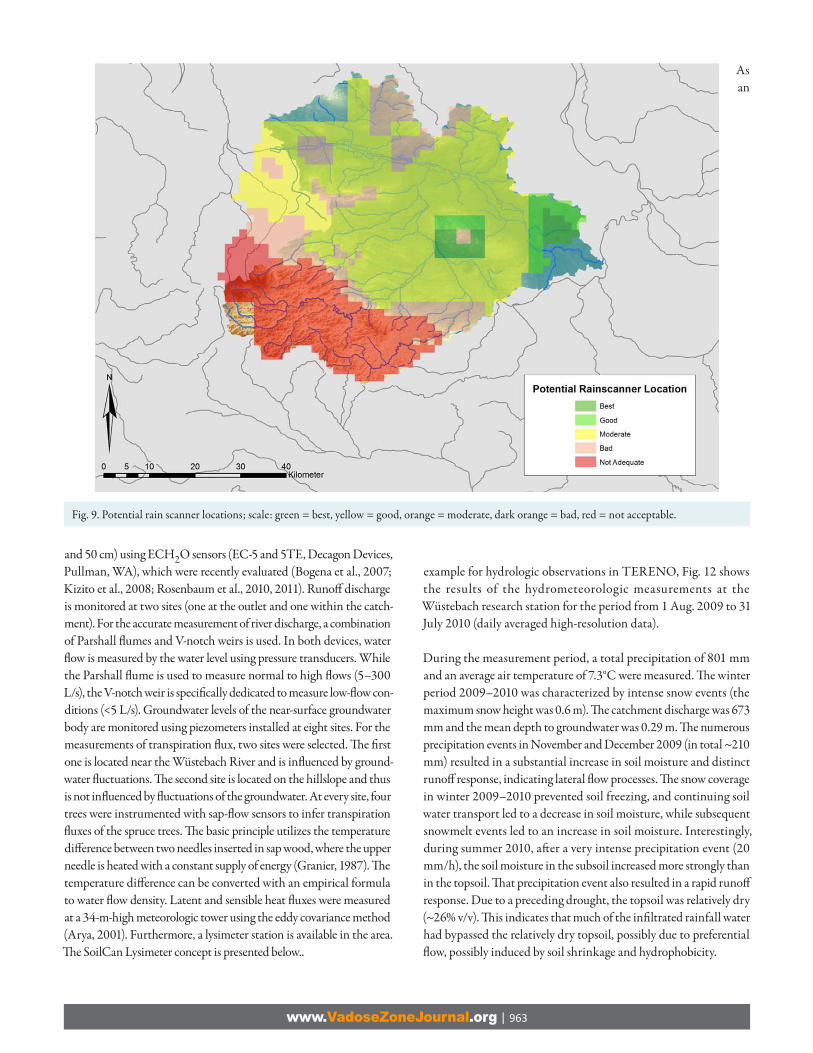
External drift kriging (EDK) coupled with the mesoscale hydrologic model were used to determine a sensitivity index that estimates the eff ect of the location of the rain gauges on the model effi ciency. Th e sensitivity index depicted for summer and winter was determined as the ratio between the cross-validated mesoscale hydrologic model effi ciency (Nash–Sutcliff e model effi ciency, NSE) in the Selke basin with respect to the overall NSE based on daily precipitation records from 1961 to 2006 for winter and summer. In this case, the smaller the index, the larger will be its infl uence on the model effi ciency. Th e precipitation predictability index was estimated as the jack-knifed Pearson correlation coeffi cient (r) estimated for each existing rainfall station during the period 1961 to 2006. Th e jackknifed estimation at every station was done with EDK and a composed variogram (nugget and spherical). Th e searching distance was in all cases at most 70 km (Fig. 7). As a result of this analysis, potential locations for the rain scanner were found (Fig. 9).
It is expected that a coverage of 15 to 20 km2 per station should be achieved in the Bode basin to be able to resolve convective precipi-tation cells, which usually have an areal extension between 20 and 50 km2 (Barry and Chorley, 2003). Th is estimate determines the upper limit of the number of additional rain gauges in this basin (i.e., about 15 new rain gauges). Th e exact number and their potential best locations will be found once the rain scanner starts operation. It should be noted that an ad hoc selection of potential locations would lead, with high probability, to a suboptimal solution (Bogárdi et al., 1985). Th is allocation problem can be formulated as a combinatorial multiobjective optimization problem (Rodríguez-Iturbe and Mejía, 1974; Bogárdi et al., 1985; Kassim and Kottegoda, 1991; Bradley et al., 2002). Robust solutions can be found by simulated annealing using the objective functions mentioned above.
Closing the Catchment-Scale Water BalanceAttempting to close the water balance by measurements at the catch-ment scale is a challenging task but if successful will yield a valuable
data set for the development and evaluation of hydrologic models. Furthermore, in conjunction with modeling, the water balance data will help in determination of the magnitude of measurement errors, determination of how to diagnose these errors, and avoidance of the misattribution of water balance components (Kampf and Burges, 2010).
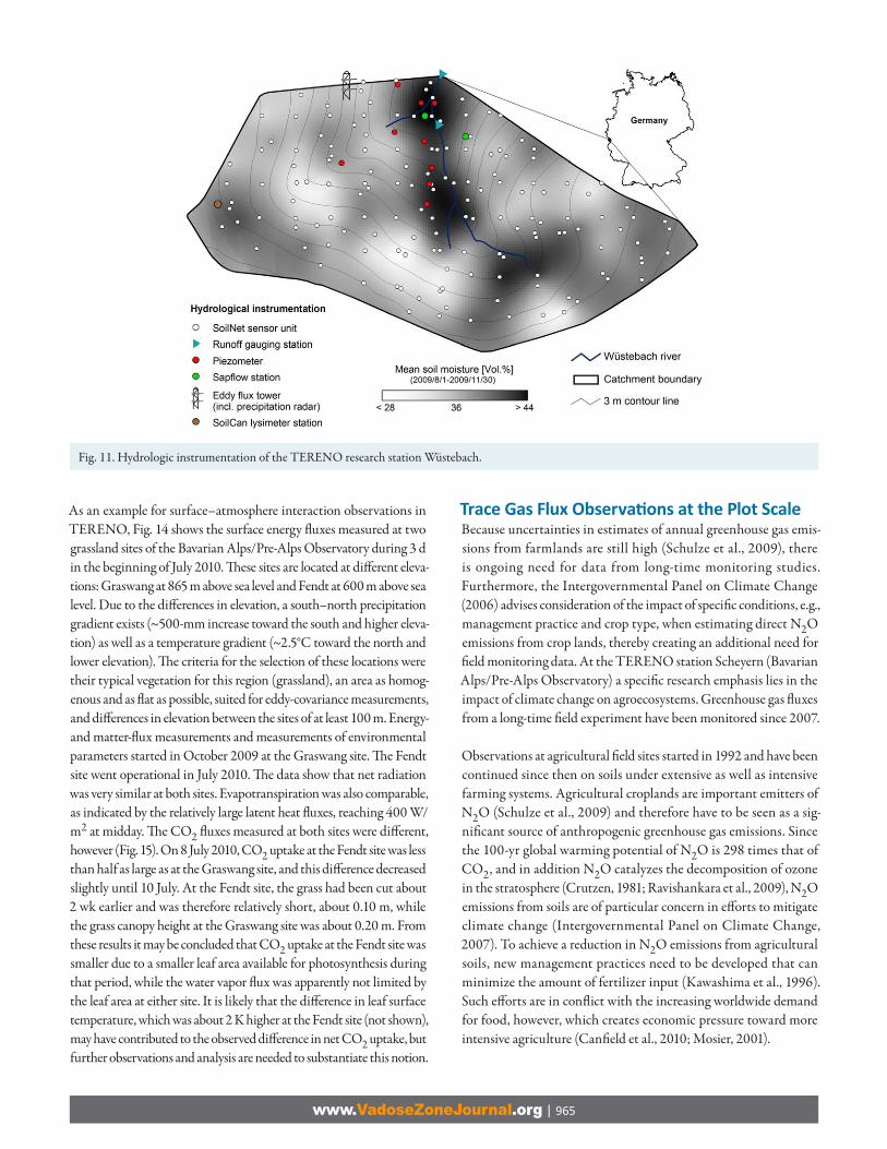
Th e monitoring concept of the TERENO Wüstebach research station is presented as an example of a hydrologic observation concept at the subcatchment scale in TERENO. Th e Wüstebach research station is part of the Eifel/Lower Rhine Valley Observatory. It is a subcatch-ment (0.27 km2) of the River Rur basin and is situated in the German low mountain ranges within the National Park Eifel (Fig. 10 and 11).
Th e mean altitude is 612 m above sea level, with a mean annual precipitation of ~1100 mm (1961–1990) and a mean annual tem-perature of ~7°C. Th e main vegetation type is Norway spruce [Picea abies (L.) H. Karst.]. Th e bedrock consists of Devonian shales with sporadic sandstone inclusions and is superimposed by a 3- to 1-m-thick periglacial solifl uction layer in which mainly Cambisols and Planosols have developed (Bogena et al., 2010).
Figure 11 presents the hydrologic instrumentation of the Wüstebach research station. In addition, the mean topsoil moisture distribution for the period 1 Aug. to 30 Nov. 2009 is presented in Fig. 11 (data from Bogena et al., 2010).
For monitoring soil state variables (soil moisture and temperature), the wireless sensor network SoilNet was developed in the framework of TERENO (www2.fz-juelich.de/icg/icg-4/index.php?index=739; verifi ed 2 July 2011). A detailed description concerning the SoilNet technology was provided by Bogena et al. (2010). Th e sensor network in the Wüstebach test site consists of 150 sensor nodes (a combina-tion of multiple sensor nodes in a nearly 60- by 60-m raster and randomly distributed nodes in between). At each measurement loca-tion, soil moisture and temperature are measured at three depths (5, 20,
Fig. 8. Cross-validation study to determine the input–output sensitivity at various locations in the Selke River basin in winter and summer.
www.VadoseZoneJournal.org | 963
and 50 cm) using ECH2O sensors (EC-5 and 5TE, Decagon Devices, Pullman, WA), which were recently evaluated (Bogena et al., 2007; Kizito et al., 2008; Rosenbaum et al., 2010, 2011). Runoff discharge is monitored at two sites (one at the outlet and one within the catch-ment). For the accurate measurement of river discharge, a combination of Parshall fl umes and V-notch weirs is used. In both devices, water fl ow is measured by the water level using pressure transducers. While the Parshall fl ume is used to measure normal to high fl ows (5–300 L/s), the V-notch weir is specifi cally dedicated to measure low-fl ow con-ditions (<5 L/s). Groundwater levels of the near-surface groundwater body are monitored using piezometers installed at eight sites. For the measurements of transpiration fl ux, two sites were selected. Th e fi rst one is located near the Wüstebach River and is infl uenced by ground-water fl uctuations. Th e second site is located on the hillslope and thus is not infl uenced by fl uctuations of the groundwater. At every site, four trees were instrumented with sap-fl ow sensors to infer transpiration fl uxes of the spruce trees. Th e basic principle utilizes the temperature diff erence between two needles inserted in sap wood, where the upper needle is heated with a constant supply of energy (Granier, 1987). Th e temperature diff erence can be converted with an empirical formula to water fl ow density. Latent and sensible heat fl uxes were measured at a 34-m-high meteorologic tower using the eddy covariance method (Arya, 2001). Furthermore, a lysimeter station is available in the area. Th e SoilCan Lysimeter concept is presented below..
As an
example for hydrologic observations in TERENO, Fig. 12 shows the results of the hydrometeorologic measurements at the Wüstebach research station for the period from 1 Aug. 2009 to 31 July 2010 (daily averaged high-resolution data).
During the measurement period, a total precipitation of 801 mm and an average air temperature of 7.3°C were measured. Th e winter period 2009–2010 was characterized by intense snow events (the maximum snow height was 0.6 m). Th e catchment discharge was 673 mm and the mean depth to groundwater was 0.29 m. Th e numerous precipitation events in November and December 2009 (in total ~210 mm) resulted in a substantial increase in soil moisture and distinct runoff response, indicating lateral fl ow processes. Th e snow coverage in winter 2009–2010 prevented soil freezing, and continuing soil water transport led to a decrease in soil moisture, while subsequent snowmelt events led to an increase in soil moisture. Interestingly, during summer 2010, aft er a very intense precipitation event (20 mm/h), the soil moisture in the subsoil increased more strongly than in the topsoil. Th at precipitation event also resulted in a rapid runoff response. Due to a preceding drought, the topsoil was relatively dry (~26% v/v). Th is indicates that much of the infi ltrated rainfall water had bypassed the relatively dry topsoil, possibly due to preferential fl ow, possibly induced by soil shrinkage and hydrophobicity.
Fig. 9. Potential rain scanner locations; scale: green = best, yellow = good, orange = moderate, dark orange = bad, red = not acceptable.

www.VadoseZoneJournal.org | 964
Th ese results illustrate the potential of intensive hydrologic moni-toring for process analysis. In conjunction with modeling activities, these observations can support the further development and vali-dation of hydrologic models.
Energy and Trace Gas Flux Measurements
Climate change, resulting from enhanced greenhouse gas emis-sions, and its eff ects on Earth systems functioning are some of the most complex and challenging environmental issues. Following the UN Framework Convention on Climate Change (www.unfccc.int, verifi ed 2 July 2011), most industrialized countries aim at reducing greenhouse gas emissions to reduce atmospheric concentrations and to mitigate the eff ects on, e.g., precipitation patterns, heat waves, storm severity, and sea level rise. Whereas data on emissions from the combustion of fossil fuels are relatively easily accessible, quanti-fying the net eff ect of terrestrial ecosystems on greenhouse gas levels in the atmosphere under a changing climate is still a challenging task, fraught with many large sources of uncertainty. To help con-strain the uncertainty of the feedbacks and net impacts of terrestrial ecosystems on C cycling and greenhouse gas emissions, long-term ecosystem-scale observations of energy and trace gas fl uxes between the Earth’s surface and the atmosphere are widely recognized to be of high priority and an important component of the TERENO observatories. To be useful on the regional or larger scale, such observation programs must be comprehensive, continuous during characteristic time periods of ecosystem development (i.e., a decade or longer), represent all important biomes and regions, and adhere to concerted standards for data quality and analysis.
Long-Term Ecosystem-Scale Observati ons in TERENO Integrated Carbon Observati on SystemOne international observatory network designed with the above-mentioned goals in mind is the Integrated Carbon Observation System (ICOS), “a new European research infrastructure to decipher the greenhouse gas balance of Europe and adjacent regions” (www.icos-infrastructure.eu, verifi ed 2 July 2011). Th e mission of ICOS is
• to provide the long-term observations required to understand the present state, and predict future behavior, of the global C cycle and greenhouse gas emissions, and
• to monitor and assess the eff ectiveness of C sequestration and greenhouse gas emission reduction activities on global atmospheric composition levels, including attribution of sources and sinks by region and sector.
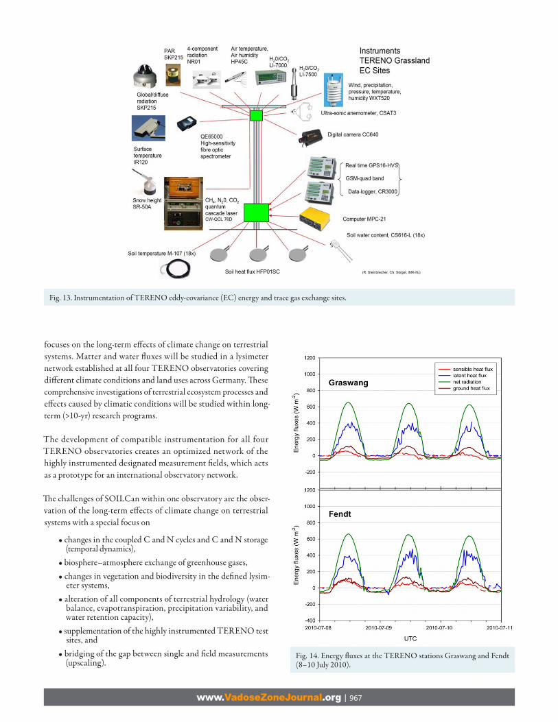
Th e objectives of TERENO’s scientifi c program mesh well with those of ICOS. A selection of TERENO sites with eddy-covari-ance stations in all observatory regions is currently being built up to include fast laser-based instrumentation for the measurement of CH4 and N2O fl uxes beyond the standard equipment for energy balance and CO2 fl ux measurements. Th e instrument setup for surface exchange observations over grassland and pasture areas is shown in Fig. 13, including standard meteorologic sensors, seven-component radiation balance, soil heat-fl ux and moisture profi les, and an eddy-covariance system consisting of a three-dimensional sonic anemometer, open- and closed-path infrared gas analyzers (for fast CO2 and H2O concentrations), and a quantum cascade laser spectrometer (for fast CH4 and N2O concentrations), plus auxiliary equipment for surface characterization and phenological observations, datalogging, processing, and communication.
Fig. 10. Soil map of the TERENO research station Wüstebach.
www.VadoseZoneJournal.org | 965
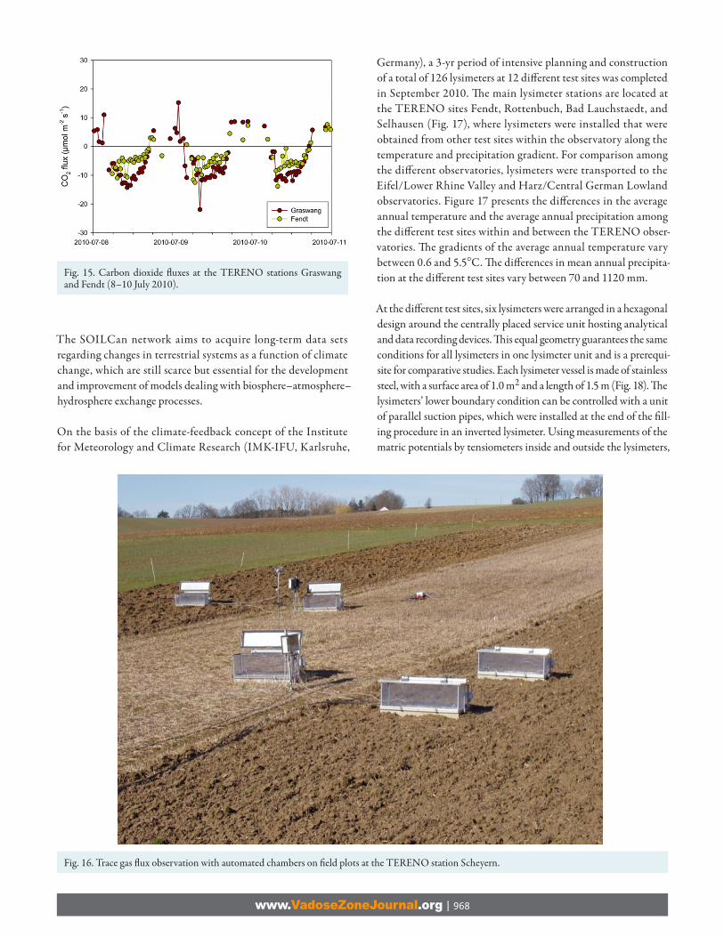
As an example for surface–atmosphere interaction observations in TERENO, Fig. 14 shows the surface energy fl uxes measured at two grassland sites of the Bavarian Alps/Pre-Alps Observatory during 3 d in the beginning of July 2010. Th ese sites are located at diff erent eleva-tions: Graswang at 865 m above sea level and Fendt at 600 m above sea level. Due to the diff erences in elevation, a south–north precipitation gradient exists (~500-mm increase toward the south and higher eleva-tion) as well as a temperature gradient (~2.5°C toward the north and lower elevation). Th e criteria for the selection of these locations were their typical vegetation for this region (grassland), an area as homog-enous and as fl at as possible, suited for eddy-covariance measurements, and diff erences in elevation between the sites of at least 100 m. Energy- and matter-fl ux measurements and measurements of environmental parameters started in October 2009 at the Graswang site. Th e Fendt site went operational in July 2010. Th e data show that net radiation was very similar at both sites. Evapotranspiration was also comparable, as indicated by the relatively large latent heat fl uxes, reaching 400 W/m2 at midday. Th e CO2 fl uxes measured at both sites were diff erent, however (Fig. 15). On 8 July 2010, CO2 uptake at the Fendt site was less than half as large as at the Graswang site, and this diff erence decreased slightly until 10 July. At the Fendt site, the grass had been cut about 2 wk earlier and was therefore relatively short, about 0.10 m, while the grass canopy height at the Graswang site was about 0.20 m. From these results it may be concluded that CO2 uptake at the Fendt site was smaller due to a smaller leaf area available for photosynthesis during that period, while the water vapor fl ux was apparently not limited by the leaf area at either site. It is likely that the diff erence in leaf surface temperature, which was about 2 K higher at the Fendt site (not shown), may have contributed to the observed diff erence in net CO2 uptake, but further observations and analysis are needed to substantiate this notion.
Trace Gas Flux Observati ons at the Plot ScaleBecause uncertainties in estimates of annual greenhouse gas emis-sions from farmlands are still high (Schulze et al., 2009), there is ongoing need for data from long-time monitoring studies. Furthermore, the Intergovernmental Panel on Climate Change (2006) advises consideration of the impact of specifi c conditions, e.g., management practice and crop type, when estimating direct N2O emissions from crop lands, thereby creating an additional need for fi eld monitoring data. At the TERENO station Scheyern (Bavarian Alps/Pre-Alps Observatory) a specifi c research emphasis lies in the impact of climate change on agroecosystems. Greenhouse gas fl uxes from a long-time fi eld experiment have been monitored since 2007.
Observations at agricultural fi eld sites started in 1992 and have been continued since then on soils under extensive as well as intensive farming systems. Agricultural croplands are important emitters of N2O (Schulze et al., 2009) and therefore have to be seen as a sig-nifi cant source of anthropogenic greenhouse gas emissions. Since the 100-yr global warming potential of N2O is 298 times that of CO2, and in addition N2O catalyzes the decomposition of ozone in the stratosphere (Crutzen, 1981; Ravishankara et al., 2009), N2O emissions from soils are of particular concern in eff orts to mitigate climate change (Intergovernmental Panel on Climate Change, 2007). To achieve a reduction in N2O emissions from agricultural soils, new management practices need to be developed that can minimize the amount of fertilizer input (Kawashima et al., 1996). Such eff orts are in confl ict with the increasing worldwide demand for food, however, which creates economic pressure toward more intensive agriculture (Canfi eld et al., 2010; Mosier, 2001).
Fig. 11. Hydrologic instrumentation of the TERENO research station Wüstebach.

www.VadoseZoneJournal.org | 966
Th e plot design at the TERENO station Scheyern combines three tillage practices (conventional, reduced, and minimum tillage) and three N fertilization practices (−30%, conventional, +30%). Th e use of automated chambers (Fig. 16) allows long-term measure-ments with a frequency of two to three measurements per day and also gives a measure of spatial variation at the plot level. A suf-fi cient spatial and temporal resolution is essential because N2O emissions are characterized by short emission pulses with a high spatial variation. Upscaling of short-term measurements or of measurements with an insuffi cient frequency can lead to a severe over- or underestimation of annual emissions (Flessa et al., 2002; Wolf et al., 2010). In addition to the gas fl ux measurements, water content, temperature, and redox potentials are measured in situ.
Long-term Monitoring of Climate Change Eff ects using Lysimeters
From the point to the regional scale, a lysimeter is the smallest unit representing a comprehensive view of processes in terrestrial systems and is widely used to study solute transport and water fl ow in soils. Th e naturally layered, undisturbed soils in lysimeters, together with their vegetation cover, allow the observation of long-term eff ects caused by climate change.
Th e TERENO-SOILCan network is a cutting edge initiative of the German Federal Ministry of Education and Research that
Fig. 12. Hydrometeorologic fl uxes and state variables at the TERENO station Wüstebach.
www.VadoseZoneJournal.org | 967
focuses on the long-term eff ects of climate change on terrestrial systems. Matter and water fl uxes will be studied in a lysimeter network established at all four TERENO observatories covering diff erent climate conditions and land uses across Germany. Th ese comprehensive investigations of terrestrial ecosystem processes and eff ects caused by climatic conditions will be studied within long-term (>10-yr) research programs.
The development of compatible instrumentation for all four TERENO observatories creates an optimized network of the highly instrumented designated measurement fi elds, which acts as a prototype for an international observatory network.
Th e challenges of SOILCan within one observatory are the obser-vation of the long-term eff ects of climate change on terrestrial systems with a special focus on
• changes in the coupled C and N cycles and C and N storage (temporal dynamics),
• biosphere–atmosphere exchange of greenhouse gases,• changes in vegetation and biodiversity in the defi ned lysim-
eter systems,• alteration of all components of terrestrial hydrology (water
balance, evapotranspiration, precipitation variability, and water retention capacity),
• supplementation of the highly instrumented TERENO test sites, and
• bridging of the gap between single and fi eld measurements (upscaling).
Fig. 13. Instrumentation of TERENO eddy-covariance (EC) energy and trace gas exchange sites.
Fig. 14. Energy fl uxes at the TERENO stations Graswang and Fendt (8–10 July 2010).
www.VadoseZoneJournal.org | 968
The SOILCan network aims to acquire long-term data sets regarding changes in terrestrial systems as a function of climate change, which are still scarce but essential for the development and improvement of models dealing with biosphere–atmosphere–hydrosphere exchange processes.
On the basis of the climate-feedback concept of the Institute for Meteorology and Climate Research (IMK-IFU, Karlsruhe,
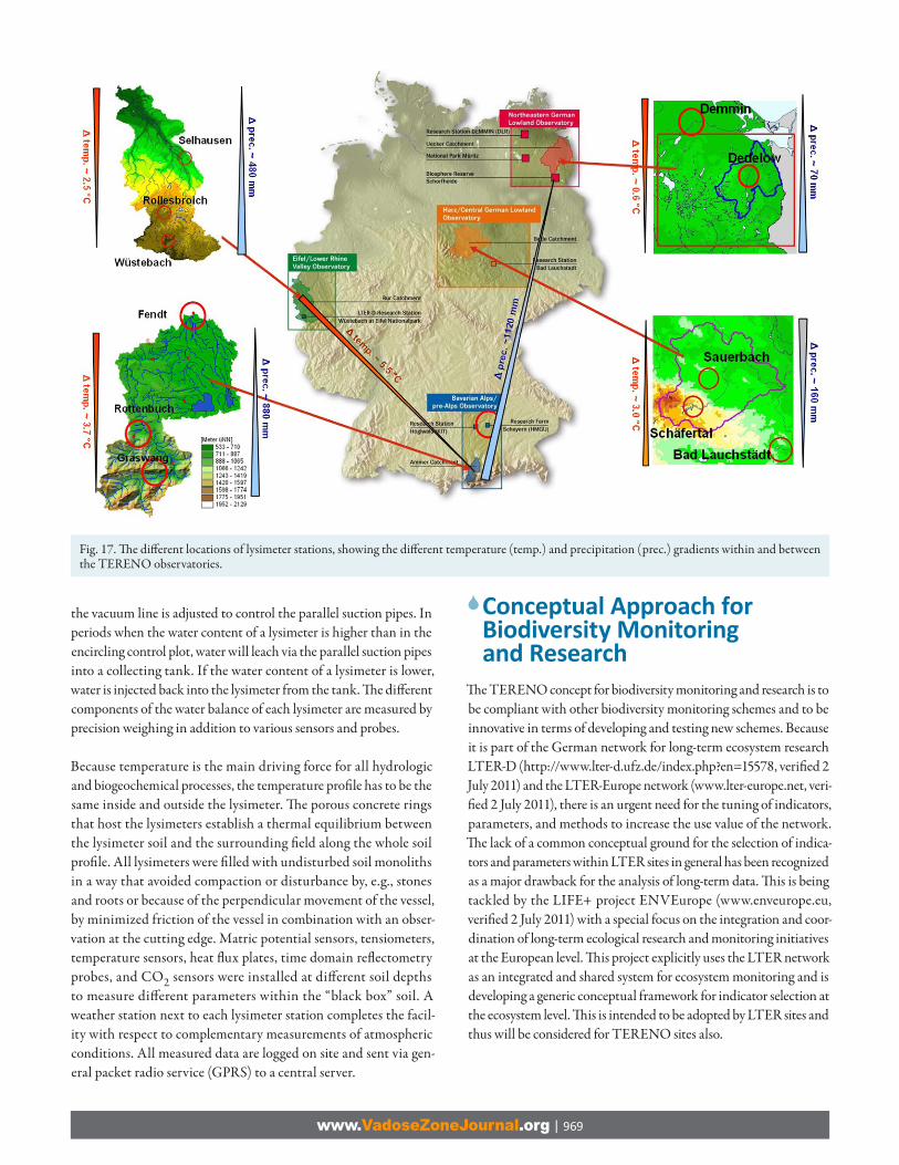
Germany), a 3-yr period of intensive planning and construction of a total of 126 lysimeters at 12 diff erent test sites was completed in September 2010. Th e main lysimeter stations are located at the TERENO sites Fendt, Rottenbuch, Bad Lauchstaedt, and Selhausen (Fig. 17), where lysimeters were installed that were obtained from other test sites within the observatory along the temperature and precipitation gradient. For comparison among the diff erent observatories, lysimeters were transported to the Eifel/Lower Rhine Valley and Harz/Central German Lowland observatories. Figure 17 presents the diff erences in the average annual temperature and the average annual precipitation among the diff erent test sites within and between the TERENO obser-vatories. Th e gradients of the average annual temperature vary between 0.6 and 5.5°C. Th e diff erences in mean annual precipita-tion at the diff erent test sites vary between 70 and 1120 mm.
At the diff erent test sites, six lysimeters were arranged in a hexagonal design around the centrally placed service unit hosting analytical and data recording devices. Th is equal geometry guarantees the same conditions for all lysimeters in one lysimeter unit and is a prerequi-site for comparative studies. Each lysimeter vessel is made of stainless steel, with a surface area of 1.0 m2 and a length of 1.5 m (Fig. 18). Th e lysimeters’ lower boundary condition can be controlled with a unit of parallel suction pipes, which were installed at the end of the fi ll-ing procedure in an inverted lysimeter. Using measurements of the matric potentials by tensiometers inside and outside the lysimeters,
Fig. 16. Trace gas fl ux observation with automated chambers on fi eld plots at the TERENO station Scheyern.
Fig. 15. Carbon dioxide fl uxes at the TERENO stations Graswang and Fendt (8–10 July 2010).
www.VadoseZoneJournal.org | 969
the vacuum line is adjusted to control the parallel suction pipes. In periods when the water content of a lysimeter is higher than in the encircling control plot, water will leach via the parallel suction pipes into a collecting tank. If the water content of a lysimeter is lower, water is injected back into the lysimeter from the tank. Th e diff erent components of the water balance of each lysimeter are measured by precision weighing in addition to various sensors and probes.
Because temperature is the main driving force for all hydrologic and biogeochemical processes, the temperature profi le has to be the same inside and outside the lysimeter. Th e porous concrete rings that host the lysimeters establish a thermal equilibrium between the lysimeter soil and the surrounding fi eld along the whole soil profi le. All lysimeters were fi lled with undisturbed soil monoliths in a way that avoided compaction or disturbance by, e.g., stones and roots or because of the perpendicular movement of the vessel, by minimized friction of the vessel in combination with an obser-vation at the cutting edge. Matric potential sensors, tensiometers, temperature sensors, heat fl ux plates, time domain refl ectometry probes, and CO2 sensors were installed at diff erent soil depths to measure diff erent parameters within the “black box” soil. A weather station next to each lysimeter station completes the facil-ity with respect to complementary measurements of atmospheric conditions. All measured data are logged on site and sent via gen-eral packet radio service (GPRS) to a central server.
Conceptual Approach for Biodiversity Monitoring and Research
Th e TERENO concept for biodiversity monitoring and research is to be compliant with other biodiversity monitoring schemes and to be innovative in terms of developing and testing new schemes. Because it is part of the German network for long-term ecosystem research LTER-D (http://www.lter-d.ufz.de/index.php?en=15578, verifi ed 2 July 2011) and the LTER-Europe network (www.lter-europe.net, veri-fi ed 2 July 2011), there is an urgent need for the tuning of indicators, parameters, and methods to increase the use value of the network. Th e lack of a common conceptual ground for the selection of indica-tors and parameters within LTER sites in general has been recognized as a major drawback for the analysis of long-term data. Th is is being tackled by the LIFE+ project ENVEurope (www.enveurope.eu, verifi ed 2 July 2011) with a special focus on the integration and coor-dination of long-term ecological research and monitoring initiatives at the European level. Th is project explicitly uses the LTER network as an integrated and shared system for ecosystem monitoring and is developing a generic conceptual framework for indicator selection at the ecosystem level. Th is is intended to be adopted by LTER sites and thus will be considered for TERENO sites also.
Fig. 17. Th e diff erent locations of lysimeter stations, showing the diff erent temperature (temp.) and precipitation (prec.) gradients within and between the TERENO observatories.

www.VadoseZoneJournal.org | 970
Biodiversity comprises diversity at diff erent levels: of ecosystems (and habitats), of species communities, of species, and of genes within popu-lations of the same species. It is an important component of ecosystems but needs to be complemented by other ecosystem features linked to processes and functions to obtain a complete picture of the ecosystem state. Th e central questions of biodiversity monitoring, observation, and experimentation within the TERENO concept are
• the impact of climate change on species phenology, species ranges, as well as communities, ecosystems, and ecosystem processes,
• the impact of land use on the same components of biodiversity,
• changes in pollinator communities of selected plant species along gradients of land use,
• local adaptation and gene fl ow (pollen and seeds) within the sites and landscapes and changes in the population genet-ics of plants (via range and quality of pollen exchange and inbreeding),
• the role of changes in matter fl ow caused by land use changes (the impact of nutrients as well as pollutants on biodiversity),
• the role of species loss and immigration of alien species, and• the role of interactions among land use change, climate
change, and species loss and gain.
Basic requirements for ecological indicators have been well defi ned and can be found, for example, in Müller and Burkhard (2010). Indicators should be easily measurable, be able to be aggregated, and depict the investigated relation between the object of indi-cation and the indicator in an understandable manner. Th ese variables should comprise optimal sensitivity, include normative loadings to a defi ned extent only, and provide a high value for early warning purposes. Müller and Wiggering (2004) provided a
detailed list of further requirements for indicators. Th e concepts to be considered for the selection of indicators include (i) ecosys-tem integrity as a basic concept, (ii) ecosystem services, and (iii) the Driver–Pressure–State–Impact–Response (DPSIR) model (European Environment Agency, 2006) as a framework linking environmental and human systems. Considering the relationship between ecosystem integrity and ecosystem services, ecosystem integrity (respective ecosystem structures and functions) is the base for the provision of ecosystem services. Human decisions and actions (e.g., land use) again have an impact on the state of the environment. Figure 19 shows the linkages among the concepts.
Th e focal components that should be taken into account to repre-sent ecosystem integrity are ecosystem structures and ecosystem functions (ecosystem energy balance, ecosystem water balance, and ecosystem matter balance). For a detailed justifi cation, see Müller and Burkhard (2010). Table 1 shows the focal components and indicators as well as potential key variables for an indicator system including the biodiversity component.
A focal point for research related to biodiversity in TERENO is the Harz/Central German Lowland Observatory. Due to its size (about 25,000 km2) and geographical characteristics, it off ers dif-ferent scales enabling biodiversity and socioeconomic research within different landscapes and environmental gradients like precipitation, temperature, land use, or urbanization. A fi eld-site network used for monitoring and experiments has been established along climatic and land use gradients and in adaptation to the ongoing abiotic monitoring activities. Th e focus is on seminatu-ral sites (grasslands and forests) and landscape elements (hedges and field margins) within agricultural landscapes and on the
Fig. 18. Sectional drawing of a lysimeter hexagon with the central service pit and one lysimeter (courtesy of UMS GmbH Munich, 2010, used by permission).

www.VadoseZoneJournal.org | 971
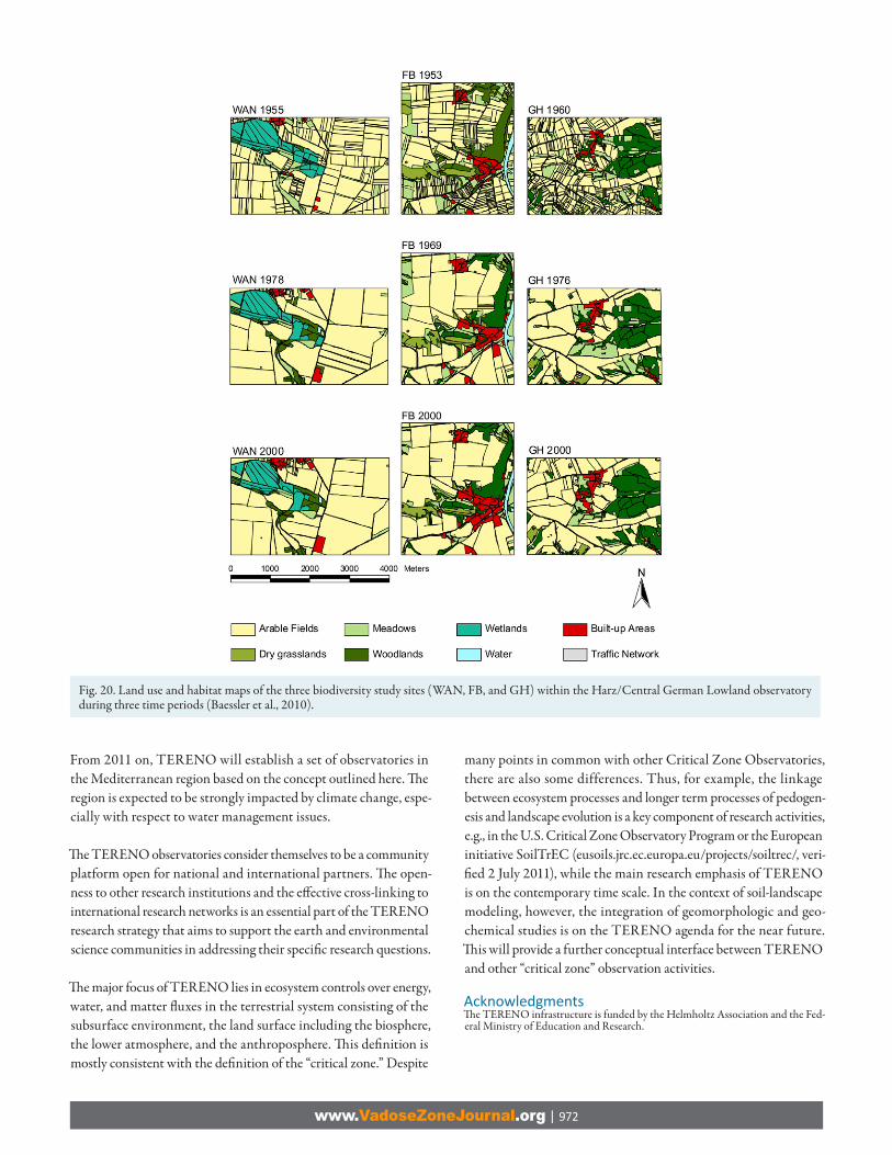
agricultural matrix, too. Six core sites with a size of 4 by 4 km are intensively investigated and additional selected activities (e.g., collection of certain plants or insects) take place at several satellite sites. A prerequisite for the selection of core sites was the avail-ability of historical data, e.g., about land use and vegetation, and the representative character of the site within the whole landscape. Based on old data including vegetation mapping, historical habitat situations were reconstructed (Fig. 20). Th e reconstructed land use map shows the dramatic changes in land use, in habitat patterns, as well as in landscape structures in general and delivers important information regarding land use–climate–biodiversity interactions.
Th e monitoring actually covers selected organism groups: (i) vas-cular plants, most important as primary producers and overall biodiversity indicators); (ii) bees and hoverfl ies, important polli-nators and thus ecosystem service agents; (iii) butterfl ies, classical indicators of habitat quality and of importance as pollinators; and (iv) birds, highly mobile and sensitive indicators for landscape structures and the whole landscape context and integrative indi-cators at the landscape scale. Important criteria for the selection of organism groups were diff erent and complementary indicator value qualities and the availability of historical and present data. In this way, popular organism groups (e.g., birds and butterfl ies) had to be included because data gained by citizen scientists are an impor-tant source to complete data sets from institution-based records. Additionally, the genetic patterns and structures within selected species and populations will be monitored as excellent indicators for the selective power of environmental change.
OutlookTh e TERENO initiative aims to provide long-term observational data on the terrestrial system in Germany combined with dedi-cated large-scale experiments and innovative integrated modeling approaches based on an integrated network concept. We expect that the integrated observation of diff erent compartments of the terrestrial system combined with experiments will allow a better understanding of the impact of land use and climate change on the evolution and adaptation of the terrestrial system. Th e available data and validated terrestrial models will be used to defi ne adapta-tion strategies needed to cope with the eff ect of climate change in Germany within the next decades. Th is is the time scale at which decisions with respect to adaptation need to be taken and imple-mented. Th e assessment of the impact of these changes is replete with very large uncertainties, however, hampering the identifi ca-tion of adaptation strategies. Th e TERENO initiative will provide the relevant data and tools to reduce this uncertainty. Th e estab-lishment of cross-network standards in environmental monitoring and experimentation opens up excellent possibilities for compara-tive studies and creates the conditions that will allow the transfer of knowledge to unobserved sites. Th e TERENO observatories were established with the aim of better integrating the various scientifi c disciplines active in terrestrial research by exploring synergisms and providing opportunities for capacity building. Th ey will, how-ever, also foster cooperation with local, national, and international authorities and organizations to better integrate monitoring data to provide a solid basis on which management and political deci-sions can be made. Th rough the establishment of a data platform and a common data policy, TERENO will make available its data to the scientifi c community.
Fig. 19. Ecosystem integrity as the base for the provision of ecosystem services and fi nally, human welfare, based on the Driver–Pressure–State–Impact–Response (DPSIR) model (B. Burkhard, unpublished data, 2010).
Table 1. Set of “optimum” indicators to represent ecological integrity (Müller, 2005; Müller and Burkhard, 2007).Focal component Indicator Potential key variableBiotic structures biodiversity e.g., number of selected speciesAbiotic structures biotope heterogeneity e.g., index of heterogeneity, habitat diversityEnergy balance energy capture, entropy production, metabolic effi ciency gross or net primary production; entropy production aft er Aoki;
entropy production aft er Svirezhev and Steinborn; output by evapotranspiration and respiration; respiration per biomass
Water balance biotic water fl ows transpiration per evapotranspirationMatter balance nutrient loss, storage capacity Leaching, e.g., of NO3; soil organic C; intrabiotic N
www.VadoseZoneJournal.org | 972
From 2011 on, TERENO will establish a set of observatories in the Mediterranean region based on the concept outlined here. Th e region is expected to be strongly impacted by climate change, espe-cially with respect to water management issues.
Th e TERENO observatories consider themselves to be a community platform open for national and international partners. Th e open-ness to other research institutions and the eff ective cross-linking to international research networks is an essential part of the TERENO research strategy that aims to support the earth and environmental science communities in addressing their specifi c research questions.
Th e major focus of TERENO lies in ecosystem controls over energy, water, and matter fl uxes in the terrestrial system consisting of the subsurface environment, the land surface including the biosphere, the lower atmosphere, and the anthroposphere. Th is defi nition is mostly consistent with the defi nition of the “critical zone.” Despite
many points in common with other Critical Zone Observatories, there are also some differences. Thus, for example, the linkage between ecosystem processes and longer term processes of pedogen-esis and landscape evolution is a key component of research activities, e.g., in the U.S. Critical Zone Observatory Program or the European initiative SoilTrEC (eusoils.jrc.ec.europa.eu/projects/soiltrec/, veri-fi ed 2 July 2011), while the main research emphasis of TERENO is on the contemporary time scale. In the context of soil-landscape modeling, however, the integration of geomorphologic and geo-chemical studies is on the TERENO agenda for the near future. Th is will provide a further conceptual interface between TERENO and other “critical zone” observation activities.
AcknowledgmentsTh e TERENO infrastructure is funded by the Helmholtz Association and the Fed-eral Ministry of Education and Research.
Fig. 20. Land use and habitat maps of the three biodiversity study sites (WAN, FB, and GH) within the Harz/Central German Lowland observatory during three time periods (Baessler et al., 2010).

www.VadoseZoneJournal.org | 973
ReferencesArya, S.P. 2001. Introducti on to micrometeorology. Academic Press, San Diego.Baessler, C., S. Klotz, and W. Durka. 2010. Temporal changes and spati al determinants of
plant species diversity and geneti c variati on. In F. Müller et al. (ed.) Long-term ecologi-cal research: Between theory and applicati on. Springer, Dordrecht, the Netherlands.
Barry, R.G., and R.J. Chorley. 2003. Atmosphere, weather, and climate. Routledge, New York.
Bogárdi, I., A. Bardossy, and L. Duckstein. 1985. Multi criterion network design using geo-stati sti cs. Water Resour. Res. 21:199–208. doi:10.1029/WR021i002p00199
Bogena, H., M. Herbst, J.A. Huisman, U. Rosenbaum, A. Weuthen, and H. Vereecken. 2010. Potenti al of wireless sensor networks for measuring soil water content vari-ability. Vadose Zone J. 9:1002–1013. doi:10.2136/vzj2009.0173
Bogena, H.R., J.A. Huisman, C. Oberdorster, and H. Vereecken. 2007. Evaluati on of a low-cost soil water content sensor for wireless network applicati ons. J. Hydrol. 344:32–42. doi:10.1016/j.jhydrol.2007.06.032
Bogena, H., K. Schulz, and H. Vereecken. 2006. TERENO: Towards a network of observa-tories in terrestrial environmental research. Adv. Geosci. 9:109–114. doi:10.5194/adgeo-9-109-2006
Bradley, A.A., C. Peters-Lidard, B.R. Nelson, J.A. Smith, and C.B. Young. 2002. Raingage network design using NEXRAD precipitati on esti mates. J. Am. Water Resour. Assoc. 38:1393–1407. doi:10.1111/j.1752-1688.2002.tb04354.x
Burt, T.P., N.J.K. Howden, F. Worrall, and M.J. Whelan. 2008. Importance of long-term monitoring for detecti ng environmental change: Lessons from a lowland river in south east England. Biogeosciences 5:1529–1535. doi:10.5194/bg-5-1529-2008
Canfi eld, D.E., A.N. Glazer, and P.G. Falkowski. 2010. The evoluti on and future of Earth’s nitrogen cycle. Science 330:192–196. doi:10.1126/science.1186120
Crutzen, P.J. 1981. Atmospheric chemical processes of the oxides of nitrogen including nitrous oxide. In C.C. Delwiche (ed.) Denitrifi cati on, nitrifi cati on and atmospheric nitrous oxide. John Wiley & Sons, New York.
Czymzik, M., P. Dulski, B. Plessen, U. von Grafenstein, R. Naumann, and A. Brauer. 2010. A 450 year record of spring-summer fl ood layers in annually laminated sedi-ments from Lake Ammersee (southern Germany). Water Resour. Res. 46:W11528. doi:10.1029/2009WR008360
Duckstein, L., and S. Opricovic. 1980. Multi objecti ve opti mizati on in river basin develop-ment. Water Resour. Res. 16:14–20. doi:10.1029/WR016i001p00014
European Environment Agency. 2006. EEA environmental statement 2006. EEA, Copenhagen.
Flessa, H., R. Ruser, R. Schilling, N. Lo fi eld, J.C. Munch, E.A. Kaiser, and F. Beese. 2002. N2O and CH4 fl uxes in potato fi elds: Automated measurement, management eff ects and temporal variati on. Geoderma 105:307–325. doi:10.1016/S0016-7061(01)00110-0
German Federal Environmental Agency. 2005. Climate change in Germany: Vulner-ability and adaptati on of climate sensiti ve sectors. Unweltbundesamt, Dessau-Roßlau, Germany.
German Federal Environmental Agency. 2008. Germany in the midst of climate change: Adaptati on is necessary. Unweltbundesamt, Dessau-Roßlau, Germany.
Granier, A. 1987. Evaluati on of transpirati on in a Douglas-fi r stand by means of sap fl ow measurements. Tree Physiol. 3:309–320.
Intergovernmental Panel on Climate Change. 2006. IPCC guidelines for nati onal green-house gas inventories. Vol. 4. Agriculture, forestry and other land use. Inst. for Glob-al Environ. Strategies, Hayama, Japan.
Intergovernmental Panel on Climate Change. 2007. Climate change 2007: Miti gati on of climate change. Contributi on of Working Group III to the Fourth Assessment Report of the Intergovernmental Panel on Climate Change. Cambridge Univ. Press, Cam-bridge, UK.
Internati onal Council for Science. 2010. Grand challenges in global sustainability re-search: A systems approach to research prioriti es for the decade. Int. Counc. for Sci., Paris.
James, W.P., C.G. Robinson, and J.F. Bell. 1993. Radar-assisted real-ti me fl ood fore-casti ng. J. Water Resour. Plan. Manage. 119:32–44. doi:10.1061/(ASCE)0733-9496(1993)119:1(32)
Kampf, S.K., and S.J. Burges. 2010. Quanti fying the water balance in a planar hillslope plot: Eff ects of measurement errors on fl ow predicti on. J. Hydrol. 380:191–202. doi:10.1016/j.jhydrol.2009.10.036
Kassim, A.H.M., and N.T. Ko egoda. 1991. Rainfall network design through compara-ti ve kriging methods. Hydrol. Sci. J. 36:223–240. doi:10.1080/02626669109492505
Kawashima, H., M.J. Bazin, and J.M. Lynch. 1996. Global N2O balance and nitrogen ferti l-izer. Ecol. Modell. 87:51–57. doi:10.1016/0304-3800(94)00204-5
Keeling, R.F. 2008. Atmospheric science: Recording Earth’s vital signs. Science 319:1771–1772. doi:10.1126/science.1156761
Keller, M., D.S. Schimel, W.W. Hargrove, and F.M. Hoff man. 2008. A conti nental strategy for the Nati onal Ecological Observatory Network. Front. Ecol. Environ. 6:282–284. doi:10.1890/1540-9295(2008)6[282:ACSFTN]2.0.CO;2
Kizito, F., C.S. Campbell, G.S. Campbell, D.R. Cobos, B.L. Teare, B. Carter, and J.W. Hop-mans. 2008. Frequency, electrical conducti vity and temperature analysis of a low-cost capacitance soil moisture sensor. J. Hydrol. 352:367–378.
Lin, H. 2003. Hydropedology: Bridging disciplines, scales, and data. Vadose Zone J. 2:1–11.Lin, H. 2010. Earth’s criti cal zone and hydropedology: Concepts, characteristi cs, and ad-
vances. Hydrol. Earth Syst. Sci. 14:25–45. doi:10.5194/hess-14-25-2010McDonnell, J.J., M. Sivapalan, K. Vaché, S. Dunn, G. Grant, R. Haggerty, C. Hinz, R. Hooper,
J. Kirchner, M.L. Roderick, J. Selker, and M. Weiler. 2007. Moving beyond heteroge-
neity and process complexity: A new vision for watershed hydrology. Water Resour. Res. 43:W07301. doi:10.1029/2006WR005467
Montgomery, J.L., T. Harmon, W. Kaiser, A. Sanderson, C.N. Haas, R. Hooper, B. Minsker, J. Schnoor, N.L. Clesceri, W. Graham, and P. Brezonik. 2007. The WATERS network: An integrated environmental observatory network for water research. Environ. Sci. Technol. 41:6642–6647. doi:10.1021/es072618f
Mosier, A.R. 2001. Exchange of gaseous nitrogen compounds between agricultural sys-tems and the atmosphere. Plant Soil 228:17–27. doi:10.1023/A:1004821205442
Müller, F. 2005. Indicati ng ecosystem and landscape organizati on. Ecol. Indicators 5:280–294.
Müller, F., and B. Burkhard. 2007. An ecosystem based framework to link landscape structures, functi ons, and services. p. 37–64. In Ü. Mander et al. (ed.) Multi func-ti onal land use: Meeti ng future demands for landscape goods and services. Spring-er-Verlag, Berlin.
Müller, F., and B. Burkhard. 2010. Ecological indicators for the integrated management of landscape health and integrity. p. 277–303. In S.E. Jørgensen et al. (ed.) Hand-book of ecological indicators for assessment of ecosystem health. CRC Press, Boca Raton, FL.
Müller, F., and H. Wiggering. 2004. Umwelti ndikatoren als Maßstäbe zur Bewertung von Umweltzuständen und -entwicklungen. P. 121–129. In H. Wiggering and F. Müller (ed.) Unweltziele und Indikatoren. Springer-Verlag, Berlin.
Nati onal Research Council. 2000. Illuminati ng the hidden planet: The future of seafl oor observatory science. Nat. Acad. Press, Washington, DC
Nati onal Research Council. 2003. Enabling ocean research in the 21st century: Imple-mentati on of a network of ocean observatories. Nat. Acad. Press, Washington, DC.
Nati onal Research Council. 2006. Toward an integrated arcti c observing network. Nat. Acad. Press, Washington, DC.
Nati onal Research Council. 2008. Understanding and responding to climate change. Nat. Acad. Press, Washington, DC.
Nisbet, E. 2007. Earth monitoring: Cinderella science. Nature 450:789–790. doi:10.1038/450789a
Ohl, C., K. Krauze, and C. Grünbühel. 2007. Towards an understanding of long-term ecosystem dynamics by merging socio-economic and environmental research cri-teria for long-term socio-ecological research sites selecti on. Ecol. Econ. 63:383–391. doi:10.1016/j.ecolecon.2007.03.014
Paola, C., E. Foufoula-Georgiou, W.E. Dietrich, M. Hondzo, D. Mohrig, G. Parker, M.E. Power, I. Rodriguez-Iturbe, V. Voller, and P. Wilcock. 2006. Toward a uni-fi ed science of the Earth’s surface: Opportuniti es for synthesis among hydrol-ogy, geomorphology, geochemistry, and ecology. Water Resour. Res. 42:W03S10. doi:10.1029/2005WR004336
Parr, T.W., M. Ferre , I.C. Simpson, M. Forsius, and E. Kovacs-Lang. 2002. Towards a long-term integrated monitoring programme in Europe: Network design in theory and practi ce. Environ. Monit. Assess. 78:253–290. doi:10.1023/A:1019934919140
Parr, T.W., A.R.J. Sier, R.W. Ba arbee, A. Mackay, and J. Burgess. 2003. Detecti ng envi-ronmental change: Science and society—Perspecti ves on long-term research and monitoring in the 21st century. Sci. Total Environ. 310:1–8. doi:10.1016/S0048-9697(03)00257-2
Queti n, L.B., and R.M. Ross. 1992. A long-term ecological research strategy for po-lar environmental research. Mar. Pollut. Bull. 25:233–238. doi:10.1016/0025-326X(92)90675-V
Ravishankara, A.R., J.S. Daniel, and R.W. Portmann. 2009. Nitrous oxide (N2O): The domi-nant ozone-depleti ng substance emi ed in the 21st century. Science 326:123–125. doi:10.1126/science.1176985</jrn>
Reckhow, K., L. Band, C. Duff y, J. Famiglie , D. Genereux, J. Helly, R. Hooper, W. Krajew-ski, D. McKnight, F. Ogden, B. Scanlon, and L. Shabman. 2004. Designing hydrologic observatories: A paper prototype of the Neuse watershed. Tech. Rep. 6. Consorti um of Univ. for the Adv. of Hydrol. Sci., Washington, DC.
Reid, W.V., C. Brechignac, and Y.T. Lee. 2009. Earth System research prioriti es. Science 325:245. doi:10.1126/science.1178591
Richter, D.D., and M.L. Mobley. 2009. Monitoring Earth’s criti cal zone. Science 326:1067–1068. doi:10.1126/science.1179117
Rodríguez-Iturbe, I., and J.M. Mejia. 1974. Design of rainfall networks in ti me and space. Water Resour. Res. 10:713–728. doi:10.1029/WR010i004p00713
Rosenbaum, U., J.A. Huisman, J. Vrba, H. Vereecken, and H. Bogena. 2011. Correcti on of temperature and electrical conducti vity eff ects on dielectric permi vity measure-ments with ECH2O sensors. Vadose Zone J. 10:582–593.
Rosenbaum, U., J.A. Huisman, A. Weuthen, H. Vereecken, and H. Bogena. 2010. Quan-ti fi cati on of sensor-to-sensor variability of the ECH2O EC-5, TE, and 5TE sensors in dielectric liquids. Vadose Zone J. 9:181–186. doi:10.2136/vzj2009.0036
Samaniego, L., R. Kumar, and S. A nger. 2010. Multi scale parameter regionalizati on of a grid-based hydrologic model at the mesoscale. Water Resour. Res. 46:W05523. doi:10.1029/2008WR007327
Schulze, E.D., S. Luyssaert, P. Ciais, A. Freibauer, I.A. Janssens, J.F. Soussana, et al. 2009. Importance of methane and nitrous oxide for Europe’s terrestrial greenhouse-gas balance. Nat. Geosci. 2:842–850. doi:10.1038/ngeo686
Willis, K.J., M.B. Araujo, K.D. Benne , B. Figueroa-Rangel, C.A. Froyd, and N. Myers. 2007. How can a knowledge of the past help to conserve the future? Biodiversity con-servati on and the relevance of long-term ecological studies. Philos. Trans. R. Soc. London, Ser. B 362:175–186.
Wolf, B., X.H. Zheng, N. Brueggemann, W.W. Chen, M. Dannenmann, X.G. Han, M.A. Su on, H.H. Wu, Z.S. Yao, and K. Bu erbach-Bahl. 2010. Grazing-induced reduc-ti on of natural nitrous oxide release from conti nental steppe. Nature 464:881–884. doi:10.1038/nature08931\Zoback, M.L. 2001. Grand challenges in earth and envi-ronmental sciences: Sciences, stewardship, and service for the twenty-fi rst century. GSA Today 12:41–47