omar al‐nuaimi
TRANSCRIPT

APPLICATIONS OF UNMANNED AERIAL VEHICLES
(UAVs) IN CONSTRUCTION INDUSTRY: AN OVERVIEW
Omar Al‐Nuaimi
Sharjah Research Academy

OUTLINE
1.Introduction
3.UAV in
Construction
2.History of
Drones
5.Challenges
4.Application of
Photogrammetry
6.Conclusion
Introduction
Recently, many new technologies have appeared to enhance productivity, reduce the cost and
time of building inspection in the construction activities.
UAVs, also known as Drones has been interfere in the construction industry and recently in
building inspection and a varied range of other sectors.
In the last decades, many researchers have concentrated on UAV applications in different areas of
the construction industry.
This paper presents an overview of photogrammetry and UAVs and its applications in the
monitoring and evaluation of structures and infrastructures.

History of DronesPa r t 1
1782
1848
1862
1898
1911
The Montgolfier brothers in France use unmanned balloons
Austria mounts bombs on two hundred pilotless balloons as
part of an secret attack against Venice
A patent for a flying machine that can hold bombs was lodged
in Massachusetts
American Armed forces use a kite with a camera attached to it for
reconnaissance during the Spanish-American war, Tesla demonstrates the Automaton at Madison Square
Garden
The Italians use drones when they attacked Libya
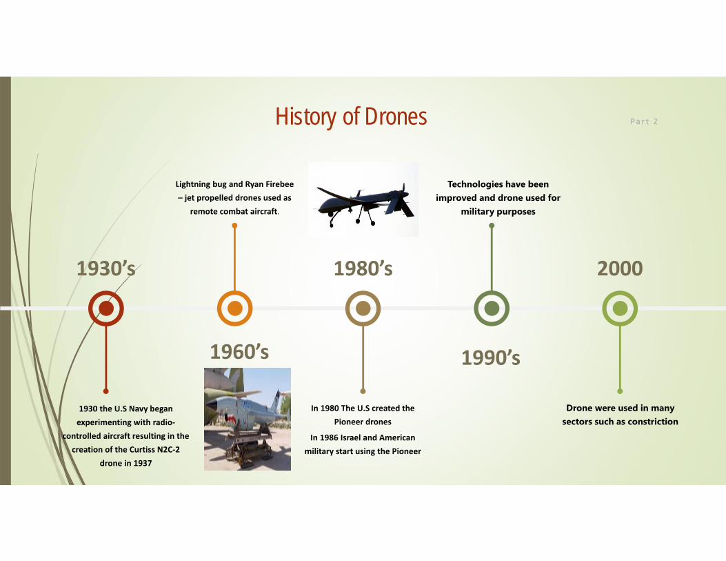
History of Drones Pa r t 2
1930’s
1960’s
1980’s
1990’s
2000
1930 the U.S Navy began experimenting with radio‐
controlled aircraft resulting in the creation of the Curtiss N2C‐2
drone in 1937
Lightning bug and Ryan Firebee– jet propelled drones used as
remote combat aircraft.
In 1980 The U.S created the Pioneer drones
In 1986 Israel and American military start using the Pioneer
Technologies have been improved and drone used for
military purposes
Drone were used in many sectors such as constriction

UAVs (Drones) and its Components
Drone in a technological context, is an unmanned air vehicle (UAV) as shown below, which is either
operated by human remotely or can fly autonomously through software-controlled flight plans.
The architecture of a commercial drone mainly consists of the control, data processing, monitoring and
landing systems. The interior system runs a variety range of functions ranging from navigation to data
transfer to ground. Before designing a drone for commercial and civilian applications, it is important to
figure out the specifications that must satisfy certain needs for their owners.
UAVs in Construction
Drone technology is used for different reasons in the construction industry. As a tool thatimproves communication, safety, and marketing, the use of drones in construction can offer manyadvantages; capturing real-time images from the field.
With their real-time data recording and unique aerial advantage, drones can improve efficiency,cut costs, and streamline workflow. Here are some of the ways drones are used in construction:
1. Topographic Mapping and Land Surveys
2. Equipment Tracking and Automating
3. Remote Monitoring and Progress Reports
4. Security Surveillance
5. Personnel Safety
6. Structure Inspection and Photography
7
Applications of Photogrammetry and UAVs
The applications of photogrammetry and UAV in civil engineering is almost unlimited.
It could be used as a standalone system or jointly with other non-contact imaging data methods
such as radar, LIDAR, holography and remote sensing.
It could be used in architectural photogrammetry, information systems such as GIS and building
information modeling (BIM).
Deformation measurement and cracks opening during laboratory tests on structure and structural
elements, crack measurement and monitoring, obtaining detailed geometries for computational
structural models and visual documentation and modeling of actual symptoms (fissures, breaking,
cracks or collapse) measurement of geometric and structural elements in bridge routine
inspection Close range photogrammetry is employed for historic bridge documentation and
routine inspection in bridge management
8

9Applications of photogrammetry
1 3D Modeling
2 Safety Monitoring
3 Surveying
4 Project Progress Control
5 Damage Assessment

1. AerialPhotogrammetry
Photogrammetry is “the science of measuring in photos” and belongs to the field of remote
sensing. With photogrammetry it is possible to determine size, shape and location of
depicted objects by measuring in images, this without a need of physical contact to the
object.
Aerial photogrammetry consists of using the imagery gathered in the air by UAVs to create
computer-generated 2D and 3D models. These models are topographical in nature,
meaning they represent the dimensions and physical features of the area of land, and in
stunning accuracy. These models can be rotated and zoomed. Because they are created
entirely from images of the real locations as captured by a UAV, they will show every last
photographic detail that exists in those photos.
10
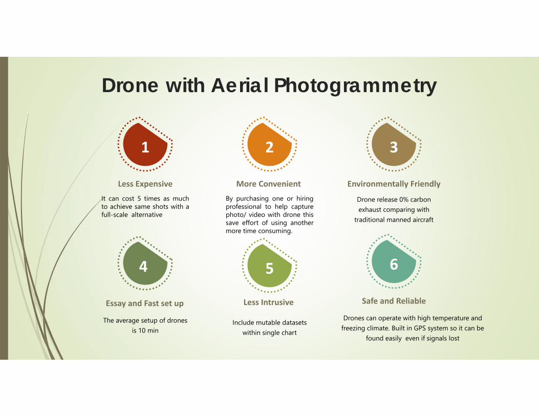
Drone with Aerial Photogrammetry
Less Expensive
It can cost 5 times as muchto achieve same shots with afull-scale alternative
Essay and Fast set up
The average setup of drones is 10 min
Less Intrusive
Include mutable datasets within single chart
Safe and Reliable
Drones can operate with high temperature and freezing climate. Built in GPS system so it can be
found easily even if signals lost
More Convenient
By purchasing one or hiringprofessional to help capturephoto/ video with drone thissave effort of using anothermore time consuming.
Environmentally Friendly
Drone release 0% carbon exhaust comparing with
traditional manned aircraft
1 2 3
654

2. Surveying
UAVs provide an economical platform for obtaining survey data Equipped with
proper sensors and camera technologies, surveying services providers use GPS
enabled UAVs that automatically follow a GPS controlled and calculated flight
path in advance.
12

3. Inspections
It has been validated by many industries that using UAVs can quicken the inspection process
and enhance safety by reducing worker exposure to harsh conditions in extreme climates.
In term of commercial construction, a CEO of UAV services company describes a scenario in
which a fifteen-story building has a water leak on one of the higher floors. A window frame is
suspected to be the source of the leak. The building is bordered by a busy highway, making
access even more difficult. A UAV is able to capture numerous photos from various angles
and zoom settings in a matter of minutes. The entire operation is conducted without road
closures, at a greatly lower cost than alternative inspection techniques, and with very little
safety risk
13

4. Safety/Security Monitoring
Using a UAV allows the safety manager to communicate with employees anywhere within the
construction site.
Images and video captured by the UAV gives the safety manager valuable documentation of jobsite
conditions in cases where accidents do occur, and the UAV provides him a tool to cover a larger area of
the construction site in a shorter amount of time.
Security of construction sites can also be enhanced using UAVs. the UAV is deployed and hovers above
the construction site to capture video of what is happening. The high definition camera will have the
capability to identify individuals or vehicles within its view, and the video can be viewed from a
smartphone. The UAV will also have the ability to be programmed for periodic security sweeps, and it
will return to its rooftop station automatically
14
Challenges in Drones Applications
Despite so many benefits of drones there are some serious challenges that need to be
highlighted. The unwelcome consequences of drones discussed below
Safety
Drones deployed in highly dense cities for various civilian applications raises serious safety issue
as huge damage can be caused due to the crashing of drone. This may be the result of technical
malfunction or inadequate maintenance of equipment or misuse by its operator.
Severe weather conditions such as turbulence, lightening and battery life lift capacity has also
triggered concerns about the falling of drones on public property. Furthermore, due to sharing
of the airspace with other commercial planes in larger cities, there is also a serious risk of
airborne collisions leading to widespread destruction
15

Security
The biggest security concerns of using commercial or civilian drone is not the drone itself, but
the technology inside of it. The technologies which equip the drones could be hijacked or
destroyed by attackers, causing the disruption of services they provide.
Drone navigation and communication modules are vulnerable to different kinds of security
breaches. like Wi-Fi Jamming which could cause the loss of control of the drone’s
communication system with serious consequences for nearby people.
16 Challenges in Drones Applications
Privacy
Privacy is one of the major concerns related to the use of commercial drones. Drones carrying
high-precision cameras, sensors and recorders that can be remotely controlled to perform
surveillance tasks precisely. However, they bring with them concerns about privacy and personal
data protection. Malicious software can be installed on a drone to data and to track and profile
individuals using wireless localization technique.
17 Challenges in Drones Applications

Conclusion
UAV regulations are under development in many countries around the world, and there is need
to propose new regulations to make use of its different applications.
It is envisaged that drones will not only be used in monitoring activities, where as it could do
more of small maintenance activities using a Snap-On gauge on the drone such as sealing
cracks and minor repair works.
18

Thank you 19