old press/ mill lane - cambridge city council old... · 3.4 archaeology 16 3.5 land use 16 3.6 ......
TRANSCRIPT
SupplementaryPlanning Document
Old Press/Mill Lane
January 2010
This publication has been produced by:Environment and PlanningCambridge City CouncilThe GuildhallCambridgeCB2 3QJ
Tel: 01223 457000Can be downloaded from www.cambridge.gov.uk
Printed on recycled paper. Please recycle.
Front cover picture by Tamzin Sale.

1. INTRODUCTION 51.1 Scope and Purpose 51.2 Process of Preparation 6
2. CONTEXT 72.1 Location 72.2 Planning Policy Context 9
3. SITE ANALYSIS 113.1 Statutory and Non-Statutory Designations 113.2 Historical Development of the Area 133.3 Cultural Development and Significance 163.4 Archaeology 163.5 Land Use 163.6 Access and Circulation 193.7 Quality of the Public Realm 223.8 Legibility 253.9 Built Form 273.10 Typology and Grain of Development 293.11 Landscape Features and Resources 30
4. CONSTRAINTS AND OPPORTUNITIES 344.1 Identification of Constraints and Opportunities 344.2 Development Options 35
5. VISION AND DEVELOPMENT OBJECTIVES 365.1 Vision 365.2 Development Objectives 36
6. DEVELOPMENT PRINCIPLES 376.1 Urban Form 376.2 Buildings 376.3 Land Uses 386.4 Delivering Sustainable Development 406.5 Public Realm 42
CONTENTS OLD PRESS/MILL LANE SPD
Contents
3

OLD PRESS/MILL LANE SPD CONTENTS
4
6.6 Access and Circulation 436.7 Utilities Infrastructure 446.8 Air Quality 446.9 Archaeology 446.10 Noise Pollution 456.11 Contaminated Land 456.12 Ecology 45
7. MASTERPLANNING AND PHASING 48
8. PLANNING REQUIREMENTS 50
Appendix A: Planning Policy Framework 51Appendix B: List of Background Documents 56Glossary 57End Notes 64
PLANS1. Aerial Photograph 82. Local Planning Policy Context 103. Historic Buildings and Conservation Area 124. Historic Features 155. Existing Land Use 186. Permeability 207. Access and Circulation 218. Townscape Quality 249. Vistas and Views 2610. Building Significance 2811. Natural Features 3212a. Development Potential 4612b. Potential Public Realm and Highway Improvements 47
4
The maps within this document are covered by the following copyright statement:
"This map is reproduced from Ordnance Survey material with the permission of Her Majesty'sStationery Office © Crown copyright. Unauthorised reproduction infringes Crown copyright and maylead to prosecution or civil proceedings." Cambridge City Council (Licence No. 100019730) 2010.

1. Introduction
1. Scope and Purpose
1.1.1 The Old Press/Mill Lane site lies in thehistoric core of the City and providesaccommodation for a range of theUniversity of Cambridge's academic andadministrative facilities. It has long beenrecognised that the University is interestedin relocating some of its activities from thesite to other more appropriate buildingsand locations within the City.
1.1.2 This document sets out the City Council'saspirations for the future use anddevelopment of the site. Based on therequirements of the Cambridge LocalPlan 2006 (hereafter referred to as theLocal Plan), the future development orredevelopment of the Old Press/Mill Lanesite presents an opportunity to:
Improve facilities;Reduce car parking spaces;Improve the external environment andamenity space;Make better use of land.
1.1.3 In bringing forward the requirements ofthe Local Plan, a vision was produced forthe site:
The Old Press/Mill Lane site provides anopportunity to create an area with adistinctive character that combines highquality buildings, streets and spaces, andresponds well to its context throughsensitive enhancement. It will contain amix of uses that complement the City'shistoric core and its riverside location.Development will support the creation of amore attractive, accessible, safe andsustainable environment.
This vision can be read in tandem withthe development objectives for the site setout in Section 5.0.
1.1.4 The University of Cambridge andCambridge City Council have worked inpartnership on the preparation of thisSupplementary Planning Document (SPD)to ensure that any future developmentsafeguards the architectural, historic,cultural and archaeological importance ofthe site, and takes advantage of its settingon the river frontage within the historicCity Centre.
1.1.5 The document will be a key materialconsideration in determining theacceptability of development on the siteand aims to reduce uncertainty bycreating a framework against whichdevelopment proposals can be assessed.
1.1.6 Chapter 1 of this document forms theintroduction and sets out the purpose ofthe framework. Chapter 2 sets the contextfor the document. Chapter 3 analyses thedifferent features of the site, whilstChapter 4 identifies the opportunities andconstraints, which arose as a result of theappraisal of the site and its existing uses.Chapter 5 sets out the vision for the siteand more detailed developmentobjectives. Following on from the vision,Chapter 6 discusses the development anddesign principles for the site. Chapter 7sets out the approach to phasing ofdevelopment, whilst Chapter 8 outlinesthe documents required to accompanyplanning applications.
INTRODUCTION OLD PRESS/MILL LANE SPD
5
1.1.7 The key issues, to be considered, include:
Known site constraints, includingstatutory controls;Existing and proposed land uses, bothwithin and in the vicinity of the site;Historic and natural environment;Access and movement;Car and Cycle Parking;Public realm enhancement.
1.2 Process of Preparation
1.2.1 The potential for the future developmentand/or redevelopment of the OldPress/Mill Lane site is recognised in theLocal Plan. The production of an SPD isalso identified within the Council's LocalDevelopment Scheme. The City Counciland the University of Cambridge set up ajoint working group to aid the productionof the SPD in Summer 2007. Backgroundstudies and research, stakeholderworkshops and an appraisal of potentialdevelopment options took place fromAutumn 2007 until September 2008.Appendix B contains a list of thebackground documents complied toinform the development of the SPD.
1.2.2 This SPD was the subject of publicconsultation for a period of six weeksfrom 23rd February until 6th April 2009.After consideration of representations andany necessary changes, this documentwas subject to final consideration by theCity Council's Environment ScrutinyCommittee and approval by the ExecutiveCouncillor for Climate Change andGrowth in January 2010.
1.2.3 The City Council was responsible for theproduction of a Sustainability AppraisalScoping Report Addendum on the SPD.The consultation for this Scoping Reportwith a number of statutory andnon-statutory consultees took placebetween 19th August and 25th
September 2008. Minor changes weremade to the Scoping Report as a result ofconsultation responses.
1.2.4 Using the Sustainability Appraisalframework set out in the Scoping ReportAddendum, this SPD has been subject toa full Sustainability Appraisal. Thisappraisal was made available forconsultation at the same time as the SPD.
1.2.5 In accordance with European regulations,a Habitats Regulations AssessmentScreening Report has been prepared. Thisassessment appraises the potential effectsof the draft SPD, both alone and incombination with other plans, on anumber of internationally designated sitesof conservation importance. Thisdocument was subject to final approvalby Natural England and has been madeavailable on the Council's website.
OLD PRESS/MILL LANE SPD INTRODUCTION
6
2.1 Location
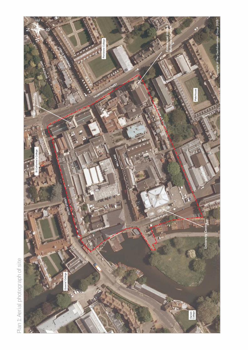
2.1.1 The Old Press/Mill Lane site, as shown inPlan 1, lies on the south-western edge ofthe historic City Centre of Cambridge. Itis bounded by Silver Street to the north,Trumpington Street to the east, Little StMary's Lane to the south and GrantaPlace and the Mill Pit to the west.
2.1.2 For the most part, the site is in theownership of the University of Cambridgeand provides accommodation for both itsadministrative and academic functions.There are a number of local amenitieslocated within and adjacent to the site,including food and drink establishments,local shops, hotel and leisure facilities. Italso marks many visitors' first experienceof the historic City Centre, given itsproximity to coach parking on Queens'Road.
2.1.3 Although there are no College buildingswithin the area covered by the SPD,Queens' College and St Catharine'sCollege stand to the north; PembrokeCollege to the east; Peterhouse to thesouth and Darwin College to the west. Tothe south-west of the site, the River Camcorridor and Laundress Green (an openspace and area of registered commonland) are major attractions to visitors andlocal people and a number of puntstations are within the vicinity. Thecobbled causeway over the Mill Pit linksthe site with the footpath and cycleway toNewnham and onto Grantchester,providing an important route into the Cityas well as access to Laundress Green.
CONTEXT OLD PRESS/MILL LANE SPD
2. Context
7
Plan
1:A
eria
l pho
togr
aph
of s
ite
""CCoopp
yyrriigg
hhtt oo
ff TThhee
GGeeoo
IInnffoo
rrmmaatt
iioonn
GGrroo
uupp 22
000088..
""
2.2 Planning Policy Context
2.2.1 This SPD will form part of the City's LocalDevelopment Framework (LDF). AppendixA of this document considers the widernational, regional and local policies,guidance and strategies that the SPDshould generally conform with and willbe a material consideration againstwhich any planning applications will beassessed. It should be noted that the listcontained in Appendix A is not intendedto be exhaustive, as other policies anddocuments may also be relevantdependent on the nature of forthcomingdevelopment proposals and/or onemerging policy documents.
2.2.2 In terms of specific area-based policiesand allocations (See Plan 2), the area inquestion is partly identified for aUniversity-led mixed-use development inthe Local Plan (Site 7.10) and is thesubject of policy 7/5, which reads:
7/5 Faculty Development in the CentralArea, University of Cambridge
The further development orredevelopment of the University ofCambridge's faculty and administrativesites in the central area will be permittedif this allows improved facilities, areduction in parking spaces,improvements to external environmentand amenity space, and better use ofland.
On the following sites, an element ofmixed use will also be supported in orderto enhance the attractiveness of thepublic realm:a. Mill Lane/Old Press Site; andb. New Museums site.
Where smaller scale properties on thefringes of academic sites become surplusto requirements, for example around the
Old Addenbrooke's site, planningpermission will also be granted to enablethe return of such sites to appropriatealternative uses such as residential uses,retail or community uses.
2.2.3 Although there are a number ofdocuments referred to in Appendix A, theCambridge Historic Core ConservationArea Appraisal is worthy of specificmention. Together with the Old Press/MillLane Site Historic Environment Analysisdocument (prepared by consultantsBeacon Planning for the City Council),the two documents provide detailedbackground information on the site. Theyhave informed the development of theSPD and should also inform futureplanning applications for the site.
CONTEXT OLD PRESS/MILL LANE SPD
9

Plan
2: L
ocal
Pla
nnin
g Po
licy
Cont
ext
Sub
Sta
Post
s
Fello
ws'
Gar
den
Hobson
s
Pete
rhou
se
Univ
ersi
ty
GRANTA PLACE
Boat HouseG
isbo
rne
Cou
rt
Hostel 40
First C
ourt
Laun
dres
s G
reen
El
TRUMPING
(foun
ded
1284
)
Littl
e
Cent
re
Chap
el
13
12
Slui
ce
LITT
LE S
T M
ARY
'S L
AN
E
14
Mas
ter's
Old
Cou
rt
Wor
ks
(foun
ded
1964
)
Dar
win
Col
lege
Littl
e St
Mar
y's
Lane
Peterhouse
10
9.7m
FB
DW
St M
ary'
s Ch
urch
11
Lodg
e6.
9m
(Cambridge University Press)
Lodg
e
GRANTA PLACE
El S
ub S
ta
7
Land
ing
51
1
10
8
Chap
el
SILV
ER S
TREE
T
Pitt Building
Wor
ks
14
11
Club
9.1m
17
2
Cent
reUn
iver
sity
Mas
ter's
St B
otol
ph's
4
Post
s
74
72
PC
MIL
L LA
NE
Hall
Clo
iste
r Cou
rt9
Pres
iden
t's L
odge
River Cam
Stag
e
16
Chur
ch
Stua
rt
TCB
7
Gar
den
LITT
LE S
T M
ARY
'S L
ANE
1
LB
Post
s
Que
ens'
2
Wei
r
Smal
l
Brid
ge
Brid
ge
15
PH
Old
Cou
rt
Unite
d R
efor
med
12
Old
Cou
rt
16
Mas
ter's
Ivy
Cour
t8.
2m
Hobson's Conduit
1
to 1
0
71
5a
LB
21
7a
12
9.8m
1a
8
Chur
ch9.
1m
1
4
Hous
e
4
PEM
BROKE STR
EET
5
54
Laun
dres
s G
reen
Mill
Pit
Emm
anue
l
Cour
t
13
Boto
lph
to 1
2
Pe
10
ON STREET
8.8m
Littl
e St
Mar
y's
Chur
ch
PH
Mas
ter's
Lect
ure
Hal
ls
13
LAUNDRESS LANE
BOTO
LPH
LAN
E (priv
ate)
8.8m
Boar
dof
Gra
duat
eSt
udie
sLi
brar
y
17
Bolla
rds
Risi
ng
Host
el
Cotta
geFl
at
52
CR
Site A
rea
Flo
od Z
on
e
AQ
MA
(Air
Qu
alit
y M
an
ag
em
ent A
rea
)
Pro
po
sal S
ite
7.1
0(a
s d
esig
nate
d in L
ocal P
lan
)
© C
row
n co
pyrig
ht (L
icen
ce N
o. 1
0001
9730
)

3.1 Statutory and Non-StatutoryDesignations
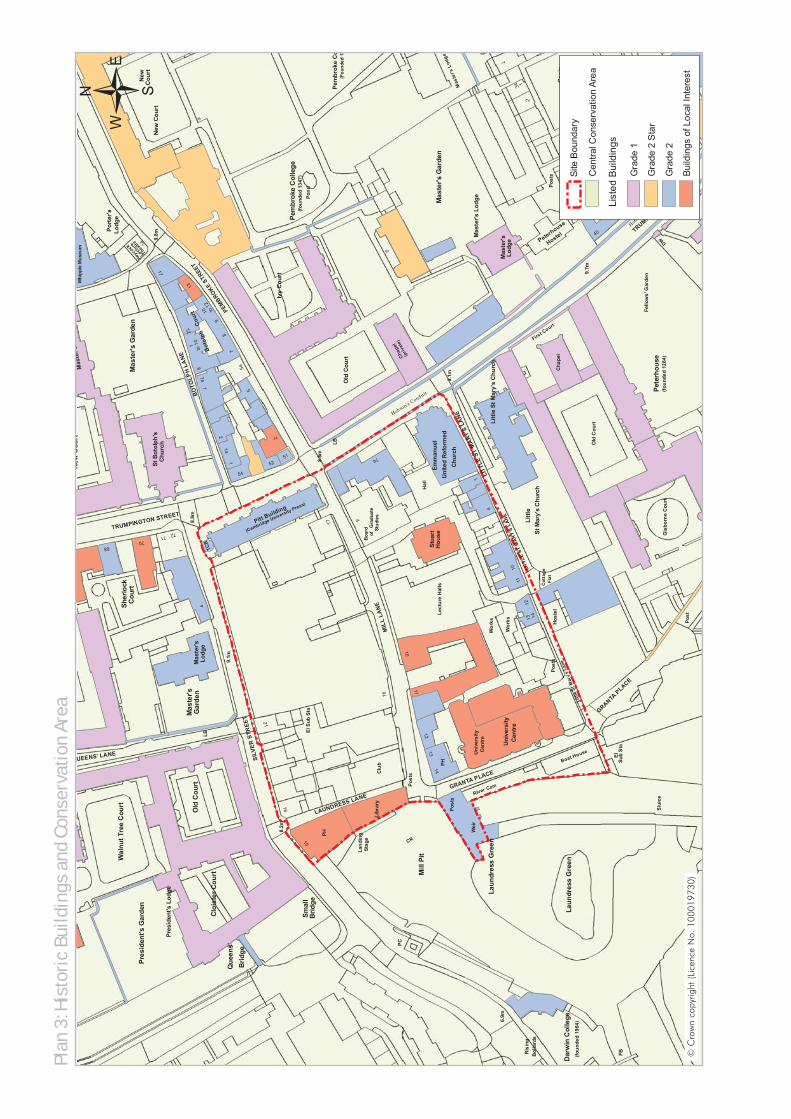
3.1.1 The entire site lies within the CentralConservation Area, which covers thehistoric core of the City and a number ofthe surrounding green spaces, includingSheep's Green and Coe Fen. There are anumber of Listed Buildings and Buildingsof Local Interest (BLI) within and directlyadjoining the site. These buildings areindicated in Plan 3. Further detailedassessment of these buildings and streetsis provided in the Cambridge HistoricCore Conservation Area Appraisal andthe Old Press/Mill Lane Site HistoricEnvironment Analysis, that form part ofthe background evidence.
3.1.2 There is a green corridor to the west ofthe Old Press/Mill Lane site that sweepsinto the City from the rural hinterlandalong the River Cam and through theLaundress Green/Sheep's Green andCoe Fen areas, which form part of theCambridge Green Belt as well as beingdesignated County Wildlife Sites.
SITE ANALYSIS OLD PRESS/MILL LANE SPD
3. Site Analysis
11
Plan
3: H
isto
ric
Build
ings
and
Con
serv
atio
n Ar
ea
Cos
in
Sub
Sta
9
Post
s
Fello
ws'
Gar
den
Hobson's Conduit
Pete
rhou
se
Uni
vers
ity
GRANTA P
LACE
Boat House
Post
s
Gis
born
e C
ourt
Hostel 40
37
First C
ourt
Laun
dres
s G
reen
El
TRUMPINGTON STREET
(foun
ded
1284
)
Littl
e
Cen
tre
Post
Cha
pel
13
12
Slui
ce
LITT
LE S
T M
ARY'
S LA
NE
DW
14
Mas
ter's
Old
Cou
rt
Can
ham
's
Wor
ks
(foun
ded
1964
)
Dar
win
Col
lege
Littl
e St
Mar
y's
Lane
Peterhouse
Yard
Cou
rt
35
33
10
9.7m
FB
DW
St M
ary'
s C
hurc
h
11
5
2
Lodg
e6.
9m
(Cambridge University Press)
Lodg
e
GRANTA PLACE
(foun
ded
1347
)El
Sub
Sta
Pres
iden
t's G
arde
n
7
Land
ing
14
Sher
lock
51
Mas
ter's
Gar
den
1
New
Cou
rt
10
8
Chap
el
SILV
ER S
TREE
T
Pitt Building
Wor
ks
14
Pond
11
Clu
b
9.1m
17
2
Cen
tre
Uni
vers
ity
Mas
ter's
St B
otol
ph's
Mas
ter's
Gar
den
4
Post
s
74
72
PC
MIL
L LA
NE
Hal
l
Clo
iste
r Cou
rt9
Pres
iden
t's L
odge
River Cam
Stag
e
16
Chu
rch
Stua
rt
TCB
QUEENS' LANE
7
Gar
den
Cou
rt
LITT
LE S
T M
ARY
'S L
ANE
New
Cou
rt
1
LB
Post
s
68
Que
ens'
2
Wei
r
Smal
l
Brid
ge
Brid
ge
15
PH
Old
Cou
rt
Uni
ted
Ref
orm
ed
12
Old
Cou
rt
16
Mas
ter's
Ivy
Cou
rt8.
2m
Hobson's Conduit
1
to 1
0
71
5a
LB
21
7a
12
9.8m
1a
8
Chu
rch
9.1m
1
4H
ouse
4
PEMBROKE
STREE
T
5
54
Mas
ters
Laun
dres
s G
reen
Mill
Pit
Lodg
e
Emm
anue
l
Cour
t
13
Wal
nut T
ree
Cou
rt
Bot
olph
to 1
2
Pem
brok
e C
olle
ge
4
34 1
20M
aste
r's L
odge
New
Pem
brok
e C
o(F
ound
ed 1
3
Cou
rt
10
TRUMPINGTON STREET
Port
er's
8.8m
Littl
e St
Mar
y's
Chu
rch
PH
Mas
ter's
Lod
ge
Lect
ure
Hal
ls
13
LAUNDRESS LANE
BO
TOLP
H L
AN
E
70
(priv
ate)
8.8m
11Cos
in
7
Cou
rt
Whi
pple
Mus
eum
Boar
dof
Gra
duat
e
Heyco
ck
Lectu
re
Thea
tre
Stud
ies
Libr
ary
17
Bol
lard
sR
isin
g
Hos
tel
Cot
tage
Flat
52
CR
Site
Boundary
Centr
al C
onserv
ation A
rea
Gra
de 2
Sta
r
Gra
de 2
Build
ings o
f Lo
cal In
tere
st
Lis
ted B
uild
ings
Gra
de 1
© C
row
n co
pyrig
ht (L
icen
ce N
o. 1
0001
9730
)
3.2 Historical Development ofthe Area3.2.1 This area of Cambridge has been part of
a centre of population and activity forover a thousand years. By the 11thcentury, the town had begun to take itspresent form, with the King's Ditch at itssouthern edge. Originally encircling thetown, the Ditch would have had adefensive role along with the river andadjacent marshland, but in later years itbecame an open sewer until it silted up.The line of the King's Ditch is believed torun close to or along the approximateline of Mill Lane up to the point wherethe street meets the river.
3.2.2 Trumpington Street is thought to havedeveloped in Anglo-Saxon times and wasknown as Magna Strata (Great Street) orHiestrata (High Street). In the 13thcentury, the Trumpington Gate waserected near to the point whereTrumpington Street crossed the King'sDitch.
3.2.3 Mill Lane developed alongside the Ditchto provide an access route to the millsfrom the main road. The Domesdaysurvey in 1086 records that there werethree grain mills situated next to the river,the King's, Bishop's and Newnham Mills.Linking Mill Lane and Silver Street,Laundress Lane is named after thewasherwomen who used to walk down tothe river to wash and dry clothes atLaundress Green. It was previouslyknown as Mill Street and provided ashort cut through from Silver Street to themills and the river.
3.2.4 During the 14th and 15th centuries, thecentre of Cambridge saw considerablechange with the growth of the Universityerasing much of the commercial areaadjacent to the river. The site contains
some of the few remaining vestiges of theCity's commercial past with some of theformer warehouses, traces of watermillsand watercourses. The other survivingarea of industrial and commercial activitywithin the historic core was situated atthe quayside next to Magdalene StreetBridge, although the Backs did not existto their current extent until the 17thcentury.
3.2.5 Silver Street, formerly known as 'SmallBridges', approached the City overseveral bridges spanning the arms of theriver. Silver Street bridge, designed byLutyens in 1932 and built in 1958/9 isthe latest of the series of bridges and hasa significant impact on one'sappreciation of the changing width ofSilver Street. It survived theHolford-Wright Plan (1950) as a route,which advocated the creation of a bridgefrom a widened Mill Lane across the MillPit. The street was renamed in the late18th century as a result of its occupationby silversmiths. The street pattern hasremained remarkably intact up to thepresent day, although many originalbuildings have been replaced andchanged from 'town' to 'gown' use overthe intervening centuries.
3.2.6 Although the University Press hadoccupied premises on the north side ofSilver Street since 1654, they purchasedThe White Lion Inn on the south side ofSilver Street in the late 18th century. Thisbuilding was later demolished and aprinting office and foundry erected in itsplace.
3.2.7 Notwithstanding the historical origins ofthe area, much of the built form on thesite, particularly the northern block, datesfrom the late 18th century onwards.Indeed, the development andredevelopment of buildings associatedwith the University in the northern blockhas taken place right up to the present
SITE ANALYSIS OLD PRESS/MILL LANE SPD
13
day. The arrival of the railway inCambridge in 1845 had significantimplications for the use of the river forcommercial purposes. Milling activityfinally moved from the site to Foster's Millat the station in the 1920s.
3.2.8 The area has, as a result of the ongoingdevelopment, had a functional link withthe developing University facilities offPembroke Street (the New Museums andDowning sites). Although early Universitybuildings on the northern block wereexclusively related to the Press, the widerrange of University facilities included theLocal Examinations Syndicate at No. 4Mill Lane in the late 1800s; the erectionof Stuart House as the centre for ExtraMural Studies in 1925; and the largelecture theatre building next door in the1930s. As the century progressed andparticularly after the main CambridgeUniversity Press site moved out toShaftesbury Road in the early 1960s, thebuildings were occupied by Universityacademic and administrative facilitiesand the role of the area as a destinationfor students and academics wascemented yet further by the erection ofthe University Centre or 'Grad Pad' in1967. The University Centre replaced theresidential and commercial buildings onGranta Place and Granta Terrace.
3.2.9 Granta Place was once the home of theGranta Brewery, which later moved toPanton Street. The street now serves asan access road to the punt hire stationson the river, the nearby open spaces ofSheep's Green and Coe Fen, and theCambridge Doubletree Hilton Hotel.
3.2.10 Little St Mary's Lane has existed since atleast the 14th century, having originallyhoused bargees. The street has alteredlittle in form and function over the years,although the residents' professions havechanged. By the late 19th century, thestreet housed College servants and also
had the reputation as something of a 'redlight district' due to the presence of theHalf Moon Inn from 1875 until 1971.The street is now a gentrified and quietresidential area with Little St Mary'sChurch and churchyard occupying thesouthern side of the roadway. The churchis of late Anglo-Saxon origin and waslargely rebuilt in the 1340s and 1350swhen it changed its name from St PeterWithout Trumpington Gate to St Mary theLess (now Little St Mary's).
3.2.11 Plan 4 illustrates the historic features ofthe site and the age of development.
OLD PRESS/MILL LANE SPD SITE ANALYSIS
14

Plan
4: H
isto
rica
l Fea
ture
s
DW
Cos
in
Sub
Sta
9
Post
s
Fello
ws'
Gar
den
Hobson's C
onduit
Pete
rhou
se
Uni
vers
ity
GRANTA PLACE
Boat House
Post
s
Gis
born
e C
ourt
Hostel 40
37
First Court
Laun
dres
s G
reen
El
TRUMPINGTON STREET
(foun
ded
1284
)
Littl
e
Cen
tre
Post
Cha
pel
13
12
Slui
ce
LITT
LE S
T M
ARY'
S LA
NE
DW
14
Mas
ter's
Old
Cou
rt
Can
ham
's
Wor
ks
eLi
ttle
St M
ary'
s La
ne
Peterhouse
Yard
Cou
rt
35
33
10
9.7m
DW
St M
ary'
s C
hurc
h
11
5
2
Lodg
em
(Cambridge University Press)
Lodg
e
GRANTA PLACE
(foun
ded
1347
)El
Sub
Sta
Pres
iden
t's G
arde
n
7
Land
ing
14
51
Mas
ter's
Gar
den
1
New
Cou
rt
10
8
Chap
el
SILV
ER S
TREE
T
Pitt Building
Wor
ks
14
Pond
11
Clu
b
9.1m
17
2
Cen
tre
Uni
vers
ity
Mas
ter's
St B
otol
ph's
Mas
ter's
Gar
den
4
Post
s
74
72
PC
MIL
L LA
NE
Hal
l
Clo
iste
r Cou
rt9
Pres
iden
t's L
odge
River Cam
Stag
e
16
Chu
rch
Stua
rt
TCB
7
Gar
den
Cou
rt
LITT
LE S
T M
ARY'
S LA
NE
1
LB
Post
s
Que
ens'
2
Wei
r
Smal
l
Brid
ge
Brid
ge
15
PH
Old
Cou
rt
Uni
ted
Ref
orm
ed
12
Old
Cou
rt
16
Mas
ter's
Ivy
Cou
rt8.
2m
Hobson's Conduit
1
to 1
0
71
5a
LB
21
7a
12
9.8m
1a
8
Chu
rch
9.1m
1
4
Hou
se
4
PEMBRO
KE S
TREE
T
5
54
Laun
dres
s G
reen
Mill
Pit
Emm
anue
l
Cour
t
13
Boto
lph
to 1
2
Pem
brok
e C
olle
ge
11Cos
inC
our
24
34 1
20M
aste
r's L
New
Pem
bro
(Fou
n
Cou
rt
10
PINGTON STREET
8.8m
Littl
e St
Mar
y's
Chu
rch
PH
Mas
ter's
Lod
ge
Lect
ure
Hal
ls
13
LAUNDRESS LANE
BOTO
LPH
LAN
E
70
(priv
ate)
8.8m
Boa
rdof
Gra
duat
e
Heyco
ck
Lectu
re
Theatre
Stud
ies
Libr
ary
17
Hos
tel
Cot
tage
Flat
52
CR
Site
Bo
un
da
ry
Ap
pro
xim
ate
site
of
Tru
mp
ing
ton
Ga
te
Site
of
Fo
rme
r M
ills
Ho
bso
n's
Co
nd
uit
Ap
pro
xim
ate
Lin
e o
f K
ing
's D
itch
16
/18
th C
en
tury
17
th C
en
tury
18
th C
en
tury
19
th C
en
tury
20
th C
en
tury
© C
row
n co
pyrig
ht (L
icen
ce N
o. 1
0001
9730
)
3.3 Cultural Development andSignificance
3.3.1 The wider area has changedconsiderably in purpose over the years.The area's significance is now based onits function as a focus for Universityacademic and administrative activity; asan entrance into the historic core of theCity from the west; and as the home ofvarious punting stations, pubs andrestaurants.
3.3.2 Laundress Green, immediately to thesouth-west of the site, is a naturalgathering point throughout the day and,during the summer months, well into theevening. It provides a good vantagepoint to watch the activity on the river.Punting has been an integral part of thecharacter of the area since Edwardiantimes, giving the river and thesurrounding area considerable vitalityand interest. Today, punts travel alongthe Backs from the lower punting stationoutside The Anchor public house, andtowards Grantchester from the upperpunting station above the Mill Pit.
3.4 Archaeology
3.4.1 The site lies in an area of higharchaeological potential andsignificance. Part of the site is situated onone of the main historic routes out ofCambridge (Trumpington Street andRoad), at the point where the medievalTrumpington Gate once stood(Cambridgeshire Historic EnvironmentRecord (HER) Number 04585). The sitealso straddles the reputed line of theKing's Ditch. This defensive structure wasrecently identified beneath the GrandArcade, where it was recorded as being10 – 12 metres wide and 3.5 metresdeep, although the level of truncation onthe Grand Arcade site meant that a
complete profile could not be recorded(Cambridge Archaeological Unit ReportNumber 800, ECB2379 and ECB2389).The location of the site, within the historiccore of Cambridge, on an importantaccess route and spanning the Citydefences, is highly significant and anysurviving archaeological remains in thisarea will be key to our understanding ofthe early development of the town.
3.4.2 Archaeological remains have previouslybeen identified within the site, includingRoman and Medieval remains behind theformer Cambridge University PressBuilding (HER 04865, 04865a, 04544),and a post-medieval well and structurebeneath the basement of 76 TrumpingtonStreet (HER MCB15982, ECB1671). Onthe boundary of the site, Little St Mary'sChurch is located on the site of anearlier, medieval chapel (HER 04809b).The existing church has pre-Conquestsculpture within its fabric.
3.4.3 Three known mills, once located to thewest of the development area, emphasisethe historic importance of this location forindustry, trade and transportation ofgoods. The proximity of the river to thesite also implies that there is potential forwaterlogged remains to survive here andit is considered highly likely thatimportant archaeological remains surviveon, and adjacent to, the site.
3.5 Land Use
3.5.1 Land uses within the site are shown onPlan 5. Greater detail on the differentbuildings within the site and their existinguses is provided below.
3.5.2 The University's academic buildings onsite include the Department of LandEconomy (16 – 21 Silver Street), Instituteof Manufacturing (16 Mill Lane), CRASSHand Humanities and Social Science
OLD PRESS/MILL LANE SPD SITE ANALYSIS
16

Institutions (17 Mill Lane), the CentralLecture Theatres on Mill Lane and theSouth Asian Studies Library building onLaundress Lane.
3.5.3 There are also a large number ofUniversity-owned administrative buildingson the site, including the Pitt Building onTrumpington Street, offices of theUniversity's Schools (17 Mill Lane), EstateManagement and Building Service (74Trumpington Street), the Board ofGraduate Studies (4 Mill Lane), theCareers Service (Stuart House), and thevarious offices in 16 Mill Lane.
3.5.4 Other buildings used primarily byUniversity staff and students include theUniversity Centre on Granta Place, andthe University Sports and Social Club atthe junction of Laundress Lane and MillLane.
3.5.5 In terms of other uses within the site,there are a small number of commercialoffices at first floor level in Millers' Yard;the row of houses fronting onto Little StMary's Lane; the Emmanuel UnitedReformed Church; two public houses,The Anchor and The Mill; a number ofrestaurants in Millers' Yard; and twoshops – a patisserie and cycle repairshop on Silver Street and Laundress Lanerespectively.
SITE ANALYSIS OLD PRESS/MILL LANE SPD
17

Plan
5: E
xist
ing
Land
Use
Sub
Sta
Post
s
Fello
ws'
Gar
den
Hobson
's
Pete
rhou
se
Uni
vers
ity
GRANTA P
LACE
Boat HouseG
isbo
rne
Cou
rt
Hostel 40
First C
ourt
Laun
dres
s G
reen
El
TRUMPING
(foun
ded
1284
)
Littl
e
Cen
tre
Cha
pel
13
12
Slui
ce
LITT
LE S
T M
ARY'
S LA
NE
14
Mas
ter's
Old
Cou
rt
Wor
ks
foun
ded
1964
)
arw
in C
olle
geLi
ttle
St M
ary'
s La
ne
Peterhouse
10
9.7m
FB
DW
St M
ary'
s C
hurc
h
11
Lodg
e6.
9m
(Cambridge University Press)
Lodg
e
GRANTA PLACE
El S
ub S
ta
7
Land
ing
51
1
10
8
Chap
el
SILV
ER S
TREE
T
Pitt Building
Wor
ks
14
11
Clu
b
9.1m
17
2
Cen
tre
Uni
vers
ity
Mas
ter's
St B
otol
ph's
4
Post
s
74
72
PC
MIL
L LA
NE
Hal
l
Clo
iste
r Cou
rt9
Pres
iden
t's L
odge
River Cam
Stag
e
16
Chu
rch
Stua
rt
TCB
7
Gar
den
LITT
LE S
T M
ARY'
S LA
NE
1
LB
Post
s
Que
ens'
2
Wei
r
Smal
l
Brid
ge
Brid
ge
15
PH
Old
Cou
rt
Uni
ted
Ref
orm
ed
12
Old
Cou
rt
16
Mas
ter's
Ivy
Cou
rt8.
2m
Hobson's Conduit
1
to 1
0
71
5a
LB
21
7a
12
9.8m
1a
8
Chu
rch
9.1m
1
4
Hou
se
4
PEM
BROKE ST
REET
5
54
Laun
dres
s G
reen
Mill
Pit
Emm
anue
l
Cour
t
13
Bot
olph
to 1
2
Pe
10
ON STREET
8.8m
Littl
e St
Mar
y's
Chu
rch
PH
Mas
ter's
Lect
ure
Hal
ls
13
LAUNDRESS LANE
BO
TOLP
H L
AN
E (priv
ate)
8.8m
Boar
dof
Gra
duat
eSt
udie
sLi
brar
y
17
Bol
lard
sR
isin
g
Hos
tel
Cot
tage
Flat
52
CR
Site B
ou
nda
ry
Com
me
rcia
l/R
eta
il
Eccle
sia
stica
l
Hou
sin
g
Le
isu
re
Reta
il
Univ
ers
ity -
ad
min
istr
ative
,acad
em
ic a
nd
so
cia
luses
© C
row
n co
pyrig
ht (L
icen
ce N
o. 1
0001
9730
)

3.6 Access and Circulation
3.6.1 The site is located in a central andwell-connected part of Cambridge. Awide range of City Centre services, shopsand other facilities are within a shortwalking distance. With the highest dailyvolumes of vehicle movement,Trumpington Street and Silver Streetprovide vehicular and pedestrian accessto the City Centre, other parts of the Cityand the wider area. Silver Street is aparticularly important route into and outof the City Centre for both residents andvisitors to Cambridge, with visitor coachparking situated on Queens' Road. In anattempt to deal with congestion andimprove safety, vehicular access to SilverStreet has been reduced by tidal flowarrangements, which render the streetone-way inbound for cars in themornings and outbound only in theevenings. Buses and taxis still use thestreet throughout the day by means ofrising bollards. Mill Lane and GrantaPlace provide access through the site forlocal traffic. Little St Mary's Lane narrowsat the western end and is impassable bymotor vehicles. Laundress Lane onlyprovides access for pedestrians andcyclists.
3.6.2 Bus services, providing links to all partsof the City and surrounding villages, arewithin a five-minute walk of the site andCambridge Railway Station is twentyminutes walk away.
3.6.3 ServicingThe site is generally difficult to servicedue to the narrow medieval street patternand the lack of dedicated servicingprovision. This gives rise to servicingtaking place from the highway, whichoften impedes the flow of other trafficand pedestrians.
3.6.4 Pedestrian and Cycling EnvironmentThere is a high level of pedestrianmovement in, around and through thesite. However, the majority of the existingfloorscape is poor and characterised bynarrow, uneven and inconsistentpavements. There is a Pelican crossingon Trumpington Street, outside the mainentrance to the Pitt Building. Thepotential for conflict with other road usersis significant particularly at the junctionsof Mill Lane/TrumpingtonStreet/Pembroke Street, Mill Lane/GrantaPlace, Laundress Lane/Mill Lane/SilverStreet and the corner of TrumpingtonStreet/Silver Street. These conflicts areexemplified in part by the number ofaccidents along Silver Street andTrumpington Street between 2004 and2007. Twenty-six accidents took place inthis period, with 80% involvingpedestrians or cyclists. The key areas ofconflict are shown on Plan 6.
3.6.5 The existing level of permeability withinthe northern and the southern blocks ofthe site is limited to some informalnorth-south links as shown on Plan 6.Formal access and circulation is shownon Plan 7.
3.6.6 All routes around and through the siteare used by cyclists. Trumpington Streetand Silver Street are particularly heavilytrafficked by cyclists, but Mill Lane,Granta Place and Laundress Lane alsoprovide important routes for cyclists. Thesite is bisected by National CycleNetwork Route 11, which runs alongGranta Place, Mill Lane and TrumpingtonStreet. Proposed improvements to theCambridge Cycle Network acrossQueens' Green, related to thedevelopment of West Cambridge, willmaintain and increase the importance ofLaundress Lane for cyclists.
SITE ANALYSIS OLD PRESS/MILL LANE SPD
19
Plan
6: P
erm
eabi
lity
Sub
Sta
Post
s
Fello
ws'
Gar
den
Hobson
Pete
rhou
se
Uni
vers
ity
GRANTA P
LACE
Boat HouseG
isbo
rne
Cou
rt
Hostel 40
First C
ourt
Laun
dres
s G
reen
El
TRUMPIN
(foun
ded
1284
)
Littl
e
Cen
tre
Cha
pel
13
12
Slui
ce
LITT
LE S
T M
ARY'
S LA
NE
14
Mas
ter's
Old
Cou
rt
Wor
ks
(foun
ded
1964
)
Dar
win
Col
lege
Littl
e St
Mar
y's
Lane
Peterhouse
10
9.7m
FB
DW
St M
ary'
s C
hurc
h
11
Lodg
e6.
9m
(Cambridge University Press)
Lodg
e
GRANTA PLACE
El S
ub S
ta
Pres
iden
ts G
arde
n
7
Land
ing
1
51
1
10
8
Chap
el
SILV
ER S
TREE
T
Pitt Building
Wor
ks
14
11
Clu
b
9.1m
17
2
Cen
tre
Uni
vers
ity
Mas
ter's
St B
otol
ph's
4
Post
s
74
72
PC
MIL
L LA
NE
Hal
l
Clo
iste
r Cou
rt9
Pres
iden
t's L
odge
River Cam
Stag
e
16
Chu
rch
Stua
rt
TCB
7
Gar
den
LITT
LE S
T M
ARY'
S LA
NE
1
LB
Post
s
Que
ens'
2
Wei
r
Smal
l
Brid
ge
Brid
ge
15
PH
Old
Cou
rt
Uni
ted
Ref
orm
ed
12
Old
Cou
rt
16
Mas
ter's
Ivy
Cou
rt8.
2m
Hobson's Conduit
1
to 1
0
71
5a
LB
21
7a
12
9.8m
1a
8
Chu
rch
9.1m
1
4
Hou
se
4
PEM
BROKE ST
REET
5
54
Laun
dres
s G
reen
Mill
Pit
Emm
anue
l
Cour
t
13
Bot
olph
to 1
2
P
TON STREET
8.8m
Littl
e St
Mar
y's
Chu
rch
PH
Mas
ter's
Lect
ure
Hal
ls
13
LAUNDRESS LANE
BO
TOLP
H L
AN
E
7
(priv
ate)
8.8m
10
Boar
dof
Gra
duat
e
Th
Stud
ies
Libr
ary
17
Bol
lard
sR
isin
g
Hos
tel
Cot
tage
Flat
52
CR
Tra
ffic
Bottle
neck
Pedestr
ian &
Cycle
Route
s T
hro
ugh S
ites
Narr
ow
Footp
ath
s
Pedestr
ian/C
ycle
Bottle
neck
© C
row
n co
pyrig
ht (L
icen
ce N
o. 1
0001
9730
)

Plan
7: A
cces
s an
d Ci
rcul
atio
n
C
Sub
Sta
9
Post
s
Fello
ws'
Gar
den
Hobson's Conduit
Pete
rhou
se
Uni
vers
ity
GRANTA P
LACE
Boat House
Post
s
Gis
born
e C
ourt
Hostel
Post
s
40
37
First C
ourt
Laun
dres
s G
reen
El
TRUMPINGTON STREET
(foun
ded
1284
)
Littl
e
Cen
tre
Post
Cha
pel
13
12
Slui
ce
LITT
LE S
T M
ARY'
S LA
NE
D
14
Mas
ter's
Old
Cou
rt
Can
ham
's
Wor
ks
(foun
ded
1964
)
Dar
win
Col
lege
Littl
e St
Mar
y's
Lane
Peterhouse
Yard
C
35
3
10
9.7m
FB
DW
St M
ary'
s C
hurc
h
11
5
Lodg
e6.
9m
(Cambridge University Press)
Lodg
e
GRANTA PLACE
(foun
ded
1347
)El
Sub
Sta
Pres
iden
t's G
arde
n
7
Land
ing
Cha
p
14
Sher
lock
51
Mas
ter's
Gar
den
1
New
Cou
10
8
Chap
el
SILV
ER S
TREE
T
Fish
er C
ourt
Pitt Building
(pri
vate
)
Wor
ks
14
Pond
11
Clu
b
9.1m
17
2
Cen
tre
Uni
vers
ity
Mas
ter's
St B
otol
ph's
Mas
ter's
Gar
den
4
Post
s
74
72
PC
MIL
L LA
NE
Hal
l
Clo
iste
r Cou
rt9
Pres
iden
t's L
odge
River Cam
Stag
e
16
Chu
rch
Stua
rt
TCB
QUEENS' LANE
7
Gar
den
Cou
rt
LITT
LE S
T M
ARY
'S L
ANE
New
Cou
rt
1
LB
Post
s
68
Que
ens'
2
Wei
r
Smal
l
Brid
ge
Brid
ge
15
PH
Old
Cou
rt
Uni
ted
Ref
orm
ed
12
Old
Cou
rt
16
Mas
ter's
The
Gro
ve
Ivy
Cou
rt8.
2m
Hobson's Conduit
1
to 1
0
71
5a
LB
Post
s21
7a
12
9.8m
1a
8
Chu
rch
9.1m
1
Crip
ps C
ourt
4
Hou
se
4
PEMBROKE
STREE
T
5
54
Mas
ter's
Lod
ge
Laun
dres
s G
reen
Mill
Pit
Lodg
e
Emm
anue
l
Cour
t
13
Wal
nut T
ree
Cou
rt
Bot
olph
to 1
2
Pem
brok
e C
olle
ge
10
TRUMPINGTON STREET
Port
er's
8.8m
Littl
e St
Mar
y's
Chu
rch
PH
Mas
ter's
Lod
ge
Lect
ure
Hal
ls
13
LAUNDRESS LANE
BO
TOLP
H L
AN
E
70
(priv
ate)
8.8m
Whi
pple
Mus
eum
Boar
dof
Gra
duat
e
Thea
treM
elvi
lle L
abor
ator
y
Heyco
ck
Lectu
re
Thea
tre
Lect
ure
Stud
ies
Libr
ary
17
Bol
lard
sR
isin
g
Post
Hos
tel
Cot
tage
Flat
52
CR
Bus R
oute
Ped
estr
ian
/Cycle
Route
Vehic
ula
r R
oute
Path
60
Path
56
© C
row
n co
pyrig
ht (L
icen
ce N
o. 1
0001
9730
)

3.6.7 Car ParkingDominating existing open spaces on site,there are approximately eighty-five carparking spaces in thirteen parking areas.The demand for parking spaces is high,with access mainly being controlled bythe University's permit scheme. Theparking areas have a proliferation ofsignage, barriers, yellow lines andhatching, which do not contributepositively to the character of theConservation Area. The site lies withinthe City's Controlled Parking Zone.
3.6.8 Cycle ParkingCycle parking provision is limited anddoes not meet the City Council's adoptedstandards in terms of the number or typeof cycle parking facilities. The demandfor cycle parking far exceeds the numberof spaces available. As a result, cycleparking occurs on an ad-hoc basis withimplications for pedestrian safety and theappearance of the site.
3.7 Quality of the Public Realm
3.7.1 The quality of the public realm within thesite, as indicated in Plan 8, has beenidentified as a key issue, both withinPolicy 7/5 of the Local Plan and duringthe two stakeholder workshops.
3.7.2 One of the main features of the historiccore is the more generous width of themain streets, such as Trumpington Street,and the narrowness of the network ofminor streets that run off these mainroutes. As a result, Trumpington Streethas relatively wide pavements, which aregenerally surfaced in York Stone. Theopen runnels of Hobson's Conduit runalong both sides of Trumpington Streetfrom the Lensfield Road roundabout andterminate at the corner of TrumpingtonStreet and Mill Lane.
3.7.3 Despite the 'tidal flow' trafficarrangements, which have reducedcar/cycle conflicts and congestion to anextent, Silver Street is not a pleasantenvironment for pedestrians as a result ofthe narrow footways and heavypeak-hour traffic flows. Contributing tothe quality of public realm, Silver Streetdoes have some attractive features,including the woodblock paving at No.20 Silver Street.
3.7.4 Mill Lane and Granta Place have narrowand uneven footpaths, with a range ofmaterials of different ages and qualities.The accesses off these two streets,including Miller's Yard and the main carpark at 16 and 16a Mill Lane, contributeto the variation in levels. As a result,these two streets are particularlychallenging for use by the elderly, peoplewith disabilities or for people withpushchairs. Vulnerable pedestrians oftenuse the main road surface as the widthand surface of the pavement isinsufficient to ensure their safety. Bicyclesinformally locked to railings and barredwindows contribute to the narrow natureof the footways and are an indication ofthe need for increased formal cycleparking. A range of different railings andgates serve to restrict Granta Placefronting the University Centre, The Millpublic house and Scudamore'sboathouse.
3.7.5 Laundress Lane has bollards at both endsto prevent use by vehicles. However, it isheavily used by pedestrians and cyclists.The floorscape is not particularlyattractive. The key issue facing this streetis the management of the commercialrefuse containers that serve The Anchorpublic house.
3.7.6 Little St Mary's Lane benefits from arelatively low number of vehiclemovements and is less heavily used bypedestrians than the other streets within
OLD PRESS/MILL LANE SPD SITE ANALYSIS
22

the site. There is scope for enhancementof the street's materials.
3.7.7 The existing railings and stone columnsof Stuart House on Mill Lane provide ahigh quality boundary to the building'scurtilage. Within the space to the front ofthe building, however, there is aproliferation of cycle parking, some carparking and low-quality soft landscaping.
3.7.8 Street lighting and furniture, includingsignage, is variable in quality, andappearance throughout the site. The levelof illumination is generally poor. Streetfurniture, such as railings, signage andcycle parking stands, is also very variedin quality and style. This is partly areflection of the different ages ofdevelopment.
SITE ANALYSIS OLD PRESS/MILL LANE SPD
23

Plan
8: T
owns
cape
Qua
lity
Sub
Sta
Post
s
Fello
ws'
Gar
den
Hobson
's Con
dui
Pete
rhou
se
Uni
vers
ity
GRANTA P
LACE
Boat House
Hostel 40
First C
ourt
Laun
dres
s G
reen
El
TRUMPINGT
Littl
e
Cen
tre
Cha
pel
13
12
LITT
LE S
T M
ARY'
S LA
NE
14
Mas
ter's
Old
Cou
rt
Wor
ks
ed 1
964)
n C
olle
geLi
ttle
St M
ary'
s La
ne
Peterhouse
10
9.7m
St M
ary'
s C
hurc
h
11
Lodg
e6.
9m
(Cambridge University Press)
Lodg
e
GRANTA PLACE
(foun
deEl
Sub
Sta
Pres
iden
t's G
arde
n
7
Land
ing
14
51
Ma
1
10
8
Chap
el
SILV
ER S
TREE
T
Pitt Building
Wor
ks
14
P
11C
lub
9.1m
17
2
Cen
tre
Uni
vers
ity
Mas
ter's
St B
otol
ph's
Mas
ters
Gar
den
4
Post
s
74
72
PC
MIL
L LA
NE
Hal
l
Clo
iste
r Cou
rt9
Pres
iden
t's L
odge
River Cam
Stag
e
16
Chu
rch
Stua
rt
TCB
7
Gar
den
LITT
LE S
T M
ARY'
S LA
NE
1
LB
Post
s
Que
ens'
2
Wei
r
Smal
l
Brid
ge
Brid
ge
15
PH
Old
Cou
rt
Uni
ted
Ref
orm
ed
12
Old
Cou
rt
16
Mas
ter's
Ivy
Cou
rt8.
2m
Hobson's Conduit
1
to 1
0
71
5a
LB
21
7a
12
9.8m
1a
8
Chu
rch
9.1m
1
4H
ouse
4
PEM
BROKE ST
REET
5
54
Laun
dres
s G
reen
Mill
Pit
Emm
anue
l
Cour
t
13
Bot
olph
to 1
2
Pem
bro
10
INGTON STREET
8.8m
Littl
e St
Mar
y's
Chu
rch
PH
Mas
ter's
Lod
ge
Lect
ure
Hal
ls
13
LAUNDRESS LANE
BO
TOLP
H L
AN
E
70
(priv
ate)
8.8m
Boar
dof
Gra
duat
e
Heyc Lect
ur
Theatre
Stud
ies
Libr
ary
17
sg
Hos
tel
Cot
tage
Flat
52
CR
Ne
gative F
loo
rscap
e
Po
sitiv
e F
loo
rsca
pe
Sig
nific
an
t T
ree
s
Tre
e/S
hru
b B
elt
Gre
en
spa
ce
Po
sitiv
e L
oca
l F
ea
ture
Ne
gative L
ocal F
ea
ture
Po
sitiv
e V
iew
Ne
gative V
iew
© C
row
n co
pyrig
ht (L
icen
ce N
o. 1
0001
9730
)

3.8 Legibility
3.8.1 The defining feature of the site, andindeed central Cambridge as a whole, isthat it is fairly flat, rising gently from theRiver Cam. As such, tall buildings suchas the Pitt Building and the EmmanuelUnited Reformed Church are importantlandmarks and orientation points alongTrumpington Street and in longer views ofthe City's skyline as illustrated in Plan 9.The uncompromising University Centreprovides a large and iconic end-stop toviews across Sheep's Green andLaundress Green, whilst theunprepossessing character of theCambridge Doubletree Hilton Hoteloccupies the forefront of such viewsacross the green space.
3.8.2 As well as landmark buildings, there areparticular activity generators within thesite. The University-related buildingsattract many visitors at particular times ofday during the week and duringterm-time.
3.8.3 There are a variety of desire linesthroughout the site, with many leadingvisitors to the two public houses, thepunting stations and the open spacesbeyond the site. For those passingthrough the site, Laundress Lane providesa convenient shortcut through to SilverStreet and beyond. A number of desirelines are also apparent at the edges ofthe site, on the junctions with Mill Laneand Trumpington Street; and TrumpingtonStreet and Silver Street. There are a fewminor routes through the site's car parks,although these are only used by thosefamiliar with the area, and would not beknown to visitors to the site.
SITE ANALYSIS OLD PRESS/MILL LANE SPD
25
Plan
9: V
ista
s an
d Vi
ews
36
DW
DW
39
35
Ande
rson
s2
Cosi
n
30
Path
River C
am
Sub
Sta
25
9
Post
s
FB
Fello
ws'
Gar
den
Post
s
Cau
sew
aysi
de
4
Hobson's Conduit
Pete
rhou
se
Univ
ersi
ty
GRANTA PLACE
Boat House
Post
s
Gisb
orne
Cou
rt
Bow
ling
Gre
en
10.3
m
Fitz
will
iam
Hostel
Post
s
40
37
Coe
Fen
First C
ourt
3
Lau
ndre
ss G
reen
7.7m
El
7.0m
NEWNHAM ROAD
THE
FEN
CAU
SEW
AY
Drai n
Lodg
e
New
nham
NEWNHAM ROAD
NEW
NHA
M W
ALK
3
SUM
MER
FIEL
D
Post
6
4
Why
ther
ton
El S
ub S
ta
1
46
TRUMPINGTON STR
EET
(foun
ded
1284
)
Littl
e
Cent
re
Post
44
8.6m
Chap
el
13
12
Slui
ce
LITT
LE S
T M
ARY
'S L
ANE
Cattl
e G
rid
Robinson Crusoe Island
31 to 42
1 to
24
Tenn
is
Path
and
Cyc
le T
rack
Post
s
Cour
t
Mus
eum
Hous
e
Fel lows ' Garden
Qu
eens
' Gre
en
DW
Underpass
14
Drain
53
51
Mas
ter's
The
Old
Oast
Hou
se
The
Lodg
e
Old
Cou
rt
Canh
am's
Wor
ks
(foun
ded
1964
)
Lodg
e
Asht
on
Drai n
Grov
e
MA
LTI
NG
LA
NE
Hou
se
36a
PH
Dar
win
Col
lege
FB
Littl
e St
Mar
y's L
ane
9
1
FB
Lab
orat
orie
s
42
Peterhouse
Yard
Cour
t
35
33
40
38
34
26
FB
Path
Brid
ge
DW
DW
Post
s
25
to 3
0
10
FB
9.7m
FB
DW
St M
ary'
s Ch
urch
11
Cour
t
Newnham Mill
Path
5
2
5
7.6m
FB
Lodg
e
Pavi
lion
8.3m
Post
s
6.9m
The
Mal
ting
Shee
p's
Gre
en
Path
Mill
Pit
45
Post
s
7.1m
Vica
rage
Newnham Terrace
Path
1
13
Crus
oe
7.5m
52
9.2m
Post
The Loft
RIDLEY HALL ROAD
Rid
ley
Hal
l
Chu
rch
Rat
e C
orne
r
WORDSWORTH GROVE
5
5
Cour
t
9.9m
Broo
kfie
ld
2
Mid
dlet
on
Cot
tage
8.7m
Frostlake
1
9.2m
Path
GW
ICK
AVEN
UE9.
4m
QUEEN'S ROAD
1
3
New
nham
Hou
se
(Fou
nded
AD
188
2)
Surg
ery
(pri
vate
)
9.3m
Cai
us C
olle
ge
Fel
low
s' G
arde
n
Post
s
Pav
LB
Sprin
gfie
ld
23
Perse Almshouses
Pat
h
Sum
mer
field
Pigt
hle
Fran
k Yo
ung
Hou
se
1
Tenn
is
9.8m
Go
nvill
e an
d C
aius
Co
llege
Pla
ying
Fie
ld
6
6
Ston
e
1
Cottage
Das
hw
ood
Queens' Green
1 to 60
Chap
el
Hou
se
1
The
25
3
1 to
5
2
Littl
e N
ewnh
am
MAL
TIN
G L
ANE
12
TCB
Church Rate Walk
(Cambridge University Press)
Lodg
e
GRANTA PLACE
(foun
ded
1347
)El
Sub
Sta
7
Fine
lla E
ast
Lyon
s C
ourt
Land
ing
51
Mas
ter's
Gar
den
1
10
8
Chap
el
SILV
ER S
TREE
T
Fish
er C
ourt
Pitt Building
Wor
ks
14
Pond
11
Club
Qu
eens
' Gre
en
9.1m
2
Cent
reUn
iver
sity
Mas
ter's
4
Drain
Post
s
74
7
PC
MIL
L LA
NE
Hall
Clo
iste
r C
ourt
9
Riv er Cam
Stag
e
16
Stua
rt
TCB
7
Gar
den
LITT
LE S
T M
ARY'
S LA
NE
1
LB
Post
s
Qu
eens
'
2
Wei
r
Smal
l
Bri
dge
Bri
dge
15
PH
Old
Cour
t
Unite
d Re
form
ed
12
Old
Cou
rt
16
Mas
ter's
Ivy
Cour
t8.
2m
Hobson's Conduit
1
to 1
0
5a
LB
Post
s
21
7a
12
1a
8
Chur
ch9.
1m
1
Sub
Sta
Crip
ps C
ourt
4
Hous
e
4
PEMBR
OKE S
TREE
T
5
54
Lau
ndre
ss G
reen
Mill
Pit
Emm
anue
l
Cour
t
13
Boto
lph
to 1
2
Pem
bro
ke C
olle
ge
10
36
The
Judg
e In
stitu
teof
Royal Cambridge Hotel
LB
24a
6
23
Grov
e Lo
dge
16
PO
4
11.3
m
5
TRUMP
24
Cent
re
69
34 1
El S
ub S
ta
20
TENNIS COURT ROAD
67
Man
agem
ent S
tudi
es
Lodge
Lab
ora
tori
es
Lo
1
10.4
m
Para
sito
logy
for r
esea
rch
in
5
TENNIS COURT ROAD
7
Labo
rato
ri
Mas
ter's
Lod
ge
Labo
rato
riesD
owni
ng S
ite
Pem
brok
e Co
llege
Res earc h
Labo
rato
ries
(Fou
nded
134
7)
TENN
IS C
OU
RT T
ERR
ACE
Laboratori es
Foundres s Court
L
Molte
no In
stitu
te
4
ET
8.8m
Littl
e St
Mar
y's
Chur
ch
PH
Mas
ter's
Lod
ge
Lect
ure
Halls
13
LAUNDRESS LANE
BOTO
LPH
LANE
El(p
rivat
e)
8.8m
7.0m
Drai n
(Gon
ville
and
Cai
us C
olle
ge)
Wes
t
Harv
ey C
ourt
Fine
lla
Post
s
Law
Fac
ulty
New
nham
Cot
tage
Kel let
Scroope Terrace
DW
Post
1
El S
ub S
ta
14
Bene
t
15
11
4
4
Labo
rato
ries
12
BROOKSIDE
1
11.0
m
30
5
29a
65
20
Labo
rato
ries
10
8
15 to 19
7
21
29
Hobson's C
onduit
1
TCB
Labo
rato
ry
Post
s
Post
s
71
8a
2
10.7
m
El S
ub S
ta
Sund
ial
11.0
m
28
Stat
ue
Hobson's Conduit
Labo
rato
ries 10
10.7
m
19
PH
Site
22
FITZW
ILLI
AM S
TREE
T
Host
el
1
22
Rese
arch
1 to 3
Cosi
n
Fn
Fitz
will
iam
Mus
eum
TRUMPINGTON STREET
11.6
m
7
11.3
m
Dow
nin
g
PH
Cour
t
St Peter's Terrace
12
16
THE
FEN
CAU
SEW
AY
15
7
3
8
Mid
dle
Eas
tan
d
Cla
ssic
al A
rcha
eolo
gy
Asi
aIn
stitu
te
Littl
eH
a ll
Stud
ies
Cen
tre
Mu
seum
of
Isla
mic
East
Libr
ary
Sir Ha Bu
Lect
ure
Thea
tre
Biff
enC
rai k
-Mar
shal
lBu
ildin
g
Squi
reLa
w
Brid
gets
Boa
rdof
Gra
duat
eSt
udie
sLi
brar
y
The
Yard
Litt
le M
alt
ing
1
Nurs
ery
2
17
The
Gur
don
Inst
itute
Bolla
rds
Risi
ng
Pos
t
Rave
rat
Gwen
Hous
e
Wel
lcom
eHe
nry
Build
ing
The
13a
Host
el
Cot
tage
Flat
52
71
a
Hobson's
TCB
25
Conduit Head
4a
27
24b
Unit for Lands cape
Mode lling
Hote
l
Pont
oon
Tenn
is C
ourt
ofIn
stitu
te
Crim
inol
ogy
1b
1aRe
ctor
y
CR
CR
ED
& W
ard
Bdy
ED & Ward Bdy
CR
Form
erw
areh
ouse
visi
ble
alon
gpa
th
Dom
inan
t vie
ws
of U
nive
rsity
Cen
tre
and
Dou
blet
ree
Hilt
onH
otel
Pitt
Bui
ldin
g vi
sibl
eov
er D
oubl
etre
eH
ilton
Hot
el
Glim
psed
vie
ws
of E
mm
anue
lU
nite
d R
efor
med
Chu
rch
Occ
asio
nal v
iew
sof
Pitt
Bui
ldin
g an
dEm
man
uel U
nite
dR
efor
med
Chu
rch
Negative L
andm
ark
Neutr
al La
ndm
ark
Positiv
e L
and
mark
Long
Vie
ws
ofK
ing'
s C
olle
geC
hape
l
View
of U
nive
rsity
Cen
tre
© C
row
n co
pyrig
ht (L
icen
ce N
o. 1
0001
9730
)

3.9 Built Form
3.9.1 Cambridge has two main groups ofbuildings within the historic core of the City,comprising the vernacular buildings of anEast Anglian market town and the grandUniversity and collegiate buildings. As aresult of phases of University and Collegedevelopment over the centuries, there arefew surviving industrial buildings in theCity's core. Within the site, remainingindustrial buildings have often been alteredin order to suit their modern function asUniversity offices or teaching facilities.
3.9.2 There are a variety of building types withinthe study area and no one typical buildingstyle dominates. Though united in purpose,the terrace of residential buildings on thenorthern side of Little St Mary's Lane isvaried by the differences between buildingsof two to three and a half storeys in height;the mixture of timber framed and brickwalls with some evidence of pargetting; theuse of clay roofing tiles and the position ofthe buildings hard up against thepavement.
3.9.3 The Mill Lane and Old Press Site HistoricEnvironment Analysis includes a detailedassessment of the site, building bybuilding.1 The level of architectural,historical and townscape significanceattributed to each building is illustrated onPlan 10. Significance will normally bemeasured as follows:
Very High: Grade I and II*Listed BuildingsHigh: Grade II BuildingsSignificant: Buildings of LocalInterest/ Buildings of considerabletownscape importanceModerate: Buildings making somecontribution to the townscape in terms ofform, materials or detailingLow: Buildings which are neutral intownscape terms
SITE ANALYSIS OLD PRESS/MILL LANE SPD
27
1 If further detail is required on the assessment of each building, this can be found in the aforementioned Historic Environment Analysis document,which is available at www.cambridge.gov.uk

Plan
10:
Bui
ldin
g Si
gnifi
canc
e
Sub
Sta
Post
s
Fello
ws'
Gar
den
Hob
Pete
rhou
se
Univ
ersi
ty
GRANTA PLACE
Boat House
Gis
born
e C
ourt
Hostel 40
First C
ourt
Laun
dres
s G
reen
El
TRUM
(foun
ded
1284
)
Littl
e
Cent
re
Chap
el
13
12
Slui
ce
LITT
LE S
T M
ARY
'S L
AN
E
14
Mas
ter's
Old
Cou
rt
Wor
ks
(foun
ded
1964
)
Dar
win
Col
lege
Littl
e St
Mar
y's
Lane
Peterhouse
10
9.7m
FB
DW
St M
ary'
s Ch
urch
11
Lodg
e6.
9m
(Cambridge University Press)
Lodg
e
GRANTA PLACE
El S
ub S
ta
7
Land
ing
1
51
1
10
8
Chap
el
SILV
ER S
TREE
T
Pitt Building
Wor
ks
14
11
Club
9.1m
17
2
Cent
reUn
iver
sity
Mas
ter's
St B
otol
ph's
4
Post
s
74
72
PC
MIL
L LA
NE
Hall
Clo
iste
r Cou
rt9
Pres
iden
t's L
odge
River Cam
Stag
e
16
Chur
ch
Stua
rt
TCB
7
Gar
den
LITT
LE S
T M
ARY
'S L
ANE
1
LB
Post
s
Que
ens'
2
Wei
r
Smal
l
Brid
ge
Brid
ge
15
PH
Old
Cou
rt
Unite
d R
efor
med
12
Old
Cou
rt
16
Mas
ter's
Ivy
Cour
t8.
2m
Hobson's Conduit
1
to 1
0
71
5a
LB
21
7a
12
9.8m
1a
8
Chur
ch9.
1m
1
4
Hous
e
4
PEM
BROKE STR
EET
5
54
Laun
dres
s G
reen
Mill
Pit
Emm
anue
l
Cour
t
13
Boto
lph
to 1
2
10
TON STREET
8.8m
Littl
e St
Mar
y's
Chur
ch
PH
Mas
te
Lect
ure
Hal
ls
13
LAUNDRESS LANE
BOTO
LPH
LAN
E
7
(priv
ate)
8.8m
Boar
dof
Gra
duat
e
T
Stud
ies
Libr
ary
17
Bolla
rds
Risi
ng
Host
el
Cotta
geFl
at
52
CR
Bui
ldin
g Si
gnifi
canc
e
Ve
ry H
igh
Hig
h
Sig
nific
an
t
Mo
dera
te
Lo
w
© C
row
n co
pyrig
ht (L
icen
ce N
o. 1
0001
9730
)
3.10 Typology and Grain ofDevelopment
3.10.1 The typology of buildings is mixed,reflecting the different periods andphases of development. The earlierdevelopment is characterised by a finergrain, whilst later development issomewhat coarser. Generally though, thesite is highly built up in direct contrast tothe nearby open green spaces ofLaundress Green and Queens' Green.
3.10.2 The eastern end of Silver Street isdominated by large collegiate buildingson the northern side, with variouschimneys and crenellated turretsappearing along the street itself and onQueens' Lane. The southern side of SilverStreet is more commercial in nature andis split between large industrial stylebuildings at the eastern end and finergrain red-brick buildings at Nos. 16 – 21Silver Street. The Anchor public housevaries the street's grain, acting as arelatively low, but bulky terminus to thesouthern side of the street prior to thebridge and the view is further enclosed bythe Grade I listed Essex building ofQueens' College on the street's northernside. Whilst Silver Street opens out to thewest over the river, there is a high level ofenclosure at the eastern end of the street.
3.10.3 Running north-south, Laundress Lanelinks Mill Lane and Silver Street and isbuilt up on both sides. Although theheight of buildings and boundary wallsvary along the lane, the passagegenerally feels very narrow and stronglyenclosed. The numerous bins serving TheAnchor public house encroach on theavailable space.
3.10.4 Mill Lane is more open than Silver Streetor Laundress Lane. This is partly due tothe variation in building heights, stylesand materials and the street width, and
also because of a more varied frontageline created by areas of car parking. Thestreet is more open at the western enddue to the Mill Pit, the river and the openspaces beyond. There has been agradual loss of the small courts, accessedfrom Mill Lane through narrow gapsbetween buildings or carriage archesthrough the buildings themselves. Onlythe cut-throughs from Silver Street to MillLane and the vestigial remains of Banks'Court off Little St Mary's Lane provide aclue to the original character of much ofthis area.
3.10.5 The northern side of Mill Lane consistslargely of industrial and commercialscale buildings, which have been alteredto suit University use. Nos. 16 and 16aMill Lane form one large and relativelyimposing building, which is comprised ofan amalgamation of different buildings.
3.10.6 The southern side of Mill Lane has anumber of smaller and older commercialbuildings at the western end, but isdominated by larger buildings thatoccupy the street from Miller's Yardeastwards up to the junction withTrumpington Street. The University'sLecture Halls have a particularlysubstantial presence.
3.10.7 Linking the Doubletree Hilton Hotel withMill Lane, Granta Place is open to theriver frontage, with few buildings. TheUniversity Centre dominates GrantaPlace with its height and bulk relative tothe smaller scale of The Mill publichouse, on the corner of Mill Lane andGranta Place.
3.10.8 Exhibiting a very different ambiance, themajority of Little St Mary's Lane has amuch finer grain of development than theremainder of the site. It is enclosed ononly one side by a consistent line ofresidential buildings, with the southernside of the street being formed by the
SITE ANALYSIS OLD PRESS/MILL LANE SPD
29
churchyard railings of Little St Mary'sChurch. Despite the essentially narrownature of the street, the railings allowviews to the planting within thechurchyard and onto the church. TheMuseum of Classical Archaeology ishoused in a former warehouse to thesouth of the site. The Emmanuel UnitedReformed Church defines the corner ofLittle St Mary's Lane and TrumpingtonStreet, whilst the Scudamore's boathouseacts as a terminus to views along Little StMary's Lane and blocks any viewstowards the river.
3.11 Landscape Features andResources
3.11.1 Cambridge is a compact University Cityin a rural setting. The rural hinterland isespecially close to the west of the City,although nowhere in Cambridge is veryfar from the countryside or the greencorridors that run into the City. The greenspaces strongly define and encircle thecentral area, allowing the historic core ofCambridge to be seen across openground. The transition between therelative peace and space of the openground and the bustle and intimacy ofthe densely packed City streets is verymarked.
3.11.2 Plan 11 illustrates the natural featureslocated in and around the site. Thelandscape structure to the west of the siteis strongly characterised by the greencorridor that sweeps into the City alongthe River Cam and through the LaundressGreen/Sheep's Green and Coe Fenareas. These areas form part of theCambridge Green Belt and, along withthe River Cam, are designated as CountyWildlife Sites. These semi-natural openspaces are informal in character, withveteran trees and livestock grazing withinmetres of the City Centre's streets. The
views across these areas, particularlytowards Peterhouse, give the impressionof a walled town. It is the relationshipbetween the built form and thesemi-natural character of these openspaces that forms the transition from thewider countryside around Grantchester tothe distant south-west of the OldPress/Mill Lane site and the more highlymanaged grounds of the nearby Backsand Colleges.
3.11.3 Open Spaces and TreesThere is little in the way of green spacewithin the Old Press/Mill Lane site apartfrom the small formal garden in front ofStuart House. In addition to the openspaces of Laundress Green/Sheep'sGreen and Coe Fen, the churchyard ofLittle St Mary's Church, to the south ofthe site, is the only other significant areaof open space within close proximity.Designated as a City Wildlife Site, thischurchyard provides an oasis of calmfrom the surrounding City. TheCambridge Landscape CharacterAssessment refers to such spaces as"borrowed landscapes" that can beviewed from public places and which addto local distinctiveness.
3.11.4 Tree planting in the Old Press/Mill Lanesite is limited to occasional specimens onGranta Place and Little St Mary's Lane. ATree Preservation Order (TPO Number08/1993) protects the Sycamore tree onLittle St Mary's Lane.
3.11.5 Water Resources and FloodingThe site is underlain by recent Alluviumand Pleistocene River Terrace Gravels,which lie above Gault Clay. Thesegravels are classified as a minor aquifer.A major aquifer, the Lower Greensand, ispresent approximately 30 metres belowthe Gault Clay. The nearest waterabstraction point from this aquifer islocated at the Leys School, located to thesouth-west of the Old Press/Mill Lane
OLD PRESS/MILL LANE SPD SITE ANALYSIS
30

site, for which the Environment Agencyhas specified a Source Protection Zone(SPZ).
3.11.6 The River Cam runs to the west of the siteand defines the boundary of the built-uparea. There have been a number ofincidents of flooding around the site inthe past. The most notable of theseevents took place in 1978, and inFebruary and again in October 2001.Flood risk data published by theEnvironment Agency and containedwithin the City Council's Strategic FloodRisk Assessment indicates2 that part of thewestern boundary of the site falls withinFlood Zone 2 (medium probability), withpart of the area around the weir beyondthe site being categorised as functionalfloodplain. The Laundress Green/Sheep'sGreen area falls within Flood Zone 3(high probability).
SITE ANALYSIS OLD PRESS/MILL LANE SPD
312 Mott MacDonald (2006). Cambridge City Strategic Flood Risk Assessment.

Plan
11:
Nat
ural
Fea
ture
s
Sub
Sta
Post
s
Fello
ws'
Gar
den
Pete
rhou
se
Univ
ersi
ty
GRANTA PLACE
Boat House
Gis
born
e C
ourt
Hostel
osts
40
First C
ourt
Laun
dres
s G
reen
El
(foun
ded
1284
)
Littl
e
Cent
re
Chap
el
13
12
Slui
ce
LITT
LE S
T M
ARY
'S L
AN
E
14
Mas
ter's
Old
Cou
rt
Wor
ks
(foun
ded
1964
)D
arw
in C
olle
geLi
ttle
St M
ary'
s La
ne
Peterh
10
9.7m
FB
DW
St M
ary'
s Ch
urch
11
Lodg
e6.
9m
(Cambridge University Press)
Lodg
e
GRANTA PLACE
El S
ub S
ta
7
Land
ing
51
1
10
8
Chap
el
SILV
ER S
TREE
T
tPitt B
uilding
Wor
ks
14
11
Club
9.1m
17
2
Cent
reUn
iver
sity
Mas
ter's
St B
otol
ph's
4
Post
s
74
72
PC
MIL
L LA
NE
Hall
Clo
iste
r Cou
rt9
Pres
iden
t's L
odge
River Cam
Stag
e
16
Chur
ch
Stua
rt
TCB
7
Gar
den
LITT
LE S
T M
ARY
'S L
ANE
1
LB
Post
s
Que
ens'
2
Wei
r
Smal
l
Brid
ge
Brid
ge
Depo
sito
ry
15
PH
Old
Cou
rt
Unite
d R
efor
med
12
Old
Cou
rt
16
Mas
ter's
Ivy
Cour
t8.
2m
Hobson's Conduit
1
to 1
0
71
5a
LB
Post
s
21
7a
12
9.8m
1a
8
Chur
ch9.
1m
1
ourt
4
Hous
e
4
PEM
BROKE STR
EET
5
54
Laun
dres
s G
reen
Mill
Pit
Emm
anue
l
Cour
t
13
Boto
lph
to 1
2
10
ON STREET
8.8m
Littl
e St
Mar
y's
Chur
ch
PH
M
Lect
ure
Hal
ls
13
LAUNDRESS LANE
BOTO
LPH
LAN
E (priv
ate)
8.8m
Boar
dof
Gra
duat
eSt
udie
sLi
brar
y
17
Bolla
rds
Risi
ng
Host
el
Cotta
geFl
at
52
CR
Site
Bo
und
ary
Sig
nific
ant
Tre
es
Tre
e/S
hru
b B
elt
Gre
en
Belt
His
tori
c P
ark
s &
Ga
rden
s
Co
mm
on
Lan
d
Co
un
ty W
ildlif
e S
ite
City W
ildlife
Site
© C
row
n co
pyrig
ht (L
icen
ce N
o. 1
0001
9730
)

3.11.7 Air QualityThe site lies within an Air QualityManagement Area (AQMA) for nitrogendioxide (NO2), which was designated byCambridge City Council in 2004. NO2 isprimarily a traffic related pollutant and assuch the City Council andCambridgeshire County Council areworking together on an integratedapproach to tackle traffic relatedemissions. An Air Quality Action Plan hasbeen developed which seeks to developa Low Emissions Zone (LEZ) for thehistoric core of the City, of which the OldPress/Mill Lane site forms a part.Measures included within this LEZ includethe setting of minimum standards forbuses and taxis as well as theconsideration of the regulation of goodsvehicles within the Historic Core. The AirQuality Action Plan also seeks thecontinued limitation of car parking in theCore Area through the City Council'sadopted car parking standards3.
3.11.8 Contaminated LandThe site consists entirely of previouslydeveloped land, which is often referred toas "brownfield" land. The site contains thevestiges of the City's industrial past, aswell as more recent laboratories, and assuch, there is the potential for the site tobe affected by the presence ofcontamination.
3.11.9 EcologyAn ecological survey of the site has notbeen undertaken as a part of theproduction of this SPD. Given theabsence of green space within the siteitself, it is likely that the current ecologicalvalue of the site is low, althoughredevelopment of the site offers thepotential for biodiversity enhancementthrough the greening of open spaces andbuildings. However, when the site isconsidered in its wider context, thechurchyard at Little St Mary's Lane, theRiver Cam corridor and the Laundress
Green/Sheep's Green and Coe Fenareas are known to have significantecological value. Little St Mary'sChurchyard qualifies as a City WildlifeSite for non-vascular plants and is knownto contain the nationally scarce mossRhynchostegiella curviseta. Sheep'sGreen, Coe Fen and the River CamCorridor qualify as County Wildlife Sites.Pipistrelle bats (Pipistrellus pipistrellusKuhl.) are also known to be present inthe area4. There is potential for existingbuildings and trees within the OldPress/Mill Lane site to support roostingbats.
3.11.10 Despite the view that the ecological valueof the Old Press/Mill Lane site is likely tobe low, it should be noted that there aretwo local Biodiversity Action Plans thatare likely to be of direct relevance to thesite, namely:
Built Environment and Derelict SitesLocal Habitat Action Plan (2003); Pipistrelle Bat Local Species ActionPlan (2003).
3.11.11 In the wider context, Local Habitat ActionPlans also exist for the following habitats:
Churchyards and Cemeteries (2003);Rivers and Streams including ChalkStreams (2003); andMeadows and Pastures (2003).
These Biodiversity Action Plans set agreedpriorities for biodiversity conservationaction to underpin the objectives ofPPS95, which are to maintain andenhance, restore or add to biodiversityand geological interests.
SITE ANALYSIS OLD PRESS/MILL LANE SPD
33
3 See the Cambridge Local Plan (2006).4 M. I. Avery (1985). Winter activity of Pipistrelle Bats. Journal of Animal Ecology, 54, 721-7738.5 Planning Policy Statement 9: Biodiversity and Geological Conservation (2005).

4.1 Identification of Constraintsand Opportunities
In carrying out the background research for theproduction of this document and undertakingconsultation with stakeholders, a number ofopportunities and constraints emerged. Thesecan be summarised as follows:
4. Constraints and Opportunities
OLD PRESS/MILL LANE SPD CONSTRAINTS AND OPPORTUNITIES
34
Opportunity A: Traffic and TransportationConstraint A: Traffic and Transportation
a) Pedestrian/cycling/vehicular conflict bothwithin and on streets surroundingthe site;
b) Lack of permeability and connectivitywithin the site;
c) Inadequacy of existing servicingarrangements;
d) Lack of cycle parking;e) Poor quality of access for those with
disabilities.
a) To prioritise walking and cycling as modes oftransport within the site and improvepermeability for pedestrians and cyclists;
b) To improve access to the waterfront;c) To rationalise and reduce car parking and
improve servicing arrangements/facilities;d) To improve external junctions/crossings for
pedestrians, cyclists and motor vehicles;e) To introduce shared spaces.
Opportunity B: Public RealmConstraint B: Public Realm
a) Poor quality/lack of uniformity of surfacematerials and street furniture in publicrealm (roads, pavements, lampposts,seats etc);
b) Lack of legibility e.g.signage/interpretation;
c) Lack of suitable waste storage facilities(particularly Laundress Lane);
d) Lack of public space within the site andrestricted access to the waterfront.
a) To improve the quality of the streetscape(material, street furniture etc);
b) To create new public spaces (courtyards,squares, etc);
c) To improve hard and soft landscaping;d) To improve legibility (gateway features/
way-finding/interpretation boards);e) To introduce public art.

4.2 Development Options
4.2.1 In identifying potential areas of changewithin the site and opportunities foradaptive reuse, the Project Team drew upa range of development options fordiscussion at the 2nd stakeholderworkshop6. These options ranged from ascheme based predominantly on thereuse of existing buildings to an optioninvolving a more significant proportion ofredevelopment of the northern blockbetween Mill Lane and Silver Street.These options were indicative only andwere intended to inform discussion at thestakeholder workshop. They also allowedthe Project Team to assess the quantumof development potentially appropriatefor the site.
4.2.2 This assessment of the quantum ofdevelopment and viability, together withthe Project Team's assessment of theoptions following the 2nd stakeholderworkshop has informed the SPD'sdevelopment principles. The ProjectTeam, comprising officers from the CityCouncil and the University and theirconsultancy team, considered eachproposed option and appraised it basedon a range of criteria, includingcompliance with planning policy;sustainability; transport; public realm;conservation of the historic environmentand viability. A summary of the optionappraisal exercise is available as abackground document.
CONSTRAINTS AND OPPORTUNITIES OLD PRESS/MILL LANE SPD
35
Opportunities C: Land UseConstraint C: Land Use
a) Lack of vibrancy in parts of the siteduring the evening as a result of existingmix of uses;
b) Lack of facilities for visitors.
a) To introduce more 'active' uses to createvibrancy during day/evening and at all times ofyear;
b) To promote a wider mix of uses includingresidential, retail, employment and hotel usesthrough the adaptive reuse of existing buildingsand redevelopment of others;
c) To promote public safety and sustainability inits widest sense.
Opportunities D: Heritage/TownscapeConstraint D: Heritage/Townscape
a) The importance of heritage featureswithin the site and the contribution theymake to the City's historic core;
b) The lack of a sense of place/destination;c) The unsuitability of some older buildings
to meet modern day needs.
a) To protect and enhance the setting of ListedBuildings, the Conservation Area and otherimportant heritage features;
b) To create an identity, a sense of place– a vibrant riverside quarter;
c) To create an environment of highest quality aspart of any new development orredevelopment;
d) To create a vantage point.
6 The Summary Report of the 2nd Stakeholder Workshop (24th July 2008) is available at www.cambridge.gov.uk.The four development options are contained in the summary report.

5.1 Vision
5.1.1 As a result of the identified opportunitiesand constraints, a vision has beenformulated to guide the futuredevelopment of the site:
The Old Press/Mill Lane site provides anopportunity to create an area with adistinctive character that combines highquality buildings, streets and spaces, andresponds well to its context throughsensitive enhancement. It will contain amix of uses that complement the City'shistoric core and its riverside location.Development will support the creation ofa more attractive, accessible, safe andsustainable environment.
5.1.2 In progressing the vision for the sitetowards fruition, the site will need to besubject to detailed masterplanning work.The Masterplan for the whole site will besubmitted with the first significantredevelopment proposal and willconsider the whole area covered by theSPD. This Masterplan will be tied to thefirst significant application, but will alsobe applied to other applications withinthe site boundary of the SPD. In order toprogress the different parts of the site andtheir different scales of redevelopmentand refurbishment, it is considered thatthe Masterplan should sub-divide the siteinto discrete parcels. Those parcels willconsist of areas where development islikely to come forward at the same time.The relationship between the parcels isvital in achieving good co-ordination ofdevelopment and a high qualityenvironment. One area, which couldform a parcel is the entire street block
enclosed by Mill Lane, the river, SilverStreet and Trumpington Street. The SPDidentifies this area as the location withthe greatest potential for redevelopment,subject to robust and detailedjustification. Masterplanning and phasingis discussed at greater length in Chapter7.
5.2 Development Objectives
In bringing forward the vision, futuredevelopment of the site should seek to:
a) preserve and/or enhance the specialhistoric character and appearance ofthe Conservation Area both within andoutwith the site, including its ListedBuildings and their settings;
b) create the opportunity for the adaptivereuse of existing buildings wherepossible;
c) create the opportunity forredevelopment to provide high quality,sustainable new buildings of innovativedesign which contribute positively tothe character of the Conservation Areaand the setting of Listed Buildings;
d) introduce a range of complementaryand compatible land uses;
e) create and enhance areas of publicopen space and public realm to ahigh quality, potentially including anew public space fronting onto theriver;
f) improve permeability through the siteand create safer streets with priority forpedestrians and cyclists;
g) minimise non-eessential car parkingand improve servicing; and
h) provide high quality, well designedareas of cycle parking.
5. Vision and Development Objectives
OLD PRESS/MILL LANE SPD VISION AND DEVELOPMENT OBJECTIVES
36

6.1 Urban Form
6.1.1 This section of the SPD sets outdevelopment principles for the site. Apotential approach is set out on Plans12a: Development Potential and 12b:Potential Public Realm and HighwayImprovements. These plans represent thespatial expression of the opportunities forthe future development and enhancementof the site.
6.1.2 The development of the site shouldcreate high quality streets, spaces andbuildings. As the future development onthe site will be achieved through acombination of the adaptive reuse ofexisting buildings as well as through newdevelopment, the success of any schemewill be based on the sympatheticintegration of any new and existingbuildings.
6.1.3 New development and proposals for theadaptive reuse of existing buildings willbe required to demonstrate highstandards of design and architecturalquality that enhance the site, the settingof adjoining and nearby Listed Buildingsand the surrounding CentralConservation Area.
6.1.4 The future form of development shouldbe informed by the existing layout, scaleand grain of development on site and inthe surrounding area. This can beachieved by maintaining the urbancharacter of the site, with high-densitynew development, courtyards, andbuildings that give a strong sense ofenclosure. The creation of courtyards andpedestrian linkages between them as part
of any redevelopment proposals will helpto enhance permeability through the site.
6.1.5 In general, the height of new buildingsshould be compatible with the rhythmand heights of existing development andthe character of the surrounding area.Any redevelopment proposals shouldreflect the predominant existing buildingheights of no more than 4 storeys inheight7. Whilst the Pitt Building and theEmmanuel United Reformed Churchshould remain as the tallest buildingswithin the site in order to preserveexisting views and vistas, this does notpreclude buildings of imaginative andcontemporary design to reflect andcontinue the rich architectural tradition ofCambridge.
6.1.6 Roof plant and renewable energyequipment will be incorporated into theoverall design of buildings to preservethe appearance of the skyline.
6.2 Buildings
6.2.1 In line with the objectives of the SPD,development should seek to retainbuildings, features and townscape thatcontribute positively, both individuallyand/or collectively, to the character ofthe area. Where demolition to facilitatenew development or alteration of anexisting building is proposed,consideration must be given to how thisdevelopment will preserve and/orenhance the character and appearanceof the Conservation Area. Anyapplications proposing the demolitionand redevelopment and/or alteration ofbuildings within the site must be
DEVELOPMENT PRINCIPLES OLD PRESS/MILL LANE SPD
6. Development Principles
377 This is based on assumed floor to ceiling heights of 3.4 metres for the residential ground floor level and 2.7 metres for residential upper floors.
accompanied by a detailed justificationfor the works proposed in the context ofcurrent policy and guidance on suchmatters. The site contains and issurrounded by buildings of considerablehistorical and architectural significance,many of which are listed Grade I and II*,within the Central Conservation Area(See Plan 3 for details). As such,development will also need to preserveand/or enhance the setting of thesurrounding historic environment. Inassessing the potential for developmentand/or redevelopment of a site,applicants should refer to the assessmentof buildings' significance within Chapter3 of this document and the Mill Lane andOld Press Site Historic EnvironmentAnalysis.
6.2.2 All of the Listed Buildings within the sitewill be retained, protected and wherenecessary suitably reused in accordancewith local, regional and nationalplanning policy. As a result ofdevelopment proposals, the setting ofListed Buildings should be enhancedthrough the improvement of thesurrounding public realm.
6.2.3 The reuse of some Listed Buildings mayrequire their sensitive alteration in order
to adapt them to an appropriate newuse, and to thereby secure theirlong-term future. Such works will need tobe undertaken in accordance withnational and local guidance and in sucha manner that their historic/architecturalsignificance is retained.
6.2.4 Buildings of Local Interest (BLI), togetherwith other buildings identified as makinga positive contribution to theConservation Area, while not statutorilylisted, will normally be retained unlessthere are clear public benefits arisingfrom their redevelopment.
6.3 Land Uses
6.3.1 Development should comprise acomplementary mix of land uses tocreate an attractive and livelyenvironment that is well used through theday and during the evening. In additionto University uses, the uses outlined in thetable below and in greater detail insections 6.3.3 to 6.3.9 will beacceptable in this area, subject to theeffective operation of the area's highwaynetwork and the amenity of the localenvironment.
OLD PRESS/MILL LANE SPD DEVELOPMENT PRINCIPLES
38
Indicative Floorspace/UnitsLand Use
Residential
Commercial
Hotel
Other (excluding Retail)
Up to 150 unitsNote: If student residential is provided, there is thepotential for up to 200 student residential units or theequivalent square metreage in student accommodation.
Up to 6,000 square metres
Up to 75 bedrooms
Up to 1,000 square metres
6.3.2 The Project Team has undertaken analysisof the potential scale of development forthe site. This work identified potential foraround 5,600 square metres (GrossExternal Area or GEA) of adaptive reuseplus around 15,400 square metres (GEA)through new build development. Thequantum of development identified foreach use is indicative and is derived froman assessment of the developmentpotential of the site taking into accountthe following issues:
a) Buildings that should be retained dueto their historic/architecturalimportance;
b) Planning policy relevant to the site andsurrounding area;
c) Potential scale and massing of newbuildings, having regard to the need topreserve and/or enhance the characterand appearance of the ConservationArea, the scale of surroundingbuildings and the setting of listedbuildings;
d) Market interest for different land uses,having regard to existing and plannedaccommodation in the City8;
e) The viability of mixed-use developmentoptions;
f) The aspirations of the University, theCity Council and other stakeholders(e.g. enhancing public realm);
g) Feedback from the stakeholderworkshop events held in January andJuly 2008;
h) Appraisal of the preferred options bythe City Council and the Universityand their advisors in September 2008.
Note: The appropriateness of a precisequantum of development will need to bedemonstrated by the applicant in relationto the site's context and current national,regional and local policy guidance. Forthe purposes of the initial work on thequantum of development, Miller's Yard,which is outside the University'sownership, and the Pitt Building and
University's Lecture Halls, which areexpected to remain in their current usesfor the foreseeable future, were excludedfrom the space calculations.
6.3.3 Residential DevelopmentResidential development will be thelargest single new use on the site with upto 150 units. This is an indicative figuredependent on type, size and mix of unitsand ancillary facilities, and therelationship of the development with itscontext. Given the town centre locationand the highly accessible nature of thesite, it is anticipated that residentialdevelopment, which could comprisemarket, affordable and/or studenthousing, will be high density andprovided principally through new builddevelopment. Where market housingschemes are over the threshold set out inPolicy 5/5 of the Local Plan, affordablehousing will be provided to the CityCouncil's adopted standards to meethousing need.
6.3.4 The site is located in close proximity to anumber of the Colleges. Although it isnot specifically allocated for studentaccommodation within the Local Plan, apositive attitude will be taken to suchdevelopment should it come forward.Schemes for student housing will bedetermined subject to the relevantpolicies of the Local Plan on suchdevelopment. Where residentialdevelopment is provided as studentresidential, the number of units couldincrease to 200 units to reflect theirsmaller unit sizes.
6.3.5 Retail DevelopmentThere should be no significant increaseon the existing level of retail floorspaceon the site. If the developer requires asignificant increase on this level of retailfloorspace, they will need to justify this inany planning application in terms of theneed for such floorspace and the
DEVELOPMENT PRINCIPLES OLD PRESS/MILL LANE SPD
398 A view has been taken of future market interest given the current market conditions that exist in Cambridge and the rest of the UK in 2008.
contribution that this form ofdevelopment will make to the area'ssense of place. Where new retail unitsare introduced, they should be smallscale to encourage a mix of differenttypes of retail and other uses. In order tominimise adverse effects on the amenitiesof residents within and in the vicinity ofthe site, the focus of any such uses willbe around any new public spacescreated within the site, adjacent to theMill Pit and on Mill Lane.
6.3.6 Commercial DevelopmentThe City and South Cambridgeshire'sEmployment Land Review (July 2008)provides analysis of employmentdevelopment gains and losses in the Cityand South Cambridgeshire. In the City,during the period 1998 – 2006, 15hectares of previously undevelopedemployment land were developed, whilst61 hectares of previously developedemployment land were lost to other uses,with the majority of losses occurring incentral area of Cambridge. The majorityof gains were linked with the knowledgeindustries.
6.3.7 There is scope to introduce a widerrange of commercial uses (Use Class B1)within the site including office andresearch and development type uses.Given the location and nature of the site,creative industries, including craftworkshops, are considered to haveparticular potential to support theenhancement of the area. Up to 6,000square metres of commercial uses couldbe accommodated. This is likely to beprincipally through the adaptive reuse ofexisting buildings. If the developerrequires a significant increase on thislevel of commercial floorspace, they willneed to justify this in any planningapplication. New development andapplications for change of use forexisting buildings will need to meet theapproach to the selective management of
the economy indicated in the CambridgeLocal Plan and its successor documentsand the Regional Spatial Strategy.
6.3.8 Hotel DevelopmentThe popularity of Cambridge and thisarea in particular as a destination forvisitors suggests that a hotel of up to 75bedrooms may be an appropriate usewithin the site and could be achievedthrough a combination of adaptive reuseand/or new build. Such a use will only beacceptable where on-site parking isrestricted to a very limited number ofspaces for use by guests with disabilities,and it can be demonstrated that accessand servicing for the hotel can beaccommodated satisfactorily within theexisting road network of the area. Giventhe City Centre location, guests shouldbe encouraged to use sustainable modesof transport, where possible.
6.3.9 Other UsesOther uses, including community uses,may be acceptable within the areaprovided that they accord with theprovisions of the various policies in theLocal Plan and the emerging LocalDevelopment Framework.
6.4 Delivering SustainableDevelopment
6.4.1 The mixed-use redevelopment of the OldPress/Mill Lane site offers a number ofopportunities to integrate the principles ofsustainable development into proposalsfor development. These includeencouraging the use of more sustainablemodes of transport to the diversificationof employment opportunities on-site. Inparticular, redevelopment will allow forthe introduction of higher sustainabledesign and construction standards than isoffered by current buildings.
OLD PRESS/MILL LANE SPD DEVELOPMENT PRINCIPLES
40
6.4.2 It is envisaged that the redevelopment ofthe site will involve the provision of newbuildings and the adaptive reuse ofexisting buildings. All new andrefurbished buildings will be expected tomeet high standards of energy efficiencyand incorporate renewable energyfeatures to comply with the City Council'sSustainable Design and ConstructionSPD, and through the application ofassessment methods such as the Codefor Sustainable Homes and BREEAMstandards, and their successors, whichalso include standards for waterefficiency.
6.4.3 A significant proportion of the sitecontains historic buildings, many of thesehave Listed Building or BLI status, whileothers make a positive contribution to theConservation Area. In addition to theirhistoric and architectural value, in linewith Objective b) of the SPD, theadaptive reuse of some buildings on siteoffers scope for potentially significantcarbon savings in terms of the embodiedenergy within the fabric of thosebuildings. Significant carbon emissionsoccur as a result of the manufacture andtransport of building materials. Where itis possible to adapt a building for analternative use, or recycle the materialscontained within a building, this can be amore sustainable option thandemolishing and replacing a building.
6.4.4 The applicant will need to demonstratecompliance with Policy 8/16 of the LocalPlan, which requires major proposals toprovide at least 10% of thedevelopment's total predicted energyrequirements on site from renewableenergy sources. When considering theenhancement of the energy efficiency ofhistoric buildings and the installation ofrenewable energy technologies on theOld Press/Mill Lane site, it is importantthat any work is sympathetic to thehistoric character of the building in
question and the overall setting of thebuilding within the Conservation Area.There is a large amount of informationavailable pertaining to the use ofrenewable energy in the historicenvironment. For example, EnglishHeritage provides a number of guidancenotes on the use of sustainable designand construction techniques and specifictechnologies in traditional buildings andthe historic environment.9 Applicants areadvised to make reference to thesedocuments when preparing theirevidence to show how the requirementsof Policy 8/16 will be met.
6.4.5 As has been previously identified, parts ofthe site are within Flood Zone 2 (mediumprobability), whilst areas surrounding thesite are within Flood Zone 3 (highprobability and some areas of functionalfloodplain). In line with the requirementsof PPS25 (Development and Flood Risk),development will need to ensure thatthere is no increased risk of flooding,either on site or areas downstream of thedevelopment. A Flood Risk Assessmentwill be required for any developmentaffecting the part of the site in FloodZone 2. The Environment Agency wouldwelcome early developer consultation onthe development and flood risk principlesfor the site.
6.4.6 In line with the requirements of the WaterResources Act 1991 and the LandDrainage Byelaws, the prior writtenconsent of the Environment Agency isrequired for any proposed works orstructure, in, under, over or within 9.00metres of the top of the bank of the RiverCam.
6.4.7 The principles of Sustainable DrainageSystems (SuDS) should be employedwhere possible on the site to deal withsurface water drainage. Whilst brownfieldsites such as the Old Press/Mill Lane sitehave different drainage requirements to
DEVELOPMENT PRINCIPLES OLD PRESS/MILL LANE SPD
419 See www.helm.org.uk for the latest English Heritage guidance on climate change and sustainability matters pertaining to the historic environment.

greenfield sites, SuDS measures can andshould still be applied in order to reduceflood risk and improve water quality. Thisis particularly important in an area withsuch high potential for flooding. Wherethere are site constraints limiting theimplementation of particular SuDStechniques, other SuDS options such aspermeable paving, green roofs andrainwater harvesting tanks should beconsidered before any conventionaldrainage components are proposed.Redevelopment of the site offers theopportunity to improve the externalenvironment and options such aspermeable paving should be given dueconsideration by any applicant.
6.5 Public Realm
6.5.1 All redevelopment proposals should seekto support new and/or improved areas ofpublic realm within the site that, whetherhard or soft landscaped, should enhancethe setting of Listed Buildings and thecharacter of the Conservation Area, andadd a greater degree of interest to thestreetscene. Furthermore, nodevelopment proposal should have adetrimental impact upon the wider settingof the site, including the green corridorformed by the River Cam and thesurrounding Greens and Fens.
6.5.2 The location of public spaces shouldrelate to the main pedestrian routes inorder to allow visual enjoyment of thespaces, this would also provide improvedsafety/security to these areas resultingfrom surveillance offered by regularpedestrian movement. New buildingsshould be outward facing with activefrontages at street level to enhance thevitality and vibrancy of the area and tooverlook the streets and public spaces ina way that creates a sense of interest andenhances public safety. In line with Policy3/7 of the Local Plan, there should be
clear definition of public and privatespace.
6.5.3 New development should seek tostrengthen the existing character of thisarea and the potential exists to improvethe site's relationship with the River Camand the Mill Pit. Subject to detailedassessment and justification of the loss ofany existing buildings, this could beachieved by opening up the riverfrontage through the creation of a newpublic space.
6.5.4 Improvement to the streets and openspaces should support the sense of localdistinctiveness, and may be enhanced byusing well-designed and appropriatestreet furniture, lighting and signage.Lighting should be appropriate to thesite's sensitive location on the urbanedge. Applications incorporating lightingshould consider the impact on thehistoric and natural environment.
6.5.5 Whilst it is recognised that the openspace in front of Stuart House is notwithin the public realm, it is consideredimportant to make specific reference tothe need to remove cars from thefrontage, improve the layout andappearance of the cycle parking andenhance the soft and hard landscaping.Such changes would benefit both thesetting of the building itself and its widertownscape.
6.5.6 Development offers an opportunity forthe inclusion of appropriate public artwithin the site. Reference should be madeto the Local Plan Policy 3/7, and toguidance prepared by the City Councilconcerning public art and planningobligations.
6.5.7 Every opportunity should be taken tomaximise the green content of newdevelopments and public realmimprovements whilst taking account of
OLD PRESS/MILL LANE SPD DEVELOPMENT PRINCIPLES
42
the urban setting of the site. Tree plantingwould improve amenity and legibility, andenhance biodiversity and air quality. Inorder to maximise biodiversity value,native trees of local provenance shouldbe used wherever possible.
6.5.8 Materials of high quality should be usedfor all areas of the public realm andshould relate well to their context. Roadmarkings and road signage should beminimal, in keeping with designation ofthe site within the Central ConservationArea and the concepts of shared space.
6.5.9 Given the constrained nature of the siteand difficulties in servicing, anydevelopment will need to consider refusestorage facilities at an early stage in theplanning process and will need to submitdetails at the planning application stage.
6.6 Access and Circulation
6.6.1 The redevelopment of the Old Press/MillLane site will ensure that accessibility andpermeability is improved. Although thissite is highly accessible due to its CityCentre location and proximity to publictransport, pedestrian and cyclemovements should have greater prioritythan at present. On Mill Lane andGranta Place, this could include theprovision of a shared space environmentin order to slow motorised vehicles andprovide a better quality environment forpedestrians and cyclists. Severalexamples of shared space schemes,which serve as working examples, havebeen implemented in the UK, includingNew Road in Brighton. On Silver Street,a number of incremental changes couldtake place independently of each otheror together and could involve changes tothe positioning of unsympatheticextensions to the Anchor public house inorder to widen the pavement and thecreation of a boardwalk from Silver Street
in front of the Anchor public house downto the Mill Pit. Whilst these changes ontheir own could bring about minor publicrealm improvements to parts of the site,the greatest potential for change relatesto the gradual closure of Silver Street tovehicular traffic. Silver Street andTrumpington Street are currently subjectto traffic demand management measuresand further restrictions on car-basedaccess may need to be consideredthrough the Local Transport Plan processto enhance access for sustainable formsof transport. Linked to further trafficrestraint measures, there is anopportunity to consider significantchanges to the streetscape in thesestreets to achieve greater road spaceallocation for pedestrians and cyclists.
6.6.2 As highlighted in section 3.6.4, conflictexists between pedestrians and cyclistsand other road users at the junctions ofMill Lane/Trumpington Street/PembrokeStreet, Mill Lane/Granta Place, LaundressLane/Mill Lane, Laundress Lane/SilverStreet and the corner of SilverStreet/Trumpington Street. As well asimprovements to accessibility andpermeability within the Old Press/MillLane site itself, there is scope fortransport improvements to be made tothe wider area to encourage the use ofmore sustainable modes of transport andcreate a more pleasant environment forpedestrians and cyclists. As the LocalPlanning Authority, the City Council caninfluence transport conditions through thecontrol of development, for examplethrough the introduction of tighter carparking standards to encourage a modalshift away from car use. However, theimplementation of improvements to thepublic highway is the responsibility ofCambridgeshire County Council as theHighways Authority. The City Council willcontinue to work closely withCambridgeshire County Council andother partners in order to encourage the
DEVELOPMENT PRINCIPLES OLD PRESS/MILL LANE SPD
43
introduction of further measures aroundthe Old Press/Mill Lane site through theLocal Transport Plan. Any offsite highwayimprovements needed to address currentproblems of congestion and highwaysafety will be carried out as part of theCambridge Core Traffic Scheme.
6.6.3 The City Council's car parking standardsare expressed as maximum standards inline with national guidance and the CityCouncil's sustainability aims. However, onthis site, given the high level ofaccessibility to public transport andfacilities, there should be reducedparking for new development, includingresidential and other uses. The potentialfor the use of car clubs within thedevelopment as a whole should also beinvestigated early in the developmentprocess.
6.6.4 Car parking for disabled people shouldbe provided to the Council's maximumstandards in suitable locations to alloweasy and level access to buildings andspaces.
6.6.5 Cycle parking should be of a highquality, an appropriate design and besafe and secure. It should be well locatedto serve different buildings and spaces,and the cycle routes into the City.
6.6.6 Development will include provision forservicing, where appropriate. It isacknowledged that the site currently hasconstrained space for servicing and thatthe adaptive reuse of existing buildingsmay not offer considerableimprovements. Whilst the Council wouldwish to see servicing of uses on sitelimited to off-peak hours; differentmethods of servicing (e.g. Envac); andthe use of smaller servicing vehicles, newbuild development should offer theopportunity to enhance servicingprovision.
6.7 Utilities Infrastructure
6.7.1 Development and redevelopment ofbuildings, highways and the public realmmust take the requirements of existingstatutory services and utilities intoaccount and plan to minimisedisturbance in the future.
6.8 Air Quality
6.8.1 Development proposals within the AQMAwill be controlled so as to prevent furtherdeterioration of air quality within theAQMA and to protect the occupiers ofdevelopment proposals from the potentialadverse effects of poor air quality.
6.8.2 All planning applications within theAQMA that are likely to have adetrimental impact on air quality willtherefore need to be supported by an airquality assessment, including suchinformation necessary to allow for the fullconsideration of the impacts of theproposal on the air quality of the area.Where necessary, applicants may berequired to provide appropriate pollutionprevention or mitigation measures.
6.9 Archaeology
6.9.1 The site lies in an area of higharchaeological importance. Whereremains or their settings are deemed tobe of national importance, whetherScheduled Ancient Monuments or not,they will need to be preserved in situ anddevelopment damaging them will not bepermitted. In other cases, developmentmay be permitted where deposits arebeing left undisturbed or impactsmitigated to an acceptable level.Detailed arrangements for the recording,publication and archiving and display ofand access to any artifacts will also be
OLD PRESS/MILL LANE SPD DEVELOPMENT PRINCIPLES
44

required. Schemes should be put in placeto allow for greater interpretation of anysuch archaeological remains.
6.9.2 The first stage of work by applicantsshould involve the production of adesk-based assessment, to includeextensive consultation with the HistoricEnvironment Record held atCambridgeshire County Council and thecreation of a deposit model. The desk-based assessment will enable the CountyCouncil Archaeology Service to makefurther comment regarding the extent ofintrusive evaluation required. Applicantsare advised to contact the CountyCouncil Archaeology Service, who wouldnormally provide a design brief for suchan assessment.
6.10 Noise Pollution
6.10.1 Redevelopment of the Old Press/MillLane site may lead to altered traffic flowsin the vicinity of the site and the locationof uses likely to generate increased levelsof noise. As such, this may have animpact on the environment in terms ofnoise pollution. The extent to which therewill be an impact on noise will bedependent upon the nature of proposalsfor redevelopment. It may be necessaryto undertake noise assessments in orderto demonstrate that the location of noisesensitive uses, such as residential units orlecture theatres, will not be adverselyaffected by noise.
6.10.2 The potential risk and significance ofpollution will be considered whenassessing planning application(s) forredevelopment. Where necessary,conditions will be applied to planningpermissions to secure appropriate noisepollution prevention or mitigationmeasures.
6.11 Contaminated Land
6.11.1 Contaminated land is a materialconsideration under the land useplanning process. Given the site'sindustrial past, there is the potential forthe site to be affected by the presence ofcontamination. Any new development orredevelopment proposals that involvepreviously developed land are referred tothe City Council's Environmental ServicesDepartment, in order to determinewhether any actions, pre-conditions orregulatory action is required prior todevelopment. Further information withregard to the processes associated withcontaminated land is available on theCity Council's website10.
6.12 Ecology
6.12.1 Surveys will be required to confirm thepresence of roosting bats prior to anydevelopment being undertaken. Thesesurveys should take place in consultationwith Natural England to ensurecompliance with relevant legislation andguidance.
6.12.2 Any tree works to living wood wouldrequire permission from the City Councildue to the Central Conservation Areadesignation.
6.12.3 The nature conservation value of theCounty Wildlife Sites surrounding the sitewill be protected from any direct orindirect damage resulting fromdevelopment of the Old Press/Mill Lanesite. Redevelopment may present anopportunity for enhancement of theCounty Wildlife Sites.
DEVELOPMENT PRINCIPLES OLD PRESS/MILL LANE SPD
4510 "Contaminated Land in Cambridge: A Developer's Guide" at www.cambridge.gov.uk
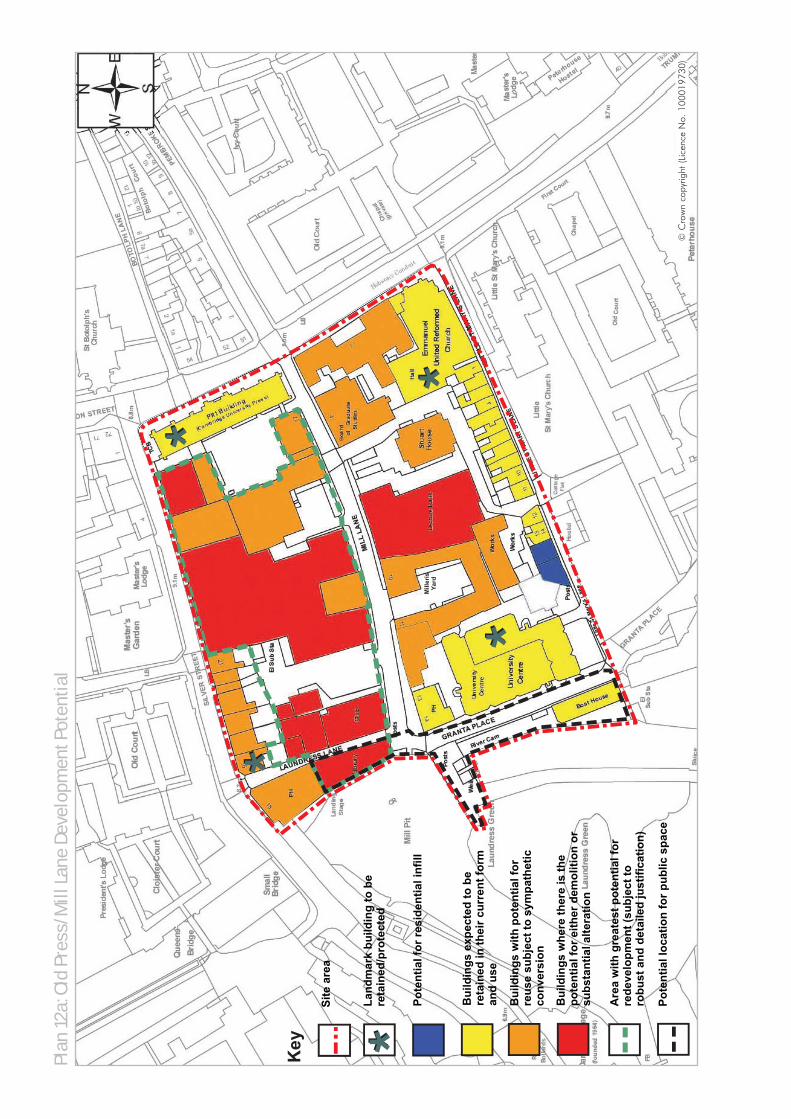
Plan
12a
: Old
Pre
ss/M
ill L
ane
Deve
lopm
ent P
oten
tial
Mill
erís
Ya
rd
* *
* *
* ** *
Pote
ntia
l loc
atio
n fo
r pub
lic s
pace
Bui
ldin
gs w
here
ther
e is
the
pote
ntia
l for
eith
er d
emol
ition
or
subs
tant
ial a
ltera
tion
Are
a w
ith g
reat
est p
oten
tial f
or
rede
velo
pmen
t (su
bjec
t to
robu
st a
nd d
etai
led
just
ifica
tion)
Bui
ldin
gs e
xpec
ted
to b
e re
tain
ed in
thei
r cur
rent
form
an
d us
e
Pote
ntia
l for
resi
dent
ial i
nfill
Bui
ldin
gs w
ith p
oten
tial f
or
reus
e su
bjec
t to
sym
path
etic
co
nver
sion
Key
Land
mar
k bu
ildin
g to
be
reta
ined
/pro
tect
ed
* *Si
te a
rea
© C
row
n co
pyrig
ht (L
icen
ce N
o. 1
0001
9730
)

Plan
12b
: Old
Pre
ss/M
ill L
ane
Pote
ntia
l Pub
lic R
ealm
and
Hig
hway
Impr
ovem
ents
Mill
erís
Ya
rd
4
3
1
2
56
7
Pote
ntia
l loc
atio
n fo
r pub
lic
spac
e
Pote
ntia
l for
offs
ite h
ighw
ay
impr
ovem
ents
*
Indi
cativ
e al
ignm
ent f
or
impr
oved
ped
estr
ian/
cycl
e on
ly
Pote
ntia
l jun
ctio
n im
prov
emen
ts
Key
Mill
Lan
e: s
hare
d su
rfac
e/pu
blic
re
alm
and
ped
estr
ian
and
cycl
e im
prov
emen
ts
Gra
nta
Plac
e: s
hare
d su
rfac
e/im
prov
ed p
ublic
real
m a
nd
cycl
e an
d pe
dest
rian
acce
ssLi
ttle
St. M
ary’
s La
ne: p
ublic
real
m,
pede
stria
n an
d cy
cle
acce
ss
Enha
ncem
ent o
f for
mer
mill
site
Enha
ncem
ent o
f the
set
ting
of
Stua
rt H
ouse
Cre
atio
n of
land
scap
ed c
ourt
yard
Pote
ntia
l for
the
crea
tion
of n
ew
publ
ic/p
rivat
e sp
ace
1 2 3 4 5 6 7
Site
are
a
* Any
hig
hway
impr
ovem
ents
wou
ld n
eed
appr
oval
from
the
Cou
nty
Cou
ncil
as H
ighw
ay A
utho
rity
poss
ibly
as
part
of f
utur
e ph
ases
of C
ambr
idge
Cor
e Tr
affic
Sch
eme
(Lim
ited
serv
ice
vehi
cle
acce
ss)
© C
row
n co
pyrig
ht (L
icen
ce N
o. 1
0001
9730
)

7.1 Policy 3/6 of the Local Plan (EnsuringCoordinated Development) states that thedevelopment of a site or part of a sitewill only be permitted where it can bedemonstrated that due consideration hasbeen given to safeguarding appropriatefuture developments on the remainder ofthe site or adjacent sites. It is felt that awell prepared, clear and informedMasterplan for proposed and futuredevelopment of the Old Press/Mill Lanesite is vital in ensuring coordinateddevelopment.
7.2 The purpose of the Masterplan is to adddetail and provide the basis for thedetermination of future planningapplications for this site and the phasingof development. The Masterplan wouldbe secured through a Section 106agreement. This approach has beentaken on a number of other sites in thecity, such as the University ofCambridge's West Cambridge site andNIAB site, where Masterplans weresubmitted with planning applications.
7.3 The Masterplan for the whole site will besubmitted with the first significantredevelopment proposal and willconsider the whole area covered by theSPD. This Masterplan will be tied to thefirst significant application, but will alsobe applied to other applications withinthe site boundary of the SPD. The firstsignificant application is categorised asthe first application, which will materiallyaffect the character of the ConservationArea. This will require discussion with theCity Council.
7.4 Prior to its submission to the CityCouncil, the Masterplan should be the
subject of extensive consultation withstakeholders and residents.
7.5 Development proposals are unlikely to bedelivered simultaneously for the entireOld Press/Mill Lane site as a result of thetiming of the relocation of University usesto other sites and the challenges ofdeveloping a constrained City Centresite. The availability of different parts ofthe site will be a principal factor that willdictate the phasing of development. Inorder to progress the different parts ofthe site and their different scales ofredevelopment and refurbishment, it isconsidered that the phasing strategywithin the Masterplan should sub-dividethe site into discrete parcels. Thoseparcels will consist of areas wheredevelopment is likely to come forward atthe same time. The relationship betweenthe parcels is vital in achieving goodco-ordination of development and a highquality environment. One area, whichcould form a parcel is the entire streetblock enclosed by Mill Lane, the river,Silver Street and Trumpington Street. TheSPD identifies this area as the locationwith the greatest potential forredevelopment, subject to robust anddetailed justification.
7.6 The University is currently working on itsEstate Implementation Plan, theoutcomes of which will feed into thedevelopment of the Old Press/Mill Lanesite. The phasing strategy within theMasterplan should be prepared insufficient detail to meet the requirementsof Policy 3/6 of the Local Plan and allowdetailed planning applications to comeforward on individual sites on a phasedbasis, forming part of a more
7. Masterplanning and Phasing
OLD PRESS/MILL LANE SPD MASTERPLANNING AND PHASING
48

MASTERPLANNING AND PHASING OLD PRESS/MILL LANE SPD
49
comprehensive strategy for the whole siteand making an appropriate contributionto the wider objectives of the SPDincluding improvements to public realmand accessibility.
7.7 All applications should be accompaniedby a Design and Access Statement, whichwill state how the proposal relates andcontributes to the vision and objectivesset out in the SPD, the wider Masterplanand the opportunities and constraints thatthe site presents.

8.1 This SPD has been prepared in sufficientdetail to allow full and detailed planningapplications to come forward onindividual sites. Outline applications willnot be accepted on this constrained andcomplex site within the CentralConservation Area.
8.2 In the context of the sensitivities of thesite, any planning application shouldinclude the following supportingevidence, where relevant, in accordancewith national and regional planningpolicy and Cambridge's adoptedplanning policy framework. The list belowis not exhaustive as additionalrequirements may arise as a result ofspecific site conditions. Furthermore, inorder to ensure that the level of detailedassessment is relevant to the particularplanning application, applicants shouldenter into pre-application discussionswith the Local Planning Authority andshould refer to any currentdocumentation on local requirementsadopted by Cambridge City Council.
Affordable Housing StatementAir Quality AssessmentBiodiversity/Habitats Survey and ReportCommunity Facilities StatementDesign and Access StatementDisability Access Statement (where adesign and access statement is notrequired)Economic and Business DevelopmentStatementEnvironmental StatementFlood Risk AssessmentFoul Sewage and Utilities AssessmentHeritage Statement includingArchaeological AssessmentLand Contamination Assessment
Landscape StrategyLighting AssessmentNoise Impact AssessmentPhasing/implementationconstruction statementPlanning Obligations Statementincluding Draft Head(s) of TermsPlanning Statement Public Art Statement/indicative StrategyResidential Development StatementSustainability StatementSustainable Drainage Strategy andMaintenance PlanTransport AssessmentTravel PlanTree Survey/Arboricultural SurveyVentilation/ Extraction Statement
8. Planning Requirements
OLD PRESS/MILL LANE SPD PLANNING REQUIREMENTS
50
APPENDIX A OLD PRESS/MILL LANE SPD
Given that this SPD will form part ofCambridge's Local Development Framework(LDF), it is important to provide a summary ofthe statutory framework in which it has beenprepared. This appendix therefore considers thenational, regional and local policies, guidanceand strategies that the document should be ingeneral conformity with and which will be amaterial consideration against which anyapplications may be assessed. This list cannothope to be exhaustive, as other policies mayalso be relevant dependent on the nature offorthcoming development proposals or uponpolicy documents, which emerge after theproduction of this document.
Local Policy
Cambridge Sustainable Community Strategy(2007) This strategy was adopted by the City Councilwith the aims to enhance the environment andimprove the quality of life for people living in,working in and visiting the City. People in theCity should live in sustainable communitiesthat are strong, healthy, active, safe andinclusive.
Cambridge Local Plan (2006) sets out policiesand proposals for future development andland use to 2016. The Local Plan interpretsnational and regional planning policies andrelates them to Cambridge. The Local Planwas subject to a Local Plan Inquiry in 2005and was amended following the receipt of thebinding Inspector's Report in 2006. The keypolicy which relates to this site is Policy 7/5which states:
The further development or redevelopment ofthe University of Cambridge's faculty andadministrative sites in the central area will be
permitted if this allows improved facilities, areduction in parking spaces, improvement toexternal environment and amenity space, andbetter use of land.
On the following sites an element of mixeduse will also be supported in order to enhancethe attractiveness of the public realm:
a – Mill Lane/Old Press site;b – New Museums site.
Where smaller scale properties on the fringesof academic sites become surplus torequirements, for example around the OldAddenbrooke's site, planning permission willalso be granted to enable the return of suchsites to appropriate alternative uses such asresidential uses, retail or community uses.
The other policies in the Local Plan relevant tothis SPD site are set out below:
3/1 Sustainable Development3/3 Safeguarding Environmental Character3/4 Responding to Context3/6 Ensuring Coordinated Development3/7 Creating Successful Places3/8 Open Space and Recreation Provision
Through New Development3/9 Watercourses and Other Bodies of Water3/11 The Design of External Spaces3/12 The Design of New Buildings3/13 Tall Buildings and the Skyline3/14 Extending Buildings3/15 Shopfronts and Signage4/2 Protection of Open Space4/3 Safeguarding Features of Amenity or
Nature Conservation Value4/4 Trees4/6 Protection of Sites of Local Nature
Conservation Importance
Appendix A: Planning Policy Framework
51

4/9 Scheduled AncientMonuments/Archaeological Areas
4/10 Listed Buildings4/11 Conservation Areas4/12 Buildings of Local Interest4/13 Pollution and Amenity4/14 Air Quality Management Areas4/15 Lighting5/1 Housing Provision5/4 Loss of Housing5/5 Meeting Housing Needs5/9 Housing for People with Disabilities5/10 Dwelling Mix5/14 Provision of Community Facilities Through
New Development6/2 New Leisure Facilities6/3 Tourist Accommodation6/4 Visitor Attractions6/6 Change of Use in the City Centre6/8 Convenience Shopping6/10 Food and Drink Outlets7/1 Employment Provision7/2 Selective Management of the Economy7/7 College and University of Cambridge
Staff and Student Housing7/10 Speculative Student Hostel
Accommodation8/1 Spatial Location 8/2 Transport Impact8/3 Mitigating Measures8/4 Walking and Cycling Accessibility8/5 Pedestrian and Cycle Network8/6 Cycle Parking8/8 Land for Public Transport8/9 Commercial Vehicles and Servicing8/10 Off-Street Car Parking8/11 New Roads8/16 Renewable Energy in Major New
Developments8/17 Renewable Energy8/18 Water, Sewerage and Drainage
Infrastructure10/1 Infrastructure Improvements
Cambridge City Council's Local DevelopmentFramework is the overall term for the portfolioof documents that will replace the Local Planand will set out the City Council's policies fordevelopment and land use in the future. As
part of the Local Development Framework theCouncil has prepared a Local DevelopmentScheme. This document specifies whichdocuments the City Council will produce aspart of the development plan for Cambridge,and the timetable for their preparation.
GVA Grimley for Cambridge City Council andSouth Cambridgeshire District Council(October 2008), Cambridge Sub-RRegionRetail StudyThis document assesses the performance ofexisting retail centres and and the quantitativeand qualitative need for new retail(comparison and convenience goods)floorspace up to 2011, 2016 and 2021.
Warwick Business Management Limited forCambridge City Council and SouthCambridgeshire District Council (July 2008),Employment Land ReviewThis document is an employment land review,which provides an evidence base foremployment land policies and allocations forproposed Local Development Frameworkswithin the City and South Cambridgeshire.
Statement of Community Involvement (2007)The City Council wants to actively engage withthe community and have drawn up aConsultation Strategy for Planning inCambridge which:
– Sets out how and when Cambridge CityCouncil will involve the community and keystakeholders in preparing, altering andreviewing its Plans and Guidance to guidefuture development in the City; and– Explains how the City Council will involvethe community in planning applications.
Supplementary Planning DocumentsThe City Council has also prepared thefollowing Supplementary Planning Documents,which will potentially be applicable to thisarea:
Affordable Housing SPDSustainable Design and Construction SPDDraft Planning Obligations Strategy SPD
OLD PRESS/MILL LANE SPD APPENDIX A
52

Public Art SPD
Other relevant local level documents include:
Cycle Parking Guide for NewResidential Development This guidance (2009) for developers givesdetailed guidelines for the provision on highquality residential cycle parking, specifically fornew developments and supplementsCambridge City Council's cycle parkingstandards.
Cambridge Historic Core Appraisal This appraisal (2006) seeks to assess thecharacter of the historic core of the City, toconsider the issues affecting this character andhow the Council can work with landownersand developers to minimise any threat to keyfeatures and enhance weaker areas. Theentirety of the Old Press/Mill Lane site lieswithin the Central Conservation Area.
Cambridge City Nature Conservation Strategy'Enhancing Biodiversity' This document (2006) was prepared by theWildlife Trust for Bedfordshire,Cambridgeshire, Northamptonshire andPeterborough for Cambridge City Council. It isa technical document, which describes thenature conservation situation at the time ofproduction in 2006 and aims to guide futurenature conservation activities across the City.
Cambridge Landscape CharacterAssessment (2003)This assessment indicates areas or featuresimportant to the environment and setting ofCambridge in order to ensure that newdevelopments will take account of existingcharacter and where possible achieveenvironmental or visual improvement.
Southern Corridor Area Transport Plan (2002)Produced by the County and City Councils,the purpose of this document is to identify newtransport infrastructure and service provisionthat is needed to facilitate large-scaledevelopment in the south of Cambridge. In
addition, it also seeks to identify a fair androbust means of calculating how individualdevelopment sites in the area shouldcontribute towards the fulfillment of thattransport infrastructure.
Open Space and Recreation Strategy (2006)This document was adopted by CambridgeCity Council following scrutiny by theEnvironment Scrutiny Committee on 7thNovember 2006. It is a material considerationin the determination of planning applicationsand appeals, supports the policies in the LocalPlan, and will guide the development of AreaAction Plans and Supplementary PlanningDocuments. The Strategy was first adopted inJuly 2004. The majority of that documentrelated to the 1996 Local Plan, but it includedelements to be incorporated in the new LocalPlan. This revised Strategy has been updatedto relate to the 2006 Local Plan.
Planning Obligation Strategy SupplementaryPlanning Guidance (SPG) (2004)The Planning Obligation Strategy SPGremains a material consideration in thedetermination of planning applications andappeals until superseded by the adoption ofthe current draft SPD.
Regional and Sub-RegionalPolicy
The East of England Plan: The Revision to theRegional Spatial Strategy for the East ofEngland (2008)This document sets out the strategy to guideplanning and development in the East ofEngland to the year 2021. It covers economicdevelopment, housing, the environment,transport, waste management, culture, sportand recreation, mineral extraction andimplementation. It aims to improve quality oflife, and sets out proposals, which willinfluence where we choose to work and liveand how we move about the region. It also
APPENDIX A OLD PRESS/MILL LANE SPD
53

seeks to address issues such as socialexclusion, the need for regeneration and theimpact of climate change.
Cambridgeshire and Peterborough StructurePlan (2003) This document sets out the strategicframework for land use planning inCambridgeshire and Peterborough up to2016. Under the 2004 Planning andCompulsory Purchase Act and following theadoption of the East of England Plan: TheRevision to the Regional Spatial Strategy forthe East of England in May 2008, theGovernment Office for the East of England(GO-East) has directed that only certainpolicies in the Plan remain in force. The savedpolicies relevant to this site are P4/4Water-Based Recreation and P6/1Development-related Provision.
Cambridgeshire Local Transport Plan(2006-22011)This Plan sets out how the County Council, thehighway authority for Cambridgeshire, will usethe money allocated by the government fortransport to deliver an improved transportsystem. This will help to meet the government'sShared Priorities for Transport, namelyimproving accessibility, improving air qualityand tackling congestion and safer roads,along with the additional objectives of meetingthe needs of the economy and the County'sgrowing population and maintaining anefficient transport network. The Rights of WayImprovement Plan, a statutory Policy of theHighway Authority, forms part of the LocalTransport Plan.
Cambridgeshire Green InfrastructureStrategy (2006)Cambridgeshire Horizons produced thisdocument to set out a vision for usingplanning development to enhance andexpand the network of large scale greenspaces, protected sites, nature reserves andgreenway linkages.
A Quality Charter for Growth in Cambridge,Cambridgeshire Horizons (2008)The aim of this document is to improve qualitywhile simplifying the development process byestablishing a short set of overridingprinciples.
Cambridgeshire Biodiversity Action Plan (BAP)The 45 Habitat and Species Action Plans forCambridgeshire were first produced in 1999and were completely reviewed in 2003. Thereare over 400 actions and the Steering Groupdecided to prioritise 50 actions for 2004-06.The BAPs were partially monitored in 2002. Acomplete review of all the BAPS nationallytook place in 2005, and many local BAPS arenow monitored in a nationwide database, theBiodiversity Action Reporting System (BARS).There are a number of Habitat and SpeciesAction Plans which may have relevance to theOld Press/Mill Lane Site, particularly thoseplans which covers rivers and streams andbiodiversity in urban areas.
Biodiversity Checklist for Land Use Planners inCambridgeshire & PeterboroughThis checklist (2001) aims to aid strategic anddevelopment control planners whenconsidering biodiversity in relation to theirwork, both in policy development and whendealing with planning proposals. It providesguidance regarding habitat creation andenhancement.
Sustainable Construction in Cambridgeshire– A Good Practice Guide (CambridgeshireCounty Council & Cambridgeshire Horizons,2006)This guide is designed to aid all thoseinvolved in the planning, design andconstruction of new developments withinCambridgeshire. It is one of a range ofdocuments providing guidance on differentaspects of sustainable development. Thepurpose of the guide is to illustrate themanner in which development should beapproached. It is a Good Practice Guide thatseeks to raise the standard of constructionacross the sub-region.
OLD PRESS/MILL LANE SPD APPENDIX A
54

National Planning PolicyAs this document is area-based, rather thanpurely thematic, there are a number ofpotentially relevant Planning Policy Guidancenotes (PPG) and Planning Policy Statements(PPS) dependent on the development schemeinvolved:
PPS 1 Delivering SustainableDevelopment (2005)PPS: Planning and Climate Change– Supplement to PPS 1 (2007)PPG 2 Green Belt (1995)PPS 3 Housing (2006)PPS 6 Planning for Town Centres (2005)PPS 9 Biodiversity and GeologicalConservation (2005)PPS 12 Local Spatial Planning (2008)PPG 13 Transport (2001) PPG 15 Planning and the HistoricEnvironment (1994)PPG 16 Archaeology and planning (1990)PPS 22 Renewable Energy (2004) PPS 23 Planning and PollutionControl (2004)PPS 25 Development and Flood Risk (2006) PPS 25 Development and Flood Risk– Practice Guide (2008)
In addition to the advice contained in PPGsand PPSs, this SPD pays close regard to theadvice and guidance on achieving highquality design in the built environmentcontained in the following publications:
The Urban Design Compendium (Volumes1 and 2), (English Partnerships, 2007)By Design – Urban Design in the PlanningSystem: Towards Better Practice,(CABE, 2000)Building in Context: New Development inHistoric Areas (English Heritage and CABE,2001)White Paper – Heritage Protection for the21st Century, (DCMS, 2007)Regeneration and the Historic Environment– Heritage as a catalyst for better social andeconomic regeneration, (English Heritage,2005
Heritage Works: The use of historicbuildings in regeneration (English Heritage,the British Property Federation, the RoyalInstitution of Chartered Surveyors andDrivers Jonas, 2006) Manual for Streets (Department forTransport, 2007)Investing in Heritage: A Guide to SuccessfulUrban Regeneration (European Associationof Historic Towns and Regions, 2007)
Regard has also to be had to British StandardBS7913: 1998 (Guide to the Principles of theConservation of Historic Buildings). This guideprovides general background information,advice and guidance on the principles of theconservation of historic buildings. It also givesinformation on the settings of buildings andstructures, their interiors and associatedcontents, fixtures and fittings and the design ofnew work in the context of historic buildings.
APPENDIX A OLD PRESS/MILL LANE SPD
55

OLD PRESS/MILL LANE SPD APPENDIX B
56
Habitat Regulations Assessment ScreeningReport for the Old Press/Mill Lane SPD,Cambridge City Council, February 2009;Old Press/Mill Lane SPD Site OptionAppraisal Summary Report,Cambridge City Council and the University ofCambridge, February 2009;Sustainability Appraisal ScopingReport Addendum,Cambridge City Council, November 2008;Mill Lane and Old Press Site HistoricEnvironment Analysis,Beacon Planning, October 2008;Old Press/Mill Lane Site 2ndStakeholder Workshop,24 July 2008 Summary Report,University of Cambridge;Old Press/Mill Lane Development Site KeyIssues Report – Environment,Peter Brett Associated LLP, July 2008;Old Press/Mill Lane Development Framework,Baseline Transport Conditions Report,Peter Brett Associates LLP, May 2008;Old Press/Mill Lane Site 1stStakeholder Workshop,24 January 2008 Summary Report,University of Cambridge;Old Press/Mill Lane Site Analysis Document,Sheppard Robson, January 2008;Cambridge Historic Core ConservationArea Appraisal,Cambridge City Council, 2006;Cambridge Local Plan,Cambridge City Council, 2006.
All of the documents referenced above areavailable on the City Council's website atwww.cambridge.gov.uk
Appendix B:List of Background Documents
GLOSSARY OLD PRESS/MILL LANE SPD
57
Active FrontagesThis term implies a relationship between theground-floor uses of the buildings that frame astreet or a space and the people walking throughor using the site. An active frontage is one thatallows some kind of movement or visualrelationship between the person outside and theactivity inside. At a minimal level, this interactionmight be one of simple observation such as awindow display or people working. Even inhousing development, it is possible to createmore active frontages by positioning front doorsand windows in frontages, allowing glimpses ofthe interior to be viewed without invasion ofprivacy and ensuring that people find thebuilding's purpose and layout easy to understand.At a higher level of interaction, the pedestriancould be encouraged to enter the unit to buysomething or participate in an activity. The mostinteractive frontages are usually those of cafés,bars or shops, which spill out onto thestreetscene.
Affordable HousingAffordable housing includes social rented andintermediate housing, provided to specifiedeligible households whose needs are not met bythe market. Affordable housing should:– Meet the needs of eligible households includingavailability at a cost low enough for them toafford, determined with regard to local incomesand local house prices.– Include provision for the home to remain at anaffordable price for future eligible households or,if these restrictions are lifted, for the subsidy to berecycled for alternative affordable housingprovision.
Social rented housing is:'Rented housing owned and managed by localauthorities and registered social landlords, forwhich guideline target rents are determinedthrough the national rent regime. It may also
include rented housing owned or managed byother persons and provided under equivalentrental arrangements to the above, as agreed withthe local authority or with the HousingCorporation as a condition of grant.'
Intermediate affordable housing is:'Housing at prices and rents above those ofsocial rent, but below market price or rents, andwhich meet the criteria set out above. These caninclude shared equity products (e.g. HomeBuy),other low cost homes for sale and intermediaterent.' The definition does not exclude homesprovided by private sector bodies or providedwithout grant funding. Where such homes meetthe definition above, they may be considered, forplanning purposes, as affordable housing.Whereas, those homes that do not meet thedefinition, for example, 'low cost market' housing,may not be considered, for planning purposes,as affordable housing.
Backs or The BacksThe Backs is an iconic landscape of collegegardens and open spaces that runs from Queens'College in the south to St John's College in thenorth, bounded by Queens' Road to the west andthe rear of the Colleges to the east. The currentlandscape is the result of over 400 years ofdevelopment. Historically, much of the land wasused by the Colleges for functional purposessuch as grazing livestock or growing fruit, withthe River Cam functioning as an importantcommercial route. In later centuries, thelandscape has evolved into a series of 'backgardens' for the Colleges as well as a landscapesetting for the buildings and is a unique part ofthe Cambridge townscape.
BiodiversityEncompasses all aspects of biological diversity,especially including species richness, ecosystemcomplexity and genetic variation.
Glossary11
11 Note: The information in this Glossary is an informal, non-ttechnical explanation of some terms and phrases used in the Supplementary Planning Document.
Biodiversity Action Plan (BAP)A plan that sets objectives and measurabletargets for the conservation of biodiversity.
Buildings of Local InterestBuildings of Local Interest are not subject tostatutory protection, but are recognised as beingof importance to the locality or the City'shistorical and architectural development.
BREEAMBuilding Research Establishment EnvironmentalAssessment Method
One of the assessment methods, 'BREEAMBuildings' can be used to gauge theenvironmental performance of any type of new orexisting building. On this site, however, it is likelythat this assessment is more likely to be used fornon-residential buildings. The Code forSustainable Homes will be used for the residentialcomponent of development.
In terms of BREEAM, buildings are rated on ascale of pass, good, very good, excellent oroutstanding with regards to a range of set criteriaincluding water conservation, materials andenergy performance.
The University of Cambridge has a target for allof its buildings over 1,000 square metres toachieve a BREEAM rating of excellent with aminimum rating of very good. It should be noted,however, that the Government is currently in theprocess of developing a new methodology for theassessment of newnon-residential development that will setprogressive targets towards the achievement ofzero carbon development, similar to that of theCode for Sustainable Homes.
Brownfield landPreviously developed land (PDL), which is or wasoccupied by a permanent structure (excludingagricultural or forestry buildings), and associatedwith fixed surface infrastructure. The definitioncovers the curtilage of development. Previouslydeveloped land can occur in both urban andrural settings.
Cambridge Core Traffic SchemeThe Cambridge Core Traffic Scheme is an urbantraffic management scheme that combines anumber of physical demand managementmethods, such as rising bollards, with othermeasures that incentivise walking and cycling,such as the pedestrianisation of the city'sshopping streets. Public transport is alsoprioritised for access to the area. The aim of thescheme is to reduce the level of traffic using theroads within the city centre, which has resulted inimproved safety and amenity, and thereforemade the area more appealing to pedestriansand cyclists.
Cambridge Local Plan 2006The Cambridge Local Plan 2006 sets out policiesand proposals for future development and landuse to 2016; the Plan will be a materialconsideration when determining planningapplications.
Cambridgeshire HistoricEnvironment RecordThe Cambridgeshire Historic Environment Recordis a comprehensive source of information onarchaeological sites and finds in the moderncounty of Cambridgeshire. Formerly known asthe Cambridgeshire Sites and MonumentsRecord, it is being expanded to includeinformation relating to all aspects of the historicenvironment.
Cambridgeshire & PeterboroughStructure PlanStatutory plan that sets out broad developmentrequirements in the County to 2016 (prepared bythe County Council). This Plan has been partiallysuperseded by the Regional Spatial Strategy.
City CentreHistoric Core and Fitzroy/Burleigh Streetshopping areas in Cambridge. These areasprovide a range of facilities and services, whichfulfil a function as a focus for both the communityand for public transport. See also CambridgeProposals Map (February 2008).
OLD PRESS/MILL LANE SPD GLOSSARY
58

Code for Sustainable HomesThe Code for Sustainable Homes measures thesustainability of a new home against categoriesof sustainable design, rating the 'whole home' asa complete package.
With regards to any residential development onthe Old Press/Mill Lane site, the Code forSustainable Homes12 came into force in Englandin April 2007. The Code has a scoring system ofsix levels and is assessed against nine criteriaincluding energy and CO2 emissions, water,materials, ecology and health and wellbeing. TheCode forms part of the Government's plans forall new homes to be built to zero carbonstandards by 2016 through a step-by-steptightening of the Building Regulations.
While the Code is currently only mandatory forpublicly funded developments, the City Councilwould wish to see the highest possible level of theCode implemented for any residentialdevelopment on the Old Press/Mill Lane site,bearing in mind technical and financial viability,in line with objective C of this SPD (see Section5.2).
CollegesColleges constituting part of CambridgeUniversity. Each is an independent corporatebody with its own governance, property andfinance. There are 31 such Colleges. TheColleges appoint their staff and are responsiblefor selecting students, in accordance withUniversity regulations. The teaching ofundergraduates is shared between the Collegesand University departments. Degrees areawarded by the University. Academic staff, insome cases, hold dual appointments, one withthe University and one with a College.
Community facilitiesFacilities, which help meet the varied needs of theresidents of Cambridge for health, educationaland public services as well as social, cultural andreligious activities. For the purposes of the LocalPlan, community facilities are defined as usesfalling within Class D1 "Non residentialinstitutions" of the Use Class Order with the
exception of university teaching accommodation.In addition, the following subcategories of ClassC2 "Residential Institutions" are considered to becommunity facilities: hospitals, residentialschools, colleges or training centres.
Conservation AreaAreas identified, which have special architecturalor historic interest, worthy of protection andenhancement
Embodied EnergyEmbodied energy refers to the quantity of energyrequired to extract or manufacture the rawmaterials; supply to the point of use, a product,material or service, and retain that product withina building throughout its lifetime. This is knownas embodied energy from 'cradle to grave.'
Green BeltA statutory designation made for the purposes ofchecking the unrestricted sprawl of large built-upareas, preventing neighbouring communitiesfrom merging into each other, assisting insafeguarding the countryside from encroachment,preserving the setting and special character ofhistoric towns and assisting in urban regenerationby encouraging the recycling of derelict andother urban land.
Habitats Regulations AssessmentAn assessment of the potential effects of aproposed plan in combination with other plans orprojects on one or more European sites, SpecialAreas of Conservation, Special Protection Areasand RAMSAR sites). Required by the HabitatsDirective 92/43/EEC, this assessment must becarried out for all local development documents,including SPDs, and approved by NaturalEngland prior to the adoption of the document inquestion.
InfrastructureBasic structure of systems such as utilities (gas,electricity, water) drainage, flood defences,transportation, roads, healthcare, education andother community facilities.
GLOSSARY OLD PRESS/MILL LANE SPD
5912 More detail on the Code for Sustainable Homes can be found on the Planning Portal website www.planningportal.gov.uk

Listed BuildingA building or structure of special architectural orhistoric interest and included in a list, approvedby the Secretary of State. The owner must getListed Building Consent to carry out alterationsthat would affect its character or its setting.
Local Biodiversity Action Plan (LBAP)The Action Plan works on the basis of partnershipto identify local priorities and to determine thecontribution they can make to the delivery of thenational Species and Habitat Action Plan targets.The Local Biodiversity Action Plan has beenprepared by Biodiversity Cambridgeshire (contactvia Cambridgeshire County Council) 1999.
Local Development Framework (LDF)A Local Development Framework is a folder oflocal development documents that outlines howplanning will be managed in your area. A LocalDevelopment Framework must include a CoreStrategy and a Proposals Map. It may alsocontain additional optional developmentdocuments such as Area Action Plans. These areclassed as DPDs and outline the key developmentgoals of the Local Development Framework.Supplementary Planning Documents (SPDs) formpart of the Local Development Framework.
Local PlanAbbreviation used to describe the statutory planadopted by the City Council. It is a materialconsideration in determining planningapplications, which should be in accordance withthem as part of the Development Plan.
Major DevelopmentDefined as:Residential development: the erection of 10 ormore dwellings or, if this is not known, where thesite are is 0.5 hectares or more; orOther development: where the floor area to becreated is 1,000m2 or more, or the site area is 1hectare or more.
MitigationThe purpose of mitigation is to avoid, reduce andwhere possible remedy or offset any significantnegative (adverse) effects on the environment etcarising from the proposed development.
Mixed use developmentDevelopment comprising two or more uses aspart of the same scheme This could apply at avariety of scales from individual buildings, to astreet, to a new neighbourhood or urbanextension. Mixed use development can helpcreate vitality and diversity and can help toreduce the need to travel, which is moresustainable.
Natural or Semi-natural GreenspaceNatural or semi-natural greenspace includeswoodland, scrub, grassland such as commonsand meadows, wetlands, open and runningwater, wastelands and derelict open land androck areas (e.g. cliffs, quarries and pits) – allactively managed by humans in order tomaintain native wildlife and sustain humanbeings. In other words these are managedenvironments including 'encapsulated countrysidewithin the formally designated public openspaces' and elsewhere (ref. English Nature– Accessible natural greenspace in towns andcities).
Open SpaceIncludes all open space of public value. There isa broad range of spaces that may be of publicvalue – not just land but also areas of water suchas rivers and lakes – and includes, parks andgardens; natural and semi-natural urbangreenspaces; green corridors; outdoor sportsfacilities; amenity greenspace; teenager's andchildren's play areas; allotments and communitygardens; cemeteries and churchyards; accessiblecountryside in urban fringe areas and civicspaces.
Open Space StandardsThe amount of open space required in alldevelopments either on site or throughcommuted payments.
OLD PRESS/MILL LANE SPD GLOSSARY
60
Parking StandardsDocument setting out maximum permissible levelsof car parking for various use-classes, along withminimum levels of cycle parking.
PermeabilityPermeability describes the degree to which urbanforms, buildings, places and spaces permit orrestrict the movement of people or vehicles indifferent directions. Permeability is generallyconsidered a positive attribute of urban design,as it permits ease of movement by differenttransport methods and avoids severingneighbourhoods. Areas which lack permeability,e.g. those severed by arterial roads or the layoutof streets in cul-de-sac form, are considered todiscourage effective movement on foot andencourage longer journeys by car.
Planning ConditionRequirement attached to a planning permission.It may control how the development is carriedout, or the way it is used in the future. It mayrequire further information to be provided to theLocal Planning Authority before or during theconstruction.
Planning ObligationA binding legal agreement requiring a developeror landowner to provide or contribute towardsfacilities, infrastructure or other measures, inorder for planning permission to be granted.Planning Obligations are normally secured underSection 106 of the Town & Country Planning Act1990.
Planning Policy Guidance Note (PPG)The guidance is issued on a range of planningissues by the (former) Department of theEnvironment; Department of the Environment,Transport and the Regions; Department ofTransport, Local Government and the Regions;the Office of the Deputy Prime Minister and theDepartment for Communities and LocalGovernment.
Planning Policy Statement (PPS)The new versions of PPGs issued by the Office ofthe Deputy Prime Minister and its successor, theDepartment for Communities and LocalGovernment.
Public ArtPublicly sited works of art, which make animportant contribution to the character and visualquality of the area and are accessible to thepublic. Details as per adopted Public Art SPGand any successor document.
Registered Social Landlord (RSL)An organisation registered by the HousingCorporation to provide affordable housing.
Renewable EnergyRenewable energy covers those energy flows thatoccur naturally and repeatedly in the environment– from the wind, the fall of water, the movementof the oceans, from the sun and from biomass.
Section 106See Planning Obligation.
Setting of the CityThe interface between the urban edge and thecountryside.
StreetscapeThe overall character, design quality, andparticular physical elements which are formed bya combination of building facades, signage,paving, street furniture (seats, bins, cycle racksetc), lighting and trees and other plantings aswell as other elements along a street. The qualityof these elements and the degree to which theycomplement each other determine the quality ofthe streetscape.
Supplementary Planning Guidance (SPG)/Supplementary Planning Document (SPD)Supplementary Planning Guidance is replaced bySupplementary Planning Documents under thenew development plans legislation. SPDs adddetail to policies laid out in development plandocuments, or a saved policy in an existing
GLOSSARY OLD PRESS/MILL LANE SPD
61

development plan. These may take the form ofdesign guides, area development briefs, a masterplan or issue-based documents. Thesedocuments can use illustrations, text and practicalexamples to expand on how the authority'spolicies can be taken forward.
Local authorities must involve the community inthe preparation of SPDs. They are also subject toa Sustainability Appraisal to ensure economic,environmental and social effects of the plan arein line with sustainable development targets.
SPG/SPD may be taken into account as amaterial consideration in making planningdecisions such as determining planningapplications.
Sustainability Appraisal (SA)An appraisal against sustainability criteria ofproposals.
Sustainable Community StrategyA strategy for promoting the economic,environmental and social wellbeing of an areaand contributing to the achievement of City anddistrict-wide sustainable development. Preparedby the Local Strategic Partnerships for CambridgeCity and South Cambridgeshire.
Sustainable DevelopmentSustainable Development is a very broad termthat encompasses many different aspects andissues from the global to local levels. Overallsustainable development can be described as'Development, which meets the needs of thepresent without compromising the ability for thefuture generations to meet their own needs' (afterthe 1987 Report of the World Commission onEnvironment and Development – the BrundtlandCommission).
Sustainable Drainage Systems (SuDS)Development normally reduces the amount ofwater that can infiltrate into the ground andincreases surface water run-off due to theamount of hard surfacing used. Sustainabledrainage systems control surface water run off bymimicking natural drainage process through the
use of surface water storage areas, flow limitingdevices and the use of infiltration areas orsoakaways etc.
Transport Assessment (TA)The Assessment [or Consideration] of thepotential transport impacts of a proposeddevelopment, with an agreed plan to reduce ormitigate any adverse consequences and whereappropriate establish how more sustainablemodes of travel can be increased.
Travel PlanPackage of measures tailored to a particular site,aimed at promoting more sustainable travelchoices (such as walking, cycling, publictransport) and reducing car use. It may includeinitiatives such as car sharing schemes, provisionof cycle facilities, improved bus services, andrestricting or charging for car parking.
University of CambridgeThe University of Cambridge is a common lawcorporation. It is a loose confederation offaculties, Colleges and other bodies. TheUniversity works with a relatively small centraladministration and with central governing andsupervisory bodies consisting of and mainlyelected by, the current academic personnel of thefaculties and Colleges. There are over 100departments, faculties and schools in which theacademic and other staff of the University provideformal teaching (lectures, seminars and practicalclasses) and carry out research and scholarships.In relation to land and property, the University isdistinct from the 31 colleges.
Use Class The Town and Country Planning (Use Classes)Order 1987 (as amended) established UseClasses, which is a system for classifying uses ofland.
Use Class A1Shops where the sale, display or service is tovisiting members of the public
OLD PRESS/MILL LANE SPD GLOSSARY
62

Use Class A2Financial and professional services where theservices are provided principally to visitingmembers of the public (banks, estate agents).
Use Class A3Restaurants & cafés – places where the primarypurpose is the sale and consumption of food andlight refreshment on the premises.
Use Class A4Public houses, wine bars or other drinkingestablishments – premises where the primarypurpose is the sale and consumption of alcoholicdrinks on the premises.
Use Class A5Take-aways – premises where the primarypurpose is the sale of hot food to take-away.
Use Class B1(a)An office other than within class A2 (financial andprofessional services).
Use Class B1(b)Research and development of products orprocesses.
Use Class B1(c)Any industrial process that can be carried out inany residential area without detriment to theamenity of that area.
GLOSSARY OLD PRESS/MILL LANE SPD
63