oklahoma department of transportation … from: subject: oklahoma department of transportation 200...
TRANSCRIPT
To: From: Subject:
OKLAHOMA DEPARTMENT of TRANSPORTATION 200 N.E. 21st Street Oklahoma City, OK 73105-3204
Tim Tegeler, Roadway Design Engineer Materials Division I Geotechnical Branch
Report No: 52181 January 30, 2012
Geotechnical Investigation, Project No. STPY-145C(l50), State Job No. 24184(04), McCurtain County
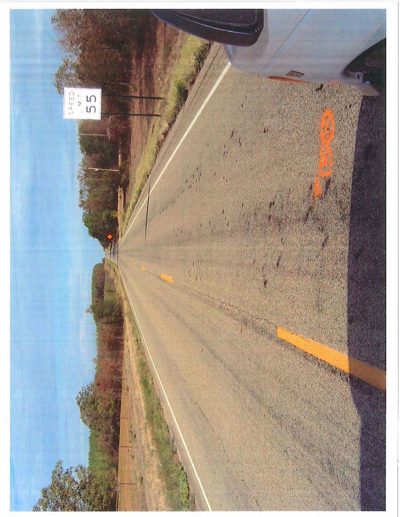
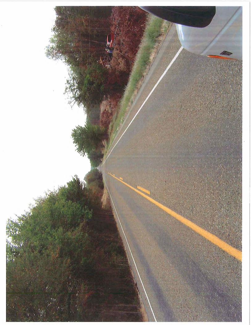
The geotechnical investigation as requested by your letter dated February 17, 20011 has been completed. The job is located on SH-3 from 10.54 miles east of Pushmataha C/L extending east 5.67 miles. This project calls for Bridge and Approach improvements over Horse Head Creek and adding Shoulders to the existing alignment, sees landscape view over Horse Head Creek in Appendix A. The work requested is for the following soil surveys and other information as indicated: pedological and geological soil survey including all resilient modulus data (Station: 606+30 to 610+85), shrinkage/expansion factors for excavation, shoulder survey including all resilient modulus data (Station: 480+06 to 606+30 and 610+85 to 779+20), pavement surface condition, falling weight deflectometer survey (FWD) includes (the resilient modulus, elastic modulus of composite pavement structure, and thickness and condition of existing pavement layers), problem soils (dispersive clays, soft stone, shrink/swell potential, and sulfates), and recommended additive (lime I portland cement I fly ash). An addendum will be done for the cutsection investigation at a later time.
Geologic Statement According to the Oklahoma Department of Transportation Engineering Classification of Geologic Materials Division Two, there are a total of five geologic fo1mations underlying the entire span of the project and they are as follows: Stanley Unit (PMs), Tuff Beds Subunit (tt), Arkansas Novaculite Unit (MDSa), Bigfork-Polk Creek Unit (Op), and Womble Unit (Ow). The Stanley Unit is predominantly composed of dark gray to green gray shale, but soft to moderately hard, green gray sandstone makes up about 25% of the total thickness, while siltstone occurs in subordinate amounts. The Tuff Beds Subunit consists of a massive, hard, tuffaceous bed which is composed of cemented volcanic ash and sandstone. It is usually gray in color, flecked or mottled with green blotches, and has a highly variable texture. The total thickness of the subunit varies from 90 to 228 feet. The Arkansas Novaculite Unit consists dominantly of novaculite with minor amounts of shale. It consists of three lithologic divisions: a lower one with almost entirely massive white to black novaculite; a middle one, consisting mainly of dense dark gray to black novaculite beds interbedded with black to brown fissile shales; and an upper one, consisting chiefly of massive, highly calcareous bluish-black novaculite; plus an overlying blue
•The mission of the Oklahoma Department of Transportation is to provide a safe, economical, and effective transportation network for the people, commerce and communities of Oklahoma"
AN EQUA L OPPORTUNITY EMPLOYER

to black slate or shale. The unit is about 950 feet thick in McCmiain County. The Bigfork Unit consists of many hard, black chert beds 4 inches to 2 feet thickness, interbedded with thin coalblack shales. The total thickness is estimated to be about 800 feet. The Pork Creek Unit overlies the Bigfork unit and consists of soft to hard coal-black slates and shales. The unit varies in thickness from 100 to 200 feet. The Womble Unit consists dominantly of black fissile shale with some interbedded tan to brown siltstone. The unit also includes some prominent beds of dark gray to blue, siliceous limestone and quartzite bronze sandstone which attains a thickness of 15 feet. The total thickness of the unit varies from 150 feet to an estimated 700 feet.
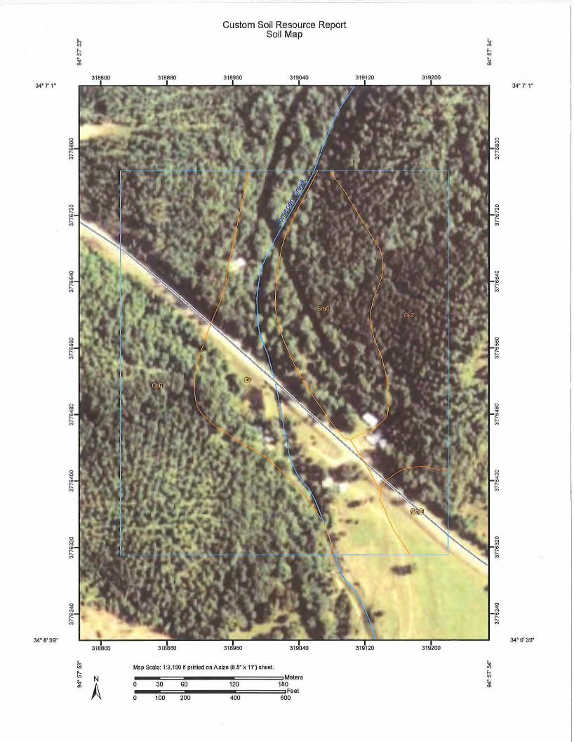
Pedological and Geological Soil Survey According to the USDA Natural Resources Conservation Service Web Soil Survey program, there are seven soil series Ceda - Rubble Laud Complex (Map Unit: Cr), Clebit - Carnasaw - Stapp Association (Map Unit: GsE), and Sherwood - Zafra (Map Unit: SmC) mapped within the specified pedological survey extents, see Web Soil Survey in Appendix A. The NRCS Otftcial Series Description was used to model the soil series profile depths and descriptions in the sampling process, see Pedological and Geological Soil Survey in Appendix B. Only the following three soil series were found within the pedological survey extents: Ceda, Clebit, and Zafra.
Series Description The Ceda series consists of very deep, dark grayish to yellowish brown gravelly loam
soils that formed in recent water deposited sediments. Fragments of quartz, sandstone, and shale make up about 30 to 67 percent by volume. These nearly level to very gently sloping soils are located mainly on the floodplains of Horse Head Creek. Slopes range from 0 to 3 percent.
The Clebit series consists of shallow, brown to dark grayish brown gravelly loam soils that formed in material weathered from sandstone. Fragments of sandstone make up 40 percent by volume. These very gently sloping to steep soils are located on the tops and side slopes of forested uplands. Slopes can range anywhere from 2 to 20 percent.
The Zafra series consists of moderately deep, dark grayish brown to yellowish red gravelly loam soils that formed in sediments that weathered from interbedded sandstone and shale. Fragments of hard to soft sandstone make up about 5 to 60 percent by volume. These nearly level to moderately steep sloping soils are located on the side slopes and tops of forested uplands. Slopes range from 1 to 20 percent.
Subsurface Description The Ceda series are soils that have little to no evidence of the development of pedogenic
horizons other than an ochric epipedon. The ochric epipedon includes the A horizon from the surface to a depth of 9 inches. Ochric means that the surface horizon contains less than 0.6 percent organic carbon, or is hard to very hard and massive. Based on its soil taxonomy, the series has an udic moisture regime which indicates the soils moisture regime as not being dry in any part of its control section for 90 cumulative days in most years. The soil has both depth to water table and depth to restrictive feature of more than 80 inches.
"The mission of the Oklahoma Department of Transportation is to provide a safe, economical, and effective transpottalion network for the people, commerce and communities of Oklahoma"
AN EQUAL OPPORTUNITY EMPLOYER
The Clebit soil series includes an ochric epipedon, a cambic horizon, and an udic soil moisture regime. The ochric epipedon includes the surface horizon of A from 0 to 5 inches. Ochric has been described above in the Ceda soil series. The cambic horizon includes the sub horizon ofBw from 5 to 12 inches. Cambic refers to a sub soil horizon of very fine sand texture with some weak indication of alteration in color from the pedogenic processes. The udic moisture regime has been described above in the Ceda soil series. The soil has a depth to restrictive feature (hard gray sandstone bedrock, fractured) of I 0 to 20 inches.
The Zafra soil series includes the following diagnostic horizons: an argillic horizon and an udic soil moisture regime. The argillic horizon includes the zone between I 0 to 3 8 inches (BE, Bt I, and Bt2 horizons). Argillic means that a significantly higher percentage of silicate clay has formed in the sub horizons by illuviation of the overlying soil material. The udic moisture regime has been described above in the Ceda soil series. The soil has a restrictive feature (hard sandstone interbedded with soft sandstone and lenses of shale) includes R horizon and occurs at a depth that can range anywhere from 20 to 56 inches.
Shoulder Survey The survey was conducted around the station extents as specified by the letter of request.
Sixty one borings were drilled to characterize the subsurface materials within the existing alignment. Samples were taken for changes with depth to a depth of 36 inches with a hand auger. Once testing was completed, four shoulder bulks were selected for resilient modulus based on the different soil classifications. All the test results are presented in Appendix E.
Resilient Modulus The resilient modulus testing was completed for the soil series as mentioned above and
the shoulder bulks. There are a total of seven bulk samples (three pedological and four shoulder) for this project, and they are as follows: pedological - Ceda "C" Composite, Clebit "B" Bulk, and Zafra "B" Composite; shoulder - Clayey Gravel w/ Sand (Station: 505+00), Silty Gravel w/ Sand (Station: 611 +00), Sandy Lean Clay (Station: 665+00), and Clayey Sand (755+00). The results are presented in the Resilient Modulus Summary Sheet and Compaction Data Sheets in Appendix C.
Falling Weight Deflectometer Survey The survey was conducted along the specific station extents 480+06 to 779+20. An
observation was made that the pavement is showing some moderate bleeding and has a combination of block and longitudinal cracking in the wheel paths. Ten cores were sampled then to assess the thickness and the type of deficiencies that might be present within the pavement. The FWD was used to estimate the pavement and subgrade modulus. All test data and analyses are presented in Appendix F.
"The mission of the Oklahoma Department of Transportation is to provide a safe, economical, and effective transportation network for the people, commerce and communities of Oklahoma"
AN EQUAL OPPORTUNITY EMPLOYER
Shrinkage I Expansion Factors for Excavation The shrinkage I expansion factors for excavation calculation were done for the same three
pedological soil series as mentioned above in the resilient modulus. The factors are calculated using the following equation: standard compacted dry density divided by bank run in situ dry density. ODOT uses an estimated range of bank run in situ dry density for each Unified Soil Classification soil class. These factors are presented in Appendix D.
Problem Soils 1) There is a significant amount of silty material found along the shoulders. This material is stable when dry; however, ravels and is easily worn away by traffic. 2) The pH and resistivity tests revealed anywhere from slightly to moderate corrosive properties within all the soil series. 3) The Ceda soil series are frequently to occasionally flooded for very brief periods during almost any season. 4) Sandstone bedrock can be encountered somewhere around 10 to 20 inches for the Clebit soil series. Zafra soil series has a depth to bedrock ranging anywhere from 25 to 60 inches. 5) Based on the shoulder survey, a few random samples between the station extents 645+00 to 665+00 showed high shrink-swell potential.
Recommendations Based on the geotechnical findings contained in this report the following assessments are recommended:
1) At this project site, the soluble sulfates reported both in the pedological and shoulder logs are low, so soil stabilization will not be a problem. Class C flyash is the recommended choice if soil stabilization is going to be done, see both Appendix B and C.
2) From the factors, it looks as if shrinkage will control for all the soil series during excavation.
3) All the soil series had slight to moderately corrosive numbers, there is the likelihood for some corrosion to occur. Metal drainage pipes are not recommended to be used for this project, see Pedological and Geological Soil Survey in Appendix B.
4) Based on the series description, all the soil series contain an ochric epipedon. This correlates to not enough organic carbon within their surface horizon depths. Clebit and Zafra can be used if topsoil material is needed.
5) There are two samples (Stations: 645+00 and 660+00) within the shoulder survey that has the potential to cause some shrink-swell problems ifleft in place. It is evident this material needs to be replaced with better soil.
6) All the soil series are recommended for subgrade material, because no issues came up during testing.
7) Based on the FWD data, a new pavement section is recommended for the following station extents: 1005+00 to 1084+50.
<·The mission of the Oklahoma Department of Transportation is to provide a safe, economical, and effective transportation network for the people, commerce and communities of Oklahoma"
AN EQUAL OPPORTUNITY EMPLOYER

This concludes our investigation unless otherwise notified. Sincerely,
Reynolds Toney, P.E. Materials Engineer
Enclosure:
tc: Mohamad Nazarirobati, Engineering Manager Jeff Dean, Pavement Design Engineer Reynolds Toney Materials File Geotechnical Branch Stephen Bettis
"The mission of the Oklahoma Department of Transportation is to provide a safe, economical, and effective transportation network for the people, commerce and communities of Oklahoma"
AN EQUAL OPPORTUNITY EMPLOYER
Appendix A Web Soil Survey
and Landscape view over Horse Head Creek
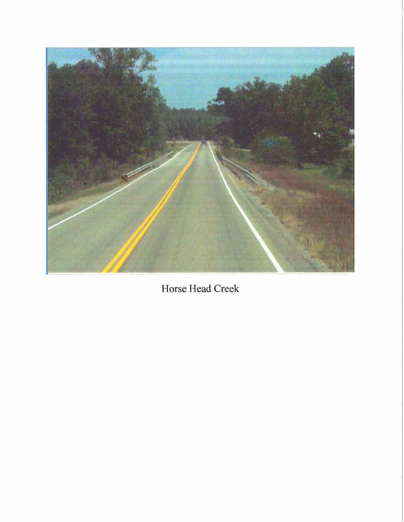
Horse Head Creek
34• 7' 1"
34•5• 39"
N
A
Custom Soil Resource Report Soil Map
318880 318960 319040
Map Scale: 1:3,190 n printed on A size (8.5" x 11") sheet.
---===-------======:JMeters 0 30 60 120 180 ---===------ic::=====Feet 0 100 200 400 600
319120 319200 34• 7' 1"
34• 6'39"
Custom Soil Resource Report
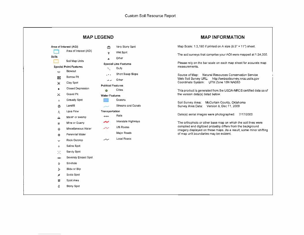
MAP LEGEND
Area of Interest (AOI)
D Area of Interest (AOI}
Soils
D Soil Map Units
Special Point Features
(:,) Blowout
181 Borrow Pit
* Clay Spot
• Closed Depression
x: Gravel Pit
.. Gravelly Spot
@ Landfill
A Lava Flow
~ Marsh or swamp
~ Mine or Quarry
@) Miscellaneous Water
® Perennial Water
v Rock Outcrop
+ Saline Spot
Sandy Spot
- Severely Eroded Spot
0 Sinkhole
9 Slide or Slip
% Sadie Spot
- Spoil Area
.c Stony Spot
Very Stony Spot
Wet Spot
Other
Special Line Features
• ._ Gully
... Short Steep Slope
Other
Political Features
o Cities
Water Features
D Oceans
Streams and Canals
Transportation
+++ Rails
Interstate Highways
US Routes
Major Roads
Local Roads
MAP INFORMATION
Map Scale: 1:3,190 if printed on A size (8.5" x 11 ") sheet.
The soil surveys that comprise your AOI were mapped at 1 :24,000.
Please rely on the bar scale on each map sheet for accurate map measurements.
Source of Map: Natural Resources Conservation Service Web Soil Survey URL: http://websoilsurvey.nrcs.usda.gov Coordinate System: UTM Zone 15N NAD83
This product is generated from the USDA-NRCS certified data as of the version date(s} listed below.
Soil Survey Area: Survey Area Data:
McCurtain County, Oklahoma Version 8, Dec 11, 2009
Date(s) aerial images were photographed: 7/17/2003
The orthophoto or other base map on which the soil lines were compiled and digitized probably differs from the background imagery displayed on these maps. As a result, some minor shifting of map unit boundaries may be evident.
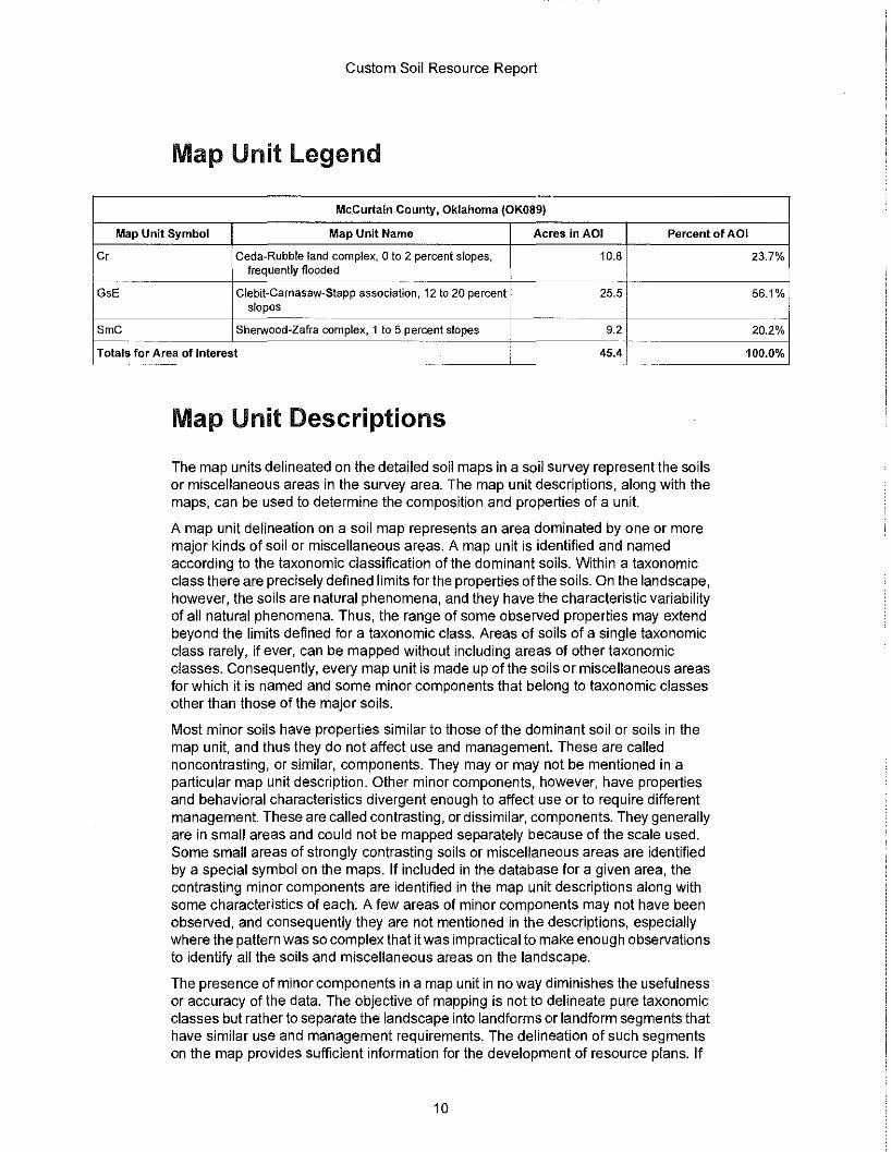
Custom Soil Resource Report
Map Unit legend
McCurtain County, Oklahoma (OK089)
Map Unit Symbol Map Unit Name Acres in AOI Percent of AOI
Cr Ceda-Rubble land complex, 0 to 2 percent slopes, 10.8 frequently flooded
~· . -- ---- ------
GsE Clebit-Carnasaw-Stapp association, 12 to 20 percent 25.5 slopes
SmC Sherwood-Zafra complex, 1 to 5 percent slopes 9.2 -Totals for Area of Interest 45.4 ---
Map Unit Descriptions
The map units delineated on the detailed soil maps in a soil survey represent the soils or miscellaneous areas in the survey area. The map unit descriptions, along with the maps, can be used to determine the composition and properties of a unit.
A map unit delineation on a soil map represents an area dominated by one or more major kinds of soil or miscellaneous areas. A map unit is identified and named according to the taxonomic classification of the dominant soils. Within a taxonomic class there are precisely defined limits forthe properties of the soils. On the landscape, however, the soils are natural phenomena, and they have the characteristic variability of all natural phenomena. Thus, the range of some observed properties may extend beyond the limits defined for a taxonomic class. Areas of soils of a single taxonomic class rarely, if ever, can be mapped without including areas of other taxonomic classes. Consequently, every map unit is made up of the soils or miscellaneous areas for which it is named and some minor components that belong to taxonomic classes other than those of the major soils.
Most minor soils have properties similar to those of the dominant soil or soils in the map unit, and thus they do not affect use and management. These are called noncontrasting, or similar, components. They may or may not be mentioned in a particular map unit description. Other minor components, however, have properties and behavioral characteristics divergent enough to affect use or to require different management. These are called contrasting, or dissimilar, components. They generally are in small areas and could not be mapped separately because of the scale used. Some small areas of strongly contrasting soils or miscellaneous areas are identified by a special symbol on the maps. If included in the database for a given area, the contrasting minor components are identified in the map unit descriptions along with some characteristics of each. A few areas of minor components may not have been observed, and consequently they are not mentioned in the descriptions, especially where the pattern was so complex that it was impractical to make enough observations to identify all the soils and miscellaneous areas on the landscape.
The presence of minor components in a map unit in no way diminishes the usefulness or accuracy of the data. The objective of mapping is not to delineate pure taxonomic classes but rather to separate the landscape into landforms or landform segments that have similar use and management requirements. The delineation of such segments on the map provides sufficient information for the development of resource plans. If
10
23.7%
56.1%
20.2°/o
1 oo.0°1o
AppendixB Pedological and Geological Soil Survey
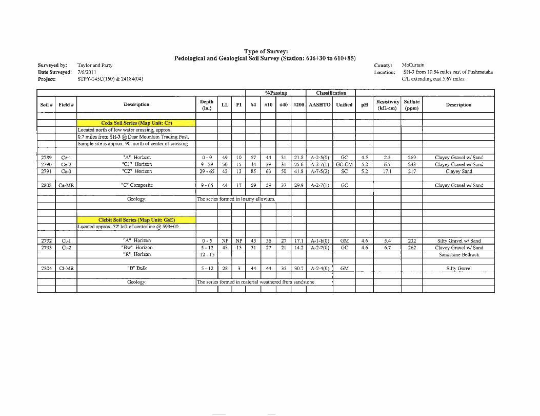
Type of Survey: Pedological and Geological Soil Survey (Station: 606+30 to 610+85)
Surveyed by: Taylor and Party
Date Surveyed: 7/6/2011
Project: STPY-145C(150) & 24184(04)
%Passing Classification
Soil# Field# Description Depth LL Pl #4 #10 #40 #200 AASHTO Unified
(in.)
Ceda Soil Series (Map Unit: Cr)
Located north of low water crossing, approx.
0.7 miles from SH-3 @Dear Mountain Trading Post. Sample site is approx. 90' north of center of crossing
2789 Ce-1 11 A" Horizon 0-9 49 IO 57 44 31 21.8 A-2-5(0) GC
2790 Ce-2 "CJ" Horizon 9 - 29 50 15 44 39 31 25-6 A-2-7(1) GC-CM
2791 Ce-3 "C2" Horizon 29-65 43 13 85 63 50 41.8 A-7-5(2) SC
2803 Ce-MR "C" Composite 9- 65 44 17 59 59 37 29.9 A-2-7(1) GC
Geology: The series formed in loamy alluvium.
Clebit Soil Series (Map Unit: GsE) Located approx. 72' left of centerline @ 593+o0
2792 Cl-l "A" Horizon 0-5 NP NP 43 36 27 17.1 A-1-b(O) GM
2793 Cl-2 11 Bw1• Horizon 5 - 12 43 13 31 27 21 14.2 A-2-7(0) GC
,.R" Horizon 12- 15
2804 Cl-MR "B" Bulk 5 - 12 28 3 44 44 35 30.7 A-2-4(0) GM
Geology: The series formed in material weathered from sandstone.
pH
4.5
5.2
5.2
4.6
4.6
County: McCurtain
Location: SH-3 from I 0.54 miles east of Pushmataha
C/L ex1:ending east 5.67 miles.
Resistivity Sulfate Description
(Jill-cm) (ppm)
2.5 269 Clayey Gravel w/ Sand
6.7 233 Clayey Gravel w/ Sand
17.1 217 Clayey Sand
Clayey Gravel w/ Sand
5.4 232 Silty Gravel w/ Sand
6.7 262 Clayey Gravel w/ Sand
Sandstone Bedrock
Silty Gravel
%Passing Classification
Soil# Field# Description Depth LL PI #4 # 10 #40 #20C AASHTO Unified pH Resistivi'" Sulfate
Description (in.) (kn-cm) (ppm)
Zafra Soil Series (Map Unit: SmC)
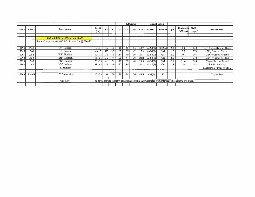
Located approximately 40' left of centerline @ 624+ 71
2795 Za-1 "A" Horizon 0- 4 36 5 76 68 54 33.7 A-2-4(0) SC-SM 5.4 5 .4 240 Silty, Clayey Sand w/ Gravel
2796 Za-2 1'E" Horizon 4 - 10 NP NP 67 57 47 27.9 A-2-4(0) SM 5.5 6.5 274 Silty Sand w/ Gravel
2797 Za-3 "BE" Horizon 10 - 15 32 8 54 40 30 20.J A-2-4(0) GC 5.2 JO.I 361 Clayey Gravel w/ Sand
2798 Za-4 "Btl" Horizon 15 - 26 36 9 60 41 30 22.2 A-2-4(0) GC 5.3 9.9 278 Clayey Gravel w/ Sand
2799 Za-5 "Bt2" Horizon 26- 38 4 1 II 70 52 40 28.8 A-2-4(0) SM 5.4 I 1.6 245 Clayey Sand w/ Gravel
2800 Za-6 "Cr" Horizon 38- 45 48 19 92 86 72 57.1 A-7-6(9) CL 4.8 15.9 341 Sandy Lean Clay "R" Horizon Sandstone Bedrock w/ Shale
2805 Za-MR "B" Composite 10- 38 34 10 98 98 76 49.5 A-4(2) SC Clayey Sand
Geology: The series formed in loamy colluvial sediments that weathered from interbedded sandstone and shale.
Appendix C Resilient Modulus Results
(Pedological and Shoulder Survey)
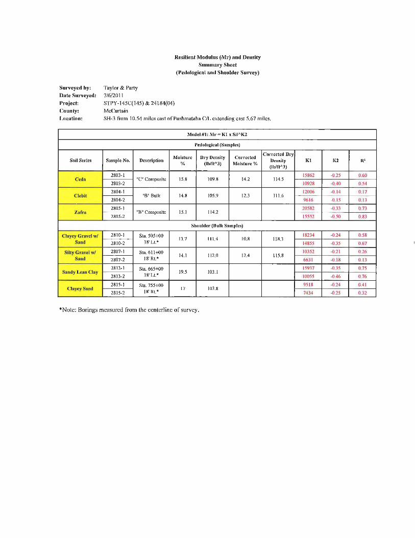
Surveyed by: Taylor & Party
Date Surveyed: 7/6/20 11
Resilient Modulus (Mr) and Density Summary Sheet
(Pedological and Shoulller Survey)
Project: STPY- I 45C( 145) & 24 184(04) County: McCurtain
Location: SH-3 from 10.54 miles cast of Pushmataha C/L extending east 5.67 miles.
Model #1: l\lr = Kl x Sd"K2
Pedological (Sam11Ies)
Moisture Dry Dens ity Cor rected Corrected Dry
Soil Series Sample No. Dcscri(lt ion % (lb/ft" 3) Moisture %
Density (lb/ft" 3)
2803- 1 Ced a "C" Composite 15.8 109.8 14.2 114.5
2803-2
2804-1 Cle bit "B" Bulk 14.8 105.9 12.3 11 1.6
2804-2
2805- 1 Zafra "B" Composite 15. 1 11 4.2
2805-2
Shoulder (Bulk Samples)
Clayey Gravel w/ 28 10- 1 Sta. 505+-00 13.7 111 .4 10 .8 118.3
Sand 2810-2 18' Lt.*
Silty Gravel w/ 2807-1 Sta. 611+00
Sand 18' Rt.* 14. 1 11 2.0 12 .4 11 5.8
2807-2
28 13- 1 Sta 665+-00 Sandy Lean Clay
18' Lt.* 19.5 103.1
2813-2
281 5- 1 Sta. 755+00 Clayey Sand
18' Rt.* 17 103.8
2815-2
*Note: Borings measured from the centerline of survey.
Kl 1(2 R'
15862 -0.25 0.60
10928 -0.40 0 .54
12006 -0. 14 0 .17
96 16 -0.15 0. 13
20582 -0.33 0 .73
15552 -0.50 0.83
18234 -0.24 0.58
14855 -0.35 0.67
10352 -0.21 0.26
663 1 -0.18 0.13
15937 -0.35 0.75
10055 -0.46 0.76
95 18 -0.24 0.4 1
7434 -0.25 0.32

Resilient Modulus Test
NAME: TEST DATE: PROJECT NUMBER : COUNTY NAME : SOIL SERIES : SPECIMEN NUMBER :
1 SOIL PROPERTIES
OPTIMUM MOISTURE CONTENT , MAXIMUM DRY DENSITY, 95%MDD, MAXIMUM WET DENSITY,
2 SPECIMEN PROPERTIES
NET DIAMETER, SAMPLE LENGTH
% (pct) (pct) (pct)
(in)
BEFORE TESTING, (in) AFTER TESTING, (in)
COMPACTION WET WEIGHT, (g) COMP ACTION MOISTURE CONTENT , % MOISTURE CONTENT AFTER Mr TEST , % COMPACTION DRY DENSITY, (pct) COMPACTION WET DENSITY, (pct)
3 TEST INFORMATION
PRE CONDITIONING-PERMANENT STRAIN, TESTING - PERMANENT STRAIN, PERMANENT DEFORMATION, (in)
> 5% > 5%
SILAS 9/12/2011 STPY -145C (150) & 24184 (04) Mc Curtain Ceda Series " C " Composite 2803 - 1
16.8 109.8 104.31 128.25
4.0
9.5 9.50
3927.4 16.8 16.7
107.36 125.39
NO NO
0
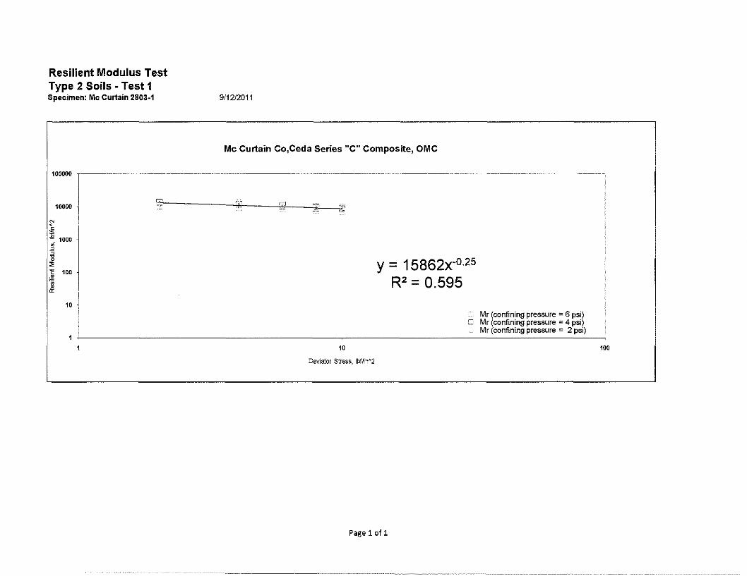
Resilient Modulus Test Type 2 Soils - Test 1 Specimen: Mc Curtain 2803-1 9/1212011
Mc Curtain Co,Ceda Series "C" Composite, OMC
100000 ,------------------------------------------ ----------------- ------------------------------------- --------------------- ---- ----
10000
N
~ 1000 • -" -§
" ~ 100
~ 0:
i 10 ~
10
Deviator Stress, !bffln"'2
y = 15862x-0·25
R2 = 0.595
Mr (confining pressure = 6 psi) O Mr (confining pressure = 4 psi)
Mr (confining pressure = 2 psi)
Page1of1
100
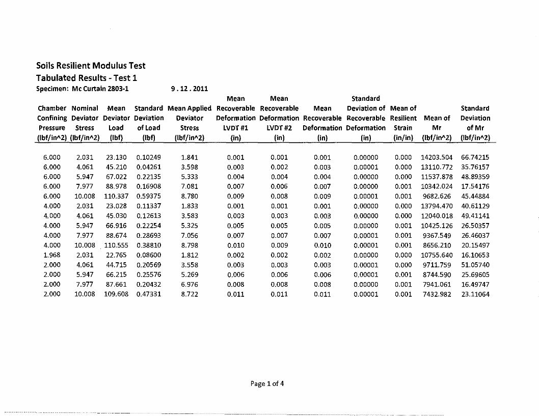
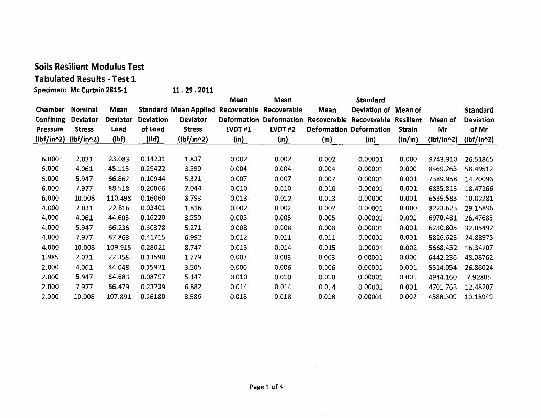
Soils Resilient Modulus Test Tabulated Results - Test 1 Specimen: Mc Curtain 2803-1 9 .12. 2011
Mean Mean Standard
Chamber Nominal Mean Standard Mean Applied Recoverable Recoverable Mean Deviation of Mean of Standard Confining Deviator Deviator Deviation Deviator Deformation Deformation Recoverable Recoverable Resilient Mean of Deviation Pressure Stress Load of Load Stress LVDT#l LVDT#2 Deformation Deformation Strain Mr of Mr (lbf/in"2) (lbf/in"2) (lbf} (lbf) (lbf/in"2) (in) (in) (in) (in) (in/in) (lbf/in"2) (lbf/in"2)
6.000 2.031 23.130 0.10249 1.841 0.001 0.001 0.001 0.00000 0.000 14203.504 66.74215
6.000 4.061 45.210 0.04261 3.598 0.003 0.002 0.003 0.00001 0.000 13110.772 35.76157 6.000 5.947 67.022 0.22135 5.333 0.004 0.004 0.004 0.00000 0.000 11537.878 48.89359 6.000 7.977 88.978 0.16908 7.081 0.007 0.006 0.007 0.00000 0.001 10342.024 17.54176
6.000 10.008 110.337 0.59375 8.780 0.009 0.008 0.009 0.00001 0.001 9682.626 45.44884
4.000 2.031 23.028 0.11337 1.833 0.001 0.001 0.001 0.00000 0.000 13794.470 40.61129 4.000 4.061 45.030 0.12613 3.583 0.003 0.003 0.003 0.00000 0.000 12040.018 49.41141
4.000 5.947 66.916 0.22254 5.325 0.005 0.005 0.005 0.00000 0.001 10425.126 26.50357 4.000 7.977 88.674 0.28693 7.056 0.007 0.007 0.007 0.00001 0.001 9367.549 26.46037 4.000 10.008 110.555 0.38810 8.798 0.010 0.009 0.010 0.00001 0.001 8656.210 20.15497 1.968 2.031 22.765 0.08600 1.812 0.002 0.002 0.002 0.00000 0.000 10755.640 16.10653 2.000 4.061 44.715 0.20569 3.558 0.003 0.003 0.003 0.00001 0.000 9711.759 51.05740 2.000 5.947 66.215 0.25576 5.269 0.006 0.006 0.006 0.00001 0.001 8744.590 25.69605 2.000 7.977 87.661 0.20432 6.976 0.008 0.008 0.008 0.00000 0.001 7941.061 16.49747 2.000 10.008 109.608 0.47331 8.722 0.011 0.011 0.011 0.00001 0.001 7432.982 23.11064
Page 1of4
Resilient Modulus Test
NAME: TEST DATE: PROJECT NUMBER : COUNTY NAME : SOIL SERIES : SPECIMEN NUMBER :
1 SOIL PROPERTIES
OPTIMUM MOISTURE CONTENT , MAXIMUM DRY DENSITY, 95%MDD, MAXIMUM WET DENSITY,
2 SPECIMEN PROPERTIES
NET DIAMETER, SAMPLE LENGTH
% (pct) (pct) (pct)
(in)
BEFORE TESTING, (in) AFTER TESTING, (in)
COMPACTION WET WEIGHT, (g) COMP ACTION MOISTURE CONTENT , % MOISTURE CONTENT AFTER Mr TEST , % COMPACTION DRY DENSITY, (pct) COMP ACTION WET DENSITY, (pct)
3 TEST INFORMATION
PRE CONDITIONING-PERMANENT STRAIN, TESTING - PERMANENT STRAIN, PERMANENT DEFORMATION, (in)
> 5% > 5%
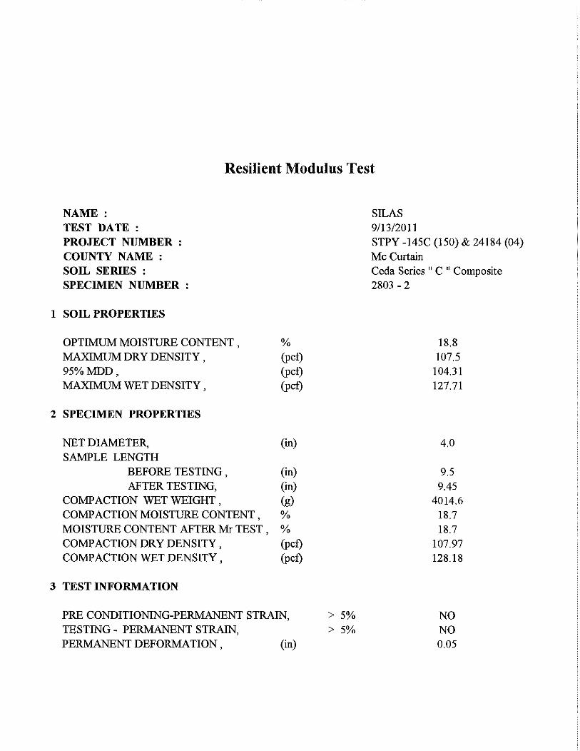
SILAS 9/13/2011 STPY -145C (150) & 24184 (04) Mc Curtain Ceda Series " C " Composite 2803 - 2
18.8 107.5
104.31 127.71
4.0
9.5 9.45
4014.6 18.7 18.7
107.97 128.18
NO NO 0.05
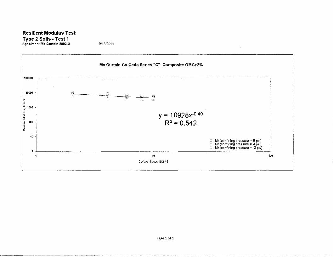
Resilient Modulus Test Type 2 Soils • Test 1 Specimen: Mc Curtain 2803-2
10000
~ 100
0:: 10 J
9/13/2011
Mc Curtain Co,Ceda Series "C" Composite OMC+2%
10
y = 10928x-o.4o R2 = 0.542
Deviator Stress, lbf/in~2
Pagelofl
_ Mr (confining pressure = 6 psi) O Mr (confining pressure = 4 psi)
Mr (confining pressure = 2 psi)
100
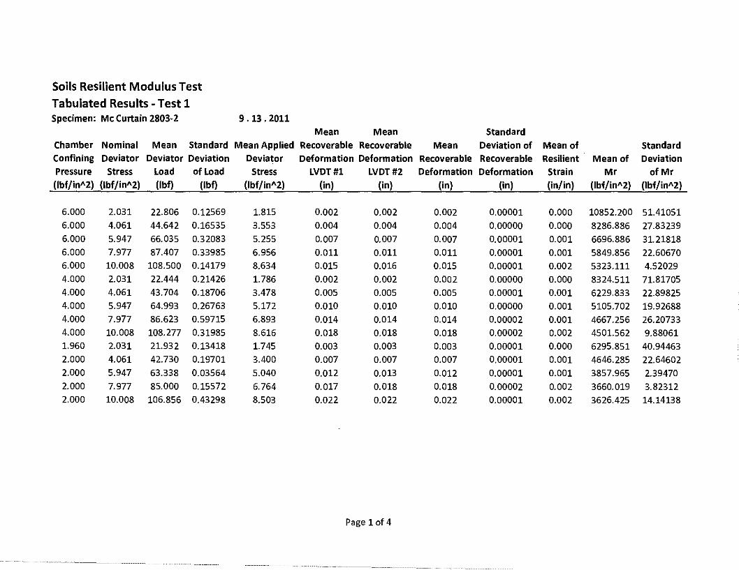
Soils Resilient Modulus Test Tabulated Results - Test 1 Specimen: Mc Curtain 2803·2 9. 13. 2011
Mean Mean Standard Chamber Nominal Mean Standard Mean Applied Recoverable Recoverable Mean Deviation of Mean of Standard Confining Deviator Deviator Deviation Deviator Deformation Deformation Recoverable Recoverable Resilient Mean of Deviation Pressure Stress Load ofload Stress LVDT#l LVDT#2 Deformation Deformation Strain Mr of Mr (lbf/inA2) (lbf/inA2) (lbf) (lbf) (lbf/inA2) (in) (in) (in) (in) (in/in) (lbf/inA2) (lbf/jnA2)
6.000 2.031 22.806 0.12569 1.815 0.002 0.002 0.002 0.00001 0.000 10852.200 51.41051 6.000 4.061 44.642 0.16535 3.553 0.004 0.004 0.004 0.00000 0.000 8286.886 27.83239 6.000 5.947 66.035 0.32083 5.255 0.007 0.007 0.007 0.00001 0.001 6696.886 31.21818 6.000 7.977 87.407 0.33985 6.956 0.011 0.011 0.011 0.00001 0.001 5849.856 22.60670 6.000 10.008 108.500 0.14179 8.634 0.015 0.016 0.015 0.00001 0.002 5323.111 4.52029 4.000 2.031 22.444 0.21426 1.786 0.002 0.002 0.002 0.00000 0.000 8324.511 71.81705 4.000 4.061 43.704 0.18706 3.478 0.005 0.005 0.005 0.00001 0.001 6229.833 22.89825 4.000 5.947 64.993 0.26763 5.172 0.010 0.010 0.010 0.00000 0.001 5105.702 19.92688 4.000 7.977 86.623 0.59715 6.893 0.014 0.014 0.014 0.00002 0.001 4667.256 26.20733 4.000 10.008 108.277 0.31985 8.616 0.018 0.018 0.018 0.00002 0.002 4501.562 9.88061 1.960 2.031 21.932 0.13418 1.745 0.003 0.003 0.003 0.00001 0.000 6295.851 40.94463 2.000 4.061 42.730 0.19701 3.400 0.007 0.007 0.007 0.00001 0.001 4646.285 22.64602 2.000 5.947 63.338 0.03564 5.040 0.012 0.013 0.012 0.00001 0.001 3857.965 2.39470 2.000 7.977 85.000 0.15572 6.764 0.017 0.018 0.018 0.00002 0.002 3660.019 3.82312 2.000 10.008 106.856 0.43298 8.503 0.022 0.022 0.022 0.00001 0.002 3626.425 14.14138
Page 1of4
Resilient Modulus Test
NAME: TEST DATE: PROJECT NUMBER : COUNTY NAME : SOIL SERIES : SPECIMEN NUMBER :
1 SOIL PROPERTIES
OPTIMUM MOISTURE CONTENT , MAXIMUM DRY DENSITY, 95%MDD, MAXIMUM WET DENSITY,
2 SPECIMEN PROPERTIES
NET DIAMETER, SAMPLE LENGTH
% (pct) (pct) (pct)
(in)
BEFORE TESTING , (in) AFTER TESTING, (in)
COMPACTION WET WEIGHT, (g) COMP ACTION MOISTURE CONTENT , % MOISTURE CONTENT AFTER Mr TEST , % COMPACTION DRY DENSITY, (pct) COMP ACTION WET DENSITY, (pct)
3 TEST INFORMATION
PRE CONDITIONING-PERMANENT STRAIN, TESTING - PERMANENT STRAIN, PERMANENT DEFORMATION, (in)
> 5% > 5%
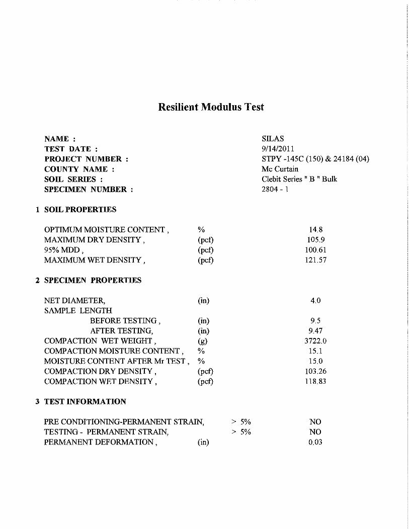
SILAS 9/14/2011 STPY -145C (150) & 24184 (04) McCurtain Clebit Series " B " Bulk 2804 - 1
14.8 105.9
100.61 121.57
4.0
9.5 9.47
3722.0 15.1 15.0
103.26 118.83
NO NO 0.03
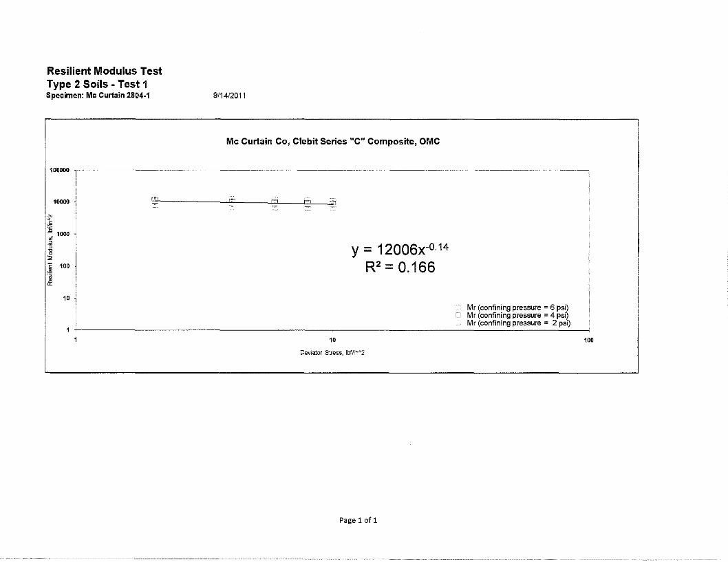
Resilient Modulus Test Type 2 Soils • Test 1 Specimen: Mc Curtain 2804-1
10000
10
9/14/2011
Mc Curtain Co, Clebit Series "C" Composite, OMC
..:_:-
10
y = 12006x-0·14
R2 = 0.166
Oevia:tor Stress, lbflin"2
Page 1of1
Mr (confining pressure = 6 psi) O Mr (confining pressure = 4 psi)
Mr (confining pressure = 2 psi)
100

Soils Resilient Modulus Test Tabulated Results - Test 1 Specimen: Mc Curtain 2804-1 9 .14. 2011
Mean Mean Standard Chamber Nominal Mean Standard Mean Applied Recoverable Recoverable Mean Deviation of Mean of Standard Confining Deviator Deviator Deviation Deviator Deformation Deformation Recoverable Recoverable Resilient Mean of Deviation Pressure Stress Load of Load Stress LVDT#l LVDT#2 Deformation Deformation Strain Mr of Mr (lbf/in"2) (lbf/in"2) (lbf) (lbf) {lbf/in"2) (in) (in) (in) (in) (in/in) (lbf/in"2) {lbf/in"2)
6.000 2.031 23.553 0.25527 1.874 0.001 0.001 0.001 0.00001 0.000 13657.177 131.33197
6.000 4.061 45.756 0.22491 3.641 0.003 0.003 0.003 0.00000 0.000 12140.174 64.10551
6.000 5.947 68.046 0.32046 5.415 0.005 0.004 0.005 0.00000 0.000 11382.313 48.30800 6.000 7.977 90.533 0.20092 7.204 0.006 0.006 0.006 0.00002 0.001 10910.893 49.01547 6.000 10.008 112.645 0.31968 8.964 0.008 0.008 0.008 0.00001 0.001 10409.439 26.78058 4.000 2.031 23.301 0.23476 1.854 0.002 0.002 0.002 0.00001 0.000 11201.441 146.77965 4.000 4.061 45.386 0.31059 3.612 0.003 0.003 0.003 0.00000 0.000 10025.467 61.33617 4.000 5.947 67.761 0.36365 5.392 0.006 0.006 0.006 0.00001 0.001 9212.275 41.07884 4.000 7.977 90.048 0.27765 7.166 0.008 0.007 0.008 0.00001 0.001 8958.224 26.26627 4.000 10.008 112.096 0.34420 8.920 0.010 0.010 0.010 0.00001 0.001 8745.583 32.49870 1.964 2.031 22.613 0.16142 1.799 0.002 0.002 0.002 0.00001 0.000 8435.566 75.90228 2.000 4.061 44.552 0.33523 3.545 0.005 0.004 0.004 0.00000 0.000 7500.034 61.00389 2.000 5.947 66.658 0.18765 5.305 0.007 0.007 0.007 0.00001 0.001 7061.651 23.03966 2.000 7.977 89.115 0.32054 7.092 0.010 0.010 0.010 0.00001 0.001 6995.837 27.09174 2.000 10.008 111.600 0.36173 8.881 0.012 0.012 0.012 0.00001 0.001 7051.092 24.49958
Page 1of4

Resilient Modulus Test
NAME: TEST DATE: PROJECT NUMBER : COUNTY NAME: SOIL SERIES : SPECIMEN NUMBER :
1 SOIL PROPERTIES
OPTIMUM MOISTURE CONTENT , MAXIMUM DRY DENSITY, 95%MDD, MAXIMUM WET DENSITY,
2 SPECIMEN PROPERTIES
NET DIAMETER, SAMPLE LENGTH
% (pct) (pct) (pct)
(in)
BEFORE TESTING, (in) AFTER TESTING, (in)
COMPACTION WET WEIGHT, (g) COMP ACTION MOISTURE CONTENT , % MOISTURE CONTENT AFTER Mr TEST , % COMPACTION DRY DENSITY, (pct) COMP ACTION WET DENSITY, (pct)
3 TEST INFORMATION
PRE CONDITIONING-PERMANENT STRAIN, TESTING - PERMANENT STRAIN, PERMANENT DEFORMATION, (in)
> 5% > 5%
SILAS 9/15/2011 STPY -145C (150) & 24184 (04) McCurtain Clebit Series " B " Bulk 2804 - 2
16.8 103.9 100.61 121.36
4.0
9.5 9.46
3782.7 17.0 17.0
103.24 120.77
NO NO 0.04

Resilient Modulus Test Type 2 Soils - Test 1 Specimen: Mc Curtain 2804-2
10000
10
911512011
Mc Curtain Co, Clebit Series "C" Composite, OMC+2%
10
Deviator stress, lbffin 112
y = 9616.x-0·15
R2 = 0.127
Mr (confining pressure = 6 psi) D Mr (confining pressure :::: 4 psi)
Mr (confining pressure = 2 psi)
Page1of1
100
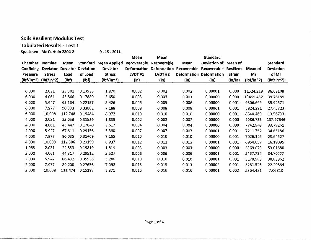
Soils Resilient Modulus Test Tabulated Results -Test 1 Specimen: Mc Curtain 2804·2 9 .15. 2011
Mean Mean Standard
Chamber Nominal Mean Standard Mean Applied Recoverable Recoverable Mean Deviation of Mean of Standard
Confining Deviator Deviator Deviation Deviator Deformation Deformation Recoverable Recoverable Resilient Mean of Deviation
Pressure Stress Load of Load Stress LVDT#l LVDT#2 Deformation Deformation Strain Mr of Mr (lbf/in"2) (lbf/in"2) (lbf) (lbf) (lbf/in"2) (in) (in) (in) (in) (in/in) (lbf/in"2) (lbf/in"2)
6.000 2.031 23.501 0.13938 1.870 0.002 0.002 0.002 0.00001 0.000 11524.219 36.68108 6.000 4.061 45.866 0.17880 3.650 0.003 0.003 0.003 0.00000 0.000 10469.432 39.76189 6.000 5.947 68.184 0.22157 5.426 0.006 0.005 0.006 0.00000 0.001 9306.699 35.92671 6.000 7.977 90.333 0.33802 7.188 0.008 0.008 0.008 0.00001 0.001 8824.291 27.45723 6.000 10.008 112.748 0.19484 8.972 0.010 0.010 0.010 0.00000 0.001 8640.469 13.56733 4.000 2.031 23.056 0.31589 1.835 0.002 0.002 0.002 0.00000 0.000 9086.735 132.97646 4.000 4.061 45.447 0.17040 3.617 0.004 0.004 0.004 0.00000 0.000 7742.949 33.79261 4.000 5.947 67.611 0.29156 5.380 0.007 0.007 0.007 0.00001 0.001 7211.752 34.65186 4.000 7.977 90.035 0.31409 7.165 0.010 0.010 0.010 0.00000 0.001 7026.126 23.64627 4.000 10.008 112.306 0.23199 8.937 0.012 0.012 0.012 0.00001 0.001 6954.057 16.19095 1.965 2.031 22.853 0.19819 1.819 0.003 0.003 0.003 0.00000 0.000 6369.073 53.01680 2.000 4.061 44.317 0.29512 3.527 0.006 0.006 0.006 0.00001 0.001 5437.232 34.70227 2.000 5.947 66.432 0.35538 5.286 0.010 0.010 0.010 0.00001 0.001 5170.983 30.83952 2.000 7.977 89.200 0.27636 7.098 0.013 0.013 0.013 0.00002 0.001 5281.525 22.20864 2.000 10.008 111.474 0.15198 8.871 0.016 0.016 0.016 0.00001 0.002 5364.421 7.06818
Page 1of4

Resilient Modulus Test
NAME: TEST DATE: PROJECT NUMBER : COUNTY NAME : SOIL SERIES : SPECIMEN NUMBER :
1 SOIL PROPERTIES
OPTIMUM MOISTURE CONTENT , MAXIMUM DRY DENSITY, 95%MDD, MAXIMUM WET DENSITY,
2 SPECIMEN PROPERTIES
% (pct) (pct) (pct)
NET DIAMETER, (in) SAMPLE LENGTH
BEFORE TESTING, (in) AFTER TESTING, (in)
COMPACTION WET WEIGHT, (g) COMPACTION MOISTURE CONTENT, % MOISTURE CONTENT AFTER Mr TEST , % COMPACTION DRY DENSITY, (pct) COMP ACTION WET DENSITY , (pct)
3 TEST INFORMATION
PRE CONDITIONING-PERMANENT STRAIN, TESTING - PERMANENT STRAIN, PERMANENT DEFORMATION , (in)
> 5% > 5%
SILAS 9/16/2011 STPY -145C (150) & 24184 (04) Mc Curtain Zafra Series " B " Composite 2805 - 1
15.1 114.2
108.49 131.44
4.0
9.5 9.5
3974.2 15.3 15.3
110.07 126.89
NO NO
0

Resilient Modulus Test Type 2 Soils • Test 1 Specimen: Mc Curtain 2805-1
10000
10
9/16/201
Mc Curtain Co, Zafra Series "B" Composite, OMC
10
Deviator Stress, lbflin"2
Pagelofl
y = 20582x-0·33
R2 = 0.733
Mr (confining pressure = 6 psi) o Mr (confining pressure = 4 psi)
Mr (confining pressure = 2 psi) .
100

Soils Resilient Modulus Test Tabulated Results - Test 1 Specimen: Mc Curtain 2805-1 9 .16. 2011
Mean Mean Standard
Chamber Nominal Mean Standard Mean Applied Recoverable Recoverable Mean Deviation of Mean of Standard
Confining Deviator Deviator Deviation Deviator Deformation Deformation Recoverable Recoverable Resilient Mean of Deviation
Pressure Stress Load of Load Stress LVDT#l LVDT#2 Deformation Deformation Strain Mr of Mr
(lbf/in"2) (lbf/in"2) (lbf) (lbf) (lbf/in"2) (in) (in) (in) (in) (in/in) (lbf/in"2) (lbf/in"2)
6.000 2.031 23.391 0.17003 1.861 0.001 0.001 0.001 0.00000 0.000 18106.338 143.74301
6.000 4.061 45.759 0.17616 3.641 0.002 0.002 0.002 0.00001 0.000 15367.864 99.72654
6.000 5.947 67.816 0.15893 5.397 0.004 0.004 0.004 0.00000 0.000 13103.300 33.95796
6.000 7.977 90.126 0.19812 7.172 0.006 0.006 0.006 0.00001 0.001 11473.883 27.81671
6.000 10.008 112.075 0.61313 8.919 0.008 0.008 0.008 0.00000 0.001 10400.506 53.64248
4.000 2.031 23.389 0.14638 1.861 0.001 0.001 0.001 0.00000 0.000 16453.096 122.35585 4.000 4.061 45.596 0.08768 3.628 0.003 0.002 0.002 0.00000 0.000 13994.241 39.95239 4.000 5.947 67.627 0.04281 5.382 0.004 0.004 0.004 0.00000 0.000 11733.846 3.34801
4.000 7.977 89.644 0.39298 7.134 0.007 0.006 0.007 0.00000 0.001 10257.973 48.02337
4.000 10.008 111.906 0.22269 8.905 0.009 0.009 0.009 0.00001 0.001 9486.395 13.92188 1.965 2.031 23.050 0.10152 1.834 0.001 0.001 0.001 0.00001 0.000 13153.330 66.88772
2.000 4.061 45.538 0.21094 3.624 0.003 0.003 0.003 0.00000 0.000 11780.403 50.56110 2.000 5.947 67.350 0.12883 5.360 0.005 0.005 0.005 0.00001 0.001 10105.370 8.34336 2.000 7.977 89.309 0.05545 7.107 0.008 0.007 0.007 0.00001 0.001 9071.581 8.87274
2.000 10.008 111.684 0.37170 8.887 0.010 0.010 0.010 0.00001 0.001 8425.339 21.76323
Page 1of4

Resilient Modulus Test
NAME: TEST DATE: PROJECT NUMBER : COUNTY NAME : SOIL SERIES : SPECIMEN NUMBER :
1 SOIL PROPERTIES
OPTIMUM MOISTURE CONTENT , MAXIMUM DRY DENSITY, 95%MDD, MAXIMUM WET DENSITY ,
2 SPECIMEN PROPERTIES
NET DIAMETER, SAMPLE LENGTH
% (pct) (pct) (pct)
(in)
BEFORE TESTING, (in) AFTER TESTING, (in)
COMPACTION WET WEIGHT, (g) COMPACTION MOISTURE CONTENT, % MOISTURE CONTENT AFTER Mr TEST , % COMPACTION DRY DENSITY, (pct) COMPACTION WET DENSITY, (pct)
3 TEST INFORMATION
PRE CONDITIONING-PERMANENT STRAIN, TESTING - PERMANENT STRAIN, PERMANENT DEFORMATION, (in)
> 5% > 5%
SILAS 9/19/2011 STPY -145C (150) & 24184 (04) Mc Curtain Zafra Series " B " Composite 2805 - 2
17.1 111.8
108.49 130.92
4.0
9.5 9.47
4066.8 17.2 17.2
110.82 129.84
NO NO 0.03
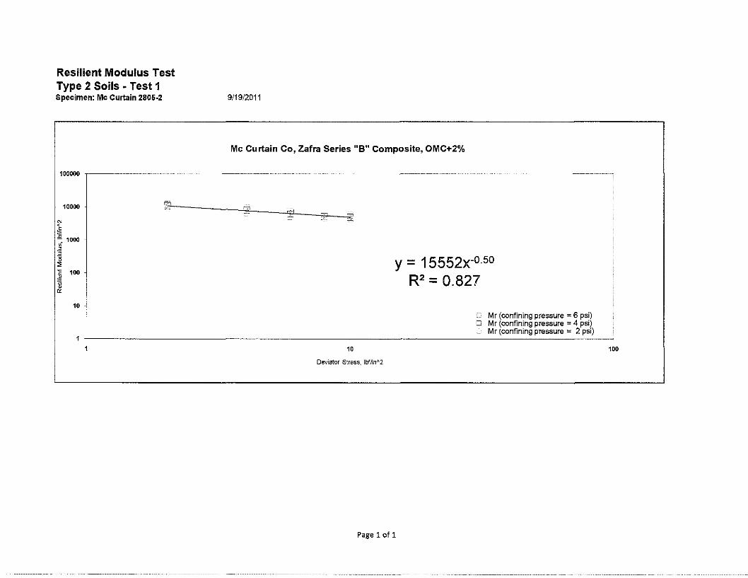
Resilient Modulus Test Type 2 Soils • Test 1 Specimen: Mc Curtain 2806-2
100000
10000
10
9/19/2011
Mc Curtain Co, Zafra Series "B" Composite, OMC+2%
y = 15552x-0-50
R2 = 0.827
Mr (confining pressure = 6 psi) o Mr (confining pressure = 4 psi) •
Mr (confinlng pressure = 2 psi)
10 100
Deviator Stress, lbflin"2
Page 1of1
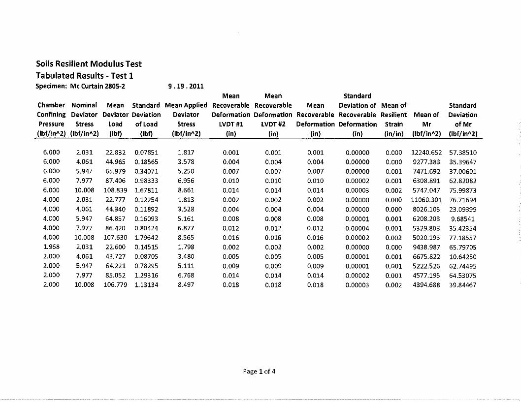
Soils Resilient Modulus Test Tabulated Results -Test 1 Specimen: Mc Curtain 2805-2 9 .19. 2011
Mean Mean Standard Chamber Nominal Mean Standard Mean Applied Recoverable Recoverable Mean Deviation of Mean of Standard Confining Deviator Deviator Deviation Deviator Deformation Deformation Recoverable Recoverable Resilient Mean of Deviation Pressure Stress Load of Load Stress LVDT#l LVDT#2 Deformation Deformation Strain Mr of Mr (lbf/in"2) (lbf/in"2) (lbf) (lbf) (lbf/in"2) (in) (in) (in) (in) (in/in) (lbf/in"2) (lbf/in"2)
6.000 2.031 22.832 0.07851 1.817 0.001 0.001 0.001 0.00000 0.000 12240.652 57.38510 6.000 4.061 44.965 0.18565 3.578 0.004 0.004 0.004 0.00000 0.000 9277.383 35.39647 6.000 5.947 65.979 0.34071 5.250 0.007 0.007 0.007 0.00000 0.001 7471.692 37.00601 6.000 7.977 87.406 0.98333 6.956 0.010 0.010 0.010 0.00002 0.001 6308.891 62.82082 6.000 10.008 108.839 1.67811 8.661 0.014 0.014 0.014 0.00003 0.002 5747.047 75.99873 4.000 2.031 22.777 0.12254 1.813 0.002 0.002 0.002 0.00000 0.000 11060.301 76.71694 4.000 4.061 44.340 0.11892 3.528 0.004 0.004 0.004 0.00000 0.000 8026.105 23.09399 4.000 5.947 64.857 0.16093 5.161 0.008 0.008 0.008 0.00001 0.001 6208.203 9.68541 4.000 7.977 86.420 0.80424 6.877 0.012 0.012 0.012 0.00004 0.001 5329.803 35.42354 4.000 10.008 107.630 1.79642 8.565 0.016 0.016 0.016 0.00002 0.002 5020.193 77.18557 1.968 2.031 22.600 0.14515 1.798 0.002 0.002 0.002 0.00000 0.000 9438.987 65.79705 2.000 4.061 43.727 0.08705 3.480 0.005 0.005 0.005 0.00001 0.001 6675.822 10.64250 2.000 5.947 64.221 0.78295 5.111 0.009 0.009 0.009 0.00001 0.001 5222.526 62.74495 2.000 7.977 85.052 1.29316 6.768 0.014 0.014 0.014 0.00002 0.001 4577.195 64.53075 2.000 10.008 106.779 1.13134 8.497 0.018 0.018 0.018 0.00003 0.002 4394.688 39.84467
Page 1of4

Resilient Modulus Test
NAME: TEST DATE: PROJECT NUMBER : COUNTY NAME : SOIL SERIES : SPECIMEN NUMBER :
1 SOIL PROPERTIES
OPTIMUM MOISTURE CONTENT , MAXIMUM DRY DENSITY, 95%MDD, MAXIMUM WET DENSITY ,
2 SPECIMEN PROPERTIES
% (pct) (pct) (pct)
NET DIAMETER, (in) SAMPLE LENGTH
BEFORE TESTING, (in) AFTER TESTING, (in)
COMPACTION WET WEIGHT, (g) COMP ACTION MOISTURE CONTENT , % MOISTURE CONTENT AFTER Mr TEST , % COMPACTION DRY DENSITY, (pct) COMP ACTION WET DENSITY , (pct)
3 TEST INFORMATION
PRE CONDITIONING-PERMANENT STRAIN, TESTING - PERMANENT STRAIN, PERMANENT DEFORMATION, (in)
> 5% > 5%
SILAS 11/18/2011 STPY -145C (150) & 24184 (04) Mc Curtain Shoulder 2810 - 1
13.7 111.4
105.83 126.66
4.0
9.5 9.48
3905.0 14.0 14.0
109.39 124.68
NO NO 0.02
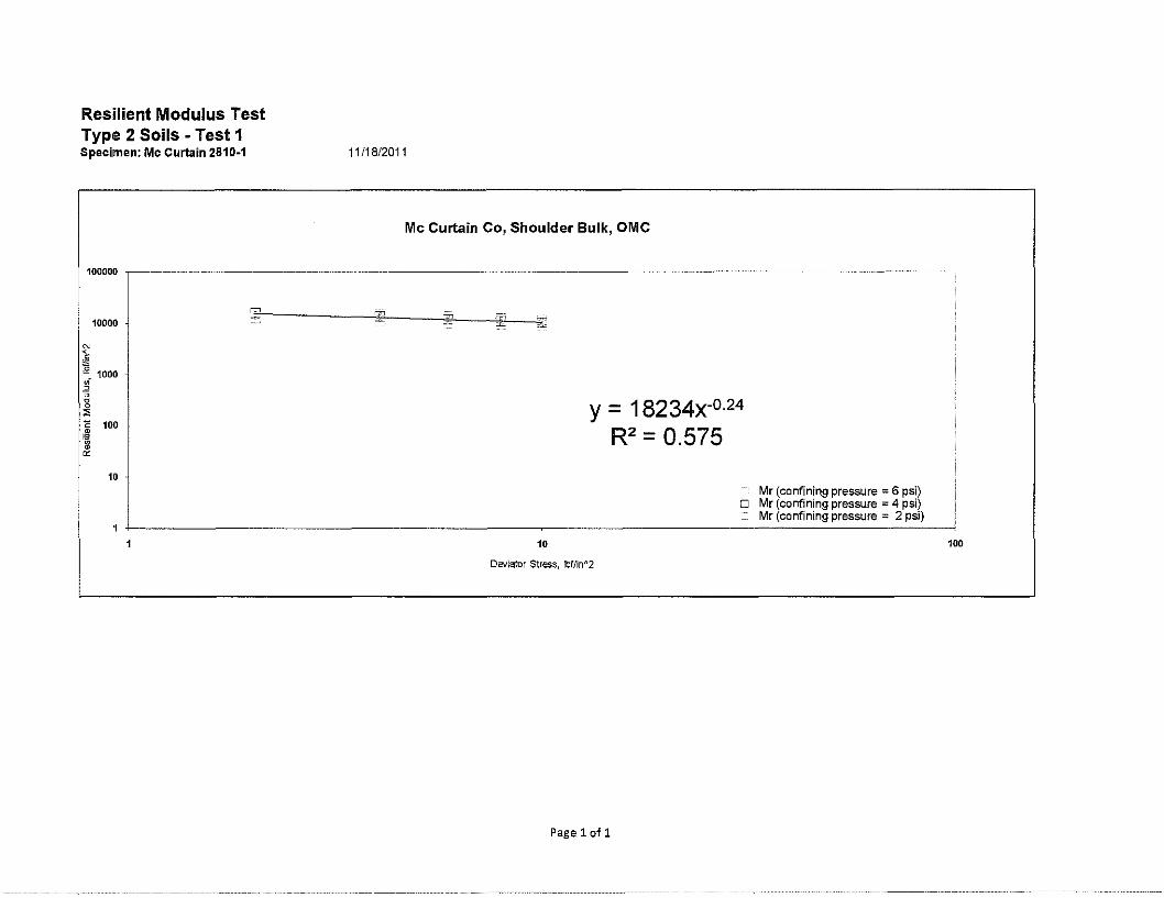
Resilient Modulus Test Type 2 Soils - Test 1 Specimen: Mc Curtain 2810-1
10000
~ ~- 1000 " " " ~ I 100
0:
10
11/18/2011
Mc Curtain Co, Shoulder Bulk, OMC
= =
10
y = 18234x-0·24
R2 = 0.575
Mr (confining pressure = 6 psi) D Mr (confining pressure = 4 psi)
Mr (confining pressure ::: 2 psi)
Deviator Stress, lbf/in 112
Pagelofl
100

Soils Resilient Modulus Test Tabulated Results -Test 1 Specimen: Mc Curtain 2810-1 11.18. 2011
Mean Mean Standard Chamber Nominal Mean Standard Mean Applied Recoverable Recoverable Mean Deviation of Mean of Standard Confining Deviator Deviator Deviation Deviator Deformation Deformation Recoverable Recoverable Resilient Mean of Deviation Pressure Stress Load of Load Stress LVDT#l LVDT#2 Deformation Deformation Strain Mr of Mr (lbf/inA2) (lbf/inA2) (lbf) (lbf) (lbf/inA2) (in) (in) (in) (in) (in/in) (lbf/inA2) (Jbf/jnA2)
6.000 2.031 23.112 0.07402 1.839 0.001 0.001 0.001 0.00001 0.000 16386.395 136.42189
6.000 4.061 45.778 0.14276 3.643 0.002 0.002 0.002 0.00001 0.000 15300.260 64.71722
6.000 5.947 67.834 0.38719 5.398 0.004 0.004 0.004 0.00001 0.000 13776.267 75.93903
6.000 7.977 89.888 0.26678 7.153 0.006 0.005 0.005 0.00001 0.001 12482.051 23.39293
6.000 10.008 111.868 0.20976 8.902 0.008 0.007 0.007 0.00001 0.001 11518.992 28.82044
4.000 2.031 23.323 0.21796 1.856 0.001 0.001 0.001 0.00000 0.000 16149.905 169.27597
4.000 4.061 45.637 0.22741 3.632 0.003 0.002 0.002 0.00001 0.000 13880.440 81.04737
4.000 5.947 67.605 0.22093 5.380 0.004 0.004 0.004 0.00000 0.000 12216.814 33.29208
4.000 7.977 89.555 0.17935 7.127 0.006 0.006 0.006 0.00001 0.001 11080.870 37.43455
4.000 10.008 111.777 0.34241 8.895 0.008 0.008 0.008 0.00001 0.001 10383.249 29.26982 1.986 2.031 22.973 0.02016 1.828 0.001 0.001 0.001 0.00000 0.000 12830.304 22.36093 2.000 4.061 45.125 0.11755 3.591 0.003 0.003 0.003 0.00000 0.000 11320.827 37.05558
2.000 5.947 67.020 0.11708 5.333 0.005 0.005 0.005 0.00001 0.001 10222.627 20.68694
2.000 7.977 88.768 0.25991 7.064 0.007 0.007 0.007 0.00001 0.001 9423.626 42.40902
2.000 10.008 111.276 0.63850 8.855 0.009 0.009 0.009 0.00002 0.001 9027.615 40.58459
Page 1of4

Resilient Modulus Test
NAME: TEST DATE: PROJECT NUMBER : COUNTY NAME : SOIL SERIES : SPECIMEN NUMBER :
1 SOIL PROPERTIES
OPTIMUM MOISTURE CONTENT , MAXIMUM DRY DENSITY, 95%MDD, MAXIMUM WET DENSITY,
2 SPECIMEN PROPERTIES
% (pct) (pct) (pct)
NET DIAMETER, (in) SAMPLE LENGTH
BEFORE TESTING, (in) AFTER TESTING, (in)
COMP ACTION WET WEIGHT , (g) COMP ACTION MOISTURE CONTENT , % MOISTURE CONTENT AFTER Mr TEST, % COMPACTION DRY DENSITY, (pct) COMP ACTION WET DENSITY , (pct)
3 TEST INFORMATION
PRE CONDITIONING-PERMANENT STRAIN, TESTING - PERMANENT STRAIN, PERMANENT DEFORMATION, (in)
> 5% > 5%
SILAS 11/21//2011 STPY -145C (150) & 24184 (04) Mc Curtain Shoulder 2810 - 2
15.7 110.7
105.83
128.08
4.0
9.5 9.44
3959.7 16.0 15.8
108.96 126.42
NO NO 0.06

Resilient Modulus Test Type 2 Soils - Test 1 Specimen: Mc Curtain 2810-2 11/21/2011
" $
10000
~ 1000 w .2
~ "E 100 :m ~
10
Mc Curtain Co, Shoulder Bulk, OMC + 2%
10
Deviator Stress, lbf/in 112
Page 1of1
y = 14855x-0·35
R2 = 0.668
Mr (confining pressure = 6 psi) o Mr (confining pressure = 4 psi)
Mr (confining pressure = 2 psi)
100
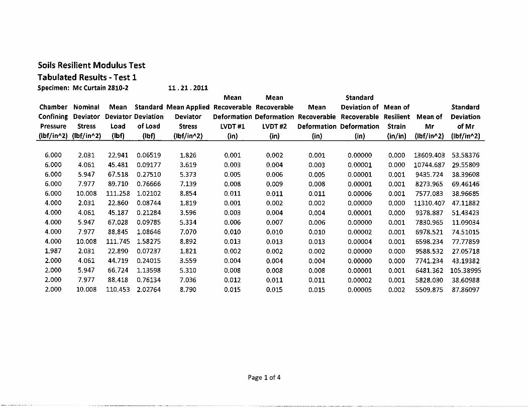
Soils Resilient Modulus Test Tabulated Results -Test 1 Specimen: Mc Curtain 2810-2 11. 21. 2011
Mean Mean Standard Chamber Nominal Mean Standard Mean Applied Recoverable Recoverable Mean Deviation of Mean of Standard Confining Deviator Deviator Deviation Deviator Deformation Deformation Recoverable Recoverable Resilient Mean of Deviation Pressure Stress Load of Load Stress LVDT#l LVDT#2 Deformation Deformation Strain Mr of Mr
(lbf/in"2) (lbf/in"2) (lbf) (lbf) (lbf/in"2) (in) (in) (in) (in) (in/in) (lbf/in"2) (lbf/in"2)
6.000 2.031 22.941 0.06519 1.826 0.001 0.002 0.001 0.00000 0.000 13609.403 53.58376 6.000 4.061 45.481 0.09177 3.619 0.003 0.004 0.003 0.00001 0.000 10744.687 29.55809 6.000 5.947 67.518 0.27510 5.373 0.005 0.006 0.005 0.00001 0.001 9435.724 38.39608 6.000 7.977 89.710 0.76666 7.139 0.008 0.009 0.008 0.00001 0.001 8273.965 69.46146 6.000 10.008 111.258 1.02102 8.854 0.011 0.011 0.011 0.00006 0.001 7577.083 38.96685 4.000 2.031 22.860 0.08744 1.819 0.001 0.002 0.002 0.00000 0.000 11310.407 47.11882 4.000 4.061 45.187 0.21284 3.596 0.003 0.004 0.004 0.00001 0.000 9378.887 51.43423 4.000 5.947 67.028 0.09785 5.334 0.006 0.007 0.006 0.00000 0.001 7830.965 11.09034 4.000 7.977 88.845 1.08646 7.070 0.010 0.010 0.010 0.00002 0.001 6978.521 74.51015 4.000 10.008 111.745 1.58275 8.892 0.013 0.013 0.013 0.00004 0.001 6598.234 77.77859 1.987 2.031 22.890 0.07237 1.821 0.002 0.002 0.002 0.00000 0.000 9588.532 27.05718 2.000 4.061 44.719 0.24015 3.559 0.004 0.004 0.004 0.00000 0.000 7741.234 43.19382 2.000 5.947 66.724 1.13598 5.310 0.008 0.008 0.008 0.00001 0.001 6481.362 105.38995 2.000 7.977 88.418 0.76134 7.036 0.012 0.011 0.011 0.00002 0.001 5828.030 38.60988 2.000 10.008 110.453 2.02764 8.790 0.015 0.015 0.015 0.00005 0.002 5509.875 87.86097
Page 1of4
Resilient Modulus Test
NAME: TEST DATE: PROJECT NUMBER : COUNTY NAME : SOIL SERIES : SPECIMEN NUMBER :
1 SOIL PROPERTIES
OPTIMUM MOISTURE CONTENT , MAXIMUM DRY DENSITY, 95%MDD, MAXIMUM WET DENSITY,
2 SPECIMEN PROPERTIES
% (pd) (pct) (pct)
NET DIAMETER, (in) SAMPLE LENGTH
BEFORE TESTING, (in) AFTER TESTING, (in)
COMPACTION WET WEIGHT, (g) COMPACTION MOISTURE CONTENT, % MOISTURE CONTENT AFTER Mr TEST , % COMPACTIONDRYDENSITY, (pct) COMPACTION WET DENSITY, (pct)
3 TEST INFORMATION
PRE CONDITIONING-PERMANENT STRAIN, > 5% TESTING - PERMANENT STRAIN, > 5% PERMANENT DEFORMATION, (in)
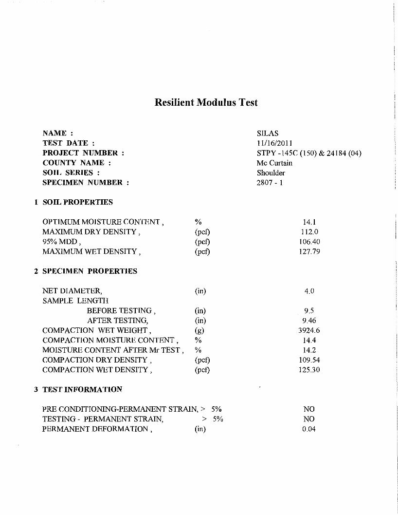
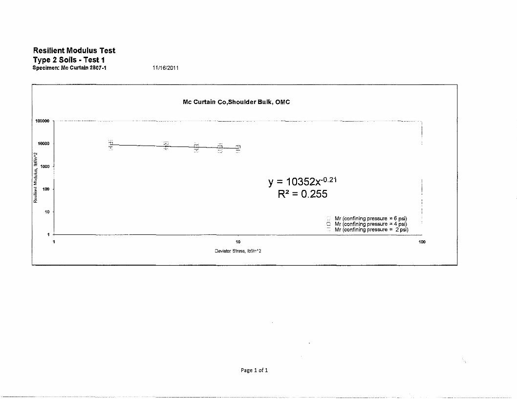
SILAS 11116/2011 STPY -145C (150) & 24184 (04) Mc Curtain Shoulder 2807 - 1
14.1 112.0 106.40 127.79
4.0
9.5 9.46
3924.6 14.4 14.2
109.54 125.30
NO NO 0.04
Resilient Modulus Test Type 2 Soils • Test 1 Specimen: Mc Curtain 2807-1
100000
10000
10
11/16/2011
Mc Curtain Co,Shoulder Bulk, OMC
"'1
10
Oeviator stress, lbf/inn2
Pagelofl
y = 10352x-0·21
R2 = 0.255
Mr (confining pressure = 6 psi) O Mr (confining pressure = 4 psi)
Mr (confining pressure = 2 psi)
100
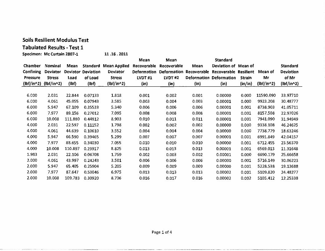
Soils Resilient Modulus Test Tabulated Results - Test 1 Specimen: Mc Curtain 2807-1 11.16. 2011
Mean Mean Standard Chamber Nominal Mean Standard Mean Applied Recoverable Recoverable Mean Deviation of Mean of Standard
Confining Deviator Deviator Deviation Deviator Deformation Deformation Recoverable Recoverable Resilient Mean of Deviation Pressure Stress Load ofload Stress LVDT#l LVDT#2 Deformation Deformation Strain Mr of Mr (lbf/inA2) (lbf/inA2) (lbf) (lbf) (lbf/inA2) (in) (in) (in) (in) (in/in) (lbf/inA2) (lbf/jnA2)
6.000 2.031 22.844 0.07133 1.818 0.001 0.002 0.001 0.00000 0.000 11590.090 33.97710
6.000 4.061 45.055 0.07943 3.585 0.003 0.004 0.003 0.00001 0.000 9923.208 30.48777 6.000 5.947 67.109 0.35533 5.340 0.006 0.006 0.006 0.00001 0.001 8738.903 41.05711 6.000 7.977 89.156 0.27012 7.095 0.008 0.008 0.008 0.00001 0.001 8157.508 22.97026 6.000 10.008 111.880 0.44812 8.903 0.010 0.011 0.011 0.00001 0.001 7941.090 31.94949 4.000 2.031 22.597 0.11152 1.798 0.002 0.002 0.002 0.00000 0.000 9338.108 46.24625 4.000 4.061 44.639 0.10610 3.552 0.004 0.004 0.004 0.00000 0.000 7738.779 18.63246 4.000 5.947 66.590 0.39465 5.299 0.007 0.007 0.007 0.00001 0.001 6991.849 42.04157 4.000 7.977 88.655 0.34030 7.055 0.010 0.010 0.010 0.00000 0.001 6712.455 23.56370 4.000 10.008 110.897 0.23917 8.825 0.013 0.013 0.013 0.00001 0.001 6569.013 11.31648 1.983 2.031 22.106 0.06708 1.759 0.002 0.003 0.002 0.00001 0.000 6690.179 25.66658 2.000 4.061 43.997 0.24243 3.501 0.006 0.006 0.006 0.00000 0.001 5716.149 30.06223 2.000 5.947 65.405 0.25904 5.205 0.009 0.009 0.009 0.00000 0.001 5228.538 19.13688 2.000 7.977 87.647 0.53046 6.975 0.013 0.013 0.013 0.00002 0.001 5109.820 24.48277 2.000 10.008 109.783 0.30920 8.736 0.016 0.017 0.016 0.00002 0.002 5105.412 12.25338
Page 1of4

Resilient Modulus Test
NAME: TEST DATE: PROJECT NUMBER : COUNTY NAME : SOIL SERIES : SPECIMEN NUMBER :
1 SOIL PROPERTIES
OPTIMUM MOISTURE CONTENT , MAXIMUM DRY DENSITY, 95%MDD, MAXIMUM WET DENSITY,
2 SPECIMEN PROPERTIES
% (pct) (pct) (pct)
NET DIAMETER, (in) SAMPLE LENGTH
BEFORE TESTING, (in) AFTER TESTING, (in)
COMPACTION WET WEIGHT, (g) COMP ACTION MOISTURE CONTENT , % MOISTURE CONTENT AFTER Mr TEST , % COMPACTION DRY DENSITY, (pct) COMP ACTION WET DENSITY, (pct)
3 TEST INFORMATION
PRE CONDITIONING-PERMANENT STRAIN, TESTING - PERMANENT STRAIN, PERMANENT DEFORMATION, (in)
> 5% > 5%
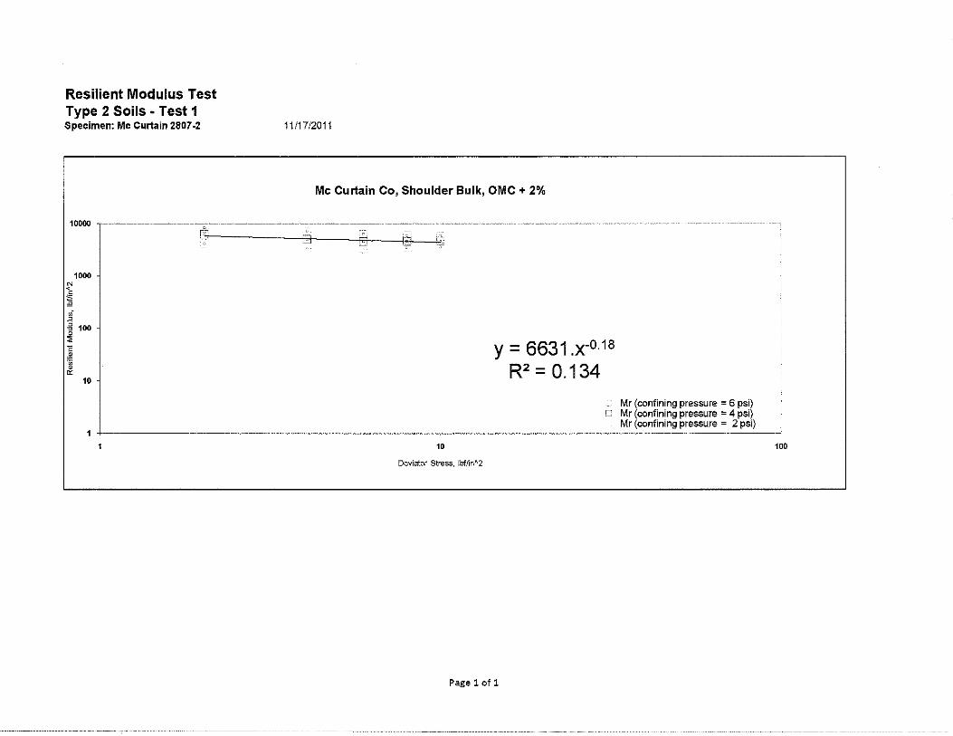
SILAS 11/17/2011 STPY -145C (150) & 24184 (04) Mc Curtain Shoulder 2807 - 2
16.1 109.5
106.40 127.13
4.0
9.5 9.45
3989.0 16.2 16.1
109.63 127.36
NO NO 0.05
Resilient Modulus Test Type 2 Soils • Test 1 Specimen: Mc Curtain 2807-2
10000 ·--------~-------~·
1000
10
11/17/2011
Mc Curtain Co, Shoulder Bulk, OMC + 2%
10
Deviator Stress, lbf/in"2
y = 6631.x-0·18
R2 = 0.134
Mr (confining pressure = 6 psi) o Mr (confining pressure = 4 psi)
Mr (confining pressure = 2 psi)
Page 1of1
100
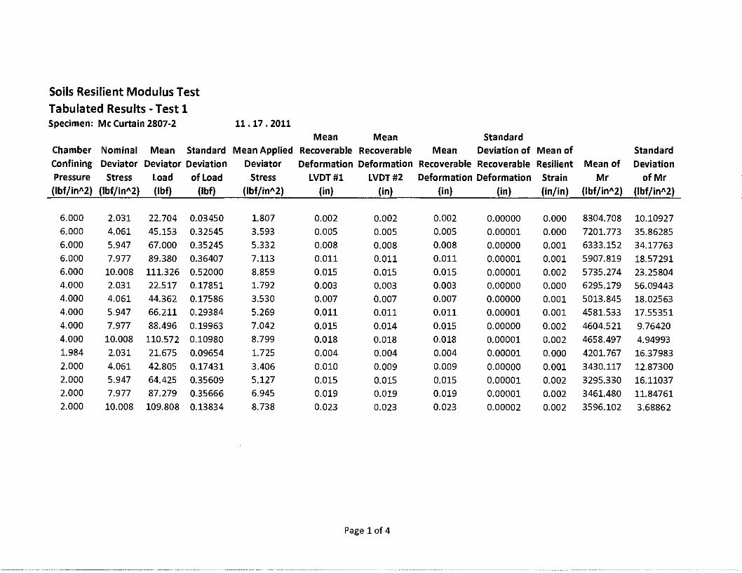
Soils Resilient Modulus Test
Tabulated Results -Test 1 Specimen: Mc Curtain 2807·2 11.17. 2011
Mean Mean Standard Chamber Nominal Mean Standard Mean Applied Recoverable Recoverable Mean Deviation of Mean of Standard Confining Deviator Deviator Deviation Deviator Deformation Deformation Recoverable Recoverable Resilient Mean of Deviation Pressure Stress Load of Load Stress LVDT#l LVDT #2 Deformation Deformation Strain Mr of Mr (lbf/in"2) (lbf/in"2) (lbf) (!bf) (lbf/in"2) (in) (in) (in) (in) {in/in) (lbf/in"2) (lbf/in"2)
6.000 2.031 22.704 0.03450 1.807 0.002 0.002 0.002 0.00000 0.000 8304.708 10.10927 6.000 4.061 45.153 0.32545 3.593 0.005 0.005 0.005 0.00001 0.000 7201.773 35.86285 6.000 5.947 67.000 0.35245 5.332 0.008 0.008 0.008 0.00000 0.001 6333.152 34.17763 6.000 7.977 89.380 0.36407 7.113 0.011 0.011 0.011 0.00001 0.001 5907.819 18.57291 6.000 10.008 111.326 0.52000 8.859 0.015 0.015 0.015 0.00001 0.002 5735.274 23.25804 4.000 2.031 22.517 0.17851 1.792 0.003 0.003 0.003 0.00000 0.000 6295.179 56.09443 4.000 4.061 44.362 0.17586 3.530 0.007 0.007 0.007 0.00000 0.001 5013.845 18.02563 4.000 5.947 66.211 0.29384 5.269 0.011 0.011 0.011 0.00001 0.001 4581.533 17.55351 4.000 7.977 88.496 0.19963 7.042 0.015 0.014 0.015 0.00000 0.002 4604.521 9.76420 4.000 10.008 110.572 0.10980 8.799 0.018 0.018 0.018 0.00001 0.002 4658.497 4.94993 1.984 2.031 21.675 0.09654 1.725 0.004 0.004 0.004 0.00001 0.000 4201.767 16.37983 2.000 4.061 42.805 0.17431 3.406 0.010 0.009 0.009 0.00000 0.001 3430.117 12.87300 2.000 5.947 64.425 0.35609 5.127 0.015 0.015 0.015 0.00001 0.002 3295.330 16.11037 2.000 7.977 87.279 0.35666 6.945 0.019 0.019 0.019 0.00001 0.002 3461.480 11.84761 2.000 10.008 109.808 0.13834 8.738 0.023 0.023 0.023 0.00002 0.002 3596.102 3.68862
Page lof4

Resilient Modulus Test
NAME: TEST DATE: PROJECT NUMBER : COUNTY NAME : SOIL SERIES : SPECIMEN NUMBER :
1 SOIL PROPERTIES
OPTIMUM MOISTURE CONTENT , MAXIMUM DRY DENSITY, 95%MDD, MAXIMUM WET DENSITY,
2 SPECIMEN PROPERTIES
% (pct) (pct) (pct)
NET DIAMETER, (in) SAMPLE LENGTH
BEFORE TESTING, (in) AFTER TESTING, (in)
COMPACTION WET WEIGHT, (g) COMP ACTION MOISTURE CONTENT , % MOISTURE CONTENT AFTER Mr TEST , % COMPACTION DRY DENSITY, (pct) COMP ACTION WET DENSITY, (pct)
3 TEST INFORMATION
PRE CONDITIONING-PERMANENT STRAIN, TESTING - PERMANENT STRAIN, PERMANENT DEFORMATION, (in)
> 5% > 5%
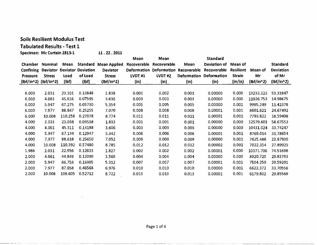
SILAS 11122/2011 STPY -145C (150) & 24184 (04) McCurtain Shoulder 2813 - 1
19.5 103.1 97.95 123.20
4.0
9.5 9.41
3731.3 19.6 19.6
99.64 119.13
NO NO 0.09
Resilient Modulus Test Type 2 Soils - Test 1 Specimen: Mc Curtain 2813-1
100000
10000
N < .. "' " 1000 ,,;
" , ~ 0
"' c 100 .. 'lij • "
10
11122/2011
Mc Curtain Co, Shoulder Bulk, OMC
10
Deviator Stress, lbf/in"2
Pagelofl
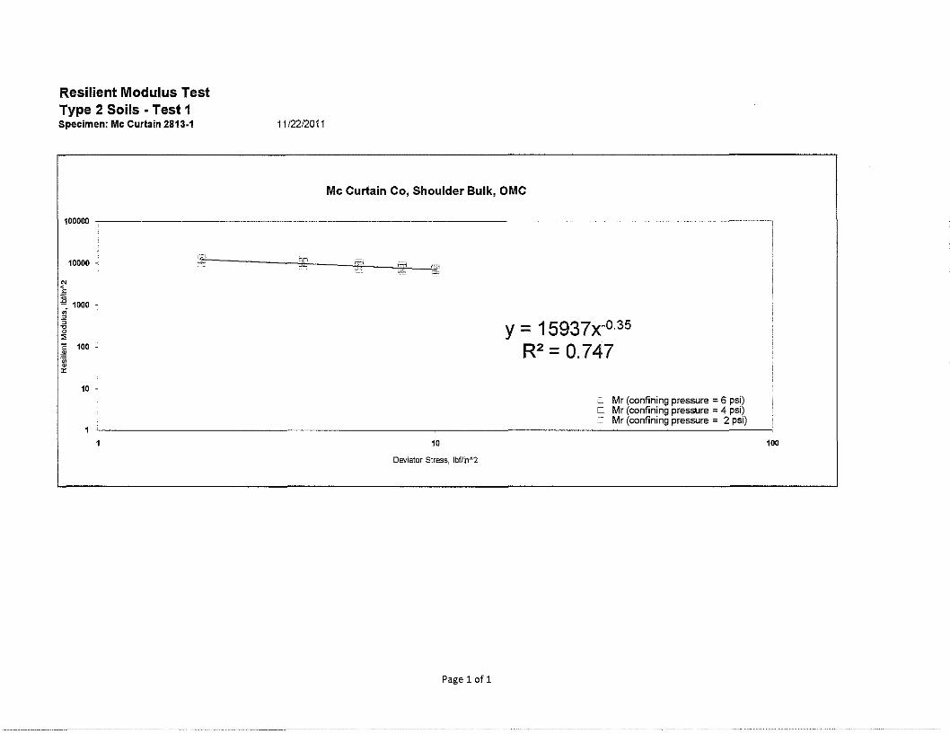
y = 15937x-0·35
R2 = 0.747
Mr (confining pressure = 6 psi) O Mr (confining pressure = 4 psi)
Mr (confining pressure = 2 psi) .
100
Soils Resilient Modulus Test
Tabulated Results -Test 1 Specimen: Mc Curtain 2813-1 11. 22. 2011
Mean Mean Standard Chamber Nominal Mean Standard Mean Applied Recoverable Recoverable Mean Deviation of Mean of Standard Confining Deviator Deviator Deviation Deviator Deformation Deformation Recoverable Recoverable Resilient Mean of Deviation Pressure Stress Load of Load Stress LVDT#l LVDT#2 Deformation Deformation Strain Mr of Mr (lbf/in"2) (lbf/in"2) (lbf) (lbf) (lbf/in"2) (in) (in) (in) (in) (in/in) (lbf/in"2) (lbf/in"2)
6.000 2.031 23.101 0.13848 1.838 0.001 0.002 0.001 0.00000 0.000 13232.222 53.31847
6.000 4.061 45.616 0.07595 3.630 0.003 0.003 0.003 0.00000 0.000 11926.753 14.98675
6.000 5.947 67.275 0.05730 5.354 0.005 0.005 0.005 0.00000 0.001 9995.249 11.42378
6.000 7.977 88.847 0.25255 7.070 0.008 0.008 0.008 0.00001 0.001 8601.621 24.67492
6.000 10.008 110.258 0.27078 8.774 0.011 0.011 0.011 0.00001 0.001 7793.822 18.59408
4.000 2.031 23.038 0.09538 1.833 0.001 0.001 0.001 0.00000 0.000 12579.601 58.67553
4.000 4.061 45.311 0.14188 3.606 0.003 0.003 0.003 0.00000 0.000 10431.024 33.74247
4.000 5.947 67.134 0.12947 5.342 0.006 0.006 0.006 0.00001 0.001 8769.014 31.78654
4.000 7.977 88.618 0.25650 7.052 0.009 0.009 0.009 0.00000 0.001 7625.486 23.87930 4.000 10.008 110.392 0.57480 8.785 0.012 0.012 0.012 0.00002 0.001 7022.354 27.89925
1.986 2.031 22.956 0.12633 1.827 0.002 0.002 0.002 0.00001 0.000 10371.706 74.51698
2.000 4.061 44.849 0.12090 3.569 0.004 0.004 0.004 0.00000 0.000 8920.720 29.83793
2.000 5.947 66.753 0.13305 5.312 0.007 0.007 0.007 0.00001 0.001 7504.250 20.59201
2.000 7.977 87.658 0.46568 6.976 0.010 0.010 0.010 0.00000 0.001 6622.372 33.70556
2.000 10.008 109.605 0.52712 8.722 0.013 0.013 0.013 0.00001 0.001 6179.802 29.85569
Page 1of4

Resilient Modulus Test
NAME: TEST DATE: PROJECT NUMBER : COUNTY NAME : SOIL SERIES : SPECIMEN NUMBER :
1 SOIL PROPERTIES
OPTIMUM MOISTURE CONTENT, MAXIMUM DRY DENSITY, 95%MDD, MAXIMUM WET DENSITY,
2 SPECIMEN PROPERTIES
% (pct) (pct) (pct)
NET DIAMETER, (in) SAMPLE LENGTH
BEFORE TESTING, (in) AFTER TESTING, (in)
COMPACTION WET WEIGHT, (g) COMP ACTION MOISTURE CONTENT , % MOISTURE CONTENT AFTER Mr TEST , % COMPACTION DRY DENSITY, (pct) COMP ACTION WET DENSITY , (pct)
3 TEST INFORMATION
PRE CONDITIONING-PERMANENT STRAIN, TESTING - PERMANENT STRAIN, PERMANENT DEFORMATION , (in)
> 5% > 5%
SILAS 11/28/2011 STPY -145C (150) & 24184 (04) Mc Curtain Shoulder 2813 - 2
21.5 102.0 97.95 123.93
4.0
9.5 9.45
3830.0 21.5 21.5
100.66 122.28
NO NO 0.05
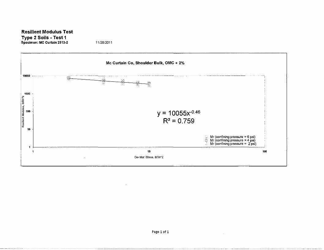
Resilient Modulus Test Type 2 Soils - Test 1 Specimen: MC Curtain 2813-2
1000
10
11 /28/2011
Mc Curtain Co, Shoulder Bulk, OMC + 2%
y = 1 oossx-0.46
R2 = 0.759
Mr (confining pressure :;;: 6 psi) O Mr (confining pressure = 4 psi)
Mr (confining pressure = 2 psi) :
• 100
Deviator Stress, lbf/in~2
Pagelofl
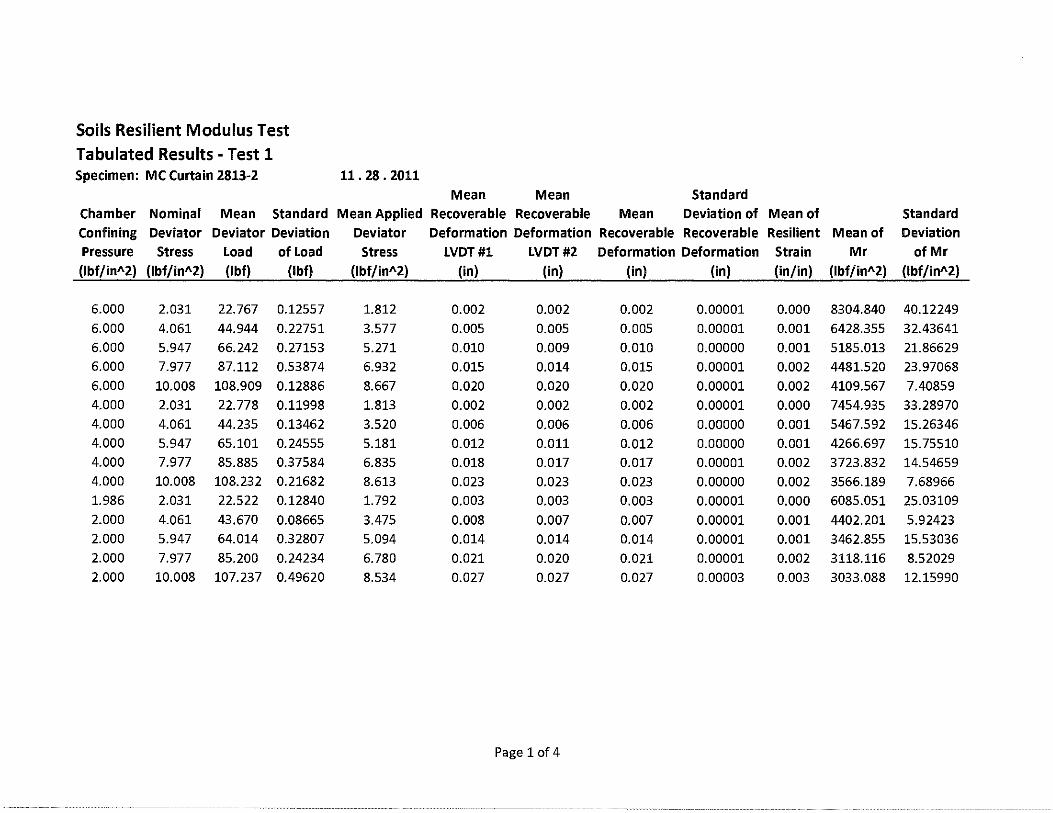
Soils Resilient Modulus Test Tabulated Results -Test 1 Specimen: MC Curtain 2813-2 11. 28. 2011
Mean Mean Standard Chamber Nominal Mean Standard Mean Applied Recoverable Recoverable Mean Deviation of Mean of Standard
Confining Deviator Deviator Deviation Deviator Deformation Deformation Recoverable Recoverable Resilient Mean of Deviation
Pressure Stress Load of Load Stress LVDT#l LVDT#2 Deformation Deformation Strain Mr of Mr
(lbf/in"2) (lbf/in"2) (lbf) (!bf) (lbf/in"2) (in) (in) (in) (in) (in/in) (lbf/in"2) (lbf/in"2)
6.000 2.031 22.767 0.12557 1.812 0.002 0.002 0.002 0.00001 0.000 8304.840 40.12249
6.000 4.061 44.944 0.22751 3.577 0.005 0.005 0.005 0.00001 0.001 6428.355 32.43641 6.000 5.947 66.242 0.27153 5.271 0.010 0.009 0.010 0.00000 0.001 5185.013 21.86629 6.000 7.977 87.112 0.53874 6.932 0.015 0.014 0.015 0.00001 0.002 4481.520 23.97068 6.000 10.008 108.909 0.12886 8.667 0.020 0.020 0.020 0.00001 0.002 4109.567 7.40859 4.000 2.031 22.778 0.11998 1.813 0.002 0.002 0.002 0.00001 0.000 7454.935 33.28970 4.000 4.061 44.235 0.13462 3.520 0.006 0.006 0.006 0.00000 0.001 5467.592 15.26346 4.000 5.947 65.101 0.24555 5.181 0.012 0.011 0.012 0.00000 0.001 4266.697 15.75510 4.000 7.977 85.885 0.37584 6.835 0.018 0.017 0.017 0.00001 0.002 3723.832 14.54659 4.000 10.008 108.232 0.21682 8.613 0.023 0.023 0.023 0.00000 0.002 3566.189 7.68966 1.986 2.031 22.522 0.12840 1.792 0.003 0.003 0.003 0.00001 0.000 6085.051 25.03109
2.000 4.061 43.670 0.08665 3.475 0.008 0.007 0.007 0.00001 0.001 4402.201 5.92423 2.000 5.947 64.014 0.32807 5.094 0.014 0.014 0.014 0.00001 0.001 3462.855 15.53036 2.000 7.977 85.200 0.24234 6.780 0.021 0.020 0.021 0.00001 0.002 3118.116 8.52029 2.000 10.008 107.237 0.49620 8.534 0.027 0.027 0.027 0.00003 0.003 3033.088 12.15990
Page 1of4

Resilient Modulus Test
NAME: TEST DATE: PROJECT NUMBER : COUNTY NAME : SOIL SERIES : SPECIMEN NUMBER :
1 SOIL PROPERTIES
OPTIMUM MOISTURE CONTENT , MAXIMUM DRY DENSITY, 95%MDD, MAXIMUM WET DENSITY,
2 SPECIMEN PROPERTIES
% (pcf) (pcf) (pct)
NET DIAMETER, (in) SAMPLE LENGTH
BEFORE TESTING, (in) AFTER TESTING, (in)
COMP ACTION WET WEIGHT , (g) COMP ACTION MOISTURE CONTENT , % MOISTURE CONTENT AFTER Mr TEST , % COMPACTION DRY DENSITY, (pct) COMP ACTION WET DENSITY, (pct)
3 TEST INFORMATION
PRE CONDITIONING-PERMANENT STRAIN, TESTING - PERMANENT STRAIN, PERMANENT DEFORMATION, (in)
> 5% > 5%
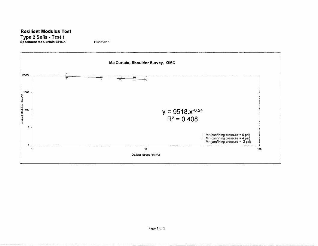
SILAS 11/29/2011 STPY -145C (150) & 24184 (04) Mc Curtain Shoulder 2815 - 1
17.0 103.8 98.61 121.45
4.0
9.5 9.35
3631.0 17.1 17.1
98.96 115.93
NO NO 0.15
Resilient Modulus Test Type 2 Soils - Test 1 Specimen: Mc Curtain 2815-1 11 /29/2011
Mc Curtain, Shoulder Survey, OMC
10000 ------ ---~-·~~ ". --- ---~-------l:"-----.J:';:O.----_-_--_-_jp:;:J·-----L' ·1
1000
10
10
Deviator Stress, lbf/inA2
y = 9518.x-0·24
R2 = 0.408
Pagelofl
Mr (confining pressure = 6 psi) Mr (confining pressure = 4 psi) Mr (confining pressure = 2 psi)
100
Soils Resilient Modulus Test Tabulated Results -Test 1 Specimen: Mc Curtain 2815-1 11. 29. 2011
Mean Mean Standard
Chamber Nominal Mean Standard Mean Applied Recoverable Recoverable Mean Deviation of Mean of Standard Confining Deviator Deviator Deviation Deviator Deformation Deformation Recoverable Recoverable Resilient Mean of Deviation Pressure Stress Load of Load Stress LVDT#l LVDT#2 Deformation Deformation Strain Mr of Mr (lbf/in"2) {lbf/in"2) (lbf) (lbf) {lbf/in"2) (in) (in) (in) (in) (in/in) (lbf/in"2) (lbf/in"2)
6.000 2.031 23.083 0.14231 1.837 0.002 0.002 0.002 0.00001 0.000 9743.310 26.51865 6.000 4.061 45.115 0.29422 3.590 0.004 0.004 0.004 0.00001 0.000 8469.263 58.49512 6.000 5.947 66.862 0.10944 5.321 0.007 0.007 0.007 0.00001 0.001 7389.958 14.20096 6.000 7.977 88.518 0.20066 7.044 0.010 0.010 0.010 0.00001 0.001 6835.813 18.47166 6.000 10.008 110.498 0.16060 8.793 0.013 0.012 0.013 0.00000 0.001 6539.583 10.02281 4.000 2.031 22.816 0.03401 1.816 0.002 0.002 0.002 0.00001 0.000 8223.623 29.15896 4.000 4.061 44.605 0.16220 3.550 0.005 0.005 0.005 0.00001 0.001 6970.481 26.47685 4.000 5.947 66.236 0.30378 5.271 0.008 0.008 0.008 0.00001 0.001 6230.805 32.05492 4.000 7.977 87.863 0.41715 6.992 0.012 0.011 0.011 0.00001 0.001 5826.623 24.88975 4.000 10.008 109.915 0.28021 8.747 0.015 0.014 0.015 0.00001 0.002 5668.452 16.34207 1.985 2.031 22.358 0.13590 1.779 0.003 0.003 0.003 0.00001 0.000 6442.236 48.08762 2.000 4.061 44.048 0.15921 3.505 0.006 0.006 0.006 0.00001 0.001 5514.054 26.86024 2.000 5.947 64.683 0.08797 5.147 0.010 0.010 0.010 0.00001 0.001 4944.160 7.92805 2.000 7.977 86.479 0.23239 6.882 0.014 0.014 0.014 0.00001 0.001 4701.763 12.48207 2.000 10.008 107.891 0.26180 8.586 0.018 0.018 0.018 0.00001 0.002 4588.309 10.18949
Page 1of4
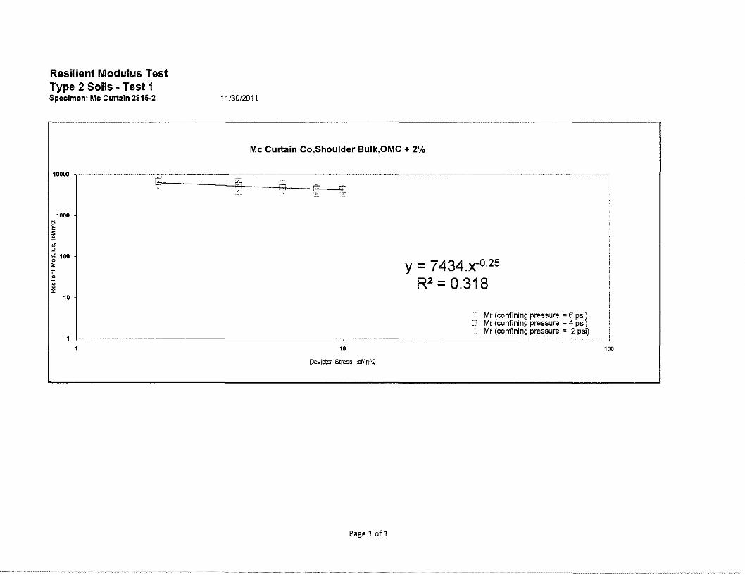
Resment Modulus Test Type 2 Soils ·Test 1 Specimen: Mc Curtain 2815-2
~
·" "' "" .;
"
1000
~ 100 ll
10
11 /30/2011
Mc Curtain Co,Shoulder Bulk,OMC + 2%
y = 7434.x-0·25
R2 = 0.318
Mr (confining pressure = 6 psi} O Mr (confining pressure = 4 psi) !
Mr (confining pressure = 2 psi) i
• 100
Deviator stress, lbflin"2
Page 1of1

Soils Resilient Modulus Test
Tabulated Results -Test 1 Specimen: Mc Curtain 2815-2 11. 30. 2011
Mean Mean Standard Chamber Nominal Mean Standard Mean Applied Recoverable Recoverable Mean Deviation of Mean of Standard Confining Deviator Deviator Deviation Deviator Deformation Deformation Recoverable Recoverable Resilient Mean of Deviation Pressure Stress Load of Load Stress LVDT#l LVDT#2 Deformation Deformation Strain Mr of Mr
(lbf/in"2) (lbf/in"2) (lbf) (lbf) (lbf/in"2) {in) {in) (in) (in) (in/in) (lbf/in"2) (lbf/in"2)
6.000 2.031 22.953 0.18448 1.827 0.002 0.002 0.002 0.00000 0.000 8069.556 63.40858
6.000 4.061 45.066 0.17841 3.586 0.005 0.005 0.005 0.00000 0.001 6782.219 25.96367
6.000 5.947 66.723 0.17627 5.310 0.008 0.008 0.008 0.00001 0.001 5957.319 16.18556
6.000 7.977 88.243 0.26433 7.022 0.012 0.012 0.012 0.00000 0.001 5462.625 15.81300
6.000 10.008 109.850 0.45913 8.742 0.016 0.016 0.016 0.00001 0.002 5225.624 22.46209
4.000 2.031 22.619 0.11399 1.800 0.003 0.003 0.003 0.00001 0.000 6516.645 30.00893
4.000 4.061 44.200 0.24684 3.517 0.006 0.006 0.006 0.00000 0.001 5298.066 28.63791
4.000 5.947 65.941 0.22409 5.247 0.011 0.011 0.011 0.00001 0.001 4699.893 16.61943
4.000 7.977 87.555 0.28313 6.967 0.015 0.015 0.015 0.00001 0.002 4447.126 13.66953 4.000 10.008 109.471 0.36297 8.711 0.019 0.019 0.019 0.00001 0.002 4382.437 15.86375
1.983 2.031 22.103 0.23153 1.759 0.004 0.004 0.004 0.00001 0.000 4723.992 54.45861
2.000 4.061 43.412 0.15775 3.455 0.008 0.008 0.008 0.00001 0.001 3915.326 17.19052
2.000 5.947 64.792 0.21732 5.156 0.014 0.014 0.014 0.00001 0.001 3523.919 12.12212
2.000 7.977 86.505 0.16643 6.884 0.019 0.019 0.019 0.00002 0.002 3403.568 6.03844
2.000 10.008 108.449 0.57062 8.630 0.024 0.024 0.024 0.00001 0.003 3388.244 18.72061
Page 1of4

AppendixD Shrinkage I Expansion Factors for Excavation
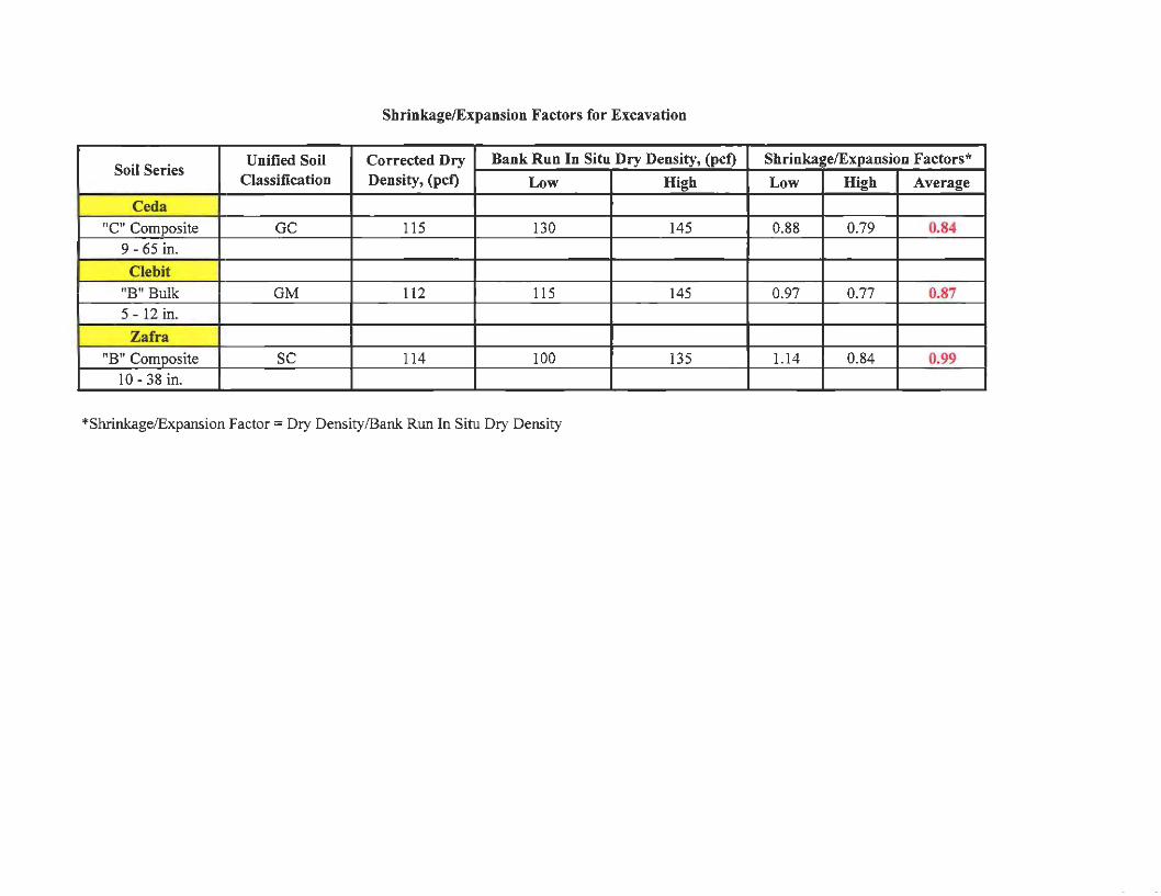
Shrinkage/Expansion Factors for Excavation
Soil Series Unified Soil Corrected Dry Bank Run In Situ Dry Density, (pct) Shrinkage/Expansion Factors*
Classification Density, (pct) Low High Low High Average
Ceda "C" Composite GC 115 130 145 0.88 0.79 0.84
9 - 65 in.
Cle bit
"B" Bulk GM 112 115 145 0.97 0.77 0.87 5 - 12 in.
Zafra
"B" Composite SC 114 100 135 1.14 0.84 0.99 10 - 38 in.
*Shrinkage/Expansion Factor= Dry Density/Bank Run In Situ Dry Density
Appendix E Shoulder Survey
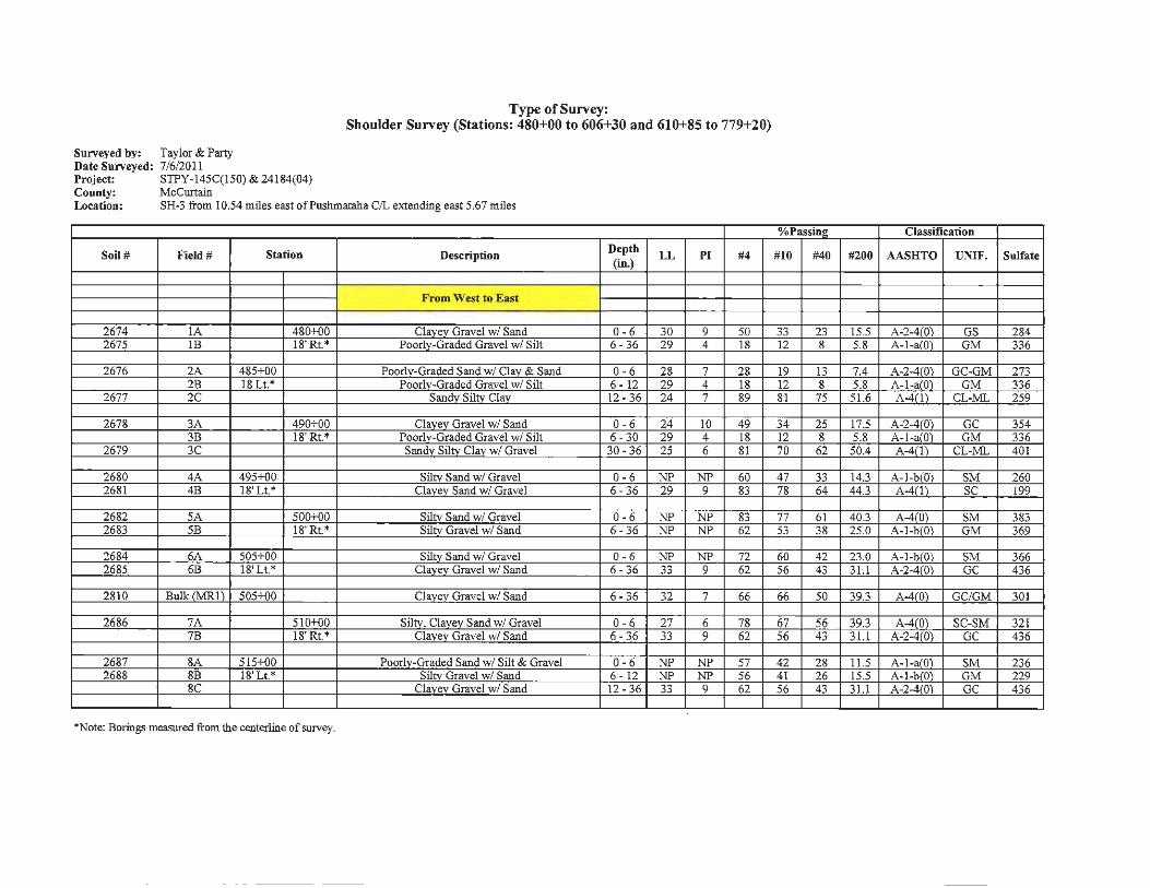
Type of Survey: Shoulder Survey (Stations: 480+00 to 606+30 and 610+85 to 779+20)
Sun-eyed by: Taylor & Party Date Sun-eyed: 7/6/2011 Project: STPY-145C(l50) & 24184(04) County: McCurtain Location: SH-3 from I 0.54 miles east of Pushmataha C/L extending east 5.67 miles
%Passing Classification
Soil# Field# Station Description Depth
LL PI #4 #10 #40 #200 AASHTO UNIF. Sulfate (in.)
From West to East
2674 IA 4SO+OO Clavev Gravel w/ Sand 0-6 30 9 50 33 23 15.5 A-2-4(0) GS 2S4 2675 lB 18' Rt.* Poorly-Graded Gravel w/ Silt 6 - 36 29 4 IS 12 s 5.S A-1-a(O) GM 336
2676 2A 4S5+o0 Poorly-Graded Sand w/ Clay & Sand 0 - 6 28 7 28 19 13 7.4 A-2-4(0) GC-GM 273 28 lS Lt.* Poorlv-Graded Gravel w/ Silt 6 - 12 29 4 IS 12 s 5.S A-1-a(O) GM 336
2677 2C Sandv Siltv Clav 12- 36 24 7 S9 81 75 51.6 A-4(1) CL-ML 259
267S 3A 490+00 Clavev Gravel w/ Sand 0-6 24 10 49 34 25 17.5 A-2-4(0) GC 354 38 18'Rt.* Poorlv-Graded Gravel w/ Silt 6 - 30 29 4 18 12 s 5.S A-1-a(O) GM 336
2679 3C Sandv Siltv Clav w/ Gravel 30 - 36 25 6 SI 70 62 50.4 A-4(1) CL-ML 401
2680 4A 495+00 Siltv Sand w/ Gravel 0 -6 NP NP 60 47 33 14.3 A-1-b(O) SM 260 26Sl 4B IS' Lt.* Clavev Sand w/ Gravel 6 - 36 29 9 83 78 64 44.3 A-4(1) SC 199
26S2 5A 500+00 Siltv Sand w/ Gravel 0-6 NP NP S3 77 61 40.3 A-4(0) SM 3S3 26S3 5B lS' Rt.* Silty Gravel w/ Sand 6- 36 NP NP 62 53 3S 25.0 A-1-b(O) GM 369
2684 6A 505+00 Siltv Sand w/ Gravel 0 - 6 NP NP 72 60 42 23.0 A-1-b(O) SM 366 26S5 6B 18'Lt.* Clavev Gravel w/ Sand 6 - 36 33 9 62 56 43 31.l A-2-4(0) GC 436
2S10 Bullc rMRl) 505+00 Clavev Gravel w/ Sand 6 - 36 32 7 66 66 50 39.3 A-4(0) GC/GM 301
2686 7A 510+00 Silty. Clavev Sand w/ Gravel 0 - 6 27 6 7S 67 56 39.3 A-4(0) SC-SM 321 7B 18' Rt.* Clavev Gravel w/ Sand 6 - 36 33 9 62 56 43 3 1.1 A-2-4(0) GC 436
26S7 SA 515+00 Poorlv-Graded Sand w/ Silt & Gravel 0-6 NP NP 57 42 2S 11.5 A-1-a(O) SM 236 268S SB 18' Lt.* Silty Gravel w/ Sand 6 - 12 NP NP 56 41 26 15.5 A-1-b(O) GM 229
SC Clavev Gravel w/ Sand 12 - 36 33 9 62 56 43 3 1.1 A-2-4(0) GC 436
*Note: Borings measured from the centerline of survey.

0/oPassino Classification
Soil# Field# Station Description Depth LL PI #4 #10 #40 #200 AASHTO UNIF. Sulfat1 (in.)
2689 9A 520+00 Siltv Sand w/ Gravel 0-6 NP NP 72 58 42 23.5 A-l-bl01 SM 252 9B 18'Rt.* Clavev Gravel w/ Sand 6-36 33 9 62 56 43 31.1 A-2-4!01 GC 436
2690 IOA 525+00 Siltv Sand w/ Gravel 0-6 NP NP 66 55 44 24.2 A-l-bl01 SM 310 2691 !OB 18'Lt.* Clavev Gravel w/ Sand 6-36 28 6 60 49 33 21.9 A-1¥01 GC-GM 332
2692 !IA 530+{)0 Clavev Gravel w/ Sand 0-6 35 9 42 32 24 16.5 A-2-4!01 GC 399 2693 IIB 18' Rt.* Poorh:-Graded Gravel w/ Silt 6-36 NP NP 25 19 14 10.3 A-1401 GM 356
2694 12A 535+00 Siltv Gravel w/ Sand 0-6 NP NP 53 41 31 17.6 A-l-bl01 GM 368 12B 18'Lt.* Poorlv-Graded Gravel w/ Silt 6-36 NP NP 25 19 14 10.3 A-1-a(Q) GM 356
2695 13A 540+00 Well-Graded Gravel w/ Silt & Sand 0-6 NP NP 36 30 24 11.9 A-1-a(Ol GM 311 13B 18'Rt.* Poorlv-Graded Gravel w/ Silt 6 - 36 NP NP 25 19 14 10.3 A-l-al01 GM 356
2696 14A 545+00 Siltv Sand w/ Gravel 0-6 NP NP 78 64 51 31.3 A-2-4(0) SM 388 2697 14B 18' Lt.* Clavev Gravel w/ Sand 6-36 33 8 52 40 24 16.2 A-2-4!01 GM 347
2698 15A 550+00 Siltv Sand 0-6 NP NP 88 79 61 32.2 A-2-4!01 SM 304 2699 15B 18' Rt.* Siltv Gravel w/ Sand 6-36 NP NP 45 36 27 17.8 A-I-b<01 GM 379
2700 16A 555+-00 Siltv Gravel w/ Sand 0-6 NP NP 47 36 24 12. l A-I-ar01 GM 2701 16B 18' Lt.* Siltv Gravel w/ Sand 6 - 36 NP NP 55 42 28 19. I A-I-bl01 GM 151
*Note: Borings measured from the centerline of survey.
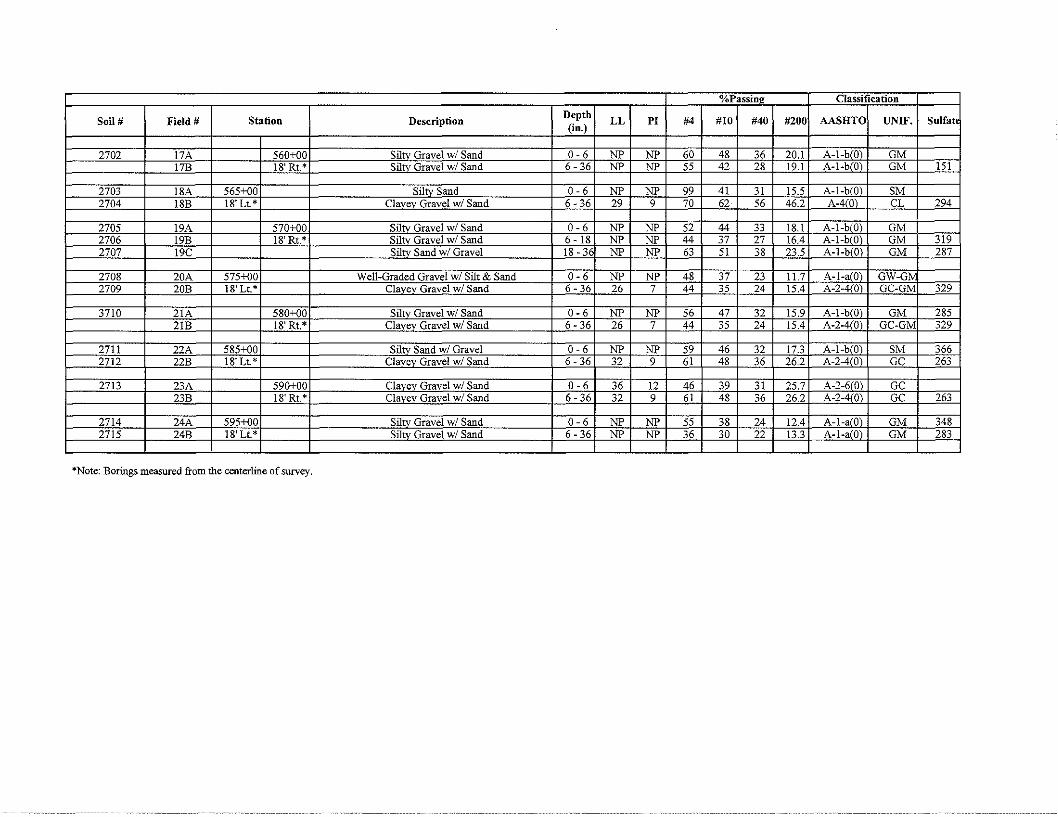
o/oPassin\'.J Classification
Soil# Field# Station Description Depth LL Pl #4 #10 #40 #200 AASHTO UNIF. Sulfat1
(in.)
2702 17A 560+00 Siltv Gravel w/ Sand 0-6 NP NP 60 48 36 20.1 A-1-blO) GM 17B 18' Rt.* Siltv Gravel w/ Sand 6-36 NP NP 55 42 28 19.1 A-1-blO) GM 151
2703 18A 565+00 Siltv Sand 0-6 NP NP 99 41 31 15.5 A-1-b(Q) SM 2704 18B 18'Lt.* Clavev Gravel w/ Sand 6-36 29 9 70 62 56 46.2 A-410) CL 294
2705 19A 570+00 Sil,.," Gravel w/ Sand 0-6 NP NP 52 44 33 18.1 A-1-b!O) GM 2706 19B 18' Rt.* Sihv Gravel w/ Sand 6 - 18 NP NP 44 37 27 16.4 A-1-blO) GM 319 2707 19C Siltv Sand w/ Gravel 18 - 36 NP NP 63 51 38 23.5 A-1-b!O) GM 287
2708 20A 575+o0 Well-Graded Gravel w/ Silt & Sand 0-6 NP NP 48 37 23 11.7 A-1-a(O) GW-G' 2709 20B 18'Lt.* Clavev Gravel w/ Sand 6- 36 26 7 44 35 24 15.4 A-2-4!0) GC-GM 329
3710 21A 580+00 Siltv Gravel w/ Sand 0-6 NP NP 56 47 32 15.9 A-l-bl01 GM 285 21B 18' Rt.* Clavev Gravel w/ Sand 6-36 26 7 44 35 24 15.4 A-2-4!01 GC-GM 329
2711 22A 585+00 Sihv Sand w/ Gravel 0-6 NP NP 59 46 32 17.3 A-l-bl01 SM 366 2712 22B 18'Lt.* Clavev Gravel w/ Sand 6-36 32 9 61 48 36 26.2 A-2-4!01 GC 263
2713 23A 590+oo Clavev Gravel w/ Sand 0-6 36 12 46 39 31 25.7 A-2-6101 GC 23B 18'Rt.* Clavev Gravel w/ Sand 6 - 36 32 9 61 48 36 26.2 A-2-4!01 GC 263
2714 24A 595+00 Siltv Gravel w/ Sand 0-6 NP NP 55 38 24 12.4 A-1-alO) GM 348 2715 24B 18' Lt.* Siltv Gravel w/ Sand 6 - 36 NP NP 36 30 22 13.3 A-1-a(O) GM 283
*Note: Borings measured from the centerline of survey.
o/oPassinl! Classification
Soil# Field# Station Description Depth LL Pl #4 #10 #40 #200 AASHTO UNIF. Sulfatt (in.)
2716 25A 600+o0 Siltv Gravel w/ Sand 0-6 NP NP 51 43 34 20.9 A-1-b(Ol GM 2717 25B 18'Rt.* Clavev Gravel w/ Sand 6 - 36 28 6 47 34 21 13.4 A-1-a 01 GC-GM 339
2718 26A 605+00 Siltv Sand w/ Gravel 0-6 NP NP 65 55 42 19.4 A-1-blOi SM 210 2719 26B 18'Lt.* Clavev Gravel w/ Sand 6-36 23 5 60 48 36 22.8 A-1-brOl GC-GM 288
2720 27A 611+00 Siltv Sand w/ Gravel 0-6 NP NP 72 63 51 24.8 A-2-4(0 SM 2721 27B 18' Rt.* Siltv Gravel w/ Sand 6 - 12 NP NP 49 37 26 14.7 A-1-a(Q GM 235 2722 27C Clavev Sand w/ Gravel 12-36 34 11 69 54 40 28.2 A-2-610 SC 304
2807 BulkrMR 611+00 Siltv Gravel w/ Sand 6 - 12 NP NP 62 62 47 25.4 A-1-b(Ql GM 284
2723 28A 615+00 Siltv Sand w/ Gravel 0-6 NP NP 76 65 46 23.7 A-1-b Ol SM 338 2724 28B 18'Lt.* Siltv Sand w/ Gravel 6 - 36 NP NP 61 44 27 16.7 A-1-bWl SM 369
2725 29A 620+00 Siltv Gravel w/ Sand 0-6 NP NP 48 39 29 14.9 A-1-afOl GM 294 2726 29B 18' Rt.* Clavev Sand w/ Gravel 6-36 30 10 71 57 45 32.1 A-2-4 01 SC 264
2727 30A 625+o0 Siltv Gravel w/ Sand 0-6 NP NP 47 40 31 17.2 A-1-b Ol GM 262 2728 30B 18' Lt.* Siltv Gravel w/ Sand 6 - 36 NP NP 60 48 36 22.4 A-1-b(Ql GM 305
2729 31A 630+00 Poorlv-Graded Gravel w/ Silt & Sand 0-6 NP NP 33 24 17 8.0 A-1-a Ol GP-GM 2730 31B 18'Rt.* Siltv Sand w/ Gravel 6 - 12 NP NP 60 41 28 14.2 A-1-a 01 SM 212 2731 31C Sandv Siltv Clav 12 - 36 27 6 95 90 77 57.2 A-4111 CL-ML 396
2732 32A 635+00 Siltv Gravel w/ Sand 0-6 NP NP 45 36 26 13.9 A-1-a(Q) GM 291 2733 32B 18'Lt.* Clavev Sand w/ Gravel 6-36 29 9 64 50 33 19.6 A-2-4f0l SC 340
*Note: Borings measured from the centerline of survey.
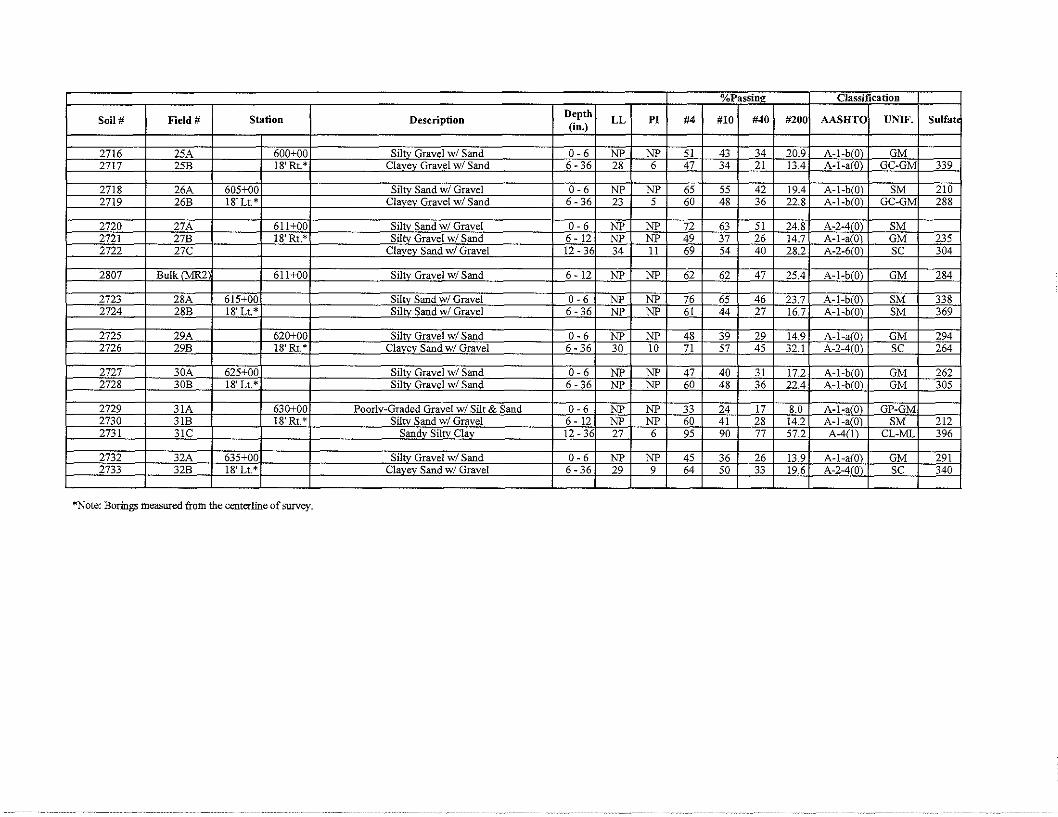
o/0Passin2 Classification
Soil# Field# Station Description Depth LL PI #4 #IO #40 #200 AASHTO UNIF. Sulfat1 (in.)
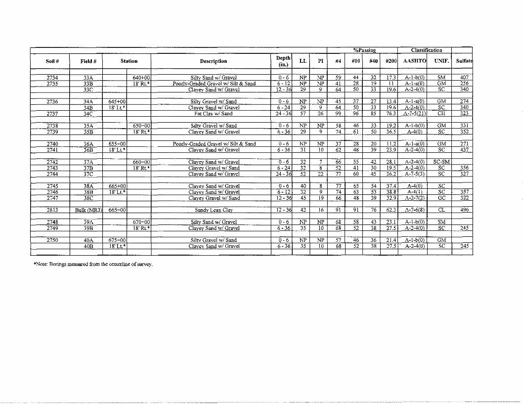
2734 33A 640+00 Siltv Sand w/ Gravel 0-6 NP NP 59 44 32 17.3 A-1-blO) SM 407 2735 33B 18'Rt.* Poorlv-Graded Gravel w/ Silt & Sand 6 - 12 NP NP 41 28 19 11 A-1-a101 GM 256
33C Clavev Sand w/ Gravel 12-36 29 9 64 50 33 19.6 A-2-4!01 SC 340
2736 34A 645+00 Siltv Gravel w/ Sand 0-6 NP NP 45 37 27 13.4 A-l-a101 GM 274 34B 18' Lt.* Clavev Sand w/ Gravel 6-24 29 9 64 50 33 19.6 A-2-4!01 SC 340
2737 34C Fat Clav w/ Sand 24-36 57 26 99 96 85 76.3 A-7-5121 CH 323
2738 35A 650+00 Siltv Gravel w/ Sand 0-6 NP NP 58 46 33 19.2 A-1-b!Ol GM 331 2739 35B 18' Rt.* Clavev Sand w/ Gravel 6-36 29 9 74 61 50 36.5 A-4!0) SC 352
2740 36A 655+00 Poorlv-Graded Gravel w/ Silt & Sand 0-6 NP NP 37 28 20 11.2 A-1-alO) GM 271 2741 36B 18'Lt.* Clavev Sand w/ Gravel 6-36 31 10 62 48 39 23.9 A-2-4!0) SC 437
2742 37A 660+00 Clavev Sand w/ Gravel 0-6 32 7 66 55 42 28.1 A-2-4!0) SC-SM 2743 37B 18' Rt* Clavev Gravel w/ Sand 6-24 32 8 52 41 30 19.5 A-2-410\ SC 356 2744 37C Clavev Sand w/ Gravel 24-36 52 22 77 60 45 36.2 A-7-513) SC 327
2745 38A 665+00 Clavey Sand w/ Gravel 0-6 40 8 77 65 54 37.4 A-4!0) SC 2746 38B 18' Lt.* Clavev Sand w/ Gravel 6 - 12 32 9 74 63 53 38.8 A-4!1i SC 357 2747 38C Clavev Gravel w/ Sand 12 - 36 45 19 66 48 39 32.9 A-2-7121 GC 322
2813 Bulk 665+00 Sandv Lean Clav 12 -36 42 16 91 91 76 62.3 A-7-6181 CL 496
2748 39A 670+00 Siltv Sand w/ Gravel 0-6 NP NP 68 58 43 23.1 A-1-blO) SM 2749 39B 18' Rt.* Clavev Sand w/ Gravel 6-36 35 10 68 52 38 27.5 A-2-410) SC 245
2750 40A 675+00 Sil"' Gravel w/ Sand 0-6 NP NP 57 46 36 21.4 A-1-b!Ol GM 40B 18'Lt.* Clavev Sand w/ Gravel 6-36 35 10 68 52 38 27.5 A-2-4101 SC 245
*Note: Borings measured from the centerline of survey.

o/oPassin£!: Classification
Soil# Field# Station Description Depth LL PI #4 #10 #40 #200 AASHTO UNIF. Sulfatf
(in.)
2751 41A 680+00 Siltv Gravel w/ Sand 0-6 NP NP 53 41 31 16.9 A-1-b Ol GM 2752 41B 18' Rt.* Siltv, Clavev Sand w/ Gravel 6-36 27 6 64 51 40 26.4 A-2-4rDl SC-SM 223
2753 42A 685+00 Siltv Gravel w/ Sand 0-6 NP NP 59 45 35 20.7 A-1-blOl GM 42B l&'Lt.* Siltv Gravel w/ Sand 6 - 18 NP NP 59 45 35 20.7 A-1-brDl GM
2754 42C Siltv Gravel w/ Sand 18 -36 NP NP 56 39 30 23.7 A-1-b(Ql GM 317
2755 43A 690+00 Siltv Sand w/ Gravel 0-6 NP NP 68 51 32 17.6 A-1-b 0 SM 2756 43B 18' Rt.* Siltv Sand w/ Gravel 6- 18 NP NP 65 49 31 17.6 A-1-b 0 SM 266
42C Siltv Gravel w/ Sand 18 - 36 NP NP 56 39 30 23.7 A-1-b 0 GM 317
2757 44A 695+00 Siltv Gravel w/ Sand 0-6 NP NP 53 44 33 18.5 A-1-b(Ol GM 2758 44B 18' Lt.* Clavev Sand w/ Gravel 6 - 36 30 7 69 55 40 26.2 A-2-4(01 SC-SM 365
2759 45A 700+00 Clavev Gravel w/ Sand 0-6 30 6 53 35 27 14.7 A-1-a(Q) GC-GM 45B 18'Rt.* Clavev Sand w/ Gravel 6 - 36 30 7 69 55 40 26.2 A-2-¥01 SC-SM 365
2760 46A 705+00 Siltv Sand w/ Gravel 0-6 NP NP 67 57 46 26.2 A-2-4(Ql SM 2761 46B 18' Lt.* Siltv Sand w/ Gravel 6-36 NP NP 65 53 41 24.1 A-1-bfOl SM 327
2762 47A 710+00 Siltv Gravel w/ Sand 0-6 NP NP 62 53 43 25.2 A-1-b(Ql GM 2763 47B 18'Rt.* Siltv Sand w/ Gravel 6-36 NP NP 80 70 60 38.4 A-4101 SM 302
2764 48A 715+00 Siltv Gravel w/ Sand 0-6 NP NP 48 40 30 17.4 A-1-b(Ql GM 2765 48B 18'Lt.* Siltv, Clavev Sand w/ Gravel 6-36 28 7 64 47 33 21.0 A-2-410l SC-SM 291
*Note: Borings measured from the centerline of survey.
o/0Passin2 Classification
Soil# Field# Station Description Depth LL Pl (in.)
#4 #10 #40 #200 AASHTO UNIF. Sulfatf
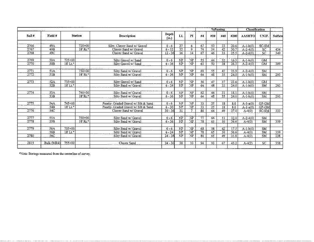
2766 49A 720+00 Siltv, Clavev Sand w/ Gravel 0-6 27 6 67 so 33 20.6 A-1-b!O\ SC-SM 2767 49B 18'Rt.* Clavev Sand w/ Gravel 6 - 12 32 9 74 S4 42 30.7 A-2-4 Dl SC 434 2768 49C Clavev Sand w/ Gravel 12 - 36 36 14 67 46 33 2S.S A-2-6!0) SC 349
2769 SOA 72S+DO Siltv Gravel w/ Sand 0-6 NP NP SS 44 32 16.5 A-1-b Ol GM 2770 SOB 18'Lt.* Siltv Gravel w/ Sand 6 - 36 NP NP 61 so 38 26.3 A-2-4(0) GM 389
2771 SIA 730+DO Siltv Sand w/ Gravel 0-6 NP NP 69 SS 42 2S.9 A-2-4 Ol SM 2772 SIB 18'Rt.* Siltv Sand w/ Gravel 6-36 NP NP 64 48 35 24.0 A-1-b(Q) SM 293
2773 52A 735+DO Siltv Gravel w/ Sand 0-6 NP NP 56 47 37 23.6 A-1-b Ol GM 52B 18'Lt.* Siltv Sand w/ Gravel 6-24 NP NP 64 48 35 24.0 A-1-b(Q) SM 293
2774 53A 740+DO Siltv Sand w/ Gravel 0-6 NP NP 62 46 31 18.1 A-1-blQ) SM 53B l81 Rt.* Siltv Sand w/ Gravel 6 - 36 NP NP 64 48 3S 24.0 A-1-b(Q) SM 293
277S S4A 74S+DO Poorlv- Graded Gravel w/ Silt & Sand 0-6 NP NP 33 2S 18 8.0 A-1-a 0) GP-GM S4B 18'Lt.* Poorlv- Graded Gravel w/ Silt & Sand 6-30 NP NP 33 2S 18 8.0 A-1-a 0) GP-GM
2776 54C Clavev Sand w/ Gravel 30-36 31 7 80 64 49 37.0 A-410) SC-SM 333
2777 55A 750+DO Siltv Sand w/ Gravel 0-6 NP NP 77 66 51 32.0 A-2-4(0) SM 2778 SSB 18'Rt.* Siltv Sand w/ Gravel 6 - 36 NP NP 78 65 50 36.6 A-4{0) SM 359
2779 S6A 755+DO Siltv Sand w/ Gravel 0-6 NP NP 68 S8 42 17.5 A-1-b 0) SM 56B 18' Lt.* Siltv Sand w/ Gravel 6-24 NP NP 78 6S so 36.6 A-41 0) SM 359
2780 S6C Siltv Sand w/ Gravel 24-36 NP NP 80 6S 49 3S.8 A-41 0) SM 238
2815 Bulk(Ml<4 755+DO Clavev Sand 24-36 38 10 94 93 67 45.2 A-4(2) SC 358
*Note: Borings measured from the centerline of survey.

0/0Passin2 Classification
Soil# Field# Station Description Depth LL PI #4 #10 #40 #200 AASHTO UNIF. Sulfat (in.)
2781 57A 760+-00 Siltv Sand w/ Gravel 0-6 NP NP 62 46 31 17.0 A-1-b(O) SM 2782 57B 18'Rt.* Siltv. Clavev Sand w/ Gravel 6 - 36 29 6 74 60 43 27.2 A-2-4!0) SC-SM 275
2783 58A 765+00 Siltv Gravel w/ Sand 0-6 NP NP 51 41 31 16.7 A-l-bl01 GM 58B 18' Lt.* Siltv Clavev Sand w/ Gravel 6-36 29 6 74 60 43 27.2 A-2-4!0) SC-SM 275
2784 59A 770+00 Clavev Sand w/ Gravel 0-6 32 8 67 52 38 25.2 A-2-4101 SC 59B 18'Rt.* Sihv. Clavev Sand w/ Gravel 6 - 36 29 6 74 60 43 27.2 A-2-4(0\ SC-SM 275
2785 60A 775+00 Siltv Sand w/ Gravel 0-6 NP NP 73 63 52 36.9 A-410) SM 2786 60B 18' Lt.* Siltv Sand w/ Gravel 6 -24 NP NP 68 53 38 24.7 A-1-b(O\ SM 234
Shale 1 NO Sarriole) 24+
2787 61A 779+00 Poorl-Graded Gravel w/ Silt & Sand 0-6 NP NP 28 23 18 11.1 A-1-afO\ GP-GM 2788 61B 18' Rt.* Siltv Gravel w/ Sand 6-36 NP NP 56 43 29 21.9 A-1-bfOl GM 452

Appendix F Pavement Surface Condition
and Falling Weight Deflectometer (FWD)
Oklahoma Department of Transportation Materials Division
Geotechnical Branch
FWD Report for:
Project No. STPY-145C(150) Job Piece No. 24184(04)
SH-3 from 10.54 miles East of Pushmataha C/L, extending East 5.67 miles.
McCurtain Co.
FWD Operator: Scott Cosby Data Analysis: Scott Cosby and Chris Clarke, P.E.

Contents: (In order of Appearance)
• Cover Sheet
• Contents Sheet
• FWD Report Sheets(s)
• Important Notes
• Pavement Cores (Log & Photographs)
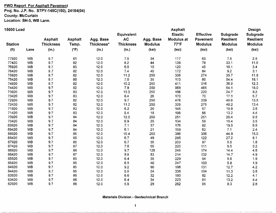
FWD Re12ort For As12halt Pavement Proj. No. J.P. No. STPY-145C(150), 24184(04) County: McCurtain Location: SH-3, WB Lane.
15000 Load Asphalt Design Equivalent Elastic Effective Subgrade Subgrade
Asphalt Asphalt Agg. Base AC Agg. Base Modulus at Pavement Resilient Resilient Station Thickness Temp. Thickness* Thickness Modulus 77°F Modulus Modulus Modulus
(ft) Lane (in.) (oF) (in.) (in.) (ksi) (ksi) (ksi) (ksi) (ksi)
77920 WB 9.7 81 12.0 7.9 34 117 63 7.5 2.5 77420 WB 9.7 82 12.0 8.2 44 139 78 33.1 11.0 76920 WB 9.7 83 12.0 6.0 15 120 45 10.1 3.4 76420 WB 9.7 82 12.0 7.4 40 172 84 9.2 3.1 75920 WB 9.7 82 12.0 11.2 250 306 274 35.7 11.9 75420 WB 9.7 80 12.0 7.0 35 173 80 54.4 18.1 74920 WB 9.7 82 12.0 10.2 250 411 316 36.9 12.3 74420 WB 9.7 82 12.0 7.9 250 868 465 54.1 18.0 73920 WB 9.7 83 12.0 13.3 250 186 220 24.7 8.2 73420 WB 9.7 83 12.0 6.4 26 170 70 17.1 5.7 72920 WB 9.7 82 12.0 9.7 250 476 339 40.6 13.5 72420 WB 9.7 82 12.0 11.2 250 309 275 40.2 13.4 71920 WB 9.7 83 12.0 6.2 20 145 57 10.8 3.6 71420 WB 9.7 83 12.0 5.4 18 196 66 13.2 4.4 70920 WB 9.7 84 12.0 12.0 250 251 251 28.4 9.5 70420 WB 9.7 84 12.0 6.9 25 134 59 10.4 3.5 69920 WB 9.7 84 12.0 7.1 37 176 82 19.5 6.5 69420 WB 9.7 84 12.0 6.1 21 159 62 7.1 2.4 68920 WB 9.7 85 12.0 10.4 250 386 306 44.9 15.0 68420 WB 9.7 85. 12.0 6.7 49 285 122 27.2 9.1 67920 WB 9.7 85 12.0 6.7 35 203 87 5.5 1.8 67420 WB 9.7 87 12.0 7.6 55 220 111 9.5 3.2 66920 WB 9.7 86 12.0 9.7 128 245 174 14.4 4.8 66420 WB 9.7 87 12.0 8.8 83 214 132 14.7 4.9 65920 WB 9.7 85 12.0 6.4 35 229 94 5.6 1.9 65420 WB 9.7 85 12.0 6.5 40 247 103 5.8 1.9 64920 WB 9.7 85 12.0 9.2 90 198 131 12.7 4.2 64420 WB 9.7 85 12.0 5.0 24 338 104 11.3 3.8 63920 WB 9.7 86 12.0 6.6 32 193 82 12.2 4.1 63420 WB 9.7 86 12.0 6.4 34 223 91 13.2 4.4 62920 WB 9.7 86 12.0 5.8 29 262 95 8.3 2.8
Materials Division - Geotechnical Branch
1
- --------- ----- ------------ ------------------·- -------------------------- ------------ -----·"· ----- -----·-----
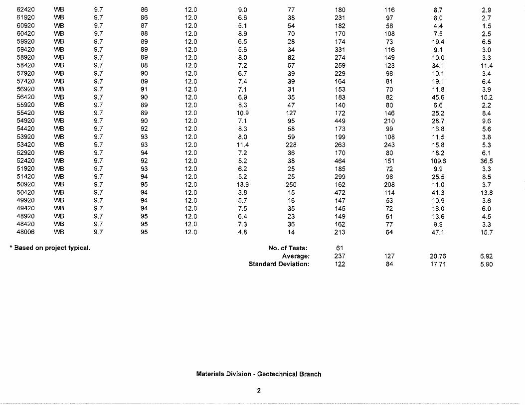
62420 WB 9.7 86 12.0 9.0 77 180 116 8.7 2.9 61920 WB 9.7 86 12.0 6.6 38 231 97 8.0 2.7 60920 WB 9.7 87 12.0 5.1 54 182 58 4.4 1.5 60420 WB 9.7 88 12.0 8.9 70 170 108 7.5 2.5 59920 WB 9.7 89 12.0 6.5 28 174 73 19.4 6.5 59420 WB 9.7 89 12.0 5.6 34 331 116 9.1 3.0 58920 WB 9.7 89 12.0 8.0 82 274 149 10.0 3.3 58420 WB 9.7 88 12.0 7.2 57 259 123 34.1 11.4 57920 WB 9.7 90 12.0 6.7 39 229 98 10.1 3.4 57420 WB 9.7 89 12.0 7.4 39 164 81 19.1 6.4 56920 WB 9.7 91 12.0 7.1 31 153 70 11.8 3.9 56420 WB 9.7 90 12.0 6.9 35 183 82 45.6 15.2 55920 WB 9.7 89 12.0 8.3 47 140 80 6.6 2.2 55420 WB 9.7 89 12.0 10.9 127 172 146 25.2 8.4 54920 WB 9.7 90 12.0 7.1 95 449 210 28.7 9.6 54420 WB 9.7 92 12.0 8.3 58 173 99 16.8 5.6 53920 WB 9.7 93 12.0 8.0 59 199 108 11.5 3.8 53420 WB 9.7 93 12.0 11.4 228 263 243 15.8 5.3 52920 WB 9.7 94 12.0 7.2 36 170 80 18.2 6.1 52420 WB 9.7 92 12.0 5.2 38 464 151 109.6 36.5 51920 WB 9.7 93 12.0 6.2 25 185 72 9.9 3.3 51420 WB 9.7 94 12.0 5.2 25 299 98 25.5 8.5 50920 WB 9.7 95 12.0 13.9 250 162 208 11.0 3.7 50420 WB 9.7 94 12.0 3.8 15 472 114 41.3 13.8 49920 WB 9.7 94 12.0 5.7 16 147 53 10.9 3.6 49420 WB 9.7 94 12.0 7.5 35 145 72 18.0 6.0 48920 WB 9.7 95 12.0 6.4 23 149 61 13.6 4.5 48420 WB 9.7 95 12.0 7.3 36 162 77 9.9 3.3 48006 WB 9.7 95 12.0 4.8 14 213 64 47.1 15.7
• Based on project typical. No. of Tests: 61 Average: 237 127 20.76 6.92
Standard Deviation: 122 84 17.71 5.90
Materials Division - Geotechnical Branch
2
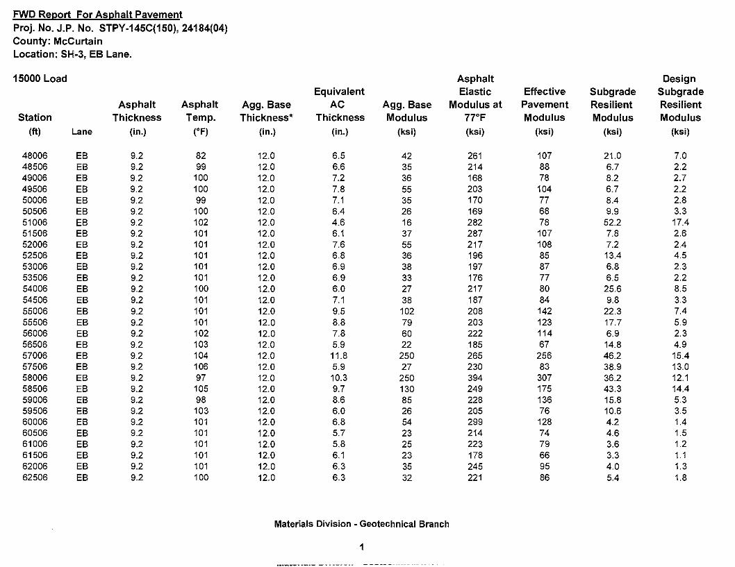
FWD Re12ort For As12halt Pavement Proj. No. J.P. No. STPY-145C(150), 24184(04) County: McCurtain Location: SH-3, EB Lane.
15000 Load Asphalt Design Equivalent Elastic Effective Subgrade Subgrade
Asphalt Asphalt Agg. Base AC Agg. Base Modulus at Pavement Resilient Resilient Station Thickness Temp. Thickness* Thickness Modulus 77°F Modulus Modulus Modulus
(ft) Lane (in.) (oF) (in.) (in.) (ksi) (ksi) (ksi) (ksi) (ksi)
48006 EB 9.2 82 12.0 6.5 42 261 107 21.0 7.0 48506 EB 9.2 99 12.0 6.6 35 214 88 6.7 2.2 49006 EB 9.2 100 12.0 7.2 36 168 78 8.2 2.7 49506 EB 9.2 100 12.0 7.8 55 203 104 6.7 2.2 50006 EB 9.2 99 12.0 7.1 35 170 77 8.4 2.8 50506 EB 9.2 100 12.0 6.4 26 169 68 9.9 3.3 51006 EB 9.2 102 12.0 4.6 16 282 78 52.2 17.4 51506 EB 9.2 101 12.0 6.1 37 287 107 7.8 2.6 52006 EB 9.2 101 12.0 7.6 55 217 108 7.2 2.4 52506 EB 9.2 101 12.0 6.8 36 196 85 13.4 4.5 53006 EB 9.2 101 12.0 6.9 38 197 87 6.8 2.3 53506 EB 9.2 101 12.0 6.9 33 176 77 6.5 2.2 54006 EB 9.2 100 12.0 6.0 27 217 80 25.6 8.5 54506 EB 9.2 101 12.0 7.1 38 187 84 9.8 3.3 55006 EB 9.2 101 12.0 9.5 102 208 142 22.3 7.4 55506 EB 9.2 101 12.0 8.8 79 203 123 17.7 5.9 56006 EB 9.2 102 12.0 7.8 60 222 114 6.9 2.3 56506 EB 9.2 103 12.0 5.9 22 185 67 14.8 4.9 57006 EB 9.2 104 12.0 11.8 250 265 256 46.2 15.4 57506 EB 9.2 106 12.0 5.9 27 230 83 38.9 13.0 58006 EB 9.2 97 12.0 10.3 250 394 307 36.2 12.1 58506 EB 9.2 105 12.0 9.7 130 249 175 43.3 14.4 59006 EB 9.2 98 12.0 8.6 85 228 136 15.8 5.3 59506 EB 9.2 103 12.0 6.0 26 205 76 10.6 3.5 60006 EB 9.2 101 12.0 6.8 54 299 128 4.2 1.4 60506 EB 9.2 101 12.0 5.7 23 214 74 4.6 1.5 61006 EB 9.2 101 12.0 5.8 25 223 79 3.6 1.2 61506 EB 9.2 101 12.0 6.1 23 178 66 3.3 1. 1 62006 EB 9.2 101 12.0 6.3 35 245 95 4.0 1.3 62506 EB 9.2 100 12.0 6.3 32 221 86 5.4 1.8
Materials Division - Geotechnical Branch
1
Important Notes:
• Modulus 6.0 from TTI (Texas Transportation Institute) was the software used for the backcalculation.
• The calculated moduli values were entered and figured in (ksi) units.
• The BELLS Method was used to obtain the Asphalt Temperature Correction to run the backcalculation in Modulus 6.0. In addition, the temperature correction was normalized to 77° F.
• For the Asphalt Temperature Correction, the Broken Bow Mesonet Station data was used to perform the calculations.
• Interpretation of FWD Analysis data indicates High Variability in the BASE (E2) and SUBG (E4) Modulus values and a higher than normal standard deviation values for both the EB and WB Lanes ofSH-3.
• Detailed information of this analysis is available at the Geotechnical Branch.
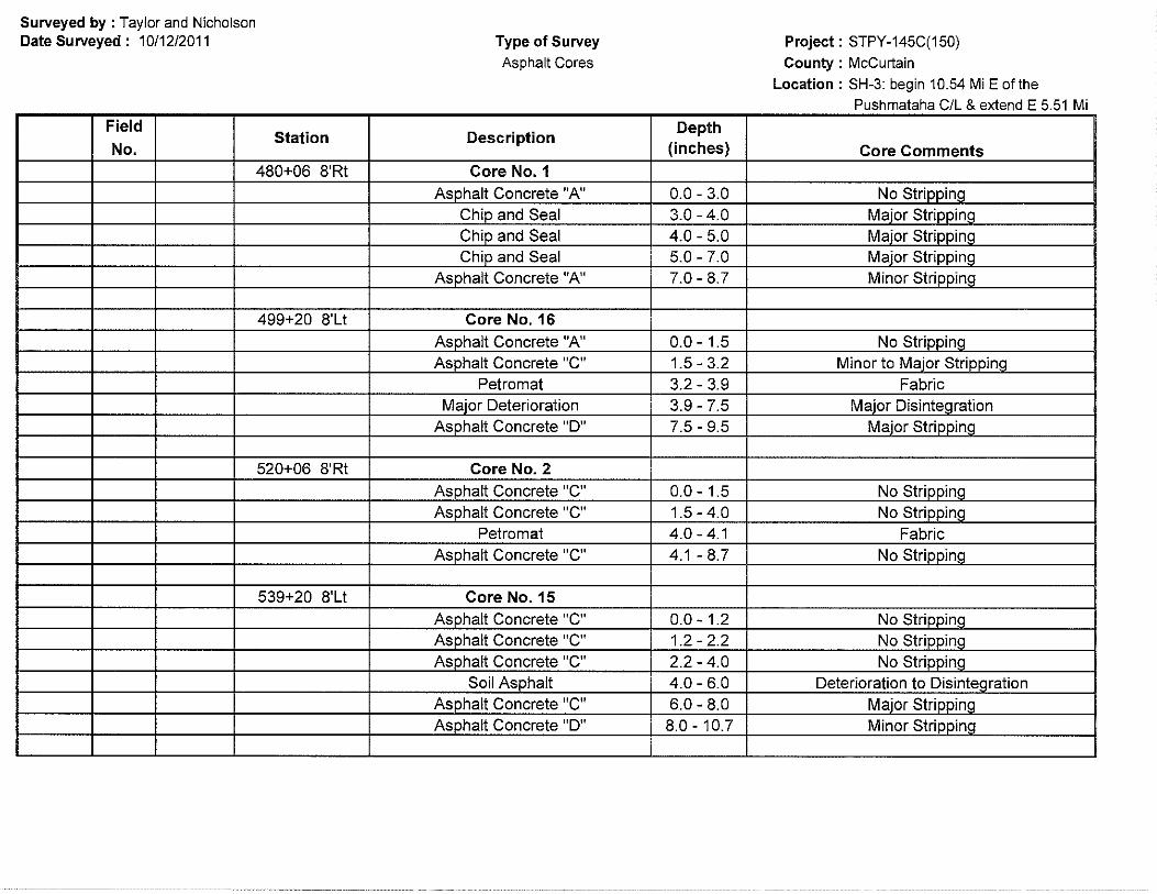
Surveyed by : Taylor and Nicholson Date Surveyed: 10/12/2011
Field
No. Station
480+06 8'Rt
499+20 8'Lt
520+06 8'Rt
539+20 8'Lt
Type of Survey Asphalt Cores
Description
Core No. 1 Asphalt Concrete "A"
Chip and Seal Chip and Seal Chip and Seal
Asphalt Concrete "A"
Core No.16 Asphalt Concrete "A" Asphalt Concrete "C"
Petro mat Major Deterioration
Asphalt Concrete "D"
Core No. 2 Asohalt Concrete "C" Asphalt Concrete "C"
Petro mat Asphalt Concrete "C"
Core No.15 Asohalt Concrete "C" Asphalt Concrete "C" Asphalt Concrete "C"
Soil Asphalt Asphalt Concrete "C" Asphalt Concrete "D"
Depth (inches)
0.0 - 3.0 3.0 - 4.0 4.0 - 5.0 5.0 - 7.0 7.0 - 8.7
0.0-1.5 1.5- 3.2 3.2 - 3.9 3.9 - 7.5 7.5 - 9.5
0.0-1.5 1.5-4.0 4.0-4.1 4.1 - 8.7
0.0-1.2 1.2-2.2 2.2- 4.0 4.0 - 6.0 6.0 - 8.0 8.0 - 10.7
Project: STPY-145C(150) County : McCurtain
Location : SH-3: begin 10.54 Mi E of the Pushmataha C/L & extend E 5.51 Mi
Core Comments
No Striooinq Maier Striooinq Maier Striooinq Maier Striooinq Minor Strinninq
No StriPPing Minor to Major Stripping
Fabric Maior DisinteQration
Major StriooinQ
No Striooing No Striooing
Fabric No StriooinQ
No Strinninq No Striooing No Striooing
Deterioration to Disintegration Major StriooinQ Minor StriooinQ

Field Station Description
Depth No. (inches)
560+06 8'Rt Core No. 3 Asphalt Concrete "C" 0.0-1.5 No StriooinQ Asphalt Concrete "C" 1.5- 4.2 No StrippinQ Asphalt Concrete "D" 4.2 - 6.2 Maier Deterioration
Soil Asphalt 6.2 - 8.0 Maier Deterioration Total Deterioration 8.0 - 9.0 Disinteqration
Asphalt Concrete "C" 9.0- 10.4 Maier Striooinq
579+20 8'Lt Core No.14 Asphalt Concrete "C" 0.0-1.5 Minor StriooinQ Asphalt Concrete "D" 1.5 - 3.5 Minor StriooinQ Asphalt Concrete "D" 3.5 - 4.5 Minor StriooinQ Asphalt Concrete "C" 4.5 - 7.0 Minor StrippinQ Maier Deterioration 7.0 - 8.0 Maier Deterioration
Soil Asphalt 8.0 - 10.6 Striooinq
600+06 8'Rt Core No. 4 Asphalt Concrete "C" 0.0-1.0 No StrippinQ Asphalt Concrete "C" 1.0-3.5 No StrippinQ
Petromat 3.5 - 3.6 Fabric Asphalt Concrete "B" 3.6 - 6.5 No StriooinQ
Soil Asphalt 6.5 - 8.7 StrippinQ
619+20 8'Lt Core No.13 Chip and Seal 0.0 -1.0 Maier StrippinQ
Asphalt Concrete "C" 1.0-3.5 No StrippinQ Asphalt Concrete "C" 3.5 - 5.2 No StrippinQ
DisinteQration 5.2 - 7.0 Disinteqration Asphalt Concrete "D" 7.0 - 8.0 Stripoino Maier DisinteQration 8.0 - 8.7 Disinteoration
Asphalt Concrete "B" 8.7 - 10.7 Minor Strinninq
------- ----- ----- - - --------.. ----·-·-·--·-·-·-------
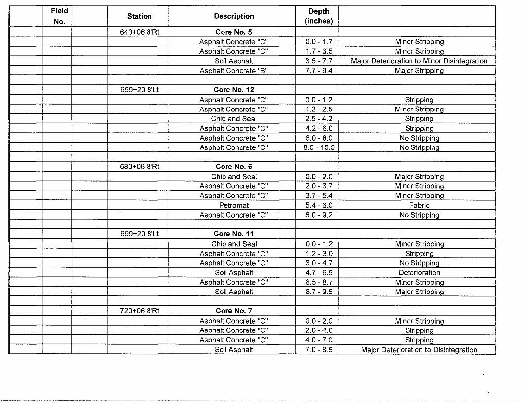
Field Station Description
Depth No. (inches)
640+06 8'Rt Core No. 5 Asohalt Concrete "C" 0.0-1.7 Minor Stripoina Asohalt Concrete "C" 1.7 - 3.5 Minor Strinnina
Soil Asohalt 3.5 - 7.7 Major Deterioration to Minor Disintearation Asphalt Concrete "B" 7.7 - 9.4 Maier Stripping
659+20 8'Lt Core No.12 Asohalt Concrete "C" 0.0 - 1.2 Strinnino Asohalt Concrete "C" 1.2 - 2.5 Minor Strinnino
Chio and Seal 2.5 - 4.2 Strinnina Asphalt Concrete "C" 4.2 - 6.0 Striooing Asphalt Concrete "C" 6.0 - 8.0 No Stripping Asphalt Concrete "C" 8.0-10.5 No Stripping
680+06 8'Rt Core No. 6 Chio and Seal 0.0 - 2.0 Maier Strippino
Asohalt Concrete "C" 2.0 - 3.7 Minor Stripoina Asohalt Concrete "C" 3.7 - 5.4 Minor Strinnina
Petro mat 5.4 - 6.0 Fabric Asphalt Concrete "C" 6.0 - 9.2 No Striooing
699+20 8'Lt Core No. 11 Chip and Seal 0.0-1.2 Minor Striooino
Asphalt Concrete "C" 1.2-3.0 Strinnina Asohalt Concrete "C" 3.0 - 4.7 No Strinnina
Soil Asphalt 4.7 - 6.5 Deterioration Asohalt Concrete "C" 6.5 - 8.7 Minor Strinning
Soil Asphalt 8.7 - 9.5 Major Stripping
720+06 8'Rt Core No. 7 Asphalt Concrete "C" 0.0 - 2.0 Minor Stripoina Asphalt Concrete "C" 2.0 - 4.0 Strioping Asohalt Concrete "C" 4.0 - 7.0 Strinnino
Soil Asphalt 7.0 - 8.5 Major Deterioration to Disintegration
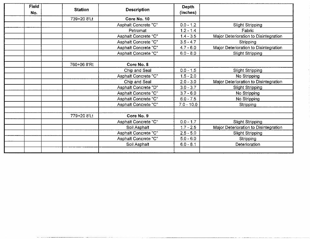
Field Depth No.
Station Description (inches)
739+20 8'Lt Core No. 10 Asphalt Concrete "C" 0.0-1.2 Slight Striooing
Petro mat 1.2 - 1.4 Fabric Asphalt Concrete "C" 1.4-3.5 Major Deterioration to Disintegration Asphalt Concrete "C" 3.5 - 4.7 Stripping Asphalt Concrete "C" 4.7 - 6.0 Maior Deterioration to Disintegration Asphalt Concrete "C" 6.0 - 8.0 Slight Striooing
760+06 8'Rt Core No. 8 Chio and Seal 0.0-1.5 Slioht Strinnino
Asohalt Concrete "C" 1.5 - 2.0 No Strinnino Chip and Seal 2.0 - 3.0 Major Deterioration to Disintegration
Asphalt Concrete "D" 3.0 - 3.7 Slight Striooing Asphalt Concrete "C" 3.7 - 6.0 No Striooing Asphalt Concrete "C" 6.0 - 7.5 No Stripping Asphalt Concrete "C" 7.0 - 10.0 Striooing
779+20 8'Lt Core No. 9 Asphalt Concrete "C" 0.0-1.7 Slight Striooing
Soil Asphalt 1.7-2.5 Major Deterioration to Disinteoration Asphalt Concrete "C" 2.5 - 5.0 Slight Striooing Asphalt Concrete "C" 5.0 - 6.0 Striooing
Soil Asphalt 6.0 - 8.1 Deterioration
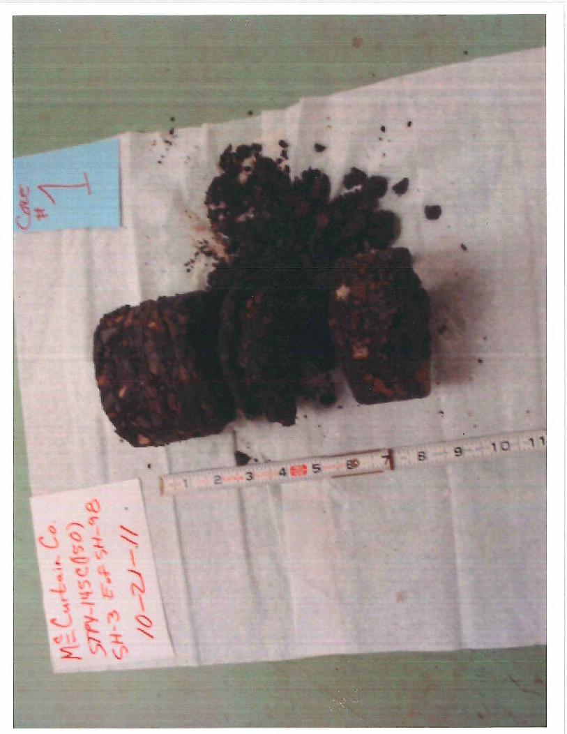
,,
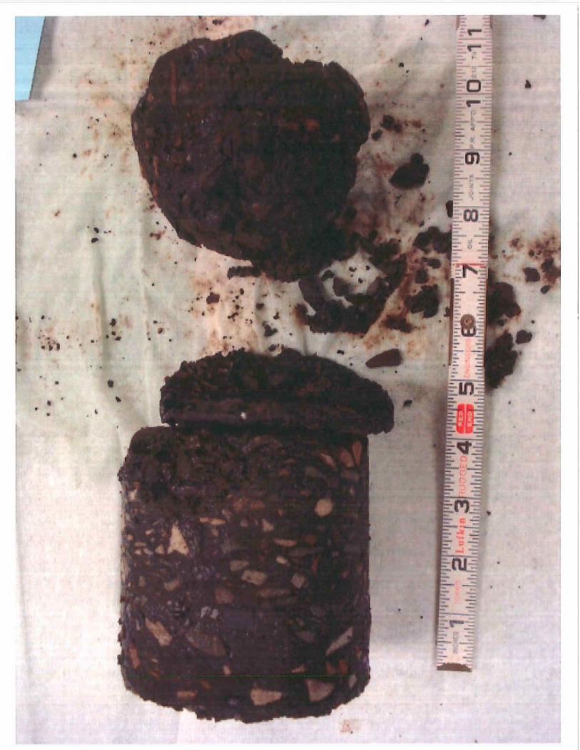
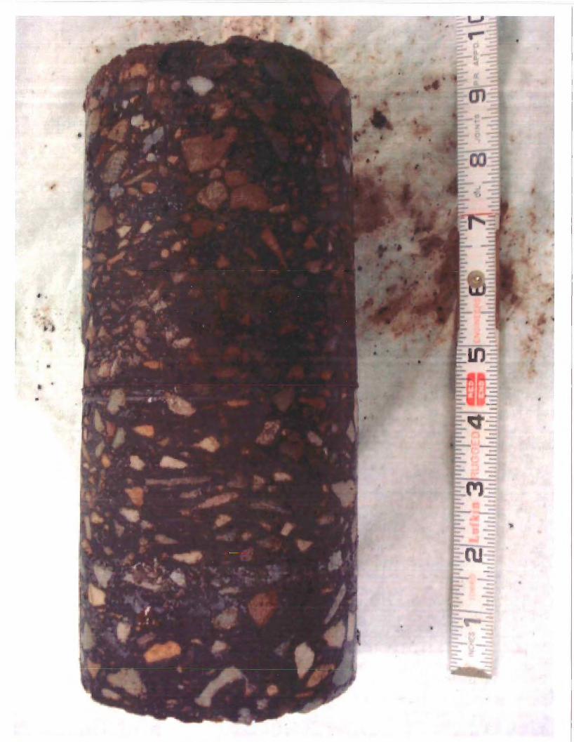
•
..
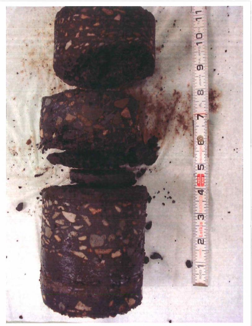
•
..
"
"' •
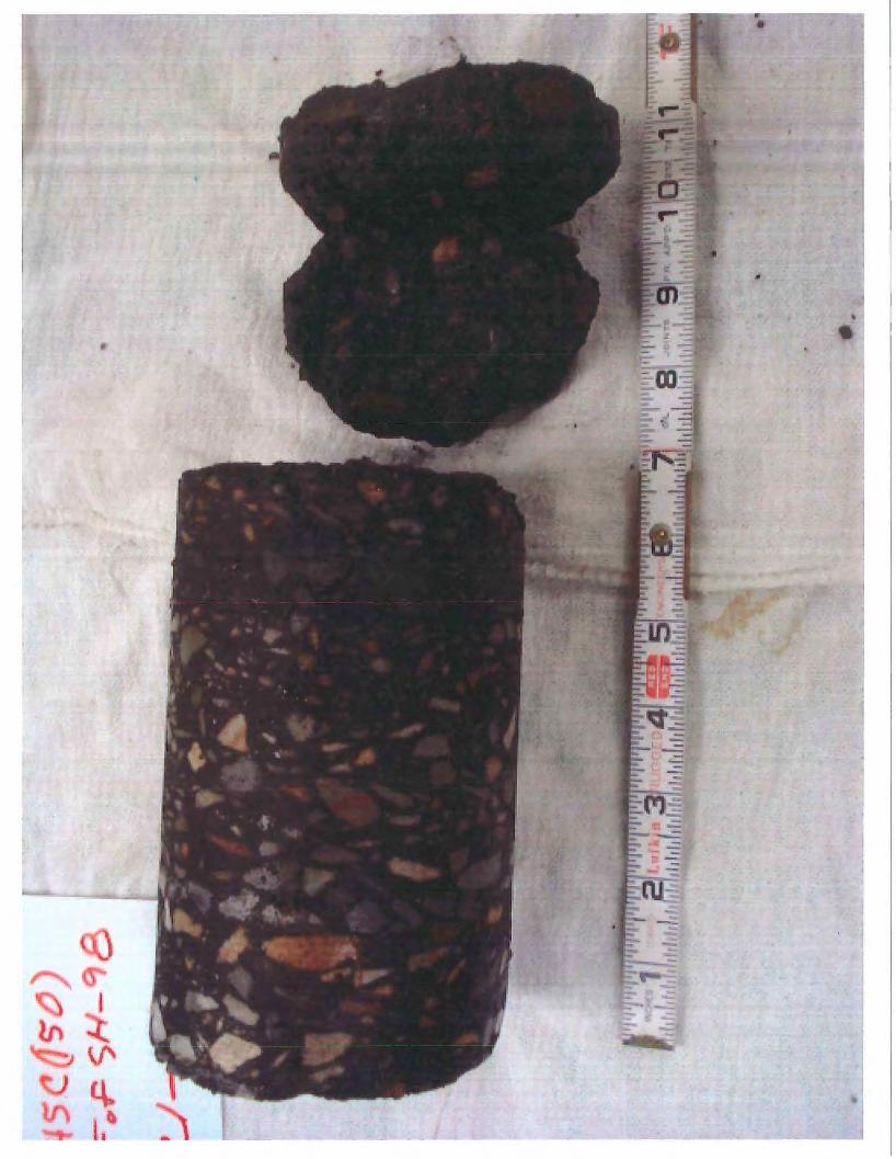
•
"
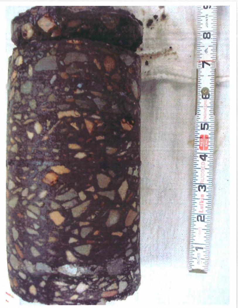
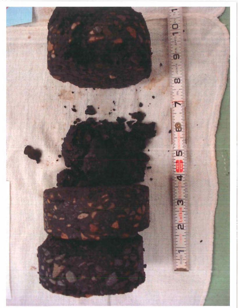
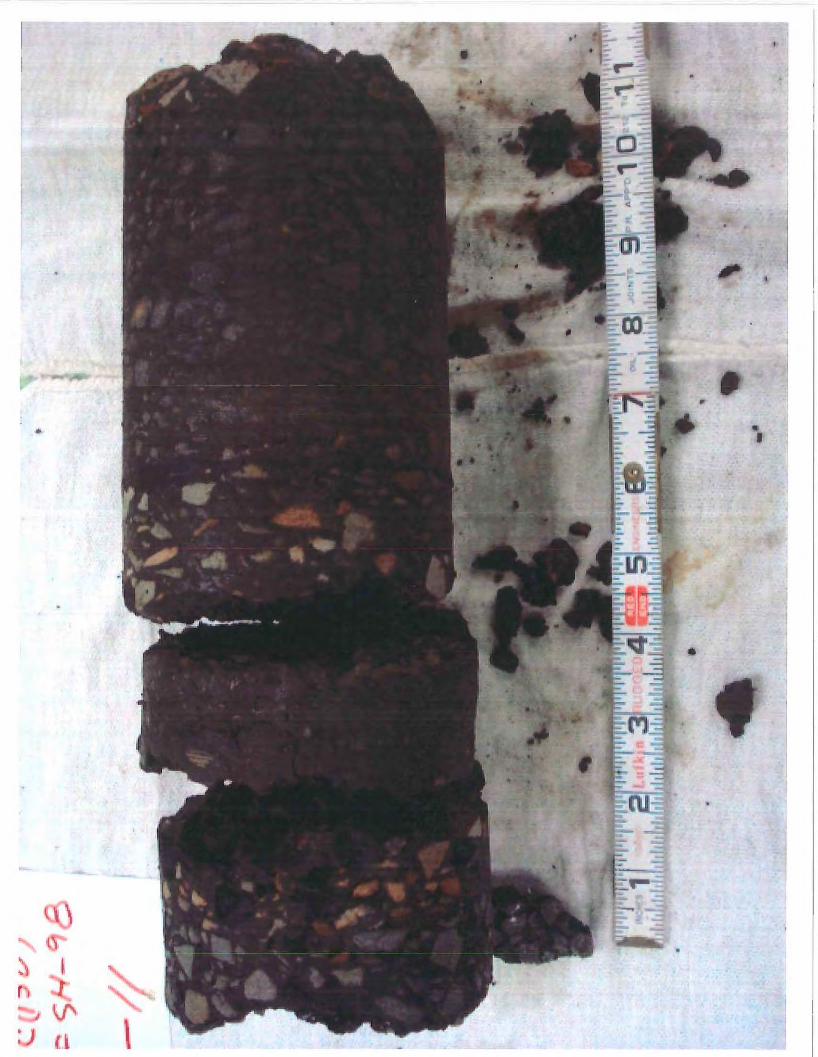
i
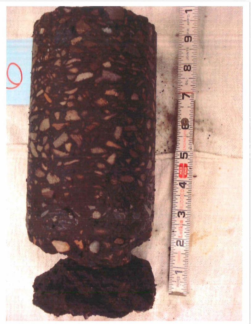
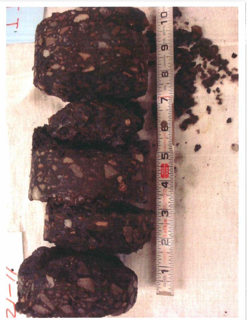
-
•
•
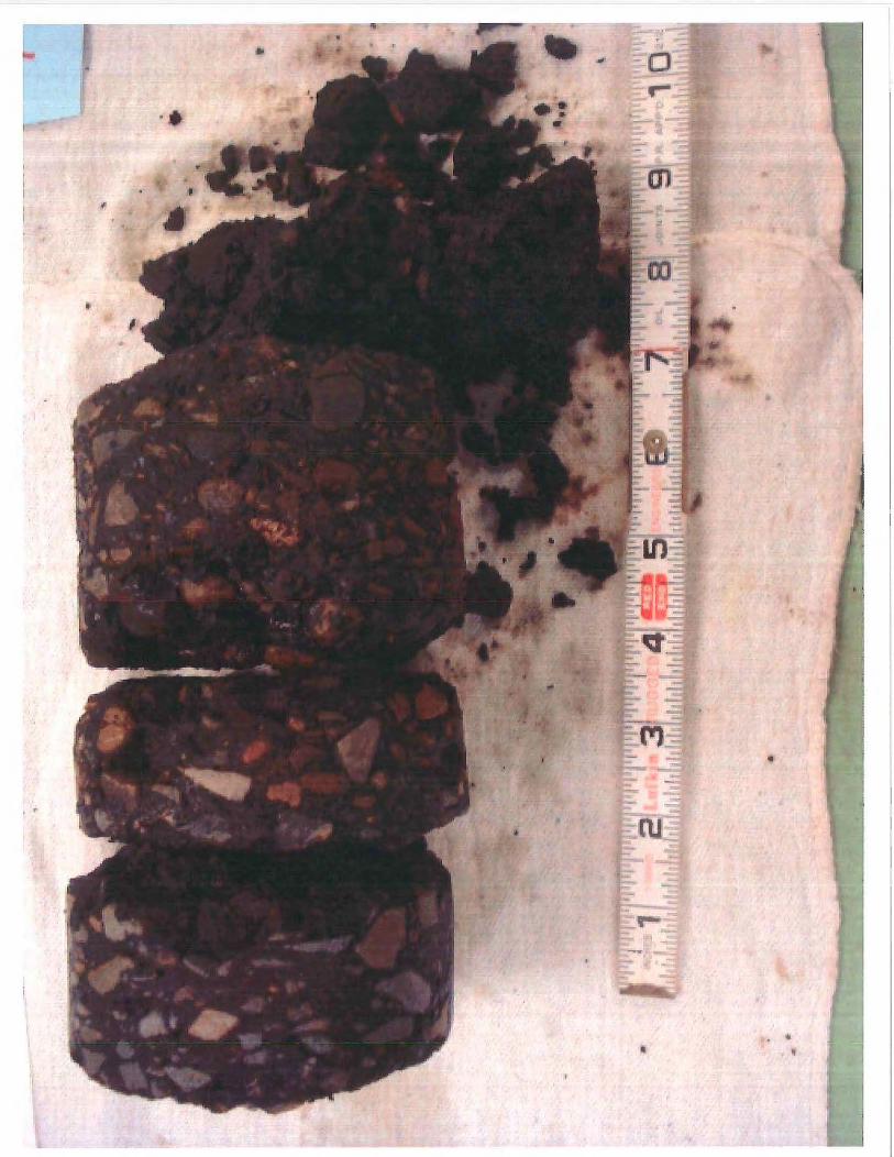
•
" '
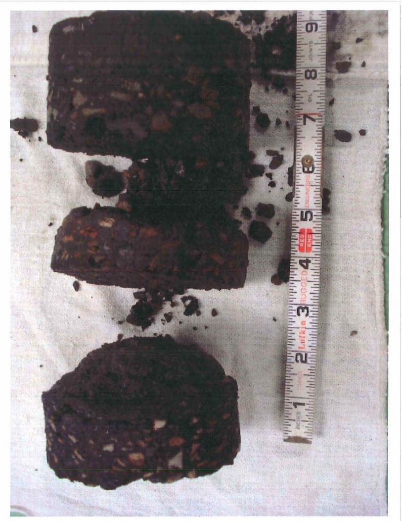

t
• ... ,,.
•
..
•
•
• '
• •

•
•
•
•
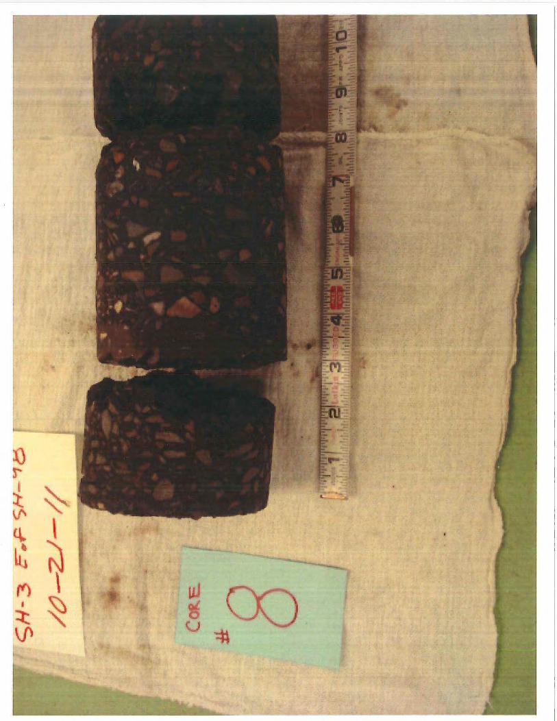
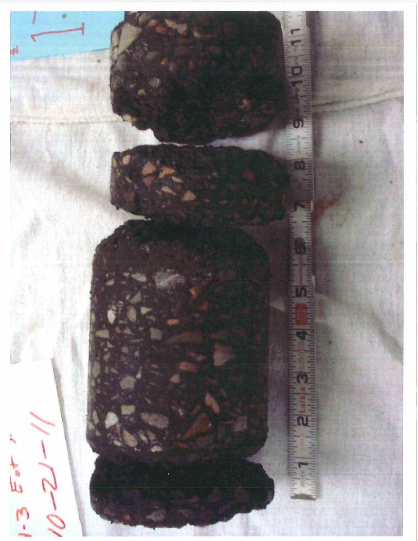

•
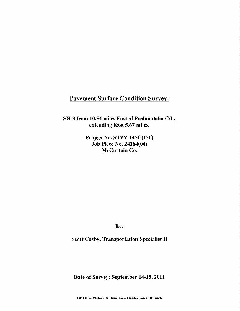
Pavement Surface Condition Survey:
SH-3 from 10.54 miles East of Pushmataha C/L, extending East 5.67 miles.
Project No. STPY-145C(150) Job Piece No. 24184(04)
McCurtain Co.
By:
Scott Cosby, Transportation Specialist II
Date of Survey: September 14-15, 2011
ODOT - Materials Division - Geotechnical Branch
Contents:
(In order of Appearance)
• Study Information Sheet
• Photograph Section Photograph Information Sheet Photographs from Study
Total: 8 pages
ODOT - Materials Division - Geotechnical Branch
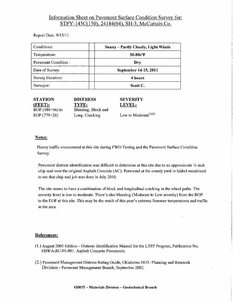
Information Sheet on Pavement Surface Condition Survey for: STPY-145C(150), 24184(04), SH-3, McCurtain Co.
Report Date: 9/15111
Conditions:
Temperature:
Pavement Condition :
Date of Survey:
Survey Duration:
Surveyor:
STATION (FEET): BOP ( 480+06) to EOP (779+20)
Notes:
Sunny - Partly Cloudy, Light Winds
DISTRESS TYPE: Bleeding, Block and Long. Cracking
50-80s°F
Dry
September 14-15, 2011
4 hours
Scott C.
SEVERITY LEVEL:
Low to Moderate(IXZJ
Heavy traffic encountered at this site during FWD Testing and the Pavement Surface Condition
Survey.
Pavement distress identification was difficult to determine at this site due to an approximate V. inch
chip seal over the original Asphalt Concrete (AC). Personnel at the county yard in Idabel mentioned
to me that chip seal job was done in July 2010.
The site seems to have a combination of block and longitudinal cracking in the wheel paths. The
severity level is low to moderate. There's also bleeding (Moderate to Low severity) from the BOP
to the EOP at this site. This may be the result of this year's extreme Summer temperatures and traffic
in the area.
References:
(I.) August 2005 Edition- Distress Identification Manna] for the LTPP Program, Publication No. FHW A-RC-05-00 I. Asphalt Concrete Pavements.
(2.) Pavement Management Distress Rating Guide, Oklahoma DOT- Planning and Research Division - Pavement Management Branch, September 2002.
ODOT - Materials Division - Geotechnical Branch
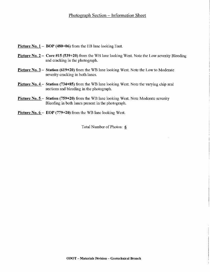
Photograph Section - Information Sheet
Picture No. 1- BOP (480+06) from the EB lane looking East.
Picture No. 2 - Core #15 (539+20) from the WB lane looking West. Note the Low severity Bleeding and cracking in the photograph.
Picture No. 3 - Station (619+20) from the WB lane looking West. Note the Low to Moderate severity cracking in both lanes.
Picture No. 4 - Station (734+85) from the WB lane looking West. Note the varying chip seal sections and bleeding in the photograph.
Picture No. 5 - Station (759+20) from the WB lane looking West. Note Moderate severity Bleeding in both lanes present in the photograph.
Picture No. 6- EOP (779+20) from the WB lane looking West.
Total Number of Photos: !!
ODOT - Materials Division - Geotechnical Branch