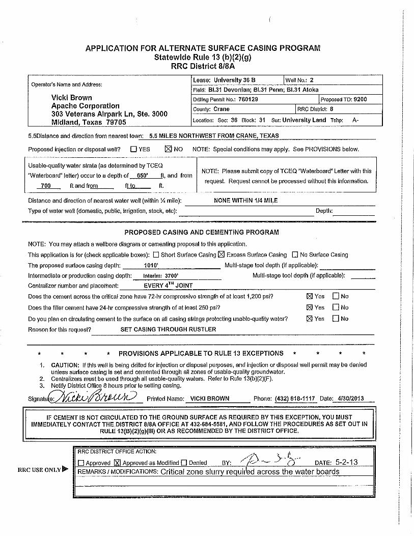
oil well potential test, completion or recompletion report
TRANSCRIPT

RAILROAD COMMISSION OF TEXAS Oil and Gas Division
API No. 42- 7. RRC District No.
8. RRC Lease No. Oil Well Potential Test, Completion or Recompletion Report, and Log
BLOCK 31 (DEVONIAN) UNIVERSITY -36B-
APACHE CORPORATION 027200
2
ATTN REGULATORY STE 3000 303 VETERANS AIRPARK LN MIDLAND, TX 79705-0000
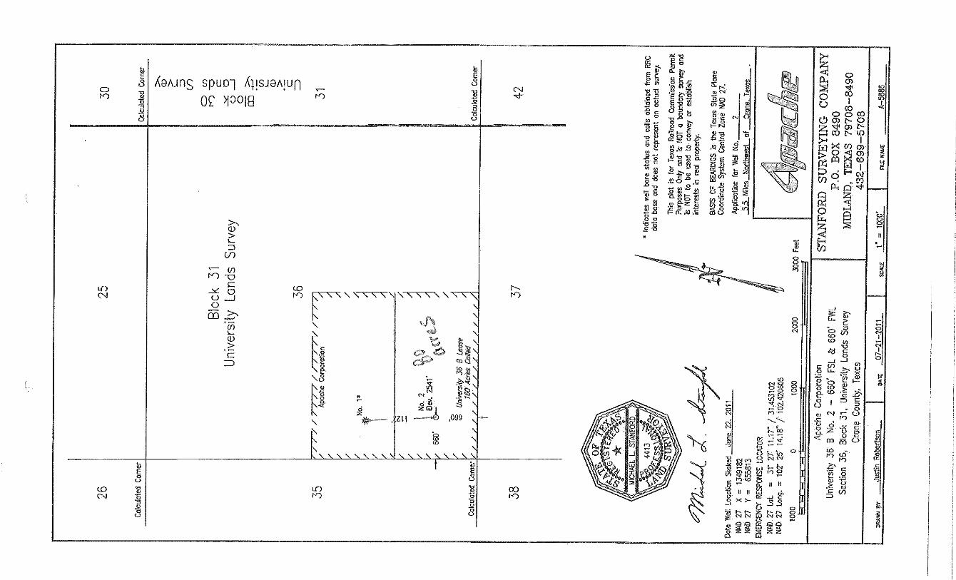
36 , 31 , UL , A-U84 5.5 MILES NW OF CRANE
Initial Potential
Reclass
(Explain In remarks)Well record only
Retest
11. Purpose of filing
6b. Distance and direction to nearest town in this county.6a. Location (Section, Block, and Survey)
4. ADDRESS
9. Well No.
RRC Operator No.3. OPERATOR'S NAME (Exactly as shown on Form P-5, Organization Report)
2. LEASE NAME1. FIELD NAME (as per RRC Records or Wildcat)
29143
08103-36153
CRANE10. County of well site
5. If Operator has changed within last 60 days, name former operator
X
This facsimile W-2 was generated electronically from data submitted to the RRC.
Tracking No.: 89817Status: Submitted
12. If workover or reclass, give former field (with reservoir) & Gas ID or oil lease no.FIELD & RESERVOIR
GAS ID or OIL LEASE #
Oil-0 Gas-G Well #
N/A
13. Type of electric or other log run 14. Completion or recompletion date
Neutron logs 06/12/2013
SECTION I- POTENTIAL TEST DATA IMPORTANT: Test should be for 24 hours unless otherwise specified infield rules. 15. Date of test 16. No. of hours tested 17. Production method (Flowing, Gas Lift, Jetting, Pumping- Size & Type of pump) 18. Choke size
06/15/2013 24 Pumping
Oil - BBLS
Oil - BBLS
Gas - MCF
Gas - MCF
Water - BBLS
Water - BBLS Gas - Oil Ratio
Oil Gravity-API-60 o
Flowing Tubing Pressure
PSI
PSI
Casing Pressure
21. Was swab used during this test? 22. Oil produced prior to test (New & Reworked wells) 23. Injection Gas-Oil RatioYes No
19. Production during Test Period
20. Calculated 24- Hour Rate
100.0 125 51 1250
100.0 125 51 41.0
X 155.0REMARKS: N/A
INSTRUCTIONS: File an original and one copy of the completed FormW-2 in the appropriate RRC District Office within30 days after completing a well and within 10 days after a potential test. If an operator does not properly report theresults of a potential test within the 10-day period, the effective date of the allowable assigned to the well will not extendback more than 10 days before the W-2 was received in the District Office. (Statewide Rules 16 and 51) To report acompletion or recompletion, fill in both sides of this form. To report a retest, fill in only the front side.
WELL TESTERS CERTIFICATIONI declare under penalties prescribed in Sec. 91.143, Texas Natural Resources Code, that I conducted or supervised this test by observation of (a) meterreadings or (b) the top and bottom gauges of each tank into which production was run during the test. I further certify that the potential test data shownabove is true, correct, and complete, to the best of my knowledge.
Signature: Well Tester Name of Company RRC Representative
OPERATOR'S CERTIFICATIONI declare under penalties prescribed in Sec. 91.143, Texas Natural Resources Code, that I am authorized to make this report, that this report was preparedby me or under my supervision and direction, and that data and facts stated therein are true, correct and complete, to the best of my knowledge.
Telephone: Area Code Number Month Day Year Signature
Title of PersonType or printed name of operator's representative
(432) 818-1107 EXT 1107 02/11/2014 Christine Smith
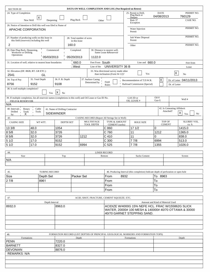
DATA ON WELL COMPLETION AND LOG (Not Required on Retest)SECTION III
24. Type of Completion
New Well Deepening Plug Back Other
26. Notice of Intention to Drill this well was filed in Name of
DATE
PERMIT NO.
PERMIT NO.
PERMIT NO.
PERMIT NO.
CASE NO.
Other
Commenced Completed
31. Location of well, relative to nearest lease boundaries Feet From
Line of the
Line and Feet from
Lease
32. Elevation (DF. RKB, RT. GR ETC.) 33. Was directional survey made otherthan inclination (Form W-12)? Yes No
34. Top of Pay 35. Total Depth 36. P. B. Depth Dt. of Letter
Dt. of Letter
PermitWater Injection
PermitSalt Water Disposal
ExceptionRule 37DeepenPlug Back or
25. Permit to Drill,
Railroad Commission (Special)
Recommendation of T.D.W.R.
Same Lease &Reservoir30. Distance to nearest well,
in this lease28. Total number of acres
this field (reservoir) including this well27. Number of producing wells on this lease in
Operations:Workover or Drilling
29. Date Plug Back, Deepening,
Determined by37. Surface Casing
RulesField
38. Is well multiple completion?
Yes No
X
APACHE CORPORATION
2 160.0
05/03/2013 05/20/2013 1122.0
660.0 South 660.0West UNIVERSITY 36 B
2541 GLX
8756 9108
X
76012904/08/2013
X 04/11/20139152
39. If multiple completion, list all reservoir names (completions in this well) and Oil Lease or Gas ID No.FIELD & RESERVOIR
GAS ID or OIL LEASE #
Oil-0 Gas-G Well #
N/A40. Intervals Drilled by:
RotaryTools
CableTools
41. Name of Drilling Contractor
Yes No
42. Is Cementing Affidavit Attached?
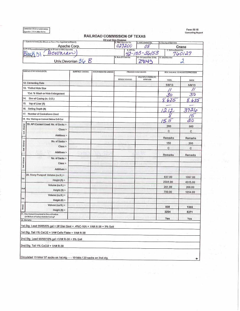
TYPE & AMOUNT CEMENT (sacks)
CASING RECORD (Report All Strings Set in Well)
SLURRY VOL. cu. ft.
HOLE SIZEDEPTH SETCASING SIZE WT #/FT. MULTISTAGETOOL DEPTH
TOP OFCEMENT
43.
XX SIDEWINDER
105413 3/8 48.0 C 860 17 1/2 0 1415.037268 5/8 32.0 C 760 11 1212 1365.03726 12128 5/8 32.0 C 410 11 0 838.091525 1/2 17.0 C 300 7 7/8 6994 513.09152 69945 1/2 17.0 C 525 7 7/8 1355 1026.0
LINER RECORD44.
Size Top Bottom ScreenSacks Cement
N/A
45. TUBING RECORD 46. Producing Interval (this completion) Indicate depth of perforation or open hole
From 8932Packer SetSize Depth Set To 8963
From2 7/8 8961 To
From To
From To
47. ACID, SHOT, FRACTURE, CEMENT SQUEEZE. ETC.
Depth Interval Amount and Kind of Material Used
8932.0 8963.0 ACIDIZE W/4000G 15% NEFE HCL. FRAC W/155862G SLICK WATER, 20000# 100 MESH & 140000# 40/70 OTTAWA & 30000 40/70 GARNET STEPPING SAND.
FORMATION RECORD (LIST DEPTHS OF PRINCIPAL GEOLOGICAL MARKERS AND FORMATION TOPS)48.
Formations FormationsDepth Depth
PENN 7220.0BARNETT 8327.0DEVONIAN 8876.0REMARKS: N/A
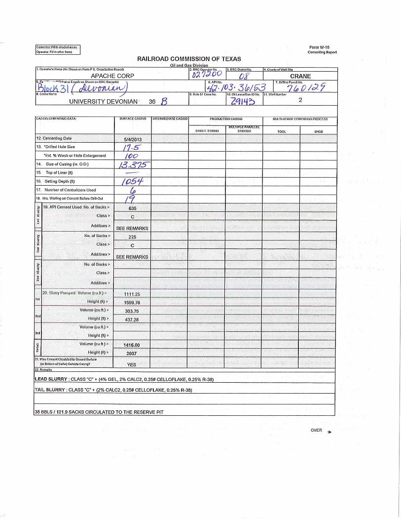


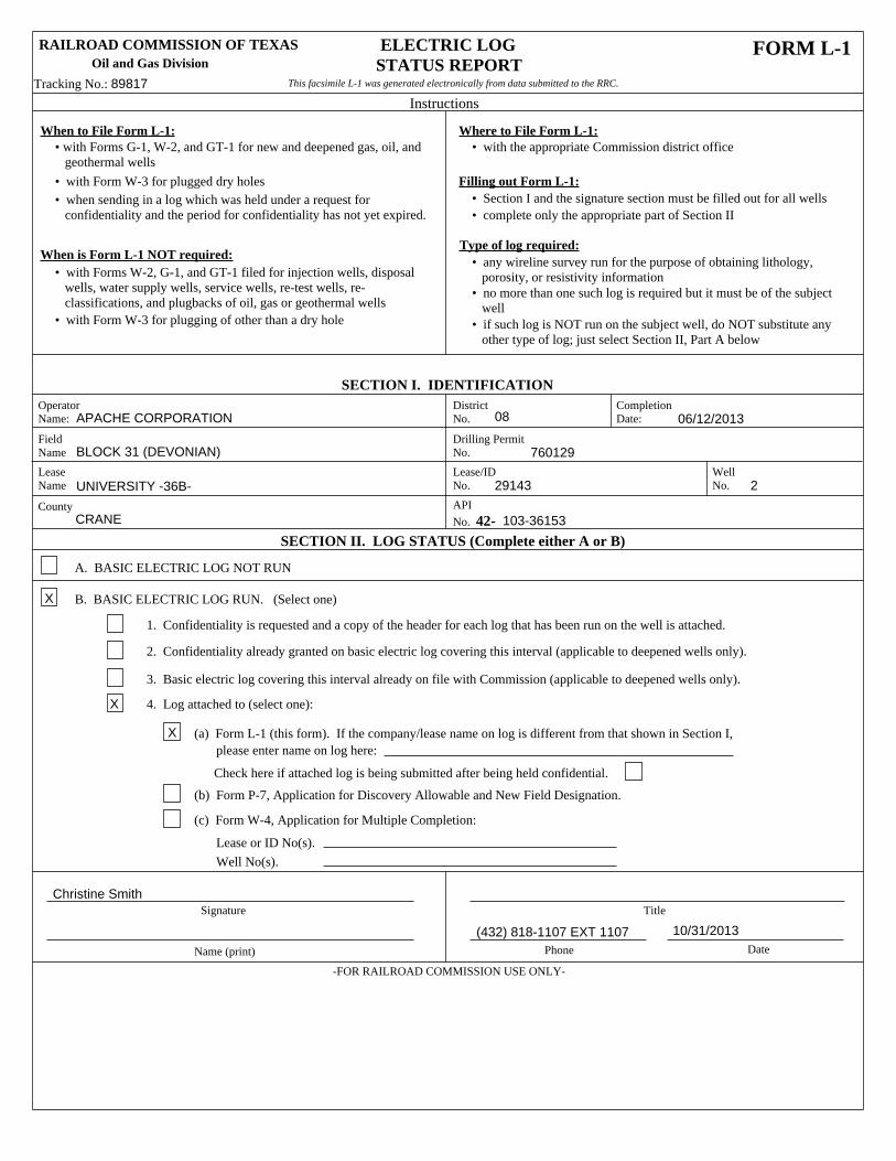
RAILROAD COMMISSION OF TEXASOil and Gas Division
FORM L-1 ELECTRIC LOGSTATUS REPORT
Instructions
When to File Form L-1: Where to File Form L-1:� with the appropriate Commission district office� with Forms G-1, W-2, and GT-1 for new and deepened gas, oil, and
geothermal wells
� with Form W-3 for plugged dry holes� when sending in a log which was held under a request for confidentiality and the period for confidentiality has not yet expired.
Filling out Form L-1:� Section I and the signature section must be filled out for all wells� complete only the appropriate part of Section II
Type of log required:When is Form L-1 NOT required:
� with Forms W-2, G-1, and GT-1 filed for injection wells, disposal wells, water supply wells, service wells, re-test wells, re- classifications, and plugbacks of oil, gas or geothermal wells� with Form W-3 for plugging of other than a dry hole
� any wireline survey run for the purpose of obtaining lithology, porosity, or resistivity information� no more than one such log is required but it must be of the subject well� if such log is NOT run on the subject well, do NOT substitute any other type of log; just select Section II, Part A below
This facsimile L-1 was generated electronically from data submitted to the RRC.
SECTION I. IDENTIFICATIONOperatorName:
District No.
CompletionDate:
Drilling PermitNo.
FieldName
LeaseName
County
Lease/IDNo.
WellNo.
API
No. 42-SECTION II. LOG STATUS (Complete either A or B)
08 06/12/2013
CRANE
760129BLOCK 31 (DEVONIAN)
APACHE CORPORATION
UNIVERSITY -36B- 29143 2
103-36153
A. BASIC ELECTRIC LOG NOT RUN
B. BASIC ELECTRIC LOG RUN. (Select one)
1. Confidentiality is requested and a copy of the header for each log that has been run on the well is attached.
2. Confidentiality already granted on basic electric log covering this interval (applicable to deepened wells only).
3. Basic electric log covering this interval already on file with Commission (applicable to deepened wells only).
4. Log attached to (select one):
(a) Form L-1 (this form). If the company/lease name on log is different from that shown in Section I, please enter name on log here:
Check here if attached log is being submitted after being held confidential.
(b) Form P-7, Application for Discovery Allowable and New Field Designation.
(c) Form W-4, Application for Multiple Completion:
Well No(s).
Signature Title
Name (print) Phone Date
-FOR RAILROAD COMMISSION USE ONLY-
X
X
X
10/31/2013
Lease or ID No(s).
(432) 818-1107 EXT 1107
Christine Smith
Tracking No.: 89817
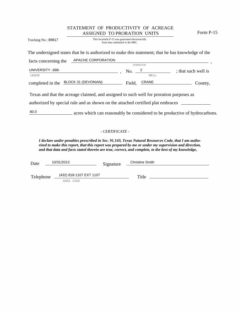
STATEMENT OF PRODUCTIVITY OF ACREAGE ASSIGNED TO PRORATION UNITS Form P-15
The undersigned states that he is authorized to make this statement; that he has knowledge of the
OPERATOR
LEASE
,
, No.WELL
facts concerning the
; that such well is
completed in the Field, County,
Texas and that the acreage claimed, and assigned to such well for proration purposes as
authorized by special rule and as shown on the attached certified plat embraces
acres which can reasonably be considered to be productive of hydrocarbons.
- CERTIFICATE -
I declare under penalties prescribed in Sec. 91.143, Texas Natural Resources Code, that I am autho-rized to make this report, that this report was prepared by me or under my supervision and direction,and that data and facts stated therein are true, correct, and complete, to the best of my knowledge,
Date 10/31/2013 Signature Christine Smith
Telephone (432) 818-1107 EXT 1107
AREA CODETitle
APACHE CORPORATION
UNIVERSITY -36B- 2
CRANE
80.0
BLOCK 31 (DEVONIAN)
This facsimile P-15 was generated electronically from data submitted to the RRC.
Tracking No.: 89817