oil spill detection using nasa active and passive sensors
TRANSCRIPT
Oil Spill Detection Using NASA Active and Passive Sensors
Sonia C. Gallegos and Robert A. Arnone(Naval Research Lab - Stennis)
William G. Pichel (NOAA/STAR)
Yongxiang Hu(NASA-Langley Research Center)

Oil Spill Detection Using NASA Active and Passive Sensors
Location and distribution of the oil and gas facilities in the Gulf of Mexico
Oil and gas pipeline distribution in the continental shelf of the Gulf of Mexico
Source: MMS – Rate Control Unit – New Orleans Office
3,800 fixed platforms42 million leased acres
37,000 miles of pipelines
Oil Spill Detection Using NASA Active and Passive Sensors
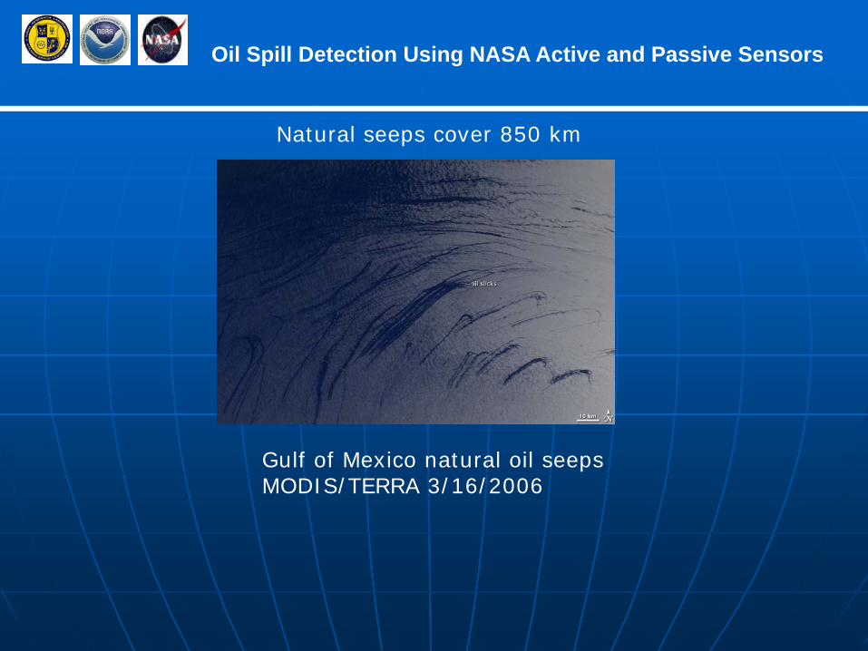
Gulf of Mexico natural oil seeps MODIS/TERRA 3/16/2006
Natural seeps cover 850 km
Oil Spill Detection Using NASA Active and Passive Sensors
Short-term Goal:
Quicker response to oil spills (1-3 days) after hurricane landfall or shipaccident while underway or docked
Long-term Goal:
Create the infrastructure for an operational oil detection system for Gulf with MODIS and CALIOP providing the “first alert” for SAR

Oil Spill Detection Using NASA Active and Passive Sensors
Current Operational Status of Oil Spill Detection at NOAA
• Product is generated on an ad hoc basis by STAR, • Timeliness is 1-2 days• After data receipt, response is during normal working hours• Accuracy of Product is unknown• Not all data sources are exploited (mostly SAR)
Maturity of oil spill algorithms
• An ad hoc research product produced by manual analysis• No oil detection algorithm using existing data is fully automated• Interactive systems must be employed to minimize false
positives.
Oil Spill Detection Using NASA Active and Passive Sensors
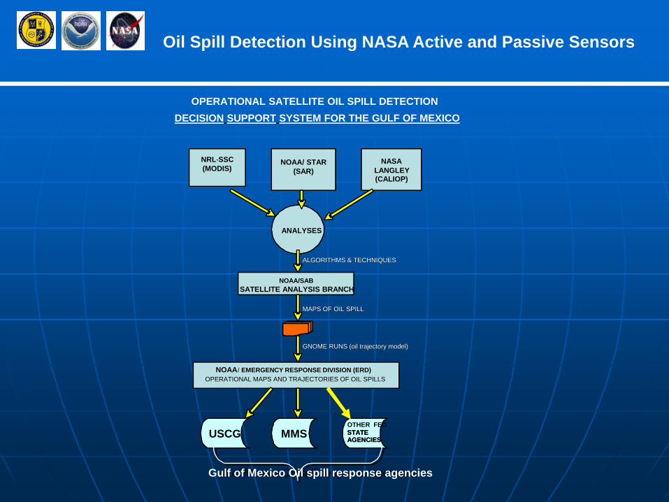
NOAA/SABSATELLITE ANALYSIS BRANCH
NRL-SSC(MODIS)
NOAA/ STAR(SAR)
NASALANGLEY(CALIOP)
ANALYSES
USCG MMSOTHER FED STATE AGENCIES
Gulf of Mexico Oil spill response agencies
MAPS OF OIL SPILL
GNOME RUNS (oil trajectory model)
NOAA/ EMERGENCY RESPONSE DIVISION (ERD)OPERATIONAL MAPS AND TRAJECTORIES OF OIL SPILLS
ALGORITHMS & TECHNIQUES
OPERATIONAL SATELLITE OIL SPILL DETECTION DECISION SUPPORT SYSTEM FOR THE GULF OF MEXICO
NOAA/SABSATELLITE ANALYSIS BRANCH
NRL-SSC(MODIS)
NOAA/ STAR(SAR)
NASALANGLEY(CALIOP)
ANALYSES
USCG MMS STATE AGENCIES
Gulf of Mexico Oil spill response agencies
MAPS OF OIL SPILL
GNOME RUNS (oil trajectory model)
NOAA/ EMERGENCY RESPONSE DIVISION (ERD)OPERATIONAL MAPS AND TRAJECTORIES OF OIL SPILLS
ALGORITHMS & TECHNIQUES

Oil Spill Detection Using NASA Active and Passive Sensors
Purpose:
1. To identify anomalies associated with oil spills or natural seeps in MODIS and CALIOP data of the Gulf of Mexico
2. To develop automated oil-spill detection products from MODIS
3. To develop interactive methods to rapidly determine oil spills or natural oil seeps using SAR data
4. To merge the MODIS automated products into the operational OSDPD/SAB environment
5. To introduce the CALIOP data into NOAA/STAR
Oil Spill Detection Using NASA Active and Passive Sensors
Expected Results after the introduction of the Oil-Spill DSS
• New and automated satellite products from SAR and MODIS will be used in generating oil detection products for NOAA/OSDPD/SAB
•Research CALIOP products identifying oil spill will be available to NOAA/STAR
• Product will be made operational with 24/7/365 support
• Product will be validated by NOAA/ERD
Oil Spill Detection Using NASA Active and Passive Sensors
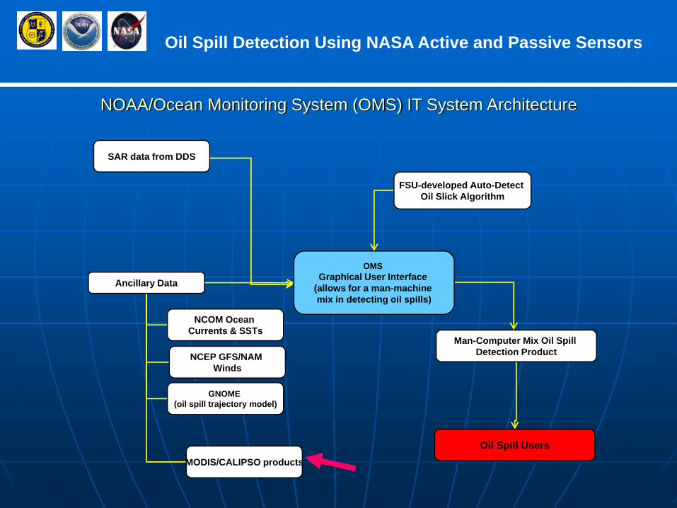
NOAA/Ocean Monitoring System (OMS) IT System Architecture
OMS Graphical User Interface
(allows for a man-machine mix in detecting oil spills)
Ancillary Data
SAR data from DDS
FSU-developed Auto-Detect Oil Slick Algorithm
Man-Computer Mix Oil Spill Detection Product
Oil Spill Users
NCOM Ocean Currents & SSTs
NCEP GFS/NAM Winds
GNOME (oil spill trajectory model)
MODIS/CALIPSO products

Oil Spill Detection Using NASA Active and Passive Sensors
Algorithm: Oscar Pineda-Garcia (FSU)
Four types of DataIntegrated:
• Satellite Variables e.g. (Incidence Angle, Beam
Mode)• Texture Features• Neighborhood• Environmental Data
SAR ANALYSES
Oil Spill Detection Using NASA Active and Passive Sensors
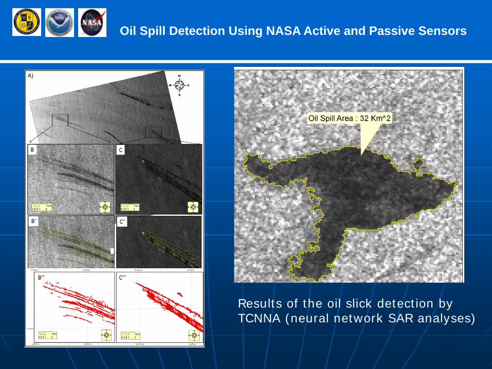
Results of the oil slick detection byTCNNA (neural network SAR analyses)
Oil Spill Detection Using NASA Active and Passive Sensors
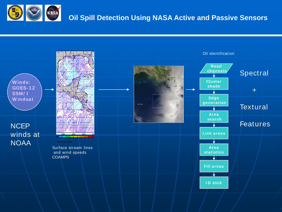
Surface stream linesand wind speedsCOAMPS
Winds:GOES-12SSM/IWindsat
Clustershade
Edgegeneration
Areasearch
Link areas
Areastatistics
ID slick
Fill areas
Readchannels
Oil identification
Spectral
+
Textural
FeaturesNCEP winds at NOAA
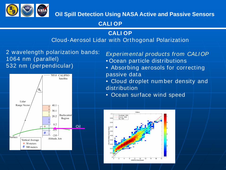
Oil Spill Detection Using NASA Active and Passive Sensors
2 wavelength polarization bands: 1064 nm (parallel)532 nm (perpendicular)
CALIOP
CALIOPCloud-Aerosol Lidar with Orthogonal Polarization
Oil
Experimental products from CALIOP•Ocean particle distributions• Absorbing aerosols for correcting passive data• Cloud droplet number density and distribution• Ocean surface wind speed

Oil Spill Detection Using NASA Active and Passive Sensors