oil and hazardous materials m response...
TRANSCRIPT
Oil and Hazardous MaterialsResponse Reports
October 1995-September 1996
December 1996
National Oceanic and Atmospheric AdministrationOffice of Ocean Resources Conservation and AssessmentHazardous Materials Response and Assessment DivisionSeattle, Washington 98115
M
AO
N
NA
LO
CE
I
A
CAND AT OSPHERIC
ADM
INIS
TRTIO
N
ITA
N
U. S. D
EPA
TNEMTROF COM M
ERCE

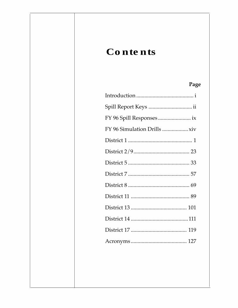
Contents
Page
Introduction .......................................... i
Spill Report Keys ................................ ii
FY 96 Spill Responses ........................ ix
FY 96 Simulation Drills ................... xiv
District 1 ............................................... 1
District 2/9......................................... 23
District 5 ............................................. 33
District 7 ............................................. 57
District 8 ............................................. 69
District 11 ........................................... 89
District 13 ......................................... 101
District 14 ..........................................111
District 17 ......................................... 119
Acronyms......................................... 127
i
INTRODUCTION Between October 1, 1995 and September 30, 1996, NOAA’s Haz-ardous Materials Response and Assessment Division ScientificSupport Coordinators and scientific staff were notified of 69 spillincidents. These 69 incidents included potential spills, false alarms,and very minor spills for which reports were not prepared. Techni-cal and operational assistance provided to the U.S. Coast Guard forspill incidents in the Nation’s coastal zone included 48 oil spills, 15chemical spills, 3 spills of unknown material, and 3 miscellaneousspills. In addition to the spills listed, NOAA assisted the U.S. CoastGuard with 35 simulation exercises.
This volume of reports follows the format established for the OilSpill Case Histories Report prepared in 1992 by the Division withU.S. Coast Guard Research and Development Center support so thatmajor spills meeting the criteria for inclusion may be incorporatedeasily into updated case histories reports.
Each report in this volume is organized as follows:
• A list of headers that summarizes the spill name; location;product; size; use of dispersants, bioremediation, and in-situburning; other special interests; shoreline types affected; andkeywords.
• A brief incident summary including weather conditions anddescription of the overall spill response.
• A description of the behavior of the spilled material includingmovement, evaporation, mousse formation, and dispersion.
• A discussion of countermeasures and mitigation.
• A description of other special interest issues such as communi-cation problems, unusual hazards encountered, and largelosses of organisms.
• A list of references that document the response operations.
Although the master list on the following pages includes all of theincidents for which the Division provided support, only those inci-dents where the pollutant actually entered the environment arereported on in this volume. These reports are abbreviated and aremeant to serve only as a summary of the Division’s response torequests from Federal On-Scene Coordinators for each of the events.
Additional details on any of the responses may be obtained from theappropriate Scientific Support Coordinator or U.S. Coast Guardoffice.

ii
Spill Report Keys
Name of Spill:
NOAA SSC:
Date of Spill (mmddyy):
Location of Spill: text description
Latitude: degrees, minutes, N or S
Longitude: degrees, minutes, E or W
Spilled Material: specific product
Spilled Material Type:
Type 1 - Very Light Oils (jet fuels, gasoline)Type 2 - Light Oils (diesel, No. 2 fuel oil, light crudes)Type 3 - Medium Oils (most crude oils)Type 4 - Heavy Oils (heavy crude oils, No. 6 fuel oil, bunker c)Type 5 - Hazardous material
Amount (Barrels, gallons, or weight in pounds if hazardous material):
Source of Spill: tank vessel, non-tank vessel, barge, facility, pipeline,platform
Resources at Risk: See A
Dispersants: Yes or No
Bioremediation: Yes or No
In-situ Burning: Yes or No
Other Special Interest:
Destruction of marshes, mangroves, or tidal flatsExtraordinarily successful salvage operationsMassive habitat lossMassive wildlife impactOil/ice interactions and adverse weather conditionsUnusual, experimental, or innovative cleanup techniques
Shoreline Types Impacted: See B
:

iii
Keywords: See C
Incident Summary:
Date and time of incidentLocation of incidentWeather at time of incidentSummary of eventsActions of responsible party and response organizationsLevel of federal involvementDuration of response
Behavior of Spilled Material:
Formation of slicks, sheen, or mousseMovement on the water of spilled materialMovement in the air of spilled materialAreas impactedAmount spilled; amount recovered (land, sea, contaminated debris)Amount not recovered (sinking, evaporation, weathering, dissolution)
Countermeasures and Mitigation:
Control at incident siteOffloading and lightering operations; movement of vesselPrecautionary protection of sensitive areasOpen water recoveryShoreline cleanupRemoval and disposal of spilled material or contaminated debris
Other Special Interest Issues: See D
NOAA Activities:
Involvement in response (on-scene, by phone and fax)Support providedParticipation in committees and special projectsUnusual responsibilitiesMeetings attended/recommendations madeDuration of NOAA support
References:
iv
Spill Report Keys
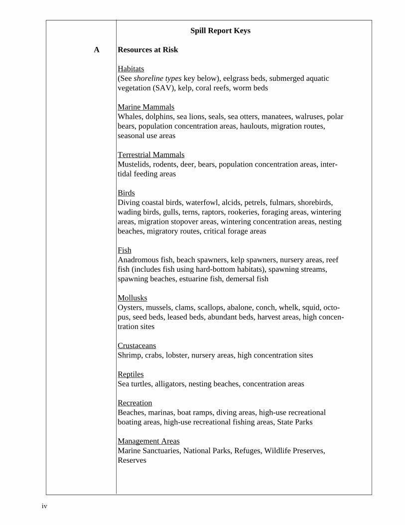
A Resources at Risk
Habitats(See shoreline types key below), eelgrass beds, submerged aquaticvegetation (SAV), kelp, coral reefs, worm beds
Marine MammalsWhales, dolphins, sea lions, seals, sea otters, manatees, walruses, polarbears, population concentration areas, haulouts, migration routes,seasonal use areas
Terrestrial MammalsMustelids, rodents, deer, bears, population concentration areas, inter-tidal feeding areas
BirdsDiving coastal birds, waterfowl, alcids, petrels, fulmars, shorebirds,wading birds, gulls, terns, raptors, rookeries, foraging areas, winteringareas, migration stopover areas, wintering concentration areas, nestingbeaches, migratory routes, critical forage areas
FishAnadromous fish, beach spawners, kelp spawners, nursery areas, reeffish (includes fish using hard-bottom habitats), spawning streams,spawning beaches, estuarine fish, demersal fish
MollusksOysters, mussels, clams, scallops, abalone, conch, whelk, squid, octo-pus, seed beds, leased beds, abundant beds, harvest areas, high concen-tration sites
CrustaceansShrimp, crabs, lobster, nursery areas, high concentration sites
ReptilesSea turtles, alligators, nesting beaches, concentration areas
RecreationBeaches, marinas, boat ramps, diving areas, high-use recreationalboating areas, high-use recreational fishing areas, State Parks
Management AreasMarine Sanctuaries, National Parks, Refuges, Wildlife Preserves,Reserves

v
Resource ExtractionSubsistence, officially designated harvest sites, commercial fisheries,power plant water intakes, drinking water intakes, industrial waterintakes, intertidal and subtidal mining leases, fish/shrimp/bivalve/plantaquaculture sites, log storage areas
CulturalArchaeological sites, Native American Lands
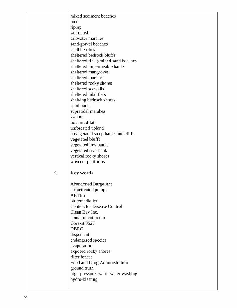
B Shoreline Types Impacted
brackish marshescoarse gravel beachescoarse sand beachescoastal structuresconsolidated seawallsconsolidated shorescypress swampsdeveloped uplanderoding bluffsexposed bedrock bluffsexposed bluffsexposed fine sand beachesexposed riprapexposed rocky platformsexposed rocky shoresexposed scarpsexposed seawallsexposed tidal flatsexposed tidal flats (low biomass)exposed tidal flats (moderate biomass)exposed unconsolidated sediment bluffsextensive intertidal marshesextensive salt marshesextensive wetlandsfine sand beachesflatsfreshwater flatfreshwater marshesfreshwater swampsfringing salt marshesfringing wetlandshardwood swampsleveeslow banksmangrovesmarshesmixed sand and shell beaches
vi
mixed sediment beaches piers riprap salt marsh saltwater marshes sand/gravel beaches shell beaches sheltered bedrock bluffs sheltered fine-grained sand beaches sheltered impermeable banks sheltered mangroves sheltered marshes sheltered rocky shores sheltered seawalls sheltered tidal flats shelving bedrock shores spoil bank supratidal marshes swamp tidal mudflat unforested upland unvegetated steep banks and cliffs vegetated bluffs vegetated low banks vegetated riverbank vertical rocky shores wavecut platforms
C Key words
Abandoned Barge Act air-activated pumps ARTES bioremediation Centers for Disease Control Clean Bay Inc. containment boom Corexit 9527 DBRC dispersant endangered species evaporation exposed rocky shores filter fences Food and Drug Administration ground truth high-pressure, warm-water washing hydro-blasting
vii
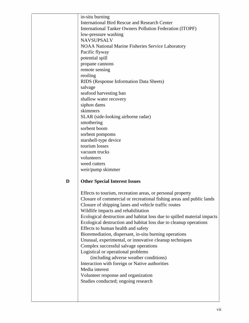
in-situ burningInternational Bird Rescue and Research CenterInternational Tanker Owners Pollution Federation (ITOPF)low-pressure washingNAVSUPSALVNOAA National Marine Fisheries Service LaboratoryPacific flywaypotential spillpropane cannonsremote sensingreoilingRIDS (Response Information Data Sheets)salvageseafood harvesting banshallow water recoverysiphon damsskimmersSLAR (side-looking airborne radar)smotheringsorbent boomsorbent pompomsstarshell-type devicetourism lossesvacuum trucksvolunteersweed cuttersweir/pump skimmer
D Other Special Interest Issues
Effects to tourism, recreation areas, or personal propertyClosure of commercial or recreational fishing areas and public landsClosure of shipping lanes and vehicle traffic routesWildlife impacts and rehabilitationEcological destruction and habitat loss due to spilled material impactsEcological destruction and habitat loss due to cleanup operationsEffects to human health and safetyBioremediation, dispersant, in-situ burning operationsUnusual, experimental, or innovative cleanup techniques
Complex successful salvage operations Logistical or operational problems
(including adverse weather conditions)Interaction with foreign or Native authorities
Media interest Volunteer response and organization Studies conducted; ongoing research

viii
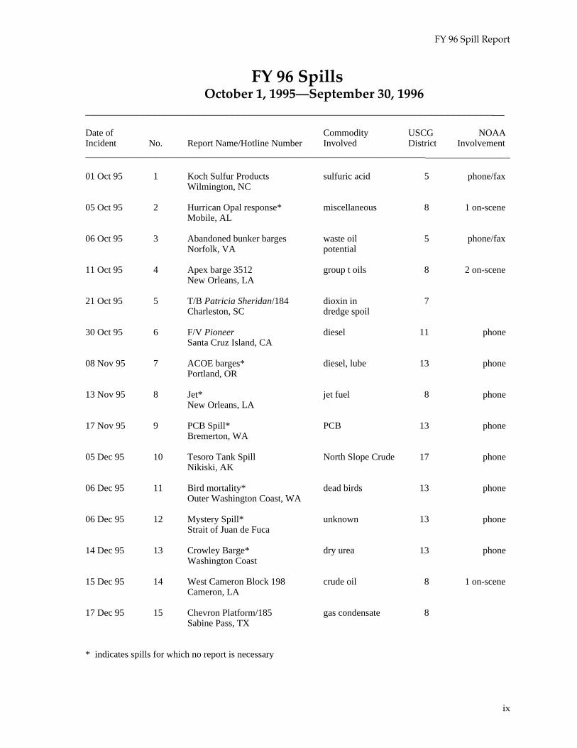
FY 96 Spill Report
FY 96 SpillsOctober 1, 1995—September 30, 1996
________________________________________________________________________
Date of Commodity USCG NOAAIncident No. Report Name/Hotline Number Involved District Involvement________________________________________________________________________
01 Oct 95 1 Koch Sulfur Products sulfuric acid 5 phone/faxWilmington, NC
05 Oct 95 2 Hurrican Opal response* miscellaneous 8 1 on-sceneMobile, AL
06 Oct 95 3 Abandoned bunker barges waste oil 5 phone/faxNorfolk, VA potential
11 Oct 95 4 Apex barge 3512 group t oils 8 2 on-sceneNew Orleans, LA
21 Oct 95 5 T/B Patricia Sheridan/184 dioxin in 7Charleston, SC dredge spoil
30 Oct 95 6 F/V Pioneer diesel 11 phoneSanta Cruz Island, CA
08 Nov 95 7 ACOE barges* diesel, lube 13 phonePortland, OR
13 Nov 95 8 Jet* jet fuel 8 phoneNew Orleans, LA
17 Nov 95 9 PCB Spill* PCB 13 phoneBremerton, WA
05 Dec 95 10 Tesoro Tank Spill North Slope Crude 17 phoneNikiski, AK
06 Dec 95 11 Bird mortality* dead birds 13 phoneOuter Washington Coast, WA
06 Dec 95 12 Mystery Spill* unknown 13 phoneStrait of Juan de Fuca
14 Dec 95 13 Crowley Barge* dry urea 13 phoneWashington Coast
15 Dec 95 14 West Cameron Block 198 crude oil 8 1 on-sceneCameron, LA
17 Dec 95 15 Chevron Platform/185 gas condensate 8Sabine Pass, TX
* indicates spills for which no report is necessary
ix
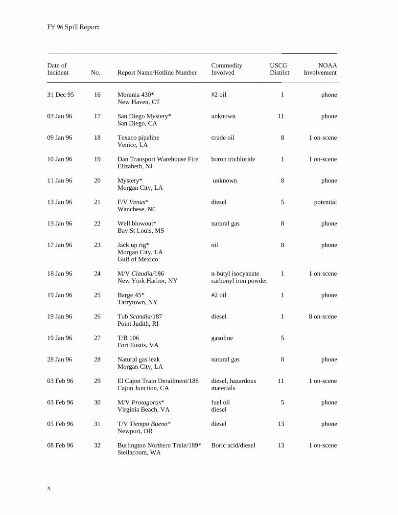
FY 96 Spill Report
________________________________________________________________________
Date of Commodity USCG NOAAIncident No. Report Name/Hotline Number Involved District Involvement________________________________________________________________________
31 Dec 95 16 Morania 430* #2 oil 1 phoneNew Haven, CT
03 Jan 96 17 San Diego Mystery* unknown 11 phoneSan Diego, CA
09 Jan 96 18 Texaco pipeline crude oil 8 1 on-sceneVenice, LA
10 Jan 96 19 Dan Transport Warehouse Fire boron trichloride 1 1 on-sceneElizabeth, NJ
11 Jan 96 20 Mystery* unknown 8 phoneMorgan City, LA
13 Jan 96 21 F/V Venus* diesel 5 potentialWanchese, NC
13 Jan 96 22 Well blowout* natural gas 8 phoneBay St Louis, MS
17 Jan 96 23 Jack up rig* oil 8 phoneMorgan City, LAGulf of Mexico
18 Jan 96 24 M/V Claudia/186 n-butyl isocyanate 1 1 on-sceneNew York Harbor, NY carbonyl iron powder
19 Jan 96 25 Barge 45* #2 oil 1 phoneTarrytown, NY
19 Jan 96 26 Tub Scandia/187 diesel 1 8 on-scenePoint Judith, RI
19 Jan 96 27 T/B 106 gasoline 5Fort Eustis, VA
28 Jan 96 28 Natural gas leak natural gas 8 phoneMorgan City, LA
03 Feb 96 29 El Cajon Train Derailment/188 diesel, hazardous 11 1 on-sceneCajon Junction, CA materials
03 Feb 96 30 M/V Protagoras* fuel oil 5 phoneVirginia Beach, VA diesel
05 Feb 96 31 T/V Tiempo Bueno* diesel 13 phoneNewport, OR
08 Feb 96 32 Burlington Northern Train/189* Boric acid/diesel 13 1 on-sceneSteilacoom, WA
x
FY 96 Spill Report
________________________________________________________________________
Date of Commodity USCG NOAAIncident No. Report Name/Hotline Number Involved District Involvement________________________________________________________________________
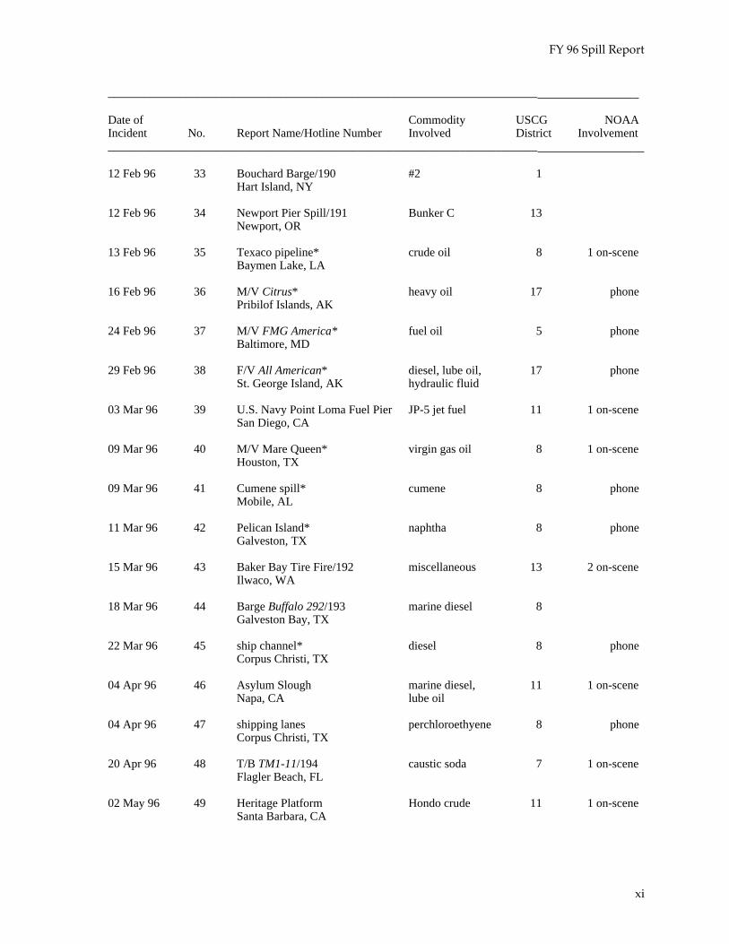
12 Feb 96 33 Bouchard Barge/190 #2 1Hart Island, NY
12 Feb 96 34 Newport Pier Spill/191 Bunker C 13Newport, OR
13 Feb 96 35 Texaco pipeline* crude oil 8 1 on-sceneBaymen Lake, LA
16 Feb 96 36 M/V Citrus* heavy oil 17 phonePribilof Islands, AK
24 Feb 96 37 M/V FMG America* fuel oil 5 phoneBaltimore, MD
29 Feb 96 38 F/V All American* diesel, lube oil, 17 phoneSt. George Island, AK hydraulic fluid
03 Mar 96 39 U.S. Navy Point Loma Fuel Pier JP-5 jet fuel 11 1 on-sceneSan Diego, CA
09 Mar 96 40 M/V Mare Queen* virgin gas oil 8 1 on-sceneHouston, TX
09 Mar 96 41 Cumene spill* cumene 8 phoneMobile, AL
11 Mar 96 42 Pelican Island* naphtha 8 phoneGalveston, TX
15 Mar 96 43 Baker Bay Tire Fire/192 miscellaneous 13 2 on-sceneIlwaco, WA
18 Mar 96 44 Barge Buffalo 292/193 marine diesel 8Galveston Bay, TX
22 Mar 96 45 ship channel* diesel 8 phoneCorpus Christi, TX
04 Apr 96 46 Asylum Slough marine diesel, 11 1 on-sceneNapa, CA lube oil
04 Apr 96 47 shipping lanes perchloroethyene 8 phoneCorpus Christi, TX
20 Apr 96 48 T/B TM1-11/194 caustic soda 7 1 on-sceneFlagler Beach, FL
02 May 96 49 Heritage Platform Hondo crude 11 1 on-sceneSanta Barbara, CA
xi

FY 96 Spill Report
________________________________________________________________________
Date of Commodity USCG NOAAIncident No. Report Name/Hotline Number Involved District Involvement________________________________________________________________________
11 May 96 50 Mystery Chemical Spill lead-based paint 17 phoneUnalaska, AK
14 May 96 51 Chevron Pipeline/ 195 #6 14 1 on-scenePearl Harbor, HI
17 May 96 52 collision Saudi Makkah #6 5 phoneNorfolk, VA
17 May 96 53 leaking container* calcium carbide 5 phoneBaltimore, MD
26 May 96 54 Barge Buffalo 286/196 #6 fuel oil 8 5 on-sceneGalveston Bay, TX
06 Jun 96 55 F/V Provider* diesel 17 phoneYunaska Island, AK
08 Jun 96 56 Mendenhall Wetlands diesel 17 phoneJuneau, AK
21 Jun 96 57 Barge MF12/197 marine diesel 8 1 on-sceneNew Orleans, LA
02 Jul 96 58 T/V Provence/198 #6 1 1 on-scenePiscataqua River, NH
17 Jul 96 59 Lime barge* limestone 13 phoneAdmiralty PointPuget Sound
18 Jul 96 60 M/V Hyundai Emperor lube oil 14 phonePacific Ocean
18 Jul 96 61 TWA Flight 800/199 JP-1, lube oil 1 1 on-sceneMoriches Inlet, NY
07 Aug 96 62 Everett pipeline spill mixed waste oils 13 phoneEverett Harbor, WA
10 Aug 96 63 Abandoned well hydrogen sulfide 8 phoneVenice, LA
11 Aug 96 64 F/V Lady Luck diesel fuel 5 phoneCape May, NJ
13 Aug 96 65 Samedon oil field crude oil 8 1 on-sceneCameron, LA
15 Aug 96 66 BP Oil Refinery Fire* 5 phoneLima, OH
xii
FY 96 Spill Report
________________________________________________________________________
Date of Commodity USCG NOAAIncident No. Report Name/Hotline Number Involved District Involvement________________________________________________________________________
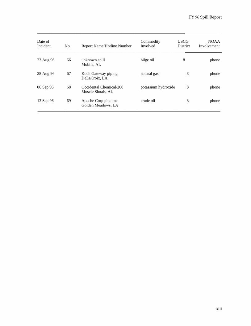
23 Aug 96 66 unknown spill bilge oil 8 phoneMobile, AL
28 Aug 96 67 Koch Gateway piping natural gas 8 phoneDeLaCroix, LA
06 Sep 96 68 Occidental Chemical/200 potassium hydroxide 8 phoneMuscle Shoals, AL
13 Sep 96 69 Apache Corp pipeline crude oil 8 phoneGolden Meadows, LA
_________________________________________________________________________________________
xiii
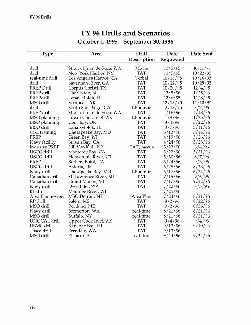
FY 96 Drills
FY 96 Drills and ScenariosOctober 1, 1995—September 30, 1996
Type Area DrillDescription
DateRequested
Date Sent
drill Strait of Juan de Fuca, WA Movie 10/5/95 10/11/95drill New York Harbor, NY TAT 10/5/95 10/22/95real-time drill Los Angeles Harbor, CA Verbal 10/16/95 10/16/95drill Savannah River, GA TAT 10/12/95 10/29/95PREP Drill Corpus Christi, TX TAT 10/20/95 12/4/95PREP drill Charleston, SC TAT 12/5/96 1/25/96PREPdrill Lanai-Molok, HI TAT 12/6/95 12/8/95MSO drill Southeast AK TAT 12/18/95 12/18/95drill South San Diego, CA LE movie 12/18/95 3/7/96PREP drill Strait of Juan de Fuca, WA TAT 1/16/96 4/18/96MSO planning Lower Cook Inlet, AK LE movie 1/8/96 1/25/96MSO planning Coos Bay, OR TAT 3/4/96 5/22/96MSO drill Lanai-Molok, HI TAT 3/7/96 3/11/96OSC training Chesapeake Bay, MD TAT 3/13/96 3/14/96PREP Green Bay, WI TAT 4/19/96 5/26/96Navy facility Suisun Bay, CA TAT 4/24/96 5/28/96Industry PREP Kill Van Kull, NY TAT/movie 5/23/96 6/4/96USCG drill Monterey Bay, CA TAT 5/22/96 5/31/96USCG drill Housatonic River, CT TAT 5/30/96 6/7/96PREP Barbers Point, CA TAT 6/24/96 9/3/96USCG drill Astoria, OR TAT 6/25/96 8/23/96Navy drill Chesapeake Bay, MD LE movie 6/17/96 6/24/96Canadian drill St. Lawrence River, MI TAT 7/15/96 9/6/96Canadian drill Grand Manan, MI TAT 7/17/96 9/12/96Navy drill Dyes Inlet, WA TAT 7/22/96 8/5/96BP drill Maumee River, WI 7/25/96Area Plan review MSO Detroit, MI Area Plan 7/24/96 8/21/96RP drill Salem, MS TAT 8/2/96 8/22/96MSO drill Portland, ME TAT 8/2/96 8/26/96Navy drill Bremerton, WA real-time 8/21/96 8/21/96MSO drill Buffalo, NY real-time 8/21/96 8/21/96UNOCAL drill Upper Cook Inlet, AK TAT 9/4/96 9/4/96USMC drill Kaneohe Bay, HI TAT 9/12/96 9/19/96Tosco drill Ferndale, WA TAT 9/13/96MSO drill Pismo, CA real-time 9/24/96 9/24/96
xiv

U.S. Coast Guard District 1
Mystery Spill.....................................................................................................................1
Dan Transport Warehouse Fire......................................................................................3
M/V MSC Claudia ............................................................................................................5
Barge North Cape ...............................................................................................................9
Barge Bouchard B-140 ..................................................................................................... 15
T/V Provence ...................................................................................................................17
TWA Flight 800 Crash ...................................................................................................21
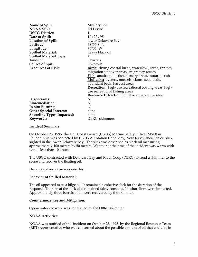
USCG District 1
Name of Spill: Mystery SpillNOAA SSC: Ed LevineUSCG District: 1Date of Spill: 10/23/95Location of Spill: lower Delaware BayLatitude: 38°56.8’ NLongitude: 75°04’ WSpilled Material: heavy black oilSpilled Material Type: 4Amount: 3 barrelsSource of Spill: unknownResources at Risk: Birds: diving coastal birds, waterfowl, terns, raptors,
migration stopover areas, migratory routesFish: anadromous fish, nursery areas, estuarine fishMollusks: oysters, mussels, clams, seed beds,abundant beds, harvest areasRecreation: high-use recreational boating areas, high-use recreational fishing areasResource Extraction: bivalve aquaculture sites
Dispersants: NBioremediation: NIn-situ Burning: NOther Special Interest: noneShoreline Types Impacted: noneKeywords: DBRC, skimmers
Incident Summary:
On October 23, 1995, the U.S. Coast Guard (USCG) Marine Safety Office (MSO) inPhiladelphia was contacted by USCG Air Station Cape May, New Jersey about an oil slicksighted in the lower Delaware Bay. The slick was described as black oil measuringapproximately 100 meters by 50 meters. Weather at the time of the incident was warm withwinds less than 10 knots.
The USCG contracted with Delaware Bay and River Coop (DBRC) to send a skimmer to thescene and recover the floating oil.
Duration of response was one day.
Behavior of Spilled Material:
The oil appeared to be a bilge oil. It remained a cohesive slick for the duration of theresponse. The size of the slick also remained fairly constant. No shorelines were impacted.Approximately three barrels of oil were recovered by the skimmer.
Countermeasures and Mitigation:
Open-water recovery was conducted by the DBRC skimmer.
NOAA Activities:
NOAA was notified of this incident on October 23, 1995, by the Regional Response Team(RRT) representative who was concerned about the possible amount of oil that could be in
1

USCG District 1
the slick. Speculations were as high as 56,000 gallons. The Scientific Support Coordinator(SSC) calculated that there were only three barrels (126 gallons) of oil on the water.
The SSC was also contacted by the MSO to provide trajectory information. NOAApredicted that there would be no land impacts within the next 24 to 48 hours.
NOAA supported this response for several hours.
References:
NOAA. 1996. ADIOS™ (Automated Data Inquiry for Oil Spills) User's Manual. Seattle:Hazardous Materials Response and Assessment Division, NOAA. 50 pp.
2
USCG District 1
Name of Spill: Dan Transport Warehouse FireNOAA SSC: Ed LevineUSCG District: 1Date of Spill : 01/10/96Location of Spill: Elizabeth, New JerseyLatitude: 40°41’ NLongitude: 74°09’ WSpilled Material: boron trichlorideSpilled Material Type: 5Amount: five 1-ton cylindersSource of Spill: warehouseResources at Risk: human health, birds, and fishDispersants: NBioremediation: NIn-situ Burning: NOther Special Interest: health and safety issues, evacuation, media interestShoreline Types Impacted: consolidated seawalls, consolidated shores, piers,
riprapKeywords: none
Incident Summary:
On January 10, 1996, the USCG Captain of the Port (COTP) New York (NY) was notifiedof a six-alarm warehouse fire, cause unknown, in Port Elizabeth, New Jersey. The firecaused the release of an unknown quantity of boron trichloride and other unknownmaterials. The weather on-scene was partly cloudy with winds northwest at 17 knots.There were more than two feet of snow on the ground.
The weight of the snow and loss of structural integrity caused the warehouse roof tocollapse. Several cylinders housed in the building exploded, causing a large mushroomcloud that reached Staten Island.
The New Jersey Department of Environmental Protection (DEP), Port of Elizabeth FireDepartment, and the New York City DEP responded to the scene. Local healthdepartments issued health advisories and the United States Environmental ProtectionAgency (EPA) performed air monitoring and water sampling on-scene.
The response lasted one day.
Behavior of Spilled Material:
The fire, located in an industrial zone several hundred feet from Newark Bay, caused asmoke plume that moved with the wind towards Staten Island. Odors were reported byarea residents and 200 people were evacuated from the vicinity. The EPA sampled waterrunoff and determined that the Elizabeth Channel had not been impacted. No injuries orcasualties were reported.
3

USCG District 1
Countermeasures and Mitigation:
Site control was established by the Port of Elizabeth Fire Department and, as a precaution,dikes were built to channel water away from sensitive areas. Water-recovery operationswere not undertaken and shoreline cleanup was not necessary. Spilled material andcontaminated debris were removed and disposed of.
Other Special Interest Issues:
Effects to human health and safety were monitored by state and federal officials. Theresults of the monitoring warranted closing commercial areas and evacuating a furniturestore.
Media interest was high due to the spectacular visual images of the fire.
NOAA Activities:
NOAA was notified of this incident at 2200 on January 10, 1996, by the USCG. The SSCwas asked to report to the USCG Crisis Action Center on Governors Island, New York.
The SSC supplied support material from reference guides and summary information. Themajor concern from the boron trichloride was the generation of hydrochloric acid whenmixed with water. The slight possibility of the generation of dioxins was also noted. Dueto the intense heat from the fire, most of the hazardous substances were incinerated andmonitoring showed minimal impact and concerns near the incident.
NOAA supported this incident for approximately two hours.
References:
Association of American Railroads (AAR) 1991. Emergency Materials in SurfaceTransportation. Washington D.C.: Bureau of Explosives.
NOAA. 1993. The CAMEO™ 4.0 Manual. Washington, D.C.: National Safety Council.440 pp.
Lewis, Sr., Richard J.. 1992. Sax's Dangerous Properties of Industrial Materials, Eighth Edition:Volume I. ISBN 0-442-01276-4. New York: Van Nostrand Reinhold. 743 pp.
4
USCG District 1
Name of Spill: M/V MSC ClaudiaNOAA SSC: Ed LevineUSCG District 1Date of Spill: 1/17/96Location of Spill: Newark, New JerseyLatitude: 74°9‘ NLongitude: 40°0‘ WSpilled Material: n-butyl isocyanateSpilled Material Type: 5Amount: 36 fifty-five gallon drumsSource of Spill: non-tank vesselResources at Risk: human health exposureDispersants: NBioremediation: NIn-situ Burning: NOther Special Interest: noneShoreline Types Impacted: man-made shorelineKeywords: none
Incident Summary:
The M/V MSC Claudia, steaming from Europe to Boston, encountered heavy weather andlost 23 containers overboard, presumably along the coast of Ireland. Upon nearing U.S.waters, the vessel contacted the USCG and other local authorities, reporting that she haddamage to containers, two of which were listed on the dangerous cargo manifest (DCM).The products of concern were n-butyl isocyanate (thirty-six 55-gallon drums) and carbonyliron powders (100 drums [9,500 kilograms]). The container carrying the n-butyl isocyanatewas damaged, but there was no evidence that any drums inside were breached. Thecarbonyl iron powder containers showed no signs that the contents had spilled.
Based on information from NOAA’s science team and more specific information from theshipper of the n-butyl isocyanate (Bayer Corp.), the USCG, Boston Fire Department,Massachusetts Port Authority, the shipping agent, and the NOAA SSC began developingcontingency plans for surveying and offloading the vessel. The vessel was due to arrive atBoston Harbor at 2300 January 16, 1996. She was ordered to remain at the outer anchorageuntil a contracted survey team and the USCG could board her and assess the risks ofbringing her into the inner harbor. The vessel was not allowed to offload the damagedcontainers until the next day
Because of the delays expected in Boston overnight, the MSC Claudia determined it was inher best interest to steam to her next port of call, New York. She requested and receivedpermission from the USCG and changed course for New York. Collected information aboutthe ship and her cargo, contingency planning in progress, and information on the dangerouscargo were forwarded to COTP New York and the New York NOAA SSC.
The M/V MSC Claudia arrived at the Ambrose Pilot anchorage on the morning of January 17,1996. COTP NY and New York City Fire Department Hazardous Material Team personnelboarded the vessel to inspect the condition of containers. The 20-foot isocyanate containerwas damaged on one corner where it had been apparently struck by another container.There was no evidence of breaching or spilling of the hazardous liquid. Fire departmentpersonnel took HNu readings and found only background levels. Several fasteners werebroken. The 40-foot iron powder container was laying on a refrigerated container atapproximately a 30-degree angle but showed no evidence of cargo spillage.
5
USCG District 1
The USCG COTP NY called a meeting at 1500 of New Jersey DEP, Port Authority of NewYork/New Jersey, Protection and Indemnity MSC (insurers and their lawyer), Union CityOffice of Emergency Management (OEM), and NOAA to discuss options for the vessel. Asthe on-scene inspection offered little evidence of drum failures, the ship was givenpermission to arrive at berth in Port Newark on the morning of January 18. Site safety planswere to be developed and approved by the USCG and New Jersey DEP before cleanupactivities were begun. Bayer was supplying their own hazardous material response team toremove the container and deliver the cargo to its final destination. MSC hired anothercompany to handle the iron powder.
Behavior of Spilled Material:
N-butyl isocyanate is a clear, colorless liquid with a flash point of 70°F that is used as anadditive in paint to inhibit mildew formation. In low concentrations its vapors are irritatingto the eyes and mucous membranes. In higher concentrations it is toxic by inhalation. It islighter than water, insoluble in water, and very slowly decomposed by water. Its vapors areheavier than air and toxic oxides of nitrogen are produced during combustion of thismaterial.
N-butyl isocyanate is poisonous and may be fatal if inhaled, swallowed, or absorbedthrough the skin. Contact may cause burns to skin and eyes. At a level of concern of1 part per million (ppm) a release of one 55-gallon drum could yield a plume of about 2.4miles. Runoff from fire control or dilution water may cause pollution.
The chemical was confined to the container. None was released into the atmosphere.
Countermeasures and Mitigation:
The USCG initiated an Incident Command System at the incident site. The New Jersey DEP beganemergency removal operations and the vessel’s movements were directed by the COTP NY. MSCClaudia was held at the Ambrose Light for inspection and until conditions became amenable tosafely proceed to dock in Newark Bay.
Removal and disposal of damaged containers were performed by the responsible party (RP)(Bayer) Emergency Response Team.
NOAA Activities:
NOAA was notified of this incident on January 16, 1996, by the COTP NY. The SSC attended ameeting with the COTP NY to plan for response activities after the vessel arrives at dock. The SSCran ALOHA™ predictions for the isocyanate and relayed the information to responders. Thisincident was treated as a delicate situation.
NOAA supported this response for one afternoon.
References:
Association of American Railroads (AAR). 1991. Emergency Materials in Surface Tansportation.Washington D.C. Bureau of Explosives.
NOAA. 1992. The ALOHA™ 5.1 Manual for the Apple Macintosh and IBM Compatibles.Washington, D.C.: National Safety Council. 350 pp.
6
USCG District 1
NOAA. 1993. The CAMEO™ 4.0 Manual. Washington, D.C.: National Safety Council. 440pp.
7

USCG District 1
8
USCG District 1
Name of Spill: Barge North CapeNOAA SSC: Stephen LehmannUSCG District: 1Date of Spill: 01/19/96Location of Spill: Narragansett, Rhode IslandLatitude: 42°21.7’ NLongitude: 071°34.9’ WSpilled Material: #2 fuel/home heating oilSpilled Material Type: 2Amount: 19,643 barrels (825,000 gallons)Source of Spill: bargeResources at Risk: Fish: juvenile flatfish, pelagics
Shellfish: American lobster, surf clams, quahogs, seastars,crabsBirds: shorebirds (piping plover), wading and diving birdsMarine Mammals: harbor sealHabitats: barrier beaches, periodically breached andoverwashed salt ponds, permanently breached salt ponds,sheltered tidal marshes (within the salt ponds)Management area: Trustom Pond National Wildlife RefugeRecreational: summer bathing beaches
Dispersants: NBioremediation: NIn-Situ Burning: NOther Special Interest: naturally dispersed oil, federal fishery closure, fish
tainting, organoleptic testingShoreline Types Impacted: Coarse to medium sand beaches, mixed sand and gravel,
sheltered tidal marshesKeywords: endangered species, ARTES
Incident Summary:
At 1430 Eastern Standard Time (EST) on January 19, 1996, MSO Providence received a callfrom Station Castle Hill that the tug Scandia was on fire. The tug Scandia was located somethree miles south and west of Point Judith, Rhode Island towing the barge North Cape, whichwas carrying 94,000 barrels of #2 home heating fuel Weather was severe with sustainedwinds of more than 40 knots from the south-southeast and forecast to increase. The tugScandia was abandoned and USCG Search and Rescue teams were dispatched to assist thecrew.
At approximately 2000 EST, a USCG helicopter reported that the barge North Cape wasaground on Nebraska Shoals, directly adjacent to the Trustom Pond National WildlifeRefuge, owned and operated by the U.S. Fish and Wildlife Service (USFWS). The helicopterfurther reported that the barge was releasing oil.
The barge North Cape spilled oil in two separate releases. The first, released during theheight of the initial storm, was 700,000 gallons and the second, less than a day later, was125,000 gallons. The combination of the type of oil released and the energy of the stormcaused great dispersion into the water column. As a result, in the days following the spill,great numbers of shellfish (mostly bivalves and juvenile lobsters) washed ashore.Subsequently, the Rhode Island Department of Health closed more than 200 square miles ofcommercial fishery in the area of the spill. This closure was coordinated with the EPARegion One and with NOAA’s National Marine Fisheries Service (NMFS), which closed
9
USCG District 1
federal fishing grounds using the Magnuson Act. This is the first time federal fisheries havebeen closed due to oil contamination.
The emergency phase of the response lasted seven days and the on-scene command postwas demobilized following the removal of the barge North Cape from the beach. ActiveUSCG spill response and assessment continued from the MSO, including re-survey of keyimpacted recreational and endangered piping plover nesting beaches.
The full re-opening of the Rhode Island fishery was not complete until the middle of June.Organoleptic panels were established to certify that seafood, lobsters, and clams, inparticular, were marketable.
Behavior of Oil:
Due to the extreme weather (onshore gale-force winds), the nearshore bathymetry and thelight oil, dispersion into the water column was intensive and immediate. NOAA modelerspredicted that 80 percent of the initial release (700,000 gallons) was dispersed within six toeight hours of the spill. Modelers from Norway’s IKU confirmed these predictions in anunsolicited effort to support the spill science support team.
Surface sheens traveled as far south as the southern end of Block Island (fewer than 15miles from the source), as far west as Charlestown Breachway, and east to the southernopening of Narragansett Bay. Narragansett Bay, however, was never confirmed to beimpacted with any significant amount oil.
The severe weather caused contamination to two salt ponds that are normally protectedfrom the sea by the barrier beach. Trustom Pond experienced a washover precisely ashoreof where the barge grounded. Card Pond, a smaller salt pond to the east of Trustom Pond,experienced a breach that allowed direct flushing with the sea. These phenomena resultedin oil contamination and resource impacts.
Sheens in the open waters south of the spill site were gone within five or six days. Sheensremained in the salt ponds and salt marshes, particularly Point Judith Pond in the TrustomPond (due largely to the fact that the pond remained ice-covered for several weeks) and inthe riprap of the Point Judith Harbor of Refuge for as long a two to three weeks followingthe spill.
The extent of water column and sediment contamination is open to speculation. However,given the location of contaminated lobsters caught for testing, oil was in the water column atdepths of greater than 100 feet, up to 15 miles south of the source.
Countermeasures and Mitigation:
Spill impact mitigation measures were mostly ineffective due to the type of oil spilled, theweather, and the current velocities. Of priority and immediate concern were the permanentbreachways of Point Judith Pond, Ninigrit Pond (Charlestown Breachway), and thebreachways farther west. Although it was not immediately known that both Trustom andCard ponds were vulnerable to contamination, little could have been done to protect them.Nevertheless, the washover on Trustom Pond was bermed.
Dispersants were approved through the RRT1 concurrence network and deployed to astaging area, along with a C-130 Hercules aircraft with an area dispersant delivery systempack.
10
USCG District 1
Charlestown Breachway/Ninigrit Pond
Boom was deployed inside the Charlestown Breachway at an acute angle to theincoming tidal current (which can run in excess of four knots). Boom was also deployedwithin the ponds. The breachway booming was much less effective than the pondbooming. This booming did not contain large amounts of oil, however.
Point Judith Pond
A booming strategy for Point Judith Pond was developed by the NOAA ScientificSupport Team (SST) and sent to the Federal On-Scene Coordinator (FOSC) before thegrounding. Due to logistical constraints and insufficient time, the strategy for the inletwas not implemented. Instead, booming was conducted within the pond, protectingindividual marsh areas. Again, because of the rapid dispersion of the fuel into the watercolumn, booming was largely ineffective in the pond.
Block Island
The Great Salt Pond on Block Island, the highest resource priority on the island, wasboomed at the entrance. Because the oil never impacted this area in significant amounts,the effectiveness of the booming is unknown.
Outer Beaches
No protection was offered for this area as none would have been effective. The beaches,however, required two separate levels of scrutiny regarding cleanup and remediationbased on the type of use on the beach; piping plover nesting beaches and recreationalbeaches.
The piping plover is a small endangered shorebird. As many as 13 nesting pairs areknown to have used the beaches in the spill area in previous seasons. The pipingplover’s vulnerability to oil contamination is virtually unknown, except as oilcontamination impacts apply to all shorebirds and their eggs. The “action level” on theplover beaches was agreed to be 100 ppm total hydrocarbons in the sediments.
Another area of concern was the profile of the beach. Following the operations toremove the barge North Cape and the tug Scandia, the profile of the beach face wasseverely altered. The USFWS trustees and refuge managers were concernedthat thealtered profile would contribute to nest washover.
Neither the oil contamination at greater than 100 ppm nor the profile of the beach requiredany cleanup activity before the migrating plovers arrived. A few weeks after the tug Scandiawas removed, contamination of the sediments dropped below 100 ppm quickly and thebeach re-profiled to its natural pre-spill condition.
The “action level” established for the recreational beaches was odor-based. It was felt that,while there existed no real health threat at levels below 100 ppm, the odor of the oil couldbe detected at well below 1 ppm and that this would create an unacceptable recreationalenvironment. Therefore, the analysis of the beaches, including the Shoreline AssessmentProgram, was conducted using odor as one of the assessment factors. Teams were asked tosmell the sediments and note if they felt the odor of oil was strong, moderate, slight, or notpresent. Comparison of chemically analyzed sediments and Shoreline Assessment Teamremarks showed almost no correlation between “heavy” oiling and strong odor or “light”oiling and slight odor.
11
USCG District 1
None of the beaches required any cleanup measures beyond the removal of some debris.
Other Special Interest Issues:
Two organoleptic testing protocols were established to determine the marketability of theseafood. The first protocol used three trained NMFS sensory specialists who smelled fishand shellfish caught in the closed area. If a single specimen smelled of oil, the area remainedclosed. Lobsters were trapped in predetermined areas and all specimens within a singlecatch or trap were chemically analyzed if any smelled of oil. The latter protocol establisheda panel of ten trained NMFS sensory specialists. Here a false positive was considered a 2to 8 vote; three or more panelists agreeing was considered a true positive or a true negative.
NOAA Activities:
NOAA was notified of this incident at 1535 on January 19, 1996, by the USCG whorequested a trajectory analysis. At 1616 the NOAA Regional Response Team naturalresource trustee was paged. The SSC established a nine-member on-scene SST consisting ofpersonnel from the SSC Branch, Modeling and Simulations Studies Branch, BiologicalAssessment Team (BAT), Research Planning Inc., and Genwest Systems.
• The SST provided trajectory, overflight maps, and weather briefings for six days,and protection strategies to the FOSC for the beachways.
• A science committee was formed consisting of the state and federal scientificresources, university personnel, non-governmental organizations, and the scienceconsultant to the responsible party. The NOAA BAT leader was assigned to chairthe committee.
• NOAA (SST and Damage Assessment Center) was instrumental in preventing thedestruction of 40,000 pounds of lobsters that were contaminated while in holdingpens due to flow-through water systems in Point Judith Pond. These lobsters wereallowed to depurate and released back into the impacted area as seed-stock.
• The NOAA SST organized and managed the Shoreline Assessment Teams as well asestablishing the Alternative Response Technologies Evaluation System to bettermanage vendor requests and solicitations.
• The NMFS Research Vessel Albatross was used for retrieving sediment, water, andtissue samples from within the spill impact zone.
• NOAA developed several documents designed specifically for the public (throughthe media) to explain certain complex issues regarding the spill.
• NOAA continued to provide support to the FOSC and State On-Scene Coordinator(SOSC) on fish tainting and seafood contamination issues for several months afterthe barge was removed from the beach.
References:
Research Planning Institute. 1980. Sensitivity of coastal environments and wildlife to spilled oil:Massachusetts. An atlas of coastal resources. Seattle: Ocean Assessments Division, NOAA.49 maps.
12

USCG District 1
13
USCG District 1
Name of Spill: Barge Bouchard B-140NOAA SSC: Ed LevineUSCG District: 1Date of Spill: 02/12/96Location of Spill: Hart Island, New YorkLatitude: 40°51.3‘ NLongitude: 73°45.8‘ WSpilled Material #2 fuel oilSpilled Material Type: 2Amount: 95 barrels (4,000 gallons)Source of Spill: BargeResources at Risk: Terrestrial Mammals: mustelids, rodents
Birds: waterfowl, shorebirds, wading birds, gulls, ternsFish: demersal fishCrustaceans: lobsterRecreation: marinas, boat ramps, high-use recreationalboating areas, high-use recreational fishing areas
Dispersants: NBioremediation: NIn-situ Burning: NOther Special Interest: noneShoreline Types Impacted: coarse gravel beaches, coarse sand beaches, coastal
structures, marshes, mixed sediment beaches, piers,riprap, salt marsh, saltwater marshes, sand/gravelbeaches, tidal mudflat
Keywords: containment boom, skimmers, sorbent boom
Incident Summary:
On February 12, 1996, the barge Bouchard B-140 reported hitting an unknown object nearHart Island, New York, at the western end of Long Island Sound, and was leaking oil.Weather at the time was winds from the west at 10 to 15 knots, temperature 29°F, and seas1 to 3 feet. Once the leak was detected the USCG COTP NY was notified and a PollutionResponse Team dispatched. Federal involvement in this incident was to monitor the RP’sactivities and conduct shoreline surveys to document any impacts; none were observed.This response lasted two days.
Behavior of Spilled Material:
The oil formed a sheen about 300 meters long. No land impacts were observed, but residentsdownwind of the release reported fuel oil odors. Of the 4,000 gallons of oil reportedlyreleased, the contractor recovered 850 gallons outside the boom and 350 gallons inside theboom by skimming. NOAA predicted that 43 percent of the oil would evaporate, 46percent would naturally disperse in the water column, and 11 percent would remain on thesurface 18 hours after the initial release.
14
USCG District 1
Countermeasures and Mitigation:
The crew of the towing tug deployed sorbent boom. Spill contractors boomed the barge withcontainment boom and recovered product using skimmers within the containment area. TheRP brought two barges along side the B-140 for lightering. Diver surveys found three cracksin the single-hull, which were temporarily plugged. With a skimmer escort, the completelylightered barge was allowed to travel to a dry-dock in Staten Island, New York.Precautionary protection boom was dispatched to sensitive areas identified in the AreaContingency Plan and as directed by the New York State Department of EnvironmentalConservation. Open-water recovery was conducted by skimmers. Shoreline cleanup wasnot necessary because the oil did not reach land.
Other Special Interest Issues:
The COTP NY issued a Safety Voice Broadcast closing shipping lanes and vehicle trafficroutes for the area around the B-140. Initially, media interest was fairly high.
NOAA Activities:
NOAA was notified of this incident on February 12, 1996, by the COTP NY who requestedtrajectory analyses and weather information. The SSC supported this incident for severalhours by phone.
References:
NOAA. 1993. ADIOS™ (Automated Data Inquiry for Oil Spills) User's Manual. Seattle:Hazardous Materials Response and Assessment Division, NOAA. 50 pp.
Research Planning Institute. 1985. Sensitivity of coastal environments and wildlife to spilled oil:Long Island. An atlas of coastal resources . Seattle: Ocean Assessments Division, NOAA. 41maps.
15
USCG District 1
Name of Spill: T/V ProvenceNOAA SSC: Stephen LehmannUSCG District: 1Date of Spill: 07/01/96Location of Spill: Portsmouth, New HampshireLatitude: 43°05’50” NLongitude: 070°47’15” WSpilled Material: #6 Fuel OilSpilled Material Type: 5Amount: 21 barrels (880 gallons)Source of Spill: tank vesselResources at Risk: Fish: juvenile flatfish, pelagics
Shellfish: American lobster, surf clams, quahogs,seastars, crabsBirds: wading and diving birdsMarine Mammals: harbor sealHabitats: sheltered spartina marshes, cobble shoreline,sheltered mudflats, exposed rocky head headlandsManagement area: Great Bay National EstuarineResearch ReserveRecreational: bathing beaches, recreational fishing andnature areas, sailing
Dispersants: Dispersants were discussed as a response option, butwere not used due to the nature of the oil.
Bioremediation: NIn-Situ Burning: NOther Special Interest: In the immediate area, oil occupied several levels in the
water column depending on the circulation. Lobstergear was very hard-hit due, in part, to the type ofmaterials used in the netting and bait bags.
Shoreline Types Impacted: sheltered tidal marshes, mud flats, cobbleKeywords: none
Incident Summary:
At approximately 2245 Eastern Daylight Time, July 1, 1996, (spring tides) during off-loading operations at a Public Service of New Hampshire (PSNH) dock on the PiscataquaRiver, the T/V Provence broke free of 21 mooring lines securing her to the dock. Two 10-inch diameter hoses were severed, releasing approximately 21 barrels (880 gallons) of heavy#6 oil into the river. The vessel had been carrying 250,000 barrels of #6 oil used to generateelectricity at the PSNH Newington Station. The Provence drifted to the Maine side of theriver and grounded in the mud. A rock jammed in the anchor when the vessel retrieved itwhile preparing to go to anchorage. The fluke of the anchor was held in the open positionand punctured the vessel just above the turn of the bilge. There was very little oil in thepunctured tank and little, if any, escaped. The hole in the vessel was not discovered forseveral days.
16

USCG District 1
Behavior of Oil:
The Piscataqua River is a vertically well-mixed system extending as far as Adams Point andinto Great Bay. Since the 6.2 API of the spilled product was heavier than the river water,much of the oil sank and quickly formed small droplets. In areas of strong vertical mixing,the oil droplets mixed throughout the water column and appeared near the surface andwithin the intertidal zone.
Areas with strong vertical mixing include Fox Point, Dover Point, and the west side ofBadger Island. The oil droplets that dispersed throughout the water column spread aswidely scattered particles. Pools or large puddles of oil along the bottom were consideredunlikely due to the strong currents. Although these particles did not tend to aggregate inpools, they did adhere to lobster pots and other oleophilic material.
Countermeasures and Mitigation:
Spill impact mitigation measures were mostly ineffective due to the type of oil spilled andcurrent velocity. Of priority and immediate concern was the Great Bay, itself; all effortswere concentrated on keeping oil out of this area.
Some limited shoreline cleanup was required at shorelines where the oil was brought to thesurface by localized vertical flow and distributed along the shore by winds. Cleaningconsisted of sorbent materials where access was appropriate.
Other Special Interest Issues:
Because this oil tended to sink or remain neutrally buoyant, it was difficult to convince thepublic (and many of the spill response organizations) that less than 1,000 gallons had beenspilled. Although it was recognized that the threat of this amount of #6 fuel oil was minor,response activities continued longer than predicted.
Several thousand oiled lobsters were purchased by the spiller as a result of the T/V Provencespill, however, none were apparently killed outright. Every lobster trap in the river(approximately 4,000) was purchased and replaced by the spiller.
NOAA Activities:
NOAA was notified of this incident on July 1, 1996, by the USCG FOSC who requestedtrajectory analysis. On July 2 the SSC reported on-scene at the request of the FOSC. TheNOAA Regional Response Team natural resource trustee was notified and briefed by theSSC.
NOAA suggested a method to attempt to qualify the amount and depth of the oil droplets;tie sorbent snare at measured depths along an anchored line. These so-called “traps” wereplaced at various locations recommended by NOAA and examined daily. Although thistechnique did not yield much oil, it is felt that in a larger spill of similar oil (type 5), it couldbe very useful determining change over time and oil movement at depth.
The SSC provided trajectory and weather briefings and organized and managed theShoreline Assessment Teams.
The SSC also developed several documents designed for the public to explain (through themedia and meetings) certain complex issues regarding the spill.
17

USCG District 1
The SSC provided support to the FOSC and SOSC on lobster contamination issues duringand following the emergency phase of the spill.
References:
Research Planning Institute. 1980. Sensitivity of coastal environments and wildlife to spilled oil:Massachusetts. An atlas of coastal resources. Seattle: Ocean Assessments Division, NOAA.49 maps.
18

USCG District 1
19
USCG District 1
Name of Spill: TWA Flight 800 CrashNOAA SSC: Stephen LehmannUSCG District: 1Date of Spill: 07/17/96Location of Spill: Long Island, New YorkLatitude: 40°39’ NLongitude: 072°38’ WSpilled Material: JP-1 jet fuel oilSpilled Material Type: 1Amount: 714 barrels (30,000 gallons)Source of Spill: Boeing 747Resources at Risk: Fish: pelagics
Shellfish: American lobsters, surf clams, quahogs,seastars, crabsBirds: wading and diving birdsMarine Mammals: harbor sealHabitats: sheltered marshes, sand beachesRecreational: bathing beaches, recreational fishing andnature areas, sailing
Dispersants: NBioremediation: NIn-Situ Burning: NOther Special Interest: seaportShoreline Types Impacted: sheltered marshes, sand beachesKeywords: none
Incident Summary:
At approximately 2040 Eastern Daylight Time, July 17, 1996, TWA Flight 800 en route fromNew York’s JFK Airport to Paris, exploded off the coast of Long Island, New York. Theplane crashed into the ocean with 229 passengers and crew onboard; there were nosurvivors. JP-1 jet fuel, hydraulic oil, and lube oil were released and burned.
Behavior of Oil:
The impact site was approximately 10 miles offshore of Moriches Inlet. The aircraft wascarrying 30,000 gallons of JP-1 and an unknown amount of lube oil. No slicks werereported. Given the method of loss (an explosion followed by a fire), much of the JP-1 orthe lube oil was lost. If the JP-1 had spilled directly onto the water and there had been nofire, estimates of the evaporation rate were as high as 70 percent within the first ten hours ofthe spill. Although the lube oil is considerably more persistent, it did not significantlyimpact beaches.
Flotsam associated with the spill moved under the influence of local currents and, todifferent extents, the winds. Contents that were very buoyant (such as seat cushions andinsulation), moved more downwind than items that had less freeboard and greater density.
20

USCG District 1
Countermeasures and Mitigation:
Little oil spill mitigation or cleanup actions were taken because so little oil came ashore;although, some oily debris was recovered on shore.
NOAA Activities:
NOAA was notified of this incident on July 17, 1996, by the USCG who requested atrajectory analysis. Trajectories for the oil and the debris were produced and coordinatedby the SSC. The debris’ movement forecast also included advice as to where victims of thedisaster might be located.
The NOAA vessel Rude was dispatched to the scene to help recover debris. As part of itssurvey, the Rude used a state-of-the-art multibeam shallow water bathymetric soundersystem (SEABAT).
The SSC provided weather forecasts and trajectory analyses throughout the incident.
21
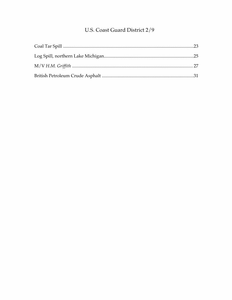
U.S. Coast Guard District 2/9
Coal Tar Spill ..................................................................................................................23
Log Spill, northern Lake Michigan..............................................................................25
M/V H.M. Griffith .......................................................................................................... 27
British Petroleum Crude Asphalt ................................................................................31
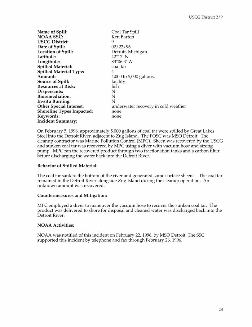
USCG District 2/9
Name of Spill: Coal Tar SpillNOAA SSC: Ken BartonUSCG District: 9Date of Spill: 02/22/96Location of Spill: Detroit, MichiganLatitude: 42°17’ NLongitude: 83°06.3’ WSpilled Material: coal tarSpilled Material Type: 4Amount: 4,000 to 5,000 gallons.Source of Spill: facilityResources at Risk: fishDispersants: NBioremediation: NIn-situ Burning: NOther Special Interest: underwater recovery in cold weatherShoreline Types Impacted: noneKeywords: noneIncident Summary:
On February 5, 1996, approximately 5,000 gallons of coal tar were spilled by Great LakesSteel into the Detroit River, adjacent to Zug Island. The FOSC was MSO Detroit. Thecleanup contractor was Marine Pollution Control (MPC). Sheen was recovered by the USCGand sunken coal tar was recovered by MPC using a diver with vacuum hose and strongpump. MPC ran the recovered product through two fractionation tanks and a carbon filterbefore discharging the water back into the Detroit River.
Behavior of Spilled Material:
The coal tar sank to the bottom of the river and generated some surface sheens. The coal tarremained in the Detroit River alongside Zug Island during the cleanup operation. Anunknown amount was recovered.
Countermeasures and Mitigation:
MPC employed a diver to maneuver the vacuum hose to recover the sunken coal tar. Theproduct was delivered to shore for disposal and cleaned water was discharged back into theDetroit River.
NOAA Activities:
NOAA was notified of this incident on February 22, 1996, by MSO Detroit The SSCsupported this incident by telephone and fax through February 26, 1996.
23

USCG District 2/9
24
USCG District 2/9
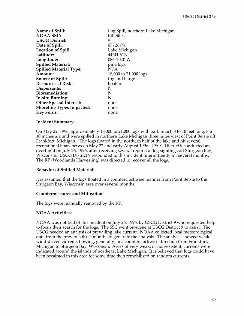
Name of Spill: Log Spill, northern Lake MichiganNOAA SSC: Bill SitesUSCG District: 9Date of Spill: 07/26/96Location of Spill: Lake MichiganLatitude: 44°41.5’ NLongitude: 086°20.0’ WSpilled Material: pine logsSpilled Material Type: N/AAmount: 18,000 to 21,000 logsSource of Spill: tug and bargeResources at Risk: boatersDispersants: NBioremediation: NIn-situ Burning: NOther Special Interest: noneShoreline Types Impacted: noneKeywords: none
Incident Summary:
On May 22, 1996, approximately 18,000 to 21,000 logs with bark intact, 8 to 10 feet long, 8 to10 inches around were spilled in northern Lake Michigan three miles west of Point Betsie offFrankfort, Michigan. The logs floated in the northern half of the lake and hit severalrecreational boats between May 22 and early August 1996. USCG District 9 conducted anoverflight on July 26, 1996, after receiving several reports of log sightings off Sturgeon Bay,Wisconsin. USCG District 9 responded to this incident intermittently for several months.The RP (Woodlands Harvesting) was directed to recover all the logs.
Behavior of Spilled Material:
It is assumed that the logs floated in a counterclockwise manner from Point Betsie to theSturgeon Bay, Wisconsin area over several months.
Countermeasures and Mitigation:
The logs were manually removed by the RP.
NOAA Activities:
NOAA was notified of this incident on July 26, 1996, by USCG District 9 who requested helpto focus their search for the logs. The SSC went on-scene at USCG District 9 to assist. TheUSCG needed an analysis of prevailing lake current. NOAA collected local meteorologicaldata from the previous three months to generate the analysis. The analysis showed weakwind-driven currents flowing, generally, in a counterclockwise direction from Frankfort,Michigan to Sturgeon Bay, Wisconsin. Areas of very weak, or non-existent, currents wereindicated around the islands of northeast Lake Michigan. It is believed that logs could havebeen becalmed in this area for some time then remobilized on random currents.
25

USCG District 2/9
26
USCG District 2/9
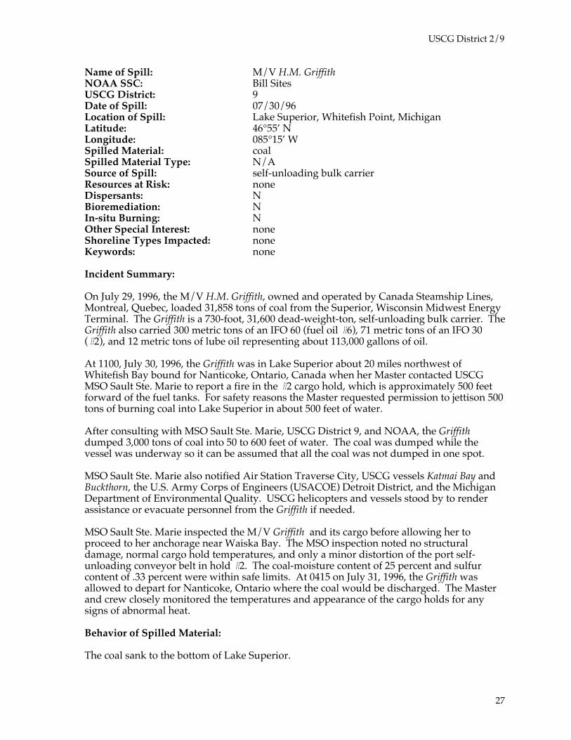
Name of Spill: M/V H.M. GriffithNOAA SSC: Bill SitesUSCG District: 9Date of Spill: 07/30/96Location of Spill: Lake Superior, Whitefish Point, MichiganLatitude: 46°55’ NLongitude: 085°15’ WSpilled Material: coalSpilled Material Type: N/ASource of Spill: self-unloading bulk carrierResources at Risk: noneDispersants: NBioremediation: NIn-situ Burning: NOther Special Interest: noneShoreline Types Impacted: noneKeywords: none
Incident Summary:
On July 29, 1996, the M/V H.M. Griffith, owned and operated by Canada Steamship Lines,Montreal, Quebec, loaded 31,858 tons of coal from the Superior, Wisconsin Midwest EnergyTerminal. The Griffith is a 730-foot, 31,600 dead-weight-ton, self-unloading bulk carrier. TheGriffith also carried 300 metric tons of an IFO 60 (fuel oil #6), 71 metric tons of an IFO 30(#2), and 12 metric tons of lube oil representing about 113,000 gallons of oil.
At 1100, July 30, 1996, the Griffith was in Lake Superior about 20 miles northwest ofWhitefish Bay bound for Nanticoke, Ontario, Canada when her Master contacted USCGMSO Sault Ste. Marie to report a fire in the #2 cargo hold, which is approximately 500 feetforward of the fuel tanks. For safety reasons the Master requested permission to jettison 500tons of burning coal into Lake Superior in about 500 feet of water.
After consulting with MSO Sault Ste. Marie, USCG District 9, and NOAA, the Griffithdumped 3,000 tons of coal into 50 to 600 feet of water. The coal was dumped while thevessel was underway so it can be assumed that all the coal was not dumped in one spot.
MSO Sault Ste. Marie also notified Air Station Traverse City, USCG vessels Katmai Bay andBuckthorn, the U.S. Army Corps of Engineers (USACOE) Detroit District, and the MichiganDepartment of Environmental Quality. USCG helicopters and vessels stood by to renderassistance or evacuate personnel from the Griffith if needed.
MSO Sault Ste. Marie inspected the M/V Griffith and its cargo before allowing her toproceed to her anchorage near Waiska Bay. The MSO inspection noted no structuraldamage, normal cargo hold temperatures, and only a minor distortion of the port self-unloading conveyor belt in hold #2. The coal-moisture content of 25 percent and sulfurcontent of .33 percent were within safe limits. At 0415 on July 31, 1996, the Griffith wasallowed to depart for Nanticoke, Ontario where the coal would be discharged. The Masterand crew closely monitored the temperatures and appearance of the cargo holds for anysigns of abnormal heat.
Behavior of Spilled Material:
The coal sank to the bottom of Lake Superior.
27
USCG District 2/9
NOAA Activities:
NOAA was notified of this incident on July 30, 1996, by USCG District 9. To come to adecision on the Griffith’s request, the SSC was asked:
❐ How will the coal behave?
❐ Where will it go?
❐ What impacts could it have on the environment?
The three main areas of concern when dumping coal into the aquatic environment are:
(1) The toxic effects from the metals and PAH compounds from the coal into the watercolumn.
(2) The toxic effect associated with the coal particulates in the water column, usuallyassociated with coal powder.
(3) The impacts to benthic communities where the coal was deposited on the lakebottom.
NOAA reported that there were no significant biological resources near the spill;consequently, environmental impacts from this incident should be minimal.
NOAA advised that a majority of the coal would sink while the coal dust would float. Coalis not considered particularly harmful to the environment, especially in 500 feet of waterand a good distance away from shore and water intakes. Any effects of the sinking coal orfloating coal dust on the natural resources in the area were expected to be short-lived andvery localized.
The SSC provided telephone and fax support to MSO Sault Ste. Marie on July 30 and in-person support to USCG District 9, Marine Safety Division (MSD) from July 30 to August 9.The support included weather forecasts, expected coal behavior, and resources at riskinformation.
References:
U.S. EPA. 1979. Implications to the aquatic environment of polynuclear aromatic hydrocarbonsliberated from northern Great Plains coal. EPA-600/3-79-093. Duluth, MN: U.S. EPAEnvironmental Research Laboratory.
U.S. EPA. 1980. Static coal storage -- biological and chemical effects on the environment. EPA-600/3-80/083A. Duluth, MN: U.S. EPA Environmental Research Laboratory.
U.S. Fish and Wildlife Service. 1978. Impacts of coal-fired power plants on fish, wildlife, and theirhabitats. FWS/OBS-78/29. Ann Arbor, Michigan: U.S. Fish and Wildlife Service.
Research Planning Inc. Unpublished paper. Potential impacts of 3,000 tons of coal dumped inLake Superior. Columbia, South Carolina: Hazardous Materials Respons and AssessmentDivision, NOAA.
28

USCG District 2/9
29
USCG District 2/9
Name of Spill: British Petroleum Crude AsphaltNOAA SSC: Bill SitesUSCG District: 9Date of Spill: 08/05/96Location of Spill: Toledo, Ohio, Maumee River, Grassy IslandLatitude: 41°42’ NLongitude: 83° 27’ WSpilled Material: crude asphaltSpilled Material Type: 4Amount: 60 barrelsSource of Spill: refineryResources at Risk: noneDispersants: NBioremediation: NIn-situ Burning: NOther Special Interest: This was an airborne oil spill.Shoreline Types Impacted: mixed sand and gravelKeywords: low-pressure flushing, sorbent boom
Incident Summary:
On Monday, August 5, 1996, the British Petroleum (BP) Toledo Refinery vented about 60barrels of atomized crude asphalt into the air via a low-pressure steam vent. The oil rainedon a portion of Toledo, Ohio. The incident received some media play from CNN, theWindsor, Ontario news, and the local Toledo news. BP hired MPC to perform the cleanup.They washed boats and cars that had been oiled. The oil that fell in the Maumee River(estimated 30 to 50 barrels) floated to Grassy Island on a southeasterly wind.Approximately 1,500 feet of Grassy Island shoreline was oiled. MPC spent approximatelytwo weeks conducting cleanup operations using low-pressure, high-volume, Lake Eriewater flushing, together with hard and sorbent booms. A vacuum barge was used to cleanup miscellaneous sheen. The FOSC was MSO Toledo, the SOSC was Ohio EnvironmentalProtection Agency (OHEPA), and the RP was BP.
Grassy Island is an island of Maumee River dredge spoils, apparently managed by the U.S.Army Corps of Engineers, but owned either by the city of Toledo or the city of Oregon.
Behavior of Spilled Material:
The oil that fell into the Maumee River formed a slick and floated to the eastern shore ofGrassy Island. Approximately 1,500 feet of shoreline were impacted by oil that stainedrocks and driftwood. The remaining oil floated off with the low-pressure flushing techniqueand was recovered in sorbent booms and the vacuum barge.
Countermeasures and Mitigation:
The main issue arising from this spill was “how clean is clean?” The FOSC, RP, and SOSCdisagreed. The NOAA SSC was called in to present a neutral, third party, unbiased opinion.
To resolve the disagreement, a team inspected the island on August 8, 1996. The teamincluded MSO Toledo Chief of Port Operations, NOAA SSC, several representatives eachfrom BP, OHEPA, and MPC. The RP, FOSC, SOSC, and NOAA met at BP Toledo after theinspection and came to a consensus on the criteria for cessation of the cleanup.
The group considered several factors including:
30
USCG District 2/9
❐ Can the oil remobilize?
❐ Is there any threat of significant sheening or toxicity?
❐ Is there a potential for bird oiling?
❐ Are there any nesting, endangered, or threatened birds in the area?
❐ Are there any endangered or threatened species in the area?
❐ Are there any human health concerns?
❐ Are there any regulatory permits regarding the dredge spoils and their level ofcleanliness, aesthetic value, recreational use, nature of the oiling, effectiveness of thecleanup method, or tradeoffs of other cleanup techniques?
All agreed that the cleanup method employed by MPC was effective and the best choice ofthe options. All agreed that the small bit of sheening in the area that had already beencleaned and signed off by MSO Toledo was insignificant. This area showed no oil availablefor remobilization, no ongoing exposure to natural resources, no residual oil on rocks andstray driftwood available to the environment, and no aesthetic or recreational use concerns.
MPC continued with their cleanup effort using the cleaned section (about 600 feet of thetotal 1,500 feet) as a benchmark for “how clean is clean.”
Removal and disposal of debris were handled by MPC.
NOAA Activities:
NOAA was notified of this incident on August 8, 1996, by MSO Toledo. The SSC went on-scene to assist in the resolution of the “how clean is clean” issue. NOAA supported thisincident for one day.
References:
NOAA and American Petroleum Institute. 1994. Options for minimizing environmentalimpacts of freshwater spill response. Seattle: Hazardous Materials Response and AssessmentDivision, NOAA. 131 pp.
31

U.S. Coast Guard District 5
Koch Sulfur Products.....................................................................................................33
Abandoned Bunker Barges...........................................................................................35
Craney Island Fuel Farm...............................................................................................37
T/B 106 ............................................................................................................................39
T/B 409 and Tug M. Jenne Dudley ................................................................................41
F/V Captain Zack ............................................................................................................43
F/V Shauna Louise ..........................................................................................................45
T/B 563 and Tug Charleston.......................................................................................... 47
Collision Saudi Makkah and USS Jacksonville...............................................................49
T/V Anitra .......................................................................................................................51
F/V Lady Luck .................................................................................................................55

USCG District 5
Name of Spill: Koch Sulfur ProductsNOAA SSC: Gary OttUSCG District: 5Date of Spill: 10/1/95Location of Spill: Wilmington, North CarolinaLatitude: 34°05' NLongitude: 79°55' WSpilled Material: sulfuric acidSpilled Material Type: 5Amount: 109 barrelsSource of Spill: facilityResources at Risk: habitatDispersants: NBioremediation: NIn-situ Burning: NOther Special Interest: noneShoreline Types Impacted: fringing salt marsh, salt marshKeywords: chemical, lime, soda ash, neutralization
Incident Summary:
On October 1, 1995, a tractor trailer backed into an eight-inch transfer line at Koch SulfurProducts, Wilmington, North Carolina and released an estimated 4,594 gallons of 90 percentsulfuric acid
Behavior of Spilled Material:
The sulfuric acid flowed onto the lime rock pavement and into a tidally influenced saltwatermarsh connected to the Cape Fear River.
Countermeasures and Mitigation:
Facility personnel used lime, sand, cement-kiln dust, marl rock, and soda ash to neutralizethe material. A sand dike was placed across a stormwater drain pipe that led to the marsharea.
Other Special Interest Issues:
Because the marsh was tidally influenced, it was naturally flushed each tidal cycle. NOAAparticipated with the USCG MSO Wilmington in discussions of some of the responseoptions. Options discussed were:
❐ partially reduce the flow of water from the marsh area by blocking one of theculverts, and
❐ increase flushing by artificially pumping additional river water into the marsh.
33
USCG District 5
NOAA Activities:
NOAA was notified of this incident on October 1, 1995, by MSO Wilmington andparticipated via telephone and fax over several days while helping to decide the bestmethods to reduce the impact of the sulfuric acid on the marsh environment. NOAAchemists recommended site safety and appropriate testing methods to determine the acidityof the residues. Based on information resulting from NOAA-recommended samplingprocedures, neutralization using lime and the natural pumping of the marsh area by tidalaction was effective in increasing the pH to neutral values in the impacted areas.
References:
NOAA. 1992. The CAMEO 4.0 Manual. Washington, D.C.: National Safety Council. 440 pp.
NOAA. 1992. Shoreline Countermeasures Manual For Regional Response Team III. Seattle:Hazardous Materials Response and Assessment Division. 98 pp.
Virginia Institute of Marine Science. 1980. Sensitivity of Coastal Environments and Wildlife toSpilled Oil, State of North Carolina. Boulder, Colorado: Hazardous Materials ResponseProject, NOAA. 113 maps.
34
USCG District 5
Name of Spill: Abandoned Bunker BargesNOAA SSC: Gary OttUSCG District: 5Date of Spill: 10/6/95Location of Spill: Norfolk, VirginiaLatitude: 36°8' NLongitude: 076°23' WSpilled Material: waste oilSpilled Material Type: 4Amount: 16,400 barrelsSource of Spill: abandoned bargesResources at Risk: habitatDispersants: NBioremediation: NIn-situ Burning: NOther Special Interest: responsibility for abandoned vesselsShoreline Types Impacted: noneKeywords: Abandoned Barge Act
Incident Summary:
Three barges, T/B Bunker Delaware, T/B Bunker 1000, and T/B VTL #1, were moored at twolocations in the southern branch of the Elizabeth River, Norfolk, Virginia. All the bargescontained oily material; T/B Bunker Delaware contained the most oil, 14,000 barrels. Thebarges, owned by the Bunker Group of Virginia, did not have current certificates ofinspections and were not gas-free. The parent company of the Bunker Group is believed tobe Peter Frank; however, Mr. Frank claimed that the Bunker Group was no longer inbusiness, had no employees, and had no funds.
During September 1995, MSO Hampton Roads’ marine inspectors concluded that the T/BBunker Delaware was in poor condition; it was listing five degrees and had holes, soft spots,and broken valves. In addition, none of the barges were under anyone’s control; no onewatched them or maintained any type of security.
Countermeasures and Mitigation:
On September 22, 1995, the USCG declared the barges a “substantial threat of discharge ofoil.” A Letter of Federal Interest and an Administrative Order to clean, gas-free, and removethe barges were sent to the owner. On September 26 the owner replied that he was unableto comply with the Administrative Order, citing lack of funds. On September 27 a letter ofFederal Assumption was sent to the owner. A local contractor boomed the barges, and theUSCG Atlantic Strike Team (AST) and contractor personnel took samples from each bargefor analysis.
On October 6 the USCG’s contractor, International Marine Services (IMS), began removingoily material from the T/B Bunker Delaware. During the next 10 days, waste oil in thebarge’s 12 tanks was removed and the tanks were cleaned. An estimated 600,900 gallons ofwaste oil and oily water were removed. The tanks were declared gas free on October 16,1995.
35

USCG District 5
On October 16, 1995, about 285 gallons of oily material on the T/B Bunker 1000 wasremoved. A cleaning and gas-free certification were completed on October 21. During thenext several days, an estimated 64,000 gallons of oily material were removed from the T/BVTL #1 and the tanks were cleaned and gas freed.
Other Special Interest Issues:
Who is responsible for assessing and removing harmful materials from “abandoned”barges? The USCG On-Scene Coordinator (OSC) has authority to remove oily material fromvessels discharging or threatening to discharge anything that would be harmful to theenvironment. However, if a vessel is on private property it is not necessarily considered“abandoned” especially if it was moored with the permission of the owner of the facility.Similarly, once the oily material has been removed and there is no longer a threat to theenvironment, the ownership of the barge does not change and security of the barge remainsthat of the owner; destruction or sale of the barge by the Government is not an easy option.These issues are not necessarily resolved by the Abandoned Barge Act.
NOAA Activities:
NOAA was notified of this incident on October 1, 1995, by MSO Hampton Roads. Analysisof samples taken from the abandoned barges was a high priority during this response. If itwas discovered that the material onboard was not an oily material that could be categorizedas a “waste oil,” but rather contained high levels of chemicals such as polychlorinatedbiphenyls (PCBs), the safety of site workers and the funding mechanism for the cleanupoperation would have to be reconsidered.
NOAA participated with MSO Hampton Roads in several meetings before removal wasstarted and by telephone during the removal operations. The goals of the samplingprogram and the details of sample results were discussed during these meetings. Forexample, sample analysis on the T/B Bunker Delaware indicated waste oil in all tanks withwaste oil and some traces of benzene in #3 and #4 port tanks only. The level of benzeneconcentration in these tanks was specifically documented as part of the safety program, butthe other appropriate reason for the testing was to determine levels of benzene that wereneeded to categorize the waste for disposal and/or resale purposes.
NOAA supported this response for 10 days.
References:
Abandoned Barge Act of 1992. Public Law 102-587, title V, subtitle C, Secs. 5301-5305, Nov.4, 1992, 106 Stat. 5081 (Title 46, Sec. 4701 et seq.)
NOAA. 1992. Shoreline Countermeasures Manual For Regional Response Team III. Seattle:Hazardous Materials Response and Assessment Division, NOAA. 98 pp.
Virginia Institute of Marine Science. 1980. Sensitivity of Coastal Environments and Wildlife toSpilled Oil, State of Virginia. Boulder, Colorado: Hazardous Materials Response Project,NOAA. 104 maps.
36

USCG District 5
Name of Spill: Craney Island Fuel FarmNOAA SSC: Gary OttUSCG District: 5Date of Spill : 01/17/96Location of Spill: Norfolk, VirginiaLatitude: 36°53.3’ NLongitude: 076°20.8’ WSpilled Material: JP-5 jet fuelSpilled Material Type: 2Amount: 3,000 barrelsSource of Spill: tank facilityResources at Risk: marshDispersants: NBioremediation: NIn-situ Burning: NOther Special Interest: noneShoreline Types Impacted: fringing salt marsh, mudflatKeywords: sorbent boom, sorbents
Incident Summary:
On January 17, 1996, a Navy fuel depot crew started transferring jet fuel, JP-5, from one tankto another to make room for an incoming shipment. During the transfer, valves weremisaligned and the fuel was inadvertently pumped into tank 276, which was already full.For approximately two hours, the JP-5 fuel overflowed tank 276.
It was initially reported that approximately 1,000 gallons of JP-5 had been spilled into theprimary fuel farm containment area. This large containment area is drained by an extensiveculvert and special drainage system. Initial investigation by MSO Hampton Roads showedthat Navy personnel were responding to the incident. No product was observed in thecontainment area's culverts and drainage canals. No product was expected to reachnavigable waters.
Behavior of Spilled Material:
On January 18, 1996, the Navy reported that more than 75,000 gallons of JP-5 had beenspilled. The actual amount was difficult to assess because it was in the extensive drainagesystem, piping, and culverts and was not visible. On January 25, 1996, it was estimated thatmore than 127,000 gallons of JP-5 had been released. All the product was held within thecontainment system. Oil in this drainage system was not visible, did not evaporate, andduring periods of heavy rain occasionally overflowed within the large containment areasoiling vegetation, such as high marsh grasses. None of the oil escaped into navigablewaters.
Countermeasures and Mitigation:
Navy personnel used vacuum trucks to remove over 80,000 gallons of product during therecovery effort. Contaminated soils in the large containment area were scheduled forremoval and treatment at the land farm on the Craney Island facility permitted for treatmentof contaminated soils.
Other Special Interest Issues:
37
USCG District 5
When it rained during the weeks following the spill, some of the oil on the water in thedrainage system overflowed within the containment area oiling tall marsh grasses. Red-winged blackbirds, attracted to this habitat, became oiled when moving through thisvegetation. By January 25, 1996, under the supervision of the U.S. Fish and Wildlife Service(USFWS), nearly 200 dead red-winged blackbirds were collected in this area.
NOAA Activities:
NOAA was notified of this incident on January 25, 1996, by USFWS representatives whorequested help coordinating their inspection of the Craney Island fuel facility with theUSCG and Navy responders. On January 26, the NOAA SSC, MSO Hampton Roads,USFWS representatives, and Navy responders met to schedule an assessment on-scene. Atthis meeting, actions necessary to prevent further impacts on red-winged blackbirds wereagreed upon. Navy public works personnel, using specialized equipment in the soft soils,cut or knocked down oiled grasses and removed the attraction to the blackbirds.
References:
NOAA. 1992. Shoreline Countermeasures Manual For Regional Response Team III. Seattle:Hazardous Materials Response and Assessment Division. 92 pp.
Virginia Institute of Marine Science. 1980. Sensitivity of Coastal Environments and Wildlife toSpilled Oil, State of Virginia. Boulder, Colorado: Hazardous Materials Response Project,NOAA. 104 maps.
38
USCG District 5
Name of Potential: T/B 106NOAA SSC: Gary OttUSCG District: 5Date of Potential Spill: 1/19/96Location of Spill: Fort Eustis, VirginiaLatitude: 37°46.7’ NLongitude: 075°58.5’ WSpilled Material gasolineSpilled Material Type: 2Amount: potential 455 barrelsSource of Spill: tank bargeResources at Risk: habitatDispersants: NBioremediation: NIn-situ Burning: NOther Special Interest: noneShoreline Types Impacted: noneKeywords: none
Incident Summary:
On January 19, 1996, the tug Triumph reported that her tow, T/B 106, had grounded with20,000 gallons of gasoline onboard, near the James River Light #36 near Fort Eustis, Virginia.T/B 106 was subsequently refloated without causing environmental damage or pollution.
NOAA Activities:
NOAA was notified of this incident on January 19, 1996, by MSO Hampton Roads. NOAAprovided weather information and an estimate of expected environmental impact if the tankbarge was damaged and gasoline released. NOAA also participated in discussions ofresponse strategies. This was a period of severe weather in the area, A frontal passage withstrong winds, potentially 40 to 45 knots, with strong wind shifts was predicted. The long-range wind prediction was for winds from the northwest at 25 to 30 knots.
The recovery of gasoline, especially in a wide-river system, is difficult. The danger of therelease of gasoline into one of the most significant areas in the region for the propagation ofshellfish was also noted. NOAA advised that the high rate of evaporation of any potentialspilled gasoline combined with the severe weather suggests that significant quantities ofgasoline would not reach the downriver industrial, populated, and bridge crossings.
References:
NOAA. 1992. Shoreline Countermeasures Manual For Regional Response Team III. Seattle:Hazardous Materials Response and Assessment Division. 98 pp.
NOAA. 1993. ADIOS (Automated Data Inquiry for Oil Spills) User's Manual. Seattle:Hazardous Materials Response and Assessment Division, NOAA. 50 pp.
Virginia Institute of Marine Science. 1980. Sensitivity of Coastal Environments and Wildlife toSpilled Oil, State of Virginia. Boulder, Colorado: Hazardous Materials Response Project,NOAA. 104 maps.
39

USCG District 5
Name of Spill: T/B 409 and Tug M. Jenne DudleyNOAA SSC: Gary OttUSCG District: 5Date of Spill: 1/19/96Location of Spill: Chesapeake Bay, VirginiaLatitude: 37°46.7’ NLongitude: 075°58.5’ WSpilled Material: #6 fuel oilSpilled Material Type: 2Amount: potential 23,000 barrelsSource of Spill: tank bargeResources at Risk: habitatDispersants: NBioremediation: NIn-situ Burning: NOther Special Interest: noneShoreline Types Impacted: noneKeywords: none
Incident Summary:
On January 19, 1996, the tug Jenne Dudley reported that her tow, tank barge PPT 409, hadrun aground three miles south of Tangier Island, near Tangier Island Light, in ChesapeakeBay, with 23,000 barrels of #6 fuel oil onboard. T/B PPT 409 was subsequently refloatedwith no damage or pollution.
NOAA Activities:
NOAA was notified of this incident on January 19, 1996, by MSO Hampton Roads. NOAAprovided weather information and an estimate of the expected environmental impact if the#6 oil was released, and participated in a discussion of response strategies. The weather inthe area was severe with strong winds potentially 40 to 45 knots and strong wind shiftspredicted. The long-range wind prediction was winds from the northwest at 25 to 30 knots.
The release of a persistent oil-like #6 in this environmentally sensitive area of ChesapeakeBay is one of the worst-case scenarios developed for the USCG Training Center and hasbeen used during exercises in the Fifth Coast Guard District. The trajectory of the oil in thisarea has been well studied by NOAA's Modeling and Simulation Studies Branch (MASS).MASS created a hypothetical movie that was used during this response to demonstrate themovement of oil spilled in this area.
This case was complicated by a possible MEDEVAC when a crew member, with a history ofheart problems, experienced arm pain. (He was not removed from the tug andsubsequently reported no problems.)
References:
NOAA. 1992. Shoreline Countermeasures Manual For Regional Response Team III. Seattle:Hazardous Materials Response and Assessment Division. 99 pp.
NOAA. 1993. ADIOS (Automated Data Inquiry for Oil Spills) User's Manual. Seattle:Hazardous Materials Response and Assessment Division, NOAA. 50 pp.
40
USCG District 5
Virginia Institute of Marine Science. 1980. Sensitivity of Coastal Environments and Wildlife toSpilled Oil, State of Virginia. Boulder, Colorado: Hazardous Materials Response Project,NOAA. 104 maps.
Virginia Institute of Marine Science. 1980. Sensitivity of Coastal Environments and Wildlife toSpilled Oil, State of Maryland. Boulder, Colorado: Hazardous Materials Response Project,NOAA. 118 maps.
41

USCG District 5
Name of Spill: F/V Captain ZackNOAA SSC: Gary OttUSCG District: 5Date of Spill: 1/23/96Location of Spill: Hatteras, North CarolinaLatitude: 35°06.1’ NLongitude: 075°37.9’ WSpilled Material dieselSpilled Material Type: 2Amount: 15 barrelsSource of Spill: fishing vesselResources at Risk: habitatDispersants: NBioremediation: NIn-situ Burning: NOther Special Interest: noneShoreline Types Impacted: hard sand beachKeywords: abandoned fishing vessel
Incident Summary:
The 40-foot F/V Captain Zack, was taken in tow during extreme weather January 23, 1996.The vessel took on considerable amounts of water and the USCG would not allow thepartially submerged vessel to enter Hatteras Inlet. The USCG anchored the vessel 8 nauticalmiles southeast of Hatteras Inlet and asked the owner to refloat the vessel before it would beallowed into the inlet. The on-scene weather was northeast winds 15 to 20 knots with three-to four-foot seas.
Behavior of Spilled Material:
The owner of the Captain Zack reported 650 gallons of diesel fuel onboard and that two ofthe three fuel tanks had been sealed. The unsealed fourth tank was nearly empty.
Countermeasures and Mitigation:
Salvors and the owner were unable to reach the vessel on January 24 due to bad weather.On January 25 the salvors were still unable to proceed to the vessel’s last reported locationand a USCG overflight could not see the vessel.
NOAA Activities:
NOAA was notified of this incident on January 23, 1996, by both MSO Hampton Roads andMSO Wilmington. Each MSO requested a trajectory for the abandoned fishing vessel andthe environmental impact of the potential 650 gallons of diesel fuel. NOAA weatheranalysis predicted a continuation of winds gusting to 20 knots from the south, and 4- to 5-foot seas. The forecast was for winds gusting to 25 knots from the southwest with buildingseas.
NOAA advised that the currents in the area normally run parallel to the shore and to thesouthwest. NOAA suggested that the vessel, if it was no longer anchored, could moveashore the evening of January 24 with the strong southerly and southwesterly winds.NOAA advised that the potential 650 gallons of diesel fuel would not impact the shoreunless the vessel grounded and broke up almost on the beach.
42
USCG District 5
References:
NOAA. 1992. Shoreline Countermeasures Manual For Regional Response Team III. Seattle:Hazardous Materials Response and Assessment Division. 99 pp.
NOAA. 1993. ADIOS (Automated Data Inquiry for Oil Spills) User's Manual. Seattle:Hazardous Materials Response and Assessment Division, NOAA. 50 pp.
Virginia Institute of Marine Science. 1980. Sensitivity of Coastal Environments and Wildlife toSpilled Oil, State of North Carolina. Boulder, Colorado: Hazardous Materials ResponseProject, NOAA. 113 maps.
43
USCG District 5
Name of Spill: F/V Shauna LouiseNOAA SSC: Gary OttUSCG District: 5Date of Spill: 1/19/96Location of Spill: Hatteras Inlet, North CarolinaLatitude: 35°011.5’ NLongitude: 075°46.0’ WSpilled Material Product: dieselSpilled Material Type: 2Amount: 2 barrelsSource of Spill: sinking fishing vesselResources at Risk: habitatDispersants: NBioremediation: NIn-situ Burning: NOther Special Interest: noneShoreline Types Impacted: noneKeywords: none
Incident Summary:
The 67-foot F/V Shauna Louise was abandoned the morning of January 19, 1996, duringextreme storm conditions. At 0830 the vessel was 35°07’ N and 075°48’ W and drifting atthree knots along the shoreline towards 230° true. The winds were 40 knots from the southwith 8- to 10-foot seas.
The vessel foundered in the afternoon of January 19 approximately 300 yards offshore offOkracoke Island and west of Hatteras Inlet. Debris was seen along the shoreline and in thesurf zone.
Behavior of Spilled Material:
The vessel carried 5,000 gallons of diesel fuel in two tanks. Very light rainbow sheen wasobserved approximately 100 yards off shore and one and one-half mile from one of the fueltanks that broke loose from the wreckage of the vessel. No fuel oil moved through theheavy surf or landed on the hard-sand beach along Okracoke Island.
Countermeasures and Mitigation:
One of the intact fuel tanks washed up on Okracoke Island and was removed by IMS. Nofuel was found in the recovered tank. The other fuel tank was not found.
NOAA Activities:
NOAA was notified of this incident on January 19, 1996, by MSO Hampton Roads and MSOWilmington. Each MSO requested a trajectory for the abandoned fishing vessel and theenvironmental impact of the potential 5,000 gallons of diesel fuel. NOAA’s weather analysispredicted a frontal passage with very strong winds, 40 to 45 knots, with heavy rain.Following the frontal passage, the winds were expected to be southwesterly between 25 and30 knots during the afternoon and early evening. By late evening the winds were expectedto be from the northwest at 25 to 30 knots and were expected to continue into the next day.
NOAA advised that the currents in the area normally run parallel to the shore and to thesouthwest. This current direction was the initial path of the abandoned vessel. NOAA
44
USCG District 5
suggested, however, if the vessel had windage that it could move ashore the afternoon ofJanuary 19 with the anticipated southerly and southwesterly winds. NOAA also advisedthat the potential 5,000 gallons of diesel fuel would not impact the shore unless the vesselgrounded within one-quarter mile of the beach.
References:
NOAA. 1992. Shoreline Countermeasures Manual For Regional Response Team III. Seattle:Hazardous Materials Response and Assessment Division. 99 pp.
NOAA. 1993. ADIOS (Automated Data Inquiry for Oil Spills) User's Manual. Seattle:Hazardous Materials Response and Assessment Division, NOAA. 50 pp.
Virginia Institute of Marine Science. 1980. Sensitivity of Coastal Environments and Wildlife toSpilled Oil, State of North Carolina. Boulder, Colorado: Hazardous Materials ResponseProject, NOAA. 113 maps.
45

USCG District 5
Name of Potential: T/B 563 and tug CharlestonNOAA SSC: Gary OttUSCG District: 5Date of Potential Spill: 2/1/96Location of Spill: Chesapeake Bay, MarylandLatitude: 37°46.7’ NLongitude: 075°58.5’ WSpilled Material: #6Spilled Material Type: 2Amount: potential 15,000 barrelsSource of Spill: tank bargeResources at Risk: habitatDispersants: NBioremediation: NIn-situ Burning: NOther Special Interest: noneShoreline Types Impacted: fringing salt marsh, tidal mudflatKeywords: potential
Incident Summary:
On February 1, 1996, the tug Charleston reported that her tow, the T/B 563, had groundedwith 15,000 barrels of diesel fuel onboard five nautical miles east of Tangier Island, in theChesapeake Bay. T/B 563 was subsequently refloated with no damage or pollution.
NOAA Activities:
NOAA was notified of this incident on February 1, 1996, by MSO Baltimore who asked forweather information, suggestions for response strategies, and an estimate of trajectory if thediesel fuel was released. NOAA advised that the winds were expected to be light andvariable with seas less than one foot. Later that evening, snow was in the forecast withvisibility reduced to less than one mile. On February 2 winds were forecast to be from thenortheast at 10 knots or less, increasing from the northeast at 10 to 15 knots in the afternoon.Snow, sleet, and rain with visibility less than one mile was also expected. The trajectory ofthe potential spilled oil during the time when the winds were light and variable was basedon the tidal excursion. Any product released during the initial several hours of the ebb tidewould move south, possibly as far as several miles. There was some risk to Watts Island. Ifthe oil was released later, during a flood tide, the oil could move initially as far north asCedar Island Marsh. The predicted northeasterly winds, however, would help hold some ofthe oil away from the marsh. NOAA also discussed the fate and effect of diesel oilweathering over time with MSO Baltimore.
References:
NOAA. 1992. Shoreline Countermeasures Manual For Regional Response Team III. Seattle:Hazardous Materials Response and Assessment Division. 99 pp.
NOAA. 1993. ADIOS (Automated Data Inquiry for Oil Spills) User's Manual. Seattle:Hazardous Materials Response and Assessment Division, NOAA. 50 pp.
Virginia Institute of Marine Science. 1980. Sensitivity of Coastal Environments and Wildlife toSpilled Oil, State of Virginia. Boulder, Colorado: Hazardous Materials Response Project,NOAA. 104 maps.
46

USCG District 5
Virginia Institute of Marine Science. 1980. Sensitivity of Coastal Environments and Wildlife toSpilled Oil, State of Maryland. Boulder, Colorado: Hazardous Materials Response Project,NOAA. 118 maps.
47

USCG District 5
Name of Spill: Collision Saudi Makkah and USS JacksonvilleNOAA SSC: Gary OttUSCG District: 5Date of Potential Spill: 5/17/96Location of Spill: Norfolk, VirginiaLatitude: 36°30’ NLongitude: 075°35’ WSpilled Material: #6 fuel oilSpilled Material Type: 2Amount: noneSource of Spill: container vesselResources at Risk: habitatDispersants: NBioremediation: NIn-situ Burning: NOther Special Interest: noneShoreline Types Impacted: fringing salt marsh, tidal mudflatKeywords: none
Incident Summary:
On May 17, 1996, MSO Hampton Roads responded to a collision between the Saudi Arabianflag roll on/roll off container ship, Saudi Makkah, and the U.S. Navy (USN) submarine, USSJacksonville. The collision occurred approximately 20 miles southeast of Cape Henry,Virginia; both vessels sustained damage. The Saudi Makkah was damaged on the port side; adent in the bow and a 21-foot crease that was open to the sea in the aft steering. The USSJacksonville sustained damage to the starboard diving plane and the rudder. After beinginspected by USCG and USN personnel, both vessels proceeded to the port of HamptonRoads under their own power. The Saudi Makkah was moored at Norfolk InternationalTerminals and the USS Jacksonville at Pier 23 on the Norfolk Navy Base.
NOAA Activities:
NOAA was contacted by MSO Hampton Roads on May 17, 1996, and was asked to provideweather and a trajectory forecast if oil was released as a result of this collision. NOAAprovided a 24-hour forecast that indicated winds from the east at 5 to 10 knots during theday and winds from the southeast at 10 knots at night. The winds were expected tocontinue from the southeast at 10 knots the next day.
NOAA reported that the oil that might be spilled would move to the south along theVirginia shoreline. The onshore winds (east/southeast) would slowly move any oil towardsthe shoreline with an impact anticipated in North Carolina. On May 19, however, theoffshore wind forecast would tend to hold the oil off shore. There would be very little oilthreat to Chesapeake Bay from any release of oil at the collision site.
References:
NOAA. 1992. Shoreline Countermeasures Manual For Regional Response Team III. Seattle:Hazardous Materials Response and Assessment Division. 98 pp.
NOAA. 1993. ADIOS (Automated Data Inquiry for Oil Spills) User's Manual. Seattle:Hazardous Materials Response and Assessment Division, NOAA. 50 pp.
48

USCG District 5
Virginia Institute of Marine Science. 1980. Sensitivity of Coastal Environments and Wildlife toSpilled Oil, State of Virginia. Boulder, Colorado: Hazardous Materials Response Project,NOAA. 104 maps.
49
USCG District 5
Name of Spill: T/V AnitraNOAA SSC: Ed LevineUSCG District: 5Date of Spill: 05/09/96Location of Spill: Big Stone Anchorage, Delaware BayLatitude: 35°57.6’ NLongitude: 75°11.4’ WSpilled Material: Nemba and Kabinda (Angolan) crude oilsSpilled Material Type: 2Amount: 42,000 gallonsSource of Spill: tank vesselResources at Risk: Birds: diving coastal birds, waterfowl, shorebirds,
wading birds, gulls, terns, raptors, rookeries, foragingareas, migration stopover areas, nesting beaches,migratory routes, critical forage areasFish: anadromous fish, nursery areas, estuarine fish,demersal fishMollusks: oysters, clams, seed beds, abundant beds,harvest areas, high-concentration sitesCrustaceans: horseshoe crab high-concentration sitesRecreation: beaches, marinas, boat ramps, high-userecreational boating and fishing areas, state parksManagement Areas: wildlife preserves, reservesResource Extraction: commercial fisheries, bivalveaquaculture sites
Dispersants: NBioremediation: NIn-situ Burning: NOther Special Interest: tilling oil into sandShoreline Types Impacted: exposed fine-sand beaches, fine-sand beaches, marshes,
salt marsh, saltwater marshes, sand/ gravel beaches,sheltered marshes
Keywords: endangered species, shallow water recovery,skimmers, tourism losses, Tri-State Bird Rescue
Incident Summary:
On May 9, 1996, the 846-foot T/V Anitra, carrying 41.9 million gallons of crude oil,reported approximately 200 gallons of oil bubbling from below her waterline. The vesselwas anchored at Big Stone Anchorage in Delaware Bay. The on-scene weather was lightwinds, air temperature 49°F, with overcast skies and calm seas.
The DBRC’s two skimmers, Del River and Del Bay, and the National Response Corporation(NRC) skimmer Patriot response vessels, dispatched to the scene, boomed off the vessel andbegan skimming operations. Initially, it was believed that the oil was leaking from the seachest, indicating the possibility that cargo was leaking into the ballast water piping.Observers on an overflight the next morning reported a steady stream of product extendingfrom the vessel’s stern to sea in a south-southeast direction for 3.5 miles, followed by a 3.8-mile sheen. After the first day, the estimate of oil spilled was raised to approxi–mately10,000 gallons; after 10 days the estimate was 42,000 gallons. Diver surveys were conductedto identify the source of the leak. Approximately 600 barrels of an oil/water mixture wererecovered by skimmers.
50
USCG District 5
Shoreline impact inside Delaware Bay occurred on the New Jersey side (approximately twomiles of Higby and Sunset beaches in Cape May) by the third day after release. The oceanbeaches of New Jersey were impacted several days later, from Cape May to Atlantic City.
The USCG COTP Philadelphia and New Jersey DEP formed a Unified Command with theRP.
Media coverage was high (the Governor was present at press conferences) due to proximityto the Memorial Day weekend. Avoiding beach closures was a major goal of the response.The other concern for the response was protecting the endangered piping plover andthreatened least tern that nest on the beaches.
Major efforts were made to remove the oiled sand and sediment as rapidly as possible. Atone point over 400 workers were employed. Cleanup consisted of manual raking and, inseveral instances, tilling. Workers used shop-vacs at a number of locations to vacuum upthe tarballs from the sand.
Behavior of Spilled Material:
Both Nemba and Kabinda crude oils are light products having a 38.5 and 32.9 API,respectively. The oil initially spread into thin films as observed during the May 10overflights. Over time, a combination of wind and waves weathered and tore the films intosmaller patches (tarballs from pea- to marble-sized) that scattered over a much wider area.An increase in sea state tended to overwash the tarballs and break up any associated sheens.A lack of visible sheen associated with the tarball field is not an indication that the oil sank.Using both visual and remote sensing techniques, the resulting tarball field was difficult totrack because the tarballs were widely dispersed.
NOAA developed a trajectory analysis that indicated a necessarily large uncertainty due tothe delay and limited nature of the information provided. This analysis indicated that theSeven Mile Beach area was threatened. The trajectory analysis uncertainty indicated forMay 14, 1996, increased due to the changes in the weather since the last trajectory.Therefore, the tarballs were likely to be dispersed over a much wider area. Althoughclimatological currents indicated a southerly flow outside Delaware Bay, shelf-wavestransiting the area are not uncommon and would lead to local, non-climatological currents.The uncertainty lines in the original analysis showed some impact potentially to the northbut this anomalous northerly current pattern may not persist. Because observationalinformation was limited, the potential threat zone included areas south of Cape Henlopenand north of Cape May. Forecast on-shore winds might continue to bring tarballs ashorethrough May 11. Any remaining oil would continue to move with the along-shore current.Offshore winds forecast on May 12 could move any unbeached tarballs slightly offshore.
Trajectory analysis is difficult at best. This is particularly true for oil that has spread outenough to become widely scattered tarballs. If, in addition, when the input orreconnaissance data is intermittent, uncertainty bounds become very large.
Initial areas impacted were within Delaware Bay on the New Jersey shoreline. These areaswere coarse-sand and gravel beaches, areas of spring bird migration stopover, andhorseshoe crab spawning areas. After several days, the oil migrated out of Delaware Bayand impacted sand beaches and marsh areas on the coast of New Jersey.
Estimates on the amount of oil spilled started at about 200 gallons and soon rose to 1,000gallons. After about ten days of tarballs stranding on the New Jersey beaches the estimatewas raised to 40,000 gallons. During the first few days of the incident, when the oil was still
51
USCG District 5
floating, skimmers recovered approximately 10,000 gallons of oil. An undetermined amountof oil in the form of tarballs was removed from the shorelines.
As this oil weathered it formed tarballs that became less buoyant as they incorporatedsediment. The remaining spilled oil dissipated offshore as a scattered tarball field.
Countermeasures and Mitigation:
Once the oil was reported, the DBRC dispatched response vessels to boom the tanker andskim floating oil. The tanker performed inspections, diver surveys, and tests to determinethe source of the leak. The sea valve was identified as the cause. Once this was remedied, theship completed lightering, took on bunkers, and was allowed to depart the anchorage. TheNRC Patriot followed Anitra to collect any oil released that may have clung to her.
Unsuccessful attempts were made to boom several inlets on the New Jersey coast. Marshesand marinas inside the inlets had small amounts of oil migrate through them.
Open-water recovery was performed by large skimming vessels inside Delaware Bay and byLori skimmers in shallow water just off the New Jersey beaches.
Shoreline cleanup was mostly manual with rakes and shovels. In some areas shop-vacs wereused to vacuum oil from the sand beaches. Tilling was employed on several sections ofupper beaches.
Removed oily sand was disposed of in an asphalt plant.
Other Special Interest Issues:
The effects of this spill to tourism and recreation areas were of high concern due to theproximity to the Memorial Day weekend. The New Jersey beach towns that were impactedare financially dependent on beach tourism for the majority of their income. Beaches werenever closed during this incident.
Wildlife impacts and rehabilitation were the other key issues faced by the UnifiedCommand. Delaware Bay is a major migratory stop-off point for the spring migration(millions of birds arrive at the end of May) and the endangered piping plover andthreatened least tern nest on New Jersey beaches. Tri-State Bird Rescue cleaned about 20oiled piping plovers. There were no reports of dead wildlife.
Effects to human health and safety were an issue for the workers due to heat stress. Somedays the temperature was over 90 degrees. Work crews were monitored for heat stress.
A test plow/tilling of a high tarball concentration area along the high-tide line in OceanCity, New Jersey was conducted. NOAA informed the Unified Command that this was atemporary solution, in that once the tide began to rise to the levels where the oil was laiddown they may observe frothy oil/water and/or more tarballs. The tilling was done toremove the oil from the surface so birds and people would not come in contact with it andto attempt to increase natural degradation. Nevertheless, the oil would probably remain forweeks to months, unless physically removed.
Media interest throughout the incident was very high. The Governor of New Jersey and theCommissioner of DEP held numerous press conferences with the COTP. The incident wascovered by the television, radio, and newspapers.
52
USCG District 5
NOAA Activities:
NOAA was notified of this incident on May 13, 1996, by COTP Philadelphia.
The COTP sent samples of oil from the vessel and tarballs for analysis to determineweathering and toxicity. The two reference oils received on May 21, 1996, were very similarin composition. The Kabinda and the Nemba were both high-alkane (waxy) crude oils witha low abundance of aromatic hydrocarbons (AH). The high wax content made the oilsreadily susceptible to biodegradation. The tarball sample exhibited a significant reductionin the toxic AH components due to a combination of evaporation (weathering) and water-in-oil emulsification.
NOAA delivered weather forecasts and provided the USCG with some warning of currentreversals and possible areas of impacts. Trajectory analysis performed four days after theinitial release indicated that oil had moved out of Delaware Bay and could possibly impactCape May, New Jersey and Cape Henlopen, Delaware.
The SSC provided a Tarball Information Sheet for use by the general public and media andparticipated in incident debriefs where the pros and cons of response options werediscussed.
The SSC supported this incident sporadically as needed by the USCG by telephone and fax.The response lasted 50 days.
References:
Captain of the Port Philadelphia Area Contingency Plan
53
USCG District 5
Name of Spill: F/V Lady LuckNOAA SSC: Ed LevineUSCG District: 5Date of Spill: 08/11/96Location of Spill: Cape May, New JerseyLatitude: 38°48.4’ NLongitude: 73°19.0’ WSpilled Material: diesel fuelSpilled Material Type: 2Amount: 180 barrels (8,000 gallons)Source of Spill: fishing vesselResources at Risk: Marine Mammals: whales, dolphins, migration routes
Fish: summer flounder wintering siteMollusks: scallops, harvest areas, high concentrationsitesRecreation: high-use recreational fishing areasResource Extraction: commercial fisheries
Dispersants: NBioremediation: NIn-situ Burning: NOther Special Interest: noneShoreline Types Impacted: noneKeywords: evaporation, NOAA National Marine Fisheries Service
Laboratory
Incident Summary:
At approximately 0900 on August 11, 1996, the 71-foot commercial F/V Lady Luck sank in230 feet of water about 70 miles east of Cape May, New Jersey. The weather at the time wascalm winds, temperature 80°F, visibility at 12 miles.
The seven people onboard were rescued before the vessel sank. The boat had about 7,500gallons of diesel fuel onboard when it went down. Initially a 2-mile long by 200-foot wideslick was observed from the point of sinking. At 1745 an overflight from USCG Group CapeMay indicated the sheen had reduced to 0.5 long by 0.25 nautical mile wide, drifting in asoutherly direction.
Behavior of Spilled Material:
The oil moved south from the release site and evaporated before impacting land. Due to thedistance from shore and short-term persistence of the product, no response efforts weremounted.
NOAA Activities:
NOAA was notified of this incident on August 11, 1996, by the USCG Group Cape May whorequested a trajectory analysis to see if land impacts could be predicted. The SSC contactedthe NMFS Laboratory at Sandy Hook, New Jersey to address any possible fisheries concernsbecause the area is known for dredging scallops, long-line tile fishing, and bottom fluke(summer flounder). The NMFS recommended that the USCG post the position of the wreckin the next “Notice To Mariners” so fishing vessels will not ruin gear on the sunken vessel.
The accident site was approximately 70 miles offshore and no detectable landfall from theoil was expected. The fuel tank was not extensively damaged during the sinking and the
54
USCG District 5
surface pollution was the result of leaking through vents or small compression cracks in thetank. NOAA reported that a surface sheen might form and result in a continuous slickextending from a fraction of a mile to several miles depending on the weather. Thislocalized surface sheen could persist for a number of days.
Diesel spills usually form large areas of silver or rainbow sheen, with smaller streaks of darkor “sooty” bands where concentrations are heavy. The edges of the slick typically featherinto streaks or streamers and dissipate over a few days or even hours for small spills whenmoderate to strong winds occur.
Typical currents for the area of the accident are a fraction of a knot, to the south-southwest,but high variability is a characteristic of this region, which is along the inner edge of theGulf Steam where spin-off eddies are common.
The area was under the influence of a large high-pressure region that covered most of theNortheast. Winds at the accident site were light. The high-pressure region was expected tomove east during the next two days followed by a frontal passage with associated afternoonsqualls.
NOAA supported this incident for about one hour.
References:
USCG MSO Philadelphia, Polrep One, Minor Spill, Spill Amount Unknown, PotentialAmount Approx. 7500 Gal. Diesel Fuel, Spill Resulting From F/V Lady Luck Sinking.PIN:05P-04-241-96, NRC Case No. 356200. 11 August, 1996.
55
U.S. Coast Guard District 7
Mystery Spill - Tampa Bay............................................................................................57
Barge Patricia Sheridan ...................................................................................................59
Savannah Toluene Diisocyanate Incident...................................................................63
T/B TM1-11 .....................................................................................................................65
USCG District 7
Name of Spill: Mystery Spill - Tampa BayNOAA SSC: Bradford L. BenggioUSCG District: 7Date of Spill: 10/03/95Location of Spill: Upper Tampa Bay, FloridaLatitude: 27°55.5’ NLongitude: 082°25.7’ WSpilled Material: #6 fuel oilSpilled Material Type: 4Source of Spill: unknownResources at Risk: Habitat: intertidal sessile organisms
Mollusks: bivalvesBirds: brown pelican
Dispersants: NBioremediation: NIn-Situ Burning: NOther Special Interest(s): noneShoreline Type(s) Impacted: seawallsKeywords: none
Incident Summary:
A spill of heavy #6 fuel oil was reported on September 28, 1995. The oil coatedapproximately 1.7 miles of shoreline in upper Tampa Bay. The majority of impacts were toman-made structures and seawalls. The source of the oil was never determined.
Behavior of Spilled Material:
The oil was reported as being heavy, dark #6 fuel oil that was somewhat weathered. Itcoated 1.7 miles of shoreline in a band that averaged a meter and was 1/4-inch thick.
Countermeasures and Mitigation:
Local contractors conducted cleanup of the impacted area.
NOAA Activities:
The NOAA was notified of this incident on October 3, 1995, by MSO Tampa who requesteda hindcast to assess where this oil might have originated. Weather and tides were evaluatedto determine where the oil was spilled. NOAA trajectory analysts could not pinpoint asource but did determine that the source was most probably near the impact area, possibly apassing vessel that discharged the product.
References:
NOAA. 1994. Shio. Tide computer program (prototype). Seattle: Hazardous MaterialsResponse and Assessment Division, NOAA.
57

USCG District 7
58
USCG District 7
Name of Spill: Barge Patricia SheridanNOAA SSC: Bradford L. BenggioUSCG District: 7Date of Spill: 10/12/95Location of Spill: Charleston Harbor, South CarolinaLatitude: 32°34.3’ NLongitude: 079°48.3’ WSpilled Material: dredge spoils and 300 gallons of dieselSpilled Material Type: 5, 2Source of Spill: bargeResources at Risk: Fish: territorial fin fishes
Crustaceans: crabsHabitat: benthic infauna
Dispersants: NBioremediation: NIn-Situ Burning: NOther Special Interest(s): noneShoreline Type(s) Impacted: noneKeywords: NAVSUPSALV
Incident Summary:
MSO Charleston was notified on October 12, 1995, that the hopper barge Patricia Sheridanhad intentionally grounded due to an extreme list, supposedly developed by a shift in thecargo. The barge was transiting from New York to Corpus Christi with a load of dredgespoils. The barge was also carrying approximately 300 gallons of diesel fuel. Upongrounding, the barge came to rest on a sand bottom in 36 feet of water. The barge wasresting on its port side with a 45-degree list. The barge has three holds. During thegrounding two hatch covers came off the #2 hold, releasing some of the dredge spoils. Thetotal cargo was approximately 12,000 tons of mud with 30 percent in the #1 hold, 30 percentin the #3 hold, and 40 percent in the #2 hold. This initial release, estimated to be 40 percentof the #2 hold and continued exchange of seawater into all compartments, created a visibleplume of mud at the grounding site.
This dredge spoil from New York Harbor had been tested and found to have as high as 140parts per trillion (ppt) of dioxin. Average dioxin concentration for the mud was reported tobe around 25 ppt. Due to this dioxin concentration, the cargo had been classified as notsuitable for ocean dumping. Based on estimates of amount spilled and dioxin concentration,the total amount of dioxin input to the environment was well below the EPAComprehensive Environmental Response, Compensation, and Liability Act (CERCLA)reportable quantity of one pound. State of South Carolina and federal resource trustees felt,however that this amount of dioxin, a listed hazardous substance, did pose a threat tonatural resources and water quality standards.
Salvors hired by the RP developed a plan to refloat the barge by pumping out water fromthe barge’s holds. This salvage plan was reviewed by NAVSUPSALV. Due to rough seas atthe grounding site, work around the barge, including assessment of damage, wasimpossible or very limited. Divers were able to conduct a limited survey on October 20 andnoted possible damage to the forward rake end of the barge. The salvage plan called forpumping off the water very rapidly to reduce stress on support members of the barge. Oncethe salvage operations began, the pumping could not be stopped without risking workersafety and breakup of the barge.
59
USCG District 7
Resource trustees and representatives from the State of South Carolina, USFWS, Departmentof the Interior, Department of Commerce, EPA, NOAA, USCG, and the RP worked togetherto address concerns associated with pumping water and possibly more contaminated mudinto the ocean. Early in the incident a sample of water was taken from the plume near thebarge and analyzed for dioxin. This sample was filtered prior to the analysis, however, anddid not indicate dioxin levels associated with the suspended particulates. The RP developeda monitoring/sampling plan that allowed for an estimation of how much dioxin and otherpotential contaminates of concern would enter the environment during the salvageoperations. Once the salvage operations were complete, another sampling plan wasdeveloped to assess the dioxin levels in bottom sediments and water at the groundinglocation.
Following salvage and refloating operations, and bottom sample results, resource trusteesrequested that removal of the spilt dredge spoil be conducted and that core and biologicalsamples be taken to determine the effectiveness of the removal. The primary concern wasfor the dioxin congener 2, 3, 7, 8-TCDD. Dredging of the grounding-impacted area tookplace from January 22, 1996, to February 29, 1996. Removed spoils were transported byrailcar for landfill disposal, but the railcars leaked so the material was transferred to linedtrucks.
Additional sediment cores and biological samples were then collected and analyzed.Elevated levels of dioxin existed near the grounding site, but all other samples indicatedlow-risk dioxin levels. Approximately six months later another round of samples was taken.After examining the analyses for both the sediment and biological samples, the trustees feltthat the existing levels were relatively clean and the cleanup had been accomplished to thelevel that could be pragmatically expected. The sample results provided the trustees with ameasure of the effectiveness of the removal action and the response was considered finishedby April 1996.
Behavior of Spilled Material:
The spilled dredge spoil that contained high levels of dioxin appeared largely confined tothe area immediately surrounding the grounding site. Some of the material was carrieddowncurrent in a plume, but apparently dissipated over time or was undetectable to abovebackground levels. Sample analyses indicated that dredging had apparently successfullyreturned the majority of the impact zone to background levels.
Countermeasures and Mitigation:
Dredging the entire impact zone removed the spoils to levels close to background. This wasconfirmed by sediment and biota sampling and analyses.
60
USCG District 7
Other Special Interest Issues:
Throughout this cleanup, the question remained of whether this response was justifiedunder emergency removal actions or whether it should have been an action under otherthan CERCLA guidelines (non-critical removal) or non-CERCLA action (permit violationunder the Clean Water Act).
NOAA Activities:
NOAA was notified of this incident on October 13, 1995, by MSO Charleston, who askedthe SSC to participate in several initial conference calls and discussions with resourcetrustees, the USCG and the RP. The SSC and support team members discussed dioxinconcerns with NOAA and other federal and state resource trustees.
NOAA provided estimates of the spoil plume trajectory and extent of bottom impacts. Thiswas compared with side scan and sampling data provided by the RP to identify the area tobe dredged and subsequently sampled.
Several RP sampling proposals were reviewed by the SSC and support team at the requestof the OSC. These reviews were coordinated with resource trustees involved with theincident.
The SSC helped plan for salvage by calculating dioxin dilution coefficients for pumping offthe barge, once refloated. Weather forecasts were provided as requested during theoperation.
References:
NOAA Hotline # 184, 7 Reports
Research Planning Institute. Sensitivity of coastal environments and wildlife to spilled oil: Stateof South Carolina. An atlas illustrating the sensitivity of the coastal environment to spilled oil.Seattle: Ocean Assessments Division, NOAA. 50 maps.
61

USCG District 7
62
USCG District 7
Name of Spill: Savannah Toluene Diisocyanate IncidentNOAA SSC: Bradford L. BenggioUSCG District: 7Date of Spill: 10/25/95Location of Spill: Chatham County, GeorgiaLatitude: N/ALongitude: N/ASpilled Material: toluene diisocyanateSpilled Material Type: 5Source of Spill: railcar containerResources at Risk: N/ADispersants: NBioremediation: NIn-Situ Burning: NOther Special Interest(s): cautionShoreline Type(s) Impacted: noneKeywords: none
Incident Summary:
On October 25, 1995, a container on a railcar released a small amount of toluenediisocyanate (UN#2078). The car was loaded with seventy-six 55-gallon drums of thechemical. The incident was reported to MSO Savannah.
Countermeasures and Mitigation:
Local hazardous material teams responded in level A protection without incident.
Other Special Interest Issues:
This incident points out an important caution. Although each MSO is equipped withComputer-Aided Management of Emergency Operations (CAMEO™ software) and otherresponse tools, these tools could be dangerous if misused by non-experts. For example,CAMEO does not warn responders that 10 percent of the population is hypersensitive tothis chemical and serious injury or even death could result from an exposure to it. It isadvised that when dealing with chemical response issues and concerns that a chemistexperienced with emergency response be consulted and any output or information providedby models or reference materials be reviewed and evaluated by a competent expert.
NOAA Activities:
NOAA was notified of this incident on October 25, 1995, by MSO Savannah who requestedinformation about toluene diisocyanate. The SSC told MSO that toluene diisocyanate has afairly low vapor pressure (1 millimeter @ 176°F), the IDLH is 2.5 ppm, and an associationwith fire could produce gas. NOAA stressed the need for appropriate respiratory protectionbecause this material has a very pungent odor and could cause serious inhalation concernsfor about 10 percent of the population who are extremely allergic to very small quantities ifinhaled. Most people will not be seriously affected. A similar incident with this chemicalresulted in the death of a responder who was not properly protected.
References:
NOAA. 1993. The CAMEO™ 4.0 Manual. Washington, D.C.: National Safety Council.440 pp.
63

USCG District 7
64
USCG District 7
Name of Spill: T/B TMI-11NOAA SSC: Bradford L. BenggioUSCG District: 7Date of Spill: 03/11/96Location of Spill: Flagler Beach, FloridaLatitude: 29°34.54’ NLongitude: 080°34.34’ WSpilled Material: caustic soda solutionSpilled Material Type: 5Amount: 1.9 million gallonsSource of Spill: tank bargeResources at Risk: Habitat: Oculina Banks hard bottom and small corals
Mollusks: bivalvesReptiles: sea turtles (endangered)Marine Mammals: Wright whales (endangered)
Dispersants: NBioremediation: NIn-Situ Burning: NOther Special Interest(s): noneShoreline Type(s) Impacted: noneKeywords: endangered species
Incident Summary:
The T/B TMI-11 sank during a storm 33 miles east of Flagler Beach, Florida at 1830 March11, 1996. The barge was loaded with 1.9 million gallons of 50 percent dilute caustic sodasolution. The barge came to rest in 100 feet of water on a sand bottom.
The RRT IV was convened to discuss options for responding to the incident and thepossibility of allowing a controlled release of the cargo. The Department of Commerce RRTrepresentative suggested that a controlled discharge limiting the pH to an upper limit of 10,100 feet downstream from the discharge point would be acceptable. This suggestion wasbased on what was known about potential resources at risk in the area, the bufferingcapacity of the surrounding sea water, and the expected behavior of the heavier-than-watercaustic soda solution. The NOAA SSC and the SSC support team, including experts in thefields of chemistry, biology, resources at risk, and trajectory analysis, reviewed this proposaland felt that it was a reasonable and realistic option. The endangered species office ofNMFS was also consulted about any endangered or threatened species in the offshorewaters that could be a concern. They concurred with the proposed discharge, but stipulatedthat adequate monitoring must be provided during the discharge to provide real-timeinformation that could be used to adjust pump rates and maintain the pH criteria agreedupon.
The salvage vessel returned on-site on April 8 to begin discharge operations with a USCGobserver onboard. The equipment proved to be inadequate for the proposed pumpingoperation, however, and the vessel returned to port.
Diver surveys were conducted on April 11 and confirmed leakage from the barge, but pHvalues around the barge were normal.
65
USCG District 7
The OSC requested the SSC and RP go to the scene to evaluate operations. The SSCreported on-scene April 20 and accompanied the RP aboard a vessel to the sinking siteoffshore where a salvage vessel was already setting moorings over the TMI-11. Surveydives made on the barge confirmed that extensive structural damage had occurred and thatthe barge was not worth salvaging. Samples were collected from the barge yielding pHprofiles for the tanks as well as for the surrounding waters. One interesting discovery wasthat a large amount of precipitate was being formed in the tanks where pH was extremelyhigh. Tests were run on the precipitate and it was determined that it would go back intosolution when diluted with sea water. The RP conducted a video survey of the bottomaround the barge and reported that only hard-packed sand bottom existed near the barge.This video was later made available to resource trustees to review. The salvage vesselreturned to port and the RP began to develop discharge plans. The SSC continued toevaluate proposals submitted by the RP and coordinate trustee concerns and input.
The RP requested bids for a bigger salvage vessel and began planning for larger pumps thatcould move the caustic and the formed solid out of the tanks to a mid-water depth of 50 feet.Models were run and evaluated and discharge criterion was changed to allow pH of ten, 100meters from the discharge in the water column, but not to exceed ten on the bottom beyond100 feet.
The new equipment was on-scene July 19 and discharge operations began the next day witha USCG Strike Team observer to monitor the operations and assist as necessary. Pumpingwas completed on July 24. Monitoring results were forwarded to the RRT IV representativefor review. The pH did not exceed the discharge criteria and all tanks were left with a pH inthe eight to nine range. The barge was then holed and opened to allow natural flushing tofinish the job. No resource damage was reported during the discharge operations.
Behavior of Spilled Material:
The caustic, which is heavier than water, was fairly stratified inside the barge tanks. It wasfeared that if discharged it might sink and lie on the bottom, killing all benthic infauna. Thisis why the plan was developed to discharge at a mid-water depth and at a controlled rate.This allowed the currents to spread the plume and buffer the solution before causing injuryto bottom resources.
Countermeasures and Mitigation:
The material was discharged in a controlled manner that allowed buffering by thesurrounding seawater. The method used was to pump the material straight up to a mid-water depth (50 feet) and monitor pH at the discharge point and down current in the watercolumn and along the bottom.
NOAA Activities:
NOAA was notified of this incident on March 11, 1996, by the OSC, but did not go on-sceneuntil April 20. The SSC provided on-scene support from April 20 through April 26, 1996.The SSC went on-site to look at the initial salvage operations, help evaluate the situation,and make recommendations to the OSC. The SSC and the SSC support team evaluated allRP proposals at the request of the OSC. The SSC handled coordination of NOAA trusteeinterests, evaluated potential resources at risk, supplied weather forecasts for salvageoperations, and evaluated chemical and physical behavior of the caustic material.
References:
66
USCG District 7
NOAA Hotline #194, 12 Reports
67

USCG District 7
68
U.S. Coast Guard District 8
Barge Apex 3512 .............................................................................................................69
West Cameron Block 198...............................................................................................73
Barge Buffalo 292 .............................................................................................................75
Barge Buffalo 286 .............................................................................................................79
Southern States Asphalt ................................................................................................83
Samedon Oil....................................................................................................................85
Occidental Chemical......................................................................................................87

USCG District 8
Name of Spill: Barge Apex 3512NOAA SSC: Ilene ByronUSCG District: 8Date of Spill: 10/11/95Location of Spill: Norco, LouisianaLatitude: 90°25’ NLongitude: 29°59.5’ WSpilled Material: heavy fuel oilSpilled Material Type: 5Amount: 4,600 barrelsSource of Spill: bargeResources at Risk: noneDispersants: NBioremediation: NIn-situ Burning: NOther Special Interest: innovative cleanup techniquesShoreline Types Impacted: river bottomKeywords: sorbents
Incident Summary:
On October 11, 1995, the tow of the M/V Sondra B collided with the tow of the M/V TheresaF near Mississippi River Mile Marker (MM) 126. Sondra B was pushing five tank bargescontaining .5 API oil; Theresa F was pushing one empty ocean-going, bulk-solid barge. Afterthe collision, the Theresa F pushed up on the right descending bank and the Sondra Bpushed up on the left descending bank at MM 125 to evaluate damage. Extensive damagewas sustained by the empty bulk-solid barge and one of the tank barges, Apex 3512. Apex3512 discharged approximately 4,600 barrels of slurry oil from the forward tank. At the timeof the collision the weather was clear and the current in the channel was approximately twoknots.
During preliminary surveys on October 11 and 12, large pockets of oil were found where thebarge was pushed against the bank. The currents in this area are slight and the bottomtopography levels out after a 45-degree, 35-foot slope from the bank. Sheening was seenover the area. The area was marked with buoys by representatives of the RP and the State ofLouisiana.
Behavior of Oil:
This product was a heavy fuel oil and immediately sank to the bottom of the MississippiRiver. Some of he product was found in about 70 feet of water and sheens were seen overpockets of the oil. These sheens were used to locate the oil during recovery operations.Near the accident where currents are stronger, or downriver in deep troughs, no oil waslocated. Between 1,900 and 2,400 barrels of oil were recovered
Countermeasures and Mitigation:
Surveying operations using various operational techniques and different oil movementtheories were attempted throughout the response. On October 14 a hydrographic surveyusing Digital Geographic Positioning System (DGPS) was done in the area of MM 126. Theresults of the survey showed there were no big troughs where oil could accumulate aroundthe barges that were pushed against the bank. Over 700 drops using sorbent pads at the endof a chain, and over 100 drops using a ponar bucket were used to locate the submerged oil.Pumps dropped to filter air through the sediment in an attempt to create sheening did not
69
USCG District 8
locate oil. A chain drag to bring sheen to the surface was also attempted with no success Inaddition to the oil found where the barges eventually came to a stop, one small patch of oilwas found in the middle of the channel.
Three large pockets of oil were found with sorbent pad drops where the barges wherepushed against the banks. Divers, with the use of a submersible hydraulic pump, were ableto recover 500 to 1,500 barrels of product. From each spot, the divers did a 200-foot radiussearch to locate additional pockets. There was no visibility on the bottom of the Mississippiand when felt by the divers, the product was not unlike the muddy bottom of the river.When the divers lost the patch of oil they were vacuuming as communicated by the surfacethey would switch operations to "roughing up" the bottom to create a sheen. Sheeningwould indicate a new patch of oil to recover. It is difficult to estimate the movement of theoil on the bottom of the river, but oil was found next to the barge a week after the accidentindicating little movement. Efficient dive operations began on October 13 and continued toOctober 19. The divers used a submersible Marflex hydraulic pump to recover the productto a hopper barge adjacent to their working barge.
On the morning of October 20, the USCG, Louisiana DEQ, and RP met to discuss futureplans. They agreed that sampling to locate oil was complete but the RP must still determinethe exact amount spilled and recovered.
The state, RP, and USCG also discussed protocols to be used if there is a similar accident onthe Mississippi.
Other Special Interest Issues:
This was first time oil has been recovered from the bottom of the Mississippi River.Difficulties encountered were no visibility, depth, and currents. Innovative divingoperations led to successful recovery of the product. Recovery operations at their mostefficient level had 92 percent pure product being recovered off the bottom.
NOAA Activities:
NOAA was notified of the incident on October 11, 1995, by the USCG MSO New Orleanswho requested on-scene support. NOAA provided the FOSC with on-scene scientificsupport from October 11 through October 20, 1996.
The SSC helped develop surveying and sampling methods for locating the sunken oil.
70
USCG District 8
References:
OSC Report of Major Pollution Incident from Tank Barge Apex 3512, at Mile 126, LowerMississippi River, on 11 October 1995, 06 May 1996
71

USCG District 8
72
USCG District 8
Name of Spill: West Cameron Block 198NOAA SSC: Ilene ByronUSCG District: 8Date of Spill: 12/15/95Location of Spill: Cameron, LouisianaLatitude: 29°20’ NLongitude: 93°20’ WSpilled Material: crude oilSpilled Material Type: 2Amount: 740 barrelsSource of Spill: platformDispersants: YBioremediation: NIn-situ Burning: NOther Special Interest: dispersant use pre-approvalShoreline Types Impacted: noneKeywords: Corexit 9527
Incident Summary:
On December 15, 1995, crude oil leaked from an offshore production platform located inWest Cameron Block 198 approximately 35 miles south of Cameron, Louisiana. The spillwas caused by a valve malfunction.
By noon December 16, the RP, state, and USCG officials decided to use dispersants. Thatafternoon, the dispersant application was completed in about an hour using two aircraftcontracted by the RP.
Behavior of Oil:
Early attempts to fly over and assess the spill were hampered by bad weather and poorvisibility, but an early-morning overflight by a USCG Falcon airplane from Corpus Christi,Texas on December 16 discovered at least 4,200 gallons of the crude oil contained in a slick35 miles offshore. The slick was approximately two miles across and five miles long.
Countermeasures and Mitigation:
By noon December 16, Chevron, state and USCG officials decided to use dispersants toexpedite response and minimize environmental impact. Pre-approved by federal and stateofficials in January 1995, use of dispersants on offshore oil spills near Louisiana and Texas ispermitted in Gulf of Mexico waters deeper than 10 meters and more than three milesoffshore.
This is the first time aerial dispersants have been used in the Gulf of Mexico under the newdispersant policy. Its use has allowed officials to potentially minimize the effects of anoffshore spill within a matter of hours, whereas traditional response efforts have taken daysto deploy equipment and months to fully mitigate spill effects on the environment.
The dispersant application started at approximately 1530 on Saturday, December 16 and wascompleted by 1630 using two contract aircraft under Chevron's control. One aircraft applied thedispersant as directed by the other "spotter" airplane, which guided the application aircraft to theheaviest concentrations of oil.
73
USCG District 8
One sortie with seven passes over the slick was accomplished using 500 gallons ofdispersant. Reports from the RP indicated dispersant operations were effective. A USCGFalcon jet flew over the area several hours after the dispersant had been spread and noted adifference from the morning’s overflight in the appearance of the slick. The slick appearedto be broken up and divided in two orange patches. Due to poor weather, there were nooverflights on December 17. A December 18 overflight found no remaining oil.
NOAA Activities:
NOAA was notified of this incident on December 15, 1995, by MSO Port Arthur whorequested a trajectory, weather information, and the possible fate and effects of the spilledoil. The MSO also asked for advice on the request of the RP to use dispersants. OnDecember 16 the SSC was contacted by the USCG MSD who requested that the SSC come tothe command center in New Orleans to supply scientific support for RRT and commandbriefings.
NOAA supported this response for four days.
References:
NOAA Hotline #185, 2 Reports
NOAA. 1993. ADIOS™ (Automated Data Inquiry for Oil Spills) User's Manual. Seattle:Hazardous Materials Response and Assessment Division, NOAA. 50 pp.
RRT VI Dispersant Pre-Approval Plan
74

USCG District 8
Name of Spill: Buffalo 292NOAA SSC: Ilene ByronUSCG District: 8Date of Spill: 3/18/96Location of Spill: Galveston, TexasLatitude: 29°22’ NLongitude: 94°48’ WSpilled Material: IFO 380Spilled Material Type: 4Amount: 5,000 barrelsSource of Spill: bargeResources at Risk: Marine Mammals: bottlenose dolphins
Birds: waterfowl, diving birds, wading birds,shorebirds, gulls, and ternsFish: Gulf menhaden, spotted seatrout, black drum,red drum, striped mullet, and southern flounderMollusks: oystersCrustaceans: shrimp, stone and blue crabsRecreation: state park, marinas, boat ramps
Dispersants: NBioremediation: NIn-situ Burning: NOther Special Interest: economic impacts, closing of the Houston Ship
Channel, PORTS, TABSShoreline Types Impacted: marshes, exposed tidal flats, mixed sand and shell
beaches, rip rap, piers, and spoil bankKeywords: containment boom, Corexit 9500, Corexit 9527,
skimmers, IR, sorbent boom, sorbent pompoms,vacuum trucks
Incident Summary:
The barge Buffalo 292 suffered a major structural failure in the early afternoon of March 18,1996, and discharged approximately 5,000 barrels of IFO 380 approximately one mile northof Pelican Island. Weather on-scene was windy with gusts to 60 knots. Evening northwestwinds blew a majority of the product into the Gulf of Mexico.
Behavior of Oil:
IFO 380 is an intermediate fuel oil exhibiting properties similar to a #6. It has a highviscosity and pour point, and tests showed it was not dispersible with either Corexit 9527 orCorexit 9500. The oil remained buoyant and an offshore tarball field was visually trackedfor three weeks as it traveled off Galveston Bay in Houston (Galveston's area of operation)and impacted at Matagorda Island (Corpus Christi’s area of operation).
75
USCG District 8
Countermeasures and Mitigation:
This spill was in two parts: the inland spill, which affected the Galveston area; and theoffshore oil, which led to scattered tarball impact on Corpus Christi beaches. A unifiedcommand center was established in Galveston and an estimated 500 federal, state, and localgovernment employees and contract workers responded. Spill priorities are in the AreaCommittee Plan and, with input from the state resource managers on-scene, protectivebooming was put in place the evening of the incident in the Galveston area and lightering ofthe vessel was completed within 30 hours of the incident. About 34,800 feet of hard boomand 12 skimmers were deployed. As the oil was tracked down the coast, protectivebooming was put into place. Sparse and sporadic tarballs were manually recovered fromMatagorda and Mustang islands. Very light impact occurred on Padre Island. Anadditional command post was established in Corpus Christi on March 31.
Four offshore skimming vessels were able to recover floating product four days after thespill, 60 miles from land. The oil was located for the skimming vessels in various ways.Evening overflights by the USCG Falcon jet equipped with AirEye dropped flares near theoil for the skimmers to locate. Hand-held infrared (IR) camera operators were put in thecrows’ nests of the skimming vessels and were able to keep them working overnight. Whena low encounter rate of oil made skimming operations offshore inefficient 10 days after thespill, 12 fishing vessels were deployed for manual tar patty pickup on the water. In the firstevening, 35 ten-gallon bags were filled by the vessels’ crews both manually and using netsand hooks. These fishing vessels followed the tarball patch until it impacted Corpus Christi-area beaches. The vessels were guided by a helicopter.
There were 25 oiled birds observed in the Galveston area; 10 were recovered. They includedducks, laughing gulls, Virginia rail, and a loon.
Other Special Interest Issues:
The city of Galveston was concerned about economic impacts because this spill occurredduring college spring break, a high tourist season.
The Houston Ship Channel was closed briefly but was reopened with a safety zone in effect.This spill was rich in information used for understanding the movement of the oil. Theincident occurred within a mile of a NOAA Physical Oceanographic Real-Time System.(PORTS) station and the higher than predicted tides were easily seen by the real-timeterminal located at MSO Galveston. The Texas Automated Buoy System (TABS) was able togive NOAA modelers the currents within the first hour of the spill. The currents had beenup-coast during the first half of the spill (an unusual condition by historical standards) andthe modelers’ anticipated switch back to a down-coast flow was observed by the TABSwithin two hours of its occurrence. Additional data were received by three MineralsManagement Service (MMS) drifting satellite buoys deployed by NOAA. Remote sensingfrom the USCG AirEye was able to locate the oil evenings when visual observations werenot possible due to heavy weather.
76
USCG District 8
NOAA Activities:
NOAA was notified of the incident on March 18, 1996, by the USCG MSO Houston, whorequested on-scene support. NOAA provided the FOSC with on-scene scientific supportfrom March 18 through April 6, 1996. This support was provided by a scientific teammanaged by the SSC.
The SSC team was an intregal part of the planning section of the USCG’s Unified CommandSystem. The SSC also had a direct link to the FOSC and immediately brought anysignificant matters directly to his attention.
The SSC closely worked with all the state and federal trustees to facilitate the consensus ofcleanup methods and "how clean is clean."
NOAA's major activities were:
❐ developing trajectories;
❐ accompanying other spill responders on overflights;
❐ predicting weather;
❐ analyzing the dispersability of spilled product;
❐ participating in developing shoreline assessments and cleanup guidelines that led to"how clean is clean" guidelines and sign-off procedures. and
❐ managing information and data related to these issues.
References:
Hall, Christopher J. 1996, Information Management Report for the Buffalo 292 Spill. May 6,1996. Seattle: Genwest Systems for Hazardous Materials Response and Assessment Division,NOAA.
NOAA Hotline #193, 2 Reports
77

USCG District 8
78

USCG District 8
Name of Spill: Buffalo 286NOAA SSC: Ilene ByronUSCG District: 8Date of Spill: 5/26/96Location of Spill: La Porte, TexasLatitude: 29°34.4’ NLongitude: 94°55.5’ WSpilled Material: IFO 380Spilled Material Type: 4Amount: 1,000 barrelsSource of Spill: bargeResources at Risk: Marine Mammals: bottlenose dolphins
Birds: waterfowl, diving birds, wading birds,shorebirds, gulls, and ternsFish: Gulf menhaden, spotted seatrout, black drum,red drum, striped mullet, and southern flounderMollusks: oystersCrustaceans: shrimp, stone and blue crabsRecreation: State Park, marinas, boat ramps
Dispersants: NBioremediation: NIn-situ Burning: NOther Special Interest: similar accident, same class barge, same company
occurred in MarchShoreline Types Impacted: marshes, exposed tidal flats mixed sand and shell
beaches, rip rap, piers, spoil bankKeywords: containment boom, skimmers, Corexit 9580, sorbent
boom, sorbent pompoms, vacuum trucks
Incident Summary:
The single-hulled barge Buffalo 286 suffered a major structural failure on May 26, 1996, anddischarged approximately 1,000 barrels of IFO 380 from damaged tanks into Galveston Bay,Texas. The #3 port and starboard wing tanks were damaged with 5,000 barrels of productdivided equally between them. The barge carried 16,000 barrels of product. Weatheronscene was southeast winds at 15 knots.
Protective booming was in place at the Houston Yacht Club, Little Cedar Bayou, parts ofAtkinson Island, and sensitive areas along the shoreline between Morgans Point and EaglePoint in accordance with the Area Committee Plan.
The USCG directed the towing vessel to transit into the Bayport Ship Channel and positionon the north bank to minimize the extent of oil impact. On May 27 the barge was against thenorth side of the channel.
Behavior of Oil:
IFO 380 is a heavy intermediate fuel oil exhibiting properties similar to a # 6. It has a highviscosity and pour point. The oil remained buoyant but in some places along AtkinsonIsland and Morgans Point it caught in the surf zone and mixed with sand. This sand-oilmixture continued to wash ashore for a week.
79
USCG District 8
Within hours of the spill, the barge was in a protected area and boomed, thus minimizingthe oil released outside the Bayport Ship Channel. Floating oil was collected by 16skimmers.
The oil on the gravel beaches penetrated the beach up to two inches and formed an incipientpavement. Waves created by boat traffic broke this oil up into tarballs. The ShorelineCleanup Assessment Team (SCAT) recommended immediate removal of these tarballs.There was evidence of oil penetration along the fine-grained sand pocket beaches and theteam recommended that this oil be removed as well. There was an initial problem ofremoving too much clean sediment during cleanup operations but this situation wasrectified by the team. The site supervisors were instructed to have workers remove as littleclean material as possible and to stress scraping, rather than digging.
Countermeasures and Mitigation:
The COTP reopened the Houston Ship Channel after an overflight. The Bayport ShipChannel remained closed for two days and a safety zone was established between MorgansPoint and an area north of the entrance to Clear Lake.
Oil impacted north-end shorelines of the Bayport Ship Channel, Boggy Bayou, Wilson StreetBayou, Morgans Point, and shorelines south of Morgans Point, Hog Island, and AtkinsonIsland. Cleanup was done manually.
The Texas General Land Office (TGLO) Bird Rehabilitation trailer was staged at SylvanBeach. There were five oiled birds treated at this site. No additional wildlife impacts werereported
The SCAT, with representatives of NOAA, USCG, TGLO, and the RP surveyed BoggyBayou in the Bayport Ship Channel, western sides of Hog and Atkinson islands, the FiveMile Cut shoreline, and the dredge spoil shoreline near Bulkhead Reef. The team foundfree-floating oil in Boggy Bayou and the lower portions of some of the vegetation werecoated with oil. The oil penetrated about one foot into the vegetation. Rainbow sheen onthe water pooled on the exposed mud flats in the bayou.
The team recommended herding the free-floating oil to a collection point at a culvert at thenorth end of the bayou. Workers were instructed to stay off the vegetation to preventtrampling and mixing the oil into the sediment.
Another SCAT Team led by the RP included personnel from TGLO, Texas Natural ResourceConservation Commission (TNRCC), and the USCG surveyed Wilson Cut/Sandy Point.There was free-floating oil in the creek. The shoreline consisted of vegetated banks,erosional clay banks, bulkheads, and riprap. All of these shoreline habitats were oiled.
The shorelines of Bayridge Park and Bay Shore Park are complex and composed of man-made coastal structures and intervening pocket beaches of mixed sand and gravel (shell).Portions of the coastal structures were coated and stained with oil (10-20% cover). Tarballs,tar patties, and incipient pavements were observed on the pocket beaches. The heavily oiledvegetation was cut and removed.
Cleaning operations of the Buffalo 286 were completed on May 29. The barge was cleared bythe FOSC for transit to Newpark Shipyard. The Clean Channel II trailed the barge en route.Clean Channel I and II began decontamination May 29. Clean Channel II remained off MorgansPoint to recover any floating oil missed by earlier skimming.
80
USCG District 8
Corexit 9580 was used to decontaminate two barges, two assist tugs, and two USCG boats atthe Baytank Facility. The vessels were in the water and the area was double boomed. TheCorexit was applied with a brush in a 50/50 water and Corexit mixture by workers in johnboats. The mixture effectively removed the oil from the sides of the vessels. Afterapplication an oil-water-Corexit mixture was seen floating in the water and recovered withsorbents.
Other Special Interest Issues:
In March, a similar accident occurred. The barge Buffalo 292 suffered a major structuralfailure and discharged about 5,000 barrels of IFO 380 in this general area. The oil impactedMatagorda Island in the Gulf of Mexico.
NOAA Activities:
NOAA was notified of this incident on May 26, 1996, by the USCG MSO Houston whorequested on-scene support.
NOAA personnel pre-assessed initial areas of oiling for shoreline types in preparation forbeach impact. Samples of spilled oil and samples of reference oil from the barge weresecured for analysis.
NOAA participated in overflights of the area. Sheens in Wilson Creek/Sandy Point (thefirst cut south of Morgans Point) and widely scattered silver sheens with a few tarballs wereobserved. Trapped, wind-driven black oil was observed along the north side of the BayportShip Channel, with silver and rainbow sheens on the west end of the channel. Recoverablefloating oil was observed west of Atkinson Island and a skimming vessel was dispatched tocollect the oil.
The SSC assisted in reviewing a plan to apply Corexit 9580 to clean oiled vessels.
The SSC left the scene the afternoon of June 2, but reviewed all maintenance and cleanupplans. NOAA provided the FOSC with on-scene scientific support from May 26 throughJune 2, 1996.
References:
NOAA Hotline #193, 126 Reports
81

USCG District 8
82
USCG District 8
Name of Spill: Southern States AsphaltNOAA SSC: Bill SitesUSCG District: 8Date of Spill: 07/25/96Location of Spill: Paducah, KentuckyLatitude: 37°01.2’ NLongitude: 088°08.4’ WSpilled Material: asphaltSpilled Material Type: 4Amount: 20 to 25 barrelsSource of Spill: bargeResources at Risk: Fish: threadfin shad, shiners, darters, carp, buffalo,
catfish (blue and channel), bluegill, longear, redear,warmouth, black crappie, white crappie, largemouthbass, spotted bass, sauger bass, white bass, carp, andcatfishShellfish: mapleleaf and threeridge musselsRecreation: high-use recreation area, boating and fishing,recreational harvesting of mussels
Dispersants: NBioremediation: NIn-situ Burning: NOther Special Interest: unusual recovery techniqueShoreline Types Impacted: none
Incident Summary:
On May 5, 1996, about 25 barrels of heated asphalt meant for Ashland Oil Company’sstorage tanks were spilled into Lake Barkley in the Cumberland River. The spill was causedby a burst transfer hose.
The barges typically tie up to "mooring cells" in the river when they perform transferoperations. The mooring cells are large, round concrete structures 10 to 12 feet in diameter,anchored on the river bottom. They are designed for barges to tie up to and are common inmany rivers in the South. Ashland Oil Southern States Asphalt claimed responsibility forthe spill and began cleanup operations. The case was closed.
On July 21, 1996, the Executive Officer (XO) of MSO Paducah was fishing in Lake Barkleywhen he noticed tarballs and some oil sheens. The XO noted that some of the tarballs hadshort asphalt streamers attached to them. MSO Paducah decided to re-investigate theincident.
On July 22, 1996, a dive team surveyed the area of the spill around the mooring cells andfound new product and old product. The new product was 3 to 18 inches thick; the oldproduct was crumbly and covered with approximately six inches of sediment.
The new product could be cut and rolled up like taffy, removed from the water, and placedin polypropylene sacks. The old product could not be cut because it crumbled whenhandled. During the week of July 22-26, tarballs with short streamers were seen, but nosheens were observed. MSO Paducah opened the Oil Spill Liability Trust Fund for theresponse.
Samples of the product were taken for laboratory analysis; no pollutant levels of concernwere present.
83
USCG District 8
MSO Paducah with representatives of the Kentucky EPA (the state natural resource trustee),the U.S. Army Corps of Engineers, Ashland Oil, and others met on July 26 to discuss theissues and develop a plan. They agreed to conduct a thorough investigation of the spilllocation using the dive team. The “how clean is clean” criteria were agreed upon. It wasalso decided that as much of the new taffy-like product as possible would be recovered andthe older crumbly product would be left alone. On July 29 a dive team made a systematicsurvey of the spill area. Cleanup operations continued through August 2.
Behavior of Spilled Material:
The asphalt sank to the bottom of the lake. Most of the new product was recovered by the diveteam.
Countermeasures and Mitigation:
The dive team manually removed as much of the new asphalt as possible. The sunken asphalt wasrecovered by an underwater dive team. The team rolled up the asphalt-like taffy, carried it toshore, and bagged it for disposal.
NOAA Activities:
NOAA was notified of this incident on July 25, 1996, by MSO Paducah who requestedguidelines for “how clean is clean.” The SSC told MSO that the product should remain onthe bottom of the lake with occasional releases of oil/tar that will float to the surface and theprimary impacts will be to bottom-feeding organisms at the spill site. This was a lakebottom spill so there was very little risk to the lake shorelines. Scattered tarballs may drift toshore, but impacts should be mostly aesthetic.
NOAA supported this response by telephone and fax from July 25 to August 5.
References:
USCG MSO Paducah POLREP's 231315Z JUL 96, 242030Z JUL 96, and 262045Z JUL 96.
84

USCG District 8
Name of Spill: Samedon OilNOAA SSC: Ilene ByronUSCG District: 8Date of Spill: 8/9/96Location of Spill: Sabine River, TexasLatitude: 29°49’ NLongitude: 93°38‘ WSpilled Material: medium crude oilSpilled Material Type: 3Amount: 35 barrels Source of Spill: pipelineResources at Risk: noneDispersants: NBioremediation: NIn-situ Burning: YShoreline Types Impacted: fresh-to-brackish marshKeywords: in-situ burning
Incident Summary:
On August 9, 1996, at the Cameron Meadows Lease in the Sabine River, a two-inch pipenipple broke off a flowline going to a header manifold. The accident was caused by internalcorrosion. A leak at the bottom of a four-inch bulk line was also discovered in the samearea. The area is a fresh-to-brackish marsh surrounded by 100-foot wide canals and spoilbanks ranging from four to six feet above mean water level.
Behavior of Oil:
The 100- by 300-foot area with a water depth of 4 to 12 inches sustained oiling 1/16-inchthick. The marsh is heavily vegetated with Spartina, rosocain, sciripus, typha, and marshalder.
Countermeasures and Mitigation:
Cleanup crews in airboats performed mechanical cleanup of oil in open areas.
Because the marsh area was very difficult to access, an in-situ burn was also performed.This area has been burned previously as a marsh management technique.
Other Special Interest Issues:
The GST was onscene with PM-10 meters and found no higher than normal readings.
A control site was left for follow-up study.
NOAA Activities:
NOAA was notified of this incident on August 9, 1996, by MSO Port Arthur to discuss thespill. An in-situ burn had been discussed, but the RP was only requesting mechanicalcleanup. On August 10 the RP requested an in-situ burn and the SSC was contacted toadvise. The RRT VI Guidelines for Inshore/Nearshore Burn were faxed to the scene anddiscussed The checklist was completed by the RP and the local state representative fromDEQ water quality. The SSC recommended the burn to the USCG based on conversationswith the state representative onscene and the completed checklist.
85

USCG District 8
References:
RRT VI Guidelines for Inshore/Nearshore In-Situ Burn
86
USCG District 8
Name of Spill: Occidental ChemicalNOAA SSC: Bill SitesUSCG District: 8Date of Spill: 09/06/96Location of Spill: Muscle Shoals, AlabamaLatitude: 34°47.5’ NLongitude: 87°37.3’ WSpilled Material: potassium hydroxideSpilled Material Type: 5Amount: 15,000 gallonsSource of Spill: facilityResources at Risk: Fish: small and largemouth bass, assorted species of
sunfish, slackwater darter (endangered) Mollusks: pink mucket, pearly mussel (Lampsilis
abrupta federally endangered), 30 different species ofmussels, varicose rocksnail, rustic rocksnail, ornaterocksnail, mussel bed,Birds: heronMammals: mink, nutria, muskrats, and river otterRecreation: high-use fishing area
Dispersants: NBioremediation: NIn-situ Burning: NOther Special Interest: noneShoreline Types Impacted: noneKeywords: endangered species, RIDS, Cameo™
Incident Summary:
On September 6, 1996, Occidental Chemical in Muscle Shoals, Alabama spilledapproximately 90,000 gallons of 50 percent concentration caustic potash/potassiumhydroxide solution. Approximately 15,000 gallons reached the Tennessee River just east ofthe Wilson Dam. The remainder of the spilled solution was contained and recovered. Theentire area was cordoned off, eliminating all traffic.
The spill was caused by a pump that had filled a storage tank beyond its capacity. The tankoverflowed into the secondary containment, then overflowed that structure and spilledapproximately 15,000 gallons into the Tennessee River. Portions of the secondarycontainment also failed, allowing more product to leak into the river. The pump was shutoff and the RP fortified the secondary containment to trap the remaining product. A smallfish kill was observed shortly after the spill, but it is not known whether the fish kill wascaused by the potassium hydroxide. No additional fish kills were observed by the FOSCthrough the morning of September 7, 1996.
Behavior of Spilled Material:
The liquid caustic potash/potassium hydroxide entered the river, sank to the bottom, andprobably moved downstream. It is assumed that at least some of the product flowedthrough the Wilson Power Dam. The solution was heavier than water (specific gravity 1.52at 16°C) and was expected to remain along the river bottom, most likely pooling in deepspots and slowly dispersing out. The product was expected to dilute to background levelswithin approximately 24 hours. None of the product spilled into the river was recovered.
87

USCG District 8
USCG MSO Paducah was notified of the spill and acted as the FOSC until the evening ofSeptember 6, 1996, when EPA Region 4 assumed the FOSC role. Also on-scene were theUSCG GST, the Alabama Police, the Alabama Department of Environmental Management,and the Tennessee Valley Authority (TVA). The TVA monitored the water for pH and tookseveral samples.
Countermeasures and Mitigation:
The pump was shut off and the secondary containment was reinforced by the RP to containthe remaining potassium hydroxide. The RP pumped the spilled material into ditches thatthey sealed off to create reservoirs for storage and recovery. Vacuum trucks were used toremove the chemical from the ditches and the containment area around the overflowedtank. Approximately 75,000 gallons of the spilled material were recovered.
NOAA Activities:
NOAA was notified of this incident on September 6, 1996, by MSO Paducah who requestedinformation on the toxicity of potassium hydroxide and possible countermeasures to use tocleanup this material. The SSC responded with CAMEO™ Response Information DataSheets (RIDS) for potassium hydroxide including a general description, first-aidrecommendations, and non-fire response recommendations.
NOAA suggested that water intakes near the spill be shut down for about 24 hours or untilpH levels returned to normal. The SSC also suggested that public access to the river in thegeneral area of the spill be restricted and that there be no fishing, boating, or swimming forseveral hours or until pH levels returned to normal. Workers should be protected fromharmful effects of the potassium hydroxide by wearing gloves and having large amounts offresh water on hand to flush their skin.
The NOAA SSC provided support to MSO Paducah via telephone and fax for one day.
References:
NOAA Hotline #200, 4 Reports
NOAA. 1993. The CAMEO™ 4.0 Manual. Washington, D.C.: National Safety Council.440 pp.
88

U.S. Coast Guard District 11
F/V Pioneer .....................................................................................................................89
El Cajon Train Derailment ............................................................................................91
U.S. Navy Pipeline .........................................................................................................95
Asylum Slough Oil Spill................................................................................................97
Heritage Platform (Exxon)............................................................................................99

USCG District 11
Name of Spill: F/V PioneerNOAA SSC: Scott StolzUSCG District: 11Date of Spill: 10/30/95Location of Spill: Santa Cruz Island, CaliforniaLatitude: 34°05.4' NLongitude: 119°57.1' WSpilled Material: diesel fuelSpilled Material Type: 2Amount: 2,000 gallonsSource of Spill: non-tank vesselResources at Risk: noneDispersants: NBioremediation: NIn-situ Burning: NOther Special Interest: noneShoreline Types Impacted: noneKeywords: noneIncident Summary:
On October 29, 1995, at about 2040, MSO Los Angeles/Long Beach received a call that thefishing vessel Pioneer had capsized approximately one and one-quarter nautical miles northof the west end of Santa Cruz Island in the Santa Barbara Channel. The vessel was taken intow but sank during transit in about 39 fathoms of water with approximately 2,000 gallonsof diesel fuel onboard. At the time, the weather was clear, winds 0 to 5 knots from thesoutheast, with calm seas. Oil sheen measuring about one by two nautical miles wasobserved at the sinking site.
NOAA Activities:
NOAA was notified of this incident at 0800 on October 30, 1995, by MSO Los Angeles/ LongBeach who requested trajectory and weather information. The SSC contacted the ChannelIslands National Marine Sanctuary and NOAA Damage Assessment Center to apprise themof the situation. NOAA informed the MSO that the oil, depending on its persistence and thedirection of the wind, could impact the northwest tip of Santa Cruz Island.
An overflight later that day indicated that the sheen had dissipated but, from the air, itlooked as if oil had impacted the shoreline near Frazier Point on Santa Cruz Island.However, shore walks by on-site biologists noted no impacts. Follow-up calls indicated theUSCG was no longer concerned.
References:
NOAA. 1993. ADIOS™ (Automated Data Inquiry for Oil Spills) User's Manual. Seattle:Hazardous Materials Response and Assessment Division, NOAA. 50 pp.
89

USCG District 11
90
USCG District 11
Name of Spill: El Cajon Train DerailmentNOAA SSC: Scott StolzUSCG District: 11Date of Spill: 02/03/96Location of Spill: Cajon Junction, CaliforniaLatitude: unknownLongitude: unknownSpilled Material: diesel fuel, polyethylene glycol, fuel oil, lube oil,
trimethyl phosphite, liquid petroleum distillate n.o.s.,liquid plastic, butyl acrylate, denatured alcohol,calcium chloride, glycol
Spilled Material Type: 2, 5Amount : 4,000 gallons locomotive oil,
22,000 gallons hazardous materialsSource of Spill: train derailmentResources at Risk: soil
health and safetyDispersants: NBioremediation: NIn-situ Burning: NOther Special Interest: water supply, railway and highway closure, political
and media interest.Incident Summary:
On February 1, 1996, a runaway Burlington Northern Santa Fe freight train, 4 locomotivesand 49 cars, derailed on the south main track near the intersection of interstates I-15 and 138in Cajon Junction, California. The train was carrying 178,000 pounds butyl acrylate, 158,000pounds trimethyl phosphite, 191,000 pounds methyl ethyl ketone, 193,000 poundsdenatured alcohol, one train car of petroleum distillates, and one train car of glycol. Alsoonboard were fiberboard, tires, fuel oil, lubrication oil, and diesel oil. Weather at the timewas clear and calm.
The locomotives and 46 of the cars were derailed compressing the train from over 3,000 feetto about 500 feet. The train landed in a wash next to the railline and an unknown amount ofhazardous materials was released. An unknown number of burning cars ignited material inthe wash, scorching about a half mile of the wash bed. There were small pockets of freeproduct as well as contaminated soil located in the wash and around the piled-up train cars.The fire also caused a large, visible smoke plume. The plume resulted in the closure of thehighways, the temporary evacuation of more than 200 people, and the establishment of aone-half mile exclusion zone. The pile-up of railcars and resulting fire caused complicationsin suppressing the fire, identifying remaining hazards, sampling soil and water, andremoving debris.
Response organizations included USEPA, who acted as the FOSC; California Department ofForestry (Fire Prevention), the incident command because of the fire suppression response;California Department of Fish and Game (CDFG), because of their trustee mandate; andCalifornia Regional Water Quality Control Board, because of the concern for the effects toarea water supplies. Other federal responders included the U.S. Forestry Service andUSFWS because of the fire response and proximity to Mormon Rocks National Park; PacificStrike Team (PST), requested by the FOSC; and National Transportation Safety Board, fortrain derailment resulting in fatalities. The level of federal involvement was limited toinvestigative duties and oversight of the RP’s actions. Other responders included CaliforniaEPA, California Occupational Safety and Health Administration (OSHA), California MojaveDesert Air Quality Management District, and San Bernadino County Environmental Health
91

USCG District 11
Services and Fire Department's Hazardous Materials Division. The RP, Burlington NorthernSanta Fe, played a large part in the response, with a variety of rail salvage and hazardousmaterial responders and their contractor, Environmental Solutions Inc.
An answer to the “how clean is clean” issue for soil had to be determined. Soil sampleswere taken from the accident site and compared to background samples. Soil sampling inestablished grids downstream from the site was begun. Heavily contaminated soil wasremoved and placed in plastic-lined covered bins.
Response personnel within the hot zone were hindered in their efforts because they wererequired to use Level B personal protective equipment (PPE). The heavy equipmentoperators worked using 30-minute self-contained breathing apparatus (SCBA). A PPEdowngrade was requested by the RP but sufficient reduced risk could not be demonstratedusing what data they had collected. A sampling program that better characterized the workarea was developed.
Work continued with heavy equipment pulling apart train car wreckage and separatingdebris. Fires occurred as smoldering flammable materials were exposed. When these firesbecame too hot, or too close to the ongoing operations, the equipment would pull back andfire suppression operations would be conducted by waiting fire teams.
New roadways and level areas were constructed in preparation for the hauling out,decontamination, cutting up, and removal of the rail cars.
Work was halted for some time when a tanker car of unidentified material was pulled fromthe pile and began venting smoke plumes and flames. The exclusion zone was increasedand survey teams were sent in. The concern was that this was a chemical that may pose anexplosive risk; it was not and work resumed.
The railway track was repaired and reopened on February 4.
Work was put on hold when the tanker car containing the butyl acrylate began "rumbling"and its temperature started rising, causing concern that the product could be undergoing achemical polymerization, a condition that could cause an explosive detonation of the tankercar. The half-mile exclusion zone was established and Interstate 15, State Road 138, and thethree area railways were closed. Specialists from Rohm and Haas, the chemical'smanufacturer, were brought onsite and thermal sensing instruments were obtained. Thetemperatures were observed remotely through the day, rising from about 110°F to as high as177°F. At some time a whitish foam-like substance escaped from some area on the tank.Experts caused a "controlled opening" of the tank using small shaped charges to eliminateany chance of an over-pressure detonation of the tank. The tank was already ofquestionable integrity due to its extended exposure to the extreme temperatures of the fire.The tank was opened without incident. About 600 gallons of product had drained and theproduct that remained seemed to have solidified in the tank. Air sampling was conductedon the roadways and they were reopened at midnight February 5.
The butyl acrylate tank car remained relatively unchanged throughout the response. Anestimated 1,200 to 1,700 gallons of chemical flowed from the holes into soil-diked holdingpools. Responders wearing Level B personal protection equipment (PPE) worked aroundthe car until a method of emptying or removing the product could be developed tominimize risk to the environment.
The site exclusion zone was downgraded on February 8 from Level B PPE to Level C. Thedowngrade occurred only after all tanker cars had been accounted for, sampling data for
92
USCG District 11
soil and air inside the hot zone had been analyzed, and specific safety and monitoringprocedures decided upon. Shredders and other heavy equipment continued to tear theremaining debris into transportable pieces. Two of the locomotives were not salvageableand were torn and torched apart for removal as scrap. The RP estimated that all materialwould be removed by February 12.
Water sampling continued for the duration of this incident. Some holes were drilled todetermine the level of the water table and a continuous sampler was established to givewarning of any plume advancement.
The CDFG and the Regional Water Quality Control Board will determine the final levels ofsite remediation.
Other Special Interest Issues:
There are drinking-water wells in the area, the closest only one and one-half mile away. Adrinking-water well for the city of San Bernadino is about seven miles away. Keepingcontaminants out of these wells became a major concern during this incident.
NOAA Activities:
NOAA was notified of this incident on February 3, 1996, by the FOSC who requested on-scene support. The SSC participated in the command and planning meetings and providedtoxicology, health and safety, and site-specific weather information. NOAA reviewed thesampling and analysis plan for soil and groundwater and recommended cleanup levels.
After studying the list of chemicals onboard the train, NOAA told the FOSC that the methylethyl ketone’s main hazard is flammability; the ethyl glycol is highly soluble in water andmay dissolve in underground water; and burning tires produce copious amounts of thick,black smoke that contains soot, hydrocarbon particulates, and sulfur dioxide.
Even after the fire is extinguished, the spilled chemicals could pose a health hazard toexposed personnel. NOAA advised workers to stay upwind to minimize inhalationexposure and suggested that respiratory, skin, and eye protection should be provided andthe level of PPE should be determined by air sampling.
The final decision on decontamination procedures had not been made when the SSC left thesite. One option being considered was off-site decontamination.
Work at the site continued through February 12. The fire was no longer a large concern andthe work site was downgraded to Level C inside the exclusion zone. A decontaminationarea was set up with a plastic-covered drainage area and a standby pump truck.
NOAA supported this incident on-scene until February 8 and by phone through February12.
References:
NOAA Hotline #188, 11 Reports
93
USCG District 11
Name of Spill: U.S. Navy PipelineNOAA SSC: Scott StolzUSCG District: 11Date of Spill: 03/07/96Location of Spill: San Diego, CaliforniaLatitude: unknownLongitude: unknownSpilled Material: JP-5 jet fuelSpilled Material Type: 1Amount: 350-500 gallonsSource of Spill: PipelineResources at Risk: Birds: various birds
Habitat: eelgrass beds, shoreline vegetationMarine Mammals: dolphinsRecreation: boats and marinas, boat ramps, high-userecreational boating areas
Dispersants: NBioremediation: NIn-situ Burning: NOther Special Interest: claims for damagesShoreline Types Impacted: coastal structures, piers, riprap, sand/gravel/riprap
beachIncident Summary:
On March 7, 1996, MSO San Diego was notified of an oil sheen covering the SouthwesternYacht Club. The discharge had come from a U.S. Navy (USN) underground pipelinecarrying JP-5 jet fuel at the Point Loma Fuel Pier. The oil was coming from the northwesternshoreline of Shelter Island Yacht Basin, near the San Diego Yacht Club. Weather at the timewas fair, mostly cloudy, with winds at about four knots, calm seas, air temperature 68°, andwater temperature 58°. The first responders boomed the area and used sorbents to absorbthe oil. The USN response contractor used vacuum trucks and two skimmers for cleanup.The CDFG, Office of Oil Spill Prevention and Response (OSPR), and Sea World WildlifeRecovery personnel were on-scene to clean oiled birds. There were about 30 oiled birds,mostly duck varieties, found; 10 birds died. The USN's contractors excavated contaminatedsoil and repaired the pipeline.
Behavior of Spilled Material:
The JP-5 bubbled out of the ground near a shore dropoff, flowed downhill, and into thewater. There it spread out in a large sheen, somewhat contained in the Yacht Basin, thatlater flowed out and dissipated with the ebb tide.
Countermeasures and Mitigation:
Skimming was ineffective. Sorbents collected some product, but most of it evaporated.Vegetation on the shoreline, California ice plant, is non-threatened and prolific. Most wasremoved during excavation, but is expected to grow back quickly. The primary focus of thisresponse was on the few injured birds.
94

USCG District 11
Other Special Interest Issues:
Media interest was high for such a small event. USN dolphins in nearby pens were notaffected by the spill. The USN expects numerous third-party claims for oiled sailboats andyachts.
NOAA Activities:
NOAA was notified of this incident on March 7, 1996, by MSO San Diego. The SSC arrivedon-scene about 1400. The SSC provided the FOSC information on the flammability andexposure limits of the JP-5. NOAA also told responders that, with the weak winds and theebb tide, any sheen expected near the entrance of the harbor would exit the harbor and headsouth with the ebb. Any oil left outside the harbor would move to the east toward NorthIsland.
The SSC also reported that about half the JP-5 should evaporate within three hours of thespill and, unless the wind and waves increased, significant amounts of oil will enter thewater column.
95

USCG District 11
Name of Spill: Asylum Slough Oil SpillNOAA SSC: Scott StolzUSCG District: 11Date of Spill: 04/12/96Location of Spill: Napa, CaliforniaLatitude: unknownLongitude: unknownSpilled Material: #2 marine diesel and lube oilSpilled Material Type: 2Amount: 100 gallonsSource of Spill: non-tank vesselResources at Risk: Habitat: vegetation
Birds: waterfowlDispersants: NBioremediation: NIn-situ Burning: NShoreline Types Impacted: mixed sediment spoil bank with vegetation, pier face,
and riprap, inland slough with vegetated low banksand brackish intertidal marshes
Incident Summary:
On April 3, 1996, the 90-foot derelict F/V Maraha sank during a heavy rain storm in AsylumSlough located on the Napa River near Napa, California. Diesel fuel and oil from on-boardtanks and engines discharged into the water. In addition, about 16 drums and smallercontainers floated from the vessel and washed ashore. About 200 containers of unknowncontents were discovered during a vessel inspection.
There was a threat of release of the hazardous materials identified onboard. They were:
❐ 1,375 gallons of liquid paint waste,❐ 770 gallons of liquid waste paint related materials,❐ 200 pounds of sodium hydroxide solid,❐ 115 gallons of sodium hydroxide liquid, and❐ 25 gallons of liquid chromic acid.
Behavior of Spilled Material:
Oil impacted mixed sediment shorelines at the dredged end of the slough during initialdischarge, and sheening from minute pockets of product continued to occur from banks,debris, and vegetation.
Countermeasures and Mitigation:
EPA FOSC was activated under CERCLA authority for the hazardous materials and OilPollution Act of 1990 funds were opened for the oil discharge. Sorbent and containmentbooms were deployed to contain the spill. The vessel continued to discharge oil and onApril 8 the vessel was salvaged to eliminate the continued discharge and remove thevarious unknown hazardous materials. On April 12, EPA assumed site control from CDFG.The USCG PST was deployed for vessel salvage and cleanup assistance.
96

USCG District 11
The vessel was raised using cranes and cleanup of the vessel and shoreline continued. Allcontainers were removed from the vessel, segregated into proper waste streams, andoverpacked for disposal. Oiled debris was removed from the shoreline and passivecollection was instituted. Vessel spaces and tanks were steam cleaned to prevent futuredischarges.
Oiled debris was removed, some cleaning of banks by small boat was performed, sorbentswere deployed for passive collection of sheening, and natural wave action and tidal flushingof slough waters continued.
NOAA Activities:
NOAA was notified of this incident on April 13, 1996, by EPA FOSC who requestedsupport onscene. The SSC arrived the next day and provided advice on countermeasures,cleanup, and "how clean is clean" issues. The SSC was on-scene until April 17.
97

USCG District 11
Name of Spill: Heritage Platform (Exxon)NOAA SSC: Scott StolzUSCG District: 11Date of Spill: 05/02/96Location of Spill: Santa Barbara, CaliforniaLatitude: 034°21.0’ NLongitude: 120°16.8’ WSpilled Material: Hondo crudeSpilled Material Type: 3Amount: 50 to 200 barrelsSource of Spill: platformResources at Risk: noneDispersants: NBioremediation: NIn-situ Burning: NOther Special Interest: noneShoreline Types Impacted: noneKeywords: Clean SeasIncident Summary:
On May 1, 1996, as the platform Heritage restarted operations, oil was forced through theplatform's gas-flame exhaust pipe. Some product was ignited as it was released but did notcontinue burning on the open seas. Weather was foggy with winds east-southeast at 10 to12 knots, seas 1 to 2 feet with swells 4 to 6 feet.
Platform personnel deployed containment boom and secured the source. Clean Seas wascontacted. They brought skimming vessels on-scene and began open-water cleanupoperations. When visibility allowed, Exxon and the USCG conducted overflights andestimated the volume of spilled material was between 50 and 200 barrels. Clean Seascollected larger concentrations of oil with skimmers and towed booms. During nightoperations, oil was corralled in booms and skimmed. The cause of this incident is beinginvestigated by MMS and the Channel Islands National Marine Sanctuary was notified. Thisresponse lasted through the day with minimal night operations and, on the first overflightMay 3, no oil could be found.
Behavior of Spilled Material:
Oil formed a non-continuous slick 5 to 8 miles long and 100 yards wide, with varied percentcoverage. It moved 17 miles due west from the platform in the first 16 hours, then slowed.During the overflight, oil was described as dark brown, but in a thin emulsion. It remainedin the open water, making no shoreline impacts. About 200 barrels of an oil-water mixturewere collected.
NOAA Activities:
NOAA was notified of this incident on May 2, 1996, by MSO Los Angeles/Long Beach whorequested on-scene support. The SSC provided weather and trajectory information. TheSSC remained on-scene one day.
98

USCG District 11
99
U.S. Coast Guard District 13
Ilwaco, Washington Tire Fire .....................................................................................101
Port of Newport Pier....................................................................................................105
USCG District 13
Name of Spill: Ilwaco, Washington Tire FireNOAA SSC: Gary Petrae, Sharon ChristophersonUSCG District: 13Date of Spill: 03/14/96Location of Spill: Fort Canby State Park, Baker Bay, WashingtonLatitude: 46°17.6' NLongitude: 124°03.2' WSpilled Material: Pyrolytic oilSpilled Material Type: 2, 5Amount 300 to 400 gallonsSource of Spill: roadfill materialResources at Risk: Fish: salmonids, herring, bottomfish
Birds: waterfowl, shorebirds, diving birds, gulls, baldeagles, other raptors, foraging areasHabitats: supratidal marsh, sheltered intertidal marsh,sheltered intertidal flats, and riverCrustaceans: Dungeness crabsRecreation: hiking, recreational fishing areas, stateparksManagement Areas: state park
Dispersants: NBioremediation: NIn-situ Burning: NOther Special Interest: Pyrolytic oil appeared and behaved like a very
aromatic medium-weight machine oil, but was laterclassified as a hazardous material. Washington StateDepartment of Transportation was the RP.
Shoreline Types Impacted: eroding upland, supratidal marsh, and shelteredintertidal marsh
Keywords: endangered species, sorbent boom
Incident Summary:
In December 1994 after heavy rains, a native soil slide occurred on the SR100 Loop betweenFort Canby State Park and Ilwaco, Washington. In the summer of 1995 rebuilding effortsbegan. Road reconstruction was completed in October 1995 using recycled 2- to 6-inch tirechips as lightweight fill material. On November 3, 1995, the road was reopened.
The pavement began to crack in late December 1995. On January 3, 1996, steam and heatwere seen emanating from the roadway and the surface temperature was recorded at 122°F.On January 5 the surface temperature was 165°F. On January 17 weekly air andgroundwater seep monitoring began. On February 12 the toe of the slope was sealed in anattempt to smother the fire by preventing oxygen uptake. On or about March 14 an oil-likesubstance was seen seeping out of the toe of the slope with the groundwater.
The oil flowed across the platform created by the original slide through an eroded ditch andinto the supratidal area. It was estimated that 300 to 400 gallons of this pyrolytic oil seepedfrom the hill before it was contained late on March 14. Approximately 200 to 300 gallons ofthis oil entered the intertidal zone, contaminating a 3,000- to 3,500-square foot area of theextreme supratidal and a small section of an intertidal marsh and drainage channel.Multiple coffer dams and sorbents applied at the toe of the slope effectively stemmed theflow of oil into the intertidal and prevented the migration of the oil already there.
101
USCG District 13
These techniques continued to effectively prevent oil migration into the intertidal zone untila more efficiently engineered system of a steep dirt road, dike pumps, and on-site storagecapacity was completed on March 23. This new system was designed to allow more efficientrecovery of oil seepage and the expected greater oil release when the tire-chip fill wasexcavated. After this system was in place with a back-up trench between the dike and theintertidal zone, the threat of an oil spill into Baker Bay was eliminated. When the hill wasopened on March 27 to expose the pool of oil, a short-term surge in flow rate wassuccessfully contained by this system. This system also proved effective at containing andfacilitating recovery of the oil released and the fire water used when the fill was completelyexcavated. The fire suppression water contained was pumped back up the embankment tobe reused, thus ensuring an adequate source of water and minimizing the discharge ofwater-soluble pyrolytic by-products into the environment. Intermittent water samples werecollected from the coffer dams, an interception trench outside the dike, and from theintertidal drainage channel to monitor the level of these contaminants.
Smoke and vapors of undetermined composition were emanating from these cracks andfrom the side of the hill during the entire response to the oil release. Coincident with the oil-seepage remediation activities at the toe of the slope, responders continually assessed thenature of the smoke and vapor at the road surface. This area was taped off and designatedan exclusion zone. Air monitoring was done for volatile organics and air samples weredrawn from the cracks. As monitoring and sample analysis dictated, PPE requirements (air-purifying respirators) and exclusion zone extents were modified to address the indicatedlevel of risk.
Behavior of Spilled Material:
The oil, generated by the pyrolysis of the chipped tires, pooled in a depression at the toe ofthe hill. The pyrolysis started soon after the road was completed. By March the oil pooled insufficient quantity to seep out of the toe of the hill where the new dirt cover met the dirtfrom the original slide. Approximately 200 to 300 gallons flowed into the supratidal zonewhere it pooled in an intertidal channel and marsh. Because the original discharge occurredduring a period of lower high tides, the oil was not mobilized to other areas of the marsh. A3,000- to 5,000-square foot area of the extreme supratidal just below the upland platformcreated by the slide was contaminated. This consisted of intertidal grasses coveredintermittently with seagrass wrack, boards, timber, tree snags, and other debris.
The oil was a product of the pyrolytic breakdown of the tire material. It had the physicalcharacteristics of a very highly aromatic medium-weight machine oil. However, there was ahigh concentration of toxic water-soluble compounds from the materials used in tireconstruction. Analysis of the oil and leachate indicated exotic compounds derived from thethermal breakdown of synthetic rubber and not typically found in petroleum oils. Several ofthe compounds identified appeared to contain nitrile functional groups that might havebeen derived from an acrylonitrile-copolymer used in the manufacture of synthetic rubberfor tires. The density of the product oil was approximately 0.935 at 20°C. The product alsocontained a significant amount of asphaltene-like particulates derived from the tire rubberand carbon-black used in manufacture; this fraction was estimated at 5 to 10 percent byweight. When compared to petroleum oil, the asphaltene-like particulates, or flocculates,appeared larger. The leachate was found to contain elevated levels of copper, nickel, andcyanide.
Countermeasures and Mitigation:
Crews used low-impact, non-intrusive manual techniques to immobilize and remove the oilthat contaminated the intertidal. These techniques included staying out of the oiled
102
USCG District 13
sediments; walking on supported boards and plywood; using sorbent pads, boom, and oilsnare; and manually removing timber snags from the upland side to expose the oil.Approximately 20 gallons of oil migrated from this supratidal area within an intertidalchannel for 150 meters. This oil was immobilized and removed with sorbent pads, boom,sweep, and snare. The entire area of impacted intertidal was surrounded by a perimeter ofsorbent sausage boom and oil snare boom staked out and anchored to the shorelinenortheast and southwest of the contaminated area.
At the toe of the slope on the platform created by the slide, crews used several coffer damsto contain and remove the oil immediately after the spill was discovered. These immediateresponse techniques, which stopped the flow of oil into the intertidal, proved effective untilthey were replaced by the more efficient and substantial engineered dike system. After theinitial release into the intertidal, no pyrolytic oil escaped the containment.
Other Special Interest Issues:
In addition to the remediation of the oil spill and the management of the human healthconcerns from the smoke and vapors, planning was conducted for the eventual excavationof the tire-chip-filled hillside. The primary issues involved were assessment of the actuallocation and amount of oil pooling in the hill, the site and location of the subsurface fire, andthe nature and extent of the threat of increased fire when the tire chips were exposed to air.
NOAA Activities:
NOAA was notified of this incident on March 14, 1996, by MSO Portland and asked toprovide scientific support on-scene. The NOAA SSC arrived on-scene late that night.
Initially, NOAA provided assistance by assessing the nature of the impacts, the extent ofoiling, and recommending cleanup and protocol techniques. A set of specific protocols foreach type of oiled area was provided to the USCG Unified Command. Information on theresources at risk in Baker Bay was provided, including an estimate of the nature of thetoxicity from pyrolytic oil. Samples of the oil were taken and analyzed for physicalcharacterization and general chemical composition. The SSC also provided advice andrecommendations on monitoring protocols for water-soluble pyrolytic by-products inleachate and water suppression water to minimize environmental impacts.
NOAA provided assistance on the health and safety issues of the pyrolysis products.Initially NOAA’s Safety and Health Officer provided off-site consultation and assistancewith the Site Safety Plan. Later, when the nature of the threat was better understood and theon-scene resources judged insufficient, he reported on-scene to prepare an updated sitesafety plan, consult on the development and implementation of the required air monitoringprogram, and assist in training.
NOAA also provided information and consultation on the nature of the threat of fire andfire suppression countermeasures during the excavation of the hillside.
NOAA supported this response for 15 days.
References:
NOAA. 1994. Shio. Tide computer program (prototype). Seattle: Hazardous MaterialsResponse and Assessment Division, NOAA. Software.
NOAA Hotline #192, 22 Reports.
103
USCG District 13
Research Planning Institute. 1991. The sensitivity of coastal environments and wildlife to spilledoil in the Columbia River. An atlas of coastal resources. Seattle: Ocean Assessments Division,NOAA. 26 maps.
104
USCG District 13
Name of Spill: Port of Newport PierNOAA SSC: Sharon K. ChristophersonUSCG District: 13Date of Spill: 01/21/96Location of Spill: Newport, OregonLatitude: 44˚37'32" NLongitude: 124˚02'05" WSpilled Material: bunker oilSpilled Material Type: 4Amount: 10-20 barrels (300-barrel potential)Source of Spill: facilityResources at Risk: Birds: waterfowl, diving ducks, black brants, bald
eagles, peregrine falcons, gulls, and cormorants,Fish: herring (eggs/larvae)Management Areas: aquarium and Hatfield MarineScience CenterHabitat: mudflatsMollusks: clams
Dispersants: NBioremediation: NIn-situ Burning: NOther Special Interest: source control, heavy weatherShoreline Types Impacted: riprap, cement pier face, sand and gravelKeywords: high-pressure hot-water washing
Incident Summary:
On the morning of January 22, 1996, the USCG MSO in Portland was notified by GroupNorth Bend that an unknown quantity of black oil had spilled from a pier in Newport,Oregon. The pier was owned by Port of Newport and used to load logs onto deep draftships. A USCG overflight observed black oil in the water in the immediate vicinity of thepier, patches of sheen in the main channel, and oiled rip rap to the west and east of the pier.The source of the oil was not known at that time, but was suspected to be a bargeincorporated into the pier structure.
Sorbent boom was initially deployed around the western portion of the pier/barge themorning of January 22. Hard boom was in place by late afternoon. Its effectiveness wasmarginal, however, due to strong tidal currents that caused the oil to entrain. A secondrelease of approximately 20 gallons of black oil was seen discharging from the tidalexchange pipe the afternoon of January 22. Contractors plugged this pipe using apneumatic plug. Over the course of the response, oil continued to weep from several smallareas of the concrete hull.
A unified command was formed to manage the spill response consisting of the USCG,Oregon Department of Environmental Quality (ODEQ), and the Port of Newport. OnJanuary 25, the Port of Newport notified the FOSC that they had expended all theiremergency funds and could no longer meet response contractual agreements. The FOSCthen assumed direction of all response activities, although the Port of Newport continued toprovide their local facilities and expertise as requested.
Shoreline assessment was conducted jointly by the USCG, NOAA, ODEQ, and the Port ofNewport. Periodically, representatives from USFWS, NMFS, and Oregon Department ofFish and Wildlife also participated. A cleanup plan outlining specific cleanuprecommendations and criteria for "how clean is clean" for each shoreline type was
105
USCG District 13
developed early in the response. Before signing off each segment as completed, the jointshoreline assessment team re-surveyed the segment and provided recommendations to theFOSC on any additional actions needed to protect the environment. Active shorelinecleanup was conducted between January 23 and February 5.
Source control was complicated because it was difficult to identify the source of the oil. Thepier was constructed from two concrete-hull, self-propelled barges purchased by the PortAuthority from the USACOE and sank in place (bow to bow) to serve as a pier in 1949.Over the years, the western-most barge has shifted and now tilts toward the water. Thestability of the pier was increased by installing six-inch cables from the barge to the shoreand filling the cargo holds with rock rubble. Pipes were installed through the hull into thecargo holds to allow water flow with the changing tidal levels. Approximately seven feet ofa soil and sand mixture was placed on top of the barge to level the surface and an eight-inchasphalt cap installed. January 24 the contractors excavated through the asphalt cap and dirtfill to the hatch covers of cargo holds No. 3 and No. 4 located above where the oil wasweeping out of the cement side of the barge. Rock was excavated from each of these holdsuntil the waterline was exposed. No oil was found in No. 4 hold, but a pocket (void) formedby rock was located on the starboard side of hold No. 3 that contained water and black oil.Further excavation was halted due to the concern that continued removal of the rock couldfurther compromise the stability of the barge. Meetings with the FOSC, ODEQ, Port ofNewport, and two engineering firms were held January 29 and February 2 to discuss bargestability. The outcome of these meetings was that rock excavated from the holds was not tobe removed, but was to be stored on top of the barge to minimize changes in the center ofgravity. The Port of Newport was to develop a formal engineering plan for the stabilizationof the barge.
It was difficult to determine where the oil was originating from. The Port of Newport nolonger had access to the vessel plans and considerable effort was required before copies ofthe plans were located and obtained January 29 from the Smithsonian Institute inWashington, D.C. These plans showed one centerline fuel tank with a capacity of 155,000gallons in the No. 4 hold along with two wing ballast tanks. Two additional small sloptanks were located forward of the machinery spaces. Since excavation had shown no oil inthe No. 4 hold centerline tank, it was believed the fuel may have come from the No. 4starboard of No. 4 port wing ballast tanks. Oil was offloaded from the pocket in hold No. 3using a vacuum truck. The openings into the two wing ballast tanks were cleared and aconsiderable amount of oil found in the starboard tank. Between January 29 and February 9,a total of 11,300 gallons (270 barrels) of black oil was recovered from the No. 4 starboardballast tank and No. 3 hold. After all the oil was removed, the pneumatic plug in the No. 3hold pipe was removed and the pipe permanently capped. All response actions werecompleted on February 10, 1996. A COTP order was issued restricting any loadingoperations at the pier until the Port of Newport provided sufficient evidence that all repairsand stability issues were satisfactorily addressed.
106
USCG District 13
Behavior of Oil:
The product spilled was a Bunker C fuel oil with surprisingly little indication of weathering.Gas chromatography-mass spectrometry analysis showed some loss of the lighter and morewater-soluble normal alkanes, n-C10 through n-C15, as well as naphthalene. This isconsistent with a product sealed in a wing ballast tank. Once released into the environment,this product would undergo minimal evaporation and would be expected to be quitepersistent.
The product stored in the starboard wing ballast tank apparently leaked into the No. 3 cargohold through some breach in their common bulkhead before January 22. The No. 3 cargohold was open to the outside through a pipe installed to allow equalization of water levelduring tidal action. During the rising tide, the floating oil in the No. 3 cargo hold reachedthe opening of the pipe and oil was discharged east into the Yaquina River during thesecond half of the flood tide. The tide began to ebb around 0400 and carried the oil westtoward the entrance to the river. Southwest winds pushed the oil in along the riprapshoreline adjacent to the pier and minimized the distance it traveled. As a result, shoreimpacts were limited to approximately 300 yards of riprap and sand/gravel west of McLeanPoint and another 100 yards of riprap immediately east of McLean Point. In addition, 150yards of the pier face was heavily stained. Oiled logs and debris were stranded at the high-tide line as far west as the Newport Marina.
Concern was raised early in the response that oil might impact the water intakes for theHatfield Science Center and Aquarium located southwest of the pier on the other side of theYaquina River. In addition to numerous research projects, these water intakes supplied apen being used to rehabilitate the killer whale, Keiko, of "Free Willy" fame. The risk to theintakes was low because they were located nine feet below low water and thereforeprotected from floating oil. Chemical analysis of the oil indicated that the oil was notexpected to sink and was very unlikely to be dispersed into the water column. State andfederal researchers at the science center were kept informed of response activities.
Countermeasures and Mitigation:
Shorelines impacted by the spill included riprap composed of one- to four-foot diameterboulders, a sand and gravel beach, and the concrete pier face. Cleanup was conducted inaccordance to the Cleanup Plan approved by the unified command. Hard boom wasdeployed to minimize remobilization of oil from the impacted shorelines. Cleanuptechniques included manual pickup and removal, high-pressure hot-water flushing, andpassive absorption using lines of pompom snares. Cleanup activities occasionally had to beinterrupted due to logistics of getting equipment or worker safety because of high winds (40to 60 knots), icing, sleet, and high water due to flooding.
All stranded oiled debris was manually collected and removed. High-pressure hot-waterwashing was used on 25 yards of heavily coated pier face (around the protruding stern ofthe barge). Lighter stained areas along the outside of the pier were wiped down to preventsheening and left to weather naturally.
Heavily impacted riprap immediately west of the pier was cleaned using high-pressure hot-water flushing. Care was taken to minimize pushing the remobilized oil deeper into theriprap by restricting flushing activities to a zone within four feet of the waterline during arising tide. A continuous cold-water deluge carried the remobilized oil away from the rocksinto the water where it was manually collected using pompom snares. Riprap farther westwas less heavily impacted and was not high-pressure washed. Localized areas of heavier oilcoating were flagged for manual scrapping or wiping. Lines of pompom snares were then
107
USCG District 13
deployed in the rocks to passively trap any remobilized oil. These were maintained untilheavy sheening was controlled. Herring populations typically spawn along these shorelinesat this time of year. The fertilized eggs attach to the rocks and marine vegetation, where thelarvae hatch.
A sand and gravel beach west of the pier was impacted by a four-foot wide band of surfaceoil along the high-tide line. This zone was characterized by patchy spotting of small graveland heavier coating of an abandoned cement slab buried in the oil. Cleanup consisted ofmanually wiping the cement slab and staking out lines of pompom snares to passivelyabsorb any remobilized oil. Small localized areas where significant oil penetration hadoccurred were flagged for excavation and removal.
South and east of the spill site were extensive mud flat areas that support winterpopulations of waterfowl including black brants, cormorants, and gulls. These areas arerich in clams, mollusks, and other invertebrates. Bald eagles and peregrine falcons forage inthe area. Fortunately, no oil was observed in these areas.
Other Special Interest Issues:
In researching the vessel plans early in the response, it was discovered that 22 barges of thissimilar design were sold for coastal development projects on both coasts of the UnitedStates. The potential remained for a similar scenario of metal deterioration and release.MSO Portland has a report summarizing the location and final disposition of the remainingbarges.
NOAA Activities:
NOAA was notified of this incident on January 24, 1996, by MSO Portland who asked theSSC to provide cleanup recommendations for the response. The NOAA SSC met with theFOSC in Portland the morning of January 25, and then deployed to Newport to provide on-scene assistance. From January 25 to February 6 the SSC provided operational weatherreports, a worst-case scenario trajectory forecast, information on potential resources at risk,and coordinated joint shoreline assessments. The SSC helped develop plans, including theShoreline Cleanup Plan, How Clean is Clean Criteria, and Oiled Wildlife RehabilitationPlan. The SSC also assisted in developing the diving survey plan to evaluate the stability ofthe pier, hull integrity, and potential subsurface oil contamination in adjacent nearshoreareas. This dive survey was conducted February 6 and the videotape reviewed by membersof the Unified Command. No evidence of subsurface oiling was found. In addition, therewas no evidence of extensive cracking in the barge hull or undercutting of the ledge thebarge is resting on.
At the request of the FOSC, the NOAA SST prepared a long-term environmental assessmentof the risk posed by the barge given different alternative response options. This riskassessment included trajectory analyses, predicted persistence and weatheringcharacteristics of the oil, and resources at risk. This risk analysis indicated a moderate levelof risk to mud flats and waterfowl in the upper reaches of the Yaquina River and YaquinaBay by even a low-level chronic release of Bunker C due to the persistence, slow weatheringcharacteristics, and potential for remobilization. Depending on the tidal cycle, river flowrate, and winds, small quantities of bunker oil could accumulate and be distributed throughthe bay and upper portion of the river.
The NOAA SSC was released from the scene at 1500 on February 6, 1996.
References:
108
USCG District 13
NOAA. 1993. ADIOS (Automated Data Inquiry for Oil Spills) User's Manual. Seattle:Hazardous Materials Response and Assessment Division, NOAA. 50 pp.
NOAA. 1994. Shio. Tide computer program (prototype). Seattle: Hazardous Materials Responseand Assessment Division, NOAA.
NOAA Hotline 191, 8 Reports.
Torgrimson, Gary M. 1984. The On-Scene Spill Model: A User's Guide. NOAA TechnicalMemorandum NOAA OMA-12. Seattle: Hazardous Materials Response and AssessmentDivision, NOAA. 87 pp.
U.S. Coast Guard Polreps/ 1996. POLREPS for USCG Case MC 96001008, FPN 13-6015,Portland: United States Coast Guard, Marine Safety Office. 18 Reports.
109

USCG District 13
110

U.S. Coast Guard District 14
Chevron Pipeline Spill.................................................................................................111
USCG District 14
Name of Spill: Chevron Pipeline SpillNOAA SSC: Sharon K. ChristophersonUSCG District: 14Date of Spill: 05/14/96Location of Spill: Pearl Harbor, HawaiiLatitude: 21˚23.2' NLongitude: 157˚58.1' WSpilled Material: #6 fuel oilSpilled Material Type: 4Amount: 1,000 barrelsSource of Spill: pipelineResources at Risk: Habitat: mangroves, submerged aquatic vegetation,
fresh water marshBirds: shorebirds, wading birds, foraging areas,nursery areasFish: bait fishReptiles: sea turtlesRecreation: recreational fishing areasManagement Areas: Arizona MemorialResource Extraction: power plant water intake
Dispersants: NBioremediation: NIn-situ Burning: NOther Special Interest: Effects to tourism, closure of recreational fishing
area, operational problems (sunken oil)Shoreline Types Impacted: fresh water marsh, brackish marsh, sheltered
mangroves, sand/gravel beaches, coarse sand beaches, tidal mudflat, piers, seawalls, riprap
Keywords: endangered species, hot-water high-pressure washing,International Bird Rescue and Research Center, sorbentpom poms
Incident Summary:
On May 13, 1996, approximately 1,000 barrels of #6 fuel oil was spilled from a leak inChevron's black oil pipeline into the Waiau fresh water tributary, located west of HawaiianElectric Company’s (HECO) power plant in Pearl City, Oahu. The oil flowed from the freshwater tributary into the East Loch of Pearl Harbor. Before the leak, oil was beingtransported from the Chevron Hawaii Refinery through the company’s 22.6-mile longpipeline to the Chevron Marine Terminal. Initial analysis indicated that the leak was causedby external corrosion of the pipeline. The pipeline was inspected by U. S. Department ofTransportation (Office of Pipeline Safety) between May 23 and May 31. Followingreplacement of the damaged section of pipeline and internal inspection of its entire length,the pipeline was returned to service on May 25 at 80 percent of its pre-spill operatingpressure with approval from federal and state agencies.
Following the Hawaii Area Response Plan, a unified command consisting of the USCG,Hawaii Department of Health, the U.S. Navy (USN), and Chevron was established tomanage the spill response. Primary landowners within the impacted area (USN, NationalPark Service, HECO) and federal and state natural resource trustees participated in theoperations and planning sections of the incident command structure. Upon theirrecommendation, protective booming was deployed at the entrances to Middle Loch, WestLoch, Aiea Bay, Halawa Stream, and around the intakes to the Pearl Harbor Wildlife Refuge
111

USCG District 14
early in the spill response. Throughout the response, there were no reports of oiling orimpacts to wildlife in these areas.
The dock and seawalls around the Arizona Memorial Visitor’s Center were heavily oiled onthe May 14, resulting in the shutdown of the visitor’s center and shuttle boat service to theArizona Memorial until May 18. This disruption in tourist access to the Arizona Memorialreceived national medial coverage.
Heavily contaminated areas including the shoreline fronting the power plant, the USN piersand docks on the east side of East Loch, the north end of Ford Island, and pocket beachesalong the Waipio Peninsula, were boomed to minimize remobilization of the oil. By the endof the third day of the response, nearly all the free-floating oil was recovered or stranded onshore. Efforts then shifted to shoreline and pier cleanup.
Shoreline cleanup was organized by geographical zones. Each zone was surveyed jointly bya team of USCG, NOAA, state, Chevron, appropriate public landowners, and appropriatenatural resource managers. The primary landowner impacted by this spill was the USN;however, the National Park Service (Arizona Memorial Visitor Center) and the HECO(Waiau Power Plant) were included in surveys of their properties. The USN OSC’srepresentative was instrumental in coordinating the input of the various USN Commandsimpacted by the spill during these surveys. Depending on the resources involved, naturalresource managers included NMFS, USFWS, and Hawaii Department of Land and NaturalResources. Specific cleanup recommendations were made for each zone and “how clean isclean” criteria identified. Prior to signing off each area, the joint assessment team re-inspected the zone and made recommendations to the Unified Command of any additionalresponse activities necessary to protect the environment.
Active cleanup activities continued until September 21. At this time, additional passivecleanup activities were recommended by the joint assessment team in the fresh waterwetlands adjacent to the HECO power plant to ensure adequate protection of resident andmigratory birds. The final sign off by the unified command for all response activitiesoccurred November 18, 1996.
Behavior of Oil:
The #6 fuel oil spilled was a blend of residual oil and light cycle oil with an API gravity of9.1 and a sulfur content of 1.98 percent. Analytical analysis of the source oil indicated theoil was an aromatic bunker with a low wax concentration. Total volatile compounds werein the range of 800 to 1,300 ppm, with PAHs comprising approximately 10 percent byweight. This bunker would be expected to be very persistent due to the high abundance ofalkylated aromatic hydrocarbons, which are resistive to biodegradation.
The oil released sometime during the evening of May 13 initially sank to the bottom of thefresh water stream and wetland next to the spill site. Much of the oil remained on thebottom in this area and was recovered. As a result of the density difference between freshwater and salt water, the oil that entered the marine waters of the East Loch of PearlHarbor rose to the surface. The trajectory of the oil was primarily affected by winds fromthe northeast (Kona winds) as tidal circulation within the Loch is generally weak. The oiltraveled southeast towards the eastern shore of the Loch and southwest around Ford Islandand along the Waipio Peninsula. Shoreline oiling occurred along portions of the East Loch,Ford Island, the western shores of the Pearl City and Waipio Peninsulas, and towards theharbor mouth. No oil was observed outside Pearl Harbor. The submerged oil in the freshwater stream and adjacent wetland pooled or collected in depressions in these sediments.Sometimes small globules broke away from these pooled areas and rose to the surface
112
USCG District 14
Concern was initially expressed regarding the potential for oil sinking in the marine watersof Pearl Harbor. Visual observations had noted oil globules distributed in the upper watercolumn of the fresh water stream discharging into Pearl Harbor. These globules thenappeared to rise to the surface and spread out in sheen at some distance from the point ofdischarge. The location of this occurrence varied with the state of the tide, wind conditions,and volume of fresh water discharge. The boom deployment in front of the HECO powerplant was modified several times during the response in an attempt to keep this area ofsurfacing oil contained. Several qualitative surveys involving the collection of surfacesediment oil samples (using weights wrapped in sorbent material dropped from smallboats) and visual observations by a diver were conducted in the Waiau flats in front of theHECO power plant to look for sunken oil. All results were negative.
A salinity study was conducted in front of the HECO power plant on May 20 tocharacterize the fresh water lens in the back portion of East Loch created by the fresh waterstream discharges. The data showed a definite input of fresh water in the back portion ofPearl Harbor that resulted in a vertically stratified water column. The salinity gradient wassteeper within the containment booms, presumably because the boom prevented mixing ofthe incoming low-salinity stream water with the higher-salinity ocean water. Within theboom, the salinity ranged from 33 ppt to as low as 29.4 ppt in the top meter of the watercolumn. Outside the boom, in the deeper water just off the Waiau Flats, the salinity was 33ppt in the upper 3.5 meters of the water column overlying the colder oceanic saline water of34 ppt.
Submerged oil was also seen in the lower intertidal and immediately adjacent subtidal areasof heavily impacted, coarse-grain sandy beaches, especially along the Waipio Peninsula.These relatively discrete areas appeared to result when oil stranded on the sand beachesand picked up sufficient sediment to cause it to sink when demobilized by tides and waves.These bands of submerged oiled were typically one- to three-feet wide patches deposited inthe nearshore area just below the lowest tide elevation. Buried oil layers were also observedin the upper intertidal of sections of the Waipio Peninsula and north shore of Ford Island.While some of this oil was identified as being from this spill, chemical analysis indicatedthat at least part of the buried oil found was the result of other earlier spills.
113
USCG District 14
Countermeasures and Mitigation:
The submerged oil in the fresh water stream, impoundment areas feeding into the coolingsystem, and the channel discharging into Pearl Harbor at the HECO power plant wasrecovered manually by workers using vacuum hoses wading or working from small skiffs.Due to the near-neutral buoyancy of the oil, regardless of how carefully workers moved, thefine sediment and pooled oil were easily stirred and suspended into the water column. Thisrequired halting recovery activities until the water cleared. This technique was very slowand labor-intensive, but resulted in a significantly higher percentage of oil recovery. As thequantity of submerged oil decreased and became more difficult to locate, a compressed airlance was used to stir up the mud and release the last of the oil into filters and boomsdownstream. This finishing technique was primarily used in the impoundment area situatedat the entrance to the cooling water system of the power plant. Throughout the response, aseries of filters (packed with absorbent snare) and coffer dams were installed downstreamto slow the migration of suspended or submerged oil into Pearl Harbor. Suspended oil thatreached the harbor resurfaced due to the increased salinity and was contained by two tiersof hard boom deployed in front of the power plant.
Divers conducted a video survey of the cooling water system of the HECO power plant todetermine the extent of the contamination. A significant quantity of oil was apparentlypulled in at the time of the spill by the plant's pumps. In response to the survey, diverswere contracted to re-enter the main tunnels of this system to remove pooled oil usingvacuum suction hoses.
It was initially thought that the thick vegetation of the fresh water marsh next to the streamand impoundment areas at the HECO power plant had acted as a boom and protected theinterior of the marsh. Oil collected along the edge of the marsh was manually vacuumed.Three weeks into the response, heavy rains increased the natural flushing of the marsh andsubmerged oil migrated from the marsh boundary. The thick vegetative mat was four to fivefeet thick and made it very difficult to locate depressions where the oil might pool or collect.Several techniques, including aerial photography, visual surface observations from a nearbytower, and manual prodding using poles to push sorbent material into the bottom, werelargely unsuccessful in determining the extent of contamination. Historical photographs ofthe area taken before the marsh was established indicated the location of a deeper channelthat originated immediately opposite of where the oil entered the stream during the initialspill. Fire hoses were used to direct water flow into this channel to flush the oil out. Inconsultation with state and federal biologists, transects were cut into the marsh to locateand facilitate removal of the pooled oil. As workers continued to find significant quantitiesof oil, 80 percent of the marsh was cut before recovery operations were completed.
A small area of oiled brackish marsh at the mouth of Waiau Stream east of the power plantwas also cut at the request of the USFWS to protect the endangered Hawaiian stilt thatforages in the area.
Heavily oil-coated concrete docks, piers, and seawalls at numerous USN facilities on theeast side of East Loch, Ford Island, and Pearl City Peninsula were cleaned using hot-waterhigh-pressure flushing. Cleanup of the Arizona Memorial Visitor's Center, identified by thejoint shoreline assessment team as the highest priority, was completed on May 18. Cleaningthe remaining man-made structures was completed in early July.
Oil-coated rocks and construction debris used to stabilize eroding banks along Ford Islandand Pearl City Peninsula were cleaned using a limited amount of low-pressure high-volumeflushing of pooled oil and manual wiping of heavily coated surfaces with pompoms andother sorbents. Once the heaviest accumulations were removed, passive absorption using
114
USCG District 14
snare booms and tidal action was employed until the oil ceased remobilizing. High-pressure flushing was not normally recommended in these areas due to the potential fordriving the underlying oiled, fine-grain sediments into the shallow subtidal zone.
Sand and gravel beaches in front of the HECO power plant, northeast Ford Island, and thesouthern end of Waipio Peninsula were heavily coated with oil. Several of the sand andgravel pocket beaches on Waipio Peninsula were fronted by uncontaminated lowerintertidal/shallow subtidal vegetated reefs Cleanup of these shorelines was accomplishedby manually removing asphalt pavement and saturated sand and gravel from the high tideline. Once the heaviest contamination was removed, contaminated coarse-sand and gravelwas tilled or manually agitated during the rising tide to release small globules of buried oilrecovered manually using snare boom. This process was continued until no more oil globuleswere released. Foot traffic in the lower intertidal vegetated reef flats was minimized, andwhen active cleanup was completed no additional mechanical damage or oiling of this areawas noted.
The prop roots of mangroves along sections of the west shore of Pearl City Peninsula werecoated with oil up to the high-tide mark. Man-made and organic debris typically strandedalong the high-tide line in the mangroves also became coated with oil. The oil on the proproots began drying, became tacky, and was coated with sediment flushed in by the tidewithin the first week of the spill. Snare boom (sorbent pom poms) were deployed along theface of the mangroves to minimize remobilization of oil. Small areas of heavily coatedleaves where the canopy touched the water surface were clipped and removed. Withindays, only minimal amounts of sheen were observed around the mangroves. Surveys of themangroves were complicated by the dense growth, shallow water, and extremely softsediments along the seaward edge. Eventually, a limited number of transects were cut intothe mangroves from their landward boundary to facilitate assessment and recovery of oileddebris from along the high tide line.
The question of whether to cut and remove the oiled mangroves up to the high-tide line wasbrought up several times during the spill response. The mangrove is not native to Hawaiiand is considered an undesirable weed by some. While mangroves provide habitat forinvertebrates and juvenile fish, they also compete with native plant species for habitat andare gradually replacing many of the shrubs and trees used by local bird species within PearlHarbor and other shallow-water bays. Based on recommendations from NOAA andresource trustees, cutting the mangroves was not approved as a response action by theUnified Command because there was no evidence that oil was being remobilized. Oilremaining on the prop roots had weathered to a very thin, tacky layer unlikely to impactwildlife; very few birds actually use the intertidal zone of the mangroves. The UnifiedCommand did require the removal of the remaining oiled debris stranded at the high-tideline. These areas were found to be stickier and less weathered than the prop roots, andpotentially posed a threat to the environment. The joint shoreline assessment groupsuggested that removal of mangroves along the Pearl City Peninsula and replacement withnative plant species should more appropriately be discussed as a possible habitatrestoration project during the Natural Resource Damage Assessment negotiations.
Other Special Interest Issues:
Monitoring for oiled wildlife was conducted during the three weeks following the spill by theInternational Bird Rescue and Research Center (under contract to Chevron), with the HawaiiDepartment of Land and Natural Resources and the USFWS. The moorhen, coot, andendangered Hawaiian stilt are known to use both fresh water wetland and tidal mudflats inthe Waiau area; however, none were seen with oil on them. The coot and the moorhen werenot observed in this habitat during this monitoring effort. Throughout the spill response, the
115

USCG District 14
black-crowned night herons frequented both of these areas and the migratory shorebirdsfeeding on the mud flats also showed no signs of oiling.
The Arizona Memorial Visitor’s Center was closed May 14 in response to the National ParkService's concerns of possible public exposure to fumes and to minimize remobilization of oilwhile cleanup of the adjacent dock and seawalls was conducted. Active cleanup wascompleted and the Visitor's Center re-opened on May 18.
A gravel causeway at the northeast corner of Ford Island used by the USN in theconstruction of a bridge connecting Ford Island to the mainland was coated with oil duringthe spill. This area was included in the original joint shoreline assessment and cleanuprecommendations made to the Unified Command, which included low-pressure flushing,passive absorption with snare boom, and monitoring until there was no furtherremobilization of oil. Due to a number of legal concerns associated with the constructioncontract, permits, and future liability issues, the USN opted to replace the contaminatedgravel with clean.
Throughout much of the spill response, an international naval exercise involving the UnitedStates and a number of other countries was in progress. This exercise included berthing andmultiple deployments of large numbers of large military vessels in and out of Pearl Harbor.The USN OSC provided not only a traffic control system to minimize problems between theexercise and response vessel movements, but also coordinated the scheduling of cleanup ofUSN docks with ship movements, the temporary opening of protective booms for USNtraffic in and out of Middle Loch and West Loch, security clearances for cleanup crews inrestricted areas, and access to Ford Island using the USN ferry system for responsepersonnel.
NOAA Activities:
NOAA was contacted on May 14, 1996, by MSO Honolulu who asked for an initial spilltrajectory, information on oil weathering characteristics, operational weather forecasts, anda summary of environmental resources at risk. At the request of the unified command,NOAA conducted the initial chemical characterization of the oil relating to its behavior,weathering, persistence, and toxicity.
The SSC was dispatched to the scene on May 15. During the first three weeks of the spillresponse, NOAA coordinated the joint shoreline assessment team that recommendedprotection priorities, cleanup strategies, and "how clean is clean" criteria for specificshoreline habitats and segments. To help reach these recommendations, the NOAA SSTprepared issue papers summarizing the environmental trade-off of the different cleanupstrategies, the potential effects of #6 fuel oil on subsistence fishing and selected sensitiveenvironments, and mitigation strategies for fresh water marshes and mangroves. The SSCparticipated in the snorkel survey and the salinity study to better assess the potential threatposed by submerged oil in Pearl Harbor. At the request of the operations section chief, theSSC worked with the individual operations field supervisors to implement and fine tune sitespecific cleanup strategies.
The SSC was released on June 7, but continued to provide assistance and recommendationson shoreline cleanup issues. At the request of the FOSC, the SSC returned to Honolulu onJune 17 to meet with the Joint Shoreline Assessment Team to discuss additional cleanuprecommendations for the fresh water marsh at the HECO power plant, the north shore ofFord Island, and the mangroves along Pearl Island Peninsula. After a series of shorelinesurveys and meetings, a consensus was reached on additional cleanup required for each site
116

USCG District 14
and a proposed schedule for completion. The SSC continued to provide advice viatelephone as requested until the completion of active cleanup on September 21.
References:
Chevron. 1996. A Public Report on May 14, 1996, Waiau Oil Spill. Kapolei, Hawaii: ChevronProducts Company.
NOAA Hotline 195, 31 Reports.
NOAA. 1993. ADIOS (Automated Data Inquiry for Oil Spills) User's Manual. Seattle:Hazardous Materials Response and Assessment Division, NOAA. 50 pp.
NOAA. 1994. Shio. Tide computer program (prototype). Seattle: Hazardous MaterialsResponse and Assessment Division, NOAA.
Torgrimson, Gary M. 1984. The On-Scene Spill Model: A User's Guide. NOAA TechnicalMemorandum NOAA OMA-12. Seattle: Hazardous Materials Response and AssessmentDivision, NOAA. 87 pp.
United State Coast Guard. 1996. POLREPS for USCG Case MC 96007102, FPN 14-6037,Honolulu: United States Coast Guard, Marine Safety Office.
117

USCG District 14
118
U.S. Coast Guard District 17
Tesoro Tank Spill..........................................................................................................119
M/V Citrus ....................................................................................................................121
Mystery Chemical Spill ...............................................................................................123
Mendenhall Wetlands .................................................................................................125
USCG District 17
Name of Spill: Tesoro Tank SpillNOAA SSC: John W. WhitneyUSCG District: 17Date of Spill: 12/05/95Location of Spill: Nikiski, AlaskaLatitude: 60°41’ NLongitude: 151°26’WSpilled Material: North Slope crudeSpilled Material Type: 3Amount: 40 barrelsSource of Spill: facility and pipelineResources at Risk: seaducks and overwintering birdsDispersants: NBioremediation: NIn-situ Burning: NOther Special Interest: noneShoreline Types Impacted: noneKeywords: CISPRI, sorbent boom
Incident Summary:
As the result of a frozen flow valve, an onshore Tesoro tank transferring North Slope crudeoverflowed into a diked area just before noon on December 5, 1995. Workers at the scenewere unaware that the storm-water drain valve had been left open. This valve led to apipeline that discharged 200 to 300 meters offshore onto the seafloor. This release wasdiscovered by a commercial helicopter pilot who spotted the sheen shortly after the initialoverflow had occurred. Weather during the spill was extremely cold with temperatures to-20°F, with only slight winds.
Behavior of Spilled Material:
The oil escaped from a pipeline for approximately three hours before it was discovered. Itnever formed a coherent slick because the strong tidal currents in Cook Inlet caused it toform stringers and ribbons over an eight-mile spread. The flood tide carried the oil roughly12 miles north of Nikiski around the East Forelands and extended past Boulder Point; thereturn ebb moved the slick westward. By the second ebb the next morning, the slick was inthe mid-channel rip zone where it disappeared from the surface. No impacts to theshoreline or wildlife were reported. An unknown amount of the oil released into the waterwas collected with sorbent boom. It is believed that most of the oil was naturally dispersedinto the water column.
Countermeasures and Mitigation:
Cook Inlet Spill Prevention and Response Inc. (CISPRI) was immediately notified, and byafternoon, its standby vessel, the Banda Seahorse, was on-scene. Due to the continuousrelease and the strong flooding tidal current, the oil was in stringers and sheen spread overeight-miles. In the one or two hours before darkness the response boats were only able todrag viscous sweep and sorbent boom. By noon, December 6, observers were unable to seeany sheen on the water. Tesoro, the RP, established a full incident command system (ICS) atthe command post in Nikiski, and USCG Marine Safety Detachment (MSD) Kenai personnelhandled the entire spill.
NOAA Activities:
119
USCG District 17
NOAA was notified of this incident on December 5, 1995, by CISPRI. The SSC providedtidal current data, a trajectory, and a prediction of the oil's fate to the USCG. The releaseoccurred at roughly the slack before a flood tide; in the past ten years, several spills haveoccurred in this location with that tidal situation. As a result, the SSC could accuratelypredict the oil’s movement northward around the East Forelands and its return on the ebbtide, moving westward in the process. No shoreline impacts were predicted, and it wassuggested that the remnants of the oil would move into the mid-channel rip zone thatwould probably disperse the last traces of the oil. The SSC supported this incident for oneday by phone and fax.
References:
NOAA. 1987. USCG District 17. F/V Glacier Bay Spill Report. In: Oil and HazardousMaterials Response Reports FY 87. Seattle: Hazardous Materials Response andAssessment Branch, NOAA.
NOAA. 1993. Oil and Hazardous Materials Response Reports. October 1991-September1992. Seattle: Hazardous Materials Response and Assessment Division, NOAA.pp 151-153.
120

USCG District 17
Name of Spill: M/V CitrusNOAA SSC: John W. WhitneyUSCG District: 17Date of Spill: 02/16/96Location of Spill: St. Paul Island, AlaskaLatitude: 57°14.7’ NLongitude: 170°10.2’WSpilled Material: heavy oil, like Bunker CSpilled Material Type: 4Amount: 500 gallons (estimated)Source of Release: non-tank vesselResources at Risk: Birds: winter concentration area of mostly king eidersOther Special Interest: bird cleaning and rehabilitationKeywords: IBRRC
Incident Summary:
On February 17, 1996, the USCG began receiving reports of hundreds of oiled birds comingashore on the northeast point of St. Paul Island. Most of the affected birds were king eiders;however, some oldsquaw ducks, guillemots, thick-billed murres, and crested auklets werealso affected. Most of the birds found were carcasses being scavenged by bulls and Arcticfoxes, but some living birds were also found. A spill source was not immediately evidentand the USCG conducted a C-130 overflight in the area with negative results. Early beachsurveys detected no sheens, oil, or tarballs. On February 20, the USCG sent out twopollution investigators and one USFWS biologist to further evaluate the situation.
The USCG obtained an oil sample from the dead birds for Central Oil IdentificationLaboratory (COIL) analysis and fingerprinting. Another USCG group fanned out to sampleforeign and domestic fish processors in the southeast Bering Sea. Meanwhile, oiled birds,both dead and alive, continued to come ashore with the number reaching over 800 byFebruary 22. On February 23, the USFWS and the Alaska Department of Fish and Game(ADFG) recommended the initiation of a bird capture and rehabilitation operation, whichthe unified command accepted, contracting the International Bird Rescue Research Center(IBRRC) of California.
A bird-collection facility was set up on St. Paul Island and a bird rehabilitation facility inAnchorage was established for cleaning and rehabilitation. An estimated 1,500 birds wereaffected; 950 carcasses were collected. Of the 186 birds taken to Anchorage, 73 percentsurvived the cleaning, rehabilitation, and return to St. Paul. Meanwhile, an oil match wasmade with the M/V Citrus, a 305-foot Japanese fish processor. The Citrus had been just offthe northeast corner of St. Paul Island February 15-17 where it apparently pumped roughly500 gallons of heavy oil overboard, which must have drifted northeast into a floating flockof offshore king eiders. By March 7, bird rescue operations on St. Paul had ceased, IBRRChad 132 birds on-site in Anchorage, and criminal charges had been filed against the ownerand master of the Citrus. For the cleaning, rehabilitating, and returning injured birds to St.Paul, the USCG has recorded a total cost of $312,000, for which the RP will be responsible.
121
USCG District 17
NOAA Activities:
NOAA was notified of this incident on February 16, 1996, by the USCG. Since no actual spillwas initially identified, NOAA’s involvement was minimal. Weather reports were updatedregularly and discussions about possible trajectory hindcasts were held. NOAA attendedmany meetings with the USFWS and ADFG and the Unified Command.
Once the M/V Citrus was identified as the RP, the USCG asked NOAA to run a possiblehindcast trajectory based on the vessel’s location on the morning of February 17, using theweather records for St. Paul. The trajectory showed the oil moving northeast away from St.Paul Island about 10 to 15 nautical miles in two days. This is the time most of the bird oilingis believed to have occurred.
122
USCG District 17
Name of Spill: Mystery Chemical SpillNOAA SSC: John W. WhitneyUSCG District: 17Date of Spill: 05/11/96Location of Spill: Unalaska, AlaskaLatitude: 55°50’ NLongitude: 166°30’ WSpilled Material lead-based paintSpilled Material Type: 5Amount: less than one gallonSource of Release: 55-gallon drumResources at Risk: salmon fry and hatcheryOther Special Interest: noneKeywords: none
Incident Summary:
On May 13, 1996, approximately 1,000 fish fry at a hatchery on the Iluliuk River nearUnalaska, Alaska were found dead. The community had held a cleanup day on theprevious Saturday when a group of students and their teacher found an old, rusty,unmarked 55-gallon drum in the river 150 feet downstream from the fish hatchery. Whiletrying to remove the drum, less than a gallon of its contents escaped into the river. The cityhired Magone and Co, a local salvor, to remove the drum. The material in the drum wasdescribed as “green gooey stuff” and was coating about two square yards on the bottom ofthe river at 50 percent coverage. Samples of the material on the bottom of the river and fromthe drum were sent to Columbia Laboratories in Anchorage where the “green gooey stuff”was identified as old, lead-based paint.
Behavior of Spilled Material:
When the old drum was first disturbed, toxic paint volatiles trapped in the drum escapedinto the water column. The high spring flood tide carried this toxic slug upriver to thehatchery water intake where it was responsible for killing the salmon fry. This one-timetoxic slug rapidly diluted to background levels.
Countermeasures and Mitigation:
Using a herring pump, Magone vacuumed the material from the bottom of the river. Noresponsible party was identified for the incident because the old drum could have been aWorld War II relic.
NOAA Activities:
NOAA was notified of this incident on May 11, 1996, by MSO Anchorage. NOAA checkedthe tide tables and confirmed that the barrel removal coincided with a spring flood tide thatmade the upriver transport of the toxic volatiles possible. NOAA recommended thatsamples of the material on the bottom of the river and in the drum be tested for volatiles andmetals.
NOAA supported this incident for seven days.
123

USCG District 17
124

USCG District 17
Name of Spill: Mendenhall WetlandsNOAA SSC: John W. WhitneyUSCG District: 17Date of Spill: 06/08/96Location of Spill: Juneau, AlaskaLatitude: 58°20’ NLongitude: 134°25’WSpilled Material: Diesel #2Spilled Material Type: 2Amount: 200-400 gallonsSource of Release: home fuel tankResources at Risk: wetlandsDispersants: NBioremediation: NIn-situ Burning: NOther Special Interest: noneShoreline Types Impacted: noneKeywords: sorbent pads
Incident Summary:
A homeowner discovered a release from his buried home heating oil tank on June 8, 1996,after an apparent tank failure. When this release actually occurred is unknown. The homeand tank are 20 feet from the edge of the Mendenhall wetlands. The escaping diesel #2contaminated a small portion of the upper intertidal zone of this marsh. The tank was lastfilled on May 20 and had a capacity of 500 gallons. Heavy contamination is approximately25 by 75 feet in marsh grass, and run off continued down a narrow drainage channel toGastineau Channel. The free product was cleaned up with sorbent pads, and the oiledvegetation and contaminated soil were removed from the site. The leaking tank wasemptied and removed. The contractor hired by the potentially responsible party (PRP)recommended that any further ground disturbance or excavation would cause more harmthan good and that in-situ biologically enhanced treatment should be undertaken. Thistreatment involved adding a garden-variety slow-release, high-nitrogen fertilizer tostimulate bacterial degradation of soil hydrocarbons and promote vascular plantregeneration, and by placing 6- to 12-inch diameter transplants from adjacent wetlands onfour foot centers in the excavated area. The Unified Command, composed of the state andthe USCG, approved the plan and initiated it on July 15, 1996.
Behavior of Oil:
The diesel never reached the open waters of Gastineau Channel, but was absorbed into theground and onto the vegetation in the upper intertidal zone of the marsh. As a result onlysheens were apparent in a 25- by 75-foot area. About 200 to 400 gallons of diesel escapedfrom the tank. There are no estimates of how much diesel was recovered.
125
USCG District 17
Countermeasures and Mitigation:
Sorbent pads were used to collect the free oil. The oiled vegetation and contaminated soilwere removed from the site. Nutrient enhancement and adjacent marsh transplantationwere then employed to reestablish the marsh growth.
NOAA Activities:
NOAA was notified of this incident on July 11, 1996, when MSO Juneau asked the SSC tocomment on the proposed marsh rehabilitation plan prepared by the contractor for the PRP.After consultations with experts, the SSC condoned the rehabilitation plan, but addedcaveats regarding elevation and oxygenation. NOAA told MSO that it is very important toget back to the original elevation because marsh grass regrowth is very sensitive toelevation; and gentle tilling and aeration of the soil is important for oxygen uptake.
126
FY 96 Spill Report Acronyms
Acronyms
ADDS aeral dispersant delivery systemADFG Alaska Department of Fish and GameADIOS™ Automated Data Inquiry for Oil SpillsAH aromatic hydrocarbonARTES Alternative Response Technologies Evaluation SystemAST Atlantic Strike Team
BAT Biological Assessment Team (NOAA)
CAMEO™ Computer-Aided Management of Emergency OperationsCDFG California Department of Fish and GameCERCLA Comprehensive Environmental Response, Compensation, and
Liability ActCISPRI Cook Inlet Spill Prevention and Response Inc.COIL Central Oil Identification Laboratory (USCG)COTP Captain of the Port (USCG)C/V cargo vessel
DBRC Delaware Bay and River CoopDCM dangerous cargo manifestDEP Department of Environmental ProtectionDEQ Department of Environmental QualityDGPS Digital Geographic PositionDRAT District Response Advisory Team
EPA Environmental Protection AgencyEPIRB Emergency Position Indicating Radio BeaconEST Eastern Standard Time
FOSC Federal On-Scene CoordinatorF/V fishing vessel
GST Gulf Strike Team
HAZMAT Hazardous Material Response and Assessment Division(NOAA)
HECO Hawaii Electric Company
127

FY 96 Spill Report Acronyms
IBRRC International Bird Rescue and Research CenterICP Incident Command PostICS Incident Command System (USCG)IDLH immediately dangerous to life and healthIMS International Marine ServicesIR infrared
MASS Modeling and Simulation Studies Branch (HAZMAT, NOAA)MDS Marine Safety Division (USCG)MIO Marine Inspection Office (USCG)MM mile markerMMS Minerals Management ServiceMPC Marine Pollution ControlMSO Marine Safety Office (USCG)M/V motor vessel
NAVSUPSAL Navy Superintendent of SalvageNJDEP New Jersey Department of Environmental ProtectionNMFS National Marine Fisheries ServiceNOAA National Oceanic and Atmosphere AdministrationNPDES National Pollutant Discharge Elimination SystemNRC National Response CorporationNY New York
ODEQ Oregon Department of Environmental QualityOSC On-Scene CoordinatorOSPR California Office of Oil Spill Prevention and Response
PAH polynuclear aromatic hydrocarbonsPCB polychlorinated biphenylsPORTS Physical Oceanographic Real-time SystemPPE personal protection equipmentppm parts per millionppt parts per thousandPSNH Public Service of New HampshirePST Pacific Strike Team
RIDS Response Information Data SheetsRP responsible partyRRT Regional Response Team
SCAT Shoreline Cleanup Assess,emt TeamSEABAT state-of-the-art multibeam shallow water bathymetric
sounder systemSFPP Santa Fe Pacific PipelineSO2 sulfur dioxideSOSC State On-Scene Coordinator
128

FY 96 Spill Report Acronyms
SOP safe operating proceduresSSC Scientific Support Coordinator (NOAA)SST Scientific Support Team
TABS Texas Automated Buoy SystemT/B tank bargeTGLO Texas General Land OfficeTNRCC Texas Natural Resource Conservation CommissionT/V tank vesselTVA Tennessee Valley Authority
USACOE United States Army Corps of EngineersUSCG United States Coast GuardUSN United States NavyUSFWS United States Fish and Wildlife Service
XO Executive Officer
129