office t+j3 - californiagmw.consrv.ca.gov/shp/apsi_siteinvestigationreports_ocr/...1980/11/11 ·...
TRANSCRIPT

STATE OF CALIFORNIA-THE RESOURCES AGENCY
t>EPART,M.ENT OF CONSERVATION
DIVISION OF MINES AND GEOLOGY SAN FRANCISCO DISTRICT OFFICE FERRY BUI LOI NO SAN FRANCISCO, CA 9'111 (Phone 415--557..()633)
(415) 557-0413
January 11, 1982
Mr. Todd Nelson Senior Planning Geologist Planning Department Contra Costa County P.O. Box 951 Martinez, California 94553
Dear Todd,
EOMUND G. BROWN JR,, G9Hrnat
t+J3
We are placing on open file the following report, reviewed and approved by the County of Contra Costa in compliance with the Alquist-Priolo Special Studies Zones Act:
Alquist-Priolo seismic hazard investigation, Day Care Center, 1453 San Ramon Valley Boulevard, Danville, California; by
. Engeo, Incorporated, November 7, 1980.
EWH/mh
cc: A-P file V
Sincerely yours,
•
Earl W. Hart Office of the State Geologist CEG 935
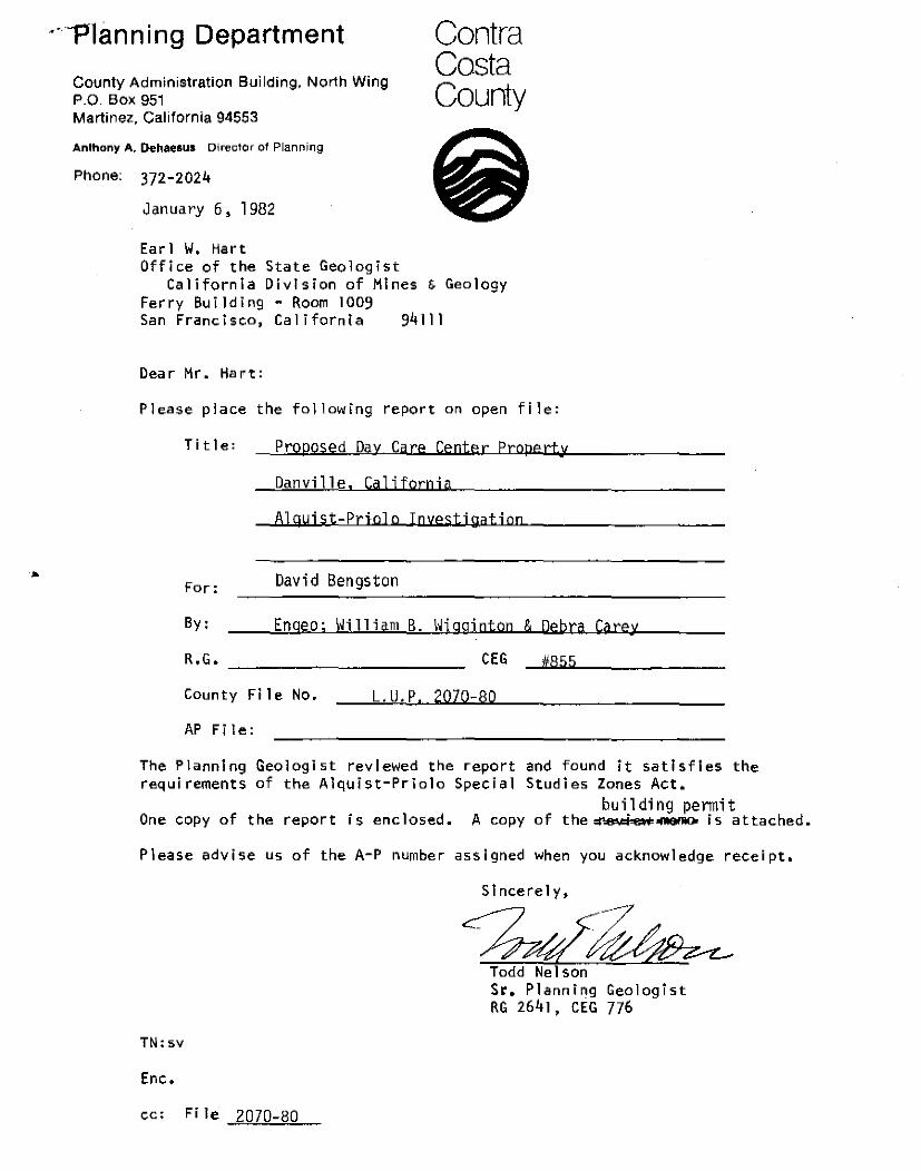
··-Planning Department
County Administration Building, North Wing P.O. Box 951 Martinel, California 94553
Anthony A. Oehaesus D1rector of Planning
Phone: 372-2024
January 6, 1982
Earl W, Hart Office of the State Geologist
Contra Costa County
California Division of Mines & Geology Ferry Bui ]ding - Room 1009 San Francisco, California 94111
Dear Mr. Hart:
Please place the following report on open file:
Title: Proposed Day Care Center Property
Danville, California
Alquist-Prtolo InyestiQation
For: David Bengston
By: Enqeo; William B. Wjgginton & Qebra Carey
R .. G. CEG #855
County File No. L.U.P, 2070-80
AP Fi le:
The Planning Geologist reviewed the report requirements of the Alquist-Priolo Special
and found it satisfies the Studies Zones Act.
One copy of the report is enclosed. A copy bu i1 ding permit
of the :1181.oi _ _..... is attached.
Please advise us of the A-P number assigned when you acknowledge receipt.
TN:sv
Enc.
cc: File 2070-80
Sincerely,
~~ Todd Nelson Sr. Planning Geologist RG 2641, CEG 776

··: ••
..•
AS APPROVED RY SAN RAMON V.ALLEY AREA PLANNING COMMISSION OCTOBE.R 22, 1980
CONDITIONS OF APPROVAL FOR LAND USE PERMIT 2070-80:
I. Development shall be as shown on the plan submitted with the application dated · ;;'1'11 received by the Planning Depmtment September 12, 1980, subject to the cond.itions listed below and subject to review and approval by the County Zoning Administrator prior to the issuance of a building permit and/or the exercising of this permit. Revisions to the site plan shall he made as detailed by the Staff Study of October 16, 1980.
2. This permit is issued to the applicants only (David and Mart Bengston) and is not transferable.
3. Building occupancy shall not exceed 611 children.
4. Comply with the requirements of the Contra Costa County Public Works Department as per a ttachcd .
.5. Submit parking/driveway area plans for review and approval by the County Zoning Administrator. The carport and gnrage area are lo feiJijin ru1J they \hll connt as 4 parking spaces. 9 parking spaces wil I be required.
6. One unlighted sign may be placed on the building only, not to exceed 12 square feet in area. Use of a freestanding sip,n is specifically prohibited.
7. Comply with the requirements of the Contra Costa County Building Inspection Department as follows:
8,
A. Building permits required.
B. Comply with requirements for handicapped,
Comply with the requirements of the Contra Costa Cou11ty Health Department as follows:
A.
B.
;.
Ti1e proposed plans indicate a parking 1ol will.be installed over the drainaqe field of the septic aystem. Because of the close proxi~1i ty of the sanitary sewage lines, this department will require hookup to local municipal sewering agency as a condition of approval rather than redesigning the septic system.
The exist.i.ng septic tank must be properly abandoned by filling the rcxposed tank with either earth, broken stone, or grav('l (Sect.ion 2440 of the Health and Safety Code.)

.. ·"'"'!!, ,.~~·,
2070-80 Page 2
9. Comply with the requirements of the San Ramon Valley fire Protection District as per attached.
10. Provide landscape screening along rear and side property line (north) to scree.n the play yard. The play area shall be surrounded by a solid wood fence.
-11- 11. The Planning Department has determined that there are apparent ha?.ardous geologic and/or soils conditions affecting the subject property. The applicant shall submit two copies of a preliminary geotechnical (geologl.c and/or soils) reconnaiss.mce report to. the Planning Department prior to issuance of building peymits. The report must he cvalu:.i.~ed by the County Geologjst who shall advise the Department as to its adequacy prior to the issuance of building_permit.s.
12. The width of on-site driveways shall he increased to 20 feet, as indicated on the revised plot plan dated 10/16/80 and 20 feet only to tlw bend in the <lri.veway. Provision of a paved turnaround area whose dimensions and location is· acceptable to the fire district, the nepartmont of Public Works anJ the Planning Department shall be utilized.
13. !\ minimum of 9 on-site parking spaces shall be provided. The dimensional ' requirements of the County Parking Ordinance shall be observed.
14. This permit is valid for a period of three (3) years at which time it shall be necessary to apply for renewal.
15. The residential character of the building and premises shall be retained.
16. No loudspeakers or amplified music shall be permitted outside the enclosed building.
17. Light standards for the parking area shall be low lying. All exterior lights shall be detected to shine on the applicant's property and not toward adjacent properties.
18. No changes in outdoor play areas shill! be made without t~e approval of the Zoning Administrator.-
'· 19. The development shall be subject to further review prior to the issuance of a building
permit for the proposed expilnsion to dcterrnine compliance with the above _conditions,
20. If archaeologic materiills are •uncovered during the preparation, grilding, trenching or other on-site excavation, earthwork within 30 meters of these materials shall be stopped until a professinal archaeologist who is certified by the Society for California Archaeology (SCA) and/or the Society of Professional Archaeology (SOP!\) has had an opportunity to evaluate the significilnce of the find and suggest appropriate mitigution measures, if they are deemed necessary.
21. An archaeologica.I field reconnaissance report shall be prepared and submitted to the Planning Department. This report shall be prepared by a professional archaeologist who is certified by the Society for California Archaeology (SCA) and/or the Society of Professional Archaeology (SOPA).
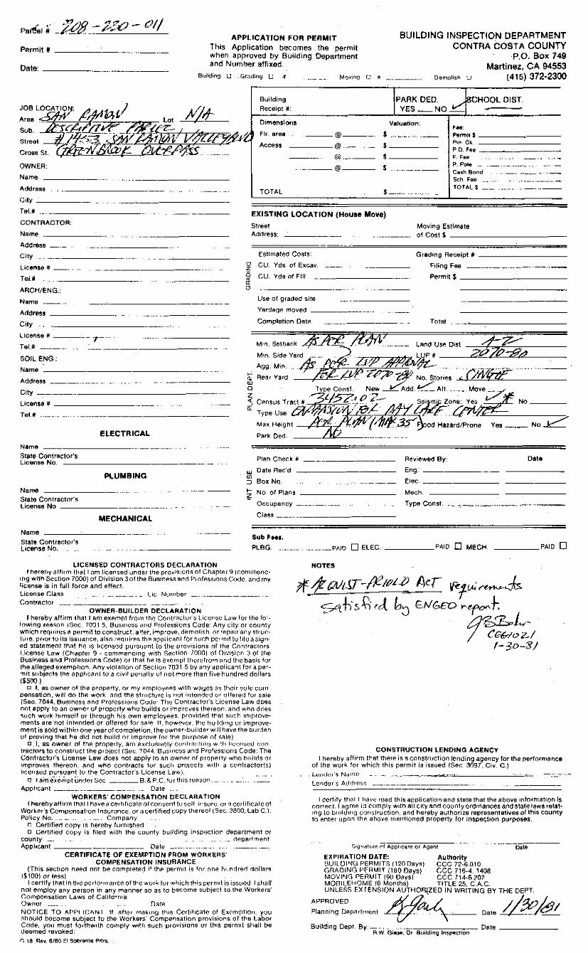
Pa'1!;.I it APPLICATION FOR PERlllllT BUILDING INSPECTION DEPARTMENT
CONTRA COSTA COUNTY P.O. Box 749
Martinez, CA 94553
PArrr'lit #
Date:---·
lhis Application becomes the permit when approved by Building Department and Number affixed.
Building LJ Gr;Jding U it
Building
R1Jceipt #:
Movinq
----@--......
Dernolish u (415) 372-2300
PARK OED. , ~ 8CHOOL DIST YES-NO_~_
V•luation: , ... DimenslOns
F1r. ere.a
Access ----@
$
•-----Permit$ ------ ----P111 Ci.; PD. Fee ·------··--------·~ F. F1111 (UJ. ____ _ $ ____ _
OWNER: P. Pole Cash ennd
...... --@--- $
N.ame
AddreBB
City ____ _ TOTAL $-.-~ ...
Sc::h. F1:m
TOTAL.$ --·-·
Tel.#
CONTRACTOR: EXISTING LOCATION (Hou1e llllove)
Streel Moving Estlm8t6 Name _____ _ Adt1ress: of co:st $ ----------Addr&ss
City
License: # __ _ ~ CU. Yds. of Excav.
Grading Receipt # ----------
Filing Fee
Permit$-------·------Tel.#
ARCH/ENG.:
i5 -< "' "
CU. Yd!! of Fill
Neme ___ _ Use of graded site
Addre~s Yardagf! move<' ------·--·-
City Completion Dflte Totfll
LIC6:1'1~9 # ------ .. _,---··
Tel.# ------ .. •··
SOIL ENG:
Name
Address
City -------·
Uc&ns& #
Tel.#
Name St~te ContrRctor's License No.
Name
HE CTR IC AL
PLUllllBING
r1an Cht:'!Ck 11
UJ Date Rec'd
"' ::J Box NQ.
1- No. ot Plans <'
Reviewod By:
Eng. -------
f!lec
Mech.
Date
State Con1ractor'!I License No
Occupancy ____ _ Type Const.
MECHANICAL
Name -~--~--------··- .. --·--··· state Contractor's License No,
l.IC~NSEO CONTRACTORS DECLARATION
Cl.f!:!!o!I -··-·-·-····-·
Sub'°"'· ?LSG
I heret)y ;Jllirr'fl H1e1t I am licensed under the provi!lton!l of ChflrtP.I" 9 (r:omrnencir10 Wllh Section 7000) of Divis'ion 3ol !he fi~J!linP.!lS Rnr! l~'rflf P.$~1ons C(ldt., <'.v1d rliY license is in full forcP. and elfP.~t. License Cla!l!I Lie. Number ·- . ·-·---.. Contractot
OWNER-BUILDER OECLAAAflON I hereby affirm lhRt I am P.)(P.tnf!l lrQ1)l lh(! COrllr'OIClor·:.; l.i(:t?ri:;t? Law for ihEI fol ..
lowing rP.R~on (~~ec. 10·31 5, Bu$ir1es:> ouid Proles:sions Code: Any city or county which req11ir1!~ <'I ~u.1rrnit to construct, alter, improve, demolish, or repF.11r any stn1r:!l1~0:. prior lo ila issuance, al!in rP.q11irP!l thP F.1pplicF.1n! for ~U<Ch pcr·r1'11\ to !ilo a $igri· ed stalP.ment th;'!! ne 1$ 1tcer1s<~d pu1$u;.1nt lo the provisions of the Contractors' l.lcense Li.lw (Chapter 9 - commencing with Seotion 7000) of Divtsion '.J or !!)C Bu:sineas and Profe!lgion!I (;odP.) or thfll hP- 1$ e.»:Cr'r~fJ~ \l~ervfro1n t•rld \ht? basis for the alleged e1i'.~mpt1on. Any vl(!IF.111(11l <)I Seel.ion 7031 5 by tiny applicant for a permit subjP.ct~ !he app!1c.::irll to a civi! p8ri;.1l\y of riot more then fr11e hundrP.d dollF.irs \$500 I
o I, a:s owner of the property, or my P.mrloy~P.$ wl\h w\"l~CS ;:1s th(:ir ~.;ol8 corn pensation, will rlo thP. work, .'In(! th~ slr1!Clvrt. i.~ riot ir1\011r.kd or offered for sale (Sec. 7044, aoslness <'!nO Protcssi011$ Code· Tl1c Contractor's License Law does not apply to an owr1cr of properly who·builds or improves thereon. flnd who does Sl1Ch work hirnscll or through his own employP.es. provirlP.rl thF.it s1J<:h improvements are·not intP.nrle<J.or offered for sale 11. howcve(. me huil(liriQ or improvement is sold within 011l~ year of cr_'lmplelion, the owner-builder will hf.Ive thP. burdP.n of proving that he did not build or improve for !hP. p11rpo~P. fl( ~;'lie)
o I, as owner of fhP. property, am P.X(:\1,1slvely (:(1!'11r;"i(,:1.inq w1tl1 liCcn:;rxl r;(nl tri;ictors to conslt'ucl Hie pr·ojcc! (S~c. 7044. Bu:>ipc:;s and Professions Code: The Got1tr.:'.lctor':s License Law does not apply to an ownP.r of properly who b11ilt.i$ or improves thereon . .::ind who COl"lt(acts !or suc11 projuc:i:; witt1 a con1ractor(sl lrr';Cri~ud pur:suanl lo the Contractor':; License Law).
rJ t a"rniJ-~~rT1pt iind<:r Sec.------- B.& P.C. fur this ruti:;t:m.
Applicant------·--·------··-·-··· ·- Date ...... WORKERS' COMPENSATION OECLARA1"10N
l herehy aliirrn th~1 I tl<'lve <" certilica1e otr:or1:;(~nt trJ ~;cl! ir1:<.;ur1~. 1.1r ;) cediliC<1tc 01 Wor1<.e1':!i Corr1pcnsatior1 Insurance, or a certified i:.:opy thereof (.Sec. 3800, Lab C:) Policy No. Company
n CP.rtifien copy is hereby t1J(n1shei~ D G~rtitiod copy is !iled with the r.;ouniy building insp!lc1ion departrnent or
counly ·-· <l~partment
Applicant ~-·--·--··-- Date ---····-·· ·---···-···-··· CERTIFICATE OF l;Xl;MPTION FROM W0h.K'e;R$"
COMPENSATION' INSURANCE (This section need no! be complP.tP.d if th.P. permit i!l lor fine h11ndrP.rl rlollflr!I
($100} or IP.SS) I certify 1h,fH In Utt. ~1et101rr~<~f!C('! ol \t11~ work. for w~1ich thi~ Dl~nnil i:.; i:;:.;u~d, I sh;_1U
not employ any person in any manner so as to bec':'Pme subject to the'Workera' Goinpen:sation Laws of Calilornia Owner -·--·· fJatP. NOTICE TO APPi l(:ANt U. F.1ft1~r mf!kmg H-iis Ct.r\i!iC;'lf(! of. Ex1~n1pt1on. you :o.11ol1l(I bucorne :sub1ect to the Workers' Compensation provisions of !he Labor Code, you must fo1U~Will'l cor.)lply wi\11 suet! p1ovisions or lhi:s pern11l :>hall be deerned revoked: r., 1!! R~. BIBO F.I SOl)fQn1>e Prlfs
... __ PAID D ELEC. _____ PAID 0 MECH, ____ ?AID 0
NOTES
CONSTRUCTION LENDING AC.~NCY I hP.reby affirm t~at lhP.rP. is R cor:is~n.1ction lending agency for lhe perlormarice
of \he work. lor which thts permit 1s issued /Se~. 3097, Civ. C.) . L'~lld\~r·~ N;1~1H.•
Lcr1dor·~ At!r'Jri:~:;~>
.... --.--·-~'·"~'"----~~
I certify 11'1<~1 I tiav1~ rrJad thi:s application and state that the above information Is correct. I ag.ff~P. io cornrly with all city anrj county ordinances ar11'.fs:ta!I} laws relat· 1r1g to IJ11ilr_l1n~~ r.;on:;truc:t1ori. a.nd hereby authorize representetwes of lh1s county to enter upon the F.ihove ment•onetl property lor lnSJ)l3'Ct1on purposes.
~:iiq•111.!urr. ;::f Applicant or Ag>e11t . -----·--ca~----
EXPIRATION DATE: Authority BUil. !JiNG PERMITS (120 Day!!) CCC 72-6.0tO GRAr.JING F-•ff~MlT (tf.10 Oars) CCC 716--4. 1408 MOVING PERMIT (90 Days CCC l14-5.70~ MODILEHOME {6 Months) TITLE 25, C.A.C. UNLESS f-.X I E:NSION AUTl10RJ.ZED IN WRITING BY THE DEPT.
APPRovrn p(,--1/~ / /c:;.n I Planning DP.p:-1rtr11cnt L--(-7"-... -: ,._.:. ___ Da1e ~/~/ Building Dept By:---·· Date-------
R.W Gin:wi, Or Suildiliq ln~p«i;:fit:m

' u ./(,. AJ47~5?
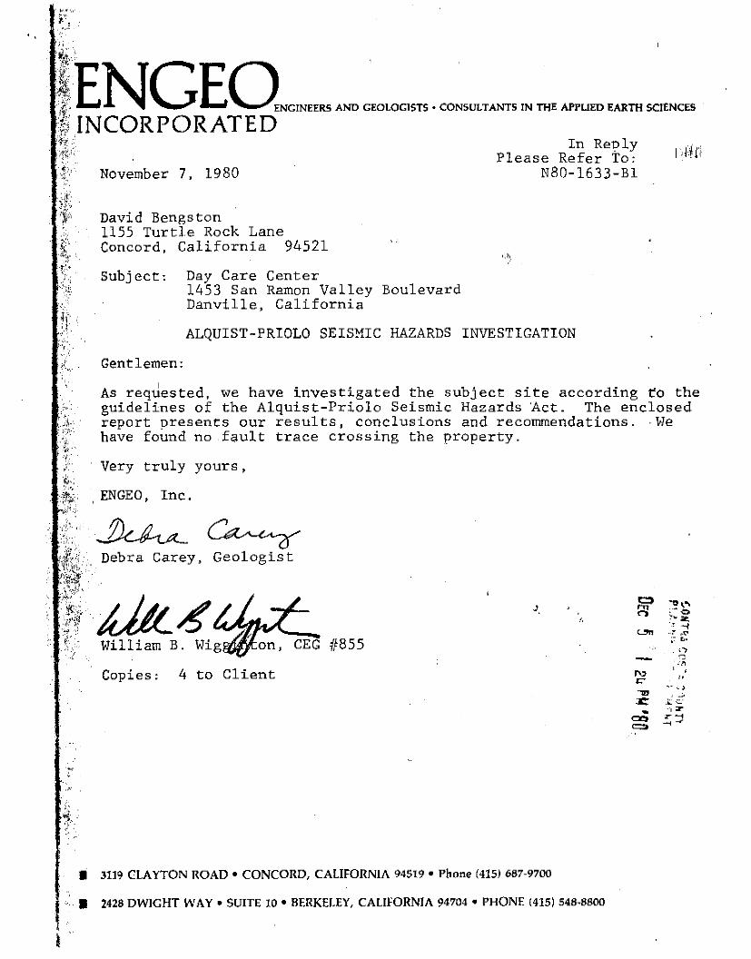
EI 7' 7tJ . .fOPROPOSED DAY CARE CENTER PROPERTY
DANVILLE, CALIFORNIA ,
ALQUIST-PRIOLO INVESTIGAT.ION
~· i I
~· '
':EN GEO•c•m•~~=~·~ -m~m•- rn ra• •~=~rn""""' ti; INCORPORATED "'' In Reply JJ , .. ,,. Please Refer To: I' I 1
t November 7, 1980 NB0-1633-Bl
!f' '
~. ::i~~'..' '•:¥
~·
David Bengston 1155 Turtle Rock Lane Concord, California 94521
Subject: Day Care Center 1453 San Ramon Valley Boulevard Danville, California
I I ~I
ALQUIST-PRIOLO SEISMIC HAZARDS INVESTIGATION
Gentlemen:
I
As requested, we have investigated the subject site according to the guidelines of the Alquist-Priolo Seismic Hazards 'Act. The enclosed report oresents our results, conclusions and recommendations .. we have found no fault trace crossing the property.
Very truly yours,
, EN GEO, Inc.
~~ Debra Carey, Geologist
ditl"1 J
William B. CEG #855
Copies: 4 to Client
I 3119 CLAYTON ROAD• CONCORD, CALIFORNIA 94519 •Phone (415) 687·9700
I 2428 DWIGHT WAY• SUITE 10 •BERKELEY, CALIFORNIA 94704 •PHONE (415) 548·8800
~tt l .. ~-~o
:-.. :;;:, . ~ '"~
.. ~ ,,u O•
'~
" ' ' ,, _,
I:.: c.: •'1 2" ,....,
.... -

l .. I
REPORT
TO
DAVID BENGSTON
CONCORD, CALIFORNIA
ON
ALQUIST-PRIOLO INVESTIGATION
OF
PROPOSED DAY CARE CENTER PROPERTY
DANVILLE, CALIFORNIA
'
ENGEO PROJECT NO. N80-1633~Bl
NOVEMBER 11, 1980
I ,, !'- ~: t ,':

!
TABLE OF CONTENTS
INTRODUCTION Purpose and Scope Methods of Investigation Site Locations Description
ALQUIST-PRIOLO INVESTIGATION Geologic and Seismic Setting Nearby Investigations Air Photograph Study Exploratory Trenching Site.Reconnaissance
SEISMIC HAZARD ASSESSMENT Ground Rupture Seismic Hazards Other Than Ground Ruj)ture
TABLE I CONCLUSIONS AND RECOMMENDATIONS LIMITATIONS BIBLIOGRAPHY
Figure 1 Figure 2 Figure 3 Figure 4 Figure 5 Figure 6
EN GEO INCORrOll:AT[0
APPENDIX
Site Location Geologic Map Preliminary Site Plan Trench Logs Test Pit Log Air Photo
'
PagE:
1 1. 2
3 4 5 5 T
8 8, 9
11 lZ 13
16 17 18 19 20 21
!:.~ f\

)
I j
INTRODUCTION
Purpose and Scope
The purpose of this study is to investigate the potential of primary
surface fault rupture affecting proposed construction on site, in
compliance with the Alquist-Priolo Special Studi1's Zone Act of 19'72.
The site is located within a Special Studies Zone delineated for the
Calaveras fault.
Study followed the Suggested Guidelines for Evaluating the Hazard of
Surfac.e Fault Rupture, Note Number 49, published by the California
Division of Mines and Geology.
The scope of this investigation is to identify and investigate any
potentially active faults that could cause ground rupture on site,
and to comment on any other hazardous geologic or seismic conditions
brought to our attention during the course of this work.
Methods of Investigation
Our Study included:
EN GEO INC01l:l"O•Af[D
1) A review of published and unpublished maps and literature
concerning the geology, soils and seismicity of.. the area.
2) The study of black and white, low sun angle and false color
infra-red aerial photographs of the site vicinity to note
surficial features and lineaments.
3) The excavation of an exploratory trench across the property,
perpendicular to the regional trend of the fault, in order
to observe subsurface materials.
4) The excavation of an exploratory pit offsite to the south
west to investigate the activity status of an existing
landslide and any hazard it might pose to proposed
development.
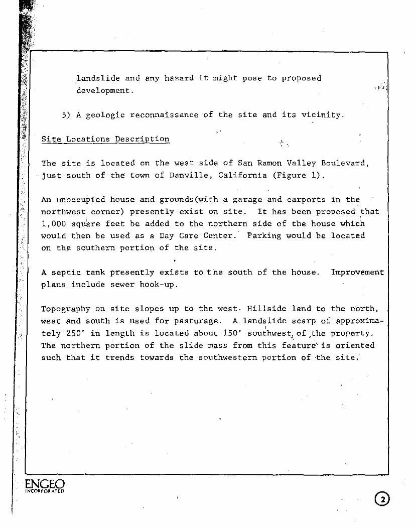
5) A geologic reconnaissance of the site and its vicinity.
Site Locations Description
The site is located on the west side of San Ramon Valley Boulevard,
just south of the town of Danville, California (Figure 1).
An unoccupied house and grounds(with a garage and carports in the
northwest corner) presently exist on site. It has been proposed that •
1,000 squ$.re feet be added to the northern side of the house which
would then be used as a Day Care Center. Parking would be located
on the southern portion of the site.
A septic tank presently exists to the south of the house. Improvement
plans include sewer hook-up.
Topography on site slopes up to the west. Hillside land to the north,
west and south is used for pasturage. A landslide scarp of approxima-' , tely 250' in length is located about 150' southwest, of ,the property.
The northern portion of the slide mass from this feature'· is oriented
such that it trends towards the southwestern portion of ·the site,,·
·ENGEO INCOfil.POJl:AT[D

I
l I !
,. •.,
ALQUIST-PRIOLO INVESTIGATION • dill
Geologic and Seismic Setting
Located in San Ramon Valley on the eastern footslopes of Las Trampas
Ridge, the site is underlain by rocks of the San Pablo Group,
predominantly the Briones formation. These sed,imentary rocks a~e covered by Quaternary aged deposits ranging from 4 to about 8 feet
in thickness, and consisting of colluvial and alluvial silty clays
and clayey silts often intermixed with more rocky, weathered, ancient
landslide debris. Bedrock as observed in exploratory trenching·on
site, consisted of siltstone to medium grained sandstone.
San Ra~on Valley is a northwesterly trending alluvial valley bounded
on the east by the Sherburne Hills and on the west by the Las Trampas
Hills. Las Trampas Ridge, the eastern portion of the Las Trampas
hills, is the topographic expression of a regional northwest trending
anticline (fold where beds incline away from the crest) and is
thought to be truncated in the .southeast by the Calaveras fault. The
marine sedimentary rocks comprising the bulk of Las Trampas Ridge
consists of sandstones with minor siltstones and shales of Teritary
age, such as the Briones formation beneath the site.
The dominant seismic feature in the vicinity is
which bounds the San Ramon Valley on the west.
' the Cataveras fault
The Calaveras fault
is part of a major fault system extending southeasterly from Cordelia
to Hollister (where it joins with the San Andreas fault system).
Historic displacement has occurred on the Calaveras fault near Dublin
(1861 earthquake), and topographic expression of recent movement along
the fault can be traced over much of its length. Fault traces
believed related to Calaveras fault activity have been located
approximately 600 feet south of the site (Peters Ranch) and faulting
has been exptlsea .. in exploratory trenches further south. North towards
·ENGEO INCORPOJl.AT[D

; .
;
j ;~~-'·r· ---------------------------------------':ii:
I. /"
Danville, however, the location and activity status of the Calaveras fault becomes indistinct. Because of this, published maps often show/; the fault as queried or concealed; sometimes by landslide deposits along the east side of Las Trampas Ridge (Herd, 1978). Fissures resulting from the 1861 earthquake have been reported, but not documented, approximately 1, 000 feet northwest and 2, 200 feet nO'l:thwest of the site (C.D.M.G., 1974) (Herd, 1978). ':
Nearby Investigations
The nearest and most pertinent recent investigations were conducted on Peters Ranch to the south of the site (Figure 1). These investigations included air photo interpretation, exploratory trenching, and geophysical surveys. As a result of two investigations conducted at Peters Ranch (Terrasearch, 1977, Berlogar, Long and Associates, 1978), it was concluded that there is an active fault trending northerly across the eastern portion of the ranch, and a photo lineament sub-
,, parallel to the fault approximately 300 feet west of San Ramon Valley Boulevard, also trending northerly. The fault was identified by magnetometer (Terrasearch, 1977) and by trenching (Berl.agar, Long and Associates, 1978), and it is a purported rupture trace of the 1861 Calaveras fault earthquake. The northern ext'ension of this faulting , . would pass about 800 feet west of the western side boun·dary.
No active or potentially active fault has been mapped crossing the site. The main concealed trace of the Calaveras fault has been mappe through San Ramon Valley approximately 500' east of the site (C.D.M.G., 1974) (Contra Costa County, 1976) but extending no more than 2 miles north of the site. Recent theories suggest that from there some othe fault (the Concord fault ?) is the modern northern extension of the Calaveras fault. Dibblee (1980) maps a concealed fault trace approximately 100 feet west of the site and another ending along San Ramon Valley Boulevard, approximately 600' south of the site (Figure
[ .. 2) . These traces have not been documented.
I' ·~~~.~g I

Air Phqtograph Study
The following air photographs were studied as part of this investiga
tion:
Date November 3, 1978
(Low Sun Angle)
April 19, 1979 (Infra-red)
July 2, 1959 (Black & White)
May 22, 1957
Flight Line
AV-1616-01-02&03
AV-1693-01-01&20
AV-334-21-19&20
AV-253-21-29&30
' '~' Source Pacific Aerial Surveys
Pacific Aerial Surveys
Pacific Aerial Surveys
Pacific Aerial S11rveys
These photographs were analyzed for the presence of terrain features characteristic of fault zones, such as linear discontinuities in rock or soil, offset water courses, topographic lows or distressed vegetation. The base of the ridge can be traced as a linear feature approximately 1,200 feet northwest of the site trending northwesterly. In the innnediate site vicinity, the base of the ridge is obscured by· San Ramon Valley Boulevard. Several tonal lineations were noted in the (then) orchard land of San Ramon Valley. The nearest of these
I
comes within 500' of the site to the east. A linea,tion.to the south, marking the northern extention of faulting identified ori' Peters Ranch, ends about 800 feet to the west of the site. No lineations were noted crossing the site.
Study of the photos also gives a relative age to the landslide to the
southwest. This feature is not evident on the 1957 photos, but is quite clear in the 1959 photos(Figure 6).
Exploratory Trenching
Two exploratory trenches were.excavated E-W across the site as shown
'ENGEO INCORPOJl:AflO

on Figure 3. One exploratory test pit was .excavated offsite to the .. i i)1,f l I
southwest, also as shown on Figure 3.
Logs of the trenches are shown on Figure 4. Trench #1 extended from
the existing San Ramon Valley Boule~ard curb to the fence to be
removed approximately 1/3 of the way up the property. No bedrock
or groundwater was encountered in this trench. Various tile drain pipes (including a septic leach line pipe) where encountered in the
eastern part of the trench, which contained about 2' of fill. The
western portion of the trench contained apparently undisturbed
sediments. of silty clays and clayey silts with limonite staining,.
The lower: sediments were bluish in color aid foul smelling due to ,the
reducing environment created by the septic system.
Trench #2 was excavated from approximately 10' on the west side of
the fence to the western property boundary. The eastern portion of
this trench contained sediments consistent with those observed in the
western end of trench #1. Bedrock was encountered in the western
portion of the trench, beginning at about Station 1+00. This bedrock,
as previously mentioned, consisted of siltstone and sandstone, massive
but jointed, with limonite stains concentrated on the joint surfaces.
A colluvial layer (C) of varying thickness was encountered on top of the bedrock, consisting of silty clay with subangul~r bedrock cobbles
suggestive of landslide debris. At about Stations 0+90, 1+00,an~
1+40, 1/8 to 1/2" wide clayey seams were noted in orientations indica
tive of old slide planes. No water was encountered.
Although the subsurface materials encountered were not completely undisturbed, and even, no breaks or offsets attributable to faulting
were observed in either trench.
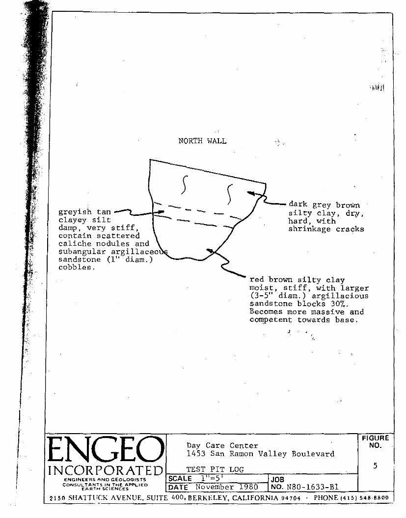
! 1. The test pit was located· approximately 88' uphill to the southwest
ENGEO INCORPO.lAT[O

-r~'. ··~· ~;;
"
'• ~ ... '.
from th.e southwestern property corner. A log of this excavation is · ,,11ll'i shown on Figure 5. The materials encountered were clayey silt and
silty clays containing angular sandstone cobbles to boulders. No
water or active slide plane was encounter.ed although the materials to
a depth of approximately 5 feet were. probably involved in the ex~sting
slide. The colluvial bedrock materials in the b~.se of the pit,
although not massive, were obviously not involved in the more shallow
sliding issuing from the present day scarp. It is possible though,
that they are debris from ancient(3,000 years old or older) massive
landsliding believed by some to have affected the area.
Site Reconnaissance
A reconnaissance of the site and its vicinity was made, to search for
features pertinent to this investigation.
Cracking and failure of a retaining wall behipd (west of) the existing
i["esidence was noted. An attempt to strengthen the wall with tie backs
has apparently been made recently. The foundation of the residence
also shows signs of distress, with upward rotation in the northwestern
corner. No unusual cracking was noted in the pool area, and no slough
ing or other evidence of creep,seepage, or shallow land· movement was
evident on the slope in the southwestern portion of the site. Debris
from the existing shallow off-site slide stops at least SO' west"of the
boundary and appears stabilized.
The foundation and retaining wall distress could be interpreted to be
related to ancient, deep, large scale landslide planes still in a
position to stress these structures. An interpreted location of such
an emergent landslide toe is shovm on Figure 3. Another perhaps more
likely cause is soil expansion and inadequate retaining structure. A
soil investigation prior to construction must resolve this question.
ENGEO I NCOA. POii: A.TE 0

I I~
...
SEISMIC HAZARD ASSESSMENT
Ground Rupture
No evidence of faulting has been found on site. Subsurface exploration
across the entire site revealed sediments and bedrock apparently ·
undisturbed by fault activity. Because of this, <ground rupture on
site is considered unlikely. The nearest found fault trace is located
600 feet south of the site on Peters Ranch. Northern extension of
this faulting would pass approximately 800 feet west o.f the site.
Seismic Hazards Other Than Ground R\1pture
Ground shaking is caused by the transmission of earthquake induced
bedrock vibrations up through the overlying soil deposit. Moderate
ground shaking can be expected on site as a result of an earthquake
on any of the active Bay Area faults. The four major Bay Area faults
are shown on Table I, along with the magnitude and probability of ' earthquake generation for each.
Liquifaction occurs when low density saturated fine-grained granular
soils ar.e subjected to the shaking of an earth'quake. The liquifaction , . potential of the materials encountered in our subsurfac'e explorations
on site is low.
'ENGEO . INCORrQRATtD
©
'•

. ··~ ··~- .. -
zLTi n,.nz TABLE I - ESTIMATED FAULT DATA Oz Zo -~~~o
- - -
:>o;o CJ FAULT ESTIMATED ESTIMATED DISTANCE ESTIMATED ESTIHATED ESTIMATED ~z'" NA.'IB LENGTH J>l.AXIMUM FROM PREDOMINANT STRONG MAXIMUM
I,;l~ -a .. _, 0 MILES EARTHQUAKE SITE PERIODS MOTION EARTHQUAKE ~zo .. ~" HILES DURATION ACCELERATION ~~8 ~ [11
in g '" r .. ~o )>
!!-io San Andreas 500+ 8.5 25 0.4 - 0.5 35 sex .38 o'" rT1 Claver as +100 7 8 less than 0.32-0.4 25-35 .73 Cl - sec -
1 c l1l Hayward +100 7 - 8. 9 0.32-0.4 20-35 sec .51 J> J> -.....
Concord +12 6.6 14 0.29 6 .23 m r-
sec m -z 0 U> t:I < Pl Pl Ill z ::i '< g, 0
::i +-'I ::<ln re Ill :<> Ill Pl '1 t;;j s '1
r< 0 IO >-' trj ::i
'° - n ~ H ro
n::i Ill rt -....- ro
Z'-..... '1
--,.,, 00 0
-. Ill
8 ~ z 00 ..... 0 Ill . I . ,_.
_, .
~ t;;j >-' -
.. . -.,,
-
~~ ZC> --H --QC :II -· m
-- --· -

,,,
1..
2.
CONCLUSIONS AND RECOMMENDATIONS
Our investigation has revealed no evidence that active faultin11iif1
crosses the subject site. Ground rupture on site is ~hus unlikel
and development is geologically feasible.
Ground shaking and landsliding are the secondary seismic hazards
most pertinent to the site.
should be made aware of the
The structuni~ ·or design engineer
ground shaking potential at the site.
We recommend that a detailed soil investigation be conducted to
obtain foundation recommendations for the purposed additio~, as
well as determining the cause of the retaining wall and founda
tion distress in the existing residence. The results of such an
investigation may suggest a more easterly placement of the'
building addition, away from the areas where greatest ground stress is presently manifested. Quality construction should be
utilized on the proposed addition in order to minimize structural
damage. Also a new retaining wall may be required to relieve the
present inadequate or partially failed wall.
3. Trench locations should be accurately noted, as recompation will
be desired to prevent differential settlement.
4. No further geologic study is necessary concelning ·,the subject
building site.
Very truly yours,
ENGEO, INC.
William B. Wigginton C.E.G. {1855
EN GEO INCORP'ORATlO

I
i I I ' , I
LIMITATIONS
This report is based upon data obtained by surface reconnaissance,
subsurface exploration by trenching, interpretation of aerial
photographs and review of geologic maps and literature pertinent
to the site. No inference should b.e drawn from the language of ,
the report that the scope of the investigation w~s any wider. It must be understood that although the observed and reported conditions
are considered representative, local variations of geologic conditions
may exist for which this firm cannot assume responsibility.
No warranty as to the contents of this report is intended and none
shall be inferred from the statements or opinions expressed. This
report wa's prepared upon your request for our services and in
accordance with accepted standards of professional practice. The
transmittal of this report to you completes our contract requirements.
J·
ENGEO INCOll'ORATEP @

BIBLIOGRAPHY f 111.i11·
l ~i Berlogar, Long and Associates, 1978, "Phase II Geologic Fault
.~.·.·.·.t.·.. Investigation, Peters Ranch, San Ramon, California" unpublished ·);:' report. •:01
''~;:. Brabb, E.E., H.S. Sonneman, J .R. Switzer,Jr., "Preliminary Geolor,ic
.. ,.
-~· Map of the Mount Diablo-Byron Area, Contra Cost[l,_ Alameda and San ·, Joaquin Counties, California" U.S. Geological Survey,
S.F.B.R.E. & R.P.S., Basic Data Contribution 28.
Burkland and Associates, 1974, "Geologic and Seismic Hazards Investigation of Harmon Edwards Property, San Ramon, California" unpublished report.
California Division of Mines and Geology, 1974, "Special Studies Zones, Diablo Quadrangle".
Contra Costa.County, 1976, "Preliminary Geologic Map of Contra Costa County" unpublished map.
Department of Water Resources, 1966, "Livermore and Sunol Valleys, Evaluation of Ground Water Resources, Appendix A: Geology" Department of Water Resources, Bulletin Number 118-2 .
• Earth Systems Consultants, 1978, "Geologic and Seismic Hazards Investigation, Vesko Property, San Ramon, California" unpublished report.
ENGEO, Inc., 1976, "Geoiogic and Seismic Hazards Investigation, Filper Property, San Ramon area, California" unpubl'ished report.
J_
ENGEO, Inc., December 20, 1976, Alquist-Priolo Seismic"Hazards Investigation for Danville Townhouses, Wembly Court and San .Ramon Valley Boulevard, Danville N6-0868-Bl.
ENGEO, Inc., 1979, "Seismic Hazards Office Park, San Ramon, California" tion December 26, 1979.
Exploration for Restaurant and N9-1445-B2, Additional Explora-
ENGEO, Inc., 1979a, "Alquist-Priolo Seismic Hazards Investigation for Sierra Investments Property, San Ramon, California" N9-1435-B2.
ENGEO, Inc., 1979b, "Slope Stability Analysis for Site Off Mont.air Drive, Danville, California" N9-1261-B2.
Ham, C.K., 1952, "Geology of Las Trampas Ridge" California Division of Mines and Geology Special Report 22. ·
EN GEO INCOltrOKATIO

, '1.(c,' ri',' ,,..,, :~
*r----------------------------. :r
\
Herd, D.G. 1978, "Map of Quaternary Faulting Along the Northern . Calaveras Fault Zone" U.S. Geological Survey Open File Report 78-3071;';1;
' ,, ,, .. i '• '
Nilsen, T.H., 1971, "Preliminary Photointerpreation Map of Landslide and Other Surficial Deposits of the Mount Diablo Area, Contra Costa and Alameda Counties, California" U.S. Geological Survey, S.F.B.R.E. & R.P.S. Basic Data Contribution 31.
,,,
Terrasearch, Inc., 1977, "Soil and Geologic Investigation on Lands of Peters, San Ramon, California" unpublished report.
Dibblee, T.W. Jr., 1980, Preliminary Geologic map of the Diablo Quadrangle, Alameda and Contra Costa Counties, California. U.S.
,' Geological Survey Open File Report 80-546.
)_
(,
'ENGEO INCORt'O•ATlD
'

: ,;'
Figure 1 Figure 2 Figure 3 Figure 4 Figure 5 }"igure 6
'ENGEO lNCORPO•ATt:O
APPENDIX
Site Location Geologic Map Preliminary Site Plan Trench Logs Test Pit Log Air Photo
J ' /.
Page
16 17 18 19 20 21

-~'
+
N
+
!~
+
+
Peters Ranch
----·--- ' ---~ ______ d,.,,____ ____ _
EN GEO Day Care Center 1453 San Ramon Valley Boulevard
IN CO R p OR ATE D 1---s-=-1.,.,._TE-.,....,,-Lo.,--:-c_AT_r_oN_-.---------1 SCALE 111 =600 I r.-~~~~~~~~~~-----1JOB ENGINEERS ANO GEOLOGISTS
.. I I J '1 I 11 : I y~ ~ "
FIGURE NO.
I
CONSULTANTS IN THE APPLIED EARTH SCIENCES DATE November 1980 NO. N80-l 3 -B
_;;;_~;;;_..;;:;..;,_;:;..;:;.__~-'-~~_;;~'-"'---="-"';.;.<.""""...<=:.a.~~--''--~~~~~
2150 SHATTUCK AVENUE, SUITE 400,BERKE.LEY, CALIFORNIA 94704 PHONE (415) 548-8800

,. 'f.
., ' I'' "\ J,
\ ~I ,. r; ', -~.\
·"' Ir
·!--0
·1· " '
. :-: (
Day Care Center 1453 San Ramon Valley Boulevard
I NCOR PO RATE O f----GE_O_L_OG_I~C_MAP __ b_y_Di~·b_b_le_e_(_l_9_8_0_) _ __, ENO.INEEA.S AND OEOLOQ.ISTS
CONSUL TP.NTS IN Tl"'IE APPL.I ED li'.ARTH SCIENCES
SCALE 1"=2 000' DATE November 1980
.,
FIGURE NO.
2

' .
\ ~i:o. .....
......-\IC.,,,,.
.. \ ~ "\ _.....
/
/ ".,_ _...-1.\0 ......
$~ ,o ,. /
/
@)/ /
f';ic..1.jS ...-~ ... (,. D'Z.-1 ..,.c;_ ' £ , ... , ,.
1!i<153 EXISTINl?i
'·
,. "; • /.
,:~+::: :..;.;--···
'.3 Sui&:i
~£.ii='iDIC.1"
--. hft1tt.£ &.ME..RM•NT ,..a.£ • J N.1ic.1.......,. "-A Jo1o1>'S..J 1>C.
"""-~
I I
/I I '
I
11 :) 5'1 D.:.n CA .!.!Foa-
I
/I I
f/
; I
I I I
1 ' I ,,
I I
If
/I I I
I
If
It II
1' I I I
II
ti (
,~ f I
. '·
J. ' ,,
'•
l·•
\_ ---- SAN RAMoN· VALLE'( BLV.P. A_.c_.e_~_ .. _~-~-'----• ..;,... __ Exploratory trench location
\EN GEO. ; I NC 0 R P 0 RATE Di!------"-"-' "-'-1-u.<.=n..l._...,,_,,...,_.._.......,,_ __ ---1
- ENGlNEE RS ANO GEOLOGISTS I SCALE JOB
Day Care Center 1453 San Ramon Valley Boulevard
FIGURE NO.
3
• CONSULT MflS tN THE APPLIED I DATE N b 19 8 0 NO NBD 16 33 Bl f.ARTH SC I ENC ES O'\,rem er . - -
2 l 5 0 SHA n·~!CK AVE:\l!!-· su1§: 6_'.!0, flf.HKicLEY. CAU~~?R~IA 9~704_· l'l IO:~F {~~~.!__54 "!!~~

_J_ ~ -------------------- - ------------------------
OtlO'
Fill-gravel in ----, .si.Lts,_cl.,..a.,.y,___
~· ... ·~
3torm :lrain ?ipe; ravel
\ .. 0t20' Of30'
Fill -- - -- ----dark grey brown silty clay moist, stiff to, very s tif'.f • ---dark grey brown silty clay
•
------------ --/----- -- --- ----
0-+50'
( !
minor scattered gravel dark_ grey brown silty cla), damp, stiff minor randomly oriented s lickens ides .
D+60'
----------------
----- -------- ----
pipe
disturbed: buried tile,
ceramic pottery, glass.
moist, stiff to very_ stiff~
limonite ~----.::::.--:=:--m • . - - B __ _
----
grey black stain
>. -1-l \..<
light grey clayey silt ~ D
B with disseminated caliche,B moist, medium stiff. ~ ~· diameter drain tile pipe
in leach gravels (septic leach line, c \..< (ll .µ A=grey brown silty clay, dry, hard,
with large shrinkage cracks.
B=blue grey silty clay (odoriferous) moist, medium stiff.
c~tan to light brown silty clay, with scattered caliche nodules argillaceous sandstone cobbles diameter with limonite staining
dry to 'damp, & s1bangular to ·' in 1+40"
I
"' ~
( \
Trench1
!2 \ - -·
-0+80' \
(
dark grey brown stiff, some red
D
l
D+90' I
I (
J_ ---------
light grey clayey silt with disseminated caliche, moist, medium stiff.
D=dark grey (with bluish tinge) clayey silt, moist, medium stiff, randomly oriented slickensides and blocky texture suggestive of ancient soil. ·
c - __.- 15"urrowr;; ~ .,..,..-----·-; - '' 11 \, --- ~ .. -,,-rQQ1:..!~- ,, ~.... ''
---- 'f'i . ~ " I' '' tfl3E, BOE ----- ---11 ''; G 1/8" w;i.de.c --;-;-- ,, J joints-/r/'' I'
"" limdn~i~t~e;___F~~~ ....... .._~'---,,"'
G
E-light grey brown clayey silt with red mottling,(weath stone) _ F=massive G=<massive
stained
fine grained sandstone/siltstone, tan.
light· tan medium grained sandstone with limonite partings: N70E,72N dominant
NlOE,65W
Day Care Center iENGEO ' .
INCORPORATED t=:-:~T_RE_N_CH_LO_G_S ---.-------_, SCALE "= • JOB
~O~A-:--=T~E-N~o-v~em-b:--er~~l7978-0~~NO. NB0-1633-Bl
1453 San Ramon Valley Boulevard
ENG,NEERS AND GEOLOCISTS CONSULT ANTS IN TH£ APPL1 ED
£.A RTH SC I E::NCE-S ;
FlGUF NO.
4
- -------·- l'!IONE 1415) o4~ H 21 so S!lA ITUCK AVE~UE. SUITE 600, Bf.RKEJ.E\', CALI FORNI A 94 J 04
,·~.
I I I I
greyish tan clayey silt damp, very stiff, contain scattered caliche nodules and subangular argillaceo sandstone (l" diam.) cobbles.
EN GEO
,. , NORTH WALL
s - - -- -
,. h
--- dark grey brown silty clay, dqr, hard, with shrinkage cracks
red brown silty clay moist, stiff, with larger (3-5" diam.) argillacious sandstone blocks 30%. Becomes more massive and co~petent towards base.
J
Day Care Center FIGURE
NO. 1453 San Ramon Valley Boulevard
5 IN co R p 0 RATED 1-_TE_S-="'"'T .,.-P.,,...IT,-----LO_G _ __,.._~-------1 SCALE 1"=5' JOB ENGINEERS ANO GEOL.OGIST~
CONSULTANTS IN THE. APPL.,IED EARiH SCIENCES
i..;D:...A:....T__cE:;_,_N....;o:....v-·e....;mc,,b_e_.r~l~9~8~0~~ NO. N 8 0 -16 3 3- Bl
2150 SHATTUCK AVENUE .. SUITE 400,BERKELEY, CA!.IFORNIA 94704 PHONE 1415) 548·8800 ~~~~~~~~~~~~~~~~~~~

t
J
I. (
'' '
'' .,,,
t IN I j I I
Q) ") landslide
••~ ~ ... lineation
ENGINEEi=iS ANO GEOLOOISTS CONSULTANTS IN THE .APPl.IED
E"ART!rol SCIENCES
Air Photo AV-334-21-20 July 2, 1959
Day Care Center San Ramon Valley Boulevard
FIGURE NO.
6