office of management and budget - odsa … · executive office of the president office of...
TRANSCRIPT
EXECUTIVE OFFICE OF THE PRESIDENT OFFICE OF MANAGEMENT AND BUDGET
WASHINGTON, D.C. 20503
February 28,2013
OMB BULLETIN NO. 13-01
TO THE HEADS OF EXECUTIVE DEPARTMENTS AND ESTABLISHMENTS
SUBJECT: Revised Delineations of Metropolitan Statistical Areas, Micropolitan Statistical Areas, and Combined Statistical Areas, and Guidance on Uses of the Delineations of These Areas
1. Purpose: This bulletin establishes revised delineations for the Nation's Metropolitan Statistical Areas, Micropolitan Statistical Areas, and Combined Statistical Areas. The bulletin also provides delineations ofMetropolitan Divisions in those Metropolitan Statistical Areas that have a single core with a population of at least 2.5 million as well as delineations ofNew England City and Town Areas.
The delineations of the statistical areas shown in the appendix's nine lists take effect immediately. The delineations reflect the Standards for Delineating Metropolitan and Micropolitan Statistical Areas that the Office of Management and Budget (OMB) published on June 28,2010, in the Federal Register (75 FR 37246 - 37252) and the application of those standards to Census Bureau population andjoumey-to-work data. This bulletin also provides guidance on the use of the delineations of these statistical areas.
2. Background: Pursuant to 44 U.S.C. 3504(e)(3) and 31 U.S.C. 1l04(d) and Executive Order No. 10253 (June 11, 1951), OMB delineates Metropolitan Statistical Areas, Metropolitan Divisions, Micropolitan Statistical Areas, Combined Statistical Areas, and New England City and Town Areas for use in Federal statistical activities. The appendix's lists represent the product ofOMB's once-a-decade comprehensive review of statistical area standards and delineations. OMB issues periodic updates of the areas between decennial censuses based on Census Bureau data,
3. Update of Statistical Areas: This bulletin provides the delineations of all Metropolitan Statistical Areas, Metropolitan Divisions, Micropolitan Statistical Areas, Combined Statistical Areas, and New England City and Town Areas in the United States and Puerto Rico based on the standards published on June 28,2010, in the Federal Register (75 FR 37246 - 37252) and Census Bureau data. The appendix to this bulletin provides the following lists of statistical areas that are recognized under the standards:
List 1 is an alphabetical list by title of 929 Metropolitan Statistical Areas and Micropolitan Statistical Areas in the United States and Puerto Rico.
List 2 provides titles, codes, delineations, principal cities, and Metropolitan Divisions for 388 Metropolitan Statistical Areas (381 in the United States and 7 in Puerto Rico). There are 11 Metropolitan Statistical Areas that contain a total of 31 Metropolitan Divisions. List 3 provides titles, codes, and delineations for the 31 Metropolitan Divisions within their respective Metropolitan Statistical Areas.
List 4 presents the titles, codes, delineations, and principal cities for 541 Micropolitan Statistical Areas (536 in the United States and 5 in Puelio Rico).
List 5 identifies 169 Combined Statistical Areas and their 524 component .Metropolitan and/or Micropolitan Statistical Areas.
List 6 identifies in each state the Metropolitan Statistical Areas, Metropolitan Divisions, Micropolitan Statistical Areas, and Combined Statistical Areas.
List 7 provides titles, delineations, principal cities, and New England City and Town Area Divisions for 38 New England City and Town Areas. 1
List 8 provides titles and delineations for 6 Combined New England City and Town Areas and their 26 component New England City and Town Areas.
List 9 identifies in each state the New England City and Town Areas, the New England City and Town Area Divisions, and the Combined New England City and Town Areas.
A change in the standards as well as their application to new Census Bureau data has resulted in an increase in the number of Combined Statistical Areas. First introduced in the 2000 standards, Combined Statistical Areas can serve as an important geographic tool for the Federal statistical data community. They can be characterized as representing larger regions that reflect broader social and economic interactions, such as wholesaling, commodity distribution, and weekend recreation activities, and are likely to be of considerable interest to regional authorities and the private sector. If specified criteria are met, adjacent Metropolitan and Micropolitan Statistical Areas, in various combinations, may become the components of a Combined Statistical Area. It should be noted that Combined Statistical Areas complement, but do not supersede Metropolitan and Micropolitan Statistical Areas, which retain their separate component identities.
1 Consistent use of counties in delineating metropolitan and micropolitan statistical areas makes it possible to have comparable areas across the Nation for preparing and disseminating Federal statistics. Cities and towns, however, are the primary units oflocal government in the six New England states, where counties generally have little or no official governmental functions. A wide variety of statistical data, from both Federal and local sources, is compiled for cities and towns in New England. OMB and its predecessor agencies have a longstanding history of delineating statistical areas on a city and town basis in the New England states.

The 2000 standards also introduced the construct "Metropolitan Division," which is used to refer to a county or group of counties within a Metropolitan Statistical Area that has a population core of at least 2.5 million. While a Metropolitan Division is a subdivision of a larger Metropolitan Statistical Area, it often functions as a distinct social, economic, and cultural area within the larger region. Metropolitan Divisions can be directly compared with each other, but comparisons of them with entire Metropolitan Statistical Areas would be inappropriate. Federal agencies will continue to provide detailed data for each Metropolitan Division. .
4. Uses of Statistical Area Delineations: All agencies that conduct statistical activities to collect and publish data for Metropolitan Statistical Areas, Metropolitan Divisions, Micropolitan Statistical Areas, Combined Statistical Areas, and New England City and Town Areas should use the most recent delineations of these areas established by OMB.
OMB establishes and maintains the delineations of Metropolitan Statistical Areas, Metropolitan Divisions, Micropolitan Statistical Areas, Combined Statistical Areas, and New England City and Town Areas solely for statistical purposes. This classification is intended to provide nationally consistent delineations for collecting, tabulating, and publishing Federal statistics for a set of geographic areas. The Metropolitan and Micropolitan Statistical Area Standards do not equate to an urban-rural classification; many counties included in Metropolitan and Micropolitan Statistical Areas, and many other counties, contain both urban and rural territory and populations.
In periodically reviewing and revising the delineations of these areas, OMB does not take into account or attempt to anticipate any nonstatistical uses that may be made of the delineations, nor will OMB modify the delineations to meet the requirements of any nonstatistical program. Thus, OMB cautions that Metropolitan Statistical Area and Micropolitan Statistical Area delineations should not be used to develop and implement Federal, state, and local nonstatistical programs and policies without full consideration of the effects of using these delineations for such purposes. These areas should not serve as a general-purpose geographic framework for nonstatistical activities, and they mayor may not be suitable for use in program funding formulas.
OMB recognizes that some legislation specifies the use ofMetropolitan Statistical Areas for program purposes, including the allocation of Federal funds, and will continue to work with the Congress to clarify the foundations of these delineations and the resultant, often unintended consequences of their use for nonstatistical purposes. In cases where there is no statutory requirement and an agency elects to use the Metropolitan, Micropolitan, or Combined Statistical Area delineations in nonstatistical programs, it is the sponsoring agency's responsibility to ensure that the delineations are appropriate for such use. When an agency is publishing for comment a proposed regulation that would use the delineations for a nonstatistical purpose, the agency should seek public comment on the proposed use.
An agency using the statistical delineations in a nonstatistical program may modify the delineations, but only for the purposes of that program. In such cases, any modifications should be clearly identified as deviations from the OMB statistical area delineations in order
to avoid confusion with OMB's official delineations of Metropolitan, Micropolitan, and Combined Statistical Areas.
5. Lists of Metropolitan Statistical Areas, Metropolitan Divisions, Micropolitan Statistical Areas, Combined Statistical Areas, and New England City and Town Area Delineations: This bulletin and its appendix that provides the nine lists of statistical areas are available electronically from the OMB web site at http://www.whitehouse.gov/omb -- under "Bulletins;" of note, this update, historical delineations, and other information about population statistics is available on the Census Bureau's web site at: http://www.census.gov/populationimetro.)
The 2010 Standards for Delineating Metropolitan and Micropolitan Statistical Areas are available at http://www.whitehouse.gov/omb/inforeg statpolicy.
6. Inquiries: Inquiries conceming the Metropolitan and Micropolitan Statistical Area Standards and the statistical uses of their delineations should be directed to Katherine K. Wallman (202395-3093). Inquiries about uses of the statistical area delineations in program administration or regulation should be directed to the appropriate agency.
Jeffrey D. Zients Deputy Director for Management
Attachments

OMB Bulletin No. Appendix
METROPOLITAN STATISTICAL AREAS
METROPOLITAN DIVISIONS
MICROPOLITAN STATISTICAL AREAS
COMBINED STATISTICAL AREAS
NEW ENGLAND CITY AND TOWN AREAS
COMBINED NEW ENGLAND CITY AND TOWN AREAS
Lists 1 through 9
Statistical and Science Policy Branch Office of Information and Regulatory Affairs
Office of Management and Budget
Metropolitan Statistical Areas, Metropolitan Divisions, Micropolitan Statistical Areas, Combined Statistical Areas, New England City and Town Areas, and
Combined New England City and Town Areas
1. Brief Overview of the Classification
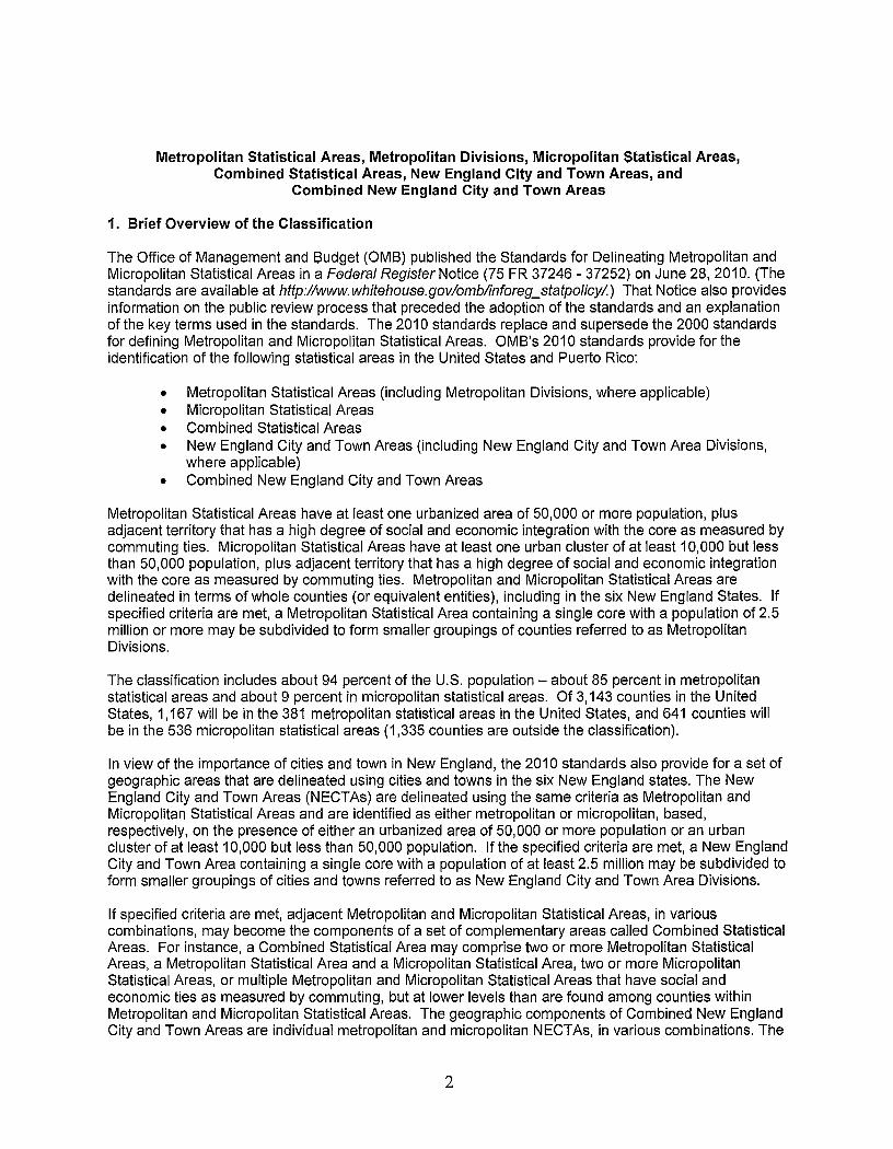
The Office of Management and Budget (OMS) published the Standards for Delineating Metropolitan and Micropolitan Statistical Areas in a Federal Register Notice (75 FR 37246 - 37252) on June 28, 2010. (The standards are available at http://www.whitehouse.govlomblinforeg_statpolicy/.) That Notice also provides information on the public review process that preceded the adoption of the standards and an explanation of the key terms used in the standards. The 20 10 standards replace and supersede the 2000 standards for defining Metropolitan and Micropolitan Statistical Areas. OMS's 2010 standards provide for the identification of the following statistical areas in the United States and Puerto Rico:
• Metropolitan Statistical Areas (including Metropolitan Divisions, where applicable) • Micropolitan Statistical Areas • Combined Statistical Areas • New England City and Town Areas (including New England City and Town Area Divisions,
where applicable) • Combined New England City and Town Areas
Metropolitan Statistical Areas have at least one urbanized area of 50,000 or more population, plus adjacent territory that has a high degree of social and economic integration with the core as measured by commuting ties. Micropolitan Statistical Areas have at least one urban cluster of at least 10,000 but less than 50,000 population, plus adjacent territory that has a high degree of social and economic integration with the core as measured by commuting ties. Metropolitan and Micropolitan Statistical Areas are delineated in terms of whole counties (or equivalent entities), including in the six New England States. If specified criteria are met, a Metropolitan Statistical Area containing a single core with a population of 2.5 million or more may be subdivided to form smaller groupings of counties referred to as Metropolitan Divisions.
The classification includes about 94 percent of the U.S. population - about 85 percent in metropolitan statistical areas and about 9 percent in micropolitan statistical areas. Of 3,143 counties in the United States, 1,167 will be in the 381 metropolitan statistical areas in the United States, and 641 counties will be in the 536 micropolitan statistical areas (1,335 counties are outside the classification).
In view of the importance of cities and town in New England, the 2010 standards also provide for a set of geographic areas that are delineated using cities and towns in the six New England states. The New England City and Town Areas (NECTAs) are delineated using the same criteria as Metropolitan and Micropolitan Statistical Areas and are identified as either metropolitan or micropolitan, based, respectively, on the presence of either an urbanized area of 50,000 or more population or an urban cluster of at least 10,000 but less than 50,000 population. If the specified criteria are met, a New England City and Town Area containing a single core with a population of at least 2.5 million may be subdivided to form smaller groupings of cities and towns referred to as New England City and Town Area Divisions.
If specified criteria are met, adjacent Metropolitan and Micropolitan Statistical Areas, in various combinations, may become the components of a set of complementary areas called Combined Statistical Areas. For instance, a Combined Statistical Area may comprise two or more Metropolitan Statistical Areas, a Metropolitan Statistical Area and a Micropolitan Statistical Area, two or more Micropolitan Statistical Areas, or multiple Metropolitan and Micropolitan Statistical Areas that have social and economic ties as measured by commuting, but at lower levels than are found among counties within Metropolitan and Micropolitan Statistical Areas. The geographic components of Combined New England City and Town Areas are individual metropolitan and micropolitan NECTAs, in various combinations. The
2
areas that combine retain their own designations as Metropolitan or Micropolitan Statistical Areas (or NECTAs) within the larger Combined Statistical Area (or Combined NECTA). Combined Statistical Areas can be characterized as representing larger regions that reflect broader social and economic interactions, such as wholesaling, commodity distribution, and weekend recreation activities, and are likely to be of considerable interest to regional authorities and the private sector.
OMB's standards provide for the identification of one or more principal cities within each Metropolitan Statistical Area, Micropolitan Statistical Area, and NECTA. Principal cities encompass both incorporated places and census designated places (CDPs). In addition to identifying the more significant places in each Metropolitan and Micropolitan Statistical Area or NECTA in terms of population and employment, principal cities also are used in titling Metropolitan and Micropolitan Statistical Areas, Metropolitan Divisions, Combined Statistical Areas, NECTAs, NECTA Divisions, and Combined NECTAs. A principal city may be only a part of a place if a portion of that place is outside of the Metropolitan Statistical Area, Micropolitan Statistical Area, or NECTA for which the place is principal.
The geographic components of Metropolitan and Micropolitan Statistical Areas and Metropolitan Divisions are counties and equivalent entities (boroughs, and a municipality in Alaska, parishes in Louisiana, municipios in Puerto Rico, and independent cities in Maryland, Missouri, Nevada, and Virginia). The counties and equivalent entities used in the delineations of the Metropolitan and Micropolitan Statistical Areas are those that were in existence as of January 1, 2010.
This appendix includes the following nine lists that provide information on the statistical areas that are recognized under the 2010 standards using data from 2010 Census and the American Community Survey.
• List 1 is an alphabetical list by title of 929 Metropolitan Statistical Areas and Micropolitan Statistical Areas in the United States and Puerto Rico.
• List 2 provides titles, codes, delineations, principal cities, and Metropolitan Divisions for 388 Metropolitan Statistical Areas (381 in the United States and 7 in Puerto Rico).
• List 3 provides titles, codes, and delineations for the 31 Metropolitan Divisions within their respective Metropolitan Statistical Areas.
• List 4 presents the titles, codes, delineations, and principal cities for 541 Micropolitan Statistical Areas (536 in the United States and 5 in Puerto Rico).
• List 5 identifies 169 Combined Statistical Areas and their 524 component Metropolitan and/or Micropolitan Statistical Areas.
• List 6 identifies in each state the Metropolitan Statistical Areas, Metropolitan Divisions, Micropolitan Statistical Areas, and Combined Statistical Areas.
• List 7 provides titles, delineations, principal cities, and New England City and Town Area Divisions for 38 New England City and Town Areas.
• List 8 provides titles and delineations for 6 Combined New England City and Town Areas and their 26 component New England City and Town Areas.
• List 9 identifies in each state the New England City and Town Areas, the New England City and Town Area Divisions, and the Combined New England City and Town Areas.
3

2. Guidance on Presenting Data for Metropolitan and Micropolitan Statistical Areas, Metropolitan Divisions, Combined Statistical Areas, NECTAs, NECTA Divisions, and Combined NECTAs
Metropolitan and Micropolitan Statistical Areas represent the basic set of county-based areas delineated under this classification. If specified criteria are met, Metropolitan Divisions are delineated within Metropolitan Statistical Areas that have a single core with a population of at least 2.5 million. Not all Metropolitan Statistical Areas with urbanized areas of this size will contain Metropolitan Divisions.
The criteria used to determine what counties are included in a Metropolitan Statistical Area are different from the criteria that are used to group counties in Metropolitan Divisions, which represent the subdivisions of (larger) Metropolitan Statistical Areas. As a result, it is generally not appropriate to rank or directly compare Metropolitan Divisions (or NECTA Divisions) with Metropolitan and Micropolitan Statistical Areas (or Metropolitan and Micropolitan NECTAs). However, because of the large population concentrations represented by Metropolitan Divisions, it may be desirable for some analyses, for example, to include Metropolitan Divisions in a table in which Metropolitan Statistical Areas are ranked. It would, of course, be appropriate to rank and compare Metropolitan Divisions. Even though Metropolitan Divisions represent subdivisions of (larger) Metropolitan Statistical Areas, they often function as distinct areas within Metropolitan Statistical Areas. Researchers analyzing demographic and economic patterns, trends, and processes within large Metropolitan Statistical Areas should also take into consideration data for specific Metropolitan Divisions. Research and analyses that previously made use of data for Primary Metropolitan Statistical Areas should now use data for Metropolitan Divisions.
Because Combined Statistical Areas represent groupings of Metropolitan and Micropolitan Statistical Areas (in any combination), they should not be ranked or compared with individual Metropolitan and Micropolitan Statistical Areas.
Because Combined New England City and Town Areas (NECTAs) represent groupings of Metropolitan and Micropolitan NECTAs (in any combination), they should not be ranked or compared with individual Metropolitan and Micropolitan NECTAs.
3. Codes for Metropolitan and Micropolitan Statistical Areas, Metropolitan Divisions, Combined Statistical Areas, New England City and Town Areas (NECTAs), NECTA Divisions, and Combined NECTAs
Codes for Metropolitan and Micropolitan Statistical Areas, Metropolitan Divisions, NECTAs, and NECTA Divisions are 5 digits in length. This replaces the 4-digit code previously used. Codes for Metropolitan and Micropolitan Statistical Areas and Metropolitan Divisions fall within the 10000 to 49999 range and are assigned in alphabetical order by area title. Metropolitan Divisions are distinguished by a 5-digit code ending in "4." NECTA and NECTA Division codes fall within the 70000 to 79999 range and are assigned in alphabetical order by area title. NECTA Divisions are distinguished by a 5-digit code ending in "4."
Combined Statistical Area and Combined NECTA codes are 3 digits in length. Combined Statistical Area codes fall within the 100 to 599 range. Combined NECTA codes fall within the 700 to 799 range.
4
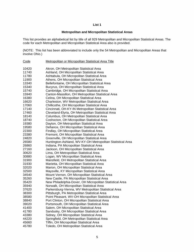
List 1
Metropolitan and Micropolitan Statistical Areas
This list provides an alphabetical list by title of all 929 Metropolitan and Micropolitan Statistical Areas. The code for each Metropolitan and Micropolitan Statistical Area also is provided. (NOTE: This list has been abbreviated to include only the 54 Metropolitan and Micropolitan Areas that involve Ohio.) Code Metropolitan or Micropolitan Statistical Area Title 10420 Akron, OH Metropolitan Statistical Area 11740 Ashland, OH Micropolitan Statistical Area 11780 Ashtabula, OH Micropolitan Statistical Area 11900 Athens, OH Micropolitan Statistical Area 13340 Bellefontaine, OH Micropolitan Statistical Area 15340 Bucyrus, OH Micropolitan Statistical Area 15740 Cambridge, OH Micropolitan Statistical Area 15940 Canton-Massillon, OH Metropolitan Statistical Area 16380 Celina, OH Micropolitan Statistical Area 16620 Charleston, WV Metropolitan Statistical Area 17060 Chillicothe, OH Micropolitan Statistical Area 17140 Cincinnati, OH-KY-IN Metropolitan Statistical Area 17460 Cleveland-Elyria, OH Metropolitan Statistical Area 18140 Columbus, OH Metropolitan Statistical Area 18740 Coshocton, OH Micropolitan Statistical Area 19380 Dayton, OH Metropolitan Statistical Area 19580 Defiance, OH Micropolitan Statistical Area 22300 Findlay, OH Micropolitan Statistical Area 23380 Fremont, OH Micropolitan Statistical Area 24820 Greenville, OH Micropolitan Statistical Area 26580 Huntington-Ashland, WV-KY-OH Metropolitan Statistical Area 26860 Indiana, PA Micropolitan Statistical Area 27160 Jackson, OH Micropolitan Statistical Area 30620 Lima, OH Metropolitan Statistical Area 30880 Logan, WV Micropolitan Statistical Area 31900 Mansfield, OH Metropolitan Statistical Area 31930 Marietta, OH Micropolitan Statistical Area 32020 Marion, OH Micropolitan Statistical Area 32500 Maysville, KY Micropolitan Statistical Area 34540 Mount Vernon, OH Micropolitan Statistical Area 35260 New Castle, PA Micropolitan Statistical Area 35420 New Philadelphia-Dover, OH Micropolitan Statistical Area 35940 Norwalk, OH Micropolitan Statistical Area 37620 Parkersburg-Vienna, WV Metropolitan Statistical Area 38300 Pittsburgh, PA Metropolitan Statistical Area 38580 Point Pleasant, WV-OH Micropolitan Statistical Area 38840 Port Clinton, OH Micropolitan Statistical Area 39020 Portsmouth, OH Micropolitan Statistical Area 41400 Salem, OH Micropolitan Statistical Area 41780 Sandusky, OH Micropolitan Statistical Area 43380 Sidney, OH Micropolitan Statistical Area 44220 Springfield, OH Metropolitan Statistical Area 45660 Tiffin, OH Micropolitan Statistical Area 45780 Toledo, OH Metropolitan Statistical Area
5

46500 Urbana, OH Micropolitan Statistical Area 46780 Van Wert, OH Micropolitan Statistical Area 47540 Wapakoneta, OH Micropolitan Statistical Area 47920 Washington Court House, OH Micropolitan Statistical Area 48260 Weirton-Steubenville, WV-OH Metropolitan Statistical Area 48540 Wheeling, WV-OH Metropolitan Statistical Area 48940 Wilmington, OH Micropolitan Statistical Area 49300 Wooster, OH Micropolitan Statistical Area 49660 Youngstown-Warren-Boardman, OH-PA Metropolitan Statistical Area 49780 Zanesville, OH Micropolitan Statistical Area
6

List 2
Metropolitan Statistical Areas
This list provides titles and codes, principal cities, Metropolitan Division titles and codes (where applicable), and delineations in counties and equivalent entities for all 388 Metropolitan Statistical Areas in the United States and Puerto Rico. There are 11 Metropolitan Statistical Areas that have a total of 31 Metropolitan Divisions. Central counties are shown in italics. (NOTE: This list has been abbreviated to include only the 17 Metropolitan Statistical Areas that involve Ohio.) 10420 Akron, OH Metropolitan Statistical Area Principal City: Akron Portage County, Summit County 15940 Canton-Massillon, OH Metropolitan Statistical Area Principal Cities: Canton, Massillon Carroll County, Stark County 16620 Charleston, WV Metropolitan Statistical Area Principal City: Charleston Boone County, Clay County, Kanawha County 17140 Cincinnati, OH-KY-IN Metropolitan Statistical Area Principal City: Cincinnati, OH Dearborn County, IN; Ohio County, IN; Union County, IN; Boone County, KY; Bracken County, KY; Campbell County, KY; Gallatin County, KY; Grant County, KY; Kenton County, KY; Pendleton County, KY; Brown County, OH; Butler County, OH; Clermont County, OH; Hamilton County, OH; Warren County, OH 17460 Cleveland-Elyria, OH Metropolitan Statistical Area Principal Cities: Cleveland, Elyria Cuyahoga County, Geauga County, Lake County, Lorain County, Medina County 18140 Columbus, OH Metropolitan Statistical Area Principal City: Columbus Delaware County, Fairfield County, Franklin County, Hocking County, Licking County, Madison County, Morrow County, Perry County, Pickaway County, Union County 19380 Dayton, OH Metropolitan Statistical Area Principal City: Dayton Greene County, Miami County, Montgomery County 26580 Huntington-Ashland, WV-KY-OH Metropolitan Statistical Area Principal Cities: Huntington, WV; Ashland, KY Boyd County, KY; Greenup County, KY; Lawrence County, OH; Cabell County, WV; Lincoln County, WV; Putnam County, WV; Wayne County, WV 30620 Lima, OH Metropolitan Statistical Area Principal City: Lima Allen County 31900 Mansfield, OH Metropolitan Statistical Area Principal City: Mansfield Richland County
7

37620 Parkersburg-Vienna, WV Metropolitan Statistical Area Principal Cities: Parkersburg, Vienna Wirt County, Wood County 38300 Pittsburgh, PA Metropolitan Statistical Area Principal City: Pittsburgh Allegheny County, Armstrong County, Beaver County, Butler County, Fayette County, Washington County, Westmoreland County 44220 Springfield, OH Metropolitan Statistical Area Principal City: Springfield Clark County 45780 Toledo, OH Metropolitan Statistical Area Principal City: Toledo Fulton County, Lucas County, Wood County 48260 Weirton-Steubenville, WV-OH Metropolitan Statistical Area Principal Cities: Weirton, WV; Steubenville, OH Jefferson County, OH; Brooke County, WV; Hancock County, WV 48540 Wheeling, WV-OH Metropolitan Statistical Area Principal City: Wheeling, WV Belmont County, OH; Marshall County, WV; Ohio County, WV 49660 Youngstown-Warren-Boardman, OH-PA Metropolitan Statistical Area Principal Cities: Youngstown, OH; Warren, OH; Boardman, OH Mahoning County, OH; Trumbull County, OH; Mercer County, PA
8

List 3
Metropolitan Statistical Areas and Metropolitan Divisions
This list provides titles, codes, and delineations for the 31 Metropolitan Divisions within their respective Metropolitan Statistical Areas. Central counties are shown in italics. (NOTE: This list is blank because Ohio is not part of any Metropolitan Division)
9
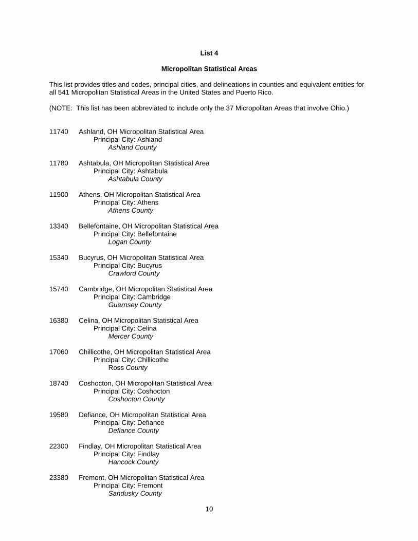
List 4
Micropolitan Statistical Areas
This list provides titles and codes, principal cities, and delineations in counties and equivalent entities for all 541 Micropolitan Statistical Areas in the United States and Puerto Rico. (NOTE: This list has been abbreviated to include only the 37 Micropolitan Areas that involve Ohio.) 11740 Ashland, OH Micropolitan Statistical Area Principal City: Ashland Ashland County 11780 Ashtabula, OH Micropolitan Statistical Area Principal City: Ashtabula Ashtabula County 11900 Athens, OH Micropolitan Statistical Area Principal City: Athens Athens County 13340 Bellefontaine, OH Micropolitan Statistical Area Principal City: Bellefontaine Logan County 15340 Bucyrus, OH Micropolitan Statistical Area Principal City: Bucyrus Crawford County 15740 Cambridge, OH Micropolitan Statistical Area Principal City: Cambridge Guernsey County 16380 Celina, OH Micropolitan Statistical Area Principal City: Celina Mercer County 17060 Chillicothe, OH Micropolitan Statistical Area Principal City: Chillicothe Ross County 18740 Coshocton, OH Micropolitan Statistical Area Principal City: Coshocton Coshocton County 19580 Defiance, OH Micropolitan Statistical Area Principal City: Defiance Defiance County 22300 Findlay, OH Micropolitan Statistical Area Principal City: Findlay Hancock County 23380 Fremont, OH Micropolitan Statistical Area Principal City: Fremont Sandusky County
10

24820 Greenville, OH Micropolitan Statistical Area Principal City: Greenville Darke County 26860 Indiana, PA Micropolitan Statistical Area Principal City: Indiana Indiana County 27160 Jackson, OH Micropolitan Statistical Area Principal City: Jackson Jackson County 30880 Logan, WV Micropolitan Statistical Area Principal City: Logan Logan County 31930 Marietta, OH Micropolitan Statistical Area Principal City: Marietta Washington County 32020 Marion, OH Micropolitan Statistical Area Principal City: Marion Marion County 32500 Maysville, KY Micropolitan Statistical Area Principal City: Maysville Mason County 34540 Mount Vernon, OH Micropolitan Statistical Area Principal City: Mount Vernon Knox County 35260 New Castle, PA Micropolitan Statistical Area Principal City: New Castle Lawrence County 35420 New Philadelphia-Dover, OH Micropolitan Statistical Area Principal Cities: New Philadelphia, Dover Tuscarawas County 35940 Norwalk, OH Micropolitan Statistical Area Principal City: Norwalk Huron County 38580 Point Pleasant, WV-OH Micropolitan Statistical Area Principal City: Point Pleasant, WV Gallia County, OH; Mason County, WV 38840 Port Clinton, OH Micropolitan Statistical Area Principal City: Port Clinton Ottawa County 39020 Portsmouth, OH Micropolitan Statistical Area Principal City: Portsmouth Scioto County
11
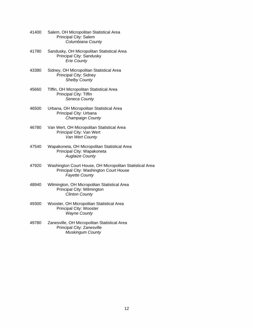
41400 Salem, OH Micropolitan Statistical Area Principal City: Salem Columbiana County 41780 Sandusky, OH Micropolitan Statistical Area Principal City: Sandusky Erie County 43380 Sidney, OH Micropolitan Statistical Area Principal City: Sidney Shelby County 45660 Tiffin, OH Micropolitan Statistical Area Principal City: Tiffin Seneca County 46500 Urbana, OH Micropolitan Statistical Area Principal City: Urbana Champaign County 46780 Van Wert, OH Micropolitan Statistical Area Principal City: Van Wert Van Wert County 47540 Wapakoneta, OH Micropolitan Statistical Area Principal City: Wapakoneta Auglaize County 47920 Washington Court House, OH Micropolitan Statistical Area Principal City: Washington Court House Fayette County 48940 Wilmington, OH Micropolitan Statistical Area Principal City: Wilmington Clinton County 49300 Wooster, OH Micropolitan Statistical Area Principal City: Wooster Wayne County 49780 Zanesville, OH Micropolitan Statistical Area Principal City: Zanesville Muskingum County
12
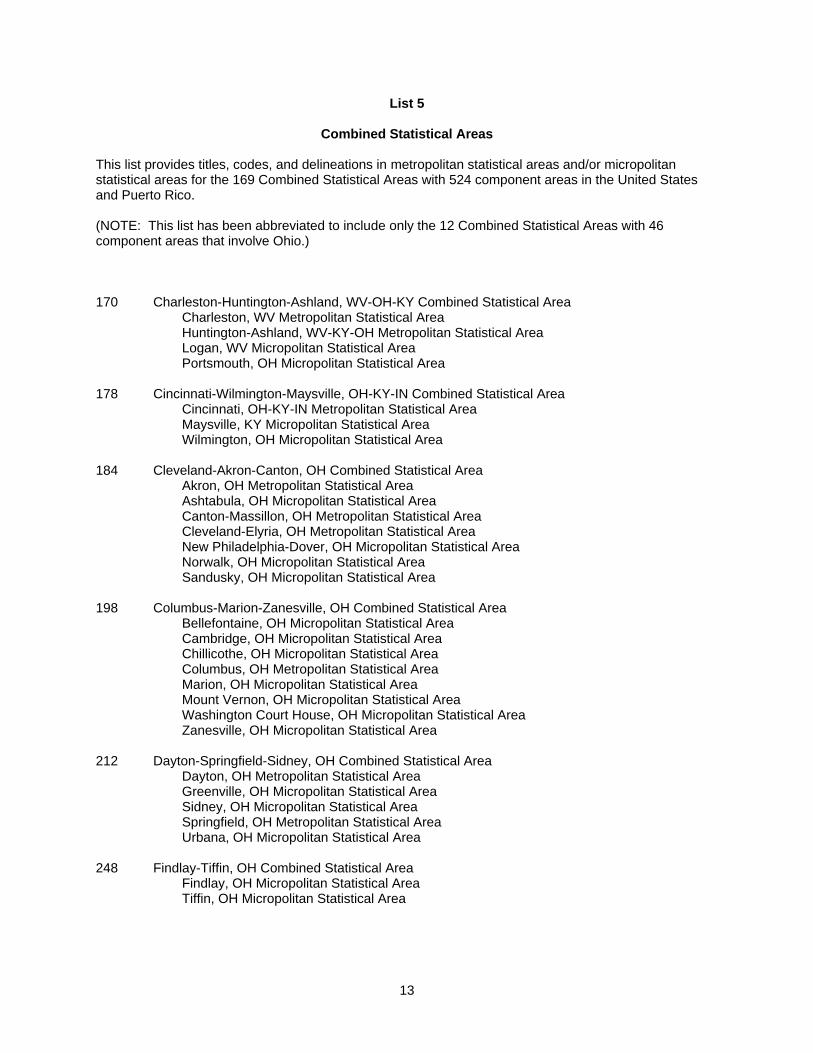
List 5
Combined Statistical Areas
This list provides titles, codes, and delineations in metropolitan statistical areas and/or micropolitan statistical areas for the 169 Combined Statistical Areas with 524 component areas in the United States and Puerto Rico. (NOTE: This list has been abbreviated to include only the 12 Combined Statistical Areas with 46 component areas that involve Ohio.) 170 Charleston-Huntington-Ashland, WV-OH-KY Combined Statistical Area Charleston, WV Metropolitan Statistical Area Huntington-Ashland, WV-KY-OH Metropolitan Statistical Area Logan, WV Micropolitan Statistical Area Portsmouth, OH Micropolitan Statistical Area 178 Cincinnati-Wilmington-Maysville, OH-KY-IN Combined Statistical Area Cincinnati, OH-KY-IN Metropolitan Statistical Area Maysville, KY Micropolitan Statistical Area Wilmington, OH Micropolitan Statistical Area 184 Cleveland-Akron-Canton, OH Combined Statistical Area Akron, OH Metropolitan Statistical Area Ashtabula, OH Micropolitan Statistical Area Canton-Massillon, OH Metropolitan Statistical Area Cleveland-Elyria, OH Metropolitan Statistical Area New Philadelphia-Dover, OH Micropolitan Statistical Area Norwalk, OH Micropolitan Statistical Area Sandusky, OH Micropolitan Statistical Area 198 Columbus-Marion-Zanesville, OH Combined Statistical Area Bellefontaine, OH Micropolitan Statistical Area Cambridge, OH Micropolitan Statistical Area Chillicothe, OH Micropolitan Statistical Area Columbus, OH Metropolitan Statistical Area Marion, OH Micropolitan Statistical Area Mount Vernon, OH Micropolitan Statistical Area Washington Court House, OH Micropolitan Statistical Area Zanesville, OH Micropolitan Statistical Area 212 Dayton-Springfield-Sidney, OH Combined Statistical Area Dayton, OH Metropolitan Statistical Area Greenville, OH Micropolitan Statistical Area Sidney, OH Micropolitan Statistical Area Springfield, OH Metropolitan Statistical Area Urbana, OH Micropolitan Statistical Area 248 Findlay-Tiffin, OH Combined Statistical Area Findlay, OH Micropolitan Statistical Area Tiffin, OH Micropolitan Statistical Area
13
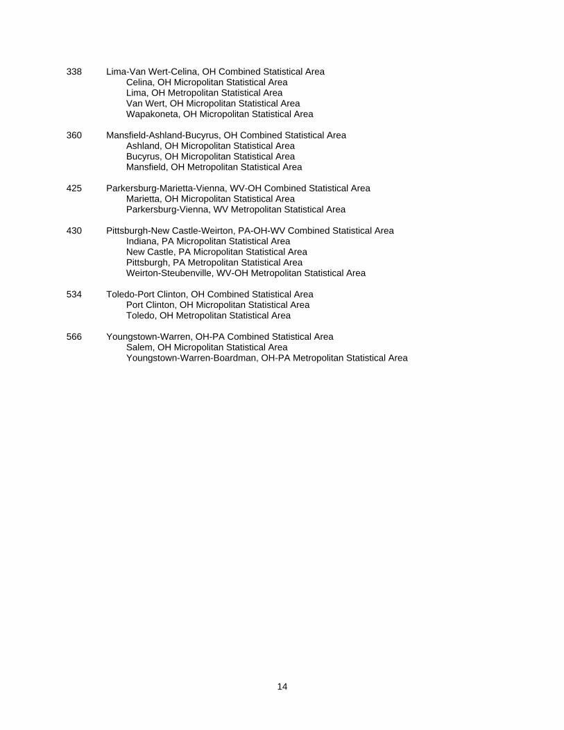
338 Lima-Van Wert-Celina, OH Combined Statistical Area Celina, OH Micropolitan Statistical Area Lima, OH Metropolitan Statistical Area Van Wert, OH Micropolitan Statistical Area Wapakoneta, OH Micropolitan Statistical Area 360 Mansfield-Ashland-Bucyrus, OH Combined Statistical Area Ashland, OH Micropolitan Statistical Area Bucyrus, OH Micropolitan Statistical Area Mansfield, OH Metropolitan Statistical Area 425 Parkersburg-Marietta-Vienna, WV-OH Combined Statistical Area Marietta, OH Micropolitan Statistical Area Parkersburg-Vienna, WV Metropolitan Statistical Area 430 Pittsburgh-New Castle-Weirton, PA-OH-WV Combined Statistical Area Indiana, PA Micropolitan Statistical Area New Castle, PA Micropolitan Statistical Area Pittsburgh, PA Metropolitan Statistical Area Weirton-Steubenville, WV-OH Metropolitan Statistical Area 534 Toledo-Port Clinton, OH Combined Statistical Area Port Clinton, OH Micropolitan Statistical Area Toledo, OH Metropolitan Statistical Area 566 Youngstown-Warren, OH-PA Combined Statistical Area Salem, OH Micropolitan Statistical Area Youngstown-Warren-Boardman, OH-PA Metropolitan Statistical Area
14
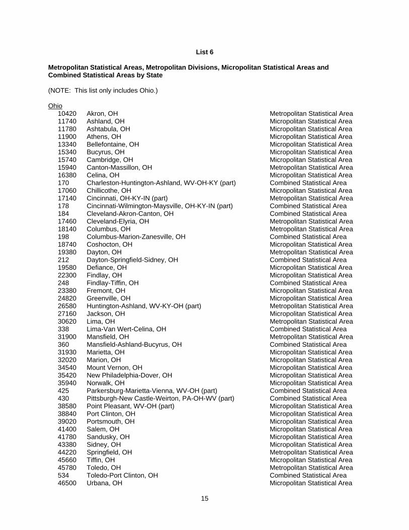
List 6
Metropolitan Statistical Areas, Metropolitan Divisions, Micropolitan Statistical Areas and Combined Statistical Areas by State (NOTE: This list only includes Ohio.) Ohio 10420 Akron, OH Metropolitan Statistical Area 11740 Ashland, OH Micropolitan Statistical Area 11780 Ashtabula, OH Micropolitan Statistical Area 11900 Athens, OH Micropolitan Statistical Area 13340 Bellefontaine, OH Micropolitan Statistical Area 15340 Bucyrus, OH Micropolitan Statistical Area 15740 Cambridge, OH Micropolitan Statistical Area 15940 Canton-Massillon, OH Metropolitan Statistical Area 16380 Celina, OH Micropolitan Statistical Area 170 Charleston-Huntington-Ashland, WV-OH-KY (part) Combined Statistical Area 17060 Chillicothe, OH Micropolitan Statistical Area 17140 Cincinnati, OH-KY-IN (part) Metropolitan Statistical Area 178 Cincinnati-Wilmington-Maysville, OH-KY-IN (part) Combined Statistical Area 184 Cleveland-Akron-Canton, OH Combined Statistical Area 17460 Cleveland-Elyria, OH Metropolitan Statistical Area 18140 Columbus, OH Metropolitan Statistical Area 198 Columbus-Marion-Zanesville, OH Combined Statistical Area 18740 Coshocton, OH Micropolitan Statistical Area 19380 Dayton, OH Metropolitan Statistical Area 212 Dayton-Springfield-Sidney, OH Combined Statistical Area 19580 Defiance, OH Micropolitan Statistical Area 22300 Findlay, OH Micropolitan Statistical Area 248 Findlay-Tiffin, OH Combined Statistical Area 23380 Fremont, OH Micropolitan Statistical Area 24820 Greenville, OH Micropolitan Statistical Area 26580 Huntington-Ashland, WV-KY-OH (part) Metropolitan Statistical Area 27160 Jackson, OH Micropolitan Statistical Area 30620 Lima, OH Metropolitan Statistical Area 338 Lima-Van Wert-Celina, OH Combined Statistical Area 31900 Mansfield, OH Metropolitan Statistical Area 360 Mansfield-Ashland-Bucyrus, OH Combined Statistical Area 31930 Marietta, OH Micropolitan Statistical Area 32020 Marion, OH Micropolitan Statistical Area 34540 Mount Vernon, OH Micropolitan Statistical Area 35420 New Philadelphia-Dover, OH Micropolitan Statistical Area 35940 Norwalk, OH Micropolitan Statistical Area 425 Parkersburg-Marietta-Vienna, WV-OH (part) Combined Statistical Area 430 Pittsburgh-New Castle-Weirton, PA-OH-WV (part) Combined Statistical Area 38580 Point Pleasant, WV-OH (part) Micropolitan Statistical Area 38840 Port Clinton, OH Micropolitan Statistical Area 39020 Portsmouth, OH Micropolitan Statistical Area 41400 Salem, OH Micropolitan Statistical Area 41780 Sandusky, OH Micropolitan Statistical Area 43380 Sidney, OH Micropolitan Statistical Area 44220 Springfield, OH Metropolitan Statistical Area 45660 Tiffin, OH Micropolitan Statistical Area 45780 Toledo, OH Metropolitan Statistical Area 534 Toledo-Port Clinton, OH Combined Statistical Area 46500 Urbana, OH Micropolitan Statistical Area
15
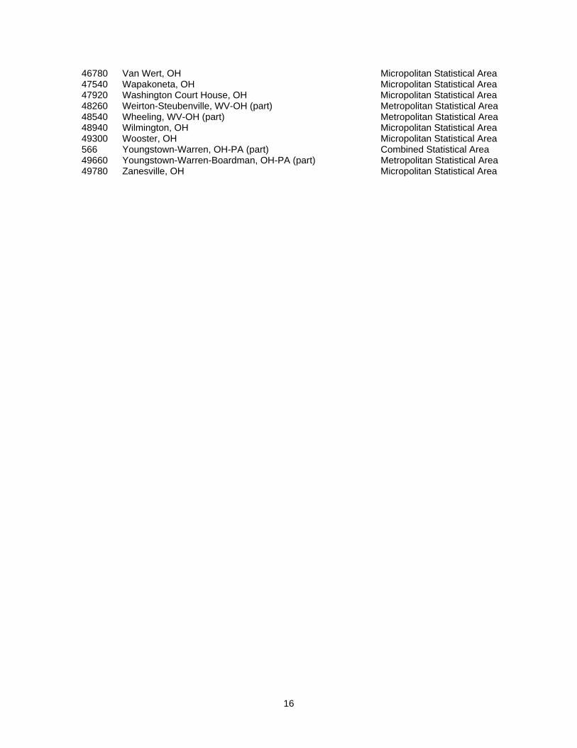
46780 Van Wert, OH Micropolitan Statistical Area 47540 Wapakoneta, OH Micropolitan Statistical Area 47920 Washington Court House, OH Micropolitan Statistical Area 48260 Weirton-Steubenville, WV-OH (part) Metropolitan Statistical Area 48540 Wheeling, WV-OH (part) Metropolitan Statistical Area 48940 Wilmington, OH Micropolitan Statistical Area 49300 Wooster, OH Micropolitan Statistical Area 566 Youngstown-Warren, OH-PA (part) Combined Statistical Area 49660 Youngstown-Warren-Boardman, OH-PA (part) Metropolitan Statistical Area 49780 Zanesville, OH Micropolitan Statistical Area
16

List 7
New England City and Town Areas and New England City and Town Area Divisions
This list provides titles and codes, principal cities, New England City and Town Area Division titles and codes (where applicable), and delineations in cities, towns, and equivalent entities for all 38 Metropolitan and Micropolitan New England City and Town Areas in the United States. (NOTE: This list is blank because Ohio does not contain any New England City and Town Areas or New England City and Town Area Divisions.)
17

List 8
Combined New England City and Town Areas
This list provides titles, codes, and delineations in metropolitan and/or micropolitan New England City and Town Areas for the 6 Combined New England City and Town Areas with 26 component areas in the United States. (NOTE: This list is blank because Ohio has no Combined New England City and Town Areas.)
18

List 9
Metropolitan New England City and Town Areas (NECTAs), NECTA Divisions, Micropolitan NECTAs, and Combined NECTAs by State
(Note: This list is blank because Ohio has no Metropolitan New England City and Town Areas (NECTAs), NECTA Divisions or Combined NECTAs.)
19