october 2018 research and analysis war room
TRANSCRIPT
The SDOT Pedestrian Wayfinding Program
Seamless SeattleResearch and Analysis War RoomOctober 2018

Seamless Seattle | Research and Analysis War Room Summary | October 2018 2
PurposeThis documents provides a commentary to the War Room presentations given to the client and stakeholder groups on October 11 2018 as part of the Seamless Seattle Wayfinding Project.
The War Room is a point in time, and is intended to show the state of research and observations up to that point – and to provide an opportunity for stakeholders to input, comment and identify any areas they feel should be included or excluded.
This document does not capture stakeholder comments and reactions to the War Room.
The outcomes of the War Room presentations will inform the further development of the strategy and design.

Seamless Seattle | Research and Analysis War Room Summary | October 2018 3
The following people attended the War Room presentations on October 11, Seattle City Hall, Boards and Commissions Room L280.
War Room 1 (am)
Zack Howard, WSDOT
Brian Ferris, Google
Erin Goodman, SODO BIA
Candace Toth, Sound Transit
Alex Hagenah, SDOT
Rob Leslie, Visit Seattle
Lizzie Moll, SDOT
Erin Harris, SDOT
Susan McLaughlin, SDOT
Allison Schwartz, SDOT
Michael Davis, SDOT
Peggy Martinez, Creative Inclusion
Elliott Krivako, DSA
Joel Miller, SDOT
Adam Parast, SDOT
Kathleen Johnson, Historic South Downtown
Jacqueline Gruber, DSA
Attendees
War Room 2 (pm)
Suzy Brunzell, Seattle IT-GIS
Brock Howell, Everett Transit
Cristina VanValkenburgh, SDOT
Amy Wallsmith, Pike Place Market
Chad Lynch, SDOT Policy and Planning
Liz Sterning, Alliance for Pioneer Square
Matt Hansen, King County Metro
Derek Holmer, King County Metro
David Driskell, SPCD
Carmen Bendixen, WSDOT-WSF
Benjamin de la Pena, SDOT
Tracy Krawczyk, SDOT
Mayumi Thompson, SDOT
Michael Shaw, SDOT
David Burgesser, SDOT
Emily Burns, SDOT
Ashley Rhead, SDOT
Nick Bolten, University of Washington
Garry Papers, OPCD
Russ Arnold, Sound Transit
Curtis Ailes, SDOT
Brock Bender, WSDOT-WSF
Brian Henry, SDOT
Sara Walton, SDOT

Seamless Seattle | Research and Analysis War Room Summary | October 2018 4
To show research and analysis to date in order to elicit direction and highlight any missing elements from stakeholders.
Context
● Team carried out Scoping Study in Nov 2017
● Research in current scope to build on the Scoping Study, not retread
● Takeaway from Scoping Study: “I am provided with the information I need, when I need it, to inspire me to explore Seattle and to help me choose the best way to travel in the city.”
○ “I” - about all people, irrespective of ability, age, income, any factors. All people of seattle, all visitors
Introduction

Seamless Seattle | Research and Analysis War Room Summary | October 2018 5
Summary
● Seattle’s form and development has been shaped by its geography, most notably its topography and water bodies. Given limited land for E-W expansion, there is strong N-S connectivity and corridors of movement.
● A study of historic city maps illustrating the N-S expansion, also shows the annexation of adjacent mature neighborhoods and cities to create modern Seattle. Annexation helps explain why Seattle has many distinctive neighborhoods with their own history, identity and character.
● During the city’s development, regrading and land reclamation have significantly changed the geography of the city. [Image: Denny Regrade]
The cityKey points
● Topography and geography support north-south axis, east-west movement more difficult
● City of neighborhoods● Street naming has a cardinal direction logic, which helps with
city-wide legibility and orientation
Summary● Seattle’s form and development has been shaped by its geography, most
notably its topography and water bodies. Given limited land for E-W expansion, there is strong N-S connectivity and corridors of movement.
● A study of historic city maps illustrating the N-S expansion, also shows the annexation of adjacent mature neighborhoods and cities to create modern Seattle. Annexation helps explain why Seattle has many distinctive neighborhoods with their own history, identity and character.
● During the city’s development, regrading and land reclamation have significantly changed the geography of the city. [Image: Denny Regrade]
● A 1956 map included a guide to understanding and navigating Seattle, which is still relevant. Areas of the city are described using compass points: N, NW, NE, W, E, S, SW, which are used in street naming – e.g. 15th Ave NE.
● A section through 85th street highlights topography and gives an indication of why east-west travel is difficult. Cyclists will use indirect routes such as along the Burke-Gilman trail to avoid steep gradients.
● There are a wealth of open spaces in the city that are not being used equitably by Seattleites. These could and should become a focal point for communities through improving links to and through them.
2. The cityKey points⁙ Topography and geography support north-south axis, east-west
movement more difficult⁙ City of neighborhoods⁙ Street naming has a cardinal direction logic, which helps with
city-wide legibility and orientation
● A 1956 map included a guide to understanding and navigating Seattle, which is still relevant. Areas of the city are described using compass points: N, NW, NE, W, E, S, SW, which are used in street naming – e.g. 15th Ave NE.
● A section through 85th street highlights topography and gives an indication of why east-west travel is difficult. Cyclists will use indirect routes such as along the Burke-Gilman trail to avoid steep gradients.
● There are a wealth of open spaces in the city that are not being used equitably by Seattleites. These could and should become a focal point for communities through improving links to and through them.
Note: Open spaces map includes tidelands around the coastline of Alki Beach and Discovery Park.These will be removed from future open spaces maps.

Seamless Seattle | Research and Analysis War Room Summary | October 2018 6
3 The cityKey points
● How should wayfinding design respond to local distinctiveness?● City landmarks are hidden from within the city● Neighborhoods have distinctive cultures as well as characters
Summary● Neighborhoods not only have distinct character and identity, but
also culture, e.g. International District, Alki Beach, Pioneer Square.● Neighborhood boundaries and names can change depending on map
producers and suppliers, e.g. Denny Triangle, Downtown. This causes confusion and needs to be fixed for them to become predictable and usable. The project will aim to gain consensus for neighborhood names and boundaries.
● A survey of 142 business addresses in the Downtown area showed low use of neighborhood names as part of formal addressing (4% them), suggesting neighborhoods are part of the verbal and cultural language of the city.
● Landmarks support wayfinding in one of three ways: providing a waymark on a journey; acting as a North Star, a reference point from distance; creating a unique sense of place and destination.
● Seattle has many landmarks, that provide a waymark and sense of place, but none that act as a North Star.
● Even the city's most recognisable landmark the Space Needle is invisible from many Downtown locations. Mount Rainier is another landmark, but is not always visible due to the weather, and the Cascade and Olympic Mountains flank the city, but provide multiple reference points in different directions so also cannot be used.
3. The cityKey points⁙ How should wayfinding design respond to local distinctiveness?⁙ City landmarks are hidden from within the city⁙ Neighborhoods have distinctive cultures as well as characters
Summary
● Neighborhoods not only have distinct character and identity, but also culture, e.g. International District, Alki Beach, Pioneer Square.
● Neighborhood boundaries and names can change depending on map producers and suppliers, e.g. Denny Triangle, Downtown. This causes confusion and needs to be fixed for them to become predictable and usable. The project will aim to gain consensus for neighborhood names and boundaries.
● A survey of 142 business addresses in the Downtown area showed low use of neighborhood names as part of formal addressing (4% them), suggesting neighborhoods are part of the verbal and cultural language of the city.
● Landmarks support wayfinding in one of three ways: providing a waymark on a journey; acting as a North Star, a reference point from distance; creating a unique sense of place and destination.
● Seattle has many landmarks, that provide a waymark and sense of place, but none that act as a North Star.
● Even the city's most recognisable landmark the Space Needle is invisible from many Downtown locations. Mount Rainier is another landmark, but is not always visible due to the weather, and the Cascade and Olympic Mountains flank the city, but provide multiple reference points in different directions so also cannot be used.

Seamless Seattle | Research and Analysis War Room Summary | October 2018 7
4 The cityKey points
● Different urban typologies require different wayfinding approaches● Wayfinding should support the events in the city throughout the
year
Summary● Urban and streetscape form has a significant impact on movement
and legibility.● A street with several lanes of traffic and narrow sidewalks and no
active frontage feels different to a street with fewer traffic lanes, cycling lanes, and a wide sidewalk with active frontage. Similarly, the dense grid of streets with monolithic blocks in Downtown is dehumanising in scale compared with low rise, more intimate urban form of Queen Anne.
● Wayfinding must be adaptable with different approaches to type and density of signage supporting pedestrians different environments
● Gradient also has a significant impact on movement. A journey uphill takes longer than a journey of equivalent distance on flat ground and is more challenging to people with limited mobility. Changes in gradient must be clearly communicated to accurately explain the walking environment and allow journeys to be planned.
● ADA guidelines state a walking surface should be <5% slope. Much of the city is steeper which presents difficulties to many people. See map, center right, orange streets >6% slope
● The city also has a rhythm of live events from community-based to international, which contribute to activity and an influx of non-Seattleites. Wayfinding must support the city's daily to seasonal cycle at the local and strategic scale.
4. The cityKey points⁙ Different urban typologies require different wayfinding
approaches⁙ Wayfinding should support the events in the city throughout
the year
Summary
● Urban and streetscape form has a significant impact on movement and legibility.
● A street with several lanes of traffic and narrow sidewalks and no active frontage feels different to a street with fewer traffic lanes, cycling lanes, and a wide sidewalk with active frontage. Similarly, the dense grid of streets with monolithic blocks in Downtown is dehumanising in scale compared with low rise, more intimate urban form of Queen Anne.
● Wayfinding must be adaptable with different approaches to type and density of signage supporting pedestrians different environments.
● Gradient also has a significant impact on movement. A journey uphill takes longer than a journey of equivalent distance on flat ground and is more challenging to people with limited mobility.
● Changes in gradient must be clearly communicated to accurately explain the walking environment and allow journeys to be planned.
● ADA guidelines state a walking surface should be <5% slope. Much of the city is steeper which presents difficulties to many people. See map, center right, orange streets >6% slope
● The city also has a rhythm of live events from community-based to international, which contribute to activity and an influx of non-Seattleites. Wayfinding must support the city's daily to seasonal cycle at the local and strategic scale.

Seamless Seattle | Research and Analysis War Room Summary | October 2018 8
5 People of the cityKey points
● The city constantly welcomes new residents who won’t know the city
● Design for all is an essential requirement of the project
Summary● Seattle has been the fastest growing of the top 50 US cities since
2010 increasing by 18%. 63% of Seattle residents were born outside of Washington State.
● This tells us that the population is in a constant state of renewal, and require information to help them familiarize with the city.
● By 2040 25% will be over 60. Of the over 60's, presently 23% currently have a disability and 22% are obese. Wayfinding must support all people.
● Providing equitable opportunity for people to experience the city is an obligation for Seattle, wayfinding is part of that opportunity.
● People's abilities to navigate a city is on a spectrum of cognitive, physical, financial and social ability, regardless of whether they consider themselves to have a disability. Wayfinding must be designed for real people's needs, not user groups.
● To help develop real world scenarios we use the Diversity Cube method developed for the city of Madrid*, which helps re-focus journeys based around people's physical ability, cognitive ability, language ability, mode choice, reason for journey, rhythm and motivation for journey.
● Another method developed for the same project is the Compensation Circle, which demonstrates how wayfinding must compensate for people's different abilities and for environmental factors, to provide people with an equitable experience.
● Wayfinding touchpoints which may seem decorative, inconsequential or that are easily missed by some, can be fundamental for others.
● This inclusive approach is fundamental to the project*Diversity Cube: Avanti Avanti/ Design for All Forum
5. People of the cityKey points⁙ The city constantly welcomes new residents who won’t
know the city⁙ Design for all is an essential requirement of the project
Summary
● Seattle has been the fastest growing of the top 50 US cities since 2010 increasing by 18%. 63% of Seattle residents were born outside of Washington State.
● This tells us that the population is in a constant state of renewal, and require information to help them familiarize with the city.
● By 2040 25% will be over 60. Of the over 60's, presently 23% currently have a disability and 22% are obese. Wayfinding must support all people.
● Providing equitable opportunity for people to experience the city is an obligation for Seattle, wayfinding is part of that opportunity.
● People's abilities to navigate a city is on a spectrum of cognitive, physical, financial and social ability, regardless of whether they consider themselves to have a disability. Wayfinding must be designed for real people's needs, not user groups.
● To help develop real world scenarios we use the Diversity Cube method developed for the city of Madrid*, which helps re-focus journeys based around people's physical ability, cognitive ability, language ability, mode choice, reason for journey, rhythm and motivation for journey.
● Another method developed for the same project is the Compensation Circle, which demonstrates how wayfinding must compensate for people's different abilities and for environmental factors, to provide people with an equitable experience.
● Wayfinding touchpoints which may seem decorative, inconsequential or that are easily missed by some, can be fundamental for others.
● This inclusive approach is fundamental to the project
* Diversity Cube: Avanti Avanti / Design for All Forum

Seamless Seattle | Research and Analysis War Room Summary | October 2018 9
6 Visitors to the cityKey points
● Small changes to tourist spending can make a big difference in overall income
● The city is a gateway to the region
Summary● Seattle welcomes 40 million visitors to the city each year, who
spend on average $195, and a total of $7.4 billion. It demonstrates that if wayfinding can bring about a small change in behaviour it would create a significant return on investment.
● Some are noticing the perceived negative impact of tourism, with residents complaining about the impact of cruise ship passengers on 1st Ave, a shuttle has been started to distribute tourists. And it is significant that tourist tax subsidizes each Seattle household $916 each year, which is not well known or communicated.
● Seattle is also a gateway to the Pacific Northwest region. Over 1 million passengers enter the city from the ports and 400,000 business visitors arrive for conventions. Wayfinding has an opportunity to engage these visitors, encouraging exploration beyond Downtown and repeat visits in future.
● The Convention Center has turned away over 350 events in the last 5 years. Investment in infrastructure for this type of visitor, including a new convention center in 2021 is an opportunity to increase visitor numbers and spend
● Ivar’s map is one of the nicest examples of a visitor map. It shows the center of Seattle as one part of a greater visitor experience.
● The number of visitors to each destination will be reviewed and analysed to ehklp understand movement and priorities as part of the next phase.
6. Visitors to the cityKey points⁙ Small changes to tourist spending can make a big difference in
overall income⁙ The city is a gateway to the region
Summary
● Seattle welcomes 40 million visitors to the city each year, who spend on average $195, and a total of $7.4 billion. It demonstrates that if wayfinding can bring about a small change in behaviour it would create a significant return on investment.
● Some are noticing the perceived negative impact of tourism, with residents complaining about the impact of cruise ship passengers on 1st Ave, a shuttle has been started to distribute tourists. And it is significant that the household tax burden is subsidized by $916 due to income from tourism each year, which is not well known or communicated.
● Seattle is also a gateway to the Pacific Northwest region. Over 1 million passengers enter the city from the ports and 400,000 business visitors arrive for conventions. Wayfinding has an opportunity to engage these visitors, encouraging exploration beyond Downtown and repeat visits in future.
● The Convention Center has turned away over 350 events in the last 5 years. Investment in infrastructure for this type of visitor, including a new convention center in 2021 is an opportunity to increase visitor numbers and spend
● Ivar’s map is one of the nicest examples of a visitor map. It shows the center of Seattle as one part of a greater visitor experience.
● The number of visitors to each destination will be reviewed and analysed to help understand movement and priorities as part of the next phase.
Seamless Seattle | Research and Analysis War Room Summary | October 2018 10
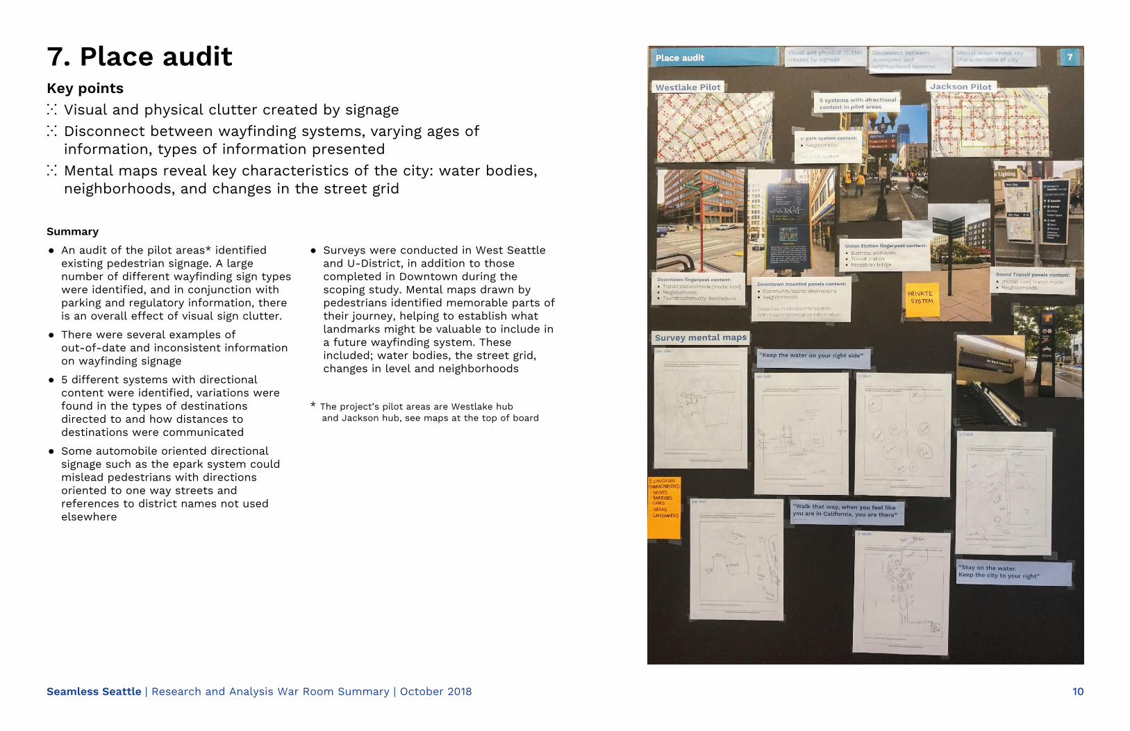
7 Place auditKey points
● Visual and physical clutter created by signage● Disconnect between wayfinding systems, varying ages of
information, types of information presented● Mental maps reveal key characteristics of the city: water bodies,
neighborhoods, and changes in the street grid
Summary● An audit of the pilot areas* identified existing pedestrian signage. A
large number of different wayfinding sign types were identified, and in conjunction with parking and regulatory information, there is an overall effect of visual sign clutter.
● There were several examples of out-of-date and inconsistent information on wayfinding signage
● 5 different systems with directional content were identified, variations were found in the types of destinations directed to and how distances to destinations were communicated
● Some automobile oriented directional signage such as the epark system could mislead pedestrians with directions oriented to one way streets and references to district names not used elsewhere
● Surveys were conducted in West Seattle and U-District, in addition to those completed in Downtown during the scoping study. Mental maps drawn by pedestrians identified memorable parts of their journey, helping to establish what landmarks might be valuable to include in a future wayfinding system. These included; water bodies, the street grid, changes in level and neighborhoods
*The project’s pilot areas are Westlake hub and Jackson hub, see maps at the top of board
7. Place auditKey points⁙ Visual and physical clutter created by signage⁙ Disconnect between wayfinding systems, varying ages of
information, types of information presented⁙ Mental maps reveal key characteristics of the city: water bodies,
neighborhoods, and changes in the street grid
Summary
● An audit of the pilot areas* identified existing pedestrian signage. A large number of different wayfinding sign types were identified, and in conjunction with parking and regulatory information, there is an overall effect of visual sign clutter.
● There were several examples of out-of-date and inconsistent information on wayfinding signage
● 5 different systems with directional content were identified, variations were found in the types of destinations directed to and how distances to destinations were communicated
● Some automobile oriented directional signage such as the epark system could mislead pedestrians with directions oriented to one way streets and references to district names not used elsewhere
● Surveys were conducted in West Seattle and U-District, in addition to those completed in Downtown during the scoping study. Mental maps drawn by pedestrians identified memorable parts of their journey, helping to establish what landmarks might be valuable to include in a future wayfinding system. These included; water bodies, the street grid, changes in level and neighborhoods
* The project’s pilot areas are Westlake huband Jackson hub, see maps at the top of board

Seamless Seattle | Research and Analysis War Room Summary | October 2018 11
8 Resource auditKey points
● There is a disconnect between journey descriptions and experience● Public art aids wayfinding but is not communicated effectively● Accessible information is not integrated● Inconsistent information even through same provider
Summary● Journey planning information comes from many sources provided by transit agencies and
third parties, available in different formats ● There is a lack of consistency of information across these sources. For example, Sound
Transit’s trip planner refers to the Link as a ‘Tram’ alongside a bus icon, whilst King County Metro’s trip planner uses refers to modes and operators, potentially confusing the user, and gives walking directions using long lists of instructions
● Use of codes assumes prior knowledge which the user may not have. Examples include use of ‘SB’ (Southbound) and ‘KC’ (King County)
● These and third party apps, such as OneBusAway, CityMapper, GoogleMaps and TripGo, prioritise efficiency of movement over quality of experience. For example there’s a lack of consideration of the walking environment such as slopes and sidewalk quality which impact pedestrian experience. Failing to include information such as this does not present the city as it actually is, creating a disconnect in users expectations vs reality
● Detailed accessible route information is available online, although this is not integrated into more commonly used route planning apps and is not currently presented in an intuitive/accessible format. E.g. surface slope is graded by %, but it is likely that many uses do not understand what a 6% slope means or feels like to walk up
● Accessible through routes exist across the city although there is limited understanding of where these routes are, even amongst Seattleites. The King County Metro map identifies these routes, although via a PDF map that isn’t integrated with routing and without noting the opening times of routes through buildings, limiting the ability to plan an accessible route in advance
● Community maps, provided by FeetFirst, look at the city through a different lense to the city-wide mapping more commonly used. They include community specific information about parks and facilities to engage local residents
● Seattle has a wealth of public art distributed across the city, but they can be difficult to find. An art map locates these pieces but they aren’t shown on other route planning/visitor maps of the city. There is an opportunity to communicate these pieces and the richness they bring to the city, they could also be identified as landmarks to support routing through the city
8. Resource auditKey points⁙ There is a disconnect between journey descriptions and experience⁙ Public art aids wayfinding but is not communicated effectively⁙ Accessible information is not integrated⁙ Inconsistent information even through same provider
Summary
● Journey planning information comes from many sources provided by transit agencies and third parties, available in different formats
● There is a lack of consistency of information across these sources. For example, Sound Transit’s trip planner refers to the Link as a ‘Tram’ alongside a bus icon, whilst King County Metro’s trip planner uses refers to modes and operators, potentially confusing the user, and gives walking directions using long lists of instructions
● Use of codes assumes prior knowledge which the user may not have. Examples include use of ‘SB’ (Southbound) and ‘KC’ (King County)
● These and third party apps, such as OneBusAway, CityMapper, GoogleMaps and TripGo, prioritise efficiency of movement over quality of experience. For example there’s a lack of consideration of the walking environment such as slopes and sidewalk quality which impact pedestrian experience. Failing to include information such as this does not present the city as it actually is, creating a disconnect in users expectations vs reality
● Detailed accessible route information is available online, although this is not integrated into more commonly used route planning apps and is not currently
presented in an intuitive/accessible format. E.g. surface slope is graded by %, but it is likely that many uses do not understand what a 6% slope means or feels like to walk up
● Accessible through routes exist across the city although there is limited understanding of where these routes are, even amongst Seattleites. The King County Metro map identifies these routes, although via a PDF map that isn’t integrated with routing and without noting the opening times of routes through buildings, limiting the ability to plan an accessible route in advance
● Community maps, provided by FeetFirst, look at the city through a different lense to the city-wide mapping more commonly used. They include community specific information about parks and facilities to engage local residents
● Seattle has a wealth of public art distributed across the city, but they can be difficult to find. An art map locates these pieces but they aren’t shown on other route planning/visitor maps of the city. There is an opportunity to communicate these pieces and the richness they bring to the city, they could also be identified as landmarks to support routing through the city

Seamless Seattle | Research and Analysis War Room Summary | October 2018 12
9 Movement: Transportation & modal integrationKey points
● Transportation modes and identities are not very legible● Gateways should support welcome and overview information● All bus stops should support first and last mile information
Summary● The city can be described as a series of concentric circles where
wayfinding supports each stage of people's journeys with the appropriate information.
● The arrival points or key gateways are critical in people's experience of a place. Providing information about journey choice, and what there is to do in the city is a priority.
● Wayfinding must then support the interchanges between multiple modes; bus-bus, rail-rail, rail-bus, bus-walk, walk-cycle, etc – each requiring connecting information about onward journey opportunities.
● Each bus stop, train station, ferry port needs to be considered as an arrival point into the city with appropriate information to support onward journeys.
● With over 8,000 bus stops in Seattle and a further 1,000 planned by 2040, bus stops are at a critical intersection of people's journeys and should be used to support people's first and last mile experience.
● Integration of wayfinding information in this way means wayfinding does not need to be thought of as 2,000 free standing totems, but rather a system of information which makes best use of existing transport information real estate.
● The needs of all users must be considered. Visually impaired users using a cane can have difficulty locating bus stops and must therefore be given more support to access this information.
9. Movement: Transportation & modal integration
Key points⁙ Transportation modes and identities are not very legible⁙ Gateways should support welcome and overview information⁙ All bus stops should support first and last mile information
Summary
● The city can be described as a series of concentric circles where wayfinding supports each stage of people's journeys with the appropriate information.
● The arrival points or key gateways are critical in people's experience of a place. Providing information about journey choice, and what there is to do in the city is a priority.
● Wayfinding must then support the interchanges between multiple modes; bus-bus, rail-rail, rail-bus, bus-walk, walk-cycle, etc – each requiring connecting information about onward journey opportunities.
● Each bus stop, train station, ferry port needs to be considered as an arrival point into the city with appropriate information to support onward journeys.
● With over 8,000 bus stops in Seattle and a further 1,000 planned by 2040, bus stops are at a critical intersection of people's journeys and should be used to support people's first and last mile experience.
● Integration of wayfinding information in this way means wayfinding does not need to be thought of as 2,000 free standing totems, but rather a system of information which makes best use of existing transport information real estate.
● The needs of all users must be considered. Visually impaired users using a cane can have difficulty locating bus stops and must therefore be given more support to access this information.

Seamless Seattle | Research and Analysis War Room Summary | October 2018 13
10 The city of tomorrowKey points
● Central Core is expanding northwards in the Denny Triangle and South Lake Union, creating a larger Downtown
● Tall buildings and architecture provide an opportunity for new landmarks
● The transit system is expanding and changing
Summary● There are a number of developments planned and committed
across the city. Together these set out a vision of how Seattle will look in the future.
● There is a likely to be an increase in density and high-rise development of Downtown, coupled with an expansion of the central core towards Denny Triangle. This will change people's perception of Downtown creating longer walking distances and creating the need for a higher density of wayfinding touchpoints.
● New architecture provides an opportunity to create landmarks to support navigation and legibility of the city. A well-placed or prominent building or structure could also become a North Star wayfinding element, again significantly improving the city's legibility.
● The expansion of the transit network will increase capacity delivering more people Downtown more quickly, and improve east-west connectivity across the city.
● The demolition of Alaskan Way viaduct and subsequent redevelopment of waterfront will improve connectivity to waterfront and create a new, more walkable neighborhood (although the gradients will still play a major role in movement choice).
● Wayfinding must be flexible to adapt to the changing city.
10. The city of tomorrowKey points⁙ Central Core is expanding northwards in the Denny Triangle and
South Lake Union, creating a larger Downtown⁙ Tall buildings and architecture provide an opportunity for new
landmarks⁙ The transit system is expanding and changing
Summary
● There are a number of developments planned and committed across the city. Together these set out a vision of how Seattle will look in the future.
● There is a likely to be an increase in density and high-rise development of Downtown, coupled with an expansion of the central core towards Denny Triangle. This will change people's perception of Downtown creating longer walking distances and creating the need for a higher density of wayfinding touchpoints.
● New architecture provides an opportunity to create landmarks to support navigation and legibility of the city. A well-placed or prominent building or structure could also become a North Star wayfinding element, again significantly improving the city's legibility.
● The expansion of the transit network will increase capacity delivering more people Downtown more quickly, and improve east-west connectivity across the city.
● The demolition of Alaskan Way viaduct and subsequent redevelopment of waterfront will improve connectivity to waterfront and create a new, more walkable neighborhood (although the gradients will still play a major role in movement choice).
● Wayfinding must be flexible to adapt to the changing city.

Seamless Seattle | Research and Analysis War Room Summary | October 2018 14
11 Memory and perceptionKey points
● Wayfinding must build on how our brains function…● … how we think and how we experience places
Summary● Wayfinding works best when it complements how our brains
function, how we think and the nature of intuition. It is through understanding these that we can create systems that are empathetic and responsive to people's needs.
● People create memories all the time, but not everything is retained. To retain information as long-term memories, the brain needs to make sense of and store information to be recalled later.
● The conditions to convert short term to long term memory, are well known: information must be significant; a person must make a conscious decision to memorise; or information needs to be repeated.
●● It is why wayfinding must be designed with these characteristics:–
predictable and repeatable● – create connections to significant places in the environment● – easy to learn●●
11. Memory and perceptionKey points⁙ Wayfinding must build on how our brains function…⁙ … how we think and how we experience places
Summary
● Wayfinding works best when it complements how our brains function, how we think and the nature of intuition. It is through understanding these that we can create systems that are empathetic and responsive to people's needs.
● People create memories all the time, but not everything is retained. To retain information as long-term memories, the brain needs to make sense of and store information to be recalled later.
● The conditions to convert short term to long term memory, are well known: information must be significant; a person must make a conscious decision to memorise; or information needs to be repeated.
● Psychologist and Behavioural Economist Daniel Kahneman, argued that the mind has two systems of thinking. System 1 functions intuitively and instinctively, with little or no effort. It is used to allow people to undertake tasks without the need to consider complex decisions.
● System 2 demands effort for mental activities, such as conscious, reasoned choices about what to think. It allows people to make sense of new things or mitigate risk.
● We prefer system 1 because it takes less energy and importantly system 1 functions begin life as system 2 skills and can be acquired through practice and deliberate learning.
● Kahneman also describes how the difference between the 'experiencing self' and the 'remembering self' has an impact on our perception and how we feel about things. The experiencing self is how we feel in the moment, it is objective and doesn't make decisions. The remembering self is how remember the experiences, it is subjective and make qualitative decisions about our experience.
● This difference explains why when people have a bad moment at the end of their journey, it can subsequently 'ruin' their entire experience. A good wayfinding experience can therefore be 'ruined', for example because of a lack of integration with transport systems.
● Kevin Lynch studied how people navigated cities and codified the physical environment as one of five characteristics – routes, nodes, barriers, landmarks and areas. These are consistently used by people recalling their mental maps of places.
● People learn places firstly as nodes – where we live, where we work – then they connect nodes to each other along routes. As they learn more routes the gaps between them and filled and people become knowledgeable about areas.

Seamless Seattle | Research and Analysis War Room Summary | October 2018 15
12 Transit identitiesKey points
● Transit plays a major role in how people move around the city so how people understand transit in the context of wider wayfinding is important
● Multiple operators with prominent brands that are not currently as well connected as they could be
● Development of city wide wayfinding can help to connect the different modes and make peoples journeys easier
● Positive discussions with Sound Transit and King County Metro shows an appetite to work together and integrate with a city wide system
Summary● Multiple operators are active in the city, with different identities and
information systems while ORCA (mostly) unites the different payment systems
● Operators refer to other services not operated by themselves, but to different degrees of detail
● Operators often use a common set of modal icons, resulting in a degree of recognizability and consistency in information delivery.
● The use of the Sound Transit regional transit icon is being phased out, since a study highlighted the lack of recognizability
● Station pictograms are used for Link Light Rail stations as an easy way to differentiate stations, and as an alternative for non-English speakers. Sound Transit considering continued use of these.
● Information provided can be consistent in many different ways, ranging from the overarching visual identity, to consistent elements such as mapping – we need to establish what is possible for Seattle
● A city-owned map as a core element of a wayfinding system could be a shared asset that provides consistency to users
12. Transit identitiesKey points⁙ Transit plays a major role in how people move around the city
so how people understand transit in the context of wider wayfinding is important
⁙ Multiple operators with prominent brands that are not currently as well connected as they could be
⁙ Development of citywide wayfinding can help to connect the different modes and make people's journeys easier
⁙ Positive discussions with Sound Transit and King County Metro shows an appetite to work together and integrate with a city wide system
Summary
● Multiple operators are active in the city, with different identities and information systems while ORCA (mostly) unites the different payment systems
● Operators refer to other services not operated by themselves, but to different degrees of detail
● Operators often use a common set of modal icons, resulting in a degree of recognizability and consistency in information delivery.
● The use of the Sound Transit regional transit icon is being phased out, since a study highlighted the lack of recognizability
● Station pictograms are used for Link Light Rail stations as an easy way to differentiate stations, and as an alternative for non-English speakers. Sound Transit considering continued use of these.
● Information provided can be consistent in many different ways, ranging from the overarching visual identity, to consistent elements such as mapping – we need to establish what is possible for Seattle
● A city-owned map as a core element of a wayfinding system could be a shared asset that provides consistency to users

Seamless Seattle | Research and Analysis War Room Summary | October 2018 16
13 Visual identityKey points
● System needs to be representative of the city – and work alongside transit operators and their identities
● City (SDOT) does not have strong style guide/graphic identity that could be built upon
● Multiple reference points for what could be developed
Summary● The city as an agency uses the seal depicting Chief Seattle● A bespoke typeface has been developed but is not widely used – to
be considered for use within the wayfinding system● Various prominent local brand identities, sports teams and flags to
be considered when developing what the identity could be for the wayfinding system – to understand local context mainly
● Lots of existing local brands/identities use similar colors – green and blue are very common Seattle colors
● In order to be representative of the city as a whole the wayfinding system identity must take into account various reference points including architectural heritage, local first nations art, design heritage and industrial heritage
● Wayfinding identity to also consider existing street furniture and how this might relate to new on street products in different areas
● A lot of public art in the city, both traditional and less formal – to be considered as as a reference for identity but also considered for inclusion into elements such as mapping
13. Visual identityKey points⁙ System needs to be representative of the city – and work
alongside transit operators and their identities⁙ City (SDOT) does not have strong style guide/graphic identity
that could be built upon⁙ Multiple reference points for what could be developed
Summary
● The city as an agency uses the seal depicting Chief Seattle
● A bespoke typeface has been developed but is not widely used – to be considered for use within the wayfinding system
● Various prominent local brand identities, sports teams and flags to be considered when developing what the identity could be for the wayfinding system – to understand local context mainly
● Lots of existing local brands/identities use similar colors – green and blue are very common Seattle colors
● In order to be representative of the city as a whole the wayfinding system identity must take into account various reference points including architectural heritage, local first nations art, design heritage and industrial heritage
● Wayfinding identity to also consider existing street furniture and how this might relate to new on street products in different areas
● A lot of public art in the city, both traditional and less formal – to be considered as as a reference for identity but also considered for inclusion into elements such as mapping

Seamless Seattle | Research and Analysis War Room Summary | October 2018 17
14 First design thoughts
Summary
● Flexible and adaptable system vs fixed/formal system – pros and cons for each approach
● Initial client aspirations and expectations suggest a less formal system is preferred
● City sign shop capabilities to be taken into account – what can be produced and or maintained in-house? What might need to be produced externally
● A design for all approach is being taken which will need to be considered in the context of product and information/graphic design of the system - both pilot sites and wider roll-out
● Some design challenges around mapping are already known/obvious – the hidden/secret routes, explaining the gradients, inclusion of commercial assets. These and other to be considered fully in design development
● Wider accessibility issues to be considered within system design – what can be delivered as part of the pilots in line with a ‘design for all approach’ and what might be future connected projects. Examples of interesting integrated systems include Tactile City and Deaf Space.
● Sustainability to be considered as part of the wider product design exercise. City requirements to be discussed and understood. Definition around what is sustainable to be considered.
● ‘Additive’ approach to be considered – what existing structures can be used and adapted rather than adding more elements to the streetscape? Where does this more opportunistic approach work and where not? This could be a more fun/flexible part of the system, perhaps for less permanent information
● Adaptability – how to incorporate local neighborhood ‘identity’ within a cohesive city-wide system? Is this physical product differences or just content. More subtle or overt? Areas such as Pioneer Square and International District – local code and design requirements to be consid
Key points
● Early research and discussions suggest the wayfinding system needs to be flexible and adaptable for use across the city – a range of elements rather than a single consistent product
● The wider system will need to be more than just signs – though the initial pilots will be focussed on on-street signage
● SDOT will own and maintain the system going forward – so governance issues around maintenance and updating need to be considered in this context
Key points⁙ Early research and discussions suggest the wayfinding system
needs to be flexible and adaptable for use across the city – a range of elements rather than a single consistent product
⁙ The wider system will need to be more than just signs – though the initial pilots will be focussed on on-street signage
⁙ The system will be implemented within a complex jurisdictional environment and the governance strategy will help define the arrangement for maintenance and updating which in turn will influence the design
Summary
● Flexible and adaptable system vs fixed/formal system – pros and cons for each approach
● Initial client aspirations and expectations suggest a less formal system is preferred
● City sign shop capabilities to be taken into account – what can be produced and or maintained in-house? What might need to be produced externally
● A design for all approach is being taken which will need to be considered in the context of product and information/graphic design of the system - both pilot sites and wider roll-out
● Some design challenges around mapping are already known/obvious – the hidden/secret routes, explaining the gradients, inclusion of commercial assets. These and other to be considered fully in design development
● Wider accessibility issues to be considered within system design – what can be delivered as part of the pilots in line with a ‘design for all approach’ and what might be future connected projects.
Examples of interesting integrated systems include Tactile City and Deaf Space.
● Sustainability to be considered as part of the wider product design exercise. City requirements to be discussed and understood. Definition around what is sustainable to be considered.
● ‘Additive’ approach to be considered – what existing structures can be used and adapted rather than adding more elements to the streetscape? Where does this more opportunistic approach work and where not? This could be a more fun/flexible part of the system, perhaps for less permanent information
● Adaptability – how to incorporate local neighborhood ‘identity’ within a cohesive city-wide system? Is this physical product differences or just content. More subtle or overt? Areas such as Pioneer Square and International District – local code and design requirements to be considered

Seamless Seattle | Research and Analysis War Room Summary | October 2018 18
Next stepsKey points⁙ The Wayfinding Strategy and Governance Plan will be completed
this year.⁙ This will provide a basis for the development of system-wide
concept designs.⁙ Early next year, detailed designs will be developed for two pilot
areas, Westlake and Jackson Hub. ⁙ A set of standards for taking the system forward will then be
developed.⁙ View to implement pilot areas summer of next year.