ocean - challenger society€¦ · institute of marine studies, scope and aims ocean challenge aims...
TRANSCRIPT

OCEAN
- Volume 8, No. 3, 1998

Volume 8, No. 3, 1998
OCEAN
The Magazine of the Challenger Society for Marine Science
EDITOR
Angela Colling
ASSOCIATE EDITOR
John Wright
Angela Coll ing andjohn Wright are both at the Department o f Earth Sciences, The Open University, Walton Hall, Mi l ton Keynes, Buckinghamshire M K 7 6AA, UK
EDITORIAL BOARD
Chair Rachel Mills Southampton Oceanography Centre
Martin Angel Southampton Oceanography Centre
Mark Brandon British Antarctic Survey, Cambridge
Keith Dyer Institute o f Marine Studies,
SCOPE AND AIMS
Ocean Challenge aims to keep i t s readers up to date with what i s happening in oceanography in the UK and the rest of Europe. By covering the whole range of marine-related sciences in an accessible style it should be valuable both to specialist oceano- graphers who wish to broaden their knowledge of marine sciences, and to informed lay persons who are concerned about the oceanic environment.
Ocean Challenge is sent automatically to members of the Challenger Society. For more information about the Society, or for queries concerning individual subscriptions to Ocean Challenge, please contact the Executive Secretary of the Society at the address given on the inside back cover.
INDUSTRIAL CORPORATE MEMBERSHIP
For information about this, please contact the Executive Secretary of the Society at the address given on the inside back cover.
University o f Plymouth ADVERTISING
Peter Foxton For information about advertising through Ocean formerly Natural Environment Research Council Challenge, contact the Executive Secretary of the (Marine Sciences) Society at the address given on the inside back
Keith Harrison cover.
British Mid-Ocean Ridge Initiative Natural Environment Research Council
Tim Jickells School o f Environmental Sciences, University o f East Anglia
John Jones University College, London
Bill Prior-Jones Specialist i n Applied Marine Science
John Scott Defence Research Agency, Winfrith
Hjalmar Thiel Alfred- Wegener-lnstitut fur Polar-und- Meeresforschung, Bremerhaven, Germany
Bill Turrell Scottish Office Agriculture and Fisheries Department
The views expressed in Ocean Challenge are those of the authors and do not necessarily reflect those of the Challenger Society or the Editor.
AVAILABILITY OF BACK ISSUES
For information about back issues of Ocean Challenge, please contact the Executive Secretary of the Society at the address given on the inside back cover.
INSTITUTIONAL SUBSCRIPTIONS
Ocean Challenge is published three times a year. The subscription (including postage by surface mail) is £70.00 ($1 33) per year for libraries and other institutions. New subscriptions, renewals and information about changes of address should be sent to Parjon Information Services, PO Box 144, Haywards Heath, West Sussex, RHI 6 2YX, UK.
DATA PROTECTION ACT, 1984 (UK)
Under the terms of this Act, you are informed that this magazine is sent to you through the use of a computer-based mailing list.
Printed in the UK by Halstan & Co. Ltd, Amersham, Bucks
0 Challenger Society for Marine Science, 1999 ISSN 0959-01 61

CONTENTS
Most o f the figures and maps for this issue were drawn by john Taylor o f the Cartography Office o f the Department o f Earth Sciences at the Open University.
The cover was designed by Ann Aldred Associates.
RRS [email protected] Colin Pelton
RRS][email protected] Andrew Brierley and Keith Reid
An Expo Experience
O ld o i l and gas rigs: The Great Yarmouth Solution
News and Views
Now, there's a funny thing ... John Wright
U K Oceanography '98
Days of dancing and debates Susanne Rolinski
Reflections on U K Oceanography Toby Sherwin
A curmudgeon writes ... John Wright
Challenger Society honours Bob Fisher
Ocean Colour Group Meeting at U K Oceanography '98 Alison Weeks
In praise of fieldwork: Report of the Mil lport Marine Biology Field Teaching Forum John Davenport
Changing Oceanographic Conditions in the Post-glacial North Sea - the story preserved i n the sediments David S. Brew, Rex Harland, John Ridgway, David Long and Matthew R. Wright
Tidal Smooths in the River Blackwater Peter Rainbird
Scotia - a Distinguished Line of Scottish Research Ships Tony Ha wkins
William Hutchinson - Local Hero Philip Woodworth
Book Reviews
Multimedia
Forthcoming events
Advertising i n Ocean Challenge
The cover image top left i s reproduced by kind permission of Sonar Research and Development Ltd, Beverley. It shows a sea-bed visualization of Peterhead Harbour, which combines computer graphic techniques with accurate sonar imaging.

RRS Discovery@ Expo. 98 From May to October, Expo '98, held in Lisbon, celebrated the International Year of the Oceans and provided one of the world's top tourist venues, with a total of nearly 10 million visitors. The Expo '98 theme of 'the ocean: a heritage for the future', was inter- preted in a wide range of exhi bits and events, national pavilions, a major new aquarium, and the reclamation of a vast waterside area on the banks of the Tagus.
Oceanography i s an international science and Expo events included a succession of visits by oceanographic research vessels from around the globe, en route to field sites and major expeditions. Berthed in a new deep-water dock within the Expo complex, their presence introduced the visitors to working research ships, their equipment and specialised, state-of-the-art survey tools. The Natural Environment Research Council (NERC) research vessels, RRS Discovery and RRS James Clark Ross (see following item), together at- tracted over 20000 visitors on their separate visits to Lisbon. In addition to the UK, ships from Germany, France, Spain, Canada and Japan were on display for up to a week each between May and October 1998.
From 12 to 19 August, I was fortunate to be at Expo on board RRS Discovery, where visitors were shown 15 exhib- its on deck and within the ship's laboratories. In addition to the University of Aberdeen (preparing for an EC-funded study of deep-sea biology using bottom-landing devices), organizations represented included: the Southampton Oceano- graphy Centre; the NERC Centre for Coastal and Marine Sciences; the Met. Office; the Environment Agency; the DTI Foresight programme, the Inter-Agency committee on Marine Science and Technology (IACMST); the Challenger Society (naturally); and the UKrs largest commercial oceanographic company, Fugro Geos.
The exhibition was arranged jointly by the NERC Research Vessel Services (RVS) and the IACMST. It was formally opened by Professor John Krebs, NERC Chief Executive, at a reception co-hosted with the Briti,sh Ambassador to Portugal, Mr Roger Westbrook. Associated events for Discovery's visit included a separate reception for the Portuguese/UK
Chamber of Commerce (see photo). Many of our guests were very im- pressed with the first class hospitality shown to them courtesy of Captain Keith Avery and the crew of RRS Discovery, and the excellent RVS catering team. Almost 11 000 visitors toured the ship whilst i t was on site at Expo and that figure could easily have been increased had there been more time and space available.
A British Council science workshop was also held during the visit to explore collaborative links in a number of areas including aqua- culture, physical oceanography, coastal zone research, geosciences, and technology support for marine research. There was also a training element: four of the best recent UK graduates in oceanography* sailed on RRS Discovery from Southampton to Lisbon, to gain first-hand knowledge of the major facilities and services needed to support science at sea. At the end of August, these students reconvened in Lisbon for an EC- supported conference, sharing their sea-going experiences with other young scientists and media repre-
Ian McCil l , Chief Engineer, welcomes visitors to a reception on Discovery hosted by the UK/Portuguese Chamber of Commerce (Photo: Colin Pelton, soc ,,
*These graduates were: Sarah Rutt from University of Wales, Bangor; Liz Galley, University of South- ampton; Claire Hughes, Newcastle University; and Louise Darroch, University of East Anglia.
Colin Pelton sentatives as part of the EC's Atlantic- Mediterranean Cruises Project.
As for the Expo itself, many of the national pavilions were spectacular. Particularly memorable was the contrast between the simplicity of Iceland's audio-visual display pro- jected across an expanse of dark still water, and the 'high-tech' German pavilion with its exciting undersea simulator voyage, and Monaco with an excellent 3-D cinema presentation of plankton in the open ocean. Even land-locked countries such as Switzerland and Mongolia rose to the occasion. My personal experience of the UK pavilion was disappointing however, particularly so as I had been involved in some of its content preparation. I heard little praise for the design concept, despite the inclusion of some well chosen exam- ples of NERC science, and I would be interested to hear what others thought.
In contrast, we heard nothing but praise for Discovery and its exhibition from both the visitors, and the Embassy and British Council staff. I'm sure the British Antarctic Survey
2 Ocean Challenge, Vol. 8, No.3

received similar positive feedback from their visit. I am also certain that the research ship visits and accom- panying meetings wi l l have furthered UK/Portuguese relations and im-
proved marine science collaboration between the two countries. I hope that following these successes we can benefit from using the NERC research vessels as floating ambassadors for
UK marine science at other venues in the future.
Colin Pelton is Head of External Affairs at the Southampton Oceanography Centre.
Andrew Brierley and Keith Reid
This September, the British Antarctic Survey took the opportunity to show- case their ice-strengthened research and supply vessel, RRS James Clark Ross, at Expo ' 98 in Lisbon. Steaming south through the Atlantic en route to Antarctica, the James Clark Ross - affectionately known as JCR - made the short detour to Portugal and, during one hectic weekend, acted as an extra floating Expo Pavilion.
RRS James Clark Ross had departed the UK on 14 September after her annual refit on the Tyne, having been loaded with over 240 tonnes of supplies and scientific equipment. In addition to her cargo, JCR was also carrying a full complement of scien- tists led by Jim Aiken from Plymouth Marine Laboratory. Capitalizing on the fact that JCR makes the return journey from the UK to Antarctica annually, NERC's Centre for Coastal and Marine Sciences conduct a research programme on board to collect a time-series of oceanographic measurement along the Atlantic Meridional Transect (AMT). AMT cruises also include experiments by NASA to ground-truth the SeaWiFS (Sea-viewing Wide Field-of-view Sensors) satellite which, among other things, gathers data on ocean colour.
Diverting from the usual transect course to the Tagus River and Expo's ocean village, AMT scientists were joined in Lisbon aboard RRS James Clark Ross by marine biologists and geophysicists from the British Antarc- tic Survey. Together the scientific party mounted a series of displays on the afterdeck describing the use of the ship as a platform for marine science. These displays included details of acoustic surveys for Antarctic krill Euphausia superba and other zoo- plankton species, of the foraging behaviour and distributions in the ocean of krill predators such as penguins, albatrosses and fur seals, and of deep water geological surveys. A video wall played 'The White Laboratory', a film about BAS science, to queues of people waiting to come aboard.
The display was open to the public between 1 Oa.m. and 5 p.m. on both the Saturday and Sunday and, during that time, almost 11 000 visitors were welcomed aboard. That such a huge number were able to visit was testament to the tireless work and good humour of the ship's Master, officers and crew. Staff from the BAS information section greeted numerous journalists and, with the help of Jose
Xavier, a Portuguese marine biology student working at BAS, this resulted in much high-profile media exposure, including a report on prime-time Portuguese TV and features in several national newspapers. The BAS Directorate and the British Ambassa- dor to Portugal hosted evening receptions for local dignitaries and academics on the ship's bridge. Numbers were swelled by delegates from the Annual ICES Science Meet- ing being held a short distance up the coast at Cascais.
Displays of British Antarctic Science were mounted in the British Pavilion ashore at Expo to coincide with the visit of RRS James Clark Ross. Southampton Oceanography Centre's autonomous underwater vehicle Autosub featured prominently in the permanent display there and, on the eve of the new millennium, it is gratifying to see that the UK is able to demonstrate innovative technology which shows clearly that our scien- tists and engineers remain at the leading edge of marine research. The next time JCR and Autosub appear side by side may well be in Antarc- tica: a grant has recently been awarded that wi l l allow the AUV to be deployed under Antarctic sea-ice.
Jose Xavier is interviewed by a reporter from Portuguese radio (far left) close to a press cuttings board and the scientific display on the deck of the James Clark Ross
Andrew Brierley and Keith Reid are in the Marine Life Sciences Division of the British Antarctic Survey.
Ocean Challenge, Vol. 8, No.3 3

An txeo t x ~ e r It served us right for leaving i t t i l l late September to see Expo '98 in Lisbon. It was the last month and i t seemed that the Portuguese themselves had finally realized the show was about to finish. The place was packed, with locals outnumbering foreign visitors by ten to one or more. The majority of people seemed a little unsure of just why they were there, but i t did look as though most of them were enjoying them- selves - which was just as well, for the admission price was not trivial.
The exhibition was truly enormous, covering an area a couple of kilome- tres long and about half a kilometre wide, and there was an array of impressive buildings, the pavilions housing the various exhibits. One of the largest was the 'Pavilion of the Future'. The crowds were such, we'd have had to queue for at least an hour and a half to get in, but we felt we didn't need to see it. Coming into Expo from the Metro, we'd had a strong sense of being in the future already. The entrance hall made us feel we were on the set of Fritz Lang's 'Metropolis', with moving ramps and escalators humming away in a vast echoing building that dwarfed the ant- like trails of people coming to join the queues.
We didn't get as much out of Expo as we'd have liked, partly because we could only afford two days and partly because the crowds precluded en- trance to most of the marine-related exhibits we'd hoped to see. After queueing for an hour and a half to get into the Oceans Pavilion, we felt a bit
The main entrance of Expo (like many of the other buildings) has a theme that evokes the sea - in this case, waves
let down. That was partly because the huge crowds necessitated numerous officials making sure you didn't linger too long anywhere, partly because the view was all too often restricted by other peoples' heads.
The Oceans Pavilion i s built around a huge aquarium, the second largest in the world, the largest in Europe, designed by the American architect Peter Chermayeff. We got a series of views of this, some quite panoramic, others much more restricted. The species range must have been rather narrow, or as one person put it, I.... you'd have ended up with just one big fish'. There was no written infor- mation anywhere, simply a set of signs reading Atlantic, Indian, Pacific,
Antarctic, intended to give the impression that you were viewing the four different oceanic environments.
The absence of labels and leaflets enhanced the feeling of being on the sea-bed -and for many people, this was probably the closest they wil l ever get to diving. However, the lack of additional information also meant that the idea of the different oceans didn't really work, especially as the same fishes seemed to come into view more or less at each viewing point and the mock(?) seaweeds didn't seem to change much either.
It turned out, upon subsequent investigation, that the vast central tank really did have separate 'satel- lite' tanks segregating off 'water masses' of contrasting temperature. The central tank represented the 'open oceans', the four smaller satellite tanks represented four contrasting coastal zones. There were penguins and seals from Antarctica; an Indian Ocean coral reef with tropical fishes; a North Pacific rocky coast with kelp forest and sea otters (inevitably the stars of the show); and an Azores area with fish and sea birds. The crowds and the need for a rapid throughput ensured that this variety and contrast must have escaped most people. However, now that Expo has ended, the Oceans Pavilion is to be called the Oceana- rium, and wil l be further developed.
The Oceans Pavilion; in the foreground is a Grumman Widgeon that was used for aerial surveys in the '50s and '60s. This pavilion will remain, and is
1 intended to become one of Lisbon's major tourist attractions, wifh computer simulations and interactive videos.
4 Ocean Challenge, Vol. 8 , No.3

Left: Viking longship - or a sail in wood? A group of schoolchildren walk under the canopy of one of the entrances
Below right: A Tagus lighter and other small vessels forming part of the Nautical Exhibition. The large three- masters in the background include the Sagres, used for many years as a naval training vessel
plethora of political statements, the kind that might be true but don't say anything. Overfishing was deplored for instance, but causes and remedies were not addressed, still less the EU's own policies and subsidies that contribute to it, and how they might be changed. There was an overall tone of aggressive slickness, which had the unfortunate effect of persuad- ing us not to linger.
On the ground floor of the tower was an area where you could acquire a variety of interesting and us&ul leaflets - on for example, the Euro- pean Court of Justice or the Treaty of Amsterdam. These were (theoreti- cally) available in a variety of Euro- pean languages but unfortunately the piles were not kept topped up. It was interesting to speculate why there were many copies of certain docu- ments in some languages but not others. Why, for example were large numbers of a leaflet on 'The Ocean Commons' available in French, but not in English? Was it because the English visitors had taken them away while the French had not? Or had the English shown so little interest that i t did not seem worth topping up the
It i s not quite true that there was no The Portuguese reclaimed a derelict
Other large pavilions with major themes included Knowledge of the
such small print as to turn off even Oceans (in essence, an historical people who might have been inter- overview of discovery and enlighten- ested - which included us. Among ment), The Future (ideas about how
the world wi l l look in a hundred the more irritating features was the Eds.
years), and Utopia (myths and dreams of humanity for a better world). The queues, lack of time, and a sense of weariness precluded visits to any of these. We probably missed all sorts of treats, but we'll never know. How- ever, we do know that we missed out on numerous dramatic night-time entertainments, as there were shows and displays until the wee small hours.
A cable car system transported people from one end of Expo to the other, along the water front. Though rather fast, i t gave wonderful views of the exhibition and of the Tagus, with its long elegant new bridge a few miles upstream; but the ride was over far too quickly, because they sold only one-way tickets -which at least had
Ocean Challenge, Vol. 8, No.3

8 Ocean Challenge, Vol. 8 , No.3
News and Views ever, i t is interesting that New Zea- land (which now sets fashions instead of following them) i s reported to be contemplating reversal of its ban on leaded petrol because of the recent findings that unleaded may be more harmful. Perhaps lead will after all continue to be a useful air mass tracer, at least in the Southern Hemi- sphere.
News of Framework 5 The EC wi l l launch the 5th Frame- work Programme early in 1999. There wi l l be a thematic programme 'Energy, environment and sustain- able development', to which over a bi l l ion ecu have been allocated and which includes the following sub- programmes:
300 pmo~ kg-' to less than 200 pmol kg-' between the mid- l 970s and mid- 1990s, and concentrations must by now be still lower
Meantime, it is hard not to feel for unfortunates with
vintage cars must scrap them next year, because c~nversion to unleaded fuel i s not possible. How-
Major natural and technological hazards.
Satellite Earth observation tech- nologies.
Improving quality of life and management of l iving resources.
Creating a user-friendly informa- tion society.
Promoting competitive and sustainable growth.
Improving human research potential and the socio-economic knowledge base.
For more information, see the following websites: http://europa.eu.int/comm/dgl2/ fp5. html
http://europa.eu.int/comm/dgl2/fp5/ conference. html
Leaded petrol shock The use of lead as an air mass tracer (cf. Lucy Spokes' article, Ocean Challenge, Vol. 8,No.2, p.12) may be about to end, for next year a total EU ban on leaded petrol comes into force. Once the Brussels bureaucrats make up their minds, the decisions are irreversible. They have either not seen, or have ignored, reports that unleaded petrol is actually more environmentally damaging than leaded petrol because of the toxic anti-knock additives it contains. These seem to run directly counter to the careful statistical and medical studies purporting to demonstrate that lead caused brain damage in children living near busy roads.
Can it really be true, as one paper reported, that: 'scientific studies claiming that leaded petrol i s harmful to human health have long been exploded'? Most people probably know that those studies led to rapid and large-scale conversion of auto- mobile engines to the use of unleaded petrol. Indeed, concentrations of lead in surface waters of the Mediter- ranean, for example, fell from over
Marine Science Education The Report of the Education and Training Working Group of the Inter-Agency Committee on Marine Science and Techno- logy (IACMST) was published recently. In summary the report recommends that the IACMST convene a forum of marine educators with representatives of learned societies, profes- sional institutions, research councils and employers, to con- sider MST courses in the context of:
The balance of transferable and core-discipline skills
Provision of skills for the global market place
Requirements of employers
Continuing professional development
Students as customers
Risks of excessive modularization
Course accreditation
Dearing Report recommendations on higher education qualifications.
The need for a continuing annual forum of Heads of MST departments as a focus for future developments in, and public understanding of, Marine Science and Techology.
Table 2 of the Report summarizes what commercial companies look for in their graduate recruits. Unsurprisingly, computer/lT skills come top, but almost as important are - all university teachers please note - numeracy and writing skills.
University teachers should also note that the reputation of their individual departments features rather low on the list, while right at the bottom come departmental Research and Teaching Ratings. Cosmopolitan readers w i l l be disappointed that foreign language skills also feature near the bottom of the list of company priorities.
Some readers may be concerned that the issue of inter- disciplinarity in marine science is not specifically addressed in the report. With the rapid growth of knowledge in specialist areas, i t seems to us that communication and understanding between scientists in different disciplines is increasingly important.
An Open Forum on marine-related education and training, organized by IACMST, wi l l be held at the Royal Society, London, on 10 June 1999.
For more information, please contact Sylvia Allison at the IACMST Office, Southampton Oceanography Centre. Tel. +44(0)1703-596611; Fax: +44(0)1703-596395;
d.pugh8soc.soton.ac.uk

Noah and the Black Sea Waterfall It's reckoned to have been equiva- lent to two hundred Niagara Falls: 50 cubic kilometres of water a day, cascading over the 'Bosphorus waterfall' from the Mediterranean, f i l l ing up the Black Sea in less than 100 years. If the fossil and radio- carbon dates from the sediments are right, i t happened as recently as 7500 years ago, and some archaeologists suggest i t may have been responsible for the spread of farming into central Europe and parts of the Middle East. Neolithic farmers cultivating the fertile shores of a large freshwater lake on what is now the floor of the Black Sea basin, were driven out by the rising waters. I t must have been terrifying: water levels are estimated to have risen several centimetres each day, driving shorelines back by a kilometre or more. The stories the fleeing farmers took with them could have evolved into the biblical flood legends.
There are similarities with the controversy that surrounded the 'Gibraltar waterfall' which f i l led the Mediterranean with Atlantic water at the time of the 'Messinian salinity crisisf in the Miocene, about 5 mil l ion years ago. The plausibility of such an idea was fiercely debated, but in this case there seems to be no dispute about rapid f i l l ing of the Black Sea via the Bosphorus, only about the timing of the event. The Black Sea i s now the largest body of anoxic water in the world, and the ques- tion i s whether i t could have lost virtually all its dissolved oxygen in such a relatively short period of time.
A couple of other questions also arise. First, i f the Black Sea flood- ing really did give rise to the biblical flood stories, why is there no mention of the waterfall, only of heavy rain? Was there rain as well during this time, or could i t be that legend transformed the giant waterfall into rain? Or was the waterfall not mentioned simply because i t was at one end of the original lake and, huge though i t must have been, only a few people knew about it? Second, there were several glaciations during the Pleistocene, and global sea-level fell significantly during each of
them. The only way the Black Sea could have lost its water would be by evaporation (as occurred in the Mediterranean in Miocene times). If there was seawater in the basin, what happened to the salts? If we assume that the Black Sea then had an average salinity similar to what i t is now, i.e. about 20, evaporation of the basin would produce a 10-1 5 m thick layer of evaporites. For a normal seawater salinity (c. 351, the evaporites would be nearly twice as thick. Does such an evaporite layer exist? Perhaps the 'proto-Black Sea' that previously occupied the basin was not saline, but was instead a huge body of freshwater isolated from the world's seas and oceans. No doubt further analysis of sediment cores from the floor of the Black Sea wi l l provide answers to such questions. It would be good if they could also clear up the origin of ancient tales of an apocalyptic flood as related both in the Bible and in the Sumerian epic of Gilgamesh.
Three Little Impacts All in a Row The movie premier of Deep Impact coincided rather well with news of an impending asteroidal near-miss. It is expected some time during 2028, and the presently estimated fly-by distance i s about 600 000 miles, roughly two-and-a-half times further away than the Moon, which seems fairly safe.
However, the asteroid (or comet) may not be a single body but an aggregate of blocks held together by their mutual gravitational pull. It i s not impossible that such an aggre- gate could be disrupted by the gravity field of the Earth-Moon system, that one or more fragments could in consequence peel off and head straight for us.
The possibility of the Earth being hit by several meteorites within the space of a few hours i s made a
whole lot more real by the recent discovery (Nature, 1998, 392, pp. 13 1 and 171 -3) of no fewer than five ancient impact craters, all of the same age (c.214 Ma). After correction for continental drift in the intervening period, the three largest impact sites line up just like the craters left by a stick of bombs dropped from an aircraft. The other two are not far off the line, and the authors of the article suggest that there may well have been other impacts, now lost either because of erosion or because the meteorites fell in the sea and the evidence has been subducted.
The impacts were in fact not little at all, but rather large: crater diam- eters range from about 10 km to about 100 km, which makes nuclear weapons look like toys. Jupiter i s credited with protecting the inner planets from the worst excesses of celestial bombardment, because of its huge size and correspondingly strong gravity field - i t effectively 'sweeps up' meteorite debris, a famous recent example being the Shoemaker-Levy cometary impacts of 1994. Our cosmic broom seems to have missed this particular body, though; let us hope there are not too many others l ining up out there.
Incidentally, i t has also been suggested that large meteorite impacts in the ocean could result in serious depletion of the ozone layer, because of the vast amounts of seawater almost literally 'splashed' into the stratosphere as aerosols. Hydroxyl radicals formed by photolytic dissociation of the water could combine with the abundant chloride ions to destroy the ozone, with consequent huge increases in ultraviolet radiation reaching the surface. Those who survived the impacts would already be having a pretty thin time of it, and this wouldn't help.
Postscript: More recent analysis of inferred 'crater chains' injects a note of scepticism. In brief (Nature, 394, p.221), i f disruption of the parent body occurs too far away from the'target planett, most of the fragments are likely to miss the target. If disruption is too close, the fragments wi l l not be sufficiently dispersed to form separate craters. To be certain that a crater chain really did form, the crater ages must be identical - and that is difficult to verify.
Ocean Challenge, Vol. 8, No.3 9

Oceanology International 99
Exhibition & Conference
27-29 April 1999 World Trade Centre . Singapore
We invite you to join with marine science and ocean technology specialists from the Asia Pacific region at the largest marine science and ocean technology exhibition and conference in the world in 1999.
Oceanology International 99 Pacific Rim will combine indoor exhibits from over 200 international companies, waterborne displays and an international conference programme which has the theme "Enabling Technology for a Sustainable Environment. "
Details on the array of oceanographic equipment, technologies, services and scientific projects that will be on display are available on the 01 Pacific Rim website http://www.spearhead.co.uk.
Contact Spearhead Exhibitions Ltd now for information about exhibiting, attending the conference or for free visitor registration,
Organised by Spearhead Exhibitions Ltd Ocean House, 50 Kingston Road New Malden, Surrey KT3 3LZ, UK
TeI: +44 (0) 181 949 9222 Fax: +44 (0) 181 949 818618193 Email: [email protected]
Supported by Sponsored by -
@I @ Hydro
-- The Ocevnagnphy Wodd ~eteomlogicul Society for Hydm Tmpicrl Marine Science Inrtilute af hlarilhe a Pon Authoricy
Society Oigunimtion UndenunerTezhnalogy lnlemalionni the Nrtiond Univemiry 0fSingvpore of singupore

A limit to CO, sequestration We have held forth auite often in these columns about'the role of rock weathering in removing atmospheric CO, from the atmos- phere (e.g. Ocean Challenge, Vol. 7, No.1, pp.24-5). In brief, i f the bicarbonate precipitated as carbon- ate and preserved in sediments comes from weathering of silicate rocks, there is net removal of atmospheric CO,; i f that bicarbon- ate comes from limestone weather- ing, the atmospheric CO, reservoir i s not changed.
Weathering large areas of silicate rock should therefore sequester significant amounts of atmospheric CO, into marine sediments. How- ever, nearly all silicate rocks have small amounts of carbonate in them, as calcite veins and/or thin limestone or marble layers. These are a lot more soluble than sili- cates, and recent research in part of the Himalayas (Geology, 26, May 1998, pp.62-4) suggests that in this region less than a fifth of the bicarbonate in solution has come from weathering of the silicates, over four-fifths from the carbonate component of the rock, which makes up only about I per cent of the total-rock mass.
Those who suppose that increases in anthropogenic carbon dioxide can in some measure be offset by increased rates of silicate weather- ing (helping to draw down excess CO, into the oceans) may have to think again. For if most of the CO, is going to dissolve limestone, rock weathering may not contribute significantly to reversal of the present global warming trend.
Readers interested in the role of plankton as a carbon sink should turn to p.57 for news of a website that may be of interest.
To clear oil spills ... I s there no end to ingenious schemes for clearing oi l spills? We've reported on hair and reconsti- tuted fibres (Ocean Challenge, Vol. 8 No.2, p.27), and recently we came across yet another innovative method, developed by a New York based firm called Environmental Remediation and Technology Research, a division of Holistic Programmes (Non-Profit) Inc. (sic). It's a cryogenic technique, using liquid air or nitrogen to freeze the oil, enabling i t to be lifted as frozen slabs or pumped up as semi- liquid slush. Sadly, financial backing has not been forthcoming. Not surprising really, i t must be jolly expensive first to liquify, then to transport and finally to spread the liquid air over the oil.
Still more recently, the last issue of the DGM Mitteilungen (3198) features a scheme to collect flotsam and jetsam from shorelines, separate out the wood, plastic, etc., then dry and process the rest (mainly seaweed) to obtain a hydrophobic oil-absorbent product that can be spread over the sea surface to soak up oil spillls. O f course you then have to scoop up the resulting mess and dispose of i t somehow, whether by composting, burning, or simply dumping in landfill sites. Each disposal method has its draw-backs, because oil isn't simply hydrocarbon, i t contains trace metals too. Research seems to be well advanced, but this does seem to be a rather costly process, involving considerable energy expenditure.
All in all, however, i t seems likely that none of these ingenious schemes stands much chance of success. Given the strong financial interest of the chemical industries in 'conven- tional' techniques of oil spill disper- sal, they might well be reluctant to permit successful competition from alternative methods.
Special offer for buccaneering Challenger Society members
Challenger Society members interested in the exploits of English buccaneers in the 17th century should see pages 52- 53 for information about a Special Offer on
William Dampier's
A New Voyage Round the World The Journal of an English Buccaneer
Whale of a Problem ... or Storm in a Teacup? A tribe of native Americans in the state of Washington (north-western USA), calling themselves the Makah Nation, want to revive an ancestral practice of ki l l ing whales using traditional methods. They used to hunt grey whales until the 1920s when industrial whaling, fuelled by the demand for whale oil, brought the animals to the brink of extinc- tion. But grey whales are now plentiful once more (population over 20 OOO), so the Makah want to resume whaling - specifically they want to take a whale a year for five years.
Should they be allowed to do so?
If i t were merely a matter of conser- vation versus tradition, there might be a solution. You could argue that conserving the customs and prac- tices of indigenous peoples is as important as conserving wi ld life - especially when, as here, the survival of a species is not thereby threatened. Admittedly, since the Makah have hunted no whales for 70 years and there's nobody left who remembers how i t was done, the hunt could turn nasty - and not just for the whale, which is consid- erably larger than the Makah's whaling canoes.
Nowadays, though, nothing is so simple, because politics gets involved. Sceptics in the conserva- tion movement allege that the 'cultural tradition' claim i s baloney, a smokescreen for commercial interests, which would use the hunt to b,reak the IWO moratorium. In particular, the allegation goes, the Japanese have negotiated to buy the whale meat and thev wi l l then claim that commercial whaling has resumed in the north-eastern Pacific, so why can't they hunt whales too? This argument may not be easy to sustain, for apparently i t wi l l be illegal for any bits of the hunted whale to leave the Makah reservation.
At all events, controversy has been raging on the north-western American seaboard, with a flotilla of vessels prepared to defend the whales (including a mini-sub painted to look like a killer whale, which eats grays), a posse of lawmen to deter trouble- makers, and an abundance of media persons to report the story.
Ocean Challenge, Vol. 8 , No.3

Oceans in Spate It has been known for several years that the water molecule is a com- mon constituent of interstellar clouds, so i t i s something of a puzzle why scientists were recently reported to have been 'amazed' that water vapour has been detected in the atmospheres of the outer planets and some of their satellites. The total amounts are vast, but they are very diffuse - space is, after all, a vacuum.
Media reports repeatedly claim that this discovery 'confirms the belief that water on Earth was delivered by comets'. How else would i t have got here? The primitive Earth was accreted from meteorites (chunks of silicate rock and/or iron- nickel alloy and/or iron-rich sul- phides) and comets (largely com- posed of ice with some silicate and some extra-terrestrial hydrocarbons) in the earliest millenia of Solar System history. This primordial mixture of materials subsequently differentiated into a metallic core and a rocky mantle and crust, liberating (degassing) most of the volatile constituents - water and at least some atmospheric components at the same time.
This i s surely a more plausible hypothesis than the alternative, viz that Earth's water supply was deliv- ered to the newly differentiated planet by a subsequent cometary bombardment.
Data from lunar rocks suggest that both the Moon and the early Earth were subjected to a Late Heavy Bombardment (LHB) by truly gigantic meteorites, tens to hun- dreds of kilometres across (the Deep Impact asteroid was a baby by comparison). Available radiometric data suggest the LHB ended about 3.8 bil l ion years ago, which is also the age of rocks containing the first signs of Life on Earth. This may be no coincidence: the LHB was so intense that if any l i fe had appeared before then i t would have been instantly obliterated. It seems most unlikely that the LHB could have been almost immediately followed by a series of cometary impacts that provided Earth with the water i t needed for life to begin. There is (as yet) no hard evidence for a late- Hadeanlearly-Archean bombard- ment by ocean-forming comets.
This latest press hype about 'water in space' seems to have stemmed in part from the coincidental claim
by NASA scientists that they have found water on the Moon. In this case, of course, delivery by comet i s the only reasonable explanation, especially as the water is in the form of ice (of course), mixed with lunar regolith ('soil') material. It occurs in the polar regions which - as on Earth - are the coldest parts of the Moon (because the Sun's rays are at grazing incidence there too). In fact, the detectors have recorded only the presence of hydrogen, but the simplest explanation for large amounts of hydrogen at the surface of the Moon i s that i t i s combined with oxygen as water - after all, hydrogen is the most abundant element in the Universe, oxygen the fourth most abundant, and there are few. if anv. other elements with
I '
which large amounts of hydrogen could plausibly be combined. The reason why the ice is still there is presumably because the energy of the cometary impact wasn't great enough to vaporize the water. Similar impacts must have occurred at lower lunar latitudes too, but as these regions are warmed by the Sun, the water would have vapor- ized and escaped to space.
The estimated quanitity of water is between 1 O7 and 3 x 10" m3, equivalent to a small to medium-
sized reservoir. But there i s no hydrological cycle on the Moon, so lunarnauts (lunatics?) would have to be sparing in their use of it.
I t seems inevitable that humans wi l l one day establish bases on the Moon and Mars (they'll soon find martian water too), and perhaps on planetary satellites like Titan or the ice-covered Europa. At least some scientists say that 'Space Can Wait', that humans should not indulge in hugely expensive adventures that wi l l end in laying waste to other worlds as we are busily doing to Planet Earth. The money would perhaps be better spent cleaning up humanity's own terrestrial backyard.
In any case, scientists can find out all they need to know from the increasingly sophisticated unmanned vehicles now being sent into space. Expensive though they are, they cost a fraction of what is needed to send humans there. And Mars has suddenly become much less attractive, now that its fa- mously spooky 'Face' has been shown to be only a trick of the light. Never mind, Spielberg has been reported as planning that the Red Planet shall feature centrally in his next big movie venture.
OCEAN SCIENTIFIC INTERNATIONAL LTD
SOUTH DOWN HOUSE STATION R O A D
PETERSFIELD HAMPSHIRE GU32 3ET
Ocean Scientgc .ELEPHoNE. t44 ( 0 ) 1730 2650 15
FAX: +44 (" ) I730 26501 1
International EMAIL: o s i ~ ~ o c e a n s c i e n t i ~ i c , c o , ~ ~
Ocean Challenge, Vol. 8 , No.3

Fishy Stories Here are some stories we read or heard about in recent months. How reliable are they? We would wel- come any further information that readers might have.
Torbay beaches had to be cleared of holiday makers on a hot August day because many bathers had their feet cut by razor shells protruding from the sand at low tide. Accord- ing to news reports, 'because of the hot weather there were extreme tides which caused the sea to go out much further than usual ... and people were paddling in areas that are not normally accessible.'
Anglers along the Trent blamed the Environment Agency for clean- ing up the River Trent so efficiently that the fish are either starving to death or being caught by animal and bird predators 'because the water is so clear there's nowhere to hide'.
0 UK trawlermen have claimed that the tonnages of fish (mainly herring, sprat and flatfish) killed by being sucked into the cold water intakes of coastal power stations are so large as to threaten their livelihoods. No tonnage estimates are given.
0 The average size of cod is decreasing because o f selective pressures caused b y overfishing. Most large mature cod (8-1 0 years) having been caught, there i s a rising proportion of those smaller and more precocious individuals capa- ble of breeding at a younger age (4-6 years). This report i s given credence by another one about natural selection leading to greater numbers of tuskless elephants in southern Africa, because animals with tusks are killed by poachers.
0 Norwegian fishermen claimed recently that the grunts of mating cod are so loud that they interfere with their fish-finding sonar equip- ment.
Polar bears are turning herm- aphrodite because of the biochemi- cal pollutants that are being pro- gressively concentrated in Arctic food chains, from algae through plankton to fish and seals, thence to the bears.
The coelacanth was thought to be extinct unti l l iving specimens were identified in Comoran waters in 1938. Unti l recently i t was believed to be unique to the west- ern Indian Ocean. Now i t has been found thousands o f kilometres to the east, off Sulawesi (formerly Celebes). (See also Nature, 395, 24 September 1998, ~p .319~335. )
Meanwhile, nearer home, the long-lost Allis Shad, last recorded i n Cornish rivers 12 I years ago ,was recently re-discovered in the Tamar, when a fishermen caught a five- and-a-half pound specimen.
Seahorses are believed to mate for life, and males have long been identified as 'politically correct', for they bear the burden of preg- nancy and rearing of the young. Recent research suggests that female seahorses in British waters are more promiscuous than their counterparts in other countries, for they deposit their eggs with more than one male ... cheeky things..
Claiming that the Thames is now Europe's cleanest metropolitian river, the Environment Agency i s planning to create artificial reedbeds and saltmarshes along the lower Thames (Docklands), to attract more birds to the area.
The Chancellor of the Exchequer has been taken to task for allegedly agreeing to spend E l 20 millions on refitting a nuclear submarine (the Spartan) that is apparently due to be scrapped i n about 2005, under the Government's defence review.
Under the combined auspices of DERA and the MOD, a hi-tech 'frigate of the future' is to be built for the millenium, reportedly at Southampton. I t w i l l have a stream- lined trimaran design, making i t both fast and economical on fuel.
At the same time, the EU is providing funds for a new-style 'ferry with wings', said to combine 'the best of aviation and maritime technology', giving speeds of up to 200 km hr-I. Sketches suggest the 'Seabus'will look like a New Age flying boat, except that i t won't rise
more than a tew metres above the water, leaving only small keel-li ke protrusions submerged. Arrays of laser and sonar sensors wi l l enable the vessel to navigate around obstacles and other shipping in its path.
... and whatever happened to ... ... the 'yellow submarine' caught
by a trawler off the coast of Corn- wall last summer? Apparently it's a Remote Counter Mine Disposal System (a most inelegant name), which i s really just another kind of 'autosub'. It belongs to the Navy, but the trawler skipper hid it pending the outome of negotiations over a 'salvage fee'. Sounds more like a ransome demand to us!
* ... the 'wingsail'? Such a simple idea in principle. You replace all the paraphernalia of canvas, ropes, winches, etc. with a rigid aerofoil, just like an aircraft wing, only mounted vertically and rotatable to make best use of the wind. In 1998 the company went bust, chiefly because there was a dearth of interest and a surfeit of scepticism. But it's a most environmentally benign way of driving ships. Tony Blair was reportedly in favour. Are those two Ministerial champions of Science, Technology and the Environment, Messrs Battle and Prescott following his lead and supporting this innovative venture? It would help cut greenhouse gas emissions and make Britain once more a world beater in wind- powered ships. What's the betting they won't take the financial risk, they'll just go on emitting hot air and greenhouse gases?
... the skipper of a tourist diving vessel who failed to take a roll call before returning to port after a day- trip, abandoning a young couple 40 miles offshore on Australia's Barrier Reef. They were not reported missing for another two days, and were presumed drowned or eaten by sharks. He went on trial accused of unlawful killing.
Ocean Challenge, Vol. 8 , No.3

W S. OCEAN SYSTEMS LTD Unit 4 Omni Business Centre Tel: +44 (0) 1420 541 555 Omega Park, ALTON Fax: +44 (0) 1420 541 499 Hants GU34 2QD, UK email: [email protected]
14 Ocean Challenge, Vol. 8, No.3

There's a
Many a true word ... Alert readers may have spotted the fascinating but fabricated tale of the correlation between E l Ni i io and the size of winnings on the Spanish lottery (El Gordo), in Ocean Chal- lenge, Vol. 8, No.1, p.18.
We postulated a l ink between ENS0 events and weather patterns in the North Atlantic. Were we being less inventive than we thought? Perhaps. A recent note in Nature (393, 1 June 18, p.638) establishes a correlation between the Gulf Stream index (a measure of its annual mean posi- tion), and the intensity of both the North Atlantic Oscillation - as we might expect - and the Southern Oscillation index: the Gulf Stream i s displaced further north following E l Niho events. So our simple-minded spoof wasn't as far-fetched as we'd thought - i t seems there really may be a tie-up between the tropical Pacific and the northern Atlantic, though whether i t really does relate to 'feel-good factors' i n Spain must for the present remain in doubt.
Dispersal by hurricane - a saga of surfing iguanas It even made Radio 4's 'News Quiz', the story that in 1995 a small group of iguanas was carried from (probably) Guadaloupe to Anguilla in the Carib- bean, 'surfing' for some 400 km upon a natural raft of trees blown into the sea by a hurricane; and more impor- tantly, that they survived to breed.
But why is this sufficiently news- worthy to merit publication as a short report in Nature (395, 8 October, p.556) and hence in the public prints? Leaving aside the journalistic whimsy that floating on a raft in a current is a form of surfing, this is surely no more than confir- mation of what must have been an almost standard way for terrestrial animal species to reach new lands, especially islands, throughout a large chunk of geological time.
Mind you, i t couldn't have been a mode of oceanic transport much used before the Carboniferous Period (about 350 Ma ago), because trees were a bit thin on the ground before then. But even if only one new species achieved successful migra- tion in this way once every few centuries thereafter, that's still getting on for a million migrations.
Leaving that aside, however, I think the clue to the importance of this story i s size. While it is easy enough to get small land invertebrates like insects and spiders across large tracts of open ocean by rafting (or even by blowing in the wind), relatively large land vertebrates (iguanas can reach over a metre in length) are a different matter. This is the first properly recorded instance of successful long- distance dispersal of a large land animal species over water - a jolly useful mechanism in regions where land bridges aren't available. How- ever at least one press report of this story quoted a sceptic who prefers land bridges for getting species across water. Golly. Don't get me wrong, land connections must have existed in glacial times when sea- levels were lower, but only where present water depths are less than about 150m (at the very most). In general, land bridges won't do for island hopping - not even in the Caribbean - especially now that sea- floor spreading and plate tectonics rule OK!
She sells sea-shells by the seashore - but she shouldn't! There I was, in the land of Expo, with its great sea-faring tradition, a rapidly growing oceanographic research base, and a burgeoning concern for the marine environment. I was shocked to see so many street traders still offering sea shells for sale as ornaments. Coral branches, cowrie shells, dried seahorses, the shells of large clams and other tropical molluscs, many with a high polish, sit alongside garish assem- blages of common cockle and mussel shells fashioned into gimcrack gewgaws. It wouldn't be so bad if I could be sure the contents of the shells had been consumed. Cockles and mussels are all right, but cowries and giant clams?
I could even support an EU directive to limit (or eliminate) the trade in the skeletal and shelly remains of exotic and probably endangered species. As a useful first step, though, the marine
science community in Portugal could do more to educate the Portuguese public in these matters.
Ban shrimps - infringe interna tional law Did anyone else catch the news item about the Americans banning imports of shrimps from states like Thailand, India, and Malaysia, because they weren't using turtle-friendly fishing nets, thereby threatening the survival of an endangered species? That would not have been surprising in itself, the surprise came with the report that the World Trade Organiza- tion told the Americans they couldn't do it because it violates a Free Trade Agreement. Wow! If ever you needed evidence that in any conflict between economics and environment, the environment loses every time, well, here i t is. Perhaps placing limits on the sale of exotic shells and corals (see previous item) would also consti- tute a violation of free trade?
A tasty dish I cannot resist it. In the April Newslet- ter from SAMS (Scottish Association for Marine Science) I read an item on sea urchin culture in Scotland. In the course of a mis-spent youth in a foreign land, I was introduced to the delicate flavour of sea urchin roe, at a time when the urchins were a great deal easier to come by than they are now. How encouraging, therefore, to see that SAMS has a group working on the culture of sea urchins, even though the product is intended primarily for export to France and perhaps also Japan. 'What about the home market?' I cry plaintively. The British tradition of shellfish consump- tion is confined to molluscs and crustaceans, although it seems that in the 19th century urchin roe was used by some people as a butter substitute. Would it really be such a giant step to go from eating raw oysters on the half shell to scooping out the raw roe from half a sea urchin?
I do recall that collecting wild urchins required venturing onto wave-battered rock platforms during low spring tides in the winter months (when the roe is best developed and tastiest) - a precarious way of earning a crust, and no longer a viable occupation, especially in these safety-conscious days. It will be a lot easier to collect cultivated urchins, and I wish SAMS every success in this enterprise.
John Wright
Ocean Challenge, Vol. 8 , No.3 15

Postgraduate Research in Marine Earth Science 23 and 24 February, 1999 Burlington House, London
Registration and further details are available through the web. Confirmations of registration wi l l also be posted on the website:
Convenors: Anneke Lubben and Alastair Vaan
[email protected] [email protected]
School of Ocean and Earth Science, Southampton University Southampton Oceanography Centre, European Way, SO14 7ZH
John Jones Department of Geological Sciences, University College London WC1 6BT
ODP Leg 187 October-December 1 999 Next autumn's ODP leg on the loides Resolution wi l l be concerned with geochemical processes in the oceanic crust and mantle. Igneous petrologists, experts in physical properties and palaeomagnetism are needed (at least two from the UK). Anyone interested in working on the cruise should contact Alastair Robertson, the UK SClCOM repre- sentative, as soon as possible, by email: Alastair.~obertson8glg.ed.ac.uk
The areas/topics under investigatia are (1) the Australian-Antarctic
mil l ion years since the separation of the South Tasman Rise from Antarc- tica. On the other hand, i t seems likely, perhaps even probable, that the isotopic boundary is inherently linked to the mantle processes that have maintained the existence of the AAD for more than 90 mil l ion years since Australia and Antarctica first rifted apart.
Discordance and (2) mantle reser- voirs and migration associated with Australian-Antarctic rifting.
The Australian-Antarctic Discord- ance is an anomalously deep region centred on the South-East lndian Ridge between Australia and Antarctica. Among its unique features i s an unusually sharp boundary between the upper mantle isotopic domains of the Pacific and Indian Oceans. This boundary has migrated westward into and across the easternmost segment of the AAD at a rate of 25-40 mm yr-' during the last 4 mil l ion years, yet the long- term relationship of this important boundary with the AAD itself remains unclear.
There i s l imited evidence to suggest the boundary has been migrating westward for approximately 40
The long-term configuration and dynamic history of the isotopic boundary can be determined by systematic off-axis sampling, beyond the l imit of effective dredg- ing (-7 Ma). Leg 1 87 wi l l extend the sampling programme to older crust, between 10 and 30 Ma.
An array of 19 dri l l sites has been designed to determine the configu- ration of the isotopic boundary and to distinguish among competing hypotheses concerning the nature and extent of mantle migration beneath the South-East lndian Ridge. Approximately 10-1 2 single- bit holes wi l l sample 20-100 m (ideally about 50 m) into igneous basement. A reactive dri l l ing strategy (on the basis of trace element data obtained from the earlier sites) w i l l allow the selection of later sites within a few hours of core-recovery .
Further information can be obtained from: http://www-odp.tamu.edu/ sched.html
APPLY SOON IF INTERESTED
Nautile Op ortunities for Young D cientists Under the European programme 'Training and Mobility of Researchers - Access to Large Scale Facilities' (TMR-ALSF), lfremer is offering places on three or four different scientific cruises of the manned sub- mersible Nautile in 1999 for young European scientists who do not normally have access to such equipment. Nautile's specifications can be found on the lfremer website at: http:// www.ifremer.fr/genavir/engins/ naut-uk.htm (English version).
The cruises wi l l be biological and geological, investigating deep-sea hydrothermal vents in the Pacific Ocean. Candidates wil l be selected on scientific merit via an independent peer review procedure. Access will be provided free of charge and will include all the infra- structural, logistic, technical and scientific support that i s normally provided to external users of the facility. Travel and subsistence expenses may be reimbursed. First selections will be made in late January 1999.
For further details, contact: Alain Cressard, Ifremer, 155, rue Jean-Jacques Rousseau 921 38 lssy les Moulineaux, France Tel: + 33-1 -46 -48-22-02 Fax: + 33-1 -46-48-22 24 Email: acressar8ifremer.fr
16 Ocean Challenge, Vol. 8 , No.3

On Friday 11 September, the local organizers of the biennial UK Oceanography Conference (Neil Wells and his tireless helpers) could at last begin to relax ... and look pityingly upon their colleagues from East Anglia, where the next such Conference wi l l be.
In the pages that fol low are three personal accounts of the week, from widely differing perspectives. First, here is a round up of some of the main events.
Challenger Society AGM This was very well attended, and included a useful and upbeat discussion of the role of the Chal- lenger Society in Europe and the new European Federation of Marine Science and Technology Societies. Another important agenda item concerned the 'Challenger 2000' ~ o l i c v document. which wi l l set out jdeas'for the futu're role of the Society in the development of Marine Science in the UK. This i s being drafted by the Society's Policy Group and wi l l be circulated to all members before finalization and publication in Ocean Challenge in the spring.
Mike Whitfield's period of office as President has come to an end and he passed the Challenger gavel to Ernest Naylor. Unfortunately, since then, Professor Naylor has had to stand down for health reasons, and his place has been taken by Profes- sor Harry Elderfield.
Highlights This conference seemed to have more special events than usual. On the Wednesday evening, SOC hosted an evening on 'Science and the Media', with entertaining contri- butions from representatives-of both 'sides'. Freelance science journalist, Jeremy Cherfas, and BBC News correspondent, David White-house, provided some excellent tips and warnings. These are discussed in more detail in succeeding pages, as are Martin Angel's Buckland lecture and Tony Rice's mysteriously titled talk on 'Abysmal Biology'.
David Cartwright gave the Henry Charnock Memorial Lecture, which was preceded by a presentation to the speaker (see photo above).
David Cartright receiving his presentation of a leather-bound copy of the Special Issue of Progress in Oceanography on tides (Photo: Mike Conquer)
Prizes At UK Oceanography, there are two prizes spcifically for young scientists -the Norman Heaps Prize for the best presentation and the Cath Allen Prize for the best poster. Because of the difficulty of comparing talks in the two separate auditoria, i t was decided to present two Norman Heaps Prizes, one for each location. These went to Susan Adcock of the Department of Meteorology at Reading (who spoke on the interaction of ocean eddies with bottom topography), and to Alex
Nimmo Smith of the Department of Oceanography, Southampton (disper- sion by wind and tide in shallow seas). The Cath Allen Prize went to Sally Thorpe of UEA (variability of the flow around South Georgia).
Alex Nimmo Smith received another round of applause for winning the prize for the best entry in the 'Presi- dents' Photographic competition (see below).
The winning photograph: An inquisitive tom-pot blenny peeps out from a sponge-encrusted cliff
Ocean Challenge, Vol. 8, No.3 1 7

Susanne Rolinski
This year's UK Oceanography in Southampton was a pleasurable experience, as was the conference two years ago in Bangor and, as I'm sure, wi l l be the one in Norwich in two years' time. Most attractive features of these conferences are the mixture of scientific topics and the balance of young and estab- lished researchers, at least as seen from my overseas viewpoint. A month later, the memories that come to mind are related mostly to the interesting discussions and debates that took place both inside and outside the lecture theatres.
Martin Angel raised a topic which touched a chord with the audience in the Buckland Lecture the very first evening: How to deal with, and make use of, the deep sea? His slides showed not only the beauties of the terrestrial and marine envi- ronment, but also those areas which are abused by waste disposal. Very cleverly, he pursued a line of argument that could only end in one conclusion: Why not sacrifice a very small area of the deep sea bottom i f this enables us to save the rest of our Earth?
Not only did many of the sessions deal with the vast amount of water in the deep oceans, and its constitu- ents, but i t seemed to me that there was a broadening of topics since the Bangor meeting. More and more biological studies are being presented. This may be partly my personal perception and partly a reflection of the increasing interest in interactions between physical and biological processes in the scientific community. Although the need for interdisciplinary approaches i s in everybody's mind, sometimes researchers are surprised by the necessity to understand other disciplines when coming across new phenomena. Tom Rippeth told us about ADCP measurements on the Hebridean Shelf and unexpect- edly strong diurnal signals at mid- depth. Since these signals vanished after a few days, instrument failure could be excluded as a cause. The only promising hypothesis was that the measurements recorded the vertical migration of zooplankton, and indeed the time of day and the velocity values matched values from the literature. But, unfortunately, no biological samples were taken.
This conference was a perfect platform for those giving their first scientific talk or poster. Graduates and post-graduates gave high quality presentations and i t was easy to fol low their arguments, with very few distractions by unreadable transparencies or other common mistakes. I had imagined that the encouraging and supportive atmos- phere of the audience was a peculi- arity of Bangor but happily i t was present in Southampton as well. I hope many others took home with them the stimulation that i s so conducive to one's personal develop- ment - mentally and scientifically.
Nowadavs. scientific research is , r
becoming as important to the public as the reporting of new findings. Feeling the same, Tony Rice, Angela Colling and others had initiated an evening dedicated to the ambiguous relationship between Science and the Media: an evening event at SOC with fish and chips and passionate debates. Two science journalists, Jeremy Cherfas and David White- house, tried to convince 'us', the scientific community, to put more effort into informing the public. Their credo was: do not hesitate to simplify (at least a bit). Two scientists, Graham Shimmield and Tony Rice, told stories about their contacts with the press. Their conclusion sounded different: be aware of the very simple simplifications that journalists make of your (of course very complex) results; and i f you give away information, you give away control over its deformation. A most lively discussion followed these introductory remarks, charm- ingly led between Scylla and Charybdis by Tim Jickells. One of the arguments dealt with the intelli- gence of 'the public'. Is i t true and inevitable that readers can only follow simple sentences with shallow content, or is the 'man in the street' able to learn at least by repetition? The catchphrase 'El Niiio' shows that this is possible, but also shows how much time and simplification are needed.
Dancing after dinner was the programme for the next evening's event. Before dinner, there were speeches among the paintings and sculptures of the City Art Gallery: a surrounding which was both festive
and inspiring, and not just because of the wine. Delicious food, served in the medieval Guildhall, bore no relationship to prejudiced overseas ideas of British meals. Much the same holds for the enthusiasm of the conference when i t came to dancing. Midnight, and with i t the time to leave, drew near much too soon.
One of the bitter drops to swallow was the announcement of the Memorial Lecture for Henry Charnock, as we still had in mind the memorial lecture Henry gave on the life of John Swallow in Bangor two years ago. Henry's excellent talent for drama and the well measured dramatic finish to his talk were mentioned in Heike Langen- berg's account of the conference two years ago. Now, David Cartwright led us back to Henry Charnock's early days when the satellites began to encircle the Earth. In our minds, we could see him standing among his colleagues on the roof of their institute in the middle of the night, watching the first Sputnik crossing the sky and thinking back to the wisdom of earlier scientists such as Leibniz.
Another bitter pi l l was the announce- ment that Tony Rice i s to retire, i.e, to give his very last lecture and concen- trate on more important things than science. A praiseworthy intention to make way for younger ones but, nevertheless, a big loss.
At the end of the conference Tony took up Martin Angel's thread of waste disposal in the deep sea. Every participant wi l l remember the abysmal conditions of worms and their researchers in the abyss of the deep sea. Tony presented the dilem- ma that arises from our very meagre knowledge of species in the deep sea and our need to assess the use of deep sea territory for humanity's problems (e.g. waste disposal), and did so in such a way that everybody could understand without having experience in biology. The same holds for his plea to train biologists in areas where most of the species are well-known and not in places where you discover a new organism wherever you step. This was one of the talks that listeners from all disciplines wi l l keep in mind be- cause skill met a talent to perform.
Ocean Challenge, Vol. 8, No.3

The days of the conference passed with delight and I left with lots of new friends who are much dearer to me than the little drawbacks such as the bus shuttle or l iving in South
Stoneham Hall. Memories wi l l remain of the city near the sea, the dancing and the worms.
Susanne Rolinski i s at the lnstitut fiir Meereskunde, Universitat Hamburg, TroplowitzstraRe 7, 22529 Hamburg, Germany, Tel. +49-40- 41 23 -5751; Fax: +49-40-5605724. Email: [email protected]
Toby Sherwin
Travelling home from Southampton this year i t struck me that at UK Oceanography '98 we had wit- nessed the three ages of science. I've attended nearly all the meet- ings since their inception and i t seemed to me that I'd enjoyed this one as much as any of the others. I felt moved to write a short per- sonal account of some of the things that appealed to me.
The key to the success of UK Oceanography is the emphasis i t places on young up-and-coming scientists. Their nervous enthusiasm and care of presentation, coupled to the fact that they are at the cutting edge of science, mean that their's are often the most rewarding talks to listen to. This fact was brought - home (to me) most keenly on Wednesday morning during the Estuaries session when a number of young speakers gave a series of excellent talks on topics relating to water quality and nutrients. For a non-expert in this field, the time taken to explain the things that were being discussed was particu- larly useful. Jian Xiong, for exam- ple, even took the trouble to explain all his acronyms before starting his exposition.
By then, though, there had already been some fascinating talks, for example about the oceanography of the North Atlantic, in particular by Andreas Thurnherr and Mei-Mei Lam who used the outflow from a hydrothermal vent to infer the physical dynamics at the sea-bed on the id-~tlantic ridge. Elsewhere, Penny Halliday and Stephen Dye were bringing us up to date on circulation in the upper layers of the North East Atlantic, in the latter case relating f low in the Faroe- Shetland Channel to the North Atlantic Oscillation.
this by continually projecting his overheads back to front, no matter how hard he tried! (It was still a good talk though.)
For speakers in their middle years, lack of preparation time, habit and perhaps a little casualness has crept into their presentations. Their professional skills are well honed but inevitably the infectious fires of their youth are a little dimmed. That's not to say that they are not involved in some fascinating work - for example, Andrew Watson's ambitious programme to measure large-scale horizontal and vertical diffusion in the Greenland Sea, or Peter Burkhill's investigations of the biological response to upwelling off Oman. Sometimes the hand of these older ~art ic iaants can be detected in bther bays - for exam- ple, was i t just chance that all the students from Southampton Institute gave excellent talks? Elsewhere, little cameos suggest that some greying heads may have other things on their minds - for example the little grouping of the directors of the three institutes of the Centre for Coastal and Marine Sciences, in a courtyard after coffee one day. What were they discussing? A new science programme? The overthrow of N ERC?
Perhaps one of the most important roles that members of the middle age have is in the husbanding and care of UK Oceanography itself as i t is handed on every second year to another university - but more of that later.
The thing that gave UK Oceano- graphy '98 a family feeling was the way that our elder statesmen were included, and invited to give major presentations. These people are (presumably) no longer anxious to make a name or further their career
on Olympus) from where they can look down on the rest of us with our mortal concerns. Thus Martin Angel stimulated a debate with his politically incorrect tenet that we should use the deep ocean as a dustbin for the next I 0 0 years while the population of the world doubles in size; and David Cartwright painted a touching picture of the late Henrv Charnock and then reminded'us, through a brief history of satellite remote sensing, that what seems modern to us today wi l l be considered old hat in 10 years' time; and Tony Rice, in a very colourful way; gave a fascinating insight into the huge scale, and our almost pathetic lack of knowledge, of 'abysmal biology'.
The feeling that UK Oceanography '98 engendered in me was that there are a lot of very keen and dedicated people in our scientific community. This enthusiasm was well encapsulated in the poster session where a great many people gathered in the evening. There was even a queue to get in on the first night! I t seems right to congratulate not only the local organizers who hosted the meeting, but also the Council and other Challenger Society members who obviously put in a lot of their own time in many activities peripheral to the meeting, such as producing merchandise and trying to raise the profile of the Society and of oceanography in the UK and now in Europe.
On a personal note, to me at least UK Oceanography is at the heart of our community and I hope that, with its winning formula, it remains that way for many years to come. Roll on UK Oceanography 2000 at UEA - who can forget the conference dinner the last time it was there!?
Ocean Challenge, Vol. 8 , No.3 19
It's always a good idea to have some original twist to make the audience remember you, and one other young speaker accomplished
University of Wales Bangor.
nor do they have the responsibility for managing students and projects. They occupy some higher station (almost, but not quite, like the gods
Toby Sherwin i s at the Unit for Coastal and Estuarine Studies, Marine Science Laboratories,

I must begin by echoing both Susanne Rolinski's and Toby Sherwin's his praises for the gener- ally high level of enthusiasm and quality of delivery displayed by virtually all the young scientists who presented papers and/or displayed posters. None of my curmudgeonly grumbles are di- rected at those young scientists. Nor indeed are they directed at the organizers and supporting staff who coped so brilliantly with the various problems that occurred, not least a paucity of buses and an unfortunate excess of rain. Both these factors exacerbated the unavoidable inconvenience of widely separated accommodation and conference venues - and my heart went out to them when their thoughtfully planned and well-run excursions ended up with so few takers.
While acknowledging the high quality of most presentations, it seemed to me that much of what was presented was a case of dotting i's and crossing t's. To take a possibly invidious example, I was struck by an earnest presentation showing the evolution of increas- ingly refined models of a well- documented storm surge that occurred 20 years ago. Each new version of the model gets closer to reproducing 'history', with the aim of making storm surge prediction better in future. But could this be a matter of diminishing returns? After all, i f an intense depression with strong onshore winds is imminent and about to coincide with a high spring tide, would you not alert coastal populations to the danger of flooding, irrespective of whether your model i s reliable to 5 cm or 50 cm?
In his keynote talk, Nick Owen called for some new paradigms in marine science to capture the imagination and stimulate the intellect, and I see what he meant. To be sure, we did learn about refinements of some existing paradigms, new insights for exam- ple, into how waves move sediment (Tony Butt) and how beach cusps form (Ciovanni Coco); into the supposed correlation between number of hydrothermal vents and spreading rate -there isn't one (Chris German); into the Redfield Ratio - the feedback mechanisms that maintain i t may be forced by
phosphate availabilty (Tim Renton); into the recognition of biogeo- chemical provinces in the oceans (several speakers); and last but not least, into the evidently woeful - nay, abysmal - state of our know- ledge about life in the deep ocean (Tony Rice). I have to confess, though, that my favourite was Tom Rippeth's wonderfully serendip- itious tale of the oscillating thermo- cline that turned out to be a scatter- ing layer of vertically migrating zooplankton.
Much excellent research i s obvi- ously being done. Scientists are daily finding out more and more about the oceans, through the use of more and more sophsticated instruments, increased use of ships of opportunity, advances in autono- mous vehicles like Autosub, not to mention all the remote sensing data from satellites and aircraft. Know- ledge of how the oceans work is continuously being refined, as observation and data collection are supported by models of progres- sively greater complexity and resolution.
Indeed, I detected a growing trend in the use of models at UK Oceano- graphy 98. Given the rapid spread of IT this i s not surprising, and i t was good to see many of the models being related to conclusions based on observations, rather than pre- sented as abstract constructs - although at times there was rather a lot of 'flute music' on the slides and overheads. It has to be said that many of those slides and overheads were quite beautiful, and I reckon that anyone presenting merely black and white illustrations at UK Oceanography 2000 wi l l be consid- ered rather naff.
Handsome is as handsome does, however. If the data on the slides and overheads can't be read from further back than the front two rows, i t won't matter how beautiful they are. Beware of overload too. You shouldn't really have more than about half a dozen pieces of 'hard' information (diagrams, maps, tables) per 15 minutes of presenta- tion -that's still only 2.5 minutes per picture - though that doesn't preclude a few pretty scene-setting photographs.
But I digress. M y principal question is: where is all this excellent work leading? The oceanic environment is being progressively degraded day by day, but I have the impression that the scientific community does little more than monitor the degra- dation and make recommendations about how i t might be ameliorated - recommendations about eliminat- ing the causes of the degradation are not much in evidence ... i s that right? Tell me I'm wrong, somebody.
Martin Angel's exuberant Buckland Lecture provided an example of what I'm trying to get at. O f course, we surely all recognize that when i t comes to sewage, i t is not easy to see how humans can cut down on their waste production, especially as the population keeps on growing. All the same, Martin was not talking only about sewage sludge, but also about dredging spoils, quarry and power station waste and the like. What is more, the wastes are contaminated with heavy metals and manufactured chemicals (PCBs, pesticides, oestrogen-disruptors etc.). Dumping them in the deep sea ensures removal of the solid components more or less indefi- nitely, but any soluble material must surely find its way back to the surface in a matter of centuries, because that it the time-scale of oceanic turnover. So this i s not 'a sustainable option' it's a techno- logical fix, an end-of-pipe solution that doesn't address the root cause, i.e. what goes into the pipe. On the other hand, i f you think how far our technological 'civilization' has advanced even in the last hundred years, advances over the next few centuries are truly unimaginable. Perhaps we don't really need to be so concerned.
Recollection of Martin's exuberance leads me naturally on to the evening session on Marine Science and the Media, a truly innovative event, an eye-opener for everyone present, young and old. Al l the speakers gave great value, profer- ring much good advice in a highly entertaining way, and Tim Jickells ran the session quite brilliantly.
The key to getting your name in media lights i s the 'Cor F.... Me!' (CFM) factor of your research, a novel discovery or synthesis, a new
Ocean Challenge, Vol. 8 , No.3

way of looking at the world that excites the reader, listener or viewer. But that's only part of it. Successful communication requires an absence of jargon and pompos- ity, so if you are the sort of person who thinks scientists are a superior life form, you wi l l neither deserve nor receive any media attention.
Hugely enjoyable and instructive though this evening was, it left me feeling slightly uneasy. It i s my belief that the CFM factor, the simple excittment of scientific discovery, is by itself no longer enough. David Whitehouse told us about the time he reported how a group of physicisits had succeeded in getting within a nano-degree of absolute zero, and how excited everyone (including himself) had been by this achievement. He quoted the reaction of his bosses to this news: 'Yes, but what i s i t for?' Plainly they could not comprehend the scientific significance of the experiment and the resulting improvement in understanding of the behaviour of materials near absolute zero.
Maybe i t i s time for a new paradigm of the way scientists interact with the rest of the world. Broadcasting your discoveries from the top of the ivory tower won't do any more. I t may be a sad commentary on how the world works these days, but that dreaded word 'relevance' comes to mind. Increasingly, people do want to know 'what it's for'. Is that really so bad? As I hinted above, I think scientists shouldn't be content just to measure, model and monitor the environment and write papers about it. I think they should get more forcefullly stuck into politicians and industrialists when they dodge and fudge and obfuscate in their at- tempts to justify polcies that are environmentally damaging but happen to be profitable.
Enough of these mood swings. Let me end on a more up-beat note by simply saying that David Cartwright did a great job of delivering the eulogy for Henry Charnock.
John Wright
Over the years, Dr Robert L. Fisher - known worldwide in Marine Earth Science circles as Bob Fisher - has made a huge and unique contribu- tion to our knowledge of the world's trenches and the crustal structure of the Pacific and lndian Oceans. Bob Fisher was a Life Member of the 'old' Challenger Society, reconstituted in 1988 to form the present Society, and so i t i s particularly fitting that he has now been elected Foreign Honourary Life Member.
Bob Fisher played a seminal role in the initiation and execution of the International Indian Ocean Expedi- tion (1 959-1 965). When the Scien- tific Committee on Oceanic Research (SCOR) set up a Working Group to initiate and co-ordinate the llOE Scientific Programmes, he was appointed Co-chairman (with Dr P.L. Bezukov) of the Geology- Geophysics and Bathymetry sub- committee.
He was an active member of the SCOR Working Group on Morpho- logical Mapping of the Ocean Floor, which met in 1972 and 1973. The recommendations by this group led to the re-generation of the General Bathymetric Chart of the Oceans (GEBCO) and the resulting publica- tion of the GEBCO 5th Edition by 1982.
'... Bob Fisher, who has been active at sea from 1951 to the present (1986), may hold the record for scientific exploration, anytime, anywhere.'
The Ocean of Truth: A personal history of global tectonics by H. W. (Bill) Menard:
As Chairman of the GEBCO Sub- committee on Undersea Feature Names, Bob has for many years brought erudition to that group by insisting that names given to newly discovered seamounts etc. should be appropriate, suitable and endur- ing. He has also been an outspoken opponent of adulatory or trivial names.
As long ago as December 1990, the late Professor Roger Revelle and Dr John Sclater (then Chairman of the Ocean Science Board of the US National Academy of Sciences) proposed that Bob Fisher should receive 'some well merited recogni- tion for [his] work in helping to prepare the latest editions of GEBCO' which the Board described as being 'of outstanding quality and ... wi l l be of lasting importance'.
Since then, during the '90s, Bob Fisher has continued with his work on GEBCO and is today the most prolific contributor of high quality material to the project - he is responsible for recontouring the greater lndian Ocean from 10" W to 165" E, and south to Antarctica. Also today, as Dr Revelle foresaw, i t i s becoming increasingly clear that ocean bathymetry is a vital factor in studies of climate, particularly for projects such as WOCE and GOOS.
Ocean Challenge, Vol. 8, No.3

Alison Weeks
The first annual meeting of the Challenger Society for Marine Science Ocean Colour affiliated group was held on 11 September at UK Oceanography 1998. The Ocean Colour Group provides a forum for ocean colour activities in the UK and operates via the Internet (http://www.n~pm.ac.uk/rsdas/ csms~ocolour). Other linked groups are the Remote Sensing Society Ocean Colour Special Interest Group and the Institute of Physics Underwater Optics Group.
The meeting was attended by about 40 people, some of whom were already at UK Oceanography 1998. There were twelve talks during the day, several poster presentations and a discussion session. The themes of the presentations ranged from the processing of ocean colour satellite imagery to research in ocean optics.
The first talk was given by Samantha Lavender who described the work of the Remote Sensing Group at the Centre for Coastal and Marine Sciences (CCMS), Plymouth, in processing ocean colour imagery from the Sea-viewing Wide Field- of-view Sensor (SeaWiFS) which was launched in August 1997. The imagery i s received by the NERC receiving station and transferred over the Internet to the CCMS for processing to biological and geo- physical products. The data are also used to support research cruises.
Steve Groom, also from CCMS, Plymouth, described how imagery from the SeaWiFS instrument were used to monitor the spatial and temporal distributions of ocean colour and hence derived phytoplankton pigment concentra- tion in the north-east Atlantic between April and August 1998. The data showed the development of the spring bloom in relation to the continental shelf, slope and oceanic environments. Colour composites of 'water-leaving radiance' observed by SeaWlFS provided information on the backscatter charactersitics of the ,
water, and showed enhanced scattering, believed to be due the coccolithophore Emiliania huxleyi.
Simon Boxall, from Southampton Oceanography Centre, described the Colours Programme, which i s an EC- MAST project. The project focusses on three European areas - the Adri- atic Sea, the English Channel and the North Sea - and wil l obtain bio- optical data for validation of products from satellite ocean colour data. As a first step, there has been an extensive inter-calibration phase to ensure coherence of measurements made at different sites by different scientific groups. A database is being devel- oped and maintained by the Irish Marine Data Centre. Models are also being developed to test and simulate the effect of the atmosphere and the seawater on the incoming light.
Gerald Moore (CCMS, Plymouth) presented an analysis of optical data collected during the spring, along the Atlantic Meridional Transect (AMT) from the English Channel to the North Sea in late April 1998. A comparison was made of the in situ data (pig- ments, suspended particulates and CDOM ('Coloured Dissolved Organic Matter', largely dissolved organic carbon) on the one hand, and data obtained from a series of concurrent SeaWiFS images on the other; this comparison enabled algorithms for chlorophyll to be developed. In Case 1 waters (regions where the optical signal depends only on phytoplankton and associated dis- solved material) the NASA algorithm was found to perform well. In Case II waters (regions where the suspended sediment concentration is high) the chlorophyll algorithm was found to respond to suspended particulate matter. Furthermore, the atmospheric correction failed in the region of high suspended particulate matter, and an iterative procedure was developed to provide a simple retrieval algorithm for regions of high suspended sedi- ment concentrations, and this is now routinely being used.
Matt Pinkerton (CCMS, Plymouth) presented the results from data acquired by the Plymouth Marine Bio-Optical Databuoy (PlyMBODy) in the western English Channel, which uses sensors similar to those on the Aqua Alta Tower in the Venice Lagoon. The bio-optical sensors from the two platforms have
been intercalibrated. The problems of making optical measurements from platforms were described, including: inclination of the sensor from the vertical, shading of the sensors by the instrument or by the platform itself, the rate of descent of sensors, and effects of bottom reflectance from the sea-bed.
John Siddorn (University Colleage of North Wales) presented bio- optical data from the Zambezi River plume, where a useful management tool would be the ability to map the plume from space, using colour as a marker. In April 1998, a research cruise was carried out in the plume to make detailed optical, water quality and salinity measurements. A good empirical negative relation- ship was found between the salinity and the concentration of 'yellow substance' (represented by the absorption of filtered seawater at 440 nm). The high levels of yellow substance in the river water dis- charge colour i t to the extent that the river discharge appears green when viewed from the deck of a ship, and there is a marked front between this and the blue Indian Ocean water. Empirical relation- ships between salinity and upwelling radiance ratios were established to allow visible-band remote sensing of the plume. Chlorophyll levels were low every- where, but suspended sediment loads were enhanced in the plume. Underwater i rradiance measure- ments combined with water quality measurements were used to estab- lish specific absorption and scatter- ing coefficients. These were used to calibrate an optical model of the water colour. Good agreement was found between this model and the observed colour.
Alison Weeks (Southampton Institute) described some initial results from the EC-MAST 3 Biocolor project which aims to use multi-spectral in situ bio- optical data to determine optically active constituents, particularly phytoplankton, in the sea. Measure- ments were made using (among other sensors) a novel in situ radiometer which aims to measure inherent and apparent optical properties simultane- ously at high spectral resolution. This
I 22 Ocean Challenge, Vol. 8 , No.3

radiometer, the Southampton Under- water Multi-parameter Optical-fibre Spectrometer System (SUMOSS), was used to measure upwelling irradiance (EJ and down-welling irradiance (Ed) and the beam attenuation coefficient, at high spectral resolution (<5 nm). Data were presented from a cruise in August 1998, off the south and south- west of Ireland, where a large phyto- plankton bloom had been located. Several distinctive water types were observed, characterized either by different assemblages of phyto- plankton, or by open ocean water.
Miroslaw Darecki (Southampton lnstitute and Polish Academy of Sciences, Gdansk) presented data from the Biocolor project compar- ing the optical characteristics of Baltic and lrish coastal waters where the chlorophyll concentra- tions were similar. The Baltic has brackish waters, and the optical characteristics of its coastal waters are modified mainly by river inflow, where the presence of yellow substances i s marked by high absorption coefficients in the blue region of the spectrum (cf, the earlier discussion of John Siddorn's talk). The lrish coast has a tidal regime, with minor river inflow and horizontal mixing with Atlantic water. The parameters compared were the diffuse attenuation coeffi- cient (K,), absorption by yellow substances, absorption by pigments and detritus. and remotelv sensed reflectance i t ten wavelehgths, including the SeaWiFS visible channels. Optical algorithms were developed for chlorophyll concen- tration, and the results from these showed that the statistics are i m ~ r o v e d in the Baltic when the nuherator of the reflectance ratio i s shifted to longer wave bands. This i s thought to be due to the large quantities of suspended sediments and yellow substances in the Baltic.
Val Byfield (Southampton Oceano- graphy Centre, SOC) described how optical remote sensing can provide information about surface and dispersed oil, which complements that of other remote-sensing instru- ments used in the monitoring of oil pollution. Differences in optical properties (refractive index, absorp- tion coefficient and fluorescence properties) allow oils to be classified into broad groups using spectral ratio analysis. Dispersed oil scatters light in a similar manner to suspended particulates, but the light absorption properties of oil molecules are
slightly different, making it possible to detect dispersed oil i f concentra- tions are sufficiently high. The ability of optical sensors to detect surface oil and determine its relative thickness is documented in field experiments and analysis of images from the Sea Empress oil spill. Determination of absolute thickness and classification of oil type depends on accurate estimates of several environmental parameters, and i s still in its early stages. This also applies to both detection and estimates of dispersed oil concentration, which may be difficult without a knowledge of the optical properties of the water column in a given area.
Sandrine Charrier (Southampton Institute) described how fluctua- tions of underwater irradiance are caused by the focussing effect of surface waves on incoming solar radiation, which causes high intensities of light i n small areas of water. The frequency and intensity of the light 'flashes' so created depend upon optical properties of the water, the diffuse quaality of solar illumination and the wind speed (because this affects surface roughness). The focussing phenom- enon may have significant biologi- cal implications, affecting photo- synthesis and primary production. However, little work has been done in the field, to explore either the extent and magnitude of the effect or its implications for photosyn- thetic organisms. Measurements of downward irradiance and u ~ w a r d radiance have been carried'out in coastal waters. Results were com- pared with published oceanic data, and the implications for further research were discussed.
Daniel Ballestero (SOC) described the problem of using satellite sensors that measure the water- leaving radiance, from which only the near-surface pigment concen- tration can be obtained. Such observations can be used to esti- mate plant biomass and, by means of theoretical and empirical models, the rate of photosynthetic primary production. Satellites can estimate the pigment concentration averaged only over the upper few metres of the water column, the penetration depth, whereas the depth down to which photosynthetic activity takes place, the euphotic depth, i s about four times greater. This limitation, intrinsic to optical remote sensing, can lead to serious misinterpreta- tions of satellite data. Vertical
profiles of phytoplankton biomass very often show a non-homogene- ous distribution which can result i n errors in the estimation of the depth of the euphotic zone and of the -
biomass within it. In the past, two approaches have been suggested to address this limitation. The first was to characterize the ocean by seasonal and regional provinces where the shapes of the vertical distributions of phytoplankton are predictable. The second was to establish statistical relationships between the satellite estimate and the vertical distribution phyto- plankton biomass, so that they might be used to complement satellite observations. A database of vertical distributions of chlorophyll in the upwelling system of Western Iberia were used for the analysis. The observed profiles have been fitted with a Gaussian model and the range of variability of the parameters defining the Gaussian curve have been derived. The pigment concentration as i t would be measured by satellite was calculated numerically for the range of observed profiles, and a new interpretation of the satellite estimation was obtained. This new approach provides a physical interpretation of the satellite estimation as an increasing function of the maximum pigment concentra- tion within the vertical distribution.
A short presentation by Raul Aguirre Gomez (University of Mexico) dealt with the methodology for process- ing SeaWiFS data using the software programme SEADAS, and described some of the particular problems encountered in acquiring and processing data from tropical regions of the world.
Finally, there was a discussion about issues affecting the ocean colour community in the UK. Two main questions were raised, of which the first related to future funding of the Remote Sensing Group at CCMS, Plymouth, to support a continuing service. The second question con- cerned the viability and desirability of developing a UK bio-optical database for developing algorithms for UK and European waters. Further discussion of these subjects wi l l continue via the web pages and at subsequent meet- ings, along with other ocean colour issues.
Alison Weeks (Convenor) Southampton Institute and SOC
Ocean Challenge, Vol. 8, No.3

Challenger Society for Marine Science
ANNUAL REPORT 1997-98
Message from kh e President9 Professor Mike Whi@eId: This 95th year of The Cllallenger Society has been an eventful one with a strongly inter~iational flavour. The Society has co~itributed sigllificantly to the Intenlational Year of tlle Oceans through a very full programme of scielitific meetings illcluding three European meetings held in Hamburg, Paris and Boulogne and jointly sponsored with other organisatioris. The illter~lational ernpliasis has been continued in the publication of a special European issue of Ocean Challenge. The work of the Society was presented at an exhibition of UK marille science in August on board RRS Discovery alongside Expo'98 in Lisbon.
The Challenger Society has been actively pursuing the establishment of a Eziropean Federation of Marine Science and Technology Societies (EFMS), togetller with the Deufiche Gesellschaftfur Meeresforschung (DGM) and the Union des Oce'anographes de France (UOF). The Swedish and the Finnish Societies have now joined the three founding societies in stating forrnally their illtention to establish the EFMS and half a dozen inore countries (Italy, Port~lgal, Iceland, Norway, Denmark, the Netherlands) are considering joiliillg the founding group. The signing of tlie Federati011 document will take place in Paris in December 1998 following formal approval by Challenger Society members at the 1998 AGM. This will be the culmination of many years of negotiations by successive Challenger Society Presidents and should have a significant inlpact on the development of marine science in the UM and in Europe at large. This bold international venture will be a fitting activily for us to launch in the 1nter11a"conal Year of the Oceans.
All Societies representing marille science atid marine technology withill the Europeati Unio~l and its associated countries will be eligible to beco~rie f~ill members. Each COUD~IY will nornillate one member to tlie governing Council. The Challeilger Society will therefore be li~iking more closely with other Societies and Associations within the UK by cotivening meetings to elect and brief the UK Council member and to discuss issues affecting the developrnelll of marine science and technology. This is an excellent opportunity for the development of better communication betweell scientists within the U1< and tliroraghout Europe and for Inore effective lobbying on their behalf.
The Society has also been active in re-organising its own affairs. The Council has introduced a structi~red budgeting approach to the Society's finances and the campaign to increase tlie advertising income for Ocean Challenge has got off to a good start. Two new Affiliated Groups have been initiated (Ocean Colour aiid Biological Oceanography) and they will be organising scientific lneetillgs in 1999. A new Policy Group has been established which has considered die future role of tlie Society in the developlnent of marine science in the UK. Its recommendations will be encapsulated in a policy document Thallenger 2000' which will be published in 1999. We a~iticipate a lively debate of its recommetidations in time for its imple~ne~ltatioll in the first year of the next millennium.

I have enjoyed my brief period as President of the Challenger Society. I have been impressed by the e~ithusiasm and conlmitment of its Council meinbers and of those who work with the Council to ensure that the Society relnains a lively and relevant organisation. Tile SocieQ l ~ a s a key role to play in promoting our interdisciplina~y science and in ensuring its positive development. I am sure it will continue to rise to tlie challenge!
Membership Membership as at Septen~ber 1998 is 538, includi~lg 343 Full members, 148 Studelzt members, 3 Honorary members, 34 Retired members and 10 Corporate members. The marine science cominu~lity greatly miss tlie contributions of Professor Henry Charnock and Professor Geoffrey Skirrow who died during 1997.
Council rnenzberslj ip aand responsribie"$ies Since the last Alanual General Meeti~ig which took place on 3 July 1997, the Council of the Society has met 4 times, on 8 July 1997, Wctober 1994, 22 Ja~luary 1998 and 8 April 1998, The Council members and their responsibilities were as follows:
Professor M Whitfield Professor E Waylor Mr. C P Quartley Dr C Robinson Dr H Elderfield Mr T Yrl Guymer Mr S Hall Mr M J Idowadh Mrs N Lane Dr R Lewis Dr C Shirnmietd Dr C Turley Dr. A Weeks
President President Designate Honorary Treasurer Honorary Secretary Policy A-Fiilialed Groups WWW page Meetings Membership Development Publicity Policy Education Publicity and Marketitlg
Tlie following scrved as ex-officio or co-opted members of Council :
Mrs J Jones Ms A M Colling Mr J B Wriglit Dr R Mills Dr M Presto11 Dr .1 O'Mahony
Executive Secretary & ~nenibership Editor, Ocean Challenge Associate Editor, Ocean Challenge Chair, Editorial Board, Ocean Challenge Chairman of the Education Committee
Sales
Dr A Weeks and Mr 'r H G~aymer, who retire from Council at the 1998 Annual General Meeting, are sincerely tlsanked for their enthusias~n and com~nitmeilt to Council and the Society.
Dr M Preston has resigned as Chairman of the Education Committee due to other commitments. The Council on bel~alf of the Society warmly thank him for his experienced time and commitment.
The Society is very grateful for the support whish it has continued to receive from the Directors of the Centre for Coastal and Marine Science and Southatnpton Oceanography Centre, Professor Jacquie MCGlade and Professor John Shepherd respectively. The capable and enthusiastic work of Mrs J Jones of SOC as Executive and Metnbership Secretary of the Society is also gratefully appreciated.
European Developments In this the In"Lerationa1 Year of the Oceans, the Society will be deciding upon its participation in the establishment of a Europea~~ Federati011 of Marine Science and Technology Societies (EFMS). The priinary aim has been to develop a Europeati forurn for the promotion of marine science and tech~lology while maintaining the strength and independence of the individual Societies and Associatio~ls within each country.

Policy The policy group met in April 1998 to coersider the drafting of a new strategy document for the Society to follow on from the Thallenger Strategy for the Nilleties9. The aim of the Challenger 2000 documen~t would be to raise the authoriv and impact of the CSMS as a profes"onal body acting on behalf of marine science, The Challenger Society could work within EFMS to develop a withoztt privzrdcc networlc of expertise within the UM member societies to address both key issues of mmarii~e cnvironmen"r1 or economic innpact and those of the management and directiora of UK marine science. The CSMS could lller~ beconae responsihie for drafiing a biennial 'state of rnarirne scie~ace' review lo be publislasd in Ocrarl C,'ljalienl:e and Iinl<ed to meetings and the developmerat of specidlast grotaps,
Education Dr M Preston and Mr S Hala participated in thc Association of Science Education lneetin~g in January 1998, Prof E Waylor and Dr M P%esion contributed to the Ed~scation and Training Vv'orkirlg Group o f the Inter- Agency CommiHee on Mariare Science and Technology (IACMST). 'The Eclprcation~ Corninittee continue to have strong links with tlae SUT Educatioxr Col-r~mittee, and are currel~tly llaising with the Geological Society to organise an information tecl~no%sgy selninar for young scientists in marine st~rclies, The role and funletion of the Education Cornmialee is calrreratly being reviewed as part. cof the overall CSMS strategy.
Ocean Challenge The increased level of co-opcraiion belwcen CSMS and nnarine sciersce societies in the rest of Europe has been marked by a European Issue of Occa~a Cllallenge (Vol.8, No,2), with contributions from colleagues in a number of other countries. It Is intended that this will become a regular feature, so the need for good articles. features, meeting reports ctc., is greater than ever. We aim to oontinile the mix of lively and interesting articles on all sorts of subjects including news items, controversial connment and cutting edge researcl~. T17ere is growitig ititerest from advertisers, and tlae wider circulation that will accomparay closer iartegration of European societies should imrpriwe the 'reach' o f advertisements, Thanks "i Mark Brandoil, an Clcean Challenge web page is now on Line at ~ I l m 7 w w qoc wtorr ac u l~ /OTFIEI~S lCSMS10Cf I .411 / sha~~ .
Meetings Since the last AGM in July 19997, the Society laas sr~pparted liac orgai~isatisra of meetings on the usual wide variety of subjects refleetirag the raragc of interests involved in ocearlograpi~y and oC the rnenabers of the Society. These were : V71e Role of6ron in tkacr Mnri~ae Envirotament" AA. Watson, December 199'7; '&'VOCEt, T. Cuymer, January 1998, jointly witla the Royal 1%2leteorologieal Society; 'T11c. dIiL~ioqi of Marifle Meteorology', M. Walker, March 19998, jointly wit11 t l~e I-iistoay Group of the Royal Meteoroiogical Society; 'Underwater Optics I l f , M. Wall, March 1998, joiiatly with the Institute of Physics; Yxtreftze Envirorln?er.ilst, P. Herring and P. Tyler, March 1998, jointly with /he MRA; arid 'Re~ltB?ic Processes in the Arabian LCc.~/J Biogeochen~i~vtry, Biodiver*slty, Eco1ojy', J . Gage, July 1998, jointly witla the S~ottis1-i Association for Marine Scie~ice and the Royal. Society crf Ldia~burgla, Overseas the Society has pal-ticipated in meetings wit11 its German equivalent, BGM, at Harnblarg, in October 1997; at the First Syn~~posl~arn of European Marine Societies, at Wimereux, Francc in1 April 1998; and at the Paris meeting of 'The Ocea~aography Society on 'Coastal and Marginal Seas' in J111ae 1998.
Publicig and mar/tslitzg A. Weelis, J. Jones amad J, O'Mahony cor~tinsued to raise public awareness of CSMSby ellslrri~ag that CSMS was well represented at all CSMS spoalsored meetings as wel! as events stlzla as Oceanology lnleraaatio~~kil 98 at Brighton in March; the Marine T C C ~ I B I O I O ~ ~ Forum, a"cootlaanspton ixa April 988; Expo 998, ora board I<RS Discovery in Lisbon in Arngush-; and the LJnn~aar~ned BJi~derwater Valnicles Slrowcass, at Soiatlla~zaptoi~ in September. New merchandise (chia~a Intags and umbrelias) werc purchased psior to Occan~ology Tnterr~atior~al '998 where we took &4-28 and aMracled some new members.

Affiliated Groups On 30 April - 1 May 1998 the BRITISF-I GROUP OF ALTIMETER SPECIALISTS converged on Liverpool Universiq for the 10th ar~r~iversary of this popular meeting. Hosted by Phil Woodworth and Ric Williams, the nieetitig upheld its reputation for friendliness and as a suitable oppo&uniQ for students to present their work. Tlie scientific conkelit is proving to be more diverse than ever as more scientists discover more practical ways in which to interpret the altimeter data. Presentations included the observed propagation of Rossby waves compared with theory, surface gravity waves from altimeters and buoys, tlie relationship between wind forcing and ocean transports in the Southern Ocean, and the determination of marine gravity and oceanic precipitation. Althoilgh altimeters are designed for open-ocean use, examples were shown of the way digital elevation models over lan~d and sea level variations in ice-covered waters can be obtained if tlie data are reprocessed.(Go~itact: > A lively and successful meetitlg of the OCEAN MODELLING GROUP was held in Liverpool on the 3rd-4th September, 1994. As usual, lnucl~ of tlae ocean modelling coriimuni@ attended (54 people), and 34 talks were given, mostly by less experienced worlters in the field. After a co~isiderable number of years of hard work, Steve Maskell bas resigned as secretaty of the Group, and George Nurser has taken over. This year's meeting is being held on Thursday September 10th as part of UK Oceanograpl?y '98, in Soutliampton.(Contact:
oto~i.ac.uk)
The MARINE CHEMISTRY DISCUSSION GROUI) meeting on 18/19 Septennber 1997 was dedicated to Professor 9. Dennis Ei~lrton to comlnemorate over 30 years of input to the field of Chemical Oceanography, and his retiremel-rt froln the Department of Oceanography at the University of Southampton. There was a very good turn out, with 86 aHendees representing all tlie major Deparl-ments and Institutes in tlie UIC plus visitors from the USA, Ireland, India and China. An important and pleasing aspect was that more than 40 % of the attendees were PhD studerlts or young researcl-r assistants. The meeting had 6 sessions ranging from air-sea interactions to hydrothermal inputs; an overview of the scientific material presented at tlie meeting was pmvided in an artisle prepared for Ocean Challenge. The Bepafirnetit of Oceanograpliy and many individuals provided superb support before and during the meeting, and the co-convenors of the meeting, Peter Sta"c1arn and Washael Mills are very grateicul to them for lielping to make this a very successful meeting. (Gor-ntact: P-,soc.soton.ac.uk)
Following a successful CSMS meeting on Ocean Colour at Imperial College on 3 July 1997, which had an interesting and wide-ranging programme, includi~ig speakers from outside the UK, the OCEAN COLOUR GROUP is seeking to act as a UK focus for ocean colour research and to enable easy exchange of relevant information. There will be a meeting of the Group on Friday 11 September as part of UK Ocea~zograpt?y '98. This will cover all aspects of ocean colour and optical oceanography. The Group has its own pages linl<ed to the CSMS website (h~p:llwww.nprn.ac.uk/rsdas/ocean -colour) and associated Inailbase mailing list. (Contacts: S. Grooln or S. Lavender >,
Finance 1997 saw an excess of expenditure over incolne [before depreciation] of g5901; a reversal of over £7100 from the previous year. This reversal was due mainly to the absence of a surplus from UK Oceanography, a special one-of"bmatio~i to Ocean Challenge, and also to an increase in Travel and Subsistence related to our active involvement in establisliing the Europeanl Federation. During tliis year we have carried out a well defined annual "sdgeting exercise, and we expect tlie deficit for tlie year 1998 to be in the region of £5000 before any surplus from UK Oceanography '98. These deficits can be covered in the sliort term by the capital reserves of the society, but i t i s a~iticipated that future budgeti~ig will involve increased incolne to Ocean Challenge from advedising which should significaiitly improve the situation.

Changing oceanographic conditions in the post-glacial North Sea - the story preserved in the sediments
David S. Brew, Rex Harland, John Ridgeway, David Long and Matthew R. Wright
At the end of the last glacial period (i.e. the end of the Pleistocene), global sea-level The morphology of the began to rise. About 12000 years ago, sea-level i n the North Sea was 9 0 m below waves indicates that present and much of the area between the UK and continental Europe was sti l l land. they were f ~ r m e d Sea-level rise was rapid at first (-20 m every 1000 years), then slowed after 6 000 years under a mean flow of I-1.5ms-' before present (BP), by which t ime much of the present North Sea was under water. As
a consequence of the early rapid rise i n 55'20' sea-level, the shorelines of the North Sea
migrated landward, and environments affected by the marine transgression would typically have progressed from freshwater (e.g. fluvial, bog etc.) to intertidal (mud flat, saltmarsh) to marine. Detailed studies of the sedimentary response to changes i n sea-level have been conducted mainly i n marginal marine environments, such as estuaries, intertidal flats and saltmarshes. However, sedimentary deposits preserved offshore also offer excellent opportunities for this
N o r t h S e a type of study, providing information on
55"N changing oceanographic and hydro- dynamic conditions.
This article describes the geometry and composition of post-glacial sediments (deposited between 11 000 years BP and the present), located about 20 km off the coast of Northumbria, north-east England, and their interpretation in terms of the sedimentary, geochemical and hydrodynamic development of the area. The sediments comprise a well preserved 25 km2 sand-wave field buried beneath an extensive (850 kmz) sequence of marine mud up to 10 m thick. The geometry and internal structure of the deposits were studied using high-resolution seismic profiles
54'40' collected by the British Geological Survey
Figure 1 Map of the study area off the coast of Northumbria, showing the limits of the buried sand
1'20' 1 'OO'W waves, the buried sand lens, and the overlying mud deposit; under the sediments shown are
buried 1 buried glaciomarine muds, glacial t i l ls or bedrock. Also
....... sand I mud shown are the locations of cores and seismic . . . .. .. waves I sand lens profiles (A-A'and 6-6') referred to in this article.
Ocean Challenge, Vol. 8, No.3

north south A se(-bed ~ost-glacial mud sand waves A'
two-way travel time (ms)
Figure 2 Seismic profi le along section A-A' in Figure 1, showing the buried sand waves and over- lying mud. 'Pleistocene' refers to sediments laid down towards the end of the last glacial period. The vertical scale is two-way travel t ime in mi l l i - seconds (ms). 1 ms corresponds to 0.8 rn depth.
(BGS) in 1977, 1981 and 1993. The 1993 profiles were recorded as part of the NERC Land-Ocean Interaction Study (LOIS). Sediments were obtained from LOIS cores recovered by the BGS in 1994, using a 6 m vibrocorer, and vibrocores collected in 1981 (see Figure 1 for core locations).
The buried sand waves The buried sand waves occur beneath the northern extremity of the mud deposits, and form part of an elongate sediment body aligned north-south, about 10 km long and up to 3 km wide (Figure 1). The sand waves are
Figure 3 Palaeogeographic reconstructions of the study area at 12 000 years BP, 10 700 years BP and 9 700 years BP. The pale grey area represents the region covered by the sea. The dark toned areas represent the area of sand waves and the sand lens.
composed of fine to medium grained sand; they range in height from 2.0 m to 5.5 m and have an average spacing (wavelength) of 340m (Figure 2). To the south, there i s a lateral equivalent of the sand waves (i.e. sediment deaosited over the same aeriod). in the form Af a large lens of fine tb very" fine grained sand (Figure 1). Sand deposits characterize environments with fairly fast currents, where any finer grained clay and silt would have been winnowed away. The sand waves are thought to have been depos- ited about 10 700-9 700 years ago, in a tidal embayment, oriented north-south and open to the north, which formed during the initial stages of the post-glacial marine transgression over the area (Figure 3).
The amphidromic system in the northern North Sea probably resembled that of the present day, with the tidal wave moving anticlockwise around the basin. The sand wave morphology thus indicates that the southerly component of the tidal f low (the flood tide) was dominant. As sea-level continued to rise, the embayment widened
The buried sand waves are asymmetric, indicating strong flow to the south
Where did the sand come from? And what happened to the sand supply after mud deposition began?
Ocean Challenge, Vol. 8, No.3 2 7
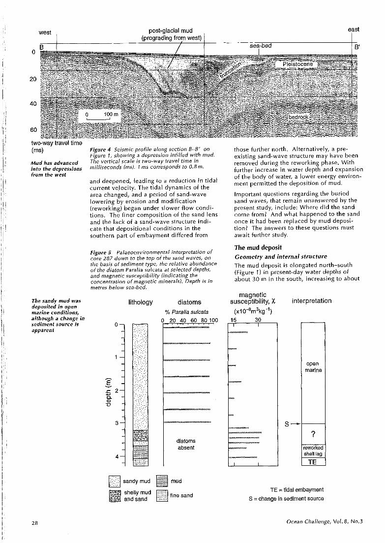
west post-glacial mud east (prograding from west) 1
B / sea-bed
two-way travel time (ms)
Mud has advanced into the depressions from the west
The sandy mud was deposited in open marine conditions, although a change in sediment source is apparent
Figure 4 Seismic profile along section 13-6' on Figure 1, showing a depression infilled with mud. The vertical scale is two-way travel time in milliseconds (ms). 1 ms corresponds to 0.8 m.
and deepened, leading to a reduction in tidal current velocity. The tidal dynamics of the area changed, and a period of sand-wave lowering by erosion and modification (reworking) began under slower f low condi- tions. The finer composition of the sand lens and the lack of a sand-wave structure indi- cate that depositional conditions in the southern part of ernbayment differed from
Figure 5 Palaeoenvironmental interpretation of core 287 down to the top of the sand waves, on the basis of sediment type, the relative abundance o f the diatom Paralia sulcata at selected depths, and magnetic susceptibility (indicating the concentration of magnetic minerals). Depth is in metres below sea-bed.
lithology diatoms
% Paralia sulcata
diatoms absent
sandy mud mud
fine sand
those further north. Alternatively, a pre- existing sand-wave structure may have been removed during the reworking phase. With further increase in water depth and expansion of the body of water, a lower energy environ- ment permitted the deposition of mud.
Important questions regarding the buried sand waves, that remain unanswered by the present study, include: Where did the sand come from? And what happened to the sand once i t had been replaced by mud deposi- t ion? The answers to these questions must await further study.
The mud deposit Geometry and internal structure
The mud deposit is elongated north-south (Figure 1 ) in present-day water depths of about 30 m in the south, increasing to about
magnetic susceptibility, X interpretation
(XI ~ - ~ r n ~ k ~ - ' )
n
TE =tidal embayrnent
S = change in sediment source
S-
Ocean Challenge, Vol. 8 , No.3
open marine
?
reworked shell lag
TE

90m at the northern tip. I t i s narrower in the north (maximum east-west dimension about 13 km) than in the south (about 30 km wide) and has a surface area of about 850 km2. The deposit i s generally thicker in the north (up to 1 Om) than the south (up to 5 m) but reaches 20m in isolated depressions (cf. Figure 4). The volume of sediment preserved has been calculated to be about 3.2 x 10⁹m3.
Two areas of infilled depressions have been identified in the deposit, one to the east of the River Wear and the other further south towards the River Tees. The bases of the infilled depressions reach a maximum depth of 20 m below the sea-bed. These depressions follow those in both the underlying Pleistocene sequence and the underlying Permo-Triassic bedrock (Figure 4). They may have initially formed by subsidence, possibly controlled by bedrock faulting (?perhaps small grabens) or by collapse of solution cavities in a bedrock (Upper Permian) lime- stone. A sub-glacial scour origin is not inferred because i t i s l ikely that the depres- sion would have been filled, not draped, by Pleistocene sediments prior to the onset of the post-glacial transgression. The internal structure of the mud shows that sediment has prograded (i.e. advanced) into the depres- sions from the west. Subsidence had ceased prior to mud deposition, allowing the depres- sion to f i l l up with sediment. Also, seismic reflection profiles indicate that layers laid down in the Pleistocene are truncated on the eastern side of the depression (Figure 4) indicating a period of erosion there (possibly tidal scour), before deposition of the mud.
Palaeoenvironmental interpretation
The environmental conditions in which the mud was deposited were investigated using diatoms, mineral magnetics and dino- flagellate cyst analysis, the latter combined with radiocarbon dating of i n si tu shell material. Dinoflagellate cysts, like pollen, are resistant to decay, and being preserved in the fossil record they can be used in inter- pretation of palaeoenvironmental change.
Diatoms and mineral magnetic properties were analysed from two LOIS cores in the vicinity of the buried sand waves (284 and 287, see Figure I ) , and these both contained a sequence of sandy mud (>3 m thick) over- lying a thin layer of mud and a layer of reworked shells. Both the cores exhibit similar diatom assemblages, dominated by Paralia sulcata which suggests open marine environments similar to those at present (Figure 5). Diatoms have not been recovered in core 287 below 3.25 m.
Both cores also exhibit similar mineral magnetic properties. Core 287 shows an abrupt change in magnetic characteristics at 3.25 m; the change is most noticeable in the parameters related to concentration of magnetic minerals, for example magnetic susceptibility (x) (Figure 5). Above 3.25 m, the sandy mud is characterized by relatively
concentration in sediment of 14c age water copper, lead and boron
(yrs BP) mass (normalized to lithium) 0 1 2 3
Figure 6 Hydrodynamic interpretation of dinoflagellate cyst assemblages, and sediment geochemistry, in core 97, south of the sand lens. On the basis of characteristic dinoflagellate assemblages (zones I-V), the water masses from which deposition occurred have been interpreted as being similar to English Coastal Water (ECW) and Scottish Coastal Water (SCW). Changes in concen- tration of copper, lead and boron with depth correlate with changes in the overlying water mass (concentrations are normalized to lithium to correct for variations in grain size). The abrupt increase in lead near the top of the core is attributed to 19th century lead mining (see overleaf). Depth is in metres below sea-bed.
low concentrations of magnetic minerals, whereas below 3.25 m, in the basal mud, the concentration of magnetic minerals i s signifi- cantly greater. This change in magnetic properties may relate to a change in sediment source - different rocks being eroded or sediment-bearing currents coming from elsewhere - possibly controlled by circula- tion changes in the area during the initial rapid post-glacial rise in sea-level.
Dinoflagellate cysts were analysed from core 97, dri l led further south (Figures 1 and 6). The assemblages can be related to two hydro- graphically distinct water masses along the east coast of the UK at present, namely English Coastal Water (ECW) and Scottish Coastal Water (SCW), the latter being influ- enced by the influx into the North Sea of North Atlantic water. SCW i s characterized by salinities of 34-35, temperatures ranging from 5.5 OC in February to 14OC in August, and medium to high turbidity. ECW i s characterized by salinities of 34-34.5,
Post-glacial marine conditions in the northern North Sea have been dominated by water masses similar to English Coastal Water and Scottish Coastal Water
Ocean Challenge, Vol. 8 , No.3
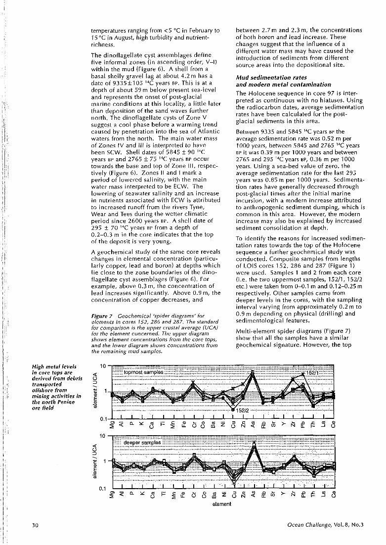
High metal levels in core tops are derived from debris transported offshore from mining activities in the north Penine ore field
temperatures ranging from <5 "C in February to 15 "C in August, high turbidity and nutrient- richness.
The dinoflagellate cyst assemblages define five informal zones (in ascending order, V-I) within the mud (Figure 6). A shell from a basal shelly gravel lag at about 4.2 m has a date of 9335+105 14C years BP. This is at a depth of about 59 m below present sea-level and represents the onset of post-glacial marine conditions at this locality, a little later than deposition of the sand waves further north. The dinoflagellate cysts of Zone V suggest a cool phase before a warming trend caused by penetration into the sea of Atlantic waters from the north. The main water mass of Zones IV and Ill i s interpreted to have been SCW. Shell dates of 5845 + 90 14C years BP and 2765 + 75 14C years BP occur towards the base and top of Zone 111, respec- tively (Figure 6). Zones II and I mark a period of lowered salinity, with the main water mass interpreted to be ECW. The lowering of seawater salinity and an increase in nutrients associated with ECW i s attributed to increased runoff from the rivers Tyne, Wear and Tees during the wetter climatic period since 2600 years BP. A shell date of 295 + 70 14C years BP from a depth of 0.2-0.3 m in the core indicates that the top of the deposit is very young.
A geochemical study of the same core reveals changes in elemental concentration (particu- larly copper, lead and boron) at depths which l ie close to the zone boundaries of the dino- flagellate cyst assemblages (Figure 6). For example, above 0.3 m, the concentration of lead increases significantly. Above 0.9 m, the concentration of copper decreases, and
Figure 7 Geochemical 'spider diagrams' for elements in cores 152, 286 and 287. The standard for comparison is the upper crustal average (UCA) for the element concerned. The upper diagram shows element concentrations from the core tops, and the lower diagram shows concentrations from the remaining mud samples.
between 2.7 m and 2.3 m, the concentrations of both boron and lead increase. These changes suggest that the influence of a different water mass may have caused the introduction of sediments from different source areas into the depositional site.
Mud sedimentation rates and modern metal contamination The Holocene sequence in core 97 is inter- preted as continuous with no hiatuses. Using the radiocarbon dates, average sedimentation rates have been calculated for the post- glacial sediments in this area.
Between 9335 and 5845 14C years BP the average sedimentation rate was 0.52 m per 1000 years, between 5845 and 2765 14C years BP i t was 0.39 m per 1000 years and between 2765 and 295 14C years BP, 0.36 m per 1000 years. Using a sea-bed value of zero, the average sedimentation rate for the last 295 years was 0.85 m per 1000 years. Sedimenta- tion rates have generally decreased through post-glacial times after the initial marine incursion, with a modern increase attributed to anthropogenic sediment dumping, which is common in this area. However, the modern increase may also be explained by increased sediment consolidation at depth.
To identify the reasons for increased sedimen- tation rates towards the top of the Holocene sequence a further geoche-mical study was conducted. Composite samples from lengths of LOIS cores 152, 286 and 287 (Figure 1 ) were used. Samples 1 and 2 from each core (i.e. the two uppermost samples, 15211, 15212 etc.) were taken from 0-0.1 m and 0.1 2-0.25 m respectively. Other samples came from deeper levels in the cores, with the sampling interval varying from approximately 0.2m to 0.9m depending on physical (drilling) and sedimentological features.
Multi-element spider diagrams (Figure 7) show that all the samples have a similar geochemical signature. However, the top
S Z a Y 0 C Q F ~ $ b Q c O ~ 3 & ~ ~ $ > f i f g ? 8 element
Ocean Challenge, Vol. 8 , No.3

0.25 m of all the cores, with the exception of 15212, show relatively high zinc and lead concentrations. Sample 15211 i s distinct i n showing the highest levels of copper, zinc, yttrium, zirconium, lead, thorium, lanthanum and cerium. Sample 15212 also contains relatively high levels of zirconium and slightly enhanced lead. Core 152 i s from a site near the coast (Figure 1) and the high element levels probably derive from mining debris related to lead-zinc mining in the north Pennine ore field, which i s known to contain enhanced concentrations of rare earths in addition to the main ore-forming elements. The relativelv high lead and zinc , " values from the tops of other cores are also considered to be a result of mining or other industrial activities. However, the relatively high levels of zirconium in the top 0.25 m of core 152 do not seem to be directly related to anthropogenic contamination, remaining high in sample 15212 whereas other enhanced metal levels are lower (Figure 7). This could indicate a change in source for the uppermost sediment in core 152, but the relationship to similar changes postulated in core 97 i s not clear.
Conclusions As the northen North Sea fi l led with water at the end of the last glaciation, strong tidal currents reworked sandy sediments in a growing embayment offshore Northumbria. In the north, these sands were sculpted into sand waves. As the embayment widened and deepened, tidal currents became weaker, allowing the deposition of mud that now overlies the sand. The mud deposit i s gener- allv UD to l O m thick but reaches 20m in
I I
several depressions, possibly formed by bed- rock subsidence. The oldest muds (c. 9335 years BP) were deposited in relatively cool water. Cool conditions ended with the arrival of warmer Scottish Coastal Water, which was followed by lower salinity English Coastal Water a little after 2765 years BP.
Mud sedimentation has been continuous throughout post-glacial times, although changes in sediment sources, related to changes in water mass, are apparent. Con- tamination of the uppermost sediments has occurred as a result of debris transported from onshore mining and other anthropogenic activities. However, i t i s not clear whether deposition of mining debris has affected sedimentation rates.
Acknowledgements Thanks are due to the staff of Marine Opera- tions Group, British Geological Survey, and the crew and officers of the RRS Challenger and M V Kommandor Ther&se for collection of the LOlS seismic profiles and cores. This is LOlS Publication Number 314 of the LOlS Community Research Programme. Published with the permission of the Director, British Geological Survey (NERC).
Further reading Brew, D.S. (1996) Late Weichselian to early
Holocene subaqueous dune formation and burial off the North Sea Northumberland coast. Marine Geology, 134, 203-1 1.
Harland, R. and Long, D. (1 996) A Holocene dinoflagellate cyst record from offshore Tyneside, North Sea. Proceedings o f the Yorkshire Geological Society, 51, 65-74.
Harrison, D.J. (1 988) Farne, Sheet 55"N OZOW, Quaternary Geology. British Geologi- cal Survey, 1 : 250 000 series.
Pantin, H.M. (1 986) Tyne-Tees, Sheet 54"N 02"W, Sea bed Sediments and Quaternary Geology. British Geological Survey, 1 : 250 000 series.
David S. Brew* and John Ridgway* are, respec- tively, a coastal geologist and geochemist at the British Geological Survey. They are both participants in N ERCrs Land-Ocean l nteractive Study to investigate material fluxes between UK river catchments and the North Sea.
Rex Harlandt is a consultant micropalaeont- ologist interested in the use of dinoflagellate cysts in environmental reconstruction.
David Long** is a marine geologist at the British Geological Survey. He works mainly on sea-bed geohazards in deep water but i s also interested in environmental studies.
Matthew R. Wrighttt is a geomorphologist with interests in coastal environmental change.
*Coastal and Engineering Geology Group, British Geological Survey, Keyworth, Nottingham, NG12 5GG Email: [email protected] and j.ridgway8bgs.ac.uk
tcentre for Palynological Studies, University of Sheffield, Mappin Street, Sheffield, S1 3JD and DinoData Services, 50 Long Acre, Bingham, Nottingham, NG13 8AH Email: rexharland8msn.com
**Marine Geology and Operations Group, British Geological Survey, West Mains Road, Edinburgh, EH9 3LA Email: d.long8bgs.ac.uk
ttDepartment of Geography, University of Liverpool, PO Box 147, Liverpool, L69 3BX Email: m.r.wright8durham.ac.uk
Ocean Challenge, Vol. 8 , No.3

Peter Rainbird
Tidal smooths (Figure 1 ) are relatively narrow sinuous regions of smooth unrippled water and are characteristic features of many estuaries. They show a marked alignment with the f low of the tide and, in the vast majority of cases, are associated with changes in the bottom topography of the channel. Smooths are basically frontal zones dividing water masses with differing temperature and/or salinity; they are also convergence zones where surface water descends before diverging again lower down in the water column Their smooth appearance i s a result of the accumulation of oi ly organic material, some of which i s dragged down through the water column. The formation of many tidal smooths can be shown to result from a transverse density gradient due to cross-channel variations in the speed of the tidal wave.
The distinguishing feature of a tidal smooth i s a lack of small ripples, or capillary waves, of wavelength 0.1 m, or less, on the water surface. Longer wavelength waves seem unaffected by these zones of surface conver- gence and are able to pass through the
Tidalsmooths are smooth with no apparent degradation. Any easily recognized
buoyant material brought into the smooth by the action of converging surface currents accumulates on the water surface. Any light organic fractions wi l l produce a thin oily layer, which serves to reduce the water surface tension, possibly by up to as much as 20% in extreme cases. The restoring force for capillary waves i s surface tension: i f the surface tension is reduced, then capillary waves cannot exist.
Some of the material brought into the smooth (especially the heavier organic fractions) is taken below the surface as a result of downwelling (and of being mixed down by longer wavelength surface wave action), and it can be detected as a line or band of in- creased acoustic density on an echo-sounder trace (Figure 2). The concentration of mate- rial (shown by the density of the black line) decreases with depth below the surface due to dispersive effects.
As this downwelling produces a zone of increased organic matter concentrations, i t would seem reasonable to assume that overall biomass concentrations would be elevated in the vicinity of tidal smooths. In 1862, it was reported to the Belfast Natural History and Philosophical Society that, 'shoals of herring were much more abun- dantly met with under smooths than any- where else'. Additionally, observers of
Figure 1 A tidal smooth on along the northern edge of the River Blackwater.
32 Ocean Challenge, Vol. 8 , No.3

Figure 2 Echo-sounder trace through a smooth in the River Blackwater; the vertical line extending from the surface above the change of slope a t the bed is due to the material carried down into the convergence zone of the smooth. (The scales are approximate.)
basking sharks on the west coast of Britain have noted that in many case, the sharks fol low the lines of smooths whilst feeding on plankton.
The physical appearance of tidal smooths changes with the seasons. During the winter, when organic productivity i s at its lowest, tidal smooths are much more difficult to distinguish from the surrounding water than during the spring/summer. Sometimes in extreme weather they are only marked by ice floes or (especially in more recent times) by the congregation of non-organic material, such as cans, bottles, plastic bags, etc. This implies that the circulatory system i s still functioning normally, but that there i s insuffi- cient accumulation of organic material to reduce the water surface tension significantly and damp the capillary waves to any great degree.
Historical background The existence of tidal smooths has been known to the fishing and barging communi- ties of the Thames Estuary for centuries. There was no great desire to investigate the nature of this phenomenon: i f asked why smooths formed, people tended to reply: 'Because they do.' However, tidal smooths were useful because i t was known that they often marked sharp changes in depth, and could thus be used as navigational aids.
The late Michael Frost (owner of Boadicea, built in 1808 and perhaps the oldest commer- cial boat s t i l l sailing in western Europe) tells of the time he was working on a Thames spritsail barge. He learned that i t was impor- tant to be in the correct 'tide lane' in order to gain the best advantage from the tide, espe- cially when the wind was light. If in the wrong tide lane, a barge may be forced to the wrong side of a sand bank or may not be able to sail against a hard-running tide. These 'tide lanes' are separated by tidal smooths. If i t is known which smooth i s being followed, it is possible to navigate with a great deal of accuracy, employing both sail and tide. Inevitably, since the advent of the internal combustion engine and electronic naviga- tional equipment, the importance of these features for navigation has decreased.
Tidal smooths were first brought to the attention of the academic community in 1882 in a paper by James Thompson, who believed that the 'lines of glassy water, usually long and sinuous, which are often to be seen extending over the surface of a sea darkened elsewhere by a ripple,' were due to surface currents flowing together acting as dampers for the small 'ripple undulations'.
The position of convergences
Unlike the surface slicks described by seems to be Langmuir in 1938, which are generated bv, related to andUalign with, thk wind, tidarsmooths wLre sharp changes always seen to occur in the same place and in the depth
with the same orientation regardless of the of the bed
wind direction. The only factor which appeared to affect them was the motion of water in the channel: i f the motion ceased (for example, at the turn of the tide) the smooth disappeared.
In 1929, Jeffries had found that in a straight channel there are downwelling areas near the centre and upwelling areas near the shores, but he was unable to explain the resulting transverse circulation on the basis of hydro- dynamic theory. The spiral f low concept of Langmuir circulation was developed further in 1968 by Houbolt who observed that in the southern North Sea, tidal currents were slower over the crests of sand banks than in the deeper water between them; he con- cluded that velocity shears between water flowing over sand banks and water flowing in the channels are responsible for a spiralling secondary circulation.
In 1985, Richard Nunes and John Simpson observed transverse secondary circulation involving surface convergence in the Conwy (a well-mixed estuary in North Wales), made visible by the collection of surface material
Ocean Challenge, Vol. 8, No.3
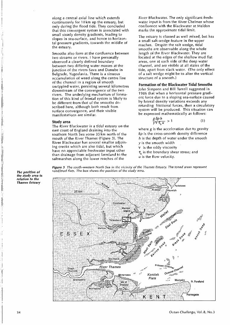
along a central axial l ine which extends continuously for 10 km up the estuary, but only during the flood tide. They concluded that this convergent system i s associated with small steady density gradients, leading to slopes in sea-surface, and hence to horizon- tal pressure gradients, towards the middle of the estuary.
Smooths also form at the confluence between two streams or rivers. I have personally observed a clearly defined boundary between two differing water masses at the junction of the rivers Sava and Danube in Belgrade, Yugoslavia. There is a sinuous accumulation of weed along the centre line of the channel i n a region &f smooth unrippled water, persisting several kilometres downstream of the convergence of the two rivers. The underlying mechanism of forma- tion of this kind of frontal system i s likely to be different from that of the smooths de- scribed here, although both result from surface convergence, and their visible manifestations are similar.
Study area The River Blackwater i s a tidal estuary on the east coast of England draining into the southern North Sea some 35 km north of the mouth of the River Thames (Figure 3). The River Blackwater has several smaller adjoin- ing creeks which are also tidal, but which have no appreciable freshwater input other than drainage from adjacent farmland to the saltmarshes along the lower reaches of the
River Blackwater. The only significant fresh- water input i s from the River Chelmer whose confluence with the Blackwater at Maldon marks the approximate tidal limit.
The estuary i s classed as well mixed, but has a small salt-wedge feature in the upper reaches. Despite the salt wedge, tidal smooths are observable along the whole length of the River Blackwater. They are located at the edges of the shallow mud flat areas, one at each side of the deep water channel, and are visible at all states of the tide, apart from slack water. (The only effect of a salt wedge might be to alter the vertical structure of a smooth.)
Formation of the Blackwater Tidal Smooths John Simpson and Bil l Turrell suggested in 1986 that when a horizontal pressure gradi- ent force due to a sloping sea-surface caused by lateral density variations exceeds any retarding frictional forces, then a circulatory system w i l l be produced. This situation can be expressed mathematically as follows:
where g is the acceleration due to gravity 6p i s the cross-smooth density difference h is the depth of water under the smooth y is the smooth width
,
v i s the eddy viscosity rb is the boundary shear stress; and u is the f low velocity.
Figure 3 The south-western North Sea in the vicinity of the Tharnes Estuary. The toned areas represent
The oosition of sand/rnud flats. The box shows the position of the study area.
the &udy area in relation to the Thames Estuary
3 4 Ocean Challenge, Vol. 8, No.3

On the basis of profiles of velocity and of temperature and salinity (to obtain density) at various points in the River Blackwater, a mean value for the expression in equation (1) was found to be in excess of three, indicating that a circulatory system w i l l exist. Observa- tional evidence (Figure 2 ) indicates that the circulatory pattern consists of surface conver- gence with, presumably, a divergence at depth.
Another prominent feature of a tidal smooth i s a velocity shear across the slick, with lower tidal velocities on the shallow-water side. The late Michael Frost suggested that a smooth becomes visible on the surface (i.e. the convergence w i l l be strong enough to cause significant organic accumulation and hence surface tension reduction) when the square of the surface tidal velocity on the deep-water side of the smooth, v , is twice the square of the surface tidal ve[bcity on the shallow-water side of the smooth, vS. Figure 4, a plot of vd2 against vs2 for data collected in this study, has a gradient approximately equal to two, suggesting that this relationship between tidal velocities has to be satisfied before the smooth can form.
If the limits on tidal wave speed are consid- ered, this speed difference can be equated to a density difference. The tide is a shallow- water wave and, as such, the speed of the tide, vt i s governed by the shallow water wave equation:
where g is the acceleration due to gravity and h i s the depth of water. Thus, water f lowing in deeper parts of the estuary (e.g. in a channel) wi l l have a higher tidal velocity than water in a shallower parts, such as mud flats. In other words, interaction with the bottom has a greater retarding effect on the shallower flow.
Consider an idealized situation with an estuary containing a deep channel and shallow region, separated by a barrier to prevent mixing, and with the water initially at rest with a horizontal surface. As the tide starts to flood, higher tidal velocity in the deeper parts wi l l cause the water surface to rise more quickly than in the shallower parts. Also, water with higher salinity w i l l intrude further up the estuary when the tide floods. Due to the difference in water level and hence hydro- static pressure, a horizontal pressure gradient w i l l be set up, amplified by the increased density gradient caused by the salinity difference between river water and seawater.
Removal of the hypothetical barrier w i l l allow the two water masses to come into contact. High salinity water w i l l 'spill over' on to the lower salinity water and, being denser, w i l l sink, and a secondary circulation system w i l l evolve because of the requirements of conti- nuity. The reverse wi l l occur on the ebb tide, when there i s relatively low salinity water in the channel (which can drain faster); and the pressure gradient force is directed towards the centre of the estuary.
-0 0.05 0.1 0.15 0.2 0.25 (velocity on shallow side)2, vl (m2s-2)
Figure 4 Relationship between tidal velocities on Velocity shear either side of a smooth. The diamonds represent and smooth- data from the River Blackwater. formation are
related
In a real estuary or creek, this mixing process occurs constantly and a smooth wi l l probably form only when the difference between shallow and deep water tidal velocities is at a critical value (cf. Figure 4). This may serve to explain why smooths are more clearly de- fined during spring tides, when the tide runs faster than during neap tides and the absolute difference between the shallow and deep water velocities i s greater.
In the River Blackwater, a distinguishing feature of a smooth marking the edge of the mud flats is the difference in the appearance of its edges on flood and ebb tides. On the flood tide, the smooth has a sharp, distinct edge on the deep-water side, but an indis- t inct edge on the shallow (mud-flat) side of the smooth, giving the impression that the smooth i s merging with the rippled water. This situation is reversed on the ebb tide.
These differences are probably due to the relationship between flow velocity and water depth. As the tidal wave propagates faster in the deeper water of the channel, water 'spilling off' the higher level of the deep water f low (on the flood tide) to adjust the level difference, w i l l produce a zone of increased convergence and hence increased definition of the boundary of the smooth. During the ebb tide, by contrast, the deeper channel w i l l drain faster than the shallower water over the mud flats on each side, so there w i l l be increased cross-channel flows from the mud flats to the deep channel. Thus, the sharper edge on one side of the smooth results from strong convergence, whilst on the other side, where the edge of the smooth can spread out over the water surface, the convergence i s weaker. This cross-estuary transfer of momentum allows the shallow sections over the mud flats (which are less efficient at transporting water in the along-channel direction) to drain and f i l l at roughly the same rate as in deeper
Ocean Challenge, Vol. 8, No.3

Smooths appear to coincide with features of bottom topography
sections of the channel. If this were not the case, the cross-channel difference in surface elevation would be significantly greater.
It has been observed that smooths can change position over a period of time. Perhaps the best example of this in the River Blackwater i s the smooth which runs from the point of O ld Hall Marsh (see Figure 5). As soon as the tide starts to ebb, this smooth forms and runs from O ld Hall Marsh, crossing Mersea Quarters and meeting the smooth which runs to the south of Cobmarsh. Approximately one hour after high water, the smooth weakens, breaks down and dissipates, and then re-forms so that it joins the smooth along the northern edge of the Nass.
For the first hour of ebb, all the water from the creeks surrounding Mersea Island runs out of Besom Fleet, whilst there i s still slack water, or very little tidal flow, in the other creeks of Mersea. Tide flowing out of Tollesbury forms the first smooth as i t meets the water in the south-east end of Mersea Quarters. After one hour of ebb, the mud flats have dried sufficiently to effectively block the route through Besom Fleet, so that the tide runs out mostly through Mersea Quarters. This breaks down the original smooth which then realigns itself, separating the flows from Tollesbury and Mersea. Although the smooth breaks down at the south-east end of Mersea Quarters, i t still exists within Tollesbury Creek both before breakdown and after re-formation. Thus, it i s effectively still the same smooth.
I t i s apparent that driftwood and other buoyant debris remain in approximately the same area in the same tide lane for some three to four days, before disappearing. This observation led to the idea that water leaving a creek does not randomly mix with the main estuarine f low as i t meets it, but follows a well defined path whose boundaries are marked by tidal smooths, and mixing w i l l
Figure 5 Chart showing a part of the River Blackwater. The toned lines are the edges of the mudflats/sand flats.
only take place at these boundaries. Smooths associated with this process do not necessar- i ly have an obvious connection with estuar- ine bathymetry, although their origins can be traced back to the channel edges of their source creeks.
Such 'mixing' smooths allow water to be transferred from one tide lane to another at a rate,determined by the density difference across the smooth. To a large extent, this density difference wi l l be determined by such factors as freshwater run-off from adjacent land and suspended sediment concentrations, in addition to salinity differences due to the progress of the tidal wave. Once the density difference between the two water masses on either side of the smooth is reduced below the critical value for smooth formation (see equation I ) , then the smooth wi l l disappear. This may serve to explain why smooths which are visible for some distance down- stream of a creek mouth, disappear over a short distance (1 00-200m), gradually spread- ing so that there i s less distinction between 'smootht water and the more normal rippled water surface.
For large creeks, these 'mixing' smooths may persist for up to 8 km downstream from the creek mouth i f the wind stress is insufficient to destroy the surface layer. This was ob- served after a week of very calm weather (July 1991) when, one morning, instead of the usual three smooths, eight were visible in the Blackwater Estuary downstream of the Nass Beacon (Figure 5). Each of these smooths was traceable to its source creek or channel: the main estuary, Besom Fleet, Mersea Quarters and Tollesbury Creek all had a pair of smooths, one smooth from each side. Water was flowing out of these channels and creeks and, because of the very calm conditions with little surface mixing by the wind, the smooths persisted for a greater distance.
Ocean Challenge, Vol. 8, No.3

The largest and most prominent smooth in the River Blackwater runs down the centre of the estuary, eastward from the Nass during the ebb tide, and originating from the conver- gence of the two smooths marking the edges of the Nass during the ebb. Beyond the Nass Beacon, this smooth has no association with any marked change in the bottom topography. There were many cases during this study when high winds obliterated all traces of the smooths in the estuary, apart from this one, which must imply that i t i s associated with the most vigorous secondary circulation.
This is the only incidence I have observed in the River Blackwater of a smooth occurring in the centre of the channel. Generally, the usual two channel-edge smooths are visible in addition to this extra smooth, making a total of three. The Conwy estuary has only a single smooth, which is aligned along the central axis of the channel and disappears during the ebb tide - whereas the smooths in the Blackwater are seen on both flood and ebb tides. It is likely that this difference in the observed number of smooths i s related to the aspect ratio of the channel cross-section. The Conwy i s relatively deep compared to its width, whilst the River Blackwater is essen- tially a very wide, shallow expanse of water. Tidal range may also be a factor: at spring tides i t is about 7 m in the Conwy, about 4 m in the River Blackwater.
Additionally, the increased variation of the topography of the Blackwater may have an effect on the generation of smooths by pro- viding the potential for transverse pressure gradients to form. However, no data exist to support this hypothesis.
If it is assumed that the scale of the circula- tion is a function of the hydrodynamic prop- erties of the fluid, then it can be inferred that the size of the circulatory cell produced as a result of mixing processes would be of a similar size in both estuaries. If this i s the case, i t may be that the narrow deep channel of the Conwy can only support a single circulatory system of two counter-rotating cells, whilst the wider River Blackwater i s able to support a greater number of such cells. However, i t should be noted that this i s pure conjecture which cannot be substanti- ated without further detailed measurements of the two estuaries. Additionally, this hypothesis does not explain why smooths in the Conwy are only visible on the flood tide whilst in the River Blackwater they are visible on both the flood and ebb tide. What is clear is that both phe- nomena are variations on the same theme.
The main difference between the two situa- tions appears to be that the central smooth in the Conwy results from a transverse pressure gradient force directed towards the centre of the channel, whilst the channel-edge smooths in the Blackwater imply pressure gradients in the opposite direction. This difference could in part be related to the aspect ratio of the channel cross-section, as noted above.
Furthermore, the greater variation in the topography of the Blackwater may have an effect on the generation of smooths by provid- ing more potential for transverse pressure gradients to develop. Again, there are no data with which to test this hypothesis.
Water movements along the axial front in the Conwy have been both measured and mod- elled in some detail, but this has not yet been done for the Blackwater smooths, so far as I am aware. In the Conwy, the effects of fric- tional resistance to the f low would be ex- pected to show significant variations across the channel, with relatively high resistance at the channel edges, mainly due to bank effects, and reduced friction in the mid- channel region As a result of this, the main determin- ing factor for the circulation in the Conwy may be the cross-channel variation in fric- tional resistance, producing variations in the water surface elevation due to retardation of the tidal wave, with a possible minor contri- bution from the relatively high density of an advancing saline intrusion. Conversely, the Blackwater would be expected to show a more uniform distribution of frictional resist- ance across the channel, so here the circula- tory system may be determined mainly by cross-channel density variations, with only a small contribution from frictional influences.
Concluding comments This article is only a general description of the flows in the Blackwater estuary. Its scope was limited by funding available at the time, which has now unfortunately ceased. There are several outstanding areas of research which I feel require investigation. More detailed profiles should be made of tempera- ture, salinity and flow velocity in order to understand fully the hydraulics of the f low and the movement of water masses. The critical factors for smooth-formation require quantification in order that smooth generation can be predicted, ideally in a numerical model.
Mixing rates between water masses should also be studied in order that a residence time for water can be determined for individual tide lanes. This has particular importance in the River Blackwater as there are at least two sewage outfalls in the estuary, and we have little idea about how long sewage remains in the shoremost tide lane before being either mixed out into the main river or washed ashore.
Apart from the mixing smooths, the tidal smooths observed in this study are analogous to the axial fronts of Nunes and Simpson, dividing the estuary into distinct water masses; but they occur in different locations with respect to the geometry of the estuary and are visible at all states of the tide, except slack water. The fact that the convergences generated by density gradients lead to increased amounts of organic material in these sinuous regions i s of importance to biologists studying plankton concentrations and fish stocks.
Ocean Challenge, Vol. 8, No.3

The study of secondary circulation in tidal Acknowledgements estuaries thus has considerable practical I would like to thank the following people for potential. From my own research and per- their help: sonal experience, the f low of the tide i s not the late Michael Frost for his enthusiasm in only extremely complex, but an incredibly attracting my interest in the subject initially, fascinating study. and his widow, Martha, for allowing access
to some of his unpublished papers; . . Wil l iam Baker, Wil l iam Reid and the late John Frost, fishermen and oystermen of West Mersea for their assistance during field work, their discussion of ideas and for pointing out when my theories did not seem to work in the 'real world';
Drs John Green (UEA), Karen Heywood (UEA) and Alec James (UMIST), for supervision of my work in this project while I was an undergraduate, and for their willingness to discuss any problems or new hypotheses.
Further Reading Belfast Natural History and Philosophical
Society, 1862, Proceedings, May 7. Jeffries, H. (1 929) Proceedings o f the Cam-
bridge Philosophical Society, 25, 20. Langmuir, I., (1938) Surface motion of water
induced by wind, Science, 87, 11 9-23. Nunes, R. A. and Simpson, J. H. (1 985) Axial
convergence in a well mixed estuary, Estuarine, Coastal and Shelf Science, 20, 637-49.
Simpson, J. H. and Turrell, W. R. (1986) in Physics o f Shallow Estuaries and Bays, Volume 16 (Ed. Van de Kreeke, 1.).
Thompson, J. (1 862) On the calm lines often seen on a rippled sea, Philosophical Magazine, 4th Series, 24, 247-48.
Peter Rainbird init ial ly developed an interest i n tidal smooths whilst studying for his first degree at the School of Environmental Sciences, University of East Anglia, where the data for this paper were collected as part of a final year project. The study was, unfortu- nately, not pursued during study for a Ph.D. in applied fluvial dynamics, working on the development of a numerical model to simu- late erosion and sediment transport processes in river channels, again at UEA. Since then,
the author has spent two years modelling statistical distributions of wind speeds and turbulent f low for a wind farm development company. He is currently working as a software engineer and analyst programmer for the scientific software consultancy of Tessella Support Services based in Abingdon, Oxon.
Peter may be contacted via Email on peter8drsrainbird.demon.co.uk
Ocean Challenge, Vol. 8 , No.3

Tony Hawkins
I n M a y o f this year, a t a co l d and blustery quayside i n Aberdeen, Her Majesty Queen Elizabeth The Queen Mother named t he n e w Scottish Fisheries Research Vessel, Scotia. Scotia is a multi-purpose, 70 metre, diesel-electric vessel designed by Skipsteknisk o f Alesund No rway and bu i l t o n the Clyde by Ferguson Shipbuilders o f Port Glasgow. Her design combines the essential features o f a modern hydrographic research ship w i t h those o f a top- l ine pelagic and demersal trawler. The four th ship t o bear the name Scotia, she is the latest i n a distinguished l i ne o f research vessels.
The steam yacht, Scotia The first Scotia was a wooden sailing ship which took part in the Scottish National Antarctic Expedition of 1902-04, to the Southern Ocean. The venture was funded by public subscription with much of the money coming from the Coats family of Paisley, manufacturers of sewing threads.
From the start the project was controversial. The end of the 19th century was a time when many expeditions to the Antarctic were being planned. The Scottish expedition was conceived and led by William Speirs Bruce, an experienced polar explorer and fervent Scottish nationalist. The voyage was a distinctly Scottish venture which was opposed by Sir Clements Markham, Presi- dent of the Royal Geographical Society. He referred to /mischievous rivalry' between the Scottish expedition and the much better funded and publicised Discovery expedition led by Robert Falcon Scott, which left for the Antarctic one year earlier. The purpose of the Scottish expedition, however, was not to race for the Pole, or to compete with others, but to carry out systematic oceanographic and meteorological observations in the Antarctic Ocean, and to do so in the name of Scotland. In Bruce's own words:
"'Science' was the talisman of the Expedition, 'Scotland' was emblazoned on its flag."
The Scotia was a strikingly beautiful Norwegian whaler, formerly known as Hekla. Purchased on the advice of Colin Archer, the builder of Fridtjof Nansen's Fram which had earlier drifted across the Arctic Ocean locked into the ice, Hekla had sailed on a Danish expedition to the coast of Greenland in 1891-92. She was in poor condi- tion when she arrived in Scotland and was almost entirely rebuilt by the Ailsa Shipbuilding
Company of Troon under the direction of C.L.Watson, who gave his services entirely free. A barque-rigged auxiliary screw steamer of 400 tons and 140 feet long, she was built of wood throughout and sheathed in greenheart to protect her from the damaging effects of pack ice. She was equipped with a laboratory, good accommodation for scientists and crew, and the latest engines and winches for dredging and trawling.
The voyage of the Scotia, 1902-04
Captained by Thomas Robertson, an experi- enced ice navigator from Peterhead, Scotia left Troon in November 1902. The ship reached the Falkland Islands in January 1903 and then pressed south across what is now known as the Scotia Sea, aiming to reach the unexplored waters of the Weddell Sea before the southern winter set in. After passing the South Orkney Islands, Scotia encountered tightly packed ice at 70" 25's and, to avoid wintering in open pack ice, where scientific work would be very limited, the ship retreated north early in March to winter in the South Orkneys. She anchored off Laurie Island in a large bay, later named Scotia Bay, just before ice jammed the entrance. Within days of arrival, the Scotia was locked in, and remained so until November.
The South Orkney Islands were almost unknown to scientists until the visit of Scotia. However, they provided an ideal location in which to spend the winter and make meteorological observations. The islands are situated on the edge of the ice-bound sea, far to the south of Cape Horn and its storms. Scotia was able to stay with safety within the polar ice, yet in an area rich in seals, birds and marine life. Throughout the winter in the South Orkneys the expedition members made a series of scientific
Ocean Challenge, Vol. 8, No.3


expected, and to the great relief of those left on the islands, bringing with her three Argentinian replacements for the Scottish shore party. Together with Robert Mossman, the expedition's meteorologist, the Argentinian party remained in the South Orkneys for a further winter, the station being ceded to the Government of Argentina with the approval of the British Foreign Office and the Admiralty.
Scotia sailed south from Laurie Island on 22 February 1904, carrying the first mail ever to leave Antarctica, with franked Argentinian postage stamps (to which Falkland Islands or Cape of Good Hope stamps were later added). She sailed farther south across difficult and dangerous waters to encounter a new ice-bound part of the Antarctic continent, named 'Coats Land' by Bruce after the expedition's sponsors. New depth soundings were made in the Weddell Sea, allowing the eastern part of this poorly explored sea to be delineated for the first time. For a while, Scotia became trapped in pack ice at 74' OI'S, and wintering within the ice became a distinct possibility. However, the weather improved, enabling Scotia to break free and sail north, where Bruce was able to explore further the bathymetry and marine biology of the Weddell Sea. The suspected 'Ross Deep' was shown to be an error in the soundings taken by Captain James Clark Ross on an earlier expedi- tion by HMS Erebus. Then, having completed a full programme of scientific observations, Scotia moved out of the Weddell Sea in early April and made for Gough Island, some 200 miles due south of Tristan da Cunha; her route took her to Cape Town, S t Helena, Ascension Island and the Azores, finally anchoring in the Clyde off Millport in July 1904.
The voyage of Scotia lasted 20 months and covered over 23 600 miles (37000 km). It was one of the last Antarctic expeditions in a wooden ship, without the benefit of radio communication or acoustic sounding equip- ment. And there was no provision for a relief ship should the Scotia come to grief. 'We'll have to get out ourselves or stay there for good,' was Bruce's philosophy. However, the voyage was one of extraordinary achievement. The meteorological station established in the South Orkneys was renamed Orcadas and i s still there today, operated by the government of Argentina. It is the oldest scientific base with continuous records in the whole of Antarctica, and plays an important role in monitoring weather conditions far to the south of Cape Horn.
The success of the expedition owed much to the character of Bruce himself. He was a friend of the two greatest polar explorers, Nansen and Amundsen, and had previously visited the Antarctic as naturalist on board the whaler Balaena. He had carried out earlier work in the Arctic, much of i t in the company of Prince Albert of Monaco, founder of the world's first major oceanographic laboratory. He realized that new work in the uncharted Southern Ocean required the application of new techniques and new equipment, and he had ensured that
Scotia carried a greater range of oceano- graphic equipment than any previous Antarctic ship.
Scotia's scientific achievements By the late 19th century exploration of the seas had entered a new phase - it was no longer confined to surface waters, with occa- sional sounding and dredging in deeper water. Skilled designers had invented new instruments for oceanographic work - notably reversing thermometers. water bottles that could be closed at predetermined depths, and more accurate depth-sounding techniques.
A sounding machine on Scotia had been developed by Francis Lucas, who had served on Great Eastern in the first attempt to lay a trans- Atlantic cable in 1856. His machine paid out wire and applied a friction brake when the sounding weight reached the sea-bed. The Scotia machine carried 6000 fathoms [I0973 m] of specially-made, treble-strand wire. The wire terminated in a Buchanan sounding tube, and immediately above it was clamped a Buchanan-Richard water bottle and a Knudsen modification of the Negretti and Zambra reversing thermometer.
New fishing nets and other contrivances for securing samples of marine life had also been devised. Scotia took plankton hauls at the surface, or at depth, using closing nets. The deep-sea trawl was designed in Monaco and constructed so that it was immaterial which side was in contact with the sea-bed. It was at- tached to the ship by a single steel cable, let out at a rate of 1 000 fathoms an hour (1 829 m hrl). It was hauled by a steam winch, but the cable was stored on a drum which had to be wound by six men, three at each handle - an exhausting activity.
Some 150 trawl hauls were taken by Scotia at depths down to 293 m, and 48 deeper hauls were obtained at 1830 to 4575 m, resulting in a collection of Antarctic marine invertebrates which for many years was unmatched by any other expedition. Sea-bed deposits were extensively charted, and pioneering reports produced on Antarctic birds and mammals. The Scotia expedition achieved all its objectives and added substantially to knowledge of the outline of the Antarctic continent, and to the bathy- metry of the Weddell and Scotia Seas. Many of the specimens collected by Scotia are now retained by the National Museums of Scotland, in Edinburgh, and include species of Antarctic fish which were then new to science.
Back home, Bruce was not forgiven by Sir Clements Markham for mounting a separate Scottish expedition and he never received the rewards due to him. The coveted Polar Medal of the Royal Geographical Society was not awarded to the crew of Scotia, as it had been in the case of earlier expeditions. Bruce instead designed his own medal, which was presented to the scientists and a number of the crew.
Ocean Challenge, Vol. 8, No.3

In selecting his scientific companions, Bruce had looked for specific skills, youth and enthusiasm. In choosing his crew he had sought out those with experience in polar waters. There were no brass-bound officers strictly adhering to naval etiquette and routine. The majority of the sailors were experienced Arctic whalers, many of them from Dundee. He paid particular attention to the welfare of the scientists and sailors involved in the expedition and wrote: 'I would like them to regard the ship as their university, as their alma mater in the highest possible sense. Not an institution given in any way to getting through examinations, but as one in which they w i l l be able to study the various phenomena of Nature, without bias from Nature itself.' Bruce's memory i s honoured to this day: the Bruce Memorial Prize i s awarded by the Royal Society of Edinburgh to scientists at the outset of their careers for their notable contribution to research in polar regions.
Scotia's f inal years
After the expedition, Bruce hoped that Scotia would continue to be engaged in oceano- graphic work and especially in the training of students from Scottish universities; but this was not to be. The ship was sold in 1905 to a Dundee whaling syndicate and subsequently sailed for several years to the Greenland whaling fishery. Following the tragic loss of Titanic in 191 2, Scotia, fitted with an early wireless, was used on Atlantic Ice Patrol, again under the command of Thomas Robertson, and during this period returned briefly to scientific work. Extensive meteorological, hydrographic and biological observations were carried out in the iceberg area of the North Atlantic.
Early in the First World War Scotia was sold once more and had a short career as a cargo vessel before she finally caught fire and was run ashore in 191 6 at Sully, Glamorgan, as a wreck. This was an undignified end for so fine a ship, which had carried scientific expeditions
to both ends of the Earth. But the name of the first Scotia is commemorated on the bows of the ships which have succeeded her.
The steam trawler, Scotia The next Scotia was a 150 foot ex-Admiralty Shakespearian class trawler, launched in 1940 by Cochrane and Sons Ltd of Selby. Originally named Fluellen, she was a coal- burner (later converted to oil), powered by a three-cylinder, triple expansion, steam engine. The vessel served initially as a minesweeper off the south coast of England and then in the Mediterranean. The Scottish Home Department acquired her in 1948, as a 'hydrographic-plankton research vessel' and renamed her Scotia. Remarkably, the first commander of the ship was Captain Eillium Alastair Bruce, the son of Wil l iam Bruce, leader of the Scottish National Antarctic Expedition.
The narrow, naval lines of the ship, together with her high superstructure (which was later reduced), made her lively in rough weather, and she was prone to drift i n high winds, making trawling and plankton hauls diff icult to perform. Even when 'dodging' in bad weather her movements were quite violent, and heavy following seas were feared. The crew believed that at least one of her sister ships had turned turtle in a storm. Scotia was not a comfortable ship to sail on. However, despite this and her limited fuel capacity and restricted cruising range, she sailed through- out the North Atlantic on Marine Laboratory business conducting (with an older, pre-war ship, Explorer) a wide-ranging programme of hydrographic research which had been interrupted by the war.
Scotia's survey work
Scotland is located at one end of the sub- marine ridge running through the Faroe Islands and Iceland to Greenland. The ridge separates the deep waters of the Norwegian Sea from those of the Atlantic, and across it water is
The steam trawler Scotia leaving Aberdeen harbour
42 Ocean Challenge, Vol. 8, No.3

exchanged between these two major basins, influencing the climate and productivity of the whole North Atlantic. Surveys along the ridge for the Fishery Board for Scotland had first begun in 1893, when H.N. Dickson had measured the temperature and salinity of the very variable quantities of Atlantic and Arctic water flowing through the Faroe-Shetland Channel. These surveys were later resumed after the First World War and then again after the Second World War, when Scotia continued and expanded an earlier programme of plankton and hydrographic surveys across the ridge along a series of lines: from the Butt of Lewis to Faroe Bank, from Fair Isle to Munken in Faroe, and from Nolser to Muckle Flugga. Today, these survey results form one of the longest time- series of hydrographic observations in the world, and have been invaluable for investiga- tion of long-term oceanographic and climatic changes in the North Atlantic.
From Scotia the Marine Laboratory also carried out pioneering studies of the drifting plants and animals (including fish larvae) that populate the seas around Scotland. Results revealed that water masses of different origin are populated by 'indicator' organisms, which can be used to follow the movements of these water masses of differing fertility, temperature and salinity as they move around Scotland from the North Atlantic and into the North Sea.
Scotia later began a series of cruises to Denmark Strait between Iceland and East Greenland. The waters beyond Iceland are dangerous. On one research cruise in 1954, when Scotia was line fishing for halibut east of Greenland, a violent storm hit the area and the ship endured moun- tainous seas. A continuous watch had to be kept for ice, which bore down on the ship from different directions as the wind changed direc- tion. Bruce was an experienced seaman and navigator, however. Under his command, Scotia also sailed regularly to Rockall Bank and the west of Ireland, as well as across the north- ern North Sea. From 1957 to 1958 the ship took part in the North Atlantic Polar Front Survey, an integral part of the world-wide programme of the International Geophysical Year, sponsored by the International Council for Exploration of the Sea (ICES) and the Inter- national Commission for the Northwest Atlantic Fisheries (ICNAF).
Development of oceanographic instruments,
At the beginning of the steamship Scotia's life William Bruce could have recognized much of her oceanographic equipment, although devel- opments had resulted in greater reliability and precision. The founding of ICES in 1902 and the establishment of an international programme of fisheries work gave great impetus to the further development of oceanographic instru- ments. Scientists working with the ICES Central Laboratory at Kristiania (now Oslo), under the direction of Fridtjof Nansen, had improved the design of water bottles and reversing thermom- eters considerably. Typically, on a cruise in the Faroe-Shetland Channel, Scotia would monitor
temperature, salinity, oxygen and nutrient levels at a range of depths, using water samplers and thermometers tethered to a weighted wire. Samples of plankton would be obtained using vertically towed Hensen and Standard nets, and by towing silk nets horizontally and obliquely. Scientists monitored surface water currents by casting overboard sealed drift bottles, to be picked up days, months and even years later.
Completely new measuring devices were also used, however, which would have gone un- recognized by William Bruce and the earlier oceanographers. In particular, depth was now obtained using the echometer or echo-sounder, rather than by the earlier sounding wires. In the 1920s simple devices had been constructed to make a sharp sound with an electric hammer, and then measure the time taken for sound to travel to the sea-bed and back, thus registering the depth. By the time of the Second World War, efficient high frequency electronic echo- sounders were available, capable of registering the depth of the sea-bed beneath the ship on a continuous paper record. By the 1950s, Scotia was able not only to measure depth with the echo-sounder, but also to register the depth and shape of herring shoals beneath the ship, and to investigate the vertical movements of sound c,
scattering layers of planktonic organisms. New high speed plankton nets had been developed too, allowing samples to be taken while the ship was underway. A new generation of fishery scientists learned their trade on Scotia and pioneered many of the sampling methods we now take for granted.
Scotia served the Marine Laboratory until 1971, operating under the name Scarba for the latter part of that year. Her last cruise as a research vessel ended on 12 November 1971, when she transferred to fishery protection duties. Scarba was withdrawn from service in May 1973 and broken up in November of the same year.
The diesel-electric trawler, Scotia The third Scotia - a purpose-built, diesel- electric trawler, 224 foot long - was launched in March 1971 from the yard of Ferguson Brothers, Port Glasgow, and commissioned in November that year. Scotia carried out her first trawling trials for the Marine Laboratory in March 1972. She was one of three similar ships; the other two were Cirolana, operated by the Lowestoft Laboratory, and Africana, built in Durban in 1981 for the South African Fisheries Ministry.
Early cruises of the third Scotia
One of Scotia's first cruises in 1972 was to West Greenland to investigate the new and growing sea fishery for Atlantic salmon. In the 1960s scientists from the Freshwater Fisheries Labora- tory had shown from tagging experiments that salmon originating in Scottish rivers migrated in the ocean as far as the Faroe Islands and Greenland before returning 'home' to spawn. The rise of a large-scale fishery at West Greenland had therefore caused concern for the survival of the fish. Now, as a result of the
Ocean Challenge, Vol. 8, No.3

pioneering work done at Greenland from Scotia and other vessels, the fishery is regulated by quota and, in most years, those quotas are bought out by angling interests and not taken
Later in her first year of operation, from Septem- ber to November 1972, Scotia took on a new but temporary role serving as a support ship off Iceland during the 'Second Cod War'. Iceland had taken unilateral action in extending her fishery limits, but British trawlers continued to fish there under the protection of the Royal Navy, harassed by Icelandic gunboats. Scotia provided medical and technical back-up for those fishing under these difficult conditions.
New developments
Scotia was one of the first ships to use a hydrau- lic crane to tow plankton nets and other sam- pling systems. Previously, such cranes had been used to lift equipment over the side, but not directly for towing. Progressively, during the life of the ship these cranes were upgraded
The diesel-electric three times, each time getting larger and more Scotia leaving powerful. Scotia also adopted on-board moni- Aberdeen toring of surface temperature, salinity and Photo: T.G. Mclnnes
seawater chemistry, by continuously measuring the characteristics of water pumped into the laboratories from an aperture in the ship's hull.
Scotia was also the first Marine Laboratory ship regularly to take female scientists to sea. Today, this i s taken for granted.
During her successful 26-year working life Scotia continued the research into water circula- tion patterns around Scotland, pioneered by her predecessor. Results showed significant changes in the quantities of deep bottom water flowing from the Norwegian Sea into the North Atlantic. Fluxes of water from one area to another were measured using mechanical, electromagnetic and acoustic current meters moored to the sea-bed. Large oceanic eddies were followed by the satellite tracking of drogues as they spun off to the north, this technique replacing the earlier method of the ship following a single drogue. The techniques employed in these studies would have seemed quite miraculous to William Bruce and his contemporaries.
In her later years, the position of Scotia was routinely determined with great accuracy using a global positioning system (CPS), the speed and direction of currents beneath the ship were measured with an acoustic doppler current profiler (ADCP). CTD probes for measuring conductivity (for salinity), tempera- ture, and depth were used in conjunction with electronically triggered rosette water sam- plers, and replaced the water sampling bottle and reversing thermometer of earlier ships.
Scotia carried computers routinely, and much of the analysis formerly carried out by exer- cise of hand and brain was completed on board, rather than months or even years after completion of the cruise. The combination of electronic instruments with fast, powerful computers enabled much more information to be collected. In the 1950s, up to 12 readings of temperature and salinity were obtained at each isolated station. By the 1990s a CTD operating 25 times per second in l 0 0 0 m of water would give about 90000 measurements of pressure, temperature and salinity. An on- board computer could convert these measure- ments into values of temperature, density, speed of sound, geostrophic velocities and other parameters. A section across the Faroe- Shetland Channel could produce almost nine mil l ion values to process and plot, with the results available within a few hours of the ship completing the section.
Monitoring the seas around Scotland
Crowing national and international concern about marine pollution, and the possible effects of contaminants on marine life, caused the third Scotia to play an increasingly impor- tant role in monitoring the chemistry of the seas around Scotland. From the 1970s Scotia conducted regular surveys of nutrients and contaminants, including metals, petroleum hydrocarbons, and artificial substances such as pesticides and chlorinated hydrocarbons. The
Ocean Challenge, Vol. 8 , No.3

demand for precise and accurate measure- ments of trace quantities of such substances saw the development of ever more complex methods of analysis. Scotia took part i n the monitoring fol lowing a series of major pollu- t ion incidents, including the Piper Alpha fire i n July 1988, the Braer stranding i n 1993 and other major o i l spills. The exploration and development of oi l and gas reserves in the North Sea, and the construction of o i l receiving terminals at Sullom Voe, Flotta, Nigg and the Firth of Forth increased the potential for accidental spills and the risk of chronic environmental pollution. An increasing proportion of Scotia's time was devoted to pollution surveys around the Scottish coast.
Young fish surveys The third Scotia not only replaced the earlier ship of the same name but, particularly from 1984, she also took on the many routine trawl- ing and sampling cruises formerly performed by Explorer, an Arctic trawler which had replaced an earlier ship of the same name in 1956. Her work included surveying the west coast and North Sea for young fish, the trien- nial mackerel surveys, which took the ship
from the coast of Norway down to the Bay of Biscay, and acoustic surveys for pelagic species of fish. As fish stocks became more heavily exploited, wi th some nearing the point of collapse, these independent surveys performed by Scotia became increasingly important to fisheries management.
Final years Management o f Scotia moved forward too, i n l ine w i th the spirit o f the age. In 1991, she was transferred, after publ ic tendering, to be operated b y a private company, Marr Vessel Management Ltd, wh ich took over from the Fleet Support Un i t o f the Scottish Fishery Protection Agency. The Marr family, w i th Dundee whal ing connections, and a long tradit ion of fishing i n North Atlantic waters, continued the practical sea-going traditions o f the ship.
The new research ship, Scotia In a new blue and whi te livery, and w i th the saltire o f Scotland (the cross o f St Andrew) on the bow, the latest Scotia w i l l also be operated for the Mar ine Laboratory Aberdeen by Marr Vessel Management. She w i l l participate i n a
Design features of the new Scotia
The new Scotia is powered by damage to the net. The trawl-deck to be locked to the crane tips close three diesel engines, coupled to i s visible both from the bridge and to the sea- surface, greatly reduc- electrical generators supplying from a trawl control cabin at the ing the potential for damage. power to two electric propulsion motors which are arranged in tandem on a common drive shaft. With all three diesels running there i s sufficient power to tow a large pelagic trawl for mackerel in winter conditions. But the vessel is also able to travel between survey positions at 11 knots using only one diesel generator for economy.
The ship has to operate close to fixed sea-bed positions and around structures like oi l platforms. Her station-keeping abilities are maintained by a combination of the single screw main power drive, an articulated rudder, an omni- directional bow thruster, and a tunnel stern thruster, steered by a dynamic global satellite position- fixing system.
The bridge of the ship allows all- round visibility. A fully instrum- ented autotrawl system facilitates fishing operations, locating the position of the trawl relative to the ship and measuring its dimensions, so reducing the potential for
aft end of the trawl-deck. To enable the vessel to move quickly from one fishing gear to another a series of small hydraulic winches are fitted, so that trawl doors can be changed easily and safely. The two main trawl winches are situated below decks and are supplemented by two net drums above deck, and an auxiliary drum below deck - allowing net repairs to be carried out under cover.
Although the ship is fitted with a stern ramp for trawling, hydrauli- cally operated ramp covers can be put in place, enabling hydro- graphic work to be carried out from a floor directly over the stern. A gamma frame allows equipment to be picked up from the deck and lowered over the stern, and replaces the less versatile A-frame or simple davit of earlier ships. Scotia also has several large cranes and tension-compensated low pressure hydraulic winches to deploy, tow and recover scientific equipment. These specialized cranes allow instrument packages
A drop keel can be lowered three metres beneath the hull of the ship, carrying acoustic transducers for echo-sounding and measuring ocean currents. The drop keel allows the systems to operate well away from the turbulence and entrained air close to the hull. The ship itself i s very quiet, as much of the machinery is placed on resilient mounts, while the hydrau- l ic systems operate under low pressure with large diameter pipework and bends of large radius.
Perhaps the most radical feature of the new Scotia i s a system for locating container laboratories within the main body of the ship. Up to nine containers, five ful l- size and four half-size, can be loaded below decks and coupled to an umbilical carrying a ful l range of services. The laboratories can be adapted and fitted out on shore, at the Marine Laboratory,
Ocean Challenge, Vol. 8, No.3 4 5

Tony Hawkins i s a fish physiologist and Director of the Marine Laboratory, Aberdeen. If you would like further information on the new research ship Scotia, please contact the author using email: hawkinsad8marlab.ac.uk
The latest Scotia undergoing sea trials off Aberdeen Photo: T.G. Mclnnes
Acknowledgements Dr Peter Speak, of the Scott Polar Research Institute provided much information on William Bruce and the first Scotia, while Dr David Munro of the Royal Scottish Geographical Society and Geoff Swinney of the Royal Scottish Museums provided additional details. Sir Cyril Lucas, Jimmy Adams, Dr John Hislop, John Dunn, Norman Nicol and Rodney Payne gave me their recollections of the later Scotias, some of them having now sailed on all three most recent ships. John Morrison has been responsible for the specification and building of the new Scotia, and has tackled the enormous task of commissioning the ship.
varied programme of fish stock assessment and environmental monitoring in the north- ern North Sea and north Atlantic waters, carrying a crew of 17 and up to 12 scientists.
The new Scotia maintains all the features of her predecessors. Although she would be unrecognizable to Wil l iam Bruce and his scientists she has essentially the same char- acteristics as the first Scotia. She is able to operate in cold and inhospitable seas, carry- ing the most advanced scientific sampling systems of her day. She is set to maintain a proud tradition of service.
Further Reading Bruce, W. S. (1 903) The Scotia's Voyage to the
Falkland Islands. By the leader and staff of the Scottish National Antarctic Expedition. Scottish Geographical Magazine, April 1903, 1 69-83.
Rice, A.L. (1 986) British oceanographic vessels 7800-7950. London: The Ray Society (Natural History Museum).
Rudmose Brown, R. N. (1 905) The voyage of the Scotia. Transactions of the Perthshire Society o f Natural Science, IV(II): 63-70.
Rudmose Brown, R. N. (1 923) A naturalist at the Poles. The life, work and voyages of Dr W. S. Bruce, the polar explorer. London: Seeley, Service & Co.
Rudmose Brown, R. N., Mossman, R. C. and Harvey Pirie, J. H. (1 906) The Voyage of the 'Scotia'. Being the record of a voyage of exploration in Antarctic Seas - by three of the staff. Edinburgh: William Blackwood & Sons.
Somner, C. 1983. Scottish fishery protection. The story o f the vessels that have served the Depart- ment o f Agriculture and Fisheries for Scotland since 7882. Kendal: The World Ship Society.
Speak, P. (Editor). (1 992) The log of the Scotia expedition, 7902-04. Edinburgh: Edinburgh University Press.
4 6 Ocean Challenge, Vol. 8 , No.3

iam Hutchinson - Loca
lip \
In the early summer o f 1759, a Liverpool seaman ca l led Mu rphy f rom the New Anson privateer decided t o murder Captain W i l l i am Hutchinson, the former commander o f the Liverpool privateer and recent ly appointed Dockmaster and Water Bail i f f . Mu rphy was heard t o ye l l 'D,,, you, you are a v i l la in ! ' as his pistol mis-fired. H e was led away t o be sentenced t o spend the rest o f his l i fe i n the Navy. Hutchinson, o n the other hand, was t o l i ve o n t o 1801, becoming an impor tant resident o f the t o w n and a f igure o f some importance i n the history o f U K mar ine science and oceanography.
Wil l iam Hutchinson was a remarkable man who was to prove as successful a Dockmaster as he had been a privateer. He was born in 171 5, the same year that the O ld Dock at Liverpool opened (the first commercial 'wet dock' in the world). He rose from being a common sailor to become a privateer captain alongside Fortunatus Wright, the most famous of the Liverpool privateers. He was also at various times a ship-owner, boat-builder, commercial trader, inventor, author and ~h i l an th ro~ i s t .
The only surviving picture of him (an old photograph of a portrait at Liverpool Central Library, now lost) i s shown above. This portrait, presumably painted late in his life, suggests a genial sort of fellow. However, his earlier character i s said to have been more like that of the Puritan seventeenth century than the eighteenth, combining the aggres- sion of privateering with strict religious adherence. He was described at the time as being 'a kindly though firm commander'. However, he must have been something of a disciplinarian, which may have been behind Murphy's grievance. For example, he ab- horred swearing, which must have made life difficult aboard ship.
Some of Hutchinson's many accomplish- ments are listed in the box overleaf. Two aspects of his life are of particular interest to us here at Bidston Observatory (now the Centre for Coastal and Marine Sciences Proudman Oceanographic Laboratory). First, Hutchinson is known to have had an interest i n mirrors and illumination mecha- nisms for lighthouses. He experimented with the construction of large one-piece mirrors up to 12 feet in diameter, and large mirrors made from smaller sections of looking-glass fixed to a wooden backing frame. He also developed oil-fired light apparatus, lighthouses at this time usually being l i t by 'firebaskets' containing wood or coal. The Liverpool Council Minutes record that in 1763 he experimented with his reflectors at the Bidston Hi l l Signal Station, which became Bidston Observatory and at which the first Bidston lighthouse was constructed in 1771. One can imagine that Hutchinson - a canny businessman as well as an inventor - saw the possibility of providing the Bidston lighthouse, and others along the Wirral coast (established by the 1761 Dock Act), with lights and mirrors.
Ocean Challenge, Vol. 8 , No.3

Some Aspects of the Life of William Hutchinson ( 1 71 5-1 801)
171 5 Born Newcastle-upon-Tyne. Spent his early years as cook's cabin boy and 'beer drawer' through to forecastleman in small colliers in east coast coastal trade.
1738-39 Sailed as forecastleman in East lndiaman to India and China.
1743 or thereabouts Served as mate of bomb's tender in Hy6res Bay during the Mediterranean war and by 1747 was in command of a privateer alongside Fortunatus Wright, the most famous of the Liverpool privateers 'whom he adored'. Sailed with FW in the Leostaff (or Lowestoft) to West lndies in 1750. The Leostaff, as Hutchinson referred to her himself, was an old 20-gun frigate sold by the Navy to FW. FW was born in Wallasey and was lost at sea in 1757 in command of the St George privateer.
Observed a particular day each year in devotion for deliverance after loss of vessel. He and crew being without food on a barren coast had drawn lots to be put to death to feed remainder. Hutchinson lost the draw but was saved when another vessel appeared.
1755 Freeman of Liverpool gratis 'in consideration of his efforts for the better supplying the town with sea fish by fitting out well boats (or cod smacks)'.
1756-58 Captain and part-owner of the Liverpool privateer during the first part of the Seven Years War (1 756-63). The Liverpool was launched soon after the start of the war. She was a 22-gun frigate (1 8 of which were 12 pounders) with 160-200 men. She was sold in April 1759 and used for the New York-Liverpool trade.
1757-58 Two years of successful cruises in the Liverpool in the Mediterranean and home waters. He was described as 'The ablest and boldest of the Liverpool privateers'.
Developed special method for making tea (quart bottle boiled in ship's kettle with the salt beef).
1758 Attempted to 'curb the insolence' of the notable French privateer Franqois Thurot in the Irish Sea by regaining command of the Liverpool from Captain Ward, who had just replaced him. The attempt got nowhere. This was the last privateering adventure by Hutchinson. Thurot was ki l led in a ba-ttle between three British and three ~ r e n c h frigates, which he commanded, off the Isle of Man in 1760.
1759 Appointed Dock Master and Water Bailiff on 7 February.
1764 On 1 April, observed the solar eclipse at Liverpool, in company with James Ferguson. For accurate timing a meridian line was drawn on the lead roof of Hutchinson's house. Hutchinson and Ferguson also constructed a tide clock, now lost.
1763 Testing at Bidston Signal Station of his invention of reflecting mirrors and oil-burning apparatus for lighthouses.
1764 Began to measure heights and times of high waters and meteorological parameters at Old Dock, continuing until 1793 (data survive for the years 1768-93).
1777 Publication of the Treatise on Practical Seamanship (second version, 1787).
1778 In April, commanded the 'Queens Battery' in defence of the town against the American corsair John Paul Jones (who did not appear). The Bidston light was extinguished in this period.
1789 Founded Liverpool Marine Society for the benefit of masters of vessels, widows and children. 'Contributor to all the benevolent institutions of the town'. Also proposed, unsuccessfully, Maritime Academies at Liverpool, North Shields and Limehouse, London, for students of seamanship.
1791 Publication of a Treatise on Naval Architecture. This publication also contains a number of sections reprinted from the 1777 Treatise. Hutchinson was the inventor of marine equipment (e.g, types of rudder) and commentator on ship design (ships at this time were being built too high, with extra decks).
A ridge of rock and gravel near Fort Perch Rock, New Brighton named after him. Hutchinson had cut away the rock and deepened the channel.
1801 Died 7 February, aged 85, and interred in St Thomas's churchyard. His w i l l records that his estate was left to his sister and nephew. No reference has been found to a wife or children except in an 1835 letter in the Royal Society archives which suggests he had a daughter living at that time. However, this is an incorrect reference to his niece, Nancy.
4 8 Ocean Challenge, Vol. 8, No.3
I

Hutchinson's measurements of High Waters The second reason for our interest in Hutchinson relates to his unstinting efforts in measuring the heights and times of high waters, and meteorological parameters, for almost 30 years (1 764-93) at the O ld Dock gates. High waters were measured at all times of day and night, and in all weathers with very few gaps. These can be claimed to be the UK's first systematic tidal measurements, John Flamsteed's famous research in the Thames a hundred years earlier, for example, being based on an extremely small dataset by Hutchinson's standards. For this reason, Hutchinson deserves to be better known to the oceanographic community.
At the start of the first bound book of surviv- ing records covering 1768 to 1772, one reads the following, presumably added in 1790:
'Hutchinson's MSS Journal from 1st January 1768 to the 31 st of December 1772. These five years observations upon the tides were made from solar time, and the winds from the true meridian, and their velocity judged according to Mr. Smeaton's rules, our great storms going at the rate of 60 miles an hour, the thermometer kept in doors, at the head of a staircase four stories high, by Wm. Hutchinson, at the Old Dock gates, Liverpool. The first sheets cut out to give Mr. Richard Holden to make out the 3000 observations mentioned in the preface of his tide table, by which he found theory from natural causes to agree with them, and his brother George Holden continues the author of our tide tables to August 23 1790.'
Some obvious questions arise: Why did he make the high waters measurements? And why did he not measure low waters as well? His Treatise on Practical Seamanship (1 777) provides the answers.
The answer to the first question is that he had an interest in understanding more about tidal elevations and currents, as the common methods then used for tidal prediction often proved inadequate, especially at neaps. He had had personal experience of the conse- quences of these defective methods:
I . . . At Leverpool I have observed ships coming in at neap tides about the quarters of the moon, when instead of meeting with high water, as expected by the common way of reckoning, they have found it about a quarter ebb, that for want of water enough they have often struck or come aground and laid upon the bar, when lots of great damage has often been the consequence
Moreover, he was ideally placed to make such measurements:
I . . . And as I live fronting, and but 14 yards from the dock gates aforementioned, which opens with the flood and shuts on high water, whilst I am able and willing would be glad of any directions, rules, or hints, that might improve observations on the tides, to make them more useful to seamen, pilots, mathematicians, astronomers or philosophers ...'
However, the work was not entirely his own idea:
'... For these reasons, and being requested by my friend Mr. Ferguson [James Ferguson, elected FRS 17631, the astronomer, who with great labour and pains furnished me with large schemes, tables, plans etc. relating to the tides in the year 1764, when I began, and have continued to make observations on the time and height of the tides flowing at the old dock gates ...I
The apparently good relationships between astronomers. mathematicians (Richard Holden, for example), and maiiners such as Hutchinson were aided by these being times of cultural renaissance in the town. Liverpool had always had a tradition of support for mathematics and related subjects. However, many new societies were being formed, including a 'Ship Club' to which Holden and Hutchinson belonged. The Liverpool (later Lyceum) Library, 'the first gentlemen's sub- scription library in England', was established in 1758. More comprehensive tidal studies would, therefore, have been of philosophical as well as practical interest.
As for there being no routine measurements of low tides in the surviving records for 1768-93, two factors would have conspired: the fact that the heights and times of low waters would have been less important for dock operations (the s i l l of the Old Dock was so high that no ship could have entered the dock on any low water, so there would have been less interest in measuring and predict- ing them); and the fact that to measure low waters would have required extra resources in the form of a second tide pole on a pier or other structure at a point in the river that did not dry out.
Hutchinson was, however, very interested in the possibility of recording low tides, i f the measurements could be performed easily. In the Treatise, one reads:
I . . . I have reason to conclude in moderate weather, that in proportion as the tides com- monly rise above the nine feet mark at the gates, they fall the same below the sill of the gates, and that the four feet and a half mark is near the half flood mark let the rise be what i t wil l [i.e. Mean Sea Level was 4.5 feet above Old Dock Sill datum], though it does not agree with half the time of flowing nor ebbing of the tides. But to observe more exactly the whole rise of our middling tides, I had a board fixed upright at low water in the river, marked with six inch marks each foot, high enough to observe by, t i l l the tide reached the dock gates, and remarked the time it flowed to each foot the rise of the whole tide . . . I
In 1793, he was forced to abandon his measurements with the following note:
'Having resigned my place as Dockmaster, this journal ceases by me, William Hutchinson ... I could not continue any longer to make observa- tions, for want of the command of our dock gate men and gauge rod to take the night tides.'
Ocean Challenge, Vol. 8 , No.3
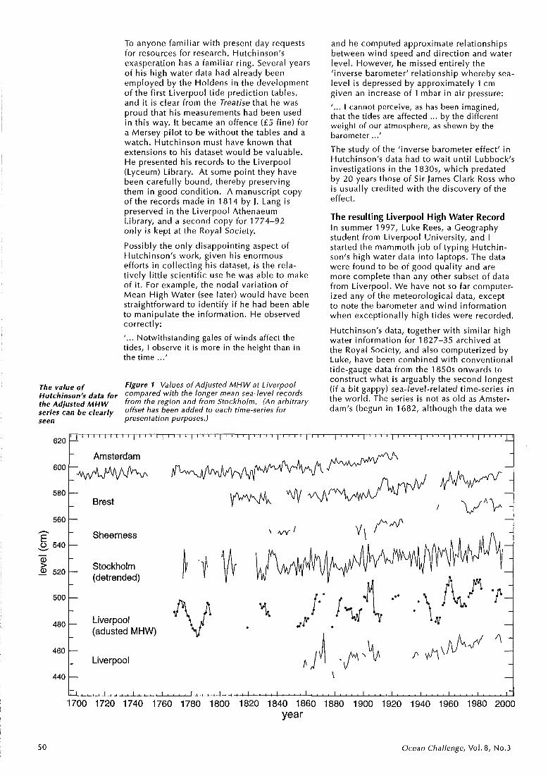
To anyone familiar with present day requests for resources for research, Hutchinson's exasperation has a familiar ring. Several years of his high water data had already been employed by the Holdens in the development of the first Liverpool tide prediction tables, and i t i s clear from the Treatise that he was proud that his measurements had been used in this way. It became an offence ( £ 5 fine) for a Mersey pi lot to be without the tables and a watch. Hutchinson must have known that extensions to his dataset would be valuable. He resented his records to the L ive r~oo l ( ~ ~ d e u m ) Library. At some point the): have been carefully bound, thereby preserving them in good condition. A manuscript copy of the records made in 1814 by J. Lang i s preserved in the Liverpool Athenaeum Library, and a second copy for 1774-92 only is kept at the Royal Society.
Possibly the only disappointing aspect of Hutchinson's work, given his enormous efforts in collecting his dataset, i s the rela- tively little scientific use he was able to make of it. For example, the nodal variation of Mean High Water (see later) would have been straightforward to identify if he had been able to manipulate the information. He observed correctly:
I . . . Notwithstanding gales of winds affect the tides, I observe it is more in the height than in the time ...'
The value of Figure 1 Values of Adjusted MHW at Liverpool hi^^^^,^ data for compared with the longer mean sea-level records the *djusted MHW from the region and from Stockholm. (An arbitrary
series can be clearly offset has been added to each time-series for seen presentation purposes.)
and he computed approximate relationships between wind speed and direction and water level. However, he missed entirely the 'inverse barometer' relationship whereby sea- level is depressed by approximately 1 cm given an increase of 1 mbar in air pressure:
'... I cannot perceive, as has been imagined, that the tides are affected ... by the different weight of our atmosphere, as shewn by the barometer ...' The study of the 'inverse barometer effect' in Hutchinson's data had to wait unti l Lubbock's investigations in the 1 830s, which predated by 20 years those of Sir James Clark Ross who is usually credited with the discovery of the effect.
The resulting Liverpool High Water Record In summer 1997, Luke Rees, a Geography student from Liverpool University, and I started the mammoth job of typing Hutchin- son's high water data into laptops. The data were found to be of good quality and are more complete than any other subset of data from Liverpool. We have not so far computer- ized any of the meteorological data, except to note the barometer and wind information when exceptionally high tides were recorded.
Hutchinson's data, together with similar high water information for 1827-35 archived at the Royal Society, and also computerized by Luke, have been combined with conventional tide-gauge data from the 1850s onwards to construct what is arguably the second longest (if a bi t gappy) sea-level-related time-series in the world. The series is not as old as Amster- dam's (begun in 1682, although the data we
Amsterdam
580 r Brest
Sheerness 0 540 V
Stockh0,m 2 520 (detrended)
Liverpool (adusted MHW)
460 I- Liverpool
Cl . . . . 1 . . . . I . . . . I . . . > r . . . . I . . . . , . . . I . . . . I . . . . I . . . . I . . . . I . . . . , . . . . I . . . , , , , ,
1700 1720 1740 1760 1780 1800 1820 1840 1860 1880 1900 1920 1940 1960 1980 2000 year
5 0 Ocean Challenge, Vol. 8, No.3

hold are from 1700 only) but is comparable with Stockholm's (1 774).
The data have been used to study how the tides have changed at Liverpool during the last 230 years: the incoming tide now arrives significantly earlier (approximately 17 minutes) than i t did during Hutchinson's era and i s larger in amplitude (approximately 6 per cent), primarily owing to engineering changes to the river. In addition, the Mean High Water (MHW) record, after adjustment for the local tidal changes, has been used to construct a proxy Mean Sea Level (MSL) record which can be compared with the very few other long records from the region. Figure 1 shows the Adjusted M H W series together with true MSL from Liverpool and data from other European sites with long records. Note that M H W time-series, unlike MSL, contain an oscillation with a period of 18.6 years and an amplitude at Liverpool of approximately 10 cm, which arises from the 'nodal cycle' of the plane of the Moon's orbit about the Equator. This oscillation accounts for the greater 'noise' of the Adjusted M H W record compared with the others.
For each of the records of Figure 1, the 'accelerations' (i.e. rates of change in the secular trend of sea-level) are comparable at 0.82, 0.42, 0.44, 0.84 and 0.45 mm/year per century for Liverpool, Amsterdam, Brest, Sheerness and Stockholm MSL respectively, and 0.33 mm/year per century for Liverpool Adjusted MHW. When combined with geo- logical data available from Durham Univer- sity, the records can be taken as evidence that most of the true acceleration in sea-level - the subject of much debate in climate circles - began during the second half of the last century. This would have resulted in the 1 mm/year or more trends in MSL observed at many locations. Hutchinson's contribution to the greater length of the Liverpool Adjusted MHW record. com~a red with the MSL time- series from the saAe location, can be seen to have been of great importance towards reaching this conclusion.
Final remarks In this article I have only had space to cover the main reason why I find Hutchinson to have been such an interesting character. I am full of admiration for his efforts: measuring high waters sounds easy but try i t yourself once (it is extremely tedious waiting for the tide to 'turn over'), then imagine repeating the task twice a day for 30 years, not forget- ting the meteorological measurements. If you want to read more about the first part of Hutchinson's life, including tales of his and Fortunatus Wright's privateering (which read better than any novel), then I recommend the excellent book History o f the Liverpool
Privateers by Gomer Williams (1 897). Histori- cal and technical details associated with the Hutchinson and later tidal datasets are contained in a report available from the author which includes as many references to Hutchinson as I have been able to find. However, you can also read about his inter- ests - including the weather, tides, naviga- tion, naval architecture, seamanship and maintenance of health at sea - in his own words in the Treatises. If ever you want to position your frigate alongsidi the enemy to best advantage, these are the books to have with you. They are surprisingly readable considering they were written so long ago, and by an elderly man with little formal education, which may explain why they were considered sufficiently interesting to reprint in 1979.
In the 1777 Treatise, Hutchinson described himself as 'a former cook of a collier .... and a seaman who had done his best' which provides an understated obituary. Williams writes that Bryan Blundell (mariner, ship owner, mayor 1721 and 1728 and founder of the Blue Coat Hospital) considered Hutchin- son's life to be 'one unwearied scene of industrious usefulness'.
Most towns with such an historically impor- tant citizen would have erected a statue, fixed a blue plaque to a wall, or named a street after him - or, better still in this case, a dock. However, Hutchinson has been ignored by Liverpool, a city with more than its fair share of interesting characters. Or at least he has been ignored so far; maybe with the help of the oceanographic community we can change that?
If you intend to visit the city, don't bother trying to pay your respects at S t Thomas's in Park Lane, where Hutchinson was interred in 1801. The church was demolished in 1885 as i t was considered unsafe, and the churchyard is now a car park.
Philip Woodworth i s at the Centre for Coastal and Marine Sciences, Proudman Oceanographic Laboratory, Bidston Observatory, Birkenhead, Merseyside L43 7RA, UK.
Tel. i44-(0)151- 653-8633; Fax: i44-(0)151-653-6269. Email: [email protected]
Ocean Challenge, Vol. 8 , No.3