oberon council | - appendix 7 · 2016. 11. 1. · environmental impact statement pine hill unit...
TRANSCRIPT
ENVIRONMENTAL IMPACT STATEMENT PINE HILL UNIT TRUST
Appendix 7 Pine Hill Quarry
Report No. 941/01
A7-1
Appendix 7
Ecological Assessment
(Total No. of pages including blank pages = 114)
* A colour version of this Appendix is available on the digital version of this document
PINE HILL UNIT TRUST ENVIRONMENTAL IMPACT STATEMENT
Pine Hill Quarry Appendix 7
Report No. 941/01
A7-2
This page has intentionally been left blank
OzArk Environmental & Heritage Management Pty Limited
Dubbo | Queanbeyan | Brisbane HEAD OFFICE: 145 Wingewarra St/PO Box 2069 DUBBO NSW 2830
ph 02 6882 0118 | [email protected] | www.ozarkehm.com.au
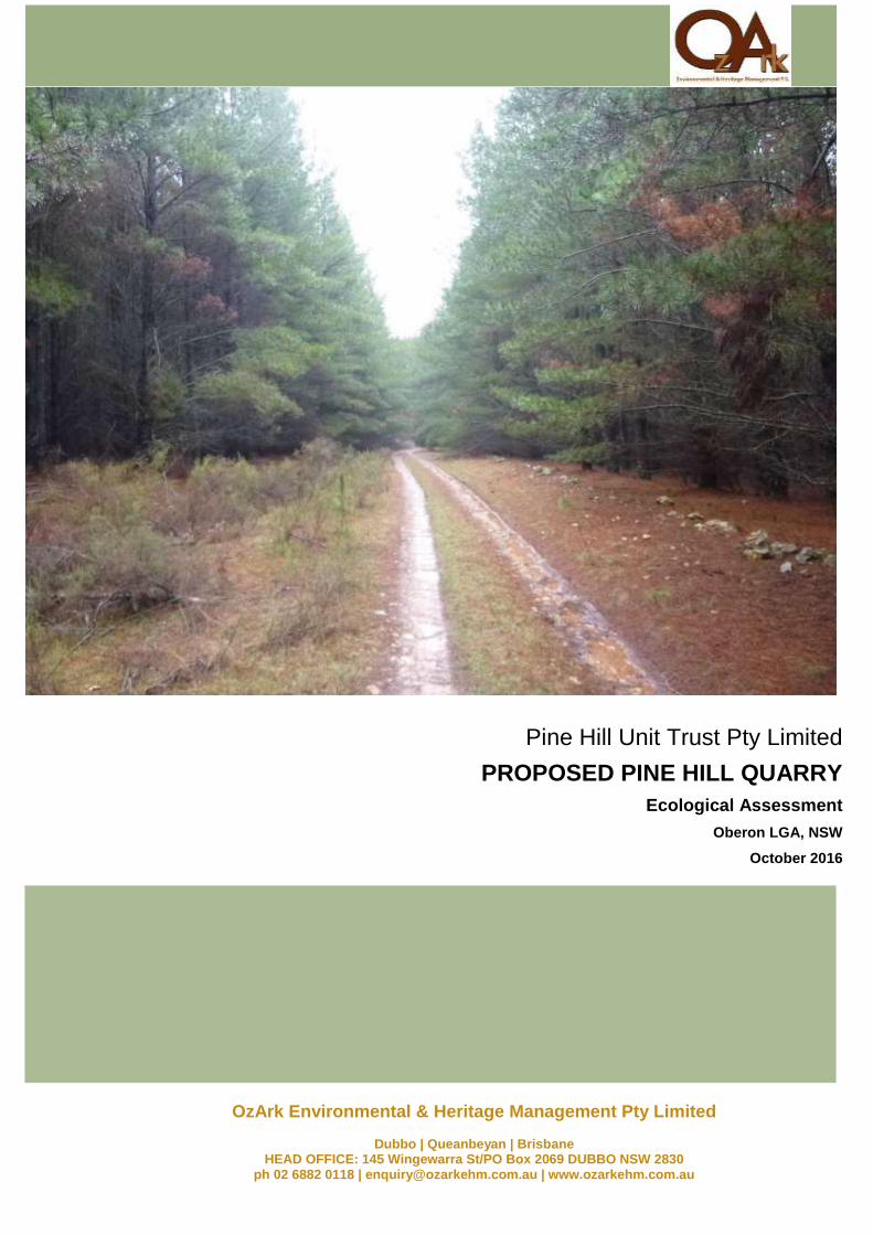
Pine Hill Unit Trust Pty Limited
PROPOSED PINE HILL QUARRY
Ecological Assessment
Oberon LGA, NSW
October 2016

OzArk Environmental & Heritage Management Pty Ltd
Ecological Assessment: Proposed Pine Hill Quarry i
Blank page
OzArk Environmental & Heritage Management Pty Ltd
Ecological Assessment: Proposed Pine Hill Quarry ii
DOCUMENT CONTROLS
Proponent Pine Hill Unit Trust Pty Limited
Client RW Corkery & Co Pty Ltd
Project No / Purchase Order No
Document Description Ecological Assessment: Proposed Pine Hill Quarry
Name Signed Date
Clients Reviewing Officer
Clients Representative Managing this Document OzArk Person(s) Managing this Document
Alex Irwin (AI) Phil Cameron (PJC)
Location OzArk Job No.
S:\OzArk EHM Data\Clients\R.W. Corkery\PineHillUnitTrust_April2016\Ecology
1399
Document Status: FINAL Version Date Action
Series V1.X = OzArk internal edits V1.0 V1.1
02.08.2016 02.08.2016
NA to RM RM Reviewed
Series V2.X = OzArk and Client internal edits V2.0 V2.1 V2.2
03.08.2016 04.08.2016 20.09.2016
NA to LC LC to NA NA to LC
FINAL once latest version of draft approved by client V3.0 11.10.2016 NA to LC
Prepared For Prepared By
Lauren Clear (LC) Environmental Consultant RW Corkery & Co Pty Ltd 62 Hill Street Orange NSW, 2800 P: 02 6362 5411 F: 02 6361 3622 E: [email protected]
Nikki Allen (NA) Environmental Scientist OzArk Environmental & Heritage Management Pty Ltd 145 Wingewarra Street (PO Box 2069) Dubbo NSW, 2830 P: 02 6882 0118 F: 02 6882 6030 E: [email protected]
COPYRIGHT
© OzArk Environmental & Heritage Management Pty Ltd, 2016 and
© Pine Hill Unit Trust Pty Limited, 2016 © RW Corkery & Co Pty Ltd, 2016
All intellectual property and copyright reserved. Apart from any fair dealing for the purpose of private study, research, criticism or review, as permitted under the Copyright Act 1968, no part of this report may be reproduced, transmitted, stored in a retrieval system or
adapted in any form or by any means (electronic, mechanical, photocopying, recording or otherwise) without written permission.
Enquiries would be addressed to OzArk Environmental & Heritage Management Pty Ltd.
OzArk Environmental & Heritage Management Pty Ltd
Ecological Assessment: Proposed Pine Hill Quarry iii
EXECUTIVE SUMMARY
Pine Hill Unit Trust Pty Limited (the proponent) propose to develop a quarry on Lot 267 DP
757068 of the “Pine Hill” property (“the property”) to supply gravel materials for road sheeting,
road base and other construction projects in the local area. The proposal is located
approximately six kilometres north of Oberon within the Oberon Local Government Area.
OzArk Environmental & Heritage Management (OzArk) was commissioned by RW Corkery &
Co Pty Ltd (the client) on behalf of the proponent to complete an ecological assessment under
Part 4 of the NSW Environmental Planning and Assessment Act 1979 (EP&A Act) for the
proposal.
The proponent is required to complete an ecological assessment under Part 4 of the NSW
EP&A Act for the proposal. This assessment addresses requirements of section 5A of the
EP&A Act and the following legislation:
Commonwealth Environment Protection and Biodiversity Conservation Act 1999 (EPBC
Act).
NSW Threatened Species Conservation Act 1995 (TSC Act).
NSW Fisheries Management Act 1994 (FM Act).
The proposed Pine Hill Quarry would be located at the southern boundary of Lot 267 DP
757068, with an access road through Blenheim State Forest. The access road will use existing
dirt roads within Blenheim State Forest, however, minor lopping of tree limbs is required to
maintain safe viewing distances. The preferred access road option will be used for the
proposal which will require minor vegetation clearing for creation of a new section of road. The
proposed Pine Hill Quarry will be developed in two stages, with the total excavation area
covering approximately 4.5ha. The final landform would be a flattened hill-top (without a void),
which would be rehabilitated through placement of subsoil and remnant gravel; then
placement of available soil resources; then spreading of seed for assisted regeneration.
An ecological field survey was carried out by Environmental Scientist Nikki Allen on 20 July
2016 (one part day). Field survey consisted of threatened fauna and flora searches, with three
vegetation plots. No threatened fauna or flora, or noxious weeds were observed during the
fieldwork. Rainfall reduced the presence and abundance of fauna species during the fieldwork
and is a limitation of the field survey, which was supplemented by database searches for
predictive modelling of threatened fauna species to occur in the study area.
The study area does not contain any ecologically sensitive communities including terrestrial
and aquatic Endangered Ecological Communities or Key Fish Habitat. Nine threatened bird
species listed under the NSW TSC Act were predicted to occur in the study area and may be
affected by the proposal. A seven-part test was applied to each of these species and found
that the proposal would not constitute a significant impact and a Species Impact Statement is
not required.
Safeguards and mitigation measures have been provided to minimise harm to the
environment. If these are implemented then the proposal is unlikely to have a significant
impact to species, populations and communities listed under the EPBC, TSC or FM Acts. No
permits, approvals, offsetting or further ecological assessment are required.
OzArk Environmental & Heritage Management Pty Ltd
Ecological Assessment: Proposed Pine Hill Quarry 4
TABLE OF CONTENTS
Introduction................................................................................................................... 8
Objectives ........................................................................................................... 8
Location .............................................................................................................. 8
1.2.1 Subject site .......................................................................................................... 8
1.2.2 Study area ........................................................................................................... 9
1.2.3 10 kilometre buffer ............................................................................................. 10
The proposal ..................................................................................................... 13
1.3.1 Pine Hill Quarry ................................................................................................. 13
1.3.2 Access roads ..................................................................................................... 13
1.3.3 Vegetation removal ........................................................................................... 14
Methods ....................................................................................................................... 17
Reporting ........................................................................................................... 17
2.1.1 Licensing and qualifications ............................................................................... 17
Desktop review .................................................................................................. 18
2.2.1 Information sources ........................................................................................... 18
Field survey ....................................................................................................... 18
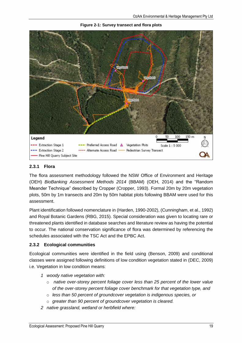
2.3.1 Flora .................................................................................................................. 19
2.3.2 Ecological communities ..................................................................................... 19
2.3.3 Fauna ................................................................................................................ 20
2.3.4 Limitations ......................................................................................................... 21
Results ........................................................................................................................ 22
Relevant legislation ........................................................................................... 22
3.1.1 State Environmental Planning Policy No 44—Koala Habitat Protection ............. 22
3.1.2 Water Management Act 2000 ............................................................................ 22
3.1.3 Fisheries Management Act 1994 ....................................................................... 22
Landscape context ............................................................................................ 23
3.2.1 Mitchell Landscape ............................................................................................ 23
3.2.2 Waterways ........................................................................................................ 23
3.2.3 Land use ........................................................................................................... 23
3.2.4 Climate .............................................................................................................. 23
Ecological communities ..................................................................................... 27
OzArk Environmental & Heritage Management Pty Ltd
Ecological Assessment: Proposed Pine Hill Quarry 5
3.3.1 Terrestrial communities ..................................................................................... 27
3.3.2 Aquatic communities ......................................................................................... 30
3.3.3 Groundwater dependant ecosystems ................................................................ 31
Flora .................................................................................................................. 31
3.4.1 Noxious weeds .................................................................................................. 32
Fauna ................................................................................................................ 32
Predictive modelling .......................................................................................... 33
3.6.1 Previously recorded threatened species and endangered populations .............. 33
3.6.2 Likelihood of occurrence - threatened biota ....................................................... 35
Potential impact .......................................................................................................... 36
Direct impact ..................................................................................................... 36
4.1.1 Impact to native vegetation ................................................................................ 36
4.1.2 Impact to endangered ecological communities .................................................. 36
4.1.3 Impact to groundwater dependent communities ................................................ 36
4.1.4 Impact to hollow bearing trees ........................................................................... 36
4.1.5 Fragmentation of habitat .................................................................................... 36
4.1.6 Soils and drainage ............................................................................................. 36
Indirect impact ................................................................................................... 37
4.2.1 Operational noise .............................................................................................. 37
4.2.2 Weeds ............................................................................................................... 37
Impact on Key Threatening Processes .............................................................. 37
Matters of National Environmental Significance ................................................. 40
Cumulative impact ............................................................................................. 40
Significance of potential impact ......................................................................... 41
4.6.1 NSW Legislation ................................................................................................ 41
4.6.2 Commonwealth Legislation ............................................................................... 42
Offsetting and rehabilitation ...................................................................................... 43
Offsetting requirement ....................................................................................... 43
Rehabilitation .................................................................................................... 43
5.2.1 Benson’s benchmarks ....................................................................................... 43
5.2.2 Results .............................................................................................................. 43
Environmental safeguards ......................................................................................... 44
Avoid impact ...................................................................................................... 44
OzArk Environmental & Heritage Management Pty Ltd
Ecological Assessment: Proposed Pine Hill Quarry 6
Minimise impact ................................................................................................. 44
Mitigate impact .................................................................................................. 44
Conclusion .................................................................................................................. 47
References .................................................................................................................. 48
Appendix A: Field survey results ..................................................................................... 49
Appendix B: Habitat assessment table ........................................................................... 51
Appendix C: EPBC Act assessment of significance ...................................................... 77
Appendix D: TSC Act assessment of significance ......................................................... 79
Appendix E: Database search results ............................................................................. 83
Appendix F: Terms and abbreviations .......................................................................... 105
FIGURES
Figure 1-1: Regional context of the study area .................................................................... 11
Figure 1-2: The study area .................................................................................................. 12
Figure 1-3: Vegetation clearing of the proposal ................................................................... 16
Figure 2-1: Survey transect and flora plots .......................................................................... 19
Figure 3-1: Waterways of the study area ............................................................................. 24
Figure 3-2: Land use of the study area ................................................................................ 26
Figure 3-3: Previously mapped vegetation communities of the study area .......................... 28
Figure 3-4: Field survey vegetation community results for the study area ........................... 29
Figure 3-5: Threatened species within 10km of the study area ............................................ 34
TABLES
Table 1-1: Description of the subject site............................................................................... 9
Table 1-2: Regional context of the study area ....................................................................... 9
Table 1-3: Proximity of environmentally sensitive areas to the study area ........................... 10
Table 2-1: Summary of OzArk qualifications ....................................................................... 17
Table 3-1: Waterways assessment ..................................................................................... 25
Table 3-2: Type and area of occupancy of vegetation of the study area .............................. 27
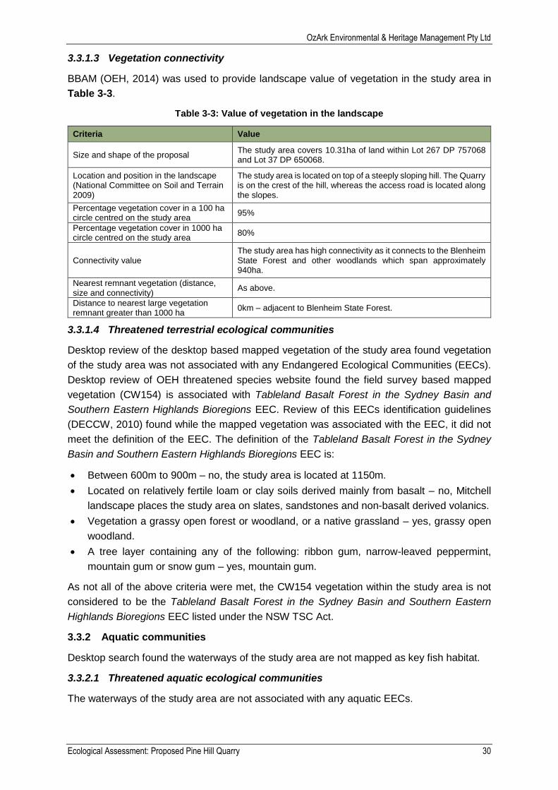
Table 3-3: Value of vegetation in the landscape .................................................................. 30
Table 3-4: Threatened species identified within 10km of the study area .............................. 33
Table 3-5: Listed species predicted to be affected by the proposal ..................................... 35
OzArk Environmental & Heritage Management Pty Ltd
Ecological Assessment: Proposed Pine Hill Quarry 7
Table 4-1: Review of proposed impacts to key threatening processes ................................ 38
Table 4-2: Impacts to Matters of National Environmental Significance ................................ 40
Table 4-3: Summary of the findings of TSC Act 7-Part Tests .............................................. 42
Table 5-1: Benson’s benchmarks ........................................................................................ 43
Table 6-1: Summary of mitigation methods ......................................................................... 44
PLATES
Plate 1-1: Photo of trees requiring felling for safe sight viewing distances ........................... 15
Plate 3-1: Example of typical ground cover at vegetation plot one....................................... 31
Plate 3-2: Example of typical ground cover at vegetation plot two ....................................... 32
OzArk Environmental & Heritage Management Pty Ltd
Ecological Assessment: Proposed Pine Hill Quarry 8
Introduction
Pine Hill Unit Trust Pty Limited (the proponent) propose to develop a quarry on Lot 267 DP
757068 of the “Pine Hill” property (“the property”) to supply gravel materials for road sheeting,
road base and other construction projects in the local area. The proposal is located
approximately six kilometres north of Oberon within the Oberon Local Government Area.
Objectives
OzArk Environmental & Heritage Management (OzArk) was commissioned by RW Corkery &
Co Pty Ltd on behalf of the proponent to complete an ecological assessment under Part 4 of
the NSW Environmental Planning and Assessment Act 1979 (EP&A Act) for the proposal. This
assessment addresses requirements of Section 5A of the EP&A Act and the following
legislation:
Commonwealth Environment Protection and Biodiversity Conservation Act 1999 (EPBC
Act).
NSW Threatened Species Conservation Act 1995 (TSC Act).
NSW Fisheries Management Act 1994 (FM Act).
The objectives of the ecological assessment are to provide:
Accurate predictions and mapping of any vegetation clearing on site.
Detailed assessment of the potential impact to any threatened species, populations,
endangered ecological communities or their habitats; groundwater dependent
ecosystems predicted to occur; and any potential for offset requirements in accordance
with the relevant Office of Environment and Heritage (OEH) Guidelines.
Detailed descriptions of the measures to avoid, minimise, mitigate and offset biodiversity
impacts.
Location
Three terms are used in this report to contextualise the proposal:
Subject site.
Study area.
10km buffer.
Boundaries of the subject site and study area are shown in Figure 1-2. Additional terms and
abbreviations used are provided in Appendix F.
1.2.1 Subject site
The ‘subject site’ is the area directly affected by the proposal (DEC, 2004). For the purpose of
this report, there are two subject sites consisting of the quarry and the access roads. All land
within the project site boundary and the alignment of the two access road options, should be
considered the two subject sites respectively (Figure 1-2).
Up to 8.6ha would be disturbed by the proposal, with 4.5ha of the 8.6ha to be extracted. The
impact areas listed in Table 1-1 are the maximum potential impact footprint.
OzArk Environmental & Heritage Management Pty Ltd
Ecological Assessment: Proposed Pine Hill Quarry 9
Table 1-1: Description of the subject site
Subject Site Parameter Dimensions Estimated Impact Area
Quarry Project Site Boundary Polygon (varies) – around 300m x 350m
8.6ha
Access Roads Preferred Alignment 1400m x 9m 1.26ha
Access Roads Alternate Alignment 1550m x 9m 1.40ha
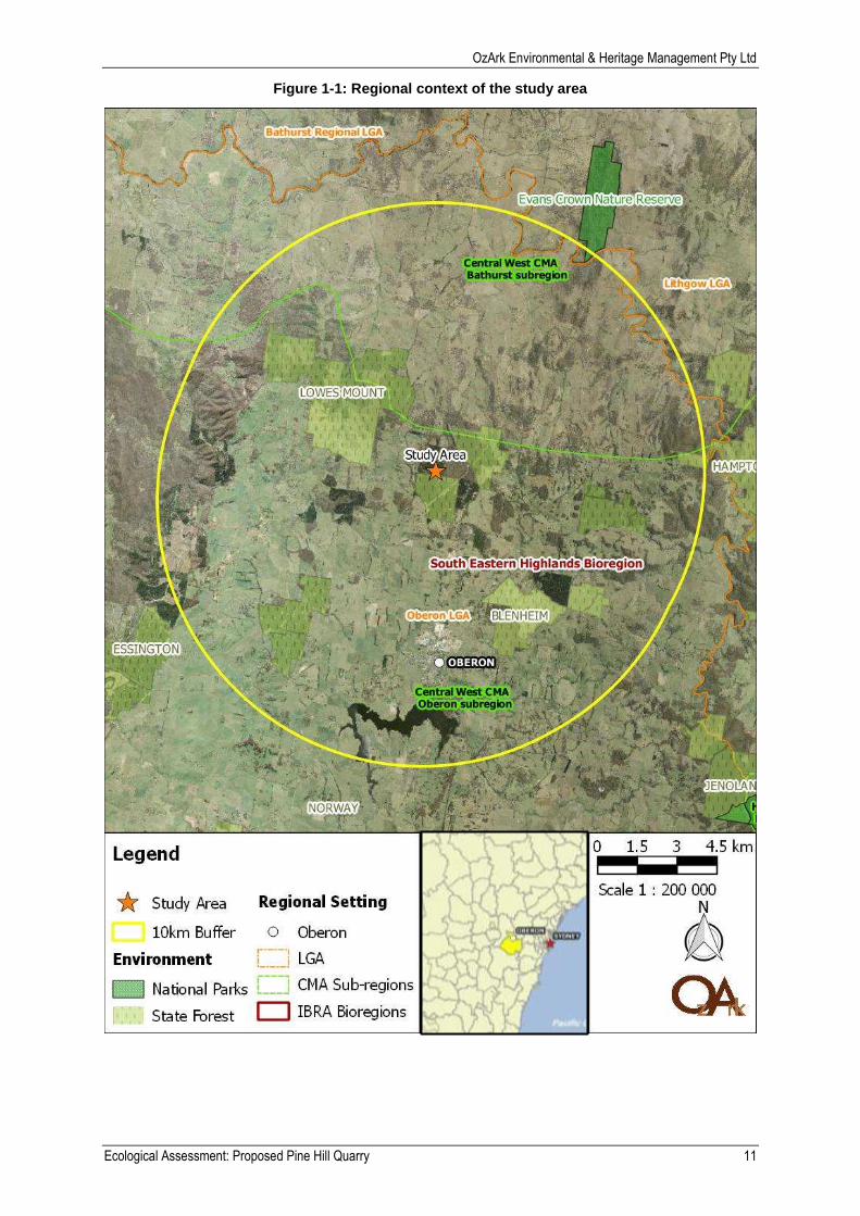
1.2.2 Study area
The ‘study area’ includes the ‘subject sites’ and any additional areas likely to be affected by
the proposal, either directly or indirectly (DEC, 2004). The study area is the combination of all
subject sites, which covers 11.26ha and is shown on Figure 1-2. Once the proposal is
finalised, only one access road option would be used. If the preferred access road is used, the
impact area would be 9.86ha. If the alternate access road is used, the impact area would be
10ha.
This report has been written to assess the potential impact area of both access road options
and the Quarry. As the preferred and alternate alignment share 1150m of common road before
diverging, the actual impact area of the access roads combined is 1.71ha, not 2.66. The
combined access road (1.71ha) and Quarry (8.6ha) impact area gives a study area of 10.31ha
and is the basis of calculations used for this report.
Regional context of the study area is provided in Table 1-2 and proximity to environmentally
sensitive areas is shown in Table 1-3. Table 1-3 shows that the study area is located within
the following environmentally sensitive land:
SEPP 44: All land within Oberon LGA applies to SEPP 44.
State Forest: The access road subject site is located within Blenheim State Forest.
Protected riparian habitat: the alternate access road option crosses a Strahler first order
tributary of Little Spring Creek.
Table 1-2: Regional context of the study area
Criteria Value
Interim Biogeographic Regionalisation for Australia (IBRA Region)
South Eastern Highlands
State NSW
Catchment Management Authority (CMA) Central West
CMA subregion Oberon
Topographical map sheet Edith: 8830-2-N
Local Government Area Oberon
Nearest town Oberon
Accessed from nearest town by Lowes Mount Road
Mitchell Landform Rockley Plains
Land use / disturbance Tree and shrub cover – softwood plantation
Nearest waterway (Name, Strahler Order) Unnamed Strahler first order tributary of Little Spring Creek
Spot point Australian Height Datum (AHD) 1150m
Surrounding land use Native and State forest

OzArk Environmental & Heritage Management Pty Ltd
Ecological Assessment: Proposed Pine Hill Quarry 10
Table 1-3: Proximity of environmentally sensitive areas to the study area
Environmental Considerations In the study area?
An area reserved or dedicated under the National Parks and Wildlife Act 1974? No
Is the proposal located within land reserved or dedicated within the meaning of the Crown Lands Act 1989 for preservation of other environmental protection purposes?
No
A World Heritage Area? No
Environmental Protection Zones in environmental planning instruments? No
Lands protected under SEPP 14 – Coastal Wetlands? No
Lands protected under SEPP 26 – Littoral Rainforests? No
Lands protected under SEPP 71 – Coastal Protection? No
Lands protected under SEPP 44 – Koala Protection? Yes
Lands protected under SEPP Sydney Drinking Water Catchment? No
Land identified as wilderness under the Wilderness Act 1987 or declared as wilderness under the National Parks and Wildlife Act 1974?
No
Aquatic reserves dedicated under the Fisheries Management Act 1994? No
Wetland areas dedicated under the Ramsar Wetlands Convention? No
Land subject to a conservation agreement under the National Parks and Wildlife Act 1974?
No
Land identified as State Forest under the Forestry Act 1916? Yes
Western Lands Lease No
Freehold or Crown Land. If Crown Land, what type? Freehold
Land within a mining subsidence district? No
Acid sulphate area? No
Protected riparian habitat? Yes
Mapped as Key Fish Habitat? No
Critical habitat NSW? No
Critical habitat nationally? No
1.2.3 10 kilometre buffer
The 10km buffer means all land within a 10km radius of the study area. The 10km buffer is
used to review database records of listed plants and animals to predict what may occur in the
study area.
OzArk Environmental & Heritage Management Pty Ltd
Ecological Assessment: Proposed Pine Hill Quarry 11
Figure 1-1: Regional context of the study area
OzArk Environmental & Heritage Management Pty Ltd
Ecological Assessment: Proposed Pine Hill Quarry 12
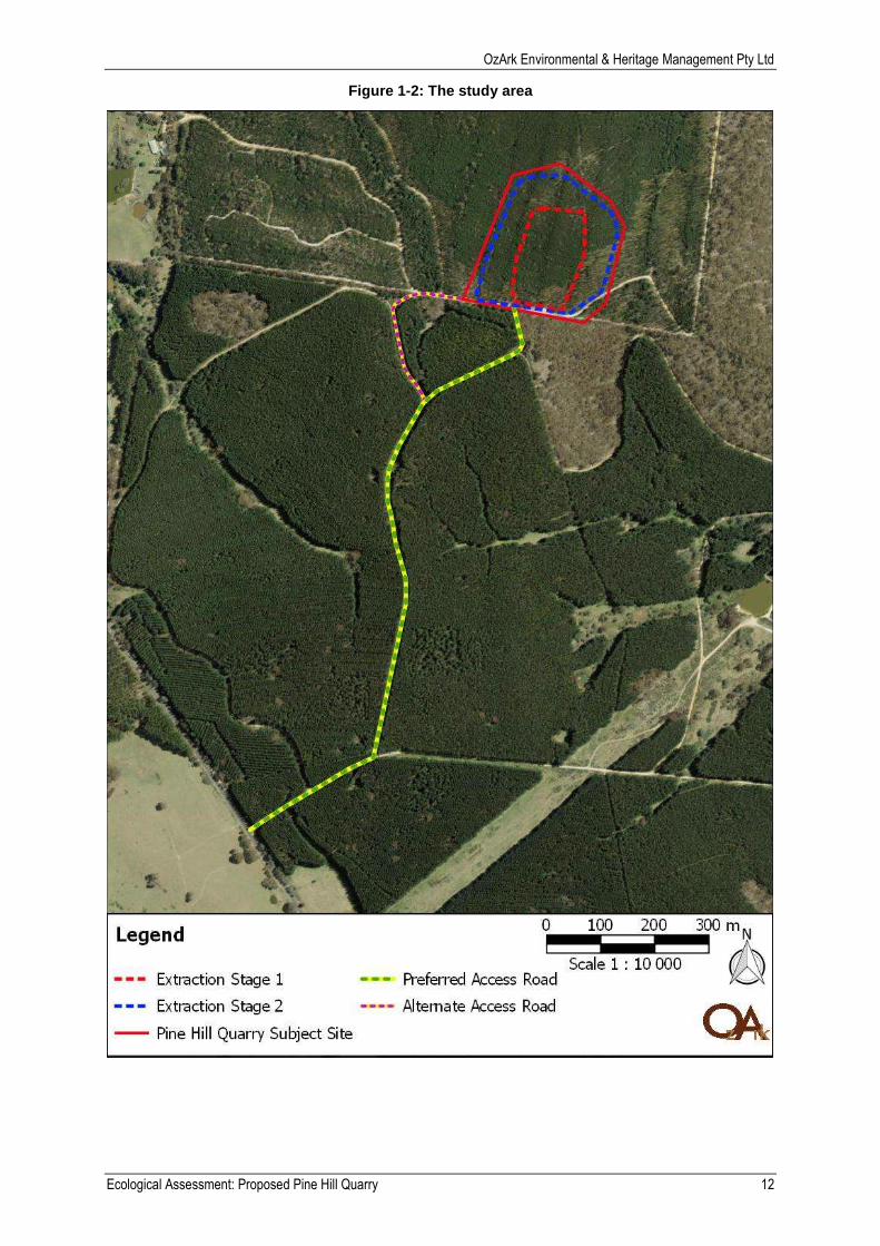
Figure 1-2: The study area
OzArk Environmental & Heritage Management Pty Ltd
Ecological Assessment: Proposed Pine Hill Quarry 13
The proposal
The proposal consists of two main components; the proposed Pine Hill Quarry and associated
access roads. The proposal incorporates the following key components.
Extraction of up to 50,000m3 of gravel material using campaign extraction methods for a
period of up to 20 years.
Campaign crushing and screening of the extracted gravel, as required to meet customer
specifications.
Establishment of an access road between the Pine Hill Quarry and Lowes Mount Road
through Blenheim SF. The access road would include upgrades to existing SF roads
(Glenmore Road and Black Bullock Track), and construction of a short additional section
linking Glenmore Road to the Pine Hill Quarry.
Transportation of the above products directly to the Applicant’s customers, primarily using
truck and dog combinations, with smaller capacity rigid trucks also used.
Establishment of ancillary infrastructure, including water management structures.
Construction and rehabilitation of a final landform that would be geotechnically stable and
would be suitable for a final land use of private forestry and passive nature conservation.
1.3.1 Pine Hill Quarry
The extraction operations would be undertaken using a conventional rip, load and haul
methods where vegetation and soil are removed to expose the underlying gravel which is
ripped and loaded prior to direct despatch or additional crushing and screening. The quarry
will have a two stage extraction area (see Figure 1-2):
Stage 1 would provide for the recovery of the weathered gravel from the most elevated
2.0ha of the Pine Hill Quarry subject site above the 1 160m AHD contour. Extraction would
commence at the southern end of this extraction stage, to develop a working face in a
northerly direction. While dependent on the hardness of the rock, the active extraction
face would likely remain approximately 10m in height with a second bench developed
from 1170m AHD as the elevation rises to the north.
Stage 2 would extend the extraction area to the east, north and west down to an elevation
of 1150m AHD where the gravel remains friable enough to excavated by ripping. Sections
of harder rock not able to be excavated by ripping is likely to be encountered as the
extraction is developed deeper below existing ground level, within these area to be left in
situ, worked around and incorporated into the final landform.
As the proposed quarry operations would be operated on a campaign basis to supply specific
customer contracts, site office facilities, workshops, maintenance areas, fuel storage and
stockpile areas would not be established or maintained.
1.3.2 Access roads
The access road will use existing unsealed roads within Blenheim State Forest, however,
minor lopping of tree limbs is required to maintain safe viewing distances. The dirt roads will
be improved through application of gravel and widening of the roads for ease of access by
construction vehicles. Nine metre wide access roads have been assessed for this report to
allow for flexibility in road design. However, it is likely the roads would be much narrower.

OzArk Environmental & Heritage Management Pty Ltd
Ecological Assessment: Proposed Pine Hill Quarry 14
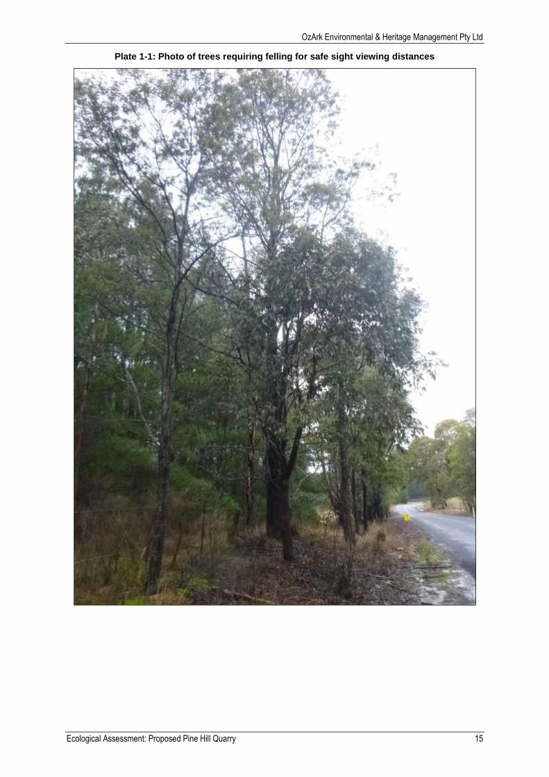
1.3.3 Vegetation removal
Vegetation removal would occur over the entire 4.5ha of the stage two quarry (see insert B of
Figure 1-3). For this report the quarry area of impact has been assessed as 8.6ha to account
for indirect impact through soil compaction of vehicle movement and by extension vegetation
removal.
During vegetation clearing operations, larger vegetation would be removed using a bulldozer
with its blade positioned just above the surface. Ground cover vegetation would be removed
with the topsoil to maximise the retention of the seed bank and nutrients within the soil, as well
as to minimise opportunities for erosion and dust lift-off between removal of the larger
vegetation and soil stripping.
Both access road options would require minor lopping of tree limbs along the road alignment
and two sections of tree removal.
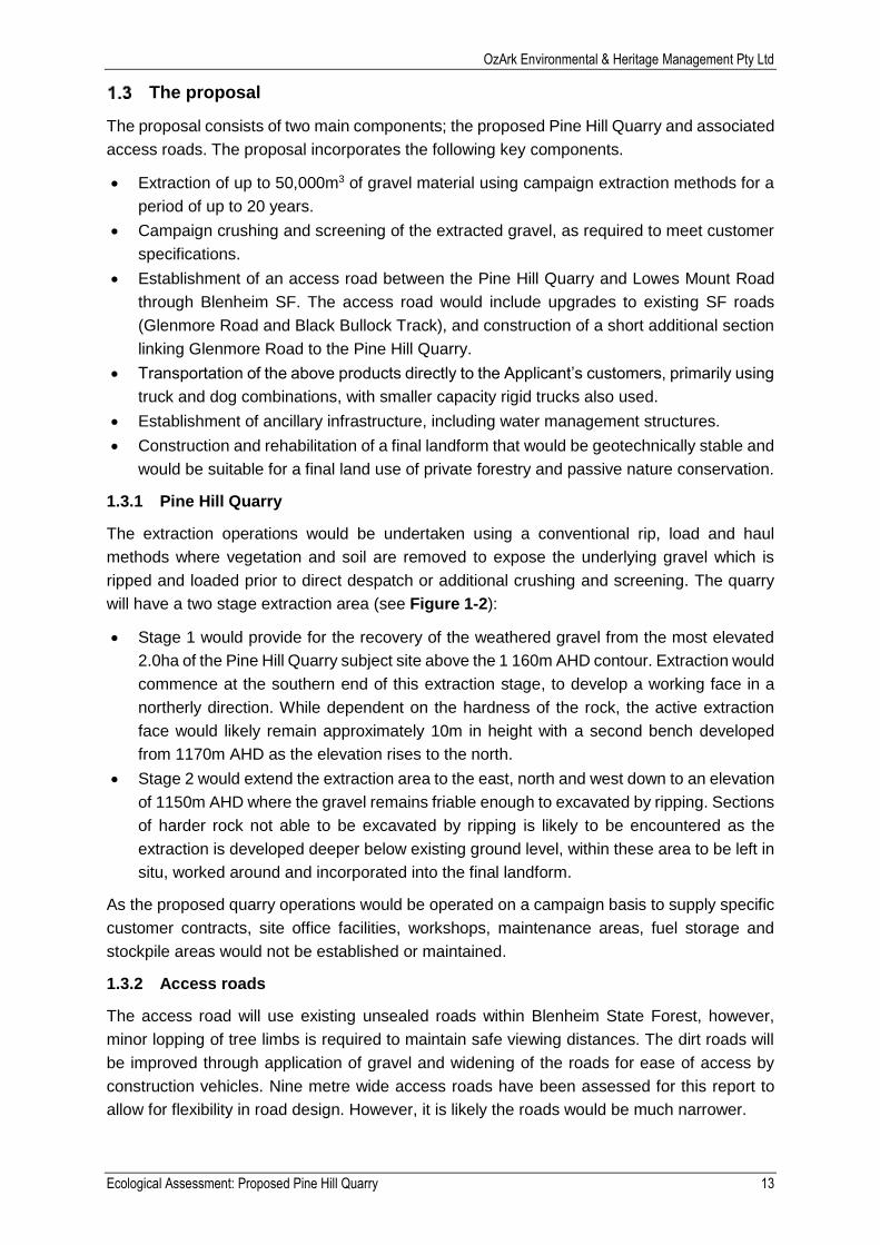
This section of clearing, is located at the intersection of Black Bullock Track and Lowes
Mount Road (see insert D of Figure 1-3). Tree removal is required for safe viewing
distances for construction vehicles entering and existing the proposal site. Tree removal
will consist of removal a mixture of Mountain Gum (Eucalyptus dalrympleana) and Manna
Gum (Eucalyptus viminalis) (Plate 1-1).
Additional vegetation clearing would be required to remove any upper, mid and lower
stratum flora species along the portions of the proposed access road which leaves the
currently formed dirt road.
o For the preferred access road, approximately 100m by nine metres (0.09ha) of
vegetation would be affected (see insert C of Figure 1-3).
o For the alternate access road option, approximately 85m by nine metres
(0.08ha) of vegetation would be affected (see insert A of Figure 1-3).
OzArk Environmental & Heritage Management Pty Ltd
Ecological Assessment: Proposed Pine Hill Quarry 15
Plate 1-1: Photo of trees requiring felling for safe sight viewing distances
OzArk Environmental & Heritage Management Pty Ltd
Ecological Assessment: Proposed Pine Hill Quarry 16
Figure 1-3: Vegetation clearing of the proposal
OzArk Environmental & Heritage Management Pty Ltd
Ecological Assessment: Proposed Pine Hill Quarry 17
Methods
The methodology employed for this report consisted of:
A desktop and literature review of ecological databases and literature sources as direct
references for the field survey.
A field survey of the study area.
The assessment rationale was to evaluate the type and quality of habitat to be affected by the
proposal; apply professional judgement, then complete targeted assessment of potential
habitat to detect the regions listed species, populations or communities.
Reporting
Reporting components were completed by:
Main Author: Nikki Allen.
Editor: Rowan Murphy.
QMS Reviewer: Rowan Murphy.
2.1.1 Licensing and qualifications
OzArk operates under NSW Department of Primary Industries (DPI) Ethics Approval No.
11/5475 and NSW Scientific Research License 101087. Key details of scientific personnel
from OzArk EHM are provided in Table 2-1.
Table 2-1: Summary of OzArk qualifications
Name Position CV Details
Nikki Allen
Environmental Scientist
BSc. Major in Chemistry and Geography. University of New
South Wales at the Australian Defence Force Academy
Grad. Dip. In Environmental Health. Queensland University
of Technology.
Apply First Aid (ABC First Aid) ID: 34795
CPCCOHS1001A Work Safely in the Construction Industry
(White Card)
Roads and Maritime Worker on Foot Training
Rowan Murphy
Environmental Scientist / Ecologist
Bachelor of Environmental Science (University of New
England)
Bachelor of Laws (University of New England)
Practicing member of the NSW Ecological Consulting
Association
Practicing member of the Environment Institute of Australia
and New Zealand (EIANZ)
National Railtrack Safety Induction (ARTC)
WHS White Card: 1652972
Apply First Aid (Parasol) ID: 6007220.
OzArk Environmental & Heritage Management Pty Ltd
Ecological Assessment: Proposed Pine Hill Quarry 18
Desktop review
2.2.1 Information sources
Preliminary assessments drew on local experience and information held on government
databases and archives (Appendix E). This data was used to assist in identifying distributions,
suitable habitats and known records of threatened species to increase the effectiveness of
field investigations. All databases were searched on 07 July 2016. Information sources
reviewed included:
Aerial photograph interpretation of the landscape and existing vegetation maps.
Literature reviews (OzArk library, OEH Biometric list) to determine vegetation and species
habitat(s) within the proposed study area and environs.
Review of flora and fauna records contained in the NSW Threatened Species Database,
EPBC Protected Matters Search Tool and DPI Records Viewer.
NSW Wildlife Atlas/Bionet GIS data request and website search.
Royal Botanical Gardens (PlantNet NSW Flora Online).
The background searches enabled the consultant to develop a predictive model for threatened
flora and fauna to be recorded in the study area (Section 3.7).
Field survey
Field assessment was carried out by Nikki Allen on 20 July 2016 (one part day). The
assessment followed the Working Draft Threatened Species Survey and Assessment
Guidelines NSW (DEC, 2004). Survey effort and location of flora plots is provided in Figure
2-1.
Weather was cool and overcast, ranging from 10.5°C to 12.9°C. Rainfall was light to moderate
throughout the duration of the fieldwork and approximately 38mm of rain fell over the course
of the day. The rain did not impact on flora survey, however, it did affect the fauna survey by
potentially reducing the likelihood of fauna species being active and easily observable.
The objective of the field assessment was to:
Describe the nature and extent of vegetation present within the study area to be removed.
Determine if species, populations or communities listed in the EPBC, TSC or FM Acts
would be, or have potential to be, affected by the proposal.
Determine if ground water dependant ecological communities would be, or have potential
to be, affected by the proposal.
Describe the quality and value of the habitat affected by the proposal.
OzArk Environmental & Heritage Management Pty Ltd
Ecological Assessment: Proposed Pine Hill Quarry 19
Figure 2-1: Survey transect and flora plots
2.3.1 Flora
The flora assessment methodology followed the NSW Office of Environment and Heritage
(OEH) BioBanking Assessment Methods 2014 (BBAM) (OEH, 2014) and the “Random
Meander Technique” described by Cropper (Cropper, 1993). Formal 20m by 20m vegetation
plots, 50m by 1m transects and 20m by 50m habitat plots following BBAM were used for this
assessment.
Plant identification followed nomenclature in (Harden, 1990-2002), (Cunningham, et al., 1992)
and Royal Botanic Gardens (RBG, 2015). Special consideration was given to locating rare or
threatened plants identified in database searches and literature review as having the potential
to occur. The national conservation significance of flora was determined by referencing the
schedules associated with the TSC Act and the EPBC Act.
2.3.2 Ecological communities
Ecological communities were identified in the field using (Benson, 2009) and conditional
classes were assigned following definitions of low condition vegetation stated in (DEC, 2009)
i.e. Vegetation in low condition means:
1 woody native vegetation with:
o native over-storey percent foliage cover less than 25 percent of the lower value
of the over-storey percent foliage cover benchmark for that vegetation type, and
o less than 50 percent of groundcover vegetation is indigenous species, or
o greater than 90 percent of groundcover vegetation is cleared.
2 native grassland, wetland or herbfield where:
OzArk Environmental & Heritage Management Pty Ltd
Ecological Assessment: Proposed Pine Hill Quarry 20
o less than 50 percent of groundcover vegetation is indigenous species1, or
o more than 90 percent of groundcover vegetation is cleared.
If native vegetation is not in low condition, it is in moderate to good condition.
The percentages for the groundcover calculations must be made in a season when
the proportion of native groundcover vegetation compared to non-native groundcover
vegetation in the area is likely to be at its maximum.
As there is woody vegetation, shrubland communities are assessed as woody native
vegetation for the low condition definition. For shrubland vegetation types greater than
one metre in height (i.e. the over-storey benchmark is not zero), both the over-storey
and groundcover assessment parts of the assessment are applied to determine
whether the vegetation is in low condition. For shrubland vegetation types less than
one metre in height (i.e. the over-storey benchmark is zero), only the groundcover
part of the woody native vegetation assessment is applied to determine whether the
vegetation is in low condition.
A list of predicted threatened or endangered EPBC Act, TSC Act and FM Act communities
was brought into the field during the assessment. Where the community had potential to be
the listed community the description and definition for the listed item was cross referenced.
2.3.3 Fauna
2.3.3.1 Habitat assessment
Habitat in the study area was assessed for its potential to provide resources for listed species
predicted to occur in Appendix B. Preference of habitat for these species was determined by
OEH, Department of Primary Industries (DPI) Fisheries and the Australian Government
Department of Environment (DoE) Threatened online Species Profiles.
Database searches were undertaken before the assessment to inform the consultant of what
species predicted or known to occur within the 10km buffer may be recorded or should need
a targeted search.
Any indirect evidence of fauna i.e. scats, tracks, calls, fur feathers, sloughed skins etc was
assessed.
Each mature tree in the subject site was inspected for hollows and to determine if they were
used for breeding. All eucalyptus trees in the study area were also assessed for nests, feeding
habitat including mistletoe or resting habitat. Where a tree with a hollow was observed it was
given a score reflecting its habitat value.
2.3.3.2 Birds
Opportunistic sighting of birds were recorded during assessment of the study area. Particular
attention was given to identifying tree hollows with signs of breeding activity or the presence
of nests.
1 Means less than 50% of the percent foliage cover of the groundcover vegetation consists of indigenous groundcover species,
not less than 50% of the groundcover species are indigenous species. Groundcover vegetation is herbaceous vegetation including grasses, forbs, herbs and similar low-growing non-woody plants.
OzArk Environmental & Heritage Management Pty Ltd
Ecological Assessment: Proposed Pine Hill Quarry 21
2.3.4 Limitations
Not all animals and plants can be fully accounted for within any given study area. The presence
of threatened species is not static. It changes over time, often in response to longer term
natural forces which can, at any time, be dramatically influenced by man-made disturbance or
weather. In order to overcome some of these limitations, database searches were conducted
for threatened species, populations and ecological communities known to occur within the
region. A ‘precautionary approach’ for species occurrence has been adopted where required.
This report is based upon data acquired from recent and current surveys, however, it should
be recognised that data gathered is indicative of the environmental conditions of the site at
the time the report was prepared.
Limitations associated with the survey included:
Trapping was not a component of the assessment.
Microbat ultrasonic call capture and analysis was decided to not be included in the field
survey as no trees to be removed by the proposal were assessed as containing potential
bat habitat.
Nocturnal assessments were not a component of the assessment.
Rainfall reduced the presence and abundance of fauna species during the fieldwork, as
indicated by only one fauna species sighting during the fieldwork. This limitation was
supplemented with database searches of previously recorded threatened species and
threatened species predicted to occur in the area.
The above-mentioned constraints are not considered to compromise the findings or results of
the field assessment as the subject site is predominantly exotic pine forest regrowth and the
habitat available across the study area was similar.
OzArk Environmental & Heritage Management Pty Ltd
Ecological Assessment: Proposed Pine Hill Quarry 22
Results
Relevant legislation
3.1.1 State Environmental Planning Policy No 44—Koala Habitat Protection
This Policy aims to encourage the proper conservation and management of areas of natural
vegetation that provide habitat for koalas to ensure a permanent free-living population over
their present range and reverse the current trend of koala population decline by:
Requiring the preparation of plans of management before development consent can be
granted in relation to areas of core koala habitat.
Encouraging the identification of areas of core koala habitat.
Encouraging the inclusion of areas of core koala habitat in environment protection zones.
Oberon LGA is listed as a LGA to which this Policy applies. The study area contains Manna
Gum (Eucalyptus viminalis), which is listed under Schedule 2 of the SEPP as a key feed tree
for the Koala. Koalas have been previously recorded within 10km of the study area, however,
no evidence of Koala habitation within the study area was recorded during the field survey. As
the study area has less than 15 percent Manna Gum in the upper stratum and no evidence of
a current Koala population was recorded during the field survey, the study area is not
considered key or potential Koala habitat. Koalas are a transient species and may move
through the study area, rather than use it as feeding or breeding habitat, hence the previous
nearby records
3.1.2 Water Management Act 2000
The objective of this Act is to manage the State’s water supply to maintain intergenerational
equity. The Act sets standard provisions for work within waterways (controlled activity
approvals) which is managed by the Department of Primary Industries Office of Water (DPI
Water). Exempts from application of a controlled activity includes construction or use of
fencing, a vehicular crossing or an access track on waterfront land does not impound water
and relates to a minor stream in a rural zone (DPI Water, 2012).
The proposal may include upgrade of the alternate access road through application of gravel,
which traverses a Strahler first order tributary of Little Spring Creek. As this is an existing road,
located on land classed as rural land under the Oberon Local Environmental Plan 2013, the
proposal is exempt from requiring a controlled activity approval from DPI Water.
3.1.3 Fisheries Management Act 1994
The objectives of this Act are to conserve, develop and share the fishery resources of the
State for the benefit of present and future generations. Under section 201 of the Act, a person
must not carry out dredging or reclamation work without a permit issued by the Minister of
Primary Industries.
The proposal may include upgrade of the alternate access road through application of gravel,
which traverses a Strahler first order tributary of Little Spring Creek. As the waterway to be
impacted is not mapped as Key Fish Habitat (KFH) and is below a Strahler third order, this
proposal is exempt from requiring a section 201 permit.
OzArk Environmental & Heritage Management Pty Ltd
Ecological Assessment: Proposed Pine Hill Quarry 23
Landscape context
Landscape context of the study area locality is important when predicting the presence and
abundance of species. Landscape features such as distance to water and land use can greatly
influence the present of certain species in an area. The topography of the proposed quarry
site within the study area is located on a steeply sloping hill while the access tracks traverse
low rolling hills and a tributary of Little Spring Creek. Of note, the study area is adjacent to
Blenheim State Forest and less than three kilometres from Lowes Mount State Forest. The
large expanses of vegetated land provided by these forests would increase the diversity and
abundance of species which could use the study area for breeding, foraging and feeding.
3.2.1 Mitchell Landscape
The proposal is located wholly within the Rockley Plains Mitchell Landscape unit. This
Landscape unit is characterised by low rolling hills on plateau surface with Silurian and
Ordovician slate, phyllites, felspathic sandstones and interbedded volcanics. General
elevation is over 1000m, with local relief to 150m. The Rockley Plains Mitchell Landscape unit
has red and yellow texture-contrast soils with often with prominent bleached A2 horizons
(Mitchell, 2002).
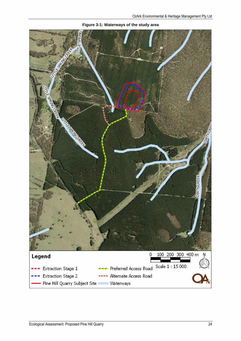
3.2.2 Waterways
Waterways within the study area are limited to a Strahler first order tributary of Little Spring
Creek (Figure 3-1). This tributary crosses an existing access track and has been furthered
impacted by damming. Details of this waterway are provided in the waterways assessment
results, provided in Table 3-1.
Adjacent to the study area, Little Spring Creek (Strahler first order) ends 85m west of the
existing access track proposed to be used for the proposal. A Strahler first order tributary of
Dirty Creek is located 100m east of the same access track.
None of the waterways listed in this section are considered KFH nor are they a part of an
aquatic endangered ecological community (EEC).
3.2.3 Land use
The property has previously been operated for the purpose of forestry with the vegetation
dominated by Monterey Pine (Pinus radiata) and limited understorey. Eucalypt species are
present, predominantly in the south-eastern corner of the property and as regrowth adjacent
to internal tracks. During the construction of access tracks it is likely the disturbance would
have been significant, consisting of both excavation and the laying of imported gravel
materials. Figure 3-2 shows part of the preferred access road overlaps with native woodland.
3.2.4 Climate
The study area is located within the South Eastern Highlands bioregion which has a temperate
climate characterised by warm summers and no dry season. Average climate statistics from
the Oberon (Springbank) monitoring station show temperatures range from an average
monthly maximum temperature of 24.8°C in January to an average monthly minimum
temperature of -0.3°C in July. Average annual rainfall in the region of the study area is the
highest in January and June with 80.2mm and lowest in April with 57.9mm.
OzArk Environmental & Heritage Management Pty Ltd
Ecological Assessment: Proposed Pine Hill Quarry 24
Figure 3-1: Waterways of the study area
OzArk Environmental & Heritage Management Pty Ltd
Ecological Assessment: Proposed Pine Hill Quarry 25
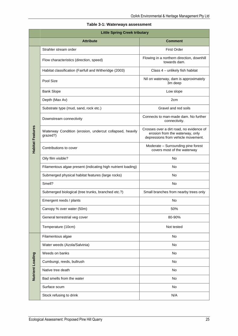
Table 3-1: Waterways assessment
Little Spring Creek tributary
Attribute Comment
Hab
ita
t F
ea
ture
s
Strahler stream order First Order
Flow characteristics (direction, speed) Flowing in a northern direction, downhill
towards dam.
Habitat classification (Fairfull and Witheridge (2003) Class 4 – unlikely fish habitat
Pool Size Nil on waterway, dam is approximately
3m deep
Bank Slope Low slope
Depth (Max Av) 2cm
Substrate type (mud, sand, rock etc.) Gravel and red soils
Downstream connectivity Connects to man-made dam. No further
connectivity.
Waterway Condition (erosion, undercut collapsed, heavily grazed?)
Crosses over a dirt road, no evidence of erosion from the waterway, only
depressions from vehicle movement.
Contributions to cover Moderate – Surrounding pine forest
covers most of the waterway
Oily film visible? No
Filamentous algae present (indicating high nutrient loading) No
Submerged physical habitat features (large rocks) No
Smell? No
Submerged biological (tree trunks, branched etc.?) Small branches from nearby trees only
Emergent reeds / plants No
Canopy % over water (50m) 50%
General terrestrial veg cover 80-90%
Temperature (10cm) Not tested
Nu
trie
nt
Lo
ad
ing
Filamentous algae No
Water weeds (Azola/Salvinia) No
Weeds on banks No
Cumbungi, reeds, bullrush No
Native tree death No
Bad smells from the water No
Surface scum No
Stock refusing to drink N/A

OzArk Environmental & Heritage Management Pty Ltd
Ecological Assessment: Proposed Pine Hill Quarry 26
Figure 3-2: Land use of the study area
OzArk Environmental & Heritage Management Pty Ltd
Ecological Assessment: Proposed Pine Hill Quarry 27
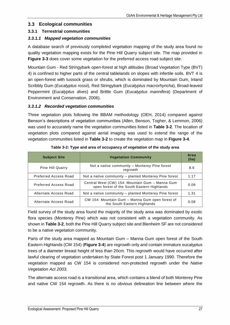
Ecological communities
3.3.1 Terrestrial communities
3.3.1.1 Mapped vegetation communities
A database search of previously completed vegetation mapping of the study area found no
quality vegetation mapping exists for the Pine Hill Quarry subject site. The map provided in
Figure 3-3 does cover some vegetation for the preferred access road subject site.
Mountain Gum - Red Stringybark open-forest at high altitudes (Broad Vegetation Type (BVT)
4) is confined to higher parts of the central tablelands on slopes with infertile soils. BVT 4 is
an open-forest with tussock grass or shrubs, which is dominated by Mountain Gum, Inland
Scribbly Gum (Eucalyptus rossii), Red Stringybark (Eucalyptus macrorhyncha), Broad-leaved
Peppermint (Eucalyptus dives) and Brittle Gum (Eucalyptus mannifera) (Department of
Environment and Conservation, 2006).
3.3.1.2 Recorded vegetation communities
Three vegetation plots following the BBAM methodology (OEH, 2014) compared against
Benson’s descriptions of vegetation communities (Allen, Benson, Togher, & Lemmon, 2006)
was used to accurately name the vegetation communities listed in Table 3-2. The location of
vegetation plots compared against aerial imaging was used to extend the range of the
vegetation communities listed in Table 3-2 to create the vegetation map in Figure 3-4.
Table 3-2: Type and area of occupancy of vegetation of the study area
Subject Site Vegetation Community Area (ha)
Pine Hill Quarry Not a native community – Monterey Pine forest
regrowth 8.6
Preferred Access Road Not a native community – planted Monterey Pine forest 1.17
Preferred Access Road Central West (CW) 154: Mountain Gum – Manna Gum
open forest of the South Eastern Highlands 0.09
Alternate Access Road Not a native community – planted Monterey Pine forest 1.31
Alternate Access Road CW 154: Mountain Gum – Manna Gum open forest of
the South Eastern Highlands 0.08
Field survey of the study area found the majority of the study area was dominated by exotic
flora species (Monterey Pine) which was not consistent with a vegetation community. As
shown in Table 3-2, both the Pine Hill Quarry subject site and Blenheim SF are not considered
to be a native vegetation community.
Parts of the study area mapped as Mountain Gum – Manna Gum open forest of the South
Eastern Highlands (CW 154) (Figure 3-4) are regrowth only and contain immature eucalyptus
trees of a diameter breast height of less than 20cm. This regrowth would have occurred after
lawful clearing of vegetation undertaken by State Forest post 1 January 1990. Therefore the
vegetation mapped as CW 154 is considered non-protected regrowth under the Native
Vegetation Act 2003.
The alternate access road is a transitional area, which contains a blend of both Monterey Pine
and native CW 154 regrowth. As there is no obvious delineation line between where the
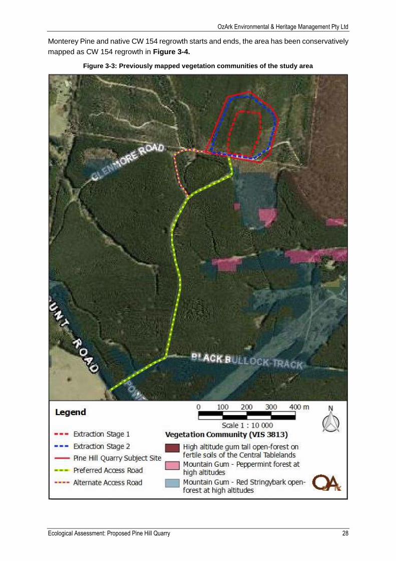
OzArk Environmental & Heritage Management Pty Ltd
Ecological Assessment: Proposed Pine Hill Quarry 28
Monterey Pine and native CW 154 regrowth starts and ends, the area has been conservatively
mapped as CW 154 regrowth in Figure 3-4.
Figure 3-3: Previously mapped vegetation communities of the study area
OzArk Environmental & Heritage Management Pty Ltd
Ecological Assessment: Proposed Pine Hill Quarry 29
Figure 3-4: Field survey vegetation community results for the study area
OzArk Environmental & Heritage Management Pty Ltd
Ecological Assessment: Proposed Pine Hill Quarry 30
3.3.1.3 Vegetation connectivity
BBAM (OEH, 2014) was used to provide landscape value of vegetation in the study area in
Table 3-3.
Table 3-3: Value of vegetation in the landscape
Criteria Value
Size and shape of the proposal The study area covers 10.31ha of land within Lot 267 DP 757068 and Lot 37 DP 650068.
Location and position in the landscape (National Committee on Soil and Terrain 2009)
The study area is located on top of a steeply sloping hill. The Quarry is on the crest of the hill, whereas the access road is located along the slopes.
Percentage vegetation cover in a 100 ha circle centred on the study area
95%
Percentage vegetation cover in 1000 ha circle centred on the study area
80%
Connectivity value The study area has high connectivity as it connects to the Blenheim State Forest and other woodlands which span approximately 940ha.
Nearest remnant vegetation (distance, size and connectivity)
As above.
Distance to nearest large vegetation remnant greater than 1000 ha
0km – adjacent to Blenheim State Forest.
3.3.1.4 Threatened terrestrial ecological communities
Desktop review of the desktop based mapped vegetation of the study area found vegetation
of the study area was not associated with any Endangered Ecological Communities (EECs).
Desktop review of OEH threatened species website found the field survey based mapped
vegetation (CW154) is associated with Tableland Basalt Forest in the Sydney Basin and
Southern Eastern Highlands Bioregions EEC. Review of this EECs identification guidelines
(DECCW, 2010) found while the mapped vegetation was associated with the EEC, it did not
meet the definition of the EEC. The definition of the Tableland Basalt Forest in the Sydney
Basin and Southern Eastern Highlands Bioregions EEC is:
Between 600m to 900m – no, the study area is located at 1150m.
Located on relatively fertile loam or clay soils derived mainly from basalt – no, Mitchell
landscape places the study area on slates, sandstones and non-basalt derived volanics.
Vegetation a grassy open forest or woodland, or a native grassland – yes, grassy open
woodland.
A tree layer containing any of the following: ribbon gum, narrow-leaved peppermint,
mountain gum or snow gum – yes, mountain gum.
As not all of the above criteria were met, the CW154 vegetation within the study area is not
considered to be the Tableland Basalt Forest in the Sydney Basin and Southern Eastern
Highlands Bioregions EEC listed under the NSW TSC Act.
3.3.2 Aquatic communities
Desktop search found the waterways of the study area are not mapped as key fish habitat.
3.3.2.1 Threatened aquatic ecological communities
The waterways of the study area are not associated with any aquatic EECs.
OzArk Environmental & Heritage Management Pty Ltd
Ecological Assessment: Proposed Pine Hill Quarry 31
3.3.3 Groundwater dependant ecosystems
The study area is mapped by the Bureau of Meteorology (BoM) Atlas of Groundwater
Dependant Ecosystems as having vegetation with a low potential for groundwater interaction
(Appendix E). As the vegetation in the study area is mainly located near the peak of Pine Hill
(above 1100m AHD), it is unlikely the vegetation the can reach any groundwater.
Waterways nearby but outside of the study area have moderate potential for surface
expression of groundwater (Appendix E).
Flora
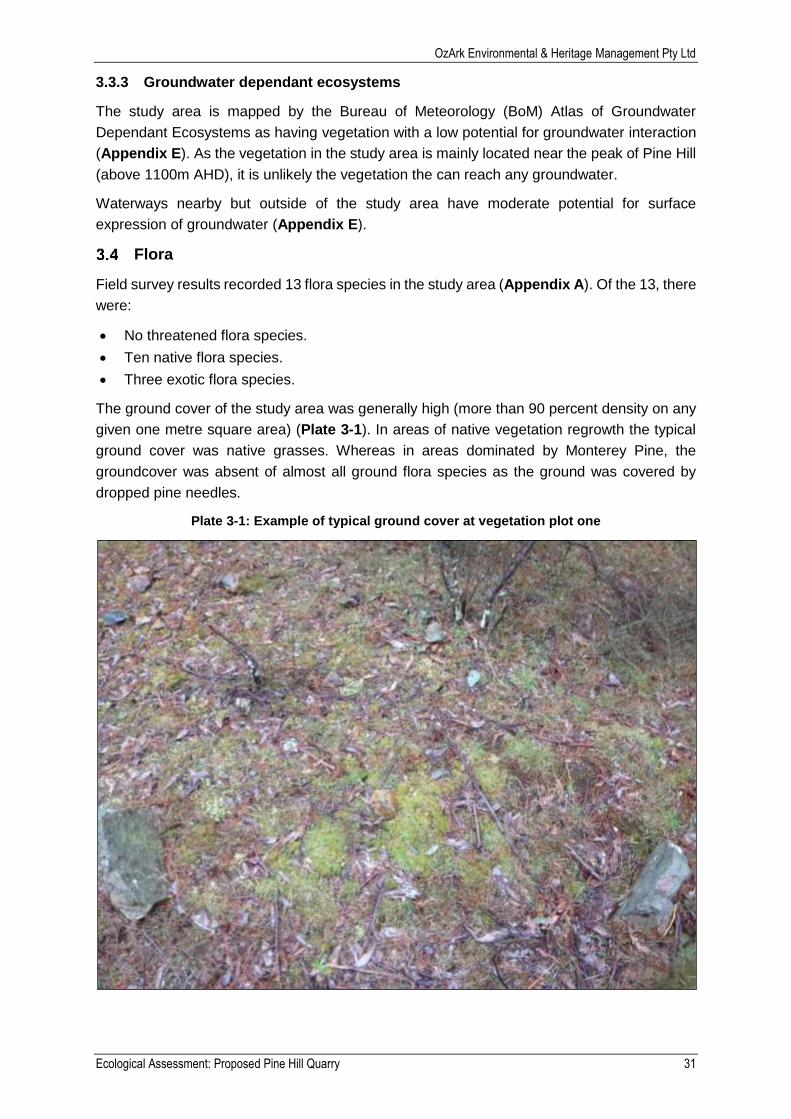
Field survey results recorded 13 flora species in the study area (Appendix A). Of the 13, there
were:
No threatened flora species.
Ten native flora species.
Three exotic flora species.
The ground cover of the study area was generally high (more than 90 percent density on any
given one metre square area) (Plate 3-1). In areas of native vegetation regrowth the typical
ground cover was native grasses. Whereas in areas dominated by Monterey Pine, the
groundcover was absent of almost all ground flora species as the ground was covered by
dropped pine needles.
Plate 3-1: Example of typical ground cover at vegetation plot one
OzArk Environmental & Heritage Management Pty Ltd
Ecological Assessment: Proposed Pine Hill Quarry 32
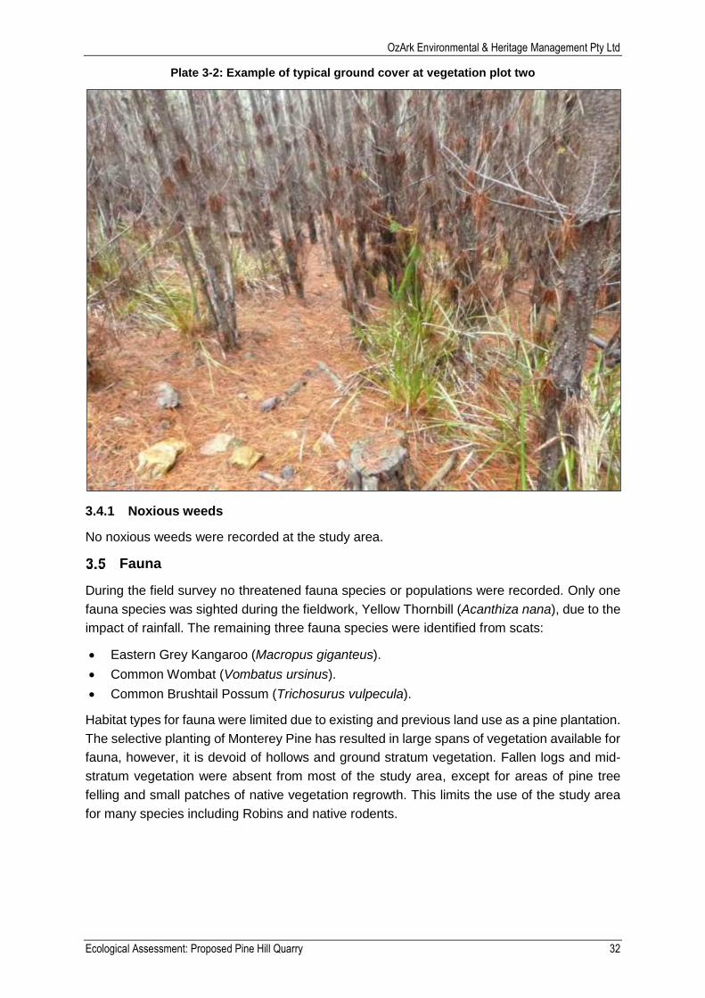
Plate 3-2: Example of typical ground cover at vegetation plot two
3.4.1 Noxious weeds
No noxious weeds were recorded at the study area.
Fauna
During the field survey no threatened fauna species or populations were recorded. Only one
fauna species was sighted during the fieldwork, Yellow Thornbill (Acanthiza nana), due to the
impact of rainfall. The remaining three fauna species were identified from scats:
Eastern Grey Kangaroo (Macropus giganteus).
Common Wombat (Vombatus ursinus).
Common Brushtail Possum (Trichosurus vulpecula).
Habitat types for fauna were limited due to existing and previous land use as a pine plantation.
The selective planting of Monterey Pine has resulted in large spans of vegetation available for
fauna, however, it is devoid of hollows and ground stratum vegetation. Fallen logs and mid-
stratum vegetation were absent from most of the study area, except for areas of pine tree
felling and small patches of native vegetation regrowth. This limits the use of the study area
for many species including Robins and native rodents.

OzArk Environmental & Heritage Management Pty Ltd
Ecological Assessment: Proposed Pine Hill Quarry 33
Predictive modelling
3.6.1 Previously recorded threatened species and endangered populations
A database search of OEH BioNet Atlas found eight TSC Act or EPBC Act listed terrestrial
species have been previously recorded within 10km of the study area (Table 3-4 and Figure
3-5).
Table 3-4: Threatened species identified within 10km of the study area
Class Name Scientific Name Common Name NSW Status Comm Status No. of
Sightings
Flora Paralucia spinifera Black Gum Vulnerable Vulnerable 4
Mammalia Ardea ibis Koala Vulnerable Vulnerable 2
Insecta Eucalyptus aggregata
Purple Copper Butterfly Bathurst Copper Butterfly
Endangered Vulnerable 1
Amphibia Eucalyptus pulverulenta
Green and Golden Bell Frog
Endangered Vulnerable 1
Aves Gallinago hardwickii Little Eagle Vulnerable 1
Aves Hieraaetus
morphnoides Latham's Snipe Protected
CAMBA JAMBA
ROKAMBA 1
Flora Litoria aurea Silver-leafed Gum Vulnerable Vulnerable 1
Aves Phascolarctos
cinereus Cattle Egret Protected
CAMBA JAMBA
1
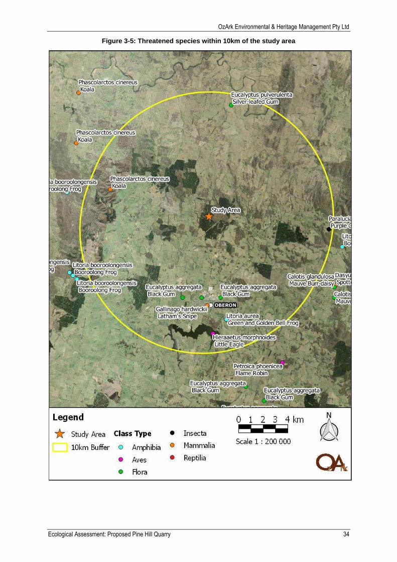
OzArk Environmental & Heritage Management Pty Ltd
Ecological Assessment: Proposed Pine Hill Quarry 34
Figure 3-5: Threatened species within 10km of the study area
OzArk Environmental & Heritage Management Pty Ltd
Ecological Assessment: Proposed Pine Hill Quarry 35
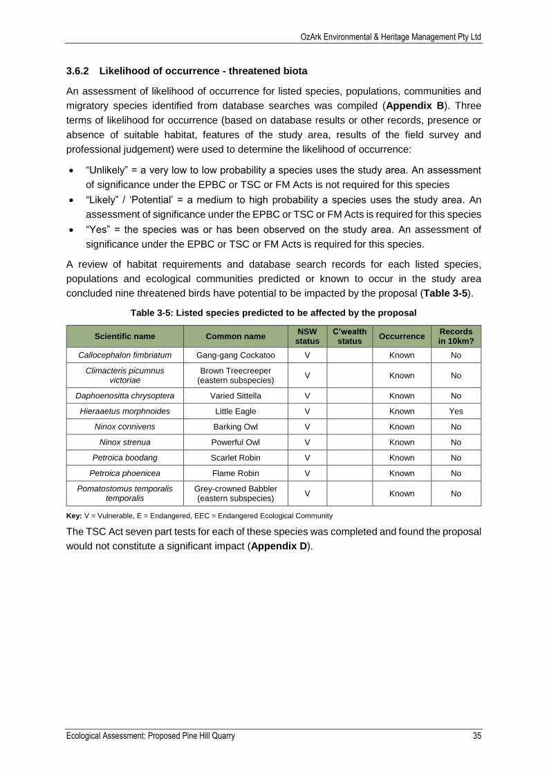
3.6.2 Likelihood of occurrence - threatened biota
An assessment of likelihood of occurrence for listed species, populations, communities and
migratory species identified from database searches was compiled (Appendix B). Three
terms of likelihood for occurrence (based on database results or other records, presence or
absence of suitable habitat, features of the study area, results of the field survey and
professional judgement) were used to determine the likelihood of occurrence:
“Unlikely” = a very low to low probability a species uses the study area. An assessment
of significance under the EPBC or TSC or FM Acts is not required for this species
“Likely” / ‘Potential’ = a medium to high probability a species uses the study area. An
assessment of significance under the EPBC or TSC or FM Acts is required for this species
“Yes” = the species was or has been observed on the study area. An assessment of
significance under the EPBC or TSC or FM Acts is required for this species.
A review of habitat requirements and database search records for each listed species,
populations and ecological communities predicted or known to occur in the study area
concluded nine threatened birds have potential to be impacted by the proposal (Table 3-5).
Table 3-5: Listed species predicted to be affected by the proposal
Scientific name Common name NSW
status C’wealth
status Occurrence
Records in 10km?
Callocephalon fimbriatum Gang-gang Cockatoo V Known No
Climacteris picumnus victoriae
Brown Treecreeper (eastern subspecies)
V Known No
Daphoenositta chrysoptera Varied Sittella V Known No
Hieraaetus morphnoides Little Eagle V Known Yes
Ninox connivens Barking Owl V Known No
Ninox strenua Powerful Owl V Known No
Petroica boodang Scarlet Robin V Known No
Petroica phoenicea Flame Robin V Known No
Pomatostomus temporalis temporalis
Grey-crowned Babbler (eastern subspecies)
V Known No
Key: V = Vulnerable, E = Endangered, EEC = Endangered Ecological Community
The TSC Act seven part tests for each of these species was completed and found the proposal
would not constitute a significant impact (Appendix D).
OzArk Environmental & Heritage Management Pty Ltd
Ecological Assessment: Proposed Pine Hill Quarry 36
Potential impact
Direct impact
4.1.1 Impact to native vegetation
The proposal has been designed to minimise impact to native vegetation. The proposal is
expected to impact at most 10.31ha of predominately exotic vegetation (Monterey Pine). The
amount of vegetation to be cleared is much less than 10.31ha as the majority of the access road
is located on existing cleared land where lopping of tree limbs would be required, not tree
removal.
Of the 10.31ha of vegetation to be cleared, 0.17ha is considered native vegetation regrowth of
Mountain Gum – Manna Gum open forest of the South Eastern Highlands (CW 154). As only
one access road option would be used, at most 0.09ha of native vegetation regrowth (CW 145)
would be impacted.
Cumulative impact to native vegetation would:
Cause death or harm to fauna present in habitat during clearing.
Remove upper, mid and ground layer foraging, resting and feeding habitat for native
species.
4.1.2 Impact to endangered ecological communities
The vegetation to be impacted by the proposal is not associated with any EECs.
4.1.3 Impact to groundwater dependent communities
GDEs are unlikely to be present in the study area, see section 3.3.3. Removal of vegetation
and excavation of Pine Hill at over 1100m AHD is unlikely to interfere with any GDEs. Therefore
the will be no GDEs impacted by the proposal.
4.1.4 Impact to hollow bearing trees
There will be no hollow bearing trees impacted by the proposal.
4.1.5 Fragmentation of habitat
The study area is adjacent to Blenheim State Forest and less than three kilometres from Lowes
Mount State Forest. The study area has high connectivity as it connects to the Blenheim State
Forest and other woodlands which span approximately 940ha.
Vegetation to be removed by the proposal is restricted to a nine metre wide corridor along the
access roads and up to 8.6ha for the Pine Hill Quarry (total 10.31ha). Loss of at most a 10.31ha
vegetated area will be not fragment habitat. The remaining vegetation will have a continuous
connection despite loss of the 10.31ha area to be cleared.
4.1.6 Soils and drainage
Construction and operation of the Pine Hill Quarry will by its design, impact soil. Pine Hill Quarry
has an expected operational life of more than 20 years, when upon completion the study area
will be rehabilitated to match the vegetation type and quality standards for CW145. Soils would
also be disturbed in any area where vegetation clearing of the ground stratum occurs for
OzArk Environmental & Heritage Management Pty Ltd
Ecological Assessment: Proposed Pine Hill Quarry 37
construction of, and operation of, the access road. Soil disturbance is not expected to negatively
impact the environment in the long term if rehabilitation is completed successfully.
Impact to waterways will only occur if the alternate access road option is used. The portion of
the road which traverses the Strahler first order tributary of Little Spring Creek is pre-existing.
The waterway is unlikely fish habitat, not mapped as KFH or an aquatic EEC and terminates at
the downstream dam. Considering all of these factors, continued use of the road will not
significantly impact the waterway.
Indirect impact
4.2.1 Operational noise
Operational noise during construction may disturb fauna or prevent them using habitat in the
study area. This impact would be short term and most fauna would be able to relocate to nearby
suitable habitat within Blenheim State Forest. Operational noise of the Pine Hill Quarry would
be high, as quarries by their nature are noisy, however, short in duration. The Quarry will not be
running constantly or during the night. The Quarry will only be operational for small blocks of a
few weeks at a time as supply demands. Any fauna which are sensitive to noise would only be
impacted periodically and for short durations.
4.2.2 Weeds
Soil disturbance may result in new weed populations. Introduction or spread of weeds through
the study area is associated with the following proposal work:
Removing native vegetation.
Excavation, stripping and construction.
If safeguards in Section 6 are followed the risk of weed colonisation in the study area will be
minimised.
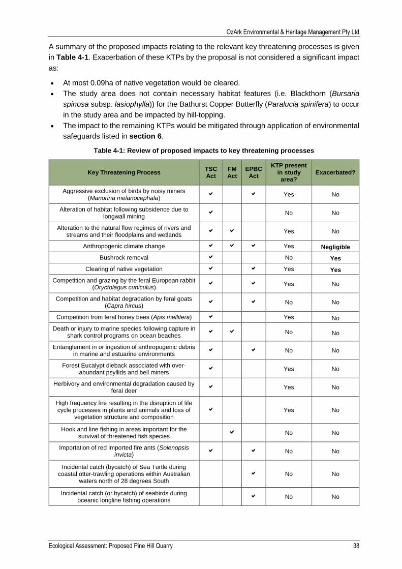
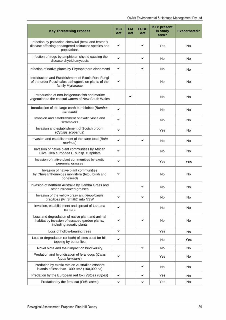
Impact on Key Threatening Processes
There are six Key Threatening Processes (KTP’s) at the NSW State and Federal level which
will be exacerbated by the proposal. The proposal will consist of minor vegetation clearing,
which provides an opportunity for exotic perennial grasses to colonise the area. Stands of felled
dead trees exist within the Pine Hill Quarry subject site and will be removed for the proposal.
The proposal is expected to negligibly contribute to anthropogenic climate change as would any
development involving vegetation clearing and use of machinery. Construction of the Pine Hill
Quarry will remove bushrock and flatten the top of Pine Hill which may be used by hill-topping
butterflies.
The OEH, DoE and DPI Fisheries list of KTPs was reviewed and 18 KTPs are active within the
study area. Six of these will be exacerbated by the proposal:
Clearing of native vegetation.
Bushrock removal.
Anthropogenic climate change.
Invasion of native plant communities by exotic perennial grasses.
Removal of dead wood and dead trees.
Loss or degradation (or both) of sites used for hill-topping by butterflies.
OzArk Environmental & Heritage Management Pty Ltd
Ecological Assessment: Proposed Pine Hill Quarry 38
A summary of the proposed impacts relating to the relevant key threatening processes is given
in Table 4-1. Exacerbation of these KTPs by the proposal is not considered a significant impact
as:
At most 0.09ha of native vegetation would be cleared.
The study area does not contain necessary habitat features (i.e. Blackthorn (Bursaria
spinosa subsp. lasiophylla)) for the Bathurst Copper Butterfly (Paralucia spinifera) to occur
in the study area and be impacted by hill-topping.
The impact to the remaining KTPs would be mitigated through application of environmental
safeguards listed in section 6.
Table 4-1: Review of proposed impacts to key threatening processes
Key Threatening Process TSC Act
FM Act
EPBC Act
KTP present in study
area? Exacerbated?
Aggressive exclusion of birds by noisy miners (Manorina melanocephala)
Yes No
Alteration of habitat following subsidence due to longwall mining
No No
Alteration to the natural flow regimes of rivers and streams and their floodplains and wetlands
Yes No
Anthropogenic climate change Yes Negligible
Bushrock removal No Yes
Clearing of native vegetation Yes Yes
Competition and grazing by the feral European rabbit (Oryctolagus cuniculus)
Yes No
Competition and habitat degradation by feral goats (Capra hircus)
No No
Competition from feral honey bees (Apis mellifera) Yes No
Death or injury to marine species following capture in shark control programs on ocean beaches
No No
Entanglement in or ingestion of anthropogenic debris in marine and estuarine environments
No No
Forest Eucalypt dieback associated with over-abundant psyllids and bell miners
Yes No
Herbivory and environmental degradation caused by feral deer
Yes No
High frequency fire resulting in the disruption of life cycle processes in plants and animals and loss of
vegetation structure and composition
Yes No
Hook and line fishing in areas important for the survival of threatened fish species
No No
Importation of red imported fire ants (Solenopsis invicta)
No No
Incidental catch (bycatch) of Sea Turtle during coastal otter-trawling operations within Australian
waters north of 28 degrees South
No No
Incidental catch (or bycatch) of seabirds during oceanic longline fishing operations
No No
OzArk Environmental & Heritage Management Pty Ltd
Ecological Assessment: Proposed Pine Hill Quarry 39
Key Threatening Process TSC Act
FM Act
EPBC Act
KTP present in study
area? Exacerbated?
Infection by psittacine circoviral (beak and feather) disease affecting endangered psittacine species and
populations
Yes No
Infection of frogs by amphibian chytrid causing the disease chytridiomycosis
No No
Infection of native plants by Phytophthora cinnamomi No No
Introduction and Establishment of Exotic Rust Fungi of the order Pucciniales pathogenic on plants of the
family Myrtaceae
No No
Introduction of non-indigenous fish and marine vegetation to the coastal waters of New South Wales
No No
Introduction of the large earth bumblebee (Bombus terrestris)
No No
Invasion and establishment of exotic vines and scramblers
No No
Invasion and establishment of Scotch broom (Cytisus scoparius)
Yes No
Invasion and establishment of the cane toad (Bufo marinus)
No No
Invasion of native plant communities by African Olive Olea europaea L. subsp. cuspidata
No No
Invasion of native plant communities by exotic perennial grasses
Yes Yes
Invasion of native plant communities by Chrysanthemoides monilifera (bitou bush and
boneseed)
No No
Invasion of northern Australia by Gamba Grass and other introduced grasses
No No
Invasion of the yellow crazy ant (Anoplolepis gracilipes (Fr. Smith)) into NSW
No No
Invasion, establishment and spread of Lantana camara
No No
Loss and degradation of native plant and animal habitat by invasion of escaped garden plants,
including aquatic plants
No No
Loss of hollow-bearing trees Yes No
Loss or degradation (or both) of sites used for hill-topping by butterflies
No Yes
Novel biota and their impact on biodiversity No No
Predation and hybridisation of feral dogs (Canis lupus familiaris)
Yes No
Predation by exotic rats on Australian offshore islands of less than 1000 km2 (100,000 ha)
No No
Predation by the European red fox (Vulpes vulpes) Yes No
Predation by the feral cat (Felis catus) Yes No
OzArk Environmental & Heritage Management Pty Ltd
Ecological Assessment: Proposed Pine Hill Quarry 40
Key Threatening Process TSC Act
FM Act
EPBC Act
KTP present in study
area? Exacerbated?
Predation by the ship rat (Rattus rattus) on Lord
Howe Island No No
Predation by Gambusia holbrooki Girard, 1859 (plague minnow or mosquito fish)
No No
Predation, habitat degradation, competition and disease transmission by feral pigs (Sus scrofa)
Yes No
Removal of dead wood and dead trees Yes Yes
The degradation of native riparian vegetation along New South Wales water courses
No No
The introduction of fish to fresh waters within a river catchment outside their natural range
No No
The removal of large woody debris from NSW rivers and streams
No No
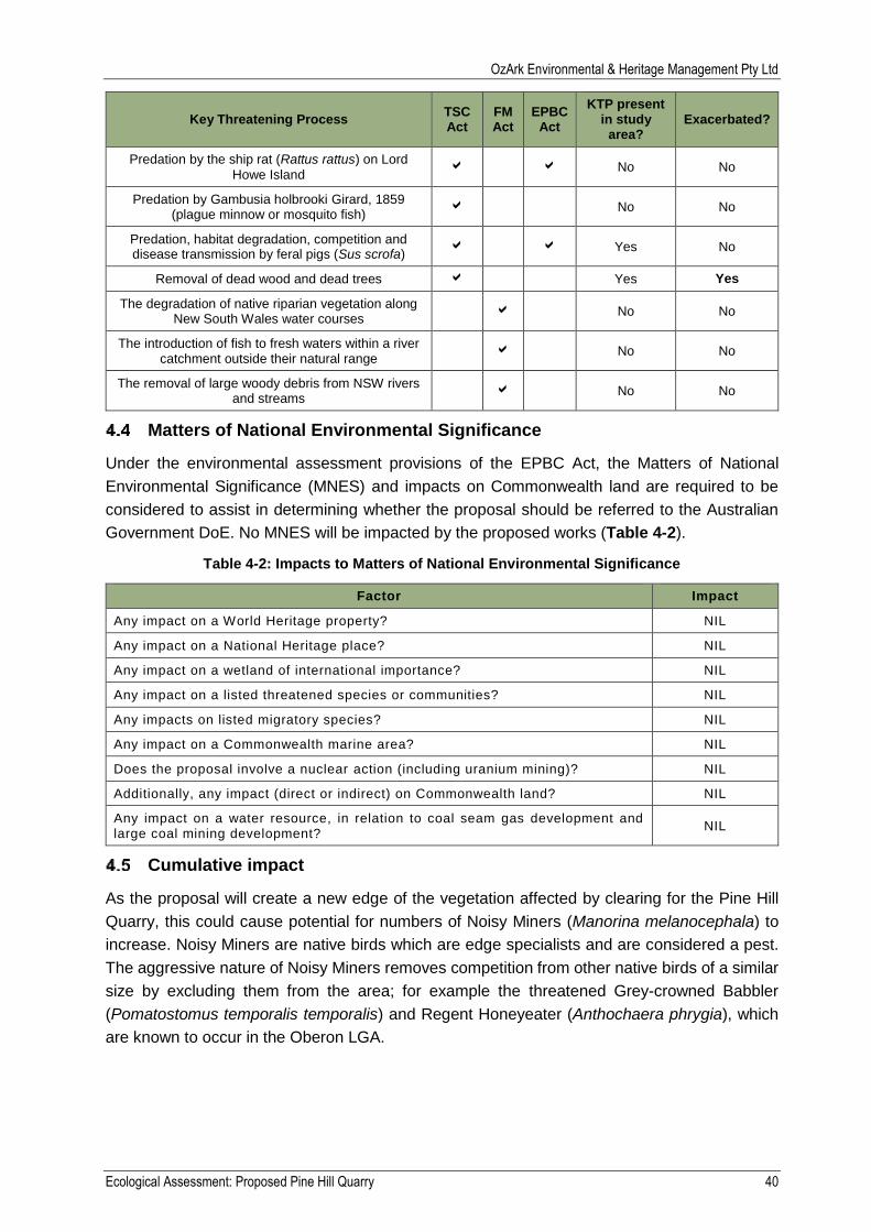
Matters of National Environmental Significance
Under the environmental assessment provisions of the EPBC Act, the Matters of National
Environmental Significance (MNES) and impacts on Commonwealth land are required to be
considered to assist in determining whether the proposal should be referred to the Australian
Government DoE. No MNES will be impacted by the proposed works (Table 4-2).
Table 4-2: Impacts to Matters of National Environmental Significance
Factor Impact
Any impact on a World Heritage property? NIL
Any impact on a National Heritage place? NIL
Any impact on a wetland of international importance? NIL
Any impact on a listed threatened species or communities? NIL
Any impacts on listed migratory species? NIL
Any impact on a Commonwealth marine area? NIL
Does the proposal involve a nuclear action (including uranium mining)? NIL
Additionally, any impact (direct or indirect) on Commonwealth land? NIL
Any impact on a water resource, in relation to coal seam gas development and large coal mining development?
NIL
Cumulative impact
As the proposal will create a new edge of the vegetation affected by clearing for the Pine Hill
Quarry, this could cause potential for numbers of Noisy Miners (Manorina melanocephala) to
increase. Noisy Miners are native birds which are edge specialists and are considered a pest.
The aggressive nature of Noisy Miners removes competition from other native birds of a similar
size by excluding them from the area; for example the threatened Grey-crowned Babbler
(Pomatostomus temporalis temporalis) and Regent Honeyeater (Anthochaera phrygia), which
are known to occur in the Oberon LGA.
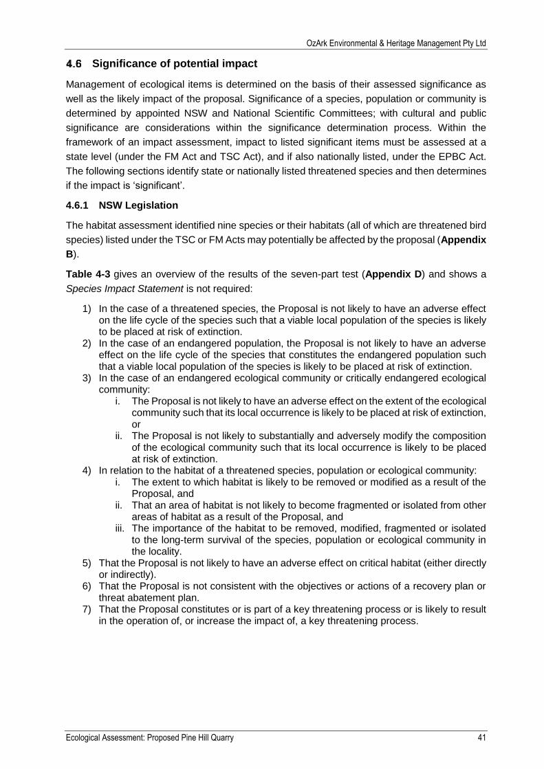
OzArk Environmental & Heritage Management Pty Ltd
Ecological Assessment: Proposed Pine Hill Quarry 41
Significance of potential impact
Management of ecological items is determined on the basis of their assessed significance as
well as the likely impact of the proposal. Significance of a species, population or community is
determined by appointed NSW and National Scientific Committees; with cultural and public
significance are considerations within the significance determination process. Within the
framework of an impact assessment, impact to listed significant items must be assessed at a
state level (under the FM Act and TSC Act), and if also nationally listed, under the EPBC Act.
The following sections identify state or nationally listed threatened species and then determines
if the impact is ‘significant’.
4.6.1 NSW Legislation
The habitat assessment identified nine species or their habitats (all of which are threatened bird
species) listed under the TSC or FM Acts may potentially be affected by the proposal (Appendix
B).
Table 4-3 gives an overview of the results of the seven-part test (Appendix D) and shows a
Species Impact Statement is not required:
1) In the case of a threatened species, the Proposal is not likely to have an adverse effect on the life cycle of the species such that a viable local population of the species is likely to be placed at risk of extinction.
2) In the case of an endangered population, the Proposal is not likely to have an adverse effect on the life cycle of the species that constitutes the endangered population such that a viable local population of the species is likely to be placed at risk of extinction.
3) In the case of an endangered ecological community or critically endangered ecological community:
i. The Proposal is not likely to have an adverse effect on the extent of the ecological community such that its local occurrence is likely to be placed at risk of extinction, or
ii. The Proposal is not likely to substantially and adversely modify the composition of the ecological community such that its local occurrence is likely to be placed at risk of extinction.
4) In relation to the habitat of a threatened species, population or ecological community: i. The extent to which habitat is likely to be removed or modified as a result of the
Proposal, and ii. That an area of habitat is not likely to become fragmented or isolated from other
areas of habitat as a result of the Proposal, and iii. The importance of the habitat to be removed, modified, fragmented or isolated
to the long-term survival of the species, population or ecological community in the locality.
5) That the Proposal is not likely to have an adverse effect on critical habitat (either directly or indirectly).
6) That the Proposal is not consistent with the objectives or actions of a recovery plan or threat abatement plan.
7) That the Proposal constitutes or is part of a key threatening process or is likely to result in the operation of, or increase the impact of, a key threatening process.
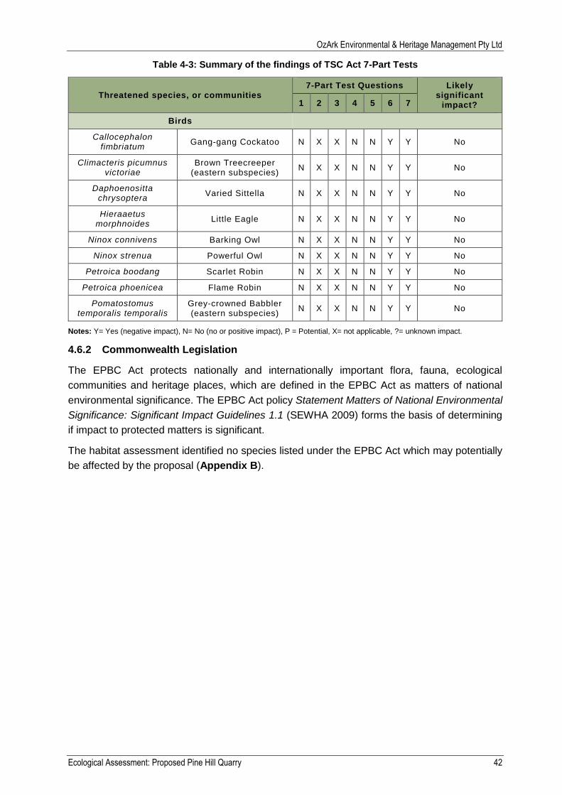
OzArk Environmental & Heritage Management Pty Ltd
Ecological Assessment: Proposed Pine Hill Quarry 42
Table 4-3: Summary of the findings of TSC Act 7-Part Tests
Threatened species, or communities 7-Part Test Questions Likely
significant impact? 1 2 3 4 5 6 7
Birds
Callocephalon fimbriatum
Gang-gang Cockatoo N X X N N Y Y No
Climacteris picumnus victoriae
Brown Treecreeper (eastern subspecies)
N X X N N Y Y No
Daphoenositta chrysoptera
Varied Sittella N X X N N Y Y No
Hieraaetus morphnoides
Little Eagle N X X N N Y Y No
Ninox connivens Barking Owl N X X N N Y Y No
Ninox strenua Powerful Owl N X X N N Y Y No
Petroica boodang Scarlet Robin N X X N N Y Y No
Petroica phoenicea Flame Robin N X X N N Y Y No
Pomatostomus temporalis temporalis
Grey-crowned Babbler (eastern subspecies)
N X X N N Y Y No
Notes: Y= Yes (negative impact), N= No (no or positive impact), P = Potential, X= not applicable, ?= unknown impact.
4.6.2 Commonwealth Legislation
The EPBC Act protects nationally and internationally important flora, fauna, ecological
communities and heritage places, which are defined in the EPBC Act as matters of national
environmental significance. The EPBC Act policy Statement Matters of National Environmental
Significance: Significant Impact Guidelines 1.1 (SEWHA 2009) forms the basis of determining
if impact to protected matters is significant.
The habitat assessment identified no species listed under the EPBC Act which may potentially
be affected by the proposal (Appendix B).

OzArk Environmental & Heritage Management Pty Ltd
Ecological Assessment: Proposed Pine Hill Quarry 43
Offsetting and rehabilitation
Offsetting requirement
Proposals assessed under Part 4 or 5 of the EP&A Act do not have compulsory offsetting
requirements unless a council or government department has a biodiversity offsetting policy or
a significant impact to a listed species, population or community has been determined. The
Australian Local Government Association does not have an offsetting policy, however, individual
councils may do. As a significant impact to threatened items is not expected to occur, offsetting
is not expected to be triggered.
Rehabilitation
5.2.1 Benson’s benchmarks
Benson’s biometric vegetation type benchmarks (Benson, 2009) were developed by the NSW
Office of Environment and Heritage for described vegetation communities in different Catchment
Management Areas across NSW. Benson’s regional benchmarks underpin each community by
providing established quality parameters. By quantifying the baseline vegetation quality
standard, the future rehabilitation of Pine Hill Quarry vegetation can be monitored over time
against an accepted standard.
5.2.2 Results
As the vegetation currently occupying the Pine Hill Quarry subject site is non-native, the Pine
Hill Quarry subject site should be rehabilitated to conform to the nearest native vegetation
community (CW 145). Results from the vegetation survey included one plot in a native
vegetation community (CW 145), which had been previously cleared. This area is a suitable
substitute for revegetation of the Pine Hill Quarry subject site. Vegetation survey results of
vegetation plot one were compared to Benson’s benchmark for CW 145 (Table 5-1).
Table 5-1: Benson’s benchmarks
Benson Benchmark
Native plant
species richness
Native over- storey cover (%)
Native mid-
storey cover (%)
Native ground cover
(grasses) (%)
Native ground cover
(shrubs) (%)
Native ground cover (other)
(%)
Number of trees
with hollows
Total length
of fallen logs (m)
CW 154 12 15-35 15-35 10-40 10-40 20-70 10 40
Plot 1 8 20.5 40 48.5 2.6 27 0 10
Key: White = Benson benchmark, green = within Benson benchmark, red = outside of Benson benchmark.
Comparison of results from Table 5-1 shows the current state of the native vegetation is outside
of most of the Benson’s benchmark standards. Of note, the average percentage of exotic flora
present over the 50m transect used for this survey found weed burden was very low at 2.9
percent (Appendix A). The above standard results for percentage of mid–storey cover and
grasses may be contributing to the below standard native plant species richness. The number
of trees with hollows and total length of fallen logs is well below standard, as is expected for any
recently cleared area of vegetation containing only immature trees. Rehabilitation of the Pine
Hill Quarry subject site to Benson’s benchmark for CW 154 is considered an achievable long
term rehabilitation goal.
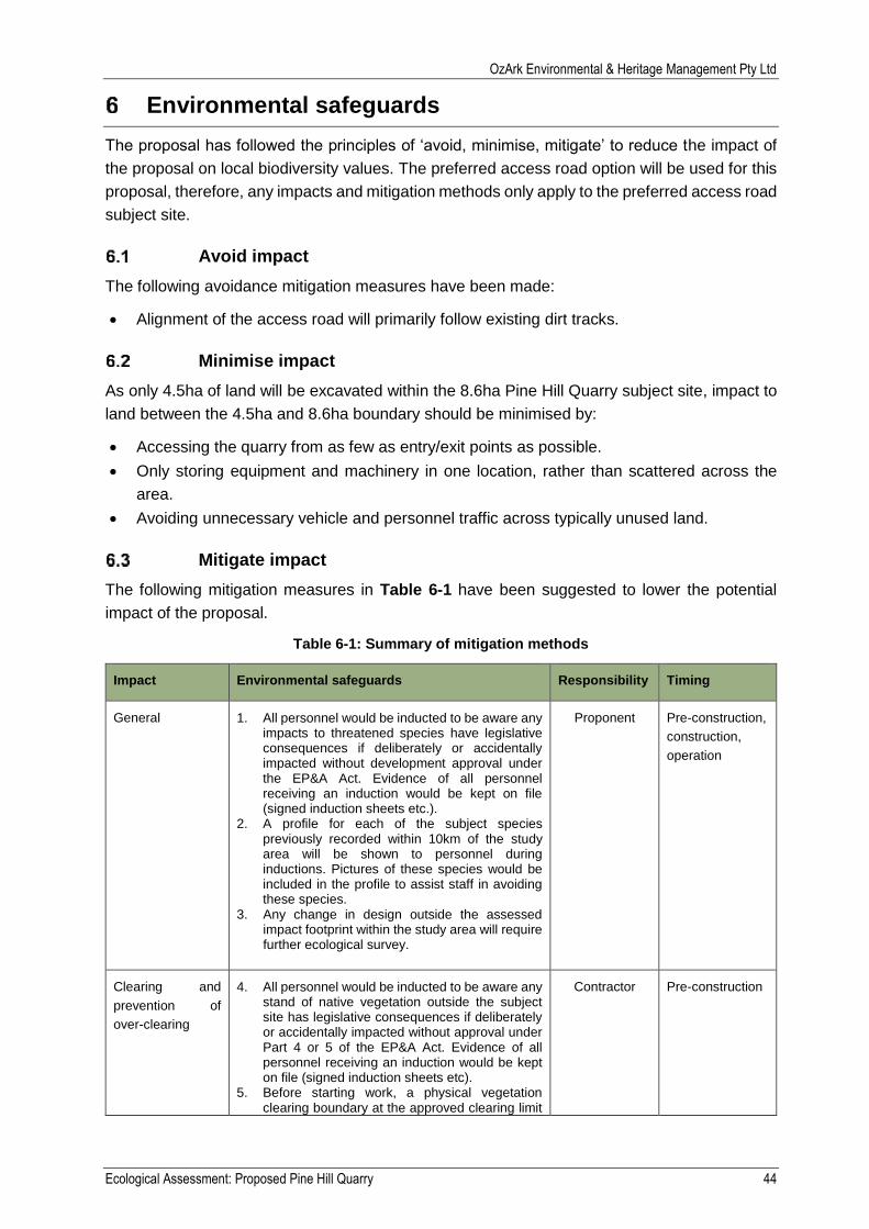
OzArk Environmental & Heritage Management Pty Ltd
Ecological Assessment: Proposed Pine Hill Quarry 44
Environmental safeguards
The proposal has followed the principles of ‘avoid, minimise, mitigate’ to reduce the impact of
the proposal on local biodiversity values. The preferred access road option will be used for this
proposal, therefore, any impacts and mitigation methods only apply to the preferred access road
subject site.
Avoid impact
The following avoidance mitigation measures have been made:
Alignment of the access road will primarily follow existing dirt tracks.
Minimise impact
As only 4.5ha of land will be excavated within the 8.6ha Pine Hill Quarry subject site, impact to
land between the 4.5ha and 8.6ha boundary should be minimised by:
Accessing the quarry from as few as entry/exit points as possible.
Only storing equipment and machinery in one location, rather than scattered across the
area.
Avoiding unnecessary vehicle and personnel traffic across typically unused land.
Mitigate impact
The following mitigation measures in Table 6-1 have been suggested to lower the potential
impact of the proposal.
Table 6-1: Summary of mitigation methods
Impact Environmental safeguards Responsibility Timing
General 1. All personnel would be inducted to be aware any impacts to threatened species have legislative consequences if deliberately or accidentally impacted without development approval under the EP&A Act. Evidence of all personnel receiving an induction would be kept on file (signed induction sheets etc.).
2. A profile for each of the subject species previously recorded within 10km of the study area will be shown to personnel during inductions. Pictures of these species would be included in the profile to assist staff in avoiding these species.
3. Any change in design outside the assessed impact footprint within the study area will require further ecological survey.
Proponent Pre-construction,
construction,
operation
Clearing and
prevention of
over-clearing
4. All personnel would be inducted to be aware any stand of native vegetation outside the subject site has legislative consequences if deliberately or accidentally impacted without approval under Part 4 or 5 of the EP&A Act. Evidence of all personnel receiving an induction would be kept on file (signed induction sheets etc).
5. Before starting work, a physical vegetation clearing boundary at the approved clearing limit
Contractor Pre-construction
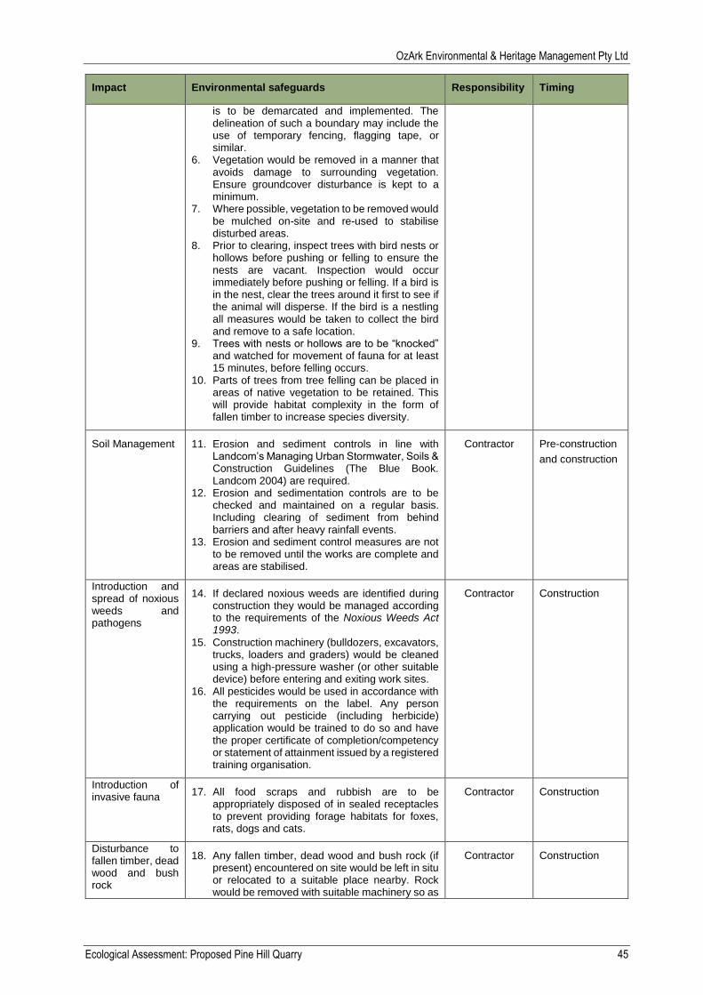
OzArk Environmental & Heritage Management Pty Ltd
Ecological Assessment: Proposed Pine Hill Quarry 45
Impact Environmental safeguards Responsibility Timing
is to be demarcated and implemented. The delineation of such a boundary may include the use of temporary fencing, flagging tape, or similar.
6. Vegetation would be removed in a manner that avoids damage to surrounding vegetation. Ensure groundcover disturbance is kept to a minimum.
7. Where possible, vegetation to be removed would be mulched on-site and re-used to stabilise disturbed areas.
8. Prior to clearing, inspect trees with bird nests or hollows before pushing or felling to ensure the nests are vacant. Inspection would occur immediately before pushing or felling. If a bird is in the nest, clear the trees around it first to see if the animal will disperse. If the bird is a nestling all measures would be taken to collect the bird and remove to a safe location.
9. Trees with nests or hollows are to be “knocked” and watched for movement of fauna for at least 15 minutes, before felling occurs.
10. Parts of trees from tree felling can be placed in areas of native vegetation to be retained. This will provide habitat complexity in the form of fallen timber to increase species diversity.
Soil Management
11. Erosion and sediment controls in line with Landcom’s Managing Urban Stormwater, Soils & Construction Guidelines (The Blue Book. Landcom 2004) are required.
12. Erosion and sedimentation controls are to be checked and maintained on a regular basis. Including clearing of sediment from behind barriers and after heavy rainfall events.
13. Erosion and sediment control measures are not to be removed until the works are complete and areas are stabilised.
Contractor Pre-construction
and construction
Introduction and spread of noxious weeds and pathogens
14. If declared noxious weeds are identified during construction they would be managed according to the requirements of the Noxious Weeds Act 1993.
15. Construction machinery (bulldozers, excavators, trucks, loaders and graders) would be cleaned using a high-pressure washer (or other suitable device) before entering and exiting work sites.
16. All pesticides would be used in accordance with the requirements on the label. Any person carrying out pesticide (including herbicide) application would be trained to do so and have the proper certificate of completion/competency or statement of attainment issued by a registered training organisation.
Contractor Construction
Introduction of invasive fauna
17. All food scraps and rubbish are to be appropriately disposed of in sealed receptacles to prevent providing forage habitats for foxes, rats, dogs and cats.
Contractor Construction
Disturbance to fallen timber, dead wood and bush rock
18. Any fallen timber, dead wood and bush rock (if present) encountered on site would be left in situ or relocated to a suitable place nearby. Rock would be removed with suitable machinery so as
Contractor Construction
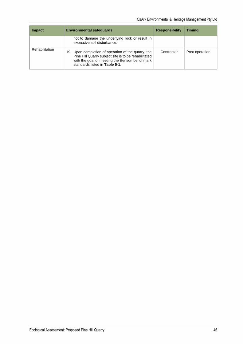
OzArk Environmental & Heritage Management Pty Ltd
Ecological Assessment: Proposed Pine Hill Quarry 46
Impact Environmental safeguards Responsibility Timing
not to damage the underlying rock or result in excessive soil disturbance.
Rehabilitation 19. Upon completion of operation of the quarry, the
Pine Hill Quarry subject site is to be rehabilitated with the goal of meeting the Benson benchmark standards listed in Table 5-1.
Contractor Post-operation
OzArk Environmental & Heritage Management Pty Ltd
Ecological Assessment: Proposed Pine Hill Quarry 47
Conclusion
Where possible, impact to the environment has been avoided through use of existing access
tracks to access to proposal. Additional safeguards and mitigation measures have been
provided to minimise harm to the environment. If these are implemented then the proposal is
unlikely to have a significant impact to species, populations and communities listed under the
EPBC, TSC or FM Acts.
No specific licences, permits, approvals and notifications required for the construction,
maintenance and operation of the proposal under Part 4 of the EP&A Act have been identified.
OzArk Environmental & Heritage Management Pty Ltd
Ecological Assessment: Proposed Pine Hill Quarry 48
References
Allen, C. B., Benson, J. S., Togher, C., & Lemmon, J. (2006). New South Wales Vegetation
Classification and Assessment: Part 1 Plant Communities of the NSW Western Plains.
Cunninghamia, 383-450.
Benson, J. (2009). New South Wales Vegetation Classification and Assessment, NSWVCA
batabase. Sydney: NSW DEC.
Bureau of Meteorology. (2016). Climate statistics for Australian locations. Retrieved from
http://www.bom.gov.au/climate/averages/tables/cw_065070.shtml
Cropper, S. (1993). Management of Endangered Plants. East Melbourne: CSIRO Publishing.
Cunningham, G., Mulham, W., Milthorpe, P., & Leigh, J. (1992). Plants of Western New South
Wales. Collingwood, VIC: CSIRO Publishing.
DEC. (2004). Threatened Biodiversity Survey and Assessment: Guidelines for Developments
and Activities. Sydney, NSW: NSW Government Department of Environment and
Conservation.
DEC. (2009). Biobanking Assessment Methodology and Credict Calculator Operation Manual .
Sydney: Department of Environment and Climate Change.
DECCW. (2010). Tableland Basalt Forest in the Sydney Basin and South Eastern Highlands
Bioregions. Sydney: Department of Environment, Climate Change and Water.
Department of Environment and Conservation. (2006). Reconstructed and Extant Distribution
of Native Vegetation in the Lachlan Catchment. Dubbo: Department of Environment and
Conservation.
DPI Water. (2012, July). Controlled activity exemptions on waterfront land. Retrieved from
http://www.water.nsw.gov.au/__data/assets/pdf_file/0010/547048/licensing_approvals_
controlled_activities_exemptions_factsheet.pdf
Harden, G. (1990-2002). Flora of New South Wales (Vols. 1 (Revised Ed.), 2 (Revised Ed.), 3
and 4). Sydney: New South Wales University Press.
Mitchell. (2002). Descriptions for NSW (Mitchell) Landscapes. NSW: NSW Government
Department of Environment and Climate Change.
OEH. (2014). BioBanking Asessment Methodology 2014. Retrieved October 2015, from
http://www.environment.nsw.gov.au/resources/biobanking/140661BBAM.pdf
RBG. (2015). PlantNET. (Royal Botanic Gardens and Domain Trust) Retrieved 2015, from
PlantNET - The Plant Information Network System of The Royal Botanic Gardens and
Domain Trust: http://plantnet.rbgsyd.nsw.gov.au

OzArk Environmental & Heritage Management Pty Ltd
Ecological Assessment: Proposed Pine Hill Quarry 49
Appendix A: Field survey results
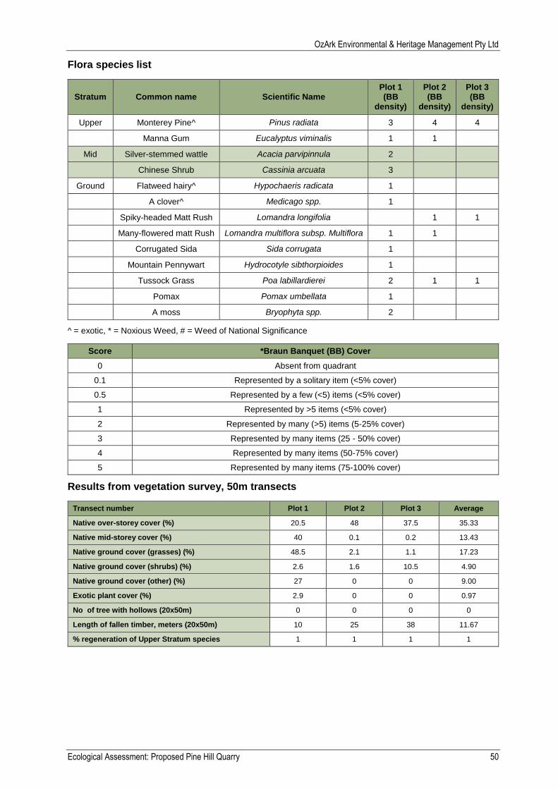
OzArk Environmental & Heritage Management Pty Ltd
Ecological Assessment: Proposed Pine Hill Quarry 50
Flora species list
Stratum Common name Scientific Name Plot 1 (BB
density)
Plot 2 (BB
density)
Plot 3 (BB
density)
Upper Monterey Pine^ Pinus radiata 3 4 4
Manna Gum Eucalyptus viminalis 1 1
Mid Silver-stemmed wattle Acacia parvipinnula 2
Chinese Shrub Cassinia arcuata 3
Ground Flatweed hairy^ Hypochaeris radicata 1
A clover^ Medicago spp. 1
Spiky-headed Matt Rush Lomandra longifolia 1 1
Many-flowered matt Rush Lomandra multiflora subsp. Multiflora 1 1
Corrugated Sida Sida corrugata 1
Mountain Pennywart Hydrocotyle sibthorpioides 1
Tussock Grass Poa labillardierei 2 1 1
Pomax Pomax umbellata 1
A moss Bryophyta spp. 2
^ = exotic, * = Noxious Weed, # = Weed of National Significance
Score *Braun Banquet (BB) Cover
0 Absent from quadrant
0.1 Represented by a solitary item (<5% cover)
0.5 Represented by a few (<5) items (<5% cover)
1 Represented by >5 items (<5% cover)
2 Represented by many (>5) items (5-25% cover)
3 Represented by many items (25 - 50% cover)
4 Represented by many items (50-75% cover)
5 Represented by many items (75-100% cover)
Results from vegetation survey, 50m transects
Transect number Plot 1 Plot 2 Plot 3 Average
Native over-storey cover (%) 20.5 48 37.5 35.33
Native mid-storey cover (%) 40 0.1 0.2 13.43
Native ground cover (grasses) (%) 48.5 2.1 1.1 17.23
Native ground cover (shrubs) (%) 2.6 1.6 10.5 4.90
Native ground cover (other) (%) 27 0 0 9.00
Exotic plant cover (%) 2.9 0 0 0.97
No of tree with hollows (20x50m) 0 0 0 0
Length of fallen timber, meters (20x50m) 10 25 38 11.67
% regeneration of Upper Stratum species 1 1 1 1

OzArk Environmental & Heritage Management Pty Ltd
Ecological Assessment: Proposed Pine Hill Quarry 51
Appendix B: Habitat assessment table
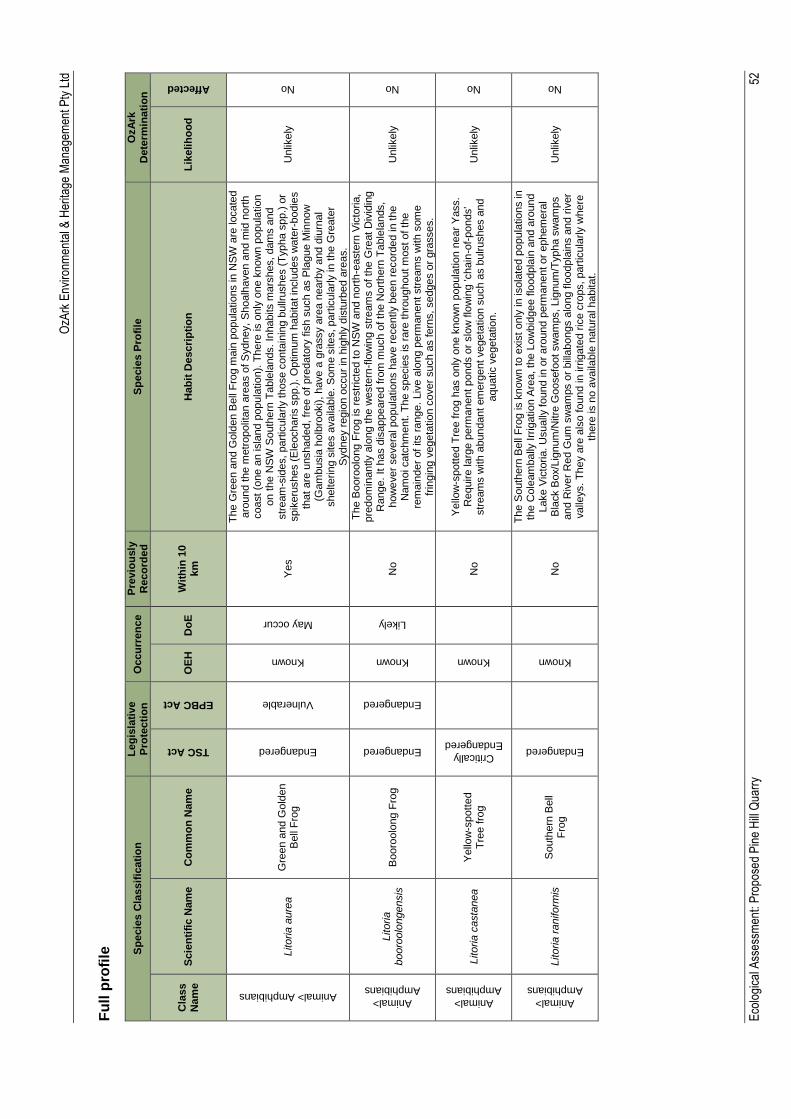
OzA
rk E
nviro
nmen
tal &
Her
itage
Man
agem
ent P
ty L
td
Eco
logi
cal A
sses
smen
t: P
ropo
sed
Pin
e H
ill Q
uarr
y
52
Fu
ll p
rofi
le
Sp
ecie
s C
lassif
icati
on
L
eg
isla
tive
Pro
tecti
on
O
ccu
rren
ce
Pre
vio
usly
R
eco
rde
d
Sp
ecie
s P
rofi
le
OzA
rk
Dete
rmin
ati
on
Cla
ss
Nam
e
Scie
nti
fic N
am
e
Co
mm
on
Nam
e
TSC Act
EPBC Act
OE
H
Do
E
Wit
hin
10
km
H
ab
it D
escri
pti
on
L
ikelih
oo
d
Affected
Animal> Amphibians
Litoria
aure
a
Gre
en a
nd G
old
en
Bell
Fro
g
Endangered
Vulnerable
Known
May occur
Yes
Th
e G
reen a
nd G
old
en B
ell
Fro
g m
ain
popula
tio
ns in
NS
W a
re locate
d
aro
und t
he m
etr
opolit
an a
reas o
f S
ydney,
Shoalh
aven a
nd m
id n
ort
h
coast
(one a
n isla
nd p
opula
tio
n).
There
is o
nly
one k
now
n p
opula
tio
n
on t
he N
SW
South
ern
Ta
ble
lands. In
habits m
ars
hes, dam
s a
nd
str
eam
-sid
es,
part
icula
rly those c
onta
inin
g b
ullr
ushes (
Typha s
pp.)
or
spik
eru
shes (
Ele
ocharis s
pp.)
. O
ptim
um
habitat in
clu
des w
ate
r-bodie
s
that
are
unshaded, fr
ee o
f pre
dato
ry f
ish s
uch a
s P
lague M
innow
(G
am
busia
holb
rooki), have a
gra
ssy a
rea n
earb
y a
nd d
iurn
al
shelterin
g s
ites a
vaila
ble
. S
om
e s
ites, part
icula
rly in
the G
reate
r S
ydney r
egio
n o
ccur
in h
ighly
dis
turb
ed a
reas.
Unlik
ely
No
Animal>
Amphibians
Litoria
booro
olo
ngensis
B
ooro
olo
ng F
rog
Endangered
Endangered
Known
Likely
No
Th
e B
ooro
olo
ng F
rog is r
estr
icte
d to N
SW
and n
ort
h-e
aste
rn V
icto
ria,
pre
dom
inantly a
long the w
este
rn-f
low
ing s
tream
s o
f th
e G
reat
Div
idin
g
Range.
It h
as d
isappeare
d f
rom
mu
ch o
f th
e N
ort
hern
Ta
ble
lands,
how
ever
severa
l popula
tio
ns h
ave r
ecently b
een r
ecord
ed in t
he
Nam
oi catc
hm
ent. T
he s
pecie
s is r
are
thro
ughout m
ost of th
e
rem
ain
der
of
its r
ange.
Liv
e a
long p
erm
anent str
eam
s w
ith s
om
e
frin
gin
g v
egeta
tio
n c
over
such a
s fern
s, sedges o
r gra
sses.
Unlik
ely
No
Animal>
Amphibians
Litoria
casta
nea
Y
ello
w-s
pott
ed
Tre
e f
rog
Critically
Endangered
Known
No
Yello
w-s
pott
ed T
ree f
rog h
as o
nly
one k
now
n p
opula
tio
n n
ear
Yass.
Require la
rge p
erm
anent ponds o
r slo
w f
low
ing 'chain
-of-
ponds'
str
eam
s w
ith a
bundant em
erg
ent vegeta
tio
n s
uch a
s b
ulrushes a
nd
aquatic v
egeta
tio
n.
Unlik
ely
No
Animal>
Amphibians
Litoria
raniform
is
South
ern
Bell
Fro
g
Endangered
Known
No
Th
e S
outh
ern
Bell
Fro
g is k
now
n to e
xis
t only
in isola
ted p
opula
tio
ns in
th
e C
ole
am
bally
Irr
igatio
n A
rea, th
e L
ow
bid
gee f
loodpla
in a
nd a
round
Lake V
icto
ria
. U
sually
found in o
r aro
und p
erm
anent or
ephem
era
l B
lack B
ox/L
ignum
/Nitre
Goosefo
ot sw
am
ps, Lig
num
/Typha s
wam
ps
and R
iver
Red G
um
sw
am
ps o
r bill
abongs a
long flo
odpla
ins a
nd r
iver
valle
ys.
Th
ey a
re a
lso f
ound in
irr
igate
d r
ice c
rops, part
icula
rly w
here
th
ere
is n
o a
vaila
ble
natu
ral habitat.
Unlik
ely
No
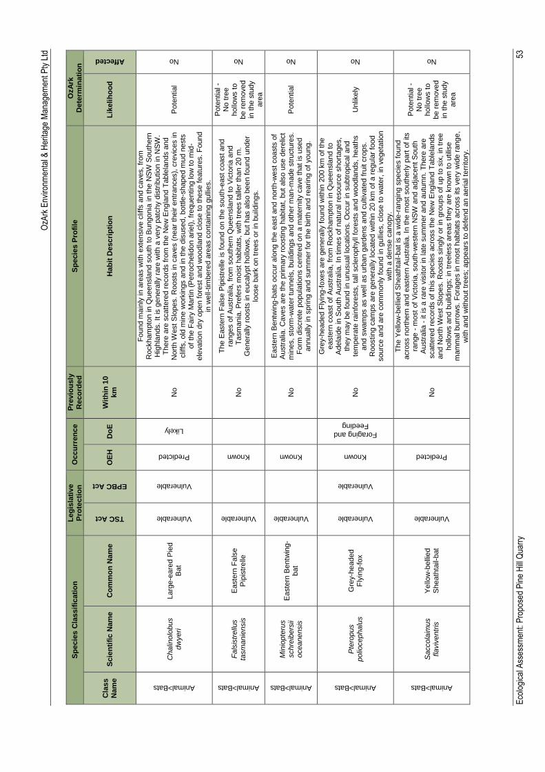
OzA
rk E
nviro
nmen
tal &
Her
itage
Man
agem
ent P
ty L
td
Eco
logi
cal A
sses
smen
t: P
ropo
sed
Pin
e H
ill Q
uarr
y
53
Sp
ecie
s C
lassif
icati
on
L
eg
isla
tive
Pro
tecti
on
O
ccu
rren
ce
Pre
vio
usly
R
eco
rde
d
Sp
ecie
s P
rofi
le
OzA
rk
Dete
rmin
ati
on
Cla
ss
Nam
e
Scie
nti
fic N
am
e
Co
mm
on
Nam
e
TSC Act
EPBC Act
OE
H
Do
E
Wit
hin
10
km
H
ab
it D
escri
pti
on
L
ikelih
oo
d
Affected
Animal>Bats
Chalin
olo
bus
dw
yeri
Larg
e-e
are
d P
ied
Bat
Vulnerable
Vulnerable
Predicted
Likely
No
Fo
und m
ain
ly in a
reas w
ith e
xte
nsiv
e c
liffs
and c
aves, fr
om
R
ockham
pto
n in Q
ueensla
nd s
outh
to B
ungonia
in t
he N
SW
South
ern
H
ighla
nds. It is g
enera
lly r
are
with a
very
patc
hy d
istr
ibutio
n in N
SW
. T
here
are
scattere
d r
ecord
s f
rom
the N
ew
Engla
nd T
able
lands a
nd
Nort
h W
est S
lopes.
Roosts
in c
aves (
near
their e
ntr
ances),
cre
vic
es in
clif
fs, old
min
e w
ork
ings a
nd in
the d
isused, bottle
-shaped m
ud n
ests
of
the F
airy M
art
in (
Petr
ochelid
on a
rie
l),
frequentin
g lo
w t
o m
id-
ele
vatio
n d
ry o
pen f
ore
st
and w
oo
dla
nd c
lose to these featu
res. F
ound
in w
ell-
tim
bere
d a
reas c
onta
inin
g g
ulli
es.
Pote
ntial
No
Animal>Bats
Fa
lsis
trellu
s
tasm
anie
nsis
E
aste
rn F
als
e
Pip
istr
elle
Vulnerable
Known
No
Th
e E
aste
rn F
als
e P
ipis
trelle
is f
ound o
n t
he s
outh
-east coast and
ranges o
f A
ustr
alia
, fr
om
south
ern
Queensla
nd t
o V
icto
ria
and
Ta
sm
ania
. P
refe
rs m
ois
t habitats
, w
ith t
rees talle
r th
an 2
0 m
. G
enera
lly r
oosts
in e
ucaly
pt hollo
ws,
but
has a
lso b
een f
ound u
nder
loose b
ark
on tre
es o
r in
build
ings.
Pote
ntial -
No t
ree
hollo
ws t
o
be r
em
oved
in t
he s
tudy
are
a
No
Animal>Bats
Min
iopte
rus
schre
ibers
ii oceanensis
Easte
rn B
entw
ing-
bat
Vulnerable
Known
No
Easte
rn B
entw
ing
-bats
occur
alo
ng t
he e
ast and n
ort
h-w
est coasts
of
Austr
alia
. C
aves a
re the p
rim
ary
roostin
g h
abitat, b
ut
als
o u
se d
ere
lict
min
es, sto
rm-w
ate
r tu
nnels
, build
ings a
nd o
ther
man
-made s
tructu
res.
Fo
rm d
iscre
te p
opula
tio
ns c
entr
ed o
n a
ma
tern
ity c
ave that is
used
annually
in
sprin
g a
nd s
um
mer
for
the b
irth
and r
earin
g o
f young.
Pote
ntial
No
Animal>Bats
Pte
ropus
polio
cephalu
s
Gre
y-h
eaded
Fly
ing-f
ox
Vulnerable
Vulnerable
Known
Foraging and
Feeding
No
Gre
y-h
eaded F
lyin
g-f
oxes a
re g
enera
lly f
ound w
ithin
200 k
m o
f th
e
easte
rn c
oast
of A
ustr
alia
, fr
om
Rockham
pto
n in Q
ueensla
nd t
o
Adela
ide in S
outh
Austr
alia
. In
tim
es o
f natu
ral re
sourc
e s
hort
ages,
they m
ay b
e found in u
nusual lo
catio
ns.
Occur
in s
ubtr
opic
al and
tem
pera
te r
ain
fore
sts
, ta
ll scle
rophyll
fore
sts
and w
oodla
nds,
heath
s
and s
wam
ps a
s w
ell
as u
rban g
ard
ens a
nd c
ultiv
ate
d f
ruit c
rops.
Roostin
g c
am
ps a
re g
enera
lly lo
cate
d w
ithin
20 k
m o
f a r
egula
r fo
od
sourc
e a
nd a
re c
om
monly
found in g
ulli
es, clo
se to w
ate
r, in
vegeta
tion
with a
dense c
anopy.
Unlik
ely
No
Animal>Bats
Saccola
imus
fla
viv
entr
is
Yello
w-b
elli
ed
Sheath
tail-
bat
Vulnerable
Predicted
No
Th
e Y
ello
w-b
elli
ed S
heath
tail-
bat is
a w
ide-r
angin
g s
pecie
s f
ound
acro
ss n
ort
hern
and e
aste
rn A
ustr
alia
. In
the m
ost
south
erly p
art
of
its
range -
most
of V
icto
ria
, south
-we
ste
rn N
SW
and a
dja
cent S
outh
A
ustr
alia
- it is
a r
are
vis
itor
in late
sum
mer
and a
utu
mn
. T
here
are
scatt
ere
d r
ecord
s o
f th
is s
pecie
s a
cro
ss the N
ew
Engla
nd T
able
lands
and N
ort
h W
est S
lopes.
Roosts
sin
gly
or
in g
roups o
f up t
o s
ix,
in t
ree
hollo
ws a
nd b
uild
ings;
in t
reele
ss a
reas t
hey a
re k
now
n t
o u
tilis
e
mam
mal burr
ow
s.
Fo
rages in
mo
st
habitats
acro
ss its
very
wid
e r
ang
e,
with a
nd w
ithout
trees;
appears
to d
efe
nd a
n a
eria
l te
rritory
.
Pote
ntial -
No t
ree
hollo
ws t
o
be r
em
oved
in t
he s
tudy
are
a
No
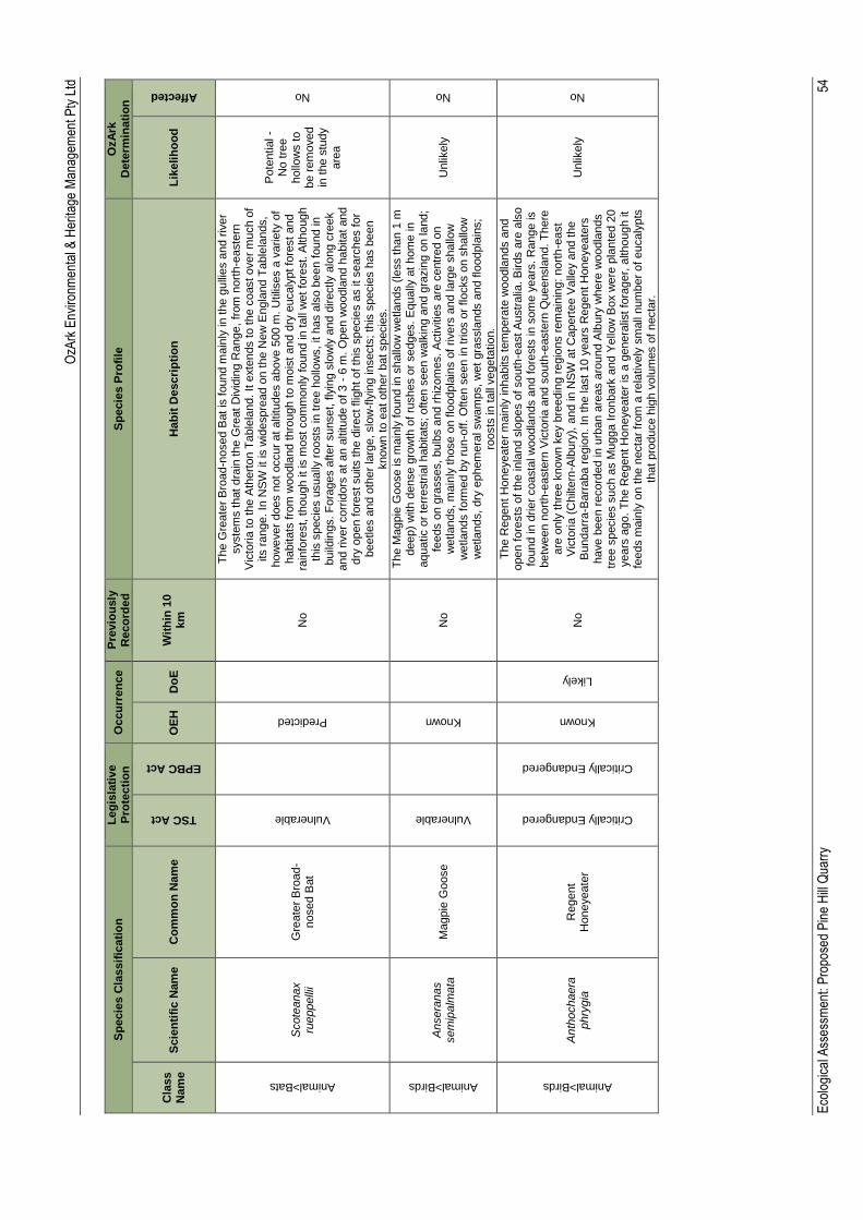
OzA
rk E
nviro
nmen
tal &
Her
itage
Man
agem
ent P
ty L
td
Eco
logi
cal A
sses
smen
t: P
ropo
sed
Pin
e H
ill Q
uarr
y
54
Sp
ecie
s C
lassif
icati
on
L
eg
isla
tive
Pro
tecti
on
O
ccu
rren
ce
Pre
vio
usly
R
eco
rde
d
Sp
ecie
s P
rofi
le
OzA
rk
Dete
rmin
ati
on
Cla
ss
Nam
e
Scie
nti
fic N
am
e
Co
mm
on
Nam
e
TSC Act
EPBC Act
OE
H
Do
E
Wit
hin
10
km
H
ab
it D
escri
pti
on
L
ikelih
oo
d
Affected
Animal>Bats
Scote
anax
rueppelli
i G
reate
r B
road
-nosed B
at
Vulnerable
Predicted
No
Th
e G
reate
r B
road
-nosed B
at
is found m
ain
ly in t
he g
ulli
es a
nd r
iver
syste
ms t
hat
dra
in the G
reat
Div
idin
g R
ange,
from
nort
h-e
aste
rn
Vic
toria
to the A
thert
on T
able
land. It e
xte
nds t
o t
he c
oast over
much o
f its r
ange. In
NS
W it
is w
idespre
ad o
n t
he N
ew
Engla
nd T
able
lands,
how
ever
does n
ot
occur
at
altitudes a
bove 5
00 m
. U
tilis
es a
varie
ty o
f habitats
fro
m w
oodla
nd t
hro
ugh t
o m
ois
t and d
ry e
ucaly
pt fo
rest and
rain
fore
st, though it is
most com
monly
found in
tall
wet
fore
st. A
lthough
this
specie
s u
sually
roosts
in t
ree h
ollo
ws,
it h
as a
lso b
een found in
build
ings. F
ora
ges a
fter
sunset, fly
ing s
low
ly a
nd d
irectly a
long c
reek
and r
iver
corr
idors
at
an a
ltitude o
f 3 -
6 m
. O
pen w
oodla
nd h
abitat and
dry
open f
ore
st suits the d
irect flig
ht
of th
is s
pecie
s a
s it searc
hes for
beetle
s a
nd o
ther
larg
e, slo
w-f
lyin
g in
sects
; th
is s
pecie
s h
as b
een
know
n t
o e
at
oth
er
bat specie
s.
Pote
ntial -
No t
ree
hollo
ws t
o
be r
em
oved
in t
he s
tudy
are
a
No
Animal>Birds
Ansera
nas
sem
ipalm
ata
M
agpie
Goose
Vulnerable
Known
No
Th
e M
agpie
Goose is m
ain
ly f
ound in
shallo
w w
etla
nds (
less than 1
m
deep)
with d
ense g
row
th o
f ru
shes o
r sedges. E
qually
at
hom
e in
aquatic o
r te
rrestr
ial habitats
; often s
een w
alk
ing a
nd g
razin
g o
n la
nd;
feeds o
n g
rasses,
bulb
s a
nd r
hiz
om
es. A
ctivitie
s a
re c
entr
ed o
n
wetla
nds, m
ain
ly t
hose o
n flo
odpla
ins o
f rivers
and la
rge s
hallo
w
wetla
nds f
orm
ed b
y r
un
-off. O
ften s
een in
trios o
r flocks o
n s
hallo
w
wetla
nds,
dry
ephem
era
l sw
am
ps, w
et
gra
ssla
nds a
nd flo
odpla
ins;
roosts
in t
all
vegeta
tio
n.
Unlik
ely
No
Animal>Birds
Anth
ochaera
phry
gia
R
egent
Honeyeate
r
Critically Endangered
Critically Endangered
Known
Likely
No
Th
e R
egent
Honeyeate
r m
ain
ly inhabits t
em
pera
te w
oodla
nds a
nd
open f
ore
sts
of th
e inla
nd s
lopes o
f south
-east A
ustr
alia
. B
irds a
re a
lso
found in
drie
r coasta
l w
oodla
nds a
nd f
ore
sts
in
som
e y
ears
. R
ange is
betw
een n
ort
h-e
aste
rn V
icto
ria
and s
outh
-easte
rn Q
ueensla
nd. T
here
are
only
thre
e k
now
n k
ey b
reedin
g r
egio
ns r
em
ain
ing:
nort
h-e
ast
Vic
toria
(C
hilt
ern
-Alb
ury
), a
nd in N
SW
at C
apert
ee V
alle
y a
nd the
Bundarr
a-B
arr
aba r
egio
n.
In the last 10 y
ears
Regent H
oneyeate
rs
have b
een r
ecord
ed in
urb
an a
reas a
round A
lbury
where
woodla
nds
tree s
pecie
s s
uch a
s M
ugga I
ronbark
and Y
ello
w B
ox w
ere
pla
nte
d 2
0
years
ago.
Th
e R
egent
Honeyeate
r is
a g
enera
list fo
rager,
although it
feeds m
ain
ly o
n t
he n
ecta
r fr
om
a r
ela
tively
sm
all
num
ber
of eucaly
pts
th
at
pro
duce h
igh v
olu
mes o
f necta
r.
Unlik
ely
No
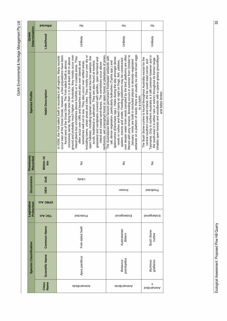
OzA
rk E
nviro
nmen
tal &
Her
itage
Man
agem
ent P
ty L
td
Eco
logi
cal A
sses
smen
t: P
ropo
sed
Pin
e H
ill Q
uarr
y
55
Sp
ecie
s C
lassif
icati
on
L
eg
isla
tive
Pro
tecti
on
O
ccu
rren
ce
Pre
vio
usly
R
eco
rde
d
Sp
ecie
s P
rofi
le
OzA
rk
Dete
rmin
ati
on
Cla
ss
Nam
e
Scie
nti
fic N
am
e
Co
mm
on
Nam
e
TSC Act
EPBC Act
OE
H
Do
E
Wit
hin
10
km
H
ab
it D
escri
pti
on
L
ikelih
oo
d
Affected
Animal>Birds
Apus p
acific
us
Fo
rk-t
aile
d S
wift
Protected
Likely
No
In N
SW
, th
e F
ork
-taile
d S
wift is
record
ed in
all
regio
ns.
Many r
ecord
s
occur
east of th
e G
reat
Div
ide,
how
ever,
a f
ew
popula
tio
ns h
ave b
een
found w
est
of th
e G
reat
Div
ide.
The F
ork
-taile
d S
wift is
alm
ost
exclu
siv
ely
aeria
l, fly
ing f
rom
less then 1
m t
o a
t le
ast 300 m
above
gro
und a
nd p
robably
much h
igher.
In A
ustr
alia
, th
ey m
ostly o
ccur
over
inla
nd p
lain
s b
ut som
etim
es a
bove f
ooth
ills o
r in
coasta
l are
as.
Th
ey
oft
en o
ccur
over
clif
fs a
nd b
eaches a
nd a
lso o
ver
isla
nds a
nd
som
etim
es w
ell
out to
sea. T
hey a
lso o
ccur
over
settle
d a
reas,
inclu
din
g tow
ns,
urb
an a
reas a
nd c
itie
s.
Th
ey m
ostly o
ccur
over
dry
or
open h
abitats
, in
clu
din
g r
iparia
n w
oodla
nd a
nd t
ea
-tre
e s
wam
ps, lo
w
scru
b, heath
land o
r saltm
ars
h. T
hey a
re a
lso found a
t tr
eele
ss
gra
ssla
nd a
nd s
andpla
ins c
overe
d w
ith s
pin
ifex,
open f
arm
land a
nd
inla
nd a
nd c
oasta
l sand
-dunes. T
he s
om
etim
es o
ccur
above
rain
fore
sts
, w
et
scle
rophyll
fore
st or
open f
ore
st
or
pla
nta
tio
ns o
f pin
es.
Unlik
ely
No
Animal>Birds
Bota
uru
s
poic
iloptilu
s
Austr
ala
sia
n
Bitte
rn
Endangered
Known
No
Th
e A
ustr
ala
sia
n B
itte
rn f
avours
perm
anent fr
eshw
ate
r w
etla
nds w
ith
tall,
dense v
egeta
tio
n, part
icula
rly b
ullr
ushes (
Typha s
pp.)
and
spik
eru
shes (
Ele
ocharis s
pp.)
. H
ides d
urin
g the d
ay a
mongst dense
reeds o
r ru
shes a
nd feed m
ain
ly a
t nig
ht on fro
gs, fish,
yabbie
s,
spid
ers
, in
sects
and s
nails
. F
eedin
g p
latf
orm
s m
ay b
e c
onstr
ucte
d
over
deeper
wate
r fr
om
reeds t
ram
ple
d b
y t
he b
ird; pla
tform
s a
re o
ften
litte
red w
ith p
rey r
em
ain
s. B
reedin
g o
ccurs
in
sum
mer
from
Octo
ber
to
January
; nests
are
built
in s
eclu
ded p
laces in d
ensely
-vegeta
ted
wetla
nds o
n a
pla
tform
of re
eds; th
ere
are
usually
six
oliv
e-b
row
n e
ggs
to a
clu
tch.
Unlik
ely
No
Animal>Bird
s
Burh
inus
gra
llariu
s
Bush S
tone
-curle
w
Endangered
Predicted
No
Th
e B
ush S
tone
-curle
w is f
ound thro
ughout
Austr
alia
except fo
r th
e
centr
al south
ern
coast and in
land, th
e f
ar
south
-east corn
er,
and
Ta
sm
ania
. O
nly
in
nort
hern
Austr
alia
is it still
com
mon h
ow
ever
and in
th
e s
outh
-east it is e
ither
rare
or
extin
ct
thro
ughout its form
er
range.
Inhabits o
pen fore
sts
and w
oodla
nds w
ith a
spars
e g
rassy g
roundla
yer
and f
alle
n tim
ber.
Unlik
ely
No
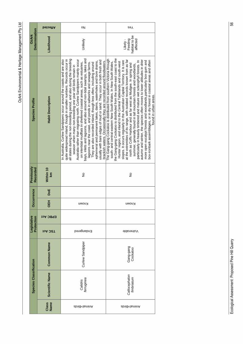
OzA
rk E
nviro
nmen
tal &
Her
itage
Man
agem
ent P
ty L
td
Eco
logi
cal A
sses
smen
t: P
ropo
sed
Pin
e H
ill Q
uarr
y
56
Sp
ecie
s C
lassif
icati
on
L
eg
isla
tive
Pro
tecti
on
O
ccu
rren
ce
Pre
vio
usly
R
eco
rde
d
Sp
ecie
s P
rofi
le
OzA
rk
Dete
rmin
ati
on
Cla
ss
Nam
e
Scie
nti
fic N
am
e
Co
mm
on
Nam
e
TSC Act
EPBC Act
OE
H
Do
E
Wit
hin
10
km
H
ab
it D
escri
pti
on
L
ikelih
oo
d
Affected
Animal>Birds
Calid
ris
ferr
ugin
ea
Curle
w S
andpip
er
Endangered
Known
No
In A
ustr
alia
, C
urle
w S
andpip
ers
occur
aro
und t
he c
oasts
and a
re a
lso
quite w
idespre
ad in
land, th
ough in s
ma
ller
num
bers
. R
ecord
s o
ccur
in
all
sta
tes d
urin
g t
he n
on
-bre
edin
g p
erio
d,
and a
lso d
urin
g the b
reedin
g
season w
hen m
any n
on
-bre
edin
g o
ne y
ear
old
birds r
em
ain
in
Austr
alia
rath
er
than m
igra
tin
g n
ort
h.
Curle
w S
andpip
ers
main
ly o
ccur
on in
tert
idal m
udfla
ts in s
heltere
d c
oasta
l are
as, such a
s e
stu
aries,
bays,
inle
ts a
nd la
goons, and a
lso a
round n
on
-tid
al sw
am
ps,
lakes a
nd
lagoons n
ear
the c
oast, a
nd p
onds in
saltw
ork
s a
nd s
ew
age f
arm
s.
Th
ey a
re a
lso r
ecord
ed in
land, th
ough le
ss o
ften, in
clu
din
g a
round
ephem
era
l and p
erm
anent la
kes, dam
s, w
ate
rhole
s a
nd b
ore
dra
ins,
usually
with b
are
edges o
f m
ud o
r sand. T
hey o
ccur
in b
oth
fre
sh a
nd
bra
ckis
h w
ate
rs. O
ccasio
nally
they a
re r
ecord
ed a
round f
loodw
ate
rs.
Unlik
ely
No
Animal>Birds
Callo
cephalo
n
fim
bria
tum
G
ang-g
ang
Cockato
o
Vulnerable
Known
No
Th
e G
ang
-gang C
ockato
o is d
istr
ibute
d f
rom
south
ern
Vic
toria
thro
ugh
south
- and c
entr
al-easte
rn N
ew
South
Wale
s. In
New
South
Wale
s,
the G
ang
-gang C
ockato
o is d
istr
ibute
d f
rom
the s
outh
-east coast to
the
Hunte
r re
gio
n,
and inla
nd t
o t
he C
entr
al T
able
lands a
nd s
outh
-west
slo
pes. It o
ccurs
regula
rly in
the A
ustr
alia
n C
apital T
err
itory
. It is r
are
at
the e
xtr
em
itie
s o
f its r
ange, w
ith isola
ted r
ecord
s k
now
n f
rom
as far
nort
h a
s C
offs H
arb
our
and a
s far
west
as M
udgee. In
sprin
g a
nd
sum
mer,
genera
lly found in
tall
mounta
in f
ore
sts
and w
oodla
nds,
part
icula
rly in h
eavily
tim
bere
d a
nd m
atu
re w
et scle
rophyll
fore
sts
. In
autu
mn a
nd w
inte
r, the s
pecie
s o
ften m
oves to lo
wer
altitudes in
drier
more
open e
ucaly
pt fo
rests
and w
oodla
nds,p
art
icula
rly b
ox-g
um
and
box-iro
nbark
assem
bla
ges,
or
in d
ry f
ore
st in
coasta
l are
as a
nd o
ften
found in
urb
an a
reas.
Lik
ely
-
Fe
edin
g
habitat to
be
aff
ecte
d
Yes
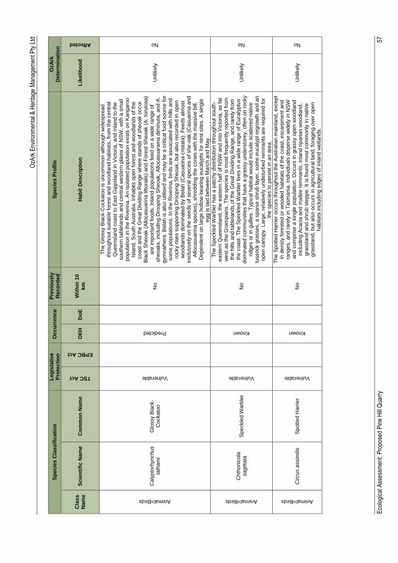
OzA
rk E
nviro
nmen
tal &
Her
itage
Man
agem
ent P
ty L
td
Eco
logi
cal A
sses
smen
t: P
ropo
sed
Pin
e H
ill Q
uarr
y
57
Sp
ecie
s C
lassif
icati
on
L
eg
isla
tive
Pro
tecti
on
O
ccu
rren
ce
Pre
vio
usly
R
eco
rde
d
Sp
ecie
s P
rofi
le
OzA
rk
Dete
rmin
ati
on
Cla
ss
Nam
e
Scie
nti
fic N
am
e
Co
mm
on
Nam
e
TSC Act
EPBC Act
OE
H
Do
E
Wit
hin
10
km
H
ab
it D
escri
pti
on
L
ikelih
oo
d
Affected
Animal>Birds
Caly
pto
rhynchus
lath
am
i G
lossy B
lack-
Cockato
o
Vulnerable
Predicted
No
Th
e G
lossy B
lack-C
ockato
o is u
ncom
mon a
lthough w
idespre
ad
thro
ughout
suitable
fore
st
and w
oodla
nd h
abitats
, fr
om
the c
entr
al
Queensla
nd c
oast to
East G
ippsla
nd in
Vic
toria
, and in
land to the
south
ern
table
lands a
nd c
entr
al w
este
rn p
lain
s o
f N
SW
, w
ith a
sm
all
popula
tio
n in
the R
iverin
a. A
n isola
ted p
opula
tio
n e
xis
ts o
n K
angaro
o
Isla
nd, S
outh
Austr
alia
. In
habits o
pen f
ore
st and w
oodla
nds o
f th
e
coast
and the G
reat D
ivid
ing R
ange w
here
sta
nds o
f sheoak o
ccur.
B
lack S
heoak (
Allo
casuarin
a litto
ralis
) and F
ore
st S
heoak (
A. to
rulo
sa)
are
im
port
ant fo
ods. In
land p
opula
tio
ns f
eed o
n a
wid
e r
ange o
f sheoaks, in
clu
din
g D
roopin
g S
heoak, A
llocasuara
ina d
imin
uta
, and A
. gym
nath
era
. B
ela
h is a
lso u
tilis
ed a
nd m
ay b
e a
critical fo
od s
ourc
e for
som
e p
opula
tio
ns. In
the R
iverin
a, birds a
re a
ssocia
ted w
ith h
ills a
nd
rocky r
ises s
upport
ing D
roopin
g S
heoak,
but
als
o r
ecord
ed in
open
woodla
nds d
om
inate
d b
y B
ela
h (
Casuarin
a c
rista
ta).
Fe
eds a
lmost
exclu
siv
ely
on t
he s
eeds o
f severa
l specie
s o
f she
-oak (
Casuarin
a a
nd
Allo
casuarin
a s
pecie
s),
shre
ddin
g the c
ones w
ith the m
assiv
e b
ill.
Dependent
on la
rge h
ollo
w-b
earin
g e
ucaly
pts
for
nest sites. A
sin
gle
egg is la
id b
etw
een M
arc
h a
nd M
ay.
Unlik
ely
No
Animal>Birds
Chth
onic
ola
sagitta
ta
Speckle
d W
arb
ler
Vulnerable
Known
N
o
Th
e S
peckle
d W
arb
ler
has a
patc
hy d
istr
ibutio
n thro
ughout south
-easte
rn Q
ueensla
nd, th
e e
aste
rn h
alf o
f N
SW
and into
Vic
toria
, as far
west
as the G
ram
pia
ns.
Th
e s
pecie
s is m
ost fr
equently r
eport
ed fro
m
the h
ills a
nd t
able
lands o
f th
e G
reat
Div
idin
g R
ange, and r
are
ly f
rom
th
e c
oast. T
he S
peckle
d W
arb
ler
lives in
a w
ide r
ange o
f E
ucaly
ptu
s
dom
inate
d c
om
munitie
s that have a
gra
ssy u
nders
tore
y,
oft
en o
n r
ocky
rid
ges o
r in
gulli
es. T
ypic
al habitat w
ould
in
clu
de s
cattere
d n
ative
tussock g
rasses, a s
pars
e s
hru
b layer,
som
e e
ucaly
pt re
gro
wth
and a
n
open c
anopy.
Larg
e, re
latively
undis
turb
ed r
em
nants
are
required f
or
the s
pecie
s to p
ers
ist
in a
n a
rea.
Unlik
ely
No
Animal>Birds
Circus a
ssim
ilis
Spott
ed H
arr
ier
Vulnerable
Known
No
Th
e S
potted H
arr
ier
occurs
thro
ughout
the A
ustr
alia
n m
ain
land, except
in d
ensly
fore
ste
d o
r w
ooded h
abitats
of th
e c
oast, e
scarp
ment and
ranges,
and r
are
ly in T
asm
ania
. In
div
iduals
dis
pers
e w
idely
in
NS
W
and c
om
prise a
sin
gle
popula
tio
n. O
ccurs
in
gra
ssy o
pen w
oodla
nd
inclu
din
g A
cacia
and m
alle
e r
em
nants
, in
land r
iparia
n w
oodla
nd,
gra
ssla
nd a
nd s
hru
b s
teppe. It is found m
ost com
monly
in
native
gra
ssla
nd, but als
o o
ccurs
in a
gricultura
l la
nd, fo
ragin
g o
ver
open
habitats
inclu
din
g e
dges o
f in
land w
etla
nds.
Unlik
ely
No
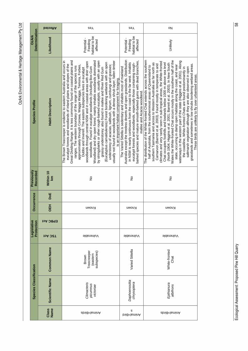
OzA
rk E
nviro
nmen
tal &
Her
itage
Man
agem
ent P
ty L
td
Eco
logi
cal A
sses
smen
t: P
ropo
sed
Pin
e H
ill Q
uarr
y
58
Sp
ecie
s C
lassif
icati
on
L
eg
isla
tive
Pro
tecti
on
O
ccu
rren
ce
Pre
vio
usly
R
eco
rde
d
Sp
ecie
s P
rofi
le
OzA
rk
Dete
rmin
ati
on
Cla
ss
Nam
e
Scie
nti
fic N
am
e
Co
mm
on
Nam
e
TSC Act
EPBC Act
OE
H
Do
E
Wit
hin
10
km
H
ab
it D
escri
pti
on
L
ikelih
oo
d
Affected
Animal>Birds
Clim
acte
ris
pic
um
nus
vic
toria
e
Bro
wn
Tre
ecre
eper
(easte
rn
subspecie
s)
Vulnerable
Known
No
Th
e B
row
n T
reecre
eper
is e
ndem
ic to e
aste
rn A
ustr
alia
and o
ccurs
in
eucaly
pt fo
rests
and w
oodla
nds o
f in
land p
lain
s a
nd s
lopes o
f th
e
Gre
at
Div
idin
g R
ange. It is less c
om
monly
found o
n c
oasta
l pla
ins a
nd
ranges.
Th
e w
este
rn b
oundary
of th
e r
ange o
f th
e s
pecie
s r
uns
appro
xim
ate
ly thro
ugh C
oro
wa, W
agga W
agga, T
em
ora
, F
orb
es,
Dubbo a
nd I
nvere
ll. T
he e
aste
rn s
ubspecie
s liv
es in
eucaly
pt
woodla
nds t
hro
ugh c
entr
al N
SW
and in
coasta
l are
as w
ith d
rie
r open
woodla
nds.
Fo
und in
eucaly
pt
woodla
nds (
inclu
din
g B
ox-G
um
W
oodla
nd)
and d
ry o
pen fore
st; m
ain
ly in
habits w
oodla
nds d
om
inate
d
by s
trin
gybark
s o
r oth
er
rough
-bark
ed e
ucaly
pts
, usually
with a
n o
pen
gra
ssy u
nders
tore
y;
als
o found in
malle
e a
nd R
iver
Red G
um
(E
ucaly
ptu
s c
am
ald
ule
nsis
) F
ore
st bord
erin
g w
etla
nds w
ith a
n o
pen
unders
tore
y o
f acacia
s, saltbush, lig
num
, cum
bungi and g
rasses;
usually
not fo
und in
woodla
nds w
ith a
dense s
hru
b la
yer;
falle
n tim
ber
is a
n im
port
ant
habitat com
ponent fo
r fo
ragin
g.
Pote
ntial -
Fe
edin
g
habitat to
be
aff
ecte
d
Yes
Animal>Bird
s
Daphoenositta
chry
sopte
ra
Varie
d S
itte
lla
Vulnerable
Known
No
Th
e V
arie
d S
itte
lla is s
edenta
ry a
nd in
habits m
ost
of m
ain
land
Austr
alia
except th
e t
reele
ss d
esert
s a
nd o
pen g
rassla
nds. D
istr
ibution
in N
SW
is n
early c
ontin
uous f
rom
the c
oast to
the far
west. I
nhabits
eucaly
pt fo
rests
and w
oodla
nds,
especia
lly t
hose c
onta
inin
g r
ough
-bark
ed s
pecie
s a
nd m
atu
re s
mooth
-bark
ed g
um
s w
ith d
ead b
ranches,
malle
e a
nd A
cacia
woodla
nd.
Pote
ntial -
Fe
edin
g
habitat to
be
aff
ecte
d
Yes
Animal>Birds
Epth
ianura
alb
ifro
ns
White-f
ronte
d
Chat
Vulnerable
Known
No
Th
e d
istr
ibutio
n o
f th
e W
hite
-fro
nte
d C
hat
exte
nds a
cro
ss the s
outh
ern
half o
f A
ustr
alia
, fr
om
the s
outh
ern
most
are
as o
f Q
ueensla
nd to
south
ern
Tasm
ania
and a
cro
ss to W
este
rn A
ustr
alia
as far
nort
h a
s
Carn
arv
on (
Barr
ett
et
al. 2
003).
Found m
ostly in t
em
pera
te t
o a
rid
clim
ate
s a
nd v
ery
rare
ly s
een in
sub
-tro
pic
al are
as, th
e W
hite
-fro
nte
d
Chat
occupie
s f
ooth
ills a
nd lo
wla
nds b
elo
w 1
000 m
above s
ea le
vel
(Nort
h 1
904;
Hig
gin
s e
t al. 2
001; B
arr
ett
et al. 2
003).
In N
ew
South
W
ale
s the W
hite
-fro
nte
d C
hat occurs
mostly in
the s
outh
ern
half o
f th
e
sta
te,
occurr
ing in
dam
p o
pen
habitats
alo
ng the c
oast, a
nd n
ear
wate
rwa
ys in
the w
este
rn p
art
of th
e s
tate
(H
iggin
s e
t al. 2
001).
Alo
ng
the c
oastlin
e, W
hite
-fro
nte
d C
hats
are
found p
redom
inantly in
saltm
ars
h v
egeta
tio
n a
lthough t
hey a
re a
lso o
bserv
ed in
open
gra
ssla
nds a
nd s
om
etim
es in
lo
w s
hru
bs b
ord
erin
g w
etla
nd a
reas.
Th
ese b
irds a
re u
nlik
ely
to fly
over
urb
anis
ed a
reas.
Unlik
ely
No
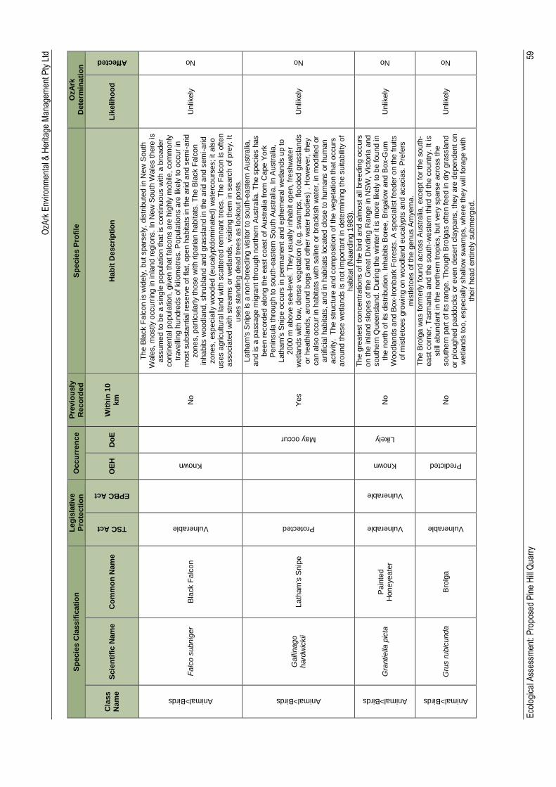
OzA
rk E
nviro
nmen
tal &
Her
itage
Man
agem
ent P
ty L
td
Eco
logi
cal A
sses
smen
t: P
ropo
sed
Pin
e H
ill Q
uarr
y
59
Sp
ecie
s C
lassif
icati
on
L
eg
isla
tive
Pro
tecti
on
O
ccu
rren
ce
Pre
vio
usly
R
eco
rde
d
Sp
ecie
s P
rofi
le
OzA
rk
Dete
rmin
ati
on
Cla
ss
Nam
e
Scie
nti
fic N
am
e
Co
mm
on
Nam
e
TSC Act
EPBC Act
OE
H
Do
E
Wit
hin
10
km
H
ab
it D
escri
pti
on
L
ikelih
oo
d
Affected
Animal>Birds
Fa
lco s
ubnig
er
Bla
ck F
alc
on
Vulnerable
Known
No
Th
e B
lack F
alc
on is w
idely
, but spars
ely
, dis
trib
ute
d in N
ew
South
W
ale
s, m
ostly o
ccurr
ing in
in
land r
egio
ns. In
New
South
Wale
s t
here
is
assum
ed t
o b
e a
sin
gle
popula
tio
n t
hat is
contin
uous w
ith a
bro
ader
contin
enta
l popula
tio
n,
giv
en that fa
lcons a
re h
ighly
mo
bile
, com
monly
tr
avelli
ng h
undre
ds o
f kilo
metr
es. P
opula
tio
ns a
re lik
ely
to
occur
in
most substa
ntia
l re
serv
e o
f flat, o
pen h
abitats
in t
he a
rid
and s
em
i-arid
zones,
part
icula
rly those w
ith r
iparia
n h
abitats
. T
he B
lack F
alc
on
inhabits w
oodla
nd,
shru
bla
nd a
nd g
rassla
nd in
the a
rid
and s
em
i-arid
zones,
especia
lly w
ooded (
eucaly
ptd
om
inate
d)
wate
rcours
es; it a
lso
uses a
gricultura
l la
nd w
ith s
cattere
d r
em
nant tr
ees.
Th
e F
alc
on is o
ften
associa
ted w
ith s
tream
s o
r w
etla
nds, vis
itin
g them
in
searc
h o
f pre
y. It
uses s
tandin
g d
ead tre
es a
s lo
okout
posts
.
Unlik
ely
No
Animal>Birds
Galli
nago
hard
wic
kii
Lath
am
's S
nip
e
Protected
May occur
Yes
Lath
am
's S
nip
e is a
non
-bre
edin
g v
isitor
to s
outh
-easte
rn A
ustr
alia
, and is a
passage m
igra
nt th
rough n
ort
hern
Austr
alia
. T
he s
pecie
s h
as
been r
ecord
ed a
long t
he e
ast coast of A
ustr
alia
fro
m C
ape Y
ork
P
enin
sula
thro
ugh t
o s
outh
-easte
rn S
outh
Austr
alia
. In
Austr
alia
, Lath
am
's S
nip
e o
ccurs
in p
erm
anent
and e
phem
era
l w
etla
nds u
p to
2000 m
above s
ea
-le
vel. T
hey u
sually
in
habit o
pen, fr
eshw
ate
r w
etla
nds w
ith lo
w,
dense v
egeta
tion (
e.g
. sw
am
ps, flo
oded g
rassla
nd
s
or
heath
lands, aro
und b
ogs a
nd o
ther
wate
r bodie
s)
. H
ow
ever,
they
can a
lso o
ccur
in h
abitats
with s
alin
e o
r bra
ckis
h w
ate
r, in
mo
difie
d o
r art
ific
ial habitats
, and in h
abitats
locate
d c
lose to h
um
ans o
r hum
an
activity. T
he s
tructu
re a
nd c
om
positio
n o
f th
e v
egeta
tio
n that occurs
aro
und t
hese w
etla
nds is n
ot im
port
ant
in d
ete
rmin
ing t
he s
uitabili
ty o
f habitat
(Naard
ing 1
983).
Unlik
ely
No
Animal>Birds
Gra
ntie
lla p
icta
P
ain
ted
Honeyeate
r
Vulnerable
Vulnerable
Known
Likely
No
Th
e g
reate
st concentr
atio
ns o
f th
e b
ird a
nd a
lmo
st
all
bre
edin
g o
ccurs
on t
he in
land s
lopes o
f th
e G
reat D
ivid
ing R
ange in
NS
W, V
icto
ria
and
south
ern
Queensla
nd.
Durin
g the w
inte
r it is m
ore
lik
ely
to b
e found in
the n
ort
h o
f its d
istr
ibutio
n. In
habits B
ore
e, B
rig
alo
w a
nd B
ox-G
um
W
oodla
nds a
nd B
ox-I
ronbark
Fo
rests
. A
specia
list fe
eder
on t
he f
ruits
of m
istle
toes g
row
ing o
n w
oodla
nd
eucaly
pts
and a
cacia
s. P
refe
rs
mis
tle
toes o
f th
e g
enus A
myem
a.
Unlik
ely
No
Animal>Birds
Gru
s r
ubic
unda
Bro
lga
Vulnerable
Predicted
No
Th
e B
rolg
a w
as f
orm
erly f
ound a
cro
ss A
ustr
alia
, except fo
r th
e s
outh
-east corn
er,
Ta
sm
ania
and the s
outh
-weste
rn t
hird o
f th
e c
ountr
y. It is
still
abundant in
the n
ort
hern
tro
pic
s, but
very
spars
e a
cro
ss the
south
ern
part
of its r
ange. T
hough B
rolg
as o
ften f
eed in
dry
gra
ssla
nd
or
plo
ughed p
addocks o
r even d
esert
cla
ypans, th
ey a
re d
ependent on
wetla
nds t
oo, especia
lly s
hallo
w s
wam
ps, w
here
they w
ill f
ora
ge w
ith
their h
ead e
ntire
ly s
ubm
erg
ed.
Unlik
ely
No
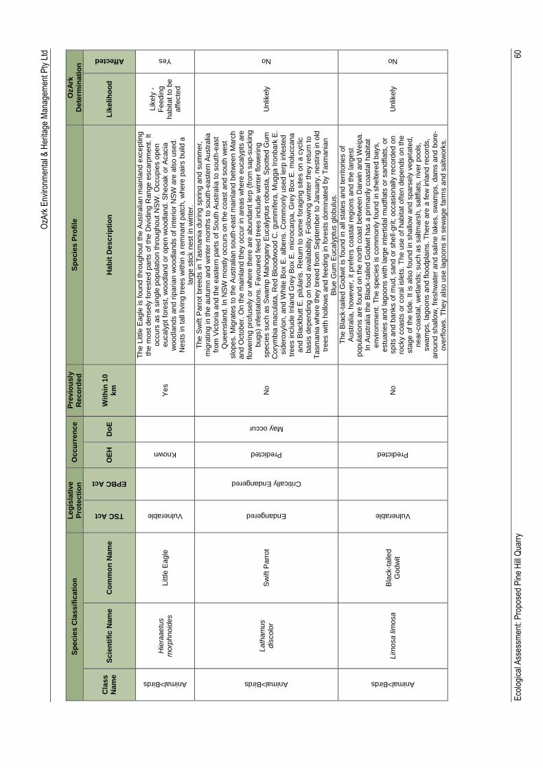
OzA
rk E
nviro
nmen
tal &
Her
itage
Man
agem
ent P
ty L
td
Eco
logi
cal A
sses
smen
t: P
ropo
sed
Pin
e H
ill Q
uarr
y
60
Sp
ecie
s C
lassif
icati
on
L
eg
isla
tive
Pro
tecti
on
O
ccu
rren
ce
Pre
vio
usly
R
eco
rde
d
Sp
ecie
s P
rofi
le
OzA
rk
Dete
rmin
ati
on
Cla
ss
Nam
e
Scie
nti
fic N
am
e
Co
mm
on
Nam
e
TSC Act
EPBC Act
OE
H
Do
E
Wit
hin
10
km
H
ab
it D
escri
pti
on
L
ikelih
oo
d
Affected
Animal>Birds
Hie
raaetu
s
morp
hnoid
es
Little E
agle
Vulnerable
Known
Yes
Th
e L
ittle
Eagle
is f
ound thro
ughout
the A
ustr
alia
n m
ain
land e
xceptin
g
the m
ost densely
fore
ste
d p
art
s o
f th
e D
ivid
ing R
ange e
scarp
ment. It
occurs
as a
sin
gle
popula
tio
n t
hro
ughout
NS
W. O
ccupie
s o
pen
eucaly
pt fo
rest, w
oodla
nd o
r open w
oodla
nd.
Sheoak o
r A
cacia
w
oodla
nds a
nd r
iparia
n w
oodla
nd
s o
f in
terio
r N
SW
are
als
o u
sed.
Nests
in t
all
livin
g tre
es w
ithin
a r
em
nant
patc
h,
where
pairs b
uild
a
larg
e s
tick n
est in
win
ter.
Lik
ely
-
Fe
edin
g
habitat to
be
aff
ecte
d
Yes
Animal>Birds
Lath
am
us
dis
colo
r S
wift P
arr
ot
Endangered
Critically Endangered
Predicted
May occur
No
Th
e S
wift P
arr
ot bre
eds in T
asm
ania
durin
g s
prin
g a
nd s
um
mer,
m
igra
tin
g in t
he a
utu
mn a
nd w
inte
r m
onth
s to s
outh
-easte
rn A
ustr
alia
fr
om
Vic
toria
and t
he e
aste
rn p
art
s o
f S
outh
Austr
alia
to s
outh
-east
Queensla
nd. In
NS
W m
ostly o
ccurs
on the c
oast
and s
outh
west
slo
pes.
Mig
rate
s to t
he A
ustr
alia
n s
outh
-east m
ain
land b
etw
een M
arc
h
and O
cto
ber.
On t
he m
ain
land they o
ccur
in a
reas w
here
eucaly
pts
are
flo
werin
g p
rofu
sely
or
where
there
are
abundant
lerp
(fr
om
sap
-suckin
g
bugs)
infe
sta
tio
ns. F
avoure
d f
eed tre
es inclu
de w
inte
r flo
werin
g
specie
s s
uch a
s S
wam
p M
ahogany E
ucaly
ptu
s r
obusta
, S
pott
ed G
um
C
ory
mbia
ma
cula
ta, R
ed B
loodw
ood C
. gum
mifera
, M
ugga I
ronbark
E.
sid
ero
xylo
n,
and W
hite B
ox E
. alb
ens.
Com
monly
used le
rp in
feste
d
trees inclu
de Inla
nd G
rey B
ox E
. m
icro
carp
a,
Gre
y B
ox E
. m
olu
ccana
and B
lackbutt
E. pilu
laris. R
etu
rn to s
om
e f
ora
gin
g s
ites o
n a
cyclic
basis
dependin
g o
n food a
vaila
bili
ty.
Fo
llow
ing w
inte
r th
ey r
etu
rn t
o
Ta
sm
ania
where
they b
reed
fro
m S
epte
mber
to J
anuary
, nestin
g in
old
tr
ees w
ith h
ollo
ws a
nd f
eedin
g in fore
sts
dom
inate
d b
y T
asm
ania
n
Blu
e G
um
Eucaly
ptu
s g
lobulu
s.
Unlik
ely
No
Animal>Birds
Lim
osa lim
osa
Bla
ck-t
aile
d
Godw
it
Vulnerable
Predicted
No
Th
e B
lack-t
aile
d G
odw
it is f
ound
in a
ll sta
tes a
nd t
err
itorie
s o
f A
ustr
alia
, how
ever,
it
pre
fers
coasta
l re
gio
ns a
nd t
he la
rgest
popula
tio
ns a
re f
ound o
n the n
ort
h c
oast betw
een D
arw
in a
nd W
eip
a.
In A
ustr
alia
the B
lack-t
aile
d G
odw
it h
as a
prim
arily
coasta
l habitat
environm
ent. T
he s
pecie
s is c
om
monly
found in s
heltere
d b
ays,
estu
arie
s a
nd la
goons w
ith la
rge inte
rtid
al m
udflats
or
sandfla
ts,
or
spits a
nd b
anks o
f m
ud, sand o
r shell-
grit;
occasio
nally
record
ed o
n
rocky c
oasts
or
cora
l is
lets
. T
he u
se o
f habitat oft
en d
epends o
n t
he
sta
ge o
f th
e tid
e. It is a
lso found in s
hallo
w a
nd s
pars
ely
vegeta
ted,
near-
coasta
l, w
etla
nds; such a
s s
altm
ars
h, saltflats
, river
pools
, sw
am
ps, la
goons a
nd f
loodpla
ins. T
here
are
a f
ew
in
land r
ecord
s,
aro
und s
hallo
w,
freshw
ate
r and s
alin
e la
kes, sw
am
ps,
dam
s a
nd
bore
-overf
low
s.
Th
ey a
lso u
se la
goons in s
ew
age f
arm
s a
nd s
altw
ork
s.
Unlik
ely
No
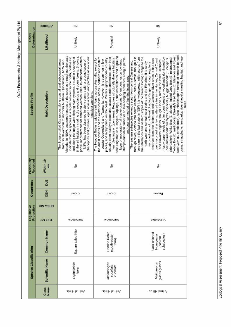
OzA
rk E
nviro
nmen
tal &
Her
itage
Man
agem
ent P
ty L
td
Eco
logi
cal A
sses
smen
t: P
ropo
sed
Pin
e H
ill Q
uarr
y
61
Sp
ecie
s C
lassif
icati
on
L
eg
isla
tive
Pro
tecti
on
O
ccu
rren
ce
Pre
vio
usly
R
eco
rde
d
Sp
ecie
s P
rofi
le
OzA
rk
Dete
rmin
ati
on
Cla
ss
Nam
e
Scie
nti
fic N
am
e
Co
mm
on
Nam
e
TSC Act
EPBC Act
OE
H
Do
E
Wit
hin
10
km
H
ab
it D
escri
pti
on
L
ikelih
oo
d
Affected
Animal>Birds
Lophoic
tin
ia
isura
S
quare
-taile
d K
ite
Vulnerable
Known
No
Th
e S
quare
-taile
d K
ite r
anges a
long c
oasta
l and s
ubcoasta
l are
as
from
south
-weste
rn t
o n
ort
hern
Austr
alia
, Q
ueensla
nd,
NS
W a
nd
Vic
toria
. In
NS
W, scatt
ere
d r
ecord
s o
f th
e s
pecie
s thro
ughout
the s
tate
in
dic
ate
that th
e s
pecie
s is a
regula
r re
sid
ent in
the n
ort
h, nort
h-e
ast
and a
long t
he m
ajo
r w
est-
flo
win
g r
iver
syste
ms. F
ound in a
varie
ty o
f tim
bere
d h
abitats
inclu
din
g d
ry w
oodla
nds a
nd o
pen fore
sts
. S
how
s a
part
icula
r pre
fere
nce f
or
tim
bere
d w
ate
rcours
es. In
arid n
ort
h-w
este
rn
NS
W, has b
een o
bserv
ed in
sto
ny c
ountr
y w
ith a
gro
und c
over
of
chenopods a
nd g
rasses,
open a
cacia
scru
b a
nd p
atc
hes o
f lo
w o
pen
eucaly
pt
woodla
nd.
Unlik
ely
No
Animal>Birds
Me
lanodry
as
cuculla
ta
cuculla
ta
Hooded R
obin
(s
outh
-easte
rn
form
)
Vulnerable
Known
No
Th
e H
ooded R
obin
is w
idespre
ad, fo
und a
cro
ss A
ustr
alia
, except fo
r th
e d
rie
st
desert
s a
nd the w
ett
er
coasta
l are
as -
nort
hern
and e
aste
rn
coasta
l Q
ueensla
nd a
nd T
asm
ania
. H
ow
ever,
it
is c
om
mon in f
ew
pla
ces,
and r
are
ly found o
n the c
oast. P
refe
rs lig
htly w
ooded c
ountr
y,
usually
open e
ucaly
pt
woodla
nd,
acacia
scru
b a
nd m
alle
e,
often in o
r near
cle
arin
gs o
r open a
reas.
Requires s
tructu
rally
div
ers
e h
abitats
fe
atu
rin
g m
atu
re e
ucaly
pts
, saplin
gs, som
e s
mall
shru
bs a
nd a
gro
und
layer
of m
odera
tely
tall
native g
rasses.
Oft
en p
erc
hes o
n lo
w d
ead
stu
mps a
nd f
alle
n tim
ber
or
on lo
w-h
angin
g b
ranches, usin
g a
perc
h-
and-p
ounce m
eth
od
of
huntin
g insect pre
y.
Pote
ntial
No
Animal>Birds
Me
lithre
ptu
s
gula
ris g
ula
ris
Bla
ck-c
hin
ned
Honeyeate
r (e
aste
rn
subspecie
s)
Vulnerable
Known
No
Th
e e
aste
rn s
ubspecie
s e
xte
nds s
outh
fro
m c
entr
al Q
ueensla
nd,
thro
ugh N
SW
, V
icto
ria
into
south
easte
rn S
outh
Austr
alia
, th
ough it is
very
rare
in
the last sta
te. In
NS
W it
is w
idespre
ad,
with r
ecord
s f
rom
th
e t
able
lands a
nd w
este
rn s
lopes o
f th
e G
reat D
ivid
ing R
ange to the
nort
h-w
est
and c
entr
al-
west pla
ins a
nd t
he R
iverin
a.
It is r
are
ly
record
ed e
ast of th
e G
reat
Div
idin
g R
ange,
although r
egula
rly
observ
ed f
rom
the R
ichm
ond a
nd C
lare
nce R
iver
are
as. It h
as a
lso
been r
ecord
ed a
t a f
ew
scattere
d s
ites in
the H
unte
r, C
entr
al C
oast
and I
llaw
arr
a r
egio
ns, th
ough it is
very
rare
in
the la
tter.
Occupie
s
mostly u
pp
er
levels
of drie
r open fore
sts
or
woodla
nds d
om
inate
d b
y
box a
nd iro
nbark
eucaly
pts
, especia
lly M
ugga I
ronbark
(E
ucaly
ptu
s
sid
ero
xylo
n),
White B
ox (
E.
alb
ens),
Inla
nd G
rey B
ox (
E. m
icro
carp
a),
Y
ello
w B
ox (
E. m
elli
odora
), B
lakely
's R
ed G
um
(E
. bla
kely
i) a
nd F
ore
st
Red G
um
(E
. te
reticorn
is).
Als
o inhabits o
pen f
ore
sts
of sm
ooth
-bark
ed
gum
s, str
ingybark
s, ironbark
s,
river
sheoaks (
nestin
g h
abitat)
and tea
-tr
ees
Unlik
ely
No
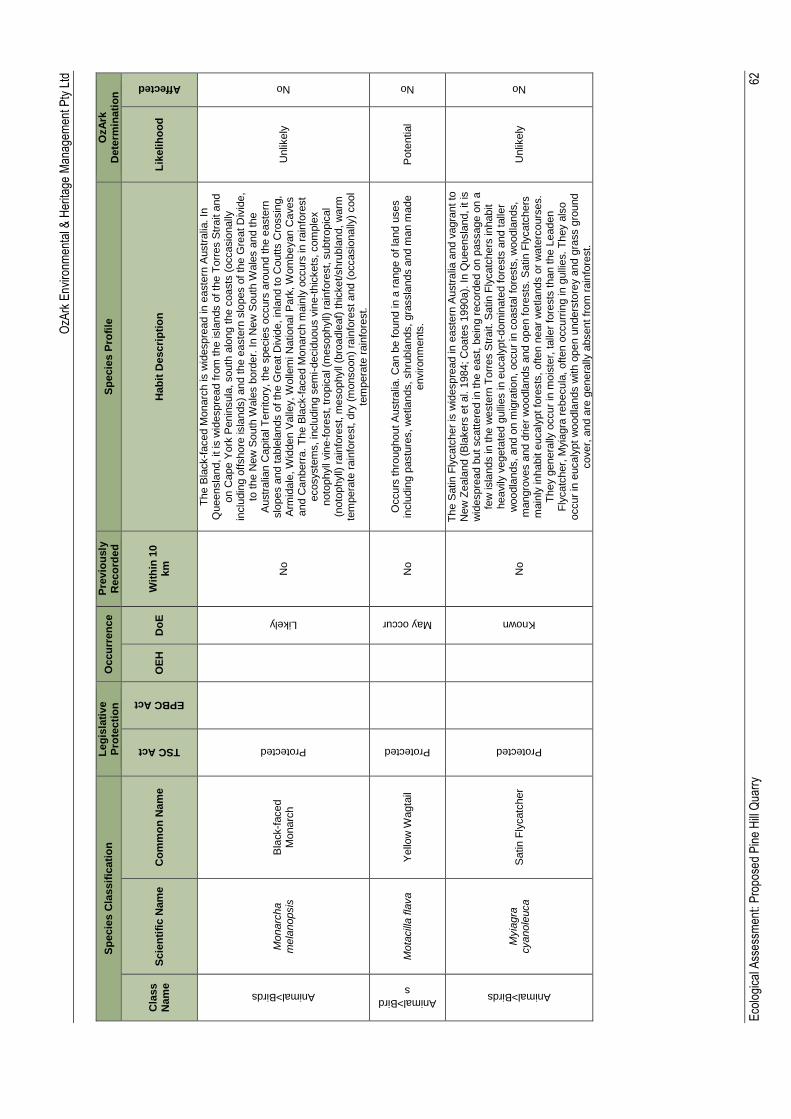
OzA
rk E
nviro
nmen
tal &
Her
itage
Man
agem
ent P
ty L
td
Eco
logi
cal A
sses
smen
t: P
ropo
sed
Pin
e H
ill Q
uarr
y
62
Sp
ecie
s C
lassif
icati
on
L
eg
isla
tive
Pro
tecti
on
O
ccu
rren
ce
Pre
vio
usly
R
eco
rde
d
Sp
ecie
s P
rofi
le
OzA
rk
Dete
rmin
ati
on
Cla
ss
Nam
e
Scie
nti
fic N
am
e
Co
mm
on
Nam
e
TSC Act
EPBC Act
OE
H
Do
E
Wit
hin
10
km
H
ab
it D
escri
pti
on
L
ikelih
oo
d
Affected
Animal>Birds
Mo
narc
ha
mela
nopsis
B
lack-f
aced
Monarc
h
Protected
Likely
No
Th
e B
lack-f
aced M
onarc
h is w
idespre
ad in
easte
rn A
ustr
alia
. In
Q
ueensla
nd, it is w
idespre
ad f
rom
the isla
nds o
f th
e T
orr
es S
trait a
nd
on C
ape Y
ork
Penin
sula
, south
alo
ng t
he c
oasts
(occasio
nally
in
clu
din
g o
ffshore
isla
nds)
and t
he e
aste
rn s
lopes o
f th
e G
reat D
ivid
e,
to t
he N
ew
South
Wale
s b
ord
er.
In N
ew
South
Wale
s a
nd the
Austr
alia
n C
apital T
err
itory
, th
e s
pecie
s o
ccurs
aro
und t
he e
aste
rn
slo
pes a
nd t
able
lands o
f th
e G
reat D
ivid
e,
inla
nd t
o C
outts C
rossin
g,
Arm
idale
, W
idden V
alle
y, W
olle
mi N
atio
nal P
ark
, W
om
be
yan C
aves
and C
anberr
a.
Th
e B
lack-f
aced M
onarc
h m
ain
ly o
ccurs
in
rain
fore
st
ecosyste
ms, in
clu
din
g s
em
i-decid
uous v
ine-t
hic
kets
, com
ple
x
noto
phyll
vin
e-f
ore
st, tro
pic
al (m
esophyll)
rain
fore
st, s
ubtr
opic
al
(noto
phyll)
rain
fore
st, m
esophyll
(bro
adle
af)
thic
ket/shru
bla
nd,
warm
te
mpera
te r
ain
fore
st, d
ry (
monsoon)
rain
fore
st and (
occasio
nally
) cool
tem
pera
te r
ain
fore
st.
Unlik
ely
No
Animal>Bird
s
Mo
tacill
a fla
va
Yello
w W
agta
il
Protected
May occur
No
Occurs
thro
ughout A
ustr
alia
. C
an b
e f
ound in a
range o
f la
nd u
ses
inclu
din
g p
astu
res, w
etla
nds, shru
bla
nds,
gra
ssla
nds a
nd m
an m
ade
environm
ents
. P
ote
ntial
No
Animal>Birds
Myia
gra
cyanole
uca
Satin F
lycatc
her
Protected
Known
No
Th
e S
atin
Fly
catc
her
is w
idespre
ad in
easte
rn A
ustr
alia
and v
agra
nt to
N
ew
Ze
ala
nd (
Bla
kers
et
al. 1
984; C
oate
s 1
990a).
In Q
ueensla
nd, it is
wid
espre
ad b
ut
scatt
ere
d in
the e
ast, b
ein
g r
ecord
ed o
n p
assage o
n a
fe
w isla
nds in
the w
este
rn T
orr
es S
trait. S
atin F
lycatc
hers
in
habit
heavily
vegeta
ted g
ulli
es in e
ucaly
pt-
dom
inate
d fore
sts
and t
alle
r w
oodla
nds,
and o
n m
igra
tio
n,
occur
in c
oasta
l fo
rests
, w
oodla
nds,
mangro
ves a
nd d
rie
r w
oodla
nds a
nd o
pen f
ore
sts
. S
atin F
lycatc
hers
m
ain
ly in
habit e
ucaly
pt
fore
sts
, often n
ear
wetla
nds o
r w
ate
rcours
es.
Th
ey g
enera
lly o
ccur
in m
ois
ter,
talle
r fo
rests
than t
he L
eaden
Fly
catc
her,
Myia
gra
rebecula
, often o
ccurr
ing in
gulli
es.
Th
ey a
lso
occur
in e
ucaly
pt
woodla
nds w
ith o
pen u
nders
tore
y a
nd g
rass g
round
cover,
and a
re g
enera
lly a
bsent fr
om
rain
fore
st.
Unlik
ely
No
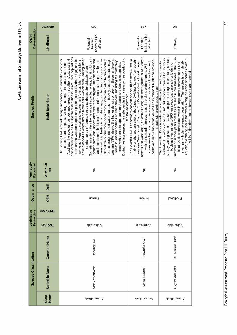
OzA
rk E
nviro
nmen
tal &
Her
itage
Man
agem
ent P
ty L
td
Eco
logi
cal A
sses
smen
t: P
ropo
sed
Pin
e H
ill Q
uarr
y
63
Sp
ecie
s C
lassif
icati
on
L
eg
isla
tive
Pro
tecti
on
O
ccu
rren
ce
Pre
vio
usly
R
eco
rde
d
Sp
ecie
s P
rofi
le
OzA
rk
Dete
rmin
ati
on
Cla
ss
Nam
e
Scie
nti
fic N
am
e
Co
mm
on
Nam
e
TSC Act
EPBC Act
OE
H
Do
E
Wit
hin
10
km
H
ab
it D
escri
pti
on
L
ikelih
oo
d
Affected
Animal>Birds
Nin
ox c
onniv
ens
Bark
ing O
wl
Vulnerable
Known
No
Th
e B
ark
ing O
wl is
found t
hro
ughout
contin
enta
l A
ustr
alia
except
for
the c
entr
al arid
regio
ns. A
lthough c
om
mon in
part
s o
f nort
hern
A
ustr
alia
, th
e s
pecie
s h
as d
eclin
ed g
reatly in
south
ern
Austr
alia
and
now
occurs
in a
wid
e b
ut spars
e d
istr
ibutio
n in N
SW
. C
ore
popula
tio
ns
exis
t on t
he w
este
rn s
lopes a
nd p
lain
s (
especia
lly t
he P
illig
a)
and in
som
e n
ort
heast coasta
l and e
scarp
ment fo
rests
. M
any p
opula
tio
ns
have c
rashed a
s w
oodla
nd o
n f
ert
ile s
oils
was c
leare
d, le
avin
g lin
ear
rip
aria
n s
trip
s o
f re
mnant tr
ees a
s the last in
habitable
are
as.
Som
etim
es e
xte
nd t
heir h
om
e r
ange in
to u
rban a
reas,
huntin
g b
irds in
gard
en t
rees a
nd in
sects
att
racte
d t
o s
treetlig
hts
. In
habits w
oodla
nd
and o
pen f
ore
st, in
clu
din
g f
ragm
ente
d r
em
nants
and p
art
ly c
leare
d
farm
land. It is fle
xib
le in
its
habitat use,
and h
untin
g c
an e
xte
nd in
to
clo
sed f
ore
st
and m
ore
open a
reas. S
om
etim
es a
ble
to s
uccessfu
lly
bre
ed a
long t
imbere
d w
ate
rcours
es in h
eavily
cle
are
d h
abitats
(e.g
. w
este
rn N
SW
) due t
o t
he h
igher
density o
f pre
y o
n these f
ert
ile s
oils
. R
oost
in s
haded p
ort
ions o
f tr
ee c
anopie
s, in
clu
din
g t
all
mid
sto
rey
trees w
ith d
ense f
olia
ge s
uch a
s A
cacia
and C
asuarin
a s
pecie
s.
Durin
g n
estin
g s
eason, th
e m
ale
perc
hes in
a n
earb
y t
ree o
verlo
okin
g
the h
ollo
w e
ntr
ance.
Pote
ntial -
Fe
edin
g
habitat to
be
aff
ecte
d
Yes
Animal>Birds
Nin
ox s
trenua
Pow
erf
ul O
wl
Vulnerable
Known
N
o
Th
e P
ow
erf
ul O
wl is
endem
ic to e
aste
rn a
nd s
outh
-easte
rn A
ustr
alia
, m
ain
ly o
n the e
aste
rn s
ide o
f th
e G
reat
Div
idin
g R
ange, fr
om
south
-easte
rn Q
ueensla
nd t
o V
icto
ria
. T
he P
ow
erf
ul O
wl is
found in o
pen
fore
sts
and w
oodla
nds,
as w
ell
as a
long s
heltere
d g
ulli
es in w
et
fore
sts
w
ith d
ense u
nders
tore
ys,
especia
lly a
long w
ate
rcours
es. W
ill
som
etim
es b
e found in o
pen a
reas n
ear
fore
sts
such a
s f
arm
land,
park
s a
nd s
ubu
rban a
reas,
as w
ell
as in
rem
nant
bushla
nd p
atc
hes.
Needs o
ld g
row
th t
rees t
o n
est.
Pote
ntial -
Fe
edin
g
habitat to
be
aff
ecte
d
Yes
Animal>Birds
Oxyura
austr
alis
B
lue-b
ille
d D
uck
Vulnerable
Predicted
No
Th
e B
lue-b
ille
d D
uck is e
ndem
ic to s
outh
-easte
rn a
nd s
outh
-weste
rn
Austr
alia
. It is w
idespre
ad in
NS
W, but m
ost com
mon in t
he s
outh
ern
M
urr
ay-D
arlin
g B
asin
are
a. B
irds d
ispers
e d
urin
g t
he b
reedin
g s
eason
to d
eep s
wam
ps u
p to 3
00 k
m a
way.
It is g
enera
lly o
nly
durin
g
sum
mer
or
in d
rie
r years
that th
ey a
re s
een in c
oasta
l are
as.
Th
e B
lue
-bill
ed D
uck p
refe
rs d
eep w
ate
r in
larg
e p
erm
anent w
etla
nds a
nd
sw
am
ps w
ith d
ense a
quatic v
egeta
tio
n. T
he s
pecie
s is c
om
ple
tely
aquatic, sw
imm
ing lo
w in
the w
ate
r alo
ng t
he e
dge o
f dense c
over.
It
will
fly
if dis
turb
ed, but
pre
fers
to d
ive if
appro
ached.
Unlik
ely
No
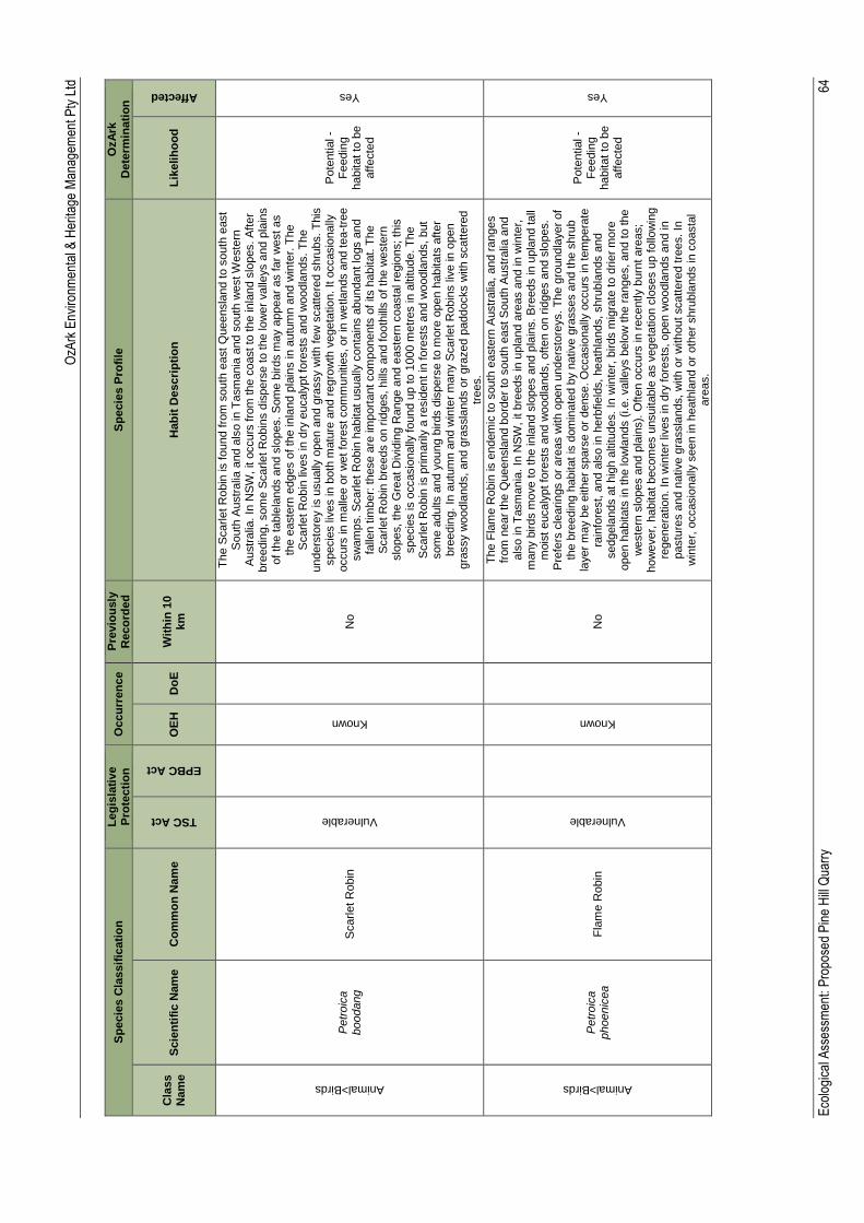
OzA
rk E
nviro
nmen
tal &
Her
itage
Man
agem
ent P
ty L
td
Eco
logi
cal A
sses
smen
t: P
ropo
sed
Pin
e H
ill Q
uarr
y
64
Sp
ecie
s C
lassif
icati
on
L
eg
isla
tive
Pro
tecti
on
O
ccu
rren
ce
Pre
vio
usly
R
eco
rde
d
Sp
ecie
s P
rofi
le
OzA
rk
Dete
rmin
ati
on
Cla
ss
Nam
e
Scie
nti
fic N
am
e
Co
mm
on
Nam
e
TSC Act
EPBC Act
OE
H
Do
E
Wit
hin
10
km
H
ab
it D
escri
pti
on
L
ikelih
oo
d
Affected
Animal>Birds
Petr
oic
a
boodang
S
carle
t R
obin
Vulnerable
Known
No
Th
e S
carle
t R
obin
is found f
rom
south
east
Queensla
nd to s
outh
east
South
Austr
alia
and a
lso in
Ta
sm
ania
and s
outh
west W
este
rn
Austr
alia
. In
NS
W,
it o
ccurs
fro
m the c
oast to
the in
land s
lopes. A
fter
bre
edin
g,
som
e S
carle
t R
obin
s d
ispers
e t
o t
he lo
wer
valle
ys a
nd p
lain
s
of
the t
able
lands a
nd s
lopes. S
om
e b
irds m
ay a
ppear
as f
ar
west as
the e
aste
rn e
dges o
f th
e in
land p
lain
s in a
utu
mn a
nd w
inte
r. T
he
Scarle
t R
obin
liv
es in
dry
eucaly
pt fo
rests
and w
oodla
nds.
Th
e
unders
tore
y is u
sually
open a
nd g
rassy w
ith few
scatt
ere
d s
hru
bs.
This
specie
s liv
es in
both
matu
re a
nd r
egro
wth
vegeta
tio
n. It o
ccasio
nally
occurs
in m
alle
e o
r w
et
fore
st com
munitie
s, or
in w
etla
nds a
nd tea
-tre
e
sw
am
ps. S
carle
t R
obin
habitat
usually
conta
ins a
bundant
logs a
nd
falle
n tim
ber:
these a
re im
port
ant com
ponents
of
its h
abitat. T
he
Scarle
t R
obin
bre
eds o
n r
idges, hill
s a
nd f
ooth
ills o
f th
e w
este
rn
slo
pes, th
e G
reat D
ivid
ing R
ange a
nd e
aste
rn c
oasta
l re
gio
ns; th
is
specie
s is o
ccasio
nally
found u
p to 1
000 m
etr
es in a
ltitude. T
he
Scarle
t R
obin
is p
rim
arily
a r
esid
ent
in fore
sts
and w
oodla
nds,
but
som
e a
dults a
nd y
oung b
irds d
ispers
e t
o m
ore
open h
abitats
aft
er
bre
edin
g.
In a
utu
mn a
nd w
inte
r m
any S
carle
t R
obin
s liv
e in
open
gra
ssy w
oodla
nds,
and g
rassla
nds o
r gra
zed p
addocks w
ith s
catt
ere
d
trees.
Pote
ntial -
Fe
edin
g
habitat to
be
aff
ecte
d
Yes
Animal>Birds
Petr
oic
a
phoenic
ea
Fla
me R
obin
Vulnerable
Known
No
Th
e F
lam
e R
obin
is e
ndem
ic t
o s
outh
easte
rn A
ustr
alia
, and r
anges
from
near
the Q
ueensla
nd b
ord
er
to s
outh
east S
outh
Austr
alia
and
als
o in T
asm
ania
. In
NS
W, it b
reeds in u
pla
nd a
reas a
nd in
win
ter,
m
any b
irds m
ove t
o t
he in
land s
lopes a
nd p
lain
s. B
reeds in u
pla
nd tall
mois
t eucaly
pt fo
rests
and w
oodla
nds,
oft
en o
n r
idges a
nd s
lopes.
Pre
fers
cle
arin
gs o
r are
as w
ith o
pen u
nders
tore
ys. T
he g
roundla
yer
of
the b
reedin
g h
abitat
is d
om
inate
d b
y n
ative g
rasses a
nd t
he s
hru
b
layer
may b
e e
ither
spars
e o
r dense. O
ccasio
nally
occurs
in t
em
pera
te
rain
fore
st, a
nd a
lso in
herb
fie
lds, heath
lands, shru
bla
nds a
nd
sedgela
nds a
t hig
h a
ltitudes. In
win
ter,
birds m
igra
te to d
rie
r m
ore
open h
abitats
in t
he lo
wla
nds (
i.e. valle
ys b
elo
w t
he r
anges, and to the
weste
rn s
lopes a
nd p
lain
s).
Often o
ccurs
in r
ecently b
urn
t are
as;
how
ever,
habitat
becom
es u
nsuitable
as v
egeta
tio
n c
loses u
p follo
win
g
regenera
tion.
In w
inte
r liv
es in d
ry fore
sts
, open w
oodla
nds a
nd in
pastu
res a
nd n
ative g
rassla
nds,
with o
r w
ithout scatt
ere
d t
rees. In
w
inte
r, o
ccasio
nally
seen in h
eath
land o
r oth
er
shru
bla
nds in c
oasta
l are
as.
Pote
ntial -
Fe
edin
g
habitat to
be
aff
ecte
d
Yes
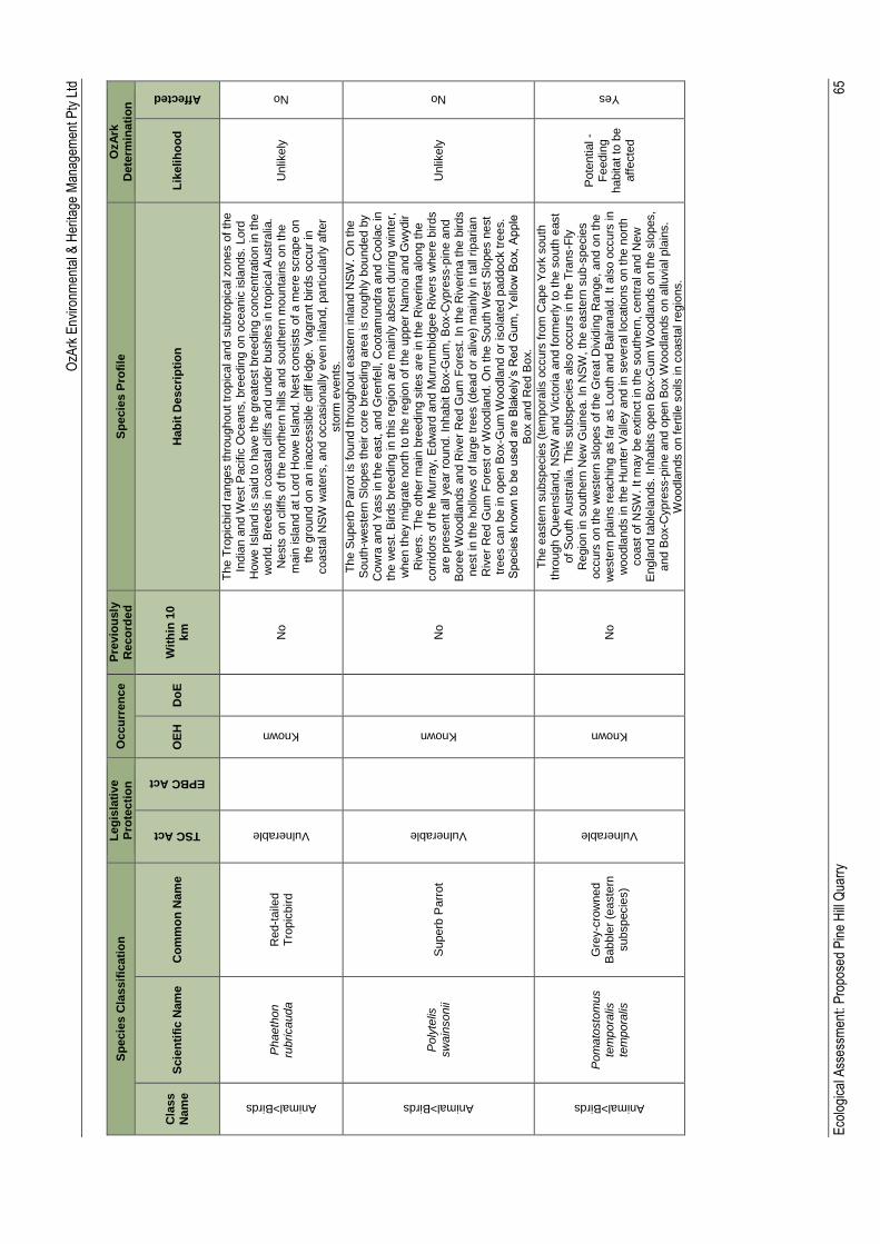
OzA
rk E
nviro
nmen
tal &
Her
itage
Man
agem
ent P
ty L
td
Eco
logi
cal A
sses
smen
t: P
ropo
sed
Pin
e H
ill Q
uarr
y
65
Sp
ecie
s C
lassif
icati
on
L
eg
isla
tive
Pro
tecti
on
O
ccu
rren
ce
Pre
vio
usly
R
eco
rde
d
Sp
ecie
s P
rofi
le
OzA
rk
Dete
rmin
ati
on
Cla
ss
Nam
e
Scie
nti
fic N
am
e
Co
mm
on
Nam
e
TSC Act
EPBC Act
OE
H
Do
E
Wit
hin
10
km
H
ab
it D
escri
pti
on
L
ikelih
oo
d
Affected
Animal>Birds
Phaeth
on
rubricauda
Red-t
aile
d
Tro
pic
bird
Vulnerable
Known
No
Th
e T
ropic
bird r
anges thro
ughout tr
opic
al and s
ubtr
opic
al zones o
f th
e
India
n a
nd W
est
Pacific
Oceans, bre
edin
g o
n o
ceanic
isla
nds.
Lord
H
ow
e I
sla
nd is s
aid
to h
ave t
he g
reate
st bre
edin
g c
oncentr
atio
n in t
he
world
. B
reeds in
coasta
l clif
fs a
nd u
nder
bushes in
tro
pic
al A
ustr
alia
. N
ests
on c
liffs
of th
e n
ort
hern
hill
s a
nd s
outh
ern
mo
unta
ins o
n the
main
isla
nd a
t Lord
How
e I
sla
nd. N
est consis
ts o
f a m
ere
scra
pe o
n
the g
round o
n a
n in
accessib
le c
liff le
dge.
Vagra
nt birds o
ccur
in
coasta
l N
SW
wate
rs, and o
ccasio
nally
even in
land,
part
icula
rly a
fter
sto
rm e
vents
.
Unlik
ely
No
Animal>Birds
Poly
telis
sw
ain
sonii
Superb
Parr
ot
Vulnerable
Known
No
Th
e S
uperb
Parr
ot
is found t
hro
ughout
easte
rn in
land N
SW
. O
n the
South
-weste
rn S
lopes their c
ore
bre
edin
g a
rea is r
oughly
bounded b
y
Cow
ra a
nd Y
ass in t
he e
ast, a
nd G
renfe
ll, C
oota
mundra
and C
oola
c in
the w
est. B
irds b
reedin
g in t
his
regio
n a
re m
ain
ly a
bsent durin
g w
inte
r,
when t
hey m
igra
te n
ort
h to the r
egio
n o
f th
e u
pper
Nam
oi and G
wydir
Riv
ers
. T
he o
ther
ma
in b
reedin
g s
ites a
re in
the R
iverin
a a
long the
corr
idors
of
the M
urr
ay,
Edw
ard
and M
urr
um
bid
gee R
ivers
where
bir
ds
are
pre
sent
all
year
round. In
habit B
ox-G
um
, B
ox-C
ypre
ss-p
ine a
nd
Bore
e W
oodla
nds a
nd R
iver
Red G
um
Fo
rest. I
n t
he R
iverin
a t
he b
irds
nest in
the h
ollo
ws o
f la
rge tre
es (
dead o
r aliv
e)
main
ly in
tall
rip
arian
Riv
er
Red G
um
Fo
rest or
Woodla
nd.
On the S
outh
West S
lopes n
est
trees c
an b
e in
open B
ox-G
um
Woodla
nd o
r is
ola
ted p
addock t
rees.
Specie
s k
now
n t
o b
e u
sed a
re B
lakely
’s R
ed G
um
, Y
ello
w B
ox,
Apple
B
ox a
nd R
ed B
ox.
Unlik
ely
No
Animal>Birds
Pom
ato
sto
mus
tem
pora
lis
tem
pora
lis
Gre
y-c
row
ned
Babble
r (e
aste
rn
subspecie
s)
Vulnerable
Known
No
Th
e e
aste
rn s
ubspecie
s (
tem
pora
lis o
ccurs
fro
m C
ape Y
ork
south
th
rough Q
ueensla
nd, N
SW
and V
icto
ria
and f
orm
erly to the s
outh
east
of
South
Austr
alia
. T
his
subspecie
s a
lso o
ccurs
in
the T
rans-F
ly
Regio
n in
south
ern
New
Guin
ea.
In N
SW
, th
e e
aste
rn s
ub
-specie
s
occurs
on the w
este
rn s
lopes o
f th
e G
reat
Div
idin
g R
ange, and o
n the
weste
rn p
lain
s r
eachin
g a
s far
as L
outh
and B
alranald
. It a
lso o
ccurs
in
woodla
nds in
the H
unte
r V
alle
y a
nd in
severa
l lo
catio
ns o
n t
he n
ort
h
coast
of
NS
W. It m
ay b
e e
xtin
ct in
the s
outh
ern
, centr
al and N
ew
E
ngla
nd t
able
lands. In
habits o
pen B
ox-G
um
Woodla
nds o
n the s
lopes,
and B
ox-C
yp
ress-p
ine a
nd o
pen B
ox W
oodla
nds o
n a
lluvia
l pla
ins.
Woodla
nds o
n fert
ile s
oils
in
coasta
l re
gio
ns.
Pote
ntial -
Fe
edin
g
habitat to
be
aff
ecte
d
Yes
OzA
rk E
nviro
nmen
tal &
Her
itage
Man
agem
ent P
ty L
td
Eco
logi
cal A
sses
smen
t: P
ropo
sed
Pin
e H
ill Q
uarr
y
66
Sp
ecie
s C
lassif
icati
on
L
eg
isla
tive
Pro
tecti
on
O
ccu
rren
ce
Pre
vio
usly
R
eco
rde
d
Sp
ecie
s P
rofi
le
OzA
rk
Dete
rmin
ati
on
Cla
ss
Nam
e
Scie
nti
fic N
am
e
Co
mm
on
Nam
e
TSC Act
EPBC Act
OE
H
Do
E
Wit
hin
10
km
H
ab
it D
escri
pti
on
L
ikelih
oo
d
Affected
Animal>Birds
Rhip
idura
ru
fifr
ons
Rufo
us F
anta
il
Protected
Likely
No
Th
e R
ufo
us F
anta
il occurs
in c
oasta
l and n
ear
coasta
l dis
tric
ts o
f nort
hern
and e
aste
rn A
ustr
alia
. In
east
and s
outh
-east A
ustr
alia
, th
e
Rufo
us F
anta
il m
ain
ly in
habits w
et
scle
rophyll
fore
sts
, often in g
ulli
es
dom
inate
d b
y e
ucaly
pts
such a
s T
allo
w-w
oo
d (
Eucaly
ptu
s m
icro
cory
s),
M
ounta
in G
rey G
um
(E
. cypello
carp
a),
Narr
ow
-le
aved P
epperm
int
(E.
radia
ta),
Mounta
in A
sh (
E. re
gnans),
Alp
ine A
sh (
E.
dele
gate
nsis
),
Bla
ckbutt (
E. pilu
laris)
or
Red M
ahogany (
E.
resin
ifera
); u
sually
with a
dense s
hru
bby u
nders
tore
y o
ften inclu
din
g fern
s. T
hey a
lso o
ccur
in
subtr
opic
al and tem
pera
te r
ain
fore
sts
; fo
r exam
ple
near
Bega in
south
-east
NS
W, w
here
they a
re r
ecord
ed in
tem
pera
te L
illy P
illy (
Acm
ena
sm
ithi) r
ain
fore
st, w
ith G
rey M
yrt
le (
Backhousia
myrt
ifolia
), S
assafr
as
(Dory
phora
sassafr
as)
and S
weet
Pitto
sporu
m (
Pitto
sporu
m
undula
tum
) subdom
inants
. T
hey o
ccasio
nally
occur
in s
econdary
re
gro
wth
, fo
llow
ing lo
ggin
g o
r dis
turb
ance in
fore
sts
or
rain
fore
sts
. W
hen o
n p
assage, th
ey a
re s
om
etim
es r
ecord
ed in d
rie
r scle
rophyll
fore
sts
and w
oodla
nds,
inclu
din
g S
pott
ed G
um
(E
ucaly
ptu
s m
acula
ta),
Y
ello
w B
ox (
E. m
elli
odora
), iro
nbark
s o
r str
ingybark
s,
oft
en w
ith a
shru
bby o
r heath
unders
tore
y.
Th
ey a
re a
lso r
ecord
ed f
rom
park
s a
nd
gard
ens w
hen o
n p
assage. In
nort
h a
nd n
ort
h-e
ast A
ustr
alia
, th
ey
oft
en o
ccur
in tro
pic
al ra
info
rest
and m
onsoon r
ain
fore
sts
, in
clu
din
g
sem
i-everg
reen m
esophyll
vin
e f
ore
sts
, sem
i-decid
uous v
ine thic
kets
or
thic
kets
of P
aperb
ark
s (
Mela
leuca s
pp.)
(H
iggin
s e
t al. 2
006).
Unlik
ely
No
Animal>Birds
Rostr
atu
la
austr
alis
A
ustr
alia
n P
ain
ted
Snip
e
Endangered
Endangered
Known
May occur
No
Most
record
s o
f th
e A
ustr
alia
n P
ain
ted S
nip
e a
re f
rom
the s
outh
east,
part
icula
rly the M
urr
ay D
arlin
g B
asin
, w
ith s
catt
ere
d r
ecord
s a
cro
ss
nort
hern
Austr
alia
and h
isto
rical re
cord
s fro
m a
round t
he P
ert
h r
egio
n
in W
este
rn A
ustr
alia
. In
NS
W m
any r
ecord
s a
re fro
m t
he M
urr
ay-
Darlin
g B
asin
inclu
din
g the P
aro
o w
etla
nds,
Lake C
ow
al, M
acquarie
M
ars
hes, F
ivebough S
wam
p a
nd m
ore
recently, sw
am
ps n
ear
Balld
ale
and W
anganella
. O
ther
import
ant lo
catio
ns w
ith r
ecent
record
s in
clu
de
wetla
nds o
n t
he H
aw
kesbury
Riv
er
and t
he C
lare
nce a
nd lo
wer
Hunte
r V
alle
ys. P
refe
rs f
rin
ges o
f sw
am
ps,
dam
s a
nd n
earb
y m
ars
hy a
reas
whe
re t
here
is a
cover
of
gra
sses, lig
num
, lo
w s
cru
b o
r open t
imb
er.
N
ests
on the g
round a
mongst ta
ll vegeta
tio
n, such a
s g
rasses,
tussocks o
r re
eds.
Unlik
ely
No
OzA
rk E
nviro
nmen
tal &
Her
itage
Man
agem
ent P
ty L
td
Eco
logi
cal A
sses
smen
t: P
ropo
sed
Pin
e H
ill Q
uarr
y
67
Sp
ecie
s C
lassif
icati
on
L
eg
isla
tive
Pro
tecti
on
O
ccu
rren
ce
Pre
vio
usly
R
eco
rde
d
Sp
ecie
s P
rofi
le
OzA
rk
Dete
rmin
ati
on
Cla
ss
Nam
e
Scie
nti
fic N
am
e
Co
mm
on
Nam
e
TSC Act
EPBC Act
OE
H
Do
E
Wit
hin
10
km
H
ab
it D
escri
pti
on
L
ikelih
oo
d
Affected
Animal>Birds
Sta
gonople
ura
gutt
ata
D
iam
ond F
ireta
il
Vulnerable
Known
No
Th
e D
iam
ond F
ireta
il is
endem
ic to s
outh
-easte
rn A
ustr
alia
, exte
ndin
g
from
centr
al Q
ueensla
nd to the E
yre
Penin
sula
in
South
Austr
alia
. It is
wid
ely
dis
trib
ute
d in N
SW
, w
ith a
concentr
atio
n o
f re
cord
s f
rom
the
Nort
hern
, C
entr
al and S
outh
ern
Table
lands,
the N
ort
hern
, C
enta
l and
South
Weste
rn S
lopes a
nd the N
ort
h W
est P
lain
s a
nd R
iverin
a. N
ot
com
monly
found in c
oasta
l dis
tric
ts, th
ough there
are
record
s f
rom
near
Sydney,
the H
unte
r V
alle
y a
nd t
he B
ega V
alle
y. T
his
specie
s h
as
a s
cattere
d d
istr
ibutio
n o
ver
the r
est of
NS
W, th
ough is v
ery
rare
we
st
of
the D
arlin
g R
iver.
Fo
und in
gra
ssy e
ucaly
pt w
oodla
nds,
inclu
din
g
Box-G
um
Woodla
nds a
nd S
now
Gum
Eucaly
ptu
s p
auciflo
ra
Woodla
nds. A
lso o
ccurs
in o
pen fore
st, m
alle
e,
Natu
ral T
em
pera
te
Gra
ssla
nd,
and in
secondary
gra
ssla
nd d
erived f
rom
oth
er
com
munitie
s. O
ften found in
rip
arian a
reas (
rivers
and c
reeks),
and
som
etim
es in lig
htly w
ooded f
arm
land.
Unlik
ely
No
Animal>Birds
Sticto
nett
a
naevosa
Fre
ckle
d D
uck
Vulnerable
Predicted
No
Th
e F
reckle
d D
uck is found p
rim
arily
in
south
-easte
rn a
nd s
outh
-w
este
rn A
ustr
alia
, occurr
ing a
s a
vagra
nt
els
ew
here
. It b
reeds in
la
rge
tem
pora
ry s
wam
ps c
reate
d b
y flo
ods in t
he B
ullo
o a
nd L
ake E
yre
basin
s a
nd t
he M
urr
ay-D
arlin
g s
yste
m, part
icula
rly a
long the P
aro
o
and L
achla
n R
ivers
, and o
ther
rivers
within
the R
iverin
a.
Th
e d
uck is
forc
ed to d
ispers
e d
urin
g e
xte
nsiv
e in
land d
roughts
when w
etla
nds in
the M
urr
ay R
iver
basin
pro
vid
e im
port
ant
habitat. T
he s
pecie
s m
ay
als
o o
ccur
as f
ar
as c
oasta
l N
SW
and V
icto
ria
durin
g s
uch tim
es.
Pre
fer
perm
anent fr
eshw
ate
r sw
am
ps a
nd c
reeks w
ith h
eavy g
row
th o
f C
um
bungi, L
ignum
or
Te
a-t
ree.
Durin
g d
rie
r tim
es t
hey m
ove fro
m
ephem
era
l bre
edin
g s
wam
ps to m
ore
perm
anent w
ate
rs s
uch a
s la
kes,
reserv
oirs, fa
rm d
am
s a
nd s
ew
age
ponds.
Unlik
ely
No
Animal>Birds
Tyto
novaeholla
ndia
e
Masked O
wl
Vulnerable
Known
No
Th
e M
asked O
wl exte
nds f
rom
the c
oast w
here
it
is m
ost abundant to
th
e w
este
rn p
lain
s. O
vera
ll re
cord
s for
this
specie
s f
all
within
appro
xim
ate
ly 9
0%
of
NS
W, exclu
din
g t
he m
ost
arid n
ort
h-w
este
rn
corn
er.
Th
ere
is n
o s
easonal varia
tio
n in its
dis
trib
utio
n. Liv
es in
dry
eucaly
pt fo
rests
and w
oodla
nds f
rom
sea le
vel to
1100 m
. A
fore
st
ow
l,
but
often h
unts
alo
ng t
he e
dges o
f fo
rests
, in
clu
din
g r
oadsid
es. R
oosts
and b
reeds in
mo
ist eucaly
pt fo
reste
d g
ulli
es, usin
g la
rge tre
e h
ollo
ws
or
som
etim
es c
aves f
or
nestin
g.
Unlik
ely
No

OzA
rk E
nviro
nmen
tal &
Her
itage
Man
agem
ent P
ty L
td
Eco
logi
cal A
sses
smen
t: P
ropo
sed
Pin
e H
ill Q
uarr
y
68
Sp
ecie
s C
lassif
icati
on
L
eg
isla
tive
Pro
tecti
on
O
ccu
rren
ce
Pre
vio
usly
R
eco
rde
d
Sp
ecie
s P
rofi
le
OzA
rk
Dete
rmin
ati
on
Cla
ss
Nam
e
Scie
nti
fic N
am
e
Co
mm
on
Nam
e
TSC Act
EPBC Act
OE
H
Do
E
Wit
hin
10
km
H
ab
it D
escri
pti
on
L
ikelih
oo
d
Affected
Animal>Fish
Ma
ccullo
chella
peelii
M
urr
ay C
od
Vulnerable
May occur
No
Th
e M
urr
ay C
od w
as h
isto
rically
dis
trib
ute
d t
hro
ughout th
e M
urr
ay-
Darlin
g B
asin
(th
e B
asin
), w
ith t
he e
xceptio
n o
f th
e u
pper
reaches o
f som
e trib
uta
ries. T
he d
istr
ibutio
n o
f th
e M
urr
ay C
od o
ccurs
in t
he
follo
win
g b
iore
gio
ns a
ccord
ing to the I
nte
rim
Bio
geogra
phic
R
egio
nalis
atio
n f
or
Austr
alia
(IB
RA
7)
(DS
EW
PaC
2012ae):
Murr
ay-
Darlin
g D
epre
ssio
n,
Riv
erin
a,
NS
W S
outh
Weste
rn S
lopes, S
outh
E
aste
rn H
ighla
nds,
Cobar
Penepla
in,
Darlin
g R
iverin
e P
lain
s, B
rig
alo
w
Belt S
outh
and N
andew
ar.
T
he M
urr
ay C
od u
tilis
es a
div
ers
e r
ange o
f habitats
fro
m c
lear
rocky s
tream
s, such a
s t
hose found in
the u
pper
weste
rn s
lopes o
f N
SW
(in
clu
din
g the A
CT
), to s
low
-flo
win
g,
turb
id
low
land r
ivers
and b
illa
bongs. M
urr
ay C
od a
re f
requently f
ound in
the
main
channels
of
rivers
and la
rger
trib
uta
rie
s.
Th
e s
pecie
s is,
there
fore
, consid
ere
d a
main
-channel specia
list. M
urr
ay C
od t
end to
occur
in flo
odpla
in c
hannels
and a
nabra
nches w
hen t
hey a
re
inundate
d.
Unlik
ely
No
Animal>
Invertebrates
Para
lucia
spin
ifera
Purp
le C
opper
Butt
erf
ly, B
ath
urs
t C
opper
Butt
erf
ly
Endangered
Vulnerable
Known
Likely
Yes
Th
e P
urp
le C
opper
Butterf
ly o
ccurs
on the C
entr
al T
able
lands o
f N
SW
in
an a
rea a
ppro
xim
ate
ly b
ounded b
y O
bero
n,
Hart
ley a
nd B
ath
urs
t.
Geolo
gy,
soils
and d
om
inant
vegeta
tio
n c
anopy s
pecie
s v
ary
betw
ee
n
habitat
locatio
ns.
How
ever
vegeta
tio
n s
tructu
re is c
onsis
tent,
com
monly
open w
oodla
nd o
r open f
ore
st
with a
spars
e u
nders
tore
y
that
is d
om
inate
d b
y t
he s
hru
b, B
lackth
orn
Burs
aria
spin
osa s
ubsp.
lasio
phylla
.
Unlik
ely
- N
o
dense
sta
nds o
f native
bla
ckth
orn
in
stu
dy a
rea
No
Animal> Marsupials
Cerc
art
etu
s
nanus
Easte
rn P
ygm
y-
possum
Vulnerable
Predicted
No
Th
e E
aste
rn P
ygm
y-p
ossum
is f
ound in
south
-easte
rn A
ustr
alia
, fr
om
south
ern
Queensla
nd t
o e
aste
rn S
outh
Austr
alia
and in T
asm
ania
. In
N
SW
it
exte
nts
fro
m t
he c
oast in
land a
s far
as the P
illig
a,
Dubbo,
Park
es a
nd W
agga W
agga o
n t
he w
este
rn s
lopes. F
ound
in
a b
road
range o
f habitats
fro
m r
ain
fore
st th
rough s
cle
rophyll
(inclu
din
g B
ox-
Ironbark
) fo
rest
and w
oodla
nd t
o h
eath
, but
in m
ost are
as w
oodla
nds
and h
eath
appear
to b
e p
refe
rred, except
in n
ort
h-e
aste
rn N
SW
where
th
ey a
re m
ost fr
equently e
ncounte
red in
rain
fore
st. S
helters
in
tre
e
hollo
ws,
rott
en s
tum
ps, hole
s in
the g
round,
abandoned b
ird
-nests
, R
ingta
il P
ossum
(P
seudocheirus p
ere
grin
us)
dre
ys o
r th
ickets
of
vegeta
tio
n,
(e.g
. gra
ss-t
ree s
kirts
).
Unlik
ely
No
Animal>
Marsupials
Dasyuru
s
macula
tus
Spott
ed-t
aile
d
Quoll
Vulnerable
Endangered
Known
Likely
No
Th
e s
pott
ed
-taile
d Q
uoll
is r
ecord
ed a
cro
ss a
range o
f habitat ty
pes,
inclu
din
g r
ain
fore
st, o
pen fore
st, w
oodla
nd,
coasta
l heath
and in
land
rip
aria
n f
ore
st, fro
m the s
ub
-alp
ine z
one t
o the c
oastlin
e. In
div
idual
anim
als
use h
ollo
w-b
earin
g t
rees, fa
llen lo
gs, sm
all
caves,
rock
outc
rops a
nd r
ocky-c
liff fa
ces a
s d
en s
ites.
Unlik
ely
No
OzA
rk E
nviro
nmen
tal &
Her
itage
Man
agem
ent P
ty L
td
Eco
logi
cal A
sses
smen
t: P
ropo
sed
Pin
e H
ill Q
uarr
y
69
Sp
ecie
s C
lassif
icati
on
L
eg
isla
tive
Pro
tecti
on
O
ccu
rren
ce
Pre
vio
usly
R
eco
rde
d
Sp
ecie
s P
rofi
le
OzA
rk
Dete
rmin
ati
on
Cla
ss
Nam
e
Scie
nti
fic N
am
e
Co
mm
on
Nam
e
TSC Act
EPBC Act
OE
H
Do
E
Wit
hin
10
km
H
ab
it D
escri
pti
on
L
ikelih
oo
d
Affected
Animal>
Marsupials
Peta
uro
ides
vola
ns
Gre
ate
r G
lider
Vulnerable
May occur
No
Th
e g
reate
r glid
er
is r
estr
icte
d t
o e
aste
rn A
ustr
alia
, occurr
ing f
rom
the
Win
dsor
Ta
ble
land in
nort
h Q
ueensla
nd thro
ugh t
o c
entr
al V
icto
ria
(W
om
bat S
tate
Fo
rest)
, w
ith a
n e
levatio
nal ra
nge f
rom
sea le
vel to
1200 m
above s
ea le
vel. T
he g
reate
r glid
er
favours
fore
sts
with a
div
ers
ity o
f eucaly
pt specie
s, due to s
easonal varia
tio
n in
its
pre
ferr
ed
tree s
pecie
s.
Roosts
in
tre
e h
ollo
ws a
nd is m
ore
com
mon in a
reas
abundant
in t
ree h
ollo
ws.
Unlik
ely
No
Animal>
Marsupials
Peta
uru
s
austr
alis
Y
ello
w-b
elli
ed
Glid
er
Vulnerable
Predicted
No
Th
e Y
ello
w-b
elli
ed G
lider
is f
ound a
long t
he e
aste
rn c
oast to
the
weste
rn s
lopes o
f th
e G
reat
Div
idin
g R
ange,
from
south
ern
Q
ueensla
nd t
o V
icto
ria
. O
ccur
in tall
matu
re e
ucaly
pt fo
rest genera
lly
in a
reas w
ith h
igh r
ain
fall
and n
utr
ient
rich s
oils
.
Unlik
ely
No
Animal>
Marsupials
Peta
uru
s
norf
olc
ensis
S
quirre
l G
lider
Vulnerable
Predicted
No
Th
e S
quirre
l G
lider
is w
idely
though s
pars
ely
dis
trib
ute
d in
easte
rn
Austr
alia
, fr
om
nort
hern
Queensla
nd t
o w
este
rn V
icto
ria
. In
habits
matu
re o
r old
gro
wth
Box,
Box-I
ronbark
woodla
nds a
nd R
iver
Red
Gum
fore
st w
est
of
the G
reat D
ivid
ing R
ange a
nd B
lackbutt
-B
loodw
ood f
ore
st
with h
eath
unders
tore
y in
coasta
l are
as. P
refe
rs
mix
ed s
pecie
s s
tands w
ith a
shru
b o
r A
cacia
mid
sto
rey.
Unlik
ely
No
Animal> Marsupials
Petr
ogale
penic
illata
B
rush-t
aile
d R
ock-
walla
by
Endangered
Vulnerable
Known
May occur N
o
Th
e r
ange o
f th
e B
rush
-taile
d R
ock-w
alla
by e
xte
nds f
rom
south
-east
Queensla
nd t
o t
he G
ram
pia
ns in w
este
rn V
icto
ria
, ro
ughly
follo
win
g
the lin
e o
f th
e G
reat D
ivid
ing R
ange.
How
ever
the d
istr
ibutio
n o
f th
e
specie
s a
cro
ss its
orig
inal ra
nge h
as d
eclin
ed s
ignific
antly in t
he w
est
and s
outh
and h
as b
ecom
e m
ore
fra
gm
ente
d. In
NS
W they o
ccur
from
th
e Q
ueensla
nd b
ord
er
in the n
ort
h t
o the S
hoalh
aven in
the s
outh
, w
ith t
he p
opula
tio
n in
the W
arr
um
bungle
Ranges b
ein
g the w
este
rn
limit. O
ccupy r
ocky e
scarp
ments
, outc
rops a
nd c
liffs
with a
pre
fere
nce
for
com
ple
x s
tructu
res w
ith f
issure
s, caves a
nd le
dges, often f
acin
g
nort
h. B
row
se o
n v
egeta
tio
n in a
nd a
dja
cent to
rocky a
reas e
atin
g
gra
sses a
nd forb
s a
s w
ell
as the folia
ge a
nd f
ruits o
f shru
bs a
nd tre
es.
Unlik
ely
No
Animal>
Marsupials
Phascogale
ta
poata
fa
Bru
sh-t
aile
d
Phascogale
Vulnerable
Predicted
No
Th
e B
rush
-taile
d P
hascogale
has a
patc
hy d
istr
ibutio
n a
round the
coast
of
Austr
alia
. In
NS
W it is
main
ly f
ound e
ast
of th
e G
reat D
ivid
ing
Range a
lthough t
here
are
occassio
nal re
cord
s w
est
ot th
e d
ivid
e.
Pre
fer
dry
scle
rophyll
open fore
st w
ith s
pars
e g
roundcover
of
herb
s,
gra
sses, shru
bs o
r le
af
litte
r. A
lso inhabit h
eath
, sw
am
ps,
rain
fore
st
and w
et
scle
rophyll
fore
st.
Unlik
ely
No
OzA
rk E
nviro
nmen
tal &
Her
itage
Man
agem
ent P
ty L
td
Eco
logi
cal A
sses
smen
t: P
ropo
sed
Pin
e H
ill Q
uarr
y
70
Sp
ecie
s C
lassif
icati
on
L
eg
isla
tive
Pro
tecti
on
O
ccu
rren
ce
Pre
vio
usly
R
eco
rde
d
Sp
ecie
s P
rofi
le
OzA
rk
Dete
rmin
ati
on
Cla
ss
Nam
e
Scie
nti
fic N
am
e
Co
mm
on
Nam
e
TSC Act
EPBC Act
OE
H
Do
E
Wit
hin
10
km
H
ab
it D
escri
pti
on
L
ikelih
oo
d
Affected
Animal>
Marsupials
Phascola
rcto
s
cin
ere
us
Koala
Vulnerable
Vulnerable
Known
Known
Yes
Th
e K
oala
has a
fra
gm
ente
d d
istr
ibutio
n t
hro
ughout
easte
rn A
ustr
alia
fr
om
nort
h-e
ast Q
ueensla
nd to the E
yre
Penin
sula
in
South
Austr
alia
. In
NS
W it m
ain
ly o
ccurs
on the c
entr
al and n
ort
h c
oasts
with s
om
e
popula
tio
ns in
the w
est
of th
e G
reat
Div
idin
g R
ange. In
habit e
ucaly
pt
woodla
nds a
nd f
ore
sts
.
Pote
ntial
No
Animal> Marsupials
Pseudom
ys
novaeholla
ndia
e
New
Holla
nd
Mouse
Vulnerable
May occur
No
Th
e N
ew
Holla
nd M
ouse h
as a
fra
gm
ente
d d
istr
ibutio
n a
cro
ss
Ta
sm
ania
, V
icto
ria
, N
SW
and Q
ueensla
nd. T
he s
pecie
s is n
ow
la
rgely
re
str
icte
d to the c
oast
of centr
al and n
ort
hern
NS
W, w
ith o
ne in
land
occurr
ence n
ear
Park
es.
Th
e N
ew
Holla
nd M
ouse h
as b
een found
from
coasta
l are
as a
nd u
p t
o 1
00 k
m in
land o
n s
andsto
ne c
ountr
y. T
he
specie
s h
as b
een r
ecord
ed f
rom
sea le
vel up t
o a
round 9
00 m
above
sea le
vel. S
oil
type m
ay b
e a
n im
port
ant
indic
ato
r of suitabili
ty o
f habitat fo
r th
e N
ew
Holla
nd M
ouse,
with d
eeper
top s
oils
and s
oft
er
substr
ate
s b
ein
g p
refe
rred for
dig
gin
g b
urr
ow
s (
Wils
on &
Laid
law
2003).
In
Vic
toria
, th
e s
pecie
s h
as b
een r
ecord
ed o
n d
eep s
iliceous
podsols
, sandy c
lay,
loam
y s
ands, sand d
unes a
nd c
oasta
l dunes. D
ue
to t
he la
rgely
gra
niv
oro
us d
iet of th
e s
pecie
s, sites w
here
the N
ew
H
olla
nd M
ouse is found a
re o
ften h
igh in
flo
ristic d
ivers
ity,
especia
lly
legum
inous p
ere
nnia
ls. T
he m
ouse is k
now
n t
o in
habit o
pen
heath
land,
open w
oodla
nd w
ith a
heath
land u
nders
tore
y a
nd
vegeta
ted s
and d
unes.
Unlik
ely
No
Animal>Reptiles
Apra
sia
para
pulc
hella
P
ink-t
aile
d
Legle
ss L
izard
Vulnerable
Vulnerable
Predicted
May occur
No
Th
ere
is a
concentr
atio
n o
f popula
tio
ns in
the C
anberr
a/Q
ueanbeyan
Regio
n.
Oth
er
popula
tio
ns h
ave b
een r
ecord
ed n
ear
Coom
a, Y
ass,
Bath
urs
t, A
lbury
and W
est W
yalo
ng.
Th
is s
pecie
s is a
lso found in t
he
Austr
alia
n C
apital T
err
itory
. In
habits s
lopin
g,
open w
oodla
nd a
reas
with p
redom
inantly n
ative g
rassy g
roundla
yers
, part
icula
rly t
hose
dom
inate
d b
y K
angaro
o G
rass (
Them
eda a
ustr
alis
). S
ites a
re typic
ally
w
ell-
dra
ined,
with r
ocky o
utc
rops o
r scatt
ere
d,
part
ially
-burie
d r
ocks.
Com
monly
found b
eneath
sm
all,
part
ially
-em
bedded r
ocks a
nd a
ppear
to s
pend c
onsid
era
ble
tim
e in
burr
ow
s b
elo
w t
hese r
ocks; th
e b
urr
ow
s
have b
een c
onstr
ucte
d b
y a
nd a
re o
ften s
till
inhabited b
y s
ma
ll bla
ck
ants
and t
erm
ites.
Unlik
ely
No
Animal>
Reptiles
Suta
fla
gellu
m
Little W
hip
Snake
Vulnerable
Known
No
Th
e L
ittle
Whip
Snake is f
ound w
ithin
an a
rea b
ounded b
y C
rookw
ell
in
the n
ort
h, B
om
bala
in t
he s
outh
, T
um
baru
mba t
o t
he w
est and
Bra
idw
ood t
o t
he e
ast. O
ccurs
in
Natu
ral T
em
pera
te G
rassla
nds a
nd
gra
ssy w
oodla
nds,
inclu
din
g t
hose d
om
inate
d b
y S
now
Gum
E
ucaly
ptu
s p
auciflo
ra o
r Y
ello
w B
ox E
. m
elli
odora
. A
lso o
ccurs
in
secondary
gra
ssla
nds d
erived f
rom
cle
arin
g o
f w
oodla
nds.
Fo
und o
n
well
dra
ined h
illsid
es, m
ostly a
ssocia
ted w
ith s
cattere
d lo
ose r
ocks.
Unlik
ely
No
OzA
rk E
nviro
nmen
tal &
Her
itage
Man
agem
ent P
ty L
td
Eco
logi
cal A
sses
smen
t: P
ropo
sed
Pin
e H
ill Q
uarr
y
71
Sp
ecie
s C
lassif
icati
on
L
eg
isla
tive
Pro
tecti
on
O
ccu
rren
ce
Pre
vio
usly
R
eco
rde
d
Sp
ecie
s P
rofi
le
OzA
rk
Dete
rmin
ati
on
Cla
ss
Nam
e
Scie
nti
fic N
am
e
Co
mm
on
Nam
e
TSC Act
EPBC Act
OE
H
Do
E
Wit
hin
10
km
H
ab
it D
escri
pti
on
L
ikelih
oo
d
Affected
Animal>
Reptiles
Vara
nus
rosenberg
i R
osenberg
's
Goanna
Vulnerable
Predicted
No
Rosenberg
's G
oanna o
ccurs
on t
he S
ydney S
andsto
ne in
Wolle
mi
Natio
nal P
ark
to the n
ort
h-w
est
of S
ydney,
in the G
oulb
urn
and A
CT
re
gio
ns a
nd n
ear
Coom
a in
the s
outh
. F
ound in
heath
, open f
ore
st
and
woodla
nd.
Associa
ted w
ith t
erm
ites, th
e m
ounds o
f w
hic
h t
his
specie
s
nests
in a
nd r
equires a
la
rge h
abitat
rang
e.
Unlik
ely
No
Community>
Threatened
Ecological Communitie
s
Natu
ral
Te
mpera
te
Gra
ssla
nd o
f th
e
South
Easte
rn
Hig
hla
nds
Natu
ral
Tem
pera
te
Gra
ssla
nd o
f th
e
South
Easte
rn
Hig
hla
nds
Critically
Endangered
Likely
No
Natu
ral T
em
pera
te G
rassla
nd o
f th
e S
outh
Easte
rn H
ighla
nds o
ccurs
at
altitudes b
etw
een 2
50m
to 1
200m
in a
nd a
round t
he S
outh
Easte
rn
Hig
hla
nds. T
he e
colo
gic
al com
munity o
ccurs
on a
wid
e r
ange o
f to
pogra
phic
positio
ns a
nd o
n s
oils
derived f
rom
a v
arie
ty o
f substr
ate
s,
inclu
din
g g
ranites,
basalts,
sedim
ents
, collu
viu
m a
nd a
lluviu
m.
Unlik
ely
No
Community>
Threatened Ecological
Communities
Ta
ble
land B
asalt
Fo
rest in
the
Sydney B
asin
and S
outh
E
aste
rn
Hig
hla
nds
Bio
regio
ns
Ta
ble
land B
asalt
Fo
rest in
the
Sydney B
asin
and
South
Easte
rn
Hig
hla
nds
Bio
regio
ns
Endangered
Ecological Community
Known
No
Ta
ble
land B
asalt F
ore
st is
curr
ently f
ound in
the E
aste
rn H
ighla
nds
and S
outh
ern
and C
entr
al T
able
lands, coverin
g t
he lo
cal govern
ment
are
as o
f B
ath
urs
t R
egio
nal, G
oulb
urn
Mulw
are
e,
Obero
n,
Pale
rang,
Shoalh
aven,
Upper
Lachla
n a
nd W
ingecarr
ibee.
Typic
ally
occurs
on
loam
or
cla
y s
oils
associa
ted w
ith b
asalt o
r, less c
om
monly
, allu
viu
m,
fin
e-g
rain
ed s
edim
enta
ry r
ocks,
gra
nites a
nd s
imila
r substr
ate
s t
hat
pro
duce r
ela
tively
fert
ile s
oils
. Its d
istr
ibutio
n s
pans a
ltitudes f
rom
appro
xim
ate
ly 6
00 m
to 9
00 m
above s
ea le
vel, u
sually
on u
ndula
tin
g
or
hill
y t
err
ain
. M
ean a
nnual ra
infa
ll varie
s fro
m a
ppro
xim
ate
ly 7
50 m
m
up t
o 1
100 m
m a
cro
ss t
he d
istr
ibutio
n o
f th
e c
om
munity.
Unlik
ely
No
Community> Threatened
Ecological Communities
Ta
ble
lands
Snow
Gum
, B
lack S
alle
e,
Candle
bark
and
Rib
bon G
um
G
rassy
Woodla
nd in t
he
South
Easte
rn
Hig
hla
nds,
Sydney B
asin
, S
outh
East
Corn
er
and N
SW
S
outh
Weste
rn
Slo
pes
Bio
regio
ns
Ta
ble
lands S
now
G
um
, B
lack
Salle
e,
Candle
bark
and
Rib
bon G
um
G
rassy W
oodla
nd
in t
he S
outh
E
aste
rn
Hig
hla
nds,
Sydney B
asin
, S
outh
East
Corn
er
and N
SW
South
W
este
rn S
lopes
Bio
regio
ns
Endangered Ecological Community
Predicted
No
Ta
ble
lands S
now
Gum
Gra
ssy W
oodla
nd o
ccurs
in
the S
outh
Easte
rn
Hig
hla
nds B
iore
gio
n;
part
of th
is r
egio
n is t
he 'S
outh
ern
Ta
ble
lands'
and t
he n
ort
hern
sectio
n o
f th
e b
iore
gio
n is the 'C
entr
al T
able
lands.
Rem
nants
may o
ccur
on t
he lo
wer,
more
fert
ile p
art
s o
f th
e la
ndscape
whe
re r
esourc
es s
uch a
s w
ate
r and n
utr
ients
are
abundant; s
ites o
n
mid
slo
pe s
ituatio
ns w
here
resourc
es a
re s
carc
er
are
mo
re c
om
mon.
Unlik
ely
No
OzA
rk E
nviro
nmen
tal &
Her
itage
Man
agem
ent P
ty L
td
Eco
logi
cal A
sses
smen
t: P
ropo
sed
Pin
e H
ill Q
uarr
y
72
Sp
ecie
s C
lassif
icati
on
L
eg
isla
tive
Pro
tecti
on
O
ccu
rren
ce
Pre
vio
usly
R
eco
rde
d
Sp
ecie
s P
rofi
le
OzA
rk
Dete
rmin
ati
on
Cla
ss
Nam
e
Scie
nti
fic N
am
e
Co
mm
on
Nam
e
TSC Act
EPBC Act
OE
H
Do
E
Wit
hin
10
km
H
ab
it D
escri
pti
on
L
ikelih
oo
d
Affected
Community>
Threatened
Ecological Communities
Upla
nd B
asalt
Eucaly
pt F
ore
sts
of
the S
ydney
Basin
Bio
regio
n
Upla
nd B
asalt
Eucaly
pt F
ore
sts
of
the S
ydney
Basin
Bio
regio
n
Endangered
Likely
No
Th
e U
pla
nd B
asalt E
ucaly
pt F
ore
sts
of th
e S
ydney B
asin
Bio
regio
n a
re
genera
lly t
all
open e
ucaly
pt fo
rests
found o
n ig
neous r
ock
(pre
dom
inate
ly T
ert
iary
basalt a
nd m
icro
syenite)
in, or
adja
cent to
, th
e
Sydney B
asin
Bio
regio
n.
Th
e e
colo
gic
al com
munity o
ccurs
in
are
as o
f hig
h r
ain
fall,
genera
lly r
angin
g f
rom
950 to 1
600 m
m/y
ear.
Th
e
ecolo
gic
al com
munity typic
ally
occurs
at ele
vatio
ns b
etw
een 6
50 a
nd
1050 m
above s
ea le
vel, a
lthough it
has b
een r
ecord
ed a
t ele
vatio
ns
as lo
w a
s 3
50 m
at th
e b
ack o
f th
e I
llaw
arr
a E
scarp
men.
Pote
ntial
No
Community>
Threatened
Ecological Communities
White B
ox
Yello
w B
ox
Bla
kely
's R
ed
Gum
Woodla
nd
White B
ox Y
ello
w
Box B
lakely
's R
ed
Gum
Woodla
nd
Endangered
Ecological Community
Known
No
Th
e B
ox –
Gum
Gra
ssy W
oodla
nd a
nd D
erived G
rassla
nd e
colo
gic
al
com
munity o
ccurs
in a
n a
rc a
long the w
este
rn s
lopes a
nd t
able
lands o
f th
e G
reat D
ivid
ing R
ange f
rom
South
ern
Queensla
nd thro
ugh N
SW
to
centr
al V
icto
ria (
Beadle
1981).
It
occurs
in t
he B
rig
alo
w B
elt S
outh
, N
ande
war,
New
Engla
nd T
able
land,
South
Easte
rn Q
ueensla
nd,
Sydney B
asin
, N
SW
Nort
h C
oast, S
outh
Easte
rn H
ighla
nds, S
outh
E
ast
Corn
er,
NS
W S
outh
Weste
rn S
lopes, V
icto
ria
n M
idla
nds a
nd
Riv
erin
a B
iore
gio
ns (
Environm
ent A
ustr
alia
2000).
Unlik
ely
No
Community>
Threatened
Ecological Communities
White B
ox-
Yello
w B
ox-
Bla
kely
's R
ed
Gum
Gra
ssy
Woodla
nd a
nd
Derived N
ative
Gra
ssla
nd
White B
ox-Y
ello
w
Box-B
lakely
's R
ed
Gum
Gra
ssy
Woodla
nd a
nd
Derived N
ative
Gra
ssla
nd
Critically
Endangered
Likely
No
Box-G
um
Woodla
nd is f
ound fro
m the Q
ueensla
nd b
ord
er
in the n
ort
h,
to t
he V
icto
ria
n b
ord
er
in the s
outh
. It o
ccurs
in
the t
able
lands a
nd
weste
rn s
lopes o
f N
SW
. C
hara
cte
rised b
y the p
resence o
r prio
r occurr
ence o
f W
hite B
ox,
Yello
w B
ox a
nd/o
r B
lakely
's R
ed G
um
.
Unlik
ely
No
Plant>Herbs and Forbs
Calo
tis
gla
ndulo
sa
Mauve B
urr
-dais
y
Vulnerable
Known
No
Th
e d
istr
ibutio
n o
f th
e M
auve B
urr
-dais
y is c
entr
ed o
n the M
onaro
and
Kosciu
szko r
egio
ns. T
here
are
thre
e k
now
n s
ites in
the u
pper
Shoalh
aven c
atc
hm
ent. T
here
are
old
and p
ossib
ly d
ubio
us r
ecord
s
from
near
Obero
n, th
e D
ubbo a
rea a
nd M
t Im
lay. F
ound in s
ubalp
ine
gra
ssla
nd (
dom
inate
d b
y P
oa s
pp.)
, and m
onta
ne o
r natu
ral te
mp
era
te
gra
ssla
nd d
om
inate
d b
y K
angaro
o G
rass (
Th
em
eda a
ustr
alis
) and
Snow
Gum
(E
ucaly
ptu
s p
auciflo
ra)
Wo
odla
nds o
n t
he M
onaro
and
Shoalh
aven a
rea.
Appare
ntly c
om
mon o
n r
oadsid
es in
part
s o
f th
e
Monaro
, th
ough it does n
ot
pers
ist fo
r lo
ng in
such s
ites. D
oes n
ot
pers
ist
in h
eavily
-gra
zed p
astu
res o
f th
e M
onaro
or
the S
hoalh
aven
are
a.
Unlik
ely
No
OzA
rk E
nviro
nmen
tal &
Her
itage
Man
agem
ent P
ty L
td
Eco
logi
cal A
sses
smen
t: P
ropo
sed
Pin
e H
ill Q
uarr
y
73
Sp
ecie
s C
lassif
icati
on
L
eg
isla
tive
Pro
tecti
on
O
ccu
rren
ce
Pre
vio
usly
R
eco
rde
d
Sp
ecie
s P
rofi
le
OzA
rk
Dete
rmin
ati
on
Cla
ss
Nam
e
Scie
nti
fic N
am
e
Co
mm
on
Nam
e
TSC Act
EPBC Act
OE
H
Do
E
Wit
hin
10
km
H
ab
it D
escri
pti
on
L
ikelih
oo
d
Affected
Plant>Herbs and
Forbs
Euphra
sia
arg
uta
E
uphra
sia
arg
uta
Critically Endangered
Critically Endangered
May occur
No
Th
e c
urr
ent know
n p
opula
tio
ns o
f E
uphra
sia
arg
uta
are
locate
d in t
he
Nundle
Sta
te F
ore
st in
eucaly
pt fo
rest
with a
mix
ed g
rass a
nd s
hru
b
unders
tore
y (
D B
inns p
ers
. com
m. F
ebru
ary
2009).
Th
is a
rea is
locate
d a
t th
e ju
nctio
n o
f th
e N
ew
Engla
nd T
able
land, N
SW
Nort
h
Coast, a
nd N
andew
ar
Bio
regio
ns. here
are
no k
now
n o
ccurr
ences o
f E
uphra
sia
arg
uta
in
a c
onserv
ation r
eserv
e.
Th
e m
ajo
rity
of E
. arg
uta
pla
nts
are
lo
cate
d in N
undle
Sta
te F
ore
st. A
sm
all
part
of th
e la
rgest
popula
tio
n o
f E
. arg
uta
is locate
d o
n p
riva
te la
nd that is
adja
cent to
the
Sta
te F
ore
st. T
he la
nd is c
urr
ently u
sed f
or
rough g
razin
g b
y s
heep o
r cattle
.
Unlik
ely
No
Plant>Herbs
and Forbs
Euphra
sia
scabra
R
ough E
yebrig
ht
Endangered
Known
No
Th
ere
are
thre
e e
xta
nt
popula
tio
ns o
f th
e R
ough E
yebrig
ht
in N
SW
: B
ondi S
tate
Fo
rest, S
outh
East
Fore
sts
Natio
nal P
ark
and n
ear
Nunnock S
wam
p. O
ccurs
in o
r at th
e m
arg
ins o
f sw
am
py g
rassla
nd o
r in
sphagnum
bogs,
often in w
et,
peaty
soil.
An a
nnual specie
s,
with
most
flo
werin
g c
olle
ctio
ns o
f th
e s
pecie
s h
ave b
een m
ade b
etw
een
January
and A
pril.
Unlik
ely
No
Plant>Herbs
and Forbs
Lepid
ium
hyssopifoliu
m
Aro
matic
Pepperc
ress
Endangered
Endangered
Known
Likely
No
In N
SW
, th
e A
rom
atic P
epperc
ress h
as a
sm
all
popula
tio
n n
ear
Bath
urs
t, o
ne p
opula
tio
ns a
t B
ungendore
, and o
ne n
ear
Cro
okw
ell.
T
he s
pecie
s o
ccurs
in a
varie
ty o
f habitats
inclu
din
g w
oodla
nd w
ith a
gra
ssy u
nders
tore
y a
nd g
rassla
nd. A
ppears
to r
espond to d
istu
rbance,
havin
g a
ppeare
d a
fter
soil
dis
turb
ance a
t one s
ite.
Unlik
ely
No
Plant>Herbs and
Forbs
Leucochry
sum
alb
icans
Hoary
Sunra
y
Endangered
Likely
No
Endem
ic to s
outh
-easte
rn A
ustr
alia
, w
here
it
is c
urr
ently k
now
n f
rom
th
ree g
eogra
phic
ally
separa
te a
reas in T
asm
ania
, V
icto
ria
and s
outh
-easte
rn N
SW
and A
CT
. In
NS
W it curr
ently o
ccurs
on the S
outh
ern
T
able
lands a
dja
cent are
as in
an a
rea r
oughly
bounded b
y A
lbury
, B
ega a
nd G
oulb
urn
, w
ith a
few
scatt
ere
d locatlitie
s k
now
fro
m b
eyond
this
regio
n.
Occurs
in
a w
ide v
arie
ty o
f gra
ssla
nd, w
oodla
nd a
nd f
ore
st
habitats
, genera
lly o
n r
ela
tively
heavy s
oils
. C
an o
ccur
in m
odifie
d
habitats
such a
s s
em
i-urb
an a
reas a
nd r
oadsid
es. H
ighly
dependent
on t
he p
resence o
f bare
gro
und for
germ
inatio
n. In
som
e a
reas,
dis
turb
ance is r
equired f
or
successfu
l esta
blis
hm
ent.
Unlik
ely
No
Plant>Herbs
and Forbs
Sw
ain
sona
sericea
Silk
y S
wain
son
-pea
Vulnerable
Known
No
Silk
y S
wain
son
-pea h
as b
een r
ecord
ed f
rom
the N
ort
hern
Ta
ble
lands
to t
he S
outh
ern
Ta
ble
lands a
nd furt
her
inla
nd o
n the s
lopes a
nd p
lain
s.
Th
ere
is o
ne isola
ted r
ecord
fro
m the f
ar
nort
h-w
est
of
NS
W. Its
str
onghold
is o
n t
he M
onaro
. A
lso found in
South
Austr
alia
, V
icto
ria
and Q
ueensla
nd. F
ound in N
atu
ral T
em
pera
te G
rassla
nd a
nd S
now
G
um
Eucaly
ptu
s p
auciflo
ra W
oodla
nd o
n t
he M
onaro
. F
ound in
Box-
Gum
Woodla
nd in t
he S
outh
ern
Table
lands a
nd S
outh
West S
lopes.
Unlik
ely
No
OzA
rk E
nviro
nmen
tal &
Her
itage
Man
agem
ent P
ty L
td
Eco
logi
cal A
sses
smen
t: P
ropo
sed
Pin
e H
ill Q
uarr
y
74
Sp
ecie
s C
lassif
icati
on
L
eg
isla
tive
Pro
tecti
on
O
ccu
rren
ce
Pre
vio
usly
R
eco
rde
d
Sp
ecie
s P
rofi
le
OzA
rk
Dete
rmin
ati
on
Cla
ss
Nam
e
Scie
nti
fic N
am
e
Co
mm
on
Nam
e
TSC Act
EPBC Act
OE
H
Do
E
Wit
hin
10
km
H
ab
it D
escri
pti
on
L
ikelih
oo
d
Affected
Plant>Herbs and
Forbs
Th
esiu
m
austr
ale
A
ustr
al T
oadfla
x
Vulnerable
Vulnerable
May occur
No
Austr
al T
oad
-fla
x is f
ound in
very
sm
all
popula
tio
ns s
cattere
d a
cro
ss
easte
rn N
SW
, alo
ng t
he c
oast, a
nd f
rom
the N
ort
hern
to S
outh
ern
T
able
lands. It is a
lso f
ound in
Tasm
ania
and Q
ueensla
nd a
nd in
easte
rn A
sia
. A
lthough o
rig
inally
describ
ed fro
m m
ate
ria
l colle
cte
d in
the S
W S
ydney a
rea,
popula
tio
ns h
ave n
ot
been s
een in
a lo
ng tim
e. It
may p
ers
ist in
som
e a
reas in
the b
roader
regio
n.
Occurs
in
gra
ssla
nd
on c
oasta
l headla
nds o
r gra
ssla
nd a
nd g
rassy w
oodla
nd a
wa
y f
rom
th
e c
oast.
Unlik
ely
No
Plant>Herbs and
Forbs
Tra
chym
ene
scapig
era
M
ounta
in
Tra
chym
ene
Endangered
Predicted
No
Th
e M
ounta
in T
rachym
ene T
he s
pecie
s o
ccurs
at aro
und f
our
genera
l lo
catio
ns b
etw
een J
enola
n c
aves a
nd G
urn
ang S
tate
Fo
rest on t
he
Centr
al T
able
lands s
outh
east of O
bero
n.
Am
ong t
hese locatio
ns,
the
specie
s o
ccurs
in
Kanangra
-Boyd N
atio
nal P
ark
. A
ssocia
ted
vegeta
tio
n a
cro
ss k
now
n s
ites v
aries fro
m r
iparia
n tea
-tre
e thic
kets
to
tall
fore
st,
to fro
st
hollo
ws a
nd in
clu
des t
he f
ollo
win
g s
pecie
s:
Lepto
sperm
um
obovatu
m, E
ucaly
ptu
s fastig
ata
, E
. dalrym
ple
ana,
Acacia
me
lanoxylo
n,
E. ste
llula
ta, E
. pauciflo
ra, E
. ru
bid
a.
Pote
ntial
No
Plant>
Mallees
Eucaly
ptu
s
pulv
eru
lenta
S
ilver-
leafe
d G
um
Vulnerable
Vulnerable
Known
Likely
Yes
Th
e S
ilver-
leafe
d G
um
is f
ound in
tw
o q
uite s
epara
te a
reas, th
e
Lithgow
to B
ath
urs
t are
a a
nd t
he M
onaro
(B
redbo t
o B
om
bala
). G
row
s
in s
hallo
w s
oils
as a
n u
nders
tore
y p
lant
in o
pen f
ore
st, t
ypic
ally
dom
inate
d b
y B
rittle
Gum
(E
ucaly
ptu
s m
annifera
), R
ed S
trin
gybark
(E
. m
acro
rhynca),
Bro
ad
-le
afe
d P
epperm
int
(E. div
es),
Silv
ert
op A
sh (
E.
sie
beri)
and A
pple
Box (
E.
brid
gesia
na).
Pote
ntial
No
Plant>
Orchids
Cala
denia
att
enuata
D
ura
mana F
ingers
Critically
Endangered
Predicted
No
Cala
denia
att
enuata
is e
ndem
ic to N
SW
. It h
as a
hig
hly
restr
icte
d
dis
trib
utio
n, havin
g b
een r
ecord
ed fro
m 2
lo
calit
ies w
ithin
the B
ath
urs
t Ilfo
rd r
egio
n w
ith a
n a
rea o
f occupance e
stim
ate
d to b
e 8
square
kilo
metr
es.
Unlik
ely
No
Plant>Orchids
Pra
sophyllu
m
petilu
m
Ta
rengo L
eek
Orc
hid
Endangered
May occur
No
Natu
ral popula
tio
ns o
f th
e T
are
ngo L
eek O
rchid
are
know
n f
rom
a t
ota
l of
five s
ites in N
SW
. T
hese a
rea a
t B
ooro
wa,
Capta
ins F
lat, Ilford
, D
ele
gate
and a
new
ly r
ecognis
ed p
opula
tio
n c
.10 k
SE
of
Musw
ellb
rook.
It a
lso o
ccurs
at H
all
in the A
ustr
alia
n C
apital T
err
itory
. T
his
specie
s h
as a
lso b
een r
ecord
ed a
t B
ow
nin
g C
em
ete
ry w
here
it
was e
xperim
enta
lly in
troduced, th
ough it
is n
ot know
n w
heth
er
this
popula
tio
n h
as p
ers
iste
d.
Gro
ws in o
pen s
ites w
ithin
Natu
ral
Tem
pera
te G
rassla
nd a
t th
e B
ooro
wa a
nd D
ele
gate
sites. A
lso g
row
s
in g
rassy w
oodla
nd in
associa
tio
n w
ith R
iver
Tu
ssock P
oa la
bill
ard
ieri,
Bla
ck G
um
Eucaly
ptu
s a
ggre
ga
ta a
nd t
ea-t
rees L
epto
sperm
um
spp. at
Capta
ins F
lat and w
ithin
the g
rassy g
roundla
yer
dom
inate
d b
y
Kanagro
o G
rass u
nder
Box-G
um
Woodla
nd a
t Ilfo
rd (
and H
all,
AC
T).
Unlik
ely
No
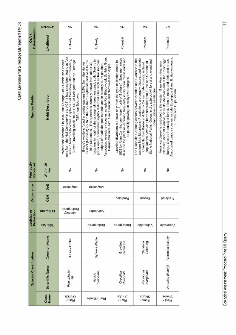
OzA
rk E
nviro
nmen
tal &
Her
itage
Man
agem
ent P
ty L
td
Eco
logi
cal A
sses
smen
t: P
ropo
sed
Pin
e H
ill Q
uarr
y
75
Sp
ecie
s C
lassif
icati
on
L
eg
isla
tive
Pro
tecti
on
O
ccu
rren
ce
Pre
vio
usly
R
eco
rde
d
Sp
ecie
s P
rofi
le
OzA
rk
Dete
rmin
ati
on
Cla
ss
Nam
e
Scie
nti
fic N
am
e
Co
mm
on
Nam
e
TSC Act
EPBC Act
OE
H
Do
E
Wit
hin
10
km
H
ab
it D
escri
pti
on
L
ikelih
oo
d
Affected
Plant>
Orchids
Pra
sophyllu
m
sp.
A L
eek O
rchid
Critically
Endangered
May occur
No
When first
describ
ed in
1991,
the T
are
ngo L
eek O
rchid
was k
now
n
only
fro
m the H
all
Cem
ete
ry in t
he A
CT
. It h
as s
ince b
een found a
t fo
ur
sites in
New
South
Wale
s:
Capta
ins F
lat
Cem
ete
ry, Ilfo
rd C
em
ete
ry,
Ste
ves T
ravelli
ng S
tock R
oute
(T
SR
) at
Dele
gate
and t
he T
are
ngo
TS
R n
ear
Booro
wa.
Unlik
ely
No
Plant>Shrubs
Acacia
bynoeana
Bynoe's
Watt
le
Endangered
Vulnerable
May occur
No
Bynoe's
watt
le is f
ound in
centr
al easte
rn N
SW
, fr
om
the H
unte
r D
istr
ict (M
orisset)
south
to the S
outh
ern
Hig
hla
nds a
nd w
est to
the
Blu
e M
ounta
ins. T
he s
pecie
s is c
urr
ently k
now
n f
rom
about 30
locatio
ns in
heath
or
dry
scle
rophyll
fore
st on s
andy s
oils
. S
eem
s t
o
pre
fer
open, som
etim
es s
lightly d
istu
rbed s
ites s
uch a
s tra
il m
arg
ins,
edges o
f ro
adsid
e s
poil
mounds a
nd in
recently b
urn
t patc
hes.
Associa
ted o
vers
tore
y s
pecie
s inclu
de R
ed B
loodw
ood,
Scrib
bly
Gum
, P
arr
am
att
a R
ed G
um
, S
aw
Banksia
and N
arr
ow
-le
aved A
pple
.
Unlik
ely
No
Plant>
Shrubs
Gre
vill
ea
div
aricata
G
revill
ea
div
aricata
Endangered
Predicted
No
Gre
vill
ea d
ivaricata
is k
now
n o
nly
fro
m t
he type c
olle
ctio
n m
ade in
1823 b
y A
llan C
unnin
gham
, fr
om
"nort
h o
f B
ath
urs
t". S
pecim
en n
ote
s
describ
e the p
lant
as o
ccurr
ing fre
quently in
dry
open fore
st la
nds a
nd
as p
ossib
ly g
row
ing o
n r
ocky r
iver
marg
ins.
Pote
ntial
No
Plant>
Shrubs
Pers
oonia
m
arg
inata
C
landulla
G
eebung
Vulnerable
Known
N
o
Th
e C
landulla
Geebung o
ccurs
betw
een K
andos a
nd C
lare
nce in
the
weste
rn B
lue M
ounta
ins. P
opula
tions a
re la
rgely
dis
junct and inclu
de
Cla
ndulla
, B
en B
ulle
n a
nd S
unny C
orn
er
Sta
te F
ore
sts
; is
ola
ted
popula
tio
ns h
ave a
lso b
een r
ecord
ed f
rom
Tu
ron a
nd G
ard
ens o
f S
tone N
atio
nal P
ark
s. G
row
s in
dry
scle
rophyll
fore
st
and w
oodla
nd
com
munitie
s o
n s
andsto
ne.
Pote
ntial
No
Plant>
Shrubs
Vero
nic
a b
lakely
i V
ero
nic
a b
lakely
i
Vulnerable
Predicted
No
Vero
nic
a b
lakeyi is
restr
icte
d t
o t
he w
este
rn B
lue M
ounta
ins, near
Cla
rence,
near
Mt H
orr
ible
, on N
ullo
Mounta
in a
nd in t
he C
oricudgy
Range.
Occurs
in
eucaly
pt fo
rest, o
ften in m
ois
t and s
heltere
d a
reas.
Associa
ted c
anopy s
pecie
s inclu
de E
ucaly
ptu
s d
ives, E
. dalrym
ple
ana,
E.
rossii
and E
. pauciflo
ra.
Pote
ntial
No
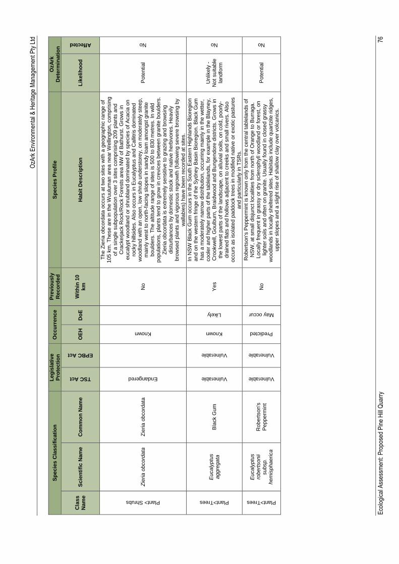
OzA
rk E
nviro
nmen
tal &
Her
itage
Man
agem
ent P
ty L
td
Eco
logi
cal A
sses
smen
t: P
ropo
sed
Pin
e H
ill Q
uarr
y
76
Sp
ecie
s C
lassif
icati
on
L
eg
isla
tive
Pro
tecti
on
O
ccu
rren
ce
Pre
vio
usly
R
eco
rde
d
Sp
ecie
s P
rofi
le
OzA
rk
Dete
rmin
ati
on
Cla
ss
Nam
e
Scie
nti
fic N
am
e
Co
mm
on
Nam
e
TSC Act
EPBC Act
OE
H
Do
E
Wit
hin
10
km
H
ab
it D
escri
pti
on
L
ikelih
oo
d
Affected
Plant> Shrubs
Zie
ria
obcord
ata
Z
ieria
obcord
ata
Endangered
Known
No
Th
e Z
ieria
obcord
ata
occurs
at tw
o s
ites w
ith a
geogra
phic
range o
f 105 k
m. T
hese a
re in
the W
uulu
ma
n a
rea n
ear
Welli
ngto
n, com
prisin
g
of
a s
ingle
subpopula
tio
n o
ver
3 s
ites c
om
prisin
g 2
09 p
lants
and
Cra
ckerja
ck R
ock/R
ock F
ore
sts
are
a N
W o
f B
ath
urs
t. G
row
s in
eucaly
pt
woodla
nd o
r shru
bla
nd d
om
inate
d b
y s
pecie
s o
f A
cacia
on
rocky h
illsid
es. A
lso o
ccurs
in
Eucaly
ptu
s a
nd C
alli
tris
dom
inate
d
woodla
nd w
ith a
n o
pen,
low
shru
b u
nders
tore
y,
on m
odera
tely
ste
ep,
main
ly w
est to
nort
h-f
acin
g s
lopes in
sandy lo
am
am
ongst gra
nite
bould
ers
. T
he a
ltitude r
ange o
f sites is 5
00 t
o 8
30 m
etr
es. In
wild
popula
tio
ns, pla
nts
tend to g
row
in
cre
vic
es b
etw
een g
ranite b
ould
ers
. Z
ieria
obcord
ata
is e
xtr
em
ely
sensitiv
e t
o g
razin
g a
nd b
row
sin
g
dis
turb
ances b
y d
om
estic s
tock a
nd n
ative h
erb
ivore
s. H
eavily
bro
wsed p
lants
and v
igoro
us r
egro
wth
(fo
llow
ing s
evere
bro
wsin
g b
y
walla
bie
s)
have b
een r
ecord
ed a
t sites.
Pote
ntial
No
Plant>Trees
Eucaly
ptu
s
aggre
gata
B
lack G
um
Vulnerable
Vulnerable
Known
Likely
Yes
In N
SW
Bla
ck G
um
occurs
in
the S
outh
Easte
rn H
ighla
nds B
iore
gio
n
and o
n t
he w
este
rn frin
ge o
f th
e S
ydney B
asin
Bio
regio
n. B
lack G
um
has a
mo
dera
tely
narr
ow
dis
trib
ution,
occurr
ing m
ain
ly in
the w
ett
er,
coole
r and h
igher
part
s o
f th
e table
lands, fo
r exam
ple
in
the B
layney,
Cro
okw
ell,
Goulb
urn
, B
raid
wood a
nd B
ungendore
dis
tric
ts. G
row
s in
th
e lo
west
part
s o
f th
e la
ndscape, on a
lluvia
l soils
, on c
old
, poorly-
dra
ined f
lats
and h
ollo
ws a
dja
cent to
cre
eks a
nd s
mall
rivers
. A
lso
occurs
as isola
ted p
addock tre
es in m
odifie
d n
ative o
r exotic p
astu
res
and p
art
icula
rly in
TS
Rs.
Unlik
ely
-
Not
suitable
la
ndfo
rm
No
Plant>Trees
Eucaly
ptu
s
robert
sonii
subsp.
hem
isphaerica
Robert
son's
P
epperm
int
Vulnerable
Vulnerable
Predicted
May occur
No
Robert
son's
Pepperm
int is
know
n o
nly
fro
m the c
entr
al ta
ble
lands o
f N
SW
, at sm
all
dis
junct lo
calit
ies fro
m n
ort
h o
f O
range to B
urr
aga.
Locally
fre
quent in
gra
ssy o
r dry
scle
rophyll
woodla
nd o
r fo
rest, o
n
lighte
r soils
and o
ften o
n g
ranite. U
sually
found in
clo
sed g
rassy
woodla
nds in
lo
cally
sheltere
d s
ites. H
abitats
in
clu
de q
uart
zite r
idges,
upper
slo
pes a
nd a
slig
ht
rise o
f shallo
w c
lay o
ver
volc
anic
s.
Pote
ntial
No
OzArk Environmental & Heritage Management Pty Ltd
Ecological Assessment: Proposed Pine Hill Quarry 77
Appendix C: EPBC Act assessment of significance

OzArk Environmental & Heritage Management Pty Ltd
Ecological Assessment: Proposed Pine Hill Quarry 78
Appendix omitted from report as there is no impact to Commonwealth listed species.
OzArk Environmental & Heritage Management Pty Ltd
Ecological Assessment: Proposed Pine Hill Quarry 79
Appendix D: TSC Act assessment of significance
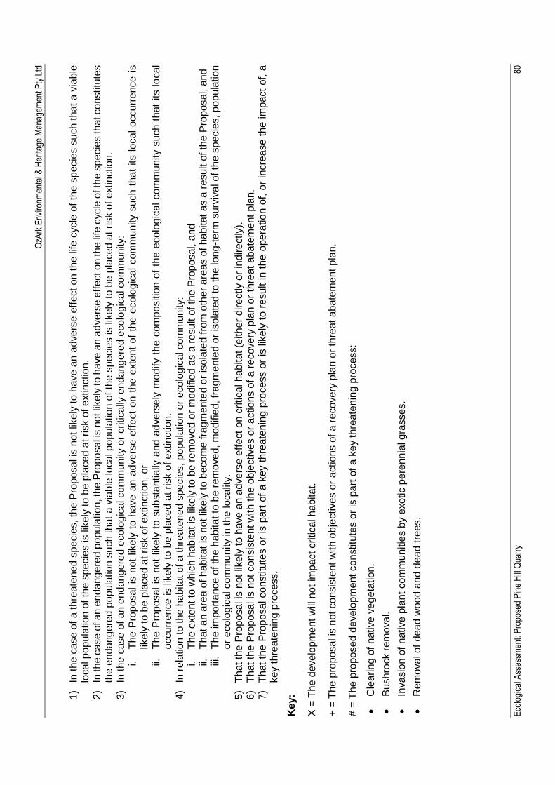
OzA
rk E
nviro
nmen
tal &
Her
itage
Man
agem
ent P
ty L
td
Eco
logi
cal A
sses
smen
t: P
ropo
sed
Pin
e H
ill Q
uarr
y
80
1)
In t
he c
ase o
f a
th
reate
ne
d s
pecie
s, th
e P
roposa
l is
not
like
ly t
o h
ave
an
adve
rse
eff
ect
on th
e life
cycle
of
the s
pecie
s s
uch
th
at
a v
iable
lo
cal p
op
ula
tion
of
the s
pe
cie
s is lik
ely
to b
e p
laced
at risk o
f e
xtin
ction
. 2)
In th
e c
ase o
f a
n e
nd
ang
ere
d p
opu
lation
, th
e P
ropo
sal i
s n
ot lik
ely
to h
ave
an
adve
rse e
ffe
ct o
n th
e li
fe c
ycle
of th
e s
pecie
s th
at co
nstitu
tes
the e
nd
ang
ere
d p
op
ula
tio
n s
uch th
at
a v
iable
loca
l p
op
ula
tion
of
the s
pecie
s is lik
ely
to b
e p
laced a
t risk o
f e
xtin
ction
. 3)
In th
e c
ase
of
an e
nd
ang
ere
d e
colo
gic
al com
mu
nity o
r critica
lly e
nd
an
ge
red
eco
log
ica
l co
mm
unity:
i.
Th
e P
ropo
sal
is n
ot
like
ly t
o h
ave
an a
dve
rse e
ffe
ct
on t
he e
xte
nt
of
the e
colo
gic
al
com
mu
nity s
uch t
hat
its l
ocal
occu
rre
nce
is
like
ly t
o b
e p
laced a
t risk o
f e
xtin
ction
, or
ii.
Th
e P
ropo
sal
is n
ot
like
ly t
o s
ubsta
ntia
lly a
nd
ad
ve
rse
ly m
odify t
he c
om
po
sitio
n o
f th
e e
colo
gic
al co
mm
unity s
uch t
hat
its lo
ca
l o
ccurr
ence
is lik
ely
to
be p
laced
at risk o
f e
xtin
ctio
n.
4)
In r
ela
tion
to th
e h
ab
itat of
a t
hre
ate
ne
d s
pecie
s, p
op
ula
tion
or
eco
log
ica
l co
mm
unity:
i.
Th
e e
xte
nt to
wh
ich
ha
bita
t is
lik
ely
to
be r
em
ove
d o
r m
odifie
d a
s a
re
sult o
f th
e P
rop
osa
l, a
nd
ii.
T
hat
an a
rea o
f h
ab
itat
is n
ot lik
ely
to
beco
me fra
gm
en
ted o
r is
ola
ted
fro
m o
the
r a
rea
s o
f h
ab
itat
as a
re
sult o
f th
e P
roposa
l, a
nd
iii
. T
he im
port
ance
of th
e h
ab
ita
t to
be r
em
ove
d, m
odifie
d, fr
ag
me
nte
d o
r is
ola
ted to
th
e lo
ng
-te
rm s
urv
iva
l o
f th
e s
pecie
s, p
op
ula
tion
o
r e
colo
gic
al com
mu
nity in
th
e lo
calit
y.
5)
Th
at th
e P
ropo
sal is
not
like
ly t
o h
ave
an a
dve
rse
eff
ect
on c
ritica
l h
ab
ita
t (e
ith
er
directly o
r in
dire
ctly).
6)
Th
at th
e P
ropo
sal is
not co
nsis
tent w
ith
th
e o
bje
ctive
s o
r a
ctio
ns o
f a r
ecove
ry p
lan o
r th
reat a
ba
tem
ent p
lan.
7)
Th
at
the P
ropo
sal co
nstitu
tes o
r is
part
of
a k
ey t
hre
ate
nin
g p
rocess o
r is
lik
ely
to
re
sult in
th
e o
pera
tio
n o
f, o
r in
cre
ase
th
e im
pact
of, a
ke
y t
hre
ate
nin
g p
rocess.
Ke
y:
X =
Th
e d
eve
lopm
ent w
ill n
ot
imp
act critica
l h
ab
ita
t.
+ =
Th
e p
rop
osal is
not co
nsis
tent w
ith
ob
jective
s o
r a
ctio
ns o
f a r
ecove
ry p
lan o
r th
reat
abate
me
nt p
lan.
# =
Th
e p
ropo
sed
de
ve
lopm
ent co
nstitu
tes o
r is
pa
rt o
f a
ke
y th
reate
nin
g p
rocess:
Cle
arin
g o
f n
ative
ve
ge
tatio
n.
Bu
shro
ck r
em
ova
l.
Inva
sio
n o
f n
ative
pla
nt
co
mm
unitie
s b
y e
xo
tic p
ere
nn
ial g
rasse
s.
Re
mo
va
l o
f d
ea
d w
ood
an
d d
ea
d tre
es.
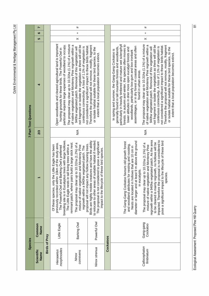
OzA
rk E
nviro
nmen
tal &
Her
itage
Man
agem
ent P
ty L
td
Eco
logi
cal A
sses
smen
t: P
ropo
sed
Pin
e H
ill Q
uarr
y
81
Sp
ec
ies
7-P
art
Te
st
Qu
es
tio
ns
Sc
ien
tifi
c
Nam
e
Co
mm
on
N
am
e
1
2/3
4
5
6
7
Bir
ds
of
Pre
y
Hie
raa
etu
s
mo
rph
no
ide
s
Little
Ea
gle
Of
the
se s
pe
cie
s, o
nly
th
e L
ittle
Ea
gle
has b
ee
n
pre
vio
usly
re
co
rde
d w
ith
in 1
0km
of
the
stu
dy a
rea
. T
he
Po
we
rfu
l O
wl a
nd
Ba
rkin
g O
wl’s
pre
ferr
ed
b
ree
din
g s
ite
is in
Eu
caly
ptu
s tre
es w
ith
la
rge
ho
llow
s.
Th
e L
ittle E
agle
ne
sts
in t
all
livin
g t
ree
s w
ith
in a
re
mn
an
t pa
tch
, w
he
re p
air
s b
uild
a la
rge
stick n
est.
Th
e p
rop
osa
l m
ay c
lea
r u
p to
10
.31h
a (
1.2
%)
of
a
mix
ture
of
native
ve
ge
tation
and
Mo
nte
rey P
ine
re
gro
wth
with
in a
94
0ha
ve
ge
tate
d p
atc
h.
Th
e
pro
posa
l w
ill n
ot im
pa
ct a
ny h
ollo
w b
ea
rin
g t
ree
s.
Bir
ds a
re h
ighly
mo
bile
cre
atu
res a
nd
ha
ve
th
e a
bili
ty
to r
elo
ca
te t
o o
the
r a
rea
s o
f suita
ble
hab
itat
if n
eed
ed
. T
he
pro
posa
l is
no
t co
nsid
ere
d t
o p
ose a
sig
nific
an
t im
pact
to t
he
life
cycle
of
these b
ird
sp
ecie
s.
N/A
Op
en
wo
od
land
s a
nd
cle
are
d a
gri
cu
ltura
l la
nd is im
po
rta
nt
hu
ntin
g g
rou
nd
s fo
r th
ese
bir
ds.
Th
e P
ow
erf
ul O
wl in
p
art
icu
lar
requ
ires larg
e e
xp
an
se
s o
f w
oo
dla
nd
to
occup
y.
Th
e p
rop
osa
l m
ay c
lea
r u
p to
10
.31h
a (
1.1
%)
of
a m
ixtu
re
of
na
tive
ve
ge
tatio
n a
nd
Mo
nte
rey P
ine
re
gro
wth
with
in a
9
40
ha v
eg
eta
ted
pa
tch
. R
em
ova
l o
f th
is v
ege
tatio
n w
ill
no
t fr
ag
men
t o
r is
ola
te t
he
ve
ge
tatio
n a
s t
he
re w
ill s
till
be
co
ntin
uou
s c
onn
ectivity.
A lo
ss o
f 1
.1%
of ve
ge
tatio
n is
no
t co
nsid
ere
d a
sig
nific
an
t im
pa
ct to
the
se
bird
s h
ab
ita
t.
Th
ere
fore
the
pro
posa
l w
ill n
ot re
mo
ve
, m
odify,
frag
men
t o
r is
ola
te h
ab
itat
su
itab
le fo
r th
ese
bir
d s
pecie
s,
to t
he
e
xte
nt
tha
t a
lo
ca
l p
op
ula
tio
n b
ecom
es e
xtin
ct.
X
+
#
Nin
ox
co
nniv
en
s
Ba
rkin
g O
wl
Nin
ox s
tren
ua
Po
we
rfu
l O
wl
Co
ck
ato
os
Callo
ce
pha
lon
fim
bri
atu
m
Ga
ng
-ga
ng
C
ockato
o
Th
e G
an
g-G
an
g C
ocka
too
fa
vo
urs
old
gro
wth
fo
rest
an
d w
oo
dla
nd
att
ribu
tes f
or
nesting
and
ro
ostin
g.
Nests
are
lo
ca
ted
in
ho
llow
s t
ha
t a
re 1
0 c
m in
d
iam
ete
r o
r la
rge
r an
d a
t le
ast 9
m a
bo
ve
the
gro
un
d
in e
uca
lyp
ts.
Th
e p
rop
osa
l m
ay c
lea
r u
p to
10
.31h
a (
1.1
%)
of
a
mix
ture
of
native
ve
ge
tation
and
Mo
nte
rey P
ine
re
gro
wth
with
in a
94
0ha
ve
ge
tate
d p
atc
h.
As t
he a
rea
to b
e c
lea
red
is m
ain
ly r
eg
row
th,
no
ho
llow
s w
ill b
e
imp
acte
d.
Th
ere
fore
the
pro
posa
l is
no
t co
nsid
ere
d to
p
ose a
sig
nific
an
t im
pact
to the
life
cycle
of th
ese
bir
d
sp
ecie
s.
N/A
In s
prin
g a
nd
sum
me
r, t
he
Gan
g-G
an
g C
ocka
too is
ge
ne
rally
fou
nd
in
tall
mo
un
tain
fo
rests
an
d w
oo
dla
nds,
pa
rtic
ula
rly in
he
avily
tim
be
red a
nd
ma
ture
we
t scle
rop
hyll
fore
sts
. In
autu
mn
and
win
ter,
th
e s
pe
cie
s o
fte
n m
ove
s to
lo
we
r a
ltitud
es in
dri
er
mo
re o
pe
n e
ucaly
pt
fore
sts
and
w
oo
dla
nd
s,
pa
rtic
ula
rly b
ox-g
um
and
bo
x-i
ron
ba
rk
asse
mbla
ge
s, o
r in
dry
fo
rest in
coa
sta
l a
rea
s a
nd o
ften
fo
un
d in
urb
an a
reas.
Th
e p
rop
osa
l m
ay c
lea
r u
p to
10
.31h
a (
1.1
%)
of
a m
ixtu
re
of
na
tive
ve
ge
tatio
n a
nd
Mo
nte
rey P
ine
re
gro
wth
with
in a
9
40
ha v
eg
eta
ted
pa
tch
. R
em
ova
l o
f th
is v
ege
tatio
n w
ill
no
t fr
ag
men
t o
r is
ola
te t
he
ve
ge
tatio
n a
s t
he
re w
ill s
till
be
co
ntin
uou
s c
onn
ectivity.
A lo
ss o
f 1
.1%
of ve
ge
tatio
n is
no
t co
nsid
ere
d a
sig
nific
an
t im
pa
ct to
the
se
bird
s h
ab
ita
t.
Th
ere
fore
the
pro
posa
l w
ill n
ot re
mo
ve
, m
odify,
frag
men
t o
r is
ola
te h
ab
itat
su
itab
le fo
r th
ese
bir
d s
pecie
s,
to t
he
e
xte
nt
tha
t a
lo
ca
l p
op
ula
tio
n b
ecom
es e
xtin
ct.
X
+
#
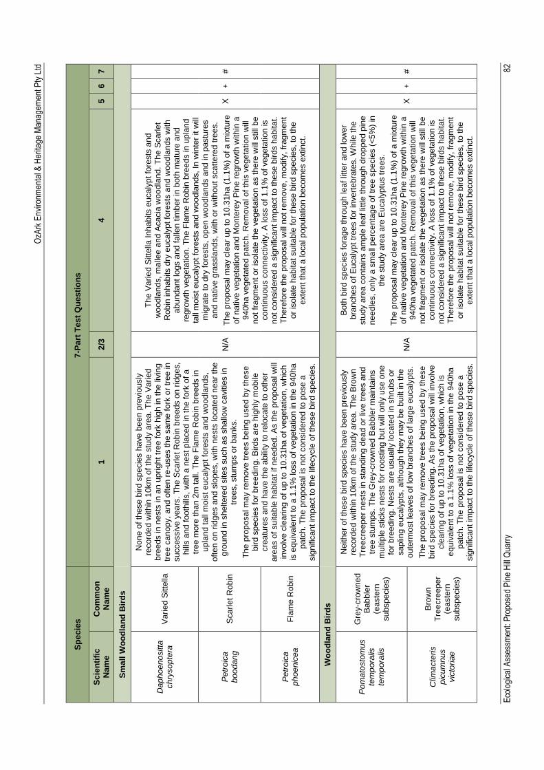
OzA
rk E
nviro
nmen
tal &
Her
itage
Man
agem
ent P
ty L
td
Eco
logi
cal A
sses
smen
t: P
ropo
sed
Pin
e H
ill Q
uarr
y
82
Sp
ec
ies
7-P
art
Te
st
Qu
es
tio
ns
Sc
ien
tifi
c
Nam
e
Co
mm
on
N
am
e
1
2/3
4
5
6
7
Sm
all
Wo
od
lan
d B
ird
s
Dap
ho
en
ositta
ch
ryso
pte
ra
Va
rie
d S
itte
lla
Non
e o
f th
ese
bir
d s
pecie
s h
ave
be
en
pre
vio
usly
re
co
rde
d w
ith
in 1
0km
of
the
stu
dy a
rea
. T
he
Va
ried
b
ree
ds in n
ests
in
an
up
righ
t tr
ee
fo
rk h
igh
in
the
liv
ing
tr
ee
ca
nop
y,
an
d o
ften
re
-uses t
he
sa
me
fo
rk o
r tr
ee
in
su
ccessiv
e y
ea
rs.
Th
e S
ca
rle
t R
ob
in b
ree
ds o
n r
idg
es,
hill
s a
nd
foo
thill
s,
with
a n
est pla
ced
in t
he f
ork
of a
tr
ee
mo
re th
an
2m
ta
ll. T
he
Fla
me
Rob
in b
reed
s in
u
pla
nd
tall
mo
ist
eu
ca
lyp
t fo
rests
an
d w
oo
dla
nds,
oft
en
on
rid
ges a
nd
slo
pe
s,
with
nests
lo
ca
ted n
ear
the
gro
un
d in
sh
elte
red
sites s
uch a
s s
ha
llow
ca
vitie
s in
tr
ee
s, stu
mps o
r b
anks.
Th
e p
rop
osa
l m
ay r
em
ove
tre
es b
ein
g u
sed
by t
hese
b
ird
sp
ecie
s f
or
bre
ed
ing
. B
irds a
re h
igh
ly m
ob
ile
cre
atu
res a
nd h
ave
the
abili
ty t
o r
elo
ca
te t
o o
the
r a
rea
s o
f su
ita
ble
hab
itat
if n
eed
ed
. A
s t
he
pro
po
sa
l w
ill
invo
lve
cle
arin
g o
f u
p t
o 1
0.3
1h
a o
f ve
ge
tatio
n, w
hic
h
is e
qu
iva
len
t to
a 1
.1%
loss o
f ve
ge
tatio
n in
the
940
ha
p
atc
h.
Th
e p
rop
osa
l is
no
t co
nsid
ere
d to
pose
a
sig
nific
an
t im
pact
to th
e lifecycle
of th
ese
bir
d s
pecie
s.
N/A
Th
e V
ari
ed
Sitte
lla In
hab
its e
uca
lyp
t fo
rests
an
d
wo
od
lan
ds,
ma
llee
and
Aca
cia
wo
od
lan
d.
Th
e S
ca
rle
t R
ob
in in
hab
its d
ry e
uca
lyp
t fo
rests
an
d w
oo
dla
nds w
ith
a
bu
nda
nt lo
gs a
nd
falle
n t
imb
er
in b
oth
ma
ture
and
re
gro
wth
ve
ge
tatio
n. T
he
Fla
me
Ro
bin
bre
ed
s in
up
lan
d
tall
mo
ist e
uca
lyp
t fo
rests
an
d w
oo
dla
nd
s,
In w
inte
r it w
ill
mig
rate
to
dry
fo
rests
, o
pe
n w
oo
dla
nds a
nd
in p
astu
res
an
d n
ative
gra
ssla
nd
s, w
ith
or
with
ou
t sca
tte
red
tre
es.
Th
e p
rop
osa
l m
ay c
lea
r u
p to
10
.31h
a (
1.1
%)
of
a m
ixtu
re
of
na
tive
ve
ge
tatio
n a
nd
Mo
nte
rey P
ine
re
gro
wth
with
in a
9
40
ha v
eg
eta
ted
pa
tch
. R
em
ova
l o
f th
is v
ege
tatio
n w
ill
no
t fr
ag
men
t o
r is
ola
te t
he
ve
ge
tatio
n a
s t
he
re w
ill s
till
be
co
ntin
uou
s c
onn
ectivity.
A lo
ss o
f 1
.1%
of ve
ge
tatio
n is
no
t co
nsid
ere
d a
sig
nific
an
t im
pa
ct to
the
se
bird
s h
ab
ita
t.
Th
ere
fore
the
pro
posa
l w
ill n
ot re
mo
ve
, m
odify,
frag
men
t o
r is
ola
te h
ab
itat
su
itab
le fo
r th
ese
bir
d s
pecie
s,
to t
he
e
xte
nt
tha
t a
lo
ca
l p
op
ula
tio
n b
ecom
es e
xtin
ct.
X
+
#
Pe
tro
ica
b
oo
dan
g
Sca
rlet
Rob
in
Pe
tro
ica
p
ho
enic
ea
Fla
me
Ro
bin
Wo
od
lan
d B
ird
s
Po
ma
tosto
mus
tem
po
ralis
te
mp
ora
lis
Gre
y-c
row
ne
d
Ba
bb
ler
(ea
ste
rn
su
bsp
ecie
s)
Neith
er
of
the
se b
ird
sp
ecie
s h
ave
be
en p
revio
usly
re
co
rde
d w
ith
in 1
0km
of
the
stu
dy a
rea
. T
he
Bro
wn
T
ree
cre
ep
er
nests
in
sta
nd
ing
de
ad
or
live
tre
es a
nd
tr
ee
stu
mp
s.
Th
e G
rey-c
row
ne
d B
ab
ble
r m
ain
tain
s
mu
ltip
le s
ticks n
ests
fo
r ro
osting
bu
t w
ill o
nly
use
on
e
for
bre
ed
ing
. N
ests
are
usua
lly lo
ca
ted
in
sh
rub
s o
r sa
plin
g e
uca
lyp
ts,
alth
ou
gh
the
y m
ay b
e b
uilt
in
th
e
ou
term
ost
lea
ve
s o
f lo
w b
ranch
es o
f la
rge
eu
ca
lyp
ts.
Th
e p
rop
osa
l m
ay r
em
ove
tre
es b
ein
g u
sed
by t
hese
b
ird
sp
ecie
s f
or
bre
ed
ing
. A
s th
e p
rop
osa
l w
ill in
vo
lve
cle
arin
g o
f up
to
10
.31
ha
of
veg
eta
tio
n,
wh
ich
is
eq
uiv
ale
nt
to a
1.1
% loss o
f veg
eta
tio
n in
the
940
ha
pa
tch
. T
he
pro
po
sa
l is
no
t co
nsid
ere
d to
pose
a
sig
nific
an
t im
pact
to th
e lifecycle
of th
ese
bir
d s
pecie
s.
N/A
Bo
th b
ird
sp
ecie
s f
ora
ge
th
roug
h lea
f lit
ter
an
d lo
we
r b
ran
ch
es o
f E
ucaly
pt
tre
es fo
r in
ve
rte
bra
tes. W
hile
th
e
stu
dy a
rea
co
nta
ins a
mp
le le
af lit
tle
th
rou
gh
dro
pp
ed p
ine
n
ee
dle
s, o
nly
a s
ma
ll p
erc
enta
ge
of
tre
e s
pecie
s (
<5
%)
in
the
stu
dy a
rea
are
Eu
ca
lyp
tus tre
es.
Th
e p
rop
osa
l m
ay c
lea
r u
p to
10
.31h
a (
1.1
%)
of
a m
ixtu
re
of
na
tive
ve
ge
tatio
n a
nd
Mo
nte
rey P
ine
re
gro
wth
with
in a
9
40
ha v
eg
eta
ted
pa
tch
. R
em
ova
l o
f th
is v
ege
tatio
n w
ill
no
t fr
ag
men
t o
r is
ola
te t
he
ve
ge
tatio
n a
s t
he
re w
ill s
till
be
co
ntin
uou
s c
onn
ectivity.
A lo
ss o
f 1
.1%
of ve
ge
tatio
n is
no
t co
nsid
ere
d a
sig
nific
an
t im
pa
ct to
the
se
bird
s h
ab
ita
t.
Th
ere
fore
the
pro
posa
l w
ill n
ot re
mo
ve
, m
odify,
frag
men
t o
r is
ola
te h
ab
itat
su
itab
le fo
r th
ese
bir
d s
pecie
s,
to t
he
e
xte
nt
tha
t a
lo
ca
l p
op
ula
tio
n b
ecom
es e
xtin
ct.
X
+
#
Clim
acte
ris
pic
um
nus
vic
tori
ae
Bro
wn
T
ree
cre
ep
er
(ea
ste
rn
su
bsp
ecie
s)
OzArk Environmental & Heritage Management Pty Ltd
Ecological Assessment: Proposed Pine Hill Quarry 83
Appendix E: Database search results
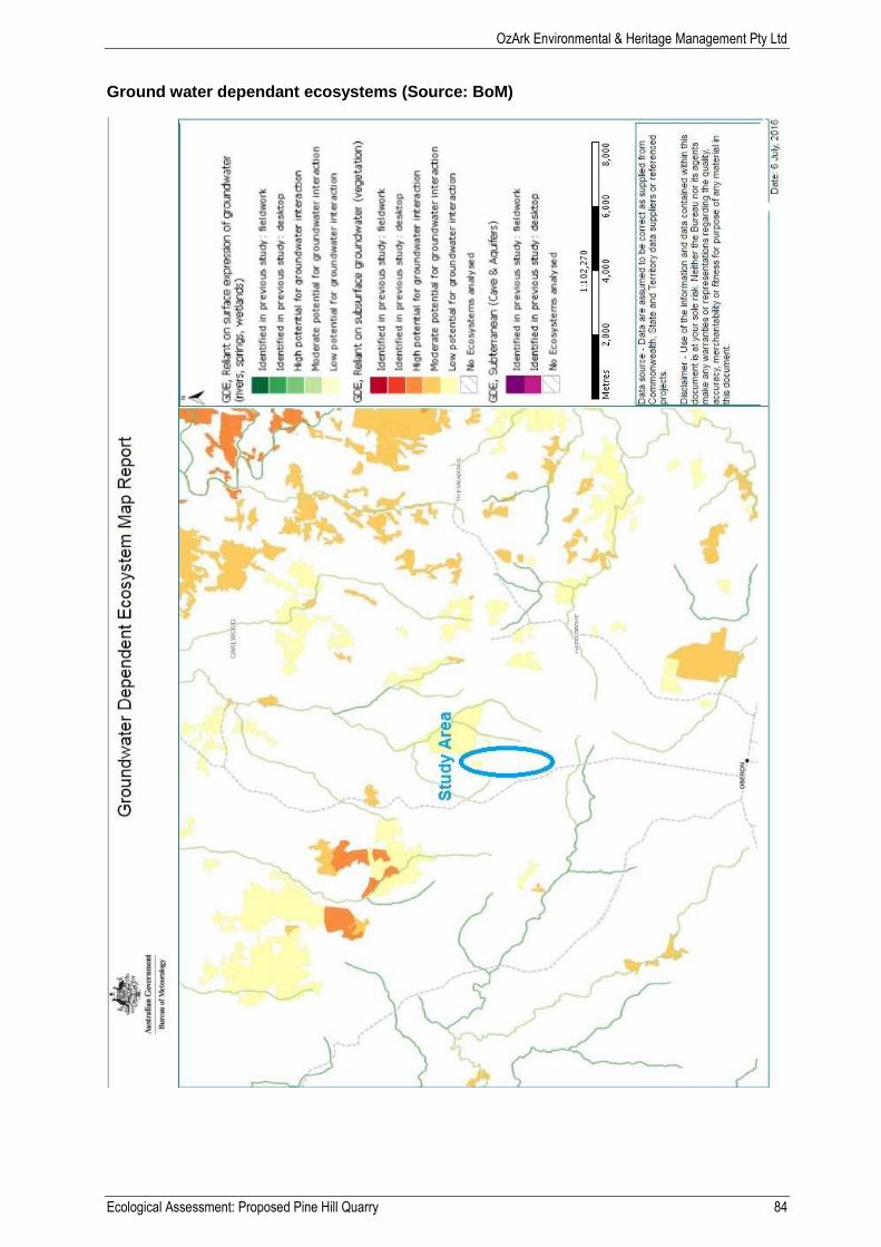
OzArk Environmental & Heritage Management Pty Ltd
Ecological Assessment: Proposed Pine Hill Quarry 84
Ground water dependant ecosystems (Source: BoM)
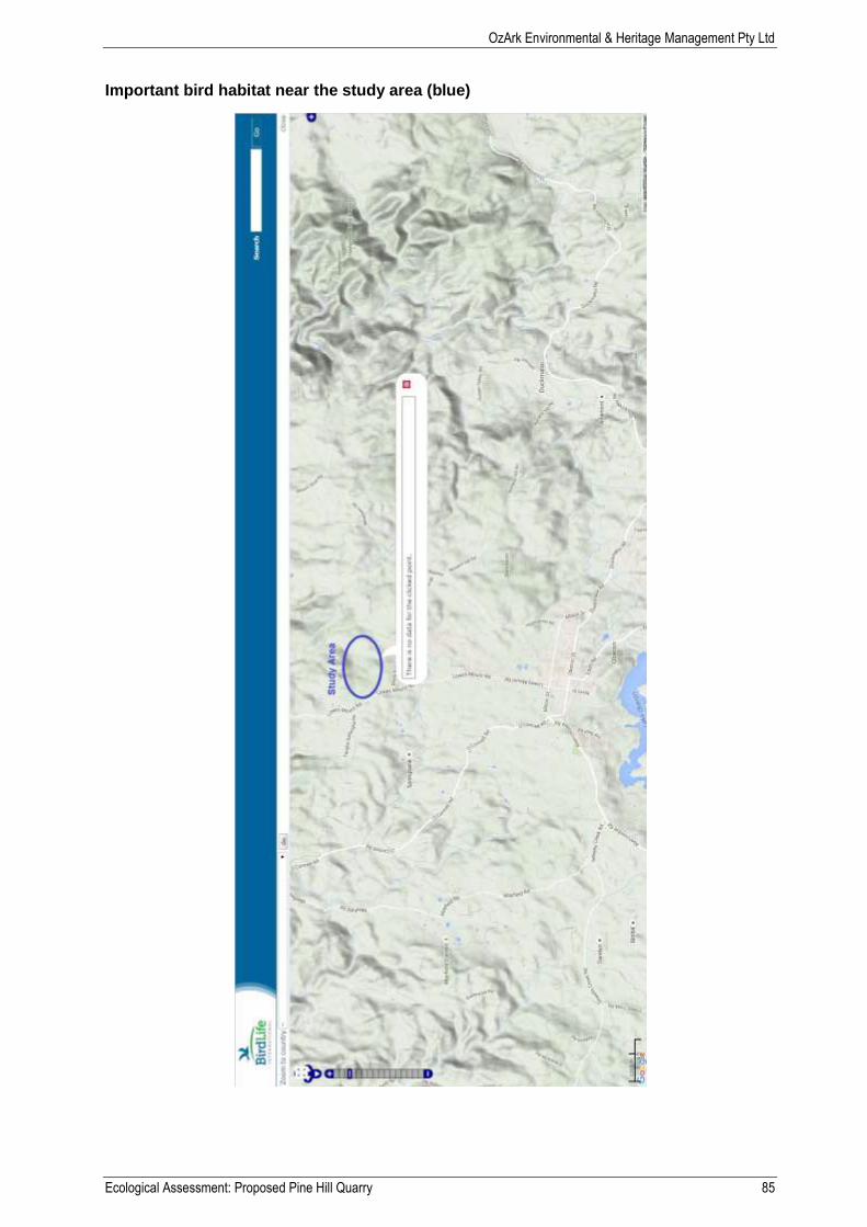
OzArk Environmental & Heritage Management Pty Ltd
Ecological Assessment: Proposed Pine Hill Quarry 85
Important bird habitat near the study area (blue)
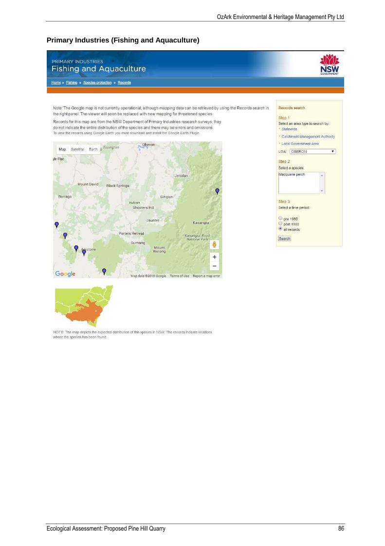
OzArk Environmental & Heritage Management Pty Ltd
Ecological Assessment: Proposed Pine Hill Quarry 86
Primary Industries (Fishing and Aquaculture)
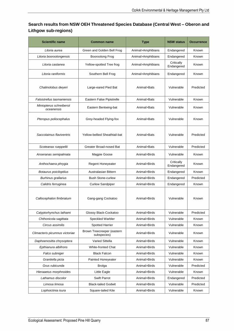
OzArk Environmental & Heritage Management Pty Ltd
Ecological Assessment: Proposed Pine Hill Quarry 87
Search results from NSW OEH Threatened Species Database (Central West – Oberon and
Lithgow sub-regions)
Scientific name Common name Type NSW status Occurrence
Litoria aurea Green and Golden Bell Frog Animal>Amphibians Endangered Known
Litoria booroolongensis Booroolong Frog Animal>Amphibians Endangered Known
Litoria castanea Yellow-spotted Tree frog Animal>Amphibians Critically
Endangered Known
Litoria raniformis Southern Bell Frog Animal>Amphibians Endangered Known
Chalinolobus dwyeri Large-eared Pied Bat Animal>Bats Vulnerable Predicted
Falsistrellus tasmaniensis Eastern False Pipistrelle Animal>Bats Vulnerable Known
Miniopterus schreibersii oceanensis
Eastern Bentwing-bat Animal>Bats Vulnerable Known
Pteropus poliocephalus Grey-headed Flying-fox Animal>Bats Vulnerable Known
Saccolaimus flaviventris Yellow-bellied Sheathtail-bat Animal>Bats Vulnerable Predicted
Scoteanax rueppellii Greater Broad-nosed Bat Animal>Bats Vulnerable Predicted
Anseranas semipalmata Magpie Goose Animal>Birds Vulnerable Known
Anthochaera phrygia Regent Honeyeater Animal>Birds Critically
Endangered Known
Botaurus poiciloptilus Australasian Bittern Animal>Birds Endangered Known
Burhinus grallarius Bush Stone-curlew Animal>Birds Endangered Predicted
Calidris ferruginea Curlew Sandpiper Animal>Birds Endangered Known
Callocephalon fimbriatum Gang-gang Cockatoo Animal>Birds Vulnerable Known
Calyptorhynchus lathami Glossy Black-Cockatoo Animal>Birds Vulnerable Predicted
Chthonicola sagittata Speckled Warbler Animal>Birds Vulnerable Known
Circus assimilis Spotted Harrier Animal>Birds Vulnerable Known
Climacteris picumnus victoriae Brown Treecreeper (eastern
subspecies) Animal>Birds Vulnerable Known
Daphoenositta chrysoptera Varied Sittella Animal>Birds Vulnerable Known
Epthianura albifrons White-fronted Chat Animal>Birds Vulnerable Known
Falco subniger Black Falcon Animal>Birds Vulnerable Known
Grantiella picta Painted Honeyeater Animal>Birds Vulnerable Known
Grus rubicunda Brolga Animal>Birds Vulnerable Predicted
Hieraaetus morphnoides Little Eagle Animal>Birds Vulnerable Known
Lathamus discolor Swift Parrot Animal>Birds Endangered Predicted
Limosa limosa Black-tailed Godwit Animal>Birds Vulnerable Predicted
Lophoictinia isura Square-tailed Kite Animal>Birds Vulnerable Known

OzArk Environmental & Heritage Management Pty Ltd
Ecological Assessment: Proposed Pine Hill Quarry 88
Scientific name Common name Type NSW status Occurrence
Melanodryas cucullata cucullata Hooded Robin (south-eastern
form) Animal>Birds Vulnerable Known
Melithreptus gularis gularis Black-chinned Honeyeater
(eastern subspecies) Animal>Birds Vulnerable Known
Ninox connivens Barking Owl Animal>Birds Vulnerable Known
Ninox strenua Powerful Owl Animal>Birds Vulnerable Known
Oxyura australis Blue-billed Duck Animal>Birds Vulnerable Predicted
Petroica boodang Scarlet Robin Animal>Birds Vulnerable Known
Petroica phoenicea Flame Robin Animal>Birds Vulnerable Known
Phaethon rubricauda Red-tailed Tropicbird Animal>Birds Vulnerable Known
Polytelis swainsonii Superb Parrot Animal>Birds Vulnerable Known
Pomatostomus temporalis temporalis
Grey-crowned Babbler (eastern subspecies)
Animal>Birds Vulnerable Known
Rostratula australis Australian Painted Snipe Animal>Birds Endangered Known
Stagonopleura guttata Diamond Firetail Animal>Birds Vulnerable Known
Stictonetta naevosa Freckled Duck Animal>Birds Vulnerable Predicted
Tyto novaehollandiae Masked Owl Animal>Birds Vulnerable Known
Paralucia spinifera Purple Copper Butterfly,
Bathurst Copper Butterfly Animal>Invertebrates Endangered Known
Cercartetus nanus Eastern Pygmy-possum Animal>Marsupials Vulnerable Predicted
Dasyurus maculatus Spotted-tailed Quoll Animal>Marsupials Vulnerable Known
Petaurus australis Yellow-bellied Glider Animal>Marsupials Vulnerable Predicted
Petaurus norfolcensis Squirrel Glider Animal>Marsupials Vulnerable Predicted
Petrogale penicillata Brush-tailed Rock-wallaby Animal>Marsupials Endangered Known
Phascogale tapoatafa Brush-tailed Phascogale Animal>Marsupials Vulnerable Predicted
Phascolarctos cinereus Koala Animal>Marsupials Vulnerable Known
Aprasia parapulchella Pink-tailed Legless Lizard Animal>Reptiles Vulnerable Predicted
Suta flagellum Little Whip Snake Animal>Reptiles Vulnerable Known
Varanus rosenbergi Rosenberg's Goanna Animal>Reptiles Vulnerable Predicted
Tableland Basalt Forest in the Sydney Basin and South
Eastern Highlands Bioregions
Tableland Basalt Forest in the Sydney Basin and South
Eastern Highlands Bioregions
Community> Threatened Ecological Communities
Endangered Ecological Community
Known
Tablelands Snow Gum, Black Sallee, Candlebark and Ribbon Gum Grassy Woodland in the
South Eastern Highlands, Sydney Basin, South East
Corner and NSW South Western Slopes Bioregions
Tablelands Snow Gum, Black Sallee, Candlebark and
Ribbon Gum Grassy Woodland in the South
Eastern Highlands, Sydney Basin, South East Corner and NSW South Western Slopes
Bioregions
Community> Threatened Ecological Communities
Endangered Ecological Community
Predicted
White Box Yellow Box Blakely's Red Gum Woodland
White Box Yellow Box Blakely's Red Gum Woodland
Community> Threatened Ecological Communities
Endangered Ecological Community
Known
Calotis glandulosa Mauve Burr-daisy Plant>Herbs and Forbs Vulnerable Known
Euphrasia scabra Rough Eyebright Plant>Herbs and Forbs Endangered Known
Lepidium hyssopifolium Aromatic Peppercress Plant>Herbs and Forbs Endangered Known
Swainsona sericea Silky Swainson-pea Plant>Herbs and Forbs Vulnerable Known
Trachymene scapigera Mountain Trachymene Plant>Herbs and Forbs Endangered Predicted
Eucalyptus pulverulenta Silver-leafed Gum Plant>Mallees Vulnerable Known
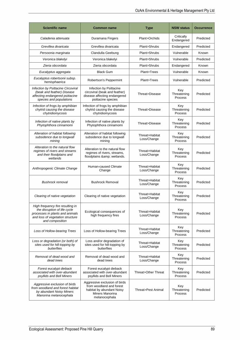
OzArk Environmental & Heritage Management Pty Ltd
Ecological Assessment: Proposed Pine Hill Quarry 89
Scientific name Common name Type NSW status Occurrence
Caladenia attenuata Duramana Fingers Plant>Orchids Critically
Endangered Predicted
Grevillea divaricata Grevillea divaricata Plant>Shrubs Endangered Predicted
Persoonia marginata Clandulla Geebung Plant>Shrubs Vulnerable Known
Veronica blakelyi Veronica blakelyi Plant>Shrubs Vulnerable Predicted
Zieria obcordata Zieria obcordata Plant>Shrubs Endangered Known
Eucalyptus aggregata Black Gum Plant>Trees Vulnerable Known
Eucalyptus robertsonii subsp. hemisphaerica
Robertson's Peppermint Plant>Trees Vulnerable Predicted
Infection by Psittacine Circoviral (beak and feather) Disease
affecting endangered psittacine species and populations
Infection by Psittacine circoviral (beak and feather)
disease affecting endangered psittacine species
Threat>Disease Key
Threatening Process
Predicted
Infection of frogs by amphibian chytrid causing the disease
chytridiomycosis
Infection of frogs by amphibian chytrid causing the disease
chytridiomycosis Threat>Disease
Key Threatening
Process Predicted
Infection of native plants by Phytophthora cinnamomi
Infection of native plants by Phytophthora cinnamomi
Threat>Disease Key
Threatening Process
Predicted
Alteration of habitat following subsidence due to longwall
mining
Alteration of habitat following subsidence due to longwall
mining
Threat>Habitat Loss/Change
Key Threatening
Process Predicted
Alteration to the natural flow regimes of rivers and streams
and their floodplains and wetlands
Alteration to the natural flow regimes of rivers, streams,
floodplains & wetlands.
Threat>Habitat Loss/Change
Key Threatening
Process Predicted
Anthropogenic Climate Change Human-caused Climate
Change Threat>Habitat Loss/Change
Key Threatening
Process Predicted
Bushrock removal Bushrock Removal Threat>Habitat Loss/Change
Key Threatening
Process Predicted
Clearing of native vegetation Clearing of native vegetation Threat>Habitat Loss/Change
Key Threatening
Process Predicted
High frequency fire resulting in the disruption of life cycle
processes in plants and animals and loss of vegetation structure
and composition
Ecological consequences of high frequency fires
Threat>Habitat Loss/Change
Key Threatening
Process Predicted
Loss of Hollow-bearing Trees Loss of Hollow-bearing Trees Threat>Habitat Loss/Change
Key Threatening
Process Predicted
Loss or degradation (or both) of sites used for hill-topping by
butterflies
Loss and/or degradation of sites used for hill-topping by
butterflies
Threat>Habitat Loss/Change
Key Threatening
Process Predicted
Removal of dead wood and dead trees
Removal of dead wood and dead trees
Threat>Habitat Loss/Change
Key Threatening
Process Predicted
Forest eucalypt dieback associated with over-abundant
psyllids and Bell Miners
Forest eucalypt dieback associated with over-abundant
psyllids and Bell Miners Threat>Other Threat
Key Threatening
Process Predicted
Aggressive exclusion of birds from woodland and forest habitat
by abundant Noisy Miners Manorina melanocephala
Aggressive exclusion of birds from woodland and forest habitat by abundant Noisy
Miners Manorina melanocephala
Threat>Pest Animal Key
Threatening Process
Predicted
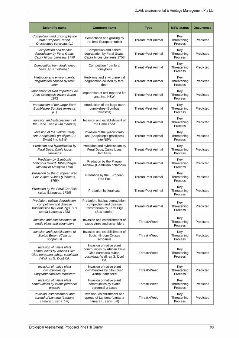
OzArk Environmental & Heritage Management Pty Ltd
Ecological Assessment: Proposed Pine Hill Quarry 90
Scientific name Common name Type NSW status Occurrence
Competition and grazing by the feral European Rabbit,
Oryctolagus cuniculus (L.)
Competition and grazing by the feral European rabbit
Threat>Pest Animal Key
Threatening Process
Predicted
Competition and habitat degradation by Feral Goats, Capra hircus Linnaeus 1758
Competition and habitat degradation by Feral Goats, Capra hircus Linnaeus 1758
Threat>Pest Animal Key
Threatening Process
Predicted
Competition from feral honey bees, Apis mellifera L.
Competition from feral honeybees
Threat>Pest Animal Key
Threatening Process
Predicted
Herbivory and environmental degradation caused by feral
deer
Herbivory and environmental degradation caused by feral
deer Threat>Pest Animal
Key Threatening
Process Predicted
Importation of Red Imported Fire Ants Solenopsis invicta Buren
1972
Importation of red imported fire ants into NSW
Threat>Pest Animal Key
Threatening Process
Predicted
Introduction of the Large Earth Bumblebee Bombus terrestris
(L.)
Introduction of the large earth bumblebee (Bombus
terrestris) Threat>Pest Animal
Key Threatening
Process Predicted
Invasion and establishment of the Cane Toad (Bufo marinus)
Invasion and establishment of the Cane Toad
Threat>Pest Animal Key
Threatening Process
Predicted
Invasion of the Yellow Crazy Ant, Anoplolepis gracilipes (Fr.
Smith) into NSW
Invasion of the yellow crazy ant (Anoplolepis gracilipes)
into NSW Threat>Pest Animal
Key Threatening
Process Predicted
Predation and hybridisation by Feral Dogs, Canis lupus
familiaris
Predation and hybridisation by Feral Dogs, Canis lupus
familiaris Threat>Pest Animal
Key Threatening
Process Predicted
Predation by Gambusia holbrooki Girard, 1859 (Plague
Minnow or Mosquito Fish)
Predation by the Plague Minnow (Gambusia holbrooki)
Threat>Pest Animal Key
Threatening Process
Predicted
Predation by the European Red Fox Vulpes Vulpes (Linnaeus,
1758)
Predation by the European Red Fox
Threat>Pest Animal Key
Threatening Process
Predicted
Predation by the Feral Cat Felis catus (Linnaeus, 1758)
Predation by feral cats Threat>Pest Animal Key
Threatening Process
Predicted
Predation, habitat degradation, competition and disease
transmission by Feral Pigs, Sus scrofa Linnaeus 1758
Predation, habitat degradation, competition and disease
transmission by Feral Pigs (Sus scrofa )
Threat>Pest Animal Key
Threatening Process
Predicted
Invasion and establishment of exotic vines and scramblers
Invasion and establishment of exotic vines and scramblers
Threat>Weed Key
Threatening Process
Predicted
Invasion and establishment of Scotch Broom (Cytisus
scoparius)
Invasion and establishment of Scotch Broom Cytisus
scoparius Threat>Weed
Key Threatening
Process Predicted
Invasion of native plant communities by African Olive
Olea europaea subsp. cuspidata (Wall. ex G. Don) Cif.
Invasion of native plant communities by African Olive
Olea europaea subsp. cuspidata (Wall. ex G. Don)
Cif.
Threat>Weed Key
Threatening Process
Predicted
Invasion of native plant communities by
Chrysanthemoides monilifera
Invasion of native plant communities by bitou bush
& boneseed Threat>Weed
Key Threatening
Process Predicted
Invasion of native plant communities by exotic perennial
grasses
Invasion of native plant communities by exotic
perennial grasses Threat>Weed
Key Threatening
Process Predicted
Invasion, establishment and spread of Lantana (Lantana
camara L. sens. Lat)
Invasion, establishment and spread of Lantana (Lantana
camara L. sens. Lat) Threat>Weed
Key Threatening
Process Predicted
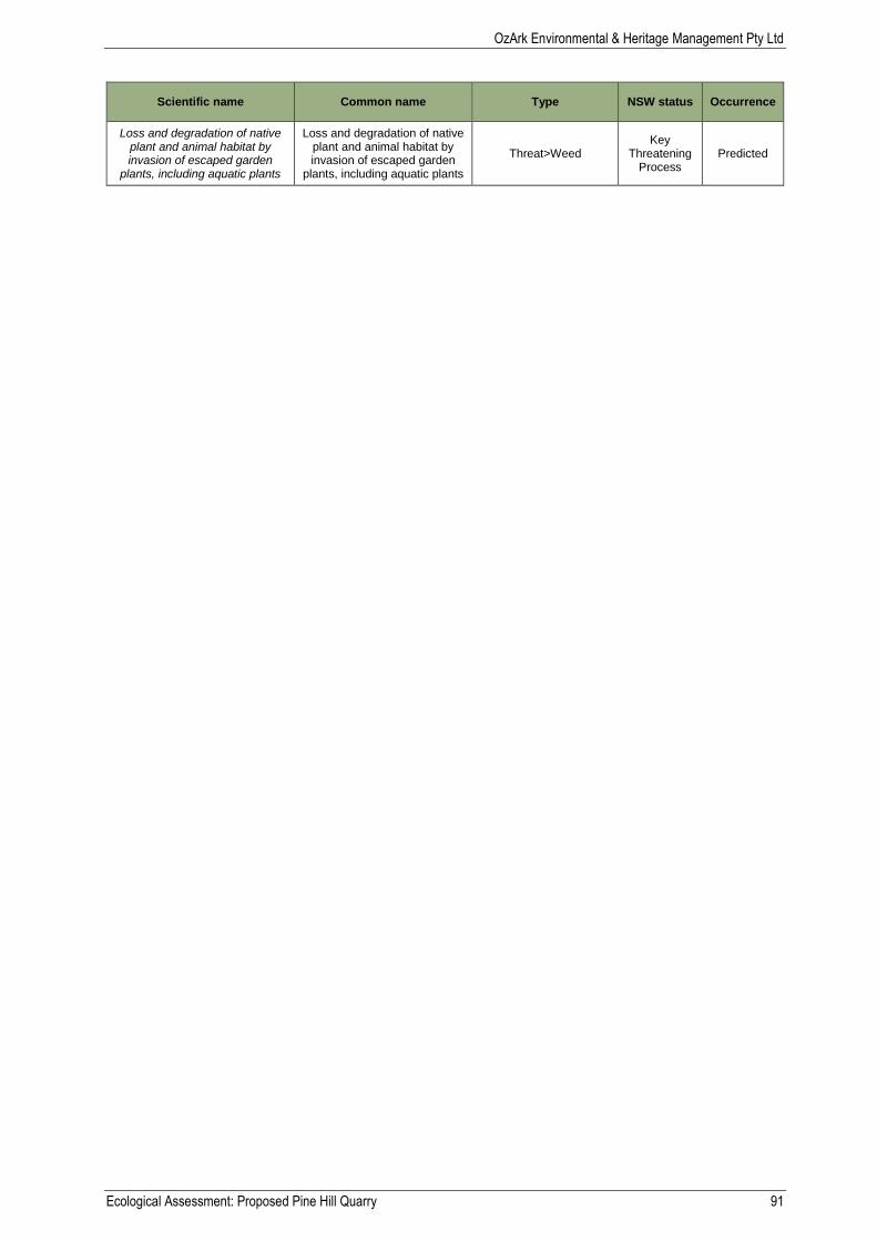
OzArk Environmental & Heritage Management Pty Ltd
Ecological Assessment: Proposed Pine Hill Quarry 91
Scientific name Common name Type NSW status Occurrence
Loss and degradation of native plant and animal habitat by invasion of escaped garden
plants, including aquatic plants
Loss and degradation of native plant and animal habitat by invasion of escaped garden
plants, including aquatic plants
Threat>Weed Key
Threatening Process
Predicted
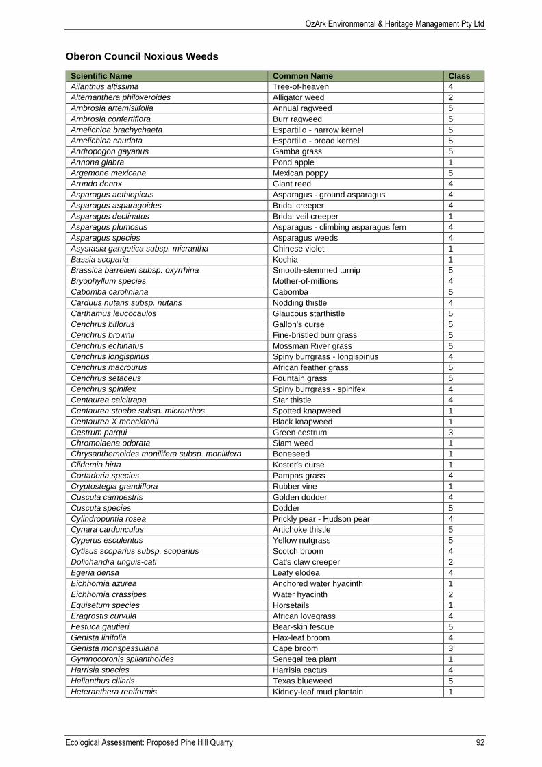
OzArk Environmental & Heritage Management Pty Ltd
Ecological Assessment: Proposed Pine Hill Quarry 92
Oberon Council Noxious Weeds
Scientific Name Common Name Class
Ailanthus altissima Tree-of-heaven 4
Alternanthera philoxeroides Alligator weed 2
Ambrosia artemisiifolia Annual ragweed 5
Ambrosia confertiflora Burr ragweed 5
Amelichloa brachychaeta Espartillo - narrow kernel 5
Amelichloa caudata Espartillo - broad kernel 5
Andropogon gayanus Gamba grass 5
Annona glabra Pond apple 1
Argemone mexicana Mexican poppy 5
Arundo donax Giant reed 4
Asparagus aethiopicus Asparagus - ground asparagus 4
Asparagus asparagoides Bridal creeper 4
Asparagus declinatus Bridal veil creeper 1
Asparagus plumosus Asparagus - climbing asparagus fern 4
Asparagus species Asparagus weeds 4
Asystasia gangetica subsp. micrantha Chinese violet 1
Bassia scoparia Kochia 1
Brassica barrelieri subsp. oxyrrhina Smooth-stemmed turnip 5
Bryophyllum species Mother-of-millions 4
Cabomba caroliniana Cabomba 5
Carduus nutans subsp. nutans Nodding thistle 4
Carthamus leucocaulos Glaucous starthistle 5
Cenchrus biflorus Gallon's curse 5
Cenchrus brownii Fine-bristled burr grass 5
Cenchrus echinatus Mossman River grass 5
Cenchrus longispinus Spiny burrgrass - longispinus 4
Cenchrus macrourus African feather grass 5
Cenchrus setaceus Fountain grass 5
Cenchrus spinifex Spiny burrgrass - spinifex 4
Centaurea calcitrapa Star thistle 4
Centaurea stoebe subsp. micranthos Spotted knapweed 1
Centaurea X moncktonii Black knapweed 1
Cestrum parqui Green cestrum 3
Chromolaena odorata Siam weed 1
Chrysanthemoides monilifera subsp. monilifera Boneseed 1
Clidemia hirta Koster's curse 1
Cortaderia species Pampas grass 4
Cryptostegia grandiflora Rubber vine 1
Cuscuta campestris Golden dodder 4
Cuscuta species Dodder 5
Cylindropuntia rosea Prickly pear - Hudson pear 4
Cynara cardunculus Artichoke thistle 5
Cyperus esculentus Yellow nutgrass 5
Cytisus scoparius subsp. scoparius Scotch broom 4
Dolichandra unguis-cati Cat's claw creeper 2
Egeria densa Leafy elodea 4
Eichhornia azurea Anchored water hyacinth 1
Eichhornia crassipes Water hyacinth 2
Equisetum species Horsetails 1
Eragrostis curvula African lovegrass 4
Festuca gautieri Bear-skin fescue 5
Genista linifolia Flax-leaf broom 4
Genista monspessulana Cape broom 3
Gymnocoronis spilanthoides Senegal tea plant 1
Harrisia species Harrisia cactus 4
Helianthus ciliaris Texas blueweed 5
Heteranthera reniformis Kidney-leaf mud plantain 1
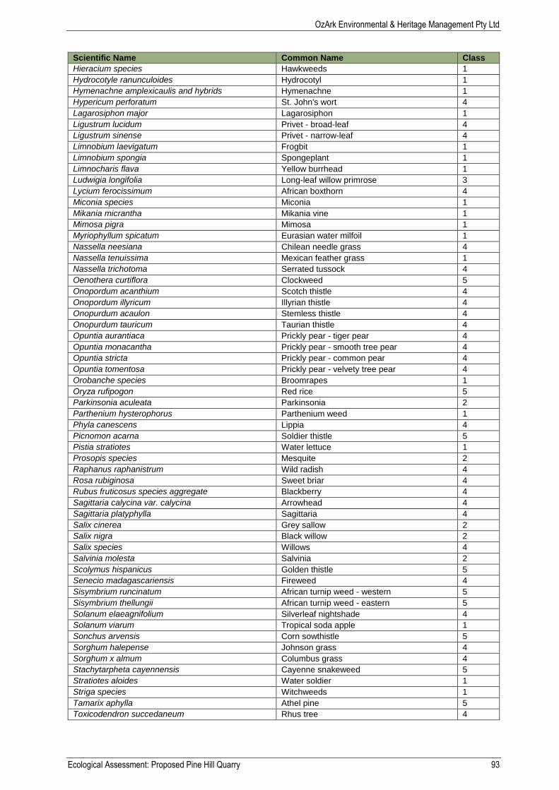
OzArk Environmental & Heritage Management Pty Ltd
Ecological Assessment: Proposed Pine Hill Quarry 93
Scientific Name Common Name Class
Hieracium species Hawkweeds 1
Hydrocotyle ranunculoides Hydrocotyl 1
Hymenachne amplexicaulis and hybrids Hymenachne 1
Hypericum perforatum St. John's wort 4
Lagarosiphon major Lagarosiphon 1
Ligustrum lucidum Privet - broad-leaf 4
Ligustrum sinense Privet - narrow-leaf 4
Limnobium laevigatum Frogbit 1
Limnobium spongia Spongeplant 1
Limnocharis flava Yellow burrhead 1
Ludwigia longifolia Long-leaf willow primrose 3
Lycium ferocissimum African boxthorn 4
Miconia species Miconia 1
Mikania micrantha Mikania vine 1
Mimosa pigra Mimosa 1
Myriophyllum spicatum Eurasian water milfoil 1
Nassella neesiana Chilean needle grass 4
Nassella tenuissima Mexican feather grass 1
Nassella trichotoma Serrated tussock 4
Oenothera curtiflora Clockweed 5
Onopordum acanthium Scotch thistle 4
Onopordum illyricum Illyrian thistle 4
Onopurdum acaulon Stemless thistle 4
Onopurdum tauricum Taurian thistle 4
Opuntia aurantiaca Prickly pear - tiger pear 4
Opuntia monacantha Prickly pear - smooth tree pear 4
Opuntia stricta Prickly pear - common pear 4
Opuntia tomentosa Prickly pear - velvety tree pear 4
Orobanche species Broomrapes 1
Oryza rufipogon Red rice 5
Parkinsonia aculeata Parkinsonia 2
Parthenium hysterophorus Parthenium weed 1
Phyla canescens Lippia 4
Picnomon acarna Soldier thistle 5
Pistia stratiotes Water lettuce 1
Prosopis species Mesquite 2
Raphanus raphanistrum Wild radish 4
Rosa rubiginosa Sweet briar 4
Rubus fruticosus species aggregate Blackberry 4
Sagittaria calycina var. calycina Arrowhead 4
Sagittaria platyphylla Sagittaria 4
Salix cinerea Grey sallow 2
Salix nigra Black willow 2
Salix species Willows 4
Salvinia molesta Salvinia 2
Scolymus hispanicus Golden thistle 5
Senecio madagascariensis Fireweed 4
Sisymbrium runcinatum African turnip weed - western 5
Sisymbrium thellungii African turnip weed - eastern 5
Solanum elaeagnifolium Silverleaf nightshade 4
Solanum viarum Tropical soda apple 1
Sonchus arvensis Corn sowthistle 5
Sorghum halepense Johnson grass 4
Sorghum x almum Columbus grass 4
Stachytarpheta cayennensis Cayenne snakeweed 5
Stratiotes aloides Water soldier 1
Striga species Witchweeds 1
Tamarix aphylla Athel pine 5
Toxicodendron succedaneum Rhus tree 4

OzArk Environmental & Heritage Management Pty Ltd
Ecological Assessment: Proposed Pine Hill Quarry 94
Scientific Name Common Name Class
Trapa species Water caltrop 1
Ulex europaeus Gorse 3
Vachellia karroo Karroo thorn 1
Vachellia nilotica Prickly acacia 1
Xanthium cavanillesii Burr - South American burr 4
Xanthium italicum Burr - Italian cockleburr 4
Xanthium occidentale Burr - Noogoora burr 4
Xanthium orientale Burr - Californian burr 4
Xanthium spinosum Burr - Bathurst burr 4
Class Type Management
1 State Prohibited Weed The plant must be eradicated from the land and that land must be kept free of the plant
2 Regionally Prohibited Weed
The plant must be eradicated from the land and that land must be kept free of the plant
3 Regionally Controlled Weed
he plant must be fully and continuously suppressed and destroyed and the plant must not be sold, propagated or knowingly distributed
4 Locally Controlled Weed The growth of the plant must be managed in a manner that continuously inhibits the ability of the plant to spread and the plant must not be sold, propagated or knowingly distributed
5 Restricted Plant The requirements in the Noxious Weeds Act 1993 for a notifiable weed must be complied with
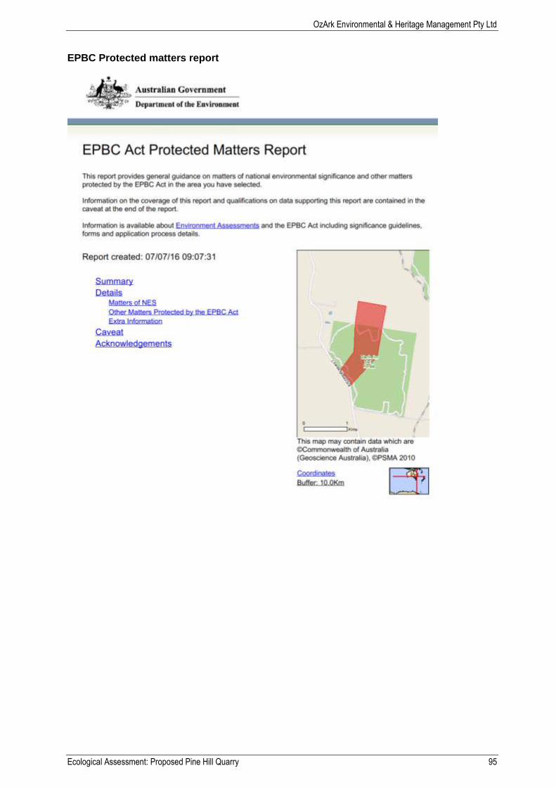
OzArk Environmental & Heritage Management Pty Ltd
Ecological Assessment: Proposed Pine Hill Quarry 95
EPBC Protected matters report
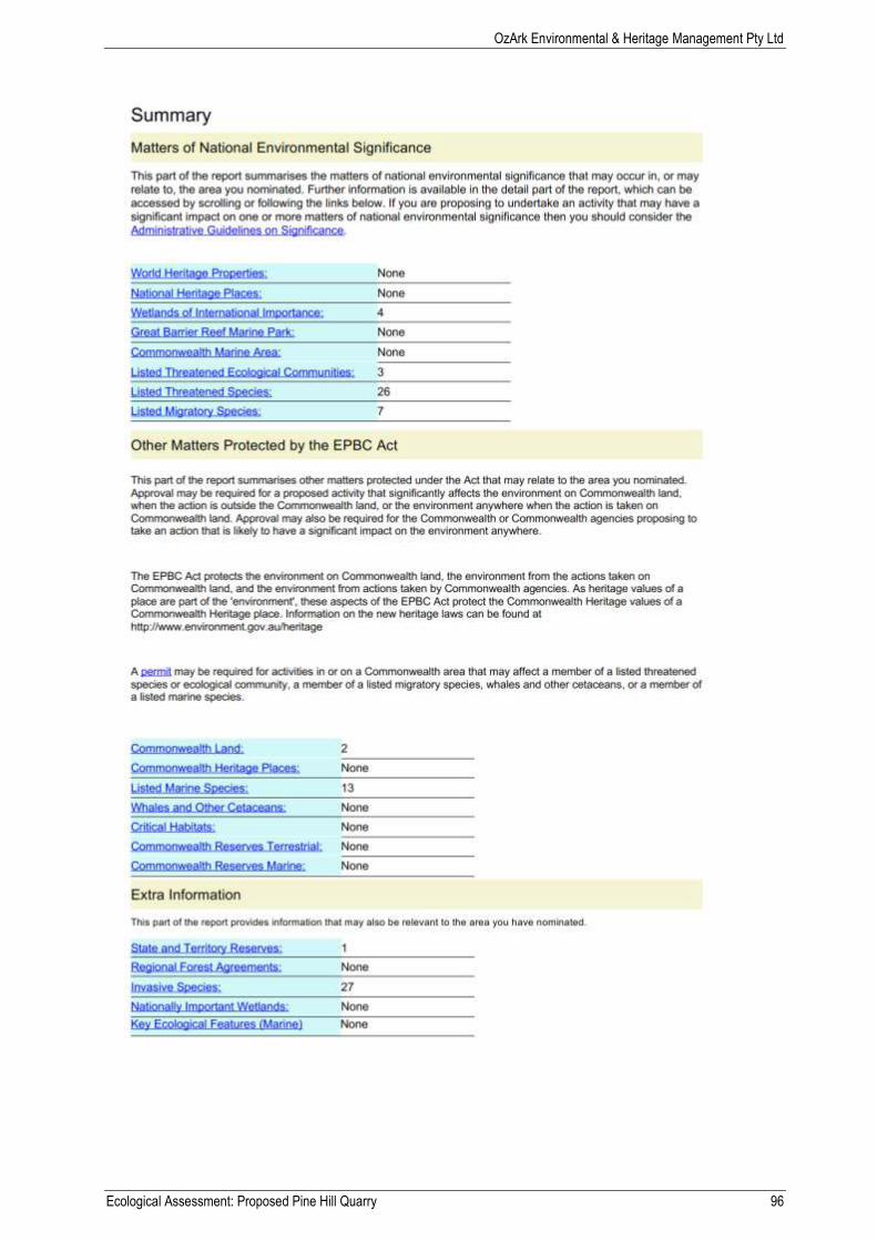
OzArk Environmental & Heritage Management Pty Ltd
Ecological Assessment: Proposed Pine Hill Quarry 96
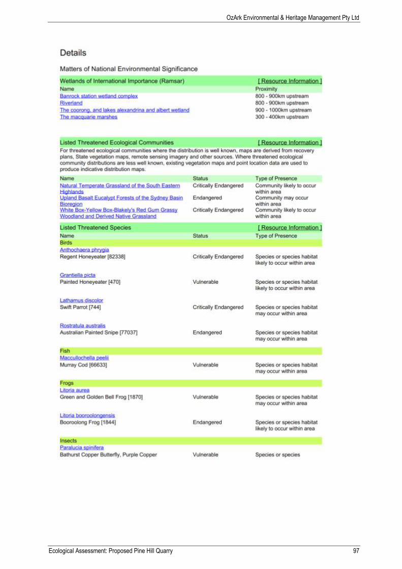
OzArk Environmental & Heritage Management Pty Ltd
Ecological Assessment: Proposed Pine Hill Quarry 97
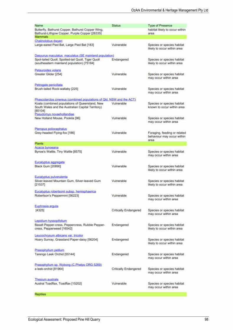
OzArk Environmental & Heritage Management Pty Ltd
Ecological Assessment: Proposed Pine Hill Quarry 98
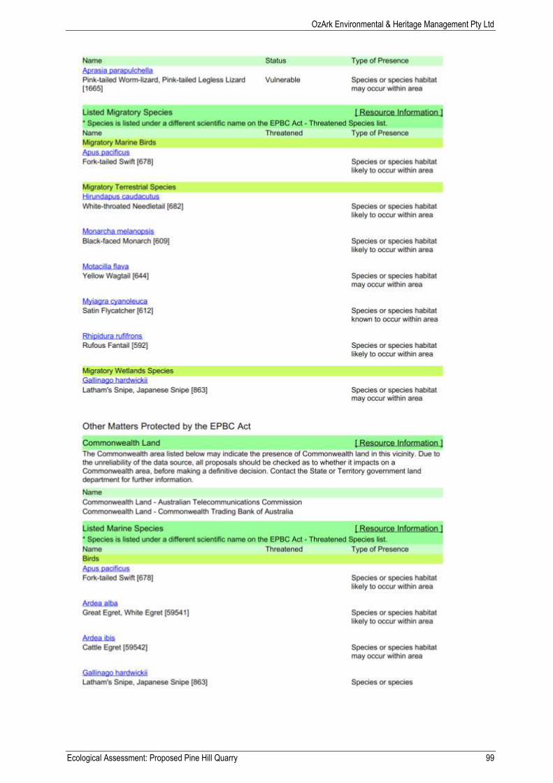
OzArk Environmental & Heritage Management Pty Ltd
Ecological Assessment: Proposed Pine Hill Quarry 99

OzArk Environmental & Heritage Management Pty Ltd
Ecological Assessment: Proposed Pine Hill Quarry 100
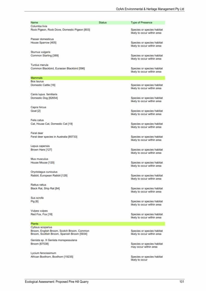
OzArk Environmental & Heritage Management Pty Ltd
Ecological Assessment: Proposed Pine Hill Quarry 101
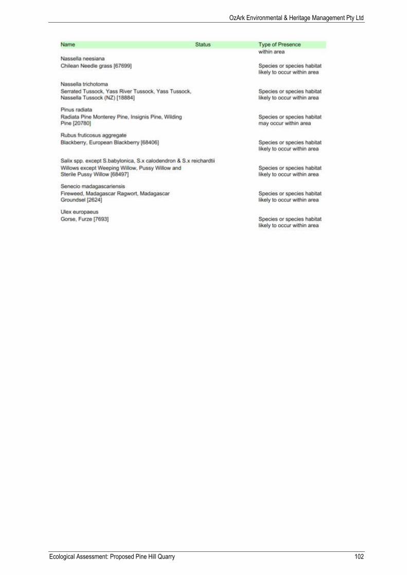
OzArk Environmental & Heritage Management Pty Ltd
Ecological Assessment: Proposed Pine Hill Quarry 102

OzArk Environmental & Heritage Management Pty Ltd
Ecological Assessment: Proposed Pine Hill Quarry 103

OzArk Environmental & Heritage Management Pty Ltd
Ecological Assessment: Proposed Pine Hill Quarry 104
OzArk Environmental & Heritage Management Pty Ltd
Ecological Assessment: Proposed Pine Hill Quarry 105
Appendix F: Terms and abbreviations
OzArk Environmental & Heritage Management Pty Ltd
Ecological Assessment: Proposed Pine Hill Quarry 106
Terms and abbreviations used in this report
Abbreviation Terminology Description
Assessment of significance
The Assessment of Significance refers to the factors that must be considered by decision makers to assess whether a proposal is likely to have a significant effect on threatened biodiversity. These mechanisms are contained in s5A of the EP&A Act and s94 of the TSC
Act.
BoM Australian Bureau of Meteorology
The Bureau of Meteorology is Australia's national weather, climate and water agency.
CAMBA China-Australia Migratory Bird Agreement
A bilateral migratory bird agreement with China entered into in 1986. It provides an important mechanism for pursuing conservation outcomes for migratory birds, including migratory waterbirds.
CMA Catchment Management Authority
Bodies established across New South Wales to ensure regional communities have a say in how natural resources are managed in their catchments. CMA’s have now been replaced with LLS’s.
Consent authority
in relation to a development application or an application for a complying development certificate, means:
The council having the function to determine the application, or
If a provision of this Act, the regulations or an environmental planning instrument specifies a Minister, the Planning Assessment Commission, a joint regional planning panel or public authority (other than a council) as having the function to determine the application-that Minister, Commission, panel or authority, as the case may be.
Critical habitat
Critical habitat is defined as an area crucial to the survival of an endangered species, population or ecological community. The declaration of critical habitat provides greater protection and stricter controls over activities in the area.
Cumulative impacts
Impacts, when considered together, lead to a stronger impact than any impact in isolation.
Direct impacts
Directly affect the habitat and individuals. They include, but are not limited to, death through predation, trampling, poisoning of the animal/plant itself and the removal of suitable habitat. When applying each factor, consideration must be given to all of the likely direct impacts of the proposed activity or development.
DoE
Australian Government Department of Environment.
The Department of the Environment designs and implements the Australian Government’s policies and programmes to protect and conserve the environment, water and heritage and promote climate action.
DP Deposited Plan A plan of land deposited in Land and Property Information (part of the Land Management Authority) and used for legal identification purposes. They most commonly depict a subdivision of a parcel of land.
EEC Endangered Ecological Community
An ecological community identified by relevant legislation likely to become extinct or is in immediate danger of extinction.
Edge effects
A change in species composition, physical conditions or other ecological factors at the boundary between two ecosystems or the ecological changes carried out at the boundaries of ecosystems (including changes in species composition, gradients of moisture, sunlight, soil and air temperature, wind speed and other factors).
Environment The environment includes all aspects of the surroundings of humans, whether affecting any human as an individual or in his or her social groupings.
EPA Environment Protection Authority
Their purpose is to improve environmental performance and waste management for NSW. The EPA works with community, business, industry and government to maintain a balance between protecting the environment, managing competing demands on the environment and supporting sustainable growth.
OzArk Environmental & Heritage Management Pty Ltd
Ecological Assessment: Proposed Pine Hill Quarry 107
Abbreviation Terminology Description
EP&A Act
Environmental Planning and Assessment Act 1979 (NSW).
Provides the legislative framework for land use planning and development assessment in NSW.
EPBC Act
Environment Protection and Biodiversity Conservation Act 1999 (Commonwealth).
Provides for the protection of the environment, especially matters of national environmental significance, and provides a national assessment and approvals process.
EPI Environmental Planning Instrument
Environmental planning instruments are fundamental documents governing development of land in NSW. They are made under Part 3 of the EP&A Act for the purposes of achieving any of the objects under that Act.
ESD Ecologically sustainable development.
Development which uses, conserves and enhances the resources of the community so ecological processes on which life depends, are maintained and the total quality of life, now and in the future, can be increased.
FM Act
Fisheries Management Act 1994 (NSW)
The objects of this Act are to conserve, develop and share the fishery resources of the State for the benefit of present and future generations. This Act protects aquatic habitats and species which are not protected under the TSC Act.
GDA Geocentric Datum of Australia
The Geocentric Datum of Australia (GDA) is the latest Australian coordinate system, replacing the Australian Geodetic Datum (AGD). The GDA is a part of a global coordinate reference frame and is directly compatible with the Global Navigation Satellite Systems.
GDE Groundwater Dependent Ecosystems
Six types of groundwater dependent ecosystems are conventionally recognised in Australia:
Terrestrial vegetation relies the availability of shallow groundwater.
Wetlands such as paperbark swamp forests and mound springs ecosystems.
River base flow systems where a groundwater discharge provides a base flow component to the river's discharge.
Aquifer and cave ecosystems where life exists independent of sunlight
Terrestrial fauna, both native and introduced, dependant on groundwater as a source of drinking water.
Estuarine and near shore marine systems, such as some coastal mangroves, salt marshes and sea grass beds, which rely on the submarine discharge of groundwater.
GIS Geographic Information System
A geographic information system (GIS) is a system designed to capture, store, manipulate, analyse, manage, and present all types of spatial or geographical data.
GPS Global Positioning System
A hand held device capable of applying location coordinates to digital objects such as photographs and GIS data such as lines or points.
Habitat
The area occupied, or periodically or occasionally occupied, by any threatened species, population or ecological community and includes all the different aspects (both biotic and abiotic) used by species during the different stages of their life cycles.
IBRA
Interim Biogeographic Regionalisation of Australia
The Interim Biogeographic Regionalisation for Australia (IBRA) is a biogeographic regionalisation of Australia developed by the Australian Government's Department of the Environment. Each region is a land area made up of a group of interacting ecosystems repeated in similar form across the landscape.
Indirect impacts
Occur when project-related activities affect species, populations or ecological communities in a manner other than direct loss. Indirect impacts can include loss of individuals through starvation, exposure, predation by domestic and/or feral animals, loss of breeding opportunities, loss of shade/shelter, deleterious hydrological changes, increased soil salinity, erosion, inhibition of nitrogen fixation, weed invasion, fertiliser
OzArk Environmental & Heritage Management Pty Ltd
Ecological Assessment: Proposed Pine Hill Quarry 108
Abbreviation Terminology Description
drift, or increased human activity within or directly adjacent to sensitive habitat areas. As with direct impacts, consideration must be given, when applying each factor, to all of the likely indirect impacts of the proposed activity or development.
JAMBA Japan-Australia Migratory Bird Agreement
A bilateral migratory bird agreement with Japan entered into in 1974. It provides an important mechanism for pursuing conservation outcomes for migratory birds, including migratory waterbirds.
KTP Key Threatening Process
A key threatening process is defined as a process that threatens, or may have the capability to threaten, the survival or evolutionary development of species, populations or ecological communities. A requirement of their listing on the TSC Act is that the process adversely affects two or more threatened species, populations or ecological communities, or may cause species, populations or ecological communities not threatened to become threatened.
LEP Local Environmental Plan
A type of planning instrument made under Part 3 of the EP&A Act.
Life cycle The series or stages of reproduction, growth, development, ageing and death of an organism.
LG Act Local Government Act 1993
The purposes of this Act are as follows:
to provide the legal framework for an effective, efficient, environmentally responsible and open system of local government in New South Wales,
to regulate the relationships between the people and bodies comprising the system of local government in New South Wales,
to encourage and assist the effective participation of local communities in the affairs of local government,
to give councils:
the ability to provide goods, services and facilities, and to carry out activities, appropriate to the current and future needs of local communities and of the wider public
the responsibility for administering some regulatory systems under this Act
a role in the management, improvement and development of the resources of their areas,
to require councils, councillors and council employees to have regard to the principles of ecologically sustainable development in carrying out their responsibilities.
LGA Local Government Area
The relevant LGA is Governed by Council who are the determining authority for this development application.
LLS Local Land Services
Launched in January 2014. Each LLS delivers services to farmers, landholders and the community across rural and regional New South Wales. LLS bring together agricultural production advice, biosecurity, natural resource management and emergency management into a single organisation.
Local population
The population occurs in the study area. The assessment of the local population may be extended to include individuals beyond the study area if it can be clearly demonstrated contiguous or interconnecting parts of the population continue beyond the study area.
The local population of a threatened plant species comprises those individuals occurring in the study area or the cluster of individuals extend into habitat adjoining and contiguous with the study area could reasonably be expected to be cross-pollinating with those in the study area.
The local population of resident fauna species comprises those individuals known or likely to occur in the study area, as well as any individuals occurring in adjoining areas (contiguous or otherwise) are known or likely to utilise habitats in the study area.
The local population of migratory or nomadic fauna species comprises those individuals likely to occur in the study area from time to time.
OzArk Environmental & Heritage Management Pty Ltd
Ecological Assessment: Proposed Pine Hill Quarry 109
Abbreviation Terminology Description
Local population (EEC)
The ecological community present within the study area. However, the local occurrence may include adjacent areas if the ecological community on the study area forms part of a larger contiguous area of the ecological community and the movement of individuals and exchange of genetic material across the boundary of the study area can be clearly demonstrated.
Locality The area within a 50 kilometre radius of the subject site.
MNES Matters of national environmental significance.
Refers to the seven matters of national environmental significance outlined under the EPBC Act.
NOW NSW Office of Water
The NSW Office of Water in the Department of Primary Industries is responsible for the management of the state's surface water and groundwater resources. The Department of Primary Industries is a division within NSW Trade and Investment.
The Office of Water reports to the NSW Government for water policy and the administration of key water management legislation, including the Water Management Act 2000 and Water Act 1912.
Noxious Weeds Act
Noxious Weeds Act 1993 (NSW)
The objects of this Act are as follows:
to reduce the negative impact of weeds on the economy, community and environment of this State by establishing control mechanisms to:
prevent the establishment in this state of significant new weeds, and
prevent, eliminate or restrict the spread in this state of particular significant weeds, and
effectively manage widespread significant weeds in this state,
to provide for the monitoring of and reporting on the effectiveness of the management of weeds in this state.
NPW Act National Parks and Wildlife Act 1974 (NSW)
The objects of this Act are as follows:
The conservation of nature, including, but not limited to, the conservation of:
habitat, ecosystems and ecosystem processes, and
biological diversity at the community, species and genetic levels, and
landforms of significance, including geological features and processes, and
landscapes and natural features of significance including wilderness and wild rivers,
The conservation of objects, places or features (including biological diversity) of cultural value within the landscape, including, but not limited to:
places, objects and features of significance to Aboriginal people, and
places of social value to the people of New South Wales, and
places of historic, architectural or scientific significance,
Fostering public appreciation, understanding and enjoyment of nature and cultural heritage and their conservation,
Providing for the management of land reserved under this Act in accordance with the management principles applicable for each type of reservation.
The objects of this Act are to be achieved by applying the principles of ecologically sustainable development.
NV Act Native Vegetation Act 2003
The objects of this Act are:
to provide for, encourage and promote the management of native vegetation on a regional basis in the social, economic and environmental interests of the State, and
to prevent broad scale clearing unless it improves or maintains environmental outcomes, and

OzArk Environmental & Heritage Management Pty Ltd
Ecological Assessment: Proposed Pine Hill Quarry 110
Abbreviation Terminology Description
to protect native vegetation of high conservation value having regard to its contribution to such matters as water quality, biodiversity, or the prevention of salinity or land degradation, and
to improve the condition of existing native vegetation, particularly where it has high conservation value, and
to encourage the revegetation of land, and the rehabilitation of land, with appropriate native vegetation,
In accordance with the principles of ecologically sustainable development.
OEH Office of Environment and Heritage
The Office of Environment and Heritage (OEH) is a separate agency within the Planning and Environment cluster. OEH was formed on 4 April 2011 and works to protect and conserve the NSW environment, including the natural environment, Aboriginal country, culture and heritage and our built heritage, and manages NSW national parks and reserves.
PoEO Act
Protection of the Environment Operations Act 1997
The objects of this Act are as follows:
to protect, restore and enhance the quality of the environment in New South Wales, having regard to the need to maintain ecologically sustainable development,
to provide increased opportunities for public involvement and participation in environment protection,
to ensure the community has access to relevant and meaningful information about pollution,
to reduce risks to human health and prevent the degradation of the environment by the use of mechanisms promoting:
pollution prevention and cleaner production,
the reduction to harmless levels of the discharge of substances likely to cause harm to the environment,
the elimination of harmful wastes,
the reduction in the use of materials and the re-use, recovery or recycling of materials,
the making of progressive environmental improvements, including the reduction of pollution at source,
the monitoring and reporting of environmental quality on a regular basis,
to rationalise, simplify and strengthen the regulatory framework for environment protection,
to improve the efficiency of administration of the environment protection legislation,
to assist in the achievement of the objectives of the Waste Avoidance and Resource Recovery Act 2001.
RAMSAR
Convention on Wetlands of International Importance
The Ramsar Convention's broad aims are to halt the worldwide loss of wetlands and to conserve, through wise use and management, those remaining. This requires international cooperation, policy making, capacity building and technology transfer.
Risk of extinction The likelihood that the local population will become extinct either in the short-term or in the long-term as a result of direct or indirect impacts on the viability of that population.
ROKAMBA Republic of Korea-Australia Migratory Bird Agreement
A bilateral migratory bird agreement with the Republic of Korea entered into in 2007. It provides an important mechanism for pursuing conservation outcomes for migratory birds, including migratory waterbirds.
RF Act Rural Fires Act 1997
The objects of this Act are to provide:
for the prevention, mitigation and suppression of bush and other fires in local government areas (or parts of areas) and other parts of the State constituted as rural fire districts, and
for the co-ordination of bush firefighting and bush fire prevention throughout the State, and
for the protection of persons from injury or death, and property from damage, arising from fires, and
for the protection of infrastructure and environmental, economic, cultural, agricultural and community assets from damage arising from fires, and
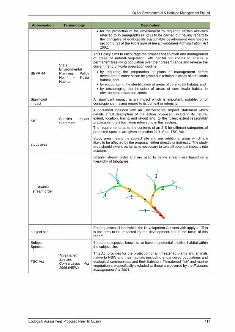
OzArk Environmental & Heritage Management Pty Ltd
Ecological Assessment: Proposed Pine Hill Quarry 111
Abbreviation Terminology Description
for the protection of the environment by requiring certain activities referred to in paragraphs (a)-(c1) to be carried out having regard to the principles of ecologically sustainable development described in section 6 (2) of the Protection of the Environment Administration Act 1991.
SEPP 44
State Environmental Planning Policy No.44 – Koala Habitat
This Policy aims to encourage the proper conservation and management of areas of natural vegetation with habitat for koalas to ensure a permanent free-living population over their present range and reverse the current trend of koala population decline:
by requiring the preparation of plans of management before development consent can be granted in relation to areas of core koala habitat, and
by encouraging the identification of areas of core koala habitat, and
by encouraging the inclusion of areas of core koala habitat in environment protection zones.
Significant impact
A ‘significant impact’ is an impact which is important, notable, or of consequence, having regard to its context or intensity.
SIS Species Impact Statement
A document included with an Environmental Impact Statement which details a full description of the action proposed, including its nature, extent, location, timing and layout and, to the fullest extent reasonably practicable, the information referred to in this section.
The requirements as to the contents of an SIS for different categories of protected species are given in section 110 of the TSC Act.
study area
Study area means the subject site and any additional areas which are likely to be affected by the proposal, either directly or indirectly. The study area should extend as far as is necessary to take all potential impacts into account.
Strahler stream order
Strahler stream order and are used to define stream size based on a hierarchy of tributaries.
subject site Encompasses all land which the Development Consent with apply to. This is the area to be impacted by the development and is the focus of this report.
Subject Species
Threatened species known to, or have the potential to utilise habitat within the subject site.
TSC Act
Threatened Species Conservation Act 1995 (NSW)
This Act provides for the protection of all threatened plants and animals native to NSW and their habitats (including endangered populations and ecological communities, and their habitats). Threatened ‘fish’ and marine vegetation are specifically excluded as these are covered by the Fisheries Management Act 1994.