nur syazwani binti saarieprints.utm.my/id/eprint/81708/1/nursyazwanisaarimfabu...seterusnya, di...
TRANSCRIPT
PLANNING FOR INTEGRATED BUS STOP USING SPACE SYNTAX
ANALYSIS
NUR SYAZWANI BINTI SAARI
A thesis submitted in fulfilment of the
requirements for the award of the degree of
Master of Philosophy in (Urban and Regional Planning)
Faculty of Built Enviroment and Surveying
Universiti Teknologi Malaysia
MARCH 2019

DEDICATION
This thesis Is dedicated to my Ma, who taught me that the best kind of knowledge to have is that which is learned for its own sake. It is also dedicated to my Abah, who taught me that even the largest task can be accomplished if it is done one
step at a time.

ACKNOWLEDGEMENT
Subhanallah, Alhamdulillah, In the name of Allah, the Most Beneficent, the Most Merciful. All the praises and thanks be to Allah, the Lord of the 'Alamin (mankind, jinns and all that exists). The Most Beneficent, the Most Merciful. The Only Owner of the Day of Recompense (i.e. the Day of Resurrection). You (Alone) we worship, and You (Alone) we ask for help. Guide us to the Straight Way. The Way of those on whom You have bestowed Your Grace, not (the way) of those who earned Your Anger, nor of those who went astray.
In preparing this thesis, I was in contact with many people; researchers, academicians, and practitioners. My deepest gratitude goes to my main thesis supervisor Dr Sharifah Salwa Syed Mahdzar and my internal examiner, Dr Zaly Shah Muhammad Hussein as well as Dr Azhan Abdul Aziz as my external examiner for their valuable inputs, dedication, close supervise and patience in dealing with me.
To my family especially Ma, Abah and siblings that constantly giving me their fullest understanding support, love and Doa and for what it’s worth I want them to know I think about them every day. Even when I got busy and caught up with everything my frantic, 20-something life affords me, I’m always thinking about them.I am so blessed to have them here for me, whatever I choose to do. I know I don’t say this enough, but I am so very grateful for every single thing that they have done for me, and I love them so much. May Allah grant them blessing with happiness and peace of this world and hereafter.
To my clique that have my back and on the same shoe as I am, particularly Ayu thank you for your patience, support and encouragement and let work harder in the future. Special shout out to my UTM-LCARC colleagues we spent a lot of time together through thick and thin. We have the best teamwork. To my idols that helps me going through stress, I owed you my gratitude. I could not wait to go to your fan sign event as soon as I finished my dissertation.
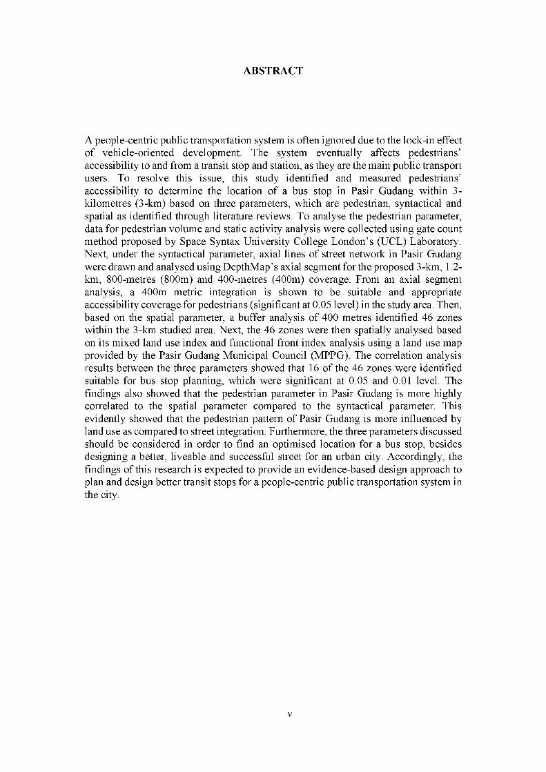
A people-centric public transportation system is often ignored due to the lock-in effect of vehicle-oriented development. The system eventually affects pedestrians’ accessibility to and from a transit stop and station, as they are the main public transport users. To resolve this issue, this study identified and measured pedestrians’ accessibility to determine the location of a bus stop in Pasir Gudang within 3- kilometres (3-km) based on three parameters, which are pedestrian, syntactical and spatial as identified through literature reviews. To analyse the pedestrian parameter, data for pedestrian volume and static activity analysis were collected using gate count method proposed by Space Syntax University College London’s (UCL) Laboratory. Next, under the syntactical parameter, axial lines of street network in Pasir Gudang were drawn and analysed using DepthMap’s axial segment for the proposed 3-km, 1.2km, 800-metres (800m) and 400-metres (400m) coverage. From an axial segment analysis, a 400m metric integration is shown to be suitable and appropriate accessibility coverage for pedestrians (significant at 0.05 level) in the study area. Then, based on the spatial parameter, a buffer analysis of 400 metres identified 46 zones within the 3-km studied area. Next, the 46 zones were then spatially analysed based on its mixed land use index and functional front index analysis using a land use map provided by the Pasir Gudang Municipal Council (MPPG). The correlation analysis results between the three parameters showed that 16 of the 46 zones were identified suitable for bus stop planning, which were significant at 0.05 and 0.01 level. The findings also showed that the pedestrian parameter in Pasir Gudang is more highly correlated to the spatial parameter compared to the syntactical parameter. This evidently showed that the pedestrian pattern of Pasir Gudang is more influenced by land use as compared to street integration. Furthermore, the three parameters discussed should be considered in order to find an optimised location for a bus stop, besides designing a better, liveable and successful street for an urban city. Accordingly, the findings of this research is expected to provide an evidence-based design approach to plan and design better transit stops for a people-centric public transportation system in the city.
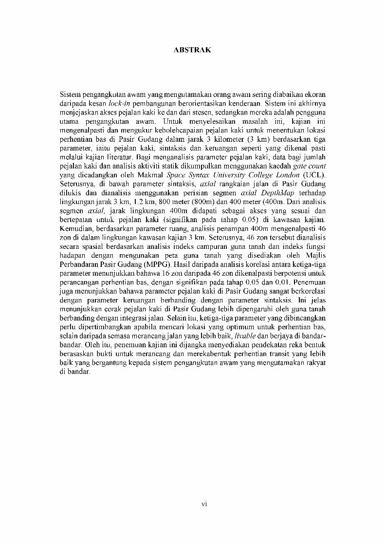
Sistem pengangkutan awam yang mengutamakan orang awam sering diabaikan ekoran daripada kesan lock-in pembangunan berorientasikan kenderaan. Sistem ini akhirnya menjejaskan akses pejalan kaki ke dan dari stesen, sedangkan mereka adalah pengguna utama pengangkutan awam. Untuk menyelesaikan masalah ini, kajian ini mengenalpasti dan mengukur kebolehcapaian pejalan kaki untuk menentukan lokasi perhentian bas di Pasir Gudang dalam jarak 3 kilometer (3 km) berdasarkan tiga parameter, iaitu pejalan kaki, sintaksis dan keruangan seperti yang dikenal pasti melalui kajian literatur. Bagi menganalisis parameter pejalan kaki, data bagi jumlah pejalan kaki dan analisis aktiviti statik dikumpulkan menggunakan kaedah gate count yang dicadangkan oleh Makmal Space Syntax University College London (UCL). Seterusnya, di bawah parameter sintaksis, axial rangkaian jalan di Pasir Gudang dilukis dan dianalisis menggunakan perisian segmen axial DepthMap terhadap lingkungan jarak 3 km, 1.2 km, 800 meter (800m) dan 400 meter (400m. Dari analisis segmen axial, jarak lingkungan 400m didapati sebagai akses yang sesuai dan bertepatan untuk pejalan kaki (signifikan pada tahap 0.05) di kawasan kajian. Kemudian, berdasarkan parameter ruang, analisis penampan 400m mengenalpasti 46 zon di dalam lingkungan kawasan kajian 3 km. Seterusnya, 46 zon tersebut dianalisis secara spasial berdasarkan analisis indeks campuran guna tanah dan indeks fungsi hadapan dengan mengunakan peta guna tanah yang disediakan oleh Majlis Perbandaran Pasir Gudang (MPPG). Hasil daripada analisis korelasi antara ketiga-tiga parameter menunjukkan bahawa 16 zon daripada 46 zon dikenalpasti berpotensi untuk perancangan perhentian bas, dengan signifikan pada tahap 0.05 dan 0.01. Penemuan juga menunjukkan bahawa parameter pejalan kaki di Pasir Gudang sangat berkorelasi dengan parameter keruangan berbanding dengan parameter sintaksis. Ini jelas menunjukkan corak pejalan kaki di Pasir Gudang lebih dipengaruhi oleh guna tanah berbanding dengan integrasi jalan. Selain itu, ketiga-tiga parameter yang dibincangkan perlu dipertimbangkan apabila mencari lokasi yang optimum untuk perhentian bas, selain daripada semasa merancang jalan yang lebih baik, livable dan berjaya di bandar- bandar. Oleh itu, penemuan kajian ini dijangka menyediakan pendekatan reka bentuk berasaskan bukti untuk merancang dan merekabentuk perhentian transit yang lebih baik yang bergantung kepada sistem pengangkutan awam yang mengutamakan rakyat di bandar.

TITLE PAGE
DECLARATION ii
DEDICATION iii
ACKNOWLEDGEMENT iv
ABSTRACT v
ABSTRAK vi
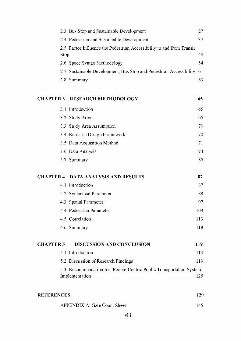
TABLE OF CONTENTS vii
LIST OF TABLES ix
LIST OF FIGURES x
LIST OF ABBREVIATION xii
LIST OF SYMBOLS xiii
LIST OF APPENDICES xiv
1 INTRODUCTION 1
1.1 Research Background and Study 1
1.2 Problem Statement 5
1.3 Research Aim 11
1.4 Research Objectives 11
1.5 Research Questions 12
1.6 Research Limitation 13
1.7 Thesis Structure 13
1.8 Research Significance 15
1.9 Expected Findings 16
CHAPTER 2 17
STRATEGY TO DEVELOPING A PEOPLE-CENTRIC PUBLIC
TRANSPORTATION SYSTEM 17
2.1 Introduction 17
2.2 Climate Change Initiative and Transportation Planning 21
2.3 Bus Stop and Sustainable Development 27
2.4 Pedestrian and Sustainable Development 37
2.5 Factor Influence the Pedestrian Accessibility to and from TransitStop 49
2.6 Space Syntax Methodology 54
2.7 Sustainable Development, Bus Stop and Pedestrian Accessibility 61
2.8 Summary 63
CHAPTER 3 RESEARCH METHODOLOGY 65
3.1 Introduction 65
3.2 Study Area 65
3.3 Study Area Assumption 70
3.4 Research Design Framework 70
3.5 Data Acquisition Method 71
3.6 Data Analysis 74
3.7 Summary 85
CHAPTER 4 DATA ANALYSIS AND RESULTS 87
4.1 Introduction 87
4.2 Syntactical Parameter 88
4.3 Spatial Parameter 97
4.4 Pedestrian Parameter 103
4.5 Correlation 113
4.6 Summary 118
CHAPTER 5 DISCUSSION AND CONCLUSION 119
5.1 Introduction 119
5.2 Discussion of Research Findings 119
5.3 Recommendation for ‘People-Centric Public Transportation System’Implementation 125
REFERENCES 129
APPENDIX A: Gate Count Sheet 145

APPENDIX B: Pedestrian Volume, Static Activities, Mixed Land Uses Index, and Functional Fronts Index, Buffer Distance 146
APPENDIX C: Average 400 Metre Metric Integration Value by Streets148
LIST OF PUBLICATIONS 149

TABLE NO. TITLE PAGE
Table 2.1 List of identified research on transportation planning, pedestrian and
space syntax methodology 19
Table 2.2 Transit stop spacing guidelines by cities 32
Table 2.3 Malaysia development plans related to sustainable development policies
34
Table 2.4 Element that generates static activities 43
Table 2.5 Malaysian pedestrian scenario 47
Table 2.6 Syntactical measures term in space syntax 59
Table 3.1 Statistical data of Pasir Gudang (2010) 67
Table 3.2 Research questions, objectives, description and method 72
Table 3.3 Category of static activities, definition and criteria 76
Table 3.4 Level and interpretation of coefficient correlation, r 85
Table 4.1 Research objectives and type of analysis 87
Table 4.2 Comparison between pedestrian volume and integration value based on
the metric, topological and angular analysis method 90
Table 4.3 Comparison between metric analysis distances with pedestrian volume
91
Table 4.4 Mixed land use index 97
Table 4.5 Functional front density index 100
Table 4.6 Pedestrian volume 104
Table 4.7 Static activities 108
Table 4.8 Summary of static activities by category 110
Table 4.9 Summary of correlation analysis 113
Table 4.10 Correlation result by zones 114

FIGURE NO. TITLE PAGE
Figure 1.1 Component of Sustainable Development 1
Figure 1.2 Design of transit station/stop that does not integrate with the surrounding
area and responsive to the pedestrian accessibility 8
Figure 1.3 Formulation of the problem statement 11
Figure 1.4 Thesis structure and framework 13
Figure 2.1 Research theoretical framework topic and authors 18
Figure 2.2 Lock-in effects 22
Figure 2.3 Sustainable Development Goals (SDGs) 2016 23
Figure 2.4 Sustainable Transport Goal 24
Figure 2.5 Station and Stop Principles 28
Figure 2.6 Breakdown of local bus passenger US cities 32
Figure 2.7 Malaysia aspiration on public transportation 36
Figure 2.8 Social-ecological framework of Pedestrian’s Need 45
Figure 2.9 Factors affect pedestrian accessibility stations and stops 52
Figure 2.10 Space influence perception of people 55
Figure 2.11 Representation of street configuration 56
Figure 2.12 Research theoretical framework and parameters proposed 63
Figure 3.1 Location of Iskandar Malaysia 66
Figure 3.2 Pasir Gudang is located within Flagship D of the economic corridor of
Iskandar Malaysia 66
Figure 3.3 Percentage of Pasir Gudang land use 67
Figure 3.4 Pasir Gudang land use map 69
Figure 3.5 Framework of research methodology 71
Figure 3.6 Illustration of gate count method 75
Figure 3.7 Shortest-path from segment three to segment eight with least-length 79
Figure 3.8 Relationship between turn angle a and distance cost value 80
Figure 3.9 Shortest-path from segment three to segment eight with least-angle 80
Figure 3.10 Shortest-path from segment three to segment eight with fewest-turn 81

Figure 3.11 Summarised framework for each parameter, method and data collection
86
Figure 4.1 Visualisation of global integration of three methods 90
Figure 4.2 3-km metric axial segment analysis (Global) 92
Figure 4.3 1.2-km metric axial segment analysis 92
Figure 4.4 800-metres metric axial segment analysis 93
Figure 4.5 400-metres metric axial segment analysis (Local) 93
Figure 4.6 Visualised axial segment integration 400 metres within 3 kilometres
study area 94
Figure 4.7 46 potential zones identified 96
Figure 4.8 Mixed land use index according to zones 99
Figure 4.9 Distribution of functional front element along the streets of study area
101
Figure 4.10 Functional front index according to zones 102
Figure 4.11 Gates within 3 kilometres study area 105
Figure 4.12 Pedestrian volume by street 106
Figure 4.13 Pedestrian volume according to zones 107
Figure 4.14 Static activities volume and NOR categories according to zones 112
Figure 4.15 The 16 potential zones for bus stop planning within 46 zones 117
Figure 5.1 Proposed people-centric public transportation design model 125
LIST OF ABBREVIATION
COP Conference of Parties
CDPii Comprehensive Development Plan Iskandar Malaysia
DOSM Department of Statistic Malaysia
ETP Economic Transformation Program
GDP Gross Domestic Product
GHG Greenhouse gases
GTP Government Transformation Program
IM-LCSBP 2025 Low Carbon Society Blueprint for Iskandar Malaysia
2025
IRDA Iskandar Regional Development Authority
MPPG Pasir Gudang Municipal Council
NCC National Climate Change
NACTO National Association of City Transportation Officials
OECD Organisation for Economic Co-operation and Development
SDGs Sustainable Development Goals
TOD Transit Oriented Development
UNFCCC United Nations Framework Convention on Climate Change
UN-DESA United Nations Department of Economic and Social Affairs
WCED World Commission on Environment and Development
CO2 - Carbon dioxide
km - Kilometre
km2 - Square kilometre
m - Metre
tCO2e - tonne carbon dioxide equivalent

APPENDIX TITLE PAGE
A Gate count method 152
B Pedestrian volume, static activities, mixed Land Uses Index, and
functional front index, buffer distance 153
C Average 400 metres metric integration value by streets 155
CHAPTER 1
INTRODUCTION
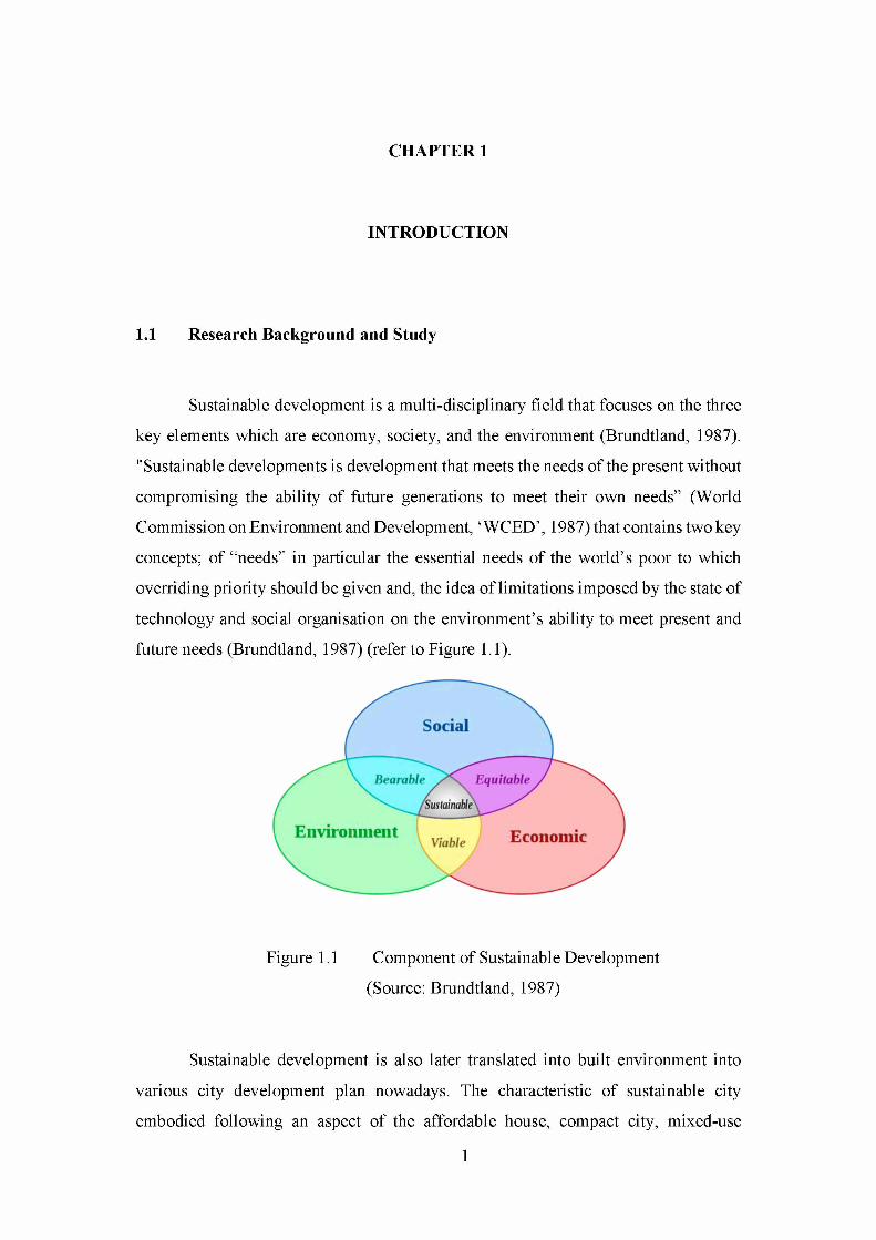
1.1 Research Background and Study
Sustainable development is a multi-disciplinary field that focuses on the three
key elements which are economy, society, and the environment (Brundtland, 1987).
"Sustainable developments is development that meets the needs of the present without
compromising the ability of future generations to meet their own needs” (World
Commission on Environment and Development, ‘ WCED’, 1987) that contains two key
concepts; of “needs” in particular the essential needs of the world’s poor to which
overriding priority should be given and, the idea of limitations imposed by the state of
technology and social organisation on the environment’s ability to meet present and
future needs (Brundtland, 1987) (refer to Figure 1.1).
Sustainable development is also later translated into built environment into
various city development plan nowadays. The characteristic of sustainable city
embodied following an aspect of the affordable house, compact city, mixed-use
Figure 1.1 Component of Sustainable Development
(Source: Brundtland, 1987)

development, green industry, safe city, urban agriculture, cultural and identity, public
information and education, climate resilient, cultural and identity, green building and
renewable energy (Roberts et al., 2014). Climate change has been seen as the most
significant challenge to sustainable development. While emissions from other sectors
are generally falling, those from transport have continued to increase a past year and
eventually in the future. It is reported the transport sector itself responsible for 22% of
energy-related greenhouse gas (GHG) emissions worldwide, and its emission rapidly
increases compared to other sectors (Lefevre et al., 2014).
Malaysia Government was also taking part in this sustainable development
when our prime minister pledged that Malaysia would participate to reduce 40%
carbon emission by 2025. Overall, Malaysia became a Non-Annex I Party to the
United Nations Framework Convention on Climate Change (UNFCCC) when it
consented the UNFCCC in 1994 and the Kyoto Protocol in 2002. During the 15th
United Nations Framework Convention on Climate Change (COP15) held in
Copenhagen on 2009, the Malaysian government has announced its commitment to
reduce the country’s carbon dioxide emission intensity to the GDP by 45% per GDP
per capita by 2030, as compared to 2005 levels - conditional upon transfer of
technology and finance from developed nations.
Moreover, the bus service has been the most feasible and affordable mode of
transport. It is also the most convenient mode of transport given the massive
investment in Malaysia transportation planning is on the road infrastructure. Besides,
the bus has the smaller carbon footprints that could accommodate up to 30 and 40
people per boarding, even though it still uses petrol, compared to the 20 private
vehicles on the road using the same petrol — furthermore, an increase in the use of
public transport results in less pollution and better air quality. Using the bus helps to
cut congestion which is a severe constraint on growth and costly to the economy.
However, bus service system in Malaysia still suffered from inefficiency services in
term of giving convenient and seamless journeys toward the customer.
Transit station and stops are one of the elements of transit planning. Good
transit systems are transit stop and station that offer safe and convenient connections2

for the public to other local destination. It is reported that the convenient location of
transit station that has better coverage and accessibility for pedestrian would reduce
people reliability to use the private vehicle and to switch to use public transport,
especially during peak hour. Transit station or stops is regarded as one of the pedestrian
facilities is an essential element to support Transit-Oriented Development (TOD),
hence reducing traffic congestion. Transit stop and stations also serve as essential part
of transit service thus it is essential to consider these facilities from the rider. It also
serves as a node to bring people into the area and to become one of the focal points in
a community.
However, people particularly pedestrian suffered in term of access and safety
ever since the introduction of the automotive industry in the early 1860s. The
expansion of this industry allowed for the planning paradigm to change dramatically
over the decades from the people-centric to vehicle oriented. The vehicle oriented
planning allowed most of the transportation investment focused on building vehicle
facilities for the instance parking lot, expansion of the road, instead of focusing on
non-motorised modes. Consequently, the physical design of the cities particularly
streets layout tends to favour mobility over accessibility while neglecting pedestrian
priorities. This, in fact, restricts walking activities and led people to be dependent
toward private vehicles. Most of the traffic congested cities in the world has suffered
from this vehicle oriented physical environment. Promoting and providing multimodal
transportation will increase the quality of urban area where walking is prioritised, and
pedestrian activities are encouraged. The increase in human movement can be seen as
a positive effect on the cities. Most of the livable cities in the world have high
pedestrian volume and movement in their cities.
There have been various studies on how urban spatial configuration has a
positive impact on the human movement in cities. Understanding human movement
behaviour is essential to promoting sustainable transportation, creating a better
walking quality space and sustaining the economic and social benefits of development
in the cities. There have been various models related to how to quantify pedestrian in
cities. Space syntax methodology proposed by Bill Hillier (1993) can capture in
understanding and predict human movement in the city. The methodology can predict

pedestrian movement over 75% that is caused by the urban street configuration. The
fundamental concept of space syntax methodology explains how the movement of
pedestrian and vehicular in an urban area are the result of people’s cognitive
topological-visual analysis (Hillier et al., 2007; Jiang 2009a). Besides, the component
of the space syntax methodology allows researchers to quantify the integration (the
level of interconnected) of a particular street to the rest of the streets network within
cities.
Overall, climate change resilient growth strategies create a low carbon, livable
and vibrant cities. One of the climate change strategies is by developing a people-
centric public transportation system. People-centric public transportation offers a great
benefit to the public particularly to the impoverished community that often suffered
from the vicious cycle of lock-in effect of land and transport development. Appropriate
with the national aspiration to develop a people-centric public transportation system it
is essential that every Malaysia cities to the pursuit and fulfil the goal. Besides, these
people-centric public transportation system could be one of the measures in reducing
Malaysia’s GHG emission reduction of 45% by 2030. TOD which is one of the climate
change strategies prioritised accessibility-based paradigm of pedestrianisation activity.
The fundamental concept of TOD focus on accessibility of pedestrian to and from the
transit stops and stations and adjacent land uses.
Accessibility of the pedestrian can be measured using the pedestrian model.
There has been a various pedestrian model developed over decades. The pedestrian
model centred on investigating human movement pattern. The human movement
analysis is proven to be one of the powerful tools in measuring the quality of cities
specifically transit stop and station. Space syntax methodology concept suggested that
the result of the human movement is through their cognitive perception toward space.
People tend to use a route which seems closer, fewer obstacles (convenient) and
interesting. Various studies have shown that space syntax methodology can provide a
platform where the relationship between human movement and the urban street
network can be investigated. Therefore, the centre of this research aims to develop a
people-centric public transportation system by measuring human movement to plan
for the suitable bus stop in Pasir Gudang.

1.2 Problem Statement
Even though there has been much emphasis on socially, economically and
environmentally benefit of TOD, people often disregard its function due to the lack of
understanding the technical details of TOD, hence failing on the public transportation
modal share. Most of the public transportation user often suffered frustration on the
poor services and ticket system, speed and punctuality, inconvenient in term of stop
and station as well as safety concern particularly toward bus services. This whole
perception has created an image where using the bus services is not convenient and
preferable, inefficient and time-consuming. Albeit bus service is one of the major
public transportation in Malaysia context, this mode of transport still suffers many
challenges especially in term of the long waiting time, no declared time schedules for
passengers and accessibility to the stops and station. Moreover, most of the public
transportation system does not expand outside of the large urban areas.
Recommendations to improve the service quality of public bus service is currently
demanding, given with the current policy on the national public transportation toward
people-centric.
Malaysia had reported an increase of three folds of private vehicles registration
that over the past 20 years from 4.7 million (1990) to 18.6 million (2010) (SPAD,
2013). This scenario depicted the failing of public transport modal share in urban areas,
mainly where mobility demands are intense which often lead to congestion. Travel
vehicle demand is expected grew from 13 million trips per day in 1991 to 40 million
in 2010 (SPAD, 2013). Projections point towards this trend continuing in Malaysia,
with the figure expected to reach a staggering 133 million in 2030 (SPAD, 2013). With
urbanisation expected to reach 75 % by 2020 (SPAD, 2016) there is a need to enable
an efficient and smooth flow of people, which in turn also enables the growth of new
urban areas through increased connectivity.
New urbanism practices are considered climate change measures as well as
energy efficient planning (Litman, 2014). The main features of the new urbanism
concept are its ability to maximise people connectivity, accessibility and reduced

private vehicles usage. One of the commonly well-known new urbanism practices is
TOD. Its unique features centred around the development of a transit stop or station as
a focal point of the development or neighbourhood where the distribution of
residential, commercial and employment centres are within pedestrian scale distances.
This design eventually improves the connectivity and accessibility of people to the
transit services, and its adjacent land uses thus encourage and improve transit ridership
(John et al., 2009). The demand for TOD neighbourhood is seen growing recently in
many cars oriented development particularly in American cities (Renne et al., 2013).
Lately, most of the TOD studies consisted and focused on the public
willingness and support to used alternative modes such as public transport system and
walking in order to enhance public ridership. However, creating an attractive walking
condition which is one of the basic active modes of transport and catalyst for TOD
development is seen as the primary challenge in most of the TOD cities. TOD concept
majorly emphasised on increase land use intensity within the specific ideal distance to
transit services so that the people can be drawn to the area, however, its often
overlooked the people movement mainly on accessibility from and to transit station
which is seen only consider land use element. This eventually affects people to walk
and use public transport willingly. For example, people are not willing to walk to stop
or station that does not have direct access to the transit services even though the
concentration of the land uses surrounding of the transit station is high.
It can be said that the current TOD development particularly in Malaysia is
often neglecting the first and last mile connectivity of people to move around therefore
create a non-friendly walking environment. Current local studies often empirical and
considers only urban design concepts in TOD. All in all, there has been lacking
empirically on how to incorporate the walking environment into the development of
TOD as well as on how to operate them to fulfil the main goal of TOD (Li et al., 2014;
Ozbil, 2009). As a result, these lead to vehicles oriented environment to dominate the
TOD development (public transport environment).
Consequently, the choice of location public transport systems is biased toward
the vehicle oriented environment which resulted in too many development issues for6
example designing of the transit station and stop that does not integrate with the
surrounding area and responsive to the pedestrian accessibility. Therefore, a study that
investigates the pattern of people around the TOD development in order to demonstrate
a sense of identity within the urban should be encouraged to change people’s urban
perspective toward using to public transport. Accordingly, this vehicle oriented
practises can be changed and shifted toward public transport which is a people-centric
development to stimulate positive people-urban interaction (Li et al., 2014). Thus,
TOD development that caters to walking environment, should be studied in the search
for optimal location wise for public transit station or stop to build a better living
environment that fulfilling social, economy and environment as well as encourage
efficient land uses.
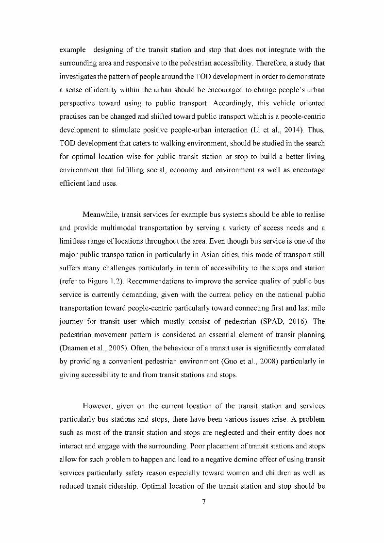
Meanwhile, transit services for example bus systems should be able to realise
and provide multimodal transportation by serving a variety of access needs and a
limitless range of locations throughout the area. Even though bus service is one of the
major public transportation in particularly in Asian cities, this mode of transport still
suffers many challenges particularly in term of accessibility to the stops and station
(refer to Figure 1.2). Recommendations to improve the service quality of public bus
service is currently demanding, given with the current policy on the national public
transportation toward people-centric particularly toward connecting first and last mile
journey for transit user which mostly consist of pedestrian (SPAD, 2016). The
pedestrian movement pattern is considered an essential element of transit planning
(Daamen et al., 2005). Often, the behaviour of a transit user is significantly correlated
by providing a convenient pedestrian environment (Guo et al., 2008) particularly in
giving accessibility to and from transit stations and stops.
However, given on the current location of the transit station and services
particularly bus stations and stops, there have been various issues arise. A problem
such as most of the transit station and stops are neglected and their entity does not
interact and engage with the surrounding. Poor placement of transit stations and stops
allow for such problem to happen and lead to a negative domino effect of using transit
services particularly safety reason especially toward women and children as well as
reduced transit ridership. Optimal location of the transit station and stop should be

placed within transportation capacity of city network in this case road network which
serves as transport infrastructure to support economic and/or residential activity
(Bruun, 2014). Besides, transit stop and station planning method and guidelines
insufficiently address particularly within the most Asian cities context particularly
toward Malaysia cities (Japheth, 2012). Thus, intensive research on the transit station
and stop planning should be broadly encouraged to fulfil both national aspirations of
the people-centric public transportation system (SPAD, 2016).
Figure 1.2 Design of transit station/stop that does not integrate with the
surrounding area and responsive to the pedestrian accessibility
Besides, being one of the Malaysia economic regions and its strategic location
nearby to Singapore, Iskandar Malaysia has experienced an increased demand for the
transportation sector due to rapid economic growth that brought an increase in
population. Iskandar Malaysia currently recorded public modal split of 15: 85 in 2010.
The percentage of the public modal split is expected to reduce up to 10% by 2025
business as usual scenario if there was no improvement regard on this issue. It is
reported that GHG emission from the transportation sector in Iskandar Malaysia is
expected to increase from 15% (2010) to 27% (2025) (Ho CS et al., 2013). The four
(4) major transportation corridors in Iskandar Malaysia often suffered traffic
congestion, particularly during peak hours.
These important routes connected to Iskandar Malaysia’s main flagships that
consist of most and important primary economic activities to the region. Hence this
8

route serves as the central platform for the daily commute. The four (4) major
transportation corridors which are identified are (a) Skudai-Johor Bahru, (b) Johor
Bahru - Pasir Gudang (c) Johor Bahru Ulu Tiram (d) Johor Bahru - Nusajaya. The
Johor Bahru - Pasir Gudang corridor notably which is recorded to have the highest
private vehicles volume travel daily even though it has the greatest bus operation.
Therefore, the study on the implementation of the non-motorised planning within this
corridor should be conducted in order to encourage transit ridership in this case using
bus services- hopefully being one of the measures to reduce traffic congestion.
Space syntax methodology is one of the effective methods to determine the
effective location of certain facilities related to movement within public urban space.
Bertonlini and Spit (1998) stated that the transit station should be located in a
“significant place” in an urban network. Some of the urban areas have high people
movement, therefore, this characteristic should be considered in order to determine the
best location for the transit station and stop. These potential areas can be used to
influence people’s natural movement and attract walking activities to happen.
According to space syntax theory, the degree of street integration has influence spatial
accessibility of an urban area (Hillier, 2007b) therefore attracting movement to exist.
Thus, it shows that high integrated streets likely have the potential to develop transit
stations and stops that could capture this movement pattern. Lacking accessibility of
transit stations and stops have respectively negative impacts on safety and liveability
of station areas; and subsequently, the public transport ridership is expected to
continue to decline.
In addition, space syntax methodology also has the ability to investigate
relationships between spatial layout and a range of social, economic and environmental
context which is significantly important for urban planning study. These contexts
include patterns of movement, awareness and interaction of people; land use density,
land use mix and land value; urban growth and societal differentiation; safety and
crime distribution (Charalambous et al., 2012). Besides, various research using the
space syntax approach has shown how: movement patterns and flows in cities are
powerfully shaped by the street network; this in return shapes the evolution of the
centres and sub-centres that affects the movement of people in the city; accessibility is

affected by spatial design; spatial segregation and social disadvantage are related in
cities (Hillier et al., 1987; Hillier, 2009). This evidence shows that space syntax has
the ability to measure spatial accessibility through analysing the movement network
of the city (Law et al., 2013).
Compares to other methodology, space syntax methodology offer solution in
terms of (Charalambous et al., 2012);
a) Constraints and opportunities of urban areas with regard to the street network
and how it can attract or deter pedestrian movement so that land use strategy is
better aligned to the pedestrian movement opportunities;
b) Offer insights on how the area can be optimised in its context regarding its
commercial viability, the potential for retail, the design of sustainable
development and the creation of vibrant and lively urban spaces;
c) Offers the possibility to test different strategic guidelines and design proposals
Therefore it can be summarised that space syntax analysis is expected to fulfil
sustainable transport policy under new urbanism practices (TOD) and pedestrian
aspect in determining a suitable location for public transit station or stop using road
network system of cities. The contiguous road network system can be studied
mathematically using graph method due to its ability to perform analysis on particular
road selection and its relationship with others road within the system (Hillier et al.,
1993). Its unique features have shown how spatial layout powerfully shapes movement
patterns, patterns of security and insecurity are affected by spatial design, and this
relation shapes the evolution of the centres and sub-centres that makes cities liveable
(Hillier, 2009) to find the optimal spot for a transit station and stop within the cities.
Henceforth, this study aims to use space syntax analysis as one of the spatial methods
to predict the suitable location for transit stops and station using pedestrian movement
pattern. Figure 1.3 shows the formulation of the problem statement for this research.

Climate change/ Global Warming
SustainableDevelopment
Malaysia global commitment to reduce
45% CO2 emission intensity by 2030 (based
Iskandar Malaysia CDPii,
Johor State Sustainable Policy
C Iskandar Malaysia Low Carbon Blueprint (IM-
LCSBP 2025)V
C \ Land PublicTransport Master
Plan 2020v y
Transportation Sector
Public Transit Space Syntax
Station Pedestrian movement
Problem solving through space syntax analysis
Constraints and opportunities of urban areas with regard to the street network and how it can attract or deter pedestrian movement so that land use strategy is better aligned to the pedestrian movement opportunities;Offer insights on how the area can be optimised in its context regarding its commercial viability, the potential for retail, the design of sustainable development and the creation of vibrant and lively urban spaces;Offers the possibility to test different strategic guidelines and design proposals
Source: Charalambous eta/., 2012
Figure 1.3 Formulation of the problem statement
1.3 Research Aim
Thus, in response to that problem statement this study aims to “Plan for
Integrated Bus Stop for Pedestrian using Space Syntax Analysis” Thus strategy to
developing a people-centric public transportation system is explored in this research.
This component explained further in Chapter 2.
1.4 Research Objectives
To achieve the stated research aim, the following objectives are formulated:
a) To identify the pedestrian volume, axial segment property (integration), type of
land uses (functional front and mixed land use index) and distribution of static
activities in the studied zones
b) To correlate pedestrian volume with the axial segment property (integration), type
of land use (functional front and mixed land use index) and distribution of static
activities in the studied zones
c) To suggest the suitable/potential location of bus stops based on the correlation
analysis result of axial segment property (integration), type of land use (functional
front and mixed land use index) and distribution of static activities with pedestrian
volume in the studied zones
1.5 Research Questions
The scope of this research is summarised based on the following discussion.
Based on the above background scenario, three (3) research question is then tabulated
to identify possible question raised while conducting the research.
a) What is pedestrian volume, axial segment property (integration), type of land uses
(functional front and mixed land use index) and static activities distribution in the
studied zones?
b) What is the relationship between the pedestrian volume with axial segment
property (integration), type of land use (functional front and mixed land use index)
and distribution of static activities in the studied zones?
c) Where is the suitable/potential location of bus stops based on the correlation
analysis result between axial segment property (integration), type of land use
(functional front and mixed land use index) and distribution of static activities with
pedestrian volume in the studied zones?

1.6 Research Limitation
This study is limited to the area of Pasir Gudang. Pasir Gudang is selected due
to its character as well as it is one of five (5) municipality regions in the Iskandar
Malaysia. Pasir Gudang is also a crucial manufacturing hub as well as the location of
a dense neighbourhood area. Moreover, this study only considers three (3) kilometres
radius of Pasir Gudang as the study area. Apart from that, this research focuses only
on defining the service coverage area of a transit service, which is the area within
walking distance of a transit stop; does not include measuring the whole bus services
system for examples the route network and ridership.
1.7 Thesis Structure
This thesis is a structure in five (5) stages, and each stage translates into Chapter 1, 2,
3, 4 and 5. Figure 1.4 shows the detailed framework of the thesis structure.
Figure 1.4 Thesis structure and framework
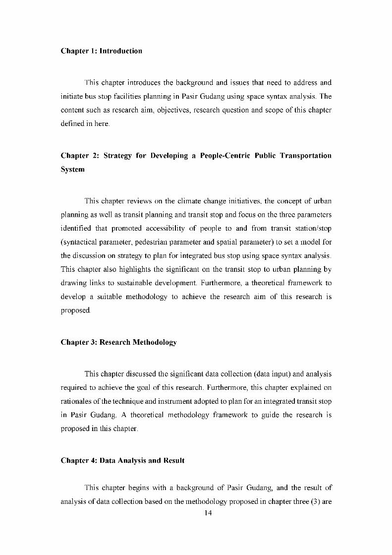
Chapter 1: Introduction
This chapter introduces the background and issues that need to address and
initiate bus stop facilities planning in Pasir Gudang using space syntax analysis. The
content such as research aim, objectives, research question and scope of this chapter
defined in here.
Chapter 2: Strategy for Developing a People-Centric Public Transportation
System
This chapter reviews on the climate change initiatives, the concept of urban
planning as well as transit planning and transit stop and focus on the three parameters
identified that promoted accessibility of people to and from transit station/stop
(syntactical parameter, pedestrian parameter and spatial parameter) to set a model for
the discussion on strategy to plan for integrated bus stop using space syntax analysis.
This chapter also highlights the significant on the transit stop to urban planning by
drawing links to sustainable development. Furthermore, a theoretical framework to
develop a suitable methodology to achieve the research aim of this research is
proposed.
Chapter 3: Research Methodology
This chapter discussed the significant data collection (data input) and analysis
required to achieve the goal of this research. Furthermore, this chapter explained on
rationales of the technique and instrument adopted to plan for an integrated transit stop
in Pasir Gudang. A theoretical methodology framework to guide the research is
proposed in this chapter.
Chapter 4: Data Analysis and Result
This chapter begins with a background of Pasir Gudang, and the result of
analysis of data collection based on the methodology proposed in chapter three (3) are14

shown and analysed. Then, a series of investigation of the relationship between the
three parameters introduced which are syntactical, spatial and pedestrian. These
parameters analysis and result are then explained further.
Chapter 5: Discussion and Conclusion
This chapter summarised on the finding from the theoretical review of Chapter
two and methodology research of Chapter three. This chapter then discussed the
findings and concluded on the spatial proposal to plan for integrated transit stops thus
to enhance transit planning in Pasir Gudang and recommends possible future research
directions in the topic.
1.8 Research Significance
The purpose of this study is to address people-based planning in TOD. People-
centric planning is one of the strategies identified to reduce GHG emission from the
highest emitter sector (transportation) through integrating land use and transport
planning. Incorporating land use and transportation approaches, for example, TOD
will encourage better connectivity and accessibility of people from and to the station
with surrounding land uses. The station should be seen as another essential platform
that bringing people in that could liven the area, particularly in Malaysia cities. By
integrating land use and transport planning approaches for examples not only can
socially benefit. However, the investment and demand for public transportation
continue to increase over the years. Comprehensive and thorough planning of the
public transport station elevated transit services quality thus improve the ridership.
In line with Malaysia’s effort to achieve the target of 40% public transport modal
share by 2030 in urban areas, this research hopefully supports the aspiration,
particularly in the Iskandar Malaysia economic region. The 40% target can be achieved
by focusing on the primary user of public transportation, people. People-centric public
transportation can be studied by observing human movement in an urban area. Being
Agrawal, A. W., Schlossberg, M., & Irvin, K. (2012). How Far , by Which Route and
W hy? A Spatial Analysis of Pedestrian Preference How Far , by Which Route
and W hy? A Spatial Analysis, (January), 37-41.
https://doi.org/10.1080/13574800701804074
Al-Mudhaffar, A., Nissan, A., & Bang, K. L. (2016). Bus Stop and Bus Terminal
Capacity. Transportation Research Procedia, 14, 1762-1771.
https://doi.org/10.1016Zj.trpro.2016.05.142
Alfonzo, M. A. (2005). To walk or not to walk? The hierarchy of walking needs.
Environment and Behavior, 37(6), 808-836.
https://doi.org/10.1177/0013916504274016
American Public Transportation Association (APTA). (2012). Design o f On-street
Transit Stops and Access from Surrounding Areas. Washington D.C. Retrieved
from
http://citeseerx.ist.psu.edu/viewdoc/download?doi=10.1.1.278.4944&rep=rep1
&type=pdf
American Public Transportation Association (APTA). (2017). Public Transportation
Reduces Greenhouse Gases and Conserves Energy The facts are clear The
Benefits o f Public Transportation.
Andersson, D. E., Shyr, O. F., & Lee, A. (2012). The successes and failures of a key
transportation link: Accessibility effects of Taiwan’s high-speed rail. Annals o f
Regional Science, 48(1), 203-223. https://doi.org/10.1007/s00168-010-0405-5
Andrade, R., & Schieck, A. F. G. (2015). Wayfinding to support urban exploration :
Combining space syntax analysis with social media data for navigation system
design. Proceedings o f the 10th International Space Syntax Symposium, London,
117:1-117:19.
Beatrix Emo, Christoph Holscher, Jan M. Wiener, R. C. D. (2012). Wayfinding and
Spatial Configuration : Evidence from Street Corners, 1-16.
Beimborn, E., Greenwald, M., & Jin, X. (2003). Accessibility, Connectivity, and
Captivity: Impacts on Transit Choice. Transportation Research Record: Journal
o f the Transportation Research Board, 1835(January), 1-9.
https://doi.org/10.3141/1835-01
Biba, S., Curtin, K. M., & Manca, G. (2010). A new method for determining the
population with walking access to transit. International Journal o f Geographical
Information Science, 24(3), 347-364.
https://doi.org/10.1080/13658810802646679
Borgers, A. W. J., & Timmermans, H. (2014). Modelling pedestrian behaviour in
downtown shopping areas, (January 2005).
Brons, M., Givoni, M., & Rietveld, P. (2009). Access to railway stations and its
potential in increasing rail use. Transportation Research Part A : Policy and
Practice, 43(2), 136-149. https://doi.org/10.1016/j.tra.2008.08.002
Brundtland, G. H. (1987). Our Common Future: Report of the World Commission on
Environment and Development. United Nations Commission, 4(1), 300.
https://doi.org/10.1080/07488008808408783
Bruun, E. C. (2014). Better Public Transit Systems (Second).
Camagni, R., Gibelli, M. C., & Rigamonti, P. (2002). Urban mobility and urban form:
The social and environmental costs of different patterns of urban expansion.
Ecological Economics, 40(2), 199-216. https://doi.org/10.1016/S0921-
8009(01)00254-3
Carpio-Pinedo, J. (2014). Urban Bus Demand Forecast at Stop Level: Space Syntax
and Other Built Environment Factors. Evidence from Madrid. Procedia - Social
and Behavioral Sciences, 160(Cit), 205-214.
https://doi.org/10.1016/j.sbspro.2014.12.132
Cervero, R. (2001). Integration of Urban Transport and Urban Planning. The
Challenge o f Urban Government: Policies and Practices, 407-427.
https://doi.org/10.1177/019263657105535117
Cervero, R. (2006). Office Development, Rail Transit, and Commuting Choices.
Journal o f Public Transportation, 9, 41-55. https://doi.org/10.1016/0965-
8564(93)90040-R
Cervero, R., & Berkeley, U. C. (2010). Urban Planning & Sustainable Mobility Meta
Evidence on 5Ds & VKT in US Vehicle Kilometers Traveled ( VKT ).
Chapman, E. H., & Lynch, K. (1962). The Image of the City. The Journal o f Aesthetics
and Art Criticism, 21(1), 91. https://doi.org/10.2307/427643
Charalambous, N., & Mavridou, M. (2012). Space syntax: Spatial integration
accessibility and angular segment analysis by metric distance (ASAMeD). In
Accessibility Instruments for Planning Practice, edited by A. Hull, C. Silva, and130
L. Bertolini: COST Office. ISBN: 978-989-20-3187-3., 57-62.
Chiaradia, A., Moreau, E., & Raford, N. (2005). Configurational Exploration of Public
Transport Movement Networks: A Case Study, The London Underground.
Group, 541-552.
Chin Siong, H., Loon Wai, C., Matsuoka, Y., Gami, K., Abdullah, R., & Jausus, N.
(2013). Low Carbon Society Blueprint for Iskandar Malaysia 2015. UTM Low
Carbon Asia Research Center, 1 -12.
https://doi.org/10.1017/CBO9781107415324.004
Christian, H. E., Bull, F. C., Middleton, N. J., Knuiman, M. W., Divitini, M. L.,
Hooper, P., ... Giles-Corti, B. (2011). How important is the land use mix measure
in understanding walking behaviour? Results from the RESIDE study.
International Journal o f Behavioral Nutrition and Physical Activity, 8(1), 55.
https://doi.org/10.1186/1479-5868-8-55
Civil Society Mechanism for relations to the UN Committee on World Food Security.
(2016). CSM Policy Working Group on Sustainable Development Goals (SDG)
Coordinator.
Currie, G. (2010). Quantifying spatial gaps in public transport supply based on social
needs. Journal o f Transport Geography, 18(1), 31-41.
https://doi.org/10.1016/jjtrangeo.2008.12.002
Daamen, W., Hoogendoorn, S., & Bovy, P. (2005). First-Order Pedestrian Traffic
Flow Theory. Transportation Research Record, 1934(January), 43-52.
https://doi.org/10.3141/1934-05
Daniels, R., & Mulley, C. (2011). Explaining walking distance to public transport: the
dominance of public transport supply, (July), 28-30.
Daniels, R., & Mulley, C. (2013). Explaining walking distance to public transport: The
dominance of public transport supply. Journal o f Transport and Land Use, 6(2),
5. https://doi.org/10.5198/jtlu.v6i2.308
Dempsey, N., Brown, C., Raman, S., Porta, S., Jenks, M., Jones, C., & Bramley, G.
(2010). Elements o f Urban Form Elements o f Urban Form.
https://doi.org/10.1007/978-1-4020-8647-2
Development, S. E. E. (2006). High-Speed Train. Railway Engineering Journal, 2(4).
Donovan, S., & Munro, I. (2013). Impact o f urban form on transport and economic
outcomes.
Dukic, A., & Vukmirovic, M. (2012). Redesigning the network of pedestrian spaces131

in the function of reduction of carbon dioxide emission. Case study: Pancevo and
Vrsac. Spatium, 523(27), 31-39. https://doi.org/10.2298/SPAT1227031D
Eboli, L., Forciniti, C., & Mazzulla, G. (2014). Service Coverage Factors Affecting
Bus Transit System Availability. Procedia - Social and Behavioral Sciences, 111,
984-993. https://doi.org/10.1016/j.sbspro.2014.01.133
Elbanhawy, E. Y., & Dalton, R. (2013). Syntactic Approach To Electric Mobility In
Metropolitan Areas : NE 1 district core , segment map, 1-16.
Ellerman, D. (2005). Jane Jacobs on Diversification and Specialization, (February), 1
24.
Era, R. T. (2012). Improving Pedestrian Accessibility to Public Space Through Space
Syntax Analysis. Eighth International Space Syntax Symposium, 1-16.
Ewing, R., Bartholomew, K., Winkelman, S., Walters, J., & Chen, D. (2008). Growing
Cooler (The evidence of urban development and climate change), 109-130.
Ewing, R., & Handy, S. (2009). Measuring the Unmeasurable: Urban Design Qualities
Related to Walkability. Journal o f Urban Design, 14(1), 65-84.
https://doi.org/10.1080/13574800802451155
Fielding, G. J., Glauthier, R. E., & Lave, C. A. (1978). Performance indicators for
transit management. Transportation, 7(4), 365-379.
https://doi.org/10.1007/BF00168037
Foda, M. A., & Osman, A. O. (2010). Using GIS for Measuring Transit Stop
Accessibility Considering Actual Pedestrian Road Network, (Tcrp 1996), 23-40.
Frank, L. D., & Pivo, G. (1994). Relationship between land use and travel behavior in
the puget sound region.
Frank, L. D., Schmid, T. L., Sallis, J. F., Chapman, J., & Saelens, B. E. (2005).
Objectively Measured Urban Form Findings from SMARTRAQ, 28, 117-125.
https://doi.org/10.1016/j.amepre.2004.11.001
Gainza, X., & Livert, F. (2013). Urban form and the environmental impact of
commuting in a segregated city, Santiago de Chile. Environment and Planning
B: Planning and Design, 40(3), 507-522. https://doi.org/10.1068/b38045
Gehl, J. (1987). Life Between Buildings: Using Public Space, (August), 200. Retrieved
from
http://books.google.hu/books/about/Life_Between_Buildings.html?id=K98JAQ
AAMAAJ&pgis=1
Girard, L. F. (2013). Toward a smart sustainable development of port cities/areas: The132

role of the “Historic Urban Landscape” approach. Sustainability (Switzerland),
5(10), 4329-4348. https://doi.org/10.3390/su5104329
Givoni, M., & Rietveld, P. (2007). The access journey to the railway station and its
role in passengers’ satisfaction with rail travel. Transport Policy, 14(5), 357-365.
https://doi.org/10.1016/j.tranpol.2007.04.004
Grajewski, T., & Vaughan, L. (2001). Space syntax observation manual. Space Syntax
Laboratory, 1-18.
Griswold, J. B., Sztainer, T., Lee, J., Madanat, S., & Horvath, A. (2017). Optimizing
Urban Bus Transit Network Design Can Lead to Greenhouse Gas Emissions
Reduction. Frontiers in Built Environment, 3(February), 1-7.
https://doi.org/10.3389/fbuil.2017.00005
Guo, Z., & Ferreira Jr, J. (2008). Pedestrian environments, transit path choice, and
transfer penalties: understanding land-use impacts on transit travel. Environment
and Planning B: Planning and Design, 35(3), 461-479.
https://doi.org/10.1068/b33074
Guru, L. T. (2015). Land Transport Guru Details : Background : Background : The
Term inal: Bus Services : Local Bus services : Retrieved April 27, 2017, from
https://landtransportguru.net/masai-bus-terminal/
Ha, E., Joo, Y., & Jun, C. (2011). Green Score : an Evaluation Scheme for Pedestrian
Environment 1.
Handy, S. (1996). Methodologies for Exploring the Link Between Urban Form and
Travel Behavior, 1(2), 151-165.
Handy, S. L. (1995). Understanding the Link Between Urban Form and Travel
Behavior. Paper Presented at the 74th Annual Meeting o f the Transportation
Research Board, 183-198.
Hass-Klau, C. (2015). The Pedestrian and The City (First).
Heath, G. W., Brownson, R. C., Kruger, J., Miles, R., Powell, K. E., & Ramsey, L. T.
(2006). The Effectiveness of Urban Design and Land Use and Transport Policies
and Practices to Increase Physical Activity: A Systematic Review. Journal o f
Physical Activity & Health, 3(Suppl1), S55-S76. Retrieved from
http://libproxy.wustl.edu/login?url=http://search.ebscohost.com/login.aspx?dire
ct=true&db=psyh&AN=2006-11624-005&site=ehost-live&scope=site
Heffernan, E. E., Heffernan, T. W., & Pan, W. (2014). The relationship between the
quality of active frontages and public perceptions of public spaces, 19, 92-102.133

Hernandez, D., Lister, M., & Suarez, C. (2011). Location Efficiency and Housing Type
- Boiling it Down to BTUs, (March), 17. Retrieved from
http://www.epa.gov/smartgrowth/pdf/location_efficiency_BTU.pdf
Hillier, B. (1988). Bill Hillier Mapping Method : Basis Of Space Syntax Technique.
In Space Syntax Laboratory.
Hillier, B. (1996). Cities as movement economies.
Hillier, B. (1999). Centrality as a process: accounting for attraction inequalities in
deformed grids, 107-127.
Hillier, B. (2007a). Space is the machine.
Hillier, B. (2007b). Space Is the Machine.
Hillier, B. (2009). Spatial Sustainability in Cities Organic Patterns and Sustainable
Forms Note 1. Symposium A Quarterly Journal In Modern Foreign Literatures,
1-20. Retrieved from http://eprints.ucl.ac.uk/18538/
Hillier, B. (2012). Studying cities to learn about minds: some possible implications of
space syntax for spatial cognition. Environment and Planning B: Planning and
Design, 39(1), 12-32. https://doi.org/10.1068/b34047t
Hillier, B., Burdett, R., Peponis, J., & Penn, A. (1987). Creating Life: Or, Does
Architecture Determine Anything? Ach. & Comport/Arch. Behav., 3(3), 233
250.
Hillier, B., & Iida, S. (2005). Network Effects and Psychological Effects: A Theory o f
Urban Movement. University College London, UK.
Hillier, B., Penn, A., Hanson, J., Grajewski, T., & Xu, J. (1993). Natural Movement:
or Configuration and attraction in urban pedestrian movement. Environment and
Planning B: Planning and Design, 20, 29-66.
Holmes, J., & Hemert, J. Van. (2008). Transit Oriented Development. Sustainable
Community Development Code, Research Monologue Series: Urban Form,
Transportation, (2009), 1-8.
Holtzclaw, J. (1994). Using Residential Patterns and Transit To Decrease Auto
Dependence and Costs, (June), 51. Retrieved from
http://docs.nrdc.org/smartGrowth/files/sma_09121401a.pdf
Holtzclaw, J., Clear, R., Dittmar, H., Goldstein, D., & Haas, P. (2002). Location
efficiency: Neighborhood and socio-economic characteristics determine auto
ownership and use - Studies in Chicago, Los Angeles and San Francisco.
Transportation Planning and Technology, 25(1), 1-27.134
https://doi.org/10.1080/03081060290032033
Hongbo, W. (2016). Taking Measures to Advance Sustainable Transport.
Hoornweg, D., Sugar, L., & Gomez, C. L. T. (2011). Cities and greenhouse gas
emissions: moving forward. Environment and Urbanization, 23(1), 207-227.
https://doi.org/10.1177/0956247810392270
Hoornweg, D., Tuts, R., & Kehew, B. (2004). Greenhouse Gas Emissions from Cities
Comparison of International Inventory Frameworks A Draft Working Paper by
UNEP , UN-Habitat and World Bank under the Joint Work Program for Cities
and Climate Change 1 Table 1 : Four prominent international GHG emissions,
(released).
Huang, S.-W., & Hsieh, H.-I. (2014). The Study of the Relationship between
Accessibility and Mixed Land Use in Tainan, Taiwan. International Journal o f
Environmental Science and Development, 5(4), 352-356.
https://doi.org/10.7763/IJESD.2014.V5.508
Huang, Z. (2014). A hierarchical process for optimizing bus stop distribution. Urban,
Planning and Transport Research, 2(February 2015), 162-172.
https://doi.org/10.1080/21650020.2014.908738
Hugh Barton & Catherine Tsourou. (2000). Healthy Urban Planning. Madison Ave,
New York NY: Taylor & Francis 2 Park Square, Milton Park, Abingdon, Oxon,
OX14 4RN on behalf of the World Health Organization.
Huxford, R. (2004). Safer places - The Planning System and Crime Prevention.
Proceedings o f the ICE - Municipal Engineer, 157, 5-107.
https://doi.org/10.1680/muen.2004.157A227
Iseki, H., Ringler, A., Taylor, B. D., Miller, M., & Smart, M. (2007). Evaluating
Transit Stops and Stations from the Perspective of Transit Users, 0194.
Iskandar Regional Development Authority. (2014). Comprehensive Development Plan
ii.
Jan Gehl and Birgitte Svarre. (2013). How To Study Public Life. ISLANDPRESS.
Japheth, L. (2012). Bus Stands in Malaysia : Signicance , Reality , Perceptions & 10
Aspects to Improve On. Retrieved from
http://blog.japhethlim.com/index.php/2012/12/01/bus-stands-in-malaysia-
significance-reality-perceptions-10-aspects-to-improve-on/
Jiang, B. (2009). Ranking spaces for predicting human movement in an urban
environment. International Journal o f Geographical Information Science, 23(7),135

823-837. https://doi.org/10.1080/13658810802022822
Jun, C., Kwon, J. H., Choi, Y., & Lee, I. (2007). An alternative measure of public
transport accessibility based on space syntax. Lecture Notes in Computer Science
(Including Subseries Lecture Notes in Artificial Intelligence and Lecture Notes in
Bioinformatics), 4413 LNAI(Berglund 2001), 281-291. Retrieved from
http://www.scopus.com/inward/record.url?eid=2-s2.0-
38549164650&partnerID=40&md5=af2a7e4988366f548a9c3884198cce4b
Kenneth A. Small, E. T. V. (2007). The Economics o f Urban Transportation.
Kenworthy, J. (2013). World Transport Policy and Practice October 2013,
19(October).
Kerkman, K., Martens, K., Meurs, H., Martens, K., & Meurs, H. (2014). Factors
influencing bus-stop level ridership in the Arnhem Nijmegen City Region,
(November).
Kim, D., Ko, J., & Lee, Y. (2013). Estimating Pedestrian Traffic V olum e: A
Preliminary Analysis, 9 .
Kimpel, T. J., Dueker, K. J., & El-Geneidy, A. M. (2007). Using GIS to Measure the
Effect of Overlapping Service Areas on Passenger Boardings at Bus Stops. Urban
and Regional Information Systems Association Journal, 19(1), 5-11.
Kockelman, K. (1997). Travel Behavior as Function of Accessibility, Land Use
Mixing, and Land Use Balance: Evidence from San Francisco Bay Area.
Transportation Research Record: Journal o f the Transportation Research Board,
1607(January 1997), 116-125. https://doi.org/10.3141/1607-16
Koohsari, M. J., Owen, N., Cerin, E., Giles-Corti, B., & Sugiyama, T. (2016).
Walkability and walking for transport: Characterizing the built environment using
space syntax. International Journal o f Behavioral Nutrition and Physical
Activity, 13(1), 1-9. https://doi.org/10.1186/s12966-016-0448-9
Land Public Transport Commission. (2016). Touching Lives Connecting
Communities - Land Public Transport Transformation Journey 2010-2015, 1-61.
Retrieved from https://www.spad.gov.my/LPT5years.pdf
Land Public Transport Commission (SPAD). (2013). Land Public Transport
Commission (SPAD) Annual Report 2013, 66.
Land Public Transport Commission (SPAD). (2016). Land Public Transport
Information-History, Aspirations and Challenges, 1-19. Retrieved from
http://www.spad.gov.my/sites/default/files/chairman_speech-22april20161.pdf136

Law, S., Hillier, B., & Penn, A. (2013). Space Syntax Angular Betweeness Centrality.
In Proceedings o f the Ninth International Space Syntax Symposium, Seoul (p. 16).
Leather, J., Fabian, H., Gota, S., & Mejia, A. (2011). Walkability and Pedestrian
Facilities in Asian Cities State and Issues. Asian Development Bank Sustainable
Development Working Paper Series, (17), 69.
Lerman, Y., Rofe, Y., & Omer, I. (n.d.). Using space syntax to model pedestrian
movement in urban transportation planning, 1-27.
Lerman, Y., Rofe, Y., & Omer, I. (2014). Using Space Syntax to Model Pedestrian
Movement in Urban Transportation Planning. Geographical Analysis, 46(4),
392-410. https://doi.org/10.1111/gean.12063
Levinson, H. S., & Smith, W. (1990). Pedestrian Way Concepts and Case Studies.
Li, C. N., & Hsieh, Y. K. (2014). Apply Space Syntax to Design a TOD land Use Plan.
International Journal o f Engineering and Technology, 6(6), 503-507.
https://doi.org/10.7763/IJET.2014.V6.749
Litman, T. (2012a). Evaluating Accessibility for Transportation Planning Measuring
People ’ s Ability To Reach Desired Goods and Activities, (January 2008), 49.
Litman, T. (2012b). Introduction to Multi-Modal Transportation Planning: Principles
and Practices, 0-18. https://doi.org/10.1080/00420987620080731
Litman, T. (2014). Smart Transportation Emission Reduction Strategies, 47(January
2013), 153-166. Retrieved from http://www.vtpi.org/ster.pdf
Litman, T. (2015). Land Use Impacts on Transport, 1-21. https://doi.org/10.1007/978-
3-642-54876-5
Litman, T. (2016). Developing Indicators for Sustainable and Livable Transport
Planning, 10-15.
Litman, T., & Burwell, D. (2006). Issues in sustainable transportation. International
Journal o f Global Environmental Issues, 6(4), 331.
https://doi.org/10.1504/IJGENVI.2006.010889
Long, Y., Baran, P. K., & Moore, R. (2007). The role of space syntax in spatial
cognition. 6th International Space Syntax Symposium , (1960).
Manaugh, K., & Kreider, T. (2013). What is mixed use? Presenting an interaction
method for measuring land use mix. Journal o f Transport and Land Use, 6(1),
63-72. https://doi.org/10.5198/jtlu.v6i1.291
Marks, M. (2016). People Near Transit: Improving Accessibility and Rapid Transit
Coverage in Large Cities. Institute fo r Transportation and Development, 34.137

Metropolitan, W., & Transit, A. (2009). Guidelines for the Design and Placement of
Transit Stops, (December).
Ming, Z. (2006). Travel choice with no alternative - Can land use reduce automobile
dependence? Journal o f Planning Education and Research, 25(3), 311-326.
https://doi.org/10.1177/0739456X05280544
Miranda-Moreno, L. F., Morency, P., & El-Geneidy, A. M. (2011). The link between
built environment, pedestrian activity and pedestrian-vehicle collision
occurrence at signalized intersections. Accident Analysis and Prevention (Vol.
43). https://doi.org/10.1016/j.aap.2011.02.005
Monteiro, F. B., & Campos, V. B. G. (2012). A Proposal of Indicators for Evaluation
of the Urban Space for Pedestrians and Cyclists in Access to Mass Transit Station.
Procedia - Social and Behavioral Sciences, 54, 637-645.
https://doi.org/10.1016/j.sbspro.2012.09.781
Moudon, A. V. (1997). Urban morphology as an emerging interdisciplinary field,
(January 1997).
Muhs, C. D., Clifton, K., Singleton, P. A., & Schneider, R. J. (2015). Development of
a Pedestrian Demand Estimation Tool: a Destination Choice Model.
Murray, A. T. (2001). Strategic analysis of public transport coverage. Socio-Economic
Planning Sciences, 35, 175-188. https://doi.org/10.1016/S0038-0121(01)00004-
0
Murray, A. T. (2002). A Coverage Model for Improving Public Transit System
Accessibility and Expanding Access. Annals o f Operations Research, 123(1-4),
143-156. https://doi.org/10.1023/A:1026123329433
Murray, A. T., Davis, R., Stimson, R. J., & Ferreira, L. (1998). Public transportation
access. Transportation Research Part D: Transport and Environment, 3(5), 319
328. https://doi .org/10.1016/S1361 -9209(98)00010-8
Neary, S. J., Symes, M. S., Brown, F. E., & Hubbard, P. J. (1994). The Urban
Experience A People-Environment Perspective. In Proceedings o f the 13th
Conference o f the International Association fo r People - Environment Studies (p.
515). Taylor & Francis Group.
Newman, P., & Kenworthy, J. (2006). Urban Design to Reduce Automobile
Dependence. Opolis : An International Journal o f Suburban and Metropolitan
Studies, 2(1), 35-52. https://doi.org/Cited By (since 1996) 16\rExport Date 27
September 2011
Newman, P., Kenworthy, J., & Glazebrook, G. (2013). Peak Car Use and the Rise of
Global Rail: Why This Is Happening and What It Means for Large and Small
Cities. Journal o f Transportation Technologies, 03(04), 272-287.
https://doi.org/10.4236/jtts.2013.34029
O’Leary, D. E. (2013). ‘ Big Data ’ , The ‘ Internet of Things ’ and The ‘ Internet of
Signs.’ Intelligent Systems in Accounting, Finance and Management, 65, 53-65.
https://doi.org/10.1002/isaf
Orellana, D., & Wachowicz, M. (2008). Exploring Patterns of Movement Suspension
in Pedestrian Mobility, 1-21.
Orellana, D., & Wachowicz, M. (2011). Exploring patterns of movement suspension
in pedestrian mobility. Geographical Analysis, 43(3), 241-260.
https://doi.org/10.1111/j.1538-4632.2011.00818.x
Ortiz-Chao, C. (2008). Land use patterns and access in Mexico City. Congress, Acsp-
Aesop Fourth Joint, (Figure 1), 1-17.
Ozbil, A. (2009). Walking to the Station : The Effects of Urban Form on Walkability
and Transit Ridership, 1-31.
Ozbil, A., & Peponis, J. (2012). The Effects of Urban Form on Walking to Transit.
Eighth International Space Syntax Symposium, 1-15.
Penn, A. (2003). Space Syntax and Spatial Cognition Or Why the Axial Line?
Environment and Behavior, 35(1), 30-65.
https://doi.org/10.1177/0013916502238864
Peterson, G. (2015). Cities for People. Seeds o f Good Anthropocenes. Retrieved from
http://goodanthropocenes.net/2015/10/20/cities-for-people/
Preston L Schiller, E. C. B. and J. R. K. (2010). An Introduction to Sustainable
Transportation.
Raford, N., & Ragland, D. R. (2005). Pedestrian Volume Modeling for Traffic Safety
and Exposure Analysis : The Case of Boston , Massachusetts. Transportation
Research Board 85th Annual Meeting, M(April).
Raford, N., Ragland, D. R., & Berkeley, U. C. (2003). U . C . Berkeley Traffic Safety
Space Syntax : An Innovative Pedestrian Volume Modeling Tool for Pedestrian
Safety Space Syntax : An Innovative Pedestrian Volume Modeling Tool for
Pedestrian Safety. City.
Renne, J. L., Curtis, C., & Bertolini, L. (2009). Transit Oriented Development Making
it Happen.

Renne, J. L., & Ewing, R. (2013). Transit-Oriented Development: An Examination of
America’s Transit Precincts in 2000 & 2010. Transit Precincts in UNOTI
Publications. Paper, 17. Retrieved from
http://scholarworks.uno.edu/unoti_pubs%5Cnhttp://scholarworks.uno.edu/unoti
_pubs/17
Roberts, P., Pearson, L. J., Newton, P. W., & Roberts, P. (2014). Resilient Sustainable
Cities A Future. (P. Roberts, L. J. Pearson, P. W. Newton, & P. Roberts, Eds.)
(First edit). Taylor & Francis Group.
Rode, P., Floater, G., Authors, C., Thomopoulos, N., Docherty, J., Schwinger, P., ...
Slavcheva, R. (2014). Accessibility in C ities: Transport and Urban Form. The
London School o f Economics and Political Science, (November), 1-61. Retrieved
from www.newclimateeconomy.net
Ryan, S., & Frank, L. F. (2009). Pedestrian Environments and Transit Ridership.
Journal o f Public Transportation, 12(1), 39-57. https://doi.org/Cited By (since
1996) 1\rExport Date 27 September 2011
Sadek, A. W., Wang, Q., Su, P., & Tracy, A. J. (2011). Reducing Vehicle Miles
Traveled Through Smart Land-Use Design. Department o f Civil, Structural and
Environmental Engineering, (11107).
Saelens, B. E., Frank, L. D., & Salis, J. F. (2003). Environmental correlates of Walking
and Cycling : Findings From the Transportation , Urban Design , and Planning
Literatures. The Society o f Behavioral Medicine, 25(February), 80-91.
https://doi.org/10.1207/S15324796ABM2502
Saelens, B. E., & Handy, S. L. (2010). Built Environment Correlates of Walking: A
Review. National Institute o f Health Public Access, 40(206).
https://doi.org/10.1249/MSS.0b013e31817c67a4.Built
Saghapour, T., Moridpour, S., & Thompson, R. G. (2018). Enhancing active transport
demand Modelling by incorporating accessibility measures. Cities, 78(September
2017), 206-215. https://doi.org/10.1016/j.cities.2018.02.015
Sallis, J. F., Frank, L. D., Saelens, B. E., & Kraft, M. K. (2004). Active transportation
and physical activity: opportunities for collaboration on transportation and public
health research. Transportation Research Part A: Policy and Practice, 38(4),
249-268. https://doi.org/10.1016/j.tra.2003.11.003
Sayed, kinda Al, Turner, A., Hillier, B., Iida, S., & Penn, A. (2014). Space Syntax
Methodology.
Schaber, C. (2007). The flow of people as an indicator for the appraisal of HST related
strategies and interventions into urban space.
Scheurer, D. J. (2010). Benchmarking Accessibility and Public Transport Network
Performance in Copenhagen and Perth. Australasian Transport Research Forum,
(October).
Smart, M., Miller, M., & Taylor, B. (2009). Transit stops and stations : Transit
managers’ perspectives on evaluating performance. Journal o f Public
Transportation, 12(1), 59-77. https://doi.org/10.5038/2375-0901.12.L4
Stonor, T., Dalton, N., Vaughan, L., Conroy, R., Fong, P., Campos, B., & Karimi, K.
(2004). UCL Space Syntax Software Manuals - The Bundle.
Sung, H., Choi, K., Lee, S., & Cheon, S. H. (2014). Exploring the impacts of land use
by service coverage and station-level accessibility on rail transit ridership.
Journal o f Transport Geography, 36, 134-140.
https://doi.org/10.1016/jjtrangeo.2014.03.013
Syed Mahdzar, S. S. (2008). Sociability Vs Accessibility Urban Street Life. University
of London, UK.
Syed Mahdzar, S. S. (2013). Streets for People: Sustaining accessible and sociable
streets in Pasir Gudang city centre. Proceedings o f the Ninth International Space
Syntax Symposium, Seoul, 19.
The Economic Planning Unit Prime Minister’s Department. (2010). The Tenth
Malaysia Plan (RMK-10). https://doi.org/10.15713/ins.mmj.3
The Economic Planning Unit Prime Minister’s Department. (2016). Eleventh Malaysia
Plan 2016-2020 Anchoring Growth on People. Putrajaya. Retrieved from
www.epu.gov.my
The United States Environmental Protection Agency (EPA). (2016). Inventory o f U.S.
Greenhouse Gas Emissions and Sinks. https://doi.org/EPA 430-T-18-003
The World Bank. (2010). Cities and Climate Change : An Urgent Agenda (Vol. 10).
The World Bank. (2015). Malaysia Economic Monitor: Transforming Urban
Transport. Malaysia Economic Monitor, 1-82. Retrieved from
http://documents.worldbank.org/curated/en/509991467998814353/Malaysia-
economic-monitor-transforming-urban-transport
Thwaites, K., Porta, S., Romice, O., & Greaves, M. (2007). Urban Sustainability
through Environmental Design.
Townes, M. S., Barnes, L. E. E., Blair, G. L., Millar, W. W., & Monroe, D. O. N. S.141

(1996a). TCRP Report 19: Guidelines fo r the Location and Design o f Bus Stops.
Townes, M. S., Barnes, L. E. E., Blair, G. L., Millar, W. W., & Monroe, D. O. N. S.
(1996b). TCRP Report 19: Guidelines for the Location and Design of Bus Stops,
222.
Transport for London. (2017). Travel in London. Report 9, Report 7(1), 1-224.
Retrieved from http://www.tfl.gov.uk/assets/downloads/corporate/travel-in-
london-report-number-1.pdf
Turner, A. (2004a). Depthmap 4: a researcher’s handbook, (June).
https://doi.org/citeulike-article-id:7921612
Turner, A. (2004b). Depthmap 4 — A Researcher’s Handbook, (June).
Turner, A. (2007). From axial to road-centre lines: A new representation for space
syntax and a new model of route choice for transport network analysis.
Environment and Planning B: Planning and Design, 34(3), 539-555.
https://doi.org/10.1068/b32067
Turner, A., & Dalton, N. (2005). A simplified route choice model using the shortest
angular path assumption. Geocomputation. Retrieved from
http://discovery.ucl.ac.uk/39855/
Turner, A., Penn, A., & Hillier, B. (2005). An algorithmic definition of the axial map.
Environment and Planning B: Planning and Design, 32(3), 425-444.
https://doi.org/10.1068/b31097
UITP EUROPE. (2018). Public Transport: Driving Europe Forward in 2014-2019 o f
Tomorrow:
UN-Habitat. (2013). Planning and Design fo r Sustainable Urban Mobility Global
Report on Human Settlements.
Unit Perancangan Ekonomi Negeri Johor (UPEN Johor). (2015). Rancangan Struktur
Negeri Johor 2030. Johor Bahru.
United Nation. (2016). Mobilizing Sustainable Transport fo r Development: Analysis
and Policy Recommendations from the United Nations Secretary-General’s
High-Level Advisory Group on Sustainable Transport. Retrieved from
https://sustainabledevelopment.un.org/content/documents/2375Mobilizing
Sustainable Transport.pdf
United Nations - Department of Economic and Social Affairs. (2013). Chapter III:
Towards sustainable cities. World Economic and Social Survey 2013, 53-84.
https://doi.org/10.1080/08111140008727833142

Urban Design Compendium. (2000). Urban Design Compendium. Design, 110.
https://doi.org/10.1080/00994480.1973.10732231
Vale, D. S., Saraiva, M., & Pereira, M. (2015). Active accessibility: A review of
operational measures of walking and cycling accessibility. Journal o f Transport
and Land Use, (June 2015). https://doi.org/10.5198/jtlu.2015.593
Victoria Transport Policy Institute. (2009). Walkability Improvements. Strategies, 1
19.
Victoria Transport Policy Institute. (2011). Public Transit Improvements. In TDM
Encyclopedia. VTPI. Retrieved from http://internal-pdf//Public Transit
Improvements-3457114368/Public Transit Improvements.pdf
Victoria Transport Policy Institute. (2014). Non - Motorized Transportation Planning.
Online TDM Encyclopedia, 1-22.
Victoria Transport Policy Institute. (2015). Transit Station Improvements Improving
Public Transit Waiting Conditions. In TDM Encyclopedia (pp. 1-12). Victoria
Transport Policy Institute.
Victoria Transport Policy Institute. (2016). Location Efficient Development and
Mortgages, (2000), 1-27.
Weisbrod, G., & Reno, A. (2009). Economic impact of public transportation
investment. The American Journal O f Managed Care, 7(16 Suppl), S496-S501.
Retrieved from http://www.ncbi.nlm.nih.gov/pubmed/11680782
Williams, J. (2013). The role of planning in delivering low-carbon urban
infrastructure. Environment and Planning B: Planning and Design, 40(4), 683
706. https://doi.org/10.1068/b38180
Williams, K., Burton, E., Jenks, M., Newton, P., Newman, P., & Kenworthy, J. (2000).
Achieving Sustainable Urban Form (First).
Xia, X. (2013). A Comparison Study on a Set of Space Syntax based Methods:
Applying metric, topological and angular analysis to natural streets, axial lines
and axial segments, 57. Retrieved from http://hig.diva-
portal.org/smash/get/ diva2:656758/FULLTEXT01.pdf
Xuebin, W. (2010). Optimizing bus stop locations in Wuhan, China, 21-26. Retrieved
from http://www.itc.nl/library/papers_2010/msc/upm/xuebin.pdf
Yang, M., Zhao, J., Wang, W., Liu, Z., & Li, Z. (2015). Metro commuters’ satisfaction
in multi-type access and egress transferring groups. Transportation Research
Part D: Transport and Environment, 34, 179-194.143

https://doi.org/10.1016/j.trd.2014.11.004
Yin, L., Cheng, Q., Wang, Z., & Shao, Z. (2015). ‘ Big data ’ for pedestrian volume :
Exploring the use of Google Street View images for pedestrian counts. Applied
Geography, 63, 337-345. https://doi.org/10.1016/j.apgeog.2015.07.010
Yoshimura, Y., Amini, A., Sobolevsky, S., Blat, J., & Ratti, C. (2017). Analysis of
pedestrian behaviors through non-invasive Bluetooth monitoring. Applied
Geography, 81, 43-51. https://doi.org/10.1016/j.apgeog.2017.02.002
Zacharias, J. (2001). Pedestrian Behavior Pedestrian Behavior and Perception in Urban
Walking Environments. Journal o f Planning Literature, 16(1), 3-18.
https://doi.org/10.1177/08854120122093249