number 1 2013 pdf - yakima county
TRANSCRIPT


FINDINGS AND RECOMMENDATION
OF THE
PLANNING DIVISION
DEPARTMENT OF PUBLIC SERVICES
March 28, 2013
Project Name: “Granger Urban Growth Area Reduction”
Yakima County Comprehensive Plan Amendment & Major Rezone
File Numbers: ZON2012-03, SEP2012-21, PRJ2012-644
Proponent: City of Granger
102 Main St
PO Box 1100
Granger WA 98932
(509) 854-1725
Representative: Shawn Conrad
Yakima Valley Conference of Governments
311 North 4th Street
Yakima, WA 98901
(509) 574-1550
Staff Contact: Phil Hoge, Project Planner
(509) 574-2300
Recommendation: Approval
INTRODUCTION
The City of Granger submitted an application to amend Plan 2015 (the Yakima County
Comprehensive Plan) by removing six parcels and adjacent road rights-of way from its
Urban Growth Area. The application also requests that the subject property be rezoned
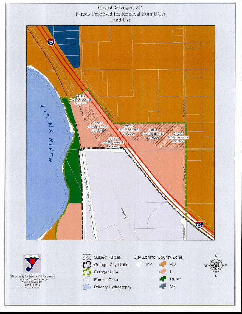
from Industrial to Valley Rural. Five maps attached to this staff report indicate the
subject area and the proposed changes:
1. Parcels Proposed for Removal from UGA (Urban Growth Area)
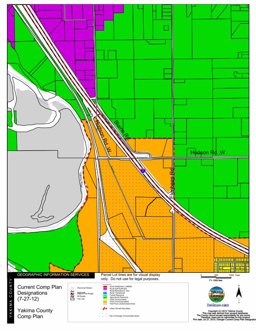
2. Current Comprehensive Plan Designations
3. Proposed Comprehensive Plan Designations
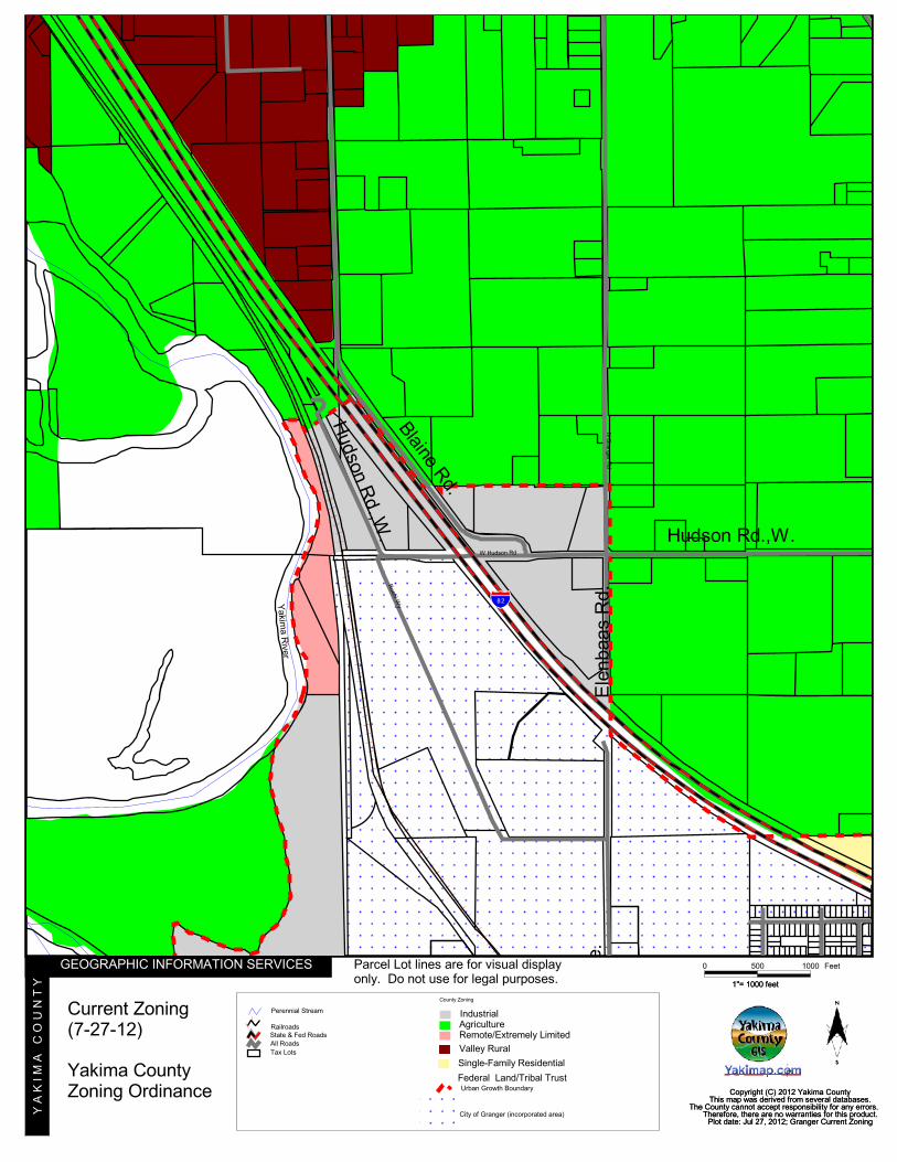
4. Current Zoning
5. Proposed Zoning
After the application was submitted, the Board of County Commissioners adopted
Resolution No. 275-2012 that declared an emergency, as provided by the Growth
Management Act, and directed that the application be considered as soon as possible

ZON2012-03
Granger UGA Reduction and Major Rezone
Page 2 of 11
in accordance with RCW 36.70A.130(2)(b)1. Without the emergency declaration, YCC
16B.10.040(5) provides that the application would have to be considered several years
in the future during the next interval for considering UGA boundary amendments.
Based on a review of the information contained in the application file, prior application
files, comments received during review under the State Environmental Policy Act
(SEPA), the determination of non-significance issued pursuant to SEPA, RCW 36.70A
(Growth Management Act), Plan 2015 (Yakima County Comprehensive Plan), YCC 15
(Yakima County Zoning Ordinance), and YCC 16B (Project Permit Administration), the
following findings, analysis, and conclusions are entered in support of the
recommendation for approval:
FINDINGS AND ANALYSIS
1. BACKGROUND: In 2004 the City of Granger submitted an application to amend Plan
2015 by adding 12 parcels and adjacent road and railroad rights-of-way (87 acres),
including the six parcels that are the subject of the current application, to its UGA.
The 2004 application also requested that the 87 acres be rezoned from Agriculture
to Industrial. The purpose of the 2004 application was to support a possible
additional I-82 interchange serving Granger at the Hudson Road overpass. This
interchange would have fostered needed industrial development in the area and
help Granger meet its economic development goals. The Board of County
Commissioners approved the UGA expansion and rezone in 2005 by adopting
Ordinance No. 10-2005.
Granger’s current application to reduce the size of the UGA provides the following
rationale: After the UGA was expanded in 2005, WSDOT informed Granger that the
anticipated interchange at the Hudson Road overpass cannot be built because it
would be too close to the existing interchange to the south. Without the
interchange, industrial development in the area is stymied due to limited access
appropriate for industrial development. With little possibility of redevelopment, the
low-density residential/agricultural nature of the subject parcels is better suited for
Plan 2015’s Rural Self-Sufficient designation and Valley Rural zone. Due to the current
Industrial zoning, the existing residential uses are nonconforming. This has resulted in
the inability of property owners to obtain financing or refinancing. While the
presence of nonconforming uses can help spur land use change, in this case the
City has determined that a change from residential to industrial uses is highly unlikely
due to the inability to obtain an I-82 interchange at Hudson Road.
2. JURISDICTION: This application proposes an amendment to Plan 2015’s policy plan
map and a simultaneous legislative rezone necessary to maintain consistency
between the comprehensive plan and the official zoning map2. Pursuant to YCC
16B.10.030(c) the Administrative Official has determined that this proposal is area-
wide in scope rather than site-specific.
1 RCW 36.70A.130(2)(b) provides that “…after appropriate public participation a county… may adopt
amendments or revisions to its comprehensive plan …whenever an emergency exists…” 2 YCC 16B.10.090
ZON2012-03
Granger UGA Reduction and Major Rezone
Page 3 of 11
YCC 16B.10.040(5) provides that amendments to UGA boundaries will only be
considered at five-year intervals. However, after receiving this application, the
Board of County Commissioners adopted Resolution No. 275-2012 that declared an
emergency and directed that the application be considered as soon as possible in
accordance with RCW 36.70A.130(2)(b).
As interpreted by Growth Management Hearing Board decisions, the GMA provides
that emergency amendments can only be considered “after appropriate public
participation”3. However, the public participation requirements of RCW 36.70A.140,
which are implemented by YCC 16B, do not apply to emergency amendments4;
and local governments have discretion to determine what “appropriate public
participation” will be taken before taking action on emergency amendments5.
When emergencies are declared, review by the Planning Commission is not
required6. Accordingly, the Board may find that appropriate public participation will
be achieved by following the County’s normal SEPA review, public notice, and
public hearing processes, but excluding review by the Planning Commission. The
Board of Yakima County Commissioners may hold a public hearing after notice, as
provided by YCC 16B, and afterwards make the final decision on this application.
3. PROJECT PROPOSAL: The proposal is to amend Plan 2015 (the Yakima County
Comprehensive Plan) by removing six parcels and adjacent road rights-of way from
Granger’s Urban Growth Area and changing Plan 2015’s designation of these six
parcels from UGA to Rural Self-Sufficient (RSS). The application also requests that the
subject property be rezoned from Industrial (I) to Valley Rural (VR).
4. PROJECT LOCATION: The subject property is located north of W. Hudson Road, on
the east and west sides of I-82, adjacent to and outside of the city limits of Granger,
WA. Parcel numbers: 211008-44003, 211009-33011, 211009-33012, 211009-33007,
211009-34002, and 211009-34004.
5. PROPERTY DESCRIPTION: The project area is approximately 40 acres, consisting of 27
acres in six privately-owned parcels and 13 acres in adjacent road rights-of-way
(including I-82). No critical areas are known to exist on the property.
Quincy loamy fine sand is the soil type throughout the site. These soils are considered
suitable for home sites, crops, and wildlife habitat.
6. COMPREHENSIVE PLAN DESIGNATION:
a. Subject property. The Yakima County Comprehensive Plan (Plan 2015)
designates the parcels as “Urban (Urban Growth Area).” The adjacent road
rights-of-way are not designated.
b. Adjacent property. Properties to the north and east are designated “Agricultural
Resource.” Properties to the west and south are designated “Urban (Urban
Growth Area)” and “Urban (City Limits).”
3 CPSGMHB: Bear Creek, 95-3-0008c, 11-3-00 Order, at 9-10 4 CPSGMHB: Wallack I, 96-3-0025, FDO, at 12 5 CPSGMHB: McVittie V, 00-3-0016, FDO, at 23-24 6 CPSGMHB: Sno-King, 06-3-0005, FDO, at 10

ZON2012-03
Granger UGA Reduction and Major Rezone
Page 4 of 11
7. ZONING:
a. Subject property. The subject property, including the unincorporated road rights-
of-way, are zoned “Industrial” by the Yakima County Zoning Ordinance (YCC
15).
b. Adjacent property. Properties to the north and east are zoned “Agriculture” by
the Yakima County Zoning Ordinance (YCC 15). Unincorporated properties to
the west and south are zoned “Industrial.” Properties to the south that are within
Granger’s city limits are zoned “Light Industrial” by the City of Granger.
8. EXISTING LAND USE:
a. Subject property. The three parcels east of I-82 are 2.15 acres, 12.92 acres, and
3.67 acres. Each parcel has a house is growing agricultural crops. A billboard
facing westbound I-82 traffic was placed on parcel 211009-33007 in or after 2008
(CUP2008-00003). It is a permitted use in the Industrial zone and would become a
legal nonconforming use if the property is rezoned to Valley Rural.
The three parcels west of I-82 are 1.71 acres, 7.45 acres, and 0.44 acres and are
owned by one couple. One house and agricultural crops exist on these three
parcels.
Each of the four houses uses wells and septic systems.
b. Adjacent property.
Properties to the north, east, and south have houses and agricultural crops.
The property to the west has a transportation trans-shipping facility that transfers
livestock feed between trains and trucks. This property was added to the UGA in
2005 and rezoned to Industrial along with the subject property. The property
owners elected not to be included in the current application because they wish
to remain in the UGA and zoned Industrial, so that their current use remains a
permitted use. If their zoning were changed from Industrial to Valley Rural, their
trans-shipping facility would become a legal nonconforming use.
9. PUBLIC NOTICE / ENVIRONMENTAL REVIEW:
On July 27, 2012 Yakima County, pursuant to RCW 36.70A.106, sent “60-day” notice
of Granger’s application to Washington State Department of Commerce, which
acknowledged receipt on July 30, 2012. No comments have been received from
Commerce as of the date of this staff report, and particularly during the 60-day
comment period that ended on September 28, 2012.
On January 28, 2013, after reviewing the application and pursuant to YCC 16.04,
Yakima County’s SEPA Responsible Official issued a Determination of Non-
Significance (DNS) on the proposal and issued a notice requesting comments on the
proposal’s probable significant adverse environmental impacts during a 14-day
public comment period ending on February 11, 2013. The DNS, environmental
checklist, and request for comments were mailed to interested or affected
ZON2012-03
Granger UGA Reduction and Major Rezone
Page 5 of 11
agencies, agencies with jurisdiction or expertise, Yakama Nation, the applicant, and
the owners of the subject properties. A notice of the DNS and a request for public
comments was also published in the Yakima Herald-Republic on February 1, 2013.
Pursuant to YCC 16B, notice of the DNS and a request for public comments was also
posted on the County’s website and on the public bulletin board in the Public
Services Department. Comments received by the end of the public comment
period are summarized below:
a. Department of Ecology Comments. The site might contain residual
concentrations of pesticides based on historical agriculture use. Ecology
recommends the soils be sampled and analyzed for lead, arsenic, and
organochlorine pesticides and that potential buyers be notified of any
concentrations above the Model Toxics Control Act cleanup levels.
Staff finding: The applicant or property owners should contact the
Department of Ecology if they would like more information or to have the
soils tested.
b. Sunnyside Valley Irrigation District Comments. SVID does have facilities within the
parcels that may hinder the proposed development. SVID requests contact as to
the location and specific information about crossing and/or encroaching on
these facilities. Runoff and/or crossings into or across SVID facilities will not be
allowed unless it is approved through the permitting process. Building will not be
allowed within SVID easements or right-of-way. Obstructions will not be allowed
within SVID easements or right-of-way without permits.
Staff finding: No development is proposed by the current application.
Property owners should contact SVID if they plan future developments
that would impact SVID facilities.
c. Subject Property Owner Comments. One of the subject property owners
requested that the application be approved so that the zoning will better reflect
the correct and foreseeable usage.
Staff finding: Granger’s application included letters from all owners of the
subject properties. All owners support the application to reduce Granger’s
UGA, to change Plan 2015’s designation from UGA to RSS, and to rezone
their land from Industrial to Valley Rural.
On March 26, 2013 the SEPA Responsible Official completed SEPA review by
retaining the DNS issued on January 28, 2013.
Notices of the Board of County Commissioners’ public hearing on this matter should
be provided in accordance with YCC 16B immediately after the Board sets its
hearing date. Written comments received will be provided to the Board at or prior
to the hearing.
10. APPROVAL CRITERIA:
The criteria that are to be considered when deciding whether or not to approve the
request are provided in:

ZON2012-03
Granger UGA Reduction and Major Rezone
Page 6 of 11
(a) YCC 16B.10.090 (Major Rezones);
(b) YCC 16B.10.095 (Approval Criteria for Comprehensive Plan Policy Map Amendments); and
(c) YCC 15.76.036(3) (Decision Criteria for Major Rezones).
The applicable text from the three ordinances listed above is shown below in italics,
followed by staff analysis:
(a) YCC 16B.10.090 (Major Rezones)
Legislative rezones necessary to maintain consistency between the comprehensive plan policy
map and the official zoning map shall be completed concurrently with the plan amendment
process wherever appropriate. … Rezones completed as part of the plan amendment process shall
be reviewed against the criteria as for plan amendments in Section 16B.10.095 (Approval
Criteria for Comprehensive Plan Policy Map Amendments) and Section 15.76.036 (Major Rezone
Review Process) … and must be consistent with the requested plan designation…7.
Staff analysis: The criteria in Section 16B.10.095 and in YCC 15.76.036 are
shown in italics below and followed by staff analysis. According to Table 15.76
in the Yakima County Zoning Ordinance (YCC 15) the proposed Valley Rural
zone is consistent with the requested Rural Self-Sufficient Plan 2015
designation.
(b) 16B.10.095 (Approval Criteria for Comprehensive Plan Policy Map Amendments)
(1) The following criteria shall be considered in any review and approval of amendments to
Yakima County Comprehensive Plan Policy Plan Maps:
(a) The proposed amendment is consistent with the Growth Management Act and
requirements, the Yakima County Comprehensive Plan, the Yakima Urban Area
Comprehensive Plan and applicable sub-area plans, applicable city comprehensive
plans, applicable capital facilities plans and official population growth forecasts and
allocations;
Staff analysis: The proposed amendment is consistent with the
stated documents.
(b) The site is more consistent with the criteria for the proposed map designation than it is
with the criteria for the existing map designation;
Staff analysis: The mapping criteria for Urban Growth Areas (UGA)
and Rural Self-Sufficient Areas (RSS) are found in the Land Use
Element of Plan 2015. Due to the current lack of municipal water
and sewer services and road infrastructure to serve the subject
area for urban industrial uses and the lack of capital facilities plans
for same, the area is more consistent with RSS than with UGA.
(c) The map amendment or site is suitable for the proposed designation and there is a lack
of appropriately designated alternative sites within the vicinity;
7 References in YCC 16B.10.090 to the Yakima County Urban Growth Area and to rezones not requiring a
plan amendment are not applicable to the subject request and have therefore been omitted.

ZON2012-03
Granger UGA Reduction and Major Rezone
Page 7 of 11
Staff analysis: The parcel sizes and current land uses make the
subject area suitable for RSS. The vicinity lacks neither RSS nor UGA
in the vicinity.
(d) For a map amendment, substantial evidence or a special study has been furnished that
compels a finding that the proposed designation is more consistent with comprehensive
plan policies than the current designation;
Staff analysis: The subject area was originally included in Granger’s
UGA to facilitate the development of a new freeway interchange
and industrial development. Granger’s application provides
evidence that WSDOT is unable to construct an interchange at this
location because it would be too close to the existing interchange
to the south. Additionally, there are no plans to provide urban
services to this area. Therefore, the current UGA designation is
inconsistent with the UGA mapping criterion that states, “The
County and the respective city or town have mutually determined
that urban services will be present within the 20-year time frame of
the plan.” The parcel sizes and their current land uses make the
area more consistent with the RSS plan designation than with the
UGA designation.
(e) To change a resource designation, the policy plan map amendment must be found to do
one of the following:
(i) Respond to a substantial change in conditions beyond the property owner’s
control applicable to the area within which the subject property lies; or
(ii) Better implement applicable comprehensive plan policies than the current
map designation; or
(iii) Correct an obvious mapping error; or
(iv) Address an identified deficiency in the plan. In the case of Resource Lands,
the applicable de-designation criteria in the mapping criteria portion of the
land use subchapter of Yakima County Comprehensive Plan, Volume 1,
Chapter I, shall be followed. If the result of the analysis shows that the
applicable de-designation criteria has been met, then it will be considered
conclusive evidence that one of the four criteria in paragraph (e) has been
met. The de-designation criteria are not intended for and shall not be
applicable when resource lands are proposed for re-designation to another
Economic Resource land use designation;
Staff analysis: Not applicable. This application does not propose to
change a resource designation.
(f) A full range of necessary public facilities and services can be adequately provided in an
efficient and timely manner to serve the proposed designation. Such services may
include water, sewage, storm drainage, transportation, fire protection and schools;
Staff analysis: There are no urban services or plans for urban
services in the subject area. However, it currently has the necessary
public facilities and services for the proposed RSS plan designation.
(g) The proposed policy plan map amendment will not prematurely cause the need for nor
increase the pressure for additional policy plan map amendments in the surrounding
area.
ZON2012-03
Granger UGA Reduction and Major Rezone
Page 8 of 11
Staff analysis: The owners of the parcels to the west and south of
the subject area that were added to the UGA in 2005 were asked
by Granger if they wanted their properties to be included in this
application. Both indicated that they preferred to remain in the
UGA. Therefore, additional policy plan map amendments in the
surrounding area are not anticipated.
(2) The following criteria shall be considered in any review and approval of changes to Urban
Growth Area (UGA) boundaries:
(a) Land Supply:
(i) The amount of buildable land suitable for residential and local commercial
development within the incorporated and the unincorporated portions of the
Urban Growth Areas will accommodate the adopted population allocation and
density targets;
(ii) The amount of buildable land suitable for purposes other than residential and
local commercial development within the incorporated and the unincorporated
portions of the Urban Growth Areas will accommodate the adopted forecasted
urban development density targets within the succeeding twenty-year period;
(iii) The Planning Division will use the definition of buildable land in YCC
16B.02.045, the criteria established in RCW 36.70A.110 and .130 and
applicable criteria in the Comprehensive Plan and development regulations;
(iv) The Urban Growth Area boundary incorporates the amount of land determined
to be appropriate by the County to support the population density targets;
Staff analysis: The proposed UGA reduction does not affect residential
and local commercial development because the subject area’s
zoning does not allow such uses due to being zoned Industrial. The
lack of plans for urban infrastructure, particularly a freeway
interchange, makes the subject area unsuitable for “purposes other
than residential and local commercial development.” In 2007 Yakima
County reviewed the appropriate amount of land in Granger’s UGA
to support population density targets and revised the UGA
accordingly. The issue of buildable lands is being addressed in the
next periodic UGA review required by the GMA to be completed by
2017.
(b) Utilities and services:
(i) The provision of urban services for the Urban Growth Area is prescribed, and
funding responsibilities delineated, in conformity with the comprehensive plan,
including applicable capital facilities, utilities, and transportation elements, of
the municipality;
(ii) Designated Ag. resource lands, except for mineral resource lands that will be
reclaimed for urban uses, may not be included within the UGA unless it is
shown that there are no practicable alternatives and the lands meet the de-
designation criteria set forth in the comprehensive plan.
Staff analysis: No plans for capital facilities, utilities, or transportation
exist to provide urban level services to the subject area. Therefore,
removal of the subject area from the UGA is consistent with this
consideration. Designated Agricultural Resource lands are not
involved with the application.

ZON2012-03
Granger UGA Reduction and Major Rezone
Page 9 of 11
(3) Land added to or removed from Urban Growth Areas shall be given appropriate policy plan
map designation and zoning by Yakima County, consistent with adopted comprehensive
plan(s).
Staff analysis: Based on existing parcel sizes and land uses in the subject
area, the most appropriate plan designation and zoning after removal
from the UGA would be RSS and Valley Rural, respectively. The property
owners all support the proposed change to RSS and VR.
(4) Cumulative impacts of all plan amendments, including those approved since the original
adoption of the plan, shall be considered in the evaluation of proposed plan amendments.
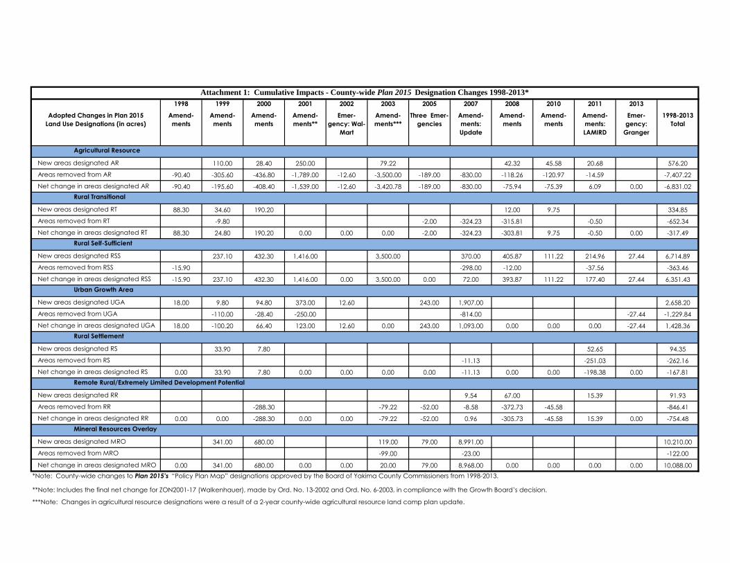
Staff analysis: A table showing the cumulative impacts is Attachment 1 to
this staff report.
(5) Plan policy and other text amendments including capital facilities plans must be consistent
with the GMA, SMA, CWPP, other comprehensive plan goals and policies, and, where
applicable, city comprehensive plans and adopted inter-local agreements.
Staff analysis: Not applicable. The application does not change plan
policy or text.
(6) Prior to forwarding a proposed development regulation text amendment to the Planning
Commission for its docketing consideration, the Administrative Official must make a
determination that the proposed amendment is consistent with the GMA, CWPP, other
comprehensive plan goals and policies, and, where applicable, city comprehensive plans
and adopted inter-local agreements.
Staff analysis: Not applicable. The application does not propose to
amend text of a development regulation.
(c) YCC 15.76.036(3) (Decision Criteria for Major Rezones)
The Planning Commission shall issue a written recommendation to approve, approve subject to a
development or concomitant agreement, modify or deny the proposed comprehensive plan
amendment/major rezone. The recommendation shall include the following considerations:
(a) The extent to which the proposed amendment/major rezone is consistent with and/or deviates
from the goals, objectives, mapping criteria and policies adopted in the comprehensive plan
and the intent of this title;
Staff analysis: The proposed amendment/major rezone is very consistent
with the goals, objectives, mapping criteria and policies in Plan 2015 and
with the intent of YCC 15.
(b) The adequacy of public facilities, such as roads, sewer, water and other public services
required to meet urban or rural needs;
Staff analysis: The current public facilities are adequate to meet rural
needs and do not meet urban industrial needs. There are no plans to
provide urban public facilities. Therefore the subject area’s plan
designation is more appropriately RSS than UGA.

ZON2012-03
Granger UGA Reduction and Major Rezone
Page 10 of 11
(c) The public need for the proposed change. Public need shall mean that a valid public purpose,
for which the comprehensive plan and this title have been adopted, is served by the proposed
application. Findings that address public need shall, at a minimum, document:
(i) Whether additional land for a particular purpose is required in consideration of the
amount already provided by the plan map designation or current zoning district within
the area as appropriate; and,
Staff analysis: Because a new freeway interchange will not be built as
earlier anticipated, the subject area will not be able to accommodate
future industrial development. A public need is therefore served by
changing the existing land uses from nonconforming uses to permitted
uses. Keeping these properties as nonconforming land uses serves no
public purpose, now that it has been determined that the freeway
interchange will not be built.
(ii) Whether the timing is appropriate to provide additional land for a particular use.
Staff analysis: The timing is appropriate to eliminate these properties as
being nonconforming uses.
(d) Whether substantial changes in circumstances exist to warrant an amendment to the current
designation or zone.
Staff analysis: The absence of plans to build a freeway interchange is a
substantial change in circumstances that warrants amending Plan 2015
and rezoning the subject area as proposed.
(e) The testimony at the public hearing; and
Staff analysis: A public hearing has not yet been held. The Board should
conduct a hearing and consider all testimony prior to making a decision
on this application.
(f) The compatibility of the proposed zone change and associated uses with neighboring land
uses; and,
Staff analysis: The proposed VR zone and existing rural homes will be
compatible with neighboring land uses.
(g) The suitability of the property in question for uses permitted under the proposed zoning; and,
Staff analysis: The subject property is very suitable for the existing homes
and agriculture being conducted. It is also generally suitable for the
possible uses that could be permitted in the VR zone.
(h) The recommendation from interested agencies and departments.
Staff analysis: Neither the Department of Ecology nor SVID made a
recommendation concerning the rezone.

ZON2012-03
Granger UGA Reduction and Major Rezone
Page 11 of 11
CONCLUSIONS
1. The proposal meets the approval criteria and is consistent with the considerations as
provided and analyzed above.
2. No probable significant adverse environmental impacts have been identified. An EIS
is not required at this time.
RECOMMENDATION
The Yakima County Planning Division recommends APPROVAL of the City of Granger’s
application to amend Plan 2015’s policy plan map and major rezone, subject to
consideration of testimony received at the Board’s public hearing.
g:\long range\projects\plan amendments\2012 plan amendments\granger uga\zon2012-03_granger_uga_reduction_staff_recommendation.docx
1998 1999 2000 2001 2002 2003 2005 2007 2008 2010 2011 2013
Amend-
ments
Amend-
ments
Amend-
ments
Amend-
ments**
Emer-
gency: Wal-
Mart
Amend-
ments***
Three Emer-
gencies
Amend-
ments:
Update
Amend-
ments
Amend-
ments
Amend-
ments:
LAMIRD
Emer-
gency:
Granger
1998-2013
Total
110.00 28.40 250.00 79.22 42.32 45.58 20.68 576.20
-90.40 -305.60 -436.80 -1,789.00 -12.60 -3,500.00 -189.00 -830.00 -118.26 -120.97 -14.59 -7,407.22
-90.40 -195.60 -408.40 -1,539.00 -12.60 -3,420.78 -189.00 -830.00 -75.94 -75.39 6.09 0.00 -6,831.02
88.30 34.60 190.20 12.00 9.75 334.85
-9.80 -2.00 -324.23 -315.81 -0.50 -652.34
88.30 24.80 190.20 0.00 0.00 0.00 -2.00 -324.23 -303.81 9.75 -0.50 0.00 -317.49
237.10 432.30 1,416.00 3,500.00 370.00 405.87 111.22 214.96 27.44 6,714.89
-15.90 -298.00 -12.00 -37.56 -363.46
-15.90 237.10 432.30 1,416.00 0.00 3,500.00 0.00 72.00 393.87 111.22 177.40 27.44 6,351.43
18.00 9.80 94.80 373.00 12.60 243.00 1,907.00 2,658.20
-110.00 -28.40 -250.00 -814.00 -27.44 -1,229.84
18.00 -100.20 66.40 123.00 12.60 0.00 243.00 1,093.00 0.00 0.00 0.00 -27.44 1,428.36
33.90 7.80 52.65 94.35
-11.13 -251.03 -262.16
0.00 33.90 7.80 0.00 0.00 0.00 0.00 -11.13 0.00 0.00 -198.38 0.00 -167.81
9.54 67.00 15.39 91.93
-288.30 -79.22 -52.00 -8.58 -372.73 -45.58 -846.41
0.00 0.00 -288.30 0.00 0.00 -79.22 -52.00 0.96 -305.73 -45.58 15.39 0.00 -754.48
341.00 680.00 119.00 79.00 8,991.00 10,210.00
-99.00 -23.00 -122.00
0.00 341.00 680.00 0.00 0.00 20.00 79.00 8,968.00 0.00 0.00 0.00 0.00 10,088.00
*Note: County-wide changes to Plan 2015’s “Policy Plan Map” designations approved by the Board of Yakima County Commissioners from 1998-2013.
**Note: Includes the final net change for ZON2001-17 (Walkenhauer), made by Ord. No. 13-2002 and Ord. No. 6-2003, in compliance with the Growth Board’s decision.
***Note: Changes in agricultural resource designations were a result of a 2-year county-wide agricultural resource land comp plan update.
Attachment 1: Cumulative Impacts - County-wide Plan 2015 Designation Changes 1998-2013*
Agricultural Resource
New areas designated AR
Areas removed from AR
Net change in areas designated AR
Adopted Changes in Plan 2015
Land Use Designations (in acres)
Net change in areas designated UGA
Rural Transitional
New areas designated RT
Areas removed from RT
Net change in areas designated RT
Rural Self-Sufficient
New areas designated RSS
Areas removed from RSS
Net change in areas designated RSS
Urban Growth Area
New areas designated UGA
Areas removed from UGA
Net change in areas designated MRO
Rural Settlement
New areas designated RS
Areas removed from RS
Net change in areas designated RS
Remote Rural/Extremely Limited Development Potential
New areas designated RR
Areas removed from RR
Net change in areas designated RR
Mineral Resources Overlay
New areas designated MRO
Areas removed from MRO
����������
��� �
��������
�������������������
�
�����
��������
�������
���������
�����������
���������� !����
������� !�!��"�#������������$�%�&�!�
'��������(!���������
)�!���*���������+��,��-���!������.
�����/������!����
����� �!!�����!�&�01/����� ��*2 �**�,���!��������!�3&!��/��������$�����!�����#����!������,�����,��!����������,�'���+1�,��-���!�.'���+'���,��-���!�.#�3$���!�&���3)���������
���,���&�!�����������*������������-����������/����!�����*���������-��-����� 456�4777�*��!456�4777�*��!
7 877 4777 #��!
���!��!�9�:����;���74�<���������)�����!�)��-������/������!�������!��!�9�:����;���74�<���������)�����!�)��-������/������!����
����=�1�0
�����)
�>�'� �$��
��>����1)�1 #>0�$1> � �?1)�
)�-�����!�+).��74���������)���!�)�-�����!�+).��74���������)���!�$������-�(���������*�������������!�������$������-�(���������*�������������!�������
$���)���!��,����!��,,�-!����-��������!��*��������������$���)���!��,����!��,,�-!����-��������!��*��������������$����*�����!������������(�����!����*���!����-���,!�$����*�����!������������(�����!����*���!����-���,!�
)�����!�)��-������/������!�����+;2�;24�.
�������)���!��)��-�����
���

����������
��� �
��������
�������������������
�
�����
��������
�������
���������
�����������
����� ������!���������"�!!�����!�#�$% �����"��&'"�&&�(���!��������!�)#!�� ��������*�����!�����+����!������(�����(��!����������(�,�����-.�!��#���!�/,����-,��������0!������/+�)*���!�#���).���������
���(���#�!�����������&������������1���������� ����!�����&���������1��1����� 234�2555�&��!234�2555�&��!
5 655 2555 +��!
���!��!�7�8����9���52�:������������1����.��1������ ������!�������!��!�7�8����9���52�:������������1����.��1������ ������!����
����;�%�$�����.
�<�,� �*��
��<����%.�% +<$�*%< �"�=%.�"
.�1�����!�-./��52���������.���!�.�1�����!�-./��52���������.���!�*������1�0���������&�������������!�������*������1�0���������&�������������!�������
*���.���!��(����!��((�1!����1��������!��&��������������*���.���!��(����!��((�1!����1��������!��&��������������*����&�����!������������0�����!����&���!����1���(!�*����&�����!������������0�����!����&���!����1���(!�
���1����.��1������ ������!�����-9'�9'2�/
�������.���!��.��1�����
��� ,��������0!���������
.�!���&���������-��(��1���!������/
����������"!����
�������"!�!��>�+������������*�?�#�!�
����
����
��
��� �
��������
�������������������
�
�����
��������
�������
���������
�����������
���� ��!�����
����"�� ������ �#�$ �������%��� �&����������'�����()����������� ���
*��� ����
)�������%��#+������+���
,��"���%� �����������-������������.����������/���� �����-���������.��.����� 012�0333�-�� 012�0333�-��
3 433 0333 )��
,�� �� �5�6����7���30�8��������������� �!�����,�� �� �5�6����7���30�8��������������� �!�����
����
9�*�:
������
�;�<
� �+
��
��;��,�*��* );:�+*; �'�&*��'
��.����� �=�>��30������������� ���.����� �=�>��30������������� �+������.�?���������-������������� �������+������.�?���������-������������� �������
+������� ��"���� ��""�. ����.�������� ��-��������������+������� ��"���� ��""�. ����.�������� ��-��������������+����-����� ������������?����� ����-��� ����.���" �+����-����� ������������?����� ����-��� ����.���" �
������ �!�������=7(�7(0�>
����������� ��!������;�����"�
���
�� ���-���������=��"��.��� ������>
<��������? ���������
+�$�%� ��������' � ��@�)������������
,���������' ����

����
����
��
��� �
��������
�������������������
�
�����
��������
�������
���������
�����������
��� ���!�"�����������#������������$����������%����"�����#���������$��$����� &'(�&)))�#��"&'(�&)))�#��"
) *)) &))) +��"
���"��"�,�-����.���)&�/������������$����0��������"��"�,�-����.���)&�/������������$����0�����
����1�2�3
�����4
�5�6� �7��
��5����24�2 +53�725 �8�924�8
4�$�����"�:4;��)&���������4���"�4�$�����"�:4;��)&���������4���"�7������$�<���������#�������������"�������7������$�<���������#�������������"�������
7���4���"�� ����"�� �$"����$��������"��#��������������7���4���"�� ����"�� �$"����$��������"��#��������������7����#�����"������������<�����"����#���"����$��� "�7����#�����"������������<�����"����#���"����$��� "�
���$����0������:.=�.=&�;
�������4���"��0������5����� ����
����������8"����
�������8"�"��>�+������������7�?�!�"�
6��������<"���������
4�"���#���������:�� ��$���"������;
+�������!��@7������7���"
2���"����
8�����=+�����������"���9�������������"�@�?"�������!���"����� ��"���
4���"��0�����

Exhibit B
DR
AINAG
E
31004
33011 34004
34002
33007
43404
43406
3200731003
42401
4340734005
33016
33012
33001
34006
34007
32008
41003
4101
5
41012
44003
44001
41016
44001
11002
11001
24004
22
90
0
12004
22003
13401
21402
21401
7157649
2
7170874
3
7159663
3
7159663
1
2
2
7157649
1
F.S.
F.S.
7170874
1
7170874
7159663
LO
T 5, 1
1. 70
SSE
2011
-039
LOT 1, 9.45
LOT 2, 34.40
T.L
. A7406
6
1
7624963
7376511
1
1
7655843
2
7655843
Inte
rsta
te H
wy 82
W Hudson R d
W H
ud
so
n R
d
Blain
e R
d
EL
LE
NB
OS
S
RO
AD
BU
RL
ING
TO
N N
OR
TH
ER
N
O. W
. R. B
. N. C
O.
T.L
. A7
406
6
HUDSON RD
EL
LE
NB
OS
S R
OA
D
SR
- 82
Ru
ehl W
y
Yakim
a R
iver
City of Granger
Granger City Lim its
Change Plan 2015 D esignation from
Urban to Rural Self-Suff icient; and
Rezone from Industrial to Valley Rural
UGA Boundary - No Change
UGA Boundary - Delete
Railroads
Tax Lots
UGA Boundary - Add
Pa rce l Lot line s are for visua l d isp la y
only. D o no t u se for lega l purp oses.
1"= 500 feet1"= 500 feet
0 400 800 Feet
Plot date: Apr 19, 2013; gugarPlot date: Apr 19, 2013; gugar
Y A K I M A C O U N T Y
G E O G R A P H I C I N F O R M A T I O N S E R V I C E S
Copyright (C) 2013 Yakima CountyCopyright (C) 2013 Yakima County
This map was derived from several databases. TheThis map was derived from several databases. The
County cannot accept responsibility for any errors.County cannot accept responsibility for any errors.
Therefore,there are no warranties for this product.Therefore,there are no warranties for this product.
Granger UGA ReductionFile No. Z ON 2012-03
BOC C decision