ntc glossary - australia's official weather forecasts ... · ntc glossary . 2010 . tidal...
TRANSCRIPT
NTC Glossary
2010
Tidal Terminology
absolute sea level
When sea level is referenced to the centre of the Earth, it is sometimes
referred to as “absolute”, as opposed to “relative”, which is referenced to a
point (eg. a coastal benchmark) whose vertical position may vary over time.
acoustic tide gauge
A unit which sends an acoustic pulse through free air down a sounding tube to
the water’s surface and measures the return time. The return travel time
though the air between a transmitter/receiver and the water surface below is
converted to sea level.
admittance
Used in the response method of tidal analysis, response method analysis
consists of determining a set of complex weights (typically five), which define
the admittance of the response system at a given frequency. Once known,
the admittance, combined with the known coefficients on the spherical
harmonics representing the tide-generating potential, can be used to deduce
the amplitude and phase of the usual harmonics (M2, S2, etc.). Admittance is
sometimes defined as the ratio of the spectra of the sea level and the
equilibrium tide (or tide-generating potential), and sometimes as the ratio of
their cross-spectrum and the spectrum of the equilibrium tide. Being a
complex quantity, it has both amplitude and phase.
(*) From the “Australian Hydrographic Office Glossary”

age of the tide
The delay in time between the transit of the moon and the highest spring tide.
Normally one or two days, but it varies widely. In other words, in many places
the maximum tidal range occurs one or two days after the new or full moon,
and the minimum range occurs a day or two after first and third quarter. In a
semi-diurnal tidal environment dominated by M2 and S2, the age in hours can
be computed using the formula (gS2 – gM2)/(M2 - S2), where gS2 and gM2 are
the phase lags (in degrees) from an analysis of the data, and M2 and S2 are
the speeds (in /hour). A similar formula can be devised for a diurnal
environment dominated by O1 and K1.
alias frequencies
Tidal frequencies that contain significant energy and are of higher frequency
than the Nyquist frequency, they result from folding of lower frequencies in the
power spectrum.
amphidrome
Maps of specific tidal constituents (eg. M2) are normally drawn with lines
connecting points of constant amplitude (co-range or co-amplitude lines)
and/or phase (co-phase lines) (Figure 1). The co-phase lines often appear
like spokes radiating out from a central hub - the "amphidrome" or "node".
Often a single map will show a number of these "amphidromic systems". The
co-range lines more or less encircle the amphidrome, where the constituent
amplitude is least.
Figure 1 A schematic of an amphidrome.
Dashed lines show amplitude (cm), increasing
away from the node. Solid lines show phase
(degrees), increasing counter-clockwise around
the amphidrome (typical of northern hemisphere
amphidromes).
(*) From the “Australian Hydrographic Office Glossary”
Amphidromes are resonance phenomena, with higher-frequency constituents
tending to have lesser areal extent. Whereas O1 has an amphidrome virtually
over the entire North Atlantic Ocean, M2 has two.
amplitude (*)
One half of the range of a constituent, tide or wave in general.
angular velocity
Rate of rotation, usually expressed in radians per unit time (as compared to
the more familiar cycles per second). Since there are 2π radians per cycle,
the angular velocity of Earth’s rotation is 2π radians/sidereal day, or 0.729211
x 10-4 radians/second.
aphelion
The point in the elliptical orbit of Earth or other planet when it is furthest from
the Sun.
apogee
The point in the Moon’s elliptical orbit when it is furthest from earth. At this
time, the tidal range tends to be reduced. The term "apogean" is sometimes
used to indicate this situation, but its opposite, perigean seems more
common.
apsides
The points in the orbit of a planet or moon which are the nearest and farthest
from the centre of attraction. In the Earth's orbit these are called perihelion
and aphelion, and in the Moon's orbit, perigee and apogee. The line passing
through the apsides of an orbit is called the line of apsides.
astronomical argument
The astronomical argument is essentially the same as the phase, but omitting
the term iat. For example, the solar day-based astronomical argument for the
constituent M1 is -s(t)+ h(t) + 90. Based on lunar days, it is simply 90. The
corresponding astronomical arguments for N2 are -3s(t) + 2h(t) + p(t) and -
s(t) + p(t). (In the shpNp' notation, which we recommend against, these are
written –3s + 2h + p and –s + p).
(*) From the “Australian Hydrographic Office Glossary”

atmospheric tides (*)
Variations in the sea level caused by the regular variations of atmospheric
pressure, especially in the tropics. See also radiational tides
azimuth (*)
A horizontal angle reckoned clockwise from the meridian, especially the
horizontal direction of a celestial point from a terrestrial point, expressed as
the angular distance from a reference direction (hence often designated as
true, magnetic, compass or relative, depending on the reference). When
applied to current or stream, it is a direction toward which such a current or
stream is flowing, and usually reckoned from the north point.
See also celestial sphere.
baroclinic (*)
Referring to a condition and type of motion in which pressure is not constant
on surfaces of constant density, eg. internal tides and other internal waves.
See also internal tides
barotropic (*)
Referring to a condition and type of motion in which pressure is constant on
surfaces of constant density, eg. surface tides.
beat frequency
The mathematical representation of the spring/neap cycle is in terms of the two
signals (in this example the semi-diurnal tides M2 and S2) going in and out of
phase over the course of a fortnight. This phenomenon is known as "beats" or
"beating" and in the context of tides is not confined to M2 and S2. When any pair
of slightly-different frequencies (of similar amplitude) add together, their sum
undergoes a regular cycle between near-zero magnitude (“neaps”), and a
magnitude equal to the sum of the pair (“springs”). The period between
successive "neaps" is equal to the inverse of the absolute value of the difference
between the two frequencies. The frequencies of M2 and S2 are 1.9322 cpd and
2.0 cpd respectively; their difference is the beat frequency 0.0678 cpd, the inverse
of which, 14.75 days, is the beat period – also known as the fortnightly or spring-
neap cycle.
(*) From the “Australian Hydrographic Office Glossary”
benchmark (*)
A fixed physical object or mark used as a reference for a vertical datum. A
tidal benchmark is one near a tidal station to which a tide gauge/pole and tidal
datums are referred.
black moon
A mythological object supposedly existing at the site of the unoccupied focus
of the orbital ellipse traced out by the moon (the other focus being claimed by
the earth). It has no other astronomical or tidal significance, but has a place
in astrology.
bore (*)
A tidal type wave which propagates up certain rivers, especially in wedge-
shaped shoaling estuaries, at times of spring tides as a solitary wave with a
steep leading edge. Common in the estuaries discharging into the Gulf of
Papua. Also known elsewhere as eagre (England), pororóca (Brazil) or
mascaret (France).
See also tidal bore
bubbler
Bubblers are a form of pressure device, but the gauge and recording device
are located out of the water, the only submerged element being a nozzle to
which gas is continuously fed from a bottle. The flow is adjusted to continue
at a minimum rate when water level is near maximum. As the water level
drops, the back pressure on the gas in the line feeding the nozzle decreases.
The back pressure is recorded as a voltage level or its digital equivalent.
cadastre
A register of land/marine boundaries. At the coastline, the cadastral
boundaries are complicated by the changing nature of the waterline due to
tides etc.
(*) From the “Australian Hydrographic Office Glossary”
canal theory
An early mathematical attempt by Airy (1845) to explain the tidal motions by
using the hydrodynamic equations of motion. The boundary conditions were
unrealistic, treating the ocean as a canal with rigid vertical walls running
around the equator or other latitude.
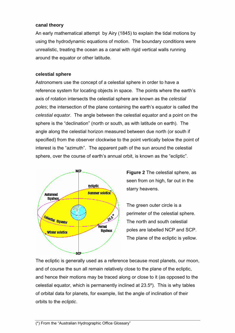
celestial sphere
Astronomers use the concept of a celestial sphere in order to have a
reference system for locating objects in space. The points where the earth’s
axis of rotation intersects the celestial sphere are known as the celestial
poles; the intersection of the plane containing the earth’s equator is called the
celestial equator. The angle between the celestial equator and a point on the
sphere is the “declination” (north or south, as with latitude on earth). The
angle along the celestial horizon measured between due north (or south if
specified) from the observer clockwise to the point vertically below the point of
interest is the “azimuth”. The apparent path of the sun around the celestial
sphere, over the course of earth’s annual orbit, is known as the “ecliptic”.
Figure 2 The celestial sphere, as
seen from on high, far out in the
starry heavens.
The green outer circle is a
perimeter of the celestial sphere.
The north and south celestial
poles are labelled NCP and SCP.
The plane of the ecliptic is yellow.
The ecliptic is generally used as a reference because most planets, our moon,
and of course the sun all remain relatively close to the plane of the ecliptic,
and hence their motions may be traced along or close to it (as opposed to the
celestial equator, which is permanently inclined at 23.5º). This is why tables
of orbital data for planets, for example, list the angle of inclination of their
orbits to the ecliptic.
(*) From the “Australian Hydrographic Office Glossary”

chart datum (CD) (*)
(or chart sounding datum): The datum or the plane of reference to which all
charted depths and drying heights are related [but not other heights and
elevations]. It is a level so low that the tide will not frequently fall below it.
Usually defined in terms of low-water level such as LAT or ISLW. Chart
datum is not a horizontal surface but may be considered as such over a
limited local area. In areas where the tidal range is not appreciable, less than
0.3 metres as in some parts of PNG, a chart datum of Mean Sea Level is
sometimes adopted. Chart Datum should preferably be the same as the
datum of tidal predictions for an area. Some ports, particularly on the SW
coast of Australia, employ a different chart datum for port charts than the chart
datum used for the coastal series of charts because the water level in such
ports is strongly affected by meteorological conditions and water level may fall
significantly below that of the predicted tide.
circadian rhythms
Biological processes which re-occur on a regular basis governed by an
internal timing mechanism are known as circadian rhythms. The timing may
be reset by environmental changes such as changing length of day. Some
animals also respond to tidal cycles, such as the spring-neap cycle. Some
crabs have both circadian and tidal behavioural cycles, with their colour
changing diurnally while their activity level varying over a period equal to the
spring-neap cycle (even when removed to an aquarium). Related biological
terms include circalunar (tied to the alignment of earth, moon, and sun) and
circatidal (tied to the ebb and flood of the tide) rhythms, both pertaining to
behaviour or physiology, which are usually found in littoral (nearshore
oceanic) species.
component (*)
1. Same as harmonic constituent. 2. Part of the tidal stream velocity, which,
after resolution into orthogonal vectors, acts in a specified direction (eg. north
or east).
(*) From the “Australian Hydrographic Office Glossary”
compound tide (*)
A harmonic constituent of a tide with a speed equal to the sum or difference of
the speeds of two or more elementary constituents. Usually associated with
shallow water effects.
constants
Harmonic tidal analysis represents the sea level record as the sum of cosine
waves. Each wave (or “constituent”) is uniquely identified by its frequency (or
“speed”); for a given location, each frequency has an amplitude and phase
which do not vary with time, and are hence known as “constants”. Tidal
currents may also be harmonically represented by tidal constants, by first
resolving them into north/south and east/west components (or along- and
across-stream components).
constituent see constants
co-phase line
Same as co-tidal lines.
co-range line (*)
Lines on a cotidal chart joining places which have the same tidal range or
amplitude. Usually drawn for a particular constituent or tidal condition (eg.
spring tides).
coriolis force
A moving body on the surface of the earth experiences a tendency to turn to
the left (right) in the southern (northern) hemisphere due to earth's rotation.
This tendency (which is an artifice of the rotating reference frame rather than
an actual force) is known as the Coriolis force (or acceleration) is only
noticeable with larger scale motions such as ocean currents and winds
(despite the myth of bathtub drain vortices rotating in opposite directions on
either side of the equator). The Coriolis force affects the direction with which
the tide propagates around an amphidrome and can also affect the
propagation of the tide as it moves up a broad channel (most noticeably by
tilting the water surface to the left or right of the direction of propagation).
(*) From the “Australian Hydrographic Office Glossary”
co-tidal line (*)
Lines on a cotidal chart joining places where tide has the same phase, for
example where high water occurs at the same time. Usually drawn for a
particular constituent or tidal condition.
datum (*)
1. Any numerical or geometrical quantity which may serve as a reference or
base for other quantities. In marine applications, a base elevation or plane
used as a reference from which to reckon heights or depths, plural: datums.
2. A single piece of information, plural: data.
day
The word day as commonly used refers to a mean solar day (msd) – the time
between successive transits of the sun overhead or across a single meridian.
The time required for earth to undergo a single revolution, known as a
sidereal day, is slightly less owing to the earth’s orbital motion. A sidereal day
is 0.9973 msd. The time between successive transits of the moon, known as
the mean lunar day, is 1.035 msd - slightly longer than a msd as a
consequence of the moon’s orbital motion.
declination (*)
The angular distance of an astronomical body north or south of the celestial
equator, taken as positive when north of the equator and negative when
south. The Sun moves through its declination cycle, between 23.5N and
23.5S, once a year, and the Moon moves through its cycle in 27.21 mean
solar days. The lunar declination varies from 28.5 to 18.5 over an 18.61
year period or a regression of lunar nodes cycle.
diurnal tides (*)
A tide with only one high water and one low water occurring during a tidal day.
Also known as single day tide, see also species
(*) From the “Australian Hydrographic Office Glossary”

diurnal inequality
The condition whereby the daily high waters or low waters are of significantly
different level.
dodge tide
Local South Australian term for a neap tide with minimal rise and fall over the
course of a day or so. While very “flat” neaps (see neap tide) occur in a
number of locations worldwide, the term “dodge” is used only in South
Australia. Professor Sir Robert Chapman, C.M.G., writing in the Official
Yearbook of the Commonwealth of Australia of 1938, stated “At spring tides
the range, due to the semi-diurnal waves, is 2(M2 + S2), and at neaps, if the
two are equal, or nearly equal, they practically neutralize one another and
cause no rise nor fall at all. This is what happens at Port Adelaide where at
this period the recording gauge shows frequently little or nothing in the way of
tide, in some cases the level of the water remaining almost constant for a
whole day; in other cases one small tide occurs during the day. On each side
of this tide is markedly irregular both as regards time and height, and the
apparent impossibility of saying when the tide will be at this particular period
has presumably gained for it its name ‘The Dodger’.”
The predicted times of high and low tides for Adelaide Outer Harbor on 10-11
August 2000 are given in Table 1.
Date Time Height (m)
10 0304 1.2 (Low)
10 1108 2.2 (High)
10 2114 1.4 (Low)
11 0248 1.5
(Dodge)
11 0357 1.5
(Dodge)
11 1415 2.2 (High)
11 2158 1.1 (Low)
Table 1 Instead of the normal
sequence of highs and lows, the
tidal level remained virtually
unchanged from 2114 on 10
August until 0357 on the following
day. The next high tide was not
reached until nearly 11 hours later.
(*) From the “Australian Hydrographic Office Glossary”

This is put in context with the August, 2000 time series of sea level at
Adelaide plotted below, with the dodge period encircled. Over most of the
month the tidal behaviour is typical of semi-diurnal regimes worldwide. It is
only the near-identity of the M2 and S2 amplitudes that give it its unique
character at neaps.
The Canadian Department of Fisheries and Ocean website glossary defines a
very similar phenomenon, which they call a "vanishing tide", defined thus: "the
phenomenon occurring when a high and low water 'melt' together into a
period of several hours with a nearly constant water level. The tide is in the
diurnal category but is known as a 'vanishing tide'." An example of this may be
found at Honiara, Solomon Islands, which exhibits a very flat period at neaps
(Figure 3). Honiara has a diurnal regime (dominated by K1 and O1). During
5/6 August 2000, the predicted sea level variation remained within a 10 cm
range for about nine hours, as opposed to a range at springs of about 90 cm.
The moon entered its first quarter on 7 August.
Me
tre
s
-1.5
-1
-0.5
0
0.5
1
1.5
Honiara Solomon Islands
1 2 3 4 5 6 7 8 9 10 11 12 13 14August 2000
Me
tre
s
-1.5
-1
-0.5
0
0.5
1
1.5
Adelaide Outer Harbor
Figure 3 Sea levels at Adelaide and Honiara. Intervals with virtually
no tidal variation are encircled. In Adelaide these intervals are called
the "Dodge Tide".
(*) From the “Australian Hydrographic Office Glossary”

doodson numbers (*)
A six digit number, with each digit describing a different characteristic of tide
according to a system developed by Doodson in 1921.
earth tide
A deformation of the solid earth in response to the gravitational tidal forces of
the sun and moon. The largest effect is the semi-diurnal deformation nearly in
phase with the transit of the moon; its amplitude is less than 20 cm. Being
nearly in phase with the tide-generating potential, and the absence of the
resonance and dynamic features of ocean flow, mean that in some respects
earth tides are closer to the Equilibrium Tide than are ocean tides. The
solutions to the equations of motion for an elastic, spherical earth can be
written in the form of vertical and horizontal displacements, plus a change in
potential due to the deformation. Each of these is a simple linear function of
the tide-generating potential, whose coefficients are known as the "Love
numbers", h2 (vertical displacement coefficient), l2 (horizontal displacement
coefficient), and k2 (coefficient of change in the potential). Note that these
refer to the deformation of the solid earth with no ocean. A similar set of
corrections to the ocean tides are described in self-attraction and loading.
ebb (*)
Usually the same as ebb stream, but sometimes used with reference to the
vertical tidal movement. Opposite to flood.
ecliptic (*)
The intersection of the plane of the Earth's orbit around the Sun (or apparent
orbit of the Sun around the Earth) and the celestial sphere, see also celestial
sphere
epoch
The time origin used to reference the longitudes of astronomical features such
as the lunar perigee. The word epoch is also used in at least two other very
different ways in tidal work – as a synonym for phase lag, and for a period of
time (usually a nodal cycle) over which a mean is calculated as the basis for a
tidal datum.
(*) From the “Australian Hydrographic Office Glossary”
equilibrium tide (*)
The hypothetical tide which would be produced by the lunar and solar
gravitational forces under the equilibrium theory in the absence of any other
ocean dynamics or terrestrial constraints.
equilibrium theory (*)
A theoretical model under which the waters covering uniformly the face of the
Earth respond instantly to the tide-producing forces of the Moon and Sun and
form an equilibrium under action of these forces. Friction, inertia, irregular
distribution of the land masses are all disregarded here, but the model
provides an important theoretical basis for tidal science.
eustatic sea level change
Global changes of sea level taking place over many years. Some authors
associate "eustatic" with ocean volume changes, others with globally
synchronous changes. However, such ocean surface displacements are now
understood to be spatially irregular (in some areas, even opposing the global
trend).
evection and variation
Two of many perturbations to the moon’s orbit caused by changes in the solar
gravitational potential during the course of the orbit, giving rise to the
evectional (1, 1, 1, 2 and 2) and variational (1, 2) constituents.
establishment of a port
Definitions vary, but it is essentially the same as the more modern term,
lunitidal interval.
(*) From the “Australian Hydrographic Office Glossary”

extended harmonic method
This term usually refers to an tidal analysis of 114 or more terms. Prior to the
work of Zetler and Cummings (1967) and Rossiter and Lennon (1968), tidal
harmonic analyses generally contained 64 or less constituents. Using
spectral analysis, these authors independently identified an additional 54
constituents (individual terms differed between the two) which subsequently
became a standard part of tidal analyses. The authors found that the
reduction in the variance of the residuals following the inclusion of the
additional terms was less than 10%.
flood (*)
Usually the same as flood stream, but sometimes used with reference to the
vertical tidal movement. Opposite to ebb, see also streams.
form factor
A factor used to characterise the tides in an area as being predominantly
diurnal, semi-diurnal, or mixed. Usually computed as (HK1 + HO1)/ (HM2 + HS2),
where H is the amplitude of the constituent in the subscript. The cut-off points
are usually: less than 0.25, semidiurnal; 0.25 to 3.0, mixed; greater than 3.0,
diurnal.
fortnightly tides
In most parts of the world, the tides go through a fortnightly "spring-neap"
cycle. These are beat phenomena rather than actual harmonics. There are,
however, harmonics arising directly from the tide-generating potential which
have a period of a fortnight (two weeks), the most important being Mf. The
harmonic MSf arises from interactions occurring in shallow water.
geoid (*)
an equipotential surface (ie. having the same potential gravity at each point)
that would be assumed by the sea level in the absence of tides, currents,
water density variations and atmospheric effects. It is the surface of reference
for astronomical observations and geodetic levelling, see also geopotential
(*) From the “Australian Hydrographic Office Glossary”
geopotential
A gravitational field can be characterised by a “potential”, the negative
gradient of which defines the strength and direction of the force exerted upon
a mass within the field. The earth’s gravitational potential is called the
geopotential. A geopotential surface is one whose potential is everywhere
equal. In the absence of planetary rotation and forces other than earth’s own
gravity, the ocean would be at rest and its surface would conform to a
geopotential surface known as the “geoid”. Such forces include wind stress,
density variations, and large-scale ocean waves. These may cause the mean
sea level to differ (locally but semi-permanently) from the geoid by as much as
a metre. The well-known 20 cm "head" of sea level between the Gulf of
Panama and the Caribbean, caused by the difference in water densities,
essentially means that the geoid passing through mean sea level on the
Caribbean side passes 20 cm below mean sea level on the Pacific side.
harmonic constants (*)
The amplitudes and phase lags of the harmonic constituents of the tide or
tidal stream at any place. Also known as tidal constants.
high water full and change (HWF&C)
Despite the name, HWF&C refers to a time interval, not a tidal plane. It is a
somewhat antique term essentially synonymous with lunitidal interval. The
“full and change” refers to full and new moon - the only part of the lunar cycle
when it was useful. As with lunitidal interval, its purpose was to indicate the
approximate delay following noon or midnight of the next high tide.
higher high water (HHW) (*)
The highest of the high waters of any specified tidal day due to the
declinational effects of the Moon and Sun.
highest astronomical tide (HAT)
The highest level of water which can be predicted to occur under any
combination of astronomical conditions.
(*) From the “Australian Hydrographic Office Glossary”
indian spring high/low water (*)
A tidal datum originated by Sir G. Darwin when investigating tides of India.
An elevation depressed below mean sea level by the amount equal to the
sum of amplitudes of the four main harmonic constituents: M2, S2, K1 and
O1.
inference of constituents
Given a tidal data set of insufficient duration, to separate a pair of constituents
of similar frequency, one may infer the amplitude and phase of one member
of the pair (generally the weaker) on the basis of an analysis of a longer data
set from a nearby location (or in the absence of any nearby data, the
equilibrium relationships). For a data set of less than one year, this approach
is routinely used for P1 (from K1), K2 and T2 (from S2), N2 (from M2), 2N2 and
ν2 (from N2), and Q1 (from O1), and many others can also be inferred. The
inference relationships between the two constituents must be accounted for in
the analysis.
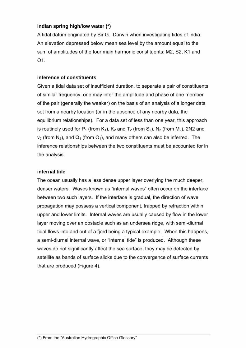
internal tide
The ocean usually has a less dense upper layer overlying the much deeper,
denser waters. Waves known as “internal waves” often occur on the interface
between two such layers. If the interface is gradual, the direction of wave
propagation may possess a vertical component, trapped by refraction within
upper and lower limits. Internal waves are usually caused by flow in the lower
layer moving over an obstacle such as an undersea ridge, with semi-diurnal
tidal flows into and out of a fjord being a typical example. When this happens,
a semi-diurnal internal wave, or “internal tide” is produced. Although these
waves do not significantly affect the sea surface, they may be detected by
satellite as bands of surface slicks due to the convergence of surface currents
that are produced (Figure 4).
(*) From the “Australian Hydrographic Office Glossary”
Figure 4 A NASA satellite photo showing internal waves. According to
the website, "In the Sulu Sea between the Philippines and Malaysia,
sunglint highlights delicate curving lines of internal waves moving to the
northeast toward Palawan Island." Photo credits: NASA.
http://earthobservatory.nasa.gov/Newsroom/NewImages/images.php3?
img_id=15334
intertidal zone
The part on a beach that lies between high and low tidal levels – sometimes
exposed, and sometimes inundated, depending on the tide. For legal
purposes, the high and low waters may be given more precise definitions,
such as “mean high water” and “mean low water”.
inverse barometer effect
An adjustment of the sea level to changes in barometric pressure; an increase
of barometric pressure of 1 mb corresponds with a fall in sea level of 1 cm.
(*) From the “Australian Hydrographic Office Glossary”
kappa phase
A notation used in older texts on ocean tides, and modern texts on earth
tides, may refer to phase in the (kappa) notation. This convention places
not only the tidal phase lag, but also the reference signal in the local time
zone. A phase lag given as n at longitude L can be converted to gn(UT) by
the formula: gn = n + iaL, where ia is the species (see § 2.2 and Chapter 6)
and L is positive (negative) for longitudes west (east) of Greenwich. See also
Doodson (1928), page 264, and the NOAA tidal glossary (NOS, 1989). Note
that for any given site, the conversion term, iaL, is the same for all tidal
constituents of a given species - thus, for example, 70º is added to all diurnal
constituents (ia = 1) at 70ºW to convert them from phase to g phase.
king tide
Term used colloquially in some parts of Australia and elsewhere for a
seasonal high tide often combined with onshore winds, or any exceptionally
high tide, in some cases due to a storm surge (see storm surge).
lagging of the tide
The retardation in the time of occurrence of high and low water due to
changes in relative position of the Moon and the Sun, see also lunitidal
interval.
Loading Love numbers see self-attraction and loading
Love numbers see earth tide
low water (LW) (*)
The lowest level reached by the water during one tidal cycle. Also called low
tide.
lower low water (LLW) (*)
The lowest of the low waters of any specified tidal day due to the declinational
effects of the Moon and Sun.
(*) From the “Australian Hydrographic Office Glossary”
lowest astronomical tide (LAT) (*)
The lowest tide level which can be predicted to occur under average
meteorological conditions and under any combination of astronomical
conditions. Increasingly used as chart datum, for example, for all new
Australian charts.
lunisolar tide
A tidal constituent whose origins are a combination of lunar and solar – that is,
by coincidence, there being identical forcing frequencies stemming from both
sources. The most important lunisolar tides are K1 and K2. A shallow-water
tide, Msf, arises from the interaction between M2 and S2.
lunitidal interval
The time interval between the moon’s transit (overhead or below) and the
following high tide. On the day of new or full moon, the moon’s transit
coincides with the sun’s, providing a simple way to estimate the lunitidal
interval – it is the number of hours after noon of the next high tide on that day.
Formulae are sometimes given – for example, if the local phase lag of the
moon’s primary constituent, M2, is known, multiply it by 0.0345 (0.0345 being
equal to the period of M2 , 12.42 hours, divided by 360). At Auckland, the
phase lag of M2 is 204 so the interval is seven hours according to the
formula. A look at a tide table for Auckland reveals that at new and full
moons, the first high tide after noon is, indeed, usually at about 7 p.m. At
Outer Harbor, Adelaide, the M2 phase is 106.6, so according to the formula,
the lunitidal interval is 3.7 hours. The formula (and in fact the concept of
lunitidal interval) is of little practical value for locations where M2 is not the
dominant constituent. At Adelaide, where M2 and S2 share equal pre-
eminence, the actual high tide at new and full moons comes about 4½ to 5½
hours after noon (and midnight) – essentially an average between the lunitidal
and “solar-tidal” intervals (the latter being 6 hours). Note: for reasons
inscrutable to the practical man, some authors define lunitidal interval in terms
of the prime meridian and local high water.
(*) From the “Australian Hydrographic Office Glossary”

Since the lunar day is about 50 minutes longer than a solar day, the lunar
wave arrives about 50 minutes later each day at a typical semi-diurnal port.
On either side of a spring tide, this implies that the time of high tide first
catches up with and then passes the lunitidal interval. Mariners (naturally)
had a name for these decreasing and then increasing time delays: the
"lagging" and "priming" of the tides, respectively.
mean high water (MHW) (*)
A tidal level. The average of all high waters observed over a sufficiently long
period.
mean sea level (MSL) (*)
A tidal datum; the arithmetic mean of hourly heights of the sea at the tidal
station observed over a period of time (preferably 19 years).
meteorological tides
Periodical or quasi-periodical changes in water level caused by the daily or
seasonal variations in local meteorological conditions. They are recognised
principally by Sa, Ssa, and S1 constituents, see also radiational tides.
mixed tide
The type of tide characterised by large diurnal inequalities in heights and/or
times of successive high and/or low waters. In general, a type of tide
intermediate between predominantly semidiurnal and predominantly diurnal.
see also form factor.
month
There are four types of month used in astronomy and relevant to the tidal
gravitational potential. The moon completes a single orbit of the earth in a
sidereal month, equal to 27.3217 days (mean solar days). During this time,
the perigee has moved about 3 in its rotation of earth; consequently the time
between the moon successively being at perigee is 27.5546 months (the
anomalistic month). Similarly, during this time the lunar ascending node will
have undergone a regression of about 4.5 (thereby reducing the length of
time between successive passages of the moon through the ecliptic), thus
defining the slightly shorter nodical month of 27.2122 days. A synodic month
(*) From the “Australian Hydrographic Office Glossary”
is the time between successive full moons. Because the earth progresses in
its orbit around the sun while the moon is orbiting the earth, it takes longer
than a sidereal month for the lunar phases to repeat. The synodic month is
29.5307 days.
NGWLMS see SEAFRAME
nodal factors: Small adjustments to the amplitudes and phases of harmonic
constituents to allow for modulations over the 18.61-year nodal period. See
regression of lunar nodes.
nodal cycle
nonlinear tides (*)
Tides produced in shallow water or by frictional effects in general which have
periods equivalent to 4, 6, 8 or more cycles per day.
Nyquist frequency
The cutoff frequency determined by the sampling time interval h defined by
hfc 2
1
orthotide
An orthogonal set of functions consisting of linear combinations of the
coefficients on the spherical harmonics. The purpose of using these functions
instead of the original coefficients is to add stability and convergence to the
response method computation.
overtide (*)
A shallow water constituent with a speed that is a multiple of the speed of one
of the basic constituents of the tide-producing force.
(*) From the “Australian Hydrographic Office Glossary”

perigeal cycle see perigee
perigean tide
Tides of increased range occurring monthly as the result of the Moon being in
perigee. In some places (notably the Bay of Fundy) this modulation may
equal that of the spring-neap cycle. The moon is at perigee every 27.5546
days, but the time between full moons is 29.5307 days. Thus, these two
“beat” in and out of phase every 412 days. Since there are two spring tides
per period between full moons, the perigean tide and the spring tides come
into phase every 206 days. In terms of tidal analysis, the largest constituent
due to the ellipticity of the lunar orbit is N2. There are also constituents
associated with the ellipticity of the solar orbit, but because it is more circular
than the lunar orbit (i.e., its eccentricity is less than a third), these constituents
are much smaller. The opposite situation is known as apogean.
perigee
In the moon’s elliptical orbit around the earth, its point of closest approach is
known as perigee. Over time, the orientation of the orbit within the orbital
plane gradually rotates. As a consequence, the perigee circles the earth
every 8.85 years, a period known as known as the perigeal cycle (not to be
confused with perigean tide), and designated “p” in tidal literature. This is
distinct from the nodal cycle, in which the orbital plane itself rotates. The
moon is at perigee every 27.5546 days.
perihelion
The point of closest approach in the earth’s orbit around the sun. The sun is
at perihelion every 365.2596 days – currently this nearly coincides with the
start of the year (coincidentally midsummer in the southern hemisphere). The
perihelion itself circles the sun every 20,942 years, in a rotation analogous to
the perigeal cycle. The period is often designated "p " or "p1" in tidal
literature.
(*) From the “Australian Hydrographic Office Glossary”

Figure 5 Funafuti, Tuvalu – a photo of the southernmost islands of the
atoll, viewed from the southeast. The nation of Tuvalu is comprised of
nine coral atolls, the highest reaching an altitude of five metres. Tide
gauges operating in Tuvalu (Figure 5) since the late 1970's have
recorded a moderate rise in sea level (less than 3 cm), but spring tides
inundate low-lying areas in the early part of most years when the earth
is at perihelion. Photo credit: Allan Suskin.
phase lag (*)
The lag of the phase of the maximum of a tidal constituent behind the phase
of a reference wave (usually the phase of the corresponding equilibrium
constituent at Greenwich). Also called tidal epoch.
pole tide
small tide of varying period (approximately 433 days, but varying) associated
with changes in the earth axis of rotation known as the “Chandler Wobble”.
Ultimately, it can be said to fall in the class of radiational tides, since the
precession has been shown to be caused by oceanographic and
meteorological variations, which redistribute water masses. This precession
is independent of, and much smaller than, the precession of the equinoxes,
which has a period of 26,000 years (see year). The largest reported pole tide
is 30 mm, from the Gulf of Bothnia.
(*) From the “Australian Hydrographic Office Glossary”
primary port see standard port
prime meridian
The meridian of 0 longitude, known also as the Greenwich Meridian.
priming of the tide see lunitidal interval
quadrature
The condition whereby the angle formed by the sun, earth, and moon is 90.
See also syzygy.
radiational tides
A quasi-periodic rise and fall of sea level caused by meteorological variability,
hence also known as “meteorological tides”. Semi-diurnal radiational tides in
the tropics are thought to be due to semi-diurnal fluctuations in surface
barometric pressure forced at diurnal period at the top of the atmosphere
(sometimes called "atmospheric tide"). Diurnal radiational tides are often
caused by land/sea breezes or solar heating (note that neither of these forcing
functions are purely sinusoidal in time). Monsoonal winds may cause semi-
annual radiational tides on some coastlines. Annual heating of the
atmosphere and redistribution of air mass can both cause annual radiational
tides.
range
The difference between the maximum and minimum water levels during a
typical tidal cycle.
Rayleigh criterion (*)
A criterion used in tidal analysis, which requires that only constituents which
are separated by at least one complete period from their neighbouring
constituents over the length of data available should be included in the
harmonic analysis of a given time series. See also synodic period.
(*) From the “Australian Hydrographic Office Glossary”
rectilinear currents (*)
Also known as a reversing stream; a tidal stream which flows alternately in
approximately opposite directions with slack water at each reversal of
direction. Encountered mainly in straits and channels. See also streams
red tide
A discolouration of lake or sea water caused by an algal bloom having very
little to do with tides.
regression of lunar nodes
Since the clockwise or western rotational direction of the lunar nodes around
the ecliptic is opposite to that of most other rotations and orbits of the solar
system, it is said to be in regression.
relative sea level (*)
Mean sea level relative to the network of benchmarks on the adjacent land. It
may be composed of both the absolute mean sea level change and a vertical
land movement component. See also absolute sea level.
residuals
The difference between the observed sea level and the tidal prediction for a
given location. Residuals are most commonly due to: weather related effects,
limitations of the harmonic model, harbour seiches and errors in measurement
or data processing, all of which leave recognisable imprints in the data.
resonance
For any gulf or other body of water, there are certain resonant frequencies.
These depend primarily on its dimensions (breadth and depth). If forced at the
resonant frequency, water motions are amplified. For example, Spencer Gulf in
South Australia is "tuned" to K1. When the K1 wave enters the Gulf, its amplitude
is about 3.3 times larger than P1 (for which the Gulf is less well-tuned). The ratio
increases up the Gulf, going from 3.3 to about 5.0 at the head (top end). The
"ability" of Spencer Gulf to discriminate between two close frequencies (their
periods differ by less than 8 minutes) attests to the fact that ocean systems are
relatively lightly damped. Perhaps the most famous such case is the Bay of
Fundy, also mentioned in the context of perigean tides.
(*) From the “Australian Hydrographic Office Glossary”

response analysis
The representation of observed tidal variations as frequency-dependent
amplitude and phase responses to the forcing functions, usually the
gravitational and radiational tide-producing forces.
revolution without rotation
This intriguing phrase represents a useful simplification which is used in some
elementary texts on tides, in their discussion of the balance of gravitational
and centrifugal forces. According to that approach, the effect of the earth's
daily rotation is ignored, leaving only the centrifugal force associated with
"revolution", ie the earth-sun or earth-moon orbit. Actually, the term "ignored"
is not completely correct. The diurnal rotation is accounted for in the
gravitational field at the earth's surface (a vector field), which governs mean
sea level.
0000 1200 2400
o
o
o
o
o
Figure 6 Five successive views of the earth from above the North Pole.
Note that the path traced out by a point on the earth, symbolised by a
small black circle, never closes on itself. In fact, the waviness is
exaggerated - the actual path would appear nearly straight.
If an observer in space above the North Pole watched an illuminated point on
the surface of the earth (say, for example, at Kuala Lumpur), the point would
trace a wavy line as in Figure 6 – not a series of closed loops as one might
expect. This is because the earth travels through a distance of about 201
earth diameters every day on its orbit around the sun. For illustration, Figure
6 is drawn as if the distance were only eight earth diameters, so the true path
would appear far less wavy than shown.
(*) From the “Australian Hydrographic Office Glossary”

rip
A narrow shearing current flowing offshore through the surf zone. Sometimes
(misleadingly) called a rip tide. Rips are a part of a circulation cell forced by
surface wave transport, and have little to do with tides.
rotary flow (*)
A tidal stream that flows continually with the direction of flow changing through
all points of the compass during a tidal cycle. Usually found offshore where
there are no restricting barriers. This natural tendency of tidal flows (they
become rectilinear only when restricted) has its origins in the Coriolis force
and thus it tends to rotate counterclockwise in the southern hemisphere. See
also streams.
satellite altimetry
Remote sensing of the ocean surface height by satellite-mounted microwave
radar. Techniques have been developed for extracting the tidal constants for
the larger constituents from the satellite data, despite its sampling interval
which is generally about twenty times longer than the semi-diurnal period,
thus providing an accurate global ocean database of tidal constants, which
was previously restricted to areas close to coastal tide gauges and to
numerical models which were poorly constrained over wide areas of the
ocean surface.
SEAFRAME see acoustic tide gauge
secondary port
In the context of tide tables, a port for which predictions are required, but for
which insufficient data for a reliable harmonic analysis is available and hence,
predictions from the nearest standard port (see standard port) must be used
(with suitable corrections). Also called a subordinate port.
(*) From the “Australian Hydrographic Office Glossary”

secular trend
Long-term trend in any time series, such as one of sea level. “Secular” is
usually used to imply a background trend – for example, the trend over
several decades of annual sea level – but with the understanding that the
secular trend may vary if the length of the time series is significantly extended.
seiche
A standing wave in an enclosed or semi-enclosed body of water set off by
weather, seismicity, or incident ocean waves. Seiches are primarily a
resonance phenomenon, whose wavelength and period are determined by the
geometry. A characteristic feature is the existence of "nodes" - points of
minimum water level disturbance, but greatest horizontal currents - and
"antinodes", where the reverse occurs. Closed basins (e.g. Lake Geneva)
have antinodes at both ends, whereas open basins (e.g., Bay of Fundy) have
an antinode at the nearshore end and a node at the open ocean. The Bay of
Fundy is frequently cited as an example because it has a natural resonance
period close to semidiurnal, and hence the tidal range at the upper end are
large due to resonance. The fundamental modes of closed- and open-basin
seiches have periods of 2L(gH)-1/2 and 4L(gH)-1/2 respectively, where L is the
length of the harbour or embayment, H is the mean depth, and g is the
gravitational acceleration (9.8 m/s2). The factor (gH)1/2 is the shallow-water
wave speed. Higher order seiches of shorter period are also possible, in
which case the two formulas must be divided by n and (2n-1) respectively,
with n=1,2,3.. in both cases. The formula for the closed-basin mode is known
as "Merian's formula".
seismic sea wave see tsunami
(*) From the “Australian Hydrographic Office Glossary”

self-attraction and loading
The description of the tide-generating potential was simplified in several ways,
two of which were by ignoring the continuous re-distribution of mass that
occurs as the water moves in response to the tidal forces, and by ignoring the
warping of the elastic solid earth surface as the water level varies. These
effects are commonly combined into the term "self-attraction and loading"
(SAL). For each constituent, the global tide is represented as a summation
over spherical harmonics. Solutions to the tidal forcing equations are
displacements proportional to the "loading Love numbers" (h'n, l'n, and k'n).
The vertical and horizontal displacements are given by h'n and l'n respectively,
and the effect on the tide-generating potential is given by k'n. This set of
numbers forms the basis for modern computations of SAL. Some early ocean
tide models attempted to account for SAL or loading alone by subtracting
where is the water level anomaly, (negative when water level is less than
mean), and typically equalled 0.08 for SAL and 0.03 for loading alone. The
advent of accurate global tide models has enabled scientists to establish far
more accurate models of SAL which can estimate the appropriate adjustment
at each new time step, for each geographic point, for each tidal constituent
included in the model (Figure 7). See also Ray (1998) and Baker (1984).
(*) From the “Australian Hydrographic Office Glossary”

Figure 6 The "SAL tide" for M2: (top) Amplitude contours in mm;
(bottom) phase lag (degrees, UT). The phase contours are
broadly similar to those seen on maps of the global M2 tide.
Graphic courtesy of Richard Ray. (Note that the SAL function is
mathematically defined over land, but is not physically
meaningful except over oceans and large lakes.)
semi-diurnal tides (*)
Tide, having a period or cycle of approximately one-half of a tidal day.
set (*)
The direction towards which the current or tidal stream is flowing. see also
(*) From the “Australian Hydrographic Office Glossary”
sidereal (day) (*)
Of or pertaining to the stars; when applied to time or its units (eg. sidereal
day, month, etc.), it refers the motion to vernal equinox. see also day.
slack water (*)
The state of a tidal stream when its speed is zero or nearly so, especially the
moment when the reversing stream changes its direction. Also known as
slack tide or slack. see also streams.
solstitial tides
Tides occurring near the times of summer and winter solstice, when the sun is
overhead at the Tropic of Cancer or Capricorn. If the associated constituents
(K1 and P1) were predominant, the tide would be diurnal, with an annual
modulation at their beat frequency, i.e. at a period equal to the tropical year.
This being a rarity, the term is of minor currency. These tides seem to have a
stronger claim to the term “tropic tide” than those that inherited it, but at least
“solstitial” is unambiguous, if tongue-twisting.
species
The Doodson number ia for each constituent defines its “species”. Those of
period half-monthly and longer are assigned ia = 0; for periods approximately
diurnal, ia = 1; for periods approximately semi-diurnal, ia = 2; for periods
approximately ter-diurnal (one-third diurnal), ia = 3; quarter-diurnal, ia = 4; and
sixth-diurnal, ia = 6. The different species form distinct groups in a line
spectrum.
speed (of constituent) (*)
The rate of change in the phase of a constituent expressed in degrees per
hour. The speed is equal to 360° divided by the constituent period expressed
in hours.
(*) From the “Australian Hydrographic Office Glossary”
speed (of stream or current) (*)
The rate at which a stream or current flows; usually expressed in knots or
metres per second.
spring high or low water see tidal planes
spring tides or streams (*)
The tides of increased range or tidal streams of increased speed occurring
semimonthly near the times of full moon and new moon. see also fortnightly
cycle.
stand of tide (*)
The condition at high or low water when there is no perceptible change in the
height of tide for a period of time. Sometimes called platform tide.
see also streams.
standard port
In the context of tide tables, a port for which sufficient data is available in
order for a set of official predictions to be produced. Also known as a
"primary port", especially in North America.
stilling well (*)
A tide gauge which measures the sea level via a float moving in a well
connected to the sea through a small orifice which filters out any high-
frequency waves whilst admitting the long period tidal (and other) level
variations. see also tide gauges.
storm surge
The temporary piling-up of water at the coast due to onshore wind and/or low
barometric pressure. A storm surge combined with high tide can be
particularly dangerous, and even more so in the presence of wind-generated
waves. Negative surges (lowered water levels) are also possible. There is a
close association between tides and storm surges - the impact of a surge
often depends on the state of the tide, and the surge and tide waves may
interact over the shelf or as they move up an estuary.
(*) From the “Australian Hydrographic Office Glossary”
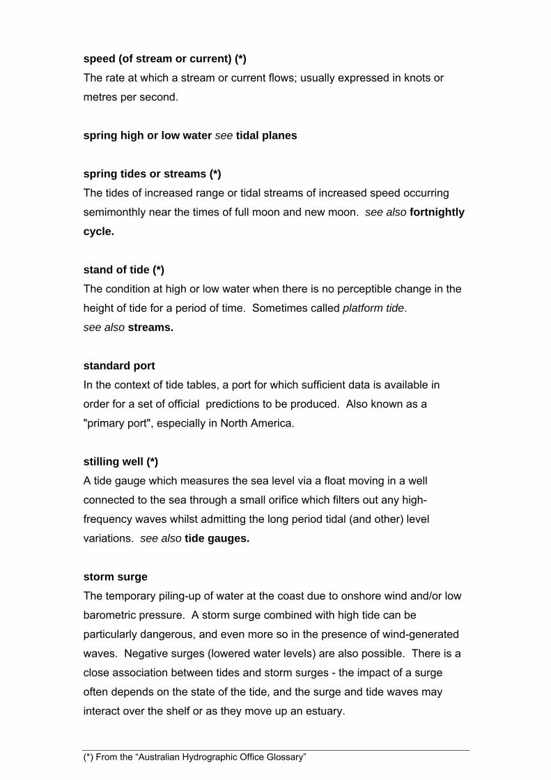
Storm surges are most often caused when a tropical cyclone (also known as a
"hurricane" or "typhoon"), generated over the open ocean, moves across the
shallower water of the continental shelf. The cyclonic wind circulation is
counter-clockwise in the northern hemisphere and clockwise in the southern
hemisphere. The strongest onshore winds - and thus, the shoreline with the
highest risk of water set-up - is thus to the right (left) of the direction in which
the storm is moving, in the northern (southern) hemisphere.
On 2 April 2000, Tropical Cyclone Tessi struck northeast Queensland,
Australia (Figure 8), bringing damage to property and uprooting trees. The
highest winds, flooding, and greatest damage, was reported at Townsville, to
the south of the point of landfall.
Figure 8 This map
of far north
Queensland and
the predicted track
of TC Tessi was
prepared by the
Joint Typhoon
Warning Center,
USNPMOC, Hawaii
(reproduced with
permission).
Times are in "Z"
(i.e., UT). The
dashed line
encircles the 24
hour warning area.
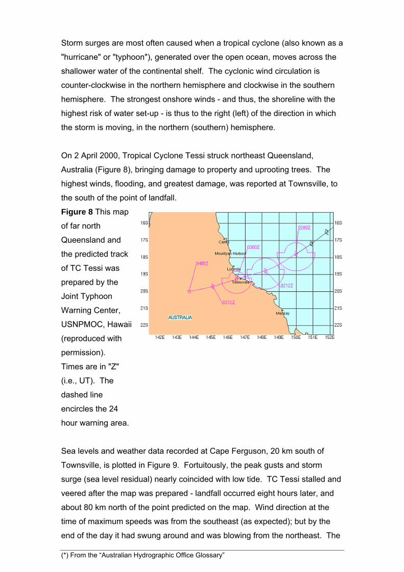
Sea levels and weather data recorded at Cape Ferguson, 20 km south of
Townsville, is plotted in Figure 9. Fortuitously, the peak gusts and storm
surge (sea level residual) nearly coincided with low tide. TC Tessi stalled and
veered after the map was prepared - landfall occurred eight hours later, and
about 80 km north of the point predicted on the map. Wind direction at the
time of maximum speeds was from the southeast (as expected); but by the
end of the day it had swung around and was blowing from the northeast. The
(*) From the “Australian Hydrographic Office Glossary”

arrival of the peak gusts after the lowest pressure is a little unusual. It may be
due to the cyclone veering and stalling before making landfall, or perhaps the
coastal topography. m
/s
10
20
Peak gust
m
1
2
3
Sea level
cm
0
20
40
60
80
02/APR/200001/APR/2000 03/APR/2000
Sea level residual
hP
a
1005
1010
Barometric pressure
Figure 6
Weather and
water level data
recorded by the
National Tidal
Centre (Bureau
of Meteorology)
SEAFRAME
gauge at Cape
Ferguson.
Barometric
pressure and
peak gust are
recorded on the
hour; sea level
is recorded at
six minute
intervals. Time
is UT.
If the alongshore progression of a tropical cyclone is close to the speed of a
long wave over the local shelf, resonance may occur and a shelf wave
generated. This can dramatically enhance the size of the storm surge. The
storm surge is thus a response to a combination of factors - high winds piling
up water against the coast, the inverse barometer effect, and the resonant
shelf wave.
strand line: The high water mark on a shoreline, typified by the presence of
flotsam and jetsam.
(*) From the “Australian Hydrographic Office Glossary”

streams
Same as tidal currents, although some hydrographic authorities use "streams"
to refer exclusively to the tidal currents along the principal directions of ebb
and flood (which may not differ by 180, but usually do!). The set of the
current is the direction in which it flows. On the incoming tide, the streams are
said to be in flood; the outgoing streams are in ebb. The stand of the tide
occurs near high and low water when the water level is unchanging. The
analogous term for streams is the slack water that may or may not occur at
the same time. Tidal streams which flow back and forth along a line are
rectilinear, whereas those that follow an elliptical circuit (due to the coriolis
force) are rotary (see also rotary flow). The ellipse traced out by a tidal
current vector in a rotary flow regime is called a tidal ellipse.
synodic period (*)
The minimum length of data necessary to separate a pair of constituents
according to the Rayleigh criterion.
synodical month (*)
The average period of the revolution of the Moon around the Earth with
respect to the Sun or the average interval between corresponding phases of
the moon. The synodical month is 29.5305888 mean solar days long. Also
known as lunation or lunar month. see also month
syzygy
The condition whereby the sun, earth and moon are in alignment. See also
quadrature.
TASK-2000 see tide software packages
terdiurnal (or third-diurnal) constituents
A harmonic constituent with three periods in a constituent day, indicated by
subscript 3. see also species.
(*) From the “Australian Hydrographic Office Glossary”
thermocline
A layer in which the temperature decreases significantly (relative to the layers
above and below) with depth. The principal ones are designated diurnal,
seasonal, and main thermocline. A common feature of thermoclines is the
presence of internal tides.
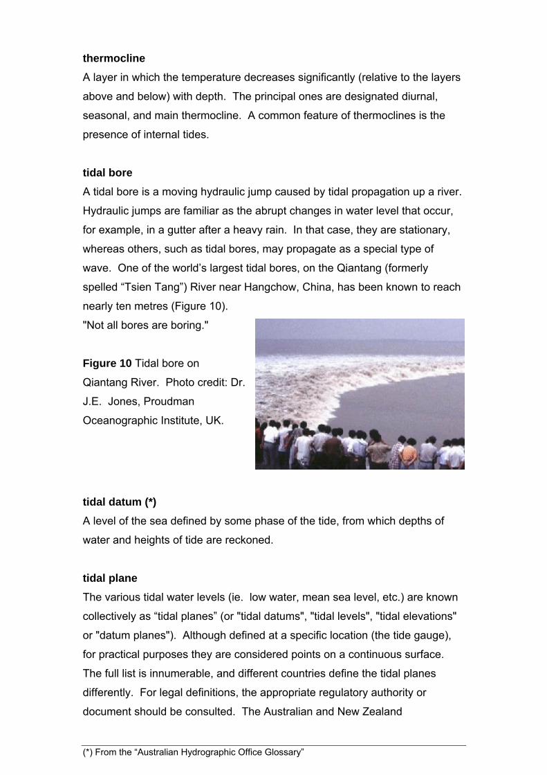
tidal bore
A tidal bore is a moving hydraulic jump caused by tidal propagation up a river.
Hydraulic jumps are familiar as the abrupt changes in water level that occur,
for example, in a gutter after a heavy rain. In that case, they are stationary,
whereas others, such as tidal bores, may propagate as a special type of
wave. One of the world’s largest tidal bores, on the Qiantang (formerly
spelled “Tsien Tang”) River near Hangchow, China, has been known to reach
nearly ten metres (Figure 10).
"Not all bores are boring."
Figure 10 Tidal bore on
Qiantang River. Photo credit: Dr.
J.E. Jones, Proudman
Oceanographic Institute, UK.
tidal datum (*)
A level of the sea defined by some phase of the tide, from which depths of
water and heights of tide are reckoned.
tidal plane
The various tidal water levels (ie. low water, mean sea level, etc.) are known
collectively as “tidal planes” (or "tidal datums", "tidal levels", "tidal elevations"
or "datum planes"). Although defined at a specific location (the tide gauge),
for practical purposes they are considered points on a continuous surface.
The full list is innumerable, and different countries define the tidal planes
differently. For legal definitions, the appropriate regulatory authority or
document should be consulted. The Australian and New Zealand
(*) From the “Australian Hydrographic Office Glossary”
Inter-governmental Committee on Surveying and Mapping (ICSM), Tidal
Interface Working Group, has compiled a Compendium of Terms (May 2003)
listing dozens of variations on terms such as "High Water Mark" and "Ordinary
Spring Tides" as they have been defined in various local, state, and national
entities over the years.
tidal prism
Where the tide moves up and down the lower reaches of a river, a volume,
known as the tidal prism, of fresh water is displaced each tidal cycle. The
tidal prism takes its name from the fact that the front between fresh and salt
water is often inclined to the vertical, with the downstream edge of the fresh
water riding over the salt.
tidal wave
The response of the ocean to the gravitational forcing of the sun and moon
includes the generation of various types of large-scale waves, generically
called tidal waves. Sometimes this term is used incorrectly as a synonym for
tsunami.
tidal pumping
This term is used in various contexts, including those of coastal aquifers and the
bringing of nutrient-rich offshore water into the shallower regions. In the former
case, the rise and fall of the tide is often accompanied by a delayed and reduced
oscillation of water level in nearby wells. The latter context usually involves a
relatively large flood tide bringing water up and into a bay or other semi-enclosed
area, where it mixes with water from previous high tides before draining more
slowly back to the open ocean. Submarine canyons across the continental shelf
may also cause a rectified flow with a net increase of nutrients in the upper layer.
(*) From the “Australian Hydrographic Office Glossary”

Time and tide: the English word for "time" goes back to an ancient Indo-
European form used about six thousand (6000) years ago: "dai-". By the
time people were speaking Germanic, about two thousand years ago,
"dai-" was being used in two Germanic words: "tídiz" (meaning "a division
of time"), and "tímon" (meaning something like "an appropriate time [at
which to do something]"). The "tídiz" word became Old English "tíd" and
then finally "tide".
- Adapted from Word Lore, http://hea-www.harvard.edu/ECT/Words/.
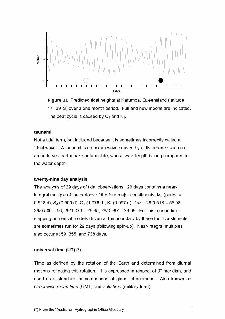
tropic tides
At latitudes near the maximum declination of the moon (which varies between
18.3 and 28.6 latitude north and south over the course of the nodal cycle)
the diurnal tides are greatest when the moon is near maximum declination.
These so-called “tropic tides” are the equivalent of the more common spring
tides, with the beat frequencies being diurnal (eg. O1 and K1) instead of semi-
diurnal. The beat period for O1 and K1 is 13.66 days. The tides at Karumba,
Queensland, which are dominated by O1 and K1, exhibit this pattern (Figure
11). The term may be slightly misleading in that the “Tropics” on the earth are
the latitudes 23.5 where the sun’s declination reaches its maximum (see
solstitial tides); nevertheless, the Tropics are also the maximum declinations
of the moon when averaged over a nodal cycle. The range (peak to peak
distance between high and low tide) at the time when these diurnal tides are
greatest is known as the tropic range.
(*) From the “Australian Hydrographic Office Glossary”
Days
Me
tre
s
-2
-1
0
1
2
Figure 11 Predicted tidal heights at Karumba, Queensland (latitude
17 29' S) over a one month period. Full and new moons are indicated.
The beat cycle is caused by O1 and K1.
tsunami
Not a tidal term, but included because it is sometimes incorrectly called a
“tidal wave”. A tsunami is an ocean wave caused by a disturbance such as
an undersea earthquake or landslide, whose wavelength is long compared to
the water depth.
twenty-nine day analysis
The analysis of 29 days of tidal observations. 29 days contains a near-
integral multiple of the periods of the four major constituents, M2 (period =
0.518 d), S2 (0.500 d), O1 (1.076 d), K1 (0.997 d). Viz.: 29/0.518 = 55.98,
29/0.500 = 56, 29/1.076 = 26.95, 29/0.997 = 29.09. For this reason time-
stepping numerical models driven at the boundary by these four constituents
are sometimes run for 29 days (following spin-up). Near-integral multiples
also occur at 59, 355, and 738 days.
universal time (UT) (*)
Time as defined by the rotation of the Earth and determined from diurnal
motions reflecting this rotation. It is expressed in respect of 0° meridian, and
used as a standard for comparison of global phenomena. Also known as
Greenwich mean time (GMT) and Zulu time (military term).
(*) From the “Australian Hydrographic Office Glossary”

upwelling
In the context of tides, upwelling (upwards movement of water) can occur as a
result of periodic flow over uneven topography, especially submarine canyons
on the continental shelf. Upwelling is more often associated with alongshore
winds combined with the coriolis effect, or spatially divergent wind fields over
the open ocean, but tidal upwelling can also lead to significant flux of nutrients
into the photic zone.
Van de Casteele test
A test designed to detect flaws in the mechanical operation of tide gauge
chart recorders. A measurement is taken of the positive distance between a
fixed point near the top of the gauge, down through the stilling well to water
level. The sum of this distance, which is a maximum at low tide, and the tide
gauge reading should be constant through a full tidal cycle. The sum when
plotted against the measured distance (with the latter plotted on the vertical
axis) should therefore be a vertical line. Deviations from the straight line can
be interpreted as faults such as backlash in the gauge mechanism, scaling
error, etc. A full description of the test and interpretation is available online
from UNESCO/IOC Manual 14:
http://www.pol.ac.uk/psmsl/manuals/ioc_14i.pdf.
vanishing tide see dodge tide
variational see evection and variation
year
Four different types of year are of significance to tides. The sidereal year is
the period taken by earth complete a single orbit of the sun, 365.2564 mean
solar days (msd). The tropical year, which is measured in relation to the
beginnings of the various seasons (specifically, successive vernal equinoxes),
is slightly shorter than the sidereal year as a consequence of precession. The
axis of the earth is tilted at about 23½ degrees to the perpendicular of the
orbital plane. The axis slowly precesses about the perpendicular, in the
manner of a “sleeping top”. If it completed a single precession in one day,
then we would experience four seasons in a single day. Of course, this is not
the case – 26,000 years are required for each precession. This means that
(*) From the “Australian Hydrographic Office Glossary”

(*) From the “Australian Hydrographic Office Glossary”
the seasons advance 1/26,000th part per sidereal year faster than they would
without precession, and the tropical year is therefore only 365.2422 msd.
Thirdly, there is an anomalistic year, which is the period between successive
perihelions. Just as the anomalistic month is slightly longer than a sidereal
month, the anomalistic year, 365.2596 msd, is slightly longer than a sidereal
year. Of the three types of year, the anomalistic is of greatest importance in
tides. The longitude of the sun (h) undergoes a complete cycle in one
tropical year. The final type of year, the Julian year, is a rather artificial
construct in comparison to the others. It is defined as 365.25 days.