nsn1, chepstow proposed new neighbourhood_nsn1... · – contains all technical surveys, reports...
TRANSCRIPT
NSN1, ChepstowProposed New Neighbourhood
Environmental Statement
Non-Technical Summary

National Shipyard No. 1, Chepstow
Environmental Statement
Non Technical SummaryNew Neighbourhood at National Shipyard No. 1 (NSN1), Chepstow
Introduction A planning application has been submitted to Monmouthshire County Council (MCC) by Mabey Holdings (the applicant) for a new neighbourhood at the National Shipyard No.1 (NSN1), Chepstow. An Environmental Impact Assessment (EIA) has been undertaken with intechnical experts and qualified persons. The result has been the preparation of a detailed Environmental Statement (ES) to accompany the planning application which assesses any potential environmental effects arising from the developmendescribes the measures necessary to reduce and mitigate any identified impacts.
The ES is set out in a structured manner to allow easier navigationfollowing:
§ Volume 1: Main Document –figures, tables of relevance and appendices
§ Volume 2: Technical Appendices documents referred to in the main text of Volum
§ Non-Technical Summary (this documeneffects of the proposed development, appropriate mitigation measures and any anticipated residual effects.
This Non-Technical Summary (NTS) provides an overview of the main findings of the ES. It is been prepared to help people understand the main conclusions from the EIA process shorter and more accessible format.
Copies of the full ES, along with all the planning application documents, can be inspected at the Council’s offices at: Monmouthshire County1GA and on the Council’s online portal.
Copies of the ES are also available for purchase from Savills, the Planning and EIA consultants working on behalf of the applicant by writing to the following address: Windsor Place, Cardiff, CF10 3BY. Additional hard copies of the ES can be obtained at a cost of £150.00 or alternatively in CD format for £5.00.
Site and Surroundings The land proposed for redevelopment (‘the site’) lies to the south of as shown on Figure 1 below. The siteMabey Bridge for large-scale engineering construction and operations are to cease and the site is expected to becoreuse in 2015/16.
Non Technical Summary New Neighbourhood at National Shipyard No. 1 (NSN1), Chepstow
A planning application has been submitted to Monmouthshire County Council (MCC) by Mabey Holdings (the applicant) for a new neighbourhood at the National Shipyard No.1
An Environmental Impact Assessment (EIA) has been undertaken with input from a range of technical experts and qualified persons. The result has been the preparation of a detailed Environmental Statement (ES) to accompany the planning application which assesses any potential environmental effects arising from the development and development process and
the measures necessary to reduce and mitigate any identified impacts.
The ES is set out in a structured manner to allow easier navigation and compris
– provides the full text of the ES along with associated and appendices;
Technical Appendices – contains all technical surveys, reports and supporting documents referred to in the main text of Volume 1; and
Technical Summary (this document) – a summary of the EIA, the likely significant effects of the proposed development, appropriate mitigation measures and any
Technical Summary (NTS) provides an overview of the main findings of the ES. It is help people understand the main conclusions from the EIA process
ormat.
Copies of the full ES, along with all the planning application documents, can be inspected at Monmouthshire County Council, County Hall, Rhadyr, Usk, NP15
ne portal.
Copies of the ES are also available for purchase from Savills, the Planning and EIA consultants working on behalf of the applicant by writing to the following address: Savills, 12 Windsor Place, Cardiff, CF10 3BY. Additional hard copies of the ES can be obtained at a cost
or alternatively in CD format for £5.00.
The land proposed for redevelopment (‘the site’) lies to the south of Chepstow Town Centre, as shown on Figure 1 below. The site has a rich industrial history, and is currently used by
scale engineering construction and building of bridges. the site is expected to become available for redevelopment and
i
New Neighbourhood at National Shipyard No. 1 (NSN1), Chepstow
A planning application has been submitted to Monmouthshire County Council (MCC) by Mabey Holdings (the applicant) for a new neighbourhood at the National Shipyard No.1
put from a range of technical experts and qualified persons. The result has been the preparation of a detailed Environmental Statement (ES) to accompany the planning application which assesses any
t and development process and
comprises the
ong with associated
contains all technical surveys, reports and supporting
a summary of the EIA, the likely significant effects of the proposed development, appropriate mitigation measures and any
Technical Summary (NTS) provides an overview of the main findings of the ES. It is help people understand the main conclusions from the EIA process in a
Copies of the full ES, along with all the planning application documents, can be inspected at Council, County Hall, Rhadyr, Usk, NP15
Copies of the ES are also available for purchase from Savills, the Planning and EIA Savills, 12
Windsor Place, Cardiff, CF10 3BY. Additional hard copies of the ES can be obtained at a cost
Chepstow Town Centre, is currently used by
building of bridges. These available for redevelopment and

National Shipyard No. 1, Chepstow
Environmental Statement
Figure 1: Site Location Plan
The main part of the site sits between western boundary and the River Wye onQuarry to the south. The main shipyard site extends to 17.2ha. The application site area (land within the red line in Figure 1) measures 20.13ha. The site is mainly flat and is occupied by a number of steelyarfacilities, slipways (which were historically used to load finished products onto board on the River Wye), areas of storage and distribution, overhead cranes and warehouses. parts of the site have been cleared and somevegetation. There is a valuable but narrow fringe of saltmarsh runnedge. The site has excellent accessibility to within easy reach of the site. Public transport links are to Chepstow Railway Station and close to the bus stationfrom Forest Sand, via Station Road which links with the A48. Most of the site itself is not covered by any statutory environmental or landscape designations. However, a narrow strip along the eastern edge of the site lies within designated Special Area of Conservation (SAC)coincides with the River Wye Site of Special Scientific Interest (SSSI)These designations are principally riparian habitats. Two Listed Buildings are located with the site’s boundary: Brunel House and the railway bridge at Forest Sand. The main site sits outside of Chepstow Conservation Area.
between the railway and its embankment, which forms the western boundary and the River Wye on its eastern boundary. The site includes Beaufort Quarry to the south. The main shipyard site extends to 17.2ha. The application site area (land within the red line in Figure 1) measures 20.13ha.
The site is mainly flat and is occupied by a number of steelyard buildings and production historically used to load finished products onto board on the
River Wye), areas of storage and distribution, overhead cranes and warehouses. Elsewhere, been cleared and some have been recolonised by scrub and other
vegetation. There is a valuable but narrow fringe of saltmarsh running along the site’s river
The site has excellent accessibility to Chepstow town centre and a number of facilities Public transport links are very good, with the site being next door and close to the bus station. Access to the site is currently taken
from Forest Sand, via Station Road which links with the A48.
self is not covered by any statutory environmental or landscape designations. However, a narrow strip along the eastern edge of the site lies within River Wye designated Special Area of Conservation (SAC), a European designation. This designation
with the River Wye Site of Special Scientific Interest (SSSI), a local designationprincipally to protect populations of migratory fish and Otter
Two Listed Buildings are located with the site’s boundary: Brunel House and the railway bridge at Forest Sand. The main site sits outside of Chepstow Conservation Area.
ii
and its embankment, which forms the eastern boundary. The site includes Beaufort
Quarry to the south. The main shipyard site extends to 17.2ha. The application site area (land
d buildings and production historically used to load finished products onto board on the
Elsewhere, scrub and other
ing along the site’s river
and a number of facilities are next door
Access to the site is currently taken
self is not covered by any statutory environmental or landscape River Wye
. This designation , a local designation.
migratory fish and Otters and
Two Listed Buildings are located with the site’s boundary: Brunel House and the railway

National Shipyard No. 1, Chepstow
Environmental Statement
Figure 2: LDP Proposals Map
The regeneration of the site is a key priority for Mabey, for the town and for the County Council. The Proposed Development
and the surrounding area, to deliver a sensitive and sustainable developmentcontained within the application have evolved as a result of extensive assessment and refinement. This has included discussions with Monmouthshire County Council (the Council) and Statutory Consultees, and Mabey has also invited the community to make its views clear on the future of the site, through a newsletter and public exhibition.
The site is allocated in the adopted Local Development Plan (LDP) for comprehensive housing led redevelopment. Figure 2 opposite is an extract of the LDP Proposals Map. This shows that the site is allocated in the LDP, under Policy SAH3, as a strategic site for mixed use residential and employment development. Policy SAH3 makes provision for the development of 350 new dwellings during the plan period. The plan period however runs up to 2021 and it is generally recognised that the site can accommodate more housing than the LDP suggests. The allocation also indicates that the site should deliver some serviced land for employment and wealth generating activity. Planning policy has had an important influence on the form and content of the proposed development. A Planning Statement is also submitted with this application, which considers the planning policy content and considerations in detail.
is a key priority for Mabey, for the town and for the County
Mabey’s vision is to create a new neighbourhood that is as connected with the river and its banks as it is with Chepstow itself. Mabey’s desire to achieve a sustainable and high quality development (that leaves a legacy from the site’s previous use). Since the inception of the project, akey priority has been to design a scheme that responds to the site
, to deliver a sensitive and sustainable development. The proposals contained within the application have evolved as a result of extensive assessment and
. This has included discussions with Monmouthshire County Council (the Council) and Statutory Consultees, and Mabey has also invited the community to make its views clear on the future of the site, through a newsletter and public exhibition.
iii
The site is allocated in the adopted Local lan (LDP) for comprehensive
Figure 2 opposite is an extract of the LDP Proposals Map. This shows that the site is allocated in the LDP, under Policy SAH3, as a strategic site for mixed use residential and
Policy SAH3 makes provision for the development of 350 new dwellings during the plan period. The plan period however runs up to 2021 and it is generally recognised that the site can accommodate more housing than the LDP
dicates that the site should deliver some serviced land for employment and wealth generating activity.
an important influence on the form and content of the proposed
A Planning Statement is also plication, which considers
the planning policy content and considerations in
is a key priority for Mabey, for the town and for the County
Mabey’s vision is to create a new neighbourhood that is as connected with the river and its banks as it is with Chepstow itself. Mabey’s desire to achieve a sustainable and high quality development (that leaves a legacy from the site’s
Since the inception of the project, a key priority has been to design a scheme that responds to the site
. The proposals contained within the application have evolved as a result of extensive assessment and
. This has included discussions with Monmouthshire County Council (the Council) and Statutory Consultees, and Mabey has also invited the community to make its views clear
National Shipyard No. 1, Chepstow
Environmental Statement
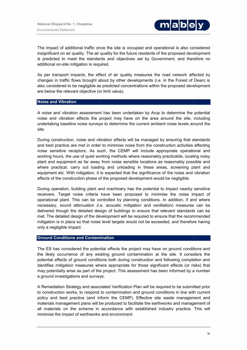
The proposed development comprise
§ Up to 600 new homes;
§ Approximately 6,500sqm of commercialscale retail / food and drink floorspace;
§ A substantial network of multiinfrastructure. This will provide a buffer between new development and the River Wye SAC and to create inter-connected and highfauna. It will also provide space for sustainableshade and climate change adaption;
§ Public open space will be provided, including a new riverof the riverbank for public access (with links to the Wales Coast Path);
§ A new Community Nature Reserve will be created in Beaufort Quarry;
§ The existing and listed Brunel House will be retained to form a flexible multiwith potential for small scale offices and workshops above;
§ Improvements to the A48 junction with Station Road access into the site at Forest Sand (the lowering of the road beneath the bridge under the railway). An additional emergency access will utilise the existing tunnel under the railway from Hardwick Avenue;
§ Provision for significant improvements to pedestrian and cycle links from the site to connect to the town centre to the north of the existing residential development and the Quarry to the south;
§ Other on site infrastructure including roads and drainage. The EIA is based on a series of definitive and indicative parameter plans. The masterplan illustrations in the NTS, including the indicative understanding of the scheme and indicate how mitigation may be achieved on the application site. It may subsequently be amended during the detailed design process.
Main Alternatives The EIA Regulations require the ES to set out the main alternatives considered by the developer. Because the site is identified in the LDthe alternative of ‘doing nothing’ would undermine the LDP and would not meet the housing need identified in the plan. In the preparation of the LDP, a number of possible alternative locations have been considered and were not considered acceptable in terms of viability, accessibility, environmental constraints and suitability for the amount and type of development proposed.
comprises of the following:
commercial space, including offices and workshops and small oorspace;
multi-functional dry and wet landscape and ecological infrastructure. This will provide a buffer between new development and the River Wye
connected and high-quality habitats for a range of flora and It will also provide space for sustainable drainage, local air quality amelioration,
shade and climate change adaption;
Public open space will be provided, including a new river-side pathway to open a portion for public access (with links to the Wales Coast Path);
Nature Reserve will be created in Beaufort Quarry;
The existing and listed Brunel House will be retained to form a flexible multi-use building, le offices and workshops above;
Improvements to the A48 junction with Station Road and improvements to the existing access into the site at Forest Sand (the lowering of the road beneath the bridge under the railway). An additional emergency access will utilise the existing tunnel under the railway
significant improvements to pedestrian and cycle links from the site to connect to the town centre to the north of the existing residential development and the
Other on site infrastructure including roads and drainage.
The EIA is based on a series of definitive and indicative parameter plans. The masterplan illustrations in the NTS, including the indicative masterplan at Figure 4, are purely to assist the
The EIA Regulations require the ES to set out the main alternatives considered by the developer. Because the site is identified in the LDP as a strategic site for new development, the alternative of ‘doing nothing’ would undermine the LDP and would not meet the housing need identified in the plan. In the preparation of the LDP, a number of possible alternative
and were not considered acceptable in terms of viability, accessibility, environmental constraints and suitability for the amount and type of
iv
offices and workshops and small
dry and wet landscape and ecological infrastructure. This will provide a buffer between new development and the River Wye
a range of flora and drainage, local air quality amelioration,
side pathway to open a portion
use building,
and improvements to the existing access into the site at Forest Sand (the lowering of the road beneath the bridge under the railway). An additional emergency access will utilise the existing tunnel under the railway
significant improvements to pedestrian and cycle links from the site to connect to the town centre to the north of the existing residential development and the
The EIA is based on a series of definitive and indicative parameter plans. The masterplan , are purely to assist the
The EIA Regulations require the ES to set out the main alternatives considered by the P as a strategic site for new development,
the alternative of ‘doing nothing’ would undermine the LDP and would not meet the housing need identified in the plan. In the preparation of the LDP, a number of possible alternative
and were not considered acceptable in terms of viability, accessibility, environmental constraints and suitability for the amount and type of

National Shipyard No. 1, Chepstow
Environmental Statement
Figure 4: Indicative Masterplan
v

National Shipyard No. 1, Chepstow
Environmental Statement
Society and Economics The effects of the proposed development upon people, the community and the economy of Chepstow and the wider community have been considered as part of the EIA process. A number of positive socio-economic benefits are likely to arise as a result of the proposed development – both during site preparation and construction of the development and during operation. The effect of the proposals on local social and community facilities Chepstow have been investigated in the following areas:
Employment and economy – operating in the region and provide direct and indirect jobs in the construction industry, as well as the supply chain. The construction phase of the development is predicted to generate, in total over the construction period (predicted 8Equivalent (FTE) jobs, from the residential development alone. Additional jobs will be provided during the construction of commercial buildings and the infrastructure works.
The presence of the construction and professional workforce during construction would also have an indirect impact on the local economy associated with their expenditure in local businesses, known as the ‘multiplier effect’.
Additional measures that could add furtherlocal labour force and contractors, and the use of local purchasing initiatives, where possible, to maximise the benefits of the scheme to local construction firms and product manufacturers/suppliers. The construction effects will therefore be employment opportunities during construction
Tthe provision of approximately 6,500 sqm floorspace for commercial, workshop and office space will generate a larger number of permanent anthe surrounding area. Furthermore, the new residents of the development will boost trade for local retail, services, leisure and recreation enterprises in the town and local area.
Provision of new housing – The schememeeting housing requirements andmix of new housing, of up to 600 homes to meet housing requirement
Community facilities – Without mitigation, the additional population they will generate)spaces. The proposals will benefit new residents providing a significant level of new additional open space and facilities within the proposed development. The includes the creation of the riverside park and riverside walkway, which will link to the Wales Coast Path, and other cobe subject to a Section 106 agreement which could include financial contributions towards offsite primary and secondary education, and other community facilities (as required and appropriate) to mitigate the impact that the increase in population may have on existing community infrastructure.
Possible temporary impacts of construction on the amenity of the residents in the neighbouring residential areas will be on working practices, including the agreement of a Construction Environmental Management
development upon people, the community and the economy of Chepstow and the wider community have been considered as part of the EIA process. A
economic benefits are likely to arise as a result of the proposed ng site preparation and construction of the development and during
operation. The effect of the proposals on local social and community facilities in and around Chepstow have been investigated in the following areas:
The development will help support construction firms operating in the region and provide direct and indirect jobs in the construction industry, as well
The construction phase of the development is predicted to generate, in (predicted 8-10 years), between 90 and 113 direct Full Time
the residential development alone. Additional jobs will be provided during the construction of commercial buildings and the infrastructure works.
of the construction and professional workforce during construction would also have an indirect impact on the local economy associated with their expenditure in local
, known as the ‘multiplier effect’.
Additional measures that could add further benefit to the area include promoting the use of a local labour force and contractors, and the use of local purchasing initiatives, where possible, to maximise the benefits of the scheme to local construction firms and product
construction effects will therefore be significantly beneficial for employment opportunities during construction.
approximately 6,500 sqm floorspace for commercial, workshop and office number of permanent and long term jobs within Chepstow and
the surrounding area. Furthermore, the new residents of the development will boost trade for local retail, services, leisure and recreation enterprises in the town and local area.
he scheme will deliver a range of housing which will assist in requirements and needs in Chepstow and Monmouthshire. The proposed
homes, will provide an important source of additional new ements.
Without mitigation, the number of proposed new homes (and the additional population they will generate) could place a larger burden on existing services and
benefit new residents and the existing community in Chepstowproviding a significant level of new additional open space and facilities within the proposed
The includes the creation of the riverside park and riverside walkway, which will th, and other community spaces. The development of the site will
be subject to a Section 106 agreement which could include financial contributions towards offsite primary and secondary education, and other community facilities (as required and
e impact that the increase in population may have on existing
Possible temporary impacts of construction on the amenity of the residents in the neighbouring residential areas will be mitigated through the agreement of planning conon working practices, including the agreement of a Construction Environmental Management
vi
development upon people, the community and the economy of Chepstow and the wider community have been considered as part of the EIA process. A
economic benefits are likely to arise as a result of the proposed ng site preparation and construction of the development and during
in and around
t will help support construction firms operating in the region and provide direct and indirect jobs in the construction industry, as well
The construction phase of the development is predicted to generate, in direct Full Time
the residential development alone. Additional jobs will be provided during the construction of commercial buildings and the infrastructure works.
of the construction and professional workforce during construction would also have an indirect impact on the local economy associated with their expenditure in local
benefit to the area include promoting the use of a local labour force and contractors, and the use of local purchasing initiatives, where possible, to maximise the benefits of the scheme to local construction firms and product
beneficial for
approximately 6,500 sqm floorspace for commercial, workshop and office within Chepstow and
the surrounding area. Furthermore, the new residents of the development will boost trade for
which will assist in . The proposed
, will provide an important source of additional new
new homes (and the could place a larger burden on existing services and
Chepstow by providing a significant level of new additional open space and facilities within the proposed
The includes the creation of the riverside park and riverside walkway, which will The development of the site will
be subject to a Section 106 agreement which could include financial contributions towards off-site primary and secondary education, and other community facilities (as required and
e impact that the increase in population may have on existing
Possible temporary impacts of construction on the amenity of the residents in the mitigated through the agreement of planning conditions
on working practices, including the agreement of a Construction Environmental Management
National Shipyard No. 1, Chepstow
Environmental Statement
Plan (CEMP). The CEMP will include the construction working hours and details of building construction methods and phasing.
The proposed development will result in a in a number of significant, beneficial effects for the local and regional community and economy. Transport Movement and Access An assessment has been undertaken of the transport, movement and access effects of the proposed development during construction and operation. The assessment has been based on a Transport Assessment prepared by Vectos which predicts and considers in detail the traffic movements (both vehicular and pedestrian / cyclists)development in the context of the transport network.
The site already benefits from excellent accessibility.includes the provision of new pedestrian route and cycle routes from the site to the town centre and to the Wales Coast Path. The provbridge and the environmental improvements at Station Road create links to existing bus and rail services. Similarly, the ‘in principle’ treatment of the junctions to improve connectivity and permeability between existing and proposed development and the town centre will encourage walking and cycling as the preferred mode for many trips Consideration has been given in the ES development in relation to a variety of factors including driver delay, pedestrian and cycle movement, public transport, and accidents and safety.the construction and operation of the proposed development, and appropriatproposed to reduce and minimise any negative impacts.
The construction of the proposed would be intermittent through the construction period. A Construction Route Management Plan (CRMP) will be agreed with the relevant authorities to ensure appropriate hours of operation and routes are used for construction traffic wherever possible to minimise impacts on the existing communities of Chepstow.on traffic, movement and access during construction.
Once developed and subject to the successful links as described above, it is predicted that there will be beneficial impacts for pedestrians and cyclists. All other effects are considered negligiblethe implementation of a Travel Plan, though which the target model split can be achieved, theadverse impact on junction delay / driver delay
This assessment has also assesscombination with other developments. Notably, this has required consideration of the additional traffic movements on the A48 generated by lapermission in the Forest of Dean (i.e. Lydney).
The CEMP will include the construction working hours and details of building construction methods and phasing.
result in a in a number of significant, beneficial effects for the local and regional community and economy.
Transport Movement and Access
ment has been undertaken of the transport, movement and access effects of the construction and operation. The assessment has been based
on a Transport Assessment prepared by Vectos which predicts and considers in detail the movements (both vehicular and pedestrian / cyclists) generated by the proposed
text of the transport network.
benefits from excellent accessibility. However, the proposed development includes the provision of new pedestrian route and cycle routes from the site to the town centre and to the Wales Coast Path. The provision of an improved footway under the railway bridge and the environmental improvements at Station Road create links to existing bus and rail services. Similarly, the ‘in principle’ treatment of the Forest Sand / Station Road and
connectivity and permeability between existing and proposed development and the town centre will encourage walking and cycling as the preferred mode
in the ES to the likely significant effects of the proposed evelopment in relation to a variety of factors including driver delay, pedestrian and cycle
movement, public transport, and accidents and safety. Effects have been considered during the construction and operation of the proposed development, and appropriate mitigation is proposed to reduce and minimise any negative impacts.
The construction of the proposed development is likely to generate additional traffic, but would be intermittent through the construction period. A Construction Route Management
MP) will be agreed with the relevant authorities to ensure appropriate hours of operation and routes are used for construction traffic wherever possible to minimise impacts on the existing communities of Chepstow. It is predicted that there will be a negligible effect on traffic, movement and access during construction.
the successful mitigation and enhancement to pedestrian links as described above, it is predicted that there will be beneficial impacts for pedestrians
All other effects are considered negligible or minor adverse. It is anticipated that the implementation of a Travel Plan, though which the target model split can be achieved, the
junction delay / driver delay can be reduced to a minor adverse impact
This assessment has also assessed the cumulative effect of the proposed development in combination with other developments. Notably, this has required consideration of the additional traffic movements on the A48 generated by large residential schemes with planning permission in the Forest of Dean (i.e. Lydney).
vii
The CEMP will include the construction working hours and details of building
result in a in a number of significant, beneficial effects for the
ment has been undertaken of the transport, movement and access effects of the construction and operation. The assessment has been based
on a Transport Assessment prepared by Vectos which predicts and considers in detail the generated by the proposed
he proposed development includes the provision of new pedestrian route and cycle routes from the site to the town
ision of an improved footway under the railway bridge and the environmental improvements at Station Road create links to existing bus and
Forest Sand / Station Road and A48 connectivity and permeability between existing and proposed
development and the town centre will encourage walking and cycling as the preferred mode
to the likely significant effects of the proposed evelopment in relation to a variety of factors including driver delay, pedestrian and cycle
Effects have been considered during e mitigation is
development is likely to generate additional traffic, but would be intermittent through the construction period. A Construction Route Management
MP) will be agreed with the relevant authorities to ensure appropriate hours of operation and routes are used for construction traffic wherever possible to minimise impacts
gible effect
to pedestrian links as described above, it is predicted that there will be beneficial impacts for pedestrians
or minor adverse. It is anticipated that the implementation of a Travel Plan, though which the target model split can be achieved, the
to a minor adverse impact.
the cumulative effect of the proposed development in combination with other developments. Notably, this has required consideration of the
rge residential schemes with planning

National Shipyard No. 1, Chepstow
Environmental Statement
Water Resources The ES assesses the potential effects respect to hydrology, water supplyincludes a review of the current conditions found within the area and identifies measures where appropriate for those significant effects that may potentially arise as part of the project. The assessment is supported by a F
The Technical Advice Note (TAN) 15 flood mapNatural Resources Wales online flood mapconsidered as little or no risk of fluvial or tidlocated near the River Wye are identified as Zone C2, which mean are not served by significant infrastrucwatercourses are located within the site boundary. The boundary of the site.
The Indicative Masterplan makes provision for Sustainable Urban Drainage Systems (SuDS) (i.e. swales, lined drainage channels and reed beds). AStrategy and management strategy will be developed as part of the detailed design of the site. This will be required to include pollution prevention measures such as gullies and catchpits. The indicative strategy includes ‘coastal lagoon’, which would also storm flow ‘filtration’, water storage for potential reuse in landscapeamenity. Storm water flows into the River Wye will be discharged via a new storm water network which will control the amount of and quality of discharge into the river.
Flood alleviation measures require the raising of developed areas of the site to a level of at least 10.60m AOD. Subject to ongoing dialogue with Dwr Cymru Welsh Water, it is likely that, whilst the existing network has capacity to receive flow fouls generated by the development, some improvements will be required (i.e. pumping stations). also confirm whether upgrades to the existing potable water infrastructure are required to serve the development. If required,necessary such that the effect is likely to be negligible.
Overall, subject to the proposed indicative strategy and mitigation, the development is not anticipated to have any negative impacts on water resources. Air Quality Arup has undertaken and air quality assessment to predict development upon air quality both during construction and upon occupation.within an Air Quality Management Area (AQMA), but impact on the Chepstow AQMA which is located approximately 550m west of the site.
During construction, there is a risk that existing and proposed properties may be affected by dust generated by the construction activities on site. It will therefore be necessary to put in place measures which reduce the dust generated, such as damping dovehicles delivering to the site. These will be set out in the CEMP.proposed development during the construction period are considered to be insignificant with mitigation measures in place.
effects of the proposed development on the environment with supply and drainage. The assessment, prepared by Arup,
includes a review of the current conditions found within the area and identifies mitigation measures where appropriate for those significant effects that may potentially arise as part of
sment is supported by a Flood Consequence Assessment.
The Technical Advice Note (TAN) 15 flood map (prepared by the Welsh Government) and Natural Resources Wales online flood map show that the majority of the site is within Zone A
little or no risk of fluvial or tidal/coastal flooding. Parts of the site which are are identified as Zone C2, which mean areas of floodplain which
served by significant infrastructure, including flood defences. No major/named in the site boundary. The River Wye abuts the eastern
The Indicative Masterplan makes provision for Sustainable Urban Drainage Systems (SuDS) (i.e. swales, lined drainage channels and reed beds). A detailed Surface Water Drainage Strategy and management strategy will be developed as part of the detailed design of the
This will be required to include pollution prevention measures such as gullies and catchpits. The indicative strategy includes the provision of a substantial retention pond, a
also serve as a feature for landscape, biodiversity opportunity, storm flow ‘filtration’, water storage for potential reuse in landscape irrigation and public
er flows into the River Wye will be discharged via a new storm water network which will control the amount of and quality of discharge into the river.
Flood alleviation measures require the raising of developed areas of the site to a level of at 60m AOD. Subject to ongoing dialogue with Dwr Cymru Welsh Water, it is likely that,
whilst the existing network has capacity to receive flow fouls generated by the development, some improvements will be required (i.e. pumping stations). This dialogue with DCWW will
upgrades to the existing potable water infrastructure are required to If required, the developer will ensure completion of such works as
necessary such that the effect is likely to be negligible.
subject to the proposed indicative strategy and mitigation, the development is not negative impacts on water resources.
Arup has undertaken and air quality assessment to predict the effect of the proposed nt upon air quality both during construction and upon occupation. The site is not
within an Air Quality Management Area (AQMA), but it has been necessary to considerer the impact on the Chepstow AQMA which is located approximately 550m west of the site.
During construction, there is a risk that existing and proposed properties may be affected by dust generated by the construction activities on site. It will therefore be necessary to put in place measures which reduce the dust generated, such as damping down and covering
These will be set out in the CEMP. The impacts of the proposed development during the construction period are considered to be insignificant with
viii
of the proposed development on the environment with , prepared by Arup,
mitigation measures where appropriate for those significant effects that may potentially arise as part of
(prepared by the Welsh Government) and show that the majority of the site is within Zone A,
Parts of the site which are areas of floodplain which
No major/named River Wye abuts the eastern
The Indicative Masterplan makes provision for Sustainable Urban Drainage Systems (SuDS) detailed Surface Water Drainage
Strategy and management strategy will be developed as part of the detailed design of the This will be required to include pollution prevention measures such as gullies and
the provision of a substantial retention pond, a opportunity,
irrigation and public er flows into the River Wye will be discharged via a new storm water
Flood alleviation measures require the raising of developed areas of the site to a level of at 60m AOD. Subject to ongoing dialogue with Dwr Cymru Welsh Water, it is likely that,
whilst the existing network has capacity to receive flow fouls generated by the development, DCWW will
upgrades to the existing potable water infrastructure are required to the developer will ensure completion of such works as
subject to the proposed indicative strategy and mitigation, the development is not
the effect of the proposed The site is not
it has been necessary to considerer the impact on the Chepstow AQMA which is located approximately 550m west of the site.
During construction, there is a risk that existing and proposed properties may be affected by dust generated by the construction activities on site. It will therefore be necessary to put in
wn and covering The impacts of the
proposed development during the construction period are considered to be insignificant with
National Shipyard No. 1, Chepstow
Environmental Statement
The impact of additional traffic once the site is occupied and operational is also considered insignificant on air quality. The air quality for the future residents of the proposed development is predicted to meet the standards and objectives set by Government, and therefore no additional on-site mitigation is required.
As per transport impacts, the effect of air quality measures the road network affected by changes in traffic flows brought about by also considered to be negligible as predicted concentrations within the proposed development are below the relevant objective (or limit value).
Noise and Vibration A noise and vibration assessment has been undertakennoise and vibration effects the proundertaking baseline noise surveys to determine the current ambient noise levels around the site.
During construction, noise and vibration effects will be managed by ensuring that standards and best practice are met in order to mininoise sensitive receptors. As such, the CEMP will include appropriate operational and working hours, the use of quiet working methods where reasonably practicable, lplant and equipment as far away from where practical, carry out loading and unloadequipment etc. With mitigation, it is expected that the significance of theeffects of the construction phase of the proposed development would be negligible.
During operation, building plant and machinery has the potential to impact nearby sensitive receivers. Target noise criteria have been proposed to minimoperational plant. This can be controlled by planning conditions. In addition, if and where necessary, sound attenuation (i.e. acoustic mitigation and ventilation) measures can be delivered though the detailed design of buildings tomet. The detailed design of the development will be required to ensure that the recommended mitigation is in place so that noise level targets would not be exceeded, and therefore haonly a negligible impact.
Ground Conditions and Contamination The ES has considered the potential effects the project may have on ground conditions the likely occurrence of any existing ground contamination at the site. It potential effects of ground conditions botidentifies mitigation measures where appropriate for those significant effectsmay potentially arise as part of the project. a ground investigations and surveys.
A Remediation Strategy and associated Verification Plan will be required to construction works, to respond to contamination and ground conditions in line with current policy and best practice (and inform the CEMP).materials management plans will be produced to facilitate the earthworks and management of all materials on the scheme in accordance with established industry practice. This will minimise the impact of earthworks and env
traffic once the site is occupied and operational is also considered insignificant on air quality. The air quality for the future residents of the proposed development is predicted to meet the standards and objectives set by Government, and therefore no
site mitigation is required.
he effect of air quality measures the road network affected by changes in traffic flows brought about by other developments (i.e. in the Forest of Dean)
as predicted concentrations within the proposed development are below the relevant objective (or limit value).
A noise and vibration assessment has been undertaken by Arup to determine the potential noise and vibration effects the project may have on the area around the site, including undertaking baseline noise surveys to determine the current ambient noise levels around the
During construction, noise and vibration effects will be managed by ensuring that standards ctice are met in order to minimise noise from the construction activities affe
noise sensitive receptors. As such, the CEMP will include appropriate operational and working hours, the use of quiet working methods where reasonably practicable, locatingplant and equipment as far away from noise sensible locations as reasonably possible and where practical, carry out loading and unloading in these areas, screening plant and
With mitigation, it is expected that the significance of the noise and vibration effects of the construction phase of the proposed development would be negligible.
uilding plant and machinery has the potential to impact nearby sensitive receivers. Target noise criteria have been proposed to minimise the noise impact of
This can be controlled by planning conditions. In addition, if and where necessary, sound attenuation (i.e. acoustic mitigation and ventilation) measures can be delivered though the detailed design of buildings to ensure that relevant standards can be
The detailed design of the development will be required to ensure that the recommended mitigation is in place so that noise level targets would not be exceeded, and therefore ha
und Conditions and Contamination
The ES has considered the potential effects the project may have on ground conditions the likely occurrence of any existing ground contamination at the site. It considers the potential effects of ground conditions both during construction and following completion identifies mitigation measures where appropriate for those significant effects (or risks)may potentially arise as part of the project. This assessment has been informed by a number
tions and surveys.
A Remediation Strategy and associated Verification Plan will be required to be submitted prior , to respond to contamination and ground conditions in line with current
policy and best practice (and inform the CEMP). Effective site waste management and materials management plans will be produced to facilitate the earthworks and management of all materials on the scheme in accordance with established industry practice. This will minimise the impact of earthworks and environment.
ix
traffic once the site is occupied and operational is also considered insignificant on air quality. The air quality for the future residents of the proposed development is predicted to meet the standards and objectives set by Government, and therefore no
he effect of air quality measures the road network affected by s (i.e. in the Forest of Dean) is
as predicted concentrations within the proposed development
to determine the potential ject may have on the area around the site, including
undertaking baseline noise surveys to determine the current ambient noise levels around the
During construction, noise and vibration effects will be managed by ensuring that standards mise noise from the construction activities affecting
noise sensitive receptors. As such, the CEMP will include appropriate operational and ocating noisy
as reasonably possible and ing in these areas, screening plant and
noise and vibration
uilding plant and machinery has the potential to impact nearby sensitive ise the noise impact of
This can be controlled by planning conditions. In addition, if and where necessary, sound attenuation (i.e. acoustic mitigation and ventilation) measures can be
ensure that relevant standards can be The detailed design of the development will be required to ensure that the recommended
mitigation is in place so that noise level targets would not be exceeded, and therefore having
The ES has considered the potential effects the project may have on ground conditions and considers the
uction and following completion and (or risks) that
This assessment has been informed by a number
to be submitted prior , to respond to contamination and ground conditions in line with current
Effective site waste management and materials management plans will be produced to facilitate the earthworks and management of all materials on the scheme in accordance with established industry practice. This will

National Shipyard No. 1, Chepstow
Environmental Statement
The measures taken in the construction of the development will ensure that mitigation measures are not required after completion. Buildings on the site are to be designed to incorporate the necessary gas protection measures to mitigate risks fromvapours and ground gases.
It is predicted that impacts relating to ground contaminationnegligible subject to the approval andAssuming successful implementation ofplan no residual effects are anticipated to remain after compl
Landscape and Visual Impacts A Landscape and Visual Appraisal was undertaken to establish the potential effects ofredevelopment on the character of the surrounding area and on local views. The outline proposals for the redevelopment of the Site have incorporated mitigation features into the design to reduce potential negative effects. These include a green infrastructure within the development and a riverside park allowing access to the riverside. There would be some minor and moderate negative effects during the construction phase, with views of ground clearance, machinery and equipment affecting both the the composition of views. Although these effects are minimised by the phasing of the construction stage. The Site lies alongside the scenic River Wye and the historic town of Chepstow, and LandMap (Welsh Geographical Information System) from both these areas. Its current industrial character diminishes the quality of local landscape character and the scale of the cranes and industrial sheds make them an unsightly feature in local views. The proposals would reduce the scaproposed green infrastructure would integrate it into its setting, benefitting local landscape character and supporting the aims of LandMap. The riverside park would be a key feature, both screening and providing riverside access. No negative effects are predicted during the operational phase. Effects on completion are predicted to range from moderate to negligible beneficial and will become more beneficial over time, as planting matures. The area from which the Site can be seen is limited by topography, the railway embankment, Port Wall, existing buildings and vegetation. Private views from residential properties are therefore very limited from Chepstow and Tutshill, though glimpses are avaiSedbury. There are few publicly available views of the savailable from the well-used Wales Coast Path and Offa’s Dyke Path, both of which are considered highly sensitive.
The measures taken in the construction of the development will ensure that mitigation measures are not required after completion. Buildings on the site are to be designed to incorporate the necessary gas protection measures to mitigate risks from inhalation of
impacts relating to ground contamination during constructionapproval and adoption of remediation and mitigation measures
implementation of the required remediation strategy and verification nticipated to remain after completion of the development.
and Visual Appraisal was undertaken to establish the potential effects ofredevelopment on the character of the surrounding area and on local views.
There would be some minor and moderate negative effects during the construction phase, with views of ground clearance, machinery and equipment affecting both the character and the composition of views. Although these effects are minimised by the phasing of the
lies alongside the scenic River Wye and the historic town of Chepstow, and nformation System) records the site as a detractive feature
from both these areas. Its current industrial character diminishes the quality of local landscape character and the scale of the cranes and industrial sheds make them an unsightly
sals would reduce the scale of built form on the site and its proposed green infrastructure would integrate it into its setting, benefitting local landscape character and supporting the aims of LandMap. The riverside park would be a key feature,
ening and providing riverside access. No negative effects are predicted during the operational phase. Effects on completion are predicted to range from moderate to negligible beneficial and will become more beneficial over time, as planting matures.
area from which the Site can be seen is limited by topography, the railway embankment, Port Wall, existing buildings and vegetation. Private views from residential properties are therefore very limited from Chepstow and Tutshill, though glimpses are available from parts of
ublicly available views of the site, though intermittent views are used Wales Coast Path and Offa’s Dyke Path, both of which are
x
The measures taken in the construction of the development will ensure that mitigation measures are not required after completion. Buildings on the site are to be designed to
inhalation of
during construction will be adoption of remediation and mitigation measures. the required remediation strategy and verification
etion of the development.
and Visual Appraisal was undertaken to establish the potential effects of the
There would be some minor and moderate negative effects during the construction phase, character and
the composition of views. Although these effects are minimised by the phasing of the
lies alongside the scenic River Wye and the historic town of Chepstow, and ite as a detractive feature
from both these areas. Its current industrial character diminishes the quality of local landscape character and the scale of the cranes and industrial sheds make them an unsightly
ite and its proposed green infrastructure would integrate it into its setting, benefitting local landscape character and supporting the aims of LandMap. The riverside park would be a key feature,
ening and providing riverside access. No negative effects are predicted during the operational phase. Effects on completion are predicted to range from moderate to negligible
area from which the Site can be seen is limited by topography, the railway embankment, Port Wall, existing buildings and vegetation. Private views from residential properties are
lable from parts of ite, though intermittent views are
used Wales Coast Path and Offa’s Dyke Path, both of which are

National Shipyard No. 1, Chepstow
Environmental Statement
The proposals would reduce the area from which the sthe detractive large scale buildings, and this would result in beneficial effects on views from residential properties, particularly at Sedbury and for walkers on the Wales Coast Path and Offa’s Dyke Path. No negative effects on visual amenity are predicted during the operational phase. Effects range from major to negligible on completion, increasing to major and substantial beneficial effects from some viewpoints as planting matures. Overall, despite some negative effects during construction, the proposed scheme would result in significant beneficial landscape and visualmatures on the Site. Most beneficial effects would be at a local level, though effects on the views from the Wales Coast Path and Offa’s Dyke Path could be of national significance. Biodiversity A comprehensive Ecological Baseline Report has been undertaken including a desk study, consultation with relevant organisationprotected/notable species. The results of the assessment, prepared by Biodiversity by Design, have been used to determine the ecological value of the site and the potential impacts which the development will have on ecology and biodiversity. As noted above, the River Wye is a designated SAC and SSSI. The mutflats and band of saltmarsh and intertidal reedbed on the sites eastern extent harbour some uncommon invertebrates. Inland of the riparian strip,greatest botanical note are small patches of relatively speciesindividuals or colonies of locally uncommon plants. Elsewhere, habitats on the main industry, some many years ago, others much more recently. have been recorded to use the site, including otters, bats, reptiles, songbirds and gulls and Hedgehogspublic ecological amenity. Beaufort Quarry in the southern part of the site is a Conservation (SINC), being a good from lack of management, a rather uniform tree age structure and considerable areas of invasive alien plants. The railway corridor to the north of the site is an and wildlife corridor abutting the grassland. The scheme has been carefully designed to avoid any significant adverse impacts on the River Wye either during construction or occupation. To achieve thishas been set back away from the river edgebut also allowing for its inland migration under rising sea levels for at least the next 100 years. Setting the development back creates spenvironmental interpretation points. Within the redeveloped site new biodiverse habitats will include a coastal lagoon and sustainable drainage corridors, a native coastal shrub belt, biodiverse living roofs, wildflower meadows and lawns apredator-resistant wildlife refuges including deadwood installations for beneficial and uncommon invertebrates. The railway corridor will be protected by attractive solid fencing,
the area from which the site can be seen, due to the removal of the detractive large scale buildings, and this would result in beneficial effects on views from residential properties, particularly at Sedbury and for walkers on the Wales Coast Path and
’s Dyke Path. No negative effects on visual amenity are predicted during the operational phase. Effects range from major to negligible on completion, increasing to major and substantial beneficial effects from some viewpoints as planting matures.
l, despite some negative effects during construction, the proposed scheme would result in significant beneficial landscape and visual effects, which would increase as planting matures on the Site. Most beneficial effects would be at a local level, though beneficial effects on the views from the Wales Coast Path and Offa’s Dyke Path could be of national
A comprehensive Ecological Baseline Report has been undertaken including a desk study, consultation with relevant organisations, a habitat survey followed by specialist surveys for protected/notable species. The results of the assessment, prepared by Biodiversity by Design, have been used to determine the ecological value of the site and the potential
t will have on ecology and biodiversity.
As noted above, the River Wye is a designated SAC and SSSI. The mutflats and band of saltmarsh and intertidal reedbed on the sites eastern extent harbour some uncommon invertebrates. Inland of the riparian strip, habitats are of a more local biodiversity value
e small patches of relatively species-rich grassland and occasional individuals or colonies of locally uncommon plants.
ain site have colonised those areas not currently used for industry, some many years ago, others much more recently. A number of different species have been recorded to use the site, including otters, bats, reptiles, Slow-worms, breeding songbirds and gulls and Hedgehogs. However, the site habitats currently offers quite limited
ry in the southern part of the site is a Site of Importance for Nature good refuge for wildlife; though one that suffers ecologically
ther uniform tree age structure and considerable areas of corridor to the north of the site is an important linear
wildlife corridor abutting the site. It is covered by a mosaic of woodland, scrub and
The scheme has been carefully designed to avoid any significant adverse impacts on the River Wye either during construction or occupation. To achieve this, the whole development has been set back away from the river edge, protecting the saltmarsh habitat as it is today,
for its inland migration under rising sea levels for at least the next 100 years. Setting the development back creates space for a biodiverse Riverside Park with extensive environmental interpretation points. Within the redeveloped site new biodiverse habitats will include a coastal lagoon and sustainable drainage corridors, a native coastal shrub belt, biodiverse living roofs, wildflower meadows and lawns and wide variety of artificial and
resistant wildlife refuges including deadwood installations for beneficial and uncommon invertebrates. The railway corridor will be protected by attractive solid fencing,
xi
ite can be seen, due to the removal of the detractive large scale buildings, and this would result in beneficial effects on views from residential properties, particularly at Sedbury and for walkers on the Wales Coast Path and
’s Dyke Path. No negative effects on visual amenity are predicted during the operational phase. Effects range from major to negligible on completion, increasing to major and
l, despite some negative effects during construction, the proposed scheme would result effects, which would increase as planting
beneficial effects on the views from the Wales Coast Path and Offa’s Dyke Path could be of national
A comprehensive Ecological Baseline Report has been undertaken including a desk study, s, a habitat survey followed by specialist surveys for
protected/notable species. The results of the assessment, prepared by Biodiversity by Design, have been used to determine the ecological value of the site and the potential
As noted above, the River Wye is a designated SAC and SSSI. The mutflats and band of saltmarsh and intertidal reedbed on the sites eastern extent harbour some uncommon
value. Of rich grassland and occasional
e areas not currently used for A number of different species
worms, breeding e site habitats currently offers quite limited
Site of Importance for Nature refuge for wildlife; though one that suffers ecologically
ther uniform tree age structure and considerable areas of important linear habitat
odland, scrub and
The scheme has been carefully designed to avoid any significant adverse impacts on the the whole development
saltmarsh habitat as it is today, for its inland migration under rising sea levels for at least the next 100 years.
with extensive environmental interpretation points. Within the redeveloped site new biodiverse habitats will include a coastal lagoon and sustainable drainage corridors, a native coastal shrub belt,
nd wide variety of artificial and resistant wildlife refuges including deadwood installations for beneficial and
uncommon invertebrates. The railway corridor will be protected by attractive solid fencing,
National Shipyard No. 1, Chepstow
Environmental Statement
and Beaufort Quarry will be managed and enReserve. The EIA demonstrates that the scheme as properly planned, executed and with all mitigation implemented, will not results in adverse impacts on the integrity of any site designated for nature conservation. The only net loss relates to that Black-backed gull populations established on theof these species are increasing and frequently causing public nuisance and mitigatioproposed. The mitigation measures included by design and for specific impacts will results in no net loss of other species. Rather, it is predicted that night-roosting opportunities for Lesser Hofreshwater to brackish wetland connected to vegetated drainage corridors. Outline concepts for enhancement of the existing saltmarsh habitat do not form part of the core proposals, but the intention is to investigate them further. Cultural Heritage and Archaeology A desk-based assessment was undertaken to identify any features or archaeological or cultural heritage significance such as listed buildings or buildings within the site, an historic Grade II Railway Bridge Arch and an historic Grade II Steam mill – both are proposed to be retainedformer mill building, known as Brunel House is currently used by Mabey as their officesmain site sits outside of the Chepstow Conservation Area. affect the setting of any World Heritage Sites, Scheduled Monuments, Listed Buildings, Registered Battlefields, Registered Parks and Gardens or Registered LandscInterest. As a result of significant and historic imported ground fill to accommodate the shipyard, there is a low to moderate risk of any significant archaeology being uncovered during During construction, demolition of existing buildings will be managed carefully to ensure the existing Grade II Listed Structures are safeguarded. Potential buried archaeology on site will require careful planning of excavations and a wundertaken so that removed material is tested for evidence of disturbed archaeology. Providing mitigation measures during construction are successful, the residual effects will be negligible. However, once operationlocal heritage will have major beneficial effects. Summary The development proposals for NSN1and meet the key national sustainable development objectives set by the Welsh Government. The proposed development has been properly considered and carefully designed to ensure that the residential development reflects environmental concerns and site conditions. Inherent mitigation such as the provision of a landscaping strategy are a core part of the scheme.
and Beaufort Quarry will be managed and enhanced as a habitat and as a Community Nature
The EIA demonstrates that the scheme as properly planned, executed and with all mitigation implemented, will not results in adverse impacts on the integrity of any site designated for
The only net loss relates to that of the breeding Herring Gull and Lesser backed gull populations established on the factory roofs – however, urban populations
of these species are increasing and frequently causing public nuisance and mitigatio
mitigation measures included by design and for specific impacts will results in no net loss other species. Rather, it is predicted that positive will accrue through the creation of new
roosting opportunities for Lesser Horseshoe Bats and through the creation of a new freshwater to brackish wetland connected to vegetated drainage corridors. Outline concepts for enhancement of the existing saltmarsh habitat do not form part of the core proposals, but
stigate them further.
Cultural Heritage and Archaeology
based assessment was undertaken to identify any features or archaeological or cultural heritage significance such as listed buildings or archaeology. There are two listed
, an historic Grade II Railway Bridge Arch and an historic Grade II proposed to be retained as part of the proposals. The Grade II Listed
former mill building, known as Brunel House is currently used by Mabey as their officesmain site sits outside of the Chepstow Conservation Area. The proposed development will not affect the setting of any World Heritage Sites, Scheduled Monuments, Listed Buildings, Registered Battlefields, Registered Parks and Gardens or Registered Landscapes of Special
and historic site modification and the raising of site levels with imported ground fill to accommodate the shipyard, there is a low to moderate risk of any significant archaeology being uncovered during the development.
During construction, demolition of existing buildings will be managed carefully to ensure the existing Grade II Listed Structures are safeguarded. Potential buried archaeology on site will require careful planning of excavations and a watching brief for any excavations being undertaken so that removed material is tested for evidence of disturbed archaeology.
Providing mitigation measures during construction are successful, the residual effects will be negligible. However, once operational, it is concluded that the enhanced access and care for local heritage will have major beneficial effects.
NSN1 comply with national and local planning policy guidance and meet the key national sustainable development objectives set by the Welsh Government.
The proposed development has been properly considered and carefully designed to ensure development reflects environmental concerns and site conditions. Inherent
ecological mitigation, informal and formal open spaces and a landscaping strategy are a core part of the scheme.
xii
hanced as a habitat and as a Community Nature
The EIA demonstrates that the scheme as properly planned, executed and with all mitigation implemented, will not results in adverse impacts on the integrity of any site designated for
of the breeding Herring Gull and Lesser urban populations
of these species are increasing and frequently causing public nuisance and mitigation is not
mitigation measures included by design and for specific impacts will results in no net loss positive will accrue through the creation of new
rseshoe Bats and through the creation of a new freshwater to brackish wetland connected to vegetated drainage corridors. Outline concepts for enhancement of the existing saltmarsh habitat do not form part of the core proposals, but
based assessment was undertaken to identify any features or archaeological or There are two listed
, an historic Grade II Railway Bridge Arch and an historic Grade II Grade II Listed
former mill building, known as Brunel House is currently used by Mabey as their offices. The The proposed development will not
affect the setting of any World Heritage Sites, Scheduled Monuments, Listed Buildings, apes of Special
raising of site levels with imported ground fill to accommodate the shipyard, there is a low to moderate risk of any
During construction, demolition of existing buildings will be managed carefully to ensure the existing Grade II Listed Structures are safeguarded. Potential buried archaeology on site will
atching brief for any excavations being
Providing mitigation measures during construction are successful, the residual effects will be al, it is concluded that the enhanced access and care for
comply with national and local planning policy guidance and meet the key national sustainable development objectives set by the Welsh Government.
The proposed development has been properly considered and carefully designed to ensure development reflects environmental concerns and site conditions. Inherent
informal and formal open spaces and

National Shipyard No. 1, Chepstow
Environmental Statement
The ES comprehensively assesseddevelopment and development process. It has identified areas where there is a potential for both positive and negative impacts from the proposed development. It will be important to manage the development process on the site so that effects can be limited in duration, magnitude or extent (especially during construction). result in the short time in relation to noise, landscape and visual amenity and traffic, mmeasures will be implemented in accordance with best practice to either remove or reduce these impacts. Given the current condition and position of the site, the development proposals capture the potential to improve the environmental performance surrounding area. The proposed development willsignificant beneficial impacts – notably with regards tolandscape and visual amenity of socio-economic benefits of the proposals of the development.
The ES comprehensively assessed the potential for environmental effects from the proposed development and development process. It has identified areas where there is a potential for both positive and negative impacts from the proposed development. It will be important to
lopment process on the site so that effects can be limited in duration, magnitude or extent (especially during construction). Whilst some small adverse effects may result in the short time in relation to noise, landscape and visual amenity and traffic, mmeasures will be implemented in accordance with best practice to either remove or reduce
Given the current condition and position of the site, the development proposals capture the potential to improve the environmental performance of the site and its relationship with the
proposed development will, in the long term, bring about a number of notably with regards to pedestrian and cyclists links, the site, biodiversity, cultural heritage and the significant
economic benefits of the proposals – particularly the numerous jobs created as a result
xiii
the potential for environmental effects from the proposed development and development process. It has identified areas where there is a potential for both positive and negative impacts from the proposed development. It will be important to
lopment process on the site so that effects can be limited in duration, Whilst some small adverse effects may
result in the short time in relation to noise, landscape and visual amenity and traffic, mitigation measures will be implemented in accordance with best practice to either remove or reduce
Given the current condition and position of the site, the development proposals capture the of the site and its relationship with the
bring about a number of pedestrian and cyclists links, the
and the significant particularly the numerous jobs created as a result