nsl@cau technical report, 2017 1 an empirical measurement study on uav...
TRANSCRIPT
NSL@CAU TECHNICAL REPORT, 2017 1
An Empirical Measurement Study on UAVController Communication
Dogeon Park, Jongho Lee, and Jeongyeup Paek
Abstract—In the recent years, Unmanned Aerial Vehicles(UAV) have helped expedite tasks in various fields. In coordinat-ing its missions, wireless radios are a commonly used mediumfor communication. However, since UAVs are constantly moving,there are many intrinsic factors that can interfere with wirelessradio communications. For instance, noise from the actuators andits ability to move in three dimensions (up, down, left, and right)can influence radio communication. Therefore, and since reliabledata communication is paramount in safely operating a UAV, it isnecessary to study which frequency and communication protocolis effective in various circumstances and whether existing studieson the concept of distance according to radio frequencies areequally applicable to UAVs. In the presented work, four differentcommunication methods are evaluated using real measurementswith a custom-built civilian UAV. We investigate which frequencyand communication method are efficient at transmitting controldata over a series of experiments. The experiments are devisedin a way that the intrinsic characteristics of a UAV is consideredin the study. After the measurement study, a hand motion-basedUAV controller which utilizes one of the communication methodis experimented as an application case study.
Index Terms—Unmanned aerial vehicles, Communication ef-fectiveness, Radio frequency, Measurement
I. INTRODUCTION
Unmanned Aerial Vehicles (UAVs) were mostly used formilitary purposes in the past. However, recent advancementshave enabled civilian UAVs to become a versatile instrumentthat can also be used in a variety of applications such aspersonal hobby life, logistics transportation [1], pesticide ap-plication [2], telecommunication infra provisioning [3], rescuestructure [4], and aerial photographing.
As the scope of its use broadened, various research anddevelopment has been done with UAV technology in re-cent years [5–7]. Most notably, civilian UAV technologybecame open to the general public in the form of open-sourceprojects [8]. However, if devoid of the knowledge to controlUAVs safely and efficiently, serious accidents are possible.Although there are many factors to consider to safely operatea UAV, we focus on studying performance with various radiofrequencies and communication techniques.
Generally, most of UAVs send and receive data for controlvia the 2.4GHz band. When using a relatively high frequencybandwidth, it is possible to transmit more data per timeframe than its lower counterparts. However, as the transmittingdistance and the number of obstacles in between increases,communication efficiency worsens. Since relatively low data
Dogeon Park, Jongho Lee, and Jeongyeup Paek are with the School ofComputer Science and Engineering, Chung-Ang University, Republic of Korea(email: {pdg102,reddyk,jpaek}@cau.ac.kr).
throughput is required to control most quadrotor UAVs, the 2.4GHz band may not be suitable for use in the transmission ofUAV control information. In addition to the aforementionedproblem, UAV operating range are also a pivotal factor indetermining communication quality. Therefore, it is necessaryto find an appropriate-sized frequency capable of handling thedata transmission throughput required for stable UAV control.
Although there are existing work in the field of wirelesscommunication that incorporates the transmitting distance(for reliable data delivery) to radio frequencies, relativelyfew works consider the dynamic characteristics of a UAV’sflight pattern with measurements in real experimental set-tings. UAV’s ability to move in three dimensions (up, down,left and right) must be taken into account. Therefore, thepresented work evaluates whether existing research can beequally applied to the UAV, and evaluate the frequencies andcommunication methods suitable for the UAV control basedon the experimental results. The results of this work willbe helpful in developing communications equipment that cannavigate UAV safely and efficiently.
II. RELATED WORK
There are previous research that focuses on the IEEE 802family (e.g. IEEE 802.11ac and IEEE 802.11n) [9] for UAVcommunications. However, one must consider the local regu-lations on radio frequencies, and how this takes into accountfor transmitting UAV control data. The factors are especiallycritical for homeland security and civil operations. In order toovercome this constraint, there have been studies on how tomanipulate UAV using existing cellular networks [10]. Also,spatial awareness is directly conveyed without being mediatedthrough another input device using gaze input for UAV control.There have also been attempts to control UAVs using gazeinput for these potential advantages [11].
III. BACKGROUND: UAV CONTROL PROTOCOLS
Two notable open source UAV projects are Multiwii andArdupilot.
Multiwii [12] has a GPL license and was originally de-veloped to support Nintendo Wii console with gyroscopesand accelerometers, as the name suggests. It is now beingused as an open source to control multirotor UAVs on theArduino platform. In the Multiwii project, Multiwii SerialProtocol(MSP) is used for communication. The header sizeand the payload size of the packet for sending and receivingthe data for controlling the multicopter are 6 and 5 bytes,respectively [13].
NSL@CAU TECHNICAL REPORT, 2017 2
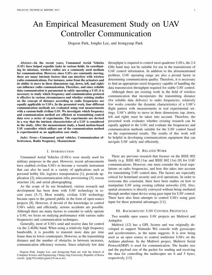
Fig. 1. The UAV (Quadcopter) used in the experiment. A Raspberry Pi Linuxbox is attached to the bottom of the quadcopter, and the 433MHz and 915MHzTelemetry Modules are attached on top of the main frame.
Ardupilot [14] is also an open source project that hasa GPL license and spans over numerous types of UAVs(Multirotors, Fixed-wing aircrafts, Model helicopters, Groundrovers, etc.). Ardupilot supports a variety of hardware includ-ing ArduPilotMega 2.X version [15], Pixhawk [16], Qual-comm SnapDragon [17] and Parrot [18]. There are alsoa large amount of commercial supporters and developers.Ardupilot uses MavLink (Micro Air Vehicle Link) proto-col for communication, which is a lightweight, header-onlyprotocol. Of the various message formats in the Mavlink,the HIL CONTROLS message contains control data such asroll, pitch, yaw, and throttle required for drone movementmanipulation. The header size of this packet is 7 bytes andthe payload size is 42 bytes [19].
Because of the large size difference between the Ardupilotproject and the Multiwii project, we set the size of packet forcommunication experiment by referring to the packet size ofthe project which is considered to have more influence on fu-ture commercial UAV development. Based on the informationwe have surveyed, the Ardupilot project is much more activethan the Multiwii project and supports a variety of hardware.Therefore, considering that the payload size of the packet usedin this project is 42 bytes, the payload size of the packet forcommunication experiment in this presented work is set to 42bytes.
IV. EXPERIMENT METHODOLOGY
For the experiments, we explored various existing commu-nication techniques for UAV control messaging. WiFi andBluetooth, which uses the same frequency band (2.4GHz),433MHz Telemetry, and 915MHz Telemetry were used in theexperiments. The packet response time and the packet loss ratewill be used as the performance metrics for the experiments.
One Raspberry Pi 3 Model B (RPi), which acts as theUAV-side receiver, is attached to the bottom of the UAV forcommunication and measurements. Figure 1 visualizes thehardware used for the experiments. The receiver RPi attachedto the bottom of the UAV returns (acknowledges) the receivedpackets sent by an external transmitter. Since the Raspberry Pi3 Model B only supports Bluetooth 4.1 and 802.11n wirelessnetworks, the HKPilot Transceiver Telemetry Radio 433MHzmodule and the 915MHz module are connected to the devicewith a USB cable. The telemetry and Raspberry Pi are thenconfigured for serial communication over USB.
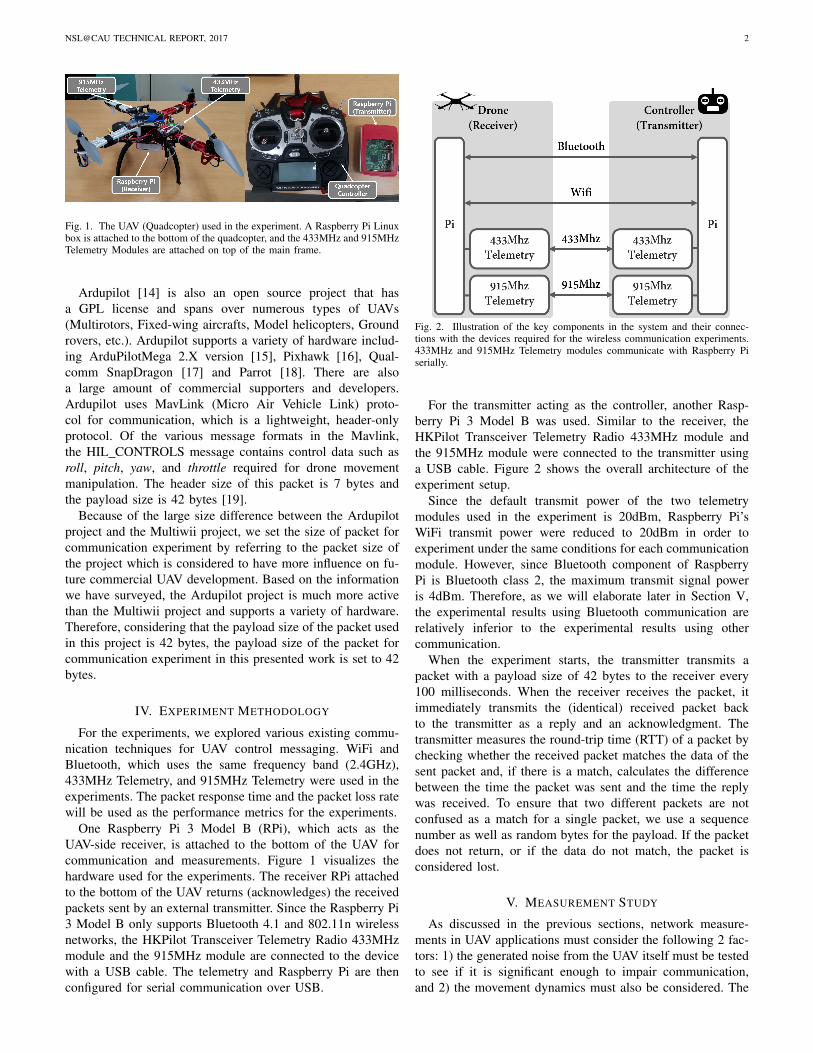
Fig. 2. Illustration of the key components in the system and their connec-tions with the devices required for the wireless communication experiments.433MHz and 915MHz Telemetry modules communicate with Raspberry Piserially.
For the transmitter acting as the controller, another Rasp-berry Pi 3 Model B was used. Similar to the receiver, theHKPilot Transceiver Telemetry Radio 433MHz module andthe 915MHz module were connected to the transmitter usinga USB cable. Figure 2 shows the overall architecture of theexperiment setup.
Since the default transmit power of the two telemetrymodules used in the experiment is 20dBm, Raspberry Pi’sWiFi transmit power were reduced to 20dBm in order toexperiment under the same conditions for each communicationmodule. However, since Bluetooth component of RaspberryPi is Bluetooth class 2, the maximum transmit signal poweris 4dBm. Therefore, as we will elaborate later in Section V,the experimental results using Bluetooth communication arerelatively inferior to the experimental results using othercommunication.
When the experiment starts, the transmitter transmits apacket with a payload size of 42 bytes to the receiver every100 milliseconds. When the receiver receives the packet, itimmediately transmits the (identical) received packet backto the transmitter as a reply and an acknowledgment. Thetransmitter measures the round-trip time (RTT) of a packet bychecking whether the received packet matches the data of thesent packet and, if there is a match, calculates the differencebetween the time the packet was sent and the time the replywas received. To ensure that two different packets are notconfused as a match for a single packet, we use a sequencenumber as well as random bytes for the payload. If the packetdoes not return, or if the data do not match, the packet isconsidered lost.
V. MEASUREMENT STUDY
As discussed in the previous sections, network measure-ments in UAV applications must consider the following 2 fac-tors: 1) the generated noise from the UAV itself must be testedto see if it is significant enough to impair communication,and 2) the movement dynamics must also be considered. The
NSL@CAU TECHNICAL REPORT, 2017 3
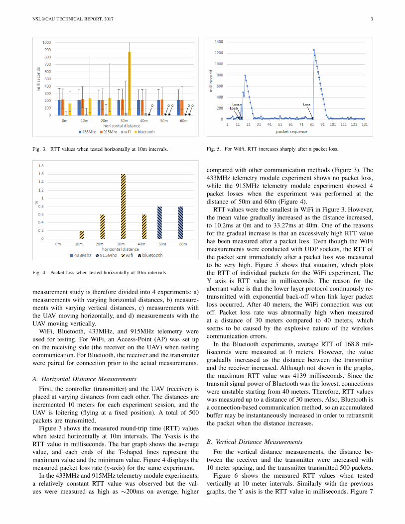
Fig. 3. RTT values when tested horizontally at 10m intervals.
Fig. 4. Packet loss when tested horizontally at 10m intervals.
measurement study is therefore divided into 4 experiments: a)measurements with varying horizontal distances, b) measure-ments with varying vertical distances, c) measurements withthe UAV moving horizontally, and d) measurements with theUAV moving vertically.
WiFi, Bluetooth, 433MHz, and 915MHz telemetry wereused for testing. For WiFi, an Access-Point (AP) was set upon the receiving side (the receiver on the UAV) when testingcommunication. For Bluetooth, the receiver and the transmitterwere paired for connection prior to the actual measurements.
A. Horizontal Distance Measurements
First, the controller (transmitter) and the UAV (receiver) isplaced at varying distances from each other. The distances areincremented 10 meters for each experiment session, and theUAV is loitering (flying at a fixed position). A total of 500packets are transmitted.
Figure 3 shows the measured round-trip time (RTT) valueswhen tested horizontally at 10m intervals. The Y-axis is theRTT value in milliseconds. The bar graph shows the averagevalue, and each ends of the T-shaped lines represent themaximum value and the minimum value. Figure 4 displays themeasured packet loss rate (y-axis) for the same experiment.
In the 433MHz and 915MHz telemetry module experiments,a relatively constant RTT value was observed but the val-ues were measured as high as ∼200ms on average, higher
Fig. 5. For WiFi, RTT increases sharply after a packet loss.
compared with other communication methods (Figure 3). The433MHz telemetry module experiment shows no packet loss,while the 915MHz telemetry module experiment showed 4packet losses when the experiment was performed at thedistance of 50m and 60m (Figure 4).
RTT values were the smallest in WiFi in Figure 3. However,the mean value gradually increased as the distance increased,to 10.2ms at 0m and to 33.27ms at 40m. One of the reasonsfor the gradual increase is that an excessively high RTT valuehas been measured after a packet loss. Even though the WiFimeasurements were conducted with UDP sockets, the RTT ofthe packet sent immediately after a packet loss was measuredto be very high. Figure 5 shows that situation, which plotsthe RTT of individual packets for the WiFi experiment. TheY axis is RTT value in milliseconds. The reason for theaberrant value is that the lower layer protocol continuously re-transmitted with exponential back-off when link layer packetloss occurred. After 40 meters, the WiFi connection was cutoff. Packet loss rate was abnormally high when measuredat a distance of 30 meters compared to 40 meters, whichseems to be caused by the explosive nature of the wirelesscommunication errors.
In the Bluetooth experiments, average RTT of 168.8 mil-liseconds were measured at 0 meters. However, the valuegradually increased as the distance between the transmitterand the receiver increased. Although not shown in the graphs,the maximum RTT value was 4139 milliseconds. Since thetransmit signal power of Bluetooth was the lowest, connectionswere unstable starting from 40 meters. Therefore, RTT valueswas measured up to a distance of 30 meters. Also, Bluetooth isa connection-based communication method, so an accumulatedbuffer may be instantaneously increased in order to retransmitthe packet when the distance increases.
B. Vertical Distance Measurements
For the vertical distance measurements, the distance be-tween the receiver and the transmitter were increased with10 meter spacing, and the transmitter transmitted 500 packets.
Figure 6 shows the measured RTT values when testedvertically at 10 meter intervals. Similarly with the previousgraphs, the Y axis is the RTT value in milliseconds. Figure 7
NSL@CAU TECHNICAL REPORT, 2017 4
Fig. 6. RTT values when tested vertically at 10m intervals.
Fig. 7. Packet loss when tested vertically at 10m intervals.
shows the measured packet loss rate for the same experiment.Similar to the horizontal experiments, 433MHz and 915MHztelemetry module experiments displayed a constant RTT valueover varying heights, and were measured as high as about 200milliseconds on average, which again is high compared withother communication methods. In the experiment using the433MHz telemetry module, three packet losses occurred ateach distance of 30 meters and 40 meters. 915MHz telemetrymodule displayed one packet loss occurring each at 20 metersand 40 meters, and two losses at 50 meters.
The average RTT value for WiFi communications were sim-ilar to the horizontal experiments. The mean value increasedas the distance increased to 10.2 milliseconds at 0 meters andto 30.52 milliseconds at 40 meters. Similarly to the horizontalexperiments, the WiFi connection was cut off at a verticalheight of 40 meters. However, packet loss was very highcompared to the horizontal experiment.
Bluetooth communication displayed an average RTT valueof 168.8 milliseconds at a 0 meter distance. Also, the RTTvalue increased as the distance between the transmitter andthe receiver increased.
C. Horizontal Movement Experiments
To account for the dynamic nature of UAV movement, theexperiments were conducted with the UAV moving up to 40
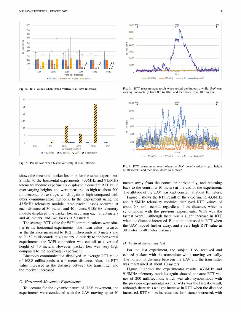
Fig. 8. RTT measurement result when tested continuously while UAV wasmoving horizontally from 0m to 40m, and then back from 40m to 0m.
Fig. 9. RTT measurement result when the UAV moved vertically up to heightof 40 meters, and then back down to 0 meter.
meters away from the controller horizontally, and returningback to the controller (0 meter) at the end of the experiment.The altitude of the UAV was kept constant at about 10 meters.
Figure 8 shows the RTT result of the experiment. 433MHzand 915MHz telemetry modules displayed RTT values ofabout 200 milliseconds regardless of the distance, which issynonymous with the previous experiments. WiFi was thefastest overall, although there was a slight increase in RTTwhen the distance increased. Bluetooth increased in RTT whenthe UAV moved further away, and a very high RTT value at30 meter to 40 meter distance.
D. Vertical movement test
For the last experiment, the subject UAV received andechoed packets with the transmitter while moving vertically.The horizontal distance between the UAV and the transmitterwas maintained at about 10 meters.
Figure 9 shows the experimental results. 433MHz and915MHz telemetry modules again showed constant RTT val-ues of 200 milliseconds, which was also synonymous withthe previous experimental results. WiFi was the fastest overall,although there was a slight increase in RTT when the distanceincreased. RTT values increased as the distance increased, with
NSL@CAU TECHNICAL REPORT, 2017 5
the average RTT value of about 500 milliseconds at a distanceof about 30 meters.
In conclusion, regardless of whether the distance betweenthe transmitter and the receiver were horizontally or verticallydistant, the absolute value of the distance between the receiverand the transmitter was related to the transmission efficiency.WiFi and Bluetooth were disconnected 10 meters ahead of thefirst experiment in the second experiment because the UAVwas raised vertically at 5 to 10 meters away horizontally forsafety reasons.
VI. APPLICATION CASE STUDY
To further validate our experimental results and observehow they impact real-world applications, we developed anovel UAV controller application on a mobile smartphone. Theapplication is an Android app that controls the UAV with user’shand motion gestures. The motivation behind the applicationis to provide UAV users with an alternative controller thathas a user-friendly interface. The application is intended foruse in cases where the main UAV controller is unexpectedlyunavailable. For example, the main controller for the UAV mayrun out of batteries while the UAV is in flight. In this case,the application acts as an emergency controller, using user’smotion as input for manipulating the UAV’s state. The useropens the Android application and swings the smartphone inan intuitive manner to control the UAV. Simply put, it is anauxiliary controller for handling UAV emergency situations.
One of the main requirement for this application is itsability to reliably and promptly transmit control messagesto the UAV. In our previous experiments, it is emphasizedthat appropriate radio frequency bands and communicationtechniques correlate to packet loss and RTT. These are criticalin real situations, especially emergency scenarios. Therefore,the presented application is used as an application case studyin this work.
A. Design and Implementation
The application uses machine learning classification tech-niques to map the user’s movement to a specific action on theUAV. Thus, training data is required for the application prior toits actual use. The smartphone’s x, y, and z-axes accelerationvalues from its accelerometer are used for the data. To trainthe application, the user first specifies which action he/she isabout to perform and presses the application’s action buttonto record the accelerometer data. The recorded data is sentto a separate learning algorithm hosted in Microsoft’s Azurecloud service. A centralized service like this is advantageousin these type of scenarios since the user’s trained actions canbe preserved and accessed over multiple Android devices.
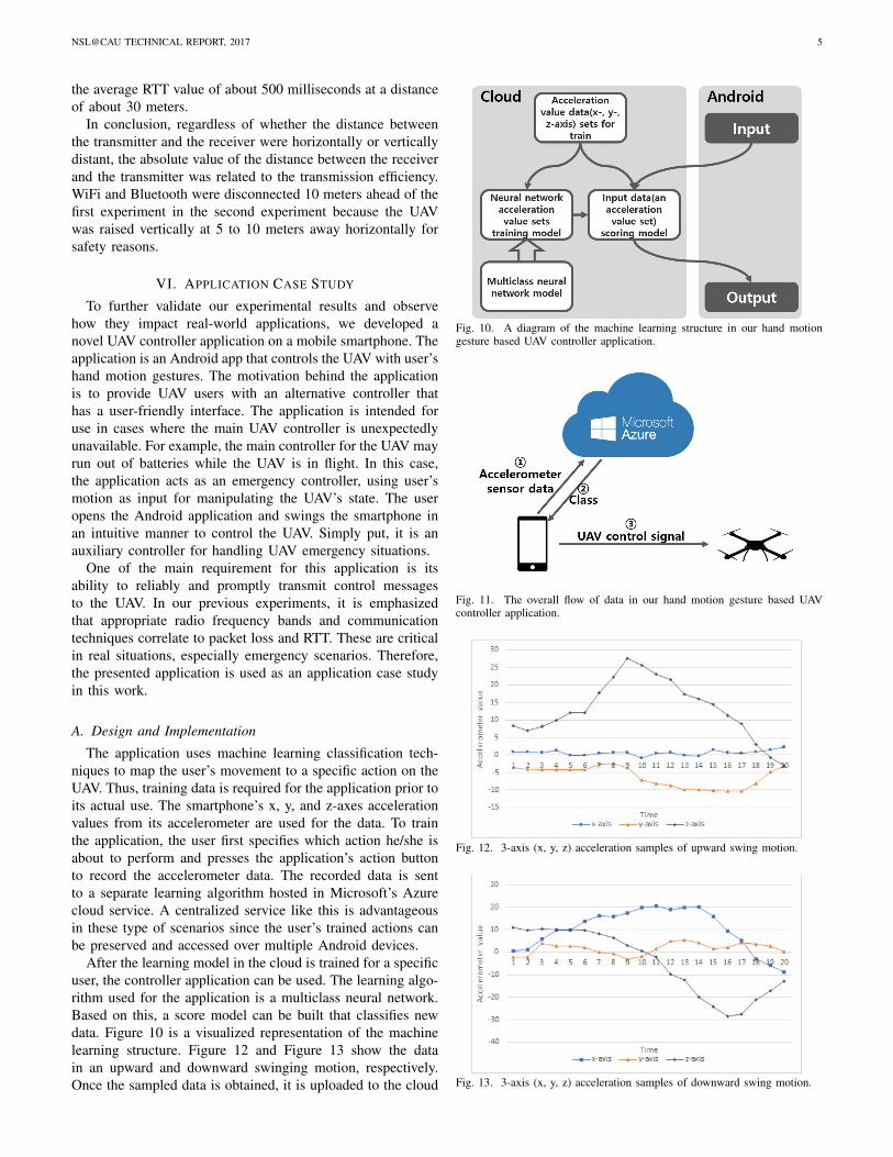
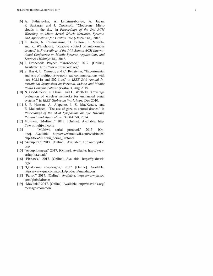
After the learning model in the cloud is trained for a specificuser, the controller application can be used. The learning algo-rithm used for the application is a multiclass neural network.Based on this, a score model can be built that classifies newdata. Figure 10 is a visualized representation of the machinelearning structure. Figure 12 and Figure 13 show the datain an upward and downward swinging motion, respectively.Once the sampled data is obtained, it is uploaded to the cloud
Fig. 10. A diagram of the machine learning structure in our hand motiongesture based UAV controller application.
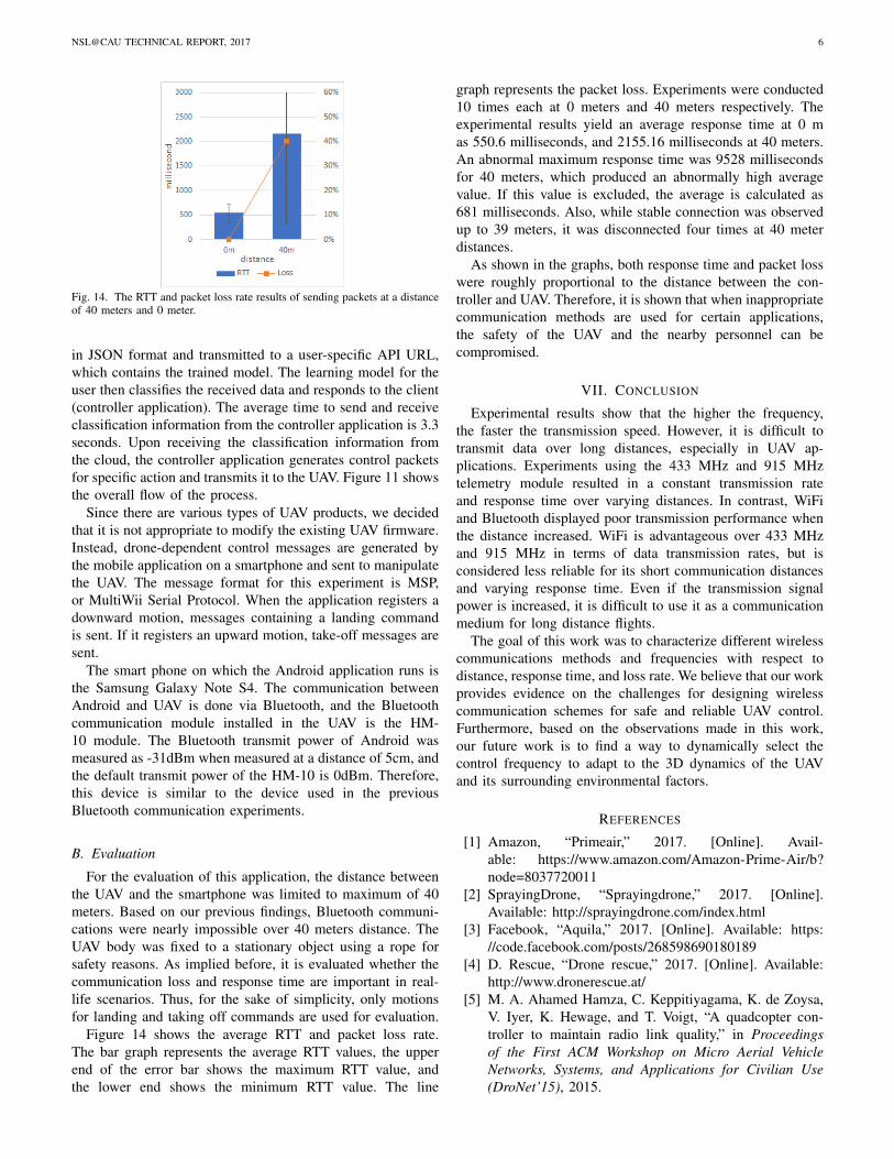
Fig. 11. The overall flow of data in our hand motion gesture based UAVcontroller application.
Fig. 12. 3-axis (x, y, z) acceleration samples of upward swing motion.
Fig. 13. 3-axis (x, y, z) acceleration samples of downward swing motion.
NSL@CAU TECHNICAL REPORT, 2017 6
Fig. 14. The RTT and packet loss rate results of sending packets at a distanceof 40 meters and 0 meter.
in JSON format and transmitted to a user-specific API URL,which contains the trained model. The learning model for theuser then classifies the received data and responds to the client(controller application). The average time to send and receiveclassification information from the controller application is 3.3seconds. Upon receiving the classification information fromthe cloud, the controller application generates control packetsfor specific action and transmits it to the UAV. Figure 11 showsthe overall flow of the process.
Since there are various types of UAV products, we decidedthat it is not appropriate to modify the existing UAV firmware.Instead, drone-dependent control messages are generated bythe mobile application on a smartphone and sent to manipulatethe UAV. The message format for this experiment is MSP,or MultiWii Serial Protocol. When the application registers adownward motion, messages containing a landing commandis sent. If it registers an upward motion, take-off messages aresent.
The smart phone on which the Android application runs isthe Samsung Galaxy Note S4. The communication betweenAndroid and UAV is done via Bluetooth, and the Bluetoothcommunication module installed in the UAV is the HM-10 module. The Bluetooth transmit power of Android wasmeasured as -31dBm when measured at a distance of 5cm, andthe default transmit power of the HM-10 is 0dBm. Therefore,this device is similar to the device used in the previousBluetooth communication experiments.
B. Evaluation
For the evaluation of this application, the distance betweenthe UAV and the smartphone was limited to maximum of 40meters. Based on our previous findings, Bluetooth communi-cations were nearly impossible over 40 meters distance. TheUAV body was fixed to a stationary object using a rope forsafety reasons. As implied before, it is evaluated whether thecommunication loss and response time are important in real-life scenarios. Thus, for the sake of simplicity, only motionsfor landing and taking off commands are used for evaluation.
Figure 14 shows the average RTT and packet loss rate.The bar graph represents the average RTT values, the upperend of the error bar shows the maximum RTT value, andthe lower end shows the minimum RTT value. The line
graph represents the packet loss. Experiments were conducted10 times each at 0 meters and 40 meters respectively. Theexperimental results yield an average response time at 0 mas 550.6 milliseconds, and 2155.16 milliseconds at 40 meters.An abnormal maximum response time was 9528 millisecondsfor 40 meters, which produced an abnormally high averagevalue. If this value is excluded, the average is calculated as681 milliseconds. Also, while stable connection was observedup to 39 meters, it was disconnected four times at 40 meterdistances.
As shown in the graphs, both response time and packet losswere roughly proportional to the distance between the con-troller and UAV. Therefore, it is shown that when inappropriatecommunication methods are used for certain applications,the safety of the UAV and the nearby personnel can becompromised.
VII. CONCLUSION
Experimental results show that the higher the frequency,the faster the transmission speed. However, it is difficult totransmit data over long distances, especially in UAV ap-plications. Experiments using the 433 MHz and 915 MHztelemetry module resulted in a constant transmission rateand response time over varying distances. In contrast, WiFiand Bluetooth displayed poor transmission performance whenthe distance increased. WiFi is advantageous over 433 MHzand 915 MHz in terms of data transmission rates, but isconsidered less reliable for its short communication distancesand varying response time. Even if the transmission signalpower is increased, it is difficult to use it as a communicationmedium for long distance flights.
The goal of this work was to characterize different wirelesscommunications methods and frequencies with respect todistance, response time, and loss rate. We believe that our workprovides evidence on the challenges for designing wirelesscommunication schemes for safe and reliable UAV control.Furthermore, based on the observations made in this work,our future work is to find a way to dynamically select thecontrol frequency to adapt to the 3D dynamics of the UAVand its surrounding environmental factors.
REFERENCES
[1] Amazon, “Primeair,” 2017. [Online]. Avail-able: https://www.amazon.com/Amazon-Prime-Air/b?node=8037720011
[2] SprayingDrone, “Sprayingdrone,” 2017. [Online].Available: http://sprayingdrone.com/index.html
[3] Facebook, “Aquila,” 2017. [Online]. Available: https://code.facebook.com/posts/268598690180189
[4] D. Rescue, “Drone rescue,” 2017. [Online]. Available:http://www.dronerescue.at/
[5] M. A. Ahamed Hamza, C. Keppitiyagama, K. de Zoysa,V. Iyer, K. Hewage, and T. Voigt, “A quadcopter con-troller to maintain radio link quality,” in Proceedingsof the First ACM Workshop on Micro Aerial VehicleNetworks, Systems, and Applications for Civilian Use(DroNet’15), 2015.
NSL@CAU TECHNICAL REPORT, 2017 7
[6] A. Sathiaseelan, A. Lertsinsrubtavee, A. Jagan,P. Baskaran, and J. Crowcroft, “Cloudrone: Microclouds in the sky,” in Proceedings of the 2nd ACMWorkshop on Micro Aerial Vehicle Networks, Systems,and Applications for Civilian Use (DroNet’16), 2016.
[7] E. Bregu, N. Casamassima, D. Cantoni, L. Mottola,and K. Whitehouse, “Reactive control of autonomousdrones,” in Proceedings of the 14th Annual ACM Interna-tional Conference on Mobile Systems, Applications, andServices (MobiSys’16), 2016.
[8] I. Dronecode Project, “Dronecode,” 2017. [Online].Available: https://www.dronecode.org/
[9] S. Hayat, E. Yanmaz, and C. Bettstetter, “Experimentalanalysis of multipoint-to-point uav communications withieee 802.11n and 802.11ac,” in IEEE 26th Annual In-ternational Symposium on Personal, Indoor, and MobileRadio Communications (PIMRC), Aug 2015.
[10] N. Goddemeier, K. Daniel, and C. Wietfeld, “Coverageevaluation of wireless networks for unmanned aerialsystems,” in IEEE Globecom Workshops, Dec 2010.
[11] J. P. Hansen, A. Alapetite, I. S. MacKenzie, andE. Møllenbach, “The use of gaze to control drones,” inProceedings of the ACM Symposium on Eye TrackingResearch and Applications (ETRA’14), 2014.
[12] Multiwii, “Multiwii,” 2017. [Online]. Available: http://www.multiwii.com/
[13] ——, “Multiwii serial protocol,” 2015. [On-line]. Available: http://www.multiwii.com/wiki/index.php?title=Multiwii Serial Protocol
[14] “Ardupilot,” 2017. [Online]. Available: http://ardupilot.org/
[15] “Ardupilotmega,” 2017. [Online]. Available: http://www.ardupilot.co.uk/
[16] “Pixhawk,” 2017. [Online]. Available: https://pixhawk.org/
[17] “Qualcomm snapdragon,” 2017. [Online]. Available:https://www.qualcomm.co.kr/products/snapdragon
[18] “Parrot,” 2017. [Online]. Available: https://www.parrot.com/global/drones
[19] “Mavlink,” 2017. [Online]. Available: http://mavlink.org/messages/common