nsdi strategic visioning workshop meeting notes · nsdi strategic visioning workshop – meeting...
TRANSCRIPT
NSDI STRATEGIC VISIONING WORKSHOP – MEETING NOTES March 5, 2013
1
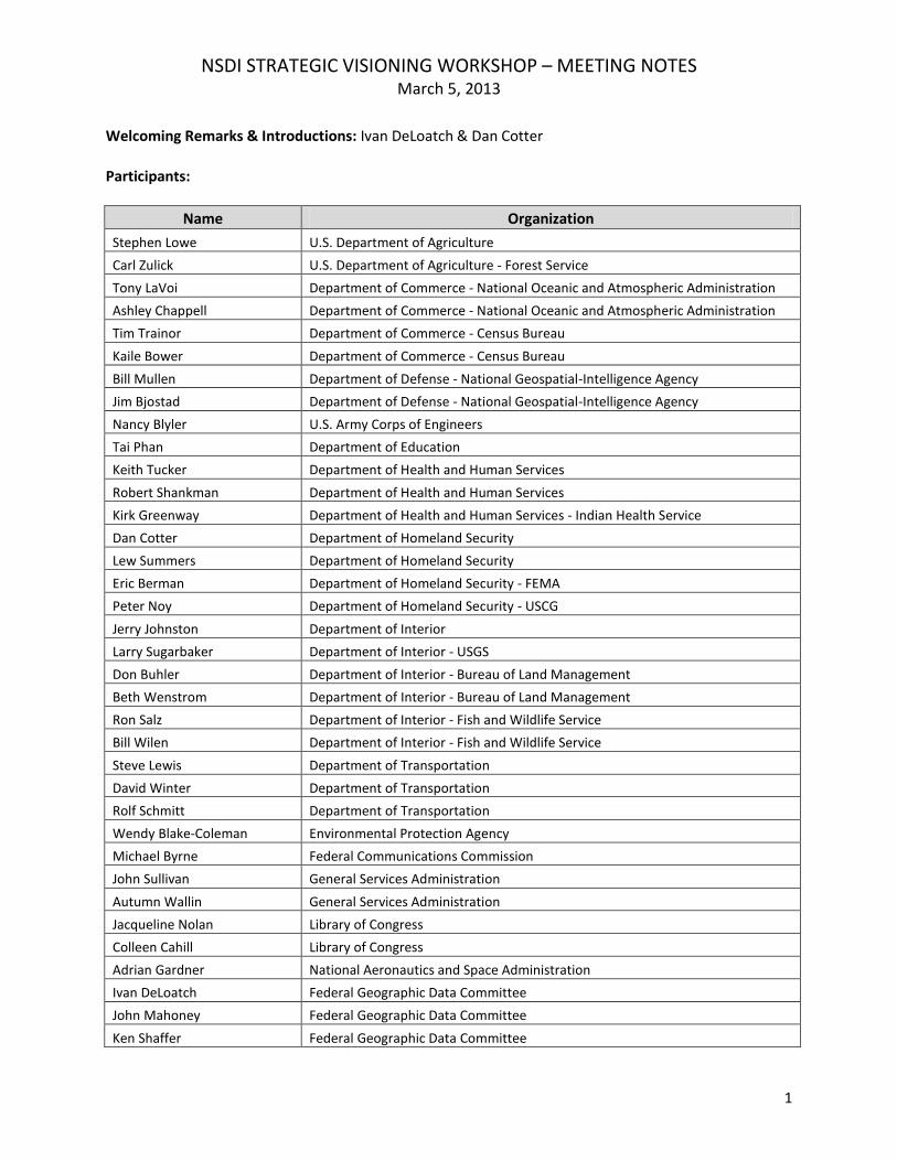
Welcoming Remarks & Introductions: Ivan DeLoatch & Dan Cotter
Participants:
Name Organization
Stephen Lowe U.S. Department of Agriculture
Carl Zulick U.S. Department of Agriculture - Forest Service
Tony LaVoi Department of Commerce - National Oceanic and Atmospheric Administration
Ashley Chappell Department of Commerce - National Oceanic and Atmospheric Administration
Tim Trainor Department of Commerce - Census Bureau
Kaile Bower Department of Commerce - Census Bureau
Bill Mullen Department of Defense - National Geospatial-Intelligence Agency
Jim Bjostad Department of Defense - National Geospatial-Intelligence Agency
Nancy Blyler U.S. Army Corps of Engineers
Tai Phan Department of Education
Keith Tucker Department of Health and Human Services
Robert Shankman Department of Health and Human Services
Kirk Greenway Department of Health and Human Services - Indian Health Service
Dan Cotter Department of Homeland Security
Lew Summers Department of Homeland Security
Eric Berman Department of Homeland Security - FEMA
Peter Noy Department of Homeland Security - USCG
Jerry Johnston Department of Interior
Larry Sugarbaker Department of Interior - USGS
Don Buhler Department of Interior - Bureau of Land Management
Beth Wenstrom Department of Interior - Bureau of Land Management
Ron Salz Department of Interior - Fish and Wildlife Service
Bill Wilen Department of Interior - Fish and Wildlife Service
Steve Lewis Department of Transportation
David Winter Department of Transportation
Rolf Schmitt Department of Transportation
Wendy Blake-Coleman Environmental Protection Agency
Michael Byrne Federal Communications Commission
John Sullivan General Services Administration
Autumn Wallin General Services Administration
Jacqueline Nolan Library of Congress
Colleen Cahill Library of Congress
Adrian Gardner National Aeronautics and Space Administration
Ivan DeLoatch Federal Geographic Data Committee
John Mahoney Federal Geographic Data Committee
Ken Shaffer Federal Geographic Data Committee
NSDI STRATEGIC VISIONING WORKSHOP – MEETING NOTES March 5, 2013
2
Name Organization
Tricia Gibbons Lead Alliance
Carol Jeffords Lead Alliance
Objective: Build the foundation for the NSDI Strategic Plan
Logistics: Tricia Gibbons
Warm-up exercise: one strength of the federal geospatial community (captured on stickies and posted on wall chart)
Discussion Re History of the NSDI graphic:
Lack of coordination pre-FGDC
Long history of collaboration within the community
Environment in 1990 o Stove-piped o Data not readily available; now data flowing so much faster o Huge technology changes o Disconnect between statistical agencies and others o Geospatial community was in the “back room” and was much smaller
SPOT Analysis Table groups identified the current and internal strengths and problems of the federal geospatial community. Themes that emerged as strengths included:
Standards
Collaboration
Communication
Sense of Community
Leadership
Knowledge management
Broad cross section Problems seemed to fall into categories or buckets. They included:
Addressing Data Services
Messaging
Accountability
Enforcement and agency commitment
Exposure & finding of data
Need for a business case & process
NSDI – role of the federal government and role of non-federal stakeholders
Operational issues There is a PowerPoint Graphic Summary of the SPOT available also. The actual inputs included: STRENGTHS
Collaboration (interagency, across organizations, cross-government, FGDC a forum for collaboration, missions support) (7)
Standards (established data standards, benefits of standards, connection to non-geo standards & architecture efforts) (5)
NSDI STRATEGIC VISIONING WORKSHOP – MEETING NOTES March 5, 2013
3
Speed & incorporation of applications
Provide directions/road work for cooperation (2)
Data; amount of data (2)
Metadata guidance
Distribution of data
Framework data – Cadastral NSDI Public Land Survey System
Dedicated community of data set managers who, if organized, would do a lot to push forward approaches in all business lines to improve cross agency cooperation
Demonstration of best practices
Innovation
FGDC cap grants
Network channels
Audit response
Large collective budget
Skills, experience
Keeping conversation moving forward on geospatial data sharing & quality to make it more accessible and useful
Document archive; traceability, track, open to public
Passion of the community and the shared value of developing standards and a new strategic plan
Single point of blame
There is a sense of community and a desire to solve real world problems. This puts a face on the NSDI.
Diverse geospatial community
Collective leadership
NGAC coordination
There are pockets of expertise, best practices, and collaboration throughout government that could be shared.
GIS still has promise to encourage geographic understanding
Common voice
Collegial interagency forum of unclassified, law enforcement and intelligence communities exploring more efficient geospatial data acquisition and dissemination
Amount of information we can share with private sector
Willing to help with solutions
Information (data, programs, people)
Evolution of web services - national MPP geoplatform PROBLEMS
Geospatial not fully integrated into wider IT community/Still in the back of the house (2)
Appearance that Google or ESRI can do all this for free
OMB expects us to function more as a business rather than an association
Data quality
Aging workforce (e.g., employees leaving government in the next five years)
Lack of FGDC Steering Committee members’ seniority (A/S representing DOI should have DAS level as a minimum.)
No consequences for failing to build your portion of NSDI: No carrot, no stick (2)
NSDI STRATEGIC VISIONING WORKSHOP – MEETING NOTES March 5, 2013
4
Lack of OMB leadership with OMB Circular A-16; Lack of enforcement mechanism for A-16 mandate to cooperate on data sharing/purchasing/acquiring (2)
Building NSDI not part of agency mission; A-16 theme leads not always aligned with agency missions (2)
We focus on everything; need to prioritize (2)
Prioritization: convincing OMB to invest in geospatial
Taking in citizen-collected data – data flows both ways
Data sharing; open data policy
Data licensing (2)
Lack of Master Data Management (MDM) skills cross-federal government
Failure to recognize data is data – we are not unique
How do we collectively identify what the focus is to be?
Unclear federal roles in NSDI; Role of the federal sector in geo-community (3)
Role definition and identity for all sectors; Define the role for private sector, state and local (2)
NSDI partnerships with non-Feds
Perception we’re not partnering – yes we are
Communication – not marketing enough
Speed of policy development vs. speed of changing technology
Speed of technology adoption impacts interoperability
Incorporation of metadata
Lack of standard symbology
How to think with maps instead of just mapping
IT security and bureaucratic inertia ‡ innovation
Congress tends to fund “missions” not data; data needs to be mapped back to mission needs to be viable
National spatial services infrastructure
What is best governance model? o Geospatial portfolio (data, services, infrastructure) o X-cutting?
No internal controls (standards, metadata)
Process maturity
OMB RMO - Geo Literacy
HSIP data access for non-HS partners
HSIP vs. common data
How do we explain the relevancy of the NSDI? Relevancy framework (business value) (2)
Agency-specific mandates not conducive to shared workload
Lack of awareness at top level of agencies
Lack of awareness, lack of visibility, lack of support
Many major programs have geospatial components that are not visible to GIOs; disconnect between geospatial and CIO (2)
Funding strategy
One size fits all mentality
Agency assertions that we can’t collaborate on data because “we’re different”
Many agencies don’t build uniform, consistent “national datasets” coast to coast, border to border
No congressional mandate to build NSDI
NSDI STRATEGIC VISIONING WORKSHOP – MEETING NOTES March 5, 2013
5
Geospatial is not a “program.” It is placed organizationally in different places agency to agency – IT, reserves, engineering, geospatial, etc. – making it hard to communicate and collaborate.
Difficult to quantify geospatial investments and expenditures
508 non-compliance
Need for decision support
Too many reasons to acquire to different standards – research, science, ops, etc.
Little accountability for success
OMB/EOP interface and coaching
Money
Archiving? Losing data
Not meeting public expectation of sharing/discovery
Addressing the needs of a diverse user community
Need to share/need to know – changing mind set
Data discovery – ongoing
Defining authoritative open data
Data privacy & open data policies
Incorrect agency level of support to NSDI
Dedicated & consistent FGDC representation
Disparate business process – challenge to cooperation THREATS
Performance measures
Competing priorities; Loss of focus/priorities (3)
System & data security restricting use
Data corruption (2)
Geo-terrorism
Loss of SMEs
Data privacy
Lack of vision
Use – What/how are we raising capability of the nation? Are we “building it, they will come”?
Lack of governance, OMB engagement
Need clear definition and re-agreement on what NSDI looks like
Failure to have a plan
Reduction in funding
Decreased productivity
Technology leapfrogging current government initiatives under development
Inertia in noting or accepting that things have changed
Spoofing of GPS? OPPORTUNITIES
Geospatial Platform – when it’s ready, invite scrutiny from users; adjust and then sell/promote the Platform
State/local partnerships (2)
Mobile technologies multiple platforms, access
Issue focused collaboration – communities
Geoplatform.gov 2.0 demo shared services!
NSDI STRATEGIC VISIONING WORKSHOP – MEETING NOTES March 5, 2013
6
Sequestration – should show industry that Congress is serious about fiscal restraint. Money for data must go farther.
Faster/more accessible data/applications
GAO Report – leverage
Real willingness within OMB to make real change (e.g., FEMA flood mapping reauthorization)
Opportunity to develop a plan that we want to be held accountable for
Make Todd Park/ Steven Van Roekel – legacy
Do some intel – which agency/program authorizations are coming up which can be leveraged
Leverage state and local base – common framework to share data
Focus on outcomes to hold FGDC accountable & executive champions
Accountability
Semantic web
Big data
Opportunity to market our successes, control our story
Economies of scale
More resourceful
Open data policy can be leaders
Development of GIO & geospatial activities visibility
Shared services can mean greater capabilities
Open source constant access/interoperability
Extend NSDI to support infrastructure analysis at local levels
Galvanizing central focus – emergency preparedness. Common denominator of all bad things in the need for place-based knowledge/data.
Performance measures There was a short discussion of the Promise of the Geospatial Platform.
Shared information
Stepping stone
Quantifiable
Cost savings
Co-investment story line
Poster child on the way government can/should provide products & services ENVIRONMENTAL SCAN: CONTEXT MAP
Participants worked in table groups to identify environmental factors that would impact the federal geospatial community. Table groups were given specific topics to explore. There is a PowerPoint Graphic Summary available also. Results by category follow. INDUSTRY TRENDS
Ubiquity of mobile computing & location-based services – huge impact on our industry
Agencies focused on making data available generically – enables downstream users – any platform
Movement spatial. What doesn’t have a spatial component any more?
Moving to the cloud – cost factor, efficiencies
Government data will be re-used by industry – how to push out more, ensure value
NSDI STRATEGIC VISIONING WORKSHOP – MEETING NOTES March 5, 2013
7
Greening industry
Globalization, human geography, competing services
Big data/data science pattern analysis
Open source
Metrics count everything
Professional services competition market shift
Market disruption – new tools
Surveillance society
Smart phones
Broadband
Trend: crowd sourcing more mainstream; how to harness this capacity if of value
Why should we do it when Google can do it?
Demand for human geography POLITICAL FACTORS
Political attention span is diminishing
Inconsistent – non-integrated federal initiative priorities
Campaign mode
Political perspective of GIS has changed - from why do we need GIS to how do we use it or where do we fund it?
Do more with less & work smarter
Privacy issues – copyright, open data sources, tension between privacy & services
Drones, wireless, hot spots – do we care? Just want to get our data out
Demonstrating utility of geospatial data - democratization to Congress
Transparency – openness philosophy; hesitation on part of agencies to publish
International – data sharing between countries is key; we impact them & they impact us
Government needs to understand what we need to publish authoritatively
Need to understand who is consuming
Politics of budget will work against enterprise anything
Leverage comms for messaging – will always be secondary
Issue is always the issue: “comms”
Desire to eliminate redundancy ECONOMIC CLIMATE
Globalization
A lot of power in the small business sector (& how they add to economy)
Pros and cons of budget cuts (good for collaboration but bad for skill set knowledge maintenance)
Shrinking budgets (2)
Business expansion
Funding restrictions
No new programs?
U.S. leadership position in geospatial services
Emphasis on shared services
Consolidation
Evolving funding models
NSDI STRATEGIC VISIONING WORKSHOP – MEETING NOTES March 5, 2013
8
TECHNOLOGY FACTORS
Mobile devices increase demand for ROI
Commoditization technology transfer
Real time data demand
Device mash-ups with spatial data
Faster access
Small disruptive tech innovation (e.g. square)
Network is the computer
Ease of delivery – mobile devices, services, apps INTERNAL TRENDS
Enterprise services
Mainstreaming GIS
Migrating to Cloud
Rapid changes in technology & mobile apps not consistent across agencies
Interagency partnering
Mobile workforce
Accessibility
Data having a geospatial component
Collect once - use many times
Tell a story with the data
Growth potential in geospatial workforce
Tech savvy “youth” (35-year-olds) enter SES ranks; total shift from fear of technology to having it be a part of life
IT and GIS merge
Agencies focused on making data available generically
Agencies don’t know who is using their data; trend for increasing external use; need to survey to justify/improve
CUSTOMER/STAKEHOLDER NEEDS
Cost – software, network
Stakeholder needs driven by industry; build so they know they need it
Spending money wisely
Social media
Crowd source
National data at local scale AGENCY NEEDS
Subject matter experts specific to agency needs
Connecting in remote locations & emergencies
Understanding & validating requirements
Data security & privacy
Shrinking budgets
Mature & trusted data
Dynamic data access
NSDI STRATEGIC VISIONING WORKSHOP – MEETING NOTES March 5, 2013
9
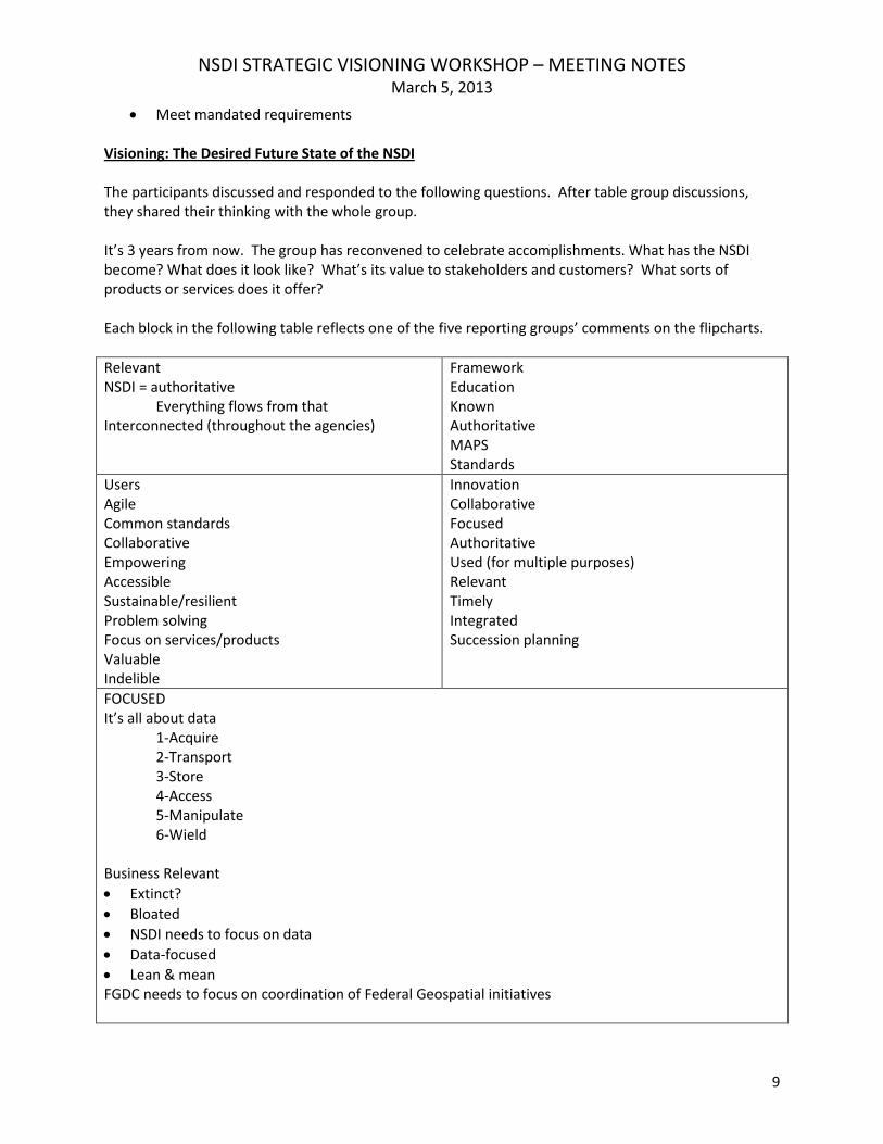
Meet mandated requirements Visioning: The Desired Future State of the NSDI The participants discussed and responded to the following questions. After table group discussions, they shared their thinking with the whole group. It’s 3 years from now. The group has reconvened to celebrate accomplishments. What has the NSDI become? What does it look like? What’s its value to stakeholders and customers? What sorts of products or services does it offer? Each block in the following table reflects one of the five reporting groups’ comments on the flipcharts.
Relevant NSDI = authoritative Everything flows from that Interconnected (throughout the agencies)
Framework Education Known Authoritative MAPS Standards
Users Agile Common standards Collaborative Empowering Accessible Sustainable/resilient Problem solving Focus on services/products Valuable Indelible
Innovation Collaborative Focused Authoritative Used (for multiple purposes) Relevant Timely Integrated Succession planning
FOCUSED It’s all about data 1-Acquire 2-Transport 3-Store 4-Access 5-Manipulate 6-Wield Business Relevant
Extinct?
Bloated
NSDI needs to focus on data
Data-focused
Lean & mean FGDC needs to focus on coordination of Federal Geospatial initiatives
NSDI STRATEGIC VISIONING WORKSHOP – MEETING NOTES March 5, 2013
10
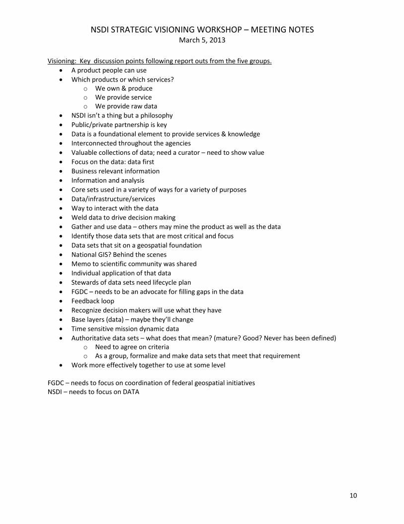
Visioning: Key discussion points following report outs from the five groups.
A product people can use
Which products or which services? o We own & produce o We provide service o We provide raw data
NSDI isn’t a thing but a philosophy
Public/private partnership is key
Data is a foundational element to provide services & knowledge
Interconnected throughout the agencies
Valuable collections of data; need a curator – need to show value
Focus on the data: data first
Business relevant information
Information and analysis
Core sets used in a variety of ways for a variety of purposes
Data/infrastructure/services
Way to interact with the data
Weld data to drive decision making
Gather and use data – others may mine the product as well as the data
Identify those data sets that are most critical and focus
Data sets that sit on a geospatial foundation
National GIS? Behind the scenes
Memo to scientific community was shared
Individual application of that data
Stewards of data sets need lifecycle plan
FGDC – needs to be an advocate for filling gaps in the data
Feedback loop
Recognize decision makers will use what they have
Base layers (data) – maybe they’ll change
Time sensitive mission dynamic data
Authoritative data sets – what does that mean? (mature? Good? Never has been defined) o Need to agree on criteria o As a group, formalize and make data sets that meet that requirement
Work more effectively together to use at some level FGDC – needs to focus on coordination of federal geospatial initiatives NSDI – needs to focus on DATA
NSDI STRATEGIC VISIONING WORKSHOP – MEETING NOTES March 5, 2013
11
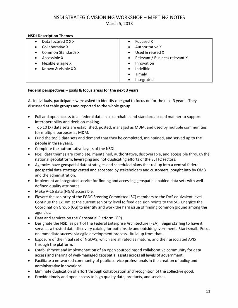
NSDI Description Themes
Data focused X X X
Collaborative X
Common Standards X
Accessible X
Flexible & agile X
Known & visible X X
Focused X
Authoritative X
Used & reused X
Relevant / Business relevant X
Innovation
Indelible
Timely
Integrated
Federal perspectives – goals & focus areas for the next 3 years As individuals, participants were asked to identify one goal to focus on for the next 3 years. They discussed at table groups and reported to the whole group.
Full and open access to all federal data in a searchable and standards-based manner to support interoperability and decision-making.
Top 10 (X) data sets are established, posted, managed as MDM, and used by multiple communities for multiple purposes as MDM.
Fund the top 5 data sets and demand that they be completed, maintained, and served up to the people in three years.
Complete the authoritative layers of the NSDI.
NSDI data themes are complete, maintained, authoritative, discoverable, and accessible through the national geoplatform, leveraging and not duplicating efforts of the SLTTC sectors.
Agencies have geospatial data strategies and scheduled plans that roll up into a central federal geospatial data strategy vetted and accepted by stakeholders and customers, bought into by OMB and the administration.
Implement an integrated service for finding and accessing geospatial enabled data sets with well-defined quality attributes.
Make A-16 data (NGA) accessible.
Elevate the seniority of the FGDC Steering Committee (SC) members to the DAS equivalent level. Continue the ExCom at the current seniority level to feed decision points to the SC. Energize the Coordination Group (CG) to identify and work the hard issue of finding common ground among the agencies.
Data and services on the Geospatial Platform (GP).
Designate the NSDI as part of the Federal Enterprise Architecture (FEA). Begin staffing to have it serve as a trusted data discovery catalog for both inside and outside government. Start small. Focus on immediate success via agile development process. Build up from that.
Exposure of the initial set of NGDAS, which are all rated as mature, and their associated APIS through the platform.
Establishment and implementation of an open sourced based collaborative community for data access and sharing of well-managed geospatial assets across all levels of government.
Facilitate a networked community of public service professionals in the creation of policy and administrative innovations.
Eliminate duplication of effort through collaboration and recognition of the collective good.
Provide timely and open access to high quality data, products, and services.
NSDI STRATEGIC VISIONING WORKSHOP – MEETING NOTES March 5, 2013
12
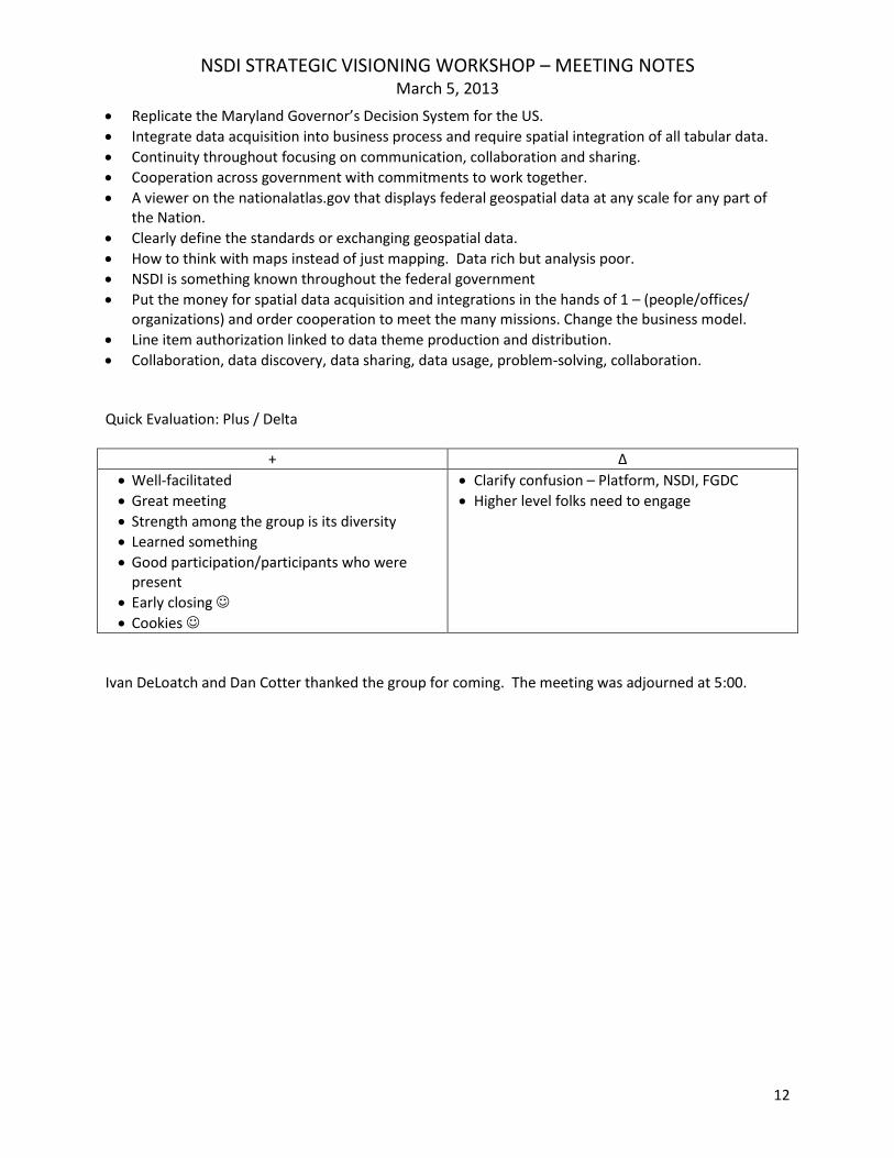
Replicate the Maryland Governor’s Decision System for the US.
Integrate data acquisition into business process and require spatial integration of all tabular data.
Continuity throughout focusing on communication, collaboration and sharing.
Cooperation across government with commitments to work together.
A viewer on the nationalatlas.gov that displays federal geospatial data at any scale for any part of the Nation.
Clearly define the standards or exchanging geospatial data.
How to think with maps instead of just mapping. Data rich but analysis poor.
NSDI is something known throughout the federal government
Put the money for spatial data acquisition and integrations in the hands of 1 – (people/offices/ organizations) and order cooperation to meet the many missions. Change the business model.
Line item authorization linked to data theme production and distribution.
Collaboration, data discovery, data sharing, data usage, problem-solving, collaboration. Quick Evaluation: Plus / Delta
+ ∆
Well-facilitated
Great meeting
Strength among the group is its diversity
Learned something
Good participation/participants who were present
Early closing
Cookies
Clarify confusion – Platform, NSDI, FGDC
Higher level folks need to engage
Ivan DeLoatch and Dan Cotter thanked the group for coming. The meeting was adjourned at 5:00.