november 2014 - landscape boards sa
TRANSCRIPT

0
South Australian Arid Lands Natural Resources Management Board
NORTH EAST PASTORAL NRM DISTRICT WEED STRATEGY
NOVEMBER 2014

1
NORTH EAST PASTORAL
NRM DISTRICT WEED STRATEGY
PAUL HODGES
DEWNR
NOVEMBER 2014
Acknowledgements
This Strategy is funded by Caring for Our Country, through the South Australian Arid Lands NRM Board
The author wishes to convey special thanks to the following people:
Jodie Reseigh and Ben Shepherd (Rural Solutions) for developing previous Weed Strategy’s
for other NRM Districts within SA Arid Lands Region, on which this strategy is based.
Greg Patrick (SAAL NRM Board) for his time in helping develop this Strategy and review
comments
John Pitt (Rural Solutions) for his technical advice and review comments
The individual artists for use of their photographs
Disclaimer
The South Australian Arid Lands Natural Resources Management Board, and its employees do not
warrant or make any representation regarding the use, or results of use of the information contained
herein as to its correctness, accuracy, reliability, currency or otherwise. The South Australian Arid Lands
Natural Resources Management Board and its employees expressly disclaim all liability or responsibility
to any person using the information or advice.
This work is copyright. Apart from any use permitted under the Copyright Act 1968 (Commonwealth), no
part may be reproduced by any process without prior written permission obtained from the South
Australian Arid Lands Natural Resources Management Board. Requests and enquiries concerning
reproduction and rights should be directed to the Regional Manager, South Australian Arid Lands
Natural Resources Management Board, 9 Mackay Street, PO Box 78, Port Augusta, SA, 5700
© South Australian Arid Lands Natural Resources Management Board 2014
Photos front page: African Boxthorn (Photo P Hodges, DEWNR), Wheel Cactus (Photo J Pitt, Rural Solutions) and Pepper Tree (Photo B Shepherd, Rural Solutions) are all prevalent in the NEP District.
2
Table of Contents
Acknowledgements ............................................................................ 1
Disclaimer ........................................................................................... 1
Table of Contents ............................................................................... 2
Purpose of Strategy ............................................................................ 3
The North East Pastoral NRM District ............................................... 4
The North East Pastoral NRM District Group ................................... 5
Target Weeds ...................................................................................... 5
Review period ..................................................................................... 8
Target Weeds and their strategy ....................................................... 9
African Boxthorn ...................................................................................... 9
African Rue ............................................................................................ 12
Athel Pine ............................................................................................... 15
Buffel Grass ........................................................................................... 19
Cactus species ...................................................................................... 22
Mesquite ................................................................................................. 30
Mexican Poppy ....................................................................................... 34
Noogoora Burr ........................................................................................ 37
Parkinsonia ............................................................................................. 41
Pepper Tree ............................................................................................ 45
Appendix 1 – Alert Weeds ................................................................ 48
Innocent Weed ........................................................................................ 48
Prickly Acacia ......................................................................................... 51
Appendix 2 – Other weeds of interest ............................................. 55
Bathurst Burr........................................................................................... 55
Castor Oil Plant ....................................................................................... 58
Bibliography ...................................................................................... 61

3
Purpose of Strategy
It is intended that this strategy be used by the North East Pastoral NRM District
Group to guide prioritisation of weed management activities within their district over
the next five years.
The strategy outlines management actions that the Group and landholders can
implement within their District that will reduce the current and potential impacts of ten
priority weeds.
The management actions outlined for each of the ten priority weeds are in line with
South Australian state policies for declared weeds and the SA Arid Lands NRM
Board regional weed policies.
The strategy also provides information regarding the distribution, possible threats and
impacts and policy on each of the ten priority weeds and outlines current best
practise control methods and surveying/monitoring activities.
Furthermore, it is recommended that the group review this strategy in five years to
assess progress and update management actions where required.
Some of the plant species discussed in this strategy are valued amenity trees (e.g.
Pepper Trees and Athel Pine) within station gardens, while others are generally
undesirable plants (e.g. cactus and African Rue). Most of the weeds are currently at
low densities, while others have infested large areas. All the plants dealt with in this
strategy have a demonstrated ability to rapidly expand their distribution given
favorable seasonal conditions. Managing current infestations and removing potential
sources for new infestations will save the considerable amounts of time and money
required to control large infestations of persistent weeds.
The District groups can be influential in the implementation of on-ground natural
resource management programs within their district. By implementing this strategy
the North East Pastoral NRM District group can develop proactive weed
management programs within their district for the long term protection of its
environmental and productive assets.

4
The North East Pastoral NRM District
The North East Pastoral District covers an area of approximately 34,500 square
kilometres and is bound to the north by the dog fence and to the east by the New
South Wales border. The population of the district is approximately 400-500 people
plus itinerant workers such as miners and field processors. There are no major
towns, however small communities exist at Yunta, Manna Hill, Olary and Mingary.
The climate is characterised by hot to very hot, dry summers and cool to mild, dry
winters. Rainfall is low and unreliable with some infrequent heavy falls and no
apparent seasonality. Average annual rainfall ranges from 175 mm in the north to
250 mm in the west. Evaporation rates are 2,500 mm per annum in the south and
2,800 mm in the north.
The dominant landforms of the district are divided by the low hills of the Olary Spur,
with undulating mallee/black oak and chenopod plains to the south and extensive
bluebush/saltbush plains with occasional dunes to the north.
The dominant vegetation of the district includes:
Low Hills: mallee box, ruby saltbush, curry bush, clammy daisy bush, rock
nightshade
Plains: black oak, bullock bush, sandalwood, bladder saltbush, senna, mulga,
bluebush
Watercourses/Drainage Lines: river red gums, river box, blackbush, saltbush,
elegant wattle, mallee box, never-fail, spotted emu-bush
Groundwater of reasonable quality is found throughout most of the district. The Olary
Spur provides the catchment and storage for most groundwater suitable for stock.
Dams are the major source of water away from the Olary Spur as the supply and
quality of bore water on the plains is low and used generally for supplementary
supplies in dry seasons.
The dominant land use in the district is sheep production, with some cattle grazing.
Other land use includes gold and uranium mining, with some tourism. There is one
DEWNR managed reserve and one property managed for conservation by Bush
Heritage.
Land management issues include: total grazing pressure; feral animals; pest plants;
wind and water erosion; increased mining and exploration impacts.
5
The North East Pastoral NRM District Group
The District Groups were established to provide a vital link in communicating
community issues to the SA Arid Lands NRM Board and provide a local perspective
on implementing on-ground projects.
The District Group members of the North East Pastoral NRM District Group as at
August 2014 are:
Glen Norris
Terrence Coulthard
Richard Williams
Kevin Heness
Ian Falkenberg (DEWNR Rep)
Ross Sawers (SAALNRM Board Rep)
Target Weeds
The weeds chosen as priorities for the North East Pastoral NRM District and dealt
with in this strategy are declared weeds under the Natural Resources Management
Act 2004 and/or demonstrated to be regional threats where the feasibility of control is
realistic i.e. they are strategic control opportunities. An initial list of priority weeds
were presented to the District Group from which the top ten priority weeds were
selected.
Weed risk assessments have been undertaken by the SA Arid Lands NRM Board on
each of the ten priority weeds. This process determines a weeds risk (low, medium or
high) in a rangelands land system by assessing the weeds invasiveness, impact and
potential distribution. Through the assessment of each weeds risk, the management
strategy for each weed was identified (Table 1).

6
Table 1. Ten priority weeds included in the North East Pastoral NRM District Strategy, the
management strategy and description of the management strategy for each weed. NB Cactus
species have different management strategies depending on the weeds risk.
Priority Weed Management strategy
Description of management strategy
African Boxthorn Manage sites African Boxthorn is common in the District and the Group should aim to reduce the overall economic and/or social impacts of this weed through targeted management. See page 9 for more details
African Rue Protect sites African Rue has a limited current distribution in the District and the Group should aim to prevent spread to key sites/assets of high economic, environmental and/or social value. See page 12 for more details.
Athel Pine Protect sites Athel Pine is common but has a limited distribution within the District and the Group should aim to prevent spread (particularly along watercourses). See page 15 for more details.
Buffel Grass Contain spread Buffel Grass has a limited distribution within the District. The Group should aim to prevent spread through control of all infestations. See page 19 for more details.
Cactus species (Devil’s rope, Coral Cactus, Jumping Cholla, Hudson Pear)
Destroy infestations
Devil’s Rope has been found in the south-west of the District. Any occurrences should immediately be reported to Natural Resources SA Arid Lands and destroyed as soon as practical. See page 22 for more details.
Cactus species (Prickly Pear, Wheel Cactus, Engelmann’s Prickly Pear)
Contain spread Wheel Cactus infestations have been found south of the Barrier Highway and treated. The Group should seek to prevent ongoing spread through control of all infestations of these species, aiming for a significant reduction in weed density. See page 22 for more details.
Mesquite Contain spread Mesquite has a very limited distribution within or close to the District and the Group should aim to prevent spread through control of all infestations. See page 30 for more details
Mexican Poppy Monitor Mexican Poppy is limited to some drainage lines within the District. The Group should monitor to detect any significant changes in the species weed risk. See page 34 for more details.
Noogoora Burr Monitor Noogoora Burr is limited to some drainage lines within the District. The Group should monitor to detect any significant changes in the species weed risk. See page 37 for more details.
Parkinsonia Contain spread Parkinsonia has a very limited distribution within the District and the Group should aim to prevent spread through control of all infestations. See page 41 for more details.
Pepper Tree Protect sites Pepper Trees are common within the District and the Group should aim to prevent spread to key sites/assets of high economic, environmental and/or social value. See page 45 for more details.

7
Table 2. Management Strategy aims and actions definitions
Management strategy
Aims & actions of management strategies
Alert Species that are not known to be present in the management area and which represent a significant threat if permitted to enter and establish.
Aims to prevent the species arriving and establishing in the management area.
Prevention of entry to management area
Ongoing surveillance for incursions of the species
Training & awareness activities for the community to enable early detection
Eradicate Aims to remove the weed species from the management area.
Detailed surveillance & mapping to locate all infestations
Destruction of all infestations including seed banks
Prevention of entry to management area and movement within
Must not grow and all cultivated plants to be removed
Monitor progress towards eradication
Destroy Aims to significantly reduce the extent of the weed species in the management area.
Detailed surveillance & mapping to locate all infestations
Destruction of all infestations, aiming for local eradication at feasible sites.
Prevention of entry to management area and movement and sale within
Must not grow
Monitor progress towards reduction
Contain spread
Aims to prevent the ongoing spread of the weed species in the management area.
Surveillance & mapping to locate all infested properties
Control all infestations, aiming for a significant reduction in weed density
Prevention of entry to management area and movement and sale within
Must not allow to spread from cultivated plants (if grown)
Monitor change in current distribution
Protect sites Aims to prevent spread of the weed species to key sites/assets of high economic, environmental and/or social value.
Weed may be of limited current distribution but only threatens limited industries/habitats (lower weed risk). Or the weed may be more widespread but is yet to invade/impact upon many key industries/habitats (higher weed risk)
Surveillance & mapping to locate all infested properties
Identification of key sites/assets in the management area
Control of infestations in close proximity to key sites/assets, aiming for a significant reduction in weed density.
Limits on movement within the management area
Must not allow to spread from cultivated plants (if grown) in close proximity to key sites/assets
Monitor change in current distribution within and in close proximity to key sites/assets

8
Manage weed Aims to reduce the overall economic, environmental and/or social impacts of the weed species through targeted management
Research and develop integrated weed management (IWM) packages for the species, including herbicides and biological control, where feasible
Promote IWM packages to landholders
Monitor decrease in weed impacts with improved management
Identify key sites/assets in the management area and ensure adequate resourcing to manage the weed species
Manage sites Aims to maintain the overall economic, environmental and/or social value of key sites/assets through improved general weed management.
Promote general IWM principles to landholders, including the range of control techniques, maintaining competitive vegetation/crops/pastures, hygiene & property management plans
Identify key sites/assets in the management area & ensure adequate resourcing to manage these to maintain their values
Broaden focus beyond weeds to all threatening processes
Monitor Aims to detect any significant changes in the species’ weed risk
Monitor the spread of the species and review any perceived changes in weediness
Limited action
The weed species would only be targeted for coordinated control in the management area if its local presence makes it likely to spread to land uses where it ranks as a higher priority
Undertake control measures if required for the benefit of other land uses at risk
Otherwise limited advice to land managers, if required
Review period
It is intended that this strategy be implemented over the next five years. In the third
year it is suggested that the District Group review progress and update management
targets and actions accordingly.
Suggested time frame:
Year Activity
2014 Draft strategy reviewed by the Group and feedback incorporated into the Strategy
Strategy endorsed by the group
2015 Implementation
2016 Implementation
2017 Implementation and review progress and update the strategy as required (and then every 3 years)
2018 Implementation

9
Photo 1: African Boxthorn leaves and spines (Photo J Pitt)
Photo 2: African Boxthorn with fruit (Photo J Pitt)
Target Weeds and their strategy
African Boxthorn
Common name(s): African Boxthorn
Scientific name: Lycium ferocissimum
Plant description: Branched shrub to 5 m high and 3 m wide. Spines occur on the main stems and branchlets, branchlets terminate with a spine
Slightly fleshy leaves (10-40 mm long), in clusters at the nodes.
Flowers are pale lilac to white with purple markings at the base.
Fruit is dull orange-red berry (1 cm diameter).
Flowering: Predominately in summer (but may occur all year round)
Origin: South Africa
When introduced: 1845
Why introduced: Introduced as a hedge plant
Other information: African Boxthorn fruit is the breeding place for numerous insects including common house fly, fruit fly and dried fruit beetles.
Threats and Impacts
Invasiveness African Boxthorn can only be dispersed through seed, which is eaten by birds and foxes and viable when excreted. Seed can be easily dispersed over large areas, particularly under trees, poles and fences where birds have perched.
Regrowth may occur from broken roots and cut stumps following physical control.

10
Impacts African Boxthorn may form dense stands which compete with native species and pastures. The sharp spines prevent grazing and make stock movement difficult, particularly near watercourses which may prevent access.
African Boxthorn can impact on native fauna by reducing habitat quality.
Thickets of African Boxthorn can harbour feral pests such as foxes and rabbits.
Persistence African Boxthorn has the ability to reshoot and reinvade areas where control has been undertaken therefore long-term follow-up is required.
Reinfestation of Boxthorn may occur from untreated plants in surrounding areas.
Distribution
Current Australian distribution:
All states
Current South Australian distribution:
In South Australia, common in large areas of the arid lands, on islands off Eyre Peninsula and amongst coastal dunes on western Eyre Peninsula.
Current District distribution:
African Boxthorn is common at low densities throughout the district. However, in some drainage lines there are significant dense infestations.
Potential distribution: African Boxthorn has the potential to infest watercourses and flood plains, especially where Boxthorns are located upstream. Boxthorns may increase in density where unmanaged.
Policy
National Strategy: African Boxthorn is classified as a Weed of National Significance (WONS).
The extent and potential of African Boxthorn in Australia will be well understood, stakeholders well equipped with information tools and knowledge, and strategic management will contain and reduce the weed’s impacts.
State Policy: To protect native vegetation and maintain access to pasture throughout SA.
Under the Natural Resources Management Act, 2004:
Restricting movement of African Boxthorn on public roads
Prohibiting sale of African Boxthorn or produce or goods carrying African Boxthorn
Requiring an owner of land to control African Boxthorn and inhibit its propagation as far as is reasonably achievable
Allowing NRM Boards to recover costs of control of African Boxthorn on road reserves from adjoining landowners.
SA Arid Lands NRM Policy:
The SAAL NRM regional management strategy for African Boxthorn is to MANAGE sites.
Aim: To reduce the overall economic, environmental and/or social impacts of African Boxthorn through targeted management.
North East Pastoral NRM District Risk management strategy:
North East Pastoral NRM District management strategy is to MANAGE sites infested with African Boxthorn,
Aim: To maintain economic, environmental and/or social values of key sites/assets through improved management of African Boxthorn.

11
North East Pastoral NRM District Strategy for management of African Boxthorn
Recommended Actions
Support land manager education in identification, monitoring and control of African Boxthorn.
North East Pastoral NRM District Group to encourage landholders to provide data on distribution of African Boxthorn in North East Pastoral NRM District to NRSAAL, so that it can be surveyed and mapped.
North East Pastoral NRM District group to provide input into identification of key sites for control of African Boxthorn infestations.
North East Pastoral NRM District group to assist in identifying and coordinating African Boxthorn control programs using integrated weed management (combination of recommended best practices), especially in areas where key sites are threatened.
Land managers encouraged to monitor success, following control of African Boxthorn, and carry out follow up control as necessary.
North East Pastoral NRM District group to encourage landholders to use best practice hygiene, to prevent movement and spread of African Boxthorn.
Best Practice Control
Control method and description Best time to control
Active ingredients and example trade names
Herbicide rates and carrier
Foliar Spray
Useful for all sized plants.
The entire plant is sprayed when actively growing. Plants should not be sprayed when they are stressed or when plants do not have foliage. Boxthorns are deciduous plants and will shed their leaves during winter and/or when stressed.
Summer and Spring when actively growing
Metsulfuron-methyl (600g/kg) e.g. Brush-off® + glyphosate (360g/L) e.g. Roundup®
Consistent with label rates in water with a penetrant e.g. Pulse®
Basal Bark
Useful for all sized plants
Spray all sides of each stem with the recommended herbicide mix, to a height of between 250 – 750 mm above soil level.
Summer and Spring when actively growing
Triclopyr 600 g/L e.g. Garlon®
Triclopyr 240 g/L + Picloram 120 g/L e.g. Access®
33 mls/L mixed in diesel
17 mls/L mixed in diesel
Cut Stump
Useful for all sized plants
Cut the entire plant down at the base using a chainsaw and immediately (within 10 seconds) spray or paint the recommended herbicide mix onto the cut stump.
Summer and Spring when actively growing
Triclopyr 600 g/L e.g. Garlon®
Triclopyr 240 g/L + Picloram 120 g/L e.g. Access®
33 mls/L mixed in diesel
17 mls/L mixed in diesel
Physical
Small plants can be hand-pulled or dug up.
Large plants can be removed using heavy machinery.
Best done when there is ground moisture as the plants will be more readily removed
Uprooted plants should be piled & destroyed by burning as they can provide shelter for vermin and the spines can still cause injury.
After removal, the area should be monitored for regrowth from root fragments left in the soil, and for germinating seedlings.
Surveys/ Monitoring
General method: Keep an eye out for African Boxthorn during routine pastoral management activities and record locations using a GPS.
Best time of year for surveys:
Spring and summer as well as in the weeks and months after rainfall events when it is bright green.

12
African Rue
Common name(s): African Rue
Scientific name: Peganum harmala
Plant description: Perennial herb or shrubby plant 30-80 cm high.
Leaves 1-5 cm long, bright green, divided several times into three or more linear segments.
Flowers, with 5 white broad petals (12- 17 mm long).
Fruit is slightly flattened capsule (8-12 mm across, 7-12 mm long) which opens at the top, containing black angular seeds.
Photo 3: African Rue plant (Photo B. Shepherd)
Photo 4: African Rue flowers (Photo Courtesy DWLBC)
Flowering: Late spring – early summer
Origin: Mediterranean region and Middle East
When introduced: Unknown
Why introduced: Unknown, was once used in Medicine
Other information: African Rue is considered an aphrodisiac in India. Its seeds and leaves have been used medicinally for treatment of various aliments including asthma, jaundice, colic and as a diuretic.
Threats and Impacts
Invasiveness Dispersal of the plant is predominately through seed, with the majority of seed being dropped close to the parent plant. Seeds can easily be dispersed through water flow, but also in mud moved by animals or vehicles. Stock and other animals may also eat the fruit and aid in the dispersal of African Rue.
African Rue prefers disturbed sites with little or no competition, and requires moisture for seed germination.
African Rue is drought and salt tolerant, and therefore has the potential to have large impacts in semi-arid and arid areas.

13
Impacts African Rue can be toxic containing more than 25 alkaloids, however the plant is highly unpalatable to livestock (few poisonings have been reported).
The likely impact on native vegetation is unknown, but due to its tolerance to drought and salt the potential impacts could be large.
Persistence African Rue is difficult to destroy once established as regeneration may occur from severed root pieces. African Rue is known to persist despite treatment with herbicide or manual removal.
Distribution
Current Australian distribution:
Confined to News South Wales and South Australia.
Current South Australian distribution:
Known to occur in patches at Tintinara, Taylorville and Snowtown as well as numerous other sites. In the SAAL region African Rue primarily occurs along roadsides and flood out areas. A core infestation exists in the eastern pastoral district and other occurrences exist in the northern Flinders Ranges and in the area between Lake Torrens and Port Augusta including along the Stuart Highway.
Current District distribution:
There are core infestations of African Rue near the north west border of the District and along roads that extend into north western and western areas of the District as well as other smaller infestations at selected locations around the district.
Potential distribution: African Rue has the potential to become widespread throughout the arid lands region in disturbed areas such as roadsides and areas receiving run-on water such as flood outs and depressions. The zone of potential distribution has been described as between the 350 mm and 175 mm isohyets.
Policy
National Strategy: African Rue is not classified as a Weed of National Significance, therefore there is no National Strategy for this species.
State Policy: African Rue is a declared species under the Natural Resources Management Act, 2004.
To prevent establishment in uninfested pastoral lands
Under the Natural Resources Management Act, 2004:
Prohibiting movement of African Rue on roads
Prohibiting the sale of African Rue or contaminated produce
Requiring landholders to control African Rue on their properties
Allowing recovery of roadside control costs of African Rue from adjoining landholders
SA Arid Lands NRM Policy:
The SAAL NRM regional management strategy for African Rue is to PROTECT sites
Aim: To prevent spread of African Rue to key sites/assets of high economic, environmental and/or social value.
North East Pastoral NRM District management strategy:
North East Pastoral NRM District management strategy is to PROTECT sites from the spread of African Rue
Aim: To prevent spread of African Rue to key sites/assets of high economic, environmental and/or social value.

14
North East Pastoral NRM District Strategy for management of African Rue
Recommended Actions
Support land manager education in identification, monitoring and control of African Rue.
North East Pastoral NRM District Group to encourage landholders to provide data on distribution of African Rue in North East Pastoral NRM District to NRSAAL, so that it can be surveyed and mapped.
North East Pastoral NRM District group to provide input into identification of key sites for control of African Rue infestations.
North East Pastoral NRM District group to assist in identifying and coordinating African Rue control programs using integrated weed management (combination of recommended best practices), especially in areas where key sites are threatened.
Land managers encouraged to monitor success, following control of African Rue, and carry out follow up control as necessary.
Best Practice Control
African Rue can be a difficult plant to kill due to its deep roots, on-going monitoring and repeated applications of herbicide will be required annually and after rainfall events.
Increasing competition from native plants, by reducing grassing pressure from livestock, rabbits and kangaroos in areas where African Rue is present will provide long term suppression and reduce its proliferation.
Control method and description Best time to control
Active ingredients and example trade names
Herbicide rates and carrier
Foliar Spray
Useful on all sized plants. African Rue has very deep roots and glyphosate may not effectively translocate to kill established plants. Repeated application over successive seasons is required.
Spray the entire plant until run off.
Better results will occur on plants that have dust free foliage.
Spot spraying with a knap sack or quad/ute mounted spray unit can be used for scattered occurrences.
Boom spray can be used for dense infestations where no native vegetation exists e.g. along some roadsides.
When actively growing, before flower.
Glyphosate (450g/L) e.g. Roundup®
1L/100L water + penetrant e.g. Pulse®
Cut stump
Cut off close to the ground and apply herbicide to stump surface immediately.
When actively growing.
Glyphosate (450g/L) e.g. Roundup®
Undiluted
Physical
Due to its deep roots, African Rue cannot be successfully controlled through hand-pulling or grubbing (it will regrow from the broken root).
Organic properties - To provide long term suppression and reduce African Rue proliferation, increasing competition from native plants, by reducing grazing pressure from livestock, rabbits and kangaroos, in areas where African Rue is present, is the best option.
Surveys/ Monitoring
General method: Undertake targeted surveys and/or opportunistic monitoring of African Rue during pastoral management activities. Especially along and adjacent to roadsides and other disturbed areas. Targeted surveys and control activities should occur annually and/or after rainfall.
Best time of year for surveys:
Any time of year and especially 2-3 weeks after rainfall.

15
Athel Pine
Common name(s): Athel Pine
Scientific name: Tamarix aphylla
Plant description: Tree to 15 m high, with branchlets which appear jointed but are small leaves (1-2 mm long) surrounding the stem.
Flowers are pink-white, with bell shaped fruit containing numerous seeds.
Photo 5: Mature Athel Pine (Photo B Shepherd)
Photo 6: Athel Pine in riparian zones (Photo B Shepherd)
Photo 7: Pink-white flowers of Athel Pine (Photo B Shepherd)
Photo 8: Athel Pine flowers (Photo B Shepherd)
Flowering: Summer
Origin: Mediterranean region, northern Africa and India
When introduced: 1930-40s
Why introduced: Introduced to arid and semi-arid areas for shade, shelter and erosion control
Other information: Tamarisk or Salt Cedar (Tamarix ramosissima), is a plant similar to Athel Pine which has also shown weedy tendencies in SA, NSW and WA

16
Threats and Impacts
Invasiveness Seeds of Athel Pine require a moist environment to germinate, but the main period of germination is in Autumn.
Seed is easily moved by flood waters and wind, but also by animals, including birds.
Athel Pine also has the ability to reproduce from pieces of stem and root and therefore has the capability spread easily.
Impacts Athel Pines may form dense stands which compete with native species, both other trees and understorey plants. Athel Pines may also alter the flow of watercourses, lower water tables, decrease pasture production and make mustering more difficult.
The leaves of Athel Pine excrete salt which leads to high salinity levels in leaf litter.
Persistence Athel Pine is tolerant to drought and fire resistant, and has the ability to sucker.
Athel Pine commonly reshoots following chemical and mechanical control, therefore follow up control is imperative.
Distribution
Current Australian distribution:
Semi-arid and arid areas of SA, NT, Qld, WA and NSW. Plantings occur across Australia.
Current South Australian distribution:
In the South Australian arid lands planted Athel Pines are common and there are 18 known locations where Athel Pine has gone wild (naturalised).
The largest population of wild Athel Pine occurs in the eastern area of the South Australian arid lands where approximately 50 km of river and lake environment are infested.
Current District distribution:
Athel Pines are common throughout the District and were planted in station gardens, community areas and around waters for shade and shelter trees. Athel Pine has established in some drainage lines in the District.
Potential distribution: Athel Pine has the potential to infest all rivers, creeks and waterways in arid areas. Where Athel Pines are located close to drainage lines the lower reaches of the water course are at risk of invasion.
Policy
National Strategy: Athel Pine is classified as a Weed of National Significance (WONS).
Non-riparian - Locate, map and remove all high risk Tamarix spp. plantings adjacent to ephemeral lakes and streams in arid and semi-arid areas.
Riparian - Eradicate all infestations in riparian areas.
State Policy: To protect native vegetation from invasion by preventing further plantings of this species and by removing existing Athel Pine from high risk areas.
Under the Natural Resources Management Act, 2004:
Prohibiting sale of Athel Pine or contaminated material; and
Landowners are required to control Athel Pine on their properties where it is within 100m of a watercourse.

17
SA Arid Lands NRM Policy:
The SAAL NRM regional management strategy for Athel Pine is to PROTECT sites.
Aim: To prevent spread of Athel Pine to key sites/assets of high economic, environmental and/or social value.
North East Pastoral NRM District management strategy:
North East Pastoral NRM District management strategy is to PROTECT sites from the spread of Athel Pine
Aim: To prevent spread of Athel Pine to key sites/assets of high economic, environmental and/or social value.
North East Pastoral NRM District Strategy for management of Athel Pine
Recommended Actions
Support land manager education in identification, monitoring and control of Athel Pine.
North East Pastoral NRM District Group to encourage landholders to provide data on distribution of Athel Pine in North East Pastoral NRM District to NRSAAL, so that it can be surveyed and mapped.
North East Pastoral NRM District group to provide input into identification of high priority areas such as significant rivers, creeks and waterholes and coordinate control programs to protect identified priority sites.
Land managers are required to undertake control of Athel Pine plants within 100m of rivers, creeks and waterholes.
Land managers encouraged to monitor success, following control of Athel Pine, and carry out follow up control as necessary.
Introductions and movement of Athel Pine are to be restricted within SAAL NRM Region.
Best Practice Control
Control method and description Best time to control
Active ingredients and example trade names
Herbicide rates and carrier
Cut stump
Useful for medium to larger trees.
The main stem(s) are cut off by chainsaw and the stump immediately (within 10 seconds) painted or sprayed with the recommended herbicide mixture.
The stump should be cut as close to the ground as possible.
Remove all cut material from moist environments to prevent root growth from tree sections.
Any time of year
Picloram (43 g/kg) e.g. Vigilant® Herbicide Gel®
Triclopyr (600 g/L) e.g. Garlon®
Triclopyr (240 g/L) + Picloram (120 g/L) e.g. Access®
Ready to use
35 ml/L mixed in diesel
17 ml/L mixed in diesel
Basal bark
Useful for smaller trees that have not developed rough bark.
Remove all debris from around the base of the tree prior to applying the herbicide.
Spray all sides of each stem with the herbicide mix, to a height of between 250 – 750 mm above soil level.
Any time of year
Triclopyr (600 g/L) e.g. Garlon®
Triclopyr (240 g/L) + Picloram (120 g/L) e.g. Access®
25 mls/L mixed in diesel
17 mls/L mixed in diesel
Foliar spray
Useful when plants are less than 2 m.
Spray the entire plant with the recommended herbicide mix.
Any time of year
Triclopyr (600 g/L) e.g. Garlon®
17 to 35 mls/L mixed in diesel or
10 mls/L water

18
Physical
Useful for very large trees, dense infestations and broad scale germination or regrowth.
The entire plant is removed from the ground using a suitably sized bull dozer or loader.
Roots must be cut about 30-50 cm below the soil surface to reduce the incidence of regrowth. This is best done with a blade plough.
Branch and root fragments of Athel Pine can take root, therefore woody material must be moved out of creek lines and moist areas.
Ongoing inspections and hand-pulling of seedlings will additionally be required where recruitment is occurring, until the seedbank is exhausted.
Surveys/ Monitoring
General method: Regular searches along rivers for new occurrences of wild Athel Pine, especially in areas downstream from planted Athel Pine, is important to detect and control Athel Pine before it becomes a problem.
Best time of year for surveys:
Athel Pine is a perennial plant and will be detected anytime of the year.
Look for grey, green pine looking leaves growing within river beds in swamps and around water holes.

19
Buffel Grass
Common name(s): Buffel Grass
Scientific name: Cenchrus ciliaris
Plant description: Buffel Grass is a perennial grass to approximately 1 m high, with very strong root stock.
Leaves bluish- green, 3-25 cm long, 1-6 mm wide. Leaf blade base with a rig of short hairs (0.2-2 mm).
Flower heads form dense hairy cylindrical spikes 2-15 cm long, pale or purplish.
Photo 9: Buffel Grass seed head (Photo B Shepherd)
Photo 10: Buffel Grass infestation (Photo B Shepherd)
Photo 11: Buffel Grass plant (Photo B Shepherd)
Flowering: Summer
Origin: Native to Africa and south western Asia
When introduced: 1840s
Why introduced: Pasture species in areas with long dry season and for erosion control
Other information: Can withstand heavy grazing and is the most drought tolerant introduced grass species in Australia.
Threats and Impacts
Invasiveness Buffel Grass is easily distributed by wind, water, stock and machinery. High levels of disturbance, such as flood, fire and heavy grazing, can assist the establishment. Buffel Grass can also root from lower nodes.
Buffel Grass can grow and seed in any season, providing rain occurs. It is only curtailed when frost is frequent.

20
Impacts Buffel Grass competes with and displaces native species. It forms monospecific stands, out-competing native grasses.
Plants are fire resistant but can carry fire in areas where fire is not normally part of the ecosystem. Buffel Grass aids fire by increasing the intensity and frequency of natural fire regimes to the point of removing competing shrubs and trees.
Persistence Buffel Grass is the most drought tolerant introduced grass species in Australia. Buffel Grass is highly persistent on lightly textured soils and is quick to respond to small amounts of rainfall.
Distribution
Current Australian distribution:
Buffel Grass is common throughout central Australia. It was (and continues to be) widely cultivated by pastoralists as a preferred pasture species for cattle. In some outback towns, namely Alice Springs it was cultivated for dust control and has since successfully naturalised and overrun large tracts of land.
Current South Australian distribution:
Large areas in the far north west of northern South Australia are infested with Buffel Grass and it is common along the Stuart Highway (from the Northern Territory border down to about Port Pirie) and the Tarcoola Road. Buffel Grass also occurs along selective rivers of the region with infestations ranging from scattered single occurrences to dense patches. It also occurs in other areas including around townships and as isolated patches along secondary roads.
Current District distribution:
A few known infestations along Barrier Highway and the risk of further incursions into the north-east of the District from North Flinders exist.
Potential distribution:
Buffel Grass establishes readily and has the capacity to expand across a large proportion of northern to central South Australia.
Policy
National Strategy: Buffel Grass is not classified as a Weed of National Significance, therefore there is no National Strategy for this species.
State Policy: Buffel Grass is a declared species under the Natural Resources Management Act, 2004.
Buffel grass contained and its impacts on native vegetation, grazing systems, remote communities and infrastructure in SA minimised.
Objectives:
• Vulnerable sites currently free of buffel grass protected from invasion.
• Buffel grass contained within its present range in South Australia, and this range incrementally reduced where possible.
• Buffel grass infestations are removed from key dispersal nodes and pathways.
• Natural and built assets protected from the fire risk associated with buffel grass infestations.
Regional Implementation:
See NRM Act, 2004 or SA Buffel Grass Strategic Plan 2012-2017 for details.
SA Arid Lands NRM Policy:
The SAAL NRM Board management strategy, based on the SA Buffel Grass Strategic Plan, is to:
MANAGE the impacts of Buffel Grass in the Marla-Oodnadatta NRM Region, and
CONTAIN SPREAD in the rest of the SAAL region.

21
North East Pastoral NRM District Risk management strategy:
North East Pastoral NRM District management strategy is to CONTAIN SPREAD
Aim: To prevent spread through control of all infestations in the North East Pastoral NRM District.
North East Pastoral NRM District Strategy for management of Buffel Grass
Recommended Actions
Support land manager education in identification, monitoring and control of Buffel Grass.
North East Pastoral NRM District Group to encourage landholders to provide data on distribution of Buffel Grass in North East Pastoral NRM District to NRSAAL, so that it can be surveyed and mapped.
North East Pastoral NRM District group to provide input into identification of key sites requiring control of Buffel Grass.
North East Pastoral NRM District group to assist in identifying and coordinating Buffel Grass control programs using integrated weed management (combination of recommended best practices), especially in areas where key sites are threatened.
Land managers encouraged to monitor success, following control of Buffel Grass, and carry out follow up control as necessary.
Introductions and movement of Buffel Grass are to be restricted within SAAL NRM Region.
Best Practice Control
Control method and description Best time to control
Active ingredients and example trade names
Herbicide rates and carrier
Foliar Spray
Spray all sides of the entire plant.
Ensure the entire plant is covered in the herbicide mix.
Spot spraying with a knap sack or quad/ute mounted spray unit can be used for scattered occurrences.
Boom spray can be used for dense infestations where no native vegetation exists between Buffel Grass plants e.g. along roads.
Follow up monitoring and spraying will be required around 4 weeks after the initial spray.
Buffel Grass can quickly regenerate from seed and ongoing monitoring and control is required annually.
Between 1-3 weeks after summer rain
Glyphosate (360g/L) e.g. Roundup®
+ Flupropanate e.g. Tussock
Glyphosate (540g/L) e.g. Roundup® + Flupropanate (745g/L) e.g. Tussock
300 mL + 1L / 100L water with a penetrant e.g. Pulse® and dye.
or
500ml + 500 ml / 100L water with LI700 adjuvant and Rhodamine dye
Physical
Burning dried out Buffel Grass allows for better control from chemical spraying when plant re-shoots after rain (e.g. better coverage of new foliage).
Grubbing can be used for isolated occurrences or small infestations.
Dig the entire plant out of the ground.
Ongoing monitoring and follow up hand pulling/grubbing will be required annually.
Surveys/ Monitoring
General method: Keep an eye out for Buffel Grass during routine pastoral management activities and record locations using a GPS. Especially look in areas adjacent to roads where the soil has been disturbed.
Best time of year for surveys:
In the weeks following rainfall, look for a large clumpy grass with often purple or black seed heads.

22
Cactus species
The major weed species of Cactus in South Australia are Coral Cactus (Austrocylindropuntia cylindrica), Devil’s Rope cactus (Cylindropuntia imbricata), Drooping Prickly Pear (Opuntia vulgaris/monacantha) [not discussed], Hudson Pear (Cylindropuntia rosea), Jumping Cholla (Cylindropuntia prolifera), Engelmann’s Prickly Pear (Opuntia engelmannii), Prickly Pear (Opuntia stricta) and Wheel Cactus (Opuntia robusta).
Common name(s): Coral Cactus
Scientific name: Cylindropuntia fulgida var. mamillata
Plant description: Cactus, 1-1.5 m high (occasionally 3 m).
Upper segments are smooth greyish to dark green, 6-70 cm long x 1-5 cm wide. Segments resemble coral as they mature. Spines (1-6) emerge from depressions, with white woolly hairs and minute bristles.
Flowers, dull red 2-3.5 cm diameter.
Fruit of Coral Cactus is yellow-green, spiny, barrel shaped.
Photo 12: Coral Cactus plant (Photo B Shepherd)
Photo 13: Coral Cactus plant (Photo B Shepherd)
Flowering: Late spring - summer
Origin: Ecuador and Peru
When introduced: Unknown
Why introduced: Unknown
Other information: Floodwaters may damage plants, and also disperse segments resulting in new infestations.
Common name(s): Devil’s Rope cactus
Scientific name: Cylindropuntia imbricata
Plant description: Cactus, 1-2 m high (occasionally 3 m) often with a woody trunk. The plant is made up of strong woody segments dark to grey-green which are rope like in appearance. Sharp spines (2-30) emerge from depressions in segments, spines, 2-3 cm long, enclosed in yellow bristles.
Flowers are 3-7.5 cm diameter, purple or purplish-red.
The fruit of Devil’s Rope cactus is usually spineless, barrel shaped and matures to a yellow colour.

23
Photo 14: Rope like appearance of Devil’s Rope cactus (Photo J Pitt)
Photo 15: Purple flowers of Devil’s Rope cactus (Photo J Pitt)
Flowering: Late spring - summer
Origin: Southern USA and Mexico
When introduced: Unknown
Why introduced: As an ornamental garden plant
Other information: Previously called Opuntia imbricata
Common name(s): Jumping Cholla
Scientific name: Cylindropuntia prolifera
Cactus to 2m high. Segments are grey-green up to 15 cm long and 5 cm wide. Segment depressions contain 6-12 spines up to 2 cm.
Flowers rose to magenta, to 4 cm diameter.
Fruit 2–4 cm long, 2–3 cm wide, spineless occasionally in short chains.
Photo 16: Jumping Cholla plant (Photo R Holtkamp)
Photo 17: Magenta flower of Jumping Cholla (Photo R Holtkamp)
Flowering: Spring–early summer
Origin: USA and Mexico
When introduced: 1993 (1st record in NSW)
Why introduced: Unknown
Common name(s): Hudson Pear
Scientific name: Cylindropuntia rosea
Plant description: Much branched Cactus, 1.5 m high, to 3 m wide. Segments are cylindrical up to 90 cm long and 4 cm wide. Segment depressions contain clusters of 4-8 spines, up to 3.5 cm
Pink flowers to 5 cm diameter
The fruit of Hudson Pear is wider towards the tip, 2–4.5 cm long.
24
Photo 18: Hudson pear plant (Photo G Patrick)
Photo 19: Pink flowers of Hudson Pear (Photo brisbanetimes.com.au)
Flowering: Late spring and summer
Origin: Mexico
When introduced: 1960s
Why introduced: As an ornamental garden plant
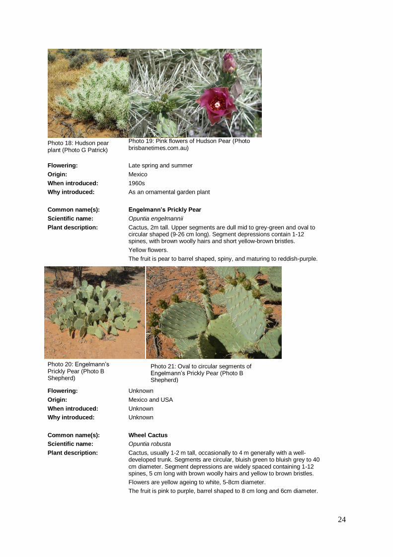
Common name(s): Engelmann’s Prickly Pear
Scientific name: Opuntia engelmannii
Plant description: Cactus, 2m tall. Upper segments are dull mid to grey-green and oval to circular shaped (9-26 cm long). Segment depressions contain 1-12 spines, with brown woolly hairs and short yellow-brown bristles.
Yellow flowers.
The fruit is pear to barrel shaped, spiny, and maturing to reddish-purple.
Photo 20: Engelmann’s Prickly Pear (Photo B Shepherd)
Flowering: Unknown
Origin: Mexico and USA
When introduced: Unknown
Why introduced: Unknown
Common name(s): Wheel Cactus
Scientific name: Opuntia robusta
Plant description: Cactus, usually 1-2 m tall, occasionally to 4 m generally with a well-developed trunk. Segments are circular, bluish green to bluish grey to 40 cm diameter. Segment depressions are widely spaced containing 1-12 spines, 5 cm long with brown woolly hairs and yellow to brown bristles.
Flowers are yellow ageing to white, 5-8cm diameter.
The fruit is pink to purple, barrel shaped to 8 cm long and 6cm diameter.
Photo 21: Oval to circular segments of Engelmann’s Prickly Pear (Photo B Shepherd)
25
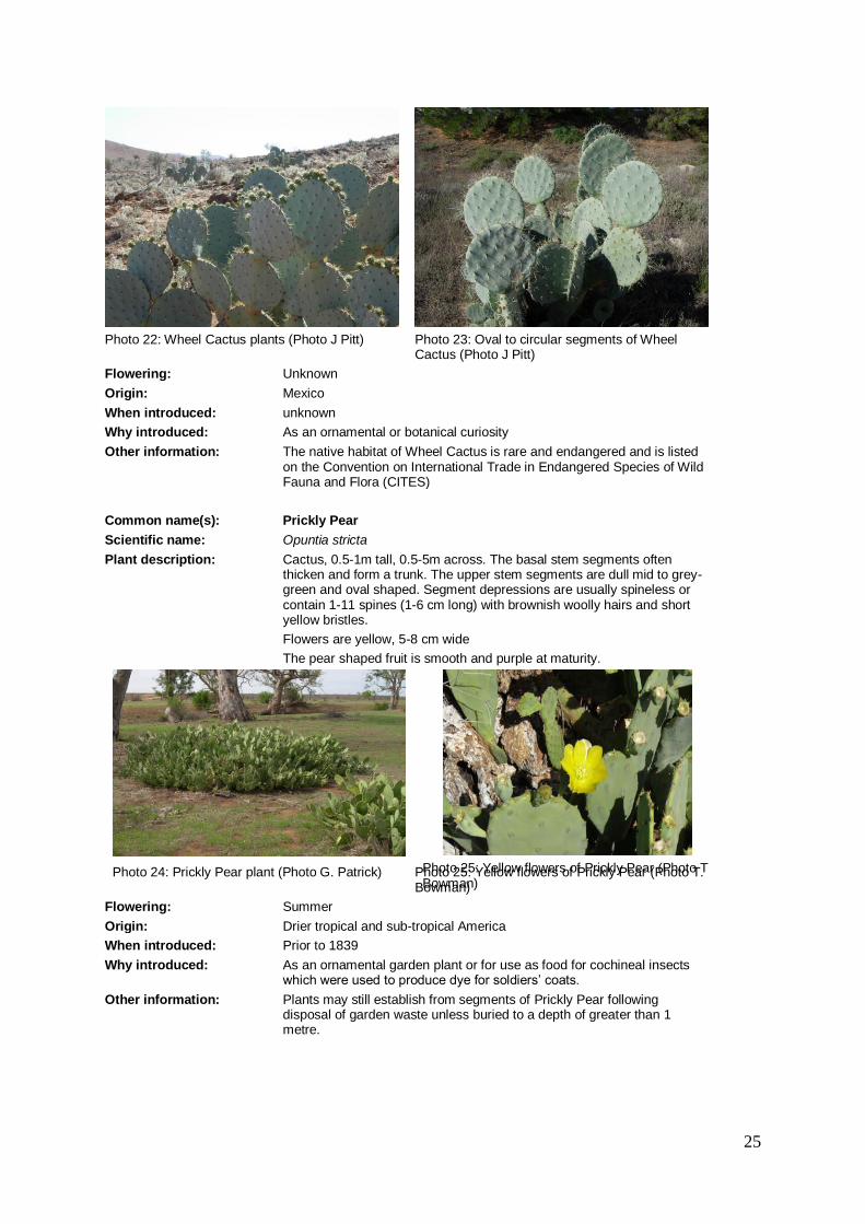
Photo 22: Wheel Cactus plants (Photo J Pitt)
Photo 23: Oval to circular segments of Wheel Cactus (Photo J Pitt)
Flowering: Unknown
Origin: Mexico
When introduced: unknown
Why introduced: As an ornamental or botanical curiosity
Other information: The native habitat of Wheel Cactus is rare and endangered and is listed on the Convention on International Trade in Endangered Species of Wild Fauna and Flora (CITES)
Common name(s): Prickly Pear
Scientific name: Opuntia stricta
Plant description: Cactus, 0.5-1m tall, 0.5-5m across. The basal stem segments often thicken and form a trunk. The upper stem segments are dull mid to grey-green and oval shaped. Segment depressions are usually spineless or contain 1-11 spines (1-6 cm long) with brownish woolly hairs and short yellow bristles.
Flowers are yellow, 5-8 cm wide
The pear shaped fruit is smooth and purple at maturity.
Photo 24: Prickly Pear plant (Photo G. Patrick) Photo 25: Yellow flowers of Prickly Pear (Photo T Bowman)
Photo 25: Yellow flowers of Prickly Pear (Photo T. Bowman)
Flowering: Summer
Origin: Drier tropical and sub-tropical America
When introduced: Prior to 1839
Why introduced: As an ornamental garden plant or for use as food for cochineal insects which were used to produce dye for soldiers’ coats.
Other information: Plants may still establish from segments of Prickly Pear following disposal of garden waste unless buried to a depth of greater than 1 metre.

26
Threats and Impacts Invasiveness Wheel Cactus and Prickly Pear are highly invasive. They have high seed
production, reproduce vegetatively, seeds are dispersed by birds and other animals and seedlings establish easily. Flood events have also been observed to promote spread of cacti species.
Other cacti species in the District are also invasive, well adapted for vegetative spread and able to withstand drought conditions.
Impacts At high density, infestations of cacti species can render land unsuitable for grazing as thickets exclude livestock and can degrade biodiversity, as the infestations out-compete native plants and reduce habitat for native fauna.
Persistence The ability of cacti to recover from control is very high. Re-establishment is assisted by the longevity of seed stored in the soil and the fact that new plants can grow from untreated or dropped pads. Follow up control is essential.
Distribution
Current Australian distribution:
Cacti species are common throughout Australia, both in gardens and as naturalised plants. In most states one or several Cactus species are declared weeds.
Current South Australian distribution:
There are significant infestations of Prickly Pear and Wheel Cactus near Peterborough, Terowie, along the River Murray cliffs, in the Blinman Parachilna area of the Flinders Ranges and around Port Augusta.
There is an infestation of Engelmann’s Prickly Pear in the Flinders Ranges north of Quorn which is often confused with Wheel Cactus.
Devil’s Rope cactus occurs to a lesser extent in these areas as well as in other areas around northern South Australia, primarily in the mid north agricultural district, the Flinders Ranges and the Olary Ranges.
There are three sites – two east of Coober Pedy and one in the North East Pastoral - where Coral Cactus and/or Jumping Cholla have naturalised and are spreading, however these populations are small and manageable. It is likely that these are not the only occurrences Coral Cactus and Jumping Cholla in northern South Australia and that others exist possibly in abandoned gardens or around ruins.
Hudson Pear occurs near Port Augusta and Whyalla.
Current District distribution:
There are cactus infestations in various locations in the North East Pastoral District. Known infestations of Wheel Cactus and Devil’s Rope Cactus are located in the south-west of the District, south of the Barrier Highway.
Potential distribution: Cacti species have the potential to establish across most of the arid and semi-arid areas of South Australia.
Policy
National Strategy: Opuntia (Cacti) species are classified as Weeds of National Significance. The Strategic Plan aims to deliver the following goals and objectives:
New infestations are prevented from establishing.
Established infestations are under strategic management.
Greater capability and commitment to manage opuntioid cacti.

27
State Policy: To prevent Opuntia1 species from competing with more desirable plants and restricting access in the pastoral areas of the State.
Under the Natural Resources Management Act, 2004:
Prohibiting movement of Opuntia species on public roads and entry into SA;
Prohibiting sale of Opuntia species or their seeds, or contaminated material;
Requiring landowners to destroy Opuntia species on their properties; and
Allowing recovery of costs of Opuntia species control on road reserves.
SA Arid Lands NRM Policy:
The SAAL NRM regional management strategy for Opuntia species is to CONTAIN SPREAD
Aim: To prevent the spread of Opuntia through control of all infestations.
The SAAL NRM regional management strategy for Cylindropuntia species is to DESTROY INFESTATIONS
Aim: To significantly reduce the extent of Cylindropuntia spp. in the SA Arid Lands.
North East Pastoral NRM District management strategy:
To CONTAIN SPREAD of Devil’s Rope cactus, Prickly Pear and Wheel Cactus.
Aim: To prevent the spread of Devil’s Rope cactus, Prickly Pear and Wheel Cactus through control of all infestations.
To DESTROY INFESTATIONS of Jumping Cholla, Coral Cactus and Hudson Pear.
Aim: To significantly reduce the extent of Jumping Cholla, Coral Cactus and Hudson Pear in the North East Pastoral NRM District.
North East Pastoral NRM District Strategy for management of Opuntia species
Recommended Actions
Support land manager education in identification, monitoring and control of Opuntia species.
North East Pastoral NRM District Group to encourage landholders to provide data on Opuntia infestations in North East Pastoral NRM District to NRSAAL, so that it can be surveyed and mapped.
North East Pastoral NRM District group to provide input into identification of key sites requiring control to significantly reduce density of all Opuntia species and protect key sites.
North East Pastoral NRM District to consider quarantine provisions around known occurrences of Coral Cactus, Engelmann’s Prickly Pear, Hudson Pear and Jumping Cholla.
Land managers to undertake control of all Opuntia species in close proximity to key sites.
Land managers encouraged to monitor success, following control of Opuntia, and carry out follow up control as necessary.
Sale and movement of all Opuntia species to be restricted within SAAL NRM Region.
Monitor distributions of Opuntia species in North East Pastoral NRM District over time (through the use of surveillance and mapping).
1 The author of this report interpret ‘Opuntia species’ to collectively refer to the weedy Cactus species including
Austrocylindropuntia, Cylindropuntia and Opuntia.

28
Best Practice Control
Following initial control of mature cactus plants, cactus seeds deposited under mature plants and pads that were missed or dropped off during treatment will germinate and grow, therefore follow up monitoring and control around mature plants is required for several years.
Control method and description Best time to control
Active ingredient and example herbicide
Herbicide rates and carrier
Foliar spray
Useful for all cacti species.
Suitable for larger infestations.
Spray all sides of every cactus pad until chemical runs off.
Spray only when cacti are green and healthy.
Any time of year providing plants are not stressed
Apply in summer above 30o
Triclopyr (600g/L) e.g. Garlon®
Triclopyr (240g/L) + Picloram (120g/L) e.g. Access®
Triclopyr (240g/L) + Picloram (120g/L) e.g.
Grazon
MSMA (800g/L MSMA) e.g. Daconate
33 ml/L water with Spray oil e.g. Hotwire® or
33 ml/L diesel
17 ml/L diesel
50ml/10L water
1 L/40L water
Stem inject
Useful for most cactus species.
Suitable for isolated plants or small infestations.
Inject a measure of herbicide into each cactus stem or in at least every 4th pad utilising a Velpar® gun and injecting lance.
Following initial control of mature cactus plants, cactus seeds deposited under mature plants and pads that were missed or dropped off during treatment will germinate and grow, therefore follow up monitoring and control around mature plants is required for several years.
Any time of year
Glyphosate e.g. Roundup®
Inject 2-4ml of neat Glyphosate into each stem or every 4th pad.
Biological
Cochineal scale (Dactylopius spp.) may be used as a biological control for various Opuntia and Cylindropuntia species including Engelmann’s Prickly Pear, Hudson pear, Prickly Pear, Wheel Cactus and Devil’s rope.
The scale appears as small white cotton wool spots across the cactus pads. Juvenile and adult females suck fluid from plant tissues and in high enough densities energy production may be impacted and the plant’s growth is restricted or the plant may die.
Pads from infected plants may be removed and wedged low on a new host plant, protected from rain where possible, with the most heavily infested surface as close as possible to the surface of the new host plant. This will allow for movement of wingless cochineals to the new host plant.

29
Physical
It is possible to dig out cacti but care must be taken due to their spines. This is only practical for small isolated plants. Care must be taken not to drop any segments, as these may grow and develop into new plants. Material must be disposed of via deep burial. This method may be used all year round.
Fire
Hot fires may kill plants but regrowth may occur, requiring follow-up control. Burning can assist in gaining access to large infestations allowing use of other control activities. This method may not be practical where cacti are growing amongst native vegetation. Note: Do not burn on days of high fire danger.
Surveys/ Monitoring General method: Keep an eye out for cactus plants during routine pastoral management
activities and record location using a GPS. Look for old plantings of cactus in historic gardens around ruins, railway sidings and other areas associated with human settlement.
Best time of year for surveys:
Any time of year
Photo 26: Control of Coral Cactus using foliar spray (Photo B Shepherd)

30
Mesquite
Common name(s): Mesquite
Scientific name: Prosopis species
Plant description: Mesquites are a group of shrubs or small trees, which reproduce by seed and suckers. Leaves are fern-like, often with one or two thorns.
Flowers are greenish-yellow, small, arranged on cylindrical-shaped flower heads 50-80 mm long.
Seed pods (up to 20 cm long) are generally straight or slightly curved, and resemble a string of beads.
Photo 27: Mature Mesquite tree (Photo B Shepherd)
Photo 28: Fern like leaves of Mesquite (Photo B Shepherd)
Photo 29: Greenish-yellow flowers of Mesquite (Photo B Shepherd)
Flowering: Spring to early summer
Origin: USA and Mexico
When introduced: 1900
Why introduced: As ornamental, fodder and shade trees
Other information: There are some 44 species of Prosopis, only a few have been introduced to Australia.

31
Threats and Impacts Invasiveness The South Australian occurrences of Mesquite are on the outer extent of
their preferred range and it tends not to spread as rapidly as in the northern Australian climate. However, vigorous establishment and growth of the South Australian populations demonstrate its potential to successfully invade and establish. Mesquite reproduces from seeds that are readily eaten and dispersed by animals.
Impacts Mesquite forms dense thickets that prevent stock from accessing water points and make mustering difficult. The thickets overrun grazing land, exclude all other vegetation and use valuable ground water.
Persistence Mesquite will grow in most of the semi-arid and arid environments of northern South Australia however it prefers areas prone to flooding or where soil moisture is retained. Mesquite is a very hardy plant that can tolerate dry conditions and seeds remain viable for several years.
Distribution
Current Australian distribution:
Mesquite occurs in every mainland state. In the semi-arid and arid areas of Queensland and Western Australia Mesquite has infested large tracks of pastoral country.
Current South Australian distribution:
Mesquite was infrequently planted in gardens around South Australia. There are four known naturalised populations of Mesquite in northern South Australia, in the eastern districts around Cockburn, around Woomera, on the south eastern side of Lake Torrens and another near Port Augusta. All Mesquite populations are demonstrating vigorous regenerating. These are being actively and successfully suppressed.
Current District distribution:
Previous infestations of Mesquite have been identified around Cockburn and control carried out. This species requires ongoing control and the current status of previous infestations is unknown. Surveys in this District along drainage lines are recommended.
Potential distribution: Mesquite’s combination of a long life cycle, ability to survive droughts, high seed production and long seed life makes it well suited to establishment in northern SA. Mesquite has the ability to establish in rivers, swamps and other areas where soil moisture persists, throughout northern SA.
Policy
National Strategy: Mesquite species and hybrids are confined and eventually eradicated from Australia. (Mesquite is classified as a Weed of National Significance)
State Policy: To maintain production from semi-arid pastoral lands and protect the integrity of native vegetation.
Under the Natural Resources Management Act, 2004:
Prohibiting entry of Mesquite into SA and movement on public roads.
Prohibiting sale of Mesquite or contaminated material.
Requiring landholders to notify NRM authority of Mesquite infestations.
Requiring landholders to destroy Mesquite on their properties.
Allowing NRM authorities to recover costs for roadside control of Mesquite

32
It is legislated that, in all parts of South Australia:
Landholders have the responsibility to destroy Mesquite on their land
Landholders have the responsibility to notify NRM authority of Mesquite infestations
NRM authorities have the responsibility to destroy Mesquite on road reserves, and may recover the cost of this work from the adjoining landholders
SA Arid Lands NRM Policy:
The SAAL NRM regional management strategy for Mesquite is to CONTAIN SPREAD.
Aim: To prevent spread through control of all infestations.
North East Pastoral NRM District management strategy
The North East Pastoral NRM District management strategy is to CONTAIN SPREAD
Aim: To prevent spread through control of all infestations in the North East Pastoral NRM District.
North East Pastoral NRM District Strategy for management of Mesquite
Recommended Actions
Support land manager education in identification, monitoring and control of Mesquite
North East Pastoral NRM District Group to encourage landholders to provide data on infestations of Mesquite in North East Pastoral NRM District to NRSAAL, so that it can be surveyed and mapped.
Destruction of all Mesquite from the North East Pastoral NRM District including removal of cultivated plants.
Land managers encouraged to monitor success, following control of Mesquite, and carry out follow up control as necessary.
North East Pastoral NRM District to consider quarantine provisions around known occurrences of Mesquite.
Sale and movement of Mesquite to be prevented within SAAL NRM Region.
Best Practice Control
Control method and description Best time to control
Active ingredients and example trade names
Herbicide rates and carrier
Basal Bark
Useful for smaller to mid-sized plants that have not developed rough bark.
Spray all sides of each stem with the recommended herbicide mix, from the ground up to a height of between 500 - 750mm.
For seedlings spray the entire plant.
Most of the year assuming the plant is not stressed. Most effective when actively growing.
Triclopyr (240 g/L) + Picloram (120 g/L) e.g. Access®
17 mls/L mixed in diesel
Foliar Spray
Best for seedlings & regrowth of previously treated areas on plants under 1.5m height
Spray the entire plant
Best time to spray is when plants are actively growing and soil moisture is good.
Triclopyr 300g/l + Picloram (salt) 100g/l
e.g. Grazon®
350 mL/100 L water.
Add a 100% concentrate non-ionic surfactant e.g. BS 1000 at 100mL/100L
Cut Stump
Useful for medium to larger trees The main stem(s) are cut off by chainsaw and the stump is painted with the herbicide mixture within 10 seconds.
The stump should be cut as close to the ground as possible.
Any time of year
Triclopyr (240 g/L) + Picloram (120 g/L) e.g. Access®
17 mls/L mixed in diesel

33
Physical
Useful for very large trees, dense infestations and broad scale germination or regrowth.
The entire plant is removed from the ground using a suitable bulldozer or loader.
Roots must be cut about 30-50 cm below the soil surface to reduce the incidence of regrowth. This is best done with a blade plough.
Branch and root fragments of Mesquite can take root, therefore woody material must be moved out of creek lines and moist areas.
Ongoing inspections and hand-pulling of seedlings will additionally be required where recruitment is occurring, until the seedbank is exhausted.
Surveys/ Monitoring
General method: Keep an eye out for Mesquite during routine pastoral management activities and record locations using a GPS.
Best time of year for surveys:
Any time of year, look for fern like leaves, long yellow flower heads and the (sometimes) bright light green leaves.

34
Photo 31: Flower and spiny leaves (Photo: WA Dept of Agriculture and Food)
Photo: 30 Light yellow flower and seed pod of Mexican Poppy (Photo WA Dept of Agriculture and Food)
Mexican Poppy Common name(s): Mexican Poppy
Scientific name: Argemone ochroleuca
Plant description:
(Photos)
Mexican Poppy is stiff bluish-green prickly plant that grows up to 1m in height.
The leaves are up to 20cm long, silvery green with white veining and deep regular lobes. The upper surface of the leaf is smooth while the underside has a few prickles along the midrib. The stem leaves (in contrast to the rosette leaves) are stalkless and clasp onto the plant's stem.
The flowers are about 6cm across. They have four light yellow or cream petals, and the ovary at the centre of the flower is topped with a dark red three or six lobed stigma.
The fruits are spiny, oblong seed capsules. They are up to 3.5cm in length with three to six openings at the top. The capsule contains up to 400 seeds. The seeds are oval-shaped, blackish brown, about 1.5mm long with a pitted seed coat and a ridge along one side.
Flowering: Generally November to February, but is opportunistic in arid areas and can flower outside these times when moisture available.
Origin: Mexico, Central America and Texas and Florida, USA.
When introduced: First reported near Sydney in 1845.
Why introduced: Probably imported as a contaminant of wheat seed.
Other information: Argemone ochroleuca is very similar in appearance and far more widespread than A. mexicana. To confuse matters even further, both species are referred to as Mexican Poppy. Argemone mexicana differs from A. ochroleuca in that it has bright yellow flowers as opposed to cream or pale-yellow flowers, and globular flower buds as opposed to the egg-shaped buds of Argemone ochroleuca (Auld & Medd 1987).
Threats and Impacts
Invasiveness It establishes readily on disturbed ground, overgrazed pastures, river beds and roadsides. Seed is readily dispersed by moving water, especially where plants grow in riparian habitats and on terrain where erosion and runoff occurs. Contaminated soil, fodder, vehicles and the fur and hooves of livestock are vectors for transport of Mexican Poppy seed (Parsons & Cuthbertson 2001).

35
Impacts The prickly fruits can become entangled in wool, reducing its value considerably. It is suspected of being toxic to animals and humans due to the presence of alkaloids in all parts of the plant. However, reported cases of poisoning are rare because livestock tend to avoid it in the field, due to the presence of a bitter sap that makes it unpalatable. Poisonings may occur as a result of hay and chaff containing traces of the plant. Poisonings in humans have occurred by the consumption of oils contaminated with the plant (Parsons & Cuthbertson 2001).
Persistence It is estimated that a single plant can produce up to 30 000 seeds per year. The seed can stay dormant for many years, making control difficult.
Distribution
Current Australian distribution:
All Australian states and territories, except Tasmania.
Current South Australian distribution:
Anecdotal reports from across rangelands.
Current District distribution:
Anecdotal reports in North East Pastoral region along roadsides and in drainage lines – no recorded voucher specimens.
Potential distribution: Potential distribution of Mexican Poppy extends across the range lands mainly in drainage lines and along roadsides.
Policy
National Strategy: Mexican Poppy is not classified as a Weed of National Significance, therefore there is no national strategy for this species.
State Policy: No State policy exists for Mexican Poppy.
SA Arid Lands NRM Policy:
SAAL NRM regional management strategy for Mexican Poppy is to MONITOR for any changes in the species weed risk.
Aim: To detect any significant changes in Mexican Poppy’s weed risk and monitor the spread of the species and review any changes in weediness.
North East Pastoral NRM District management strategy
North East Pastoral NRM District management strategy for Mexican Poppy is to MONITOR for any changes in the species weed risk.
Aim: To detect any significant changes in Mexican Poppy’s weed risk and monitor the spread of the species and review any changes in weediness. If any negative changes occur, carry out control to prevent spread.
North East Pastoral NRM District Strategy for management of Mexican Poppy
Recommended Actions
Support land manager education in identification, monitoring and control of Mexican Poppy.
North East Pastoral NRM District Group to encourage landholders to provide data on distribution of Mexican Poppy in North East Pastoral NRM District to NRSAAL, so that it can be surveyed and mapped.
Monitor distributions of Mexican Poppy in North East Pastoral NRM District over time (through the use of surveillance and mapping) and advise NR SAAL if species weediness increases.
North East Pastoral NRM District group to provide input into identification of key sites requiring control of Mexican Poppy.
Land managers encouraged to monitor success, following control of Mexican Poppy, and carry out follow up control as necessary.

36
Best Practice Control
Control method and description Best time to control
Active ingredients and example trade names
Herbicide rates and carrier
Foliar Spray
There are no registered herbicides for use in SA.
Physical
Hand pulling or grubbing using a mattock/hoe for immature plants that haven’t seeded.
Surveys/ Monitoring
General method: Keep an eye out for Mexican Poppy during routine pastoral management activities, especially along roadsides and drainage lines, and record locations using a GPS or farm map.
Best time of year for surveys:
Late spring through to late autumn, especially after summer rains.

37
Photo 33: Dry Noogoora Burrs’ on plant (Photo lrm.nt.gov.au)
Noogoora Burr
Common name(s): Noogoora Burr
Scientific name: Xanthium strumarium sp. agg.
Plant description:
A single or multi stemmed herb growing up to 2m high. Its stems are hairy but without spines.
The leaves are broad-ovate to triangular, 50-150mm wide, 3 or 5 lobed, with a lobed base and toothed margins. The upper leaf surface is darker green than the under surface and prominently 3-veined with purplish veins. The leaf stalk (petiole) is 20-120 mm long (modified from Cross et al., unpublished).
The flowers are unisexual with separate male and female flowers on the same plant. The cream or creamy green male flowers are clustered at the end of the branches, or in the upper leaf axils while the yellowish green to brown female flower heads occur in the leaf junctions.
The burrs are ellipsoid, 15-25 mm long, with glandular & non-glandular hairs, covered with numerous hooked spines and with 2 longer stout and straight spines (or 'beaks'). Two seeds formed in each burr, one larger than the other (modified from Cross et al., unpublished).
Flowering: Seeds may germinate in response to late spring/summer rain. Flowering occurs from mid-summer to autumn with burrs forming from February to May.
Origin: North America
When introduced: 1860’s into Australia. Recorded in South Australia in 1916 and eradicated, but reinfested in 1959 when large numbers or sheep were imported that had Noogoora Burr in their wool.
Why introduced: Probably introduced to Australia at Noogoora station, in Queensland, in the 1860's as a contaminant of cotton seed.
Other information:
Noogoora burr, Xanthium strumarium is a group of species including X. occidentale (Noogoora burr) and X. californicum (Californian burr). Both weeds are annual plants that have been introduced from North America. They are very similar in appearance and ecology and can be described together.
Photo 32: Noogoora Burr with seed pods (Photo depi.vic.gov.au)

38
Threats and Impacts
Invasiveness Large dense infestations are dependent on periodic wet summers. The seed must be in good contact with water to germinate. Low temperatures are lethal to Noogoora burr.
Noogoora Burr is dispersed by burrs attached to stock, and also along watercourses by floodwaters. To establish it requires a year with summer rains to provide adequate water to break seed dormancy.
Impacts The major concern with Noogoora Burr is as a contaminant of wool. The burrs contribute to hardheads, which damage shearing machinery. Spines of this plant also cause physical damage to stock and people. Wool processors generally reject infested wool.
Although Noogoora Burr seedlings are poisonous, the main toxin (carboxyatratyloside) is found only in the cotyledons. Cases of stock poisoning are very rare in Australia.
Noogoora Burr competes strongly with pastures due to its extensive root system and rapid growth.
Persistence In SA most infestations of the Noogoora Burr group have been eradicated easily. This is probably due to unsuitable environments or by controlling the few plants surviving after many dry years.
There are few areas of SA suitable for Noogoora Burrs to persist. In the pastoral lands, these areas are often the most productive, as they are the accumulation areas for runoff.
There are 2 seed in each burr and the upper one germinates in the following season while the lower one remains dormant for 2 or more years. It has several types of dormancy (enforced, innate and induced) making control difficult.
Distribution
Current Australian distribution:
Noogoora Burr is widespread throughout most parts of New South Wales and Queensland, extending across into the Northern Territory, particularly around the Katherine, Daly Waters and Darwin regions and also the river systems flowing into the Gulf of Carpentaria. A few collections have been recorded from around the Alice Springs region. It also has a scattered distribution through northern Victoria and eastern South Australia, particularly around the Murray River and some tributaries. A few infestations have been recorded from the Kimberley region and the Perth region of Western Australia. One infestation was recorded in Tasmania but has since been eradicated (Parsons & Cuthbertson 2001).
Current South Australian distribution:
Two species of the Xanthium strumarium complex are known to occur in SA.
The Californian burr (Xanthium californicum) is distributed along the River Murray from the Victorian border to Swan Reach, with occasional plants and small patches downstream from Swan Reach. It is also established on the Gawler River.
The true Noogoora Burr (Xanthium occidentale) is also found with Californian burr adjacent to the River Murray from Lyrup ferry upstream to the Victorian/NSW border. Other areas include 5500 ha at Kallioota Swamp on Lake Torrens, small isolated infestations along the Coopers Creek system, and in the Mingary-Cockburn area.
Occasional plants are found throughout the state, especially adjacent to dams, waterholes, saleyards, transport depots and stock holding areas.
Current District distribution:
Creeks and drainage lines throughout the District, especially the Mingary-Cockburn area.
Potential distribution In South Australia suitable habitats are restricted to wetlands, adjacent to rivers,
some flood irrigation areas, drains, creeks and flood outs, which may be inundated during summer.

39
Policy
National Strategy: Noogoora Burr is not classified as a Weed of National Significance, therefore there is no national strategy for this species.
State Policy: For Grazing Rangelands the State Policy is to Monitor.
Under the Natural Resources Management Act, 2004:
Prohibiting entry to area of Noogoora Burr.
Prohibiting movement of Noogoora Burr on public roads.
Prohibiting sale of Noogoora Burr, or produce or goods carrying Noogoora Burr.
Requiring notification of Noogoora Burr infestations to NRM authorities.
Requiring landholders to control Noogoora Burr on their properties.
Allowing recovery of control costs on adjoining road reserves of Noogoora Burr.
SA Arid Lands NRM Policy:
SAAL NRM regional management strategy for Noogoora Burr is to MONITOR for any changes in the species weed risk.
Aim: To detect any significant changes in Noogoora Burr’s weed risk and monitor the spread of the species and review any changes in weediness.
North East Pastoral NRM District management strategy
North East Pastoral NRM District management strategy for Noogoora Burr is to MONITOR for any changes in the species weed risk.
Aim: To detect any significant changes in Noogoora Burr’s weed risk and monitor the spread of the species and review any changes in weediness. If any negative changes occur, carry out control to prevent spread.
North East Pastoral NRM District Strategy for management of Noogoora Burr
Recommended Actions
Support land manager education in identification, monitoring and control of Noogoora Burr.
North East Pastoral NRM District Group to encourage landholders to provide data on distribution of Noogoora Burr in North East Pastoral NRM District to NRSAAL, so that it can be surveyed and mapped.
North East Pastoral NRM District group to provide input into identification of key sites requiring control of Noogoora Burr.
North East Pastoral NRM District group to assist in identifying and coordinating Noogoora Burr control programs using integrated weed management (combination of recommended best practices), especially in areas where key sites are threatened.
Land managers are encouraged to monitor success, following control of Noogoora Burr, and carry out follow up control as necessary.
Best Practice Control
Control method and description Best time to control
Active ingredients and example trade names
Herbicide rates and carrier
Foliar spray
Spot spray - Hormone type treatment – use with caution near sensitive crops. Refer to drift warnings on label. Spray seedlings only.
When actively growing and before flower and burr formation.
2,4-D amine (625g/L) e.g. 2,4-D Amine 625
17-22ml/10L water + Surfactant e.g. Pulse®
Spot spray – Do not add surfactants if using near aquatic areas.
Suitable for use near waterways – refer to label.
Non-selective, avoid contact with desirable plants.
Glyphosate bioactive (360g/kg) e.g. Roundup Biactive®
1L/100L water

40
Control method and description Best time to control
Active ingredients and example trade names
Herbicide rates and carrier
Boom spray - Non-selective, avoid contact with desirable plants.
Prior to planting a crop or pasture.
Glyphosate (450g/L) e.g. Roundup®
1.5-2.5L/ha + Surfactant e.g. Pulse®
Spot spray - Non-selective, avoid contact with desirable plants.
Soil active herbicide, may damage desirable vegetation.
Glyphosate (450g/L) + metsulfuron-methyl (600g/L) e.g. Roundup® + Ally
1L + 7g/100L water + Surfactant e.g. Pulse®
Spot spray - Hormone type treatment – use with caution near sensitive crops. Refer to drift warnings on label. Grass pastures. Use higher rate on late flowering or larger plants.
MCPA (340g/L) + dicamba (80g/L) e.g. Banvil®M
190-270ml/100L water
Physical
Seedlings and individual plants can often be pulled up by hand (In large infestations this may not be practical).
Manual hoeing or slashing should occur before burr formation.
Plants with burrs should be collected and burned.
Surveys/ Monitoring
General method: Keep an eye out for Noogoora Burr during routine pastoral management activities, especially along drainage lines, and record locations using a GPS or farm map.
Best time of year for surveys:
Summer through to late autumn, especially after summer rains.

41
Parkinsonia
Common name(s): Parkinsonia
Scientific name: Parkinsonia aculeate
Plant description: Parkinsonia is a much branched shrub or tree, 2-8 m tall but at times reaching 10 m tall. Parkinsonia has extensive surface roots and a deep taproot.
Leaves consist of a flat, green leaf stalk (up to 30 cm long) with numerous pairs of small oval leaflets, often with a sharp spine (3-20 mm long)
Flowers are fragrant up to 2 cm diameter, bright yellow in colour becoming reddish with age. The top petal either has orange spots or turns completely orange.
The pod is almost straight (3-13 cm long and 3.5-8 mm wide), narrowing at each end.
Photo 34: Parkinsonia tree (Photo B Shepherd)
Photo 35: The bright yellow flowers of Parkinsonia (Photo B Shepherd)
Photo 36: Pods of Parkinsonia (Photo B Shepherd)
Flowering: Summer to early autumn
Origin: Central America
When introduced: 1890s and early 1900s
Why introduced: As a shade and ornamental shrub

42
Other information: Parkinsonia has the potential to invade more than three quarters of mainland Australia.
Distribution
Current Australian distribution:
Parkinsonia was commonly planted in many areas around Australia in the late 1800s. Over one million hectares of Australia is now infested with Parkinsonia primarily throughout coastal, central and western Queensland, central and northern Territory and the Kimberly and Pilbara regions of Western Australia.
Current South Australian distribution:
Within northern South Australia there are 3 current locations where Parkinsonia has naturalised – near Leigh creek in northern Flinders Ranges, around Woomera and Port Augusta. All these occurrences are small populations (2-10 plants). Historically there have been more occurrences recorded within gardens, however all of these have been successfully controlled.
Current District distribution:
One known infestation, along a drainage line near a homestead was reported in the central-north of the District in 2009. Control work was recommended but a follow-up inspection, after a change of landowner, found recent evidence of the infestation.
Potential distribution: Parkinsonia has the potential to establish in watercourses, swampy areas and other watered areas throughout arid and semi-arid areas in South Australia.
Threats and Impacts
Invasiveness Parkinsonia reproduces by seeds that are spread by flood waters and in mud attached to vehicles or animals. It establishes and grows in a wide variety of conditions from semi-arid to sub-humid environments and prefers drainage lines, swamps, floodplains and other watered areas. Mature plants typically produce 5000 seeds annually, and germination after flood event or disturbance can be prolific.
Impacts Parkinsonia forms dense thickets and can take over vast tracks of land replacing native plant species including valuable pasture species. It reduces access to land and water and increases difficulty when mustering stock. Parkinsonia reduces habitat for native species and provides a refuge for feral animals. The areas at risk are the more productive arid rivers and floodplains.
Persistence Parkinsonia can re-shoot from roots. Germination from seed after control disturbance can be prolific. Parkinsonia seeds remain viable for many years.
Policy
National Strategy: Parkinsonia is a Weed of National Significance (WONS). The National Strategy states: Parkinsonia is confined and its impact reduced to a minimum.
State Policy: To maintain access to pastoral lands, and the integrity of native vegetation.
Under the Natural Resources Management Act, 2004:
Prohibiting movement of Parkinsonia into SA.
Prohibiting movement of Parkinsonia on public roads.
Prohibiting sale of Parkinsonia, or produce or goods carrying Parkinsonia.
Requiring notification of Parkinsonia infestations to NRM authorities.
Requiring landholders to destroy Parkinsonia on their properties.
Allowing recovery of costs of roadside control of Parkinsonia.

43
SA Arid Lands NRM Policy:
The SAAL NRM regional management strategy for Parkinsonia is to CONTAIN SPREAD.
Aim: To prevent spread through control of all infestations.
North East Pastoral NRM District management strategy:
The North East Pastoral NRM District management strategy is to CONTAIN SPREAD
Aim: To prevent spread through control of all infestations in the North East Pastoral NRM District.
North East Pastoral NRM District Strategy for management of Parkinsonia
Recommended Actions
Support land manager education in identification, monitoring and control of Parkinsonia.
North East Pastoral NRM District Group to encourage landholders to provide data on distribution of Parkinsonia in North East Pastoral NRM District to NRSAAL, so that it can be surveyed and mapped.
Destruction of all populations of Parkinsonia in the North East Pastoral NRM District.
Sale and movement of Parkinsonia is prohibited within SAAL NRM Region.
Land managers encouraged to monitor success, following control of Parkinsonia, and carry out follow up control as necessary.
Best Practice Control
Control method and description Best time to control
Active ingredients and example trade names
Herbicide rates and carrier
Basal Bark
Useful for smaller to mid-sized plants that have not developed rough bark.
Spray all sides of each stem with the recommended herbicide mix, from the ground up to a height of between 500 - 750mm.
For seedlings spray the entire plant.
Most of the year assuming the plant is not stressed. Most effective when actively growing.
Triclopyr (240 g/L) + Picloram (120 g/L) e.g. Access®
17 mls/L mixed in diesel
Foliar Spray
Best for seedlings & regrowth of previously treated areas on plants under 1.5m height
Spray the entire plant
Best time to spray is when plants are actively growing and soil moisture is good.
Triclopyr 300g/l plus Picloram (salt) 100g/l
e.g. Grazon®
350 mL/100 L water.
Add a 100% concentrate non-ionic surfactant e.g. BS 1000 at 100mL/100L
Cut Stump
Useful for medium to larger trees The main stem(s) are cut off by chainsaw and the stump painted with the herbicide mixture within 10 seconds.
The stump should be cut as close to the ground as possible.
Any time of year
Triclopyr (240 g/L) + Picloram (120 g/L) e.g. Access®
17 mls/L mixed in diesel
Physical
Useful for very large trees, dense infestations and broad scale germination or regrowth.
The entire plant is removed from the ground using a suitably sized bull dozer or loader.
Roots must be cut about 30-50 cm below the soil surface to reduce the incidence of regrowth. This is best done with a blade plough.
Branch and root fragments of Parkinsonia can take root, therefore woody material must be moved out of creek lines and moist areas.
Ongoing inspections and hand-pulling of seedlings will additionally be required, where recruitment is occurring, until the seedbank is exhausted.

44
Surveys/ Monitoring
General method: Keep an eye out for Parkinsonia during routine pastoral management activities and record locations using a GPS.
Best time of year for surveys:
Any time of year, look for the distinctive small leaves and the overall bright light green colour of the plant.

45
Pepper Tree
Common name(s): Pepper Tree
Scientific name: Schinus molle
Plant description: A large evergreen tree to 12 m tall and 5-10 m wide. Leaves are divided into 15-41 alternatively arranged, shiny leaflets (to 4 cm long). Leaves are aromatic and sticky when crushed.
Small white flowers hang in long sprays, are followed by spherical shiny pink fruit (4-6 mm across).
Photo 37: Pepper Trees (Photo B Shepherd)
Photo 38: Immature fruit (Photo B Shepherd)
Photo 39: Mature pink fruit (Photo B Shepherd)
Flowering: All year round
Origin: South America
When introduced: 1870-1880 (listed for sale in nursery catalogues)
Why introduced: For shade
Other information: All Schinus species leaves and fruit are poisonous to livestock and possibly humans.

46
Threats and Impacts
Invasiveness Pepper Trees reproduce from seed, and germination requires sustained soil moisture. The seeds are dispersed by birds, animals, water and human activity. Broad scale seed germinations can occur following floods and favourable rainfall events, especially in swampy areas.
Impacts Pepper Trees can form dense thickets in swamps and along rivers excluding native vegetation and using valuable ground water.
Persistence Mature Pepper Trees can re-shoot following initial chemical control and can re-shoot from root portions left in the ground following mechanical control. Seeds remain viable for less than three years.
Distribution
Current Australian distribution:
Pepper Trees are favoured garden plants throughout Australia and their ability to withstand dry conditions makes them well suited as garden and shade plantings in arid and semi-arid areas.
Current South Australian distribution:
Pepper Trees are common at nearly every township, station house and stockyard in northern SA. Naturalised Pepper Trees are a common site, particularly along drainage lines of the Flinders Ranges, the Olary Ranges and in the mid north agricultural districts. Within some creeks and swamps, naturalised Pepper Trees are the dominant tree choking out all other plants.
Current District distribution:
Pepper Trees were planted at most homesteads throughout the North East Pastoral NRM District. There are several locations where Pepper Trees have naturalised along creek lines adjacent to these homesteads. In some areas, such as around Olary, the Pepper Tree infestations are extensive.
Potential distribution: Pepper Trees have demonstrated their ability to establish in many of the semi-arid drainage lines and swampy areas of South Australia.
Policy
National Strategy: Pepper Trees are not classified as a Weed of National Significance, therefore there is no National Strategy for this species.
State Policy: Pepper Trees are not a declared species under the Natural Resources Management Act, 2004, (therefore there is no South Australian policy)
SA Arid Lands NRM Policy:
The SAAL NRM Board currently management strategy is to MANAGE sites infested with Pepper Trees
Aim: To maintain economic, environmental and/or social values of key sites/assets through improved management of Pepper Trees
North East Pastoral NRM District management strategy:
North East Pastoral NRM District management strategy is to MANAGE sites infested with Pepper Trees
Aim: To maintain economic, environmental and/or social values of key sites/assets through improved management of Pepper Trees

47
North East Pastoral NRM District Strategy for management of Pepper Tree
Recommended Actions
Support land manager education in identification, monitoring and control of Pepper Trees.
North East Pastoral NRM District Group to encourage landholders to provide data on distribution of Pepper Trees in North East Pastoral NRM District to NRSAAL, so that it can be surveyed and mapped.
North East Pastoral NRM District group to provide input into identification of high priority areas such as significant rivers, creeks and waterholes and coordinate control programs to protect identified priority sites.
Land managers encouraged to control naturalised Pepper Trees, and control cultivated Pepper Trees where key sites are threatened.
Land managers encouraged to monitor success, following control of Pepper Trees, and carry out follow up control as necessary.
Best Practice Control
Control method and description Best time to control
Active ingredients and example trade names
Herbicide rates and carrier
Cut Stump
Useful for medium to large trees The main stem(s) are cut off by chainsaw and the stump immediately (within 10 seconds) painted or sprayed with the recommended herbicide mixture.
The stump should be cut as close to the ground as possible.
Any time of year
Triclopyr (240 g/L) + Picloram (120 g/L) e.g. Grazon® or Access®
17 mls/L mixed in diesel
Basal Bark
Useful for smaller to mid-sized plants that have not developed rough bark.
Spray all sides of each stem with the recommended herbicide mix, from the ground up to a height of between 500 – 750 mm.
For seedlings spray the entire plant
Any time of the year assuming the plant is not stressed. Most effective when actively growing
Triclopyr (240 g/L) + Picloram (120 g/L) e.g. Grazon® or Access®
17 mls/L mixed in diesel
Physical
Useful for very large trees, dense infestations and broad scale germination or regrowth.
The entire plant is removed from the ground using a suitably sized bull dozer or loader.
Roots must be cut about 30-50 cm below the soil surface to reduce the incidence of regrowth. This is best done with a blade plough.
Branch and root fragments of Pepper Trees can take root, therefore woody material must be moved out of creek lines and moist areas.
Ongoing inspections and hand-pulling of seedlings will additionally be required where recruitment is occurring, until the seedbank is exhausted.
Surveys/ Monitoring
General method: Keep an eye out for naturalised Pepper Trees during routine pastoral management activities and record locations using a GPS
Best time of year for surveys:
Any time of year, look for the distinctive bi-pinnate leaves and the overall light green colour of the plant

48
Appendix 1 – Alert Weeds
The weeds identified in this section have not been sighted in the North East Pastoral District. However, there have been infestations of them in neighbouring District(s) and the threat they pose are significant. They are included here to provide a reference for identification.
If you discover any of these plants in the North East Pastoral District please contact Natural Resources SA Arid Lands (Ph. 8648 5300) immediately and report the location. Alternatively you can contact the Sustainable Landscapes Officer on 8648 5194 or 0417 738 498.
Innocent Weed
Common name(s): Innocent Weed/Spiny Burr-grass
Scientific name: Cenchrus longispinus and Cenchrus incertus
Plant description: Cenchrus longispinus (Innocent Weed) - annual grass to 70 cm. Leaves narrow 1-6 mm wide, 3-15 cm long, with a reddish or purplish tinge.
Seed head has 8-18 ‘burrs’, 3-12 mm across, with 40-70 sharp spines (3.5-7 mm long). ‘Burrs’ are reddish or purplish-green when young but mature to a straw colour or brown. The ‘burrs’ are on stalks 1-5 mm long.
Seeds are egg shaped, 2-4 mm long, 2-3 mm wide
Photo 40: Innocent Weed plant (Photo A Harvey)
Photo 41: Innocent Weed seed heads (Photo A Harvey)
Cenchrus incertus (Spiny Burr-grass) - annual and occasionally perennial grass to 60 cm tall. Leaves narrow 2-8mm wide to 2-20 cm long.
The seed-head has up to 40 ‘burrs’, 3-10 mm across, with 8-45 sharp spines (2-5 mm long). ‘Burrs’ are purplish-green when young but mature to a straw colour or brown.
Seeds are egg shaped, 2-4 mm long, 2-3 mm wide
Flowering: Summer and autumn
Origin: North and Central America
When introduced: 1886
Why introduced: Unknown

49
Other information: Cenchrus longispinus and Cenchrus incertus can be confused with each other and other Cenchrus species. Species are distinguished by their ‘burrs’.
Threats and Impacts
Invasiveness Innocent Weed is readily spread by dispersal of its ‘burrs’ (which contain the plants’ seeds), as they attach to animals, vehicles and clothing. ‘Burrs’ may also be distributed by water and contaminated agricultural produce, especially hay.
A weed of disturbed sites such as waste areas, roadside, pastures and cultivation areas.
Seedlings have been known to establish from seed deeply buried (to 25 cm) in sandy soils.
Impacts Innocent Weed can become tangled in wool, as a result wool is devalued and animals are more difficult to handle. The ‘burrs’ may also cause ulcers in the mouths of grazing animals.
Persistence Innocent Weed does not establish well in pastures, particularly when there are competitive pasture species present. ‘Burrs’ lying on the soil surface do not readily germinate (due to low moisture and also inhibiting effect of light), but buried seeds germinate more easily, requiring ongoing control.
Distribution
Current Australian distribution:
Innocent Weed is widespread throughout the Murray Mallee and irrigated areas along the Murray River of both Victoria and South Australia. It is common in coastal Queensland and is found in small isolated areas of the Northern Territory and Western Australia.
Current South Australian distribution:
In South Australia, it has been found on the Eyre Peninsula, northern pastoral and agricultural districts, and in isolated patches of the South East. Major infestations are in the Riverland irrigation areas, the Northern Murray Mallee dry land areas and in urban areas.
Current District distribution:
There are no known records of Innocent Weed in the North East Pastoral District.
Potential distribution: Innocent Weed has the potential to establish throughout most of the semi-arid areas of South Australia.
Policy
National Strategy: Innocent Weed is not classified as a Weed of National Significance, therefore there is no National Strategy for this species.
State Policy: To prevent Innocent Weed being introduced to areas free of the plant especially urban areas, areas with sandy soils and irrigation areas.
Under the Natural Resources Management Act, 2004:
Prohibiting movement of Innocent Weed on public roads.
Prohibiting sale of Innocent Weed or produce or goods carrying the plant.
Requiring land owners to control Innocent Weed on their properties.
Allowing recovery of costs of roadside control of Innocent Weed.
Requiring notification of Innocent Weed infestations to NRM authority
SA Arid Lands NRM Policy:
The SAAL NRM Board management strategy is to ALERT (monitor) sites from the spread of Innocent Weed.
Aim: Innocent Weed is not currently present in the District and entry into

50
the region should be prevented – any found through monitoring should be reported and destroyed.
North East Pastoral NRM District management strategy:
North East Pastoral NRM District management strategy is ALERT for Innocent Weed
Aim: Entry into the region should be prevented – any found should be reported and destroyed.
North East Pastoral NRM District Strategy for management of Innocent Weed
Recommended Actions
Support land manager education in identification, monitoring and control of Innocent Weed.
Occurrences of Innocent Weed in North East Pastoral NRM District to be surveyed, mapped and reported to NR SAAL immediately.
Identify current distributions of Innocent Weed in neighbouring NRM regions/districts and ascertain possible pathways of entry into North East Pastoral NRM District.
Destruction of all infestations, as they are detected, aiming for local eradication.
Land managers are encouraged to monitor success, following control of Innocent Weed, and carry out follow up control as necessary.
Sale and movement of Innocent Weed to be prevented within North East Pastoral NRM District.
Best Practice Control
Control method and description Best time to control
Active ingredients and example trade names
Herbicide rates and carrier
Foliar Spray
Useful on all plants
Spray the entire plant with the recommended herbicide mixture when it is actively growing and before seed set, i.e. within the first week after summer rainfall.
Within 1 week after summer rain
Glyphosate (360g/L) e.g. Roundup®
10 ml/1L water with penetrant e.g. Pulse®
Physical
Isolated occurrences of Innocent Weed can be easily grubbed out of the ground.
Grub the plant(s) out of the ground within one week after rain, prior to seed set.
Surveys/ Monitoring
General method: Keep an eye out for Innocent Weed during routine pastoral management activities, especially around stock yards.
Best time of year for surveys:
Immediately after summer rainfall.

51
Prickly Acacia
Common name(s):
Prickly Acacia
Scientific name:
Acacia nilotica
Plant description: Prickly Acacia is a deep-rooted thorny shrub or small tree that usually grows to 5 m but occasionally to 10 m. The tree has an umbrella-shaped canopy and is usually single-stemmed but may be multi-stemmed at the base, particularly if damaged by fire or frost.
Bark on the saplings often has an orange and/or green tinge. Mature trees have a rough, brown to black bark. The tree has a very deep taproot and several branching lateral roots close to the soil surface.
Leaves are finely divided and fern-like with pairs of stout thorns growing at the base.
The flowers, which are ball-shaped, golden-yellow and about 1 cm across, grow on the stems with two to six flowers per group. The grey-green pods are a very good distinguishing feature—they are flat, 6–25 cm long, with narrow constrictions between the seeds. They usually contain 8–15 brown, rounded seeds with a very hard seed coat.
Photo 42: Prickly Acacia beside creek in Northeast
South Australia (Photo: DEWNR)
Photo 44: Flowers with spines protruding
from base (Photo: DAFF, Qld)
Photo 43: Prickly Acacia seed pods are distinctly constricted between seeds (Photo: DAFF, Qld)
Photo 45: Prickly Acacia in full fruit near Hughenden, Qld (Photo: Weed Management Guide, CRC)

52
Flowering:
Autumn and winter
Origin:
Southern Asia Minor to Burma
When introduced:
Introduced to Queensland in 1890’s
Why introduced:
Shade and fodder
Other information:
During a good season one tree can produce 175,000 seeds.
Threats and Impacts
Invasiveness Prickly Acacia can spread readily and grow quickly. It often forms thorny thickets. Seeds sprout readily and plants grow rapidly. It does well in dry localities and on loamy or sandy soils, forming thickets and spreading along watercourses.
Seeds are primarily dispersed when livestock and feral animals eat the fruit and pass the seeds intact. Seeds may also be dispersed along water courses, when they are flowing.
Impacts The thorny thickets cause considerable nuisance during mustering and can also hinder stock access to water. Infestations can drastically alter the ecological balance of grasslands and threaten biodiversity. The thorns may also cause eye injuries to stock and native fauna. The thickets may provide harbour for rabbits. Biodiversity issues exist with native species being out-competed and becoming displaced.
Persistence Prickly Acacia withstands drought well, is readily eaten by stock, and has good regrowth after grazing. It reproduces by seed, and also produces suckers when its above-ground parts are damaged. The hard coating on the seeds allows them to persist in the environment for a long time and they don’t all germinate at the same time.
Distribution
Current Australian distribution:
Over 6.6 million ha of arid and semi-arid land in central and western Queensland is infested with Prickly Acacia. Smaller infestations have also been found in central eastern Queensland, the Barkly Tablelands and Arnhem Land in NT, north-east SA and the south-eastern Kimberley Ranges in WA.
Current South Australian distribution:
Recorded infestation on Cordillo Downs that was initially treated in 2010.
Current District distribution:
There are no known infestations of Prickly Acacia in the North East Pastoral District.
Potential distribution: Prickly Acacia has the potential to invade most of northern Australia, including the majority of Queensland and the Northern Territory and a significant area of Western Australia. The Channel Country in north-eastern South Australia is also a vector through which it could move into SA.
Policy
National Strategy: Prickly Acacia is a weed of national significance (WONS). The National Strategy states: Prickly Acacia is eradicated outside of core infestations within Queensland and national impacts reduced to a minimum.

53
State Policy: To protect the northern rangelands and their native vegetation from invasion by prickly acacia.
Under the Natural Resources Management Act, 2004:
Prohibiting sale of Prickly Acacia or of goods contaminated with the plant (Statewide); and
Landowners are required to destroy the plant on their properties (SA Arid Lands NRM region).
SA Arid Lands NRM Policy:
SAAL NRM regional management strategy for Prickly Acacia is to DESTROY INFESTATIONS
Aim: To significantly reduce the extent of Prickly Acacia in the SA Arid Lands.
North East Pastoral NRM District management strategy:
North East Pastoral NRM District management strategy for Prickly Acacia is ALERT
Aim: Entry into the region should be prevented – any Prickly Acacia found should be reported and destroyed.
North East Pastoral NRM District Strategy for management of Prickly Acacia
Recommended Actions
Support land manager education in identification, monitoring and control of Prickly Acacia.
Identify current distributions of Prickly Acacia in neighbouring NRM regions/districts and ascertain possible pathways of entry into North East Pastoral NRM District.
Infestations of all Prickly Acacia in the North East Pastoral NRM District to be surveyed, mapped and reported to NR SAAL immediately. Destruction of all infestations as they are identified, aiming for local eradication.
Land managers are encouraged to monitor success, following control of Prickly Acacia, and carry out follow up control as necessary.
Sale and movement of Prickly Acacia to be prevented within North East Pastoral NRM District.
Must not grow.
Best Practice Control
Control method and description Best time to control
Active ingredients and example trade names
Herbicide rates and carrier
Cut stump
Cut trunk off horizontally as close to the ground as possible. Immediately, within 15 seconds, swab cut surface with herbicide mixture.
On organic properties, where scattered trees are not near water, tree guards, made from star droppers and chicken wire, can be put around each stump. Barbed wire can be threaded through the top of tree guards to prevent any access (by cattle) to the treated stump.
Any time of year
Triclopyr (240 g/L) + Picloram (120 g/L) e.g. Access®
17 ml/L diesel (solvent included in chemical – Liquid Hydrocarbon 389g/L)
Basal bark
For stems up to 10 cm basal diameter, carefully spray completely around base of plant to a height of 30 cm above ground level. Thoroughly spray into all crevices.
Larger trees may be controlled by spraying to a greater height, up to 100 cm above ground level.
Autumn, when plants are actively growing (providing summer rains have occurred).
Triclopyr (240 g/L) + Picloram (120 g/L) e.g. Access®
17 ml/L diesel (solvent included in chemical – Liquid Hydrocarbon 389g/L)

54
Foliar spray
Useful when plants are smaller than 2 m.
Spray the entire plant with the recommended herbicide mix.
Any time of year – best when actively growing.
Triclopyr (600 g/L) e.g. Garlon®
16 to 32 mls/10L water
Physical
Useful for very large trees, dense infestations and broad scale germination or regrowth. The entire plant is removed from the ground using a suitably sized bull dozer or loader. Roots must be cut about 30-50 cm below the soil surface to reduce the incidence of regrowth. This is best done with a blade plough. Branch and root fragments of Prickly Acacia can take root, therefore woody material must be moved out of creek lines and moist areas.
Ongoing inspections and hand-pulling of seedlings will additionally be required, where recruitment is occurring, until the seedbank is exhausted. Subject to fire restrictions, controlled burning (minimum 2 subsequent burns) can also be effective.
Surveys/ Monitoring
General method: Keep an eye out for Prickly Acacia during routine pastoral management activities, especially along drainage lines, and record locations using a GPS or farm map.
Best time of year for surveys:
Autumn to winter, when plants are flowering.

55
Appendix 2 – Other weeds of interest
The weeds in this section are not considered priority weeds by the North East Pastoral NRM District Group and are not a part of the list for the District Weed Strategy. However, they are included in this appendix for identification and control purposes for local landholders and other stakeholders.
Bathurst Burr
Common name(s):
Bathurst Burr
Scientific name:
Xanthium spinosum
Plant description:
Bathurst Burr is an erect, multi-branched annual herb, growing up to 1 m high (but usually 30–60 cm).
Leaves are dark green on the upper surface, a paler green on the under surface, up to 7 cm long and usually three-lobed.
Stems are branched with one or two three-pronged yellow spines at the base of each leaf stalk.
Flowers are creamy green and small, developing into straw-coloured burrs, 1–1.5 cm long, with numerous yellow hooked spines. Each burr contains two seeds.
Flowering:
Summer generally but opportunistic when moisture is available.
Origin:
South America
When introduced:
Early 1800’s
Why introduced:
Accidently in contaminated grain or livestock imports
Photo 47: Bathurst Burr close-up (Photo: Biosecurity Queensland)
Photo 46: Bathurst Burr with seed pods
(Photo: Biosecurity Queensland)

56
Threats and Impacts
Invasiveness Heavy infestations occur where the ground has been disturbed, such as on roadsides, old cultivation paddocks and irrigated pastures or watercourses. It does not tolerate dense competition from other weeds or dense pasture. It has been widespread in the more marginal pasture areas for over a century, rarely incurring into areas of higher rainfall.
The hooked spines of Bathurst Burr will readily attach to the fur or wool of animals and other fibrous material (such as clothing), making burrs easy to disperse. Burrs are also able to float and can spread along watercourses.
Impacts Its burrs are a major contaminant of fleeces in some years, especially when summer rainfall has been high. Seedlings are poisonous to domestic stock animals, especially horses and pigs, causing death in some circumstances.
Persistence
Of the two seeds present in each burr, only one will germinate in a single season. The other seed will remain dormant for two or three years (sometimes longer). The registered chemical control methods are highly effective on growing plants, but Bathurst Burr will survive as a seed bank for several years.
Distribution
Current Australian distribution:
Bathurst Burr is widespread in Australia, occurring in all states and the Northern Territory. It is particularly widespread in Queensland, occurring in southern, western and central areas, but is seldom important in the tropics. It prefers drier areas, such as well-drained contour banks and lighter soils.
Current South Australian distribution:
The distribution of Bathurst Burr is disjunct due to its habitat requirements, but extends from eastern Eyre Peninsula through the North East Pastoral, mid North, Yorke Peninsula, Riverland, South East and parts of the mallee.
Current District distribution:
Around dams, along drains and the flood-out areas associated with ephemeral creeks, mainly after summer rains.
Potential distribution:
Potential distribution of Bathurst Burr extends across the agricultural zone from western Eyre Peninsula to the South East, and also in suitable microhabitats in the Alinytjara Wilurara and SA Arid Lands regions. The main sites open to infestation are around dams, along drains and the flood-out areas associated with creeks and rivers.
Policy
National Strategy: Bathurst Burr is not classified as a Weed of National Significance, therefore there is no National Strategy for this species.
State Policy:
To minimise losses to the wool industry due to hardhead burr contamination.
Under the Natural Resources Management Act, 2004:
Prohibiting movement of Bathurst Burr on public roads.
Prohibiting sale of Bathurst Burr.
Prohibiting sale of goods contaminated with Bathurst Burr.
Landowners to control Bathurst Burr on their properties.
Landowners to comply with regulations or instructions.
Allowing NRM authorities to recover costs from landholders for control of Bathurst Burr on adjoining road reserves.
SA Arid Lands NRM Policy:
SAAL NRM regional management strategy for Bathurst Burr is to MANAGE sites.
Aim: To reduce the overall economic and/or social impacts of this weed through targeted management.

57
North East Pastoral NRM District management strategy
North East Pastoral NRM District management strategy for Bathurst Burr is to MANAGE sites.
Aim: To reduce the overall economic and/or social impacts of this weed through targeted management.
North East Pastoral NRM District Strategy for management of Bathurst Burr
Recommended Actions
Support land manager education in identification, monitoring and control of Bathurst Burr.
North East Pastoral NRM District Group to encourage landholders to provide data on distribution of Bathurst Burr in North East Pastoral NRM District to NRSAAL, so that it can be surveyed and mapped.
North East Pastoral NRM District group to provide input into identification of key sites for control of Bathurst Burr infestations.
North East Pastoral NRM District group to assist in identifying and coordinating Bathurst Burr control programs using integrated weed management (combination of recommended best practices), especially in areas where key sites are threatened.
Land managers are encouraged to monitor success, following control of Bathurst Burr, and carry out follow up control as necessary.
Best Practice Control
Control method and description Best time to control
Active ingredients and example trade names
Herbicide rates and carrier
Foliar Spray
Spot spraying with a knap sack or quad/ute mounted spray unit can be used
Spray the entire plant with the recommended herbicide mix.
Before flower and burr formation
Glyphosate (450g/L) e.g. Roundup®
1L/100L water + Surfactant e.g. Pulse®
Spot spraying with a knap sack or quad/ute mounted spray unit can be used
Spray the entire plant with the recommended herbicide mix
Soil active herbicide, may damage desirable vegetation.
Before flower and burr formation
Glyphosate (450g/L) + metsulfuron-methyl (600g/L) e.g. Roundup® +Ally®
1L + 7g/100L water + Surfactant e.g. Pulse®
Hormone type treatment – use with caution near sensitive crops. Refer to drift warnings on label. Grass pastures – Spray seedlings, use higher rates on larger plants or plants in late flower.
Before flower and burr formation
MCPA (340g/L) + dicamba (80g/L) e.g. Banvil®M
190-270ml/100L water
Physical
Ground can be cultivated in suitable areas during seedling stage.
Surveys/ Monitoring
General method: Keep an eye out for Bathurst Burr during routine pastoral management activities, especially along drainage lines, and record locations using a GPS or farm map.
Best time of year for surveys:
Late spring through to late autumn, especially after summer rains.

58
Castor Oil Plant
Common name(s):
Castor Oil Plant
Scientific name:
Ricinus communis
Plant description: Castor Oil Plant Ricinus communis is a tall, branching perennial shrub which grows to 3 m high and occasionally higher. It has stout hollow branches which are a dull pale green or red; older branches and trunks turn greyish.
Large leaves (10−60 cm across) are widely spaced on the branches and grow on long, stout, hollow stalks attached off-centre to the bottom of the leaf. Each leaf is divided into 7−9 pointed triangular segments with toothed edges and conspicuous veins. Leaves are glossy, dark reddish-green when young; glossy green when mature.
The flowers are crowded in stout, erect spikes in the forks of the upper branches. Female flowers are in the upper part of the spikes, male flowers at the base.
Female flowers develop into fruits about 2.5 cm across which are covered with soft green or red spines. These fruits have three segments, each segment containing one large, mottled, smooth seed. When ripe, the fruits explode violently and throw the seeds a distance of several metres.
Flowering: Summer to autumn
Origin: Africa and Eurasia
When introduced: First recorded 1803
Why introduced: As an ornamental for gardens
Other information: Seed contain ricin and are poisonous to stock and people. The sap can cause temporary blindness if exposed to eyes.
Threats and Impacts
Invasiveness Invasive in disturbed areas. Spread locally several metres by the explosive release of seed from the ripening capsule. Water flow, road maintenance and mud on vehicles also contribute to its spread. Large plants only develop in wet areas such as creeks, where they may cause blockages. Generally spreads slowly.
Photo 49: Castor Oil Plant with fruit (Photo: DAFF, Qld)
Photo 48: Castor Oil Plant (Photo: P Hodges, DEWNR)

59
Impacts The seeds of castor oil contain ricin, a poison that is extremely toxic to livestock and humans. Leaves have a lesser amount of toxin. Symptoms of poisoning in animals usually do not appear for a few hours or several days. However, stock find castor oil unpalatable and won’t eat it if alternative feed is available.
Persistence Seeds may emerge from 30cm below the soil surface. Seed has medium longevity. Drought tolerant. Very rapid growth rates and may seed in its first year.
Distribution
Current Australian distribution:
Found in all mainland States of Australia
Current South Australian distribution:
Found in Mt Lofty Ranges, Fleurieu Peninsula, South East, Flinders Ranges, North East Pastoral, Mid North and Murray Mallee.
Current District distribution:
Found in some drainage lines in the District.
Potential distribution: Mainly in drainage lines but spreads slowly. It has been naturalised in areas of Australia for a long time and its current extent is not anticipated to greatly change.
Policy
National Strategy: Castor Oil Plant is not classified as a Weed of National Significance, therefore there is no National Strategy for this species.
State Policy: Castor Oil Plant is not declared under the Natural Resources Management Act, 2004, and no sections of the Act apply to it.
SA Arid Lands NRM Policy:
SAAL NRM regional management strategy for Castor Oil Plant is LIMITED ACTION.
Aim: Castor Oil Plant would only be targeted for coordinated control in the management area if its local presence makes it likely to spread to land uses where it ranks as a higher priority.
North East Pastoral NRM District management strategy:
North East Pastoral NRM District management strategy for Castor Oil Plant is to LIMITED ACTION.
Aim: Castor Oil Plant would only be targeted for coordinated control in the management area if its local presence makes it likely to spread to land uses where it ranks as a higher priority.
North East Pastoral NRM District Strategy for management of Castor Oil Plant
Recommended Actions
Support land manager education in identification, monitoring and control of Castor Oil Plant.
North East Pastoral NRM District Group to encourage landholders to provide data on distribution of Castor Oil Plant in North East Pastoral NRM District to NRSAAL, so that it can be surveyed and mapped.
North East Pastoral NRM District group to provide input into identification of key sites for control of Castor Oil Plant infestations.
North East Pastoral NRM District group to assist in identifying and coordinating Castor Oil Plant control programs using integrated weed management (combination of recommended best practices), especially in areas where key sites are threatened.
Land managers are encouraged to monitor success, following control of Castor Oil Plant, and carry out follow up control as necessary.

60
Best Practice Control
Control method and description Best time to control
Active ingredients and example trade names
Herbicide rates and carrier
Foliar Spray
Spray to run-off.
Re-inspect the site regularly and carry out follow-up control.
While plant is actively growing
Glyphosate (360g/L) e.g. Roundup®
10 ml/1L water with penetrant e.g. Pulse®
Physical
Seedling plants may be removed by hand-pulling. Use protective gloves and glasses to prevent sap contacting skin or eyes.
Larger plants can be mechanically removed using a loader. Burn or dispose of the plants as preferred. Soil disturbance associated with this method will provide ideal conditions for seed germination and follow-up control will be necessary.
Surveys/ Monitoring
General method: Keep an eye out for Common Thornapple during routine pastoral management activities, especially along drainage lines, and record locations using a GPS or farm map.
Best time of year for surveys:
Any time.

61
Bibliography
Agnew, D (2009), A local action plan for African Rue. South Australian Arid Lands NRM
Board.
Agriculture & Resource Management Council of Australia & New Zealand, Australian & New Zealand Environment & Conservation Council and Forestry Ministers, (2000) Weeds of National Significance Mesquite (Prosopis species) Strategic Plan. National Weeds Strategy Executive Committee, Launceston.
Agriculture & Resource Management Council of Australia & New Zealand, Australian & New Zealand Environment & Conservation Council and Forestry Ministers, (2000) Weeds of National Significance Parkinsonia (Parkinsonia aculeata) Strategic Plan. National Weeds Strategy Executive Committee, Launceston.
Agriculture & Resource Management Council of Australia & New Zealand, Australian & New Zealand Environment & Conservation Council and Forestry Ministers, (2000) Weeds of National Significance Athel Pine (Tamarix aphylla) Strategic Plan. National Weeds Strategy Executive Committee, Launceston.
Auld, B.A. & Medd, R.W. 1987, Weeds: an illustrated botanical guide to the weeds of Australia - with original line drawings by Julie M. Morris, Inkata Press, Melbourne.
CSIRO. (2008). The costs and benefits of Buffel Grass and its management. Retrieved 29-6-10, from http://www.csiro.au/science/BenefitCostOfBuffel.html.
Department of Environment and Natural Resources. (2010). Census of South Australian Plants, Algae and Fungi Retrieved 2010, from http://www.flora.sa.gov.au/census.shtml.
Department of the Environment, Water, Heritage and the Arts. (2009). Weeds in Australia. Retrieved 23-6-10, from http://www.weeds.gov.au/.
Department of Water, Land and Biodiversity Conservation (2007) Declared Plant Policy, African Boxthorn
Department of Water, Land and Biodiversity Conservation (2007) Declared Plant Policy, Athel Pine
Department of Water, Land and Biodiversity Conservation (2007) Declared Plant Policy, Innocent Weed
Department of Water, Land and Biodiversity Conservation (2007) Declared Plant Policy, Mesquite
Department of Water, Land and Biodiversity Conservation (2007) Declared Plant Policy, Opuntia species
Department of Water, Land and Biodiversity Conservation (2007) Declared Plant Policy, Parkinsonia.
Northern Flinders Soil Conservation Board (2002). Northern Flinders Soil Conservation Board District Plan.
Holtkamp, R. (2006). Primefact: Hudson Pear. NSW Department of Primary Industries, New South Wales.
Parsons, W.T. & Cuthbertson, E.G. 2001, Noxious Weeds of Australia, 2nd edn, CSIRO
Publishing, Collingwood, Victoria.
Richardson, F. J., Richardson, R. G. and Shepherd, R. C. H. (2006). Weeds of the south-east: an identification guide for Australia. R.G. and F.J. Richardson, Meredith, Victoria.

62
The State of Queensland (2004), Parkinsonia - National Case Studies Manual (2004), Department of Natural Resources, Mines and Energy, 2004
Virtue, J.G. (2005). SA weed risk management guide, August 2005. Department of Water
Land & Biodiversity Conservation, South Australia.