notice of preparation - oro verde solar project - county of kern
TRANSCRIPT

PLANNING PLANNING AND COMMUNITY DEVELOPMENT DEPARTMENT Lorelei H. Oviatt, AICP, Director 2700 "M" STREET, SUITE 100 BAKERSFIELD, CA 93301-2323 Phone: (661) 862-8600 FAX: (661) 862-8601 TTY Relay 1-800-735-2929 E-Mail: [email protected] Web Address: www.co.kern.ca.us/planning
DEVELOPMENT SERVICES AGENCY Administrative Operations Engineering, Surveying and Permit Services Planning and Community Development Roads
NOTICE OF PREPARATION
DATE: May 23, 2013 To: See Attached Mailing List FROM: Kern County Planning and Community Development Department Attn: Matthew Hall 2700 “M” Street, Suite 100 Bakersfield, CA 93301 (661) 862-8611; [email protected] SUBJECT: NOTICE OF PREPARATION OF A DRAFT ENVIRONMENTAL IMPACT REPORT The Kern County Planning and Community Development Department as Lead Agency (per CEQA Guidelines Section 15052) has required that an Environmental Impact Report (per CEQA Guidelines Section 15161) be prepared for the project identified below. The Planning and Community Development Department solicits the views of your agency as to the scope and content of the environmental information which is germane to your agency’s statutory responsibilities in connection with the proposed project. Your agency will need to use the EIR prepared by our agency when considering your permit or other approval of projects. Due to the limits mandated by State law, your response must be received by June 24, 2013 at 5:00 pm. In addition, comments can be submitted at one of two scoping meetings that will be held at: June 12, 2013 — Mojave, CA
Place: Mojave Veterans Hall, Room 1
Address: 15580 O Street, Mojave, CA
Time: 5:30 PM to 9:00 PM
June 13, 2013 — Rosamond, CA
Place: Hummel Community Hall, Room 1
Address: 2500 20th Street West, Rosamond, CA
Time: 5:30 PM to 9:00 PM
PROJECT TITLE: Oro Verde Solar Project by Sun Edison, LLC. (PP112205).
PROJECT LOCATION: The project is located at the northwest corner of Edwards Air Force Base (AFB), southeast of the unincorporated town of Mojave, in eastern Kern County. Part of the project includes a 230 kV overhead interconnection transmission corridor between Edwards AFB and SCE’s Windhub substation on Oak Creek Road. The site is located in: Township 10 North, Range 11 West and Township 10 North, Range 12 West; with the transmission corridor running through Township 11 North, Range 12 West; and Township 11 North, Range 13 West, all in the San Bernardino Base and Meridian. PROJECT DESCRIPTION: The proposed project is a renewable energy development that would generate up to 450 megawatts (MW) of electricity through use of solar photovoltaic power. The project proponent is requesting: a franchise agreement with the County of Kern for the transmission corridor along existing County rights-of-way. The project’s permanent facilities would include up to 2.125-million solar panels, service roads, a power collection system, communication cables, overhead and underground transmission lines, electrical switchyards, project substations, meteorological towers, and operations and maintenance facilities. Signature: ________________________________ Name: Matthew Hall, Planner III


Metrostudy 5001 California Ave. Bakersfield, CA 93309
Eric J. VonBerg URS Corporation 30 River Park Place West Suite 180 Fresno, CA 93720
Sarah Adams Vestas 1881 Southwest Naito Parkway Portland, OR 97201
Solveig A. Thompson 29200 Woodview Ct. Tehachapi, CA 93561
Fay Van Horn PO Box 1507 Bakersfield, CA 93302
Joyce LoBasso PO Box 6003 Bakersfield, CA 93386
Stuart Witt East Kern Airport District 1434 Flightline Street Mojave, CA 93501
Dave Russell, Engineer East Kern Airport District Engineer 3900 Ridgemoor Ave Bakersfield, CA 93306
Mojave Airport 1434 Flightline Mojave, CA 93501
Karen Northcutt Northcutt & Associates PO Box 2893 Lake Isabella, CA 93240
County of Inyo PO Drawer "L" Independence, CA 93526
County of Kings 1400 West Lacey Blvd Hanford, CA 93230
Reg Planning Dept County of Los Angeles 320 West Temple Street, Room 1390 Los Angeles, CA 90012
Office of Planning County of San Bernardino 385 North Arrowhead Avenue, 1st Floor San Bernardino, CA 92415-0182
Planning & Building County of San Luis Obispo 976 Osos Street San Luis Obispo, CA 93408
Planning and Building Department County of San Luis Obispo County Government Center San Luis Obispo, CA 93408
Resource Mgt Dept County of Santa Barbara 123 East Anapamu Street Santa Barbara, 93101
County of Tulare 5961 So. Mooney Boulevard Visalia, CA 93291
Planning & Development Dept. County of Tulare County Civic Center 1, Room 105-11 Visalia, CA 93291-4503
Kim Rodriquez, Director County of Ventura, RMA Planning Div. 800 South Victoria Avenue, L1740 Ventura, CA 93009-1740
Jodean M Giese Los Angeles Department of Water and Power 111 North Hope Street, Room 1121 Los Angeles, CA 90012
Bureau of Land Management - Ridgecrest Office 300 South Richmond Road Ridgecrest, CA 93555
U. S. Department of Interior Bureau of Land Management- Caliente/Bakersfield Office 3801 Pegasus Drive Bakersfield, CA 93308-6837
Tim Fox, RLA China Lake Naval Air Weapons Station 429 E. Bowen, Building 979, Stop 4003 China Lake, CA 93555-6108
Eastern Kern County Resource Conservation District 300 S. Richmond Road Ridgecrest, CA 93555
Edwards Air Force Base AFFTC/XRX Bldg 0001, Room 110 #1 South Rosamond Blvd Edwards AFB, CA 93524-1936
Environmental Protection Agency, Region IX Office 75 Hawthorn Street San Francisco, CA 94105
Western Region Office Federal Aviation Administration 15000 Aviation Blvd Lawndale, CA 90261
Western Reg Office/Airport Div - AWP 600 Federal Aviation Administration PO Box 92007 Los Angeles, CA 90009

Federal Communications Commission 18000 Studebaker Road #550 Cerritos, CA 90701
U.S. Department of Agriculture Natural Resources Conservation Service 5000 California Ave Ste 100 Bakersfield, CA 93309-0711
Peter Rubin U.S. Army 5th StreetB790 Parks RFTA Dublin, CA 94568
Coral Borgstrom U.S. Department of Energy, Office of NEPA 1000 Independence Avenue, SW Washington, DC, 20585-0119
Patrick Christman U.S. Marine Corps Building 1164 Box 555246 Camp Pendleton, CA 92055
Sheila Donovan U.S. Navy 1220 Pacific Highway , Bldg. 127 San Diego, CA 92132
Director of Public Works US Army Corps of Engineers Master Plan Division P.O. Box 105097 Fort Irwin, CA 92310-5097
US Army Corps of Engineers PO Box 997 Lake Isabella, CA 93240
Planning Division US Army Corps of Engineers 1325 J Street Sacramento, CA 95814
Division of Ecological Services US Fish & Wildlife Service 2800 Cottage Way # W2605 Sacramento, CA 95825-18888
US Fish & Wildlife, Ventura Office 2493 Portola Road Suite B Ventura, CA 93003
Valerie Davenport US Postal Service 28201 Franklin Pky Santa Clarita, CA 91383-9321
Kern County Administrative Office
Kern County Agriculture Department
Kern County Air Pollution Control District
Kern County Code Compliance
Kern County Community Development
Kern County Department of Agriculture
Kern County Engineering, Surveying and Permit Services—Floodplain Management ,
Kern County Engineering, Surveying and Permit Services—Surveying
Kern County Environmental Health Services
Kern County ESS (Floodplain)
Kern County ESS (Surveyor)
Kern County Farm Bureau
Brian Marshall & Dave Goodell Kern County Fire Dept.
Diane Duquette Kern County Library
Kern County Library – California City Branch 9507 California City Blvd. California City, CA 93505
Kern County Library – Mojave Branch 16916 ½ Highway 14 Space D2 Mojave, CA 93501
Kern County Library – Rosamond Branch 3611 Rosamond Blvd. Rosamond, CA 93560
Kern County Museum 3801 Chester Avenue Bakersfield, CA 93301

Kern County Parks and Recreation Department
Kern County Resource Management Agency - Special Projects/Fiscal Analysis
Kern County Roads Department – Traffic
Kern County Sheriff
Kern County Waste Management Department
Jon McQuiston Supervisor, Dist. 1 1115 Truxtun Ave. Bakersfield, CA 93301
Don Maben Supervisor, Dist. 2 1115 Truxtun Ave. Rm. 502 Bakersfield, CA 93301
Mike Maggard Supervisor, Dist. 3 1115 Truxtun Ave. Bakersfield, CA 93301
Ray Watson Supervisor, Dist. 4 1115 Truxtun Ave. Bakersfield, CA 93301
Michael Rubio Supervisor, Dist. 5 1115 Truxtun Ave. 5th Floor Bakersfield, CA 93301
Antelope Valley Conservation District 44811 Date Avenue, #G Lancaster, CA 93534-3136
Antelope Valley-East Kern Water Agency 6500 West Avenue N Palmdale, CA 93551
California City Community Services District 21000 Hacienda Blvd California City, CA 93505
Planning Department City of Bakersfield 1715 Chester Avenue Bakersfield, CA 93301
East Kern Air Pollution Control District 300 S. Richmond Road Ridgecrest, CA 93555
Golden Hills Community Service District PO Box 637 Tehachapi, CA 93561
Mary Baker Kern County Superintendent of Schools 1300 17th Street Bakersfield, CA 93301
Kern County Water Agency PO Box 58 Bakersfield, CA 93302
KernCOG 1401 19th St. Suite 300 Bakersfield, CA 93301
LAFCO 5300 Lennox Ave Ste. 303 Bakersfield, CA 93309
Bruce Gaines – General Manager Mojave Public Utility District 15844 K Street Mojave, CA 93501
Mojave School Dist. (California City Middle)
Mojave School Dist. (Joshua Middle School)
Mojave School Dist. (Mojave Elementary)
Mojave School Dist. (Ulrich Elementary)
Mojave School District (Mojave High School) 3500 Douglas Mojave, CA 93501
Muroc School Dist. (Bailey Avenue Elementary)
Muroc School Dist. (Boron Junior Senior High)
Muroc School District (Desert High School)
Rosamond Community Services District 3179 35th St., W Rosamond, CA 93560

So. Kern School Dist. (Rosamond Elementary)
So. Kern School Dist. (Tropico Middle)
So. Kern School District (Rosamond High School)
J. Edward Duggan Tehachapi Resource Conservation District 202 South Green St. Tehachapi, CA 93561
Janet M. Laurain Adams, Broadwell, Joseph & Cardozo 601 Gateway Boulevard Suite 1000 South San Francisco, CA 94080
Bill Barnes, Director of Asset Management AES Wind Gen 4542 Ruffner Street Suite 200 San Diego, CA 92111
California Farm Bureau Federation 2300 River Plaza Drive, NRED Sacramento, CA 95833
Cindy Lee AT&T Phone Service 5555 E. Olive Avenue Cubicle 450F Fresno, CA 93727
BNSF Railroad 740 East Carnegie Drive San Bernardino, CA 92408
Executive Director Center on Race, Poverty, and the Environment 47 Kearny Street, Ste. 804 San Francisco, CA 94108-5528
Adam Lazar Center for Biological Diversity 351 California Street #600 San Francisco, CA 94104
Caroline Farrell Center on Race, Poverty and Environment 1302 Jefferson Street Ste 2 Delano, CA 93215
Cynthia Wilkerson Defenders of Wildlife 1303 “J” Street, Suite 270 Sacramento, CA 95814
Communities for a Better Environment 1904 Franklin Street # 600 Oakland, CA 94612
Jan de Leeuw Cuddy Valley Statistical Consulting 11667 Steinhoff Road Frazier Park, CA 93222
Desert Tortoise Preserve Committee 4067 Mission Inn Avenue Riverside, CA 92501
Defenders of Wildlife 83737 Star Lane Twentynine Palms, CA 92277
Defenders of Wildlife PO Box 953 Joshua Tree, CA 92252
Jon & Helen Lantz Eight Bar Ranch 11300 Cameron Canyon Rd Mojave, CA 93501
Rick Williams First Solar 18300 Von Karman Ave, Ste 930 Irvine, CA 92612
Glen Stephans Eastern Kern APCD 2700 "M" Street Suite 302 Bakersfield, CA 93301
Jameson Saberon Gestamp Energy 2414 Tulare Street Fresno, CA 93721
Charlie Turlinksi Horizon Wind Energy 1600 Shattuck Ave, Suite 222 Berkeley, CA 94709
Sean Kiernan Fotowatio Renewable Ventures 44 Montgomery Street Suite, 2200 San Francisco, CA 94104
Kern Audubon Society PO Box 3581 Bakersfield, CA 93385
Kern Audubon Society PO Box 3581 Bakersfield, CA 93385
Los Angeles Audubon PO Box 931057 Los Angeles, CA 90093-1057
Cash Long Mogul Energy 7201 Panorama Drive Bakersfield, CA 93306
Kate Kelly Kelly Group PO Box 868 Winters, CA 95694
Los Angeles Audubon Society PO Box 931057 Los Angeles, CA 90093-1057

Cathy Hart Southern California Edison 42060 10th Street West Lancaster, CA 93534
Planning Department District Southern California Edison - Ridgecrest 510 S. China Lake Blvd Ridgecrest, CA 93555
Mojave Chamber of Commerce PO Box 999 Mojave, CA 93502
Beth Boysr, Program Manager Pacific Crest Trail 1323 Club Drive Vallejo, CA 94592
Suzanne Wilson Pacific Crest Trail Association 26121-A Hemstreet Place Idyllwild, CA 92549
Brendan Taylor Pacific Crest Trail Association 645 East Ridgecrest Blvd, Apt. B Ridgecrest, CA 93555
Anitra Kass Pacific Crest Trail Association PO Box 3398 Idyllwild, CA 92549
Recurrent Energy Seth Israel 300 California Street, 8th Floor San Francisco, CA 92109
San Diego Gas and Electric PO Box 129831 San Diego, CA 92112‐9831
Marilyn Burke Sempra Generation 101 Ash Street HQ-14A San Diego, CA 92101
Sierra Club Bucket in County Lobby
Sarah Friedman Sierra Club (Beyond Coal Campaign) 1417 Calumet Avenue Los Angeles, CA 90026
Smart Growth Coalition ‐ Bakersfield 302 S Mojave Street Tehachapi, CA 93561‐1826
So. California Gas 1510 North Chester Avenue Bakersfield, CA 93308
Southern California Edison Antelope Valley District – Planning Dept. 421 West J Street Tehachapi, CA 93561
Southern Kern Unified School District PO Box CC Rosamond, CA 93560
Steve Yatsko Terra-Gen Power 11512 El Camino Real, Suite 100 San Diego, CA 92130
T. Alana Steele, General Counsel Western Wind Energy Corporation 3500 Glenrose Avenue Altadena, CA 91001
Wind Stream, LLC Albert Davies 1275 4th Street, No. 107 Santa Rosa, CA 95404
Julie Clark Archeological Conservancy 6130 Freeport Blvd ,Ste. H Sacramento, CA 95822
Barbara Fry California Air Resources Board, Stationary Resource Division PO Box 2815 Sacramento, CA 95812
Director's Office California Department of Conservation 801 “K” Street, MS 24-01 Sacramento, CA 95814-3528
State Mining and Geology Board California Department of Conservation 801 “K” Street, MS 20-15 Sacramento, CA 95814-3528
Land Conservation California Department of Conservation 801 “K” Street, MS 18-01 Sacramento, CA 95814
Office of Governmental and Environmental California Department of Conservation 801 “K” Street, MS 24-02 Sacramento, CA 95814-3514
Dave Hacker California Department of Fish and Wildlife, Region 4 Renewable Energy Projects 3196 South Higuera Street, Suite A San Luis Obispo, CA 93401
Jesse Dhaliwal California Department of Public Health Services, Drinking Water Field Operations 1200 Discovery, Suite 100 Bakersfield, CA 93309
California Department of Toxic Substances Control 1001 “I” Street P. O. Box 806 Sacramento, CA 95812-0806
Division of Oil & Gas California Dept. of Conservation - DOGGER 4800 Stockdale Hwy, Suite 417 Bakersfield, CA 93309
Affairs California Dept. of Fish and Game 1234 East Shaw Avenue Fresno, CA 93710

Julie Vance California Dept. of Fish and Wildlife 1416 Ninth Street Sacramento, CA 95814
California Dept. of Food and Agriculture 122 “N” Street Sacramento, CA 95814
Drinking Water & Env Mgt California Dept. of Public Health 4925 Commerce Dr., Suite 120 Bakersfield, CA 93309
Environmental Protection Agency California Dept. of Toxic Substances Control 1515 Tollhouse Road Clovis, CA 93612
Lance K. McMahan California Dept. of Toxic Substances Control 8800 Cal Center Drive Sacramento, CA 95826
California Dept. of Water Resources San Joaquin District 3374 East Shield Ave Room A‐7 Fresno, CA 93726
Dr. James W. Reed Jr. California Energy Commission 1516 9th Street, MS 17 Sacramento, CA 95814
California Highway Patrol, Planning and Analysis Division PO Box 942898 Sacramento, CA 94298‐0001
California Historical Preservation
Sue O'Leary, MS #15 California Integrated Waste Management PO Box 4025 Sacramento, CA 95812‐4025
CalRecycle 1001 I Street Sacramento, CA 95814
Susan Stratton California Office of Historical Preservation PO Box 942896 Sacramento, CA 94296‐0001
California Public Utilities Commission, Energy Division 505 Van Ness Ave San Francisco, CA 94102
Sergio Licon California Public Utility Commission 180 Promenade Circle Suite #115 Sacramento, CA 95834
California Reg. Water Quality Control Board Lahontan Region 14440 Civic Drive Suite 200 Victorville, CA 92392‐2306
California State Clearinghouse PO Box 3044 Sacramento, CA 95812
California State Lands Commission 1000 Howe Avenue, Ste. 100S Sacramento, CA 95825
Southern San Joaquin Valley Archaeological Information Center California State University - Bakersfield 9001 Stockdale Hwy Bakersfield, CA 93311
Planning Department CALTRANS - District 9 Maintenance Area 500 South Main Street Bishop, CA 93514
Planning/Land Bank Bldg. CALTRANS - District No. 6 PO Box 12616 Fresno, CA 93778
California Regional Water Quality Control Board Central Valley Region 1685 E Street Fresno, CA 93706-2020
Gary Cathey Caltrans – Division of Aeronautics PO Box 942873 MS 40 Sacramento, CA 94273
Jim Roberts CalTrans Division of Structures PO Box 1499 Sacramento, CA 95807
Arianne Garcia, Chairperson Chumash Council of Bakersfield PO Box 902 Bakersfield, CA 93302
California Department of Public Health Drinking Water Field Operations Branch 265 W Bullard Avenue Suite 101 Fresno, CA 93704-1755
San Joaquin Air Pollution Control District 1990 East Gettysburg Avenue Fresno, CA 93726
Planning Department Southern California Edison PO Box 800 Rosemead, CA 91770
Charlie Cooke, Former Chairperson, Elder, Spokesman Charlie Cooke 32835 Santiago Road Acton, CA 93510
Southern California Gas 1510 North Chester Ave Bakersfield, CA 93308
David Laughinghorse Robinson Kawaiisu Tribe of Tejon Reservation PO Box 1547 Kernville, CA 93238

Delia Dominguez, Chairperson Kitanemuk & Yowlumne Tejon Indians 115 Radio Street Bakersfield, CA 93305
Bob Robinson Kern Valley Indian Council PO Box 1010 Lake Isabella, CA 93240
Bob Robinson, Co-Chairperson, THPO Kern Valley Indian Council PO Box 401 Weldon, CA 93283
Richard Arnold, Chairperson Pahrump PAIUTE Tribe PO Box 3411 Pahrump, NV 89041
Delia Dominguez, Chairperson Kitanemuk & Yowlumne Tejon Indians 981 North Virginia Covina, CA 91722
Fay Van Horn Native American Heritage Council of Kern County PO Box 1507 Bakersfield, CA 93302
Rueben Barrios, Chairperson Santa Rosa Rancheria PO Box 8 Lemoore, CA 93245
Ron Wermuth, Shaman, Elder, Advisor, MLD, NAGPRA POC Ron Wermuth PO Box 168 Kernville, CA 93238
John Valenzuela, Chairperson San Fernando Band of Mission Indians PO Box 221838 Newhall, CA 91322
Katherine Montes Morgan, Chariperson Tejon Indian Tribe 1731 Hasti-acres Drive Suite 108 Bakersfield, CA 93309
Goldie Walker, Chariperson Serrano Nation of Mission Indians PO Box 343 Patton, CA 92369
Robert L. Gomez, Jr., Chairperson Tabatulabals of Kern Valley PO Box 226 Lake Isabella, CA 93240
Ryan Garfield, Chairperson Tule River Indian Tribe PO Box 589 Porterville, CA 93258
Katherine Montes-Morgan, Chairperson Tejon Indian Tribe 2234 4th Street Wasco, CA 93280
Donna Begay, Tribal Chairwoman Tubatulabals of Kern County PO Box 226 Lake Isabella, CA 93240
Doug Snyder - Land Dept. Pacific Gas and Electric Co 1918 H Street Bakersfield,, CA 93301
David Laughing Horse Robinson PO Box 1547 Kernville, CA 93238
Steven Ng, Manager Pacific Gas & Electric, Renewal Development, T & D Intercon 77 Beal St Room 5361 San Francisco, CA 94105
Shaw Office/Land Projects Pacific Gas and Electric Co. 650 “O” Street First Floor Fresno,, CA 93760‐0001

Notice of Completion & Environmental Document Transmittal
Mail to: State Clearinghouse, P. O. Box 3044, Sacramento, CA 95812-3044 (916) 445-0613
For Hand Delivery/Street Address: 1400 Tenth Street, Sacramento, CA 95814
Project Title: Oro Verde Solar Project by Sun Edison, LLC (PP112205)
Lead Agency: Kern County Planning and Community Development Department Contact Person: Matthew Hall
Mailing Address: 2700 "M" Street Suite 100 Phone: (661) 862-8611
City: Bakersfield Zip: 93301-2323 County: Kern
Project Location: County: Kern City/Nearest Community: Mojave
Cross Streets: Trotter Avenue and Lone Butte Road Zip Code:
Lat. / Long: 34 º 58 ’0 ” N / 18 º8 ’ 27 ” W Total Acres: > 4,000 acres
Assessor's Parcel No.: Edwards Air Force Base Section: 15 Twp.: 10 Range: 12 Base: SBB&M
Within 2 Miles: State Hwy #: 14 Waterways N/A
Airports: N/A Railways: N/A Schools: N/A
Document Type:
CEQA: NOP Draft EIR NEPA: NOI Other: Joint Document
Early Cons Supplement/Subsequent EIR EA Final Document
Neg Dec (Prior SCH No.) Draft EIS Other
Mit Neg Dec Other FONSI
Local Action Type:
General Plan Update Specific Plan Rezone Annexation
General Plan Amendment Master Plan Prezone Redevelopment
General Plan Element Planned Unit Development Use Permit Coastal Permit
Community Plan Site Plan Land Division (Subdivision, etc.) Other: Franchise Agrmnt
Development Type:
Residential: Units Acres Water Facilities: Type
Office: Sq.ft. Acres Employees Transportation: Type
Commercial: Sq.ft. Acres Employees Mining: Mineral
Industrial: Sq.ft. Acres Employees Power: Type Solar PV MW 350-450
Educational Waste Treatment: Type MGD
Recreational Hazardous Waste: Type
Other:
Project Issues Discussed in Document:
Aesthetic/Visual Fiscal Recreation/Parks Vegetation
Agricultural Land Flood Plain/Flooding Schools/Universities Water Quality
Air Quality Forest Land/Fire Hazard Septic Systems Water Supply/Groundwater
Archeological/Historical Geologic/Seismic Sewer Capacity Wetland/Riparian
Biological Resources Minerals Soil Erosion/Compaction/Grading Growth Inducing
Coastal Zone Noise Solid Waste Land Use
Drainage/Absorption Population/Housing Balance Toxic/Hazardous Cumulative Effects
Economic/Jobs Public Services/Facilities Traffic/Circulation Other: ___________
Present Land Use/Zoning/General Plan Designation:
Project Description: (please use a separate page if necessary)
Construction and operation of a 350- to 450- megawatt (MW) solar photovoltaic (PV) energy-generating facility and an associated
230-kilovault (kV) generation interconnection transmission line with up to two circuits and associated fiberoptic communications
located within the perimeter of Edward Air Force Base. A 6,000-acre area has been identified as the potential location and will be
studied, but the final footprint is expected to be 4,000-acres or less to minimize potential environmental impacts. The proposed gen-tie
line would run approximately 13.5-miles across publicly- and privately-owned property in unincorporated Kern County to the
Southern California Edison (SCE) Windhub Substation located on Oak Creek Road.
SCH #

Reviewing Agencies Checklist Lead Agencies may recommend State Clearinghouse distribution by marking agencies below with and "X".
If you have already sent your document to the agency please denote that with an "S".
X Air Resources Board, Eastern Kern District Office of Emergency Services
Boating & Waterways, Department of Office of Historic Preservation
California Highway Patrol Office of Public School Construction
X CalFire Parks & Recreation
X Caltrans District # 9 Pesticide Regulation, Department of
Caltrans Division of Aeronautics X Public Utilities Commission
Caltrans Planning (Headquarters) X Regional WQCB # Lahontan
Central Valley Flood Protection Board Resources Agency
Coachella Valley Mountains Conservancy S.F. Bay Conservation & Development Commission
Coastal Commission San Gabriel & Lower L.A. Rivers and Mtns Conservancy
Colorado River Board San Joaquin River Conservancy
Conservation, Department of Santa Monica Mountains Conservancy
Corrections, Department of State Lands Commission
Delta Protection Commission SWRCB: Clean Water Grants
Education, Department of SWRCB: Water Quality
Energy Commission SWRCB: Water Rights
X Fish & Game Region # Fresno Tahoe Regional Planning Agency
Food & Agriculture, Department of Toxic Substances Control, Department of
General Services, Department of Water Resources, Department of
Health Services, Department of
Housing & Community Development Other Army Corps of Engineers
Integrated Waste Management Board Other CPUC
X Native American Heritage Commission
Local Public Review Period (to be filled in by lead agency)
Starting Date May 24, 2013 Ending Date June 24, 2013
Lead Agency (Complete if applicable):
Consulting Firm: Applicant: County of Kern, Planning and Community Development
Address: Address: 2700 “M” Street, Suite 100
City/State/Zip: City/State/Zip: Bakersfield, CA 93301-2370
Contact: Contact: Matthew Hall
Phone: Phone: (661) 862-8611
Signature of Lead Agency Representative:
Date: May 24, 2013
Matthew Hall, Planner III
Authority cited: Section 21083, Public Resources Code. Reference: Section 21161, Public Resources Code.
INITIAL STUDY/NOTICE OF PREPARATION
Oro Verde Solar Project
by Sun Edison, LLC (PP12205)
LEAD AGENCY:
Kern County Planning and Community Development Department 2700 M Street, Suite 100
Bakersfield, CA 93301-2370 Contact: Matthew Hall
(661) 862-8611
TECHNICAL ASSISTANCE BY:
Environmental Science Associates
626 Wilshire Boulevard, Suite 1100 Los Angeles, CA 90017
May 2013


KERN COUNTY PLANNING AND COMMUNITY DEVELOPMENT DEPARTMENT
ORO VERDE SOLAR PROJECT
1. Description of Proposed Action The Proposed Action is to lease land to Sun Edison, LLC (Developer) for the construction, operation and maintenance of a solar photovoltaic (PV) energy-generating facility (solar facility) of up to 450-megawatts (MW) on non-excess land at Edwards Air Force Base (AFB). The Proposed Action also includes development of an associated 230-kilovolt (kV) generation interconnection transmission line (gen-tie line) with up to two circuits and associated fiber optic communications.
The project site is located on land that is subject to the jurisdiction of Kern County (County) and to the U.S. Air Force (Air Force); therefore, Kern County and the Air Force will direct the preparation of a joint Environmental Impact Statement (EIS) and Environmental Impact Report (EIR) for the Oro Verde Solar Project (herein identified as OVSP).
In response to a Request for Qualifications (RFQ) issued by the Air Force for solar development through the Enhanced Use Lease (EUL) program, the Developer submitted a proposal to Edwards AFB to construct, operate, and maintain a utility-scale solar PV energy-generating facility. Edwards AFB property would be developed under the terms of a site development lease on up to 4,000-acres of non-excess real property under the control of the Secretary of the Air Force. The Developer filed an application with the County for a franchise agreement for routing a generation tie (gen-tie) transmission line from the proposed solar facility to the Southern California Edison (SCE) Windhub Substation.
In compliance with the National Environmental Policy Act (NEPA) as implemented by the Air Force’s Environmental Impact Analysis Process (EIAP) regulation, 32 CFR §989, and the California Envirnmental Quality Act (CEQA), the Air Force and County are preparing an EIS/EIR to inform the public and other interested entities of the OVSP. This EIS/EIR process is intended to provide opportunties for public involvement, and to assess the project impacts to the human and natural environment. The information contained in this Draft EIS/EIR will be considered by the Air Force in its decisionmaking on whether and how to proceed with the proposed OVSP. Additionally, the County will consider the information in its determination of whether to authorize the franchise agreement. Finally, this documented information may also be considered by other governmental or regulatory agencies associated with any required consultations or permits for the OVSP.
1.1 Project Location The proposed solar facility would be located on Edwards AFB, approximately six miles northeast of the community of Rosamond and five miles south of Mojave, in southeastern Kern County, California (Figures 1 and 2). The proposed gen-tie line would run approximately 13.5 miles northwest from the solar facility to the Southern California Edison (SCE) Windhub Substation located northwest of the solar facility, south of Oak Creek Road (Figure 2). The alignment options currently being considered for the gen-tie line are referred to as the “route options.”
Edwards AFB consists of approximately 308,000 acres of largely undeveloped or semi-improved land used predominantly for aircraft test ranges and maintained and unmaintained landing sites (i.e., dry lake beds). An approximately 6,000-acre area located in the northwest corner of Edwards AFB has been identified as the potential location for the solar facility (herein referred to as the project site). The project site is approximately five miles north of Rosamond Dry Lake and 10 miles west of Rogers Dry Lake,
IS/NOP 1 May 2013

KERN COUNTY PLANNING AND COMMUNITY DEVELOPMENT DEPARTMENT
ORO VERDE SOLAR PROJECT
located south of Trotter Avenue and east of Lone Butte Road (Figure 2). The final proposed footprint of the solar facility within the project site has not yet been defined but is expected to be 4,000 acres or less. For the purpose of analysis, all 6,000 potential acres of the project site will be studied and the project would be sited to minimize environmental impacts. The project site was defined based on a number of environmental constraints (e.g., land use and air space restrictions, slope, aspect, and Edwards AFB’s historical knowledge of environmental constraints such as biological and cultural resources).
The proposed 230 kV gen-tie line would run across publicly and privately owned property in unincorporated Kern County. The current options for the potential route are shown in Figure 2. The main constraint for identifying the alignment of the gen-tie line is securing access easements from public and private entities.
1.2 Environmental Setting
1.2.1 Solar Facility
The project site is located on an undeveloped alluvial plain associated with the southeastern slope of the Tehachapi Mountains. The project site is relatively flat, with elevations ranging from approximately 2,545 feet above mean sea level (amsl) in the northwest sloping gradually to approximately 2,480 feet amsl to the east. Ridges, rocky outcrops, and other substantial topographic features are generally absent within the project site.
Vegetation
The project site is located in the western Mojave Desert, within the Mojave Desert Ecoregion Section (322a) as mapped by the U.S. Department of Agriculture. Vegetation communities within the site are generally characteristic of Mojave Desert scrub habitats and include creosote bush (Larrea tridentata), shadscale (Atriplex confertifolia), spinescale (Atriplex spinifera), burrobush (Ambrosia dumosa), and four-wing saltbush (Atriplex canescens). Joshua trees (Yucca brevifolia) are common throughout much of the project site, and a Joshua tree woodland overstory covers some of these desert scrub communities in the southeastern portion of the site. Limited unvegetated areas showing signs of periodic ponding are present in the interior of the site. Historic biological surveys of the project site have detected rare plant species, including the alkali mariposa lily (Calochortus striatus) and Mojave spineflower (Chorizanthe spinosa).
Hydrology
As described by the California Interagency Watershed Mapping Committee (CalWater), the project site is located in the southwestern portion of the South Lahontan Hydrologic Region. This Hydrologic Region abuts the eastern slope of the Sierra Nevada, and spring runoff from melting snowpack provides the majority of the region’s surface water. The South Lahontan Hydrologic Region encompasses a total of 26,732 square miles (16.9 percent of California), and occupies portions of Mono, Inyo, Kern, San Bernardino, and Los Angeles Counties. Mean annual rainfall in the region is 7.8 inches. In the vicinity of the project site, topographic relief is low and no major watercourses are present. The local hydrology is characterized by ephemeral stream channels and washes conveying surface runoff from northwest to southeast, generally from the foothills of the Tehachapi Mountains toward the Rosamond and Rogers dry lakes on Edwards AFB.
IS/NOP 2 May 2013

Mo
jave
Ca
nti
l
Are
a of
Det
ail
Ker
n C
ount
y
San Bernardino CountyKern County
Edw
ards
AFB
Oro
Ver
de S
olar
Pro
ject
Ä Æ14
Ä Æ58
Ä Æ58
Ä Æ14
06
Mile
s
KE
RN
CO
UN
TY
PL
AN
NIN
G D
EPA
RT
ME
NT
AN
DC
OM
MU
NIT
Y D
EV
EL
OPM
EN
T D
EPA
RT
ME
NT
OR
O V
ER
DE
SO
LA
R P
RO
JEC
T
IS/N
OP
May
201
3
Fig
ure
1: S
ITE
VIC
INIT
Y M
AP

UV58
BA
CK
US
RD
HOLT STUV14
SIERRA HWY
OAK
CR
EEK
RD
PU
RD
Y A
V
MOJAVE TROPICO RD
UNITED ST
E T
RO
TTE
R A
V
OV
SP
Gen
-tie
rout
e op
tions
Gen
-tie
Stu
dy A
rea
(spe
cific
rout
e TB
D)
Edw
ards
AFB
EU
L P
arce
ls to
Sol
ar G
ener
atio
n Fa
cilit
y
02
Mile
s
SCE
Win
dhub
Subs
tatio
n
KE
RN
CO
UN
TY
PL
AN
NIN
G D
EPA
RT
ME
NT
AN
DC
OM
MU
NIT
Y D
EV
EL
OPM
EN
T D
EPA
RT
ME
NT
OR
O V
ER
DE
SO
LA
R P
RO
JEC
T
IS/N
OP
May
201
3
Fig
ure
2: P
RO
JEC
T S
ITE
BO
UN
DA
RIE
S

KERN COUNTY PLANNING AND COMMUNITY DEVELOPMENT DEPARTMENT
ORO VERDE SOLAR PROJECT
Hydrologic patterns within the project site are muted, due to the low relief and arid nature of the region. Several ephemeral drainage areas occur within the site, but they are generally poorly defined with sandy substrate and vegetation similar to surrounding areas. The project site is within an enclosed hydrologic subbasin, where surface flows are eventually lost to percolation and evaporation. The project site’s ephemeral channels are not hydrologically connected to any navigable body of water.
Surrounding Land Uses
The lands abutting the project site to the south and east are undeveloped and lie within the perimeter of Edwards AFB. To the north, the site borders approximately 30 existing residences along Trotter Avenue. These rural residences occupy lands designated for Limited Agriculture (Zone A-1) and Estate (E) uses by the Kern County Zoning Ordinance. General Plan land use designations for lands north of the project site are dictated by the West Edwards Road Settlement Specific Plan and the Kern County General Plan. To the west, the project site borders scattered single-family homes and industrial uses. General Plan land use designations for lands west of the site are dictated by the Actis Interim Rural Community Plan and the Kern County General Plan. The General Plan land use designations and zoning districts abutting the project site are summarized in Table 1 and shown on Figures 3 through 10.
Table 1: Solar Facility - Surrounding Land Use Designations
Location in Relation to the project site
Summary of General Plan Land Use Designations
Summary of Surrounding Zoning Designations
South/East Map Code 1.1 (State and Federal Land) - Applied to all property under the ownership and control of the various State and federal agencies operating in Kern County (military, U.S. Forest Service, Bureau of Land Management, Department of Energy, etc.).
Lands to the south and east of the site are within Edwards AFB, and are not subject to Kern County zoning.
North Map Code 4.1 (Accepted County Plan Areas [Mojave]) - The Mojave Priority Area Map identifies the lands immediately north of the site as the West Edwards Road Settlement. Map Code 8.5 (Resource Management) - Primarily open space lands containing important resource values, such as wildlife habitat, scenic values, or watershed recharge areas. These areas may be characterized by physical constraints, or may constitute an important watershed recharge area or wildlife habitat or may have value as a buffer between resource areas and urban areas. Other lands with this resource attribute are undeveloped, non-urban areas that do not warrant additional planning within the foreseeable future
Limited Agriculture (A-1) - Designates areas suitable for a combination of estate-type residential development, agricultural uses, and other compatible uses. Final map residential subdivisions are not allowed in the A-1 District. Estate (E 10) - Designates areas suitable for larger lot residential living environments. Uses are limited to those typical of and compatible with quiet residential neighborhoods. The minimum lot size shall be ten (10) acres. Estate (E 2 1/2) - Designates areas suitable for larger lot residential living environments. Uses are limited to those typical of and compatible with quiet residential neighborhoods. The minimum
IS/NOP 5 May 2013

KERN COUNTY PLANNING AND COMMUNITY DEVELOPMENT DEPARTMENT
ORO VERDE SOLAR PROJECT
Table 1: Solar Facility - Surrounding Land Use Designations
Location in Relation to the project site
Summary of General Plan Land Use Designations
Summary of Surrounding Zoning Designations
because of current population (or anticipated increase), marginal physical development, or no subdivision activity. Map Code 6.2 (General Commercial) - Retail and service facilities of less intensity than regional centers providing a broad range of goods and services which serve the day-to-day needs of nearby residents. Map Code 5.6 (Residential - Minimum 2.5 Gross Acres/Unit) - This constitutes a single-family designation with rural service needs in the valley and desert regions, while in the mountain region residential uses of this density will require urban service provision Map Code 5.7 (5.0 Gross Acres/Dwelling Unit Maximum) - Designated in the outlying, less densely settled areas, often characterized with physical constraints and not requiring connections to public water and sewer infrastructure. Map Code 8.5/2.5 (Resource Management/Flood Hazard) – See above for summary of Map Code 8.5. Map Code 2.5 (Flood Hazard) – Special Flood Hazard Areas (Zone A), as identified on the Flood Insurance Rate Maps (FIRM) of the Federal Emergency Management Agency (FEMA) and supplemented by floodplain delineating maps that have been approved by the Kern County Engineering and Survey Services Department.
lot size shall be two and one-half (2 1/2) acres. Residential Suburban (RS) - This combining district expands the number and type of permitted domestic agricultural uses within rural residential areas. The uses allowed and regulations established by the RS District are in addition to regulations of the base district with which the RS District is combined. Mobile Home (MH) - This combining district provides for the installation of mobile homes with or without foundations in agricultural, resource-related, and residential zoned areas. The uses allowed and regulations established by the MH District are normally in addition to the regulations of the base district with which the MH District is combined. General Commercial (C-2) - Designates areas for the widest range of retail commercial activities, including regional shopping centers and heavy commercial uses. The C-2 District may also be combined with the Cluster (CL) Combining District to achieve innovative, creative office or commercial development. Precise Development Combining (PD) - Designates areas with unique site characteristics or environmental conditions or areas surrounded by sensitive land uses to ensure that development in such areas is compatible with such constraints.
West Map Code 4.2 (Interim Rural Community Plan (Actis)) - The Actis Interim Rural Community Plan map designates the area immediately west of the site as Map Code 7.2: Service Industrial.
Medium Industrial (M-2) - Designates areas for general manufacturing, processing, and assembly activities. Uses may not produce fumes, odor, dust, smoke, gas, or vibrations extending beyond zoning district boundaries.
IS/NOP 6 May 2013

KERN COUNTY PLANNING AND COMMUNITY DEVELOPMENT DEPARTMENT
ORO VERDE SOLAR PROJECT
Table 1: Solar Facility - Surrounding Land Use Designations
Location in Relation to the project site
Summary of General Plan Land Use Designations
Summary of Surrounding Zoning Designations
Map Code 7.2 (Service Industrial) - Commercial or industrial activities which involve outdoor storage or use of heavy equipment. Such uses produce significant air or noise pollution and are visually obtrusive. Uses shall include, but are not limited to, the following: Automobile and truck parking, storage and repair shops, freighting or trucking yards, bottling plants, breweries, welding shops, cleaning plants, and other manufacturing and processing activities. Map Code 8.5 (Resource Management) – See above.
Floodplain Primary (FPP) - Protects public health and safety and minimizes property damage by designating areas that are subject to flooding with high velocities or depths and by establishing reasonable restrictions on land use in such areas. Uses in the FPP District are limited to those low intensity uses not involving buildings, structures, and other activities that might adversely affect or be adversely affected by flow of water in the floodway. Precise Development (PD) – See above.
IS/NOP 7 May 2013

1.1
1.1
1.1
1.1
1.1
1.1
1.1
1.1
1.1
1.1
1.1
1.1
1.1
1.1
1.1
E(2
1/2)
RS
A-1
A-1
MH
A-1
MH
1.1
5.6
8.5
8.5
8.5
7.2
8.5
7.2
1.1
8.5
8.5
8.5
8.5/
2.5
1.1
8.5/
2.4
1.1
3.3 5.
7
5.6
8.5/
2.5
8.5
7.3
8.5
8.5/
2.4
5.1
8.5/
2.5
8.5/
2.4
6.2
04,
000
Feet
EU
L P
arce
ls to
Sol
ar G
ener
atio
n Fa
cilit
yKe
rn C
ount
y G
ener
al P
lan
Map
Cod
e D
esig
natio
ns1.
1 - S
tate
or F
eder
al L
and
2.4
- Ste
ep S
lope
2.5
- Flo
od H
azar
d3.
3 - O
ther
Fac
ilitie
s5.
1 - M
axim
um 2
9 U
nits
/Net
Acr
e5.
2 - M
axim
um 1
6 U
nits
/Net
Acr
e5.
3 - M
axim
um 1
0 U
nits
/Net
Acr
e5.
4 - M
axim
um 4
Uni
ts/N
et A
cre
5.6
- Min
imum
2.5
Gro
ss A
cres
/Uni
t5.
7 - M
inim
um 5
Gro
ss A
cres
/Uni
t6.
2 - G
ener
al C
omm
erci
al6.
3 - H
ighw
ay C
omm
erci
al7.
2 - S
ervi
ce In
dust
rial
7.3
- Hea
vy In
dust
rial
8.5
- Res
ourc
es M
anag
emen
t (M
in. 2
0 Ac
re P
arce
l Siz
e)Lo
w D
en. R
es. -
Low
Den
sity
Res
iden
tial
KE
RN
CO
UN
TY
PL
AN
NIN
G D
EPA
RT
ME
NT
AN
DC
OM
MU
NIT
Y D
EV
EL
OPM
EN
T D
EPA
RT
ME
NT
OR
O V
ER
DE
SO
LA
R P
RO
JEC
T
NO
P20
13
Fig
ure
3: E
XIS
TIN
G G
EN
ER
AL
PL
AN
: SO
LA
R G
EN
ER
AT
ION
FA
CIL
ITY

6
Figure 4: EXISTING GENERAL PLAN: OVSP GEN-TIE ROUTE OPTIONS
IS/NOP May 2013
KERN COUNTY PLANNING AND COMMUNITY DEVELOPMENT DEPARTMENTORO VERDE SOLAR PROJECT
Tourist Oriented
Low Den. Res.
7.37.3
5.6
7.3
8.5
8.5
1.1 8.5
Low Den. Res.
8.5
1.15.6
5.3
8.5
7.2
7.3/2.5
3.4
8.5
1.1
8.5
7.2
8.5/2.5
5.6
5.4
3.3
Mineral Extraction and Processing
5.3 5.3
8.4/2.4
1.1
1.1
Med. Den. Res.
8.5/2.4
5.2
6.2
Tourist Oriented
Public Lands
5.4
8.5/2.5
8.5/2.4
3.1
6.3
Mineral Extraction and Processing
5.1
3.1
3.2
5.2
Public Lands
5.2
0 3,000
Feet
OVSP Gen-Tie Route OptionsKern County General Plan Map Code Designations1.1 - State or Federal Land2.4 - Steep Slope2.5 - Flood Hazard3.1 - Public or Private Recreation Area3.2 - Educational Facilities3.3 - Other Facilities3.4 - Solid Waste Facility4.3 - Specific Plan Required5.1 - Maximum 29 Units/Net Acre5.2 - Maximum 16 Units/Net Acre5.3 - Maximum 10 Units/Net Acre5.4 - Maximum 4 Units/Net Acre5.6 - Minimum 2.5 Gross Acres/Unit6.1 - Major Commercial6.2 - General Commercial6.3 - Highway Commercial7.2 - Service Industrial7.3 - Heavy Industrial8.4 - Mineral and Petroleum (Min. 5 Acre Parcel Size)8.5 - Resources Management (Min. 20 Acre Parcel Size)Low Den. Res. - Low Density ResidentialMineral Extracting and ProcessingPublic LandsTourist OrientedGreenbelt - City of Los Angeles Transmission Line

A W
E
1.1
8.3
8.3
8.5
8.5
7.3
8.5
8.3
7.3
8.4
5.7
8.3/
2.5
Low
Den
. Res
.
1.1
8.3/
2.5
02,
000
Feet
Gen
-tie
Stu
dy A
rea
(spe
cific
rout
e TB
D)
Kern
Cou
nty
Gen
eral
Pla
n M
ap C
ode
Des
igna
tions
1.1
- Sta
te o
r Fed
eral
Lan
d2.
5 - F
lood
Haz
ard
5.7
- Min
imum
5 G
ross
Acr
es/U
nit
8.3
- Ext
ensi
ve A
gric
ultu
re (M
in. 2
0 A
cre
Par
cel S
ize)
8.4
- Min
eral
and
Pet
role
um (M
in. 5
Acr
e P
arce
l Siz
e)8.
5 - R
esou
rces
Man
agem
ent (
Min
. 20
Acre
Par
cel S
ize)
Low
Den
. Res
. - L
ow D
ensi
ty R
esid
entia
l
KE
RN
CO
UN
TY
PL
AN
NIN
G D
EPA
RT
ME
NT
AN
DC
OM
MU
NIT
Y D
EV
EL
OPM
EN
T D
EPA
RT
ME
NT
OR
O V
ER
DE
SO
LA
R P
RO
JEC
T
IS/N
OP
May
201
3
Fig
ure
5-A
: EX
IST
ING
GE
NE
RA
L P
LA
N: O
VS
P G
EN
-TIE
ST
UD
Y A
RE
A

8.3/
2.5
8.3
8.3
1.1
5.3/
2.5
8.3
5.3
5.3
5.3/
2.5
5.6
8.3/
2.5
5.6
5.4
Low
Den
. Res
.
1.1/
2.5
5.4
7.3
3.1
1.1
5.4
5.3
5.2
8.3/
2.5
5.4/
2.5
Low
Den
. Res
.
7.1
5.5
5.2/
2.5
5.2
5.2
5.3
7.2/
2.5
5.2/
2.5
5.7
8.5
6.2
5.4/
2.5
5.2/
2.5
5.3
7.2/
2.5
7.1
5.5
5.4/
2.5
5.6/
2.5
5.6/
2.5
5.3
6.2
6.1
7.1
5.2
6.2
3.2
5.4
5.2/
2.4 6.
2
5.3
5.1
6.2
7.2/
2.5 5.
2/2.
5
5.2
5.4/
2.5
5.4
3.1
3.1/
2.5
5.2
5.1
3.1
3.1
5.3
6.2
5.2
6.2
5.2/
2.5 3.
3
3.3
6.2/
2.5
6.1/
2.5
3.3
5.2
3.3/
2.5
7.3/
2.5
7.2/
2.5
5.3/
2.5
7.1/
2.5
7.2/
2.1
5.2/
2.5
7.2/
2.5
5.4
5.3/
2.5
5.2/
2.5
7.2/
2.1
5.1/
2.5
6.2/
2.5
5.2
Gre
enbe
lt
7.2/
2.5 5.
2/2.
1
6.1/
2.5
6.2/
2.5
5.6/
2.5
5.6/
2.5
5.4
3.3/
2.5
5.6
5.2/
2.5
6.2
7.3/
2.1
5.2/
2.5
5.6
5.4
6.3/
2.5
02,
000
Feet
Gen
-tie
Stu
dy A
rea
(spe
cific
rout
e TB
D) 5.
6 - M
inim
um 2
.5 G
ross
Acr
es/U
nit
5.7
- Min
imum
5 G
ross
Acr
es/U
nit
6.1
- Maj
or C
omm
erci
al6.
2 - G
ener
al C
omm
erci
al6.
3 - H
ighw
ay C
omm
erci
al7.
1 - L
ight
Indu
stria
l7.
2 - S
ervi
ce In
dust
rial
7.3
- Hea
vy In
dust
rial
8.3
- Ext
ensi
ve A
gric
ultu
re (M
in. 2
0 A
cre
Par
cel S
ize)
8.5
- Res
ourc
es M
anag
emen
t (M
in. 2
0 Ac
re P
arce
l Siz
e)Lo
w D
en. R
es. -
Low
Den
sity
Res
iden
tial
Gre
enbe
lt - C
ity o
f Los
Ang
eles
Tra
nsm
issi
on L
ine
Kern
Cou
nty
Gen
eral
Pla
n M
ap C
ode
Des
igna
tions
1.1
- Sta
te o
r Fed
eral
Lan
d2.
1 - S
eism
ic H
azar
d2.
4 - S
teep
Slo
pe2.
5 - F
lood
Haz
ard
3.1
- Pub
lic o
r Priv
ate
Rec
reat
ion
Area
3.2
- Edu
catio
nal F
acilit
ies
3.3
- Oth
er F
acilit
ies
5.1
- Max
imum
29
Uni
ts/N
et A
cre
5.2
- Max
imum
16
Uni
ts/N
et A
cre
5.3
- Max
imum
10
Uni
ts/N
et A
cre
5.4
- Max
imum
4 U
nits
/Net
Acr
e5.
5 - M
axim
um 1
Uni
t/Net
Acr
e
KE
RN
CO
UN
TY
PL
AN
NIN
G D
EPA
RT
ME
NT
AN
DC
OM
MU
NIT
Y D
EV
EL
OPM
EN
T D
EPA
RT
ME
NT
OR
O V
ER
DE
SO
LA
R P
RO
JEC
T
IS/N
OP
May
201
3
Fig
ure
5-B
: EX
IST
ING
GE
NE
RA
L P
LA
N: O
VS
P G
EN
-TIE
ST
UD
Y A
RE
A

A-1
A-1
A-1
A-1
A-1
A-1
A-1
A-1
A-1
A-1
A-1
A-1
A-1
A-1
A-1
A-1
A-1
M-2M
-2
A-1
MH
E(2
1/2)
RS
A-1
MH
M-2
PD
A-1
A-1
M-2
PD
A-1
MH
A-1
MH
E(10
) RS
MH
E(2
1/2)
RS
MH
E(2
1/2)
RS
MH
A-1
MH
A-1
MH
M-2
PD
FPS
M-2
PD
FPS
M-3
M-2
PD
A-1
MH
M-2
A-1
MH
C-2
PD
04,
000
Feet
EU
L P
arce
ls to
Sol
ar G
ener
atio
n Fa
cilit
y
Zoni
ng C
lass
ifica
tions
A-1
- Li
mite
d A
gric
ultu
reC
-2 -
Gen
eral
Com
mer
cial
E(1
/2) -
Est
ate
.5 A
cres
E(1
0) -
Est
ate
10 A
cres
E(2
1/2
) - E
stat
e 2.
5 A
cres
E(5
) - E
stat
e 5
Acr
esM
-2 -
Med
ium
Indu
stria
lM
-3 -
Hea
vy In
dust
rial
FPS
- Fl
oodp
lain
Sec
onda
ry C
ombi
ning
FP -
Floo
dpla
in S
econ
dary
PD
- P
reci
se D
evel
opm
ent
RS
- R
esid
entia
l Sur
burb
an C
ombi
ning
MH
- M
obile
hom
e C
ombi
ning
KE
RN
CO
UN
TY
PL
AN
NIN
G D
EPA
RT
ME
NT
AN
DC
OM
MU
NIT
Y D
EV
EL
OPM
EN
T D
EPA
RT
ME
NT
OR
O V
ER
DE
SO
LA
R P
RO
JEC
T
IS/N
OP
May
201
3
Fig
ure
6: E
XIS
TIN
G Z
ON
ING
: SO
LA
R G
EN
ER
AT
ION
FA
CIL
ITY

6
Figure 7: EXISTING ZONING: OVSP GEN-TIE ROUTE OPTIONS
IS/NOP May 2013
KERN COUNTY PLANNING AND COMMUNITY DEVELOPMENT DEPARTMENTORO VERDE SOLAR PROJECT
Tourist Oriented
Low Den. Res.
7.37.3
5.6
7.3
8.5
8.5
1.1 8.5
Low Den. Res.
8.5
1.15.6
5.3
8.5
7.2
7.3/2.5
3.4
8.5
1.1
8.5
7.2
8.5/2.5
5.6
5.4
3.3
Mineral Extraction and Processing
5.3 5.3
8.4/2.4
1.1
1.1
Med. Den. Res.
8.5/2.4
5.2
6.2
Tourist Oriented
Public Lands
5.4
8.5/2.5
8.5/2.4
3.1
6.3
Mineral Extraction and Processing
5.1
3.1
3.2
5.2
Public Lands
5.2
0 3,000
Feet
OVSP Gen-Tie Route OptionsKern County General Plan Map Code Designations1.1 - State or Federal Land2.4 - Steep Slope2.5 - Flood Hazard3.1 - Public or Private Recreation Area3.2 - Educational Facilities3.3 - Other Facilities3.4 - Solid Waste Facility4.3 - Specific Plan Required5.1 - Maximum 29 Units/Net Acre5.2 - Maximum 16 Units/Net Acre5.3 - Maximum 10 Units/Net Acre5.4 - Maximum 4 Units/Net Acre5.6 - Minimum 2.5 Gross Acres/Unit6.1 - Major Commercial6.2 - General Commercial6.3 - Highway Commercial7.2 - Service Industrial7.3 - Heavy Industrial8.4 - Mineral and Petroleum (Min. 5 Acre Parcel Size)8.5 - Resources Management (Min. 20 Acre Parcel Size)Low Den. Res. - Low Density ResidentialMineral Extracting and ProcessingPublic LandsTourist OrientedGreenbelt - City of Los Angeles Transmission Line

A-1
A-1
A-1
A-1
A-1
WE
A-1
WE
A W
E
A-1
A-1
WE
A-1
A W
E
A-1
M-3
A-1
A-1
A-1
A W
E
A
A W
EA
WE
A W
E
A W
E
A-1
A W
E
A W
E
A W
E
A
A-1
WE
A-1
A-1
WE
A W
E
AA
WE
PL R
S
A W
E
A-1
A
A W
E
A
A
A-1
WE
A-1
A-1
A-1
A W
EM
-3 W
E
M-3
WE
A-1
WE
OS
M-3
WE
A-10
2,00
0
Feet
Gen
-tie
Stu
dy A
rea
(spe
cific
rout
e TB
D)
Zoni
ng C
lass
ifica
tions
A - E
xclu
sive
Agr
icul
ture
A-1
- Li
mite
d A
gric
ultu
reC
-2 -
Gen
eral
Com
mer
cial
M-3
- H
eavy
Indu
stria
lFP
S -
Floo
dpla
in S
econ
dary
Com
bini
ngFP
P -
Floo
dpla
in P
rimar
yFP
- Fl
oodp
lain
Sec
onda
ryP
D -
Pre
cise
Dev
elop
men
tP
L - P
latte
d La
nds
OS
- O
pen
Spa
ceR
S -
Res
iden
tial S
urbu
rban
Com
bini
ngR
F - R
ecre
atio
n Fo
rest
ryW
E -
Win
d E
nerg
y C
ombi
ning
MH
- M
obile
hom
e C
ombi
ning
KE
RN
CO
UN
TY
PL
AN
NIN
G D
EPA
RT
ME
NT
AN
DC
OM
MU
NIT
Y D
EV
EL
OPM
EN
T D
EPA
RT
ME
NT
OR
O V
ER
DE
SO
LA
R P
RO
JEC
T
IS/N
OP
May
201
3
Fig
ure
8-A
: EX
IST
ING
ZO
NIN
G: O
VS
P G
EN
-TIE
ST
UD
Y A
RE
A

R-1
R-1
R-2
R-2
A-1*
A-1
A-1
A-1
A-1
A-1
A-1
A-1
A W
E
A
A-1*
A-1
A-1
A
A
A W
E
A
A W
E
A-1
A-1
A-1*
A W
E
A-1
A
A
A
A-1
A W
E
M-3
PD
A-1
FPS
AA
WE
A W
E
A
R-1
A-1
AA-
1*
A W
E FP
S
A-1
A-1
FPS
MP
A-1
A
R-1
R-1
FPS
A W
E
A-1*
A FP
S
A-1*
M-3
PD
FPS
A-1
A-1*
A
MP
MP
A
A-1
WE
R-1
MH
PD
R-2
PD
R-1
FPS
R-1
A W
E
A
R-1
A-1
FPS
*
M-1
PD
MP
FPS
A FP
SR
-1
A FP
S
A-1
FPS
*
C-2
PD
E(1/
4)
R-1
FPS
A-1
FPS
*
R-2
PD
A
OS
A W
E
A-1
A-1
WE
A W
E
M-2
PD
E(2
1/2)
RS
MH
R-2
PD
R-1
C-2
PD
C-2
PD
MP
FPS
A-1
FPS
C-2
PD
E(2
1/2)
RS
MH
A W
E
R-2
PD
R-2
PD
A-1
FPS
*
A-1
FPS
C-2
PD
C-2
PD
R-2
PD
R-1
R-2
PD
C-2
PD
R-1
C-2
PD
R-2
PD
C-2
PD
FP
S
R-2
PD
FP
S
R-2
PD
R-2
PD
02,
000
Feet
Gen
-tie
Stu
dy A
rea
(spe
cific
rout
e TB
D)
Zoni
ng C
lass
ifica
tions
A - E
xclu
sive
Agr
icul
ture
A-1
- Li
mite
d A
gric
ultu
reC
-1 -
Nei
ghbo
rhoo
d C
omm
erci
alC
-2 -
Gen
eral
Com
mer
cial
M-1
- Li
ght M
anuf
actu
ring
M-2
- M
ediu
m M
anuf
actu
ring
M-3
- H
eavy
Indu
stria
lR
-1 -
Low
Den
sity
Res
iden
tial
R-2
- M
ediu
m D
ensi
ty R
esid
entia
lR
-3 -
Hig
h D
ensi
ty R
esid
entia
l
FPS
- Fl
oodp
lain
Sec
onda
ryP
D -
Pre
cise
Dev
elop
men
tP
L - P
latte
d La
nds
OS
- O
pen
Spa
ceR
S -
Res
iden
tial S
urbu
rban
RF
- Rec
reat
ion
Fore
stry
WE
- W
ind
Ene
rgy
MH
- M
obile
hom
eH
- A
irpor
t App
roac
h H
eigh
tC
L - C
lust
erM
P -
Mob
ileho
me
Par
k
KE
RN
CO
UN
TY
PL
AN
NIN
G D
EPA
RT
ME
NT
AN
DC
OM
MU
NIT
Y D
EV
EL
OPM
EN
T D
EPA
RT
ME
NT
OR
O V
ER
DE
SO
LA
R P
RO
JEC
T
IS/N
OP
May
201
3
Fig
ure
8-B
: EX
IST
ING
ZO
NIN
G: O
VS
P G
EN
-TIE
ST
UD
Y A
RE
A

KERN COUNTY PLANNING AND COMMUNITY DEVELOPMENT DEPARTMENT
ORO VERDE SOLAR PROJECT
1.2.2 Gen-Tie Line
The alignment options currently being considered for the gen-tie line (the “route options”) are located northwest of the solar facility and connect the site to Windhub Substation on Oak Creek Road. It is expected that the gen-tie line will generally follow existing County roads between the solar facility and the substation. Deviations from existing County roads are most likely to occur in limited segments due to land use constraints. Although the Route Option lengths vary, the gen-tie line is expected to be approximately 13.5 miles long. The point of interconnection at Windhub Substation is located at an elevation of approximately 3,500 feet, and the gen-tie line route gains approximately 1,000 feet of elevation along its length. The overall slope of the gen-tie line route is approximately 1.26 percent, although topography is generally steeper along the northwestern route segments approaching the foothills of the Tehachapi Mountains.
Vegetation
The majority of route options are near public roadways and traverse developed lands in some areas. Vegetation is absent where the route options traverse graded road shoulders or manmade surfaces, or consists of weedy species that have colonized developed areas. Creosote bush scrub is the most abundant community along the route options. Joshua trees are relatively common but irregularly distributed, and are generally more abundant along the northernmost Route Option segments. In very limited areas where the route options are adjacent to residential development, ornamental or landscaped vegetation may be present.
Hydrology
The route options are within the same hydrologic basin as the project site with similar hydrologic characteristics. However, along the route options closer to Windhub Substation, and particularly those along Oak Creek Road, the topography becomes steeper and drainage channels become more defined. A series of channels in this area convey runoff from the southern shoulder of Oak Creek Road. Similar to the drainage channels on the SPSA, the drainages along the route options are ephemeral and do not support persistent surface flows or riparian vegetation.
Surrounding Land Uses
The route options traverse largely undeveloped lands that have been assigned a broad variety of land use designations and zoning classifications by Kern County. The majority of the route options are adjacent to lands designated for agricultural purposes, and the “limited agriculture” zoning designation abuts most of the proposed route option segments. A significant portion of the route options are adjacent to lands designated as “wind energy combining zones.” However, portions of the route options are in proximity to the unincorporated community Mojave. The Kern County General Plan, Mojave Specific Plan, Soledad Mountain-Elephant Butte Specific Plan, West Edwards Road Settlement Specific Plan, and Actis Interim Rural Community Plan identify land use designations within the proposed route locations. Generally, lands located north of Purdy Avenue and east of 40th Street West are designated for a variety of residential, commercial, and industrial land uses. The site of the Windhub Substation is designated for Heavy Industrial use in both the Kern County General Plan and Zoning Ordinance (Title 19 of the Kern County Code).
IS/NOP 16 May 2013

KERN COUNTY PLANNING AND COMMUNITY DEVELOPMENT DEPARTMENT
ORO VERDE SOLAR PROJECT
1.3 Project Description
1.3.1 Structures and Facilities
The proposed solar facility would consist of solar arrays arranged in a grid pattern to convert solar energy directly to electrical power to supply the electrical grid. The solar facility would consist of the following components, as described in more detail below:
• PV arrays (480,000 to 1,451,000 panels);
• Up to three on-base substations;
• One switchyard;
• Several meteorological stations and associated equipment;
• One microwave tower and receiver tower (if required);
• SCE upgrades required to interconnect the project;
• Up to 40,000 square feet of permanent services and warehouse buildings;
• Multiple one-are temporary staging areas and two-acre lay down areas located throughout the solar facility site;
• Associated roads, fencing, and drainage facilities;
• Generators for emergency back-up power; and
• Emergency gen-tie line connecting the facility to an Edwards AFB substation.
PV Arrays
An array consists of an aggregation of PV panels, that captures sunlight converting it directly to generate an electric current (DC). Approximately 3,200 panels would be used to produce one MW of energy. If a full 450 MW of energy were to be produced, an estimated 1,451,000 panels would be installed to implement the Proposed Action, whereas approximately 480,000 panels would be installed as part of a 150 MW facility.
The panels would be mounted on metal pipe or H beam foundations that are approximately four to six inches in diameter. The panels would be installed using either a single axis tracking system, whereby the panels are controlled to move with the sun, or on a fixed tilt system, whereby the panels are fixed at a particular angle. The mounting configuration for the project has not yet been determined. For either configuration, most of the pipe pile foundations would be driven to depths of 10 to 15 feet. When piles cannot be driven to the required depth, an alternate spread footing detail would be required; these footings are approximately six feet wide by six feet long and two feet deep. The PV panels, at their highest point, would not exceed 12 feet above the ground surface and, at their lowest point, would be approximately 30 inches above the ground surface.
Power Conversion and Fiber Optic Lines
The DC power generated by the PV panels would be delivered along an underground trench system located between each row of PV panels. The trenches would be approximately three feet deep and up to
IS/NOP 17 May 2013

KERN COUNTY PLANNING AND COMMUNITY DEVELOPMENT DEPARTMENT
ORO VERDE SOLAR PROJECT
five feet wide (including the trench and disturbed area). The DC power for each array would be routed to a 12-foot-wide, 30-foot-long, and 12-foot-tall metal clad electrical enclosure mounted on concrete foundation pads where an inverter and transformer would be located. The inverters within the electrical enclosures would convert the DC power to alternating current (AC). The medium voltage transformers would increase the voltage to 34.5 kV, which is the level required for collection. All electrical equipment would be either outdoor rated or mounted within the electrical enclosures designed specifically for outdoor installation to avoid electrical shock risks to humans and wildlife.
The transformers would be connected in parallel circuits, to deliver AC power along underground trenches to up to three on-site substations. The trenches would be approximately four feet deep and up to five feet wide (including the trench and disturbed area). These trenches would also contain a fiber optic cable.
The final size of each subarray would be determined during final design. For example, a two MW subarray, including the PV panels and associated electrical enclosure, would occupies approximately 10 acres for a fixed tilt configuration and 15 acres for a tracker configuration.
On-Base Substations
The solar facility would include up to three on-base substations. Each substation would step-up the generation voltage from 34.5 kV to 230 kV for off-base transmission. Each substation would contain an approximately 20-foot-wide, 30-foot-long, and 10-foot-high control building with an attached battery room and standard substation equipment. Each on-base substation would not exceed 1.5 acres in size. Substation equipment would generally be between 15 and 35 feet tall, with the exception of the transmission tower, which would be a maximum of 60 feet in height and a lightning protection mast, which would not exceed 75 feet in height (transmission tower plus 15 feet).
Grounding of the substations would be accomplished by ground grids designed to meet the requirements of the Institute of Electrical and Electronics Engineers (IEEE) Guide for Safety in AC Substation Grounding. Final ground grid design would be based on site-specific information such as available fault current and local soil resistivity. Typical ground grids consist of direct buried copper conductors with eight-foot-long copper-clad ground rods arranged in a grid pattern to approximately three feet outside of the substation area. Overhead lines would then run from each substation to the project switchyard described below using 60-foot steel monopoles. The number of poles that would be required within the solar facility would be determined after the facility layout is finalized.
Project Switchyard
The project switchyard is where the voltage from the up to three solar facility substations would be combined before being routed via the 230 kV gen-tie line to SCE’s Windhub Substation or to the City of Los Angeles Department of Water and Power (LADWP) Barren Ridge-Rinaldi transmission line. The switchyard contains standard switching, metering, and voltage protection equipment. The switchyard site would not exceed 2.4 acres in size. The project switchyard requires dead-end structures to resist the pulls from phase conductors and shielding wires. These structures would not exceed 80 feet in height. The project switchyard would also require lightning protection masts, which would not exceed 95 feet in height.
IS/NOP 18 May 2013

KERN COUNTY PLANNING AND COMMUNITY DEVELOPMENT DEPARTMENT
ORO VERDE SOLAR PROJECT
Microwave Tower
The solar facility may also include a microwave tower for utility communications (if deemed necessary), which would be sited to achieve a line-of-site to the point of grid interconnection and would not exceed 150 feet in height. A reciprocal receiver at the interconnection point may also be required.
Service Buildings and Warehouses
A 450-MW solar facility would require up to 40,000 square feet of permanent services and warehouse buildings placed throughout the site. A smaller scale project would require less overall warehouse space in relative proportion to the size of the project. Such buildings would not exceed 14 feet in height. Each service building would contain offices, a break room, and a restroom, and would house the overall plant control system (PCS) where operation of the solar facility would be monitored and controlled using a Supervisory Control and Data Acquisition (SCADA) system. The warehouses would contain a restroom and shower, and would be used to conduct various maintenance activities on the solar facility equipment. These buildings would include paved parking lots and septic systems.
Meteorological Equipment
The solar facility would include several Solar Meteorological Stations (SMS) located within the site. It would include two solar energy (irradiance) meters, as well as an air temperature and a wind meter. The equipment would be mounted on tripods (at a maximum of 15 feet in height) that would require no permanent foundation. Power for the SMS would be provided by the plant’s essential power system or a dedicated PV panel with a small battery. The SMS would be located inside the solar array field or adjacent to a services building; data would be communicated directly to the PCS. The SMS would be used for electrical generation predictions and for coordination with the California Independent Systems Operator (CAISO).
Access Roads
Access to the solar facility would be from Trotter Avenue. A permanent 25-foot access road would be paved and lead to each service building within the solar facility site.
In addition, the solar facility would contain an internal, permanent unpaved roadway system that would include 25-foot-wide perimeter roads surrounding the facility, as well as a network of 25-foot roads between sub arrays. These roads would provide access for operations and maintenance activities and would consist of existing on-site materials or a blend of existing and imported materials (e.g., gravel) that would be compacted.
Fencing
To ensure the safety of the public and to maintain site security, the solar facility would be secured with six-foot-high chain-link fencing topped with three strands of barbed wire for a total height of seven feet. The chain-link fencing may be “wildlife permeable” for certain species (e.g., desert tortoise), where an approximately two-foot opening would be left at the bottom of the fence at regular intervals along its length, to allow the passage of certain wildlife through the solar facility. The opening would be sized to prevent theft of PV panels and would contain a slack line within the opening to deter people from accessing the site.
IS/NOP 19 May 2013

KERN COUNTY PLANNING AND COMMUNITY DEVELOPMENT DEPARTMENT
ORO VERDE SOLAR PROJECT
Access to the solar facility would be controlled and gates would be installed to provide the required access to the site. The site would have closed-circuit television that would be monitored from a remote location.
Drainage Facilities
Conventional grading would be performed throughout the project site to facilitate proper drainage. Earthworks scrapers, paddlewheels, haul vehicles and graders may all be used to perform grading. Where possible, the project would employ disk-and-roll grading to maintain the general slopes and topography of the site. This would be followed by selected micrograding using conventional grading equipment to displace soil in high areas and spread it to fill in low areas. Finally, land-leveling equipment, like a smooth steel drum roller, would be used to even the surface of the ground and to compact the upper layer of soil to a value recommended by a geotechnical engineer for structural support. Perimeter and access roads may be additionally compacted to 90 percent or greater, as required to support construction and emergency vehicles. The grading would be balanced on-site.
Gen-tie and Telecommunication Lines
Power would be carried from the solar facility to the SCE Windhub Substation and/or the LADWP Barren Ridge-Rinaldi transmission line via a 230 kV gen-tie line. One or two circuits and fiber optic communications lines would be installed. The selected gen-tie line route would be constructed on one set of steel monopoles for the majority of the route. Where there are ROW constraints, an alternate pole design may be used to support routing of the line. Poles would be a maximum height of 150 feet. The gen-tie line would travel overhead for the majority of the route, but would be installed underground in certain sections where necessary due to physical or commercial constraints. Up to two fiber optic communication cables would run parallel with the gen-tie line. If two cables are required, one would be installed overhead and the other installed underground, in order to ensure diverse communications paths exist between the solar facility and grid interconnection point.
Foundation sizes for the gen-tie poles would be approximately six to 12 feet in diameter, 20 to 40 feet deep. The gen-tie poles would be set in poured concrete foundations.
Where the gen-tie route includes one set of poles, the approximate width of disturbance associated with construction and maintenance of the gen-tie line would be 100 feet. These widths of disturbance include 50 feet of disturbance associated with ground lines extending from the poles. The gen-tie line may also share ROWs with existing public and private transmission lines where technically and commercially feasible.
It is estimated that the implementation of the Proposed Action would require the installation of approximately 11 poles per mile for the off base portion of the gen-tie line. All poles would be designed to be avian-safe in accordance with the Avian Power Line Interaction Committee’s (APLIC) suggested practices as identified in their publication, Avian Protection on Power Lines: the State of the Art in 2006 (Avian Power Line Interaction Committee (APLIC) 2006).
Interconnection Upgrades
Upgrades required to interconnect the solar facility to the transmission grid include installation of new transmission equipment, including circuit breakers, switches, bus supports, breaker management relays,
IS/NOP 20 May 2013

KERN COUNTY PLANNING AND COMMUNITY DEVELOPMENT DEPARTMENT
ORO VERDE SOLAR PROJECT
insulator/hardware assemblies, telecommunications equipment, and spans of conductors between the last developer-owned structure and the interconnection point.
1.3.2 Construction Construction of the solar facility is anticipated to last two years, beginning in late 2014 and lasting through 2016.
The construction worker population would consist of laborers, electricians, supervisory personnel, support personnel, and construction management personnel. As many as 1,250 temporary construction workers would be employed during project construction. Construction work would generally occur during daylight hours, Monday through Friday. Non-daylight work hours may be necessary to make up schedule deficiencies, or to complete critical construction activities including activities that cannot be completed during daylight. It is anticipated that the construction workforce would commute to the site each day from local communities. Construction staff not drawn from the local labor pool would stay in any of the local hotels in Rosamond, Lancaster or other local cities.
Solar Facility
Site Preparation
Site preparation would begin by clearing existing vegetation, to the extent necessary, and grading the areas proposed for the main permanent access road to the site and the permanent unpaved internal road system. Vegetation clearing and removal operations would be undertaken using mowers, skip loaders, chippers, and dump trucks. Areas proposed for the service buildings and warehouses and their associated parking lots, as well as the proposed switchyard location and on-site substation locations, would also be cleared and graded. These areas would be disked and rolled and compacted to 90 percent; due to the flat topography, the amount of grading is anticipated to be minimal. IT is currently unknown if any over excavation and compaction of these areas would be required, pending a detailed geotechnical investigation. Initial site preparation activities would also include installation of fencing along the solar facility boundary.
Because of the flat topography of the project site, it is anticipated that minimal grading would be required to prepare the site for PV modules. The PV module piers also allow for installation on uneven ground, reducing the need for grading. To the extent possible, existing topsoil would be left in place. However, it s anticipated that vegetation would need to be removed and as a result of trenching and other construction activities.
Temporary Staging and Laydown Areas, Temporary Buildings, and Concrete Batch Plant
Equipment and material staging areas would be established during the site preparation phase. Multiple temporary staging and laydown areas would be located throughout the solar facility site to support final assembly and installation. The staging areas would be approximately one acre each and the laydown areas would be approximately two acres each. Temporary assembly buildings and construction trailers, not exceeding a total of 40,000 square feet, would be installed on-site to assemble the PV sub arrays and for other construction activities, and would likely be located near to the warehouse and services buildings.
IS/NOP 21 May 2013

KERN COUNTY PLANNING AND COMMUNITY DEVELOPMENT DEPARTMENT
ORO VERDE SOLAR PROJECT
Temporary holding locations for construction debris and waste would be established outside of any jurisdictional drainage and near the substation and laydown areas. A local, licensed disposal company would be contracted to haul and properly dispose of the refuse. Recyclable items would be staged and disposed of separately, and hazardous materials would be handled in accordance with all laws and regulations.
Water Supply
It is anticipated that up to 1,000 acre-feet (325,850,000 gallons) per year of water would be required during the two-year construction period to support concrete manufacturing, dust control, and sanitation. To the extent available, tertiary treated water for non-potable uses would be obtained from the Rosamond Community Services District or would be trucked to the site.
Temporary Power
Temporary power for solar facility construction would be provided by mobile diesel-driven generator sets and/or by temporary electrical service from the local power provider. The diesel generators would be registered with the California Air Resources Board (CARB) Portable Equipment Registration Program (PERP).
Gen-tie and Related Telecommunication Lines
Site Preparation
Site preparation would include clearing existing vegetation at the proposed pole locations, including their ground lines; trenching locations; access roads; areas for guard structures; and stringing areas. Vegetation in all of these areas, except for the access roads, would be reseeded with a seed stock comprising local, native species. Vegetation in the temporary staging and laydown areas would be trampled but not cleared; these areas would be reseeded as well. Selective vegetation clearing may also be necessary to provide for line clearance.
Foundations for the gen-tie poles would be installed a minimum of 28 days prior to erection of the poles. Pole installation would then occur sequentially along the route to the extent practical. After the poles are installed, stringing of the lines onto the poles would be conducted as described below.
Installation of underground fiber optic line would require a trench that would disturb an approximate 20-foot-wide corridor underneath the gen-tie line. In addition, three-foot by four-foot surface-mounted splice cabinets would need to be installed aboveground, every 5,000 feet, along the fiber optic route.
Certain sections of the gen-tie line would be installed underground along with the fiber optic cables. In this situation, the gen-tie line would be installed in a trench approximately four to five feet wide, resulting in a maximum 40-foot-wide disturbance corridor. Approximately every 2,000 feet, the lines would enter below-grade, pre-cast concrete vaults that would be approximately 10 feet wide, 20 feet long, and 10 feet tall. Access to the vaults would be via round, steel manhole covers installed at existing grade. Installation of the vaults would require an excavation of approximately 20 feet wide and 40 feet long. An approximate 40-foot-wide by 200-foot-long area would be needed to install each vault and to stage equipment and materials for the vault installation. A total of approximately 2,800 cubic yards of soil would be excavated for each linear mile of gen-tie line installed underground.
IS/NOP 22 May 2013

KERN COUNTY PLANNING AND COMMUNITY DEVELOPMENT DEPARTMENT
ORO VERDE SOLAR PROJECT
Temporary Staging and Laydown Areas
Structures for the gen-tie line and conductor support hardware would be assembled at each pole location to minimize damage during transport. Construction of the gen-tie line would require an approximate area of 100 feet by 250 feet at each pole location, for use as temporary laydown or staging areas for equipment, poles, and hardware.
Stringing Areas
In addition to the temporary staging and laydown areas described above, additional areas of disturbance would be required in certain locations along the gen-tie line route in order to string the lines. Specifically, an approximate 100-foot by 400-foot area would be disturbed along the route, where there are large angles in the alignment, at all dead end structures, and at other strategic locations, in order to accommodate equipment required for wire pulling and tensioning in these areas.
Guard Structures
During construction of the gen-tie line across existing roads, temporary guard structures would need to be installed on either side of the crossing to maintain vertical clearance during construction. Guard structures are installed at locations such as road crossings, flood control facilities, and utility crossings. Guard structures would protect underlying areas during wire stringing operations. They intercept wire should it drop below a conventional stringing height, preventing damage or interference to underlying structures. These guard structures are temporary and are removed after conductor installation is complete. Each guard structure would disturb an approximate 100-foot by 100-foot area (10,000 square feet).
Roads
Because it is anticipated that the gen-tie line would primarily follow existing roads, main access to the gen-tie route would be via these roads. However, new unpaved access roads would need to be installed to access the laydown areas for each pole, and where the gen-tie line is installed underground. These access roads would be 15 feet to 20 feet wide. They would also be used to access the poles for future maintenance activities.
Construction Design Features and Best Management Practices
Dust Control, Erosion Control, and Water Quality Protection Measures
Construction would commence after a Stormwater Pollution Prevention Plan (SWPPP) incorporating BMPs for runoff and erosion control has been prepared. Site-specific BMPs would be designed by the contractor in compliance with regulations and permit conditions. The project would also comply with applicable post-construction water quality requirements adopted by the Regional Water Quality Control Board (RWQCB - Lahontan Region). Areas disturbed during construction activities would be stabilized to minimize wind and water erosion, and generation of fugitive dust, by watering and/or the use of dust palliatives or tackifiers. Chipped mulch created as a result of selective vegetation removal may also be spread on-site for this purpose as appropriate.
Solid Waste Management
Solid waste generated from construction activities may include paper, wood, glass, plastics from packing material, waste lumber, insulation, scrap metal and concrete, empty non-hazardous containers, and vegetation wastes. These wastes would be segregated, where practical, for recycling. Non-recyclable
IS/NOP 23 May 2013

KERN COUNTY PLANNING AND COMMUNITY DEVELOPMENT DEPARTMENT
ORO VERDE SOLAR PROJECT
wastes would be placed in covered dumpsters and removed on a regular basis by a certified waste handling contractor for disposal at a Class III landfill. Vegetation wastes generated by site clearing and grubbing would be chipped/mulched and spread on-site or hauled off-site to an appropriate green waste facility.
Hazardous Materials and Hazardous Waste Management
The hazardous materials used for construction would be typical of most construction projects of this type. Such materials would include small quantities of gasoline, diesel fuel, oils, lubricants, solvents, detergents, degreasers, paints, ethylene glycol, and welding materials/supplies. Small quantities of hazardous wastes would likely be generated over the course of construction. These wastes may include waste paint, spent construction solvents, waste cleaners, waste oil, oily rags, waste batteries, and spent welding materials. Hazardous materials management and hazardous waste management during construction activities would follow the requirements of the Hazardous Material Management Program (HMMP) and Hazardous Waste Management Plan for Edwards AFB.
1.3.3 Operations and Maintenance
Once placed into service, the solar facility would operate during daylight hours, when there is sufficient sunlight for operation of the solar field.
Maintenance performed on the site would consist of equipment inspection and replacement in accordance with manufacturer recommendations. Maintenance activities would occur primarily during daylight hours. Maintenance activities would also include washing the PV panels, as described in more detail below.
Operation and maintenance vehicles would include trucks (pickups, flatbeds, dump trucks), forklifts, and loaders for routine and unscheduled maintenance, and water trucks for solar panel washing. Large heavy-haul transport equipment may be brought to the site, as needed, for equipment repair or replacement. A minimal amount of equipment will be stored on-site in equipment enclosures.
The facility is expected to be staffed by up to 24 full-time personnel for operation, maintenance, and security at the solar facility. Additional personnel would conduct operations from an off-site location. Additional maintenance and security personnel would be dispatched to the solar facility, as needed.
Other operational details are summarized below.
Electrical Supply
The solar facility would require power for the electrical enclosures, substation equipment, tracker motors, service buildings, warehouses, and for plant lighting and security. Power would be provided by the solar facility’s electrical generation or supplied by the local power provider. Substation protection equipment would be supplied by DC power provided by each substation control building’s battery room. There may also be emergency generators may be located on-site as a back-up power source; however, such emergency generators may only be needed during construction and could perhaps be removed during operations.
Lighting
The lighting system for the solar facility would provide operation and maintenance personnel with illumination for both normal and emergency conditions. Lighting would be designed to provide the
IS/NOP 24 May 2013
KERN COUNTY PLANNING AND COMMUNITY DEVELOPMENT DEPARTMENT
ORO VERDE SOLAR PROJECT
minimum illumination needed to achieve safety and security objectives. Lighting would be directed downward and shielded to focus illumination on the desired areas only and to minimize light spillover in accordance with applicable County requirements. Lighting would be provided at the electrical enclosures, on-site buildings, and the main access road entrance. Lighting would be limited so that light spillover on the adjacent properties would be minimal. If lighting at individual solar panels or other equipment is needed for night maintenance, portable lighting would be used.
Water Use
Water for operation of the solar facility would be used primarily for panel washing with small quantities used for dust mitigation. To the extent available, tertiary treated water for non-potable uses would be obtained from the Rosamond Community Services District or would be trucked to the site.
It is assumed that panel washing would require two gallons of water per panel, and that under a worst-case scenario each panel would need to be washed three times per year. Assuming that 310-watt panels would be used, approximately 1,451,613 panels would be installed for the project, which would require approximately 27 acre-feet of water annually to wash the panels three times per year. Operational decisions regarding panel washing would be made based upon real-time conditions and there may be years in which no washing is required.
Portions of the site may be landscaped with species native to the area. Assuming that a 10-foot-wide area along Trotter Avenue and Lone Butte Road would be landscaped with drought-tolerant vegetation (10.96 acres), water use for landscaping is estimated to be 5.5 acre-feet per year.
Additional water would be needed annually for sinks and toilets. Using the 2010 California Green Building Standards Code, based on 24 personnel using restrooms and sinks three times a day, less than 0.5 acre-foot of water is anticipated for worker-related operational use (sinks, toilets, and kitchen faucets). This assumes a 1.6 gallon per minute (gpm) flush rate and metering faucets for wash fountains. Therefore, the total estimated water use during operation of the project is 33 acre-feet per year.
Wastewater Generation
Wastewater generated would include sanitary waste handled via on-site septic systems, stormwater runoff, and panel washdown water. Sanitary waste would be handled via on-site septic systems for the services buildings and warehouses. Stormwater runoff would be collected via an on-site drainage system that has not yet been designed. Finally, panel washdown water would be discharged to grade.
Fire Protection
The project would comply with all Kern County Fire Code requirements. The PV panels and ancillary equipment represent a negligible increase in fire potential. For the off-site gen-tie line, clearances for vegetation would be implemented in accordance with California Public Utility Code (CPUC) General Order 95 (Rules for Overhead Electric Line Construction).
Solid Waste Management
Operation of the solar facility would produce a small amount of non-hazardous solid waste. This would include refuse generated by workers and office operations such as rags, scrap metal, packing materials from deliveries, and empty containers. Solid waste would be recycled to the maximum extent possible.
IS/NOP 25 May 2013

KERN COUNTY PLANNING AND COMMUNITY DEVELOPMENT DEPARTMENT
ORO VERDE SOLAR PROJECT
Hazardous Materials Use and Management
Limited quantities of hazardous materials would be used and stored for operation and maintenance activities. These materials would include oils, lubricants, paints, solvents, degreasers and other cleaners, and transformer mineral oil. Transformer mineral oil would be stored at the on-site substations; all other hazardous materials would be stored in the warehouses.
Approximately 205,000 gallons of mineral oil would be stored at the solar facility. Each of the two generation step-up transformers at the on-site substations would contain approximately 15,000 gallons of dielectric fluid (mineral oil) which would be located on a concrete pad surrounded by a six-inch earthen, fiberglass, or concrete containment berm/curb. The containment area would be lined with an impermeable membrane covered with gravel, and would drain to an underground storage tank. Each medium-voltage transformer would also carry approximately 500 gallons of mineral oil (e.g., each for the estimated 350 medium-voltage transformers that would be required). The on-site substations would have a comprehensive Spill Prevention, Control, and Countermeasure (SPCC) plan in accordance with state and federal regulations. Any stormwater or fluid drained to the tank would be inspected for a sheen prior to disposal. If a sheen is observed, the tank contents would be removed by vacuum truck to an appropriate disposal site. If no sheen or contaminants are detected, the stormwater would be drained onsite.
Any hazardous materials would be stored in appropriate storage locations and containers. Flammable materials, such as paints and solvents, would be stored in non-flammable material storage cabinets with built-in containment sumps. An HMMP would be developed for project operations in compliance with the HMMP for Edwards AFB and the Kern County Fire Department prior to turnover of the site from construction to operations.
1.3.5 Decommissioning The Developer intends to sell the renewable energy produced by the project for the term of the 50-year Enhanced Use Lease (EUL) with the Air Force. Upon completion of the lease, the owner may extend the EUL with the Air Force or decommission and remove the system and its components. The solar modules would be dismantled and removed from the site by truck and footings removed to a depth of three feet. Upon decommissioning, the solar site could be converted to other uses in accordance with applicable land use regulations in effect at that time. A collection and recycling program would be executed to promote recycling of project components and minimize disposal in landfills.
1.4 Project Objectives CEQA also requires a statement of project specific objectives which consist of the following.
Air Force Objectives
The Air Force’s objectives include the following:
• Evaluate renewable energy projects on non-excess Air Force real property that would promote the efficient and economic use of Federal real property under EO 13327, Federal Real Property Management and Air Force policy guidance (Air Force Policy Memorandum, February, 2007).
• Support attainment of Federal, Department of Defense (DoD) and Air Force energy and facilities mandates and goals (Executive Orders 13423, 13514 and 2007 NDAA) and the Air Force
IS/NOP 26 May 2013

KERN COUNTY PLANNING AND COMMUNITY DEVELOPMENT DEPARTMENT
ORO VERDE SOLAR PROJECT
renewable energy generation goals in the updated Air Force Energy Strategic Plan (Air Force, March 2013).
• Evaluate, implement and support renewable energy projects that can minimize or contribute to the reduction of GHG emissions (EO 13514.)
Project Objectives
The Developer’s objectives include the following:
• Establish a solar PV generating-facility in order to assist the State of California in achieving the RPS for 2020 by providing a significant new source of renewable energy (AB 32, SB 1078, SB 107 and SB 2).
• Supply clean, safe, renewable energy for up to 120,000 homes.
• Produce and transmit electricity at a competitive cost and in a manner that is eligible for commercial financing.
• Use technology that is available, proven, efficient, easily maintained, recyclable, and environmentally sound.
• Support the economic development of Kern County and the State of California.
• Enhance existing electrical distribution infrastructure and provide greater support to existing and future customer loads.
• Ensure EUL development plans support County operations in a manner consistent with County plans.
• Minimize environmental effects by:
o Using existing electrical distribution facilities, rights-of-way, roads, and other existing infrastructure, where practicable;
o Minimizing impacts on threatened and/or endangered species;
o Minimizing water use; and
o Reducing GHG emissions.
Some objectives, such as reducing GHG emissions and increasing the amount of renewable energy consumed and produced are mutual and overlapping goals, while other goals are unique to either the Air Force or the Developer.
1.5 Alternatives Considered
The EIS/EIR will also include an evaluation of the following alternatives:
Alternative A (Full Project Build-out): This Alternative includes the construction, operation and decommissioning of a PV facility of up to 450 MW of energy on up to 4,000 acres on the project site.
IS/NOP 27 May 2013

KERN COUNTY PLANNING AND COMMUNITY DEVELOPMENT DEPARTMENT
ORO VERDE SOLAR PROJECT
Alternative A includes an associated gen-tie line of approximately 10 to 14 miles in total length that would run in a northwest direction to either SCE’s Windhub substation and/or to the LADWP Barren Ridge-Rinaldi transmission line. The gen-tie would also include an emergency gen-tie line connecting the facility to the Edwards AFB south base substation.
Alternative B (Reduced Project Build-out): Alternative B includes the construction, operation, and decommissioning of a solar facility of between 150 to 200 MW on up to 1,500 acres of non-excess real property located within the project site. This alternative would utilize the same Gen-tie line route proposed in Alternative A. The reduced project alternative would require approximately one third to one half of the acreage and construction-related ground disturbance required to support Alternative A.
Alternative C (No Action/No Project): Under Alternative C, the proposed EUL action and solar array development would not occur. Base operations at Edwards AFB would continue without benefit of the EUL or lease consideration. The Air force would not be able to maximize the use of non-excess lands, make progress towards implementing Air Force energy goals, or move towards implementation of Federal facility efficiency and energy mandates. GHG emissions would also not be reduced, nor would the Air Force assist the County or State of California in attainment of RPS standards.
1.5 Proposed Discretionary Actions/Required Approvals The proposed discretionary actions, including required agency consultations, are identified in Table 3 below. Other additional permits or approvals from responsible agencies may be required for OVSP.
Table 3: Proposed Discretionary Actions
Action / Permit / Consultation Agency Purpose
Enhanced Use Lease DoD/Air Force To develop a utility scale renewable energy project on non-excess real property on Edwards AFB
Air Force Form 332, Work Request
Air Force To construct proposed facilities within Edwards AFB
Air Force Form 103, Work Authorization Request
Air Force To construct proposed facilities within Edwards AFB
Record of Decision Air Force Approval of the EIS
Environmental Impact Report
Kern County Consideration and certification of the Final EIR with appropriate Findings (15091 and 15093) and mitigation measures monitoring program, if applicable, by the Kern County Planning Commission
Franchise Agreement Kern County To utilize County franchise rights for routing the gen-tie line from the project area to Windhub Substation
Grading and Building Permits
Kern County To permit the construction of proposed facilities within Kern County and Edwards AFB
Permit for Septic Systems Kern County To permit the construction and operation of proposed septic systems
IS/NOP 28 May 2013

KERN COUNTY PLANNING AND COMMUNITY DEVELOPMENT DEPARTMENT
ORO VERDE SOLAR PROJECT
Table 3: Proposed Discretionary Actions
Action / Permit / Consultation Agency Purpose
Encroachment Permit Kern County To permit the construction of facilities with County road rights-of-way
Encroachment Permit Caltrans To construct an encroachment into the SR 14 right-of-way
Right-of-Way Grant Bureau of Land Management (BLM)
To construct a portion of the gen-tie line on BLM lands
Permit State Lands Commission
To construct a portion of the gen-tie line on state lands
Easement by Ordinance LADWP To cross the LADWP 230 kV and 500 MW transmission lines
Easement LADWP To cross the LADWP Los Angeles Aqueduct
Federal Endangered Species Act (ESA) Section 7 Consultation
U.S. Fish and Wildlife Service (USFWS)
To fulfill the requirement for federal agencies to consult with the USFWS if they are proposing an "action" that may affect listed species or their designated habitat
National Historic Preservation Act (NHPA) Section 106 Consultation
State Historic Preservation Officer (SHPO)
To fulfill the requirement for federal agencies to take into account the effects of their undertakings on historic properties, and afford the Advisory Council on Historic Preservation a reasonable opportunity to comment
Determination of No Hazard to Air Navigation
Federal Aviation Administration (FAA)
To ensure that proposed structures would not have a substantial aeronautical impact to air navigation
Incidental Take Permit California Department of Fish and Wildlife (CDFW)
To permit the potential take of state-listed threatened and endangered species
Streambed Alteration Agreement
CDFW To permit alterations to CDFW jurisdictional drainages
Wireline Encroachment Permit
Union Pacific Railroad
To permit the construction of wireline crossings over Union Pacific Railroad railways
Authority to Construct/Permit to Operate
Eastern Kern Air Pollution Control District (EKAPCD)
To permit the operation of equipment that may generate significant quantities of air contaminants
National Pollution Discharge Elimination System (NPDES) General Permit
RWQCB To permit stormwater discharges associated with construction activities
Well Abandonment Approval
RWQCB and Edwards AFB
To properly abandon water wells that are no longer in use
IS/NOP 29 May 2013

KERN COUNTY PLANNING AND COMMUNITY DEVELOPMENT DEPARTMENT
ORO VERDE SOLAR PROJECT
Kern County Environmental Checklist Form
Environmental Factors Potentially Affected The environmental factors checked below would be potentially affected by this project, involving at least one impact that is a “potentially significant impact” as indicated by the Kern County Environmental Checklist presented herein.
Aesthetics Agricultural Resources Air Quality
Biological Resources Cultural Resources Geology and Soils
Greenhouse Gas Emissions Hazards and Hazardous Materials Hydrology and Water Quality
Land Use and Planning Mineral Resources Noise
Population and Housing Public Services Recreation
Transportation and Traffic Utilities and Service Systems Mandatory Findings of Significance
In addition to the above environmental factors, the EIS/EIR will include a discussion of the following in order to meet the Proposed Action’s NEPA requirements:
• Air Space Management and Use
• Environmental Justice
• Safety
• Socioeconomics
In addition, geology and soils will be included under the heading Soil Resources, and hydrology and water quality, along with water usage will be discussed under the heading Water Resources.
IS/NOP 30 May 2013

KERN COUNTY PLANNING AND COMMUNITY DEVELOPMENT DEPARTMENT
ORO VERDE SOLAR PROJECT
Determination On the basis of this initial evaluation:
I find that the proposed project COULD NOT have a significant effect on the environment, and a NEGATIVE DECLARATION will be prepared.
I find that although the proposed project could have a significant effect on the environment, there will not be a significant effect in this case because revisions in the project have been made by or agreed to by the project proponent. A MITIGATED NEGATIVE DECLARATION will be prepared.
I find that the proposed project MAY have a significant effect on the environment, and an ENVIRONMENTAL IMPACT REPORT is required.
I find that the proposed project MAY have a “potentially significant impact” or “potentially significant unless mitigated” impact on the environment, but at least one effect (a) has been adequately analyzed in an earlier document pursuant to applicable legal standards, and (b) has been addressed by mitigation measures based on the earlier analysis as described on attached sheets. An ENVIRONMENT IMPACT REPORT is required, but it must analyze only the effects that remain to be addressed.
I find that although the proposed project could have a significant effect on the environment, because all potentially significant effects (a) have been analyzed adequately in an earlier EIR or NEGATIVE DECLARATION pursuant to applicable standards, and (b) have been avoided or mitigated pursuant to that earlier EIR or NEGATIVE DECLARATION, including revisions or mitigation measures that are imposed upon the proposed project, nothing further is required.
Signature
Date
Matthew Hall
Printed Name
For
IS/NOP 31 May 2013

KERN COUNTY PLANNING AND COMMUNITY DEVELOPMENT DEPARTMENT
ORO VERDE SOLAR PROJECT
Evaluation of Environmental Impacts 1. A brief explanation is required for all answers except “No Impact” answers that are adequately supported
by the information sources a lead agency cites in the parentheses following each question. A “No Impact” answer is adequately supported if the referenced information sources show that the impact simply does not apply to projects like the one involved (e.g., the project falls outside a fault rupture zone). A “No Impact” answer should be explained where it is based on project-specific factors as well as general standards (e.g., the project will not expose sensitive receptors to pollutants, based on a project-specific screening analysis).
2. All answers must take account of the whole action involved, including offsite as well as onsite, cumulative as well as project-level, indirect as well as direct, and construction as well as operational impacts.
3. Once the lead agency has determined that a particular physical impact may occur, then the checklist answers must indicate whether the impact is potentially significant, less than significant with mitigation, or less than significant. “Potentially Significant Impact” is appropriate if there is substantial evidence that an effect may be significant. If there are one or more “Potentially Significant Impact” entries when the determination is made, an EIR is required.
4. Negative Declaration: “Less than Significant with Mitigation Incorporated” applies where the incorporation of mitigation measures has reduced an effect from “Potentially Significant Impact” to a “Less-than-Significant Impact.” The lead agency must describe the mitigation measure and briefly explain how they reduce the effect to a less than significant level (mitigation measures from Section XVII, “Earlier Analyses,” may be cross-referenced).
5. Earlier analyses may be used where, pursuant to the tiering, program EIR, or other CEQA process, an effect has been adequately analyzed in an earlier EIR or negative declaration, Section 15063(c)(3)(D). In this case, a brief discussion should identify the following:
a. Earlier Analysis Used. Identify and state where they are available for review.
b. Impacts Adequately Addressed. Identify which effects from the above checklist where within the scope of and adequately analyzed in an earlier document pursuant to applicable legal standards, and state whether such effects were addressed by mitigation measures based on the earlier analysis.
c. Mitigation Measures. For effects that are “Less than Significant with Mitigation Incorporated,” describe the mitigation measures that were incorporated or refined from the earlier document and the extent to which they address site-specific conditions for the project.
6. Lead agencies are encouraged to incorporate into the checklist references to information sources for potential impacts (e.g., general plans, zoning ordinances). Reference to a previously prepared or outside document should, where appropriate, include a reference to the page or pages where the statement is substantiated.
7. Supporting Information Sources: A source list should be attached, and other sources used or individuals contacted should be cited in the discussion.
8. This is only a suggested form, and lead agencies are free to use different formats; however, lead agencies should normally address the questions from this checklist that are relevant to a project’s environmental effects in whatever format is selected.
9. The explanation of each issue should identify:
a. the significance criteria or threshold, if any, used to evaluate each question; and
b. the mitigation measure identified, if any, to reduce the impact to a less-than–significant level.
IS/NOP 32 May 2013

KERN COUNTY PLANNING AND COMMUNITY DEVELOPMENT DEPARTMENT
ORO VERDE SOLAR PROJECT
Potentially Significant
Impact
Less than Significant
with Mitigation
Incorporated
Less-than-Significant
Impact
No Impact
AESTHETICS. Would the project:
a. Have a substantial adverse effect on a scenic
vista?
b. Substantially damage scenic resources,
including, but not limited to, trees, rock outcroppings, and historic buildings within a state scenic highway?
c. Substantially degrade the existing visual
character or quality of the site and its surroundings?
d. Create a new source of substantial light or glare
that would adversely affect day or nighttime views in the area?
Discussion:
a. The project site is situated within Edwards AFB. There are no ridges, rocky outcrops, or other substantial topographic features in the project area. Due to the flat topography and limited height of the solar modules, visual impacts would likely be limited to persons within the immediate area, including residences located across Trotter Avenue. Additionally, the solar facility and gen-tie line are not located in an area identified as having scenic views, nor are they considered to be within a scenic vista. Impacts would be less than significant and no further analysis is warranted.
b. According to the California Department of Transportation (Caltrans) California Scenic Highway Mapping System, the nearest scenic highways to the project site include State Route (SR) 14, which is considered an eligible scenic highway from its junction with SR 58 to its junction with SR 395, and SR 58, which is also considered an eligible scenic highway from its junction with SR 14 to Interstate 5. These eligible portions of SR 14 and SR 58 are located nearly 10 miles north of the project site. The installation of PV solar modules would not be visible from this distance. Therefore, there would be no impacts to scenic resources on a state scenic highway, and no further analysis is warranted.
c. Surrounding land uses consist primarily of undeveloped land within Edwards AFB. Land uses along the gen-tie line are generally undeveloped and rural in nature, with scattered residences. Approximately 30 residences border the north side of the Edwards AFB boundary along Trotter Avenue. PV solar modules and associated structures on the project site would be visible to those residences, as well as to those traveling in the vicinity and would alter the character of the surrounding area. Changes to the visual quality and character of the project site would be potentially significant, and impacts will be further evaluated in the EIS/EIR.
IS/NOP 33 May 2013

KERN COUNTY PLANNING AND COMMUNITY DEVELOPMENT DEPARTMENT
ORO VERDE SOLAR PROJECT
d. The project site is situated on a currently undeveloped site within Edwards AFB. No lighting exists
on the project site, however, some street and residential lighting exists along Trotter Avenue. The PV modules are designed to absorb sunlight to maximize electrical output; therefore, they are not expected to create significant reflective surfaces or the potential for glint/glare during the day. The proposed solar facility lighting would be designed to provide the minimum illumination needed to achieve safety and security objectives, and would be directed downward and shielded to focus illumination on the desired areas only and minimize light trespass. However, further analysis of the specific lighting required, the effects of nighttime light on the area, and impacts from glare from the project are warranted due to the abundance of flight training activities that occur at Edwards AFB. These impacts will be further evaluated in the EIS/EIR.
IS/NOP 34 May 2013

KERN COUNTY PLANNING AND COMMUNITY DEVELOPMENT DEPARTMENT
ORO VERDE SOLAR PROJECT
Potentially Significant
Impact
Less than Significant
with Mitigation
Incorporated
Less-than- Significant
Impact
No Impact
AGRICULTURE AND FOREST RESOURCES. In determining whether impacts to agricultural resources are significant environmental effects, lead agencies may refer to the California Agricultural Land Evaluation and Site Assessment Model (1997) prepared by the California Department of Conservation as an optional model to use in assessing impacts on agriculture and farmland. In determining whether impacts to forest resources, including timberland, are significant environmental effects, lead agencies may refer to information compiled by the California Department of Forestry and Fire Protection regarding the state’s inventory of forest land, including the Forest and Range Assessment Project and the Forest Legacy Assessment project; and the forest carbon measurement methodology provided in the Forest Protocols adopted by the California Air Resources Board. Would the project: a. Convert Prime Farmland, Unique Farmland, or
Farmland of Statewide Importance (Farmland), as shown on the maps prepared pursuant to the Farmland Mapping and Monitoring Program of the California Resources Agency, to nonagricultural use?
b. Conflict with existing zoning for agricultural
use or a Williamson Act Contract?
c. Conflict with existing zoning for, or cause
rezoning of, forest land (as defined in Public Resources Code section 12220(g)), timberland (as defined by Public Resources Code section 4526), or timberland zoned Timberland Production (as defined by Government Code section 51104(g))?
d. Result in the loss of forest land or conversion of
forest land to non-forest use?
e. Involve other changes in the existing
environment which, due to their location or nature, could result in conversion of Farmland, to non-agricultural use or conversion of forest land to non-forest use?
f. Result in the cancellation of an open space
contract made pursuant to the California Land Conservation Act of 1965 or Farmland Security Zone Contract for any parcel of 100 or more acres (Section 15205(b)(3) Public Resources Code)?
IS/NOP 35 May 2013

KERN COUNTY PLANNING AND COMMUNITY DEVELOPMENT DEPARTMENT
ORO VERDE SOLAR PROJECT
Discussion:
a. The California Department of Conservation Farmland Mapping and Monitoring Program does not identify any of the lands within the proposed solar facility site or along the proposed gen-tie line as Prime Farmland, Unique Farmland, or Farmland of Statewide Importance. As a result, the proposed OVSP would not convert Prime Farmland, Unique Farmland, or Farmland of Statewide Importance as designated by the Department of Conservation. Therefore, further analysis of this issue is not warranted in the EIS/EIR.
b. The site of the proposed solar facility is not located within lands zoned for agricultural purposes. Additionally, the project site does not contain lands that are subject to Williamson Act contracts, either active or in nonrenewal. However, the gen-tie route options abut lands that are zoned Exclusive Agriculture and Limited Agriculture. Thus, the project may conflict with existing zoning for agricultural use. This issue will be further analyzed in the EIS/EIR.
c., d. There are no lands in the vicinity of the solar facility site and gen-tie route options that are zoned as forest land, timberland, or for timberland production. Therefore, there would be no impacts regarding the rezoning of forest land, timberland, or timberland zoned for timberland production and no further analysis is warranted.
e. The proposed solar facility site consists of undeveloped land within Edwards AFB and would not result in the conversion of farmland to nonagricultural uses. However, the proposed gen-tie line is immediately adjacent to lands zoned for agricultural purposes, and has the potential to convert farmland to non-agricultural uses. Therefore, this issue will be further analyzed in the EIS/EIR.
f. The project site is not subject to an open space contract made pursuant to the California Land Conservation Act of 1965 or the Farmland Security Zone Contract. As stated above, the project site is not under a Williamson Act contract, and no impacts are anticipated. Therefore, further analysis of this issue is not warranted in the EIS/EIR.
IS/NOP 36 May 2013

KERN COUNTY PLANNING AND COMMUNITY DEVELOPMENT DEPARTMENT
ORO VERDE SOLAR PROJECT
Potentially Significant
Impact
Less than Significant
with Mitigation
Incorporated
Less-than- Significant
Impact
No Impact
AIR QUALITY. Where available, the significance criteria established by the applicable air quality management or air pollution control district may be relied upon to make the following determinations. Would the project: a. Conflict with or obstruct implementation of the
applicable air quality plan?
b. Violate any air quality standard as adopted in (c)
i or (c) ii, or as established by EPA or air district or contribute substantially to an existing or projected air quality violation?
c. Result in a cumulatively considerable net
increase of any criteria pollutant for which the project region is in nonattainment under an applicable federal or state ambient air quality standard (including releasing emissions which exceed quantitative thresholds for ozone precursors)? Specifically, would implementation of the project exceed any of the following adopted thresholds:
i. Eastern Kern Air Pollution Control District. Operational and Area Sources
Reactive organic gases (ROG)
25 tons per year.
Oxides of nitrogen (NOX) 25 tons per year.
Particulate matter (PM10) 15 tons per year.
Stationary Sources – as Determined by
District Rules
25 tons per year. ii. San Joaquin Valley Air Pollution Control
District (SJVAPCD).
Ozone Precursor Emissions
Reactive Organic Gases (ROG) 10 tons per year
Oxides of Nitrogen (NOx) 10 tons/year
IS/NOP 37 May 2013

KERN COUNTY PLANNING AND COMMUNITY DEVELOPMENT DEPARTMENT
ORO VERDE SOLAR PROJECT
Potentially Significant
Impact
Less than Significant
with Mitigation
Incorporated
Less-than- Significant
Impact
No Impact
PM-10 Emissions
Complying with SJVAPCD Regulation VIII reduces to less than significant. Large or high intensity construction projects near sensitive receptors may require mitigation beyond Regulation VIII.
CO Emissions Project causes or contributes to an exceedance of state or federal ambient CO standards. Determined by screening or modeling.
Hazardous Air Pollutant Emissions Based on potential to increase cancer risk for the person with maximum exposure potential by 10 in one million. Non-cancer Hazard Index > 1. Determined by screening or modeling.
d. Expose sensitive receptors to substantial
pollutant concentrations?
e. Create objectionable odors affecting a
substantial number of people?
Discussion:
a. The project site is located entirely within the jurisdiction of the Eastern Kern Air Pollution Control District (EKAPCD), in the Mojave Desert Air Basin (MDAB). The EKAPCD is designated nonattainment for both the state and federal ozone standards and the state particulate matter (PM10) standard. Construction of the solar facility would generate emissions of oxides of nitrogen (NOX) and PM10 that could result in significant impacts to air quality in the area. Equipment usage and activities during construction of the OVSP would result in emissions of PM10 and ozone precursors, including NOX and volatile organic compounds (VOCs), which could result in significant impacts to air quality in the area. The sources of emissions would include heavy equipment used to excavate and grade the array pads and access areas, cranes, and on-road motor vehicles for equipment and material deliveries and workers commuting to and from the site. Grading and activity on unpaved roads and lay-down areas would contribute to PM10 emissions. This impact is potentially significant. Further analysis of air quality impacts is warranted to determine whether the OVSP would conflict with or obstruct implementation of the applicable plans for attainment and, if so, to determine the reasonable and feasible mitigation measures that could be imposed. These issues will be evaluated in the EIS/EIR.
b. Short-term construction emissions could significantly contribute to an existing or projected air quality violation of PM10 or ozone standards, requiring the consideration of mitigation measures. This impact is potentially significant and will be evaluated further in the EIS/EIR.
IS/NOP 38 May 2013

KERN COUNTY PLANNING AND COMMUNITY DEVELOPMENT DEPARTMENT
ORO VERDE SOLAR PROJECT
c. The EKAPCD is a nonattainment area for the state and federal ozone standards and the state PM10
standard. The EKAPCD rules and regulations apply to all project activities. The air quality analysis will include a quantitative discussion of emissions created by this project regardless of the air basin. This will include activities such as truck trips to deliver panels or employees to the site. Cumulative contributions to this basin could be potentially significant. Construction and operational emissions will be analyzed in the EIS/EIR.
d. The project site is located in a sparsely populated area, and the nearest resident is across Trotter Avenue, approximately 200 feet from the site. However, any sensitive receptors could be exposed to pollutant emissions. Construction-related activity would result in diesel exhaust emissions and dust that could adversely affect air quality for the nearest sensitive receptors. Mitigation measures for diesel equipment and dust control that are recommended by the EKAPCD will be evaluated as part of the EIS/EIR to avoid or reduce the impacts to construction workers and occupants of nearby residences.
e. Aside from odors associated with vehicle exhaust and fueling, no odors would result from implementation of OVSP. In addition, there are no sensitive receptors near the project site. Therefore, it is anticipated that there would be no impact and further analysis is not warranted in the EIS/EIR.
IS/NOP 39 May 2013

KERN COUNTY PLANNING AND COMMUNITY DEVELOPMENT DEPARTMENT
ORO VERDE SOLAR PROJECT
Potentially Significant
Impact
Less than Significant
with Mitigation
Incorporated
Less-than- Significant
Impact
No Impact
BIOLOGICAL RESOURCES. Would the project:
a. Have a substantial adverse effect, either directly
or through habitat modifications, on any species identified as a candidate, sensitive, or special-status species in local or regional plans, policies, or regulations or by the California Department of Fish and Game or U.S. Fish and Wildlife Service?
b. Have a substantial adverse effect on any riparian
habitat or other sensitive natural community identified in local or regional plans, policies, regulations, or by the California Department of Fish and Game or U.S. Fish and Wildlife Service?
c. Have a substantial adverse effect on federally
protected wetlands as defined by Section 404 of the Clean Water Act (including, but not limited to, marsh, vernal pool, coastal, etc.) through direct removal, filling, hydrological interruption, or other means?
d. Interfere substantially with the movement of any
native resident or migratory fish or wildlife species, or with established native resident or migratory wildlife corridors, or impede the use of native wildlife nursery sites?
e. Conflict with any local policies or ordinances
protecting biological resources, such as a tree preservation policy or ordinance?
f. Conflict with the provisions of an adopted
habitat conservation plan, natural community conservation plan, or other approved local, regional, or state habitat conservation plan?
Discussion:
a., b. The project site is located within Edwards AFB in southeastern Kern County. The project site contains large areas of undeveloped land with native vegetation. A biological analysis is required to identify any critical habitats, riparian habitats, and sensitive species on or near the site. As such, impacts to biological resources are potentially significant and impacts will be analyzed in the EIS/EIR.
IS/NOP 40 May 2013

KERN COUNTY PLANNING AND COMMUNITY DEVELOPMENT DEPARTMENT
ORO VERDE SOLAR PROJECT
c. The project site is located within Edwards AFB and does not appear to support any riparian habitat
or other sensitive natural communities as may be defined by local or regional plans, policies, or regulations, or by the California Department of Fish and Wildlife (CDFW) or U.S. Fish and Wildlife Service (USFWS). A biological analysis, soils characterization, and drainage study will be prepared to examine this issue in more detail. This issue will be further evaluated in the EIS/EIR.
d. The project site and surrounding area may be used for migration or dispersal by some avian species. Construction and operation of OVSP could also remove foraging habitat. This impact will be evaluated in the EIS/EIR.
e. There is a policy within the Kern County General Plan addressing oak tree preservation. However, due to the lack of oak trees within the project site, there would be a less than significant impact.
f. The project site is not located within a local, regional, or state habitat conservation plan boundary. There would be no impacts and no further analysis is warranted.
IS/NOP 41 May 2013

KERN COUNTY PLANNING AND COMMUNITY DEVELOPMENT DEPARTMENT
ORO VERDE SOLAR PROJECT
Potentially Significant
Impact
Less than Significant
with Mitigation
Incorporated
Less-than- Significant
Impact
No Impact
CULTURAL RESOURCES. Would the project:
a. Cause a substantial adverse change in the
significance of a historical resource as defined in CEQA Guidelines Section 15064.5?
b. Cause a substantial adverse change in the
significance of an archaeological resource pursuant to CEQA Guidelines Section 15064.5?
c. Directly or indirectly destroy a unique
paleontological resource or site or unique geologic feature?
d. Disturb any human remains, including those
interred outside of formal cemeteries?
Discussion:
a., b. The project site consists of undeveloped and previously disturbed land. A cultural resources survey will be conducted for the project site and this issue will be further evaluated in the EIS/EIR.
c. Kern County is rich in paleontological resources. Construction activities would involve relatively shallow excavations and trenching; therefore, significant impacts to paleontological resources are anticipated to be less than significant with mitigation. However, the EIS/EIR will include an analysis of paleontological resources.
d. There is no evidence that the project site is located within an area likely to contain human remains, and discovery of human remains during earthmoving activities is not anticipated. However, the potential for human remains to be encountered will be further analyzed in the EIS/EIR.
IS/NOP 42 May 2013

KERN COUNTY PLANNING AND COMMUNITY DEVELOPMENT DEPARTMENT
ORO VERDE SOLAR PROJECT
Potentially Significant
Impact
Less than Significant
with Mitigation
Incorporated
Less-than- Significant
Impact
No Impact
GEOLOGY AND SOILS. Would the project:
a. Expose people or structures to potential
substantial adverse effects, including the risk of loss, injury, or death involving:
i. Rupture of a known earthquake fault, as
delineated on the most recent Alquist-Priolo Earthquake Fault Zoning Map issued by the State Geologist for the area or based on other substantial evidence of a known fault? Refer to Division of Mines and Geology Special Publication 42.
ii. Strong seismic ground shaking? iii. Seismic-related ground failure, including
liquefaction?
iv. Landslides? b. Result in substantial soil erosion or the loss of
topsoil?
c. Be located on a geologic unit or soil that is
unstable, or that would become unstable as a result of the project, and potentially result in on- or offsite landslide, lateral spreading, subsidence, liquefaction, or collapse?
d. Be located on expansive soil, as defined in
Table 18-1-B of the Uniform Building Code (1994), creating substantial risks to life or property?
e. Have soils incapable of adequately supporting
the use of septic tanks or alternative wastewater disposal systems in areas where sewers are not available for the disposal of wastewater?
Discussion:
a.i Primary ground rupture is ground deformation that occurs along the surface trace of the causative fault during an earthquake. The project site is not transected by known active or potentially active faults. The Garlock fault zone, the nearest fault to the project site, is located approximately 12 miles northwest of the site.
IS/NOP 43 May 2013

KERN COUNTY PLANNING AND COMMUNITY DEVELOPMENT DEPARTMENT
ORO VERDE SOLAR PROJECT
As many as 1,250 construction workers would be employed during construction of OVSP and up to 24 personnel would be required for operation, maintenance, and security at the solar facility. Up to 40,000 square feet of permanent services and warehouse buildings would be constructed throughout the solar facility site. Thus, there is the potential for active fault zones to expose people or structures to substantial adverse effects. Further analysis will be included in the EIS/EIR.
a.ii Strong seismic ground shaking could occur at the project site, resulting in damage to structures that are not properly designed to withstand strong ground shaking. The OVSP would include the construction of the solar facility, transmission lines, an electrical collection system, service buildings, warehouses, and other associated infrastructure. During operations, up to 24 personnel would be required for operation, maintenance, and security at the solar facility. These staff could be affected by strong seismic ground shaking. Construction workers would be on-site temporarily. Construction of the OVSP would be subject to all applicable ordinances of the Kern County Building Code (Chapter 17.08). Kern County has adopted the California Building Standards Code, 2010 Edition (CCR Title 24), which imposes substantially the same requirements as the International Building Code (IBC), 2009 Edition, with some modifications and amendments. The entire County is located in seismic Zone 4, a designation previously used in the Uniform Building Code (UBC) to denote the areas of the highest risk to earthquake ground motion. Adherence to applicable regulations would minimize the potential impacts associated with OVSP. This issue will be analyzed further in the EIS/EIR.
a.iii Seismically induced liquefaction occurs when loose, water-saturated sediments of relatively low density are subjected to extreme shaking that causes soils to lose strength or stiffness because of increased pore water pressure. Liquefaction generally occurs when the depth of groundwater is less than approximately 50 feet. Based on review of available groundwater data in the site vicinity, the groundwater is reported to be deeper than 100 feet below the ground surface. Thus, the potential for liquefaction at the surface is low. Structures constructed as part of the project would be required by state law to be constructed in accordance with all applicable IBC and California Building Code (CBC) earthquake construction standards, including those relating to soil characteristics. Adherence to all applicable regulations would avoid any potential impacts to structures resulting from liquefaction at the project site. Impacts resulting from liquefaction are anticipated to be less than significant; however, further analysis in the EIS/EIR is warranted.
a.iv The project site is located in a relatively flat plain, where the likelihood of landslides is low. Therefore, impacts related to landslides are not anticipated to occur or pose a hazard to the project or surrounding area. Further analysis of this issue is not warranted in the EIS/EIR.
b. Minimal grading and excavation would be required for foundations at the site, but some trenching would be required for the installation of underground cables and circuits. Construction of OVSP would have the potential to result in erosion, sedimentation, and discharge of construction debris from the site. Clearing of vegetation and grading activities, for example, could lead to exposed or stockpiled soils susceptible to peak stormwater runoff flows and wind. The compaction of soils by heavy equipment may minimally reduce the infiltration capacity of soils (exposed during construction) and increase runoff and erosion potential. The presence of large amounts of raw materials for construction, including aggregate base course material, may lead to stormwater runoff contamination. The project operator would be required to obtain a National Pollutant Discharge Elimination System (NPDES) general construction permit, because development of OVSP would disturb at least one acre of soil. In order to conform to the requirements of the NPDES general
IS/NOP 44 May 2013

KERN COUNTY PLANNING AND COMMUNITY DEVELOPMENT DEPARTMENT
ORO VERDE SOLAR PROJECT
construction permit, a Stormwater Pollution Prevention Plan (SWPPP) would need to be prepared that specifies best management practices (BMPs) to prevent construction pollutants, including eroded soils (such as topsoil), from moving off-site. Although impacts are anticipated to be less than significant with implementation of the above requirements, this issue will be further evaluated in the EIS/EIR.
c. As discussed above, the project site lies in a relatively flat plain where landslides would not be expected to occur. Therefore, impacts related to landslides are not anticipated to occur or to pose a hazard to the proposed solar facility or surrounding area, and further analysis of this issue is not warranted in the EIS/EIR.
Most of the project site is located on an undeveloped alluvial plain. Compressible alluvial soils pose the risk of adverse settlement under static loads imposed by new fill or structures. The project would be designed to comply with applicable building codes and structural improvement requirements to withstand the effects of collapsible soils; however, this issue will be further evaluated in the EIS/EIR.
d. Expansive soils are fine-grained soils (generally high plasticity clays) that can undergo a significant increase in volume when wetted and a significant decrease in volume as they dry. Changes in the water content of a highly expansive soil can result in severe distress to structures constructed on or against the soil. The expansion potential of on-site soils has not been determined. The proposed solar facility would be designed to comply with applicable building codes and structural improvement requirements to withstand the effects of expansive soils. The implementation of Kern County Building Code requirements, as applicable, would minimize the potential impact of expansive soils. However, this issue will be further evaluated in the EIS/EIR.
e. The operational phase of OVSP would include service buildings and warehouses with up to 24 employees. This facility would include development of a septic system. Wastewater generated during operation is not expected to be significant because the project would require a small number of employees. Soils on-site could have expansive qualities potentially impacting operation of the proposed septic system. The impact is considered to be less than significant; however, this issue will be further evaluated in the EIS/EIR.
IS/NOP 45 May 2013

KERN COUNTY PLANNING AND COMMUNITY DEVELOPMENT DEPARTMENT
ORO VERDE SOLAR PROJECT
Potentially Significant
Impact
Less than Significant
with Mitigation
Incorporated
Less-than- Significant
Impact No
Impact GREENHOUSE GAS EMISSIONS. Would the project:
a. Generate greenhouse gas emissions, either
directly or indirectly, that may have a significant impact on the environment?
b. Conflict with any applicable plan, policy, or
regulation adopted for the purpose of reducing the emissions of greenhouse gases?
Discussion:
a. Greenhouse gas (GHG) emissions emitted by human activity are implicated in global climate change or global warming. The principal GHGs are carbon dioxide (CO2), methane (CH4), nitrous oxides (NOX), ozone, water vapor, and fluorinated gases. Fossil fuel consumption in the transportation sector (on-road motor vehicles, off-highway mobile sources, and aircraft) is the single largest source of GHG emissions, accounting for an estimated one-half of GHG emissions globally. Construction activities associated with heavy equipment operation, truck deliveries, and construction worker commute trips would temporarily generate GHGs. Although operation of OVSP is intended to offset GHGs generated by traditional sources of electricity, potential impacts will be further evaluated in the EIS/EIR.
b. California has passed several bills and the governor has signed at least three executive orders regarding GHGs. Assembly Bill (AB) 32 (the Global Warming Solutions Act) was passed by the California legislature on August 31, 2006. It requires the state’s global warming emissions to be reduced to 1990 levels by 2020. The reduction will be accomplished through an enforceable statewide cap on GHG emissions that will be phased in starting in 2012.
In 2002, California established its Renewable Portfolio Standard (RPS) Program, with the goal of increasing the percentage of renewable energy in the state’s electricity mix to 20 percent renewable energy by 2017. In 2006, under Senate Bill (SB) 107, the RPS Program codified the 20 percent goal. The RPS Program requires electric utilities and providers to increase procurement from eligible renewable energy resources by at least one percent of their retail sales annually until they reach 20 percent by 2010. On November 17, 2008, the governor signed Executive Order S-14-08, requiring California utilities to reach the 33 percent renewable goal by 2020. The proposed solar facility is intended to: (1) reduce importation of power from fossil fuel power plants; and (2) contribute to a reduction in GHGs. Nevertheless, potential impacts related to GHG emissions will be further evaluated in the EIS/EIR.
IS/NOP 46 May 2013

KERN COUNTY PLANNING AND COMMUNITY DEVELOPMENT DEPARTMENT
ORO VERDE SOLAR PROJECT
Potentially Significant
Impact
Less than Significant
with Mitigation
Incorporated
Less-than- Significant
Impact
No Impact
HAZARDS AND HAZARDOUS MATERIALS. Would the project:
a. Create a significant hazard to the public or the
environment through the routine transport, use, or disposal of hazardous materials?
b. Create a significant hazard to the public or the
environment through reasonably foreseeable upset and accident conditions involving the release of hazardous materials into the environment?
c. Emit hazardous emissions or involve handling
hazardous or acutely hazardous materials, substances, or waste within one-quarter mile of an existing or proposed school?
d. Be located on a site that is included on a list of
hazardous materials sites compiled pursuant to Government Code Section 65962.5 and, as a result, would it create a significant hazard to the public or the environment?
e. For a project located within the adopted Kern
County Airport Land Use Compatibility Plan, would the project result in a safety hazard for people residing or working in the project area?
f. For a project within the vicinity of a private
airstrip, would the project result in a safety hazard for people residing or working in the project area?
g. Impair implementation of, or physically
interfere with, an adopted emergency response plan or emergency evacuation plan?
h. Expose people or structures to a significant risk
of loss, injury, or death involving wildland fires, including where wildlands are adjacent to urbanized areas or where residences are intermixed with wildlands?
i. Would implementation of the project generate
vectors (flies, mosquitoes, rodents, etc.) or have a component that includes agricultural waste?
IS/NOP 47 May 2013

KERN COUNTY PLANNING AND COMMUNITY DEVELOPMENT DEPARTMENT
ORO VERDE SOLAR PROJECT
Potentially Significant
Impact
Less than Significant
with Mitigation
Incorporated
Less-than- Significant
Impact
No Impact
Specifically, would the project exceed the following qualitative threshold: The presence of domestic flies, mosquitoes, cockroaches, rodents, and/or any other vectors associated with the project is significant when the applicable enforcement agency determines that any of the vectors:
i. Occur as immature stages and adults in
numbers considerably in excess of those found in the surrounding environment; and
ii. Are associated with design, layout, and
management of project operations; and
iii. Disseminate widely from the property; and iv. Cause detrimental effects on the public health
or well being of the majority of the surrounding population.
Discussion:
a. The proposed OVSP would not involve the routine transport, use, or disposal of hazardous materials as defined by the Hazardous Materials Transportation Uniform Safety Act and is not expected to create a significant hazard to the public or the environment. Construction of the proposed OVSP would require transporting general construction materials (concrete, wood, metal, fuel, etc.) as well as materials necessary to construct the proposed PV arrays. Project-related infrastructure would not emit hazardous materials, or be constructed of acutely hazardous materials or substances that could adversely impact the public or on-site workers. Wastes generated during construction of OVSP would also be non-hazardous, and would consist of cardboard, wood pallets, copper wire, scrap steel, common trash, and wood wire spools. Although field equipment used during construction activities could contain various hazardous materials (hydraulic oil, diesel fuel, grease, lubricants, solvents, adhesives, paints, etc.), these materials are not considered to be acutely hazardous and would be used in accordance with the manufacturer specifications and all applicable regulations. In addition, hazardous fuels and lubricants used on field equipment would be subject to a Hazardous Waste Management Plan and a Spill Prevention, Containment, and Countermeasure Plan. Impacts resulting from the transport, use, or disposal of hazardous materials during construction of OVSP would be potentially significant and the EIS/EIR will include an evaluation of potential hazardous materials impacts.
OVSP would be subject to all local, state, and federal laws pertaining to the use of hazardous materials on-site and would be subject to review by the Kern County Environmental Health Services Division. The project operator would be required to submit a complete list of all materials used on-site, how the materials would be transported, and in what form they would be used to maintain safety and prevent possible environmental contamination or worker exposure. During
IS/NOP 48 May 2013

KERN COUNTY PLANNING AND COMMUNITY DEVELOPMENT DEPARTMENT
ORO VERDE SOLAR PROJECT
construction of the project, Material Safety Data Sheets (MSDS) for all applicable materials present at the site would be made readily available to on-site personnel. During construction of the facilities, non-hazardous construction debris would be generated and disposed of in approved facilities. During construction of the facility, sanitary waste would be managed using portable toilets located at reasonably accessible on-site locations. Therefore, construction would not create a significant hazard to the public or the environment through the routine transport, use, or disposal of hazardous materials.
The PV panels may include solid materials that are considered to be hazardous, such as cadmium telluride. The project would use the manufacturer’s collection and recycling program to ensure the proper collection and recycling of PV panels, as needed. Solar panels are in a solid and non-leachable state; broken PV panels would not be a source of pollution in stormwater.
Dust palliative and herbicides, if used, may be transported to and stored at the project site. These materials would be stored in appropriate containers that would prevent their accidental release at the site.
SR 138 is located 23 miles south of the project site and is a designated route for the transport of hazardous materials. SR 138 can be accessed from Interstate 5 and SR 14. These roadways are equipped to handle the transport of hazardous materials and would provide regional access to the site. The operation of OVSP would not involve the routine use of materials defined as hazardous and, therefore, would not create a significant hazard to the public or the environment through the routine transport, use, or disposal of hazardous materials during either construction or operation. Impacts are anticipated to be potentially significant; therefore the EIS/EIR will include an evaluation of potential hazardous material impacts.
b. Construction and operation of OVSP may include the accidental release of materials such as cleaning fluids and petroleum products including lubricants, fuels, and solvents. Electrical transformer equipment that would be installed as part of the project may include various hazardous substances, including polychlorinated biphenyls (PCBs). The toxicity and potential release of these materials would depend on the quantity, type of storage container, safety protocols used on the site, frequency and duration of spills or storage leaks, and the reactivity of hazardous substances with other materials. OVSP would be subject to all local, state, and federal laws pertaining to the use of hazardous materials onsite and would be subject to review by the Kern County Environmental Health Services Division. Through the review process, the project operator would be required to submit a complete list of all materials used on-site, how the materials would be transported, and in what form they would be used. This would be recorded to maintain safety and prevent possible environmental contamination or worker exposure. This would include submission of MSDS for all applicable materials present at the site. The MSDS would be made readily available to on-site personnel. It is anticipated that adherence to regulations and standard protocols during the storage, transportation, and usage of any hazardous materials would avoid significant impacts. However, potential impacts will be evaluated in the EIS/EIR.
c. The project site is located in a predominantly rural and undeveloped part of Kern County. There are no schools within one-quarter mile of the project site and none planned in the vicinity. Additionally, OVSP consists of solar energy generation facilities that involve using PV panels to generate electricity. Project-related infrastructure would not emit hazardous materials or involve handling hazardous or acutely hazardous materials, substances, or waste within one-quarter mile of an
IS/NOP 49 May 2013
KERN COUNTY PLANNING AND COMMUNITY DEVELOPMENT DEPARTMENT
ORO VERDE SOLAR PROJECT
existing or proposed school. No significant impacts are anticipated, and further analysis of this issue is not warranted in the EIS/EIR.
d. The project site may be located on a site that is included on a list of hazardous materials sites compiled pursuant to Government Code Section 65962.5. This issue will be further analyzed in the EIS/EIR.
e. The project site is located on Edwards AFB, which is a military aviation installation identified in the County Airport Land Use Compatibility Plan (ALUCP). Therefore, the project has the potential to result in a safety hazards for people residing or working in the project area. This issue will be further analyzed in the EIS/EIR.
f. The proposed gen-tie line would be constructed with 1.5 miles of the Mojave Air and Space Port, which is identified in the ALUCP. A portion of the gen-tie line may be constructed within Airport Influence Zones D, E1 and E2. This issue will be further analyzed in the EIS/EIR.
g. OVSP would not physically impede the existing emergency response plans, emergency vehicle access, or personnel access to the project site. The project site is located in a remote area with several alternative access roads allowing access to the site in the event of an emergency. Access would be maintained throughout construction, and appropriate detours would be provided in the event of potential road closures. Therefore, no significant impacts related to impairment of the implementation of or physical interference with an adopted emergency response plan or emergency evacuation plan would occur. Further analysis of this issue is not warranted in the EIS/EIR.
h. The project site is classified as having a (-1) fire hazard potential, which indicates a very low potential. It is also outside of areas identified by the California Department of Forestry and Fire Protection as having substantial or very high risk. The construction and operation of OVSP would not result in increased risk of wildfires in the project area. Regardless, the proposed solar facility would comply with all applicable wildland fire management plans and policies established by CAL FIRE and Kern County Fire Department. Accordingly, OVSP is not expected to expose people or structures to a significant risk of loss, injury, or death involving wildland fires. Therefore, impacts would be less than significant, and further analysis of this issue is not warranted in the EIS/EIR.
i. Project-related infrastructure is not expected to result in features or conditions (such as standing water, agricultural products, agricultural waste, or human waste) that would provide habitat for vectors such as mosquitoes, flies, cockroaches, or rodents. During construction and operation of OVSP, workers would generate small quantities of solid waste (trash) that would be appropriately stored for permanent disposal. Therefore, impacts would not occur and no further analysis is warranted.
IS/NOP 50 May 2013

KERN COUNTY PLANNING AND COMMUNITY DEVELOPMENT DEPARTMENT
ORO VERDE SOLAR PROJECT
Potentially Significant
Impact
Less than Significant
with Mitigation
Incorporated
Less-than- Significant
Impact
No Impact
HYDROLOGY AND WATER QUALITY. Would the project:
a. Violate any water quality standards or waste
discharge requirements?
b. Substantially deplete groundwater supplies or
interfere substantially with groundwater recharge such that there would be a net deficit in aquifer volume or a lowering of the local groundwater table level (e.g., the production rate of pre-existing nearby wells would drop to a level that would not support existing land uses or planned uses for which permits have been granted)?
c. Substantially alter the existing drainage pattern
of the site or area, including through the alteration of the course of a stream or river, in a manner that would result in substantial erosion or siltation on site or off site?
d. Substantially alter the existing drainage pattern
of the site or area, including through the alteration of the course of a stream or river, or substantially increase the rate or amount of surface runoff in a manner that would result in flooding on site or off site?
e. Create or contribute runoff water that would
exceed the capacity of existing or planned stormwater drainage systems or provide substantial additional sources of polluted runoff?
f. Otherwise substantially degrade water quality? g. Place housing within a 100-year flood hazard
area as mapped on a federal flood hazard boundary or flood insurance rate map or other flood hazard delineation map?
h. Place within a 100-year flood hazard area
structures that would impede or redirect flood flows?
i. Expose people or structures to a significant risk
of loss, injury, or death involving flooding, including flooding as a result of the failure of a levee or dam?
IS/NOP 51 May 2013

KERN COUNTY PLANNING AND COMMUNITY DEVELOPMENT DEPARTMENT
ORO VERDE SOLAR PROJECT
Potentially Significant
Impact
Less than Significant
with Mitigation
Incorporated
Less-than- Significant
Impact
No Impact
j. Contribute to inundation by seiche, tsunami, or
mudflow?
Discussion:
a. The project site is located within the RWQCB Lahontan Region. Project construction activities have the potential to result in erosion, sedimentation, and the discharge of construction debris. Appropriate BMPs and compliance with applicable regulations would reduce potential water quality impacts. The OVSP contractor(s) would apply for coverage under the state’s General Construction Permit for stormwater discharges from construction activities and would prepare a Stormwater Pollution Prevention Plan (SWPPP) including BMP erosion-control measures to control stormwater runoff. Site-specific BMPs would be designed by the contractor in compliance with regulations and permit conditions. Therefore, impacts related to water quality during construction would be considered less than significant. Although no significant impacts related to water quality are anticipated, a comprehensive hydrology and water quality impact analysis will be included in the EIS/EIR.
b. Water would be used during construction and operation for dust control, panel washing, and sanitary use. Water needed for construction is expected to be purchased from a local water purveyor. Nonpotable water supplies for operation of the solar facility would rely on tertiary treated water to the extent available from the Rosamond Community Services District or Antelope Valley East Kern Water Agency. Cleaning of solar panels would be required at least once each year. A comprehensive hydrology and water quality study assessing potential impacts to groundwater use, quality, and recharge would be prepared. This topic will be further analyzed in the EIS/EIR.
c. As with much of the surrounding valley, the project site is relatively flat. The solar modules and associated facilities areas would require limited site grading. Each array of panels would require concrete footings and fencing would be installed around the entire site. The construction of the concrete pads or other types of foundational supports for the arrays would potentially alter the existing drainage pattern of the site or area. However, the project is not expected to significantly affect the flow patterns of any of the existing drainage courses in the vicinity. The selected technology leads to a design with minimal obstruction to the existing sheetflow pattern of stormflows on the site.
Minor site grading and compaction would result in a slight increase in impervious surface area. An area would be graded to prepare a smooth surface for panel foundations. The addition of the foundations and inverter pads would create a slight increase in area that can be considered impervious. However, these foundations would be small in size and located throughout the site.
Rainwater that falls onto the panels would drain freely to the ground. The panels would have a sloping orientation, and in general, the lower edge of the PV panel is where rain would run off. Based on the small volume of water falling from each panel, the height of the fall, and the soil conditions, only a very small amount of erosion would occur. Water would fall from the PV panels
IS/NOP 52 May 2013

KERN COUNTY PLANNING AND COMMUNITY DEVELOPMENT DEPARTMENT
ORO VERDE SOLAR PROJECT
and pond at a drip point before infiltrating or gradually migrating into the existing drainage patterns.
A SWPPP would be prepared for the project and applicable permits would be obtained from the RWQCB, Lahontan Region. A hydrology study will be prepared for the project in accordance with Kern County requirements, and the potential for erosion will be analyzed in the EIS/EIR.
d. The project site is located within a 100-year floodplain as described below; therefore, flooding is part of the baseline condition for the area. Development of the project site would increase impervious surface and could result in an increase in sheetflow across the site and changes in drainage patterns. A SWPPP would be prepared that will incorporate BMPs to limit erosion during construction and operation of the project. The EIS/EIR will evaluate impacts to drainage patterns and the potential for increased flooding.
e. During construction and following installation of the solar arrays, most of the site would remain as pervious surfaces. The design of the solar arrays is such that stormwater infiltration would occur similar to existing conditions. No component of the project would concentrate runoff and exceed the capacity of existing or planned stormwater drainage systems. Similarly, no component of the project is considered a substantial source of polluted runoff. The construction period SWPPP and the operational period Water Quality Management Plan (WQMP) would ensure the proper control and treatment, if necessary, of any stormwater prior to discharge. With adherence to site-specific BMPs, potential pollutants would be minimized to the extent practicable and should not exceed numeric thresholds for water quality protection. Nevertheless, this impact will be discussed further in the EIS/EIR.
f. Project construction activities (such as grading) could potentially degrade water quality through erosion and subsequent sedimentation of streams. Additionally, accidental release of potentially harmful materials, such as engine oil, diesel fuel, and cement slurry, could degrade the water quality of nearby streams. Implementation of a Spill Prevention, Containment, and Countermeasure Plan would include construction BMPs to reduce the impact of project activities on surrounding water quality. Therefore, construction and operation of the proposed solar facility should not substantially degrade water quality. Nevertheless, this impact will be discussed further in the EIS/EIR.
g. Current Federal Emergency Management Agency (FEMA) Flood Rate Insurance Maps (FIRM) do not show data such as 100-year flood zones for areas within Edwards AFB. According to FIRM 06029C3675E, 06029C3290E, 06029C3295E, 06029C3280E, and 06029C3285E, the proposed gen-tie line would cross areas designated as Zone “A,” which include areas that have a one percent annual chance of flooding (100-year flood zones). However, OVSP does not include housing. Therefore, no impact would occur and no further analysis is warranted.
h. As discussed under item g above, the proposed gen-tie line would cross areas designated as Zone “A,” which include areas that have a one percent annual chance of flooding (100-year flood zones). OVSP would be reviewed by the Kern County Engineering, Surveying, and Permit Services Department for adherence to all floodplain management standards. Further analysis is required to identify appropriate mitigation/design measures to reduce impacts from potential flooding and additional review will be provided in the EIS/EIR.
IS/NOP 53 May 2013

KERN COUNTY PLANNING AND COMMUNITY DEVELOPMENT DEPARTMENT
ORO VERDE SOLAR PROJECT
i. The project site is not located within an area that is subject to flooding due to failure of a levee or
dam. Therefore, OVSP would not expose people or structures to a significant risk of loss, injury, or death due to flooding. Impacts would not be expected, and no further analysis is warranted in the EIS/EIR.
j. The project site is not located near an ocean or enclosed body of water, and it would not be subject to inundation by seiche or tsunami. Mudflows are a type of mass wasting or landslide where earth and surface materials are rapidly transported downhill under the force of gravity. Due to the flat nature of the project site and surrounding area, the potential to be inundated by mudflow is considered remote. Therefore, impacts would not be expected, and no further analysis is warranted.
IS/NOP 54 May 2013

KERN COUNTY PLANNING AND COMMUNITY DEVELOPMENT DEPARTMENT
ORO VERDE SOLAR PROJECT
Potentially Significant
Impact
Less than Significant
with Mitigation
Incorporated
Less-than-Significant
Impact
No Impact
LAND USE AND PLANNING. Would the project:
a. Physically divide an established community? b. Conflict with any applicable land use plan,
policy, or regulation of an agency with jurisdiction over the project (including, but not limited to, the general plan, specific plan, local coastal program, or zoning ordinance) adopted for the purpose of avoiding or mitigating an environmental effect?
c. Conflict with any applicable habitat
conservation plan or natural community conservation plan?
Discussion:
a. The project site is located within Edwards AFB. The nearest established community is Mojave, which is located five miles north of the project site. The proposed solar facility would not physically divide or restrict access to Mojave or any other community. Therefore, the project would have no impacts related to the physical division of an established community, and further analysis is not warranted.
b. The solar facility would be located within Edwards AFB and is not subject to Kern County land use and zoning requirements. As a result, the solar facility is not under the jurisdiction of the Kern County General Plan, any specific plans, or the zoning ordinance. Therefore, the solar facility would not conflict with any applicable plans. However, the proposed 230 kV gen-tie line would traverse publicly and privately owned land to connect the solar facility to the Windhub Substation. The gen-tie line would traverse areas under the jurisdiction of the Kern County General Plan, Mojave Specific Plan, Soledad Mountain-Elephant Butte Specific Plan, West Edwards Road Settlement Specific Plan, and Actis Interim Rural Community Plan. Although it is anticipated that the gen-tie line would not conflict with these plans and impacts would be less than significant, this will be analyzed further in the EIS/EIR.
c. The project site is not located within the boundaries of any habitat conservation plan or natural community conservation plan; therefore, no impact would occur and no further analysis is warranted.
IS/NOP 55 May 2013

KERN COUNTY PLANNING AND COMMUNITY DEVELOPMENT DEPARTMENT
ORO VERDE SOLAR PROJECT
Potentially Significant
Impact
Less than Significant
with Mitigation
Incorporated
Less–than- Significant
Impact
No Impact
MINERAL RESOURCES. Would the project:
a. Result in the loss of availability of a known
mineral resource that would be of value to the region and the residents of the state?
b. Result in the loss of availability of a locally
important mineral resource recovery site delineated on a local general plan, specific plan, or other land use plan?
Discussion:
a. This project site is not located in any designated resource area. Numerous mining operations in Kern County extract sand and gravel, stone, gold, dimensional stone, limestone, clay, shale, gypsum, pumice, decorative rock, silica, and specialty sand. There are no known mineral resources within the project area; therefore, the project would not have a significant impact on future mineral development. The installation of PV panels on the site would not preclude future on-site mineral resource development, should the site be determined to contain mineral resources in the future. However, impacts will be further discussed in the EIS/EIR.
b. The project site contains no locally important mineral resource recovery sites delineated in the Kern County General Plan, Mojave Specific Plan, Soledad Mountain-Elephant Butte Specific Plan, West Edwards Road Settlement Specific Plan, and Actis Interim Rural Community Plan. The installation of PV panels on the site would not preclude future on-site mineral resource development, should the site be determined to contain mineral resources in the future. However, impacts will be further discussed in the EIS/EIR.
IS/NOP 56 May 2013

KERN COUNTY PLANNING AND COMMUNITY DEVELOPMENT DEPARTMENT
ORO VERDE SOLAR PROJECT
Potentially Significant
Impact
Less than Significant
with Mitigation
Incorporated
Less-than- Significant
Impact
No Impact
NOISE. Would the project result in:
a. Exposure of persons to, or generate, noise
levels in excess of standards established in a local general plan or noise ordinance or applicable standards of other agencies?
b. Exposure of persons to or generate excessive
groundborne vibration or groundborne noise levels?
c. A substantial permanent increase in ambient
noise levels in the project vicinity above levels existing without the project?
d. A substantial temporary or periodic increase in
ambient noise levels in the project vicinity above levels existing without the project?
e. For a project located within the Kern County
Airport Land Use Compatibility Plan, would the project expose people residing or working in the project area to excessive noise levels?
f. For a project located within the vicinity of a
private airstrip, would the project expose people residing or working in the project area to excessive noise levels?
Discussion:
a. Land uses determined to be “sensitive” to noise as defined by the Kern County General Plan include residential areas, schools, convalescent and acute care hospitals, parks and recreational areas, and churches. The OVSP site is located on Edwards AFB where loud noises related to aircraft and testing regularly occur. The nearest residence is located on Trotter Avenue, approximately 200 feet from the site boundary. Project construction has the potential to result in increased noise levels during the approximate 24-month construction period that may exceed local noise standards. This issue will be evaluated in the EIS/EIR.
b. Ground-borne vibration and ground-borne noise could originate from earth movement during the construction phase of OVSP. Significant vibration is typically associated with activities such as blasting or the use of pile drivers, neither of which would be required during project construction. OVSP would not expose persons to excessive ground-borne vibration or ground-borne noise levels; therefore, impacts would be less than significant and no further analysis is warranted.
IS/NOP 57 May 2013
KERN COUNTY PLANNING AND COMMUNITY DEVELOPMENT DEPARTMENT
ORO VERDE SOLAR PROJECT
c. Operation of OVSP would not generate substantial noise increases above ambient conditions. The
project site is located on Edwards AFB where loud noises related to aircraft and testing regularly occur. The solar facility would require up to 24 personnel during operations. Traffic on the solar facility access roads would be for routine access and maintenance activities and would primarily consist of personal vehicles. Therefore, the majority of operations would not produce noise discernable above ambient conditions. This impact would be less than significant and no further analysis is warranted in the EIS/EIR.
d. Heavy equipment used during construction would cause a temporary or periodic increase in ambient noise levels. The project would also introduce temporary or periodic increases in ambient noise levels during the operational phase from general maintenance vehicles. Large heavy-haul transport equipment may be brought to the site, as needed, for equipment repair or replacement. However, the project site is located on Edwards AFB where loud noises related to aircraft and testing regularly occur. Nevertheless, project construction has the potential to expose nearby residences to increased noise levels that may exceed local noise standards during the approximate 24-month construction period. Therefore, this issue will be evaluated in the EIS/EIR.
e. The project site is located on Edwards AFB, which is a military aviation installation identified in the Kern County Airport Land Use Compatibility Plan. Also, a portion of the gen-tie line may be constructed within the Mojave Air and Space Port Airport Influence Area (Zones D, E1 and E2). The proposed solar facility does not involve the construction of residences. However, up to 24 employees would work at the proposed solar facility. Therefore, the project has the potential to expose people working on the project to excessive noise levels. This issue will be evaluated in the EIS/EIR.
f. The project site is not located in the vicinity of a private airstrip. Therefore not impact would occur and no further analysis is warranted.
IS/NOP 58 May 2013
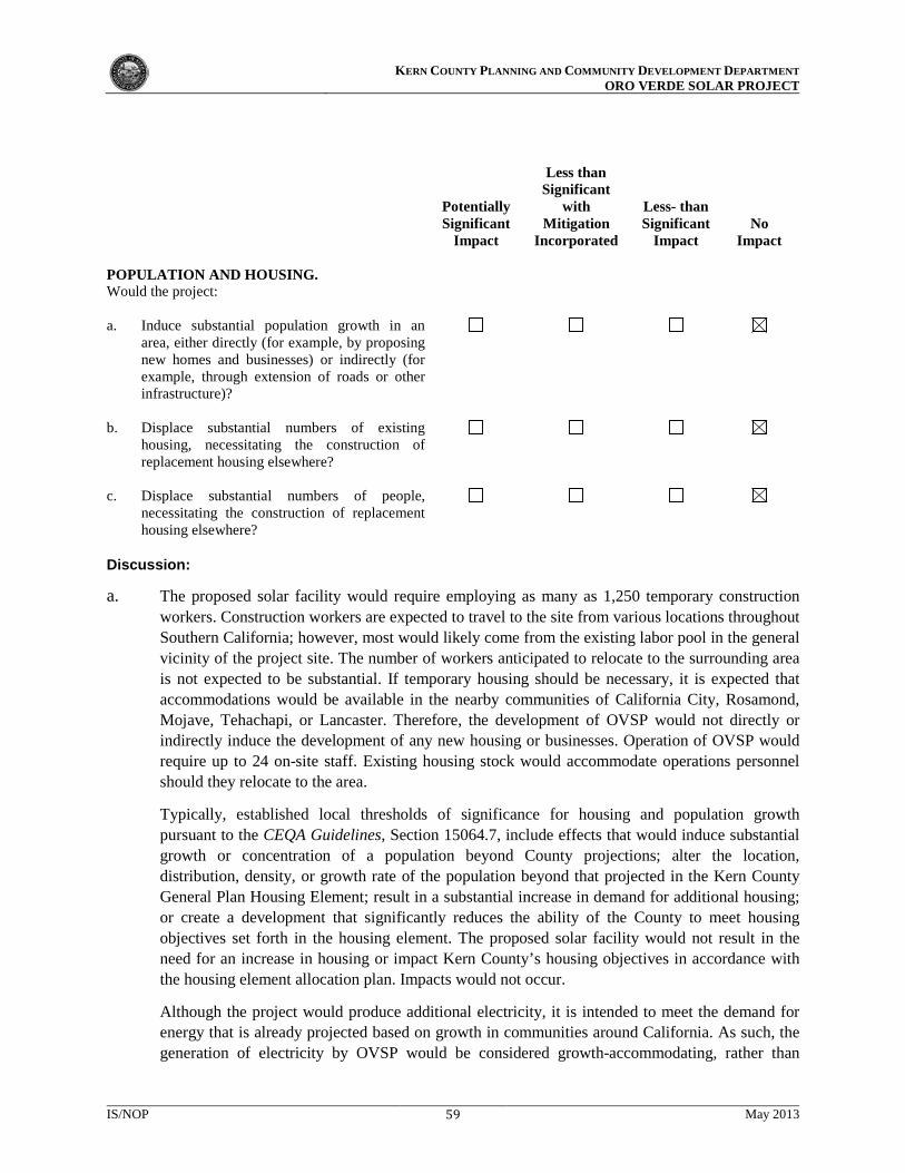
KERN COUNTY PLANNING AND COMMUNITY DEVELOPMENT DEPARTMENT
ORO VERDE SOLAR PROJECT
Potentially Significant
Impact
Less than Significant
with Mitigation
Incorporated
Less- than Significant
Impact
No Impact
POPULATION AND HOUSING. Would the project:
a. Induce substantial population growth in an
area, either directly (for example, by proposing new homes and businesses) or indirectly (for example, through extension of roads or other infrastructure)?
b. Displace substantial numbers of existing
housing, necessitating the construction of replacement housing elsewhere?
c. Displace substantial numbers of people,
necessitating the construction of replacement housing elsewhere?
Discussion:
a. The proposed solar facility would require employing as many as 1,250 temporary construction workers. Construction workers are expected to travel to the site from various locations throughout Southern California; however, most would likely come from the existing labor pool in the general vicinity of the project site. The number of workers anticipated to relocate to the surrounding area is not expected to be substantial. If temporary housing should be necessary, it is expected that accommodations would be available in the nearby communities of California City, Rosamond, Mojave, Tehachapi, or Lancaster. Therefore, the development of OVSP would not directly or indirectly induce the development of any new housing or businesses. Operation of OVSP would require up to 24 on-site staff. Existing housing stock would accommodate operations personnel should they relocate to the area.
Typically, established local thresholds of significance for housing and population growth pursuant to the CEQA Guidelines, Section 15064.7, include effects that would induce substantial growth or concentration of a population beyond County projections; alter the location, distribution, density, or growth rate of the population beyond that projected in the Kern County General Plan Housing Element; result in a substantial increase in demand for additional housing; or create a development that significantly reduces the ability of the County to meet housing objectives set forth in the housing element. The proposed solar facility would not result in the need for an increase in housing or impact Kern County’s housing objectives in accordance with the housing element allocation plan. Impacts would not occur.
Although the project would produce additional electricity, it is intended to meet the demand for energy that is already projected based on growth in communities around California. As such, the generation of electricity by OVSP would be considered growth-accommodating, rather than
IS/NOP 59 May 2013

KERN COUNTY PLANNING AND COMMUNITY DEVELOPMENT DEPARTMENT
ORO VERDE SOLAR PROJECT
growth-inducing. In addition, state law requires utility companies to produce a certain percentage of electricity from green or renewable sources. Solar electricity is considered a renewable product and would help the utility companies meet this new state law.
The project’s electricity would replace electricity generated by fossil fuels, thereby contributing to California’s renewable energy goals, and would not contribute to induced growth. No significant impacts related to population growth are expected from the project, and further analysis of this issue is not warranted in the EIS/EIR.
b., c. The project would be sited on lands that are currently undeveloped. No residences would be condemned and no people would be displaced by this project. No impacts are expected and no further analysis is warranted.
IS/NOP 60 May 2013

KERN COUNTY PLANNING AND COMMUNITY DEVELOPMENT DEPARTMENT
ORO VERDE SOLAR PROJECT
Potentially Significant
Impact
Less than Significant
with Mitigation
Incorporated
Less-than- Significant
Impact
No Impact
PUBLIC SERVICES. Would the project:
a. Result in substantial adverse physical impacts
associated with the provision of new or physically altered governmental facilities, need for new or physically altered governmental facilities, the construction of which could cause significant environmental impacts, in order to maintain acceptable service ratios, response times, or to other performance objectives for any of the public services:
i. Fire protection? ii. Police protection? iii. Schools? iv. Parks? v. Other public facilities?
Discussion:
a.i. Fire Protection. Fire suppression and emergency medical services would be provided in the project area by the Kern County Fire Department (KCFD). The project site would be served by Kern County Fire Station #14, located at 1953 State Highway 58 in the community of Mojave, approximately 4.5 miles north of the proposed solar facility site. Adherence to all applicable regulations would reduce wildfire ignitions and prevent the spread of wildfires. Construction and operation activities may result in increased need for fire-fighting personnel and facilities in the area. Therefore, the potential impact on fire services from construction in a Local Responsibility Area and operation of the solar facility is potentially significant and will be evaluated in the EIS/EIR.
a.ii. Police Protection. Police protection services in the project area are provided by the Kern County Sheriff’s Department. The project site would be served by the Mojave substation, located at 1771 State Highway 58, approximately 4.5 miles north of the solar facility site. Although the potential is low, the project may attract vandals or other security risks, and construction activities could result in increases in traffic volumes along surrounding roads. On-site security would be provided and access to the areas surrounding the project site would be limited during construction and operation, thereby minimizing the need for police surveillance. Nonetheless, the project’s impacts on sheriff services are potentially significant and will be evaluated in the EIS/EIR.
a.iii. Schools. Most project-related construction workers would likely live in the project area and commute to the site from surrounding communities where their children are already enrolled in school, and where their contribution to local taxes funds the schooling of their children. Even if
IS/NOP 61 May 2013

KERN COUNTY PLANNING AND COMMUNITY DEVELOPMENT DEPARTMENT
ORO VERDE SOLAR PROJECT
these workers came from out of the area, they would likely return to their out-of-town residences once the facilities were built and would not take their children out of their current schooling situation to relocate to the project area for 24 months. Therefore, substantial temporary increases in population that would adversely affect local school populations are not expected. Likewise, the up to 24 employees who would operate the project are not expected to generate a permanent increase in population that would impact school populations. Therefore, no significant impacts to schools are anticipated to occur, and further analysis of this issue is not warranted in the EIS/EIR.
a.iv. Parks. The population increase that would be experienced during the construction phase of OVSP would be temporary and would not result in additional demand for park facilities. Operations personnel would include up to 24 employees. Therefore, no significant impacts to parks are anticipated to occur, and further analysis of this issue is not warranted in the EIS/EIR.
a.v. Other Public Facilities. Most project-related construction workers would likely live in the project area and commute to the site from surrounding communities. Therefore, substantial temporary increases in population that would adversely affect local public facilities, such as post office, courthouse, and library services, are not expected. The project would not require the appreciable use of other public facilities—such as libraries, courts, and Kern County services—that would result in a significant impact. Once constructed, the project would employ up to 24 full time employees. The need for the project operator to use other services in the future (such as the Kern County services for future endeavors) is speculative. The project would have a less-than-significant impact on other public services, and further analysis of this issue is not warranted.
IS/NOP 62 May 2013

KERN COUNTY PLANNING AND COMMUNITY DEVELOPMENT DEPARTMENT
ORO VERDE SOLAR PROJECT
Issues (and Supporting Information Sources):
Potentially Significant
Impact
Less than Significant
with Mitigation
Incorporated
Less–than- Significant
Impact
No Impact
RECREATION. Would the project:
a. Increase the use of existing neighborhood and
regional parks or other recreational facilities such that substantial physical deterioration of the facility would occur or be accelerated?
b. Include recreational facilities or require the
construction or expansion of recreational facilities that might have an adverse physical effect on the environment?
Discussion:
a, b. The project would not include new recreational facilities. The temporary increase of population during construction that might be caused by an influx of workers would be minimal. As a result, there would not be a detectable increase in the use of parks or other recreational facilities. No impacts would occur, and no further analysis is warranted.
IS/NOP 63 May 2013

KERN COUNTY PLANNING AND COMMUNITY DEVELOPMENT DEPARTMENT
ORO VERDE SOLAR PROJECT
Potentially Significant
Impact
Less than Significant
with Mitigation
Incorporated
Less-than- Significant
Impact
No Impact
TRANSPORTATION AND TRAFFIC. Would the project:
a. Conflict with an applicable plan, ordinance,, or
policy establishing measures of effectiveness for the performance of the circulation system, including but not limited to intersections, streets, highways and freeways, pedestrian and bicycle paths, and mass transit?
b. Conflict with an applicable congestion
management program, including, but not limited to level of service standards and travel demand measures, or other standards established by the county congestion management agency for designated roads or highways?
i. Metropolitan Bakersfield General Plan
LOS “C”?
ii. Kern County General Plan LOS “D”?
c. Result in a change in air traffic patterns,
including either an increase in traffic levels or a change in location that results in substantial safety risks?
d. Substantially increase hazards due to a design
feature (e.g., sharp curves or dangerous intersections) or incompatible uses (e.g., farm equipment)?
e. Result in inadequate emergency access?
f. Conflict with adopted policies, plans, or
programs regarding public transit, bicycle, or pedestrian facilities, or otherwise decrease the performance or safety of such facilities?
Discussion:
a. Project construction would rely on the local circulation system for worker commutes and the delivery of construction materials. Construction-related traffic (including construction worker trips) could conflict with an applicable plan, ordinance, or policy establishing measures of effectiveness for the performance of the circulation system. Operation of OVSP would require up to 24 employees, who
IS/NOP 64 May 2013

KERN COUNTY PLANNING AND COMMUNITY DEVELOPMENT DEPARTMENT
ORO VERDE SOLAR PROJECT
would commute to the site and are not expected to generate significant traffic. A traffic land use analysis will be prepared, and potential impacts on the local roadway system from construction-related vehicle trips will be evaluated in the EIS/EIR.
b. Construction of OVSP would rely on the local circulation system for the up to 1,250 worker commutes and the delivery of construction materials. Construction-related traffic, including construction worker trips, could conflict with an applicable congestion management program, including but not limited to level of service standards and travel demand measures, or other standards established by the County congestion management agency for designated roads or highways. Operation of OVSP would require up to 24 employees, who would commute to the site and are not expected to generate significant traffic. A traffic analysis will be prepared, and potential impacts on the local roadway system from construction-related vehicle trips will be evaluated in the EIS/EIR.
i. The project site is located outside of the Metropolitan Bakersfield General Plan Area, and the level of service (LOS) standards are not applicable to this project. Although trips generated by the project may be distributed throughout the Metropolitan Bakersfield General Plan Area, the anticipated minimal number of trips would not affect LOS standards. Further analysis of this issue is not warranted in the EIS/EIR.
ii. Construction of the project would generate construction trips which could temporarily increase the daily traffic volumes on local roadways and intersections in Kern County. The employees required for operation and maintenance of OVSP are expected to originate from the local area and would not result in a substantial number of trips on roadways in the metropolitan Bakersfield area or in other parts of Kern County. Therefore, the project’s impacts on Kern County’s traffic/circulation system are anticipated to be less than significant; however, this issue will be further analyzed in the EIS/EIR.
c. The project site is located on Edwards AFB, which is a military aviation installation identified within the Kern County ALUCP. Potential changes in air traffic patterns and aviation safety risks will be analyzed in the EIS/EIR.
d. Access to the project would be from existing roads. No new design features would be introduced that would result in transportation-related hazards or safety concerns. However, the project is located in a rural area and existing roads may not be designed to accommodate large construction equipment and construction traffic. Therefore, this issue will be further analyzed in the EIS/EIR..
e. As described above, construction of the project would generate construction trips that could temporarily increase the daily traffic volumes on local roadways and intersections. However, emergency access would be maintained at all times, and appropriate detours would be provided. Impacts to emergency access are anticipated to be less than significant but will be further analyzed in the EIS/EIR.
f. As described above, construction of the project would generate construction trips that could temporarily disrupt bicycle traffic on local roadways. However, due to the rural nature of the area, no bus stops or designated bicycle lanes exist on the roadways in the vicinity of the project site. Therefore, the project would comply with County policies, plans, and programs related to alternative transportation. Further analysis of this issue is not warranted in the EIS/EIR.
IS/NOP 65 May 2013

KERN COUNTY PLANNING AND COMMUNITY DEVELOPMENT DEPARTMENT
ORO VERDE SOLAR PROJECT
Potentially Significant
Impact
Less than Significant
with Mitigation
Incorporated
Less-than- Significant
Impact
No Impact
UTILITIES AND SERVICE SYSTEMS. Would the project:
a. Exceed wastewater treatment requirements of
the applicable regional water quality control board?
b. Require or result in the construction of new
water or wastewater treatment facilities or expansion of existing facilities, the construction of which could cause significant environmental effects?
c. Require or result in the construction of new
stormwater drainage facilities or expansion of existing facilities, the construction of which could cause significant environmental effects?
d. Have sufficient water supplies available to
serve the project from existing entitlements and resources, or would new or expanded entitlements be needed?
e. Result in a determination by the wastewater
treatment provider that serves or may serve the project that it has adequate capacity to serve the project’s projected demand in addition to the provider’s existing commitments?
f. Be served by a landfill with sufficient
permitted capacity to accommodate the project’s solid waste disposal needs?
g. Comply with federal, state, and local statutes
and regulations related to solid waste?
Discussion:
a. During construction, wastewater would be contained for up to 1,250 workers within portable toilet facilities and disposed of at an approved site. The Kern County Environmental Health Services Division is responsible for monitoring the use of portable toilet facilities, and a condition of approval would require the project operator to provide documentation of a portable toilet pumping contract.
During operation, the proposed solar facility would include a septic system to handle wastewater generated on-site; however, with a maximum of up to 24 employees, the facility is not anticipated to generate substantial volumes of wastewater. Impacts would be less than significant; however, further analysis of this issue will be included in the EIS/EIR.
IS/NOP 66 May 2013

KERN COUNTY PLANNING AND COMMUNITY DEVELOPMENT DEPARTMENT
ORO VERDE SOLAR PROJECT
b. OVSP would include the construction of a septic system. Wastewater generation during operation is
not expected to be significant, as the proposed solar facility would require a relatively small number of employees. The facilities’ low demand for water and limited production of wastewater would not require the construction or expansion of water or wastewater treatment facilities. This impact would be less than significant; however, further analysis will be included in the EIS/EIR.
c. The proposed solar panels would create impervious surfaces and would require imported water for dust suppression during construction and the washing of panels. However, these changes are not anticipated to substantially increase the amount of stormwater runoff. The project area does not rely on constructed stormwater drainage systems. As previously stated, the pattern and concentration of runoff could be altered by project activities, such as grading of the site and roads, and must comply with the National Pollutant Discharge Elimination System (NPDES) through a Stormwater Pollution Prevention Plan (SWPPP) or other means to contain water on-site during construction. It is not anticipated that the amount of runoff across the project site would be substantially altered. Therefore, the project is not expected to overwhelm existing stormwater drainage systems or create substantial additional sources of polluted runoff. However, further analysis of this issue will be included in the EIS/EIR.
d. It is anticipated that up to 1,000 acre-feet per year of water would be required during the two-year construction phase for concrete manufacturing, dust control, and sanitary use. To the extent available, tertiary treated water would be used for non-potable uses from the Rosamond Community Services District, or would be trucked to the site. Project operations would require up to 27 acre-feet of water per year that would be purchased from the Rosamond Community Services District or would be trucked to the site. Impacts related to water use would be potentially significant, and further analysis of this issue will be included in the EIS/EIR.
e. The project would include construction of a septic system and all wastewater would be handled on-site. Therefore, no impacts to any existing wastewater treatment facilities would occur, and further analysis of this issue is not warranted in the EIS/EIR.
f. OVSP is not expected to generate a significant amount of waste that would exceed the capacity of local landfills. Materials brought to the project site would be used to construct facilities, and few residual materials are expected. Non-hazardous construction refuse and solid waste would be either collected and recycled or disposed of at a local landfill, while any hazardous waste generated during construction would be disposed of at an approved location. It is not anticipated that the amount of solid waste generated by the project would exceed the capacity of local landfills. Impacts are anticipated to be less than significant; however, further analysis of this issue will be included in the EIS/EIR.
g. OVSP would generate solid waste during construction and operation, thus requiring the consideration of waste reduction and recycling measures. The 1989 California Integrated Waste Management Act (AB 939) requires Kern County to attain specific waste diversion goals. In addition, the California Solid Waste Reuse and Recycling Access Act of 1991, as amended, requires expanded or new development projects to incorporate storage areas for recycling bins. The project would comply with the 1989 California Integrated Waste Management Act and the 1991 California Solid Waste Reuse and Recycling Access Act of 1991, as amended. Therefore, impacts are anticipated to be less than significant; however, further analysis of this issue will be included in the EIS/EIR.
IS/NOP 67 May 2013

KERN COUNTY PLANNING AND COMMUNITY DEVELOPMENT DEPARTMENT
ORO VERDE SOLAR PROJECT
Discussion:
a. The EIS/EIR’s biological and cultural resources sections will discuss specific project impacts on plants and wildlife and historical resources. The document will also evaluate the OVSP’s contribution to cumulative resource impacts and propose mitigation that is designed to reduce the impacts to less-than-significant levels, where feasible.
b. OVSP has the potential to cumulatively contribute to aesthetics, air quality, biological resources, cultural resources, geology, greenhouse gas emissions, hydrology, land use, mineral resources, noise, public services, and traffic/transportation impacts. The EIS/EIR will evaluate the project’s contribution to cumulative impacts in these and other resource areas.
c. Although there may be significant air quality impacts during construction, the long-term air quality impacts could be beneficial if fossil fuel use is reduced. OVSP’s short-term cumulative contribution to air quality impacts will be evaluated in the EIS/EIR.
Potentially Significant
Impact
Less than Significant
with Mitigation
Incorporated
Less than Significant
Impact
No Impact
MANDATORY FINDINGS OF SIGNIFICANCE. a. Does the project have the potential to degrade
the quality of the environment, substantially reduce the habitat of a fish or wildlife species, cause a fish or wildlife population to drop below self-sustaining levels, threaten to elimi-nate a plant or animal community, substantially reduce the number or restrict the range of a rare or endangered plant or animal, or eliminate important examples of the major periods of California history or prehistory?
b. Does the project have impacts that are individ-
ually limited, but cumulatively considerable? (“Cumulatively considerable” means that the incremental effects of a project are significant when viewed in connection with the effects of past projects, the effects of other current projects, and the effects of probable future projects.)
c. Does the project have environmental effects
that would cause substantial adverse effects on human beings, either directly or indirectly?
IS/NOP 68 May 2013