note to user - mississippi · nch k eek er nch k e eek ea eek k nch h ch eek h e eek eek nch ch eek...
TRANSCRIPT
PRELIMINARY DEC 23 2009
13
72
RAILROAD
RAILR
OAD
RAILROAD
RAILROAD
364
30
4
350
25
365
25
366
25
30
28141C0111C
28141C0118C28141C0114C28141C0113C
28141C0116C28141C0112C
28141C0108C28141C0104C
28141C0245C28141C0240C
28141C0235C28141C0230C
28141C0170C28141C0165C*
28141C0160C28141C0155C
28141C0095C28141C0090C
28141C0085C28141C0080C
28141C0065C28141C0045C28141C0040C28141C0020C
28141C0035C28141C0030C
28141C0110C28141C0105C
28141C0120C
28141C0325C28141C0300C
28141C0275C
28141C0225C28141C0200C
28141C0150C
28141C0025C
TENNESSEE
ALABAMA
TISHOMINGOCOUNTY
CITY OFIUKA
TOWN OFBELMONT
CITY OFBURNSVILLE
VILLAGE OFGOLDEN
TOWN OFTISHOMINGO
VILLAGEOF
PADEN
MAP NUMBER
COLB
ERT C
OUNT
Y ALA
BAMA
FRAN
KLIN
COUN
TY AL
ABAM
A
ITAWAMBA COUNY
PRENTISSCOUNTY
ALCORN COUNTY
HARDIN COUNTY
LAUDERDALE
COUNTY
Bear Cree
k
Tenn
essee
Tomb
igbee
Water
way
Tennessee River
Rock Cree
kBay
Spring
s Lake
Cripple DeerCreek
Indian CreekYellow Creek
Jourdan Creek
Mill Creek
Panther Creek
Little Yellow Creek
Little Cripple Deer Creek
Cane
y Cree
k
EllingtonCreek
Holly BranchRed Bud Creek
Riddle Creek
TriggerBranch
Robinson Creek
PennywinkleCreek
BereaCreek
Cedar Creek
Perry
Bran
ch
Moore Branch
Hazard Branch
Dry CreekSouth
CokeCreek
Dry Creek
McMinn Branch
Mayo
Bran
ch
Sandy Creek
Epps Branch
Wofford Branch
Reedy Branch
Mud Branch
Moody Branch
King Creek
Bailey Branch
McDougalBranch
MarlarBranch
Prairie Branch
Brown Branch
McRoe Branch
Fowler Branch
Hubbard Branch
Drainage Creek
Hurricane
Creek
Counts Branch
BlissetBranch
Mill CreekSouth
South Fork
Eastport Branch
Hurricane Branch
Long BranchSouth
Burgess Creek
Tributary A
McNutt BranchSouth
Zippy Branch
Shelby Branch
Morgan BranchEast
RowinBranch
TributaryNo. 2
Leitch Mill Branch
Mad Dog Branch
Mackeys CreekSouth
WhetstoneBranch
Tanyard Branch
Indian Creek
PickwickLake
PickwickLake
Clear Creek
North ForkRed Bud Creek
South ForkRed Bud Creek
Newcomb Branch
BrumleyBranch
TributaryNo. 1
Waldrop Creek
Wayne Branch
Johnson Branch South
Panther Branch
Tennessee TombigbeeWaterway
Bear
Cree
k
Crippl
e Deer
Creek
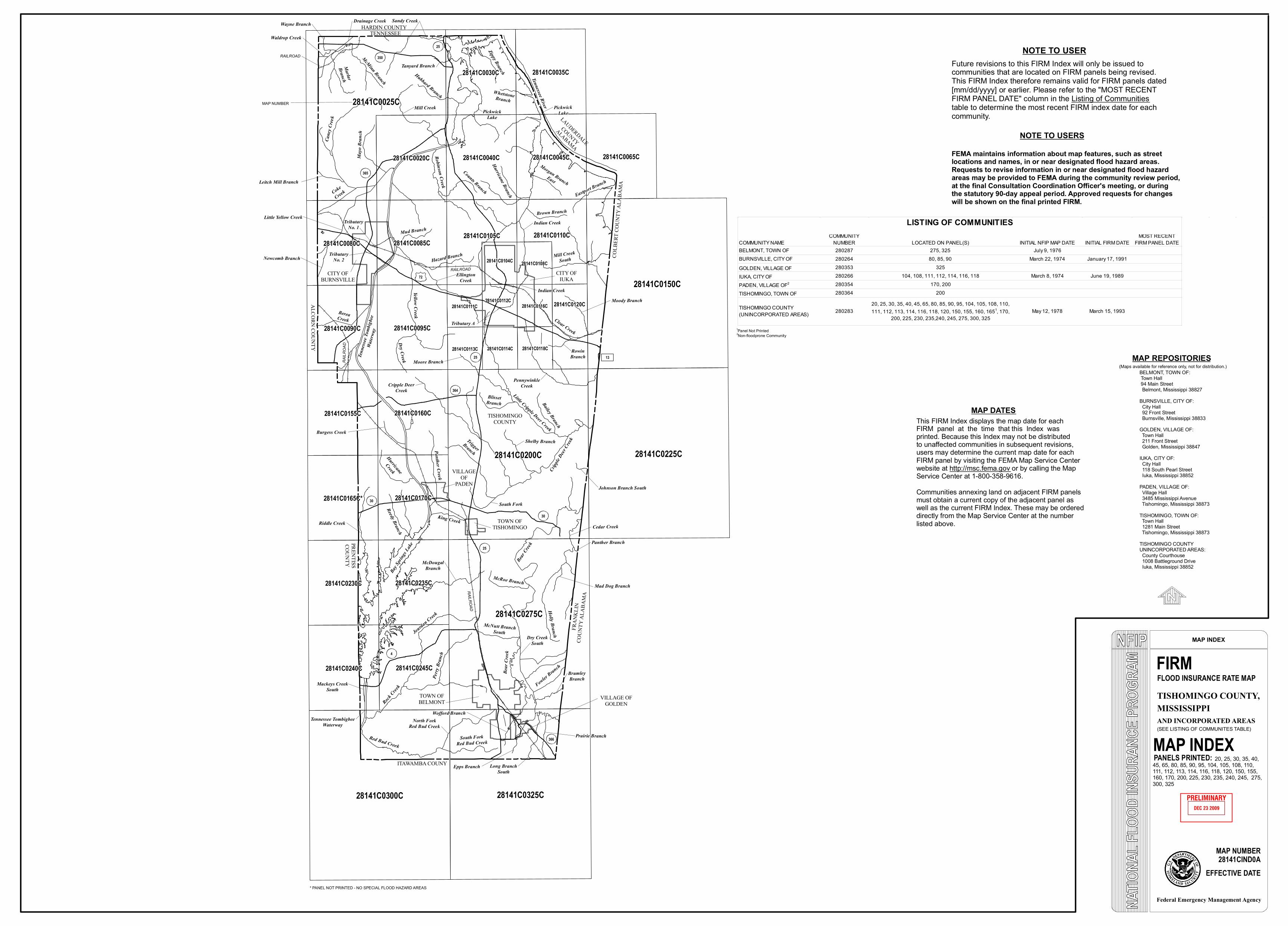
MAP INDEX
FIRMFLOOD INSURANCE RATE MAP
MAP NUMBER28141CIND0A
EFFECTIVE DATE
Federal Emergency Management Agency
MAP INDEXPANELS PRINTED: 20, 25, 30, 35, 40,
45, 65, 80, 85, 90, 95, 104, 105, 108, 110, 111, 112, 113, 114, 116, 118, 120, 150, 155, 160, 170, 200, 225, 230, 235, 240, 245, 275, 300, 325
TISHOMINGO COUNTY,MISSISSIPPIAND INCORPORATED AREAS
FEMA maintains information about map features, such as streetlocations and names, in or near designated flood hazard areas.Requests to revise information in or near designated flood hazardareas may be provided to FEMA during the community review period,at the final Consultation Coordination Officer's meeting, or duringthe statutory 90-day appeal period. Approved requests for changeswill be shown on the final printed FIRM.
NOTE TO USERS
Future revisions to this FIRM Index will only be issued tocommunities that are located on FIRM panels being revised.This FIRM Index therefore remains valid for FIRM panels dated[mm/dd/yyyy] or earlier. Please refer to the "MOST RECENTFIRM PANEL DATE" column in the Listing of Communitiestable to determine the most recent FIRM index date for eachcommunity.
NOTE TO USER
1Panel Not Printed
* PANEL NOT PRINTED - NO SPECIAL FLOOD HAZARD AREAS
(SEE LISTING OF COMMUNITES TABLE)
This FIRM Index displays the map date for eachFIRM panel at the time that this Index wasprinted. Because this Index may not be distributedto unaffected communities in subsequent revisions,users may determine the current map date for eachFIRM panel by visiting the FEMA Map Service Centerwebsite at http://msc.fema.gov or by calling the MapService Center at 1-800-358-9616. Communities annexing land on adjacent FIRM panelsmust obtain a current copy of the adjacent panel aswell as the current FIRM Index. These may be ordereddirectly from the Map Service Center at the numberlisted above.
MAP DATES
2Non-floodprone Community
(Maps available for reference only, not for distribution.)MAP REPOSITORIES
BELMONT, TOWN OF: Town Hall 94 Main Street Belmont, Mississippi 38827BURNSVILLE, CITY OF: City Hall 92 Front Street Burnsville, Mississippi 38833GOLDEN, VILLAGE OF: Town Hall 211 Front Street Golden, Mississippi 38847IUKA, CITY OF: City Hall 118 South Pearl Street Iuka, Mississippi 38852PADEN, VILLAGE OF: Village Hall 3485 Mississippi Avenue Tishomingo, Mississippi 38873TISHOMINGO, TOWN OF: Town Hall 1281 Main Street Tishomingo, Mississippi 38873TISHOMINGO COUNTYUNINCORPORATED AREAS: County Courthouse 1008 Battleground Drive Iuka, Mississippi 38852
COMMUNITY NAMECOMMUNITY
NUMBER LOCATED ON PANEL(S) INITIAL NFIP MAP DATE INITIAL FIRM DATEMOST RECENT
FIRM PANEL DATEBELMONT, TOWN OF 280287 275, 325 July 9, 1976BURNSVILLE, CITY OF 280264 80, 85, 90 March 22, 1974 January 17, 1991GOLDEN, VILLAGE OF 280353 325IUKA, CITY OF 280266 104, 108, 111, 112, 114, 116, 118 March 8, 1974 June 19, 1989PADEN, VILLAGE OF2 280354 170, 200TISHOMINGO, TOWN OF 280364 200
TISHOMINGO COUNTY (UNINCORPORATED AREAS) 280283
20, 25, 30, 35, 40, 45, 65, 80, 85, 90, 95, 104, 105, 108, 110, 111, 112, 113, 114, 116, 118, 120, 150, 155, 160, 1651, 170,
200, 225, 230, 235,240, 245, 275, 300, 325May 12, 1978 March 15, 1993
LISTING OF COMMUNITIES