note - mississauga 4.13 erin mills district policies of mississauga plan 2012 november note: the...
TRANSCRIPT

SECTION 4.13 ERIN MILLS
DISTRICT POLICIES OF
MISSISSAUGA PLAN
2012 November
NOTE:
THE POLICIES IN THIS DOCUMENT ARE SPECIFIC TO THE ERIN MILLS PLANNING DISTRICT OF MISSISSAUGA PLAN,
AND MUST BE READ IN CONJUNCTION WITH ALL THE POLICIES OF MISSISSAUGA PLAN
PLEASE REFER TO MISSISSAUGA PLAN
FOR ADDITIONAL CITY-WIDE POLICIES WHICH APPLY TO THIS DISTRICT.
THE ERIN MILLS DISTRICT POLICIES OF MISSISSAUGA PLAN CAME INTO EFFECT 2003 MAY 05, EXCEPT FOR THE
AREAS MARKED AND OUTLINED IN THIS PLAN THAT HAVE BEEN APPEALED TO THE OMB.
ALL APPEALS HAVING BEEN SETTLED, THE ERIN MILLS DISTRICT POLICIES OF MISSISSAUGA
PLAN ARE IN FULL FORCE AND EFFECT.


MISSISSAUGA PLAN
Specific policies in this section must be read in conjunction with all the policies in this Plan.
Erin Mills District Policies of Mississauga Plan
OFFICE CONSOLIDATION This is an office consolidation of the Erin Mills District Policies of Mississauga Plan (Official Plan), as amended, prepared for the purpose of convenience only. For accurate reference, the "originals" should be consulted. The number in brackets and italics, eg. (MPA-123), at the end of a section, subsection, paragraph, subparagraph, etc., is the number of the Amendment or By-law amending the Erin Mills District Policies of Mississauga Plan (Official Plan). The following text and map, attached hereto, constitute the Erin Mills District Policies of Mississauga Plan (Official Plan), being an office consolidation of the Erin Mills District Policies of Mississauga Plan (Official Plan), modified and approved by the Region of Peel, 2003 May 05, save and except certain parts that were appealed to the Ontario Municipal Board. SECTION DATE STATUS APPROVED BY
Mississauga Plan Erin Mills District Policies and District Land Use Map
2003 May 05 Partially approved with modifications and appeal to OMB
Region of Peel
Erin Mills District Policies subsequently further amended by:
AMENDED BY SECTION DATE STATUS APPROVED BY
Mississauga Plan Appeal B4 - District Land Use Map
2004 Mar. 29 Further approval Appeal dismissed All approved
Ontario Municipal Board Order No. 0662
Amendment 14 District Land Use Map 2004 Mar. 29 All approved Ontario Municipal Board Order No. 0662
Amendment 33 District Land Use Map 2005 July 19 All approved City of Mississauga
Amendment 24 District Policies and District Land Use Map
2006 Mar. 13 All approval With modifications
Ontario Municipal Board Order No. 0757
Amendment 25 District Policies and District Land Use Map
2007 Sept. 10 All approved Ontario Municipal Board Order No. 2622
Issued 2007 Oct. 01
Amendment 40 District Policies 2008 Mar. 24 All Approved Except for two (2) appeals to the OMB
“Retail” of term “retail commercial” - Appealed
City of Mississauga
Amendment 40 District Policies and District Land Use Map
2009 Dec. 01 All Approved Except for two (2) appeals to the OMB
Term “retail commercial” is no longer under appeal
City of Mississauga
Amendment 95 District Policies and District Land Use Map
2010 Jan. 07 Partial Approval All Appealed to the OMB
(Azuria Group, Gemini Urban Design (Cliff) Corp., Orlando Corp., Solmar Dev. Corp. and Berkley Homes [current owners: Hush Homes] – as it relates to lands at 1745, 1765, 1775 Thorny Brae Place)
Region of Peel
Amended: ERIN MILLS DISTRICT POLICIES OF MISSISSAUGA PLAN 2010 January Section 4.13 ~ Page 1

MISSISSAUGA PLAN
Specific policies in this section must be read in conjunction with all the policies in this Plan.
Erin Mills District Policies of Mississauga Plan
SECTION DATE STATUS APPROVED BY
Amendment 95 District Policies and District Land Use Map
2011 Feb. 25 Partial Approval All Appealed to the OMB
(Azuria Group, Gemini Urban Design (Cliff) Corp., Orlando Corp., Solmar Dev. Corp. and Berkley Homes – as it relates to lands at 1745, 1765, 1775 Thorny Brae Place)
Region of Peel
Withdrawn: Berkley Homes – as it relates to lands at 1745, 1765, 1775 Thorny Brae Place)
2011 Feb. 25
Case No. PL101408 File No. PL100111
Amendment 95 District Policies and District Land Use Map
2011 May 09 Partial Approval All Appealed to the OMB
(Azuria Group, Gemini Urban Design (Cliff) Corp.-as it relates to the lands located at 2021-2041 Cliff Road, Orlando Corp., Solmar Dev. Corp.
Region of Peel
Withdrawn: Solmar Dev. Corp., 2011 May 09
Case No. PL101408 File No. PL100111
Amendment 95 District Policies and District Land Use Map
2011 Dec. 13 Partial Approval All Appealed to the OMB
(Azuria Group, Gemini Urban Design (Cliff) Corp.-as it relates to the lands located at 2021-2041 Cliff Road, Orlando Corp.
Region of Peel
Withdrawn: Azuria Group Inc., 2011 Dec. 13
Case No. PL101408 File No. PL100111
Amendment 95 District Policies and District Land Use Map
2012 Apr. 25 Partial Approval Site Specific Appeal to the OMB
Gemini Urban Design (Cliff) Corp.-as it relates to the lands located at 2021-2041 Cliff Road Orlando Corp.
Region of Peel
Withdrawn: Orlando Corp., 2012 Apr. 25
Case No. PL101408 File No. PL100111
Amendment 129 District Policies and District Land Use Map
2012 Oct. 10 All Approved City of Mississauga
Amendment 95 District Policies and District Land Use Map
2012 Nov. 20 All Approved Region of Peel
Withdrawn: Gemini Urban Design (Cliff) Corp.-as it relates to the lands located at 2021-2041 Cliff Road 2012 Nov. 20 Case No. PL101408 File No. PL100111
Copyright © 2007 City of Mississauga Not to be reproduced without permission
Amended: ERIN MILLS DISTRICT POLICIES OF MISSISSAUGA PLAN 2012 November Section 4.13 ~ Page 2

MISSISSAUGA PLAN
Specific policies in this section must be read in conjunction with all the policies in this Plan.
Erin Mills District Policies of Mississauga Plan
PREFACE The adopting By-laws and Region of Peel approval certificate for Mississauga Plan (Official Plan) is on file in the Planning and Building Department. CITY OF MISSISSAUGA APPROVAL Mississauga Plan (Official Plan) for the City of Mississauga, except for the Commercial Policies and Commercial Land Use Designations, was adopted by By-law Number 0317-2002 by City Council on the 10th day of July, 2002. The Commercial Policies, Commercial Land Use Designations and modifications for Mississauga Plan (Official Plan) were adopted by By-law Number 0085-2003 by City Council on the 26th day of February, 2003. REGION OF PEEL APPROVAL Pursuant to sections 17(35) of the Planning Act, the Region of Peel made a Decision on 2003 March 31, to modify and approve part of Mississauga Plan (Official Plan) for the City of Mississauga Planning Area as adopted by By-laws 0317-2002 and 0085-2003 Dated at Brampton this 31st day of March, 2003. "NICK TUNNACLIFFE" Commissioner of Planning Region of Peel The Notice of Decision was issued 2003 April 14 with the Last Date of Appeal being 2003 May 04.
ONTARIO MUNICIPAL BOARD APPEALS MISSISSAUGA PLAN (OFFICIAL PLAN) CAME INTO EFFECT 2003 MAY 05, EXCEPT FOR THE FOLLOWING WHICH HAVE BEEN APPEALED TO THE ONTARIO MUNICIPAL BOARD. Pursuant to section 17(42) of the Planning Act, the Region of Peel is forwarding to the Ontario Municipal Board the following parts of Mississauga Plan (Official Plan), which have been appealed as set out in Part B, and indicated in Mississauga Plan (Official Plan) text and on the Schedules and Land Use Maps and labelled as B#. THE FOLLOWING PARTS OF MISSISSAUGA PLAN HAVE BEEN APPEALED: B4. The following in their entirety (Greater
Toronto Airports Authority): ● Section 4.13, Erin Mills District
Policies: – District Land Use Map, the
Commercial Land Use designations.
APPEAL DISMISSED OMB Order No. 0662 - 2004 Mar. 29 "MARK H. KLUGE" Principal Planner Development Planning Services Region of Peel ALL APPEALS HAVING BEEN SETTLED, THE ERIN MILLS DISTRICT POLICIES OF MISSISSAUGA PLAN ARE IN FULL FORCE AND EFFECT.
Amended: ERIN MILLS DISTRICT POLICIES OF MISSISSAUGA PLAN 2007 September Section 4.13 ~ Page 3
MISSISSAUGA PLAN
Specific policies in this section must be read in conjunction with all the policies in this Plan.
Erin Mills District Policies of Mississauga Plan
4.13 ERIN MILLS 4.13.1 Planning Context The Erin Mills District is comprised of the former Erin Mills South and Erin Mills West Planning Districts. Most of the residential lands are developed as a combination of low density detached and semi-detached units, medium density townhouses and high density apartment residential development. The open space system consists of a City Park and Community Parks and a continuous pedestrian Greenbelt system along the Credit River and its tributaries, and in other suitable locations. The campus of the University of Toronto's Erindale College is located along the Credit River. The Erin Mills District is within the Credit River watershed which is divided into the sub-watersheds of Loyalist Creek, Sawmill Creek, Glen Erin Brook and Mullet Creek. The Credit River valley, which delineates the easterly boundary of the District is the main natural corridor in the City, stretching from Lake Ontario to the northerly boundary of the City and beyond to Orangeville. This valley system and the secondary corridors provided by Sawmill Creek and Mullet Creek link the Credit River to natural areas within and beyond the District. The Credit River provides both coldwater and warmwater fish habitat, and is a significant migratory route for Atlantic Salmon. In addition, the valley provides abundant habitat and acts as a migratory corridor for birds, animals and plants. The Credit Valley trail offers an opportunity for passive recreation and nature appreciation. The section of the Credit River from Eglinton Avenue West to Dundas Street West is designated as an Environmentally Significant Area (ESA) by Credit Valley Conservation. In addition, the portion of the ESA from Burnhamthorpe Road West to Eglinton Avenue West is designated as a regionally significant life and earth science Area of Natural and Scientific Interest (ANSI). The Sawmill Creek valley contains an area designated as an ESA (Ivor’s Bird Sanctuary) which is characterized by woodlands. The Sawmill Creek valley system also contains a number of Provincially rare plant species and provides connection to a number of natural areas within the District as well as providing opportunities for nature appreciation and passive recreation. Glen Erin Brook is a tributary of
Sawmill Creek, and has been significantly impacted by channelization and enclosures associated with flood and erosion control. The Mullet Creek sub-watershed covers only a small portion of the watershed but provides an important linkage function from the Credit River to natural areas beyond the District. A portion of the Credit River Eglinton to Dundas ESA is found along the Mullet Creek valley corridor, extending south of Burnhamthorpe Road West to the Credit River. The most significant woodland within the District is the mature sugar maple - American beech forest located south of Burnhamthorpe Road West, north of The Collegeway, between Glen Erin Drive and Erin Mills Parkway. The District also has a number of smaller woodlands. NOTE: All terms listed in Section 7, Glossary, where used, are bolded and italicised throughout the text. (MPA-25)
Amended: ERIN MILLS DISTRICT POLICIES OF MISSISSAUGA PLAN 2012 November Section 4.13 ~ Page 4

MISSISSAUGA PLAN
Specific policies in this section must be read in conjunction with all the policies in this Plan.
Erin Mills District Policies of Mississauga Plan
4.13.2 Development Concept The Erin Mills District is generally a stable, established area with a few sites remaining to be developed. The focus of these policies is on preserving the character of the existing development and transportation system and facilitating infilling and redevelopment. The Erin Mills Node is the central focus of activity in the District. The area has been designed to accommodate a variety of housing types, with the multiple family housing component located in proximity to major transit routes and activity nodes. These policies provide for further development in the District, with emphasis on its compatibility with existing residential development. The preservation of significant natural features is an integral aspect of these policies.
4.13.3 Land Use 4.13.3.1 Residential 4.13.3.1.1 Residential Low Density I a. The Residential Low Density I designation
permits development to a density of 17 units per net residential hectare.
b. East of Winston Churchill Boulevard, the
Residential Low Density I designation permits detached, semi-detached and duplex dwellings.
c. West of Winston Churchill Boulevard,
semi-detached and duplex dwellings will not be permitted.
4.13.3.1.2 Residential Low Density II The Residential Low Density II designation permits detached, semi-detached, duplex and street townhouse dwellings, within a density range of 18-30 units per net residential hectare. (MPA-25) 4.13.3.1.3 Residential Medium Density I The Residential Medium Density I designation permits detached, semi-detached, duplex, townhouse dwellings and all forms of horizontal multiple dwellings within a density range of 30-57 units per net residential hectare. (MPA-25) 4.13.3.1.4 Residential High Density I The Residential High Density I designation permits apartment dwellings at a Floor Space Index (FSI) of 0.8-1.4. 4.13.3.1.5 Residential High Density II The Residential High Density II designation permits apartment dwellings at a Floor Space Index (FSI) of 1.5-3.0. 4.13.3.2 Institutional Further expansion of the University of Toronto’s Erindale College by the acquisition of adjacent properties will be permitted. As part of any significant future development, additional/ alternative access to Mississauga Road will be reviewed.
Amended: ERIN MILLS DISTRICT POLICIES OF MISSISSAUGA PLAN 2007 September Section 4.13 ~ Page 5

MISSISSAUGA PLAN
Specific policies in this section must be read in conjunction with all the policies in this Plan.
Erin Mills District Policies of Mississauga Plan
4.13.4 Transportation 4.13.4.1 Road Classification The transportation system for the District is illustrated on the Erin Mills District Land Use Map, and described in Table 1, Basic Road Characteristics, Erin Mills District. TABLE 1: BASIC ROAD CHARACTERISTICS, ERIN MILLS DISTRICT
ROAD TYPE NAME SECTION JURISDICTION RIGHTS- OF-WAY*
PROVINCIAL HIGHWAY
Provincial Highway 403
Winston Churchill Boulevard to Credit River
Province of Ontario
ARTERIAL Burnhamthorpe Road West
Ridgeway Drive to Erin Mills Parkway
City of Mississauga 35 m
Burnhamthorpe Road West
Erin Mills Parkway to Credit River
City of Mississauga 50 m
Dundas Street West Approximately 125 m west of Fifth Line West to Credit River
City of Mississauga 35 m
Winston Churchill Boulevard
Provincial Highway 403 to Laird Road
City of Mississauga 35 m
Erin Mills Parkway Provincial Highway 403 to Dundas Street West
Region of Peel 45 m
MAJOR COLLECTOR
The Collegeway Ridgeway Drive to Mississauga Road
City of Mississauga 26 m
Ridgeway Drive Unity Drive to Laird Road
City of Mississauga 26 m
Glen Erin Drive Provincial Highway 403 to Burnhamthorpe Road West
City of Mississauga 26 m
Glen Erin Drive Burnhamthorpe Road West to approximately 100 m south of Council Ring Road
City of Mississauga 30 m
Mississauga Road (Scenic Route)
Provincial Highway 403 to Dundas Street West
City of Mississauga 26 m
MINOR COLLECTOR
As shown on District Land Use Map
City of Mississauga 20-26 m
LOCAL ROAD As shown on District Land Use Map
City of Mississauga 17-20 m
* These are considered basic rights-of-way. At intersections, grade separations or major physical
topographical constraints, wider rights-of-way may be required to accommodate bus bays, transit stations along Higher Order Transit Corridors, Bus Rapid Transit facility, Bus Rapid Transit stations, auxiliary lanes, side slopes, bicycle paths, streetscape works, etc. (MPA-25) (MPA-95 assoc. with OMB File No.: PL100111)
Amended: ERIN MILLS DISTRICT POLICIES OF MISSISSAUGA PLAN 2012 November Section 4.13 ~ Page 6

MISSISSAUGA PLAN
Specific policies in this section must be read in conjunction with all the policies in this Plan.
Erin Mills District Policies of Mississauga Plan
4.13.5 Special Site Policies 4.13.5.1 Introduction There are sites within the District which merit special attention and are subject to the following policies. 4.13.5.2 Site 1
The lands identified as Special Site 1 are located on Walnut Grove Road, south of Burbank Drive. Notwithstanding the provisions of the Residential Low Density I designation, any new lots will have a minimum lot frontage of thirty (30) m.
4.13.5.3 Site 2
The lands identified as Special Site 2 are located on Featherston Drive, on the west side of Mississauga Road. Notwithstanding the provisions of the Residential Low Density I designation, any new lots will have a minimum lot frontage of thirty (30) m.
Amended: ERIN MILLS DISTRICT POLICIES OF MISSISSAUGA PLAN 2007 September Section 4.13 ~ Page 7

MISSISSAUGA PLAN
Specific policies in this section must be read in conjunction with all the policies in this Plan.
Erin Mills District Policies of Mississauga Plan
4.13.5.4 Site 3
The lands identified as Special Site 3, are located at the southeast corner of The Collegeway and Ridgeway Drive. Notwithstanding the Residential High Density I designation on these lands, a maximum of one-hundred and thirty-two (132) units, will be permitted.
4.13.5.5 Site 4
The lands identified as Special Site 4, are located at the southwest corner of The Collegeway and Colonial Drive. Notwithstanding the Residential Medium Density I designation on these lands, townhouse and horizontal multiple dwelling units with a density of 76 units per net residential hectare, accommodating a maximum of one-hundred and twenty-six (126) units, will be permitted.
Amended: ERIN MILLS DISTRICT POLICIES OF MISSISSAUGA PLAN 2007 September Section 4.13 ~ Page 8
MISSISSAUGA PLAN
Specific policies in this section must be read in conjunction with all the policies in this Plan.
Erin Mills District Policies of Mississauga Plan
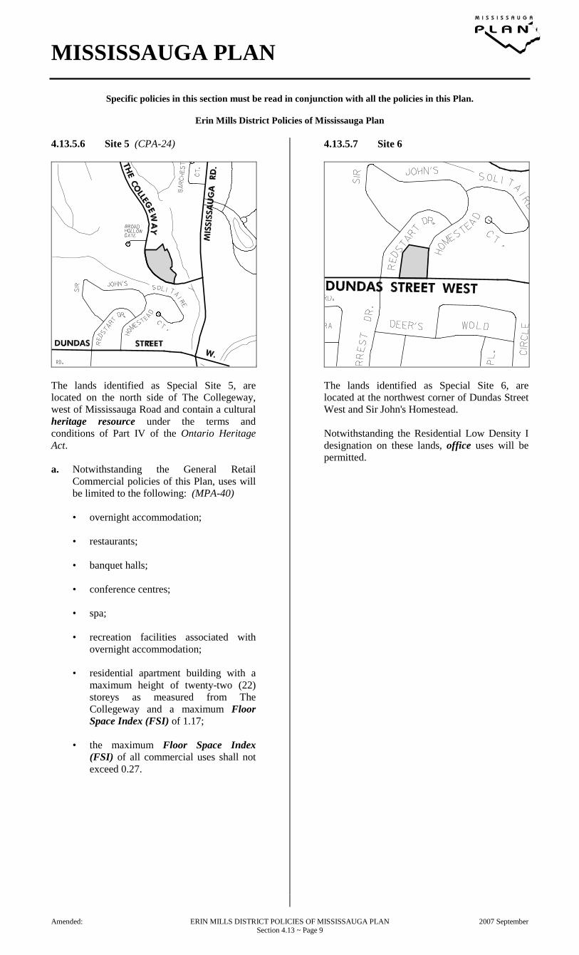
4.13.5.6 Site 5 (CPA-24)
The lands identified as Special Site 5, are located on the north side of The Collegeway, west of Mississauga Road and contain a cultural heritage resource under the terms and conditions of Part IV of the Ontario Heritage Act. a. Notwithstanding the General Retail
Commercial policies of this Plan, uses will be limited to the following: (MPA-40)
• overnight accommodation;
• restaurants;
• banquet halls;
• conference centres;
• spa;
• recreation facilities associated with
overnight accommodation;
• residential apartment building with a maximum height of twenty-two (22) storeys as measured from The Collegeway and a maximum Floor Space Index (FSI) of 1.17;
• the maximum Floor Space Index
(FSI) of all commercial uses shall not exceed 0.27.
4.13.5.7 Site 6
The lands identified as Special Site 6, are located at the northwest corner of Dundas Street West and Sir John's Homestead. Notwithstanding the Residential Low Density I designation on these lands, office uses will be permitted.
Amended: ERIN MILLS DISTRICT POLICIES OF MISSISSAUGA PLAN 2007 September Section 4.13 ~ Page 9

MISSISSAUGA PLAN
Specific policies in this section must be read in conjunction with all the policies in this Plan.
Erin Mills District Policies of Mississauga Plan
4.13.5.8 Site 7
The lands identified as Special Site 7 are located at the southeast corner of The Collegeway and Glen Erin Drive. Notwithstanding the provisions of the Convenience Retail Commercial designation, the following additional policy will apply: (MPA-40) a. motor vehicle commercial uses will be
permitted.
4.13.5.9 Site 8 (MPA-25)
The lands identified as Special Site 8 are located on the north side of Dundas Street West, east of Erin Mills Parkway. Notwithstanding the provisions of the General Retail Commercial designation, a funeral establishment will be the only permitted use. (MPA-40)
Amended: ERIN MILLS DISTRICT POLICIES OF MISSISSAUGA PLAN 2009 December Section 4.13 ~ Page 10

MISSISSAUGA PLAN
Specific policies in this section must be read in conjunction with all the policies in this Plan.
Erin Mills District Policies of Mississauga Plan
4.13.5.10 Site 9 (MPA-25)
The lands identified as Special Site 9 are located at the southeast corner of Frankston Road and Winston Churchill Boulevard. Notwithstanding the provisions of the Residential Low Density I designation, a garden centre will also be permitted.
4.13.5.11 Site 10 (MPA-129)
Notwithstanding the provisions of the Residential High Density I designation, a maximum height of five (5) storeys will be permitted.
Amended: ERIN MILLS DISTRICT POLICIES OF MISSISSAUGA PLAN 2012 October Section 4.13 ~ Page 11
MISSISSAUGA PLAN
Specific policies in this section must be read in conjunction with all the policies in this Plan.
Erin Mills District Policies of Mississauga Plan
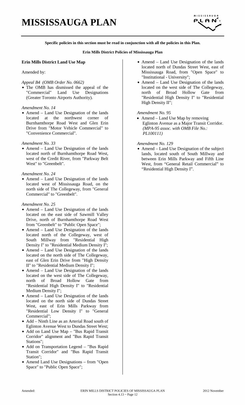
Erin Mills District Land Use Map Amended by: Appeal B4 (OMB Order No. 0662) $ The OMB has dismissed the appeal of the
"Commercial" Land Use Designations (Greater Toronto Airports Authority).
Amendment No. 14 $ Amend – Land Use Designation of the lands
located at the northwest corner of Burnhamthorpe Road West and Glen Erin Drive from "Motor Vehicle Commercial" to "Convenience Commercial".
Amendment No. 33 $ Amend – Land Use Designation of the lands
located north of Burnhamthorpe Road West, west of the Credit River, from "Parkway Belt West" to "Greenbelt".
Amendment No. 24 $ Amend – Land Use Designation of the lands
located west of Mississauga Road, on the north side of The Collegeway, from "General Commercial" to "Greenbelt".
Amendment No. 25 $ Amend – Land Use Designation of the lands
located on the east side of Sawmill Valley Drive, north of Burnhamthorpe Road West from "Greenbelt" to "Public Open Space";
$ Amend – Land Use Designation of the lands located north of the Collegeway, west of South Millway from "Residential High Density I" to "Residential Medium Density I";
$ Amend – Land Use Designation of the lands located on the north side of The Collegeway, east of Glen Erin Drive from "High Density II" to "Residential Medium Density I";
$ Amend – Land Use Designation of the lands located on the west side of The Collegeway, north of Broad Hollow Gate from "Residential High Density I" to "Residential Medium Density I";
$ Amend – Land Use Designation of the lands located on the north side of Dundas Street West, east of Erin Mills Parkway from "Residential Low Density I" to "General Commercial";
$ Add – Ninth Line as an Arterial Road south of Eglinton Avenue West to Dundas Street West;
$ Add on Land Use Map – "Bus Rapid Transit Corridor" alignment and "Bus Rapid Transit Stations";
$ Add on Transportation Legend – "Bus Rapid Transit Corridor" and "Bus Rapid Transit Station";
$ Amend Land Use Designations – from "Open Space" to "Public Open Space";
$ Amend – Land Use Designation of the lands located north of Dundas Street West, east of Mississauga Road, from "Open Space" to "Institutional - University";
$ Amend – Land Use Designation of the lands located on the west side of The Collegeway, north of Broad Hollow Gate from "Residential High Density I" to "Residential High Density II";
Amendment No. 95 • Amend – Land Use Map by removing
Eglinton Avenue as a Major Transit Corridor. (MPA-95 assoc. with OMB File No.: PL100111)
Amendment No. 129 $ Amend – Land Use Designation of the subject
lands, located south of South Millway and between Erin Mills Parkway and Fifth Line West, from “General Retail Commercial” to “Residential High Density I”.
Amended: ERIN MILLS DISTRICT POLICIES OF MISSISSAUGA PLAN 2012 November Section 4.13 ~ Page 12