norms for feasibility studies of irrigation projects
TRANSCRIPT

GOVERNMENT OF NEPAL
MINISTRY OF IRRIGATION
DEPARTMENT OF IRRIGATION
NORMS FOR FEASIBILITY STUDIES OF
IRRIGATION PROJECTS2072


GOVERNMENT OF NEPAL
MINISTRY OF IRRIGATION
DEPARTMENT OF IRRIGATION
NORMS FOR FEASIBILITY STUDIES OF
IRRIGATION PROJECTS2072


NORMSFOR
IDENTIFICATION STUDIES


1
FIELD WORK
HEADWORK SITE
a - Hydrological survey
i - Manpower required :
Subengineer (SE) 1Labour 4
ii Performance criteria :All Projects 1 day
Hydrological Survey at Headwork site NRs. ((4 x District Rate for Labor)x1)
CANAL ALIGNMENT
a - Layout Survey
i - Manpower required :
Subengineer 1Labour 2
Guide 1Labour 1
ii- Performance criteria :
All Projects 1 dayCanal Layout Survey NRs. ((2 x District Rate for Labor)x1)
COMMAND AREA
a – Socio-Economical Surveyi - Manpower required :
Association Organizer (AO) 1Labour 1
Guide 1
ii - Performance criteria :
All Projects 1 daySocio-Economic Survey NRs. ((1 x District Rate for Labor)x1)

2
b – GPS Survey of Command Area
i - Manpower required:
Sub Engineer 1Labour 2
Guide 1
ii - Performance criteria :
All Projects 1 dayGPS Survey of command area NRs. ((2 x District Rate for Labor)x1)
MISCELLANEOUS
a - Transportation
Travel Expenses for the departmental employee shall be provided as per GON Rules above that Extra amount NRs. 1 x district rate for labour per day shall be provided for the carrying baggage & other equipments required for survey
b - Equipment :
Compensation of Nrs. 1.5 x district rate for labour per day for the hiring equipments (GPS) shall be provided
OFFICE WORK
REPORT
a - Data Compilation and Report presentation
i - Manpower required :
Engineer 1 Sub-engineer 1
AO 1 OfficeAssistant 1
ii - Performance criteria :
All projects 7 days

3
Thecriteriafortheselectionoftheprojectforidentificationmaybe:
ØAt least two-third of the beneficiary households should sign the project requestform;
ØThere are no potential water right disputes;ØThebeneficiariescommittotakefutureO&Mresponsibilities;ØSufficientwaterisavailable;
Aftertheveryfirstinitialscreeningidentificationstudyoftheprojectneedtobeprocessed.Engineeringand socio-agricultural staff should visit the proposed project site and assess whether the project shouldbe carried on the feasibility study or rejected. Formediumscaleirrigationschemesitwillbesufficienttocarryouttwolevelsofthestudy:
ØIdentification StudyØDetail Feasibility Study including Detailed Design& Estimate
For large scale irrigation schemes,the study will be carried out as follows:For command area up to 1000 ha in hill & 5000 ha in Terai, three levels of study will be carried out
ØIdentification StudyØPrefeasibility StudyØDetail Feasibility Study, Detail Design & Estimate
For command area more than 1000 ha in hill & 5000 ha in Terai, four levels of study will be carried out
ØIdentification StudyØPrefeasibility StudyØDetail Feasibility StudyØDetail Design & Estimate
Note: If DFS recommends DDE, specialized TOR shall be developed & implemented accordingly.
Terms of Reference for Identification of the Irrigation ProjectDesk StudyReview of Farmers' Request Form and other available documents related with project area;Locate the project area on Topographic Map/Google/GIS map/s;
Field Visit (Walkthrough Survey)Sendinformationtothefarmersbeforefieldvisitinformingtentativedateofsitevisit.Identificationteamshouldcarrythefollowingtools:
· Copy of project request form;· Projectidentificationquestionnaire;· Topographical maps;· Note books and necessary stationary;· GPS;· Stop watch;· Calculator;· Camera;· Measuring tape;

4
Verify the appropriate Intake/Head Work locationMeasure Discharge at Proposed Intake/Head work locationWalkthroughalongtheproposedcanalalignmenttakingGPSpointatspecificlocationsDuring walk through, landslide/erosion should be assessed Tentatively Close Traverse of command area using GPSAssessment of existing cropping patternAssessment Existing Irrigation Practices if any Assessment of Water Management Practices if any Assessment of Market facility Accessibility of Project AreaAssessment of construction material availabilityExisting WUA & its function if any AssessmentofbeneficiaryPopulation/HHoftheprojectAssessment of Woman Headed HH of the project areaAssessment of Social Composition of the areaAssessmentoffoodsufficiencyoftheprojectareaIf it is an existing system, brief inventory of the system Assessment of willingness of the farmers for providing land for developing systemAssessment of willingness of the farmers towards cost contribution as per Irrigation Policy/Regulation
ReportingBasedonthedataandinformationcollectedduringthefieldvisittheteamneedstoanalyzetheprojectfindingsandfinalizetheidentificationstudy.Theanalysisshouldbebasedontechnical, economical andsocial aspects of project implementation. In addition to technical details, the analysis should cover the following aspects:Water Availability;Type of Diversion works;Length of main canal;Size and type of command area (terrace/plain);Water right problems;Nature of soil in canal alignment & command area;Majortechnicaldifficulties(crossdrainage/landslide/unstablezones);Poor farmer’s presence;Farmer’s interest;
Based on the analysis the team has to prepare a report stating the project recommendation for further actions. The recommendation may be based on:Genuineness of demands;Command areaTechnical complicationWater availability and Water dispute;Potential for increased agriculture production;Environmental adverse effectRehabilitation/ Rehab with extension/ New Scheme/Minor improvements

5
Selection Criteria: Based on Scoring of the ID report, the project in general having size 10 ha to 500 ha in hill &100 ha to 2000 ha in Terai will be recommended for detail feasibility study including detail design
The project having size more than 500 ha in hill & 2000 ha in Terai shall be recommended for Pre-Feasibility Study of the project
Assumption/Basis of NormsØIf the assignment is to be performed through the consultant, the estimation should
be done based on rate for the different expert approved by DOI & evaluated salary per day shall be based on considering 30 days of a month.
ØField Survey allowance per day for GON employee = ((Basic Monthly Salary + MonthlyRemoteAreaAllowanceofthefieldlocation)x1.5)/30
ØDaily allowance shall not be provided for the employee who is receiving survey allowance; however other allowances (except daily allowances) shall be provided as per GON rules
Øfor the desk study Daily allowance for Departmental Employees, considering the over/extra time (rather thannormal officehours) to be given for desk studyand report preparation, is provisioned at a rate 50% of ((Basic Monthly Salary + Monthly Remote Area allowance at the location of report preparation) x 1.5/30)
ØLodging and Travel allowance will not be provided to the locally hired personnelØRatesforthematerialrequiredforthefieldsurvey,deskstudyandreportpreparation
will be based on the general market available rates.
Mode of Payment
a) To Departmental Employees:The amount shall be paid to the employees as advance assigned for the study as follows;For mobilization and Field work 60% of the total amountUpon Submission and acceptance of Final Survey Report 40% of the total amount
The final payment shall not be made if the above mentioned work is not completed as per TOR, and the assigned team will be fully responsible ensuring the quality of report as per requirement.
b) To Consultant (if employed) :The amount shall be paid as per agreement to the consultant assigned for the study. However, the consultant can claim the payment either in a single installment after submissionandacceptanceoffinalreportasperTORorininstallmentasfollows;First Installment (if necessary), 10% of the total amount upon submission and acceptance of desk study/inception report;SecondInstallment,40%ofthetotalamountuponsubmissionandacceptanceoffieldstudy report;Third Installment, 25% of the total amount upon submission and acceptance of draft finalreport;

6
Final Installment, remaining of the total amount upon submission and acceptance of finalreportcomplyingwithTOR;
20% of the total amount may be provided as an advance payment on submission and acceptance of bank guarantee and such payment shall be recovered within third installment

NORMSFOR
PRE-FEASIBILITY STUDIES


7
FIELD WORK
A. HEADWORK SITE
a - Site selection ( Fly level survey )i - Manpower required :
Senior Surveyor/Engineer 1Sub-Engineer 1
Labour 7
Tapeman 2Staffman 2
Instrument man 1Guide 1
Waterman 1
ii - Performance criteria :
Hills 6 km/dayTerai 8 km/day
Head Work Site Selection for Hills NRs. ((7 x District Rate for Labor)/6) per kmHead Work Site Selection for Terai NRs. ((7 x District Rate for Labor)/8) per km
b - Profile Surveyi - Manpower required :
Senior Surveyor/Engineer 1 Sub-engineer 1 Labour 7
Tapeman 2Staffman 2
Instrument man 1 Guide 1
Waterman 1
ii - Performance criteria :
X-section measured along the profile
1 km/day
X-section survey at HW site NRs. (7 x District Rate for Labor)/1 per km

8
c - Hydrological survey
i - Manpower required :
Engineer/Hydrologist 1 Assistant 1 Labour 2
Labour 2
ii - Performance criteria :
All Projects 2 daysHydrological Survey NRs. (2 x District Rate for Labor) x 2
B. CANAL ALIGNMENT
a - Layout Survey
i - Manpower required :
Surveyor/Engineer 1 Sub-engineer 1 Labour 5
Staffman 2Instrument man 1
Guide 1Waterman 1
ii - Performance criteria :
All Projects 3 days
Canal Layout Survey NRs. ((5 x District Rate for Labor) x 3)

9
C. CROSS DRAINAGE WORKSa - Hydrological Survey
i - Manpower required :
Engineer/Hydrologist 1 Assistant 1 Labour 2
Labour 2
ii - Performance criteria :
All Projects 3 CD/dayNote : Only major cross-drainages with a river width of more than 10 meter bank to bank or with a discharge more than 200 l/s are to be assessed
Hydrological Survey NRs. ((2 x District Rate for Labor)/3) per CD
D. COMMAND AREA
a - Area Surveyi - Manpower required :
Surveyor/Engineer 1 Sub-engineer 1 Labour 3
Note taker 1
Pegman 2
ii - Performance criteria :
Hills 1 day Terai 2 days
Command Area Survey for Hills NRs. (3 x District Rate for Labor) x 1Command Area Survey for Terai NRs. (3 x District Rate for Labor) x 2
b - Agricultural Survey
i - Manpower required :
Agriculturist/Agronomist 1 Assistant 1 Labour 1
Guide 1
10
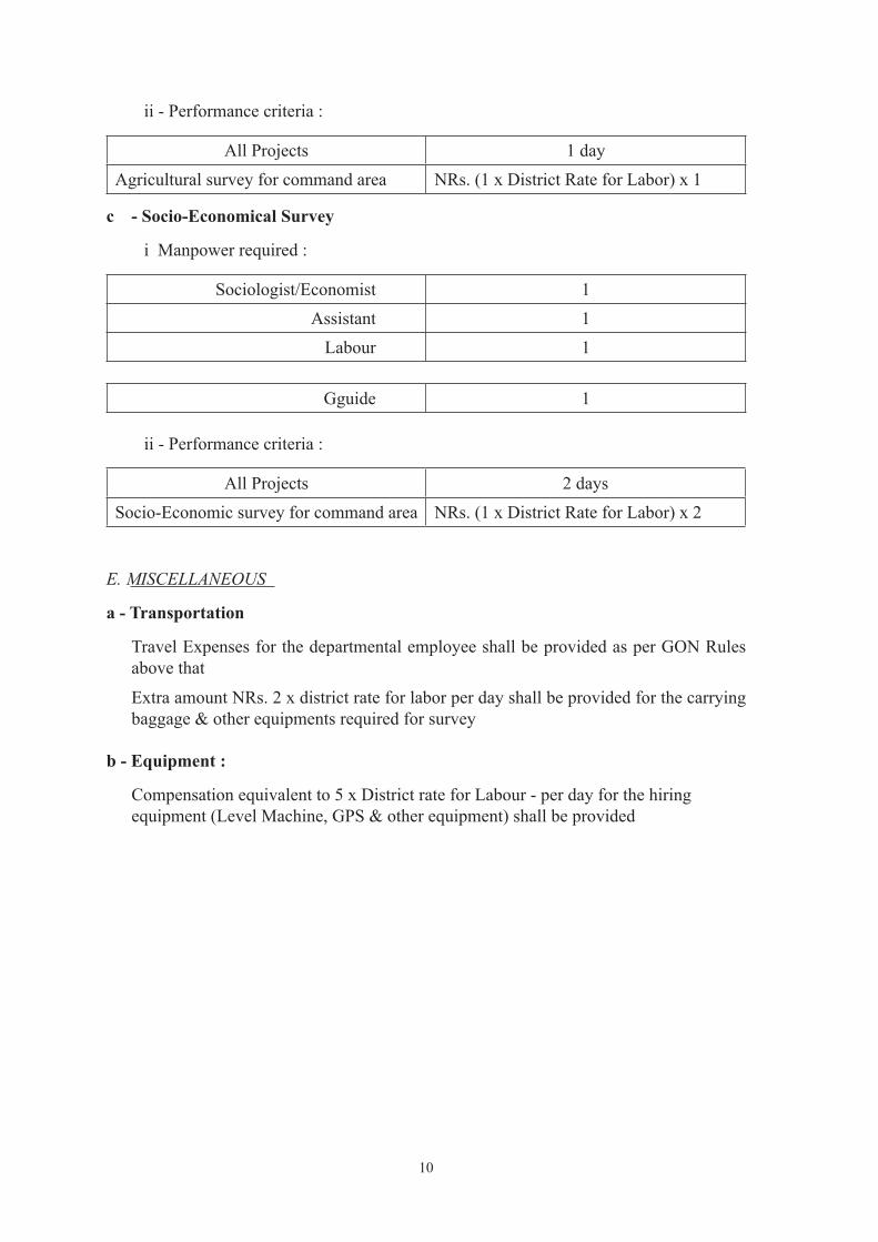
ii - Performance criteria :
All Projects 1 dayAgricultural survey for command area NRs. (1 x District Rate for Labor) x 1
c - Socio-Economical Survey
i Manpower required :
Sociologist/Economist 1 Assistant 1 Labour 1
Gguide 1
ii - Performance criteria :
All Projects 2 daysSocio-Economic survey for command area NRs. (1 x District Rate for Labor) x 2
E. MISCELLANEOUS
a - Transportation
Travel Expenses for the departmental employee shall be provided as per GON Rules above that
Extra amount NRs. 2 x district rate for labor per day shall be provided for the carrying baggage & other equipments required for survey
b - Equipment :
Compensation equivalent to 5 x District rate for Labour - per day for the hiring equipment (Level Machine, GPS & other equipment) shall be provided

11
OFFICE WORK
A. DESK STUDY
a - Data collection, Compilation and Report presentation
i - Manpower required : Engineer 1
Sub-engineer 1 OfficeAssistant 1
ii - Performance criteria :
All Projects 4 days
B. HEADWORK SITE
a -L-section and X-section
i - Manpower required : Engineer 1
Sub-engineer 1OfficeAssistant 1
ii - Performance criteria :
All Projects 2 days
b – Hydrology
i - Manpower required : Hydrologist 1
Assistant 1 OfficeAssistant 1
ii - Performance criteria :
All Projects 1 day
c - Drawings
i - Manpower required :
Engineer 1 Sub-engineer 1 OfficeAssistant 1
ii - Performance criteria :All Projects 2 days

12
C. CANAL ALIGNMENT
a – Layout
i - Manpower required :
Engineer 1 Sub-engineer 1 OfficeAssistant 1
ii - Performance criteria :
All Projects 2 days
D. CROSS DRAINAGE WORKS
a - Hydrology
i- Manpower required :
Hydrologist 1 Assistant 1
ii - Performance criteria :
All Projects 8 CD/day
E. COMMAND AREA
a - Area
i - Manpower required :
Engineer 1 Sub-engineer 1 OfficeAssistant 1
ii - Performance criteria :
All Projects 1 day
b - Agriculture
i - Manpower required :
Agriculturist/Agronomist 1 Assistant 1
ii - Performance criteria :
All Projects 1 day
13
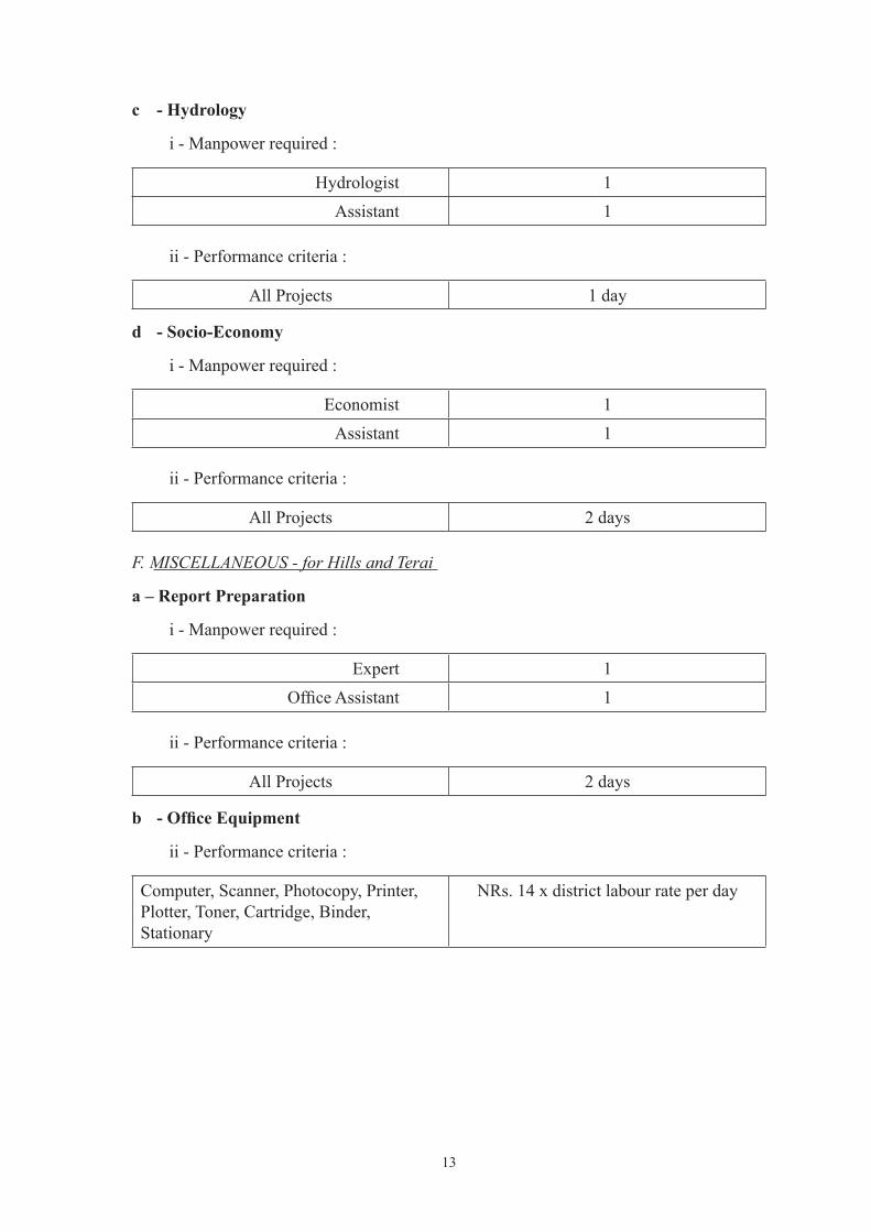
c - Hydrology
i - Manpower required :
Hydrologist 1 Assistant 1
ii - Performance criteria :
All Projects 1 day
d - Socio-Economy
i - Manpower required :
Economist 1Assistant 1
ii - Performance criteria :
All Projects 2 days F. MISCELLANEOUS - for Hills and Terai
a – Report Preparation
i - Manpower required :
Expert 1OfficeAssistant 1
ii - Performance criteria :
All Projects 2 days
b - Office Equipment
ii - Performance criteria :
Computer, Scanner, Photocopy, Printer, Plotter, Toner, Cartridge, Binder, Stationary
NRs. 14 x district labour rate per day

14
The pre-feasibility study should be carried out for the large irrigation projects that will decide whether detail feasibility study will be required or not. The study tentatively assesses the technical feasibility, economical viability and institutional suitability of the project implementation. The pre-feasibility study is carried out in the following steps:
ØDesk studyØField survey workØReporting and recommendation
Terms of Reference for Pre-feasibility of the Irrigation Project
Desk study
ReviewofIdentificationReportandFarmers’RequestFormandanyotherrelateddocumentsLocate the project area on Topographical/Google/GIS map/sAssessment of Intake/Head Work, Canal Layout & Command Area on above map/s
Field survey work
Sendinformationtothefarmersbeforefieldvisitinformingtentativedateofsitevisit.survey team should carry the following tools:
· Copy of project request form;· CopyofIdentificationReport;· Topographical maps;· Note books and necessary stationary;· Level Machine· GPS;· Stop watch;· Calculator;· Camera;· Measuring tapes
Verify the appropriate Intake/Head Work location, TakeCrossProfilesoftherivercoveringatleast0.5kmu/s&0.5kmd/s(atanintervalbutnotlimited to 250 m) of proposed intake site, and at least one at proposed Intake/Head work location.Measure Discharge at Proposed Intake/Head work locationAssess the type of Intake/Head Work to be proposed Walk through along the proposed canal alignment and verify whether alternative alignment canbeconsidered;takeGPSpointatspecificlocationsTakeaflylevelalongtheproposedcanalalignmenttoassessthegroundprofile.Assess the tentative number & type of major/minor structure along the canalAssess landslide, erosion with possible mitigation measuresMake Assessment of construction material/equipments availability & costMake Assessment of skilled/unskilled labor availability in the areaTake close traverse of command area using GPSMake Assessment of existing cropping patternMake Assessment of Existing Irrigation Practices if any Make Assessment of Water Management Practices if any Make Assessment of Market facility Make Accessibility of Project AreaFind and interact with Existing WUA & evaluate its function if any

15
MakeAssessmentofbeneficiaryPopulation/HHoftheprojectMake Assessment of Woman Headed HH of the project areaMake Assessment of Social Composition of the areaMakeAssessmentoffoodsufficiencyoftheprojectareaIf it is an existing system, brief inventory of the system Make Assessment of willingness of the farmers for providing land for developing systemMake Assessment of willingness of the farmers towards cost contribution as per Irrigation Policy/Regulation
Reporting & RecommendationBasedonthedataandinformationcollectedduringthefieldvisittheteamneedstoanalyzetheprojectfindingsandfinalizetheprefeasibilitystudy.Theanalysisshouldbebasedontechnical, economical and social aspects of project implementation. The analysis should cover the following aspects:Length of main canal;Size and type of command area (terrace/plain);Water right problems;Type of soil;Majortechnicaldifficulties(crossdrainage/landslide/unstablezones);Poor farmer’s presence;Farmer’s interest;Make Assessment of tentative cost of the projectEvaluate Cost per haMakeAssessmentoftentativebenefitoftheprojectEvaluateInternalRateofReturnandBenefitCostRatioBased on the analysis the team has to prepare a report stating the project recommendation for further actions. The recommendation may be based on:Genuineness of demands;Command area;Technical complication;Environmental adverse effect;Economic indicators i.e. Cost/ha, EIRR & B/C ratio’
Based on Scoring of the Prefeasibility Report & complexity, the projects generally with a size up to 1000 ha in hill & 5000 ha in Terai will be recommended for Detail Feasibility Study including Detail DesignBased on Scoring of the Prefeasibility Report.., the projects with more than 1000 ha in hill & 5000 ha in Terai shall be recommended for Detail Feasibility Study
Assumption/Basis of NormsØIf the assignment is to be performed through the consultant, the estimation should
be done based on rate for the different expert approved by DOI & evaluated salary per day shall be based on considering 30 days of a month.
ØField Survey allowance per day for GON employee = ((Basic Monthly Salary + MonthlyRemoteAreaAllowanceofthefieldlocation)x1.5)/30
ØDaily allowance shall not be provided for the employee who is receiving survey allowance; however other allowances (except daily allowances) shall be provided

16
as per GON rulesØfor the desk study Daily allowance for Departmental Employees, considering
the over/extra time (rather thannormal officehours) to be given for desk studyand report preparation, is provisioned at a rate 50% of ((Basic Monthly Salary + Monthly Remote Area allowance at the location of report preparation) x 1.5/30)
ØLodging and Travel allowance will not be provided to the locally hired personnelØRatesforthematerialrequiredforthefieldsurvey,deskstudyandreportpreparation
will be based on the general market available rates.
Mode of Payment
a) To Departmental Employees :
The amount shall be paid to the employees as advance assigned for the study as follows;For mobilization and Field work 60% of the total amountUpon Submission and acceptance of Final Survey Report 40% of the total amount
The final payment shall not be made if the above mentioned work is not completed as per TOR, and the assigned team will be fully responsible ensuring the quality of report as per requirement.
b) To Consultant (if employed) :
· The amount shall be paid as per agreement to the consultant assigned for the study. However, the consultant can claim the payment either in a single installment after submissionandacceptanceoffinalreportasperTORorininstallmentasfollows;
· First Installment (if necessary), 10% of the total amount upon submission and acceptance of desk study/inception report;
· Second Installment, 40% of the total amount upon submission and acceptance of fieldstudyreport;
· Third Installment, 25% of the total amount upon submission and acceptance of draft finalreport;
· Final Installment, remaining of the total amount upon submission and acceptance of finalreportcomplyingwithTOR;
· 20% of the total amount may be provided as an advance payment on submission and acceptance of bank guarantee and such payment shall be recovered within third installment

NORMSFOR
DETAILED FEASIBILITY STUDIES

17
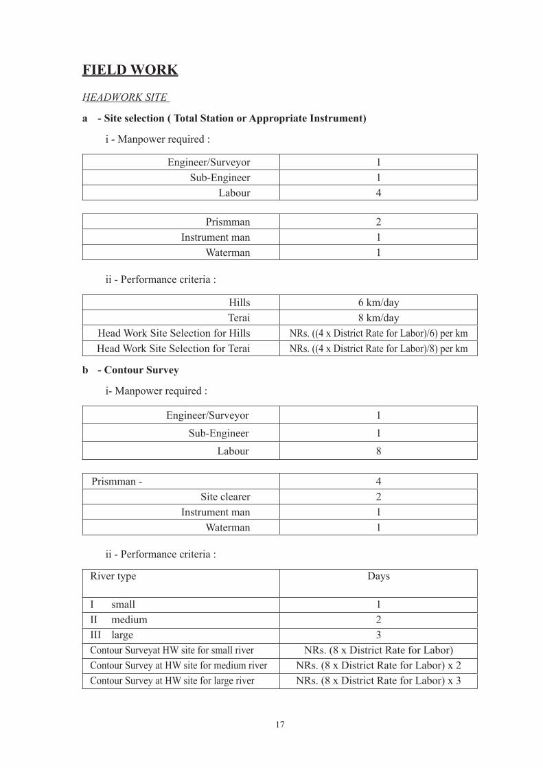
FIELD WORK
HEADWORK SITE
a - Site selection ( Total Station or Appropriate Instrument)
i - Manpower required :
Engineer/Surveyor 1 Sub-Engineer 1 Labour 4
Prismman 2 Instrument man 1 Waterman 1
ii - Performance criteria :
Hills 6 km/day Terai 8 km/day
Head Work Site Selection for Hills NRs. ((4 x District Rate for Labor)/6) per kmHead Work Site Selection for Terai NRs. ((4 x District Rate for Labor)/8) per km
b - Contour Survey
i- Manpower required :
Engineer/Surveyor 1 Sub-Engineer 1 Labour 8
Prismman - 4
Site clearer 2Instrument man 1
Waterman 1
ii - Performance criteria :
River type Days
I small 1II medium 2III large 3Contour Surveyat HW site for small river NRs. (8 x District Rate for Labor)Contour Survey at HW site for medium river NRs. (8 x District Rate for Labor) x 2Contour Survey at HW site for large river NRs. (8 x District Rate for Labor) x 3

18
Note : River type Hill TeraiI small Width <= 5m Width <=10m
Area <=3 ha Area <=5 haII medium Width <=25m Width <=50m
Area <=5 ha Area <=10 haIII large Width > 25m Width > 50m
Area > 5 ha Area > 10 haNote:ifanyofthecriteriaexceedstheupperlimitshallgoverntofixtherivertype
c - L-section & X-section Survey
i - Manpower required :
Engineer/Surveyor 1 Sub-Engineer 1 Labour 7
Chainman 2Prismman 2
Site clearer 1 Instrument man 1 Waterman 1
ii - Performance criteria :
River type daysI small 1II medium 1.5III large 2L-section & X-section survey at HW site for small river
NRs. (7 x District Rate for Labor)
L-section & X-section survey at HW site for medium river
NRs. (7 x District Rate for Labor) x 1.5
L-section & X-section survey at HW site for large river
NRs. (7 x District Rate for Labor) x 2
Note : River type Hill TeraiI small Width <= 5m Width <= 10mII medium Width <=25m Width <=50mIII large Width > 25m Width > 50m

19
d - Geological Survey
i - Manpower required :
Geologist 1 Assistant 1 Labour 6
2 labourers can dig 1 pit a day Pit size :- 1 * 1 * 1.5 meter
ii - Performance criteria :
River width Pit c/c Days<=20 meter 4 meter 1<= 50 meter 5 meter 2<=100 meter 7 meter 2.5> 100 meter 10 meter 3
Geological Survey for <= 20 m river width NRs. (6 x District Rate for Labor)Geological Survey for <=50 m river width NRs. (6 x District Rate for Labor) x 2Geological Survey for <=100 m river width NRs. (6 x District Rate for Labor) x 2.5Geological Survey for > 100 m river width NRs. (6 x District Rate for Labor) x 3
Note : one extra day shall be added for surface geological study (one geologist & one labour)
e - Hydrological survey - (+ Water quality test )
i - Manpower required :
Hydrologist 1 Assistant 1 Labour 3
Guide 1Labour 2
ii - Performance criteria :
Hills 2 days
Terai 2 days
Hydrological Survey for Hills NRs. (3 x District Rate for Labor) x 2
Hydrological Survey for Terai NRs. (3 x District Rate for Labor) x 2

20
f –River morphology and Sedimentation survey through consultant –
i - Manpower required :
Engineer/Silt Analyst/Geotechnical Engineer 1 Assistant 1 Labour 3
Guide 1Labour 2
ii - Performance criteria :
Hills 2 daysTerai 3 days
Sedimentation Survey for Hills NRs. (3 x District Rate for Labor) x 2Sedimentation Survey for Terai NRs. (3 x District Rate for Labor) x 3
g - Environmental survey - (for IEE/EIA )
i - Manpower required :
Environmental expert 1 Assistant 1 Labour 3
Guide 1Labour 2
ii - Performance criteria :
Hills 1 dayTerai 1 day
Environmental Survey for Hills NRs. (3 x District Rate for Labor) x 1Environmental Survey for Terai NRs. (3 x District Rate for Labor) x 1
h – Incase works is to be performed through consultant (Site Selection for Headwork/Settling Basin)
i - Additional Manpower required :
Team Leader/Irrigation Management Expert 1 Hydraulic Engineer 1 Labour 2
Guide 1Labour 1

21
ii - Performance criteria :
Hills 1 dayTerai 1 day
Head Work Site Selection for Hills NRs. (2 x District Rate for Labor) x1Head Work Site Selection for Terai NRs. (2 x District Rate for Labor) x 1
CANAL ALIGNMENT
a - Layout Survey
i - Manpower required :
Engineer/Surveyor 1 Sub-Engineer 2 Labour 5
Prismman 2 Site clearer 1 Instrument man 1
Waterman 1
ii - Performance criteria :
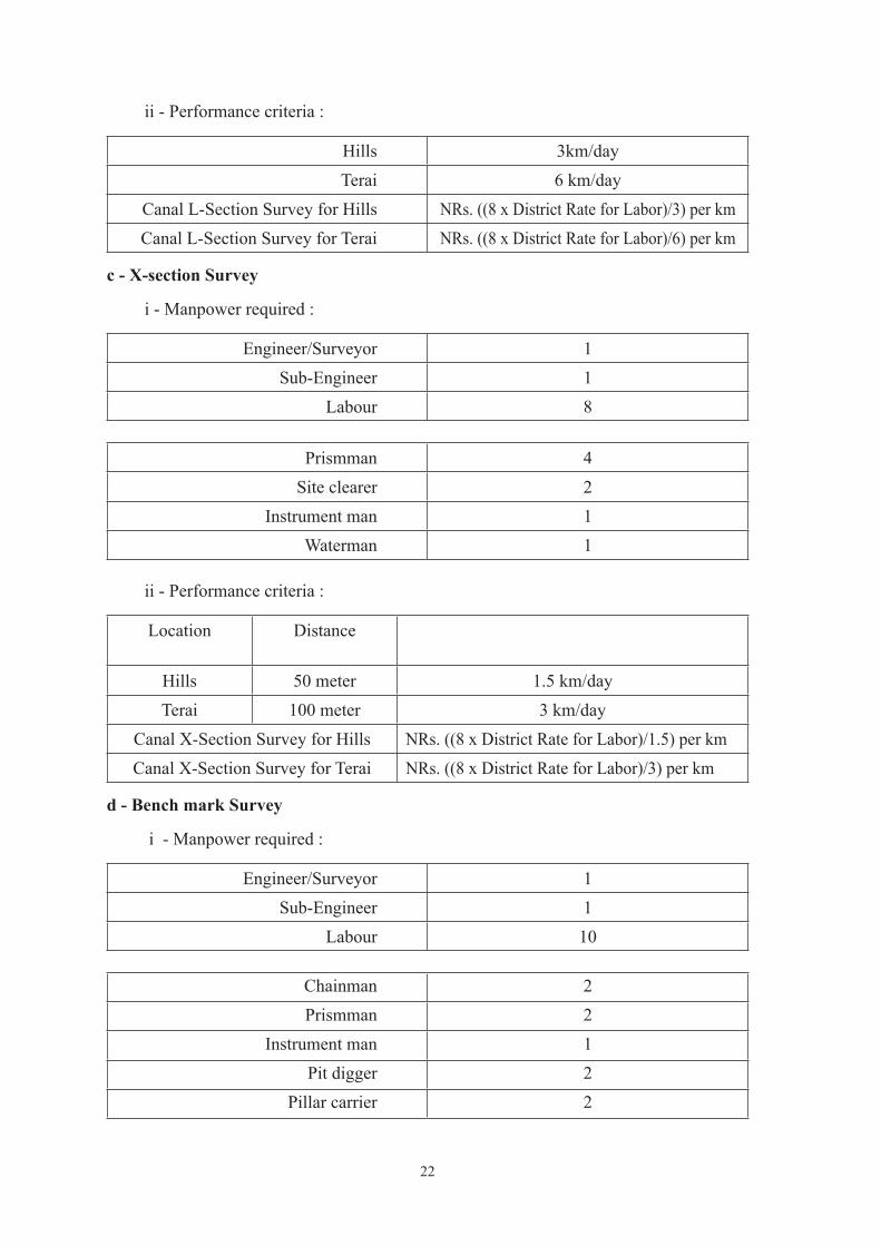
Hills 3 km/dayTerai 6 km/day
Canal Layout Survey for Hills NRs. ((5 x District Rate for Labor)/3) per kmCanal Layout Survey for Terai NRs. ((5 x District Rate for Labor)/6) per km
b - L-section Survey
i - Manpower required :
Engineer/Surveyor 1Sub-Engineer 1
Labour 8
chainman 2Prismman 2
Instrument man 1Pegman 2
Waterman 1
22
ii - Performance criteria :
Hills 3km/day Terai 6 km/day
Canal L-Section Survey for Hills NRs. ((8 x District Rate for Labor)/3) per kmCanal L-Section Survey for Terai NRs. ((8 x District Rate for Labor)/6) per km
c - X-section Survey
i - Manpower required :
Engineer/Surveyor 1 Sub-Engineer 1 Labour 8
Prismman 4 Site clearer 2 Instrument man 1 Waterman 1
ii - Performance criteria :
Location Distance
Hills 50 meter 1.5 km/dayTerai 100 meter 3 km/day
Canal X-Section Survey for Hills NRs. ((8 x District Rate for Labor)/1.5) per kmCanal X-Section Survey for Terai NRs. ((8 x District Rate for Labor)/3) per km
d - Bench mark Survey
i - Manpower required :
Engineer/Surveyor 1 Sub-Engineer 1 Labour 10
Chainman 2Prismman 2
Instrument man 1Pit digger 2
Pillar carrier 2

23
Waterman 1Pillar size 0.15 * 0.15 * 0.50
ii - Performance criteria :
Location Distance c/c BM/dayHills 0.5 km 10Terai 1.0 km 10
BM Survey along canal alignment for Hills NRs. ((10 x District Rate for Labor)/10) per BM
BM Survey along canal alignment for Terai NRs. ((10 x District Rate for Labor)/10) per BM
e - Geological Survey
i - Manpower required :
Geologist 1 Assistant 1 Labour 6
2 labourers can dig 1 pit a day Pit size :- 1 * 1 * 1.5 meter
ii - Performance criteria :
Location Distance c/c km/day
Hills 0.25 km 1.5Terai 0.25 km 1.5
Geological Survey along Canal Alignment for Hills
NRs. ((6 x District Rate for Labor)/1.5) per km
Geological Survey along Canal Alignment for Terai
NRs. ((6 x District Rate for Labor)/1.5) per km
f - Infiltration rate Survey
i - Manpower required :
Geologist 1 Assistant 1 Labour 4
Water carrier 3
Digger 1

24
ii - Performance criteria :
Location Distance c/c km/dayHills 0.5 km 1Terai 0.5 km 1
Infiltrationratesurveyalongcanalalignment for Hills
NRs. ((4 x District Rate for Labor)/1.0) per km
Infiltrationratesurveyalongcanalalignment for Terai
NRs. ((4 x District Rate for Labor)/1.0) per km
g - Environmetal Survey (IEE/EIA)
i - Manpower required :
Environmetal Specialist 1 Assistant 1 Labour 3
Guide 1
Labour 2
ii - Performance criteria :
Location km/day
Hills 3
Terai 6
Environmental Surveyalong the canal alignment for Hills
NRs. ((3 x District Rate for Labor)/3) per km
Environmental Survey along the canal alignment for Terai
NRs. ((3 x District Rate for Labor)/6) per km
h– Incase works is to be performed through consultant
i - Additional Manpower required :
Team Leader/Irrigation Management Expert 1 Hydraulic Engineer 1 Labour 2
Guide 1
Labour 1

25
ii - Performance criteria :
Location km/dayHills 3Terai 6
VerificationofthecanalalignmentforHills NRs. ((2 x District Rate for Labor)/3) per kmVerificationofthecanalalignmentforTerai NRs. ((2 x District Rate for Labor)/6) per km
CROSS DRAINAGE WORKS
a - Contour, L-section and X-section Survey
i - Manpower required :
Engineer/Surveyor 1 Sub-Engineer 1 Labour 6
Chainman 2Prismman 2
Instrument man 1 Waterman 1
ii - Performance criteria :
Hills 4 CD/day Terai 6 CD/dayContour, L & X section survey for Cross Drainage for Hills
NRs. ((6 x District Rate for Labor)/4) per CD
Contour, L & X section survey for Cross Drainage for Terai
NRs. ((6 x District Rate for Labor)/6) per CD
b - Geological Survey
i - Manpower required :
Geologist 1 Assistant 1 Labour 12
2 labourers can dig 1 pit a day Pit size :- 1 * 1 * 1.5 meter

26
ii - Performance criteria :
CD – width Center to Center days
<= 20 meter 4 meter 1<= 50 meter 5 meter 2<= 100 meter 7 meter 2.5> 100 meter 10 meter (2.5 + (river width more than 100
m)*(0.5/50))Geological Survey for Cross Drainage with <=20 m river width
NRs. (12 x District Rate for Labor) x 1
Geological Survey for Cross Drainage with <=50 m river width
NRs. (12 x District Rate for Labor) x 2
Geological Survey for Cross Drainage with <=100 m river width
NRs. (12 x District Rate for Labor) x 2.5
Geological Survey for Cross Drainage with > 100 m river width
NRs. (12 x District Rate for Labor) x (2.5 + (river width more than 100 m)*(0.5/50))
c - Hydrogical survey
i - Manpower required :
Hydrologist 1 Assistant 1 Labour 4
Guide 1Labour 3
ii - Performance criteria :
Hills 4 CD/dayTerai 4 CD/day
Hydrological Surveyfor Cross Drainage for Hills
NRs. ((4 x District Rate for Labor)/4) per CD
Hydrological Survey for Cross Drainage for Terai
NRs. ((4 x District Rate for Labor)/4) per CD
d - Environmental survey
i - Manpower required :
Environmental Expert 1 Assistant 1 Labour 3

27
Guide 1Labour 2
ii - Performance criteria :
Hills 6 CD/dayTerai 6 CD/day
Environmental Survey for Cross Drainage for Hills
NRs. ((3 x District Rate for Labor)/6) per CD
Environmental Survey for Cross Drainage for Terai
NRs. ((3 x District Rate for Labor)/6) per CD
e – Incase works is to be performed through consultant
i - Additional Manpower required :
Team Leader/Irrigation Management Expert
1
Hydraulic Engineer 1 Labour 2
Guide 1Labourers - 1
ii - Performance criteria :
Hills 4 CD/dayTerai 4 CD/day
FieldverificationforCrossDrainageforHills
NRs. ((2 x District Rate for Labor)/4) per CD
FieldverificationforCrossDrainageforTerai
NRs. ((2 x District Rate for Labor)/4) per CD
COMMAND AREA - for Hills and Terai
a - Traverse Line Survey
i - Manpower required:
Engineer/Surveyor 1 Sub-Engineer 1 Labour 6

28
Prismman 4 Instrument man 1 Waterman 1
ii - Performance criteria :
Command Area (CA) days
<=100 ha 2<=200 ha 3.5<=300 ha 4.5<=500 ha 5<=1000 ha 6<=5000 ha 7.5> 5000 ha (7.5 + (hectarage more than 5000
ha)*(1/1000))Traverse Line Survey for Command area with <= 100 ha
NRs. (6 x District Rate for Labor) x 2
Traverse Line Survey for Command area with <= 200 ha
NRs. (6 x District Rate for Labor) x 3.5
Traverse Line Survey for Command area with <= 300 ha
NRs. (6 x District Rate for Labor) x 4.5
Traverse Line Survey for Command area with <=500 ha
NRs. (6 x District Rate for Labor) x 5
Traverse Line Survey for Command area with <= 1000 ha
NRs. (6 x District Rate for Labor) x 6
Traverse Line Survey for Command area with <=5000 ha
NRs. (6 x District Rate for Labor) x 7.5
Traverse Line Survey for Command area with > 5000 ha
NRs. (6 x District Rate for Labor) x (7.5 + (hectarage more than 5000 ha)*(1/1000))
b - Topographical Survey
i - Manpower required :
Engineer/Surveyor 1 Sub-Engineer 1 Labour 6
Prismman 4 Instrument man 1
Waterman 1

29
ii - Performance criteria :
Hills 20 ha/day Terai 30 ha/dayTopographical survey of command area for Hills
NRs. ((6 x District Rate for Labor)/20) per ha
Topographical survey of command area for Terai
NRs. ((6 x District Rate for Labor)/30) per ha
c - Bench mark Survey
i - Manpower required :
Engineer/Surveyor 1 Sub-Engineer 1 Labour 12
Prismman 2
Instrument man 1Pit digger 4
Pillar carrier 4Waterman 1Pillar size 0.15 * 0.15 * 0.50
ii - Performance criteria :
Location Distribution BM/day
Command Area (CA) 1 BM/ 50 ha 10
Bench Mark Survey for command area
NRs. ((12 x District Rate for Labor)/10) per BM
d - Agricultural Survey
i - Manpower required :
Agronomist 1 Assistant 1 Labour 1
Guide 1

30
ii - Performance criteria :
Command Area (CA) days<= 100 ha 2<= 200 ha 3<= 300 ha 4<= 500 ha 5<= 1000 ha 6> 1000 ha (6 + (hectarage more than 1000
ha)*(1/500))Agricultural survey for command area with<= 100 ha
NRs. (1 x District Rate for Labor) x 2
Agricultural survey for command area with <= 200 ha
NRs. (1 x District Rate for Labor) x 3
Agricultural survey for command area with <=300 ha
NRs. (1 x District Rate for Labor) x 4
Agricultural survey for command area with <= 500 ha
NRs. (1 x District Rate for Labor) x 5
Agricultural survey for command area with <= 1000 ha
NRs. (1 x District Rate for Labor) x 6
Agricultural survey for command area with > 1000 ha
NRs. (1 x District Rate for Labor) x (6 + (hectarage more than 1000 ha)*(1/500))
e - Soil Survey
i - Manpower required :
Geologist 1 Assistant 1 Labour 4
2 labourers can dig 1 pit a day Pit size :- 1 * 1 * 1.5 meter
ii - Performance criteria :
Command Area (CA) Distribution days<= 100 ha one sample / 25 ha 2<= 200 ha one sample / 35 ha 3<= 400 ha one sample / 50 ha 4<= 700 ha one sample / 70 ha 5<=1000 ha one sample / 90 ha 6<= 1500 ha one sample / 110 ha 7<= 2000 ha one sample / 130 ha 8> 2000 ha one sample / 150 ha (8 + (hectarage more than 2000
ha)*(1/500))Soil Survey for command area with<=100 ha NRs. (4 x District Rate for Labor) x 2

31
Command Area (CA) Distribution daysSoil Survey for command area with <=200 ha NRs. (4 x District Rate for Labor) x 3Soil Survey for command area with <=400 ha NRs. (4 x District Rate for Labor) x 4Soil Survey for command area with <=700 ha NRs. (4 x District Rate for Labor) x 5Soil Survey for command area with <=1000 ha NRs. (4 x District Rate for Labor) x 6Soil Survey for command area with <= 1500 ha
NRs. (4 x District Rate for Labor) x 7
Soil Survey for command area with <= 2000 ha
NRs. (4 x District Rate for Labor) x 8
Soil Survey for command area with > 2000 ha NRs. (4 x District Rate for Labor) x (8 + (hectarage more than 2000
ha)*(1/500))
f - Infiltration rate Survey
i - Manpower required :
Geologist 1 Assistant 1 Labour 4
Water carrier 3Digger 1
ii - Performance criteria :
Location Distribution IT/dayCommand Area (CA) 1 IT/50 ha 2InfiltrationRatesurveyforcommandarea NRs. ((4 x District Rate for Labor) / 2)
per ITNote:IT=InfiltrationTest
g - Socio-Economical Survey
i - Manpower required :
Economist 1 Sociologist 1 GESI expert 1 Assistant 3 Labour 3
Guide 3

32
ii - Performance criteria :
Command Area days<= 100 ha 5<= 200 ha 6<= 300 ha 7<= 500 ha 8<=1000 ha 9> 1000 ha (9 + (hectarage more than 1000
ha)*(1/500))Socio Economical Survey for command area with<= 100 ha
NRs. (3 x District Rate for Labor) x 5
Socio Economical Survey for command area with <=200 ha
NRs. (4 x District Rate for Labor) x 6
Socio Economical Survey for command area with <= 300 ha
NRs. (4 x District Rate for Labor) x 7
Socio Economical Survey for command area with <= 500 ha
NRs. (4 x District Rate for Labor) x 8
Socio Economical Survey for command area with <= 1000 ha
NRs. (4 x District Rate for Labor) x 9
Socio Economical Survey for command area with > 1000 ha
NRs. (4 x District Rate for Labor) x (9 + (hectarage more than 1000 ha)*(1/500))
h - Environmental Survey
i - Manpower required :
Environmental Expert 1Assistant 1
Labour 1
Guide 1
ii - Performance criteria :
Command Area Days<= 100 ha 5<= 200 ha 6<= 300 ha 7<= 500 ha 8<= 1000 ha 9> 1000 ha (8 + (hectarage more than 1000
ha)*(1/500))Environmental survey for command area with< 100 ha
NRs. (1 x District Rate for Labor) x 5

33
Command Area DaysEnvironmental survey for command area with < 200 ha
NRs. (1 x District Rate for Labor) x 6
Environmental survey for command area with < 300 ha
NRs. (1 x District Rate for Labor) x 7
Environmental survey for command area with < 500 ha
NRs. (1 x District Rate for Labor) x 8
Environmental survey for command area with < 1000 ha
NRs. (1 x District Rate for Labor) x 9
Environmental survey for command area with > 1000 ha
NRs. (1 x District Rate for Labor) x (9+ (hectarage more than 1000 ha)*(1/500))
i - – Incase works is to be performed through consultant
i - Additional Manpower required :
Team Leader/Irrigation Management Expert 1 Hydraulic Engineer 1
Labour 1
Guide 1
ii - Performance criteria :
Command Area Days
<=100 ha 5
<= 200 ha 6
<= 300 ha 7
<= 500 ha 8
<= 1000 ha 9
> 1000 ha (9 + (hectarage more than 1000 ha)*(1/500))
verificationforcommandareawith<=100ha NRs. (1 x District Rate for Labor) x 5
verificationforcommandareawith<=200ha NRs. (1 x District Rate for Labor) x 6
verificationforcommandareawith<=300ha NRs. (1 x District Rate for Labor) x 7
verificationforcommandareawith<=500ha NRs. (1 x District Rate for Labor) x 8
verificationforcommandareawith<=1000ha NRs. (1 x District Rate for Labor) x 9
verificationforcommandareawith>1000ha NRs. (1 x District Rate for Labor) x (9 + (hectarage more than 1000 ha)*(1/500))

34
PUBLIC CONSULTATIONa. - For IEE
i - Manpower required :
Environmental Expert 1Sociologist 1
Assistant 1 Labour 1
ii- Performance criteria :
Command Area Days<= 100 ha 5<= 200 ha 6<= 300 ha 7
b. - For EIA
i - Manpower required :
Number Days Required
Environmental Expert 1 14Sociologist 1 22
Assistant 1 50Labour 4 50
MISCELLANEOUS - for Hills and Terai
a. Accommodation & Equipment
A compensation of NRs. 6 x district labour rate/day, per person shall be provided for accommodationandequipments(Tent,Bed,Furniture,Utensiletc.)duringfieldperiod.
b . Transportation
Travel Expenses for the departmental employee shall be provided as per GON Rules above that Extra amount NRs. 2 x district rate for labor per day shall be provided for the carrying baggage & other equipments required for survey
c . Equipment required :
Compensation of Nrs. 6 x district rate for labour per day for the hiring equipments (Total Station, Prism, Level Machine& other equipments) shall be provided
35
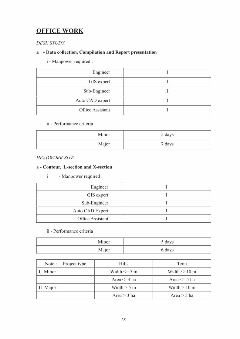
OFFICE WORK
DESK STUDY
a - Data collection, Compilation and Report presentation
i - Manpower required :
Engineer 1
GIS expert 1
Sub-Engineer 1
Auto CAD expert 1
OfficeAssistant 1
ii - Performance criteria :
Minor 5 days
Major 7 days
HEADWORK SITE
a - Contour, L-section and X-section
i - Manpower required :
Engineer 1 GIS expert 1
Sub-Engineer 1Auto CAD Expert 1 OfficeAssistant 1
ii - Performance criteria :
Minor 5 days Major 6 days
Note : Project type Hills TeraiI Minor Width <= 5 m Width <=10 m
Area <=3 ha Area <= 5 haII Major Width > 5 m Width > 10 m
Area > 3 ha Area > 5 ha

36
b - Geology
i - Manpower required :
Geologist 1GIS expert 1
Auto CAD expert 1 OfficeAssistant 1
ii - Performance criteria :
Minor 4 days Major 5 days
Note : Project type Hills Terai
I Minor Width <= 10 m Width <=50 m
II Major Width > 10 m Width > 50 m
c - Hydrology
i - Manpower required :
Hydrologist 1
GIS expert 1
Assistant 1
OfficeAssistant 1
ii - Performance criteria :
Minor 3 days Major 3 days
d - Design and Drawings
i - Manpower required :
Engineer 1 GIS expert 1
Sub-Engineer 2Auto CAD expert 1
OfficeAssistant 1

37
ii - Performance criteria :
Minor 5 days Major 10 days
Note : Project type Hills TeraiI Minor Width <= 10 m Width <= 50 mII Major Width > 10 m Width > 50 m
e - Estimate
i - Manpower required :
Engineer 1 Sub-Engineer 2
OfficeAssistant 1
ii - Performance criteria :
Minor 4 days Major 7 days
Note : Project type Hills TeraiI Minor Width <=10 m Width <=50 mII Major Width > 10 m Width > 50 m
CANAL ALIGNMENT
a - Layout
i - Manpower required :
Engineer 1
GIS expert 1
Sub-Engineer 1
Auto CAD expert 1
OfficeAssistant 1
ii - Performance criteria :
Minor 2 days Major 2 days

38
b - Contour, L-section and X-section
i - Manpower required :
Engineer 1 Sub-Engineer 2
Auto CAD expert 1 OfficeAssistant 1
ii - Performance criteria :
Minor 2 days Major 2 days
c - Geology
i - Manpower required :
Geologist 1
GIS expert 1
OfficeAssistant 1
ii - Performance criteria :
Minor 10 pits/day 2 km/day Major 10 pits/day 2 km/day
d - Design and Drawings
i - Manpower required :
Engineer 1
GIS expert 1
Sub-Engineer 2
AutoCAD expert 1
OfficeAssistant 1
ii - Performance criteria :
Minor 3 days
Major 6 days

39
Note : Project type Hills TeraiMinor Q <= 0.5 m3/ s Q <=1.0 m3/ s
C.L <= 5 km C.L <=7 kmMajor Q > 0.5 m3/ s Q > 1.0 m3/ s
C.L > 5 km C.L > 7 km
e - Estimate
i - Manpower required :
Engineer 1 Sub-Engineer 2
OfficeAssistant 1
ii - Performance criteria :
Minor 4 km/day Major 4 km/day
Note : Project type Hills TeraiMinor Q <= 0.5 m3/ s Q <=1.0 m3/ s
C.L <= 5 km C.L <=7 kmMajor Q > 0.5 m3/ s Q > 1.0 m3/ s
C.L > 5 km C.L > 7 km
CROSS DRAINAGE WORKS
a - Contour, L-section and X-section
i - Manpower required :
Engineer 1 GIS expert 1
Sub-Engineer 2 AutoCAD expert 1
OfficeAssistant 1
ii - Performance criteria :
Minor 3 CD/day Major 2 CD/day

40
Note : Project type Hills TeraiI Minor Width <=5 m Width <=10 mII Major Width > 5 m Width > 10 m
b - Geology
i - Manpower required:
Geologist 1 GIS expert 1
Assistant 1 Auto CAD expert 1 OfficeAssistant 1
ii - Performance criteria :
Minor 3 CD/day Major 2 CD/day
Note : Project type Hills Terai I Minor Width <= 5 m Width <=10 m II Major Width > 5 m Width > 10 m
c - Hydrology
i - Manpower required :
Hydrologist 1 GIS expert 1
Assistant 1 OfficeAssistant 1
ii - Performance criteria :
Minor 3 CD/day Major 2 CD/day
Note : Project type Hills Terai
I Minor Width <= 5 m Width <=10 m
II Major Width > 5 m Width > 10 m

41
e - Design and Drawings
i - Manpower required :
Engineer 1 GIS expert 1
Sub-Engineer 2 Auto CAD expert 1 OfficeAssistant 1
ii - Performance criteria :
Minor 1 CD/ 2 day Major 1 CD/ 4 day
Note : Project type Hills Terai Minor Q <= 0.5 m3/ s Q <=1.0 m3/ s
span <= 10 m span <= 25 m
Major Q > 0.5 m3/ s Q > 1.0 m3/ sspan > 10 m span > 25 m
f - Estimate
i - Manpower required :
Engineer 1 Sub-Engineer 2
OfficeAssistant 1
ii - Performance criteria :
Minor 2 CD/day Major 2 CD/day
Note : Project type Hills Terai Minor Q <= 0.5 m3/ s Q <= 1.0 m3/ s
span <= 10 m span <= 25 m Major Q > 0.5 m3/ s Q > 1.0 m3/ s
span > 10 m span > 25 m

42
COMMAND AREA - for Hills and Terai
a - Traverse Line Survey
i - Manpower required :
Engineer 1 GIS expert 1
Sub-Engineer 2 Auto CAD expert 1 OfficeAssistant 1
ii - Performance criteria :
Command area (CA) Days<= 200 ha 2<=500 ha 3<=1000 ha 4> 1000 ha (4 + (hectarage more than 1000 ha)*(1/500))
b - Topography
i - Manpower required :
Engineer 1 GIS expert 1
Sub-Engineer 2 AutoCAD expert 1 OfficeAssistant 1
ii - Performance criteria :
Hills 25 ha/day
Terai 50 ha/day
c - Agriculture
i - Manpower required :
Agronomist 1
Assistant 1
OfficeAssistant 1

43
ii - Performance criteria :
Minor 7 days Major 7 days
d - Geology
i - Manpower required :
Geologist 1 GIS expert 1
Assistant 1 OfficeAssistant 1
ii - Performance criteria :
Command area (CA) Days
<=500 ha 3<=1000 ha 5<=1500 ha 7> 1500 ha (7 + (hectarage more than 1500 ha)*(2/500))
e - Socio-Economy
i - Manpower required :
Economist 1
Socilologist 1
GESI expert 1
OfficeAssistant 1
ii - Performance criteria :
Command area (CA) Days
<= 500 ha 7
<=1000 ha 8
<=1500 ha 9
> 1500 ha (9 + (hectarage more than 1500 ha)*(1/500))
44
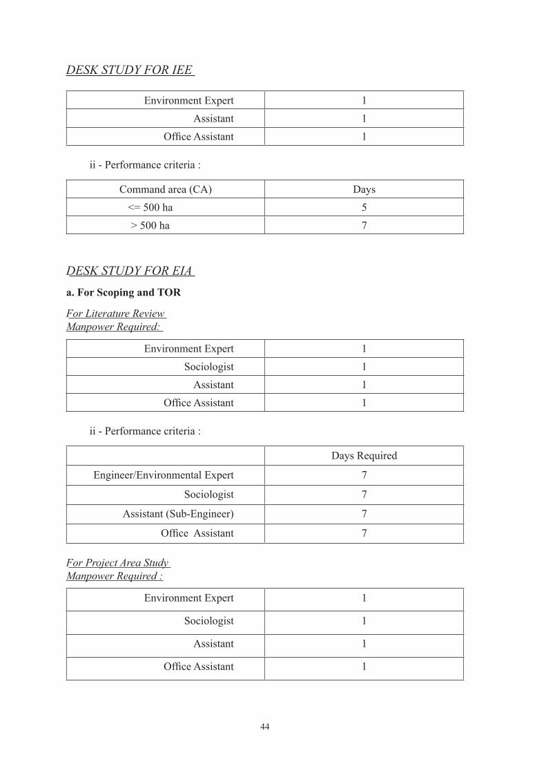
DESK STUDY FOR IEE
Environment Expert 1 Assistant 1 OfficeAssistant 1
ii - Performance criteria :
Command area (CA) Days<= 500 ha 5> 500 ha 7
DESK STUDY FOR EIAa. For Scoping and TOR
For Literature ReviewManpower Required:
Environment Expert 1 Sociologist 1
Assistant 1 OfficeAssistant 1
ii - Performance criteria :
Days Required
Engineer/Environmental Expert 7
Sociologist 7
Assistant (Sub-Engineer) 7
OfficeAssistant 7
For Project Area StudyManpower Required :
Environment Expert 1
Sociologist 1
Assistant 1
OfficeAssistant 1

45
ii - Performance criteria :
Person DaysEngineer/Environmental Expert 2
Sociologist 2Assistant (Sub-Engineer) 2
OfficeAssistant 2
b. - After Scoping and TOR approval )
For Literature Review
Environment Expert 1 Sociologist 1
Assistant 1 OfficeAssistant 1
ii - Performance criteria :
Person DaysEngineer/Environmental Expert 15
Sociologist 7Assistant (Sub-Engineer) 15
OfficeAssistant 15
For Project Area Study
Environment Expert 1 Sociologist 1
Assistant 1 OfficeAssistant 1
ii - Performance criteria :
Person DaysEngineer/Environmental Expert 7
Sociologist 7Assistant (Sub-Engineer) 7
OfficeAssistant 7

46
MISCELLANEOUS - for Hills and Terai
a - Planning and Management ( For construction )
i - Manpower required :
Engineer/Expert 1 Assistant 2
OfficeAssistant 1
ii - Performance criteria :
Minor 5 days Major 10 days
Note : Project type Hills Terai I Minor C.A. <=100 ha C.A. <= 500 ha II Major C.A. > 100 ha C.A. > 500 ha
b - Planning and Management ( For construction ) if the work is to be performed through consultant
i - Additional Manpower required :
Team Leader/Irrigation Management Expert 1Procurement Expert 1
OfficeAssistant 1
ii - Performance criteria :
Minor 5 days Major 10 days
Note : Project type Hills Terai I Minor C.A. <=100 ha C.A. <=500 ha II Major C.A. > 100 ha C.A. > 500 ha
c - Rate Analysis
i - Manpower required :
Engineer 1 Sub-Engineer 2 OfficeAssistant 1

47
ii - Performance criteria :
Minor 6 days Major 6 days
d - Economical Analysis
i - Manpower required :
Economist 1 Assistant 1 OfficeAssistant 1
ii - Performance criteria :
Minor 5 days Major 7 days
e - Report Preparation
i - Manpower required :
Engineer/other Expert 1 Assistant 2
OfficeAssistant 1
ii - Performance criteria :
Minor 15 days Major 25 days
Note : Project type Hills Terai I Minor C.A. <=100 ha C.A. <= 500 ha II Major C.A. > 100 ha C.A. > 500 ha
f – Report(FSR/Design) Preparation except environmental report; if the work is to be performed through consultant
i - Manpower required :
Team Leader/Irrigation Management Expert 1 Hydraulic Engineer 1*Structural Engineer 1
OfficeAssistant 1* Structural Engineer is required if design work is also included

48
ii - Performance criteria :
Minor 7 days Major 10 days
Note : Project type Hills Terai I Minor C.A. <=100 ha C.A. <=500 ha II Major C.A. > 100 ha C.A. > 500 ha
g - Environmental Report Preparation
For IEE
i - Manpower required :
Engineer/other Expert 1 Assistant 2 OfficeAssistant 1
ii - Performance criteria :
Minor 15 days Major 25 days
Note : Project type Hills TeraiI Minor C.A. < =100 ha C.A. <= 500 haII Major C.A. > 100 ha C.A. > 500 ha
For EIA (Including Scoping, TOR and EIA Report)
i - Manpower required :
Engineer/other Expert 160Sociologist 30Gis Expert 30
Assistant 160OfficeAssistant 160
h - Office Equipment
ii - Performance criteria :
(Computer, Scanner, Photocopy, Printer, Plotter, Toner, Cartridge, Binder, Stationary) for Minor Project NRs. 20,000
(Computer, Scanner, Photocopy, Printer, Plotter, Toner, Cartridge, Binder, Stationary) for Major Project NRs. 25,000
Note : Project type Hills Terai I Minor C.A. <= 100 ha C.A. <= 500 ha II Major C.A. > 100 ha C.A. > 500 ha

49
Terms of Reference for Detail Feasibility Study and Detail Design of Irrigation Schemes, under Department of Irrigation
INTRODUCTION
Background to ToRDepartment of Irrigation (DoI) is a government organization, with a mandate to plan, develop, maintain, operate, manage and monitor different modes of environmentally sustainable and socially acceptable irrigation and drainage systems - from small to larger scale surface systems and from individual to community groundwater schemes. Its ultimate aim is to provide year round irrigation facilities and increase the irrigable area of the country to higher limits. This giving a primary input in increasing the productivity of the land and providing a major input to the Gross Domestic Product (GDP) and eventually improve the standardoflivingofthebeneficiaryfarmers.ApartfromthistheDoIalsohastocarryoutrivertrainingactivitiestoprotectthefloodways,floodplainsandagriculturallandsintheformofriverbankprotectionsuchthatthelossofpropertiescausedbyfloodingisreduced.The Detail Feasibility Study is the basis for the project implementation and is carried out by a team of experts having engineering, agriculture, environmental, and socio-economic professionals.Thisstudynormallyformsthebasisoffinancingbyexternalfundingagenciesor by the Government. The study assesses the technical feasibility, friendly environment, economical viability and institutional suitability of the project implementation.
Normally the detail feasibility of Medium Irrigation Project (MIP) will consist of Detail Feasibility Study (DFS) and Detail Design (DD), however Identification Study (ID) will recommend, if more studies at different level are required for MIP; for the large irrigation projects, Prefeasibility Study (PF) and consequently based on PF recommendation, DFS will be carried out first; and if the project is feasible, DD will be carried out at a later stage.Based on the appraised cost during feasibility study, the cost estimate may vary up to 10%, after DD.
A survey Norms was prepared and implemented in Oct 1988 to carryout ID, PF or DFS. With the introduction of new technologies, methodology and extended scope of work, it is felt necessary to revise above mentioned Norms, so the proposed Norms needs to be approved and implemented in order to facilitate different studies which will be carried out bydepartmentorindividualconsultantorfirms.
Objective of the Study
The overall objective of the study is to formulate technically sound, environmental friendly and economically viable Irrigation System is to be designed for a design life of more than 25-years and with low maintenance cost. The canal & related structures must harmonize with the surroundings and present a pleasing appearance. The maximum possible use of locally available materials & technology in the feasibility study/design will be appreciated.
Scope of Works
Detailed Design (if ID/PF survey directly recommends for DFS, otherwise detailed design is not required) Detail Cost estimate (if ID/PF survey directly recommends for DFS, otherwise tentative cost is required)

50
The detail survey team (here onwards “the team”) will perform detailed technical, social and economical analysis (techno-socio-env-economical) along with related works herein to attain the desired objectives. The team will be responsible for accuracy, interpretation, analysis of all data received and for the conclusion and recommendations in their report. The mentioned scope of work to be carried by the team will broadly include but not limited to the following;
a) Desk study
A desk study will be carried out collecting all the data, maps and information relevant to theprojectandreviewofIdentification/Pre-feasibilityReportforplanningoffurtherfieldsurvey and investigation works as well as detailed design; this study needs to see generally two aspects.
ØList of outstanding matters to be studied, and
ØAny possible scheme alternatives
There may be several outstanding issues not touched during previous studies, which will be addressed during detail feasibility study (DFS). The scheme alternatives need to be reviewed in the DFS, which may include the following:
For New Schemesi) Possibility of alternative water sources from different river, supply, ground
water or supplementary rivers etc.
ii) Alternative intake site, canal alignment etc.
For Rehabilitation Schemes
i) Possibility of command area extension
ii) Combining several schemes
iii) Revised intake site/canal alignment
b) Field Survey Work
Thefieldsurveyworkmaydifferslightlybasedonthetypeoftheschemewhetheritisneworrehabilitation.Thefollowingare themainactivities tobecarriedoutduring thefieldsurvey work:
i) Intake/Head Work site survey
ii) Discharge measurement
iii) Canal alignment survey
iv) Canal Profile Survey
v) Work Inventory
vi) Major structure site survey
vii) Command area survey (GPS Survey)

51
Intake/Head work Site Survey
ØSite plan for an Intake/Head works to be investigated situated on the River Bank will be prepared (Covering total width of the river & at least 100 m both side fromthefirmbank(dependinguponthesitecondition)or5metersabovehighfloodlevelwhereverpossibleordependinguponthesiteconditions).
ØTheprofile andcross-sectionwillbe taken1kmu/s and1kmd/sof intakelocation (with at least an interval of 100 m, depending upon layout & topography, intervalcanbeshorter).Allthecrosssectionandprofileoftherivermustshowtheriverbedlevel,highfloodlevelmarkandbanktoplevels.
ØAll mapping work will be performed using appropriate instrumentation and proceduresforestablishingcontrol,fielddataacquisition,andcompilation inaccordance with the functional accuracy requirements to include all quality control associated with these functions.
ØA surface model for the entire survey area (head work, canal alignment & command area) will be developed using CAD compatible Digital Terrain Modeling software, or its equivalent. The model file should have the .dtmextension.
ØThe digital terrain model will be developed from cross sections, spot elevations, and break lines (when applicable). Break lines will include ridges, drainage, road edges, surface water boundaries, top of bank and other linear features implying a change in slope.
ØThe surface model will be prepared of adequate density and quality to produce 0.25 m, 0.50 m or 1.00 m contour interval (as per requirement) derived from the originalDigitalTerrainModel(DTM)file.
ØThecontourdatawillbeincorporatedasareferencefileintothefinaldataset.The contours should be developed in the DTM. The contours should be provided inoneormoremasterdatabaseDGNfilesattachedasareferencefiletoallsheetfilesutilizingtheclipboundsmethods.Eachcontourwillbedrawnsharpandclear as a continuous solid line. Every index contour will be accentuated as a heavier line than the intermediate and will be annotated according to its actual elevation above datum. Labeling or numbering of contours should be inserted in breaks along the contour lines, so that the elevation is readily discernible. Labeling of intermediate contours may be required in areas of low relief.
ØTopographic and planimetric feature detail maps will be compiled at a target scale of 1:1000 for the head works delineated on exhibits.
ØPlanimetric feature detail will be compiled in accordance with the horizontal accuracy.
ØContours will be developed at 0.25 m intervals for Terai and 0.5 m or 1.0 m intervals (for terrain slope < 100, contour interval 0.50 m and for terrain slope > 100, contour interval 1.0 m) for hill.

52
Discharge MeasurementThe discharge measurement will be done at the headwork/intake location, using appropriate methods.
Canal Alignment SurveyStrip mapping of the Irrigation System main/secondary/sub secondary canals etc. originating from the Source River and off takes will be prepared.
Canal Profile Survey
ØTheprofileofthecanal/embankmentshallbecompiledinahorizontalscaleof1:1000 and vertical scale of 1:100, underneath the 100 m wide (or as per site condition) strip plan of canal/embankment.
ØCross sections along the alignment of the canal at an interval required but not limited to 50 m. (Cross sections will be based on actual survey along each cross section rather than interpolation).
Work InventoryDuring Detail Survey, work inventory along the canal system will be prepared, i.e. number of major/minor structures and other physical features etc.
Major Structure Site SurveySurvey of the major structures like Siphon, Aquaduct, Bridge, Settling Basin, Escapes will be carried out independently (no interpolation)
Command area survey Closed Traverse Survey of the command area indicating Gross Command Area, Cultural Command Area including minor canals network and other important physical features will be carried out.
Feature and terrain data should be delivered in both hard copy and digital format.The detailed survey will be completed in four parts;
i) Benchmark Survey (Closed loop traverse)ii) Topographic Surveyiii) Command Area Survey (Closed loop traverse)iv) ProfileandCross-SectionSurvey
Bench Mark SurveyInthefirststepofthesurvey,Surveyorneedstostartvertical&horizontalcontrolpointsurvey by closed traverse. All of the calculations for error adjustments and distribution of errorswillbecarriedoutproperly;oncethebenchmarkisfinalized,theSurveyorshouldproceed with the second step. The benchmarks will be established every 0.50 km in hills and 1 km in Terai and at permanent structures or as per requirement. All benchmarks will be located in sites that should remain stable and undisturbed throughout project construction activitiesandwillbeconstructedasperspecifications.
Topographic SurveyOncecontrolpoints(benchmarks)arefixed, theSurveyorwillstart topographicsurveysthatwill also coverfixingof alignment (fornewcanal/embankments).The topographicmap will be prepared in soft and hard copies. All of the readings (co-ordinate readings) will

53
be submitted in Excel Spreadsheet form or as per requirement. Interpolation for contours shouldcomplywiththeactualsiteconditionsandaccuratelyreflectchangesinslopesandgroundconfiguration.Topographicsurveys instructure locationsshouldbedetailedandcomplete,toaccuratelyreflectconditionsandelevationsrelatedtodesignrequirements.
Command Area SurveyAclosed loop traverse surveywill be carriedout tofind theGross IrrigableCommandArea and Net Cultural Command Area. In the command area map all minor (secondary/sub secondary) canals and other important physical features should be shown.
Profile and Cross Section SurveyAlong the finalized alignment, the profile and cross-section survey will be carried outindependently to the topographic survey at an interval but not limited to 50 m. Whenever alignment crosses special features (Structures, Depressions or other geographical features etc.), the closer cross-sections of that portion(i.e. u/s and d/s of structure) must be taken. Theplottedprofileandcrosssectionwillbepreparedinsoftandhardcopiesalongwithdata in excel spread sheets.
Detailcrosssectionandprofileforthecrossdrainageworkwillbecarriedoutindependentlyclearlyindicatingdrain/riverbedlevelandhighfloodlevel.
Field Data
Allfieldsurveydatawillbegatheredbyuseofelectronicfieldbook.
1. Using a total station and an electronic data collector with Electronic Field Book Software, locate all topography, infrastructure, and natural features to five(5)metersoutsidetheexistingmaincanalandsecondarycanalrightsofwayorfive(5)metersoutsidetheexistingmaincanalandsecondarycanalembankment break lines, if applicable.
2. Using a total station and electronic data collector with Electronic Field Book software,collectsufficientdatatogenerateaDigitalTerrainModel(DTM)tofive(5)metersoutsidetheexistingmaincanalandsecondarycanalrightsof way or ten (10) meters outside the existing main canal and secondary canal embankment break lines, if applicable.
3. Using a total station and electronic data collector with Electronic Field Book software,collectsufficientdatatogenerateDigitalTerrainModels(DTM)at the proposed intake/head works site to be investigated. The DTM should encompass the swath of topography measuring approximately 500 meters in length running along the bank of the River to an elevation approximately 5metersabovefloodlevel.Thetopographycoverageshouldfacilitatethespatial requirements for the future design of canal head works and desilting facilities.
4. Takeindependentcross-sectionsatamaximumoffifty(50)meterintervalsto verify the Digital Terrain Model (DTM).
5. Locate all above ground evidence of underground water conveyance facilities.

54
6. Locate and obtain invert elevations on all pipelines, side drains, cross drains, etc.) within the prescribed limits of the project. NOTE: In all cases when an appurtenant facility falls outside these limits but is needed to determine grade and location of a hydraulic feature, pipeline or culvert within these limits, it should be located and inverts obtained.
Horizontal ControlHorizontal control should refer existing project area control. Control points will be occupied as a station within a closed traverse, 1:10,000 accuracy mapping standards. The traverse will initiate and close upon acceptable control monument used to establish the existing project grid system. All grid coordinates shown on the map products will be expressed in or converted to meters. Coordinates should be referenced to the local UTM zone.
Vertical ControlVertical Control will be referenced to a datum. Controlling points will be established within a closed level loop, 1:5000 for vertical control accuracy, as established for mapping standard. Elevations will originate and close on acceptable benchmarks to be established in the project area.
Existing Project Network Control
a. The Surveyor will perform the necessary surveys to connect existing project control to assurethatsuchcontrolhassufficientrelativeaccuracytoadequatelycontroltheoverallproject. The Surveyor will furnish appropriate data indicating a deficiency in networkcontrol.
b. Suitable control monument will be set as required to adequately control during construction phases. All monumentation will be constructed as per requirements and should be in locations that will remain stable and unchanged throughout the construction period.
c. At each station, angle and distance measurements will be made between a network station and reference and azimuth marks established in accordance with the requirements. All observationswill be recorded in a standard bound field book or comparable electronicnotebook.
Map Compilation Scale Thesurveyorwillproducestripmapsandprofilesatascaleof1:1000plottedonA3–size sheets.
Topographic and Planimetric Features The maps will contain all topographic and planimetric features encountered within the project limits. The maps will properly depict the existing site conditions as necessary for the properuseoftheirintendedpurpose.Thefinalmappingproductgeneratedbythesurveyorwill comply with and contain but not be limited to the following:
a. Terrain features/contour development. The contour interval will be 0.5 m or 1.0 m (for terrain slope < 100, contour interval 0.50 m and for terrain slope > 100, contour interval 1.0 m) for hill and 0.25 m for Terai. Contours will be legible and drawn sharp and clear as solid lines. Every second contour will be accentuated as a heavier line than the intermediate contour. Half-interval or 0.25 m supplemental contours will be added as designated. Labeling or numbering of contours will be placed so

55
the elevations are readily discernible. Labeling of intermediate contours may be required in areas of low relief.
(1) Turningpointsthatdefinedrainagechannels,ditches,etc.,willbeconsistent in depicting correct alignment and direction of drainage.
(2) Spot elevations will be established and shown on the maps at water surfaces on shorelines of rivers, lakes, reservoirs, ponds, canals and like high and low points at hilltops and depressions; at intersections and along center lines of linear elements and, where applicable, on canal embankments; at top and bottom of vertical walls and other structures and at center lines of ends of bridges.Groundspotelevationsshouldsufficientlysupplementcontouredelevations. Spot elevations shown on the map sheets will be accurate to 1.0 m or 0.5 m/0.25 m designated contour interval.
(3) Digital Terrain Model (DTM) generation. Digital Elevation Models (DEM) should be generated by grid or trace methods on a network of random points supplemented with break-line points to properly establish the terrain model. Contours will be generated using standard DTM/CAD application software.
b. Planimetric feature data detailing. The strip maps should contain all planimetric features encountered within the project limits and compatible with the objectives of conceptualplanningthroughfinaldesignandconstruction.Featuresshouldincludeall infrastructure, but not be limited to hydraulic structures, buildings, walls, roads, pipelines; surface and subsurface utility and irrigation facility systems including all appurtenances, such as water supply pipelines, overhead power lines, storm drainage features, and structures, bridges, culverts, ramps, waste ways, channel systems; forest areas, landscapes and individual trees that are recognized as such; water supply access areas; cemeteries; etc. Features should be sketched in detail and shown on the map sheet(s) properly indexed in relation to location.
(1) Surface utility data: Locate and identify all hydraulic structures, irrigation turn-outs, culverts (pipes or box drains – dimensions, end points crowns andinverts),watersystemsincludingvalvesandflowmeasuringdevices,catch basin inlets and outlets, manholes, meter/valve boxes, overhead power pole location and type, low wire heights, overhead towers, and transformers. Obtain photographs and/or sketches as designated.
(2) Roads and cart tracks:Obtainnames,descriptions,classifications;center-lineprofilesorsectionsasdesignated;routeclassification;pavementwidthand type and condition of surface. Where applicable, show curb and gutter and joint layout for concrete pavement.
(4) Bridges and culverts: Obtain dimensions and structural type and condition; measure deck, flow line, and clearance elevations; horizontal clearancesbetween abutments and piers, if any; and width of piers. Include detailed plan and elevation sketches, obtain photographs upstream and downstream.

56
Final Site Plan Map and/or Digital Data Contents. TheSurveyorshouldincorporatethefollowingcriteriaintothefinalsiteplanmapsanddigital data contents:
a. Coordinate grid. The grid system will be established on the Universal Transverse Mercator (UTM). Grid ticks will be placed on the map sheets at 125 mm intervals with coordinate values properly annotated and shown at the top and right edge of each map sheet.
b. All horizontal and vertical controls will be plotted on the maps to accuracy relative to their true position. Primary control set to control construction phases shall be labeled as such.
c. Multiple map sheets should contain an index of the sheet layout oriented north on each sheet. Clear dashed lines/match grid will be provided and properly labeled such that each sheet may be joined accurately to adjacent sheets.
d. Symbols used on the map sheets will be in accordance with CAD standards.
e. The title block, sheet index, and legend should be placed on the map sheets to the designated size and arrangement per CAD standards
f. Alldesignfileswithsupportingdatawillbefurnishedontransferablemedia.Theformatspecifiedwillbedependentontheoperatingsystemofthedesignworkstation [dxf] [dgn] other.
Master DGN Files
1) The survey data (DTM data points) points will be provided in one or more master DGNfile, attached as a referencefile to all sheet files utilizing the clip boundsmethods.
2) The contourswill be provided in one ormoremasterDGNfiles, attached as areferencefiletoallsheetfilesutilizingtheclipboundsmethods.
3) ThecontrolandbaselineswillbeprovidedinoneormoremasterDGNfile,attachedasareferencefiletoallsheetfilesutilizingtheclipboundsmethods.
4) The planimetric detail, canal prescribed limits, and alignments will be provided inmasterDGNfiles,attachedasareferencefiletoallsheetfilesutilizingtheclipbounds methods.
5) ThebreaklineswillbeprovidedinmasterDGNfiles,attachedasareferencefiletoallsheetfilesutilizingtheclipboundsmethods.
6) ThecadastraldatawillbedepictedinoneormoremasterDGNfiles,attachedasareferencefiletoallsheetfilesutilizingtheclipboundsmethods.Labelbearingsanddistances on Section lines.
7) TheSurveyDataandDeliverablesfinishedproductswillbedeliveredinCAD(*.dgn)and*.dtmformat, or equivalent.

57
OTHER ACTIVITIES ON THE FIELDGeological Study & Geomorphologic study (Optional)In this study the following points related to river, its catchment area and all the considered head work/canal alignment/command area will be studied in detail.
i) Topography
ii) Nature and structure of the surface soil
iii) Nature and structure of local as well as regional geology
iv) Possibility of change of catchment
v) Nature, size and quantities of debris carried by the river
vi) Intensity, duration and distribution of rain in the catchment
vii) Vegetation, cultivation etc. of the catchment
viii) Existence of reservoirs, lakes etc in the catchment
ix) Existing and/or existed head work/intake/canal alignment or other hydraulic structures across the river/drainage in the vicinity of the proposed head work site with their details as much as possible. If the proposed head work/canal is suggested to build in lieu of the existing/damaged structure, the salvage value of the same must be worked out and provided in the report
x) Other information as per need
Seismological Study (Optional)Nepal being a seismic prone zone, a seismic consideration needs to be taken into account whiledesigningamajorhydrauicstructure.Toworkouttheseismiccoefficient–thedesignstandard and criteria RRRSDP (recently proposed by BS) or IRC: 6-1966 (Reprint 1985) may be followed.
Subsurface Exploration (Optional)After the selection of proposed headwork/major structure site with alternatives and preparation of toposheets, the surveyor along with the hydrological data and the following points will consider to carry out the soil exploration.
· Design discharge
· Scour depth, maximum scour depth
· Waterway
· Anticipated soil condition for foundation
· The most feasible proposed site
· River training and access roads
· Type of proposed foundation, sub-structures and superstructure

58
The soil investigation will be carried out including relevant required tests etc. as mentioned hereunder
1) No. of bore holes (depending upon the river) each to a depth as explained in preferably at a possible locations of abutments and piers with conduction of Standard Penetration Test (SPT).
2) No. auger holes in the river to a depth of ……m for determination of mean particle size of riverbed materials in each layer.
3) The depth of soil exploration from existing ground level must not exceed as mentioned below (unless otherwise necessitated by the type of structure):
· In the silty sand and other sand strata – 4 times of the designed scour depth· In strata of gravel and boulders – 2.5 times of designed scour depth· In soft rock – a maximum of 8m, and· In hard rock – a maximum of 3 m
4) Depthofsoilexplorationcarriedoutmustbecertifiedbytheconcernedauthorityfor each bore hole and should be submitted in plastic bags duly labeled for further testing.
5) Determination of bearing capacity including other engineering properties of each layer of soil with respect to assumed factor of safety and proposed type of foundation
6) Recommendation of type of headwork/structure, and its foundation, depth of foundation
7) Other necessary soil survey as found essential for design and construction of the headwork/structure
Hydrological Study
Beside collection of hydro & meteorological data from DHM, For determination of all design data the hydrologist will carry out a detailed hydrometrical survey and hydrological study of the river along with the headwork/intake site which will include but not limited to the following:
i) Catchment area of the river up to head work/intake site
ii) Length of the river from origin up to head work/intake site
iii) Slope of the river from the critical point (origin) of the river up to head work/intake site
iv) Cross-sectionscovering100mbeyondfloodlines/firmbank(dependingonsitecondition) of the river at proposed head work/intake site, at about 1000 m up-stream and 1000 m down-stream wherein High Flood Level (HFL), Low Water Level (based on local enquiry, LWL), Lowest Bed Level (LBL), area of cross-section,andgeologicalprofilewithsiltfactorofeachstrata(atproposedheadwork/intake site only) shall be indicated. However, the scale of the drawing for horizontal and vertical should be the same.
v) The drawing should include the slope of the river at the proposed head work/

59
intake axis which should be extended 1000 m U/S and 1000 m D/S along the thalweg (lowest level) of the river
vi) Maximum discharge shall be calculated by established formulas with 50 yr/100 yr return periods
vii) The peak discharges calculated for a returned of 50/100-years shall be taken as a maximum discharge
viii) Areaofflow,velocityanddepthoftheflowatthetimeofsurvey(forDischarge Calculation)
ix) Study of horizontal & vertical shifting of the river
x) Other information required for river control, design, construction and/or maintenance of the head work/intake
After the selection of proposed head work/intake site with alternatives and preparation of toposheets, the surveyor must evaluate along with the collected hydrological data and the following points to carry out the soil exploration and design of the head work/intake:
· Design discharge· Scour depth, maximum scour depth· Waterway· Anticipated soil condition for foundation· The most feasible proposed site· River training and approach roads· Type of proposed foundation, sub-structures and superstructure
Soil Test (Optional)Soil exploration will be carried out (for command area sample from a 90 cm depth will be collected whereas for head work depending on site requirements). Soil sample will be collected from head work site and different location of command area (head, middle & tail);
Generally Following Tests will be carried out
Head Work/Intake Site
a) Natural moisture content
b) Sieve analysis
c) Hydrometric analysis
d) Atteberg’s limit
e)Specificgravity
f)Unconfinedcompressiontest
g) Direct shear test
h) Consolidation test
i) Tri-axial tests
j) Other tests as per need

60
Command Area
a)InfiltrationTest
b) Percolation Test
Environmental StudyThe most suitable site for the headwork/canal alignment based on the above characteristics of the site as well as the catchment area will be selected. The selected site will be clearly indicated in the map and all the characteristic features of the chosen head work site/ canal alignment will be given, in order to facilitate easy reference while designing the head work/canal. The environmental study will be carried out i.e. identifying the environmental changes due to the proposed structures and the outcomes of the study need to be presented clearly in the form of recommendations and subsequently be considered in detail design. DOI Environmental Safeguard Guideline is to be followed.Vulnerable area of landslide/soil erosion will be evaluated & mitigation measures will also be proposed.
Socio-Economic StudyThe socio-economic survey will be carried out to determine the social structure of the community and its economic status. The survey includes the collection of quantitative and qualitative data and information on social structure, socio-cultural institutions, and economic activities of the farmers of the scheme command area. Some of social and economic indicators of the community are as follows:Social indicators:
· Willingness/commitment- verbal request, formation of committee, submission of request form;
· Social composition- homogeneity, diversity;
· Education- literacy, school and college, awareness about irrigated agriculture, prior experience on irrigation;
· Rural organization- Parma, Guthi, etc;
· Family size- male/female, economically active members,
· Migration- temporary, permanent, foreign/urban areas;
· Economic indicators:
· Land holding size- land less, marginal land holding (for Terai < 1 ha & for hills < 5 ropani), land lords (for Terai> 10 ha & for hiils > 2 ha);
· Main occupation- agriculture, service, labor, foreign service, business;
· Source of income- agriculture, service, remittance etc;
· Standard Formats will be used
· Expenditure- food, cloth, schooling, festivals, livestock, agriculture
Social Safeguard(SS) Studies & Gender Equality and Social Inclusion (GESI) studies will be carried out complying Social Safeguard & GESI guidelines prepared for Department of Irrigation.
With reference to above guidelines, Indigenous People (IP) inventory & Involuntary/

61
voluntary Resettlement (IR) plan, and Gender Action Plan (GAP) will be prepared.An assessment of activities of WUA will be made, if exists; if a WUA doesn’t exist, what is the possibility of creating a viable WUA ? Withinteractionwithbeneficiaryfarmers/VDC/DDCrecords, thenumberofbeneficiaryhouseholds/population, woman headed HH/population and presence of marginalized farmers, disadvantage group, landless population, land holding size, land use will be evaluated.Withinteractionwithbeneficiaryfarmers/VDC/DDC,theaverageincomeoftheprojectarea & other economic parameters will be assessed, including seasonal migration/permanent migration, education level & other source of income than agriculture, percentage of population involve in agriculture, gross income from agriculture & other business. Agriculture SurveyFor Irrigation schemes agricultural survey will include data and information regarding the soil type, land use and agriculture practices of the command area to be proposed. The soil survey will include the assessment of the type of soil in the command area and its suitability for irrigated agriculture. The soils may be alluvial, sandy, gravel and boulder mixed. The land use survey will include the general assessment on land use in the command area which may classify in percent the agricultural land, forest land, grazing land, wetlands, National Parks and reserve forest area.
The agriculture survey includes the collection of data and information on:
· Existing cropping pattern,
· Existing crop yields,
· Inputs used and its availability,
· Marketing facility and labor situation
· Food Security
· Existing & Anticipated Irrigation/Water Management Practices
· Accessibility
Existing cropping patternAnassessmentofexistingcroppingcalendar/patterninteractingwithbeneficiaryfarmers/nearbyAgricultureServiceCenter/DADO&otherrelatedofficeswillbemade,Basedonabove interaction, assessment will also be made for anticipated cropping calendar/pattern & possibility of commercial agriculture (introduction or extension of cash crops)
Existing crop yieldsAnassessmentofexistingcropyieldinteractingwithbeneficiaryfarmers/nearbyAgricultureServiceCenter/DADO&otherrelatedofficeswillbemade.Inputs used and its availabilityAnassessmentofagricultureinputinteractingwithbeneficiaryfarmers/nearbyAgricultureServiceCenter/DADO&otherrelatedofficeswillbemade.
Marketing facility and labor situationAn assessment of market facilities for selling of agriculture products, buying of seeds, fertilizer etc., in case of implementation of the project availability of construction materials will be made.

62
Food SecurityAssessment of the Food Security Situation of the project area will be made with DDC/WFP-list of food unsecured areas/VDSc with Higher Index & it will be clearly mentioned whether the project area has excess food to supply or shortage to import (if yes ! for how many months)
Existing & Anticipated Irrigation/Water Management PracticesWith existing users’ group or beneficiary farmers’ interaction, existing Irrigation/WaterManagement Practices will be carried out if any?With the proposed intervention and assessment of anticipated cropping pattern will evaluate possible Water Management Plan
AccessibilityFind the distance of the project area from the nearest road head, cost of construction material at site, district rates for labor, materials & equipment
Report PreparationTo analysis of Irrigation System Area, system background information, location & accessibility, geological and environment along with the layout of the system will be explained in detail.
Technical SurveyLocation and condition of Water Source(s) and Assessment will be explained in detail with the description of the proposed structures, availability of construction materials and labors and rate of construction materials/equipments.
Environmental Survey Initial Environmental Examination/Environmental Impact Assessment as per TOR prepared (TOR for IEE/EIA will be prepared separately), Environment Management Plan (EMP) based on Environment Safeguard Guideline (ESG) will be prepared.
Socio-economic and Agricultural SurveySocial, Economic and Agricultural Situation of the project area will be assessed that will also include existing and proposed command area, cropping pattern and intensity. An assessment of availability and linkage to agricultural service providers, willingness of the farmers for providing land for developing system, willingness of the farmers towards cost contribution as per Irrigation Policy/Regulation will be made. With Social Safeguard Analysis, Indigenous People Plan, Involuntary/Voluntary Resettlement Plan and Gender Action Plan (GAP) will be prepared.If it is an existing system, brief inventory of the system will be prepared.
Detail Cost - EstimateApproved District Rates for labor and materials at the project sites will be collected or analyzed. Detail rate analysis, detail quantity & cost estimates along with bill of quantity (BOQ) will be prepared.
Economic AnalysisCropBudgetwithoutandwithIrrigationSystemwillbepreparedandBenefit/CostRatio and Economic Internal Rate of Return (EIRR) will be evaluated; Conclusion and Recommendation will be made based on economic & other indicators.

63
AnnexesAnnexes will include details of compiled data, designs and calculations, bidding drawings, minutes of community meetings and consent letters of land donation, besides that photographs of sites/location (Intake, command area, alignment, community meeting) will be included. Total station/GPS data will be presented in hard copy.
Terms of Reference for Detail Design of the Irrigation ProjectLay out the system on suitable base maps will be prepared.The preparation of comprehensive base maps by ground control from aerial photograph is not economic or practical for medium level schemes; therefore other slightly less accurate methods must be used; however it should be used for larger schemes.If necessary, new features such as roads and houses will be added from field survey.Cadastral maps or ALOS Satellite Imagery can also be used for base mappingThe location of the headwork, canal layout, major structures’ locations, land slide or other vulnerable zone and command area will be shown in base map; beside base map, irrigation infrastructures should also be shown on GIS/Google map
Hydrological Analysis and Water Requirement AssessmentThe criteria for the selection of maximum design discharge are based on technical and economicconsiderations.Themajorcriteriafortheselectionofdesignfloodare:
· Importance of structure to be constructed,
· Effect of overtopping of the structure,
· Potential loss of life and downstream damage, and
· Cost of the structure
· ClimateChangeeffectonfloodhydrographhencedesignflood
Flood Frequency AnalysisThefloodfrequencyanalysis isastatisticalmethodtoshowthatfloodeventsofcertainmagnitude may on average is expected once every n year. It is generally carried out to estimate thedesignfloodfromthe recordedflowdataofmore than10years.Themostcommonly used methods for frequency analysis are:Gumbel’s distribution,Log Pearson Type III distribution, and3 parameter Log Normal distributionThe details of these methods are available in the chapter 5 of updated PDSP Planning and Design Manual Volume I or chapter 6 of PDSP Design Manual M3. Hydrology and Agro-Metrology, beside above analysis; climate change risk should also be given due consideration (if such analysis is available with DHM or other agencies) Regional AnalysisWhen the recorded hydrological data of the river is absent or too short a regional analysis is adoptedtoestimatethefloodflow,andlowflowofrequiredreturnperiods.Inthismethoda hydrological homogeneous region is considered from statistical point of view. There are variousmethodsofestimatingfloodflowofgivenreturnperiodbasedonregionalanalysis.InNepalfollowingmethodsareusedtoestimatethefloodflow:WECS/DHM (1990) Method- based on regression analysis,Tahal et al (2002) Method – based on Index Flood Method,

64
Sharma and Adhikari (2004) – based on regression analysisInaddition, thereare rationalmethodandempiricalmethodssuchasModifiedDickensmethod, Ryve’s method. The most commonly used methods in Nepal is Sharma and Adhikari Method based on regional analysis and Rational Method as empirical method; if available, analysis based on climate change risk will be given due consideration. Besides above methods Design Flood will be evaluated using appropriate method/software which includes climate change effectsEvaluation of Stage Discharge Curve will be made at Intake/Head Work location with appropriate method/software Water Availability for IrrigationThe assessment of water availability for irrigation is carried out on 80% reliability of full supply. This means 80% of the time there is at least enough water available to meet full demand of irrigation. For gauged river the reliability assessment is carried out by frequency analysiswhileforungaugedriverregionalregressionanalysisforlongtermmeanflowisadoptedinNepal.ifavailable,DHM’sevaluationof80%reliableflowconsideringclimatechangeimpactwillbetakenasreliableflow.The details of these methods are available in the chapter 5 of PDSP revised Planning and Design Manual Volume I or chapter 3 of PDSP Design Manual M3. Hydrology and Agro-MetrologyEffective RainfallThe total crop water requirement is met from two sources: rainfall and irrigation. However, notallrainfallingonthefieldwillbe"effective"intermsofcropgrowth;somepercolatesto depths below the root zone, some is lost to evaporation, and some runs off to contribute tostreamflow.Forcalculationofeffectiverainfall(Pe),80%homogeneousreliablerainfallvalues based on DHM’s new climate change parameter will be used.Irrigation Water Requirement & Water BalanceCalculation of Irrigation Water Requirement should follow the steps mentioned in the chapter 5 of CMIASP/PDSP revised Planning and Design Manual Volume I but the evaluation will be based on irrigation scheduling & crop arrangements using CROPWAT8 orappropriatesoftware(mentionedinFAO-56orFAO-66);hencefinalizingwaterbalancewithoptimizationofwateruseandirrigationefficiencyThe diversion requirement should be evaluated based on above mentioned water balance Design of canal & related structures should be carried out based on bottom up approach, hencethepondlevelwillbefixedSelection of type of head work/intake and design will be carried out using standard hydraulic & structural engineering conceptsSensitivity analysis of hydraulic design of head works & other hydraulic structures will be carried out using available software (WINFLUME/HEC-RAS or other softwares)Detail Cost Estimation of the project making sure that proper allocation has been made for Resettlement Plan (RP), Environment Management Plan (EMP)Detail Economic Analysis and Evaluation of EIRR & BC ratio will be made.

65
Assumption/Basis of NormsØIf the assignment is to be performed through the consultant, the estimation should
be done based on rate for the different expert approved by DOI & evaluated salary per day shall be based on considering 30 days of a month.
ØField Survey allowance per day for GON employee = ((Basic Monthly Salary + MonthlyRemoteAreaAllowanceofthefieldlocation)x1.5)/30
ØDaily allowance shall not be provided for the employee who is receiving survey allowance; however other allowances (except daily allowances) shall be provided as per GON rules
Øfor the desk study Daily allowance for Departmental Employees, considering the over/extra time (rather thannormal officehours) to be given for desk studyand report preparation, is provisioned at a rate 50% of ((Basic Monthly Salary + Monthly Remote Area allowance at the location of report preparation) x 1.5/30)
ØLodging and Travel allowance will not be provided to the locally hired personnelØRatesforthematerialrequiredforthefieldsurvey,deskstudyandreportpreparation
will be based on the general market available rates.
Mode of Paymenta) To Departmental Employees :The amount shall be paid to the employees as advance assigned for the study as follows;
· For mobilization and Field work 40% of the total amount· UponSubmissionofbrieffieldreport30%ofthetotalamount· Upon Submission and acceptance of Final Survey Report 30% of the total amount
The final payment shall not be made if the above mentioned work is not completed as per TOR, and the assigned team will be fully responsible ensuring the quality of report as per requirement.b) To Consultant (if employed) :
· The amount shall be paid as per agreement to the consultant assigned for the study. However, the consultant can claim the payment either in a single installment after submissionandacceptanceoffinalreportasperTORorininstallmentasfollows;
· First Installment (if necessary), 10% of the total amount upon submission and acceptance of desk study/inception report;
· Second Installment, 40% of the total amount upon submission and acceptance of fieldstudyreport;
· Third Installment, 25% of the total amount upon submission and acceptance of draft finalreport;
· Final Installment, remaining of the total amount upon submission and acceptance of finalreportcomplyingwithTOR;
· 20% of the total amount may be provided as an advance payment on submission and acceptance of bank guarantee and such payment shall be recovered within third installment


Government of NepalMinistry of Irrigation
Department of Irrigation Jawalakhel, Lalitpur
Tel. 01-5537136, 5537313, Fax: 977-1-5537169Email: [email protected]