non technical summary · mountsorrel quarry loughborough road . mountsorrel . leicestershire . non...
TRANSCRIPT

MOUNTSORREL QUARRY LOUGHBOROUGH ROAD MOUNTSORREL LEICESTERSHIRE NON TECHNICAL SUMMARY
Further information in support of a planning application to extend Mountsorrel Quarry
September 2014
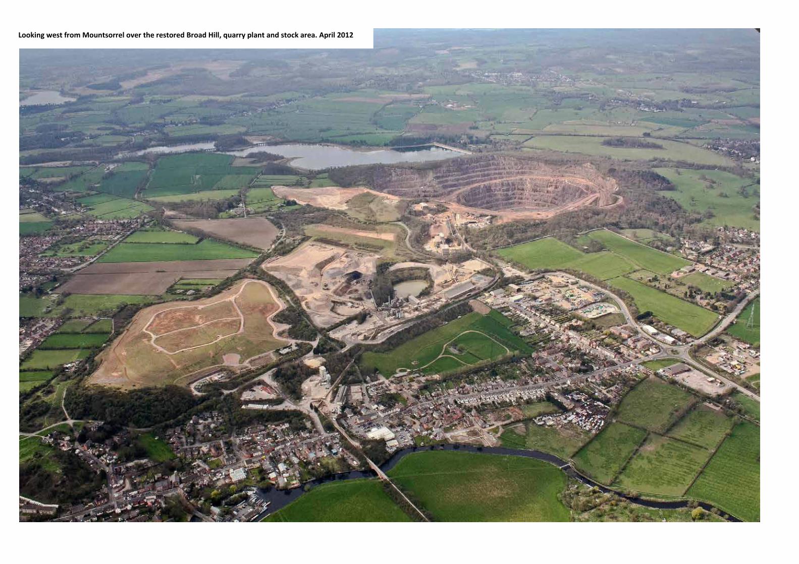
Looking west from Mountsorrel over the restored Broad Hill, quarry plant and stock area. April 2012

The Application Site- Figure 1
The Mountsorrel Quarry application site covers approximately 221 hectares (546 acres), shown shaded pink and outlined in red.

CONTENTS
INTRODUCTION
THE COMPANY
THE PLANNING APPLICATION
THE CONSULTATION PROCESS
PROPOSED CHANGES TO THE SUBMITTED SCHEME
ENVIRONMENTAL EFFECTS OF THE CHANGES
THE RESTORATION SCHEME
Photos clockwise from top
□ The quarry rim and regenerating woodland as seen from the viewing platform
□ The existing primary processing plant
and stone surge pile □ Quarry overburden being removed □ Drill rig, excavator and dump truck
working within the quarry

INTRODUCTION In January 2014 Lafarge Tarmac Ltd submitted a planning application in respect of our operations at Mountsorrel Quarry. The application proposes a range of developments all designed to ensure that the known reserves of minerals are accessible and economic to work. This document provides a summary of additional information supplied to Leicestershire County Council in non-technical language.
Mountsorrel Quarry is an important mineral reserve for the UK
THE COMPANY Lafarge Tarmac Ltd is a joint venture company formed in 2013 following the merger of Lafarge UK and Tarmac to create the UK’s leading construction materials and services supplier. Mountsorrel Quarry is a major local employer and an important contributor to the local economy. It provides approximately 140 direct jobs, pays wages of some £4m per year and generates a further £10m per year on goods and services to support the activities on site which in turn creates employment and wealth for those suppliers. Around 90% of the workforce lives within 10 miles of the quarry. Additional information about the company can be found on our website: http://www.lafargetarmac.com
The quarry primary crusher and surge pile will be relocated to a lower position within the quarry
Dump truck stone haulage on the upper quarry benches will be replaced by a mineral conveyor

THE PLANNING APPLICATION
In January 2014 we submitted a planning application to widen the quarry rim, relocate and update the main processing plant and construct new landforms. The application, if allowed, will allow us to access the remaining stone reserves, safeguard local jobs and extend the life of the quarry. The main elements of the application are:
• An 8.36 hectare (20.6 acre) extension of the stone extraction boundary
• Relocation of the primary crusher and stone pile to a lower level within the quarry
• An extended operating life from December 2033 to December
2040
• The majority of the stone extension area (around 90% is developed within the footprint of the existing quarry development area).
THE CONSULTATION PROCESS Following submission of the planning application Leicestershire County Council consulted a number of organisations and sought views from the wider public. A total of 28 organisations (known as ‘statutory consultees’) were consulted including The Environment Agency, Natural England, borough and parish councils, The Woodland Trust and the Leicestershire and Rutland Wildlife Trust. The consultation process resulted in some requests for additional information about the project and the potential environmental effects it would cause. Consequently over the spring and summer period we embarked on a number of additional specialist environmental surveys and reviewed the proposed quarry design. We then held additional exhibitions at Mountsorrel and Quorn during May 2014 specifically to address concerns raised by local residents and describe the changes to the scheme. We also supplied Natural England with a copy of the additional ecological surveys that had been carried out within the Buddon Wood Site of Special Scientific Interest (SSSI) as well as details of the proposed ecological works. Natural England have since confirmed that the additional information should enable them to remove their holding objection in relation to the SSSI.
Following the exhibitions we continued to refine the designs of the proposed quarry processing plant, the proposed replacement quarry offices and associated staff welfare facilities as well as elements of the restoration scheme.
One of the planning exhibitions in May 2014 PROPOSED CHANGES TO THE SUBMITTED SCHEME The proposed changes to the submitted scheme are summarised below.
• A reduction in the width of the proposed quarry access road and mineral conveyor ramp.
• Steepening of the quarry internal restoration slopes.
• Re-location of a proposed maintenance track from the quarry rim to the quarry benches.
• Protective fencing replacing earth bunds at specific locations
on the quarry rim.
• Additional details supplied for the proposed primary crusher screen house, the covered surge pile as well as a cover for the proposed mineral conveyor.
• Details of the proposed relocated quarry offices and
workshop facilities.
• An increase in the extent of existing woodland retained within Buddon Wood SSSI, Rowhele Wood and the northern screening mound.
• An increase in the extent of proposed woodland on the proposed extension to the south mound land form and a corresponding reduction in proposed heathy grassland.
The changes to the design of the quarry rim and processing plant are shown on Plan N° 2026/ES/11D overleaf.
Reducing the width of the proposed quarry access and mineral conveyor ramp would reduce the area of land needed for the quarry rim. As a result it will be possible to retain more woodland than was originally thought possible. These areas are shown in light green shading on the plan.
Details of the proposed primary crusher design have progressed and include additional measures to control potential dust emissions.
The proposed covered surge pile would be substantially smaller and contained within a smaller circular building. The mineral conveyor would also be covered.
A covered conveyor
The proposed screen house would be located behind existing plant and at a lower level than originally proposed.
In a change to the proposed restoration scheme an area of ‘heathy grassland’ on the southern mound extension would be replaced by open woodland scrub with glades. This measure follows the recommendations of ecologists who have been carrying out very detailed surveys in the locality. The revised scheme is shown on Plan N° 2026/ES/13A overleaf.

By reducing the width of the proposed quarry access road and steepening the proposed overburden batters more woodland and screening will be retained (shaded light green).

Additional woodland will be planted on the south facing slopes of the proposed southern mound extension.

ENVIRONMENTAL EFFECTS The proposed changes to the submitted quarry scheme have been examined to see what effects they might have on the environment. Many of the changes have been made in response to comments and concerns raised during the planning application consultation period. The changes also reflect additional detailed survey and design work, all aimed at improving the environmental performance of the submitted scheme. These are summarised below: Ecology
• As with the submitted scheme, there would be no net loss of ancient woodland from Buddon Wood SSSI.
• The proposed quarry rim has retreated within Rowhele Wood
• More of the existing woodland would be retained
• A larger area of new woodland would be created compared to the submitted scheme
Noise
• Retaining more of the existing northern screen mound and relocating the new primary screen to a lower level will reduce noise levels.
• Noise levels resulting from the relocated quarry offices, workshops and lorry parking will remain within the levels required by national guidance and the permitted scheme.
• Reduced working hours for specific operations on the quarry rim and constructing the new landforms
Air Quality
• There would be some additional improvements in air quality compared to the permitted scheme as more of the existing northern screen mound and associated woodland would be retained
• The proposed mineral conveyor would be covered.
Visual amenity
• The reduced area of the extension will result in more of the northern screen mound and woodland being retained
• The southern mound extension landform would appear more
wooded.
• Additional photomontages have been supplied (see below) to show what the southern mound extension and the Site 4 landform would look like from Kinchley Lane.
Recently opened permissive path in Site 1
Rights of Way
A revised proposal is made for the permanent diversion of Byway K25. The route currently leads from Bond Lane through busy operational areas of the quarry plant and stock areas to reach a footpath near Wood Lane. The submitted proposal changes the route to a bridleway and diverts it along Bond Lane and onto the new Site 1 mound to reach Wood Lane.
The revised scheme would provide a permissive off- road footpath route within the site running parallel to Bond Lane. From the point bridleway 18 reaches Bond Lane horse riders would carry on up the lane to Cufflins Pit Lane, at which point a short off-road stretch would be installed leading to the Bond Lane rail bridge. Horse riders would then reach Wood Lane via a new bridleway route through Rothley Common and the new Site 1 mound.
The proposed arrangement is shown on Plan N° 2026/ES/16A opposite.
View of the proposed southern mound extension from Kinchley Lane
View of the proposed Site 4 landform from Kinchley Lane

Under the revised scheme the proposed permanent diversion of byway K25 would run along Bond Lane from Crown Lane to reach Cufflins Pit Lane. It would then run along a short off-road bridle path to the Bond Lane rail bridge and then to Wood Lane via Rothley Common and the new Site 1 mound. A new permissive off-road footpath would be installed within the site running parallel to Bond Lane.

THE RESTORATION SCHEME The indicative final restoration scheme has been adjusted to include:
• The reduced quarry rim area
• The refinements to the quarry design
• Areas of existing woodland and screening that will now be retained at the north eastern edge of the quarry rim
• Additional areas of woodland that will be created on the
southern mound extension
• Adjustments to the proposed diversion route of byway K25 The revised scheme is shown on Plan N° 2026/ES/20B opposite. The overall scheme remains very similar to the original proposals. The quarry has been identified as a potential future storage facility for public water supply. The perimeter landscape areas will contain a mix of woodland and pasture with a network of public access routes through them.
Restoration work is designed to complement existing woodland
WHAT HAPPENS NEXT? This additional information has been submitted to Leicestershire County Council in support of our planning application. The Council will carry out further consultation and will take account of comments made during this process. Leicestershire County Council may be in a position to determine the proposals later this year. If the new scheme is approved a new planning permission will be issued and work could begin later in 2015. It would take around two to three years of construction work until the new primary crusher and covered surge pile become operational. We hope you found this summary informative. Further information is also available on our website www.lafargetarmac.com/mountsorrel
Natural regeneration of woodland on the southern mound (Site 2) after approximately 10 years.
Vegetation establishment on the upper quarry benches and faces

The proposed restoration scheme has been adjusted to show the smaller quarry rim, the additional areas of woodland and screening that will be retained, additional new woodland and the alternative route for byway K25.

Portland House Bickenhill Lane,
Birmingham B37 7BQ
T 0845 812 6400
LAFARGETARMAC.COM