noaa water quality operations in chesapeake bay · a progressive overview followed by some...
TRANSCRIPT
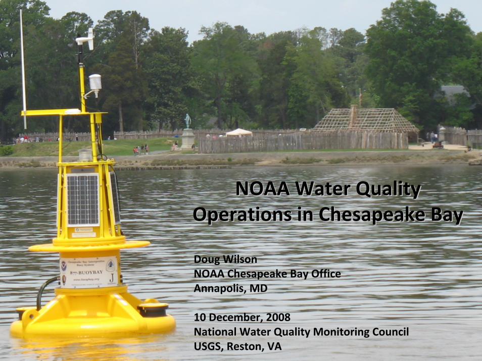
NOAA Water Quality NOAA Water Quality Operations in Chesapeake BayOperations in Chesapeake Bay
Doug WilsonNOAA Chesapeake Bay OfficeAnnapolis, MD
10 December, 2008National Water Quality Monitoring Council USGS, Reston, VA

A Progressive Overview followed by some Questions
The Chesapeake Bay Interpretive Buoy System
The Chesapeake Bay Interpretive Buoy System (CBIBS) is an innovative system to collect, transmit and interpret real‐time environmental data from the Chesapeake Bay to a wide variety of constituents – including scientists, on‐the‐water users, educators, and natural resource decision‐makers – and to fill critical observational gaps in the Chesapeake Bay.
The Buoys collect meteorological, waves, currents, and water quality (T, C, DO, ChlA, Turbidity) and report in real‐time via Verizon Broadband Wireless network.
Data management system collects, archives, and delivers to applications using standard XML‐based Web Services.
Web Services used by growing number of applications (www.buoybay.org , 877‐BUOYBAY, Fieldscope, Estuaries 101/102) as well as delivery to NDBC and CBOS.
Future expansion of CBIBS as well as introduction of “educational quality” BOBs (Basic Observation Buoys) and FLOs ( Fixed Local Observations) through NCBO B‐WET.

NOAA operates (with States) the National Estuarine Research Reserve System.
In Chesapeake Bay WQ monitoring in the NERRS is operated by MD DNR and VA DEQ/VIMS in compliance with Chesapeake Bay Program Shallow Water Monitoring protocols. Near real‐time data transfer uses HADS via GOES.
Data are now available via NERRS Centralized Data Management Office via Web Services (http://cdmo.baruch.sc.edu/webservices/index.cfm)
NERRS has also integrated Chesapeake Bay NERRS real‐time data into the CBIBS system for educational applications.

The Chesapeake Bay Program Water Quality Monitoring Stations Network
• CBP supports fixed shallow water monitoring stations through MD DNR and VA DEQ/VIMS, including many real‐time. NCBO is working to put these data into the CBOS/CBIBS data system as well.• CBP also supports synoptic ‘DATAFLOW”high speed WQ measurement cruises in tributaries.• UMD / MD DEQ are sponsoring conversion to WQX.

Two applications presently utilizing Web Service access are National Geographic’s FIELDSCOPE and the NCBO/CBIBS ESTUARIES 102. Both use GIS based visualization tools and Flex graphics.

The ESTUARIES 102 curriculum is being developed by NCBO CBIBS and B‐WET, and NERRS.

The East Coast COASTWATCH node at NCBO provides remote sensing WQ products specifically for the Chesapeake Bay

Collaborative Ventures like the Chesapeake Bay Observing System and the Chesapeake Community Modeling Project bring partners together.
This includes groups like CBEO the Chesapeake Bay Earth Observatory (NEON /GEON/CUAHSI CyberInfrastructure project) and CIPS, the IOOS‐funded Chesapeake Inundation Prediction System.

Some Other Applications: CBOLT, EcoForecasting, Habitat Suitability
CBOLT links Hydrodynamic and WQ modeling and data

EPA ORD will fund autonomous WQ profiling field experiment in 2009

Summary & Questions
NOAA activities focused on INTEGRATION, INNOVATION, and APPLICATIONS in collection and use of WQ data in Chesapeake Bay
How are ongoing NWQMC and related Agencies activities – especially regarding methods, standards, access – being reported to “Field Level” data collectors and users?
How good a job are ‘we’ doing at identifying and resolving overlapping and duplicate efforts?