no slide title · 1. meteorograph carried by free, unmanned balloons 2. aircraft sounding in...
TRANSCRIPT
Copyright of Junhong (June) Wang 1
Atmospheric Sounding: Basics, Research and Development
Radiosonde, Dropsonde and Driftsonde
Read Chapter 11 “Upper Air Instruments” (Harrison)

Copyright of Junhong (June) Wang 2
Radiosonde Overview
(1) To make accurate measurements of
important atmospheric parameters (usually
temperature, pressure, humidity and wind)
above the surface
(2) To send this information back in as
close to real-time as possible
From Dabberdt et al. (2002)
Receiving equipment

Copyright of Junhong (June) Wang 4
Radiosonde Applications: Operation and Field projects
•Input for weather prediction models;
•Local severe storm, aviation, and marine forecasts;
•Climate change research;
•Input for air pollution models;
•Ground truth for satellite data;
•Characterization of thermo-dynamical and wind profiles
CCSP (2006)
Copyright of Junhong (June) Wang 5
Copyright of Junhong (June) Wang 6

Copyright of Junhong (June) Wang 7
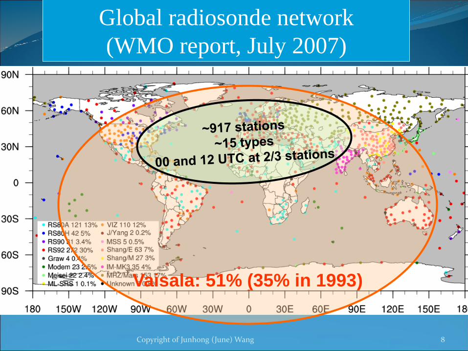
Copyright of Junhong (June) Wang 8
Vaisala: 51% (35% in 1993)
Global radiosonde network
(WMO report, July 2007)
Copyright of Junhong (June) Wang 9
Vaisala
RS80-
H (60)
VIZ B-
2 (32)
U.S.A. Radiosonde Network
Mark-II
LMS-6RS92

WMO # Name VIZ B
MicroART
Microsonde
MKII w/rod
temp. sensor
W-9000
Microsonde
MKII w/chip
temp. sensor
W-9000
Microsonde
MKIIA – GPS
RRS
Lockheed
LMS-6
GPS RRS
72518 Albany, NY 9/1/88-5/20/97 5/20/97-10/1/03 10/1/03 – 4/19/10 4/19/10-10/4/13 10/4/13-Present
Albany, NY (72518)
Copyright of Junhong (June) Wang 10
WMONo.
Old Location
Lat/Long(deg/min)
Release Elev(m)
Move Date New Location Lat/Long(deg/min)
Release Elev(m)
WMONo.
72518 Albany, NY 42/45N73/48W
86 5/20/97 S.U.N.Y Albany
Albany, NY
42/42N73/50W
93 72518
From Maarit Lockhoff (DWD)
Monthly mean PWMonthly mean PW diff
(others – Radiosonde)

Copyright of Junhong (June) Wang 11

Copyright of Junhong (June) Wang 12
Ozonesonde:
ozone profiles
Radioactivity sonde:
Β and γ radioactivity
http://www.eol.ucar.edu/homes/junhong/MT11B_radiosondes.pdf
In-cloud measurements:
changes in charge, aerosols
Needs:
Trace gases (o3, SO2,
CO2), Vertical velocity,
Turbulence,
cloud/aerosol, Radiations
Other special radiosondes
Harrison
and Hogan
(2006)
Electricity:
Electric field probe
Copyright of Junhong (June) Wang 13
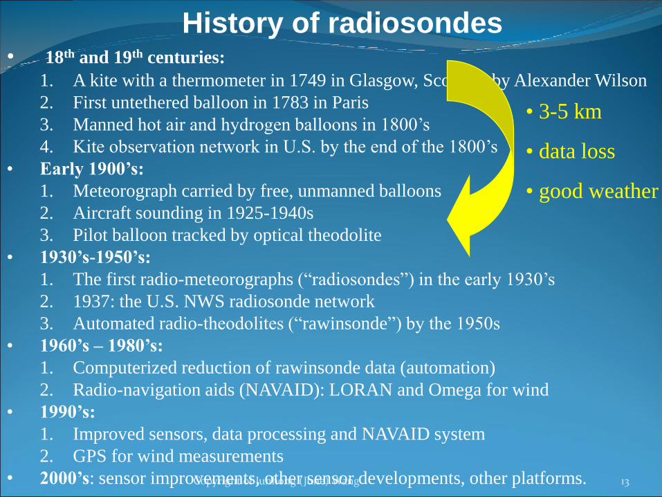
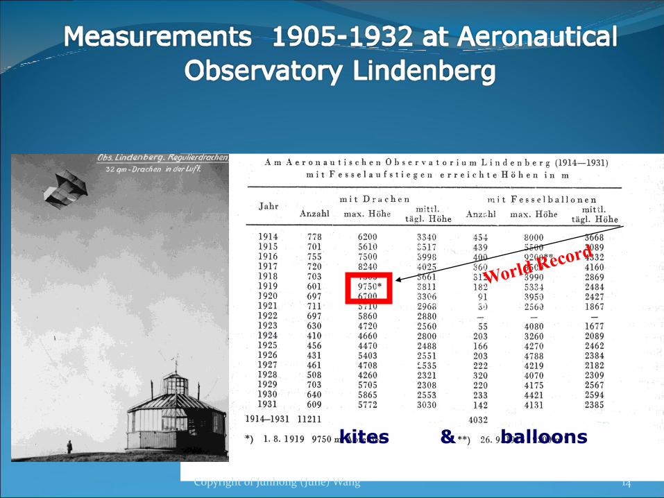
History of radiosondes• 18th and 19th centuries:
1. A kite with a thermometer in 1749 in Glasgow, Scotland by Alexander Wilson
2. First untethered balloon in 1783 in Paris
3. Manned hot air and hydrogen balloons in 1800’s
4. Kite observation network in U.S. by the end of the 1800’s
• Early 1900’s:
1. Meteorograph carried by free, unmanned balloons
2. Aircraft sounding in 1925-1940s
3. Pilot balloon tracked by optical theodolite
• 1930’s-1950’s:
1. The first radio-meteorographs (“radiosondes”) in the early 1930’s
2. 1937: the U.S. NWS radiosonde network
3. Automated radio-theodolites (“rawinsonde”) by the 1950s
• 1960’s – 1980’s:
1. Computerized reduction of rawinsonde data (automation)
2. Radio-navigation aids (NAVAID): LORAN and Omega for wind
• 1990’s:
1. Improved sensors, data processing and NAVAID system
2. GPS for wind measurements
• 2000’s: sensor improvements, other sensor developments, other platforms.
• 3-5 km
• data loss
• good weather
kites & balloons
Copyright of Junhong (June) Wang 14
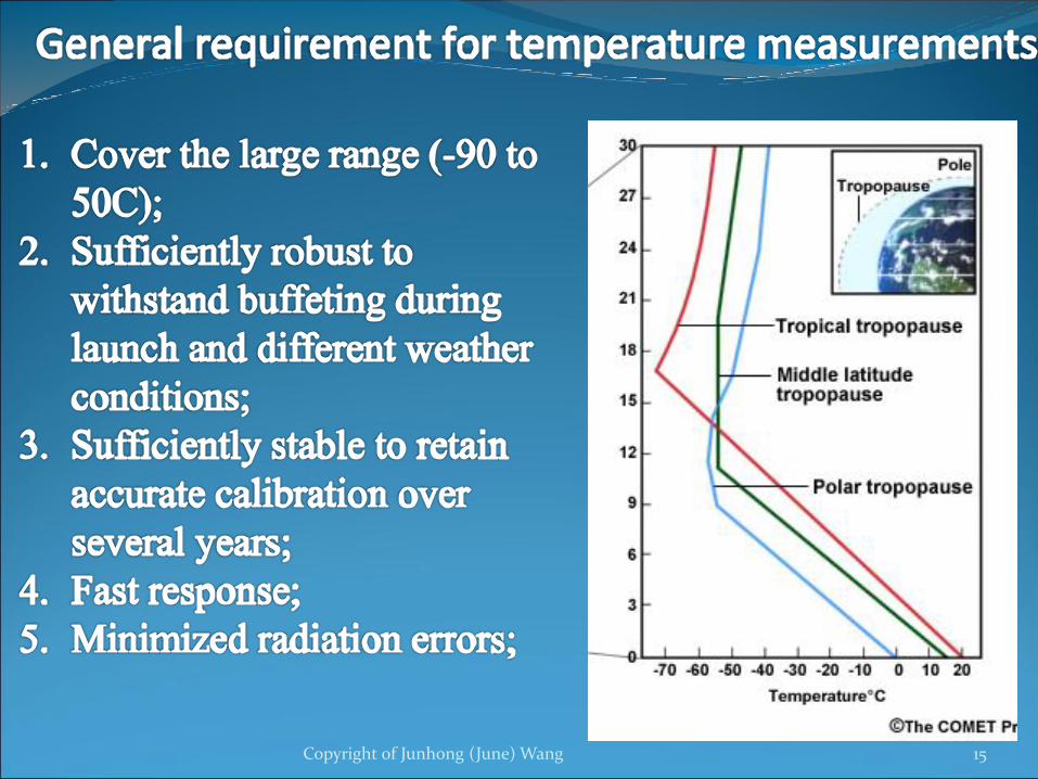
Copyright of Junhong (June) Wang 15

Copyright of Junhong (June) Wang 16
Thermocapacitors
Thermistors
SRS
thermocouple
• Ceramic material
• Resistance changes with T: R = A · exp (B/T)
• Sippican, Modem, Meisei,
• Ceramic material
• Permittivity changes with T
• Vaisala
• The junction of two dissimilar metals
• Measure the voltage diff between two
junctions (with one T sensor inside)
• SRS
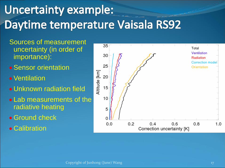
Sources of measurement uncertainty (in order of importance):
Sensor orientation
Ventilation
Unknown radiation field
Lab measurements of the radiative heating
Ground check
Calibration
Copyright of Junhong (June) Wang 17

Copyright of Junhong (June) Wang 18

Copyright of Junhong (June) Wang 19
Humidity sensors:
1. Thin-film capacitor
2. Carbon hygristor
3. Goldbeater’s skin
4. Dew/frost-point
hygrometer
5. Tunable diode
laser (TDL)
Vaisala Humicap
Meisei
capacitive
Modem
capacitiveGraw
capacitive
Carbon
hygristor
Goldbeater’s
skin
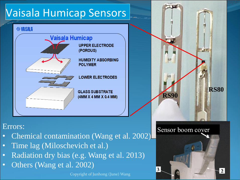
Vaisala Humicap Sensors
RS80RS90
Errors:
• Chemical contamination (Wang et al. 2002)
• Time lag (Miloschevich et al.)
• Radiation dry bias (e.g. Wang et al. 2013)
• Others (Wang et al. 2002)Copyright of Junhong (June) Wang 20

Water vapor trends in the troposphere?
e.g.: Lindenberg 8km (0:00 UT)
Freiberg RKS-2 RKS-5 MARZ RS80 RS92
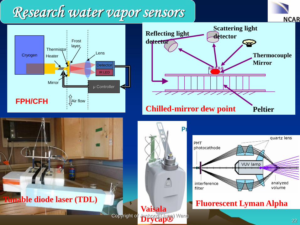
Detector
IR LED
μ Controller
Cryogen
Air flow
Lens
Mirror
Heater
Frost
layerThermistor
FPH/CFH
Research water vapor sensors
Thermocouple
Mirror
Peltier
Scattering light
detectorReflecting light
detector
Chilled-mirror dew point
Fluorescent Lyman Alpha Tunable diode laser (TDL)
Vaisala
DrycapCopyright of Junhong (June) Wang
22
Copyright of Junhong (June) Wang 23
https://www.youtube.com/watch?v
=iMvydih9rlM
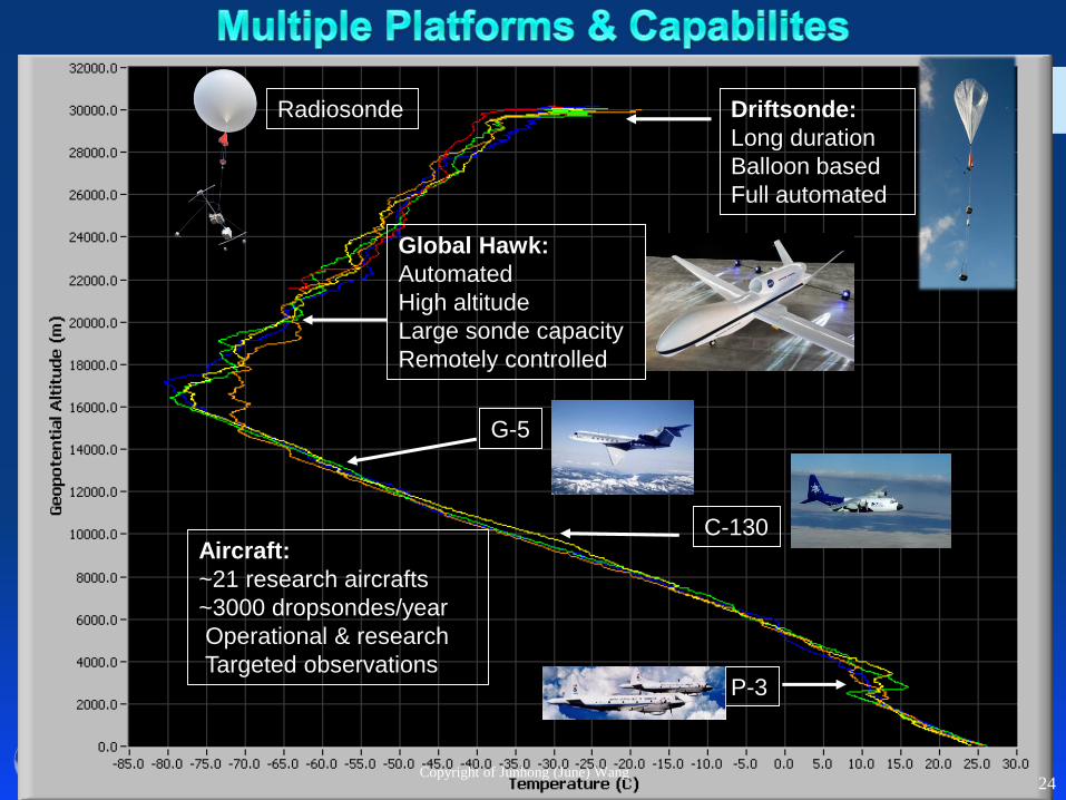
Radiosonde Driftsonde:
Long duration
Balloon based
Full automated
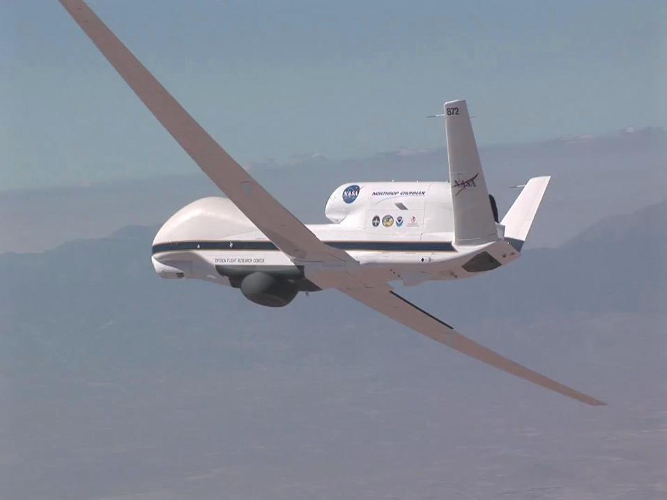
G-5
Global Hawk:
Automated
High altitude
Large sonde capacity
Remotely controlled
C-130Aircraft:
~21 research aircrafts
~3000 dropsondes/year
Operational & research
Targeted observationsP-3
Copyright of Junhong (June) Wang24

25
T-PARC: 20081990-2012:
41 Field projects
>8000 soundings
Concordiasi (2010)
Pre-Concordiasi (2010)
Copyright of Junhong (June) Wang
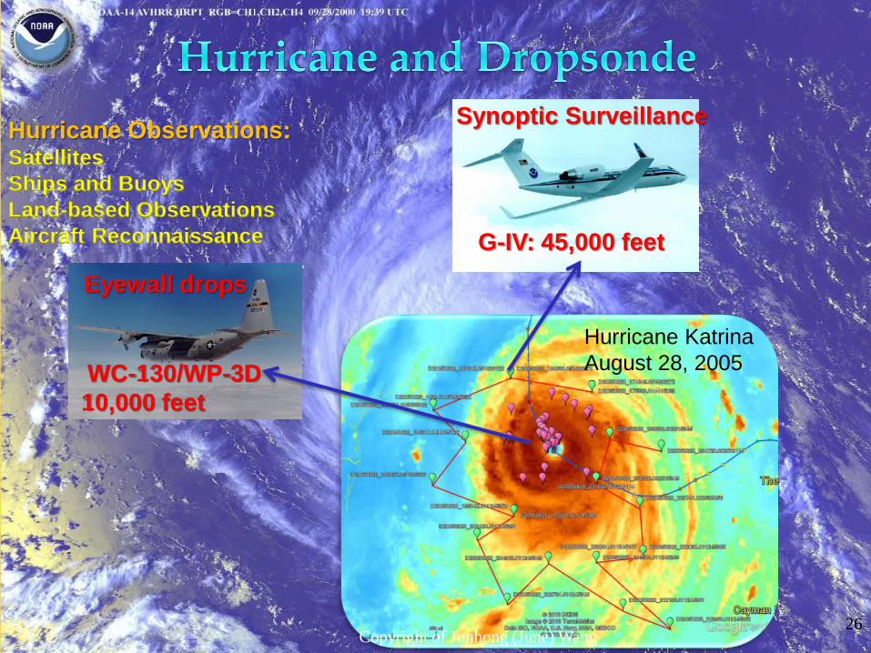
Hurricane Observations:Satellites
Ships and Buoys
Land-based Observations
Aircraft Reconnaissance
Synoptic Surveillance
G-IV: 45,000 feet
Eyewall drops
WC-130/WP-3D
10,000 feet
Hurricane Katrina
August 28, 2005
Copyright of Junhong (June) Wang26
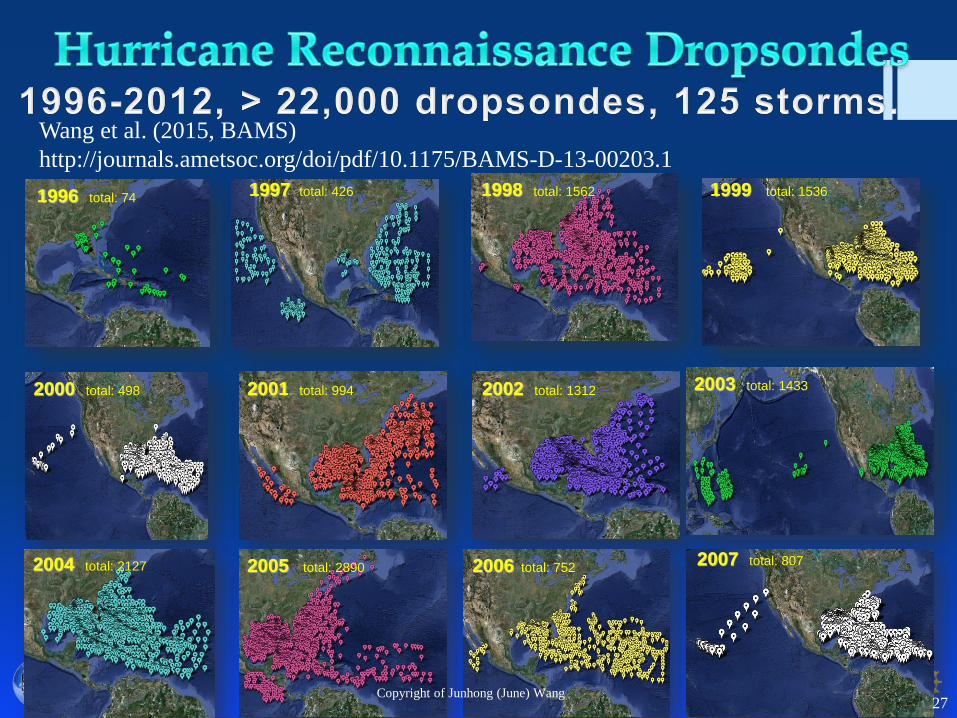
1996 total: 741997 total: 426 1998 total: 1562 1999 total: 1536
2000 total: 498 2001 total: 994 2002 total: 1312 2003 total: 1433
2004 total: 2127 2005 total: 2890 2006 total: 7522007 total: 807
Copyright of Junhong (June) Wang27
Wang et al. (2015, BAMS)
http://journals.ametsoc.org/doi/pdf/10.1175/BAMS-D-13-00203.1

28
Data courtesy
Sim Aberson, HRD
Thanks to
James Franklin,
NOAA/AOML/NHC
Copyright of Junhong (June) Wang
29
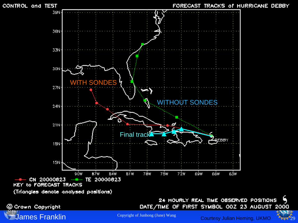
UKMET MODEL
WITHOUT SONDES
WITH SONDES
Courtesy Julian Heming, UKMOJames Franklin
Final track
Copyright of Junhong (June) Wang
Copyright of Junhong (June) Wang30
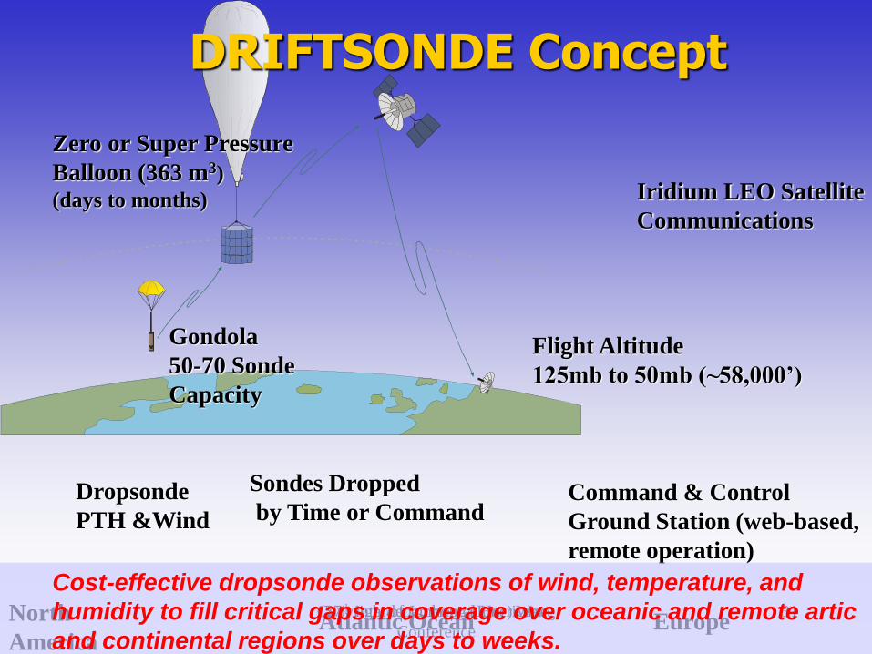
DRIFTSONDE Concept
Copyright of Junhong (June) Wang 3157th Interdepartmental Hurricane
Conference
DRIFTSONDE Concept
Zero or Super Pressure
Balloon (363 m3)
(days to months) Iridium LEO Satellite
Communications
Gondola
50-70 Sonde
Capacity
Command & Control
Ground Station (web-based,
remote operation)
Flight Altitude
125mb to 50mb (~58,000’)
Dropsonde
PTH &Wind
Sondes Dropped
by Time or Command
Atlantic Ocean EuropeNorth
America
Cost-effective dropsonde observations of wind, temperature, and
humidity to fill critical gaps in coverage over oceanic and remote artic
and continental regions over days to weeks.

To combine innovative measurements and
modeling components for a better analysis
and prediction of weather over Antarctica.Copyright of Junhong (June) Wang 32
Copyright of Junhong (June) Wang 33