nmfs and usfws biological assessment - caltrain.comassessment.pdf · 2013-10-10 · nmfs and usfws...
TRANSCRIPT
LOS GATOS CREEK BRIDGE REPLACEMENT / SOUTH TERMINAL
PHASE III PROJECT
NMFS and USFWS Biological Assessment
Prepared for Peninsula Corridor Joint Powers Board
1250 San Carlos Avenue P.O. Box 3006
San Carlos, California 94070-1306
and the
Federal Transit Administration Region IX U.S. Department of Transportation
201 Mission Street Suite1650
San Francisco, CA 94105-1839
Prepared by HDR Engineering, Inc.
2379 Gateway Oaks Drive Suite 200
Sacramento, California 95833
August 2013


NMFS and USFWSBiological Assessment
Prepared for Peninsula Corridor Joint Powers Board
1250 San Carlos Avenue P.O. Box 3006
San Carlos, California 94070-1306
and the
Federal Transit Administration Region IX U.S. Department of Transportation
201 Mission Street Suite 1650
San Francisco, CA 94105-1839
Prepared by HDR Engineering, Inc.
2379 Gateway Oaks Drive, Suite 200 Sacramento, California 95833
August 2013

This page left blank intentionally.
Los Gatos Creek Bridge Replacement / South Terminal Phase III June 2013 NMFS and USFWS Biological Assessment Page i
Summary
The Peninsula Corridor Joint Powers Board (JPB) which operates the San Francisco Bay Area’s Caltrain passenger rail service proposes to replace the two-track railroad bridge that crosses Los Gatos Creek, in the City of San Jose, Santa Clara County, California. The Proposed Action is needed to address the structural deficiencies and safety issues of the Caltrain Los Gatos Creek railroad bridge to be consistent with the standards of safety and reliability required for public transit, to ensure that the bridge will continue to safely carry commuter rail service well into the future, and to improve operations at nearby San Jose Diridon Station and along the Caltrain rail line.
This Biological Assessment (BA) has been prepared for the National Marine Fisheries Service (NMFS) and U.S. Fish and Wildlife Service (USFWS) to ensure compliance with Section 7 of the Federal Endangered Species Act (ESA) due to the potential for listed, proposed to be listed, or candidate aquatic and terrestrial species and designated critical habitat under the jurisdiction of NMFS and USFWS to occur in the Action Area. In addition, Essential Fish Habitat (EFH) for various species managed under the Magnuson-Stevens Fishery Conservation and Management Act (MSFCMA) has been designated within Los Gatos Creek; therefore consultation with NMFS is required.
As discussed herein, the BA determines to what extent the Proposed Action may affect any of the endangered and threatened species and EFH that may occur in the Action Area. Based on existing conditions and characteristics of the Action Area, one aquatic species, one terrestrial species, and one species within an EFH were evaluated for potential effects: Central California Coast Steelhead Distinct Population Segment (NMFS jurisdiction), California Red-legged Frog (USFWS jurisdiction), and Central Valley fall-run Chinook Salmon (managed under the Pacific Coast Fisheries Management Plan (FMP); NMFS jurisdiction).
The BA concludes that the Proposed Action “is not likely to adversely affect” Central California Coast steelhead and California Red-legged Frog, and will have “no effect” on critical habitat for Central California Coast steelhead and California Red-legged Frog. Also, the Proposed Action is “not likely to adversely affect” Central Valley fall-run Chinook Salmon managed under the Pacific Coast Salmon FMP or their designated EFH.

Los Gatos Creek Bridge Replacement / South Terminal Phase III July 2013 NMFS and USFWS Biological Assessment Page ii
This page left blank intentionally
Los Gatos Creek Bridge Replacement / South Terminal Phase III July 2013 NMFS and USFWS Biological Assessment Page iii
Table of Contents
Summary ....................................................................................................................................................... i
1.0 Introduction ................................................................................................................................. 1-1 1.1 Regulatory Framework ..................................................................................................... 1-1
1.2 Project Location ............................................................................................................... 1-3
1.3 Purpose and Need of Proposed Action............................................................................ 1-3
1.3.1 Existing Safety Concerns .................................................................................... 1-5
1.3.2 Need for a Tail Track .......................................................................................... 1-5
1.3.3 Purpose of the Proposed Project ........................................................................ 1-6
2.0 Description of the Proposed Action .......................................................................................... 2-1 2.1 Project Elements .............................................................................................................. 2-1
2.2 Construction Staging ........................................................................................................ 2-4
3.0 Action Area .................................................................................................................................. 3-1 3.1 Location of the Action Area .............................................................................................. 3-1
3.2 Existing Environment ....................................................................................................... 3-1
3.2.1 Hydrology and Water Quality .............................................................................. 3-1
3.2.2 Groundwater ....................................................................................................... 3-7
3.2.3 Stormwater .......................................................................................................... 3-8
3.2.4 Geology and Geomorphology ............................................................................. 3-8
3.2.5 Land Use ........................................................................................................... 3-10
3.2.6 Fish Habitat and Fish Community Description .................................................. 3-10
3.2.7 Terrestrial Habitat Types/Vegetation Communities .......................................... 3-11
3.2.8 Sensitive Natural Communities/Wetlands and Waters of the U.S. ................... 3-13
4.0 Species and Habitat Considered ............................................................................................... 4-1 4.1 Species Included in the Analysis ..................................................................................... 4-1
4.2 Species Eliminated from the Analysis .............................................................................. 4-1
4.3 Critical Habitat .................................................................................................................. 4-4
4.4 Essential Fish Habitat ...................................................................................................... 4-5
4.5 Consultation to Date......................................................................................................... 4-5
5.0 Species Accounts ....................................................................................................................... 5-1 5.1 Listed Aquatic Species ..................................................................................................... 5-1
5.1.1 Central California Coast Steelhead DPS ............................................................ 5-1
5.2 Listed Terrestrial Species ................................................................................................ 5-4
5.2.1 California Red-legged Frog ................................................................................. 5-4
6.0 Effects on Species and Habitat ................................................................................................. 6-1

Los Gatos Creek Bridge Replacement / South Terminal Phase III July 2013 NMFS and USFWS Biological Assessment Page iv
6.1 Listed Aquatic Species ..................................................................................................... 6-2
6.1.1 Central California Coast Steelhead DPS ............................................................ 6-3
6.2 Listed Terrestrial Species .............................................................................................. 6-12
6.2.1 California Red-Legged Frog .............................................................................. 6-12
6.3 Determination of Effects ................................................................................................. 6-15
7.0 Conservation Measures.............................................................................................................. 7-1 8.0 Essential Fish Habitat Assessment .......................................................................................... 8-1
8.1 Essential Fish Habitat Background .................................................................................. 8-1
8.2 Managed Fisheries with Potential to Occur in the Action Area ........................................ 8-2
8.2.1 Pacific Salmon Fishery ....................................................................................... 8-2
8.3 Potential Adverse Effects of the Proposed Action on EFH .............................................. 8-6
8.4 Minimization and Avoidance of EFH Impacts .................................................................. 8-7
8.5 PFMC Recommended Minimization Measures ............................................................... 8-8
8.6 Conclusion and Effect Determination ............................................................................... 8-9
9.0 References ................................................................................................................................. 9-11
List of Figures Figure 1-1 Regional Location of the Proposed Action ....................................................................... 1-2
Figure 1-2 Project Location Map ....................................................................................................... 1-4
Figure 1-3 Deteriorating Conditions of Los Gatos Creek Bridge ....................................................... 1-5
Figure 2-1 Los Gatos Creek Bridge Replacement / South Terminal Phase III Project Site Plan ...... 2-2
Figure 2-2 Final Track Alignment ...................................................................................................... 2-3
Figure 2-3A Construction Staging Plan – Initial Out-of-Creek Construction ........................................ 2-5
Figure 2-3B Construction Staging Plan – Season 1 In-Creek Construction ........................................ 2-6
Figure 2-3C Construction Staging Plan – Winter Out-of-Creek Construction ...................................... 2-7
Figure 2-3D Construction Staging Plan – Season 2 In-Creek Construction Part 1 ............................. 2-8
Figure 2-3E Construction Staging Plan – Season 2 In-Creek Construction Part 2 ............................. 2-9
Figure 2-3F Construction Staging Plan – Finish Out-of-Creek Construction .................................... 2-10
Figure 3-1 Action Area ....................................................................................................................... 3-2
Figure 3-2 Guadalupe Watershed Dams ........................................................................................... 3-3
Figure 3-3 Peak Flow in Los Gatos Creek at Lincoln Avenue (1995 to 2012) .................................. 3-5
Figure 3-4 Average Water Temperature (oF) in Los Gatos Creek Upstream of Confluence with Guadalupe River (2009 to 2012) ...................................................................................... 3-6
Figure 3-5 Average Flows (cfs) in Los Gatos Creek, 2010-2012 ...................................................... 3-7
Figure 3-6 Habitat Types within Action Area ................................................................................... 3-12
Los Gatos Creek Bridge Replacement / South Terminal Phase III July 2013 NMFS and USFWS Biological Assessment Page v
List of Tables
Table 2-1 Construction Stage Work Elements ................................................................................. 2-4
Table 3-1 Peak Flow in Los Gatos Creek at Lincoln Avenue (1995 to 2012) .................................. 3-4
Table 3-2 Average Water Temperature (oF) in Los Gatos Creek Upstream of Confluence with Guadalupe River (2009 - 2012) ....................................................................................... 3-5
Table 3-3 Average Water Flows (cfs) Los Gatos Creek near Santa Clara Street (2010 through 2012) ................................................................................................................................ 3-6
Table 3-4 Acreage of Waters of the U.S. in the Action Area .......................................................... 3-13
Table 4-1 Species Potentially Occurring within the Action Area ...................................................... 4-2
Table 4-2 Federally-Listed Species Dismissed from Further Consideration .................................... 4-2
Table 5-1 Key Seasonal Periods for Central California Coast Steelhead ........................................ 5-2
Table 5-2 Steelhead Redd Observations in Los Gatos Creek1 ........................................................ 5-3
Table 6-1 Effects of the Proposed Action on Los Gatos Creek ....................................................... 6-5
Table 6-2 NMFS Underwater Noise Thresholds to Fish Exposed to Elevated Levels of Underwater Sounds Produced During Pile Driving .......................................................... 6-7
Table 6-3 Number of Pile Strikes Expected for Proposed Action .................................................... 6-8
Table 6-4 NMFS Underwater Noise Calculations using a Dewatered Cofferdam – Minimum Number of Blows in Soft Material ..................................................................................... 6-9
Table 6-5 NMFS Underwater Noise Calculations using a Dewatered Cofferdam – Maximum Number of Blows in Soft Material ..................................................................................... 6-9
Table 6-6 NMFS Underwater Noise Calculations using a Dewatered Cofferdam – Minimum Number of Blows in Stiff Material ................................................................................... 6-10
Table 6-7 NMFS Underwater Noise Calculations using a Dewatered Cofferdam – Maximum Number of Blows in Stiff Material ................................................................................... 6-10
Table 8-1 Key Seasonal Periods for Fall-Run Chinook Salmon ...................................................... 8-4
Table 8-2 Chinook Salmon Observations in Los Gatos Creek ........................................................ 8-5
Table 8-3 Chinook Salmon Redd Observations in Los Gatos Creek ............................................... 8-6
Appendices
Appendix A Regionally Occuring Special Status Species Lists ........................................................... A-1
Appendix B Contingency Plan for Horizontal Directional Drill Inadvertent Returns (“FRAC-Out”)
of Drilling Mud ................................................................................................................... B-1

Los Gatos Creek Bridge Replacement / South Terminal Phase III July 2013 NMFS and USFWS Biological Assessment Page vi
List of Abbreviations and Acronyms ACE Altamont Corridor Express BA Biological Assessment BMP Best Management Practice BO Biological Opinion CDFW California Department of Fish and Wildlife CFR Code of Federal Regulations CNDDB California Natural Diversity Database CRLF California Red-Legged Frog CTS California Tiger Salamander CWA Clean Water Act DPS Distinct Population Segment EFH Essential Fish Habitat EMU Electric Multiple Unit ESA Endangered Species Act ESU Evolutionarily Significant Unit FMP Fishery Management Plan FTA Federal Transportation Administration HCP Habitat Conservation Plan JPB Peninsula Corridor Joint Powers Board MMRP Mitigation, Monitoring, and Reporting Plan MSFCMA Magnuson-Stevens Fishery Conservation and Management Act MT Main Track NMFS National Marine Fisheries Service OSH Orchard Supply Hardware PFMC Pacific Fisheries Management Council Quad Quadrangle ROW Right-of-way RPA Reasonable and Prudent Alternative RWQCB Regional Water Quality Control Board SCVWD Santa Clara Valley Water District SWPPP Storm Water Pollution Prevention Plan TMDL Total Maximum Daily Load UPRR Union Pacific Railroad USACE U.S. Army Corps of Engineers U.S.C. U.S. Code USFWS U.S. Fish and Wildlife Service USGS U.S. Geological Survey
Los Gatos Creek Bridge Replacement / South Terminal Phase III July 2013 NMFS and USFWS Biological Assessment Page 1-1
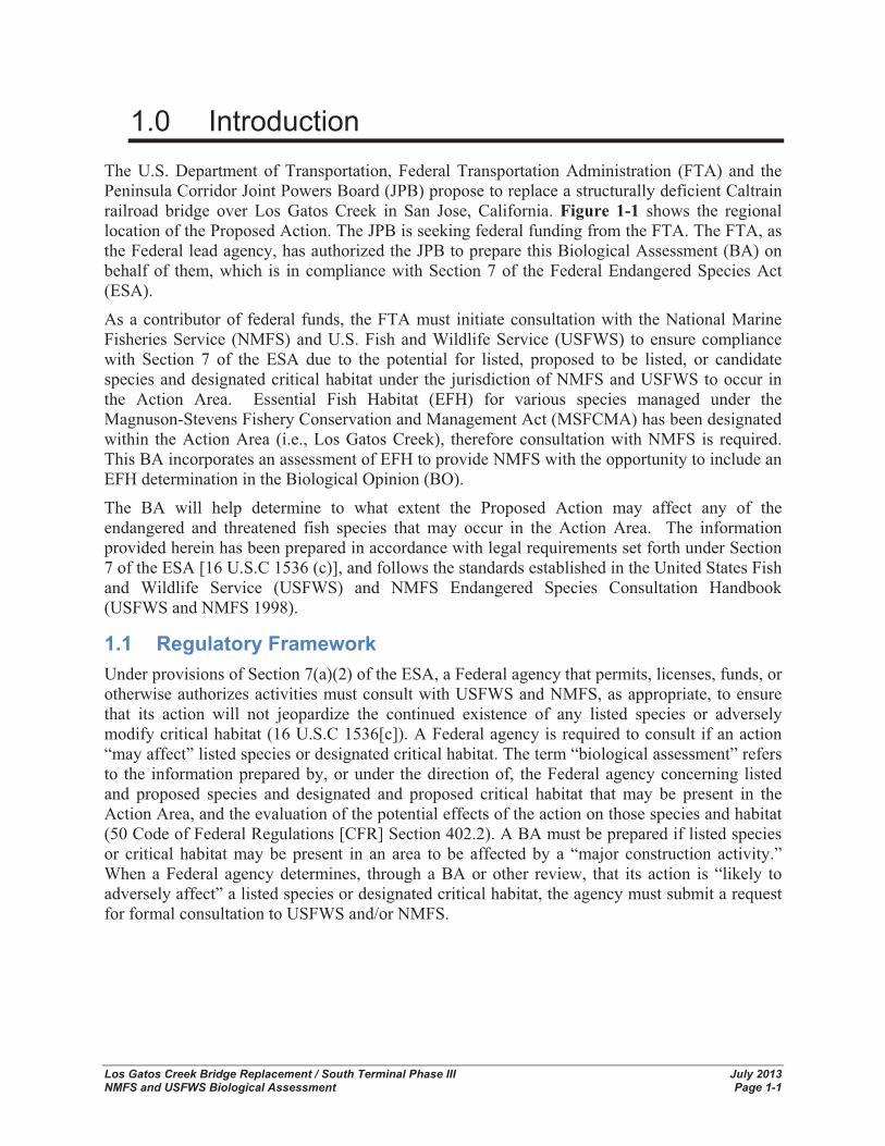
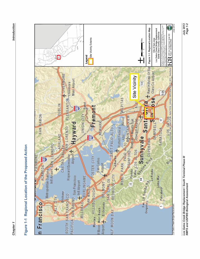
1.0 Introduction The U.S. Department of Transportation, Federal Transportation Administration (FTA) and the Peninsula Corridor Joint Powers Board (JPB) propose to replace a structurally deficient Caltrain railroad bridge over Los Gatos Creek in San Jose, California. Figure 1-1 shows the regional location of the Proposed Action. The JPB is seeking federal funding from the FTA. The FTA, as the Federal lead agency, has authorized the JPB to prepare this Biological Assessment (BA) on behalf of them, which is in compliance with Section 7 of the Federal Endangered Species Act (ESA).
As a contributor of federal funds, the FTA must initiate consultation with the National Marine Fisheries Service (NMFS) and U.S. Fish and Wildlife Service (USFWS) to ensure compliance with Section 7 of the ESA due to the potential for listed, proposed to be listed, or candidate species and designated critical habitat under the jurisdiction of NMFS and USFWS to occur in the Action Area. Essential Fish Habitat (EFH) for various species managed under the Magnuson-Stevens Fishery Conservation and Management Act (MSFCMA) has been designated within the Action Area (i.e., Los Gatos Creek), therefore consultation with NMFS is required. This BA incorporates an assessment of EFH to provide NMFS with the opportunity to include an EFH determination in the Biological Opinion (BO).
The BA will help determine to what extent the Proposed Action may affect any of the endangered and threatened fish species that may occur in the Action Area. The information provided herein has been prepared in accordance with legal requirements set forth under Section 7 of the ESA [16 U.S.C 1536 (c)], and follows the standards established in the United States Fish and Wildlife Service (USFWS) and NMFS Endangered Species Consultation Handbook (USFWS and NMFS 1998).
1.1 Regulatory Framework Under provisions of Section 7(a)(2) of the ESA, a Federal agency that permits, licenses, funds, or otherwise authorizes activities must consult with USFWS and NMFS, as appropriate, to ensure that its action will not jeopardize the continued existence of any listed species or adversely modify critical habitat (16 U.S.C 1536[c]). A Federal agency is required to consult if an action “may affect” listed species or designated critical habitat. The term “biological assessment” refers to the information prepared by, or under the direction of, the Federal agency concerning listed and proposed species and designated and proposed critical habitat that may be present in the Action Area, and the evaluation of the potential effects of the action on those species and habitat (50 Code of Federal Regulations [CFR] Section 402.2). A BA must be prepared if listed species or critical habitat may be present in an area to be affected by a “major construction activity.” When a Federal agency determines, through a BA or other review, that its action is “likely to adversely affect” a listed species or designated critical habitat, the agency must submit a request for formal consultation to USFWS and/or NMFS.
Cha
pter
1
In
trod
uctio
n
Los
Gat
os C
reek
Brid
ge R
epla
cem
ent /
Sou
th T
erm
inal
Pha
se II
I Ju
ly 2
013
NM
FS a
nd U
SFW
S B
iolo
gica
l Ass
essm
ent
Page
1-2
Figu
re 1
-1 R
egio
nal L
ocat
ion
of th
e Pr
opos
ed A
ctio
n
Chapter 1 Introduction
Los Gatos Creek Bridge Replacement / South Terminal Phase III July 2013 NMFS and USFWS Biological Assessment Page 1-3
The BOs present USFWS’s and NMFS’s determinations as to whether or not the Proposed Action would likely jeopardize the species or adversely modify its critical habitat. If a “jeopardy” or “adverse modification” determination is made, the BO must identify reasonable and prudent alternative (RPA) actions that could satisfy the purpose and need for the action.
If USFWS and NMFS issue either a “no jeopardy” opinion or a “jeopardy” opinion that contains RPAs, the opinion may include an incidental take statement. USFWS and NMFS must anticipate the quantity of take that may result from the Proposed Action and authorize such take with a statement that the listed species described in the incidental take statement will not be jeopardized. The incidental take statement must contain clear terms and conditions designed to reduce the impact of the anticipated take; these terms are binding on the action agency.
In addition to compliance with ESA, FTA is required to comply with the MSFCMA. The purpose of this act is for Federal agencies to take immediate action to conserve and manage the fishery resources found off the coasts of the United States, and the nation’s anadromous species and continental shelf fishery resources.
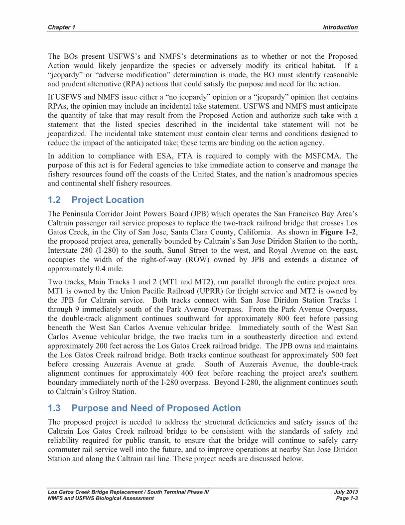
1.2 Project Location The Peninsula Corridor Joint Powers Board (JPB) which operates the San Francisco Bay Area’s Caltrain passenger rail service proposes to replace the two-track railroad bridge that crosses Los Gatos Creek, in the City of San Jose, Santa Clara County, California. As shown in Figure 1-2,the proposed project area, generally bounded by Caltrain’s San Jose Diridon Station to the north, Interstate 280 (I-280) to the south, Sunol Street to the west, and Royal Avenue on the east, occupies the width of the right-of-way (ROW) owned by JPB and extends a distance of approximately 0.4 mile.
Two tracks, Main Tracks 1 and 2 (MT1 and MT2), run parallel through the entire project area. MT1 is owned by the Union Pacific Railroad (UPRR) for freight service and MT2 is owned by the JPB for Caltrain service. Both tracks connect with San Jose Diridon Station Tracks 1 through 9 immediately south of the Park Avenue Overpass. From the Park Avenue Overpass, the double-track alignment continues southward for approximately 800 feet before passing beneath the West San Carlos Avenue vehicular bridge. Immediately south of the West San Carlos Avenue vehicular bridge, the two tracks turn in a southeasterly direction and extend approximately 200 feet across the Los Gatos Creek railroad bridge. The JPB owns and maintains the Los Gatos Creek railroad bridge. Both tracks continue southeast for approximately 500 feet before crossing Auzerais Avenue at grade. South of Auzerais Avenue, the double-track alignment continues for approximately 400 feet before reaching the project area's southern boundary immediately north of the I-280 overpass. Beyond I-280, the alignment continues south to Caltrain’s Gilroy Station.
1.3 Purpose and Need of Proposed Action The proposed project is needed to address the structural deficiencies and safety issues of the Caltrain Los Gatos Creek railroad bridge to be consistent with the standards of safety and reliability required for public transit, to ensure that the bridge will continue to safely carry commuter rail service well into the future, and to improve operations at nearby San Jose Diridon Station and along the Caltrain rail line. These project needs are discussed below.

Chapter 1 Introduction
Los Gatos Creek Bridge Replacement / South Terminal Phase III July 2013 NMFS and USFWS Biological Assessment Page 1-4
Figure 1-2 Project Location Map
Chapter 1 Introduction
Los Gatos Creek Bridge Replacement / South Terminal Phase III July 2013 NMFS and USFWS Biological Assessment Page 1-5
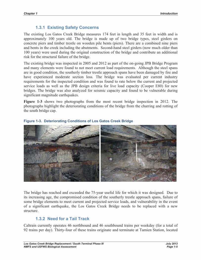
1.3.1 Existing Safety Concerns The existing Los Gatos Creek Bridge measures 174 feet in length and 35 feet in width and is approximately 100 years old. The bridge is made up of two bridge types, steel girders on concrete piers and timber trestle on wooden pile bents (piers). There are a combined nine piers and bents in the creek including the abutments. Second-hand steel girders (now much older than 100 years) were used during the original construction of the bridge and contribute an additional risk for the structural failure of the bridge.
The existing bridge was inspected in 2005 and 2012 as part of the on-going JPB Bridge Program and many elements were found to not meet current load requirements. Although the steel spans are in good condition, the southerly timber trestle approach spans have been damaged by fire and have experienced moderate section loss. The bridge was evaluated per current industry requirements for the inspected condition and was found to rate below the current and projected service loads as well as the JPB design criteria for live load capacity (Cooper E80) for new bridges. The bridge was also analyzed for seismic capacity and found to be vulnerable during significant magnitude earthquakes.
Figure 1-3 shows two photographs from the most recent bridge inspection in 2012. The photographs highlight the deteriorating conditions of the bridge from the charring and rotting of the south bridge cap. Figure 1-3. Deteriorating Conditions of Los Gatos Creek Bridge
The bridge has reached and exceeded the 75-year useful life for which it was designed. Due to its increasing age, the compromised condition of the southerly trestle approach spans, failure of some bridge elements to meet current and projected service loads, and vulnerability in the event of a significant earthquake, the Los Gatos Creek Bridge needs to be replaced with a new structure.
1.3.2 Need for a Tail Track Caltrain currently operates 46 northbound and 46 southbound trains per weekday (for a total of 92 trains per day). Thirty-four of these trains originate and terminate at Tamien Station, located
Chapter 1 Introduction
Los Gatos Creek Bridge Replacement / South Terminal Phase III July 2013 NMFS and USFWS Biological Assessment Page 1-6
approximately 1.3 miles south of the Los Gatos Creek Bridge. All Caltrain service to Tamien Station and further south utilizes only one of the two tracks through the project area, MT2.
The San Jose Diridon Station has recently completed an expansion program that included four new platform faces with extended platform lengths. The expansion allows for more trains to serve the San Jose Diridon Station and more passengers to access the Caltrain trains.
In addition to Caltrain, Altamont Corridor Express (ACE), Capitol Corridor, and Amtrak also serve Diridon Station. ACE currently operates three weekday trains to San Jose during the morning peak period and three weekday trains departing San Jose in the evening peak period. Capitol Corridor operates seven weekday trains originating and departing from San Jose Diridon Station (for a total of 14 trains per day). Amtrak Long Distance currently operates the Coast Starlight which serves San Jose Diridon Station with two trains per day (one northbound and one southbound). While ACE and Capitol Corridor trains terminate passenger service at Diridon Station, one Capitol Corridor train and three ACE trains use Tamien Station and the Tamien yard for layovers. These trains utilize MT1 through the project area from San Jose Diridon Station to Tamien Station. Since MT1 is owned by UPRR, freight service has priority use for the track.
Currently, the two tracks are sufficient to provide service through this rail corridor. However, several trains a day pass through the project area just to access the layover area at Tamien Station. There is no siding along this stretch of the Caltrain corridor; therefore non-revenue, non-passenger trains are traveling the full length between Diridon and Tamien Stations just to turn around. Moreover, other trains that terminate at San Jose Diridon Station have limited rail yard space to efficiently maneuver and change directions. A tail track extending south from San Jose Diridon Station would improve operations at San Jose Diridon Station and would be able to accommodate the trains otherwise laying over and changing direction at Tamien Station.
In addition, if there is a delay in one of the rail services, or if a train breaks down, the lack of any siding along this alignment creates a delay along the entire route. The tail track in the project area would also serve as a temporary, emergency layover area for a passenger train.
1.3.3 Purpose of the Proposed Project The purpose of the proposed project is to replace the structurally deficient Los Gatos Creek railroad bridge and provide a tail track south of San Jose Diridon Station in order to:
- Ensure safe rail travel for Caltrain passengers and other users of the Los Gatos Creek railroad bridge;
- Improve operations at the San Jose Diridon Station and provide an efficient way for trains to change directions; and,
- Minimize system-wide delays by providing a temporary, emergency layover area.
Without the proposed project, the replacement of the Los Gatos Creek railroad bridge would not be completed and the bridge would continue to present a safety hazard to all users. In addition, operations at nearby San Jose Diridon Station would not be improved and system-wide delays would be likely to occur.
Los Gatos Creek Bridge Replacement / South Terminal Phase III July 2013 NMFS and USFWS Biological Assessment Page 2-1
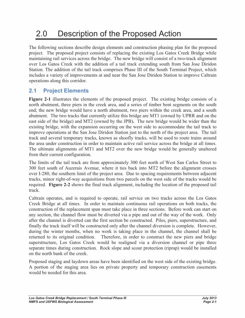
2.0 Description of the Proposed Action The following sections describe design elements and construction phasing plan for the proposed project. The proposed project consists of replacing the existing Los Gatos Creek Bridge while maintaining rail services across the bridge. The new bridge will consist of a two-track alignment over Los Gatos Creek with the addition of a tail track extending south from San Jose Diridon Station. The addition of the tail track comprises Phase III of the South Terminal Project, which includes a variety of improvements at and near the San Jose Diridon Station to improve Caltrain operations along this corridor.
2.1 Project Elements Figure 2-1 illustrates the elements of the proposed project. The existing bridge consists of a north abutment, three piers in the creek area, and a series of timber bent segments on the south end; the new bridge would have a north abutment, two piers within the creek area, and a south abutment. The two tracks that currently utilize this bridge are MT1 (owned by UPRR and on the east side of the bridge) and MT2 (owned by the JPB). The new bridge would be wider than the existing bridge, with the expansion occurring on the west side to accommodate the tail track to improve operations at the San Jose Diridon Station just to the north of the project area. The tail track and several temporary tracks, known as shoofly tracks, will be used to route trains around the area under construction in order to maintain active rail service across the bridge at all times. The ultimate alignments of MT1 and MT2 over the new bridge would be generally unaltered from their current configuration.
The limits of the tail track are from approximately 300 feet north of West San Carlos Street to 300 feet south of Auzerais Avenue, where it ties back into MT2 before the alignment crosses over I-280, the southern limit of the project area. Due to spacing requirements between adjacent tracks, minor right-of-way acquisitions from two parcels on the west side of the tracks would be required. Figure 2-2 shows the final track alignment, including the location of the proposed tail track.
Caltrain operates, and is required to operate, rail service on two tracks across the Los Gatos Creek Bridge at all times. In order to maintain continuous rail operations on both tracks, the construction of the replacement span must take place in three sections. Before work can start on any section, the channel flow must be diverted via a pipe and out of the way of the work. Only after the channel is diverted can the first section be constructed. Piles, piers, superstructure, and finally the track itself will be constructed only after the channel diversion is complete. However, during the winter months, when no work is taking place in the channel, the channel shall be returned to its original condition. Therefore, in order to construct the new piers and bridge superstructure, Los Gatos Creek would be realigned via a diversion channel or pipe three separate times during construction. Rock slope and scour protection (riprap) would be installed on the north bank of the creek.
Proposed staging and laydown areas have been identified on the west side of the existing bridge. A portion of the staging area lies on private property and temporary construction easements would be needed for this area.

Cha
pter
2
D
escr
iptio
n of
the
Prop
osed
Act
ion
Los
Gat
os C
reek
Brid
ge R
epla
cem
ent /
Sou
th T
erm
inal
Pha
se II
I Ju
ly 2
013
NM
FS a
nd U
SFW
S B
iolo
gica
l Ass
essm
ent
Page
2-2
Figu
re 2
-1 L
os G
atos
Cre
ek B
ridge
Rep
lace
men
t / S
outh
Ter
min
al P
hase
III P
roje
ct S
ite P
lan

Cha
pter
2
D
escr
iptio
n of
the
Prop
osed
Act
ion
Los
Gat
os C
reek
Brid
ge R
epla
cem
ent /
Sou
th T
erm
inal
Pha
se II
I Ju
ly 2
013
NM
FS a
nd U
SFW
S B
iolo
gica
l Ass
essm
ent
Page
2-3
Figu
re 2
-2 F
inal
Tra
ck A
lignm
ent

Chapter 2 Description of the Proposed Action
Los Gatos Creek Bridge Replacement / South Terminal Phase III July 2013 NMFS and USFWS Biological Assessment Page 2-4
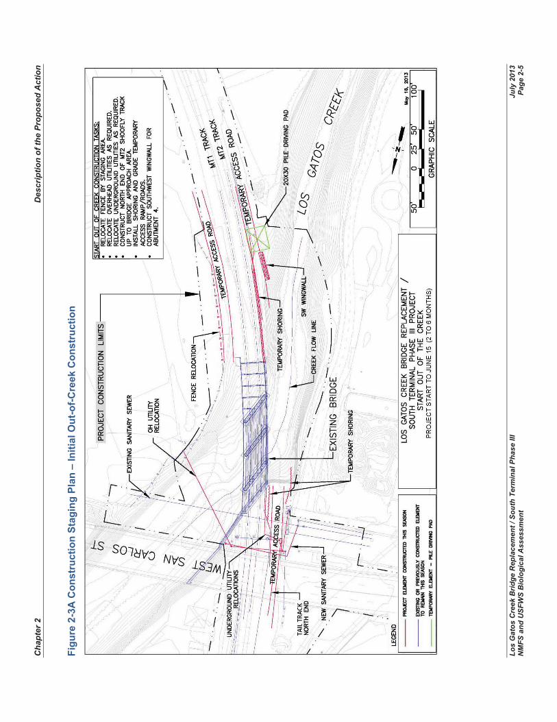
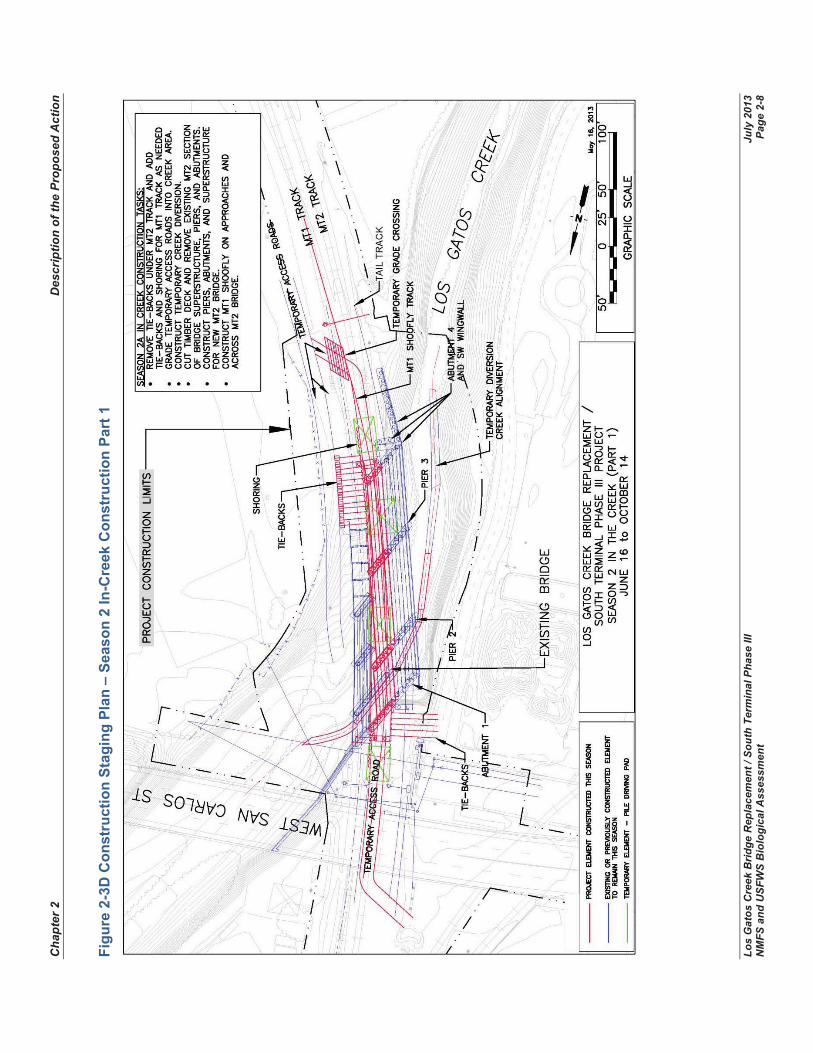
2.2 Construction Staging Replacement of the Los Gatos Creek railroad bridge has an estimated duration of approximately 24 months starting in 2015. The project’s construction staging has been designed so that all work in the stream bed will be completed in the summer period (June 15th to October 15th) to minimize impacts to the creek and wildlife. The June 15th through October 15th period is due to the salmonid migration and spawning periods that occurs outside of this window. In order to meet this schedule, National Environmental Policy Act and California Environmental Quality Act clearance shall be completed by early 2014. The construction stages and major work elements are illustrated in Figures 2-3A through 2-3F and outlined in Table 2-1.
Table 2-1 Construction Stage Work Elements
Construction Stage
Time period for Work Construction Work Elements
1 – Initial out-of-creekconstruction
Project Start to June 15 (two to six months)
o Relocate fence by staging area o Relocate overhead and underground utilities as required o Construct north end of tail track up to bridge approach area o Install shoring and grade temporary access ramp/roads o Construct southwest wingwall for abutment 4
2 - Season 1 in-creek construction
June 16 to October 14
o Add tie-backs and shoring as needed o Grade temporary access roads into creek area o Construct temporary creek diversion, new sanitary sewer line under the creek, and
piers 2 and 3 for new tail track bridge o install precast abutments and southwest wingwall caps and remove tie-backs o adjust shoring and remove access ramps o reset channel flow
3 - Winter out-of-creekconstruction
October 15 to June 15
o Construct tail track bridge superstructure o Install tail track over new track bridge o Install new fiber optic and other electrical associated with new bridge o Cut in tail track at ends on train-free weekends and begin operations
4 - Season 2 in-creek construction
June 16 to October 14
o Remove tie-backs under MT2 track and add tie-backs and shoring for MT1 o Grade temporary access roads into creek area o Construct temporary creek diversion o Cut timber deck and remove existing MT2 section of bridge superstructure, piers, and
abutmentso Construct piers, abutments, and superstructure for new MT2 bridge o Construct MT1 shoofly on approaches and across MT2 bridge o Grade temporary access roads into creek area o Remove existing MT1 section of bridge superstructure, piers, and abutments o Construct piers and abutments for new MT1 bridge o Grade new creek channel, regrade upstream channel embankment, and place riprap o Remove access roads from creek area and regrade downstream channel
embankments5 - Finishout-of-creekconstruction
October 15 to projectcompletion
o Construct superstructure for new MT1 bridge o Construct new MT1 track on new bridge o Remove remaining access road segments o Remove temporary MT1 shoofly and return service to MT1 mainline track o Remove temporary tail track connection and return service to MT2 mainline track
Cha
pter
2
D
escr
iptio
n of
the
Prop
osed
Act
ion
Los
Gat
os C
reek
Brid
ge R
epla
cem
ent /
Sou
th T
erm
inal
Pha
se II
I Ju
ly 2
013
NM
FS a
nd U
SFW
S B
iolo
gica
l Ass
essm
ent
Page
2-5
Figu
re 2
-3A
Con
stru
ctio
n St
agin
g Pl
an –
Initi
al O
ut-o
f-Cre
ek C
onst
ruct
ion

Cha
pter
2
D
escr
iptio
n of
the
Prop
osed
Act
ion
Los
Gat
os C
reek
Brid
ge R
epla
cem
ent /
Sou
th T
erm
inal
Pha
se II
I Ju
ly 2
013
NM
FS a
nd U
SFW
S B
iolo
gica
l Ass
essm
ent
Page
2-6
Figu
re 2
-3B
Con
stru
ctio
n St
agin
g Pl
an –
Sea
son
1 In
-Cre
ek C
onst
ruct
ion

Cha
pter
2
D
escr
iptio
n of
the
Prop
osed
Act
ion
Los
Gat
os C
reek
Brid
ge R
epla
cem
ent /
Sou
th T
erm
inal
Pha
se II
I Ju
ly 2
013
NM
FS a
nd U
SFW
S B
iolo
gica
l Ass
essm
ent
Page
2-7
Figu
re 2
-3C
Con
stru
ctio
n St
agin
g Pl
an –
Win
ter O
ut-o
f-Cre
ek C
onst
ruct
ion
Cha
pter
2
D
escr
iptio
n of
the
Prop
osed
Act
ion
Los
Gat
os C
reek
Brid
ge R
epla
cem
ent /
Sou
th T
erm
inal
Pha
se II
I Ju
ly 2
013
NM
FS a
nd U
SFW
S B
iolo
gica
l Ass
essm
ent
Page
2-8
Figu
re 2
-3D
Con
stru
ctio
n St
agin
g Pl
an –
Sea
son
2 In
-Cre
ek C
onst
ruct
ion
Part
1

Cha
pter
2
D
escr
iptio
n of
the
Prop
osed
Act
ion
Los
Gat
os C
reek
Brid
ge R
epla
cem
ent /
Sou
th T
erm
inal
Pha
se II
I Ju
ly 2
013
NM
FS a
nd U
SFW
S B
iolo
gica
l Ass
essm
ent
Page
2-9
Figu
re 2
-3E
Con
stru
ctio
n St
agin
g Pl
an –
Sea
son
2 In
-Cre
ek C
onst
ruct
ion
Part
2

Cha
pter
2
D
escr
iptio
n of
the
Prop
osed
Act
ion
Los
Gat
os C
reek
Brid
ge R
epla
cem
ent /
Sou
th T
erm
inal
Pha
se II
I Ju
ly 2
013
NM
FS a
nd U
SFW
S B
iolo
gica
l Ass
essm
ent
Page
2-1
0
Figu
re 2
-3F
Con
stru
ctio
n St
agin
g Pl
an –
Fin
ish
Out
-of-C
reek
Con
stru
ctio
n

Los Gatos Creek Bridge Replacement / South Terminal Phase III July 2013 NMFS and USFWS Biological Assessment Page 3-1
3.0 Action Area The regulations governing consultations under the ESA define the “Action Area” as “all areas to be affected directly or indirectly by the Federal action and not merely the immediate area involved in the action” (51 Federal Register [FR] 19957). The Action Area should be determined based on consideration of all direct and indirect effects of the proposed agency action (project) (50 CFR 402.02 and 402.14[b][2]). Therefore, the Action Area (proposed project) is typically larger than the area directly affected by the action. The sections below describe the Action Area of the Los Gatos Creek Bridge Replacement Project.
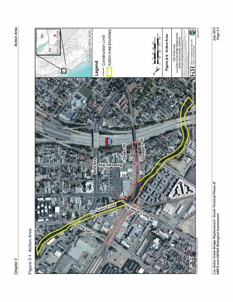
3.1 Location of the Action Area The Proposed Action (replacement of Los Gatos Creek Bridge) lies within Santa Clara County, California, approximately two miles west of downtown San Jose. The Action Area is generally bounded by the Caltrain San Jose Diridon Station to the north, Interstate 280 (I-280) to the south, Sunol Street to the west, and Royal Avenue on the east, occupies the width of the right-of-way (ROW) owned by JPB and extends a distance of approximately 0.4 mile. The Action Area lies within the low-relief Santa Clara Valley, at the south end of San Francisco Bay. Specifically, the Action Area has been identified as a ¼-mile distance upstream and downstream of construction to include indirect affects to water quality or dispersal movement of species covered in the BA (Figure 3-1).
The reach of Los Gatos Creek in the Action Area is tightly constricted by urbanization on both banks. The creek and railroad tracks crossing the Los Gatos Creek Bridge pass between an Orchard Supply Hardware (OSH) retail store and the former site of the Del Monte cannery which is currently a re-development property recently constructed as a residential townhome community. Specifically, the site is located in an un-sectionalized portion of Township 7 South, Range 1 East, as depicted on the San Jose West U.S. Geological Survey (USGS) 7.5’ topographic quadrangle (quad).
3.2 Existing Environment
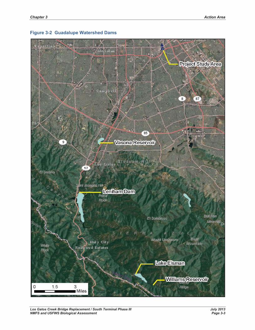
3.2.1 Hydrology and Water Quality Flow regulation by dams play a significant part in the hydrology of Los Gatos Creek. There are three major dams within the Guadalupe watershed – Lenihan Dam, Vasona Reservoir, and Williams Reservoir (see Figure 3-2).
The largest of these is Lenihan Dam (formerly known as Lexington Dam), which impounds up to 20,000 acre-feet in Lexington Reservoir where Los Gatos Creek exits the Santa Cruz Mountains 20 miles upstream of the project site (Balance Hydrologics 2009). Upstream of Lexington Reservoir is Lake Elsman with an original capacity of 6,200 acre-feet, now largely sedimented1.
1 Part of the runoff is diverted from Lake Elsman by the San Jose Water Works to their Montevina Filter Plant. Maximum production of the plant was 16,000 acre feet per year in 1988 (Iwatsubo et al. 1988 as cited in Balance Hydrologics), equivalent to an average diversion of 22 cfs when operating at the rated maximum.
Cha
pter
3
A
ctio
n A
rea
Los
Gat
os C
reek
Brid
ge R
epla
cem
ent /
Sou
th T
erm
inal
Pha
se II
I Ju
ly 2
013
NM
FS a
nd U
SFW
S B
iolo
gica
l Ass
essm
ent
Page
3-2
Figu
re 3
-1 A
ctio
n A
rea
Chapter 3 Action Area
Los Gatos Creek Bridge Replacement / South Terminal Phase III July 2013 NMFS and USFWS Biological Assessment Page 3-3
Figure 3-2 Guadalupe Watershed Dams
Chapter 3 Action Area
Los Gatos Creek Bridge Replacement / South Terminal Phase III July 2013 NMFS and USFWS Biological Assessment Page 3-4
Immediately upstream of Lake Elsman, and also owned by the San Jose Water Works company, is Williams Reservoir, with an original capacity of about 160 acre feet, now largely sedimented (Ritter and Brown 1971 as cited in Balance Hydrologics 2009). Vasona Reservoir, 3.5 miles downstream from Lenihan Dam, is a 400-acre-foot forebay regulating managed recharge through the bed of Los Gatos Creek and a nearby area that was once mined for gravel (creating floor pits) and has since been flooded. Low flows downstream of the recharge facilities are strongly affected by operations at Vasona Reservoir (Balance Hydrologics 2009).
The hydrology of the creek is greatly affected by the reservoirs upstream of the project site. In general, the dams have reduced high flows (greater than 65 cfs) and increased low flows (less than 65 cfs). Los Gatos Creek at the rail bridge is now classified as a perennial stream, but this appears to be largely due to reservoir releases over the dry season; prior to 1995, this section of Los Gatos Creek was often dry (Balance Hydrologics 2009). Recent late-summer base flows typically range between 1.5 and 3 cfs; prior to 1996 summer base flows were typically either very low or dry, although peak flows from the estimated two-year recurrence storm was approximately 1,300 cfs at the bridge (Balance Hydrologics 2009). The watershed area upstream of the bridge is 50.8 square miles, 13.9 square miles of which is downstream from Lexington Reservoir. Los Gatos Creek channel width varies from about 60 to 100 feet near the bridge and its bottom elevation is about 80 feet.
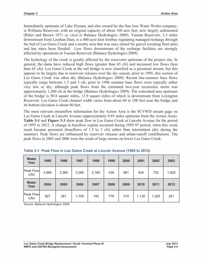
The most relevant streamflow information for the Action Area is the SCVWD stream gage on Los Gatos Creek at Lincoln Avenue (approximately 0.85 miles upstream from the Action Area). Table 3-1 and Figure 3-3 show peak flow in Los Gatos Creek at Lincoln Avenue for the period of 1995 to 2012. A change in baseflow regime occurred during 1995-97 period, when this creek reach became perennial (baseflows of 1.5 to 3 cfs) rather than intermittent (dry during the summer). Peak flows are influenced by reservoir releases and urban-runoff contributions. The peak flows in 2003 and 2006 were the result of large storms on lower Los Gatos Creek.
Table 3-1 Peak Flow in Los Gatos Creek at Lincoln Avenue (1995 to 2012)
Water Year 1995 1996 1997 1998 1999 2000 2001 2002 2003
Peak Flow (cfs) 4,980 2,360 2,060 2,160 439 881 424 752 1,920
Water Year 2004 2005 2006 2007 2008 2009 2010 2011 2012
Peak Flow (cfs) 927 381 1,700 140 779 315 1,130 1,220 251
Source: Balance Hydrologics 2009
Chapter 3 Action Area
Los Gatos Creek Bridge Replacement / South Terminal Phase III July 2013 NMFS and USFWS Biological Assessment Page 3-5
Figure 3-3 Peak Flow in Los Gatos Creek at Lincoln Avenue (1995 to 2012)
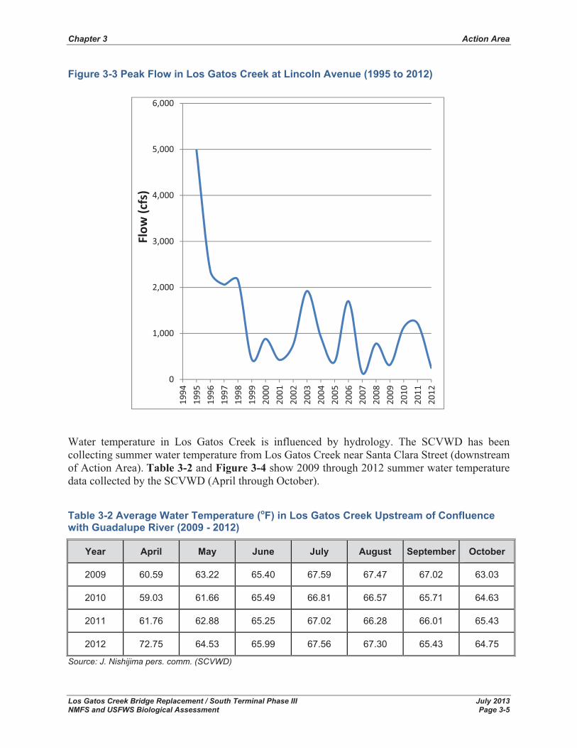
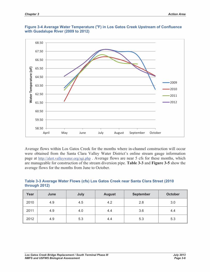
Water temperature in Los Gatos Creek is influenced by hydrology. The SCVWD has been collecting summer water temperature from Los Gatos Creek near Santa Clara Street (downstream of Action Area). Table 3-2 and Figure 3-4 show 2009 through 2012 summer water temperature data collected by the SCVWD (April through October).
Table 3-2 Average Water Temperature (oF) in Los Gatos Creek Upstream of Confluence with Guadalupe River (2009 - 2012)
Year April May June July August September October
2009 60.59 63.22 65.40 67.59 67.47 67.02 63.03
2010 59.03 61.66 65.49 66.81 66.57 65.71 64.63
2011 61.76 62.88 65.25 67.02 66.28 66.01 65.43
2012 72.75 64.53 65.99 67.56 67.30 65.43 64.75
Source: J. Nishijima pers. comm. (SCVWD)
0
1,000
2,000
3,000
4,000
5,000
6,000
1994
1995
1996
1997
1998
1999
2000
2001
2002
2003
2004
2005
2006
2007
2008
2009
2010
2011
2012
Flow
�(cfs)
Chapter 3 Action Area
Los Gatos Creek Bridge Replacement / South Terminal Phase III July 2013 NMFS and USFWS Biological Assessment Page 3-6
Figure 3-4 Average Water Temperature (oF) in Los Gatos Creek Upstream of Confluence with Guadalupe River (2009 to 2012)
Average flows within Los Gatos Creek for the months where in-channel construction will occur were obtained from the Santa Clara Valley Water District’s online stream gauge information page at http://alert.valleywater.org/sgi.php . Average flows are near 5 cfs for these months, which are manageable for construction of the stream diversion pipe. Table 3-3 and Figure 3-5 show the average flows for the months from June to October.
Table 3-3 Average Water Flows (cfs) Los Gatos Creek near Santa Clara Street (2010 through 2012)
Year June July August September October
2010 4.9 4.5 4.2 2.8 3.0
2011 4.9 4.0 4.4 3.6 4.4
2012 4.9 5.3 4.4 5.3 5.3
58.50
59.50
60.50
61.50
62.50
63.50
64.50
65.50
66.50
67.50
68.50
April May June July August September October
Water�Tem
perature�(o
F)
2009
2010
2011
2012

Chapter 3 Action Area
Los Gatos Creek Bridge Replacement / South Terminal Phase III July 2013 NMFS and USFWS Biological Assessment Page 3-7
Figure 3-5 Average Flows (cfs) in Los Gatos Creek, 2010-2012
A 19-mile segment of Los Gatos Creek, including the section of Los Gatos Creek within the Action Area, is listed as impaired and having an approved total maximum daily load (TMDL) for diazinon (USEPA 2007). The sources of the diazinon in the project area are urban runoff and storm sewers. Diazinon, an organophosphorus insecticide, is readily transported as a free substance dissolved in water, and does not readily adsorb to soil particles. The half-life of diazinon ranges from approximately 70 hours to 12 weeks in surface water and 10 to 200 days in soil (ASTR 2006).
GANDA (2008) found trash and homeless camp debris along Los Gatos Creek within the project site. Previously the Guadalupe-Coyote Resource Conservation District (2005) petitioned the City of San Jose, SCVWD, and California Department of Fish and Wildlife to remove and prevent the continuous presence of homeless encampments along creeks in San Jose that results in substantial pollution of the creeks. The homeless discard shopping carts, furniture, hypodermic needles, car parts, clothing, personal hygiene products and other wastes directly into the creeks. They also use the creeks as their toilets and showers. On October 28, 2010, HDR staff noted that there were still homeless camped along Los Gatos Creek within the project site.
3.2.2 Groundwater The Action Area is within the Santa Clara Valley Groundwater Basin, Santa Clara Subbasin. Generally, the topography around the Action Area slopes from southern end of the Santa Clara Valley to the north. The Santa Clara subbasin consists of a series of stacked alluvial aquifers and aquitards that collectively have fairly well defined boundaries in the lateral direction. The bottom boundary is less well-defined due to a lack of depth-to-bedrock information in the center of the sub-basin. Hydrogeologically, the subbasin is generally divided into confined and unconfined areas and a zone of special concern containing saline water of poor quality (SCVWD 1989 ascited in Parsons 2009). Aquifer materials on top of a thick clay layer are considered unconfined (water table at atmospheric pressure), while aquifer materials beneath the thick clay layer are confined, or under hydrostatic pressure (Parsons 2009).
2.0
2.5
3.0
3.5
4.0
4.5
5.0
5.5
July August September October
Average��Flow�(cfs)
2010
2011
2012
Chapter 3 Action Area
Los Gatos Creek Bridge Replacement / South Terminal Phase III July 2013 NMFS and USFWS Biological Assessment Page 3-8
The Action Area is located at the confined area that is characterized by upper and lower aquifers divided by discontinuous and laterally extensive low permeability materials such as clays, silty clays, silts and silty sands that restrict the vertical flow of groundwater (Parsons 2009). Previous investigations in and around the Action Area have measured groundwater 24 to 25 feet below the ground surface (Elevation 73) during drilling in 1999 and 2005 (Golder Associates 2005 and Vasona Light Rail Project 1999 as cited in MACTEC 2010). The historical high ground water in the area has been also reported to be about 25 feet below the ground surface (California Geologic Survey, formerly Division of Mines and Geology, Seismic Hazard Zone Report for San Jose West 2002 as cited in MACTEC 2010).
3.2.3 Stormwater Storm water runoff reaches the San Jose’s streets via overland flow or downspouts, and travels in street gutters until reaching storm drain inlets. The storm drain pipe network discharges either by gravity directly to a surface water body or to a facility that pumps the water into a surface water body or another storm drain.
Storm drainage facilities in the Action Area are owned and maintained by the City of San Jose. The SCVWD has jurisdiction over Los Gatos Creek. Existing stormwater drainage facilities in the project area include the following pipes that outfall directly to Los Gatos Creek:
� 18-inch outfall to Los Gatos Creek at Auzerais Street from the east
� 33-inch outfall to Los Gatos Creek at West San Carlos Street from the west
� 18-inch outfall to Los Gatos Creek at West San Carlos Street from the east
The nearest storm drain pump station to the project site is located at Park Avenue at Los Gatos Creek. Discharges from these outfalls are covered under the MS4 permit (National Pollutant Discharge Elimination System (NPDES) Permit No. CAS029718) to discharge stormwater to South San Francisco Bay.
With respect to stormwater quality, new developments must also comply with the municipal regional stormwater NPDES permit (CAS029718) with the San Francisco Bay Regional Water Quality Control Board (RWQCB). The Santa Clara Valley Urban Runoff Pollution Prevention Program has published a guide titled, C.3 Stormwater Handbook to assist developers in meeting with the requirements of discharges. The City of San Jose has ordinances and policies to address the management of urban runoff.
3.2.4 Geology and Geomorphology The Proposed Action is situated in northern Santa Clara County in Santa Clara Valley south of San Francisco Bay. The area is located within the Coast Ranges geomorphic province. Northwest trending mountain ranges and intervening valleys characterize the province. Santa Clara Valley is underlain at depth by bedrock of the Mesozoic and Early Tertiary Franciscan Assemblage, consisting of a complex of sedimentary, igneous, and metamorphic rocks mixed together in a subduction zone and uplifted to their present positions. Overlying the Franciscan Assemblage are sedimentary and volcanic deposits of Tertiary age and surficial deposits including alluvium, Bay Mud, and man-placed fill. The northern Santa Clara Valley is predominately sands and gravels (alluvium) deposited from streams and rivers during relatively low sea levels interbedded with

Chapter 3 Action Area
Los Gatos Creek Bridge Replacement / South Terminal Phase III July 2013 NMFS and USFWS Biological Assessment Page 3-9
silts and clays (Bay Mud) deposited during high sea levels (Weese 2001 as cited in MACTEC 2010).
The Action Area is characterized by high seismicity. This is due to the proximity of the San Andreas Fault System of which several faults are in the vicinity of the Action Area. Active faults include the San Andreas, San Gregorio, and Monte Vista-Shannon Faults to the southwest, and the Hayward and Calaveras Faults to the northeast of the Action Area. All of these faults are capable of generating severe ground shaking in the event of a strong earthquake, which is likely during the lifetime of the bridge (MACTEC 2010).
Geologic units in the vicinity of the Action Area are alluvial fan, flood plain, flood basin, natural levee, and stream channel deposits, all of Holocene age. Los Gatos Creek is located on Holocene alluvial fan deposits and bridges Holocene stream channel deposits. The ground surface in this area has subsided 6 to 8 feet over the past century due to ground water extraction in the Santa Clara Valley (Galloway et al. 2000).
MACTEC (2010) found that the subsurface conditions at the bridge abutments can be 2.5 to 7 feet of fill over clayey sands, sandy clays, and poorly graded sand and gravels to the depths explored (86 feet maximum). The sands and gravels are generally medium dense to very dense in consistency. Clays are generally medium stiff to very stiff. The soils around the creek channel are predominantly sandy clay and clayey or silty sands. At the riverbed, the surficial soils have considerably less fines and are predominantly sands and gravels.
Los Gatos Creek is one of several major watercourses that drain the east side of the Santa Cruz Mountains and eventually flow to San Francisco Bay. Los Gatos Creek can be divided into two main sections. In the headwater portion, the creek occasionally flows over bedrock through the Santa Cruz Mountains, tightly constrained in a narrow valley. The creek flows northwest through the San Andreas fault zone, until its course turns north and enters Lexington Reservoir. The lower portion of Los Gatos Creek flows north-northeast across the Santa Clara Valley over alluvial sediments on its way to joining the Guadalupe River and finally flowing out over bay muds to the southern end of San Francisco Bay (Balance Hydrologics 2009).
This lower gradient portion of Los Gatos Creek is 12.8 miles long and flows through the urban and suburban communities of Los Gatos, Campbell, and San Jose. Much of this lower watershed area is residential or commercial development with the percentage of impervious area greater than 40 percent for much of the watershed (SCVWD 2006 as cited in Balance Hydrologics 2009). Channel modification is extensive and pervasive, with 31 percent of the creek below Lenihan Dam having been hardened (SCVWD 2006 as cited in Balance Hydrologics 2009).
Prior to western settlement in the early 19th century, Los Gatos Creek had a braided plan form and a wide floodplain for the first several miles after leaving its mountainous canyon. As the creek became less steep, the pattern of flow transitioned to a more broadly meandering plan form before joining the Guadalupe River about one-quarter mile downstream of the rail bridge in what was then a hydrologically diffuse willow swamp. Channel straightening, incision and other types of modification had begun by the late 19th century as the area urbanized, with the fastest growth during the 1960’s, but continuing to increase through the 1990’s (SCVWD 2006 as cited inBalance Hydrologics 2009).
Some of the significant history of manipulation of the creek includes substantial gravel mining in 1877 (SCVWD 2006 as cited in Balance Hydrologics 2009). By 1888, the lowest thousand feet
Chapter 3 Action Area
Los Gatos Creek Bridge Replacement / South Terminal Phase III July 2013 NMFS and USFWS Biological Assessment Page 3-10
of Los Gatos Creek (which corresponds to the Action Area) had been straightened and its width had been doubled to provide flood protection; the channel dimensions were reported as 66 feet average width and 13.5 feet of depth (SCVWD 2006 as cited in Balance Hydrologics 2009). The current channel is approximately 20 feet deep, so this suggests incision since 1888, in addition to possible incision from gravel mining prior to 1888 (Balance Hydrologics 2009).
There is an old channel of Los Gatos Creek between Vasona Reservoir and the Action Area on the east side of the current channel. This channel is mentioned in histor records (SCVWD 2006 as cited in Balance Hydrologics 2009) and is still detectable in aerial photographs despite residential development. The street that runs along this former creek bed is named Dry Creek Road; relict meander geometry can be observed in the curvature of this street.
3.2.5 Land Use As described above, the reach of Los Gatos Creek in the Action Area is tightly constricted by urbanization on both banks. The Action Area includes railroad tracks and associated gravel track rights-of-way, roadways, parking lots, building fronts, and landscaped areas along building fronts. The creek and railroad tracks pass between an OSH retail store and the former site of the Del Monte cannery which is currently a re-development property actively under construction as a multi-use project.
The Action Area has very little vegetation, except for small landscaped areas. Along the margins of the creek, willow riparian forest and scrub can be found. Trash and homeless camp debris are present throughout the Action Area (GANDA 2008).
3.2.6 Fish Habitat and Fish Community Description The streambanks of Los Gatos Creek are steep and unconsolidated but naturally armor themselves with cobbles as the finer sediments are eroded away (MACTEC 2010).
Los Gatos Creek is a regulated, perennial stream, with daily fluctuating flows. During a field visit by HDR biologists on October 28, 2010, flows within Los Gatos Creek were visibly altered within the period of an hour. During a September 16, 2008 field site visit by Balance Hydrologics (2010), during late-summer baseflow conditions occurring in a dry year, streamflow was approximately 1 cfs.
Instream habitat within Los Gatos Creek is considered good (GANDA 2008). There is a suitable mix of riffle-run-pool sequences and gravel/cobble dominate the substrate, although fines are also present. Balance Hydrologics (2010) noted that the pool-to-riffle spacing in the Action Area is approximately 200-250 ft. Geomorphically, the existing bridge straddles a pool-glide reach of Los Gatos Creek, with water depths of up to 3 feet. The two riffles bounding the bridge pool-glide reach are composed of concrete slabs that either fell into or were placed in the creek and now act as grade control which is immobile under all but the largest streamflows. Pools were up to 3 feet deep at baseflow conditions (Balance Hydrologics 2010).
Well-sorted cobbles and coarse gravel make up the channel bed over the majority of the channel surveyed. Variations in the grain size within different habitat units (i.e. riffles or heads or tails of pools) were not immediately apparent. Outside of, but near the wetted bed, frequent gravel patches are present. The grain sizes within these patches were well-sorted and seemed to be dominated by either fine-coarse gravel or coarse gravel-fine cobbles. Well-sorted sand deposits were found on benches several feet above the channel bottom (Balance Hydrologics 2010).

Chapter 3 Action Area
Los Gatos Creek Bridge Replacement / South Terminal Phase III July 2013 NMFS and USFWS Biological Assessment Page 3-11
Riparian shade and overhanging bank vegetation are present and compliment the instream habitat (GANDA 2008). Water quality may be poor at times, but there are no signs of eutrophication (i.e., mat or filamentous algal growth). Siltation and other urban runoff-related problems exist in Los Gatos Creek within the Action Area. In June 2007, USEPA Region IX issued the final 2006 CWA Section 303(d) list of water quality limited (“impaired”) segments requiring total maximum daily loads (TMDLs) (USEPA 2007). Los Gatos Creek is listed as impaired by diazinon from urban runoff and storm sewers; the creek has approved TMDLs for diazinon.
Based on the species composition in Guadalupe River, the fish community within the Action Area likely includes both native and introduced fishes (J. Nishijima SCVWD, pers. comm.) In addition to fall-run Chinook salmon and Central Coast steelhead, the native resident fish in the Guadalupe River and its tributaries (including Los Gatos Creek) include Sacramento sucker (Catostomus occidentalis), California roach (Lavinia symmetricus), prickly sculpin (Cottusasper), and Pacific lamprey (Lampetra tridentate). Los Gatos Creek also supports introduced species, including largemouth bass (Micropterus salmoides), bluegill (Lepomis macrochirus), green sunfish (Lepomis cyanellus), goldfish (Carassius auratus), carp (Cyprinus carpio),mosquitofish (Gambusia affinis), brown bullhead (Ictalurus nebulosus), and pumpkinseed (Lepomis gibbosus).
During a biological reconnaissance survey of the Action Area on October 28, 2010, several fish and other aquatic species were observed, including, roach, mosquitofish, sunfish (Lepomis sp.), as well as crayfish (unknown epithat).
3.2.7 Terrestrial Habitat Types/Vegetation Communities The Action Area is generally bordered by an urban/suburban area that includes railroad tracks, roadways, parking lots, buildings, and landscaped areas. These areas have very little vegetation, except for small landscaped areas. A habitat map of the Action Area is included as Figure 3-6.Two types of terrestrial habitat occur within the Action Area: urban/suburban and willow riparian forest and scrub2. Urban/suburban areas include railroad tracks and the gravel track ROW, roadways, parking lots, building fronts, the San Jose municipal multi-use trail along the left bank of Los Gatos Creek, and landscaped areas along building fronts. Urban/suburban areas within the Action Area are either barren of vegetation or contain horticultural species in narrow landscape strips such as around buildings and along the multi-use trail. Urban/suburban areas provide little to no habitat value for wildlife.
The remainder of the terrestrial habitat within the Action Area consists of willow riparian forest and scrub. The riparian habitats in the Action Area are comprised of tree and herbaceous species, including willow (Salix laevigata), Fremont cottonwood (Populus fremontii), tree of heaven (Ailanthus altissima), black locust (Robinia pseudoacacia), box elder (Acer negundo),California walnut (Juglans californica ), Himalayan blackberry (Rubus discolor), and California blackberry (Rubus ursinus).Willow riparian forest and scrub habitat types occur along the margins of active channels on intermittent and perennial streams. The creek corridor is highly disturbed and predominately supports non-native riparian vegetation with occasional native trees and shrubs.
2 Willow riparian forest and scrub habitats are natural communities and equivalent to sensitive natural communities as defined by the CDFW.

Cha
pter
3
A
ctio
n A
rea
Los
Gat
os C
reek
Brid
ge R
epla
cem
ent /
Sou
th T
erm
inal
Pha
se II
I Ju
ne 2
013
NM
FS a
nd U
SFW
S B
iolo
gica
l Ass
essm
ent
Page
3-1
2
Figu
re 3
-6 H
abita
t Typ
es w
ithin
Act
ion
Are
a
Chapter 3 Action Area
Los Gatos Creek Bridge Replacement / South Terminal Phase III July 2013 NMFS and USFWS Biological Assessment Page 2-13
The dominant tree species occurring within this habitat in the Action Area include yellow willow (Salix lasiandra), red willow, Fremont cottonwood, tree of heaven, black locust, box elder, and California black walnut. Understory vegetation within this community was dominated by Himalayan blackberry and California blackberry in patches as well as a variety of non-native grasses and forbs.
The willow riparian forest and scrub habitat within the Action Area is heavily disturbed by human activity; there is a homeless camp providing shelter for numerous humans and pets downstream of the West San Carlos Street Bridge and numerous other small homeless camps occur up and down Los Gatos Creek within the Action Area. Trash, dogs, and feral cats are prevalent within the riparian habitat.
3.2.8 Sensitive Natural Communities/Wetlands and Waters of the U.S. Within the Action Area, Los Gatos Creek and its associated willow riparian forest and scrub habitats meet the criteria of sensitive natural communities as defined by CDFW. Los Gatos Creek is also a water of the U.S. subject to U.S. Army Corps of Engineers (USACE), RWQCB, and CDFW jurisdiction.
A delineation of wetlands and other waters of the U.S. occurring within the Action Area was conducted in 2010 and submitted to the USACE in 2013. All areas were assessed to the degree necessary to determine the presence or absence of jurisdictional waters of the U.S. in the Action Area. Potentially jurisdictional waters of the U.S. occupy a total of 0.87 acres within the Action Area (Table 3-4). No wetland features were detected within the Action Area. The results of this delineation are preliminary until verified by the USACE.
Table 3-4 Acreage of Waters of the U.S. in the Action Area
Feature Length Average Width Area
Los Gatos Creek 1,141 feet 20 feet 0.87 acres/
37,783 square feet

Chapter 3 Action Area
Los Gatos Creek Bridge Replacement / South Terminal Phase III July 2013 NMFS and USFWS Biological Assessment Page 2-14
This page left blank intentionally
Los Gatos Creek Bridge Replacement / South Terminal Phase III June 2013 NMFS and USFWS Biological Assessment Page 4-1
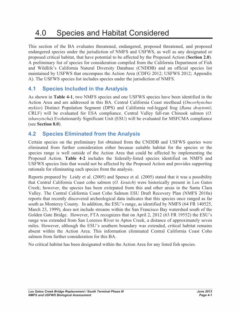
4.0 Species and Habitat Considered This section of the BA evaluates threatened, endangered, proposed threatened, and proposed endangered species under the jurisdiction of NMFS and USFWS, as well as any designated or proposed critical habitat, that have potential to be affected by the Proposed Action (Section 2.0). A preliminary list of species for consideration compiled from the California Department of Fish and Wildlife’s California Natural Diversity Database (CNDDB) and an official species list maintained by USFWS that encompass the Action Area (CDFG 2012; USFWS 2012; Appendix A). The USFWS species list includes species under the jurisdiction of NMFS.
4.1 Species Included in the Analysis As shown in Table 4-1, two NMFS species and one USFWS species have been identified in the Action Area and are addressed in this BA. Central California Coast steelhead (Oncorhynchusmykiss) Distinct Population Segment (DPS) and California red-legged frog (Rana draytonii;CRLF) will be evaluated for ESA compliance. Central Valley fall-run Chinook salmon (O.tshawytscha) Evolutionarily Significant Unit (ESU) will be evaluated for MSFCMA compliance (see Section 8.0).
4.2 Species Eliminated from the Analysis Certain species on the preliminary list obtained from the CNDDB and USFWS queries were eliminated from further consideration either because suitable habitat for the species or the species range is well outside of the Action Area that could be affected by implementing the Proposed Action. Table 4-2 includes the federally-listed species identified on NMFS and USFWS species lists that would not be affected by the Proposed Action and provides supporting rationale for eliminating each species from the analysis.
Reports prepared by Leidy et al. (2005) and Spence et al. (2005) stated that it was a possibility that Central California Coast coho salmon (O. kisutch) were historically present in Los Gatos Creek; however, the species has been extirpated from this and other areas in the Santa Clara Valley. The Central California Coast Coho Salmon ESU Draft Recovery Plan (NMFS 2010a) reports that recently discovered archeological data indicates that this species once ranged as far south as Monterey County. In addition, the ESU’s range, as identified by NMFS (64 FR 140525, March 23, 1999), does not include streams within the San Francisco Bay watershed south of the Golden Gate Bridge. However, FTA recognizes that on April 2, 2012 (63 FR 19552) the ESU’s range was extended from San Lorenzo River to Aptos Creek, a distance of approximately seven miles. However, although the ESU’s southern boundary was extended, critical habitat remains absent within the Action Area. This information eliminated Central California Coast Coho salmon from further consideration for this BA.
No critical habitat has been designated within the Action Area for any listed fish species.
Chapter 4 Species and Habitat Considered
Los Gatos Creek Bridge Replacement / South Terminal Phase III June 2013 NMFS and USFWS Biological Assessment Page 4-2
Table 4-1 Species Potentially Occurring within the Action Area
SpeciesFederalStatus Critical Habitat Habitat Association
Potential for Occurrence
NMFS Species
Central California Coast Steelhead DPS
T
No designated critical habitat in the Action Area (70 FR 52488-52536, September 2, 2005)
Drainages of San Francisco, San Pablo, and Suisun bays eastward to Chipps Island at confluence of the Sacramento and San Joaquin rivers.
Likely; the Action Area overlaps the range of the species.
Central Valley fall-run Chinook salmon ESU
FSC,MSFCMAmanaged species
Essential Fish Habitat
Drainages of Sacramento and San Joaquin rivers. San Francisco, San Pablo, and Suisun bays eastward to Chipps Island.
Likely; the Action Area overlaps the range of the species. Species is known to stray into Los Gatos Creek.
USFWS Species
California red-legged frog T
No designated critical habitat in the Action Area
Species occupies a fairly distinct habitat, combining both specific aquatic and riparian components. The adults require dense, shrubby or emergent riparian vegetation closely associated with deep (greater than 2 1/3-foot deep) still or slow moving water. The largest densities of California red-legged frog are associated with deep-water pools with dense stands of overhanging willows (Salix spp.) and an intermixed fringe of cattails (Typha latifolia). Well-vegetated terrestrial areas within the riparian corridor may provide important sheltering habitat during winter. Species aestivate (enter a dormant state during summer or dry weather) in small mammal burrows and moist leaf litter. They have been found up to 100 feet from water in adjacent dense riparian vegetation. Studies have indicated that this species can not inhabit water bodies that exceed 70° F, especially if there are no cool, deep portions (USFWS 2002).
Likely; although nearest occurrence is seven miles away from Action Area; Action Area has potential habitat. Has been known to disperse distances up to 2.9 km (1.8 mi) from the breeding site to sites within stream systems.
T=Federally Threatened FSC = Federal Species of Concern MSFCMA = -Stevens Fishery Conservation and Management Act
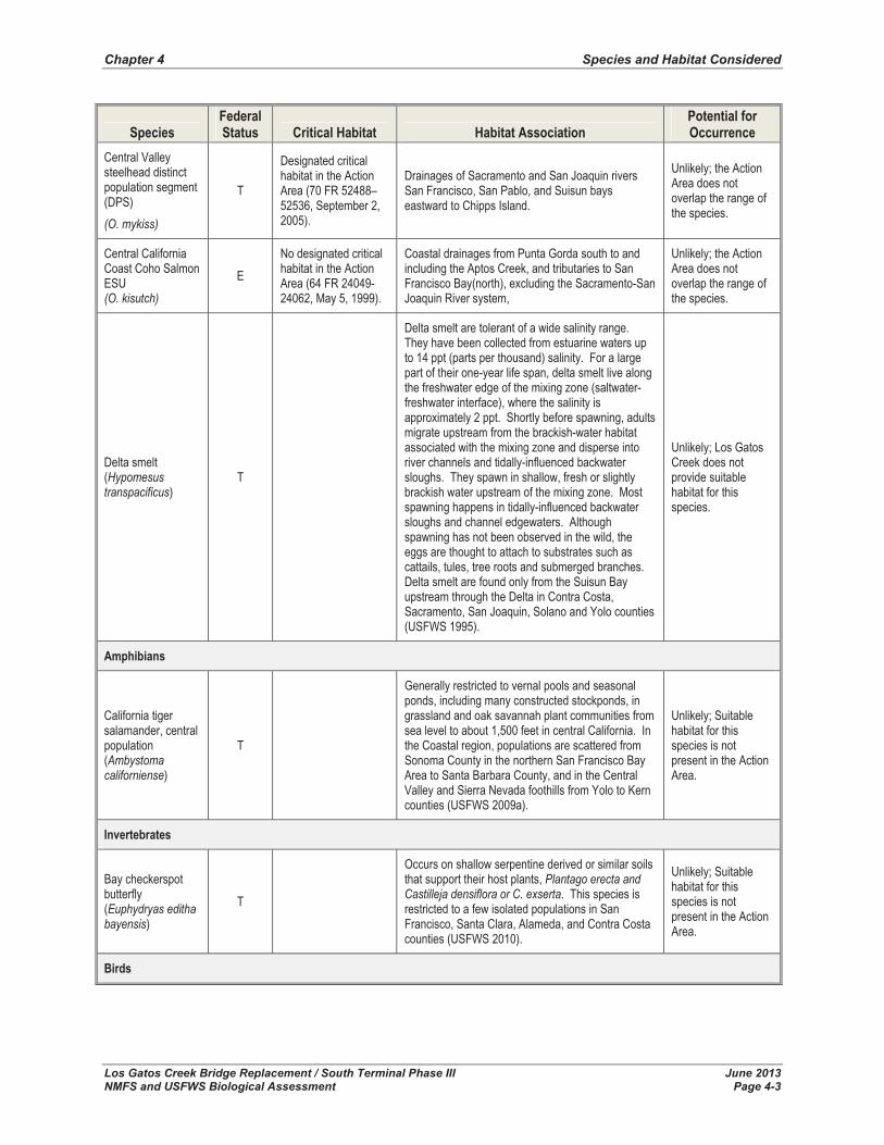
Table 4-2 Federally-Listed Species Dismissed from Further Consideration
SpeciesFederalStatus Critical Habitat Habitat Association
Potential for Occurrence
Fish
Central Valley spring-run Chinook salmon ESU (O. tshawytscha)
T
No designated critical habitat in the Action Area (70 FR 52488–52536, September 2, 2005).
Drainages of Sacramento and San Joaquin rivers. San Francisco, San Pablo, and Suisun bays eastward to Chipps Island.
Unlikely; the Action Area does not overlap the range of the species
Sacramento River winter-run Chinook salmon ESU (O .tshawytscha)
E
No designated critical habitat in the Action Area (58 FR 33212–33219, June 16, 1993).
Drainages of Sacramento river. San Francisco, San Pablo, and Suisun bays eastward to Chipps Island.
Unlikely; the Action Area does not overlap the range of the species
Chapter 4 Species and Habitat Considered
Los Gatos Creek Bridge Replacement / South Terminal Phase III June 2013 NMFS and USFWS Biological Assessment Page 4-3
SpeciesFederalStatus Critical Habitat Habitat Association
Potential for Occurrence
Central Valley steelhead distinct population segment (DPS)(O. mykiss)
T
Designated critical habitat in the Action Area (70 FR 52488– 52536, September 2, 2005).
Drainages of Sacramento and San Joaquin rivers San Francisco, San Pablo, and Suisun bays eastward to Chipps Island.
Unlikely; the Action Area does not overlap the range of the species.
Central California Coast Coho Salmon ESU(O. kisutch)
ENo designated critical habitat in the Action Area (64 FR 24049-24062, May 5, 1999).
Coastal drainages from Punta Gorda south to and including the Aptos Creek, and tributaries to San Francisco Bay(north), excluding the Sacramento-San Joaquin River system,
Unlikely; the Action Area does not overlap the range of the species.
Delta smelt (Hypomesus transpacificus)
T
Delta smelt are tolerant of a wide salinity range. They have been collected from estuarine waters up to 14 ppt (parts per thousand) salinity. For a large part of their one-year life span, delta smelt live along the freshwater edge of the mixing zone (saltwater-freshwater interface), where the salinity is approximately 2 ppt. Shortly before spawning, adults migrate upstream from the brackish-water habitat associated with the mixing zone and disperse into river channels and tidally-influenced backwater sloughs. They spawn in shallow, fresh or slightly brackish water upstream of the mixing zone. Most spawning happens in tidally-influenced backwater sloughs and channel edgewaters. Although spawning has not been observed in the wild, the eggs are thought to attach to substrates such as cattails, tules, tree roots and submerged branches. Delta smelt are found only from the Suisun Bay upstream through the Delta in Contra Costa, Sacramento, San Joaquin, Solano and Yolo counties (USFWS 1995).
Unlikely; Los Gatos Creek does not provide suitable habitat for this species.
Amphibians
California tiger salamander, central population (Ambystoma californiense)
T
Generally restricted to vernal pools and seasonal ponds, including many constructed stockponds, in grassland and oak savannah plant communities from sea level to about 1,500 feet in central California. In the Coastal region, populations are scattered from Sonoma County in the northern San Francisco Bay Area to Santa Barbara County, and in the Central Valley and Sierra Nevada foothills from Yolo to Kern counties (USFWS 2009a).
Unlikely; Suitable habitat for this species is not present in the Action Area.
Invertebrates
Bay checkerspot butterfly (Euphydryas editha bayensis)
T
Occurs on shallow serpentine derived or similar soils that support their host plants, Plantago erecta and Castilleja densiflora or C. exserta. This species is restricted to a few isolated populations in San Francisco, Santa Clara, Alameda, and Contra Costa counties (USFWS 2010).
Unlikely; Suitable habitat for this species is not present in the Action Area.
Birds
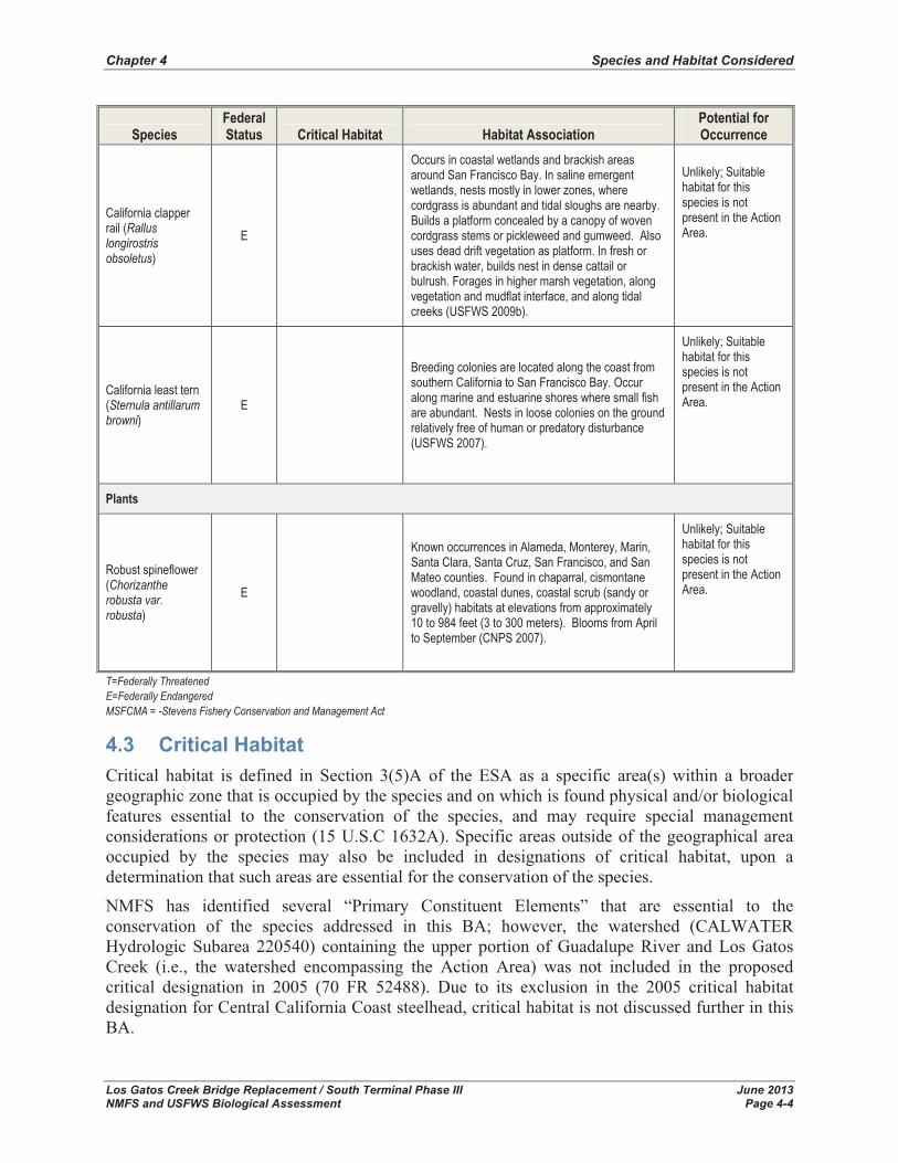
Chapter 4 Species and Habitat Considered
Los Gatos Creek Bridge Replacement / South Terminal Phase III June 2013 NMFS and USFWS Biological Assessment Page 4-4
SpeciesFederalStatus Critical Habitat Habitat Association
Potential for Occurrence
California clapper rail (Rallus longirostris obsoletus)
E
Occurs in coastal wetlands and brackish areas around San Francisco Bay. In saline emergent wetlands, nests mostly in lower zones, where cordgrass is abundant and tidal sloughs are nearby. Builds a platform concealed by a canopy of woven cordgrass stems or pickleweed and gumweed. Also uses dead drift vegetation as platform. In fresh or brackish water, builds nest in dense cattail or bulrush. Forages in higher marsh vegetation, along vegetation and mudflat interface, and along tidal creeks (USFWS 2009b).
Unlikely; Suitable habitat for this species is not present in the Action Area.
California least tern (Sternula antillarum browni)
E
Breeding colonies are located along the coast from southern California to San Francisco Bay. Occur along marine and estuarine shores where small fish are abundant. Nests in loose colonies on the ground relatively free of human or predatory disturbance (USFWS 2007).
Unlikely; Suitable habitat for this species is not present in the Action Area.
Plants
Robust spineflower (Chorizanthe robusta var. robusta)
E
Known occurrences in Alameda, Monterey, Marin, Santa Clara, Santa Cruz, San Francisco, and San Mateo counties. Found in chaparral, cismontane woodland, coastal dunes, coastal scrub (sandy or gravelly) habitats at elevations from approximately 10 to 984 feet (3 to 300 meters). Blooms from April to September (CNPS 2007).
Unlikely; Suitable habitat for this species is not present in the Action Area.
T=Federally Threatened E=Federally Endangered MSFCMA = -Stevens Fishery Conservation and Management Act
4.3 Critical Habitat Critical habitat is defined in Section 3(5)A of the ESA as a specific area(s) within a broader geographic zone that is occupied by the species and on which is found physical and/or biological features essential to the conservation of the species, and may require special management considerations or protection (15 U.S.C 1632A). Specific areas outside of the geographical area occupied by the species may also be included in designations of critical habitat, upon a determination that such areas are essential for the conservation of the species.
NMFS has identified several “Primary Constituent Elements” that are essential to the conservation of the species addressed in this BA; however, the watershed (CALWATER Hydrologic Subarea 220540) containing the upper portion of Guadalupe River and Los Gatos Creek (i.e., the watershed encompassing the Action Area) was not included in the proposed critical designation in 2005 (70 FR 52488). Due to its exclusion in the 2005 critical habitat designation for Central California Coast steelhead, critical habitat is not discussed further in this BA.
Chapter 4 Species and Habitat Considered
Los Gatos Creek Bridge Replacement / South Terminal Phase III June 2013 NMFS and USFWS Biological Assessment Page 4-5
Critical habitat was originally designated by USFWS on March 13, 2001 for CRLF and redesignated and reduced on April 13, 2006 (FR 71:19243). However, due to court challenges and questions about scientific validity, an increase in critical habitat for the CRLF was proposed by the USFWS in a news release on September 16, 2008 and again on March 17, 2010. The most recent critical habitat designation is more than three times larger (1,636,609 acres) than the 2006 rule it replaces, yet covers only 40 percent as much land as the USFWS designated in 2001 (USFWS 2010). Although the Action Area is located within the current and historic range of the CRLF (USFWS 2002), the Action Area is not located within a designated critical habitat unit (USFWS 2010). The closest designated critical habitat for CRLF to the Action Area is approximately eight miles east in the foothills. Given that this habitat is located well outside of the Action Area, effects of the Proposed Action on CRLF critical habitat is not discussed further in this document.
4.4 Essential Fish Habitat Essential Fish Habitat is defined as “those waters and substrate necessary to fish for spawning, breeding, feeding, or growth to maturity” (16 U.S.C. 1802[10]). “Waters” include aquatic areas and their associated physical, chemical, and biological properties that are used by fish, and may include areas historically used by fish where appropriate; “substrate” includes sediment, hard bottom, structures underlying the waters, and associated biological communities; “necessary” means habitat required to support a sustainable fishery and a healthy ecosystem; and “spawning, breeding, feeding, or growth to maturity” covers a species’ full life cycle. The term “adverse effect” means any impacts which reduce the quality and/or quantity of EFH. Adverse affects may include direct or indirect physical, chemical, or biological alterations of the waters or substrates and loss of, or injury to, benthic organisms, prey species, and their habitats, and other ecosystem components. Adverse effects may be site-specific or habitat-wide impacts, including individual, cumulative, or synergistic consequences of actions (50 CFR 600.910).
The EFH consultation mandate applies to all species managed under a federal Fishery Management Plan (FMP) that may be present in the Action Area. In the Mid-Pacific Region, the Pacific Fisheries Management Council (PFMC) works with NMFS to develop FMPs and designate EFH for commercial fish species. Central Valley fall-run Chinook salmon, which are managed under the Pacific Coast Salmon FMP, may potentially be present in the Action Area. This BA includes an evaluation of EFH (Section 8.0) for Pacific salmon, specifically Central Valley fall-run Chinook salmon, which are likely to occur within the Action Area.
4.5 Consultation to Date The FTA, pursuant to ESA, must consult with USFWS and NMFS with regard to Proposed Actions that may affect the continued existence of a federally-listed species. The following is a brief summary of relevant key consultation conducted for federally-listed fish species potentially occurring in the Action Area analyzed in this BA.
- April 20, 2011 – Site visit with Mr. Joseph Terry. Mr. Terry stated that the USFWS would seek consistency with the Santa Clara Valley Habitat Conservation Plan (HCP) assessment that Los Gatos Creek, including the Action Area, is potential breeding habitat for CRLF. Furthermore, Mr. Terry concurred with project biologists that California tiger salamander (CTS) was not likely present in the area.

Chapter 4 Species and Habitat Considered
Los Gatos Creek Bridge Replacement / South Terminal Phase III June 2013 NMFS and USFWS Biological Assessment Page 4-6
This page left blank intentionally

Los Gatos Creek Bridge Replacement / South Terminal Phase III June 2013 NMFS and USFWS Biological Assessment Page 5-1
5.0 Species Accounts This section presents the approach used to determine the potential presence of listed and other species under NMFS and USFWS jurisdiction, and the status, habitat requirements, and critical habitat of those species as applicable to the Proposed Action. Recovery and management actions from existing recovery plans or other available information important to the conservation of species are also summarized.
For the purposes of preparing this BA, a comprehensive list of regionally-occurring special-status species was compiled from: 1) the CDFW California Natural Diversity Database (CNDDB) for reported occurrences of special-status species for the San Jose West, California 7.5 minute quad (CDFW 2013; Appendix A); and 2) a list of federally-listed special-status species with the potential to occur in, or be affected by projects in the San Jose West quad (USFWS 2013; Appendix A). Habitat conditions in the Action Area were compared with the habitat requirements of the special-status species identified as occurring regionally, to determine which of these species had the potential to occur in the Action Area. One NMFS listed species, one USFWS listed species, and one MSFCMA-managed species are considered to occur within the Action Area and analyzed in this BA. This section includes discussions of the USFWS- and NMFS-listed species; the MSFCMA-managed species is discussed in Section 8.0.
5.1 Listed Aquatic Species This section discusses the characteristics of the NMFS-listed fish species with the potential to occur within the Action Area of the Los Gatos Creek Bridge Replacement Project. Recent documented occurrences within the Action Area are also discussed.
5.1.1 Central California Coast Steelhead DPS The Central California Coast steelhead DPS was listed as threatened under the ESA on January 5, 2006 (71 FR 834), and includes all naturally spawned steelhead populations below natural and manmade impassable barriers in California streams from the Russian River (inclusive) to Aptos Creek (inclusive), and the drainages of San Francisco, San Pablo, and Suisun bays eastward to Chipps Island at the confluence of the Sacramento and San Joaquin Rivers. Tributary streams to Suisun Marsh include Suisun Creek, Green Valley Creek, and an unnamed tributary to Cordelia Slough, excluding the Sacramento-San Joaquin River Basin, as well as two artificial propagation programs (NMFS 2009).
NMFS has identified discrete populations of steelhead as DPSs. For a group of vertebrates to be considered a DPS, it must be: (1) discrete from other populations; and (2) significant to its taxon. A group of organisms are considered to be discrete if the group is markedly separated from other populations of the same taxon as a consequence of physical, physiological, ecological and behavioral factors (71 FR 834). Significance is measured with respect to the taxon as opposed to the full species (71 FR 834).
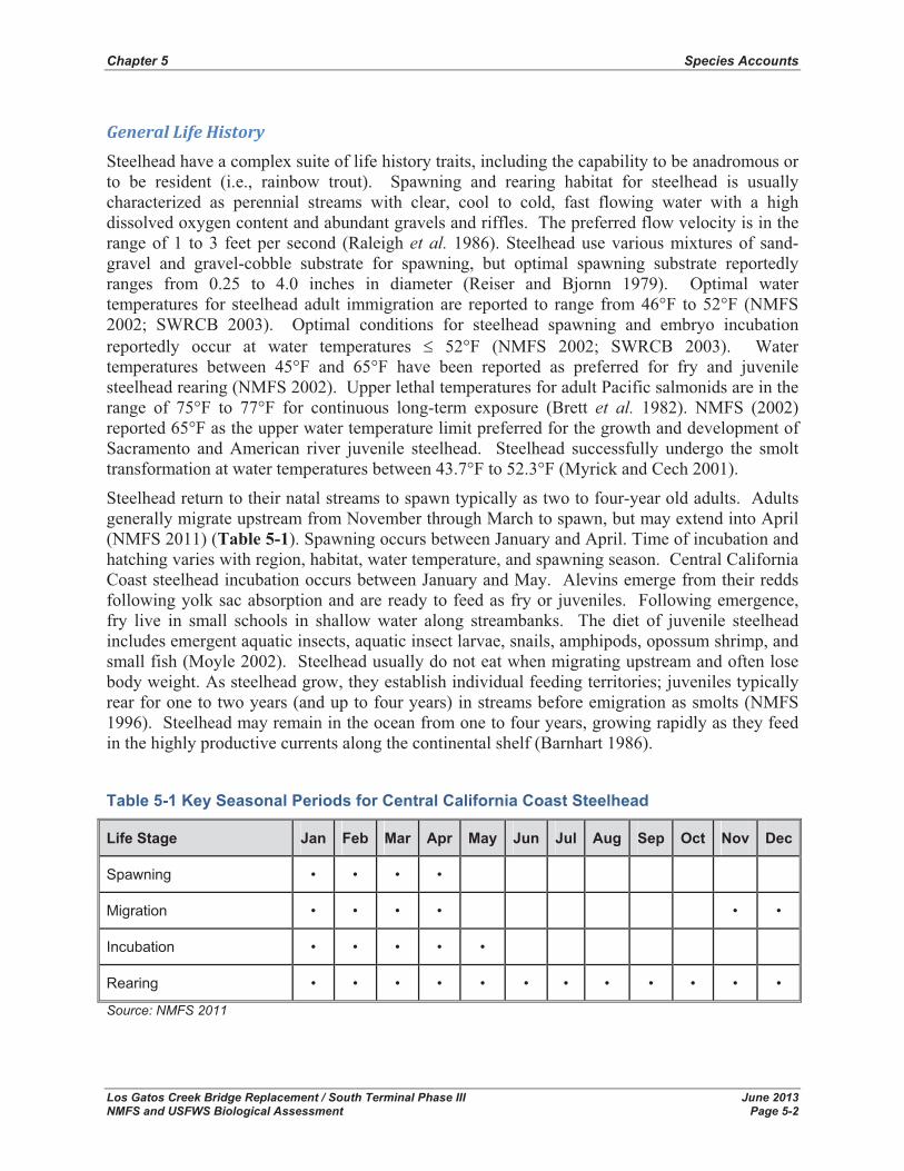
Chapter 5 Species Accounts
Los Gatos Creek Bridge Replacement / South Terminal Phase III June 2013 NMFS and USFWS Biological Assessment Page 5-2
General�Life�History�Steelhead have a complex suite of life history traits, including the capability to be anadromous or to be resident (i.e., rainbow trout). Spawning and rearing habitat for steelhead is usually characterized as perennial streams with clear, cool to cold, fast flowing water with a high dissolved oxygen content and abundant gravels and riffles. The preferred flow velocity is in the range of 1 to 3 feet per second (Raleigh et al. 1986). Steelhead use various mixtures of sand-gravel and gravel-cobble substrate for spawning, but optimal spawning substrate reportedly ranges from 0.25 to 4.0 inches in diameter (Reiser and Bjornn 1979). Optimal water temperatures for steelhead adult immigration are reported to range from 46°F to 52°F (NMFS 2002; SWRCB 2003). Optimal conditions for steelhead spawning and embryo incubation reportedly occur at water temperatures � 52°F (NMFS 2002; SWRCB 2003). Water temperatures between 45°F and 65°F have been reported as preferred for fry and juvenile steelhead rearing (NMFS 2002). Upper lethal temperatures for adult Pacific salmonids are in the range of 75°F to 77°F for continuous long-term exposure (Brett et al. 1982). NMFS (2002) reported 65°F as the upper water temperature limit preferred for the growth and development of Sacramento and American river juvenile steelhead. Steelhead successfully undergo the smolt transformation at water temperatures between 43.7°F to 52.3°F (Myrick and Cech 2001).
Steelhead return to their natal streams to spawn typically as two to four-year old adults. Adults generally migrate upstream from November through March to spawn, but may extend into April (NMFS 2011) (Table 5-1). Spawning occurs between January and April. Time of incubation and hatching varies with region, habitat, water temperature, and spawning season. Central California Coast steelhead incubation occurs between January and May. Alevins emerge from their redds following yolk sac absorption and are ready to feed as fry or juveniles. Following emergence, fry live in small schools in shallow water along streambanks. The diet of juvenile steelhead includes emergent aquatic insects, aquatic insect larvae, snails, amphipods, opossum shrimp, and small fish (Moyle 2002). Steelhead usually do not eat when migrating upstream and often lose body weight. As steelhead grow, they establish individual feeding territories; juveniles typically rear for one to two years (and up to four years) in streams before emigration as smolts (NMFS 1996). Steelhead may remain in the ocean from one to four years, growing rapidly as they feed in the highly productive currents along the continental shelf (Barnhart 1986).
Table 5-1 Key Seasonal Periods for Central California Coast Steelhead
Life Stage Jan Feb Mar Apr May Jun Jul Aug Sep Oct Nov Dec
Spawning • • • •
Migration • • • • • •
Incubation • • • • •
Rearing • • • • • • • • • • • •
Source: NMFS 2011

Chapter 5 Species Accounts
Los Gatos Creek Bridge Replacement / South Terminal Phase III June 2013 NMFS and USFWS Biological Assessment Page 5-3
Distribution�in�the�Action�Area�The CNDDB (CDFW 2013) does not have records for steelhead in Los Gatos Creek and no steelhead were found during a five-year (1989-1994) study conducted by the SCVWD (Leidy etal. 2005). However, in 1998, steelhead were observed spawning in Los Gatos Creek near Hamilton and Meridian Avenues (upstream of the Action Area) and in 2001, two juvenile steelhead were collected in Los Gatos Creek at Leigh Avenue (upstream of the Action Area) (Leidy et al. 2005). In June 2003, rainbow trout were collected from the Guadalupe River near the confluence of Los Gatos Creek. Rainbow trout have also been observed in Hooker Gulch and Austrian Gulch Creeks, which are tributaries to Los Gatos Creek (Leidy et al. 2005).
Leidy et al. (2005) report that steelhead historically occurred in Los Gatos Creek. Their report summarizes each historic, recorded observation (i.e., McCaulay 1948, CDFG 1950, Evans 1952, Skinner 1962, Hinton 1962b, Wood 1970, and J. Abel pers. comm.). In summary of Leidy et al.(2005), Los Gatos Creek likely supported substantial steelhead use throughout its watershed, with many occurrences reported upstream of the Action Area (i.e., immediately downstream of Lenihan Dam), until 1937. In 1952 and 1953, CDFG reported that no steelhead run had occurred in Los Gatos Creek since 1937 (Evans 1952, Jones 1953 as cited in Leidy et al. 2005). During a field visit by HDR biologists on October 28, 2010, no steelhead of any life stage were observed.
The SCVWD has been conducting spawning surveys on Los Gatos Creek, from Lincoln Avenue to Leigh Avenue (upstream of West San Carlos) from October to April since 2002 (J. Nishijima pers. comm.). Their data show very few steelhead redd observations between 2003 and 2009 (Table 5-2).
Table 5-2 Steelhead Redd Observations in Los Gatos Creek1
Date of Observation Number of Steelhead Redds Observed February 19, 2003 1
March 5, 2003 1 February 9, 2005 1 March 27, 2007 1 March 13, 2009 1
May 3, 2011 1 1Survey extent is from Lincoln Avenue upstream to Leigh Avenue, beginning approximately 3,000 feet upstream of Auzerais Avenue. Surveys occur between October and April. The species that created the redds are not directly verified since the spawning fish are not always in the vicinity at the time of the survey. Source: J. Nishijima pers.comm (SCVWD)
In addition to the spawning surveys, the SCVWD has been collecting juvenile rearing data in the Guadalupe River at the end of summer (sampling occurs in late September or early October). The sampling sites (100 feet long) are downstream from the confluence of Guadalupe River and Los Gatos Creek (J. Nishijima pers. comm).
Population�Trends�Information on abundance and productivity trends for the naturally spawning component of the Central California Coast Steelhead DPS is very limited (NMFS 2007). Within the DPS,

Chapter 5 Species Accounts
Los Gatos Creek Bridge Replacement / South Terminal Phase III June 2013 NMFS and USFWS Biological Assessment Page 5-4
estimates of run sizes in the largest river system, the Russian River, have decreased from 65,000 in the 1960s to 1,750 to 7,000 in the 1990s (Busby et al. 1996; Good et al. 2005). Due to migration barriers and water diversions in tributaries to San Francisco Bay, steelhead have been eliminated from 58 percent of historically occupied steelhead streams (Leidy et al. 2005).
5.2 Listed Terrestrial Species This section discusses the characteristics of the USFWS-listed terrestrial species with the potential to occur within the Action Area of the Los Gatos Creek Bridge Replacement Project. Recent documented occurrences within the Action Area are also discussed.
5.2.1 California Red-legged Frog The CRLF was listed as a threatened species under the ESA by the USFWS on May 23, 1996 (FR 61:25813). A member of the true frog family Ranidae, the CRLF occurs from Baja California, Mexico, north to the vicinity of Redding inland, and at least to Point Reyes, California coastally (Jennings and Hayes, 1994).
General�Life�History�The CRLF occurs from sea level to elevations of 5,200 feet (1,500 meters), occupying a fairly distinct habitat, combining both specific aquatic and riparian components. Aquatic habitat consists of low-gradient freshwater bodies, including ponds, marshes, sag ponds, dune ponds, stock ponds, lagoons, seeps, springs, and backwaters within streams and creeks. While CRLF can occur in either ephemeral or perennial streams or ponds, populations generally cannot be maintained in ephemeral streams in which surface water disappears before metamorphosis (July to September) during most years. Studies have indicated that this species can not inhabit water bodies that exceed 70° F, especially if there are no cool, deep portions (USFWS 2002). The adults require dense, shrubby or emergent riparian vegetation closely associated with deep (greater than 2 1/3-foot deep) still or slow moving water, but frogs have been observed in shallow sections of streams and ponds that are devoid of vegetative cover.
The largest densities of CRLF are associated with deep-water pools with dense stands of overhanging willows (Salix sp.) and an intermixed fringe of cattails (Typha latifolia). Well-vegetated terrestrial areas within the riparian corridor may provide important sheltering habitat during winter. Also, the species is known to utilize well-vegetated riparian zones for foraging habitat and facilitating dispersal. During summer, the CRLF often disperses from their breeding habitat to forage and seek summer habitat if water is not available (USFWS 2002). This habitat may include shelter under boulders, rocks, logs, industrial debris, agricultural drains, water troughs, small mammal burrows, incised streamed channels, or areas with moist leaf litter (Jennings and Hayes, 1994; USFWS, 1996, 2002). CRLF may use these upland habitats up to approximately 200 feet from suitable aquatic habitat (USFWS 2002; USFWS 2008a). CRLFs have also been found up to 100 feet from water in adjacent dense riparian vegetation.
Adult CRLF breeding typically starts in November and continues into April (USFWS 2002). CRLF usually lay egg masses of between 2,000 and 5,000 eggs attached to emergent vegetation in shallow water during or shortly following large rainfall events from late December to early April. Larvae metamorphose in 3.5 to 7 months, typically between July and September. Breeding ponds must retain water until this time. CRLF may remain active throughout the year along the

Chapter 5 Species Accounts
Los Gatos Creek Bridge Replacement / South Terminal Phase III June 2013 NMFS and USFWS Biological Assessment Page 5-5
coast. In drier inland areas they aestivate in upland habitat from late summer to early winter (USFWS 2002; USFWS 2008a), utilizing small mammal burrows or other refugia.
Distribution�in�the�Action�Area�No CRLF are reported in CNDDB within five miles of the Action Area, however there are several occurrences within ten miles. The nearest occurrence is approximately 7.5 miles to the northeast of the site, but is in the Coyote Creek watershed and not in the Guadalupe River watershed. One occurrence of CRLF is reported in the Guadalupe Creek watershed within ten miles of the Action Area. This record is in Guadalupe Creek, just downstream of Guadalupe Reservoir, approximately 8.5 miles south of the site and was reported in 2000. An additional two records occur over ten miles from the site in the Guadalupe Creek watershed, upstream from the Action Area. These records are from 1989. One record is in Los Gatos Creek, upstream of Lexington Reservoir and one is adjacent to Los Gatos Creek, just downstream of Lake Elsman. During a field visit by HDR biologists on October 28, 2010, no CRLF of any life stage were observed.
An analysis of known locality records for CRLF (CNDDB records and San Jose State University locality information) from Santa Clara County was conducted in 1997 by H.T. Harvey and Associates (H.T. Harvey and Associates 1997 in ICF Jones and Stokes 2009). The analysis concluded that the species has essentially disappeared from the urbanized lowland areas of Santa Clara County, which includes the Action Area, as well as from the brackish marshlands bordering the San Francisco Bay (H.T. Harvey and Associates 1997 in ICF Jones and Stokes 2009). It was hypothesized that the lack of CRLF in the urbanized lowland areas was due to channelization of riparian habitats and the presence of a wide variety of introduced predatory fishes and bullfrogs in these areas (H.T. Harvey and Associates 1997).
Potential�to�Occur�in�the�Action�Area�Although no CRLF were observed in the Action Area during the biological reconnaissance survey, and that there are no known populations/occurrences of CRLF within 7 miles of the Action Area, the potential for CRLF to occur within the Action Area still exists. Based on the: (1) administrative draft of the HCP/NCCP, which considers Los Gatos Creek in the project region to provide potential breeding habitat for CRLF (ICF Jones and Stokes 2009), (2) the results of the reconnaissance survey, the segment of Los Gatos Creek in the Action Area contains some of the elements necessary to meet the physical habitat requirements for CRLF breeding, dispersal, and refugia3, and (3) the opinion of the USFWS during a 2010 site visit; this BA assumes that there is suitable habitat for CRLF within the Action Area in the following forms: breeding habitat, migratory corridor, aestivation habitat, or foraging habitat.
Population�Trends�The historic range of the CRLF extended coastally from the vicinity of Point Reyes National Seashore, Marin County, California, and inland from the vicinity of Redding in Shasta County, California, southward to northwestern Baja California, Mexico (Jennings and Hayes 1985). The animal was historically known from 46 counties but is currently only found in 22 of them
3 The creek contains water greater than 2 1/3-foot deep in several runs that contain overhanging woody and herbaceous vegetation and adjacent riparian habitat, but lacks well defined pools.

Chapter 5 Species Accounts
Los Gatos Creek Bridge Replacement / South Terminal Phase III June 2013 NMFS and USFWS Biological Assessment Page 5-6
(USFWS 2002). The species is still locally abundant within portions of the San Francisco Bay area and the central coast. Within the remaining distribution, only isolated populations have been documented in the Sierra Nevada, northern Coast, and northern Transverse Ranges. The species is believed to be extirpated from the southern Transverse and Peninsular ranges, but is still present in Baja California, Mexico. The most secure aggregations of the CRLF are found in aquatic sites that support substantial riparian and aquatic vegetation and lack of non-native predators.
The CRLF is threatened by human activities, many of which operate synergistically and cumulatively with each other and with natural disturbances (i.e., droughts or floods). Factors associated with declining populations of the frog include degradation and loss of its habitat through agriculture, urbanization, mining, overgrazing, recreation, timber harvesting, non-native plants, impoundments, water diversions, degraded water quality, use of pesticides, and introduced predators. The reason for decline and degree of threats vary by geographic location. CRLF populations are threatened by more than one factor in most streams.

Los Gatos Creek Bridge Replacement / South Terminal Phase III June 2013 NMFS and USFWS Biological Assessment Page 6-1
6.0 Effects on Species and Habitat Five possible determinations exist regarding a Proposed Action’s effects on protected species under the ESA (USFWS and NMFS 1998). These determinations are as follows.
� No effect - “No effect” is the appropriate conclusion when it is determined that the Proposed Action would not affect a listed species or designated critical habitat.
� Is not likely to adversely affect - “Is not likely to adversely affect” is the appropriate finding when effects on ESA protected species are expected to be discountable, insignificant, or completely beneficial. “Insignificant effects relate to the size of the impact, and should never reach the scale where take occurs. Discountable effects are those extremely unlikely to occur (USFWS and NMFS 1998).”
� Is likely to adversely affect - “Is likely to adversely affect” is the appropriate finding if any adverse effect to listed species may occur as a direct or indirect result of the Proposed Action or its interrelated or interdependent actions, and the effect is not discountable, insignificant, or beneficial. In fact, in the event the overall effect of the Proposed Action is beneficial to an ESA-protected species, but also is likely to cause some adverse effects, then the Proposed Action “is likely to adversely affect” the listed species. If incidental take is anticipated to occur as a result of the Proposed Action, an “is likely to adversely affect” determination should be made (USFWS and NMFS 1998).
� Is likely to jeopardize the continued existence of a listed species or result in the destruction or adverse modification of critical habitat - “May affect, and is likely to jeopardize the continued existence of a listed species or result in the destruction or adverse modification of critical habitat” is the appropriate determination when the action agency or the USFWS and/or NMFS identify situations where the Proposed Action is likely to jeopardize the species or adversely modify critical habitat. Jeopardy occurs when a Proposed Action is likely to directly or indirectly appreciably reduce the likelihood of both the survival and recovery of a protected species in the wild by reducing their reproduction, numbers, or distribution. Destruction or adverse modification of critical habitat is a direct or indirect alteration that appreciably diminishes the value of critical habitat for the survival or recovery of a listed species. Such alterations include, but are not limited to, alterations adversely modifying any of those physical or biological features that were the basis for determining the habitat to be critical (USFWS and NMFS 1998).
� Is likely to jeopardize a proposed species or adversely modify proposed critical habitat- “Is likely to jeopardize a proposed species or adversely modify proposed critical habitat” is the appropriate conclusion if the Proposed Action is likely to jeopardize the continued existence of the proposed species or adversely modify the proposed critical habitat.

Chapter 6 Effects on Species and Habitat
Los Gatos Creek Bridge Replacement / South Terminal Phase III June 2013 NMFS and USFWS Biological Assessment Page 6-2
The ESA Consultation Handbook (USFWS and NMFS 1998) identifies six factors that should be examined (as appropriate for the Proposed Action under consideration), to assess the direct and indirect effects of a Proposed Action. These factors are: (1) proximity of the Proposed Action to the species, management units or designated critical habitat units; (2) geographic areas where the Proposed Action-induced disturbance occurs; (3) timing of the Proposed Action in relationship to sensitive period of a species’ lifecycle; (4) the nature of the effects of the Proposed Action on elements of a species lifecycle, population size or variability, or distribution; or on the primary constituent elements of the critical habitat; (5) duration of the effects (i.e., pulse effect- short term event whose effects are relaxed almost immediately; press effect- sustained, long-term, or chronic event whose effects are not relaxed; and threshold effect- permanent event that sets a new threshold for some feature of a species’ environment); and (6) the disturbance frequency of the effects resulting from the Proposed Action, and how it affects a species based on the species recovery rate (USFWS and NMFS 1998).
The factors described above are to be evaluated, as appropriate, to determine if the Proposed Action would be associated with the overriding consideration of take, which is the main discriminating factor for selecting the appropriate ESA determination.
Under the federal ESA, take is defined as “…to harm, harass, pursue, hunt, shoot, wound, kill, trap, capture, or collect, or attempt to engage in any such conduct [ESA§3(19)].” Harass, pursue, hunt, shoot, wound, kill, trap, capture or collect can be classified as actions that would have a direct impact on a species, at the individual level. Conversely, harm, which is a form of take, is further defined to include “…significant habitat modification or degradation that results in death or injury to listed species by significantly impairing behavioral patterns such as breeding, feeding, or sheltering” (USFWS and NMFS 1998).
Proposed actions that result in adverse changes to habitat (e.g., flows and water temperatures) would result in harm and, thus, result in take of a listed species. When determining the amount and extent of take in order to select the appropriate ESA determination, both the direct effects on a protected species at the individual level, and the effects to the habitat of that species should be thoroughly evaluated.
To guide the effective and correct evaluation of the anticipated effects associated with the Proposed Action, and to ensure that the appropriate steps are taken to select the correct ESA determination, technical evaluation guidelines have been developed. The technical evaluation guidelines take into consideration the interplay between the six previously identified factors to assess direct and indirect effects of an action, and the effects’ contribution to the different forms of take (i.e., harm, harass, pursue, hunt, shoot, wound, kill, trap, capture, collect). Thus, the technical evaluation guidelines are used as the primary tool to appropriately evaluate and identify the amount and extent of take associated with the Proposed Action. In turn, this information is used to select the appropriate ESA determination for the Proposed Action.
6.1 Listed Aquatic Species This section discusses the direct, indirect, and cumulative effects of the Proposed Action on the NMFS-listed fish species in the Action Area.
Chapter 6 Effects on Species and Habitat
Los Gatos Creek Bridge Replacement / South Terminal Phase III June 2013 NMFS and USFWS Biological Assessment Page 6-3
6.1.1 Central California Coast Steelhead DPS Direct effects are those effects caused by the Proposed Action and that occur at the time of the action. Indirect effects are those effects that are caused by the Proposed Action, but occur later in time (USFWS and NMFS 1998). Potential project-related effects are described below.
Direct�Effects�Effect indicators and technical evaluation guidelines have been developed as a means to assess potential construction and operational-related effects of the Proposed Action on Central California Coast steelhead and critical habitat (below). The technical evaluation guidelines serve as the basis of the conclusion and determination of potential project-related effects on Central California Coast steelhead.
Direct�Construction�Related�Effects�Potential effects from construction activities vary according to the location of the activity, time of year when the activity occurs, and the location of each fish species during their respective life cycle. Potential effects on fishes can include, but are not limited to, interference with migration, degradation of water quality, habitat loss or degradation, and interference with foraging habitat and food resources (USACE 2004). Negligible effects are expected where habitats are not significantly altered (USACE 2004). In general, disruption of the benthic and near-bottom waters and disruption of sensitive habitats and key migratory corridors are of greatest concern (USACE 2004). However, it is anticipated that potential effects associated with the Proposed Action would be only temporary in duration and would not result in adverse effects to listed species or their critical habitat.
The following discussion is a summary of the potential effects of the Proposed Action on evaluated species.
Sedimentation�and�Turbidity�Activities associated with access, staging, storage, and disposal areas, in addition to activities associated with construction of the railroad bridge, have the potential to contribute sediment and increase turbidity in Los Gatos Creek above those levels generally found under existing conditions. Although anadromous salmonids are highly migratory and would be capable of moving freely throughout the Action Area, a sudden localized increase in turbidity could affect normal behaviors that are essential to growth and survival such as feeding, sheltering, and migrating (NMFS 2003b). Behavioral avoidance of turbid waters may be one of the most important effects of suspended sediments on salmonids (Birtwell et al. 1984; DeVore et al. 1980; Scannell 1988). Additional turbidity-related effects associated with behavioral alteration include disruption of feeding behaviors, which increases the likelihood that individual fish would face increased competition for food and space, and experience reduced growth rates, or possibly weight loss (NMFS 2003b).
During construction of the Los Gatos Creek Replacement Bridge structure and demolition of the existing bridge, sediment suspension would occur as a result of the placement methodology of the in-channel piles (e.g., vibrating, jetting, jacking or drilling the posts into place), the construction of the bridge superstructure, placement of temporary trestles during construction, and the removal of the existing bridge infrastructure. Water quality impairment would likely include increased turbidity and decreased dissolved oxygen. Depending on the quantity of the
Chapter 6 Effects on Species and Habitat
Los Gatos Creek Bridge Replacement / South Terminal Phase III June 2013 NMFS and USFWS Biological Assessment Page 6-4
sediments and their chemical characteristics, contaminants within the sediments could be released. Also, debris could enter receiving water from construction activities.
Aquatic� Habitat� Modification� and� Loss� of� Shaded� Riverine� Aquatic� (SRA)�Habitat�
Activities associated with construction of the bridge may include the removal of riparian vegetation and large woody debris (LWD) affecting SRA quantity and quality. The Proposed Action will also involve disturbance of the channel that could affect benthic habitats, such as spawning and rearing and food production. SRA habitat effects are determined by comparing the amount of available SRA habitat prior to project implementation (i.e., basis of comparison) to the amount of SRA habitat available after project implementation.
The Proposed Action would require clearing, grubbing, and grading to construct the temporary access roads on both sides of the creek. Grading activities would permanently remove 0.365 acres (15,893 square feet) of riparian habitat, and approximately 0.208 (acres 9,057 square feet) of creek habitat. The grading of the streambed to facilitate the construction of the temporary bypass channels could potentially reduce biodiversity, macroinvertebrate production and nutrient exchange between aquatic and terrestrial ecosystems. The amount of streambed grading would be dependent on the size of the bypass pipe. The size of the pipe will be determined prior to construction, with direct coordination with NMFS and CDFW.
Construction of the bridge would result in the loss of some SRA habitat and streamside vegetation. Presently, the existing fill associated with the existing bridge occupies 0.060 acres (2,616 square feet) of SRA/streamside vegetation (i.e., riparian habitat), and the existing bridge shades approximately 0.074 acres (3,230 square feet) of riparian habitat (Table 6-1). With the construction of the Proposed Action, there will be a net increase of 0.003 acres (124 square feet) of fill. The installation of riprap would remove an additional 0.008 acres (362 square feet) of riparian habitat, and 0.038 acres (1,676 square feet) of creek habitat. With the Proposed Action, the shaded area will increase by 0.111 acres. This shading may slightly alter potential juvenile salmonid foraging and rearing habitat. However, the area of shaded habitat is negligible compared to the amount habitat present in the vicinity of the Proposed Action (both upstream and downstream).
All activities will occur in the dry season and when no fish are present in the Action Area (i.e., in-water work window of June 15th through October 15th). Temporarily disturbed sections of Los Gatos Creek will be revegetated with native grasses and forbs. Emergent (rising out of water) and submergent (covered by water) vegetation will be retained where feasible, and rapidly sprouting plants, such as willows, will be cut off at ground level and root systems left intact, when removal is necessary.
Hazardous�Materials�and�Chemical�Spills�Hazardous materials and chemicals in the form of gasoline, engine oil, lubricants, or other fluids used during construction activities could potentially enter Los Gatos Creek as a result of seepage or accidental spills. Accidental discharge of hazardous materials and chemicals could potentially affect fish that may be present in the immediate vicinity and down current of the construction area by increasing physiological stress, altering primary and secondary production, and causing direct mortality.

Chapter 6 Effects on Species and Habitat
Los Gatos Creek Bridge Replacement / South Terminal Phase III June 2013 NMFS and USFWS Biological Assessment Page 6-5
Table 6-1 Effects of the Proposed Action on Los Gatos Creek
Item Description Total Area
(Square Feet)
Area in Riparian Habitat
(Square Feet)
Area in Riparian Habitat (Acre)
Area in Creek
(Square Feet)
Area in Creek (Acre)
Existing Conditions Existing Bridge Fill - Piers 1,350 457 0.010 893 0.021 Existing Bridge Fill - Bents 167 167 0.004 0 0.000 Existing Bridge Fill - Abutment 2,190 1,992 0.046 0 0.000
Total Existing Fill 3,707 2,616 0.06 893 0.02 Existing Bridge Shade 4,129 3,230 0.074 899 0.021
New Construction New Bridge Fill - Piers 1,079 694 0.016 385 0.009 New Bridge Fill - Abutments 2,463 1,352 0.031 0 0.000 New Bridge Fill - Wingwalls 433 359 0.008 0 0.000 Riprap 2,038 362 0.008 1,676 0.038
Total New Fill 6,013 2,767 0.063 2,061 0.047 Grading 15,893 0.365 9,057 0.208
Total Permanent Impacts 18,660 0.428 11,118 0.255 Temporary Impacts 9,730 0.223 3,683 0.085
New Bridge Shade 10,742 8,085 0.186 2,657 0.061
Net Increase in Fill 2,306 151 0.003 1,168 0.027 Net Increase in Shade Area 6,613 4,855 0.111 1,758 0.040
Note: Quantities based on preliminary cadd and plan information.
The concern for habitat disruption resulting from the crossing of the waterways arises from theloss of riparian habitat at the crossing alignment and from the potential for a frac-out4 to occur. In a typical crossing, vegetation along the alignment is cleared to allow for visual inspection of the pipeline route. In the application of horizontal directional drilling (HDD) or bore and jack techniques, vegetation clearing occurs only in a finite area surrounding the entrance and exit points of the crossing. The siting of the entrance and exit points for a HDD crossing typically occurs at a substantial distance away from the banks of the waterbody to be crossed. This accommodates the curvature of the pipeline as it crosses under the waterway along the lumen of the bore hole. The pits dug for the entrance and exit points of a bore and jack crossing usually are closer to the banks of the waterway than in the HDD method, but are relatively smaller in surface area.
The potential for a frac-out to occur is highest for the HDD method. The drill bit used to bore the lumen of the pipeline hole is lubricated by a slurry of bentonite mud. Bentonite is a nontoxic mud made of mineral clays but its particle size is very fine in diameter. This can make respiration difficult for organisms exposed to this compound. The particles adhere to the cellular
4 Frac-out –Inadvertent returns of drilling mud during drilling
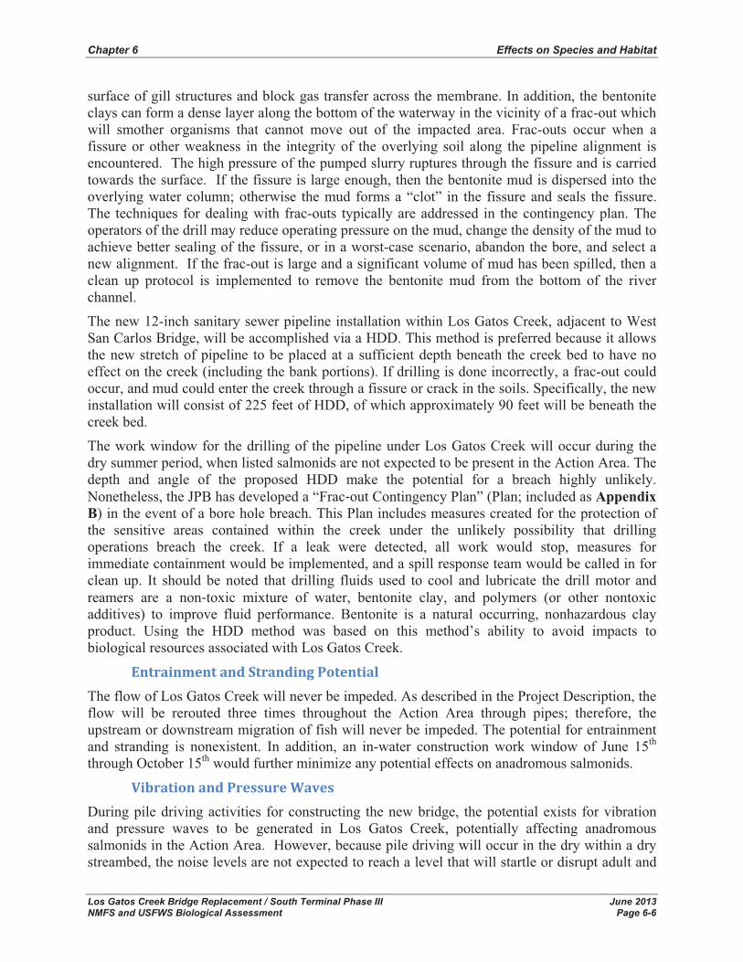
Chapter 6 Effects on Species and Habitat
Los Gatos Creek Bridge Replacement / South Terminal Phase III June 2013 NMFS and USFWS Biological Assessment Page 6-6
surface of gill structures and block gas transfer across the membrane. In addition, the bentonite clays can form a dense layer along the bottom of the waterway in the vicinity of a frac-out which will smother organisms that cannot move out of the impacted area. Frac-outs occur when a fissure or other weakness in the integrity of the overlying soil along the pipeline alignment is encountered. The high pressure of the pumped slurry ruptures through the fissure and is carried towards the surface. If the fissure is large enough, then the bentonite mud is dispersed into the overlying water column; otherwise the mud forms a “clot” in the fissure and seals the fissure. The techniques for dealing with frac-outs typically are addressed in the contingency plan. The operators of the drill may reduce operating pressure on the mud, change the density of the mud to achieve better sealing of the fissure, or in a worst-case scenario, abandon the bore, and select a new alignment. If the frac-out is large and a significant volume of mud has been spilled, then a clean up protocol is implemented to remove the bentonite mud from the bottom of the river channel.
The new 12-inch sanitary sewer pipeline installation within Los Gatos Creek, adjacent to West San Carlos Bridge, will be accomplished via a HDD. This method is preferred because it allows the new stretch of pipeline to be placed at a sufficient depth beneath the creek bed to have no effect on the creek (including the bank portions). If drilling is done incorrectly, a frac-out could occur, and mud could enter the creek through a fissure or crack in the soils. Specifically, the new installation will consist of 225 feet of HDD, of which approximately 90 feet will be beneath the creek bed.
The work window for the drilling of the pipeline under Los Gatos Creek will occur during the dry summer period, when listed salmonids are not expected to be present in the Action Area. The depth and angle of the proposed HDD make the potential for a breach highly unlikely. Nonetheless, the JPB has developed a “Frac�out Contingency Plan” (Plan; included as AppendixB) in the event of a bore hole breach. This Plan includes measures created for the protection of the sensitive areas contained within the creek under the unlikely possibility that drilling operations breach the creek. If a leak were detected, all work would stop, measures for immediate containment would be implemented, and a spill response team would be called in for clean up. It should be noted that drilling fluids used to cool and lubricate the drill motor and reamers are a non�toxic mixture of water, bentonite clay, and polymers (or other nontoxic additives) to improve fluid performance. Bentonite is a natural occurring, nonhazardous clay product. Using the HDD method was based on this method’s ability to avoid impacts to biological resources associated with Los Gatos Creek.
Entrainment�and�Stranding�Potential�The flow of Los Gatos Creek will never be impeded. As described in the Project Description, the flow will be rerouted three times throughout the Action Area through pipes; therefore, the upstream or downstream migration of fish will never be impeded. The potential for entrainment and stranding is nonexistent. In addition, an in-water construction work window of June 15th
through October 15th would further minimize any potential effects on anadromous salmonids.
Vibration�and�Pressure�Waves�During pile driving activities for constructing the new bridge, the potential exists for vibration and pressure waves to be generated in Los Gatos Creek, potentially affecting anadromous salmonids in the Action Area. However, because pile driving will occur in the dry within a dry streambed, the noise levels are not expected to reach a level that will startle or disrupt adult and

Chapter 6 Effects on Species and Habitat
Los Gatos Creek Bridge Replacement / South Terminal Phase III June 2013 NMFS and USFWS Biological Assessment Page 6-7
juvenile salmonids to the point of causing non-volitional movement of these fish out of their preferred habitat. Table 6-2 displays NMFS’ underwater noise thresholds for salmonids. Because all excavation activities will occur above water, the noise levels under water will be much lower than those created in the air.
Table 6-2 NMFS Underwater Noise Thresholds to Fish Exposed to Elevated Levels of Underwater Sounds Produced During Pile Driving
Effect Metric Fish mass Threshold
Onset of physical injury
Peak pressure N/A 206 dB (re: 1 μPa)
Accumulated Sound Exposure Level (SEL) � 2 g 187 dB (re: 1μPa2•sec)
< 2 g 183 dB (re: 1μPa2•sec)
Adverse behavioral effects Root Mean Square Pressure (RMS) N/A 150 dB (re: 1 μPa)
Source: NMFS 2010b
The Proposed Action would use both impact and vibratory pile drivers. The impact pile drivers would be used to install the foundation piles while the vibratory pile drivers will be used for the shoring piles. The Proposed Action would drive a maximum of four foundation piles per day.
A total of 115 30-inch steel pipe piles will be used for the Proposed Action, of which, a total of 70 piles will be used for the two abutments and one wing wall in the upland area of the Action Area. The other 45 steel pipe piles are for the two proposed piers that lie below the ordinary high-water mark (OHWM).
Using information from a similar soil profile for a project within the vicinity of the Action Area, the Proposed Action expects the following blow counts for the 30-inch steel pipe piles:
� 0 to 10 feet: Zero blow counts. The piles will be tethered; however, it is likely that the pile will “run” (i.e., sink under its own weight for the first few feet (5 to 10 feet).
� 10 to 35 feet: Blow counts “negligible”. Blow counts are not typically reported for less than 1 blow per foot. It is unlikely that the Proposed Action will see recordable blow counts in the first 30 to 35 feet below grade.
� 35 to 60 feet: Blow counts in the six to 14 blows per foot range are expected.
� 60 to 75 feet: Blow counts will vary significantly from 20 to 25 blows per foot in the softer material, and as high as 60 to 70 in stiffer materials5.
� 75 to 80 feet: This is the range of expected refusal. It is expected that somewhere in this range, pile driving may be terminated due to “pile refusal”. The cutoff elevation is highly site specific and difficult to predict in advance of pile driving.
5 Softer material is not always above stiffer layers and that passing through a sand layer may cause blow counts to spike and then return to a lower value.

Chapter 6 Effects on Species and Habitat
Los Gatos Creek Bridge Replacement / South Terminal Phase III June 2013 NMFS and USFWS Biological Assessment Page 6-8
Based on the expected length of the steel pipe pile (i.e., 80 feet), it is expected that there would be approximately 475 to 755 strikes per pile in softer material, or 1,075 to 1,430 strikes per pile in stiffer materials (Table 6-3).
Table 6-3 Number of Pile Strikes Expected for Proposed Action
Depth (ft) Blows per Foot Total Blows From To Min Max Min Max
0 5 0 0 0 0
5 10 0 1 0 5
10 35 1 1 25 25
35 60 6 14 150 350
60 75 20 25 300 375
60 75 60 70 900 1050
Total Blows Per Pile
Softer Material 475 755
Stiffer Material 1075 1430
Soft Soil Stiff Soil
Underwater sound levels associated with installation of steel pipe piles were calculated using the information described above, as well as the following:
� Single pile strike peak pressure at 20 meters6(66 feet): 200 decibel(s) (dB) (Caltrans 2009 – Richmond-San Rafael Bridge, CALTRANS project)
� Single pile strike root mean square (RMS) at 20 meters (66 feet): 185 dB (Caltrans 2009 – Richmond-San Rafael Bridge, CALTRANS project)
� Single pile strike sound exposure level (SEL) at 20 meters (66 feet): 147 (Caltrans 2009 – Richmond-San Rafael Bridge, CALTRANS project)
� Dewatered in-water work area will result in a 10 dB pile driving noise reduction7
Underwater sound levels for the minimum number of blows in softer material, would not exceed the peak pressure threshold of 206 dB and SEL threshold of 187 dB, but would exceed the SEL threshold of 183 dB for approximately 36 meters (Table 6-4). The 150 dB threshold for potential behavioral effects would be exceeded for approximately 928 meters (approximately 3,044 feet) away from the piles being driven; however, all in-water work will occur within the June through October work window when special status fish species are not present in the Action Area.
Underwater sound levels for the maximum number of blows in softer material, would not exceed the peak pressure threshold of 206 dB, but would exceed the SEL thresholds (183 and 187 dB) for approximately 49 and 26 meters, respectively (Table 6-5). The 150 dB threshold for potential
6 20 meter distance used as this is the estimated shortest distance from pile to open water. 7 10dB subtracted from Peak, RMS, and SEL acoustic metrics
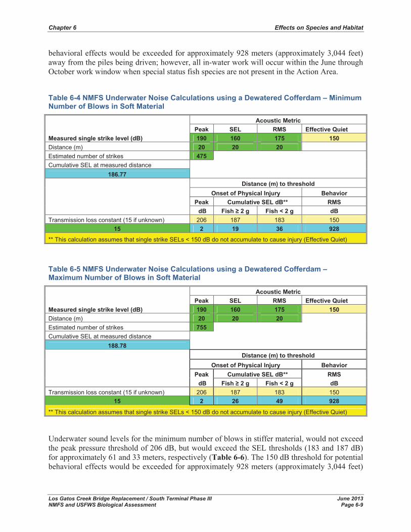
Chapter 6 Effects on Species and Habitat
Los Gatos Creek Bridge Replacement / South Terminal Phase III June 2013 NMFS and USFWS Biological Assessment Page 6-9
behavioral effects would be exceeded for approximately 928 meters (approximately 3,044 feet) away from the piles being driven; however, all in-water work will occur within the June through October work window when special status fish species are not present in the Action Area.
Table 6-4 NMFS Underwater Noise Calculations using a Dewatered Cofferdam – Minimum Number of Blows in Soft Material
Measured single strike level (dB)
Acoustic Metric Peak SEL RMS Effective Quiet 190 160 175 150
Distance (m) 20 20 20 Estimated number of strikes 475 Cumulative SEL at measured distance
186.77
Distance (m) to threshold Onset of Physical Injury Behavior
Peak Cumulative SEL dB** RMS dB Fish � 2 g Fish < 2 g dB
Transmission loss constant (15 if unknown) 206 187 183 150 15 2 19 36 928
** This calculation assumes that single strike SELs < 150 dB do not accumulate to cause injury (Effective Quiet)
Table 6-5 NMFS Underwater Noise Calculations using a Dewatered Cofferdam – Maximum Number of Blows in Soft Material
Measured single strike level (dB)
Acoustic Metric Peak SEL RMS Effective Quiet 190 160 175 150
Distance (m) 20 20 20 Estimated number of strikes 755 Cumulative SEL at measured distance
188.78
Distance (m) to threshold Onset of Physical Injury Behavior
Peak Cumulative SEL dB** RMS dB Fish � 2 g Fish < 2 g dB
Transmission loss constant (15 if unknown) 206 187 183 150 15 2 26 49 928
** This calculation assumes that single strike SELs < 150 dB do not accumulate to cause injury (Effective Quiet)
Underwater sound levels for the minimum number of blows in stiffer material, would not exceed the peak pressure threshold of 206 dB, but would exceed the SEL thresholds (183 and 187 dB) for approximately 61 and 33 meters, respectively (Table 6-6). The 150 dB threshold for potential behavioral effects would be exceeded for approximately 928 meters (approximately 3,044 feet)
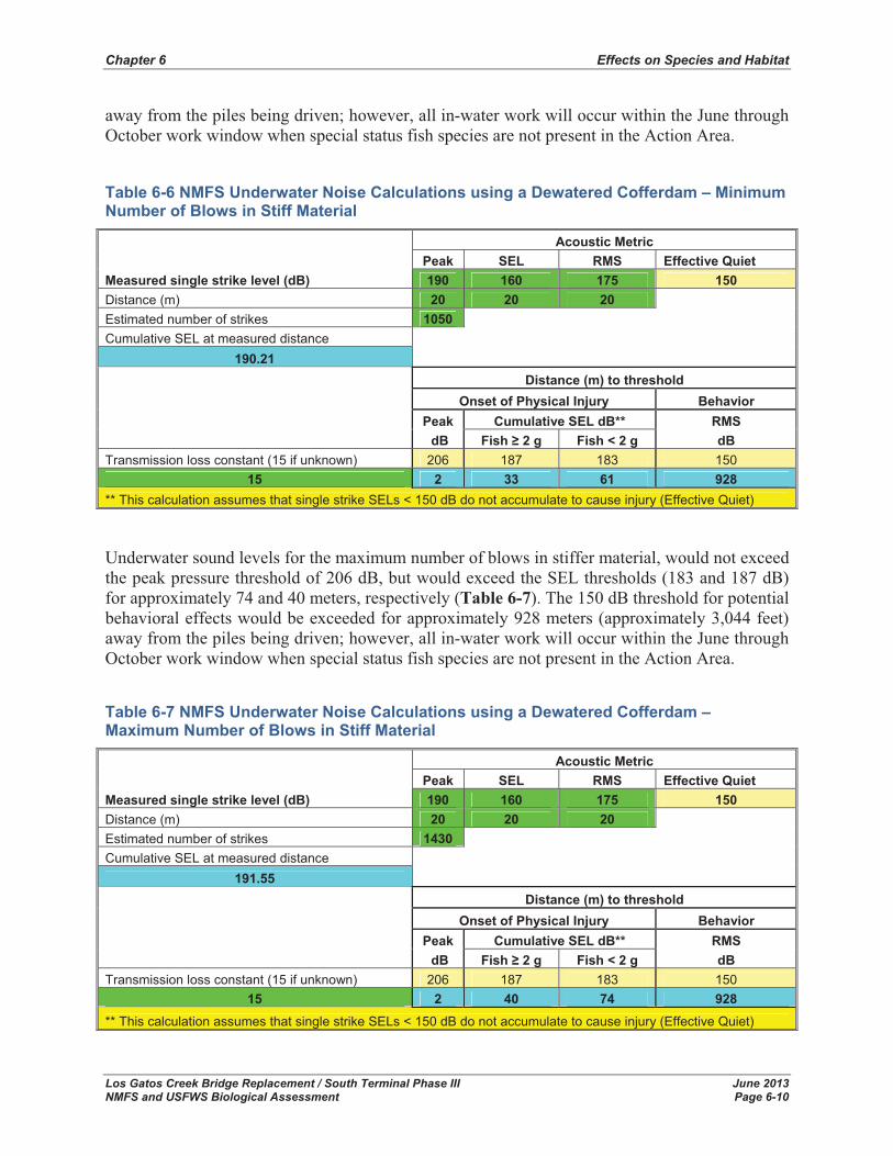
Chapter 6 Effects on Species and Habitat
Los Gatos Creek Bridge Replacement / South Terminal Phase III June 2013 NMFS and USFWS Biological Assessment Page 6-10
away from the piles being driven; however, all in-water work will occur within the June through October work window when special status fish species are not present in the Action Area.
Table 6-6 NMFS Underwater Noise Calculations using a Dewatered Cofferdam – Minimum Number of Blows in Stiff Material
Measured single strike level (dB)
Acoustic Metric Peak SEL RMS Effective Quiet 190 160 175 150
Distance (m) 20 20 20 Estimated number of strikes 1050 Cumulative SEL at measured distance
190.21
Distance (m) to threshold Onset of Physical Injury Behavior
Peak Cumulative SEL dB** RMS dB Fish � 2 g Fish < 2 g dB
Transmission loss constant (15 if unknown) 206 187 183 150 15 2 33 61 928
** This calculation assumes that single strike SELs < 150 dB do not accumulate to cause injury (Effective Quiet)
Underwater sound levels for the maximum number of blows in stiffer material, would not exceed the peak pressure threshold of 206 dB, but would exceed the SEL thresholds (183 and 187 dB) for approximately 74 and 40 meters, respectively (Table 6-7). The 150 dB threshold for potential behavioral effects would be exceeded for approximately 928 meters (approximately 3,044 feet) away from the piles being driven; however, all in-water work will occur within the June through October work window when special status fish species are not present in the Action Area.
Table 6-7 NMFS Underwater Noise Calculations using a Dewatered Cofferdam – Maximum Number of Blows in Stiff Material
Measured single strike level (dB)
Acoustic Metric Peak SEL RMS Effective Quiet 190 160 175 150
Distance (m) 20 20 20 Estimated number of strikes 1430 Cumulative SEL at measured distance
191.55
Distance (m) to threshold Onset of Physical Injury Behavior
Peak Cumulative SEL dB** RMS dB Fish � 2 g Fish < 2 g dB
Transmission loss constant (15 if unknown) 206 187 183 150 15 2 40 74 928
** This calculation assumes that single strike SELs < 150 dB do not accumulate to cause injury (Effective Quiet)
Chapter 6 Effects on Species and Habitat
Los Gatos Creek Bridge Replacement / South Terminal Phase III June 2013 NMFS and USFWS Biological Assessment Page 6-11
Predation�Risk�Construction activities associated with the Proposed Project have the potential to increase the risk of predation due to: (1) noise associated with pile driving activities and (2) increased turbidity above those levels normally found in Los Gatos Creek. Potential effects associated with these activities that are not directly associated with predation risk are described in other portions of this section.
Disorientation caused by noise associated with pile driving can temporarily disrupt normal fish behaviors, thereby increasing the risk of predation (NMFS 2000; NMFS 2003b). However, as previously mentioned, special-status fish are unlikely to be in the vicinity of the Action Area during pile driving activities. Construction activities may increase turbidity, which in turn, could alter normal fish behavior and increase the risk of predation (DeVore et al,. 1980; Birtwell et al,.1984; Scannell 1988 as cited in NMFS 2003a). However, increased turbidity could also decrease predation on fish.
The amount of increased predation risk associated with increased turbidity, pile driving, and habitat modification is unknown, but would likely be minimal due to implementation of BMPs and conservation measures associated with construction activities to reduce potential increases in turbidity, noise, and habitat modification. In addition, sensitive fish and aquatic resources would only be exposed to potentially increased predation risk for a limited duration during their downstream migration therefore potentially increased predation risk and is not expected to result in long-term population declines.
The implementation of BMPs to minimize sedimentation and turbidity, hazardous spills, and vibration and pressure waves, is expected to indirectly reduce any potentially adverse effects associated with increased predation risk to insignificant levels.
In-water construction activities in Los Gatos Creek will be conducted during the work window of June 15th through October 15th to avoid the potential for adverse effects to anadromous salmonids.
Indirect�Effects�There are no indirect effects to listed fish species identified with the Proposed Action. Indirect effects are those that may occur to listed species over time after the project has been completed. Indirect effects may result for listed species for the duration of time it takes to replant the riparian vegetation in the footprint of the Proposed Action (e.g., access roads, rip rap, etc.). Any permanent damage to fish from pile driving activities may have an indirect effect on their future life histories affecting their feeding and reproduction; however, these types of impacts cannot be quantified and pile driving would occur when special-status fish species are not present in the Action Area.
Interrelated�and�Interdependent�Effects�Interrelated actions are those that are part of a larger action and depend on the larger action for their justification (i.e., this action would not occur “but for” a larger action) (USFWS and NMFS 1998). Interdependent actions are those that would have no significant utility apart from the action that is under consideration, i.e., other actions would not occur “but for” this action (USFWS and NMFS 1998). The Proposed Action is reconstruction of an existing facility and will not incur any interrelated or interdependent effects.
Chapter 6 Effects on Species and Habitat
Los Gatos Creek Bridge Replacement / South Terminal Phase III June 2013 NMFS and USFWS Biological Assessment Page 6-12
Cumulative�Effects�Cumulative effects include the effects of future state, tribal, local or private actions that are reasonably certain to occur in the Action Area. Future federal actions that are unrelated to the Proposed Action are not considered in this section because they would be subject to separate consultation pursuant to Section 7 of the ESA (USFWS and NMFS 1998). The Proposed Action is not anticipated to change conditions from existing as it is a reconstruction of an existing facility and will not add to the exiting infrastructure. The effects associated with this project are short term and principally occur during the construction period.
6.2 Listed Terrestrial Species This section discusses the direct, indirect, and cumulative effects of the Proposed Action on the USFWS-listed terrestrial species in the Action Area.
6.2.1 California Red-Legged Frog Direct effects are those effects caused by the Proposed Action and that occur at the time of the action. Indirect effects are those effects that are caused by the Proposed Action, but occur later in time (USFWS and NMFS 1998). Potential project-related effects are discussed below.
Direct�Effects�Potential effects of the Proposed Action on CRLF include direct construction related effects and modification of potential dispersal, foraging, or refugia habitat. Construction activities within and adjacent to Los Gatos Creek have the potential to harm or harass CRLF if individuals entered the Action Area during construction. Direct effects on the CRLF could include, but are not limited to, harm or harassment of an individual frog(s) due to adverse contact with construction equipment or personnel and construction related degradation of water quality that causes direct adverse effects to an individual frog(s).
Loss�of�Habitat�No permanent effects would occur to CRLF breeding habitat; however, the Proposed Action would result in a total loss of 0.255 acres (11,118 square feet) of non-breeding aquatic habitat, and 0.428 acres (18,860 square feet) of dispersal habitat/upland habitat, comprising of willow riparian forest (Table 5-1). The grading associated with grading the channel to accommodate the diversion pipe, would be considered a temporary affect to non-breeding aquatic habitat, as the flow would be restored and channel returned to pre-project conditions.
Direct�Contact�with�Construction�Equipment�and/or�Personnel�If CRLF were to disperse into the Action Area during construction, they could come into direct contact with construction equipment and/or personnel and be harmed or harassed. In addition, construction related disturbances such as increased levels of human activity and increased noise and vibration levels could result in alteration of normal behavior (such as invoking an escape response or alteration of normal dispersal routes) resulting in increased chances of predation or other harm.

Chapter 6 Effects on Species and Habitat
Los Gatos Creek Bridge Replacement / South Terminal Phase III June 2013 NMFS and USFWS Biological Assessment Page 6-13
If plastic monofilament netting is used at the project for erosion control or other purposes, CRLF may become entangled or trapped resulting in injury or death of individuals due to exposure, desiccation, or predation.
Sedimentation,�and�Turbidity�Activities associated with access, staging, storage, and disposal, in addition to activities associated with construction associated with the Proposed Action (e.g., bridge replacement) have the potential to contribute sediment and increase turbidity in waters within Los Gatos Creek above those levels generally found under existing conditions.
The sediment plume created as a result of any in-stream construction activities would stem from sediment disturbed from the stream bed and, thus, should rapidly settle out of suspension. Depending on the exact composition of the substrate in the stream channel and along the stream bank, there is a potential to mobilize an unknown but potentially substantial amount of fine sediments which could enter the water column and directly affect CRLF.
Grading activities in Los Gatos Creek will be conducted subsequent to temporarily diverting the creek channel. Therefore, the potential for construction activities to increase sedimentation or turbidity within Los Gatos Creek will be minimized. In addition, all grading activities will occur in the dry season, therefore CRLF will not experience any effects associated with sedimentation and turbidity.
Hazardous�Material�and�Chemical�Spills�Hazardous materials and chemicals in the form of gasoline, engine oil, lubricants, or other fluids used during construction activities could potentially enter Los Gatos Creek or other aquatic habitats as a result of seepage or accidental spills. Accidental discharge of hazardous materials and chemicals could affect aquatic species present in the immediate vicinity and down current of construction area, including CRLF, by increasing physiological stress and/or causing direct mortality.
Night�Time�Construction�Activities�Night time activities would have an adverse effect to the species (dusk and dawn are often the times when CRLF are actively foraging and dispersing). The Proposed Action would be occurring between the hours of 7AM and 7PM; however, all construction activities would cease one half hour before sunset and should not begin prior to one half hour before sunrise.
Indirect�Effects�Indirect effects may occur to CRLF that have been relocated due to construction. Reduced fitness (e.g., genetic contribution) and survivability may occur as a result of relocating individuals. Survivorship of relocated CRLF has not been estimated, but one study reported that relocations of this species conducted during the wet season resulted in all relocated individuals abandoning release sites and traveling long distances to return to capture sites over a short period of time (Rathbun and Schneider 2001). In the same study, a second relocation had similar results, with one individual traveling 1.7 miles back to its pond of origin over 32 days. Rathbun and Schneider (2001) hypothesized that this homing tendency may be reduced by relocating individuals during the dry season.
Chapter 6 Effects on Species and Habitat
Los Gatos Creek Bridge Replacement / South Terminal Phase III June 2013 NMFS and USFWS Biological Assessment Page 6-14
Additionally, increased competition from other CRLF already occupying areas where relocated individuals are released may occur. However, given the amount of habitat available, the short distance individuals would be relocated, it is expected that this effect will be negligible.
Interrelated�and�Interdependent�Effects�Interrelated actions are those that are part of a larger action and depend on the larger action for their justification (i.e., this action would not occur “but for” a larger action) (USFWS and NMFS 1998). Interdependent actions are those that would have no significant utility apart from the action that is under consideration, i.e., other actions would not occur “but for” this action (USFWS and NMFS 1998). The Proposed Action is reconstruction of an existing facility and will not incur any interrelated or interdependent effects.
Cumulative�Effects�Cumulative effects include the effects of future state, tribal, local or private actions that are reasonably certain to occur in the Action Area. Future federal actions that are unrelated to the Proposed Action are not considered in this section because they would be subject to separate consultation pursuant to Section 7 of the ESA (USFWS and NMFS 1998).
According to the California Department of Forestry and Fire Protection, from 2000 to 2020, the human population within counties in the Bay Area region is expected to grow by 29 percent (5.3 million to people to 6.8 million people), and by 60 percent from 2000 to 2040 (5.3 million people to 8.4 million people). Urbanization is known to cause habitat loss, fragmentation, and degradation, which affects a variety of plant and animal species, including CRLF. Range wide habitat loss is a contributing factor to the decline of both species. Habitats may be lost or degraded as a result of a number of activities including road and utility construction and maintenance, overgrazing, agricultural expansion, and water irrigation and storage projects that may not be funded, permitted, or constructed by a Federal agency.
Additional threats resulting from urbanization include contamination, poisoning, increased predation, and competition from non-native species associated with human development. Non-federal actions that may impact listed species, such as conversion of land, mosquito control, and residential development may occur without consultation with or authorization by USFWS or CDFW pursuant to their respective Endangered Species Act.
The global average temperature has risen by approximately 0.6 degrees Centigrade during the 20th Century (IFPC 2001, 2007; Adger et al. 2007 as cited in USFWS 2008). There is an international scientific consensus that most of the warming observed has been caused by human activities (IFPC 2001, 2007; Adger et al. 2007 as cited in USFWS 2008), and “very likely” that it is largely due to man-made emissions of carbon dioxide and other greenhouse gasses (Adger et al. 2007 as cited in USFWS 2008). Ongoing climate change (Anonymous 2007; Inkley et al. 2004; Adger et al. 2007; Kanter 2007 as cited in USFWS 2008) likely imperils the CRLF and the resources necessary for their survival. Since climate change threatens to disrupt annual weather patterns, it may result in a loss of their habitats and/or prey, and/or increased numbers of their predators, parasites, and diseases. Where populations are isolated, a changing climate may result in local extinction, with range shifts precluded by lack of habitat.

Chapter 6 Effects on Species and Habitat
Los Gatos Creek Bridge Replacement / South Terminal Phase III June 2013 NMFS and USFWS Biological Assessment Page 6-15
6.3 Determination of Effects The following discussion provides conclusions and determinations concerning whether the Proposed Action is likely to adversely affect listed species and their critical habitat. Under ESA Section 7, and the implementing regulations promulgated by NMFS and the USFWS, formal consultation between a Federal Agency and NMFS and/or USFWS is required if a Proposed Action “may affect listed species or designated critical habitat,” unless the Federal Agency determines with NMFS’ written concurrence, “…that the Proposed Action is not likely to adversely affect any listed species or critical habitat.” (50 CFR 402.14(a)-(b)(1)). As mentioned above, the FTA will obtain a permit from USACE under Section 404 of the CWA; therefore, FTA must consult with NMFS regarding potential effects associated with the Proposed Action on Central California Coast steelhead, and with USFWS regarding potential effects on CRLF.
Central California Coast SteelheadThe Proposed Action “is not likely to adversely affect” Central California Coast steelhead. The Proposed Action would not directly or indirectly appreciably reduce the likelihood of both the survival and recovery of Central California Coast steelhead in the wild by reducing their reproduction, numbers, or distribution.
California Red-Legged FrogThe Proposed Action “is not likely to adversely affect” CRLF. The Proposed Action would not directly or indirectly appreciably reduce the likelihood of both the survival and recovery of CRLF in the wild by reducing their reproduction, numbers, or distribution.
Critical HabitatThe Proposed Action will have “no effect” on critical habitat for Central California Coast steelhead and CRLF.

Chapter 6 Effects on Species and Habitat
Los Gatos Creek Bridge Replacement / South Terminal Phase III June 2013 NMFS and USFWS Biological Assessment Page 6-16
This page left blank intentionally

Los Gatos Creek Bridge Replacement / South Terminal Phase III June 2013 NMFS and USFWS Biological Assessment Page 7-1
7.0 Conservation Measures Conservation measures are actions to benefit or promote the recovery of listed species that are included by the federal agency as an integral part of the Proposed Action. These measures will be carried out by the applicant, and serve to minimize or compensate for, project effects on the species under review. These may include actions taken prior to the initiation of consultation or actions which the applicant has committed to complete in a biological assessment or similar document (USFWS and NMFS 1998).
Conservation measures as part of the Proposed Action include the following:
� The in-water work window will be restricted to June 15th through October 15th, when special-status species are not present within the creek. Grading activities associated with the Proposed Action will be conducted “in the dry” after diverting Los Gatos Creek flow through the temporary channel diversion pipes.
� The JPB will prepare a Mitigation Monitoring and Reporting Program (MMRP).
� The JPB’s contractor will prepare and implement a fish rescue plan during any dewatering activities. The plan will include utilizing a qualified biologist to capture, remove, and relocate all fishes utilizing areas to be dewatered. The plan will be provided to NMFS for approval prior to the onset of construction activities.
� The JPB’s environmental specialist will make regular site visits to confirm that the BMPs and mitigation measures are being implemented.
� Temporary orange fencing will be placed to delineate environmentally sensitive areas to exclude these areas from being impacted by construction activities.
o All construction personnel will receive training notifying them of the environmentally sensitive areas on the Action Area and the potential for these areas to support special-status species.
� The JPB’s contractor will prepare and implement a Storm Water Pollution Prevention Plan (SWPPP), which will comprise erosion control measures including, but not limited to:
o Site-specific erosion and sediment control practices, including installation of erosion control wattles around all disturbed areas and ditches, installation of silt fencing, drainage inlet protection, sediment settling basins (if applicable), concrete washout areas, and hydroseeding and mulching disturbed areas.
o Erosion will be controlled in accordance with an approved Erosion Control Plan. In addition, all construction activities will be performed in accordance with the California NPDES General Permit for Storm Water Discharges Associated with Construction Activities, 2009-0009-DWQ (effective July 1, 2010), requiring the implementation of BMPs to control sediment and other pollutants mobilized from construction activities. BMPs may include, but would not be limited to:

Chapter 7 Conservation Measures
Los Gatos Creek Bridge Replacement / South Terminal Phase III June 2013 NMFS and USFWS Biological Assessment Page 7-2
- Excavation and grading activities in areas with steep slopes or directly adjacent to open water shall be scheduled for the dry season only (June 15th to October 15th),to the extent possible. This will reduce the chance of severe erosion from intense rainfall and surface runoff.
� If excavation occurs during the rainy season, storm runoff from the construction area shall be regulated through a storm water management/erosion control plan that shall include temporary onsite silt traps and/or basins with multiple discharge points to natural drainages and energy dissipaters. Stockpiles of loose material shall be covered and runoff diverted away from exposed soil material. If work stops due to rain, a positive grading away from slopes shall be provided to carry the surface runoff to areas where flow would be controlled, such as the temporary silt basins. Sediment basins/traps shall be located and operated to minimize the amount of off-site sediment transport. Any trapped sediment shall be removed from the basin or trap and placed at a suitable location onsite, away from concentrated flows, or removed to an approved disposal site.
� Temporary erosion control measures shall be provided until perennial revegetation or landscaping is established and can minimize discharge of sediment into nearby waterways. For construction within 500 feet of a water body, appropriate erosion control measures shall be placed upstream adjacent to the water body.
� Erosion protection shall be provided on all cut-and-fill slopes. Revegetation shall be facilitated by mulching, hydroseeding, or other methods and shall be initiated as soon as possible after completion of grading and prior to the onset of the rainy season (by October 15th).
� Shaded riverine aquatic habitat or natural woody riparian habitat should be avoided or preserved to the maximum extent practicable. Any disturbed riparian vegetation will be replanted with native trees and shrubs, with appropriate irrigation, care, and monitoring to ensure that healthy riparian and shaded riverine aquatic habitat is fully established. Successful replanting is measured as 100 percent or greater replacement of original habitat function after three years.
� Emergent (rising out of water) and submergent (covered by water) vegetation will be retained where feasible. Rapidly sprouting plants, such as willows, should be cut off at ground level and root systems left intact, when removal is necessary.
� Upon completion of construction, temporarily disturbed sections of Los Gatos Creek will be revegetated with native grasses and forbs.
� BMPs selected and implemented for the Proposed Action shall be in place and operational prior to the onset of major earthwork on the site. The construction phase facilities shall be maintained regularly and cleared of accumulated sediment as necessary. Effective mechanical and structural BMPs that would be implemented at the Action Area include the following:
o Mechanical storm water filtration measures, including oil and sediment separators or absorbent filter systems such as the Stormceptor® system, can be installed within the storm drainage system to provide filtration of storm water prior to discharge.

Chapter 7 Conservation Measures
Los Gatos Creek Bridge Replacement / South Terminal Phase III June 2013 NMFS and USFWS Biological Assessment Page 7-3
o Vegetative strips, high infiltration substrates, and grassy swales can be used where feasible throughout the development to reduce runoff and provide initial storm water treatment.
o Roof drains shall discharge to natural surfaces or swales where possible to avoid excessive concentration and channelization of storm water.
o Permanent energy dissipaters can be included for drainage outlets.
o The water quality detention basins can be designed to provide effective water quality control measures including the following:
- Maximize detention time for settling of fine particles;
- Establish maintenance schedules for periodic removal of sedimentation, excessive vegetation, and debris that may clog basin inlets and outlets;
- Maximize the detention basin elevation to allow the highest amount of infiltration and settling prior to discharge.
� Hazardous materials such as fuels and solvents used on the construction sites shall be stored in covered containers and protected from rainfall, runoff, vandalism, and accidental release to the environment. All stored fuels and solvents will be contained in an area of impervious surface with containment capacity equal to the volume of materials stored. A stockpile of spill cleanup materials shall be readily available at all construction sites. Employees shall be trained in spill prevention and cleanup, and individuals shall be designated as responsible for prevention and cleanup activities.
� Equipment shall be properly maintained in designated areas with runoff and erosion control measures to minimize accidental release of pollutants.
� To reduce potential contamination by spills, The JPB’s contractor will prepare a Spill Prevention and Response Plan that will include but not be limited to:
o Limiting refueling, servicing, and maintenance of vehicles and equipment as far from wetlands and waterbodies as feasible, but at a minimum of 100 feet away.
o Collecting any fluids drained from the machinery during servicing in leak-proof containers and transporting the containers to an appropriate disposal or recycling facility.
o Isolating and containing spills with appropriate absorbent materials.
o Disposing of contaminated materials and soils appropriately if spills occur.
o Stopping construction activities immediately and contacting CDFW and NMFS for remedial measures if spills occur in Los Gatos Creek.
o Regular maintenance of construction vehicles and equipment such that leaks of fuels, lubricants and other materials are prevented.
� All maintenance materials (i.e., oils, grease, lubricants, antifreeze, and similar materials) will be stored at off-site areas. If these materials are required during field operations, then they will be placed in a designated area as far away from site activities and drainages as possible, and at a minimum of 100 feet away from Los Gatos Creek. All workers shall

Chapter 7 Conservation Measures
Los Gatos Creek Bridge Replacement / South Terminal Phase III June 2013 NMFS and USFWS Biological Assessment Page 7-4
be informed of the importance of preventing spills and of the appropriate measures to take should a spill occur.
� No open burning of removed vegetation will occur. Removed vegetative material will be chipped or delivered to a waste disposal facility.
� Traffic speeds on all unpaved surfaces will be limited to 10 miles per hour or less.
� Water will be applied periodically to disturbed areas, as needed to reduce dust dispersion during hot weather.
� Soil-disturbing activities will be suspended during periods with winds over 25 miles per hour.
� Soil stabilizers will be applied to all inactive construction areas (previously graded areas that remain inactive for 96 hours) in accordance with manufacturers’ specifications.
� Regular maintenance of construction vehicles and equipment will be performed to ensure equipment is in proper running order.
� A minimum of two feet of board space will be maintained on all haul trucks.
� Any riprap placed will include native vegetation in its design.
� In-water construction will occur during the window of June 15th through October 15th, to minimize effects on listed anadromous salmonids species and their habitat.
� Piles for the railroad bridge will be driven “in the dry”, minimizing any potential impacts to fishes to less than significant levels. Avoidance and minimization measures to be employed to reduce underwater noise levels to less than significant levels will be developed in consultation with NMFS, but may include some or all of the following:
o Use of a cofferdam;
o Use of a vibratory pile driver when feasible;
o Use of a percussion hammer;
o Use of a cushioning block between the hammer head and pile;
o Restricting pile driving to the June 15th to October 15th work window to protect anadromous salmonids; and
o Use of a qualified biologist to monitor pile installation to ensure that the sound minimizing techniques are effective in maintaining sound waves below established thresholds.
� At least 15 days prior to the onset of activities, the JPB shall submit the name(s) and credentials of biologists who would conduct activities specified in the following measures. No project activities shall begin until proponents have received written approval from USFWS that the biologist(s) is qualified to conduct the work.
� A USFWS-approved biologist shall survey the work site two weeks before the onset of activities. If CRLF, tadpoles, or eggs are found, the approved biologist shall contact the USFWS to determine if moving any of these life-stages is appropriate. In making this determination, the USFWS shall consider if an appropriate relocation site exists. If the
Chapter 7 Conservation Measures
Los Gatos Creek Bridge Replacement / South Terminal Phase III June 2013 NMFS and USFWS Biological Assessment Page 7-5
USFWS approves moving animals, the approved biologist shall be allowed sufficient time to move CRLF from the work site before work activities begin. Only USFWS-approved biologists shall participate in activities associated with the capture, handling, and monitoring of CRLF.
� Before any construction activities begin on a project, a USFWS-approved biologist shall conduct a training session for all construction personnel. At a minimum, the training shall include a description of the CRLF and its habitat, the importance of the CRLF and its habitat, the general measures that are being implemented to conserve the CRLF as they related to the project, and the boundaries within which the project may be accomplished. Personnel will also be instructed on the penalties for not complying with avoidance and minimization measures. If new construction personnel are added to the project, the contractor will ensure that the personnel receive the mandatory training before starting work. Brochures, books, and briefings may be used in the training session, provided that a qualified person is on hand to answer any questions.
� To prevent CRLF from moving through the Action Area during construction, temporary exclusion fencing will be placed around a defined work area two days prior to the start of construction activities and immediately after the pre-construction survey. The fence should be made of a material that does not allow CRLF to pass through, should be fitted with one-way exit holes, and the bottom should be buried to a depth of two inches so that frogs cannot crawl under the fence. To avoid potential entanglement of listed species, the use of plastic monofilament netting will be prohibited.
� To ensure that no CRLF are present in the Action Area when construction begins, the JPB will conduct a preconstruction survey within the area to be disturbed including under all construction vehicles that have been on the site overnight. If any CRLF are found during pre-construction surveys or during construction, all construction activities will cease and the USFWS will be notified. Biologists handling the species must be in possession of appropriate federal and state permits to move the species.
� Prior to the start of daily construction activities during initial ground disturbance, the biological monitor will inspect the perimeter fence to ensure that it is neither ripped nor has holes and that the base is still buried. The fenced area will also be inspected to ensure that no frogs are trapped in it. Any frogs found along and outside the fence will be closely monitored until they move away from the construction area.
� A USFWS-approved biologist shall be present at the work site until such time as all removal of CRLF, instruction of workers, and habitat disturbance has been completed. After this time, the contractor or the JPB shall designate a person to monitor on-site compliance with all minimization measures. The USFWS-approved biologist shall ensure that this individual receives training outlined above, and in the identification of CRLF. The monitor and the USFWS-approved biologist shall have the authority to halt any action that might result in impacts that exceed the levels anticipated by the USFWS during review of the Proposed Action. If work is stopped, the USFWS shall be notified immediately by the USFWS-approved biologist or on-site biological monitor.
� Individual CRLF will not be relocated great distances from their site of capture and will be able to return once construction is completed.
Chapter 7 Conservation Measures
Los Gatos Creek Bridge Replacement / South Terminal Phase III June 2013 NMFS and USFWS Biological Assessment Page 7-6
� The JPB will restrict work to daylight hours within the riparian habitat, except during an emergency, in order to avoid nighttime activities when CRLF may be present in the Action Area.
o Night time construction activities will cease one half hour before sunset and will not begin earlier than one half hour before sunrise to protect CRLF. Dusk and dawn are often the times when the CRLF are actively foraging and dispersing.
� During project activities, all trash that may attract predators shall be properly contained, removed from the work site, and disposed of regularly. Following construction, all trash and construction debris shall be removed from work areas.
� A USFWS-approved biologist shall ensure that the spread or introduction of invasive exotic plant species shall be avoided to the maximum extent possible. When practicable, invasive exotic plants in the Action Area shall be removed.
� Stream contours shall be returned to their original condition at the end of the project activates, unless consultation with the USFWS/NMFS has determined that it is not beneficial to species or feasible.
� The number of access routes, number and size of staging areas, and the total area of activity shall be limited to the minimum necessary to achieve the project goal. Routes and boundaries shall be clearly demarcated, and these areas shall be outside of the riparian and wetland areas when possible. Where impacts occur in these staging areas and access routes, restoration shall occur as described above.
� Traffic speed should be maintained at 15 mph (24 kmh) or less in the work area.
� If a work site is to be temporarily dewatered by pumping, intakes shall be completely screened with wire mesh not larger than five millimeters to prevent CRLF from entering the pump system. Water shall be released or pumped downstream at an appropriate rate to maintain downstream flows during construction. Upon completion of construction activities, any barriers to flow shall be removed in a manner that would allow flow to resume with the least disturbance to substrate.
� To mitigate for loss of CRLF habitat, consultation with the USFWS, under Section 7, will be required to ascertain where suitable off-site mitigation lands could be purchased. Habitat will be mitigated at a 3:1 ratio.
� All construction-related holes should be covered to prevent entrapment of individuals.
� All materials placed in Los Gatos Creek below the OHWM will be nontoxic. Any combination of wood, plastic, cured concrete, steel pilings or other materials used for in-channel structures will not contact coatings or treatments or consist of substances deleterious to aquatic organisms that may leach into the surrounding environment in amounts harmful to aquatic organisms.
� A USFWS-approved biologist shall permanently remove, from within the Action Area, any individuals of exotic species, such as bullfrogs (Rana catesbeiana), crayfish, and centrarchid fishes, to the maximum extent possible. The JPB shall have the responsibility to ensure that their activities are in compliance with California Fish and Game Code.

Los Gatos Creek Bridge Replacement / South Terminal Phase III June 2013 NMFS and USFWS Biological Assessment Page 8-1
8.0 Essential Fish Habitat Assessment This section includes an assessment of potential impacts to Essential Fish Habitat. The Magnuson-Stevens Fishery Conservation and Management Act and the managed fisheries and EFH with the potential to occur within the Action Area are discussed. Potential adverse effects and minimization and avoidance measures are included.
8.1 Essential Fish Habitat Background Public Law 104-297, the Sustainable Fisheries Act of 1996, amended the Magnuson-Stevens Fishery Conservation and Management Act (MSFCMA) to establish new requirements for EFH descriptions in federal fishery management plans. In addition the MSFCMA established procedures designed to identify, conserve, and enhance EFH for those species regulated under a federal fisheries management plan. Pursuant to the MSFCMA:
� Federal agencies must consult with NMFS on all actions, or proposed actions, authorized, funded, or undertaken by the agency, that may adversely affect EFH;
� NMFS must provide conservation recommendations for any federal or state action that would adversely affect EFH;
� Federal agencies must provide a detailed response in writing to the NMFS within 30 days after receiving EFH conservation recommendations. The response must include a description of measures proposed by the agency for avoiding, mitigating, or offsetting the impact of the activity on EFH. In the case of a response that is inconsistent with the NMFS’ EFH conservation recommendations, the Federal agency must explain its reasons for not following the recommendations.
EFH has been defined for the purposes of the Magnuson-Stevens Act as “those waters and substrate necessary to fish for spawning, breeding, feeding, or growth to maturity” (NMFS 1999). NMFS has further added the following interpretations to clarify this definition:
� “Waters” include aquatic areas and their associated physical, chemical, and biological properties that are used by fish, and may include areas historically used by fish where appropriate;
� “Substrate” includes sediment, hard bottom, structures underlying the waters, and associated biological communities;
� “Necessary” means the habitat required to support a sustainable fishery and the managed species’ contribution to a healthy ecosystem; and
� “Spawning, breeding, feeding, or growth to maturity” covers the full life cycle of a species.
Adverse effect means any impact that reduces quality and/or quantity of EFH, and may include direct (e.g., contamination or physical disruption), indirect (e.g., loss of prey or reduction in species fecundity), or site-specific or habitat-wide impacts, including individual, cumulative, or synergistic consequences of actions.
Chapter 8 Magnuson-Stevens Fishery Conservation and Management Act
Los Gatos Creek Bridge Replacement / South Terminal Phase III June 2013 NMFS and USFWS Biological Assessment Page 8-2
EFH consultation with the NMFS is required regarding any federal agency action that may adversely affect EFH, including actions that occur outside EFH, such as certain upstream and upslope activities.
The objectives of this EFH consultation are to determine whether the Proposed Action would adversely affect designated EFH and to recommend conservation measures to avoid, minimize, or otherwise offset potential adverse effects to EFH. The Magnuson-Stevens Act requires consultation for all federal agency actions that may adversely affect EFH. EFH consultation with NMFS is required by federal agencies undertaking, permitting, or funding activities that may adversely affect EFH, regardless of its location. Under Section 305(b)(4) of the MSFCMA, NMFS is required to provide EFH conservation and enhancement recommendations to federal and state agencies for actions that adversely affect EFH. Wherever possible, NMFS utilizes existing interagency coordination processes to fulfill EFH consultations with federal agencies. For the proposed action, this goal is being met by incorporating EFH consultation into the ESA Section 7 consultation, as represented by this BA.
8.2 Managed Fisheries with Potential to Occur in the Action Area The MSFCMA requires that EFH be identified for all federally managed species including all species managed by the PFMC. The PFMC is responsible for managing commercial fisheries resources along the coast of Washington, Oregon, and California.
Managed species that have a potential to occur in the Action Area are covered under the Pacific Salmon Fishery Management Plan.
The only fish species subject to any federal fisheries management plan (FMP) that regularly occurs within the Action Area is fall-run Chinook salmon. Fall-run Chinook salmon is regulated by the PFMC’s Salmon FMP. The only EFH identified within the vicinity of the Action Area is in Coyote Creek (upstream to Anderson Dam) and San Francisco Bay (tributaries are not included) (PFMC 1999). However, because Chinook salmon are known to occur in Los Gatos Creek, NMFS may consider these streams to contain Chinook salmon EFH and as such is analyzed in this EFH Assessment.
8.2.1 Pacific Salmon Fishery The PFMC manages the fisheries for coho, Chinook, and Puget Sound pink salmon and has defined EFH for these three species. Salmon EFH includes all those streams lakes, ponds, wetlands, and other water bodies currently or historically accessible to salmon in Washington, Oregon, Idaho, and California. Salmon EFH excludes areas upstream of longstanding naturally impassible barriers (i.e., natural waterfalls in existence for several hundred years), but includes aquatic areas above all artificial barriers except specifically named impassible dams (PFMC 2003). When the EFH needs of all these species at each life stage are considered as a whole, the EFH for the Pacific coast salmon fishery is broad, covering freshwater, estuarine, and marine environments. Salmon EFH extends from the nearshore and tidal submerged environments within state territorial waters out to the full extent of the exclusive economic zone (200 miles or 370.4 km) offshore of Washington, Oregon, and California north of Point Conception (PFMC 2003).
The Pacific Coast Salmon FMP considers Chinook salmon as a single species and does not distinguish runs with regard to protecting EFH and related management issues. However, the run
Chapter 8 Magnuson-Stevens Fishery Conservation and Management Act
Los Gatos Creek Bridge Replacement / South Terminal Phase III June 2013 NMFS and USFWS Biological Assessment Page 8-3
most likely to occur within the Action Area is the fall-run (i.e. Central Valley fall- and late-fall-run Chinook salmon).
Chinook�Salmon��In the ocean, Chinook from Washington, Oregon and California range widely throughout the Pacific Ocean and the Bering Sea, and as far south as the U.S. border with Mexico (PFMC 2003). Like all Pacific salmon, Chinook are anadromous, which means they hatch in freshwater streams and rivers, migrate to the ocean for feeding and growth, and return to their natal waters to spawn. Within this life history, however, Chinook can be very diverse. Chinook exhibit variable life histories and can spend from two months to more than a year in freshwater before emigrating to the ocean, which has led to Chinook being subdivided into ocean-types and stream-types, respectively. In addition, Chinook have been known to spawn in environments ranging from just above tidewater to over 3,200 kilometers (approximately 1,988 miles) from the ocean. Coho, unlike Chinook, spend a relatively fixed or consistent amount of time in fresh and salt water.
Wild Chinook populations have disappeared from large areas where they used to flourish, and several ESUs have been listed or are proposed for listing as at risk for extinction under the ESA. The primary reason for West Coast salmon population decline has been the degradation and loss of freshwater spawning, rearing and migration habitats. Surveys of both public and private lands in the Pacific Northwest reveal widespread degradation of freshwater, wetland, and estuarine habitat conditions (PFMC 2003). Attempts to improve salmon survival, therefore, rely heavily on EFH quantity and quality. Due to the wide geographic range inhabited by salmon over the course of their life history, salmon habitat is affected by a wide variety of factors in the ocean and on land. These factors include: ocean and climatic conditions, dams, physical habitat loss, urbanization, agricultural and logging practices, and water diversion (PFMC 2003).
Central�Valley�Fall��and�Late�Fall�run�Chinook�Salmon�The Central Valley fall- and late fall-run Chinook salmon ESU is not listed under the ESA, but is classified by NMFS as a Species of Concern (69 FR 19975). On September 16, 1999, NMFS determined that listing was not warranted for this ESU.
Fall-run Chinook salmon is the most abundant of the four Chinook salmon runs in the Central Valley, and continues to support commercial and recreational fisheries of significant economic importance. However, the run collapsed in 2008, resulting in commercial and recreational fishing closures. The minimum conservation goal needed to maintain the health of the fall-run Chinook salmon population in the Central Valley is reported to be between 122,000 and 180,000 spawning adults; however, escapement in 2008 was projected to be less than half of this objective. Run sizes have increased since 2008 and were approaching pre-2008 conditions in 2010 (USA Fishing Website 2010).
General�Chinook�Salmon�Life�History�Chinook salmon exhibit two generalized life history types (i.e., ocean-type and spring-type) (Healey 1991). Adult “stream-type” Chinook salmon enter freshwater as sexually immature fish, months before spawning. The juveniles typically reside in freshwater for a year or more, depending upon natal stream conditions. In contrast, “ocean-type” Chinook salmon enter freshwater as sexually mature fish and spawn within a short period. Their juveniles typically

Chapter 8 Magnuson-Stevens Fishery Conservation and Management Act
Los Gatos Creek Bridge Replacement / South Terminal Phase III June 2013 NMFS and USFWS Biological Assessment Page 8-4
migrate to the ocean as fry or parr within their first year, again depending upon natal stream conditions. Adequate instream flows and cool water temperatures are more critical for the survival of Chinook salmon exhibiting a stream-type life history due to over-summering by adults and/or juveniles. Both winter-run and spring-run tend to enter freshwater as immature fish, migrate far upriver, and delay spawning for weeks or months; however, fall-run Chinook salmon enter freshwater at an advanced stage of maturity, move rapidly to their spawning areas on the mainstem or lower tributaries of the rivers, and spawn within a few days or weeks of freshwater entry (Healey 1991).
Central Valley fall-run Chinook salmon spawn from late September to December, with peak spawning taking place during late-October and November when water temperatures decrease (Moyle 2002) (Table 8-1). NMFS reports that fall-run Chinook salmon spawn in the lower reaches of Guadalupe River between September and late-November (NMFS Website 2010). For successful spawning and incubation, Chinook salmon are dependent upon suitable intra-gravel flow, water depth, flow velocity, water temperature, and substrate. Raleigh et al. (1986) concluded that optimal gravel conditions would include less than 5 to 10 percent fine sediments measuring 0.12 inch or less in diameter. Water depth should be at least deep enough to cover the fish during spawning. Studies have found Chinook salmon spawning in water as shallow as 0.16 feet, and as deep 23.6 feet (Burner 1951 in Healey 1991; Bjorn and Reiser 1991; Vronski 1972 in Healey 1991). Flow velocity also affects spawning gravel selection; however the range in water depth and velocity is very broad (Healey 1991); ranging as little as 0.98 feet per second to as much as 6.2 feet per second. Survival of Chinook salmon eggs and larvae during incubation declines as water temperatures increase to 53.6 to 60.8°F (Myrick and Cech 2001). Although the suitability of gravel substrates for spawning depends largely on the fish size, a number of studies have determined substrate sizes that represent the most suitable conditions. Generally, Chinook salmon require substrates of approximately 0.1–5.9 inches (Bjornn and Reiser 1991).
Table 8-1 Key Seasonal Periods for Fall-Run Chinook Salmon
Life Stage Jan Feb Mar Apr May Jun Jul Aug Sep Oct Nov Dec
Immigration • • •
Spawning • • • •
Incubation • • • • •
Rearing/Emigration • • • • •
Source: Moyle 2002; Healey 1991 a Based on fall-run Chinook salmon life history observed in tributaries to lower Sacramento River. More representative of the
conditions in the Bay tributaries versus the upper reaches of the Sacramento River or coastal streams north of the Bay.
Eggs hatch in 50 to 60 days, and the larvae spend another 3 to 4 weeks in the gravel before emerging into the water column (Williams 2006). Upon emergence some juvenile Chinook salmon begin migration towards the ocean, while others remain in the stream for up to a year. The majority of fry migrate from Central Valley streams within a few days to a month (Snider and Titus 2000, William 2006).
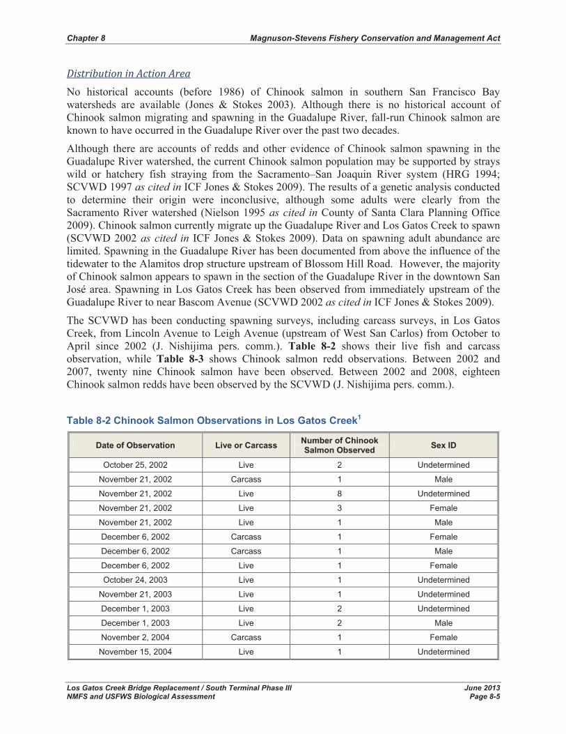
Chapter 8 Magnuson-Stevens Fishery Conservation and Management Act
Los Gatos Creek Bridge Replacement / South Terminal Phase III June 2013 NMFS and USFWS Biological Assessment Page 8-5
Distribution�in�Action�Area�No historical accounts (before 1986) of Chinook salmon in southern San Francisco Bay watersheds are available (Jones & Stokes 2003). Although there is no historical account of Chinook salmon migrating and spawning in the Guadalupe River, fall-run Chinook salmon are known to have occurred in the Guadalupe River over the past two decades.
Although there are accounts of redds and other evidence of Chinook salmon spawning in the Guadalupe River watershed, the current Chinook salmon population may be supported by strays wild or hatchery fish straying from the Sacramento–San Joaquin River system (HRG 1994; SCVWD 1997 as cited in ICF Jones & Stokes 2009). The results of a genetic analysis conducted to determine their origin were inconclusive, although some adults were clearly from the Sacramento River watershed (Nielson 1995 as cited in County of Santa Clara Planning Office 2009). Chinook salmon currently migrate up the Guadalupe River and Los Gatos Creek to spawn (SCVWD 2002 as cited in ICF Jones & Stokes 2009). Data on spawning adult abundance are limited. Spawning in the Guadalupe River has been documented from above the influence of the tidewater to the Alamitos drop structure upstream of Blossom Hill Road. However, the majority of Chinook salmon appears to spawn in the section of the Guadalupe River in the downtown San José area. Spawning in Los Gatos Creek has been observed from immediately upstream of the Guadalupe River to near Bascom Avenue (SCVWD 2002 as cited in ICF Jones & Stokes 2009).
The SCVWD has been conducting spawning surveys, including carcass surveys, in Los Gatos Creek, from Lincoln Avenue to Leigh Avenue (upstream of West San Carlos) from October to April since 2002 (J. Nishijima pers. comm.). Table 8-2 shows their live fish and carcass observation, while Table 8-3 shows Chinook salmon redd observations. Between 2002 and 2007, twenty nine Chinook salmon have been observed. Between 2002 and 2008, eighteen Chinook salmon redds have been observed by the SCVWD (J. Nishijima pers. comm.).
Table 8-2 Chinook Salmon Observations in Los Gatos Creek1
Date of Observation Live or Carcass Number of Chinook Salmon Observed Sex ID
October 25, 2002 Live 2 Undetermined
November 21, 2002 Carcass 1 Male
November 21, 2002 Live 8 Undetermined
November 21, 2002 Live 3 Female
November 21, 2002 Live 1 Male
December 6, 2002 Carcass 1 Female
December 6, 2002 Carcass 1 Male
December 6, 2002 Live 1 Female
October 24, 2003 Live 1 Undetermined
November 21, 2003 Live 1 Undetermined
December 1, 2003 Live 2 Undetermined
December 1, 2003 Live 2 Male
November 2, 2004 Carcass 1 Female
November 15, 2004 Live 1 Undetermined
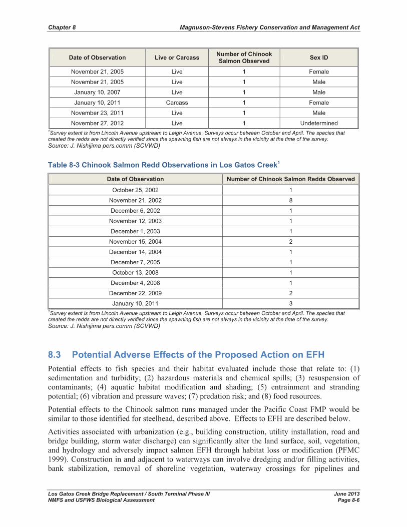
Chapter 8 Magnuson-Stevens Fishery Conservation and Management Act
Los Gatos Creek Bridge Replacement / South Terminal Phase III June 2013 NMFS and USFWS Biological Assessment Page 8-6
Date of Observation Live or Carcass Number of Chinook Salmon Observed Sex ID
November 21, 2005 Live 1 Female
November 21, 2005 Live 1 Male
January 10, 2007 Live 1 Male
January 10, 2011 Carcass 1 Female
November 23, 2011 Live 1 Male
November 27, 2012 Live 1 Undetermined 1Survey extent is from Lincoln Avenue upstream to Leigh Avenue. Surveys occur between October and April. The species that created the redds are not directly verified since the spawning fish are not always in the vicinity at the time of the survey. Source: J. Nishijima pers.comm (SCVWD)
Table 8-3 Chinook Salmon Redd Observations in Los Gatos Creek1
Date of Observation Number of Chinook Salmon Redds Observed
October 25, 2002 1
November 21, 2002 8
December 6, 2002 1
November 12, 2003 1
December 1, 2003 1
November 15, 2004 2
December 14, 2004 1
December 7, 2005 1
October 13, 2008 1
December 4, 2008 1
December 22, 2009 2
January 10, 2011 3 1Survey extent is from Lincoln Avenue upstream to Leigh Avenue. Surveys occur between October and April. The species that created the redds are not directly verified since the spawning fish are not always in the vicinity at the time of the survey. Source: J. Nishijima pers.comm (SCVWD)
8.3 Potential Adverse Effects of the Proposed Action on EFH Potential effects to fish species and their habitat evaluated include those that relate to: (1) sedimentation and turbidity; (2) hazardous materials and chemical spills; (3) resuspension of contaminants; (4) aquatic habitat modification and shading; (5) entrainment and stranding potential; (6) vibration and pressure waves; (7) predation risk; and (8) food resources.
Potential effects to the Chinook salmon runs managed under the Pacific Coast FMP would be similar to those identified for steelhead, described above. Effects to EFH are described below.
Activities associated with urbanization (e.g., building construction, utility installation, road and bridge building, storm water discharge) can significantly alter the land surface, soil, vegetation, and hydrology and adversely impact salmon EFH through habitat loss or modification (PFMC 1999). Construction in and adjacent to waterways can involve dredging and/or filling activities, bank stabilization, removal of shoreline vegetation, waterway crossings for pipelines and
Chapter 8 Magnuson-Stevens Fishery Conservation and Management Act
Los Gatos Creek Bridge Replacement / South Terminal Phase III June 2013 NMFS and USFWS Biological Assessment Page 8-7
conduits, removal of riparian vegetation, channel realignment, and the construction of docks and piers (PFMC 1999). These alterations can alter salmon habitat directly or indirectly by interrupting sediment supply that creates spawning and rearing habitat for prey species, by increasing turbidity levels and diminishing light penetration to submergent vegetation, by altering hydrology and flow characteristics, by raising water temperature, and by re-suspending pollutants (Phillips 1984 as cited in PFMC 1999).
Projects in or along waterways (i.e., Los Gatos Creek) can be of sufficient scope to potentially cause long-term or permanent adverse affects on aquatic habitat. However, most waterway projects and other projects associated with growth, urbanization, and construction within the region are small-scale projects that individually cause minor losses or temporary disruptions to habitat (PFMC 1999).
Construction activities can also have detrimental effects on have the potential to affect salmon habitat through the run-off of large quantities of sediment, as well as the nutrients, heavy metals, and pesticides and the potential or hazardous spills or seepage from equipment. Run-off of petroleum products and oils from roads and parking lots and sediment, nutrients, and chemicals from yards as well as discharges from municipal sewage treatment plants and industrial facilities are also associated with urbanization (EPA 1993 as cited in PFMC 1999). Urbanized areas also alter the rate and intensity of run-off into streams and waterways. Organic contaminants, often found in urban runoff, can cause immunosuppression in fish (Arkoosh et al. 1998 as cited in PFMC 1999). However, Implementation of conservations measures and BMPs described in Section 6.0 and below, will minimize and/or eliminate any potential effects to Pacific salmon EFH.
Effects of run-off rates can be much greater in urbanized settings relative to other types of land use, because of the amount of impervious surfaces. Buildings, rooftops, sidewalks, parking lots, roads, gutters, storm drains, and drainage ditches, in combination, can quickly divert rainwater to receiving streams, resulting in an increased rate and volume of runoff from each storm, increased peak discharges, decreased discharge time for runoff to reach the stream, and increased frequency and severity of flooding (EPA 1993 as cited in PFMC 1999). Flooding reduces refuge space for fish, especially where accompanied by loss of instream structure, off-channel areas, and habitat complexity. Flooding can also scour eggs and young from the gravel. Increases in streamflow disturbance frequencies and peak flows also compromises the ability of aquatic insects and fish life to recover (May et al. 1997 as cited in PFMC 1999). The Proposed Action will not be creating additional impervious surfaces; therefore no impacts to EFH associated with runoff are expected.
8.4 Minimization and Avoidance of EFH Impacts PFMC and NMFS have established policies and procedures for conserving and enhancing EFH. This framework includes adverse impact avoidance and minimization; provision of compensatory mitigation whenever the impact is significant and unavoidable; and incorporation of enhancement measures. New and expanded responsibilities contained in the MSFMCA will be met through appropriate application of these policies and principles. In assessing the potential impacts of Proposed Actions, the PFMC and NMFS are guided by the following general considerations (PFMC 1998a):

Chapter 8 Magnuson-Stevens Fishery Conservation and Management Act
Los Gatos Creek Bridge Replacement / South Terminal Phase III June 2013 NMFS and USFWS Biological Assessment Page 8-8
� The extent to which the activity would directly and indirectly affect the occurrence, abundance, health, and continued existence of fishery resources.
� The extent to which the potential for cumulative impacts exists.
� The extent to which adverse impacts can be avoided through project modification, alternative site selection or other safeguards.
� The extent to which the activity is water dependent if loss or degradation of EFH is involved.
� The extent to which mitigation may be used to offset unavoidable loss of habitat functions and values.
8.5 PFMC Recommended Minimization Measures In addition to the Conservation Measures described in Section 7.0, the following section details the PFMC-recommended minimization measures for each type of riverine activity that could impact EFH during construction of the Proposed Action (PFMC 1998a, 1999).
Oil/Gas�and�Other�Contaminant�Spill�Measures�
� Containment equipment and sufficient supplies to combat spills should be on site at all facilities that handle oil or hazardous substances.
� Each facility should have a “Spill Contingency Plan” and all employees should be trained in how to respond to a spill.
� To the maximum extent practicable, storage of oil and hazardous substances should be located in an area that would prevent spills from reaching the aquatic environment.
Construction/Urbanization�
� Protect existing, and wherever practicable, establish new riparian buffer zones of appropriate width on all permanent and ephemeral streams that include or influence EFH. Establish buffers wide enough to support shading, large woody debris input, leaf litter inputs, sediment and nutrient control, and bank stabilization functions.
� Plan development sites to minimize clearing and grading and cut-and-fill activities.
� During construction, temporarily fence setback areas to avoid disturbance of natural riparian vegetation and maintain riparian functions for EFH.
� Use best management practices in building as well as road construction and maintenance operations such as avoiding ground disturbing activities during the wet season, minimizing the time disturbed lands are left exposed, using erosion prevention and sediment control methods, minimizing vegetation disturbance, maintaining buffers of vegetation around wetlands, streams and drainage ways, and avoiding building activities in areas of steep slopes with highly erodible soils. Use methods such as sediment ponds, sediment traps, or other facilities designed to slow water run-off and trap sediment and nutrients.
� Where feasible, remove impervious surfaces such as abandoned parking lots and buildings from riparian areas, and re-establish wetlands.

Chapter 8 Magnuson-Stevens Fishery Conservation and Management Act
Los Gatos Creek Bridge Replacement / South Terminal Phase III June 2013 NMFS and USFWS Biological Assessment Page 8-9
8.6 Conclusion and Effect Determination With the implementation measures outlined in Section 8.5, the Proposed Action is “not likely to adversely affect” fish species (i.e., fall-run Chinook salmon) managed under the Pacific Coast Salmon FMP or their designated EFH. The Proposed Action would not directly or indirectly appreciably reduce the likelihood of the survival of Chinook salmon runs in the wild by reducing their reproduction, numbers, or distribution.

Chapter 8 Magnuson-Stevens Fishery Conservation and Management Act
Los Gatos Creek Bridge Replacement / South Terminal Phase III June 2013 NMFS and USFWS Biological Assessment Page 8-10
This page left blank intentionally
Chapter 9 References
Los Gatos Creek Bridge Replacement / South Terminal Phase III June 2013 NMFS and USFWS Biological Assessment Page 9-11
9.0 References Balance Hydrologics, Inc. 2009. Geomorphic Recommendations for Los Gatos Creek Railroad
Bridge Replacement Project San Jose, California. Report prepared for: Parsons Transportation
Barnhart, R.A. 1986. Species profiles: life histories and environmental requirements of coastal fishes and invertebrates (Pacific Southwest), steelhead. U.S. Fish and Wildlife Service, Biological Report 82 (11.60). 21 pages.
Birtwell, I. K., G. F. Hartman, B. Anderson, D. J. McLeay, and J. G. Malick. 1984. A Brief Investigation of Arctic Grayling (Thymallus arcticus) and Aquatic Invertebrates in the Minto Creek Drainage, Mayo, Yukon Territory: An Area Subjected to Placer Mining. Canadian Technical Report of Fisheries and Aquatic Sciences. Volume 1287
Brett, J.R., W.C. Clarke, and J.E. Shelbourn. 1982. Experiments on Thermal Requirements for Growth and Food Conversion Efficiency of Juvenile Chinook Salmon, Oncorhynchustshawytscha. Nanaimo, BC: Government of Canada, Fisheries and Oceans.
Busby, P. J., T. C. Wainwright, G. J. Bryant, L. J. Lierheimer, R. S. Waples, F. W. Waknitz, and I. V. Lagomarsino. 1996. Status Review of West Coast Steelhead From Washington, Idaho, Oregon, and California. Report No. NMFS-NWFSC-27. NOAA Technical Memorandum. U.S. Department of Commerce.
California Department of Fish and Game (CDFG) California Natural Diversity Database (CNDDB). 2010. RareFind 3 personal computer program. Data accessed September 2010. Sacramento, CA.
California Department of Transportation (Caltrans). 2009. Technical Guidance for Assessment and Final Mitigation of the Hydroacoustic Effects of Pile Driving on Fish. Prepared by ICF Jones & Stokes and Illingworth and Rodkin, Inc. February 2009
Cushman, R. M. 1985. Review of Ecological Effects of Rapidly Varying Flows Downstream from Hydroelectric Facilities. North American Journal of Fisheries Management. Volume 5: 330-339
Department of Commerce, National Oceanic and Atmospheric Administration. 2013. Endangered and Threatened Species; Range Extension for Endangered Central California Coast Coho Salmon, Final Rule, Federal Register Vol. 77, No. 63, codified at 50 CFR Part 224. April 2, 2013. Available online at: http://swr.nmfs.noaa.gov/hcd/HCD_webContent/pdf/Final_CCC_Coho_Range_Ext_040212.pdf , accessed July 25, 2013.
DeVore, P. W., L. T. Brooke, and W. A. Swenson. 1980. The Effects of Red Clay Turbidity and Sedimentation on Aquatic Life in the Nemadji River System. Red Clay Project, Final Report, Part II. Prepared for U.S. Environmental Protection Agency, Great Lakes National Program Office. Impact of Nonpoint Pollution Control on Western Lake Superior. Washington, D.C.: U.S. EPA.

Chapter 9 References
Los Gatos Creek Bridge Replacement / South Terminal Phase III June 2013 NMFS and USFWS Biological Assessment Page 9-12
Galloway, D.L., D.R. Jones, and S.E. Ingebritsen. 2000. Measuring Land Subsidence from Space. Fact Sheet-051-00. April 2000. Available online at: http://ca.water.usgs.gov/insar/ex_santaclara/.
Garcia and Associates (GANDA). 2008. Biological Memorandum to Davis Wemmer and Elizabeth Hughes, Parsons from Joe Drennan and JoAnna Lessard (GANDA), July 2, 2008.
Good, T. P., R. S. Waples, and P. Adams. 2005. Updated Status of Federally Listed ESUs of West Coast Salmon and Steelhead. U.S. Dept. of Commerce, NOAA Technical Memorandum NMFS�NWFSC� 66, 598 p.
Healey, M. C. 1991. Life history of Chinook salmon (Oncorhynchus tshawytscha). In C. Groot and L. Margolis, editors, Pacific Salmon Life Histories, pages 396-445 [check. Another reference said Pages 313-393]. University of British Columbia Press, Vancouver, British Columbia. 564 pages.
ICF Jones & Stokes. 2009. Santa Clara Valley Habitat Plan. 2nd Administrative Draft. June 1, 2009. Prepared for County of Santa Clara Planning Office, County Government Center. Available online at: http://scv-habitatplan.org/www/site/alias__default/292/ administrative_draft_habitat_plan.aspx, accessed October 28, 2010.
Leidy, R.A., G.S. Becker, B.N. Harvey. 2005. Historical distribution and current status of steelhead/rainbow trout (Oncorhynchus mykiss) in streams of the San Francisco Estuary, California. Center for Ecosystem Management and Restoration, Oakland, CA.
MACTEC Engineering and Consulting, Inc. (MACTEC). 2010. Geotechnical Investigation Report, Los Gatos Creek Bridge Replacement Project, San Jose, California. Prepared for Parsons Transportation Group. September 10, 2010.
Moyle, P. B. 2002. Inland Fishes of California. Berkeley, CA: University of California Press.
Myrick, C. A. and J. J. Cech. 2001. Temperature Effects on Chinook Salmon and Steelhead: A Review Focusing on California's Central Valley Populations. Bay-Delta Modeling Forum Technical Publication 01-1.
National Marine Fisheries Serivce (NMFS). 1996. Status Review of West Coast Steelhead From Washington, Idaho, Oregon, and California. Technical Memorandumn - NOAA Fisheries-NWFSC-27.
_____. 2000. City of Sacramento Water Treatment Plant Fish Screen Replacement Project Biological Opinion.
_____. 2002. Biological Opinion on Interim Operations of the Central Valley Project and State Water Project Between April 1, 2002 and March 31, 2004, on Federally Listed Threatened Central Valley Spring-Run Chinook Salmon and Threatened Central Valley Steelhead in Accordance With Section 7 of the Endangered Species Act of 1973, As Amended. Long Beach: National Marine Fisheries Service, Southwest Region.
_____. 2003a. Biological Opinion and Magnuson-Stevens Fishery Conservation and Management Act Consultation on the Effects of Construction of Leaburg Tailrace Barrier
Chapter 9 References
Los Gatos Creek Bridge Replacement / South Terminal Phase III June 2013 NMFS and USFWS Biological Assessment Page 9-13
and Modification of Leaburg Fish Screens, in the McKenzie River Subbasin, on Upper Willamette River Chinook Salmon. F/NWR/2003/00761.
_____. 2003b. Biological Opinion, Ord Ferry Road Bridge Seismic Retrofit Project. SWR-01-SA-6002:HLB.
_____. 2007. 2007 Federal Recovery Outline for the Distinct Population Segment of Central California Coast Steelhead. National Marine Fisheries Service, Southwest Regional Office.
_____. 2009. Biological Opinion on the Long-Term Central Valley Project and State Water Project Operations Criteria and Plan. NMFS Southwest Region.
_____. 2010a. Recovery Plan for the Evolutionarily Significant Unit of Central California Coast Coho Salmon. Public Draft. Version. March 2010. NMFS, Santa Rosa, California. Available online at: http://www.swr.noaa.gov/recovery/Coho_Recovery_Plan_031810.htm,accessed November 17, 2010.
_____. 2010b. NMFS Underwater Noise Thresholds to Fish Exposed to Elevated Levels of Underwater Sounds Produced During Pile Driving. Available online at: http://www.wsdot.wa.gov/NR/rdonlyres/1C4DD9F8-681F-49DC-ACAF-ABD307DAEAD2/0/BA_NMFSpileDrivCalcs.xlsm, accessed November 10, 2010
_____. 2011. REVIEW DRAFT – Recovery Plan for the North Central California Coast Domain, Northern California Steelhead, California Coastal Chinook Salmon, Central California Coast Steelhead. Center for Independent Experts Review Draft. Version – September 29, 2011
NMFS Website. 2010. Central Valley Chinook Salmon Current Stream Habitat Distribution Table. Available online at: http://www.swr.noaa.gov/hcd/dist2.htm, accessed November 8, 2010.
National Research Council. 1996. Upstream Salmon and Society in the Pacific Northwest. NRC approved and funded report. Washington, D.C.: National Academy Press.
Pacific Fishery Management Council (PFMC). 1999. Amendment 14, Appendix A: Identification and Description of Essential Fish Habitat, Adverse Impacts, and Recommended Conservation Measures for Salmon. Chapter 3 Description of Adverse Effects on Pacific Salmon Essential Fish Habitat and Actions to Encourage the Conservation and Enhancement of Essential Fish Habitat. Available online at: http://www.pcouncil.org/salmon/fishery-management-plan/adoptedapproved-amendments/amendment-14-to-the-pacific-coast-salmon-plan-1997/, accessed November 27, 2012.
Parsons. 2009. Water Quality Technical Report – Los Gatos River Bridge. Prepared for Peninsula Corridor Joint Power Board. August 2009.
Raleigh, R.F., W.J. Miller, and P.C. Nelson. 1986. Habitat Suitability Index Models and Instream Flow Suitability Curves: Chinook Salmon. (Biological Report 82[10.122]). U.S. Fish and Wildlife Service.

Chapter 9 References
Los Gatos Creek Bridge Replacement / South Terminal Phase III June 2013 NMFS and USFWS Biological Assessment Page 9-14
Reiser, D. W. and T. C. Bjornn. 1979. Influence of Forest and Rangeland Management of Anadromous Fish Habitat in Western North America - Habitat Requirements of Anadromous Salmonids. USDA Forest Service General Technical Report PNW-96.
Santa Clara Valley Water District (SCVWD). 1999. Final Environmental Impact Report/Environmental Impact Statement for the Upper Guadalupe River Flood Control Project EIR/EIS, November 1999
Scannell, P. O. 1988. Effects of Elevated Sediment Levels From Placer Mining on Survival and Behavior of Immature Arctic Grayling. Alaska Cooperative Fishery Unit, University of Alaska. Unit Contribution 27.
Shapovalov, L. and A.C. Taft. 1954. The Life Histories of the Steelhead Rainbow Trout and Silver Salmon. (Fish Bulletin No. 98). California Department of Fish and Game.
State Water Resources Control Board (SWRCB). 2003. SWRCB Order WR 2003-0016 In the Matter of Fishery Resources and Water Right Issues of the Lower Yuba River. Order Vacating Water Right Decision 1644 and Adopting Revised Water Right Decision 1644 Following Consideration of Additional Evidence Specified by Yuba County Superior Court.
USA Fishing Website. 2010. American River salmon numbers a big improvement over last year. Article by Dan Bacher.
U.S. Army Corp of Engineers (USACE). 2004. Framework for Assessing the Potential Effects of Dredging on Sensitive Fish Species in San Francisco Bay. Final Report. August 5, 2004. Prepared by LFR. Available at: http://www.spn.usace.army.mil/ltms/rpt-USACE-SciencePlan-Final-Aug04-09170.pdf Accessed December 11, 2009.
U.S. Environmental Protection Agency. 2007. 2006 CWA Section 303(d) List of Water Quality Limited Segments Requiring TMDLs. U.S. Environmental Protection Agency Region 9. Available online at: http://www.swrcb.ca.gov/water_issues/programs/tmdl/docs/303dlists2006/epa/r2_06_303 d_ reqtmdls.pdf
U.S. Fish and Wildlife Service (USFWS) and NMFS. 1998. Procedures for Conducting Consultation and Conference Activities under Section 7 of the Endangered Species Act. March 1998.
USFWS. 2008. Biological Opinion for the Proposed Jenner Community Club Fire Station Bridge Replacement, Sonoma County, California (FEMA-1628-DR-CA, PW #2721). Available online at: http://www.jenner-cc.org/bridge/USFWS_CRLF_BO.pdf, accessed November 26, 2012
_____2000. Impacts of Riprapping to Ecosystem Functioning, Lower Sacramento River, California. Prepared for the United States Army Corps of Engineers, FWS's Fish and Wildlife Coordination Act Report, and Biological Opinion, and for proposed bank protection work.
Chapter 9 References
Los Gatos Creek Bridge Replacement / South Terminal Phase III June 2013 NMFS and USFWS Biological Assessment Page 9-15
_____. 2013. USFWS Species List Query – San Jose West Quad. Available online at: http://www.fws.gov/sacramento/es_species/Lists/es_species_lists-form.cfm, accessed April 2013
Western Regional Climate Center. 2008. http://www.wrcc.dri.edu/cgi-bin/cliMONtmxt.pl?casjos and http://www.wrcc.dri.edu/cgi-bin/cliMONtmnt.pl?casjos, accessed October 13, 2008.
Williams, J. G. 2006. Central Valley Salmon: A Perspective on Chinook and Steelhead in the Central Valley of California. San Francisco Estuary and Watershed Science 4(3): Article 2.
Personal Communication
Jason Nishijima, Biologist, Santa Clara Valley Water District. November 3, 2010. Email correspondence to Jelica Arsenijevic regarding fish species present in Los Gatos Creek.

Chapter 9 References
Los Gatos Creek Bridge Replacement / South Terminal Phase III June 2013 NMFS and USFWS Biological Assessment Page 9-16
This page left blank intentionally

Los Gatos Creek Bridge Replacement / South Terminal Phase III June 2013 NMFS and USFWS Biological Assessment Page B-1
APPENDIX A
REGIONALLY OCCURRING SPECIAL-STATUS SPECIES LISTS
� California Department of Fish and Game Natural Diversity Database List of Special-Status Species Reported on the San Jose West USGS 7.5 Minute Quad
� Sacramento Fish and Wildlife Office List of Federal Endangered and Threatened Species that Occur in or may be Affected by Projects in the San Jose West USGS 7.5 Minute Quad

Appendix A Regionally Occurring Special-Status Species Lists
Los Gatos Creek Bridge Replacement / South Terminal Phase III June 2013 NMFS and USFWS Biological Assessment Page B-2
This page left blank intentionally.
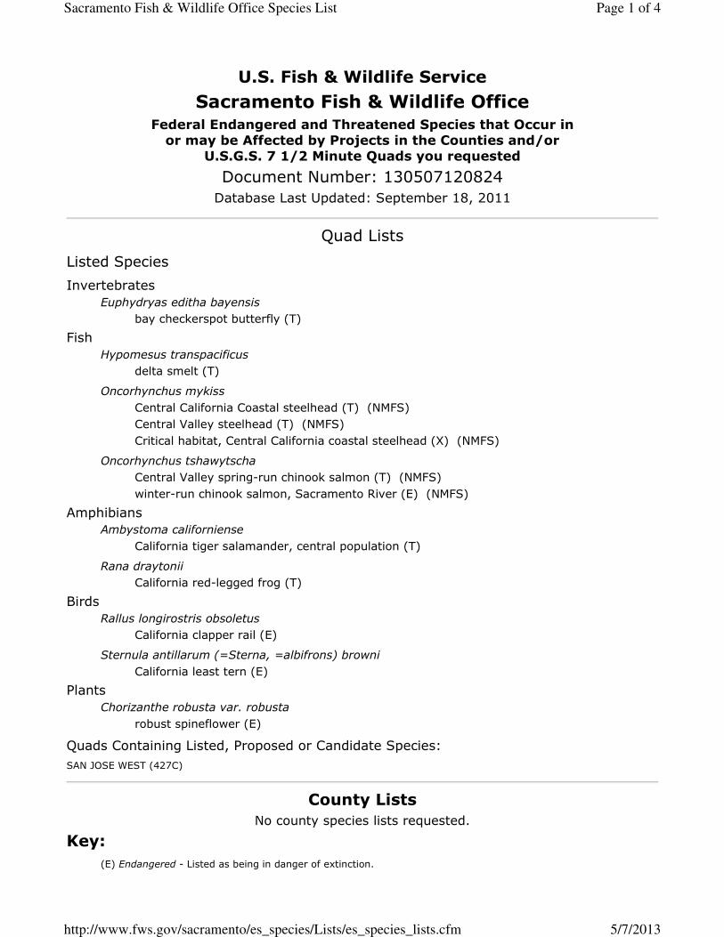
������������� �������������������������������� ������������
�� ������� ������ ��� ��������� �������������������������������� ������ ����!��"�����������#���������� $���
����%����&�'$(�)������*�� ��������+����� ������������� �������������
������������������������ �������
����� ��� ������� ��!�"� �� ���
����������� ������� ��#�$��%� ������ &'#()*
+ �$������������� � ��
��'����'()*
��������������� ,�� �',�' &� � �,����'���'$���()*(�-+�*,�� �'.�''�#���'$���()*(�-+�*, ��'$�� ��,�� �',�' &� � ������'���'$���(/*(�-+�*
�������������������,�� �'.�''�#�� �01 ���$ ���%��'���()*(�-+�*2 �� 1 ���$ ���%��'������� �����3 "� (4*(�-+�*
5��$ � ������������� ���� ���
,�' &� � � 0� ��'������ ���� �'����'� ��()*
��������� ,�' &� � � ��1'�00��& �0()*
6 ����������� ���� ��������
,�' &� � ��'���� � '(4*
���������� ������������� ���� ����!������ ,�' &� � �'���� �(4*
7'���"��� #�����������$�%������
������ ��&'�2� (4*
�����,��� � �0� ����7 ������� ,��� ������� ����5�89�4:4�)(���,*
#������,�����������#���� ��' �� �;�����<
-��.�(4*���������1� ������� �0 ����0� �&�= �� ��<
Page 1 of 4Sacramento Fish & Wildlife Office Species List
5/7/2013http://www.fws.gov/sacramento/es_species/Lists/es_species_lists.cfm
()*&��������1� �����' %�'#������������0� ��2 $ �$�&� ������'�&�� �<
(7*'������19&& � �''#� ������ �$�+��� �'3�0 �� &� ' � �0�������0� ��� $ ������<
(�-+�*���� ������ $�8� �� � ���&$��� ���'9���� �>5����$� �5�� � � � ��+ �$� ���� " ��<,����'2 $$��� ��'#����$������� ��<
"� � ����� ��15 ������� �'�$������ "� ���&����� ��<
(7/*'�������"� � ����� ��1)$����� �� ��' ���#' ���<, ��'$�� � ��� �0� ������&� <
(,*"�� ���1,��� ������������ ���������� ��<
(.*.������#���� � �� <���� ��'# ��&&��<6� �0 �" �2���#$��� " ��<
(/*"� � ����� ����� 0����&� $ ����� ��
!��� ��!�&� �� ��5���?�� ���� ��� �@�2:�-�%����� ��� ��:��� � �&� �� �����������0� �����$ ���������� ��' ���#�<�<A��'�0 ��'�� "�#�B� ���;����<)$��� ������ �� " ��� ��$���;�����2$ �$� �����$�� C��&���+ ��� ���<
)$��� ��'���#�� ���� ��' �� �����$����� 2 $ ������������������� ���� �D���2 $ ��$�;������"� ���#$�' �<
� + �$����$� �;�� ����� ������� ��#�� ' � &$�#� � �$�����2�� �$����#�� ;���� &2�� ��� �#�� ;���� 0$�&&��$��<
� 5��$ � ���2 ''����$�' �&� �;���� ����# &��� � ������' �� �$�� ����#���� ���$� $�� ��#� �� ���<
� 6 ��� ��$�2� �0� �'����&2$�$� $�#� � �� ���� � 0 �� #<3�'�"��� ����$�����#' ��$��'������� �� �� �0� �'����&2$�$� $�#����� ���;���' �<
7'���5�#�'�����#�� ' �� �����$�$�"�����''#�������� "�� �$�� ����"� ���#$�' �<7'�����#�= � ���� ��2 $���"� $�" �0����������$� �<?�����& ����2$�E� �$��� ���� �0;����$ ��0$$�,�' &� � ��� "�7'����� �#E���' ��!�"��� #�&3� ����4����0� ��7'���<
�� "�# �0�����&$����� ����#�� ' ���#�����&&�����##�� � �D��<5 � ���� �'�0 ����F� ���� ��&�� ' � 2 $$�$�� � �;� ������&$����� ����#�� ' ���$��'���� � ��2$�$� $�#� $�� ���� ��'�&� $����#���&&�����##�� � �D��<:� ��������$�#�� �� "�#� ��'�����#� ������������� ������� ����#�� ' �<����� 7 ����'���3���"� #7� � ���0��<
+� �'���� "�#��2� ���������� �0$�A� ��' ���&� ,����� �0���3��� �06��� ��'!�"��� ��<)$� ���'��&#�� �� "�#��$��'������' �$�� ���#��" ������'��������� ��� ��&� #�� � �D��<
?�� 3������ � ' ������ $�4����0� ������ ��5�5''�� ��'� ��� & ����' ������"�� �&�''#� ��������� $�4����0� ������ ��5��&�G������������<��� ��G�&$�5���� � ��'���� �0 �0�'� ���� �$ � $��%��&�&��� �''#' ���2 '�' &����� ��<)�%� ���& ����#$�5���H�$� ����$� ���� ����$����$���2�����% ''� ������� ��� ��''��H��#���$�� ��'<
)�%���# ��'���� 0� & ���$�� ���� & �� ��� ��0 ��� ��2$� � ����''#% ''��
Page 2 of 4Sacramento Fish & Wildlife Office Species List
5/7/2013http://www.fws.gov/sacramento/es_species/Lists/es_species_lists.cfm
�D� ��2 '�' &��#� 0� & ���'# ��� �0����� �'��$�" � �'��� ��� ��'�� �0� ��� �0�&��� �0�� �$�'� (��,+3I��<�*<
)�%� �� ����'����$� 2 ��'�2&�'�� " #��#����$� C���#����&2�� ����� ���
� !&�+��� �'�0���# � �"�'"��2 $$��� � �0�&��� �0�� �� # �0���&�� �D��$���# ���' ��%��$��$��0���#�����0�0� ��&� ��'�����'� ��2 $$��� " ��<
�� �0&� ��'�����'� ���$�+��� �'�0���#�$����' ������$��� " ��2� %�0�$� ��"� �� � � � C�$� ������' ������� �����$� $�� �<���$�����'� ��2��'� ���' ��� �'�0 ��'�� � ���#$��� " ����� ��� �0$��� � �����&&���&$�� �D����' ������� ���������� ��<)$��� � ����#��$� C��' � ��'�"�'�& �� ����'�%�<
� !&��+��� �'�0���# � �"�'"��2 $$�� �D������&��� �''#' ������� ����#���%������ �&$�� �D���$��#���$����' �����$��'����'#&� �� �� ����'�%��� � <)$��� " ����# �������$��� � &#������ ��� �&��� #����� "� ���'��&� $����� ��$�2��'����&&�����##�� � �D��<
�$��'�#�� �� "�#��� � ��$�&��� �''#' ���� � ���������� ������ �$�� ������ �' %�'#����&&�����#$�� �D���2� ��������$�#��2� %2 $$ ��&& �����$�,�' &� � ����� ����&+ �$���A������"�'����'��$�� � � C��$�� �D��E�� ����� �� �� ������' ������� ���������������&� � �D��1 �'���'����&$�� �<?���$��'� ��'���$��'�� ���#��" ������'��������#��& '�<
, ��'@�� �:$������� �� �' ����������0� ��� $ �������� ����&$�� ����� �� ������� �'� ������ "� ����#����� 0������� ��'$�� �<)$���� �����# �;� ����� �'����0�������� �� � ���� � ��� ��<)$�#� �" �������������&� 0 �2$����� ��'��$�" � J&����2�� �� �' 0$��$� �� ���'� �$#� �'�0 ��' �;� �����J��"� � �$�'� J���� ��&� � ��� �0� �� ���� ��� �� �0�&�&&�� �0�0� � �� ��� ����� ��� ��'<
5'$��0$� ��'$�� ���#����� 0������� "��� ���'������� " ����$���'����� ��� �� �����'���$� � �+��� �' �"�'"���� �$��� " ��� � ��$� ��' ���2 '�' &�<
!&��#���� ��$��� ������� ��� 0����� ��'$�� �2 $ ��;����$� �2 ''������� ��' ��&� $ ���$����� ��' �<6����� #���� � ����&$�� ��'$�� ���#��&���� �$�+��� �'3�0 �� <)$� �&� �� �� ��'�� �� ��� �$�,����&+��� �'3�0�'� ���(��,+3��<G�*<����� -��3�����0�<
,��� ������� ��:� ��������$�#����� ��� ���������� ������� ��<:����'�������� ��'����� ���� ���' �2$��2�$�"�����0$�� �� & � �&� �� ����"����''#� �����$��&� ' � �0��$ ������� �����0� ��<6#���� �� �0$������� ���� '# �#�� �'��� �0� �����#����#����'���"� �$�� ��'���$����'���"�'�� &����&$������� ����2��' �����&� �$�����&#�� � �D��<
���� ���&,���� �)$���� �����+ �$>: '�' &�9&& ����'��0� �� �� ���' ��&���� ���&����� �<@�2�"� �"� ����$� �0��� ������ 0�� C� ����� �� �' ���&�1 �%���� ��<)$���' ��� �" ������� �' �&� �� ��&� '�������0�����'��� �0�������� "� ���&&� �<-� � �&�
:�'����
Page 3 of 4Sacramento Fish & Wildlife Office Species List
5/7/2013http://www.fws.gov/sacramento/es_species/Lists/es_species_lists.cfm

!&#�� � �D��2 '' ����2�'����� �� ��$�� ��� �$� D� �� � ���'2�� �����& ����#��� ������&$�,'���:�� 5����F� ��� �����&$�3 "� ����@� �� �5��#��2 ''�������� ���� � & ��$��<�<5 �#,� ���&4�0 ��� �<!������2�'���$�� �� �;� �� ����� & �� 0� �������� � �0<+� ;��� ��� �0� � �02�'������'���������-� %� '�& �'��&$ ��&& ���(G�K*���1K��� <
������9� ������� �������'#������������ ��� �� �������' ��������' ���<!&#����� ���� ������������� ������� �� �#�� �'��� �0�$ ��$��'������� ��'��<@�2�"� �2� ��������$�#��0���������' ��"� #G���#�<)$�2��'���5�0���������<
Page 4 of 4Sacramento Fish & Wildlife Office Species List
5/7/2013http://www.fws.gov/sacramento/es_species/Lists/es_species_lists.cfm

Species Element Code Federal Status State Status Global Rank State Rank
Rare Plant Rank/CDFWSSC or FP
American peregrine falconFalco peregrinus anatum
ABNKD06071 Delisted Delisted G4T3 S2 FP
arcuate bush-mallowMalacothamnus arcuatus
PDMAL0Q0E0 None None G2Q S2.2 1B.2
burrowing owlAthene cunicularia
ABNSB10010 None None G4 S2 SSC
California tiger salamanderAmbystoma californiense
AAAAA01180 Threatened Threatened G2G3 S2S3 SSC
Congdon's tarplantCentromadia parryi ssp. congdonii
PDAST4R0P1 None None G4T2 S2 1B.2
Cooper's hawkAccipiter cooperii
ABNKC12040 None None G5 S3 WL
hairless popcornflowerPlagiobothrys glaber
PDBOR0V0B0 None None GH SH 1A
Hall's bush-mallowMalacothamnus hallii
PDMAL0Q0F0 None None G2Q S2 1B.2
hoary batLasiurus cinereus
AMACC05030 None None G5 S4?
pallid batAntrozous pallidus
AMACC10010 None None G5 S3 SSC
robust spineflowerChorizanthe robusta var. robusta
PDPGN040Q2 Endangered None G2T1 S1 1B.1
saline cloverTrifolium hydrophilum
PDFAB400R5 None None G2 S2 1B.2
western pond turtleEmys marmorata
ARAAD02030 None None G3G4 S3 SSC
Record Count: 13
Report Printed on Thursday, April 18, 2013
Page 1 of 1Commercial Version -- Dated April, 2 2013 -- Biogeographic Data Branch
Information Expires 10/2/2013
Selected Elements by Scientific NameCalifornia Department of Fish and Wildlife
California Natural Diversity Database

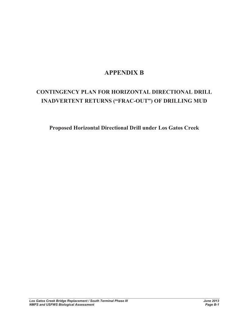
Los Gatos Creek Bridge Replacement / South Terminal Phase III June 2013 NMFS and USFWS Biological Assessment Page B-1
APPENDIX B
CONTINGENCY PLAN FOR HORIZONTAL DIRECTIONAL DRILL INADVERTENT RETURNS (“FRAC-OUT”) OF DRILLING MUD
Proposed Horizontal Directional Drill under Los Gatos Creek

Appendix B Contingency Plan For Horizontal Directional Drill Inadvertent Returns (“Frac-Out”) of Drilling Mud
Los Gatos Creek Bridge Replacement / South Terminal Phase III June 2013 NMFS and USFWS Biological Assessment Page B-2
This page left blank intentionally.
1
CONTINGENCY PLAN FOR HORIZONTAL DIRECTIONAL DRILL INADVERTENT RETURNS (“FRAC-OUT”) OF DRILLING MUD
Proposed Horizontal Directional Drill under Los Gatos Creek Introduction The JPB proposes to relocate an existing 12-inch pipeline underneath Los Gatos Creek in San Jose, CA with a new Horizontally Directionally Drilled (HDD) 12-inch pipeline to accommodate the replacement of Los Gatos Creek Bridge. HDD pipeline installation methods minimize environmental impacts normally associated with open trench installation methods. However, with the use of the HDD installation method to traverse waterways, inadvertent returns of drilling mud could occur and measures of protection must be implemented.
These protection measures primarily focus on prevention of inadvertent returns of drilling mud into sensitive areas. These measures include monitoring the pressure of drilling fluids, maintaining drilled hole diameter and monitoring drilling fluid viscosity and gel strength.
Drilling Process and Equipment The HDD method will be used to install a 12-inch diameter pipeline beneath Los Gatos Creek. The following is an overview of the proposed HDD method.
Drilling Equipment The essential equipment required for the directional bore operation includes the drill rig, solids control system, mud pump, pipe trailers, bentonite trailers, tool van, water truck, and accessory equipment trailer. The accessory equipment trailer contains the anchor, optional downhole tool, and additional solids control equipment.
The employees required to run the drilling operation typically include the drilling superintendent, surveyor, driller, assistant driller, solids control operator, crane operator, mechanic/welder, and rig hands.
Workspace Two staging areas are required; the entry site where the drilling rig and auxiliary equipment are positioned, and the exit site-pipeline laydown area.
Drill Rig Setup After the alignment and entry point are set and the precise location for the drill rig is determined, an anchor is installed to prevent any movement of the drill rig and allow for the several-ton push and pull pressures on the drill pipe.
Once the drill rig is positioned and anchored, the sump pit is excavated. The sump pit is required to hold the drilling fluid and cuttings that have returned to the surface from the borehole. From the sump pit drilling fluid is pumped to the solids control system for processing and recycling.
Drilling Fluid and Drilling Fluid System Drilling fluids typically used to cool and lubricate the drill motor and reamers consist of a non-toxic mixture of water, bentonite clay, and polymers or other non-toxic additives to improve fluid performance. The drilling fluids further serve to transport rock and soil cuttings away from
2
the drill cutters to reduce friction between the pipe and the bore hole wall and to stabilize the hole. Bentonite is a naturally occurring, non-hazardous clay product.
Drilling fluid is prepared in mixing tanks using both new and recycled drilling fluid. The fluid is pumped through the drill pipe to the cutters. Flow rates, pressure, density, viscosity, gel strength, and lubricity are monitored throughout the drilling and reaming operation to maintain fluid performance and detect drill fluid losses.
Returning fluid flows through the annulus created between the wall of the bore and drill pipe to the sump pit. Once in the sump pit, larger particles are pumped through the shaker screens, desanders, and desilters to progressively remove the different size fractions of cuttings from the drilling fluid. The cleaned and recycled fluid is returned to the mixing tank for reuse in the borehole. All excess drilling mud will be hauled off site with vacuum trucks and taken to an appropriate dump site.
Environmental Concerns Drilling Fluid Losses and Measures to Control Spills While directional drilling is an effective and increasingly popular method of pipeline installation for crossing rivers and waterways, it does present some risk of waterway disturbance due to lost circulation or inadvertent returns. The potential for an accidental release is greatly reduced by providing adequate depth of cover and by selecting an experienced and knowledgeable contractor.
Lost Circulation Lost circulation refers to the loss of drilling mud into the soft or rock through open fissures, coarse gravel, and highly-jointed or easily fractured formations. Measures that will be taken to control lost circulation include:
� Controlling fluid pressures in the annulus by minimizing viscosity required to satisfy hole cleaning and stabilization requirements.
� Minimizing gel strength.
� Sizing the hole frequently to ensure an adequate clear annulus.
� Controlling “plunger effects” caused by rapid penetration or spoil buildup on bits or pipe.
Inadvertent Returns “Frac-out”, or inadvertent return of drilling fluid, is a potential concern when a HDD method is used for installing pipelines under sensitive habitats and waterways. An inadvertent return is the abrupt escape of drilling fluid from the pipe annulus to the ground or streambed surface along alternate flow paths through soil and rock. Hydraulic fracturing of rock, open fissures, and insufficient rock cover can all lead to inadvertent returns. Measures that will be taken to reduce chances of inadvertent return during installation include:
� Adequate cover - a minimum depth of 30 feet beneath the streambed surface will be maintained at all points of the alignment.
� Maintaining drilled annulus - cutters and reamers will be pulled back into previously drilled sections after each new joint of pipe is added to removed blockage.
3
� Monitoring - drilling pressures will be monitored so they do not exceed pressures that may penetrate the formation.
If an inadvertent return occurs on land, standard containment procedures are implemented. The mud pumps are stopped while a shallow pit or sandbags and hay bales are used to contain and collect the returning flow. Once isolated, the fluid can be pumped back to the mud return pits and re-used. After drilling fluid seepage has been contained, the subcontractor will attempt to determine the cause of the seepage.
If inadvertent returns occur through the sediments under the waterway, the seeping mud may produce a visible plume in the water. If not visible in the water, signs of mud loss will be evident through monitoring mud return flow rates and pressures. Corrective measures that will be taken to control the seepage and minimize chances of recurrence include:
� Stopping all work and waiting several hours to see if the fracture occludes.
� Stopping all work and diffusing loss circulation materials such as a “Nut Plur, Flow Check”, or shredded paper.
� Stopping all work and pumping cement or grout.
If circulation cannot be restored using sealing materials and adjustments to the fluid properties and drilling practices, the hole will be abandoned (as described below) and redrilled along a deeper alignment.
Protection Measures Loss of Circulation Measures that will be taken to control lost circulation include: controlling fluid pressures in the annulus by minimizing viscosity required to satisfy hole cleaning and stabilization requirements, minimizing gel strength, sizing the hole frequently to ensure an adequate clear annulus, and controlling “plunger effects” caused by rapid penetration or spoil buildup on bits or pipe.
Frac Out Common wildlife, as well as aquatic species, are present in the waterways and its surroundings and make these areas environmentally sensitive habitats. Because of the sensitivity of these areas, implementation of the HDD method for crossing these waterways is necessary to reduce the potential for adverse impacts to these species and their habitat.
A qualified monitor will be on site at all times while drilling under sensitive areas to identify any possible “frac-out” conditions or lowered pressure readings on the drilling equipment. The monitor shall be a biologist experienced with HDD operations and “frac-outs”.
If a leak were observed or detected by the pressure readings, all work would stop immediately and remedial actions would be implemented. The monitor will be on site during all aspects of drilling activities within the sensitive areas. Hay bales, sand bags, or silt fencing will be kept on site and used to surround and contain the drilling mud. A mobile vacuum truck will be used to pump the drilling mud from the contained area and recycled to the return pit. The vacuum truck will remain within a temporary workspace and extend a hose to the containment area.

4
If a “frac-out” is determined to be within the waterway, a spill response team will be called in to contain and clean up excessive amounts of drilling mud within the waterway. Phone numbers of spill response teams in the area will be on site.
Evacuation Plan In the event of a “frac-out”, Shell and the contract drilling engineer will evaluate the feasibility of continuing the boring procedure or implementing the Abandonment Contingency Plan after evaluating the following:
� The exact location of the drilling head assembly will be verified with portable locating equipment. If it is determined that the drilling profile does not match the planned profile, and exceeds design limits, the Abandonment Contingency Plan will be implemented.
� If the location and profile are within design limits, the specific weight of the drilling mud will be verified to ensure a slightly overbalanced condition to the surrounding formation. The specified weight will be adjusted, if necessary.
� If location, profile and drilling mud weight are determined to be within design limits, and seepage of Bentonite slurry is controlled, the contract drilling engineer may proceed.
� Should it be determined that the stability of the bored crossing is in serious question, even if location, profile and drilling mud weight are deemed satisfactory, the Abandonment Contingency Plan will be implemented.
Abandonment Contingency Plan Abandonment of the bore is a last resort measure that will be followed only when all efforts to restore circulation have failed. Steps that will be taken in the unlikely event that an incomplete bore must be abandoned are the following:
� The as-built hole alignment will be determined to the extent practicable, and documented.
� The pilot hole pipe string will be removed.
� A thick, bentonite-cement grout will be pumped through the casing as it is extracted, resulting in complete filling of the bore.