nj protecting against climate threats
TRANSCRIPT
z
NJ Protecting Against Climate ThreatsResilient Environment and Landscapes (REAL)
Framework of Potential Amendments toLand Resource Protection Rules
New Jersey Department of Environmental Protection22 December 2020
Fo
r genera
l dis
cussio
n p
urp
oses o
nly
. Info
rmatio
n p
rovid
ed is
pre
-decis
ional a
nd d
oes n
ot c
onstitu
te a
final a
gency d
ecis
ion o
r actio
n.

This meeting is being held by the
New Jersey Department of
Environmental Protection for
general discussion purposes only.
Information provided is pre-
decisional and does not constitute a final agency decision or action.
Fo
r genera
l dis
cussio
n p
urp
oses o
nly
. Info
rmatio
n p
rovid
ed is
pre
-decis
ional a
nd d
oes n
ot c
onstitu
te a
final a
gency d
ecis
ion o
r actio
n.

z
z
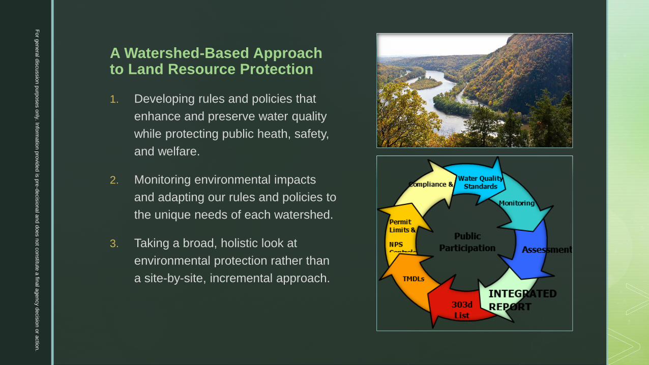
A Watershed-Based Approachto Land Resource Protection
Fo
r genera
l dis
cussio
n p
urp
oses o
nly
. Info
rmatio
n p
rovid
ed is
pre
-decis
ional a
nd d
oes n
ot c
onstitu
te a
final a
gency d
ecis
ion o
r actio
n.
z
A Watershed-Based Approachto Land Resource Protection
1. Developing rules and policies that
enhance and preserve water quality
while protecting public heath, safety,
and welfare.
2. Monitoring environmental impacts
and adapting our rules and policies to
the unique needs of each watershed.
3. Taking a broad, holistic look at
environmental protection rather than
a site-by-site, incremental approach.
Fo
r genera
l dis
cussio
n p
urp
oses o
nly
. Info
rmatio
n p
rovid
ed is
pre
-decis
ional a
nd d
oes n
ot c
onstitu
te a
final a
gency d
ecis
ion o
r actio
n.
z
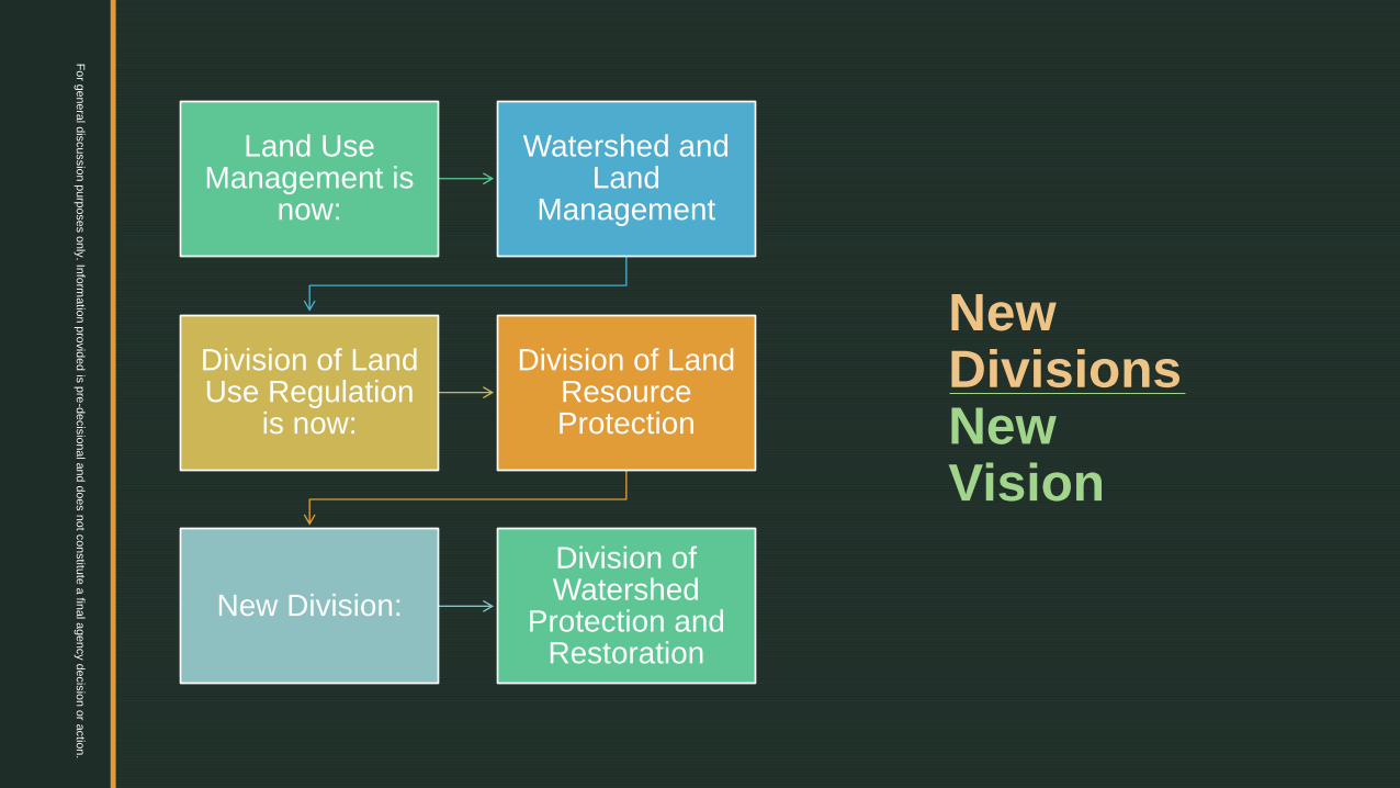
New DivisionsNew Vision
Land Use Management is
now:
Watershed and Land
Management
Division of Land Use Regulation
is now:
Division of Land Resource Protection
New Division:
Division of Watershed
Protection and Restoration
Fo
r genera
l dis
cussio
n p
urp
oses o
nly
. Info
rmatio
n p
rovid
ed is
pre
-decis
ional a
nd d
oes n
ot c
onstitu
te a
final a
gency d
ecis
ion o
r actio
n.

z
Rulemaking Objective
To address the unavoidable impacts of
climate change, such as sea-level rise,
extreme weather, and chronic flooding
through targeted regulatory reforms that
will modernize the land use rules and
focus on increased resiliency throughout
the State.
Fo
r genera
l dis
cussio
n p
urp
oses o
nly
. Info
rmatio
n p
rovid
ed is
pre
-decis
ional a
nd d
oes n
ot c
onstitu
te a
final a
gency d
ecis
ion o
r actio
n.

z
Guiding Principles
▪ Develop regulatory standards that are commensurate with the anticipated level of risk.
▪ Provide tools to help homeowners, developers, and public entities make informed decisions about their investments.
▪ Protect public health and safety in consideration of climate threats both today and tomorrow.
▪ Ensure that DEP’s land use rules reflect the current science and consider future conditions as informed by that science.
▪ Encourage development and redevelopment that is safe, sustainable, resilient, and that whenever possible reduces risk from and contribution to climate change.
▪ Facilitate the creation and restoration of natural systems that will assist in the mitigation of climate threats.
Fo
r genera
l dis
cussio
n p
urp
oses o
nly
. Info
rmatio
n p
rovid
ed is
pre
-decis
ional a
nd d
oes n
ot c
onstitu
te a
final a
gency d
ecis
ion o
r actio
n.

z
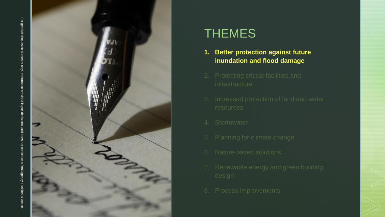
THEMES
1. Better protection against future
inundation and flood damage
2. Protecting critical facilities and
infrastructure
3. Increased protection of land and water
resources
4. Stormwater
5. Planning for climate change
6. Nature-based solutions
7. Renewable energy and green building
design
8. Process improvements
Fo
r genera
l dis
cussio
n p
urp
oses o
nly
. Info
rmatio
n p
rovid
ed is
pre
-decis
ional a
nd d
oes n
ot c
onstitu
te a
final a
gency d
ecis
ion o
r actio
n.
z
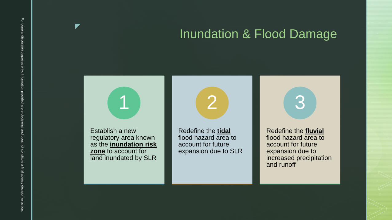
Inundation & Flood Damage
Establish a new regulatory area known as the inundation risk zone to account for land inundated by SLR
1
Redefine the tidalflood hazard area to account for future expansion due to SLR
2
Redefine the fluvialflood hazard area to account for future expansion due to increased precipitation and runoff
3
Fo
r genera
l dis
cussio
n p
urp
oses o
nly
. Info
rmatio
n p
rovid
ed is
pre
-decis
ional a
nd d
oes n
ot c
onstitu
te a
final a
gency d
ecis
ion o
r actio
n.
z
Inundation & Flood Damage
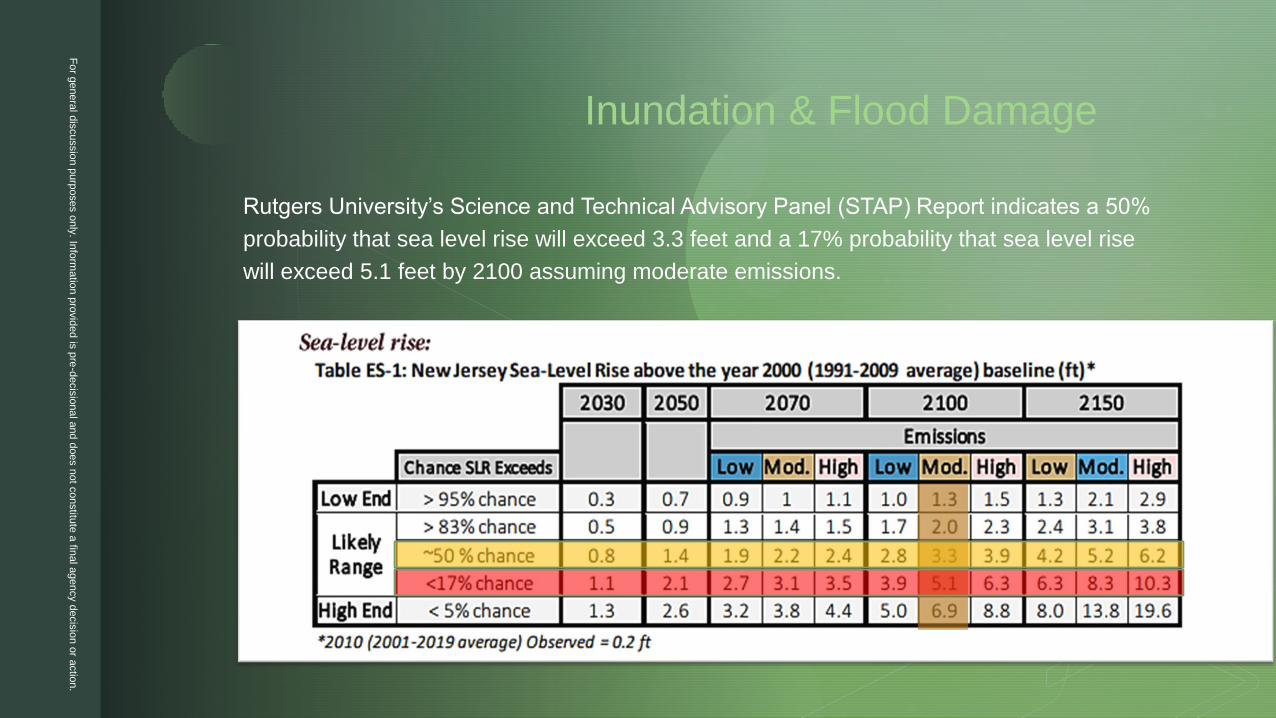
Rutgers University’s Science and Technical Advisory Panel (STAP) Report indicates a 50%
probability that sea level rise will exceed 3.3 feet and a 17% probability that sea level rise
will exceed 5.1 feet by 2100 assuming moderate emissions.
Fo
r genera
l dis
cussio
n p
urp
oses o
nly
. Info
rmatio
n p
rovid
ed is
pre
-decis
ional a
nd d
oes n
ot c
onstitu
te a
final a
gency d
ecis
ion o
r actio
n.

z
Fo
r genera
l dis
cussio
n p
urp
oses o
nly
. Info
rmatio
n p
rovid
ed is
pre
-decis
ional a
nd d
oes n
ot c
onstitu
te a
final a
gency d
ecis
ion o
r actio
n.

z
Inundation Risk Zone
▪ Consists of currently dry land that is expected to be inundated by tidal waters daily or permanently by 2100.
▪ Encompasses all land that lies below the IRZ elevation, which is calculated by adding five feet to the elevation of the mean higher high water (MHHW).
▪ See it today at www.njfloodmapper.org
▪ An applicant asserting that using a GIS layer to
determine the IRZ results in an incorrect location can
alternately determine the elevation of the ground at the
MHHW line along the tidal waterway(s) in proximity to
the site in question. Where multiple elevations
determined in this manner are within proximity of the
site, the highest ground elevation shall be selected. The
IRZ encompasses all land within five feet vertically of
the MHHW line.
▪ Development within the IRZ will be subject to more protective standards than the remainder of the floodplain beyond it.
Fo
r genera
l dis
cussio
n p
urp
oses o
nly
. Info
rmatio
n p
rovid
ed is
pre
-decis
ional a
nd d
oes n
ot c
onstitu
te a
final a
gency d
ecis
ion o
r actio
n.


z
Inundation Risk Zone: Buildings
▪ New buildings would require a
hardship exception.
▪ Applicant must demonstrate that there
is no other reasonable use for the site
and that preventing construction of a
new building would constitute an
exceptional and undue hardship.
▪ New and substantially
damaged/improved residential
buildings would need to be elevated to
new Climate Adjusted Flood Elevation
(CAFE)+1.
▪ Nonresidential & non-critical buildings
can be flood-proofed to CAFE+1 if
elevating is impracticable.
▪ Applicant must provide an Owner-
Certified Climate Risk Assessment
that acknowledges the flooding risks.
▪ Deed notice required, summarizing
flooding risks (both present and
future).
Fo
r genera
l dis
cussio
n p
urp
oses o
nly
. Info
rmatio
n p
rovid
ed is
pre
-decis
ional a
nd d
oes n
ot c
onstitu
te a
final a
gency d
ecis
ion o
r actio
n.
z
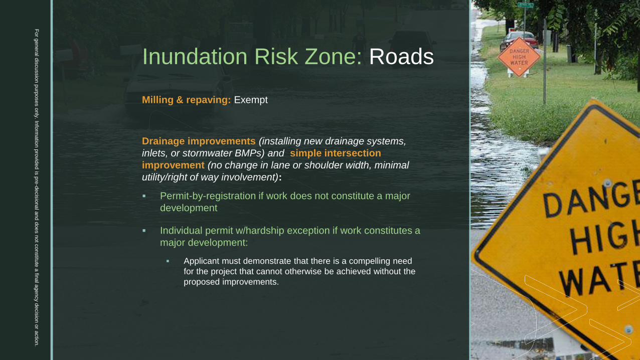
Inundation Risk Zone: Roads
Milling & repaving: Exempt
Drainage improvements (installing new drainage systems,
inlets, or stormwater BMPs) and simple intersection
improvement (no change in lane or shoulder width, minimal
utility/right of way involvement):
▪ Permit-by-registration if work does not constitute a major
development
▪ Individual permit w/hardship exception if work constitutes a
major development:
▪ Applicant must demonstrate that there is a compelling need
for the project that cannot otherwise be achieved without the
proposed improvements.
Fo
r genera
l dis
cussio
n p
urp
oses o
nly
. Info
rmatio
n p
rovid
ed is
pre
-decis
ional a
nd d
oes n
ot c
onstitu
te a
final a
gency d
ecis
ion o
r actio
n.

z
Inundation Risk Zone: Roads
Full depth reconstruction and new roads: Hardship exception required
▪ Public roadway:
▪ Applicant must demonstrate that there is a compelling public need for the project that cannot otherwise be achieved.
▪ Expenditure of public funds highly discouraged.
▪ Private roadway:
▪ Applicant must demonstrate that the road is necessary to serve or access private property that cannot otherwise be accessed.
▪ Provide notice summarizing flooding risks (both present and future) on each lot served by the roadway.
▪ Applicant must provide a climate impact statement and acknowledge the flooding risks to the proposed structure
▪ Signage required for roads constructed below the CAFE
Fo
r genera
l dis
cussio
n p
urp
oses o
nly
. Info
rmatio
n p
rovid
ed is
pre
-decis
ional a
nd d
oes n
ot c
onstitu
te a
final a
gency d
ecis
ion o
r actio
n.

z
Inundation Risk Zone: Bridges and Culverts
Simple culvert structural repair or bridge deck
replacement: Permit-by-registration
▪ Applicant must identify areas where improvements
could be made to address climate change impacts and
take said measures where practicable.
In-kind replacement: General permit or individual permit
depending on the scope of work
▪ Applicant must identify areas where improvements
could be made to address climate change impacts and
take said measures where practicable.
Fo
r genera
l dis
cussio
n p
urp
oses o
nly
. Info
rmatio
n p
rovid
ed is
pre
-decis
ional a
nd d
oes n
ot c
onstitu
te a
final a
gency d
ecis
ion o
r actio
n.

z
Inundation Risk Zone: Bridges and Culverts
Modification of shape/size/length: General permit or individual permit based on new climate adjusted flood elevation depending on the scope of work
▪ Applicant must identify areas where improvements could be made to address climate change impacts and take said measures where practicable.
▪ Expenditure of public funds highly discouraged.
New structure: Individual permit with a hardship exception
▪ Applicant must identify areas where improvements could be made to address climate change impacts and take said measures where practicable.
▪ Expenditure of public funds highly discouraged.
Fo
r genera
l dis
cussio
n p
urp
oses o
nly
. Info
rmatio
n p
rovid
ed is
pre
-decis
ional a
nd d
oes n
ot c
onstitu
te a
final a
gency d
ecis
ion o
r actio
n.
z
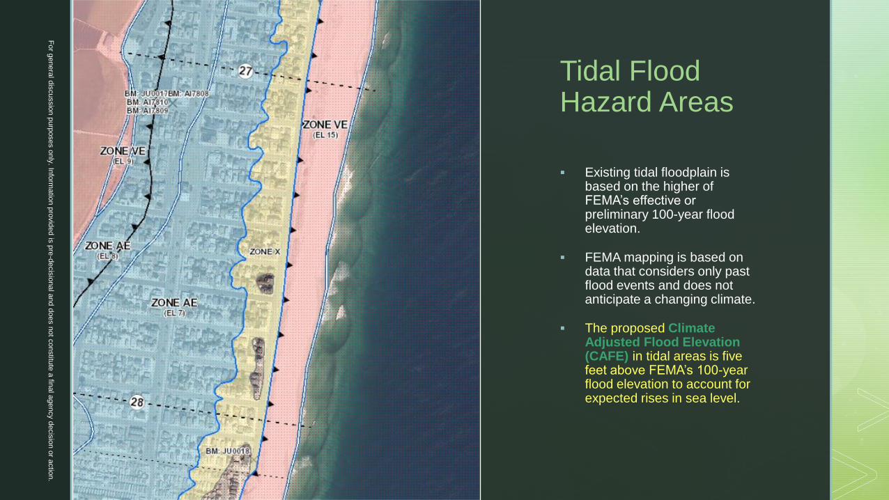
Tidal Flood Hazard Areas
▪ Existing tidal floodplain is based on the higher of FEMA’s effective or preliminary 100-year flood elevation.
▪ FEMA mapping is based on data that considers only past flood events and does not anticipate a changing climate.
▪ The proposed Climate Adjusted Flood Elevation (CAFE) in tidal areas is five feet above FEMA’s 100-year flood elevation to account for expected rises in sea level.
Fo
r genera
l dis
cussio
n p
urp
oses o
nly
. Info
rmatio
n p
rovid
ed is
pre
-decis
ional a
nd d
oes n
ot c
onstitu
te a
final a
gency d
ecis
ion o
r actio
n.

z
Fluvial Flood Hazard Areas
▪ Recent climate change models predict
increases in atmospheric temperatures that
will lead to greater precipitation amounts and
intensities. NJDEP continues to work with
educational institutions to provide the best
available Statewide precipitation projections.
▪ One recent study concludes that precipitation
intensities in New Jersey are likely to
increase by as much as 35% by 2100.
▪ For reference, NOAA’s current 500-year 24-hour
storm is roughly 38% more precipitation than
today’s 100-year 24-hour storm.
▪ Today's 500-year flood limits may therefore be a
good approximation of the future 100-year flood
limits.
Fo
r genera
l dis
cussio
n p
urp
oses o
nly
. Info
rmatio
n p
rovid
ed is
pre
-decis
ional a
nd d
oes n
ot c
onstitu
te a
final a
gency d
ecis
ion o
r actio
n.

z
Fluvial Flood Hazard Areas
Two options for the Climate Adjusted Flood Elevation:
Option 1: The CAFE is the highest of the following:
▪ FEMA’s 500-year flood + 1 ft
▪ DEP’s flood hazard area design flood elevation + 2 ft
▪ FEMA’s 100-year + 3 ft
Option 2: Calculate the CAFE
▪ Calculate the flood hazard area limits using hydrologic
and hydraulic calculations based on 125% of the
future 100-year discharge
Fo
r genera
l dis
cussio
n p
urp
oses o
nly
. Info
rmatio
n p
rovid
ed is
pre
-decis
ional a
nd d
oes n
ot c
onstitu
te a
final a
gency d
ecis
ion o
r actio
n.

z
CalculatingFlood Hazard Areas
▪ Discontinue use of the “Rational Method” and “Modified
Rational Method” for floodplain delineations to match
proposed SWM rulemaking.
▪ Require use of standard unit hydrograph to calculate
flood flows unless applicant can demonstrate in the
coastal plain that the watershed is undeveloped and
cannot be appreciably developed in the future based on
existing zoning or land restrictions.
▪ Require applicants who assert FEMA flood mapping is
inaccurate to seek appropriate map change document
from FEMA.
▪ Where applicant self-calculates the flood hazard area, it
cannot be lower than minimum NFIP standards.
▪ Approximation method will be adjusted to account for
higher flood elevations due to climate change by
increasing flood depths by one additional foot.
Fo
r genera
l dis
cussio
n p
urp
oses o
nly
. Info
rmatio
n p
rovid
ed is
pre
-decis
ional a
nd d
oes n
ot c
onstitu
te a
final a
gency d
ecis
ion o
r actio
n.

z
Flood Storage Displacement Calculations
Flood storage displacement calculations
(a.k.a. net fill calculations) should be
computed for three horizontal slices of the
flood fringe:
▪ Between the ground and the 10-year
elevation
▪ Between the 10-year elevation and the
100-year elevation
▪ Between the 100-year elevation and the
CAFE
Note: in cases where the existing floodplain is fluvial, but the future flood hazard is tidal, net-fill calculations would still need to performed.
Fo
r genera
l dis
cussio
n p
urp
oses o
nly
. Info
rmatio
n p
rovid
ed is
pre
-decis
ional a
nd d
oes n
ot c
onstitu
te a
final a
gency d
ecis
ion o
r actio
n.
z
FEMA: National Flood Insurance Program
Amendments necessary to better align FHACA Rules with minimum NFIP standards
▪ Add a new provision that if work within a flood hazard area is not commenced
within 180 days of approval, the permit will be automatically “paused” and work
cannot commence until permittee reinstates the approval by registering online.
▪ Clarify that DEP will not issue a permit for a building that violates minimum NFIP
standards.
▪ Ensure that flood hazard area delineations based on calculations are not less
protective than minimum NFIP standards.
▪ Amend hardship exception provisions to ensure that buildings approved under a
hardship either meet minimum NFIP standards or comport with FEMA’s
prescribed waiver process that is effectuated by participating local communities.
(Note: FEMA does not consider economic factors in determining whether a
building standard should be waived.)
Fo
r genera
l dis
cussio
n p
urp
oses o
nly
. Info
rmatio
n p
rovid
ed is
pre
-decis
ional a
nd d
oes n
ot c
onstitu
te a
final a
gency d
ecis
ion o
r actio
n.

z
THEMES
1. Better protection against future inundation
and flood damage
2. Protecting critical facilities and
infrastructure
3. Increased protection of land and water
resources
4. Stormwater
5. Planning for climate change
6. Nature-based solutions
7. Renewable energy and green building
design
8. Process improvements
Fo
r genera
l dis
cussio
n p
urp
oses o
nly
. Info
rmatio
n p
rovid
ed is
pre
-decis
ional a
nd d
oes n
ot c
onstitu
te a
final a
gency d
ecis
ion o
r actio
n.

z
Protecting Critical Facilities and Infrastructure
▪ Create a new definition for critical facilities
and critical infrastructure as informed by the
NFIP and Office of Emergency Management
definitions.
▪ Amend the definition of critical building to be
more in line with the Flood Design Classes
published by the American Society of Civil
Engineers.
▪ Placing restrictions on construction of
facilities in the inundation risk zone.
▪ Applicant must provide an Owner-Certified
Climate Risk Assessment that acknowledges
the flooding risks.
Fo
r genera
l dis
cussio
n p
urp
oses o
nly
. Info
rmatio
n p
rovid
ed is
pre
-decis
ional a
nd d
oes n
ot c
onstitu
te a
final a
gency d
ecis
ion o
r actio
n.
z
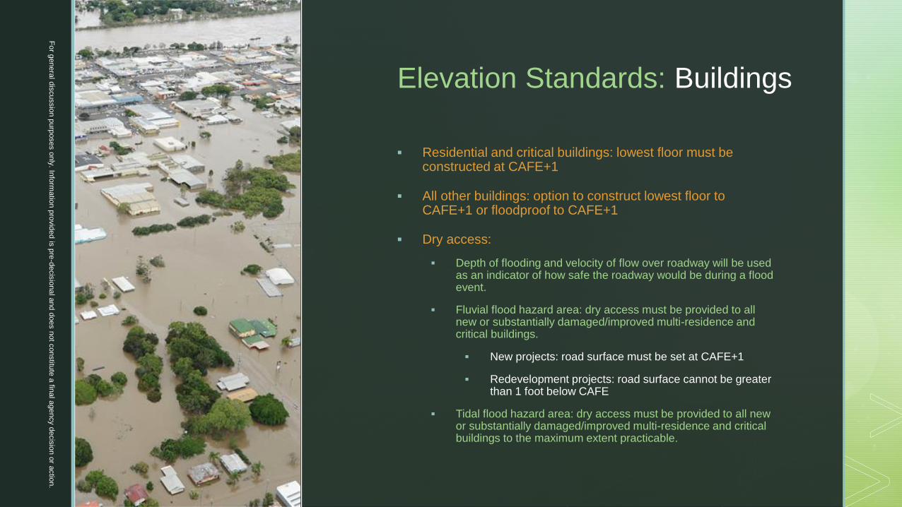
Elevation Standards: Buildings
▪ Residential and critical buildings: lowest floor must be constructed at CAFE+1
▪ All other buildings: option to construct lowest floor to CAFE+1 or floodproof to CAFE+1
▪ Dry access:
▪ Depth of flooding and velocity of flow over roadway will be used as an indicator of how safe the roadway would be during a flood event.
▪ Fluvial flood hazard area: dry access must be provided to all new or substantially damaged/improved multi-residence and critical buildings.
▪ New projects: road surface must be set at CAFE+1
▪ Redevelopment projects: road surface cannot be greater than 1 foot below CAFE
▪ Tidal flood hazard area: dry access must be provided to all new or substantially damaged/improved multi-residence and critical buildings to the maximum extent practicable.
Fo
r genera
l dis
cussio
n p
urp
oses o
nly
. Info
rmatio
n p
rovid
ed is
pre
-decis
ional a
nd d
oes n
ot c
onstitu
te a
final a
gency d
ecis
ion o
r actio
n.

z
Elevation Standards: Roads
▪ Designated evacuation routes: must be elevated to
CAFE+1 or applicant must seek a hardship
exception.
▪ Other new and full-depth reconstructed roads: must
be elevated as close to CAFE+1 as practicable,
recognizing that existing grades, intersecting roads
and driveways, and drainage patterns may often
present a significant obstacle to elevating.
▪ Other roadway improvements: applicant must identify
areas where improvements could be made to
address climate change impacts and take said
measures where practicable. Even raising the road
surface by 6-12 inches would make the roadway
more resilient to flooding and climate change.
Fo
r genera
l dis
cussio
n p
urp
oses o
nly
. Info
rmatio
n p
rovid
ed is
pre
-decis
ional a
nd d
oes n
ot c
onstitu
te a
final a
gency d
ecis
ion o
r actio
n.
z
THEMES
1. Better protection against future inundation
and flood damage
2. Protecting critical facilities and
infrastructure
3. Increased protection of land and water
resources
4. Stormwater
5. Planning for climate change
6. Nature-based solutions
7. Renewable energy and green building
design
8. Process improvements
Fo
r genera
l dis
cussio
n p
urp
oses o
nly
. Info
rmatio
n p
rovid
ed is
pre
-decis
ional a
nd d
oes n
ot c
onstitu
te a
final a
gency d
ecis
ion o
r actio
n.

z
Increased Protection of
Land and Water Resources
▪ Clarify that the presence of engineered dunes
created for the purpose of shore protection does
not diminish the importance of any other dune
areas.
▪ Revise Erosion Hazard Rule to complement the
inundation risk zone.
▪ Add standards for pre-storm activities on
beaches and dunes.
▪ Modify traffic rule to ensure that any permitted
development meets Traffic Level D.
▪ Require applicants and permittees who are
proposing mitigation projects to contemplate the
impacts of a changing climate on the viability of
said projects.
CZM Rules
Fo
r genera
l dis
cussio
n p
urp
oses o
nly
. Info
rmatio
n p
rovid
ed is
pre
-decis
ional a
nd d
oes n
ot c
onstitu
te a
final a
gency d
ecis
ion o
r actio
n.

z
Increased Protection of
Land and Water Resources
▪ Expanding definition of regulated water to include
isolated waters draining less than 50 acres.
▪ Placing riparian zones on the non-oceanfront side
of barrier island complexes.
▪ Increasing riparian zone widths to 150 feet for all
T&E species and requiring mitigation for all
impacts.
▪ Requiring RZ mitigation in a 50-ft riparian zone
when onsite impacts cumulatively exceed specified
limits.
▪ Requiring an IP for bridge and culvert replacements
in order to reduce species fragmentation.
▪ Requiring an IP for horizontal directional drilling to
account for accidental release of contaminants.
▪ Require applicants and permittees who are
proposing mitigation projects to contemplate the
impacts of a changing climate on the viability of
said projects.
FHACA Rules
Fo
r genera
l dis
cussio
n p
urp
oses o
nly
. Info
rmatio
n p
rovid
ed is
pre
-decis
ional a
nd d
oes n
ot c
onstitu
te a
final a
gency d
ecis
ion o
r actio
n.

z
Increased Protection of
Land and Water Resources
▪ Clarifying that wetland impacts must be necessary for
the conduct of a project regardless of whether the
impacts meet general permit criteria.
▪ Require applicants to demonstrate compliance with
the Stormwater Management rules for any project
impacting wetlands or transition areas, which is
associated with or part of a major development
▪ In non-surface water connected wetlands, requiring
onsite assessment when impacts are proposed in
vernal habitats.
▪ Requiring a general permit for horizontal directional
drilling and limiting the size and scope of drilling
activities that may qualify for a general permit.
Freshwater Wetland Rules
Fo
r genera
l dis
cussio
n p
urp
oses o
nly
. Info
rmatio
n p
rovid
ed is
pre
-decis
ional a
nd d
oes n
ot c
onstitu
te a
final a
gency d
ecis
ion o
r actio
n.

z
Increased Protection of
Land and Water Resources
▪ Adding more comprehensive cumulative
mitigation requirements.
▪ Require the removal of existing pavement, where
practicable, within 25 feet of the wetlands under
a special activity transition area waiver for
redevelopment of a significantly disturbed area
▪ Requiring that all activities in the transition area
stay at least 25 feet from the wetlands.
▪ Requiring the entire transition area to be
protected by a conservation restriction once
modified through averaging.
▪ Require applicants and permittees who are
proposing mitigation projects to contemplate the
impacts of a changing climate on the viability of
said projects.
Freshwater Wetland Rules
Fo
r genera
l dis
cussio
n p
urp
oses o
nly
. Info
rmatio
n p
rovid
ed is
pre
-decis
ional a
nd d
oes n
ot c
onstitu
te a
final a
gency d
ecis
ion o
r actio
n.

z
THEMES
1. Better protection against future inundation
and flood damage
2. Protecting critical facilities and
infrastructure
3. Increased protection of land and water
resources
4. Stormwater
5. Planning for climate change
6. Nature-based solutions
7. Renewable energy and green building
design
8. Process improvements
Fo
r genera
l dis
cussio
n p
urp
oses o
nly
. Info
rmatio
n p
rovid
ed is
pre
-decis
ional a
nd d
oes n
ot c
onstitu
te a
final a
gency d
ecis
ion o
r actio
n.

z
Stormwater Management
▪ Require onsite retention of the
water quality storm to reduce
offsite pollution and flooding
impacts.
▪ Require 80% TSS removal for
redeveloped/reconstructed motor
vehicle surfaces.
▪ Require projects that require a
freshwater wetlands permit to
meet the Stormwater
Management rules if the
authorized activities a part of a
major development.
Fo
r genera
l dis
cussio
n p
urp
oses o
nly
. Info
rmatio
n p
rovid
ed is
pre
-decis
ional a
nd d
oes n
ot c
onstitu
te a
final a
gency d
ecis
ion o
r actio
n.

z
THEMES
1. Better protection against future inundation
and flood damage
2. Protecting critical facilities and
infrastructure
3. Increased protection of land and water
resources
4. Stormwater
5. Planning for climate change
6. Nature-based solutions
7. Renewable energy and green building
design
8. Process improvements
Fo
r genera
l dis
cussio
n p
urp
oses o
nly
. Info
rmatio
n p
rovid
ed is
pre
-decis
ional a
nd d
oes n
ot c
onstitu
te a
final a
gency d
ecis
ion o
r actio
n.

z
Planning for Climate Change
▪ Add standards to CZM rules regarding the minimum
criteria for determining consistency of a SPC
approved center, core, or node with the purposes of
the rules and the requirement in CAFRA that it will
not result in unacceptable harm to the coastal
ecosystem or the resources of the built or natural
environment.
▪ Delete Department-delineated coastal centers from
the CZM Rules (currently codified in Appendix H).
▪ Centers that wish to be designated as a center will be
required to go through the formal SPC plan
endorsement process in order to receive a higher
impervious cover limit.
Fo
r genera
l dis
cussio
n p
urp
oses o
nly
. Info
rmatio
n p
rovid
ed is
pre
-decis
ional a
nd d
oes n
ot c
onstitu
te a
final a
gency d
ecis
ion o
r actio
n.

z
THEMES
1. Better protection against future inundation
and flood damage
2. Protecting critical facilities and
infrastructure
3. Increased protection of land and water
resources
4. Stormwater
5. Planning for climate change
6. Nature-based solutions
7. Renewable energy and green building
design
8. Process improvements
Fo
r genera
l dis
cussio
n p
urp
oses o
nly
. Info
rmatio
n p
rovid
ed is
pre
-decis
ional a
nd d
oes n
ot c
onstitu
te a
final a
gency d
ecis
ion o
r actio
n.

z
Nature-based Solutions
Encourage use of nature-based solutions, such as living shorelines,
when stabilizing the shoreline and wetland edge through the addition
of new permits-by-certification and general permits.
Address elevation of the wetland platform through the beneficial use
of dredged material to enhance the resiliency of the wetland in
response to sea level rise.
▪ Add definitions for non-governmental organization “NGO,” nature-
based solution
▪ Modify definition of “living shoreline”
▪ Add permits-by-certification for:
▪ Shoreline stabilization using suitable native vegetation
▪ Shoreline stabilization using oysters, marine mussels
and/or shell bags
Fo
r genera
l dis
cussio
n p
urp
oses o
nly
. Info
rmatio
n p
rovid
ed is
pre
-decis
ional a
nd d
oes n
ot c
onstitu
te a
final a
gency d
ecis
ion o
r actio
n.
z
Nature-based Solutions
For g
enera
l dis
cussio
n p
urp
oses o
nly. In
form
atio
n p
rovid
ed is
pre
-decis
ional a
nd d
oes n
ot c
onstitu
te a
final a
gency d
ecis
ion o
r actio
n.
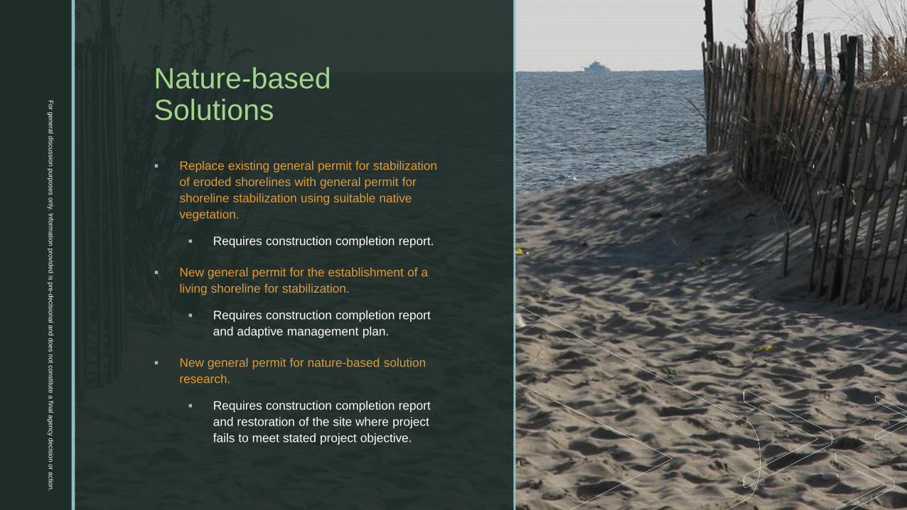
▪ Replace existing general permit for stabilization
of eroded shorelines with general permit for
shoreline stabilization using suitable native
vegetation.
▪ Requires construction completion report.
▪ New general permit for the establishment of a
living shoreline for stabilization.
▪ Requires construction completion report
and adaptive management plan.
▪ New general permit for nature-based solution
research.
▪ Requires construction completion report
and restoration of the site where project
fails to meet stated project objective.
z
Nature-based Solutions
For g
enera
l dis
cussio
n p
urp
oses o
nly. In
form
atio
n p
rovid
ed is
pre
-decis
ional a
nd d
oes n
ot c
onstitu
te a
final a
gency d
ecis
ion o
r actio
n.
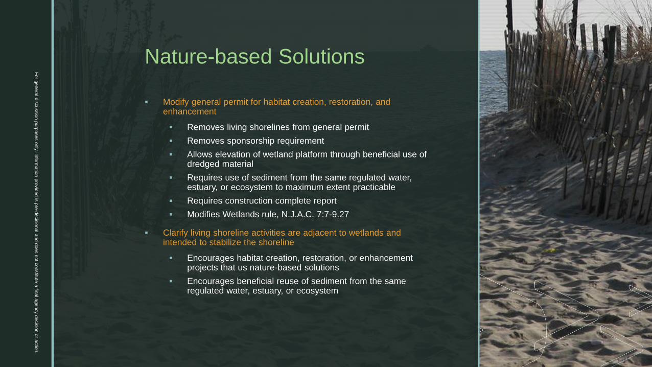
▪ Modify general permit for habitat creation, restoration, and enhancement
▪ Removes living shorelines from general permit
▪ Removes sponsorship requirement
▪ Allows elevation of wetland platform through beneficial use of dredged material
▪ Requires use of sediment from the same regulated water, estuary, or ecosystem to maximum extent practicable
▪ Requires construction complete report
▪ Modifies Wetlands rule, N.J.A.C. 7:7-9.27
▪ Clarify living shoreline activities are adjacent to wetlands and intended to stabilize the shoreline
▪ Encourages habitat creation, restoration, or enhancement projects that us nature-based solutions
▪ Encourages beneficial reuse of sediment from the same regulated water, estuary, or ecosystem

z
Nature-based Solutions
For g
enera
l dis
cussio
n p
urp
oses o
nly. In
form
atio
n p
rovid
ed is
pre
-decis
ional a
nd d
oes n
ot c
onstitu
te a
final a
gency d
ecis
ion o
r actio
n.
▪ Modify living shorelines rule, N.J.A.C. 7:7-12.23
▪ Removes limitation on placement of fill within
▪ Addresses ecological risk
▪ Encourages beneficial reuse of sediment from the same
regulated water, estuary, or ecosystem
▪ Requires submission of a construction completion report,
monitoring for five years, an adaptive management plan
▪ Restriction on installation of new bulkheads can allow for marsh
migration
▪ Require better assessment of stream systems, and establish clear
hierarchy prioritizing vegetative mechanisms for stream bank
stabilization

z
THEMES
1. Better protection against future inundation
and flood damage
2. Protecting critical facilities and
infrastructure
3. Increased protection of land and water
resources
4. Stormwater
5. Planning for climate change
6. Nature-based solutions
7. Renewable energy and green building
design
8. Process improvements
Fo
r genera
l dis
cussio
n p
urp
oses o
nly
. Info
rmatio
n p
rovid
ed is
pre
-decis
ional a
nd d
oes n
ot c
onstitu
te a
final a
gency d
ecis
ion o
r actio
n.
z
Renewable Energy
For g
enera
l dis
cussio
n p
urp
oses o
nly. In
form
atio
n p
rovid
ed is
pre
-decis
ional a
nd d
oes n
ot c
onstitu
te a
final a
gency d
ecis
ion o
r actio
n.
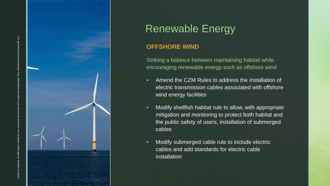
OFFSHORE WIND
Striking a balance between maintaining habitat while
encouraging renewable energy such as offshore wind
▪ Amend the CZM Rules to address the installation of
electric transmission cables associated with offshore
wind energy facilities
▪ Modify shellfish habitat rule to allow, with appropriate
mitigation and monitoring to protect both habitat and
the public safety of users, installation of submerged
cables
▪ Modify submerged cable rule to include electric
cables and add standards for electric cable
installation
z
Renewable Energy
For g
enera
l dis
cussio
n p
urp
oses o
nly. In
form
atio
n p
rovid
ed is
pre
-decis
ional a
nd d
oes n
ot c
onstitu
te a
final a
gency d
ecis
ion o
r actio
n.
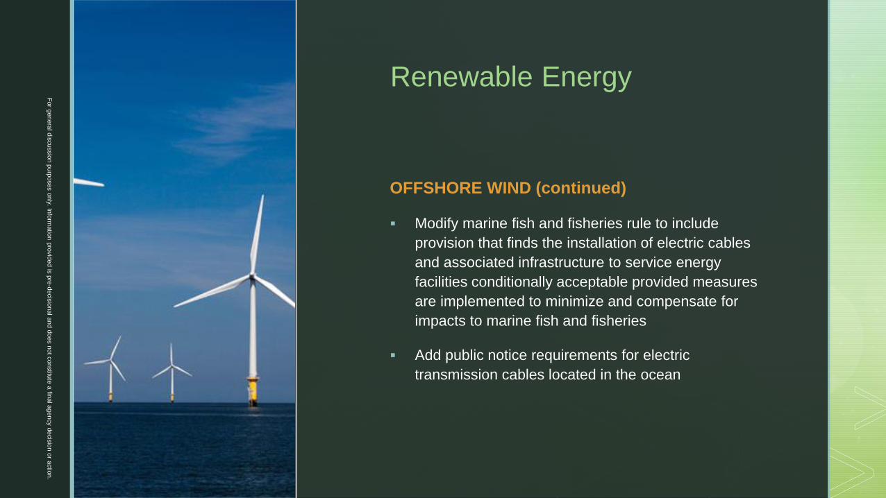
OFFSHORE WIND (continued)
▪ Modify marine fish and fisheries rule to include
provision that finds the installation of electric cables
and associated infrastructure to service energy
facilities conditionally acceptable provided measures
are implemented to minimize and compensate for
impacts to marine fish and fisheries
▪ Add public notice requirements for electric
transmission cables located in the ocean
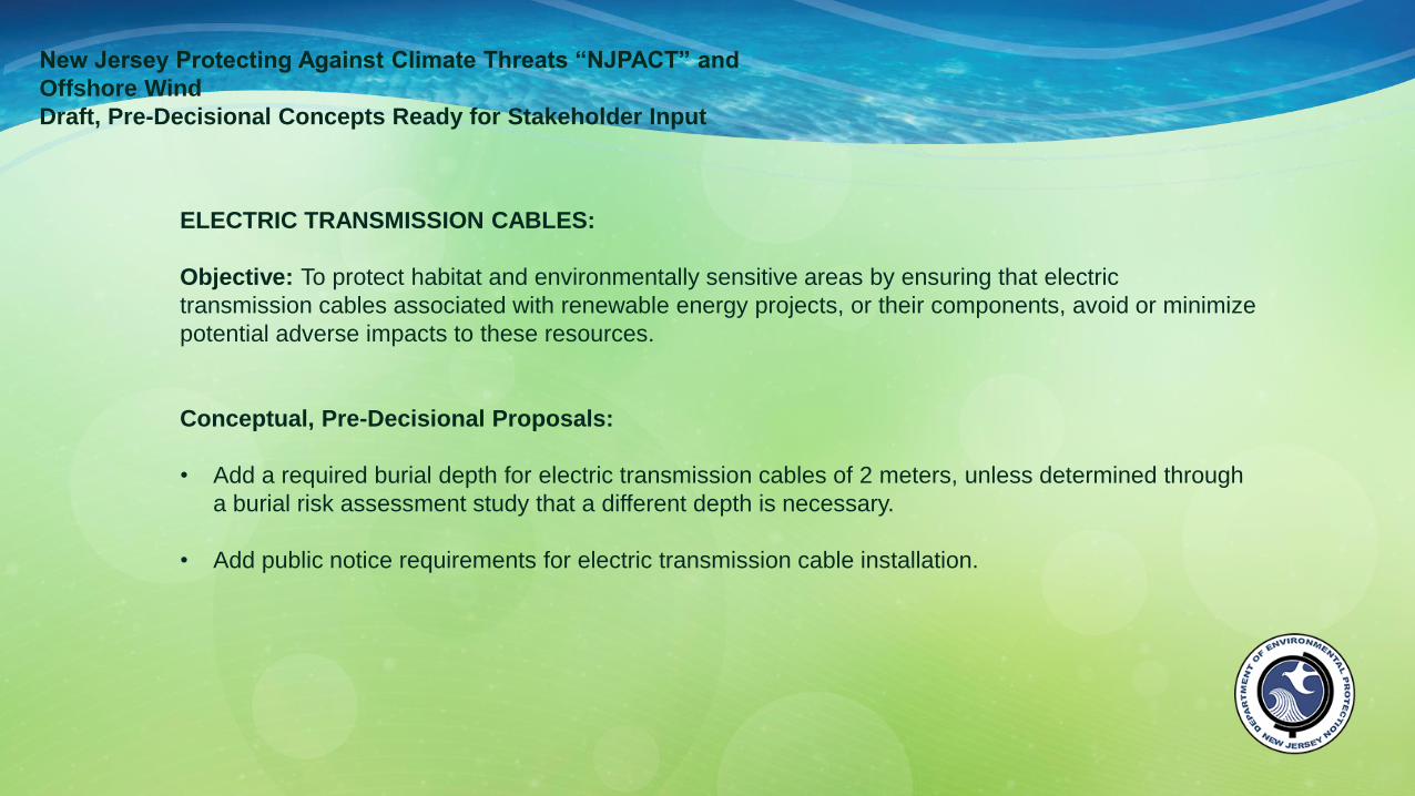
New Jersey Protecting Against Climate Threats “NJPACT” and
Offshore Wind
Draft, Pre-Decisional Concepts Ready for Stakeholder Input
ELECTRIC TRANSMISSION CABLES:
Objective: To protect habitat and environmentally sensitive areas by ensuring that electric
transmission cables associated with renewable energy projects, or their components, avoid or minimize
potential adverse impacts to these resources.
Conceptual, Pre-Decisional Proposals:
• Add a required burial depth for electric transmission cables of 2 meters, unless determined through
a burial risk assessment study that a different depth is necessary.
• Add public notice requirements for electric transmission cable installation.

New Jersey Protecting Against Climate Threats “NJPACT” and
Offshore Wind
Draft, Pre-Decisional Concepts Ready for Stakeholder Input
SHELLFISH HABITAT:
Objective: To balance the continued protection of shellfish habitat and resources by ensuring that
renewable energy projects, or their components, avoid or minimize potential adverse impacts to these
resources and, where appropriate, mitigate for any adverse impacts that cannot be practicably
avoided.
Conceptual, Pre-Decisional Proposals:
• Modify shellfish habitat rule to allow installation of submerged cables in shellfish habitat only where
installation is demonstrated to be the public interest and unavoidable impacts are minimized and
mitigation is provided.
• Modify shellfish habitat rule and mitigation requirements to avoid oyster reef shellfish habitat to
maximum extent practicable, and if not possible, take steps to mitigate including:
o In kind restoration of habitat of the disturbed area to its preconstruction state, shell and oyster
density and population conditions, including reef reconstruction, oyster seeding, replanting,
and monitoring.

New Jersey Protecting Against Climate Threats “NJPACT” and
Offshore Wind
Draft, Pre-Decisional Concepts Ready for Stakeholder Input
MARINE FISH AND FISHERIES:
Objective: To protect marine fish and fisheries by ensuring that renewable energy projects, or their
components, avoid or minimize potential adverse impacts to these resources and, where appropriate,
mitigate for any adverse impacts that cannot be practicably avoided.
Conceptual, Pre-Decisional Proposals:
• Add that renewable energy projects are conditionally acceptable if potential adverse impacts are
avoided or minimized, including potential impacts from placement of structures or cables in critical
habitat areas or migration corridors, use of materials and layout, noise or vibration, footprint size,
installation and maintenance of electric transmission cables, and integrate mitigation requirements
in the event any adverse impacts cannot be practicably avoided.
z
Renewable Energy
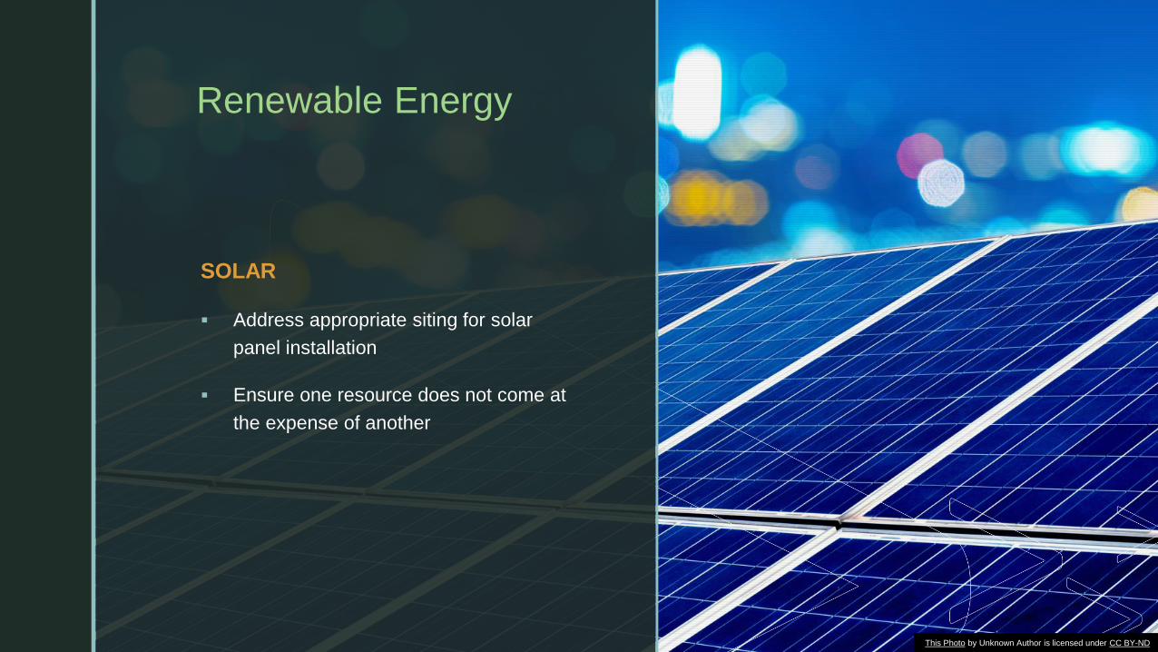
SOLAR
▪ Address appropriate siting for solar
panel installation
▪ Ensure one resource does not come at
the expense of another
This Photo by Unknown Author is licensed under CC BY-ND

z
THEMES
1. Better protection against future inundation
and flood damage
2. Protecting critical facilities and
infrastructure
3. Increased protection of land and water
resources
4. Stormwater
5. Planning for climate change
6. Nature-based solutions
7. Renewable energy and green building
design
8. Process improvements
Fo
r genera
l dis
cussio
n p
urp
oses o
nly
. Info
rmatio
n p
rovid
ed is
pre
-decis
ional a
nd d
oes n
ot c
onstitu
te a
final a
gency d
ecis
ion o
r actio
n.

z
Permits-by-Registration
▪ New type of authorization that replaces most permits-by-rule.
▪ Parties intending to undertake an authorized activity would
be required to log on to NJDEP’s online permitting portal,
enter basic information (such as the location and type of
activity being undertaken and appropriate contact
information).
▪ Registration would enable WLM to track cumulative impacts
on a watershed-wide basis and adjust standards to address
303(d) impaired waters and TMDLs and/or to reflect the
State’s planning goals.
▪ Allows more accurate tracking of regulated activities and
better aligns with FEMA’s requirement to record and track
approvals under the NFIP.
▪ Existing flood hazard and coastal permits-by-rule would be
converted to one of the following: limited categorical
exemptions; permits-by-registration, general permits or
individual permits.
Fo
r genera
l dis
cussio
n p
urp
oses o
nly
. Info
rmatio
n p
rovid
ed is
pre
-decis
ional a
nd d
oes n
ot c
onstitu
te a
final a
gency d
ecis
ion o
r actio
n.
z
Permits-by-Certification
▪ Many are rarely used; some will be folded into
general permits so that range of activities can be
broadened.
▪ Proposal would require a NJ licensed professional
engineer to apply for and certify each item in an FHA
permit-by-certification since most include a
requirement that certain information be provided or
that engineering certifications are necessary.
▪ Same for CZM permits-by-certification where
compliance with the flood hazard area rule at N.J.A.C.
7:7-9.25 is required.
Fo
r genera
l dis
cussio
n p
urp
oses o
nly
. Info
rmatio
n p
rovid
ed is
pre
-decis
ional a
nd d
oes n
ot c
onstitu
te a
final a
gency d
ecis
ion o
r actio
n.

z
Anticipated changes to existing permits-by-rule, general permits-by-certification and general permits: CZM Rules
▪ Modify permit-by-rule (PBR) for the construction of a swimming pool, spa, or hot tub
and associated decking on a bulkheaded lot without wetlands to not apply to sites
located along the Atlantic Ocean or Delaware Bay.
▪ Modify general permit-by-certification (PBC) for reconstruction of a legally existing
bulkhead in-place or upland of a legally existing functioning bulkhead to not apply to
bulkheads located along Atlantic Ocean or Delaware Bay.
▪ Clarify PBC for construction of piers, docks, including jet ski ramps, pilings and boatlifts
in man-made lagoons.
Fo
r genera
l dis
cussio
n p
urp
oses o
nly
. Info
rmatio
n p
rovid
ed is
pre
-decis
ional a
nd d
oes n
ot c
onstitu
te a
final a
gency d
ecis
ion o
r actio
n.

z
Anticipated changes to existing permits-by-rule, general permits-by-certification and general permits: CZM Rules (continued)
▪ Covert existing PBRs for the below listed activities to PBCs:
▪ At grade dune walkover at a commercial development
▪ Expansion of a single-family home or duplex on the non-waterward side of the
single-family home or duplex
▪ Development of a single-family home or duplex and/or accessory development on
a bulkheaded lagoon lot
▪ Reconstruction of a residential or commercial development within the same
footprint
▪ Expansion or relocation (with or without expansion) landward or parallel to the
mean high water line of the footprint of a residential or commercial development
▪ Reconfiguration of any legally existing dock, wharf, or pier at a legally existing
marina
Fo
r genera
l dis
cussio
n p
urp
oses o
nly
. Info
rmatio
n p
rovid
ed is
pre
-decis
ional a
nd d
oes n
ot c
onstitu
te a
final a
gency d
ecis
ion o
r actio
n.

z
Anticipated changes to existing permits-by-rule, general permits-by-certification and general permits: CZM Rules (continued)
▪ Modify general permit (GP) for expansion, reconstruction (with or without expansion) of
a single-family home to require that for sites located on the Delaware Bay or Atlantic
Ocean, development under the general permit cannot be located waterward of the
waterward side of development
▪ Modify GP for the construction of certain structures related to the tourism industry at
hotels and motels, commercial developments, and multi-family residential
developments over 75 units to:
▪ Not authorize the construction of cabanas or installation of sewer lines
▪ Structures located on a beach cannot unreasonably conflict with public access
▪ Require the plans submitted on an annual basis include the location of where
structures will be relocated in cases where a Severe Weather Alert requires
removal of the structure from the beach
▪ New definitions of cabana, temporary equipment storage container and sun
shelter are added to facilitate changes to this general permit
Fo
r genera
l dis
cussio
n p
urp
oses o
nly
. Info
rmatio
n p
rovid
ed is
pre
-decis
ional a
nd d
oes n
ot c
onstitu
te a
final a
gency d
ecis
ion o
r actio
n.

z
Anticipated changes to existing permits-by-rule, general permits-by-certification and general permits: FHACA Rules
▪ Convert all 63 permits-by-rule to exemptions, permit-by-registration or permit-by-
certification.
▪ Delete the permit-by-rule for horizontal directional drilling and require an individual
permit just as any other pipeline installation in a flood hazard area or riparian zone.
▪ General permit-by-certification for construction of homes in tidal areas to be deleted in
favor of a general permit.
▪ General permits-by-certification for agricultural roadways and culvert replacements, as
well as general permit for culvert replacement to be deleted in favor of an individual
permit.
▪ In order to facilitate wildlife crossings in cases where bridges and culverts are being replaced
in areas with documented habitat fragmentation.
▪ Recognition that in some cases hydraulic conditions and/or the geometry of the structure or
channel may preclude significant modifications to the shape or size of a bridge or culvert.
Fo
r genera
l dis
cussio
n p
urp
oses o
nly
. Info
rmatio
n p
rovid
ed is
pre
-decis
ional a
nd d
oes n
ot c
onstitu
te a
final a
gency d
ecis
ion o
r actio
n.
z
Anticipated changes to existing permits-by-rule, general permits-by-certification and general permits: FWPA Rules
▪ Make clear that wetland impacts must be necessary for the conduct of a project
regardless of whether the impacts meet general permit criteria.
▪ Modify GP2 for underground utility lines to require a permit for directional drilling under
a freshwater wetland and add general permit criteria for some activities.
▪ Modify GP6 for non-surface water connected wetlands to delete references to Waters
of the United States. Also require onsite assessment when impacts are proposed in
vernal habitats.
▪ Modify GP10 for minor road crossings to make clear that it is intended for access to
developable uplands and not internal roadways.
▪ Modify GP20 for bank stabilization to require better assessment of stream systems and
establish clear hierarchy prioritizing vegetative mechanisms for stream bank
stabilization.
Fo
r genera
l dis
cussio
n p
urp
oses o
nly
. Info
rmatio
n p
rovid
ed is
pre
-decis
ional a
nd d
oes n
ot c
onstitu
te a
final a
gency d
ecis
ion o
r actio
n.

z
For All Permits
Establish improved noticing requirements such as:
▪ Online notice of start of construction.
▪ Online notice of deed restriction filing (permittee
can upload a copy of modified deed).
▪ Online notice of completion (permittee can upload
photos and as-built drawings as available).
▪ Automatic response from online system if the
above aren’t received in a timely manner.
Fo
r genera
l dis
cussio
n p
urp
oses o
nly
. Info
rmatio
n p
rovid
ed is
pre
-decis
ional a
nd d
oes n
ot c
onstitu
te a
final a
gency d
ecis
ion o
r actio
n.

Fo
r genera
l dis
cussio
n p
urp
oses o
nly
. Info
rmatio
n p
rovid
ed is
pre
-decis
ional a
nd d
oes n
ot c
onstitu
te a
final a
gency d
ecis
ion o
r actio
n.
z
THANK YOU
Please contact us to share additional comments at:
You may also submit comments to the NJPACT webpage
through the survey tab at:
https://www.surveymonkey.com/r/b8fqqdw
Fo
r genera
l dis
cussio
n p
urp
oses o
nly
. Info
rmatio
n p
rovid
ed is
pre
-decis
ional a
nd d
oes n
ot c
onstitu
te a
final a
gency d
ecis
ion o
r actio
n.