ni 43-101 technical report rey salomon gold project
TRANSCRIPT

NI 43-101 TECHNICAL REPORT On The
REY SALOMON GOLD PROJECT District of Atico, Province of Caraveli,
Department of Arequipa, Peru
Centered at Approximately
Latitude 15° 51’ South by Longitude 73° 34’ West Peruvian (NTS) Map Area 32-o
- Report Prepared For -
MONTAN Mining CORP.
- Report Prepared By -
JAMES A. McCREA. P. Geo. 10743 139 Street, 306 Surrey, BC V3T 4L8
Effective Date:
November 10, 2016
IMPORTANT NOTICE
This report was prepared as a National Instrument 43-101 Technical Report for Montan Mining Corp. by James A. McCrea, P.Geo. The quality of information and conclusions contained herein are consistent with the level of effort involved in Mr. McCrea’s services, based on: i) information available at the time of preparation, ii) data supplied by outside sources, and iii) the assumptions, conditions and qualifications set forth in this report. This report is intended to be used by Montan Mining Corp., subject to the terms and conditions of its contract with Mr. McCrea. This contract permits Montan Mining Corp. to file this report as a Technical Report to satisfy TSX Venture Policy requirements pursuant to National Instrument 43-101, Standards of Disclosure for Mineral Projects. Except for the purposes legislated under provincial securities law, any other use of this report by any third party is at that party’s sole risk.

Montan Mining Corp. Page i ______________________________________________________________________
______________________________________________________________________NI 43-101 Technical Report on the Rey Salomon Gold Project, District of Atico,
Province of Caraveli, Department of Arequipa, Peru James A. McCrea, P.Geo. November 10, 2016
DATE and SIGNATURE PAGE CERTIFICATE OF QUALIFIED PERSON I, James Albert McCrea, am a professional geologist residing at 306 - 10743 139 Street, Surrey, British Columbia, Canada, do hereby certify that:
I am the author of the "NI 43-101 Technical Report on the Rey Salomon Gold Project, District of Atico, Province of Caraveli, Department of Arequipa, Peru”, dated November 10, 2016;
I am a Registered Professional Geoscientist (P. Geo.), Practising, with the Association of Professional Engineers and Geoscientists of British Columbia, (Licence # 21450). I graduated from the University of Alberta, Canada, with a B. Sc. in Geology in 1988.
I have worked as a geoscientist in the minerals industry for over 25 years and I have been directly involved in the mining, exploration and evaluation of mineral properties mainly in Canada, the United States, Mexico, Peru, Argentina, Bolivia and Colombia for gold, silver, copper, molybdenum and base metals;
I visited the Rey Salomon Gold Project and area on October 2nd to 4th, 2016. I had visited the property once before in 2006 but had no prior involvement with the property before I
visited it in October of 2016; I am responsible for all sections of the “NI 43-101 Technical Report on the Rey Salomon Gold
Project, District of Atico, Province of Caraveli, Department of Arequipa, Peru”, dated November 10, 2016.
I am independent of Montan Mining Corp. as independence is described in Section 1.5 of NI 43-101. I have not received, nor do I expect to receive, any interest, directly or indirectly, in Montan Mining Corp.
I was retained by Montan Mining Corp. to prepare an exploration summary on the Rey Salomon Gold Project, District of Atico, Province of Caraveli, Department of Arequipa, Peru, in accordance with National Instrument 43-101. The report is based on my review of project files and information provided by Montan Mining Corp. and discussions with other consultants working on site;
I have read National Instrument 43-101 and Form 43-101F1 and, by reason of education and past relevant work experience, I fulfill the requirements to be a “Qualified Person” for the purposes of NI 43-101. This technical report has been prepared in compliance with National Instrument 43-101 and Form 43-101F1;
As of the date of this certificate, to the best of my knowledge, information and belief, the technical report contains all scientific and technical information that is required to be disclosed to make the technical report not misleading.
I, the undersigned prepared this report titled “NI 43-101 Technical Report on the Rey Salomon Gold Project, District of Atico, Province of Caraveli, Department of Arequipa, Peru”, dated November 10, 2016, in support of the public disclosure of technical aspects for the Rey Salomon Gold Project by Montan Mining Corp.
Effective Date: November 10, 2016 Signed By James A. McCrea _______________________ James A. McCrea, B. Sc., P. Geo. (signed and sealed original copy on file) Dated this 10th day of November, 2016

Montan Mining Corp. Page ii ______________________________________________________________________
______________________________________________________________________NI 43-101 Technical Report on the Rey Salomon Gold Project, District of Atico,
Province of Caraveli, Department of Arequipa, Peru James A. McCrea, P.Geo. November 10, 2016
Table of Contents Page No.
DATE and SIGNATURE PAGE……………………………………………………….………...i 1.0 SUMMARY ........................................................................................................................ 4
1.1 Introduction.................................................................................................................... 4 1.2 Property Description and Ownership ............................................................................. 4
1.2.1 Description of the Transaction ................................................................................... 4 1.3 Accessibility and Physiography ..................................................................................... 5 1.4 History ........................................................................................................................... 5 1.5 Geological Setting and Mineralization ........................................................................... 6 1.6 Exploration and Drilling ................................................................................................. 6 1.7 Mineral Processing and Metallurgical Testing ............................................................... 6 1.8 Mineral Resources ........................................................................................................ 6 1.9 Interpretations and Conclusions .................................................................................... 7 1.10 Recommendations and Proposed Exploration Budget .................................................. 7
2.0 INTRODUCTION ............................................................................................................... 8 2.1 Introduction and Terms of Reference ............................................................................ 8 2.2 Site Visit ........................................................................................................................ 8 2.3 Sources of Information .................................................................................................. 8 2.4 Abbreviations and Units of Measure ........................................................................... 10 2.5 Acknowledgements ..................................................................................................... 11
3.0 RELIANCE ON OTHER EXPERTS ................................................................................ 11 4.0 PROPERTY DESCRIPTION and LOCATION................................................................. 12
4.1 Property Location ........................................................................................................ 12 4.2 Property Description .................................................................................................... 13 4.3 Underlying Agreements ............................................................................................... 14 4.4 Surface Rights ............................................................................................................. 15 4.5 Mineral Rights in Peru ................................................................................................. 15 4.6 Royalties and Obligations ............................................................................................ 16 4.7 Environmental Regulations & Exploration Permits ...................................................... 16 4.8 Environmental Considerations .................................................................................... 16
5.0 ACCESSIBILITY, CLIMATE, LOCAL RESOURCES, INFRASTRUCTURE and PHYSIOGRAPHY ....................................................................................................................... 18
5.1 Accessibility ................................................................................................................. 18 5.2 Climate ........................................................................................................................ 18 5.3 Local Resources and Infrastructure ............................................................................ 18 5.4 Physiography............................................................................................................... 19
6.0 HISTORY ........................................................................................................................ 20 7.0 GEOLOGICAL SETTING and MINERALIZATION .......................................................... 22
7.1 Regional Geology ........................................................................................................ 22 7.2 Property Geology ........................................................................................................ 24
7.2.1 Lithology .................................................................................................................. 24 7.2.2 Alteration ................................................................................................................. 25 7.2.3 Mineralization .......................................................................................................... 25
8.0 DEPOSIT TYPES ............................................................................................................ 27 9.0 EXPLORATION ............................................................................................................... 28 10.0 DRILLING ........................................................................................................................ 29 11.0 SAMPLE PREPARATION, ANALYSES AND SECURITY .............................................. 30
11.1 Minera Ofir, Cerro Dorado 2012 to 2015 ..................................................................... 30
Montan Mining Corp. Page iii ______________________________________________________________________
______________________________________________________________________NI 43-101 Technical Report on the Rey Salomon Gold Project, District of Atico,
Province of Caraveli, Department of Arequipa, Peru James A. McCrea, P.Geo. November 10, 2016
11.2 2016 Verification Sampling Preparation ...................................................................... 30 12.0 DATA VERIFICATION .................................................................................................... 31
12.1 Verification Sampling Results ...................................................................................... 31 13.0 MINERAL PROCESSING and METALLURGICAL TESTING ......................................... 47 14.0 MINERAL RESOURCE ESTIMATES ............................................................................. 48 23.0 ADJACENT PROPERTIES ............................................................................................. 49 24.0 OTHER RELEVANT DATA and INFORMATION ............................................................ 50 25.0 INTERPRETATION and CONCLUSIONS....................................................................... 51 26.0 RECOMMENDATIONS ................................................................................................... 52 27.0 REFERENCES ................................................................................................................ 53 List of Tables Table 1.1: Rey Salomon Gold Project Mining Concession Titles .................................................. 4 Table 4.1: Rey Salomon Gold Project Mining Concession Titles ................................................ 13 Table 5.1: Road Distances to Access the Rey Salomon Project ................................................ 18 Table 12.1: Verification Samples from Rey Salomon ................................................................. 31 List of Figures Figure 4.1: Location Map of the Rey Salomon Project ............................................................... 12 Figure 4.2: Mineral Concession Map of Rey Salomon Project ................................................... 13 Figure 6.1: Plan Showing Main Veins and Workings on the Rey Salomon Property .................. 21 Figure 7.1: Regional Geologic Map for the Rey Salomon Property ............................................ 23 Figure 7.2: Property Geology Map .............................................................................................. 24 Figure 7.3: Known Veins on the Rey Salomon Property ............................................................. 26 Figure 12.1: Underground Verification Sampling ........................................................................ 37 List of Photographs Photograph No. 1: Sample 2318, Skarn Mineralization in Trench .............................................. 36 Photograph No. 2: Sample 2319, Skarn Mineralization in Working ............................................ 36 Appendix 1: Title Opinion for the Rey Salomon Property

Montan Mining Corp. Page 4
______________________________________________________________________
______________________________________________________________________NI 43-101 Technical Report on the Rey Salomon Gold Project, District of Atico,
Province of Caraveli, Department of Arequipa, Peru James A. McCrea, P.Geo. November 10, 2016
1.0 SUMMARY
1.1 Introduction The Rey Salomon Gold Project (the ‘Project”) is a gold exploration project in the Department of Arequipa, Peru and is held 100% by M & F Minera Ofir S.A. (Minera Ofir). The property is under option to Cerro Dorado S.A.C. (Cerro Dorado), a subsidiary of Chazel Capital, a Company with a binding agreement announced on October 31st, 2016 with Montan Mining Corp. (“Montan”), where Montan can acquire 100% of the Chazel interest in Cerro Dorado. At the request of Montan Mining Corp., James A. McCrea, P. Geo., carried out an independent review of the Rey Salomon Gold Project, District of Atico, Province of Caraveli, Department of Arequipa, Peru. This report is intended to be used in support of Montan’s acquisition of Cerro Dorado, a Peruvian company with its major asset being the Rey Salomon Gold Project as described in the press release dated July 14, 2016. The author conducted a property examination, reviewed available exploration results and prepared this independent technical report (the ‘Report’) in accordance with the formatting requirements of National Instrument 43-101 (‘NI 43-101’) and Form 43-101F1 (Standards of Disclosure for Mineral Properties) to be a comprehensive review of the exploration activities on the property, and to provide recommendations for future work, if warranted. Information and data used in this report consists of field observations made by the author during the site visit on October 2th to 4th of 2016; data collected by Montan in the field during their due diligence and sampling completed during the site visit, which was supervised by the author.
1.2 Property Description and Ownership The Rey Salomon Project consists of four contiguous mining concessions or mining rights totalling 1,172.34 ha. The concessions are known by the names of Rey Salomon I, Rey 2, Rey 3 and Tia Gaby. The mining rights are listed in Table 1.1 and are shown in Figure 4.2.
Table 1.1: Rey Salomon Gold Project Mining Concession Titles Mining Registry
No. Name Holder of Record
Granted Area (ha)
Expiration Date
05-00036-99 Rey Salomon I M & F Minera Ofir S.A. 200.00 30-June-2017
05-00114-06 Rey 2 M & F Minera Ofir S.A. 572.34 30-June-2017
05-00115-06 Rey 3 M & F Minera Ofir S.A. 300.00 30-June-2017
54-00133-09 Tia Gaby M & F Minera Ofir S.A. 100.00 30-June-2017
Note: Title information effective November 10, 2016
1.2.1 Description of the Transaction On July 14, 2016, Montan Mining Corp. (“Montan”) announced a purchase transaction (the “Transaction”) whereby Montan proposed to purchase all the outstanding shares of Cerro Dorado S.A.C. including all assets, permits and underlying agreements from Chazel Capital Inc. (‘Chazel’) for stock and debt payments. Assets of Cerro Dorado include a permitted 60 tonne per day ‘carbon in pulp” (CIP) gold recovery plant located on the Rey Salomon property, access rights, water rights and Cerro Dorado’s option (the “Option”) on the Rey Salomon property (Montan News Release July, 2016). The Option includes mining rights (mining rights lease) to the Rey Salomon mine and property. The acquisition terms are as follows:
Montan Mining Corp. Page 5
______________________________________________________________________
______________________________________________________________________NI 43-101 Technical Report on the Rey Salomon Gold Project, District of Atico,
Province of Caraveli, Department of Arequipa, Peru James A. McCrea, P.Geo. November 10, 2016
Montan will assume US$ 300,000 of debt owed by Cerro Dorado in Peru. The initial share payment will be adjusted at the date of closing with the difference between this value and the actual debt based on a 20 day VWAP of Montan shares.
Montan will also assume Cerro Dorado’s debt to the property owner, Minera Ofir, including monthly payments and buyout.
10 million Montan Shares on execution of sale (discounted as described above) to be held in escrow and released at 2 million shares at the end of every 3 months from the day of closing.
2 million Montan Shares upon sale of 1,000 oz Au-contained ore or dore from either the mine or the plant.
2 million Montan Shares upon sale of an additional 2,000 oz Au-contained ore or dore (3,000 oz total) from either the mine or the plant.
Cerro Dorado has entered into a Binding Indicative Term Sheet (the “Term Sheet”) to purchase a 100% interest in the Rey Salomon property from Minera Ofir. In the Term Sheet Minera Ofir has agreed to expire their existing Option Agreement (of 2012) and Mining Lease Agreement (of 2014) on the Rey Salomon Project in favour of a new Share Purchase Agreement wherein Cerro Dorado will purchase 100% of the outstanding shares of Minera Ofir. The new Share Purchase Agreement requires that Cerro Dorado pay the shareholders of Minera Ofir US $453,968 in 24 payments over 2 years, commencing on January 25th, 2017. Cerro Dorado is required to pay interest on the outstanding balance monthly at a 5% annual rate of interest. Shareholders of Ofir will hold no residual royalties or operating interest in the Rey Salomon project from January 31st, 2017, providing however that until the $453,968 payments are complete, a mortgage over the property will comprise security against payment. Cerro Dorado is entitled to accelerate payments at any time to complete the purchase and release security against the property. Montan is still required to pay option payments of US $12,500 per month for the property until the Share Purchase agreement comes into effect.
1.3 Accessibility and Physiography The Project is located 564.5 km southeast of the city of Lima and road access is by the Pan American South highway, route S1, following the coast for 707 km to Atico then turn north on highway 104 for 43 km. The total travel time from Lima to the Project is about 11.5 hours in a pickup truck. No commercial flights in Peru provide good access to the Project. The closest commercial airport to the project is in the City of Arequipa, 305 km to the southeast on the Pan American highway and a 6-hour drive from the Project. Arequipa, the capital of the Department of Arequipa with a population of 870,000 (2015, Wikipedia), can be accessed via numerous daily flights from Lima or other centres around the country. The Project is situated in the Coastal Cordillera of the southern Peruvian Andes. The Rey Salomon property is located between 1,400 and 1,860 metres above sea level. The terrain is mountainous with relatively moderate topographic relief and numerous hills and valleys where the drainage is often controlled by faults and drains south into the Pacific Ocean. Vegetation is also typical of a dry desert climate with slopes having little or no vegetation. At higher elevations, the slopes are talus covered.
1.4 History The Ofir vein was recognized in 1994 by the artisanal miner Tonny Matheus (Torres, 2015).
Montan Mining Corp. Page 6
______________________________________________________________________
______________________________________________________________________NI 43-101 Technical Report on the Rey Salomon Gold Project, District of Atico,
Province of Caraveli, Department of Arequipa, Peru James A. McCrea, P.Geo. November 10, 2016
The Rey Saloman I concession was petitioned in August of 1999 to cover the Ofir and Esperanza veins. The concession was then transferred by public deeds to Minera Ofir in April of 2001. The concessions, Rey 2 and Rey 3, were petitioned in 2006 and Tia Gaby in 2009. Minera Ofir begins the underground exploration stage in 2002, with an advance of 324 meters on the mineralized veins Ofir and Esperanza. The recovered mineral was transported to the cyanidation plant at Minera Titan, located in Chala, 150 km from Atico (Torres, 2015). In 2012, Cerro Dorado leased the operational mining rights for the four concessions from Minera Ofir with an option to purchase the concessions. Cerro Dorado developed more than 1175 m of additional galleries up until September 2015 (Torres, 2015).
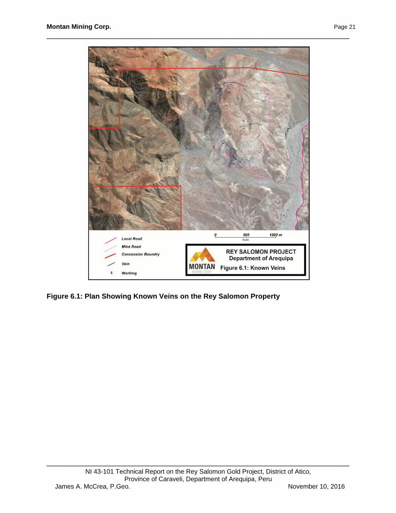
1.5 Geological Setting and Mineralization The Rey Salomon property is situated near the eastern limit of the Coastal Cordillera of southwestern Peru in an area known as the Nazca-Ocoña gold belt. The belt consists of orogenic or intrusive related gold-silver-copper veins located in different phases of the Coastal Batholith Complex (Acosta, 2006). The veins are typically found in tonalitic, andesitic and granodioritic rocks of the Tiabaya, Incahuasi and Linga Superunits. The Superunits have radiometric dates 80 Ma, 95-80Ma and 97 Ma respectively (Olchauski, 1980). The Nazca-Ocoña gold belt extends for approximately 300 km paralleling the coast in a northwest–southeast direction, and has a width of approximately 40 km. Regional Geology is shown in Figure 7.1. The dominant rock type on the Rey Salomon property is Cretaceous granodiorite of the Linga Superunit. The granodiorite is in fault contact with a Cretaceous subvolcanic andesite in the northwest corner of the property. The fault contact is the southern limit of the Pan de Azúcar graben, an extensional feature on the north side of the property. The Miocene Huaylillas, Alpabamba and Moquegua Formations consisting of a sequence of ignimbrites, dacitic to rhyolitic tuffs and sandstones/conglomerates overlie the granodiorite on the east side of the property (Figure 7.2). The mineralization present on the Rey Salomon property is intrusive related quartz veins. There are some 58 known veins on the property with (see Figure 7.3). Four principle veins have the majority of the development with multiple adits and shafts totalling some 2,200 metres of underground development. The four principle veins have been traced for over 1,200 m on surface.
1.6 Exploration and Drilling There is no current exploration on the Rey Salomon property and there has never been drill on the property.
1.7 Mineral Processing and Metallurgical Testing There are currently no metallurgical studies for this property.
1.8 Mineral Resources There are currently no 43-101-compliant Mineral Resource estimates for this property.

Montan Mining Corp. Page 7
______________________________________________________________________
______________________________________________________________________NI 43-101 Technical Report on the Rey Salomon Gold Project, District of Atico,
Province of Caraveli, Department of Arequipa, Peru James A. McCrea, P.Geo. November 10, 2016
1.9 Interpretations and Conclusions The Rey Salomon Project has extensive historic underground exploration/development and displays styles of mineralization characteristic of orogenic or intrusive related gold (±Ag, Cu, Zn) veins, which are often called mesothermal veins. Mineralization is associated with intrusive rocks of the Cretaceous Coast Batholith Complex and in this case, the granodiorite phase of the Linga Superunit. Historic exploration/development on the property has, to date, identified 58 veins on the property with four principle veins having extensive underground workings. The developed veins are open at depth and along strike. Exploration on the property to date has mainly been for veins in the granodiorites. The subvolcanic andesites in the northwest area of the property have seen little work. Extensive local occurrences of intrusive related gold veins in the subvolcanic andesites have been documented (Galazra, 1967) at the Mina Calpa eight km to the northeast of the property. The author has been unable to verify this information about Mina Calpa and the information may not be indicative of the mineralization on the Rey Salomon property. The Rey Salomon Project warrants further exploration for intrusive related gold veins. The property is perspective for the discovery of additional gold mineralization and with higher gold prices returning to the metal markets, the demand for this type of small-scale project should be high.
1.10 Recommendations and Proposed Exploration Budget The recommended exploration and work programs for the Rey Salomon Project are as follows: Phase I $30,000
Structural mapping and prospecting $10,000 Detailed structural mapping and sampling to identify additional vein structures on the property.
Geophysics, Drone Mag survey $20,000 Magnetometer survey to identify intrusive/geologic contacts and possible vein targets.
The Phase II program is not contingent on positive results from the Phase I program and following a thorough compilation and review by a qualified person the following Phase II program is recommended. Phase II $120,000
130 m of underground exploration/development Underground exploration on known veins to search for additional shoots of high-grade mineralization.
Montan Mining Corp. Page 8
______________________________________________________________________
______________________________________________________________________NI 43-101 Technical Report on the Rey Salomon Gold Project, District of Atico,
Province of Caraveli, Department of Arequipa, Peru James A. McCrea, P.Geo. November 10, 2016
2.0 INTRODUCTION
2.1 Introduction and Terms of Reference At the request of Montan Mining Corp., James A. McCrea, P. Geo., carried out an independent review of the Rey Salomon Gold Project, District of Atico, Province of Caraveli, Department of Arequipa, Peru. This report is intended to be used in support of Montan’s acquisition of Cerro Dorado, a Peruvian company with its major asset being the Rey Salomon Gold Project as described in the press release dated July 14, 2016. The author conducted a property examination, reviewed available exploration results and prepared this independent technical report (the ‘Report’) in accordance with the formatting requirements of National Instrument 43-101 and Form 43-101F1 (Standards of Disclosure for Mineral Properties) to be a comprehensive review of the exploration activities on the property, and to provide recommendations for future work, if warranted. The Report is intended to be read in its entirety.
2.2 Site Visit The author, an independent qualified person according to NI 43-101, visited the Rey Salomon Gold Project on October 2th to 4th of 2016. The author examined several mine workings on the property and supervised the collection of 131 verification samples from various mine workings. The Project is considered to be an exploration stage property with underground development. The Project benefits from an in place camp with good living facilities, and a constructed and operational gold recovery mill. The Rey Salomon Project is a gold exploration project in the Department of Arequipa, Peru and is held 100% by M & F Minera Ofir S.A. (Ofir). The property is under option to Cerro Dorado S.A.C., a Peruvian Company that is the target for acquisition by Montan so that Cerro Dorado becomes a wholly owned subsidiary of Montan. Information and data used in this report consists of field observations made by the author during the site visit on October 2th to 4th of 2016; data collected by Montan in the field during their due diligence and sampling completed during the site visit, which was supervised by the author.
2.3 Sources of Information The author was not involved in any previous exploration or development activities on the property. The information, conclusions, opinions and recommendations are based upon:
information available to the author at the time of the preparation of this report; assumptions, conditions and qualifications as set forth in this report; and data, reports and other information provided by Montan and other third party
sources.
During the site visit and while preparing this report, the author reviewed all of the readily available exploration information and reports pertaining to this property. This exploration information appears to be of good quality, and there is no reason to believe that any of the information is incomplete or inaccurate. The sources of information for this technical report are field observations made by the author during the site visit and published government reports and scientific papers such as papers

Montan Mining Corp. Page 9
______________________________________________________________________
______________________________________________________________________NI 43-101 Technical Report on the Rey Salomon Gold Project, District of Atico,
Province of Caraveli, Department of Arequipa, Peru James A. McCrea, P.Geo. November 10, 2016
published by Instituto Geologico, Minero y Metalurgico (INGEMMET), Peru’s government geological library. Information concerning mining concessions comes from Peru’s mining claim registry: Instituto Nacional de Concesiones y Catastro Minero (INACC). Population statistics, weather and local information on the Project has been obtained from Wikipedia (http://www.en.wikipedia.org/wiki/cusco). A detailed list of references and sources of information is provided in the References section of this report.

Montan Mining Corp. Page 10
______________________________________________________________________
______________________________________________________________________NI 43-101 Technical Report on the Rey Salomon Gold Project, District of Atico,
Province of Caraveli, Department of Arequipa, Peru James A. McCrea, P.Geo. November 10, 2016
2.4 Abbreviations and Units of Measure Metric units are used throughout in this report and currencies are in United States Dollars (US$) unless otherwise stated. Market gold or silver metal prices are reported in US$ per troy ounce. A list of abbreviations that may be used in this report is provided below.
Abbreviation Description Abbreviation Description % percent li limonite AA atomic absorption m metre Ag silver m2 square metre AMSL above mean sea level m3 cubic metre as arsenic Ma million years ago Au gold mg magnetite AuEq gold equivalent grade mm millimetre Az azimuth mm2 square millimetre b.y. billion years mm3 cubic millimetre CAD$ Canadian dollar mn pyrolusite cl chlorite Mo Molybdenum cm centimetre Moz million troy ounces cm2 square centimetre ms sericite cm3 cubic centimetre Mt million tonnes cc chalcocite mu muscovite cp chalcopyrite m.y. million years Cu copper NI 43-101 National Instrument 43-101 cy clay opt ounces per short ton °C degree Celsius oz troy ounce (31.1035 grams) °F degree Fahrenheit Pb lead DDH diamond drill hole pf plagioclase ep epidote ppb parts per billion ft feet ppm parts per million ft2 square feet py pyrite ft3 cubic feet QA Quality Assurance g gram QC Quality Control gl galena qz quartz go goethite RC reverse circulation drilling GPS Global Positioning System RQD rock quality description gpt grams per tonne sb antimony
ha hectare Sedar System for Electronic Document Analysis and Retrieval
hg mercury SG specific gravity hm hematite sp sphalerite ICP induced coupled plasma st short ton (2,000 pounds) kf potassic feldspar t tonne (1,000 kg or 2,204.6 lbs) kg kilogram to tourmaline km kilometre um micron km2 square kilometre US$ United States dollar l litre Zn zinc

Montan Mining Corp. Page 11
______________________________________________________________________
______________________________________________________________________NI 43-101 Technical Report on the Rey Salomon Gold Project, District of Atico,
Province of Caraveli, Department of Arequipa, Peru James A. McCrea, P.Geo. November 10, 2016
2.5 Acknowledgements The author wishes to thank the officers and directors of Montan Mining Corp. for providing the technical materials and the assistance required to prepare this report.
3.0 RELIANCE ON OTHER EXPERTS
On November 10, 2016, the author confirmed the status of the subject mineral tenures with information available through Instituto Geologico, Minero y Metalurgico (INGEMMET) the Peruvian government geological library and Peru’s mining claim registry: Instituto Nacional de Concesiones y Catastro Minero (INACC) which is available on the INGEMMET website (http://www. http://geocatmin.ingemmet.gob.pe/geocatmin/). The author is not an expert in legal matters, such as the assessment of the legal validity of mining claims, mineral rights, and property agreements. The author did not conduct any detailed investigations of the environmental or social-economic issues associated with the Project, and the author is not an expert with respect to these issues. The author has relied on Montan Mining Corp. to provide full information concerning the legal status of mineral tenures, material terms of all agreements, and material environmental and permitting information that pertain to the property. Estudio Jurídico Oropeza y Asociados have provided a property title opinion to Montan and it is copied in Appendix 1 for reference. This report has been prepared for use by Montan Mining Corp. The Report is intended to be read as a whole, and sections or parts thereof should therefore not be read or relied upon out of context.

Montan Mining Corp. Page 12
______________________________________________________________________
______________________________________________________________________NI 43-101 Technical Report on the Rey Salomon Gold Project, District of Atico,
Province of Caraveli, Department of Arequipa, Peru James A. McCrea, P.Geo. November 10, 2016
4.0 PROPERTY DESCRIPTION and LOCATION
4.1 Property Location The Rey Salomon project is located in the Coastal Cordillera approximately 50 km east of the coastal town of Atico in the District of Atico, Province of Caraveli, and Department of Arequipa, Peru. The geographic coordinates near the centre of the Project are approximately 15° 51’ South latitude by 73o 34’ West longitude, or in the local UTM PSAD 56 coordinate system, Zone 18S, at 8,248,352 m North by 652,933 m East (see Figure 4.1). The property is within Peruvian National Topographic System (NTS) map area Chaparra 32-o.
Figure 4.1: Location Map of the Rey Salomon Project

Montan Mining Corp. Page 13
______________________________________________________________________
______________________________________________________________________NI 43-101 Technical Report on the Rey Salomon Gold Project, District of Atico,
Province of Caraveli, Department of Arequipa, Peru James A. McCrea, P.Geo. November 10, 2016
4.2 Property Description The Rey Salomon Project consists of four contiguous mining concessions or mining rights totalling 1,172.34 ha. The concessions are known by the names of Rey Salomon I, Rey 2, Rey 3 and Tia Gaby. The mining rights are listed in Table 1.1 and are shown in Figure 4.2.
Table 4.1: Rey Salomon Gold Project Mining Concession Titles Mining Registry
No. Name Holder of Record
Granted Area (ha)
Expiration Date
05-00036-99 Rey Salomon I M & F Minera Ofir S.A. 200.00 30-June-2017
05-00114-06 Rey 2 M & F Minera Ofir S.A. 572.34 30-June-2017
05-00115-06 Rey 3 M & F Minera Ofir S.A. 300.00 30-June-2017
54-00133-09 Tia Gaby M & F Minera Ofir S.A. 100.00 30-June-2017
Note: Title information effective November 10, 2016 The concessions are registered in Superintendencia Nacional de Registros Publicos (SUNARP), to M & F Minera Ofir S.A. The concessions are under option to Cerro Dorado, a private Peruvian company with offices in the San Isidro Municipality of Lima, and a target for 100% acquisition by Montan.
Figure 4.2: Mineral Concession Map of Rey Salomon Project

Montan Mining Corp. Page 14
______________________________________________________________________
______________________________________________________________________NI 43-101 Technical Report on the Rey Salomon Gold Project, District of Atico,
Province of Caraveli, Department of Arequipa, Peru James A. McCrea, P.Geo. November 10, 2016
The known environmental liabilities within the property limits are the 60 tonne per day mill, its tailings impoundment and a 40 man camp. The Rey Salomon I, Rey 2, Rey 3 and Tia Gaby concessions were originally registered on August 2, 1999, May 25, 2006, May 25, 2006, and August 7, 2009 respectively. Rey Salomon I was originally registered as a limited responsibility mining society (“Sociedad Contractual”) and has since been transferred by public deed to Minera Ofir. The remaining three concessions were registered directly to Minera Ofir.
4.3 Underlying Agreements On July 14, 2016, Montan Mining Corp. (“Montan”) announced a purchase transaction (the “Transaction”) whereby Montan proposed to purchase all the outstanding shares of Cerro Dorado S.A.C. including all assets, permits and underlying agreements from Chazel Capital Inc. (‘Chazel’) for stock and debt payments. Assets of Cerro Dorado include a permitted 60 tonne per day ‘carbon in pulp” (CIP) gold recovery plant located on the Rey Salomon property, access rights, water rights and Cerro Dorado’s option (the “Option”) on the Rey Salomon property (Montan News Release July, 2016). The Option includes mining rights (mining rights lease) to the Rey Salomon mine and property. The acquisition terms are as follows:
Montan will assume US$ 300,000 of debt owed by Cerro Dorado in Peru. The initial share payment will be adjusted at the date of closing with the difference between this value and the actual debt based on a 20 day VWAP of Montan shares.
Montan will also assume Cerro Dorado’s debt to the property owner, Minera Ofir, including monthly payments and buyout.
10 million Montan Shares on execution of sale (discounted as described above) to be held in escrow and released at 2 million shares at the end of every 3 months from the day of closing.
2 million Montan Shares upon sale of 1,000 oz Au-contained ore or dore from either the mine or the plant.
2 million Montan Shares upon sale of an additional 2,000 oz Au-contained ore or dore (3,000 oz total) from either the mine or the plant.
Cerro Dorado has entered into a Binding Indicative Term Sheet (the “Term Sheet”) to purchase a 100% interest in the Rey Salomon property from Minera Ofir. In the Term Sheet Minera Ofir has agreed to expire their existing Option Agreement (of 2012) and Mining Lease Agreement (of 2014) on the Rey Salomon Project in favour of a new Share Purchase Agreement wherein Cerro Dorado will purchase 100% of the outstanding shares of Minera Ofir. The new Share Purchase Agreement requires that Cerro Dorado pay the shareholders of Minera Ofir US $453,968 in 24 payments over 2 years, commencing on January 25th, 2017. Cerro Dorado is required to pay interest on the outstanding balance monthly at a 5% annual rate of interest. Shareholders of Ofir will hold no residual royalties or operating interest in the Rey Salomon project from January 31st, 2017, providing however that until the $453,968 payments are complete, a mortgage over the property will comprise security against payment. Cerro Dorado is entitled to accelerate payments at any time to complete the purchase and release security against the property. Montan is still required to pay option payments of US $12,500 per month for the property until the Share Purchase agreement comes into effect.

Montan Mining Corp. Page 15
______________________________________________________________________
______________________________________________________________________NI 43-101 Technical Report on the Rey Salomon Gold Project, District of Atico,
Province of Caraveli, Department of Arequipa, Peru James A. McCrea, P.Geo. November 10, 2016
4.4 Surface Rights Surface rights at the Rey Salomon Project belong to the Peruvian government and are state assets called Bienes Estatales or “terrenos erizos”. These require an application to the office of State Assets to secure access. Provisional access was granted on March 23, 2015. The author is unaware of any other significant factors or risks that could affect the title or access to perform work on the property.
4.5 Mineral Rights in Peru The ‘General Mining Law of Peru’ defines and regulates different categories of mining activities, ranging from sampling and prospecting to development, mining, and processing. The General Mining Law of Peru was changed in the mid-1990s to foster the development of the country’s mineral resources. The law defines and regulates different categories of mining activities according to stage of development (prospecting, exploitation, processing, and marketing). Titles over mineral claims are controlled by INGEMMET (Geological, Mineral and Metallurgical Survey of Peru). Mining titles (mining concessions) are granted using UTM coordinates (PSAD56) to define areas in hectares. New mining concessions shall be at least of 100 ha in size (1 km2), and must be oriented in a north-south or east-west direction. Pre-existing concessions, based on the old system (“punto de partida” or starting point system), can be at any orientation. The old framework, which has been in force since 1992, establishes that mining concessions are irrevocable if the concession titleholder complies with the annual payment of US$ 3.00 of validity-fee per hectare and reaches a minimum production of US$ 100.00 per hectare within six years following the year in which a mining concession is granted. Otherwise, the titleholder must pay a US$ 6.00 penalty per hectare per year as of the first semester of the seventh year until such production is reached (penalties increase to US$ 20 from the 12th year). Current regulations establish that the holder of mining concessions shall achieve a minimum production of at least one Peruvian Tax Unit (approximately US$ 1,900) per hectare per year, within a 10-year term following the year in which the mining concession title is granted. If the minimum production is not reached in the referred term, the mining concession holder shall pay penalties equivalent to 10% of the Peruvian Tax Unit per hectare. If minimum production within a 15-year term from the day in which the mining concession was granted is not achieved, the mining concession will be cancelled unless, a qualified force majeure event occurs and is approved by the Mining Authority. The titleholder may also maintain the title by paying the applicable penalties and providing evidence of a minimum investment of at least ten times the amount of the applicable penalties. In this last case, the mining concession will not be cancelled up to a maximum term of five additional years (total term 20 years). If minimum production is not reached in the 20-year term, the concession title will be inevitably cancelled. While the holder of a mining concession is protected under the Peruvian Constitution and the Civil Code, it does not confer ownership of land and the owner of a mining concession must deal with the registered landowner to obtain the right of access to fulfill the production obligations inherent in the concession grant. It is important to recognize that all transactions and contracts pertaining to a mining concession must be duly registered with the Public Registry in the event of subsequent disputes at law.
Montan Mining Corp. Page 16
______________________________________________________________________
______________________________________________________________________NI 43-101 Technical Report on the Rey Salomon Gold Project, District of Atico,
Province of Caraveli, Department of Arequipa, Peru James A. McCrea, P.Geo. November 10, 2016
4.6 Royalties and Obligations Peru established a sliding scale mining royalty late in 2004. Calculation of the royalty payable is made monthly and is based on the gross value of the concentrate sold (or its equivalent) using international metal prices as the base for establishing the value of metal. The sliding scale is applied as follows:
First stage: up to US$60 million annual revenue; 1.0 percent of gross value; Second stage: in excess of US$60 million up to US$120 million annual revenue; 2.0
percent of gross value; and Third stage: in excess of US$120 million annual revenue; 3.0 percent of gross value.
4.7 Environmental Regulations & Exploration Permits The General Mining Law, administered by the Ministry of Energy and Mines (MEM), may require a mining company to prepare an Environmental Evaluation (EA), an Environmental Impact Assessment (EIA), a Program for Environmental Management and Adjustment (PAMA), and a Closure Plan prior to mining construction and operation. The Supreme Decree Nº 020-2004-EM classifies the environmental requirements for mining and exploration programs as follows:
Category I: this category includes mining projects involving small scale drilling programmes up to and including a maximum 20 drill pads, a disturbed area of less than 10 hectares considering drilling platforms, trenches, auxiliary facilities and access means or the construction of tunnels with a total maximum length of 50 metres. These projects require the preparation of an Environmental Impact Declaration (“Declaración de Impacto Ambiental –DIA-”). Category I permits require, prior to their submittal to the Ministry of Energy and Mines, water-use permits from the Ministry of Agriculture, if required, and land-use agreements with the surface rights owners in the form of a registered agreement resulting from a town-hall meetings in the local community(s).
Category II: this category includes mining projects involving more than 20 drill pads, a disturbed area of more than 10 hectares considering drilling platforms, trenches, auxiliary facilities and access, or the construction of tunnels over a total length of 50 metres, require an authorisation called an Environmental Impact Study-semi detailed (“Estudio de Impacto Ambiental-semi detallado”, or EIA-sd) and is approved by the Ministry of Energy and Mines. Category II permits, which include mining projects involving more than just drilling, must include, prior to their submittal to the Ministry of Energy and Mines, water-use permits from the Ministry of Agriculture, land-use agreements with the surface rights owners and evidence of having held town-hall meetings in all nearby communities. Additionally, the EIA-sd must include a detailed reclamation program once the drilling phase ends.
Permits are usually granted within 3 to 6 months of submittal of an application. No permit is required for general exploration such as surface mapping, sampling or geophysics. Permission of the surface rights owner is required for access to the property and for any kind of surface disturbance such as trenching or the construction of trails.
4.8 Environmental Considerations Montan is subject to an outstanding environmental liability on the concessions relating to the mine, process plant and tailings impoundment. Montan has no environmental responsibility for historic exploration and operational activities prior to the involvement of Cerro Dorado in the project. Cerro Dorado has completed a “Mining Operation Certificate for small mining” for the Rey 2 concession and a semi-detailed environmental impact study. The mine operation certificate expires in March of 2017.

Montan Mining Corp. Page 17
______________________________________________________________________
______________________________________________________________________NI 43-101 Technical Report on the Rey Salomon Gold Project, District of Atico,
Province of Caraveli, Department of Arequipa, Peru James A. McCrea, P.Geo. November 10, 2016
To the best of the author’s knowledge there are no other significant factors or risks that may affect access, title, or the right or ability to perform work on the property.
Montan Mining Corp. Page 18
______________________________________________________________________
______________________________________________________________________NI 43-101 Technical Report on the Rey Salomon Gold Project, District of Atico,
Province of Caraveli, Department of Arequipa, Peru James A. McCrea, P.Geo. November 10, 2016
5.0 ACCESSIBILITY, CLIMATE, LOCAL RESOURCES, INFRASTRUCTURE and PHYSIOGRAPHY
5.1 Accessibility The Project is located 564.5 km southeast of the city of Lima and road access is by the Pan American South highway, route S1, following the coast for 707 km to Atico then turn north on highway 104 for 43 km. The total travel time from Lima to the Project is about 11.5 hours in a pickup truck. No commercial flights in Peru provide good access to the Project. The closest commercial airport to the project is in the City of Arequipa, 305 km to the southeast on the Pan American highway and a 6-hour drive from the Project. Arequipa, the capital of the Department of Arequipa with a population of 870,000 (2015, Wikipedia), can be accessed via numerous daily flights from Lima or other centres around the country. Road distances from Lima to the Project are listed in Table 5.1.
Table 5.1: Road Distances to Access the Rey Salomon Project Segment Kilometres Hours Road Surface
Lima to Nasca 450 6.0 Paved Nasca to Chala 166 3.0 Paved Chala to Atico 91 1.5 Paved Atico to Project 43 1.0 Paved/Gravel/Dirt
5.2 Climate The climate of the region is typical of the Coastal Cordillera and Coastal Belt of southern Peru. The climate is classified as cold desert by the Köppen climate classification. The seasons are divided into a wet season between January and March with slightly higher temperatures and a dry season during May to August with cooler temperatures. The entire year has fog with the rainy season being three months in duration; the climate is summarized as temperate, cool and dry. The area receives an average of 150 mm of precipitation per year with over 90% of that falling in summer (January to March). Average daily temperature range is from 8°C at night to a daily high of almost 30°C; the yearly daily average is 12.8°C (Wikipedia).
5.3 Local Resources and Infrastructure The population of the District of Atico, where the concessions are located, is 3,976 (2005) and the province of Caraveli has a population of 31,477 (2005). The nearby communities can provide local unskilled labour and some skilled labour but sources of skilled labour would most typically come from Arequipa, the department capital, or from outside the area (Wikipedia). Most supplies for exploration can be obtained in Arequipa, the nearest major centre and a 6-hour drive from the property. For mineral processing, supplies are abundant in Chala, 2.5 hours from the property. Some food and basic supplies can be obtained locally in the town of Atico, approximately 43 km south of the property but major purchases would be made in Arequipa or Lima. Casual labourers can be available from the nearby town of Atico, 43 km south of the property. The Project has a well with a permit to produce up to 100 m3 of water per day to supply the camp and process plant. The surface rights and concession area provide sufficient area for future mining operations.

Montan Mining Corp. Page 19
______________________________________________________________________
______________________________________________________________________NI 43-101 Technical Report on the Rey Salomon Gold Project, District of Atico,
Province of Caraveli, Department of Arequipa, Peru James A. McCrea, P.Geo. November 10, 2016
5.4 Physiography The Project is situated in the Coastal Cordillera of the southern Peruvian Andes. The Rey Salomon property is located between 1,400 and 1,860 metres above sea level. The terrain is mountainous with relatively moderate topographic relief and numerous hills and valleys where the drainage is often controlled by faults and drains south into the Pacific Ocean. Vegetation is also typical of a dry desert climate with slopes having little or no vegetation. At higher elevations, the slopes are talus covered.
Montan Mining Corp. Page 20
______________________________________________________________________
______________________________________________________________________NI 43-101 Technical Report on the Rey Salomon Gold Project, District of Atico,
Province of Caraveli, Department of Arequipa, Peru James A. McCrea, P.Geo. November 10, 2016
6.0 HISTORY
The recorded mining history of the Atico district, department of Arequipa goes back to the early parts of the last century and mining history in the Atico district goes back to Spanish Colonial times. The village of Atico is mentioned in “The Geographical and Historical Dictionary of America and the West Indies” which contains the entire translation of the Spanish work of Colonel Don Antonio de Alcedo (1735-1812) indicating that the village was a stopover point on the route from Lima to Arequipa in the 18th century. Little information is readily available about the colonial mining history of the district. The early recorded mining history of the Atico district relates mainly to the Mina Calpa located 8 km northeast of the Rey Salomon Project and the numerous other undocumented artisanal mines in the Nazca-Ocoña gold belt and immediate area. The titles for the main concessions of Mina Calpa were originally petitioned in 1931 and the artisanal mining of the gold veins on the Mina Calpa property and area was likely going on years before that. Misti Gold S.A. (Misti Gold) is reported to have conducted exploration in the Rey Salomon area during the 1990’s where the work was completed on 5000 ha blocks (Torres, 2015). Misti Gold is said to have left Peru in 1998. No results or information on work programs or other information was available to the author. The Ofir vein was recognized in 1994 by the artisanal miner Tonny Matheus (Torres, 2015). The Rey Saloman I concession was petitioned in August of 1999 to cover the Ofir and Esperanza veins. The concession was then transferred by public deeds to Minera Ofir in April of 2001. The concessions, Rey 2 and Rey 3, were petitioned in 2006 and Tia Gaby in 2009. Minera Ofir begins the underground exploration stage in 2002, with an advance of 324 meters on the mineralized veins Ofir and Esperanza. The recovered mineral was transported to the cyanidation plant at Minera Titan, located in Chala, 150 km from Atico (Torres, 2015). In 2012, Cerro Dorado leased the operational mining rights for the four concessions from Minera Ofir with an option to purchase the concessions. Cerro Dorado developed more than 1175 m of additional galleries up until September 2015 (Torres, 2015).
Montan Mining Corp. Page 21
______________________________________________________________________
______________________________________________________________________NI 43-101 Technical Report on the Rey Salomon Gold Project, District of Atico,
Province of Caraveli, Department of Arequipa, Peru James A. McCrea, P.Geo. November 10, 2016
Figure 6.1: Plan Showing Known Veins on the Rey Salomon Property
Montan Mining Corp. Page 22
______________________________________________________________________
______________________________________________________________________NI 43-101 Technical Report on the Rey Salomon Gold Project, District of Atico,
Province of Caraveli, Department of Arequipa, Peru James A. McCrea, P.Geo. November 10, 2016
7.0 GEOLOGICAL SETTING and MINERALIZATION
The Rey Salomon Project is located in the Peruvian National Topographic system on map sheet 32-o Chaparra, in the Department of Arequipa. INGEMMET completed regional geologic mapping on the map sheets in 1969 to 72 and the corresponding Bulletin, A 034, was completed in 1980.
7.1 Regional Geology The Rey Salomon property is situated near the eastern limit of the Coastal Cordillera of southwestern Peru in an area known as the Nazca-Ocoña gold belt. The belt consists of orogenic or intrusive related gold-silver-copper veins located in different phases of the Coastal Batholith Complex (Acosta, 2006). The veins are typically found in tonalitic, andesitic and granodioritic rocks of the Tiabaya, Incahuasi and Linga Superunits. The Superunits have radiometric dates 80 Ma, 95-80Ma and 97 Ma respectively (Olchauski, 1980). The Nazca-Ocoña gold belt extends for approximately 300 km paralleling the coast in a northwest–southeast direction, and has a width of approximately 40 km. Regional Geology is shown in Figure 7.1. Sillitoe (2003) describes the emplacement of the Coastal or Andean Batholith Complex in the Coastal Cordillera of southern Peru and northern Chile as follows:
In the Coastal Cordillera and immediately adjoining physiographic regions of northern Chile and southern Peru, major Mesozoic plutonic complexes are emplaced into broadly contemporaneous arc and intra-arc volcanic products and underlying penetratively deformed metasedimentary units of Palaeozoic age. Early Proterozoic cratonic basement of the Arequipa-Antofalla massif underpins the central segment of the Coastal Cordillera (Shackleton et al. 1979) and the adjoining Andean Cordillera, between about latitudes 14 and 26_S (Ramos and Aleman 2000). Extensive longitudinal brittle fault systems and/or ductile shear zones, including the Atacama Fault System in northern Chile (e.g. Scheuber and Andriessen 1990) and deeply penetrating faults that localised the Can˜ ete basin in Peru (Atherton and Aguirre 1992), were active during the Mesozoic volcanism and plutonism. Widespread extension induced tilting of the volcano-sedimentary sequences. Immediately east of the Mesozoic arc terrane of the Coastal Cordillera in northern Chile and southern Peru, sedimentary sequences accumulated in a series of interconnected, predominantly marine back-arc basins (Mpodozis and Ramos 1990). Early to mid-Jurassic through mid-Cretaceous volcanism and plutonism throughout the Coastal Cordillera and immediately adjoining regions are generally considered to have taken place under variably extensional conditions in response to retreating subduction boundaries (slab roll-back) and steep, Mariana-type subduction (Mpodozis and Ramos 1990; Grocott and Taylor 2002). Nevertheless, Atherton and Aguirre (1992) questioned the existence of subduction during the Early Cretaceous in southern Peru and favoured extension at a passive continental margin. Throughout much of the Coastal Cordillera of northern Chile and southern Peru, western portions of the Mesozoic arc terrane (and the corresponding fore-arc) seem likely to have been removed by subduction erosion or lateral translation (Rutland 1971; Dalziel 1986; Mpodozis and Ramos1990) or, at the very least, lie below sea level.

Montan Mining Corp. Page 23
______________________________________________________________________
______________________________________________________________________NI 43-101 Technical Report on the Rey Salomon Gold Project, District of Atico,
Province of Caraveli, Department of Arequipa, Peru James A. McCrea, P.Geo. November 10, 2016
Figure 7.1: Regional Geologic Map for the Rey Salomon Property
Montan Mining Corp. Page 24
______________________________________________________________________
______________________________________________________________________NI 43-101 Technical Report on the Rey Salomon Gold Project, District of Atico,
Province of Caraveli, Department of Arequipa, Peru James A. McCrea, P.Geo. November 10, 2016
7.2 Property Geology
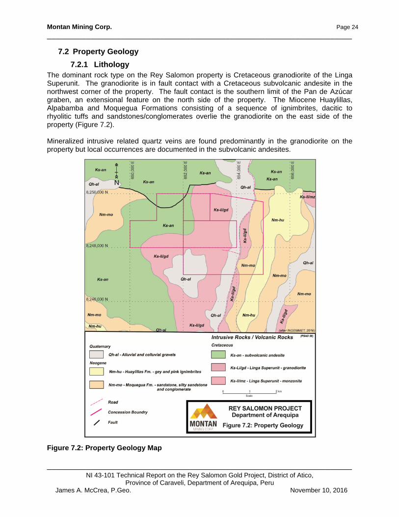
7.2.1 Lithology The dominant rock type on the Rey Salomon property is Cretaceous granodiorite of the Linga Superunit. The granodiorite is in fault contact with a Cretaceous subvolcanic andesite in the northwest corner of the property. The fault contact is the southern limit of the Pan de Azúcar graben, an extensional feature on the north side of the property. The Miocene Huaylillas, Alpabamba and Moquegua Formations consisting of a sequence of ignimbrites, dacitic to rhyolitic tuffs and sandstones/conglomerates overlie the granodiorite on the east side of the property (Figure 7.2). Mineralized intrusive related quartz veins are found predominantly in the granodiorite on the property but local occurrences are documented in the subvolcanic andesites.
Figure 7.2: Property Geology Map
Montan Mining Corp. Page 25
______________________________________________________________________
______________________________________________________________________NI 43-101 Technical Report on the Rey Salomon Gold Project, District of Atico,
Province of Caraveli, Department of Arequipa, Peru James A. McCrea, P.Geo. November 10, 2016
7.2.2 Alteration The alteration at Rey Salomon is associated with the vein structures. In the oxide zone, the association is with the quartz containing limonite and hematitic stains with copper oxide stains derived from chalcopyrite and where free gold is observed. At the lower levels, pyrite and sporadic occurrences of chalcopyrite are observed, indicating the presence of primary sulphides (Torres, 2015). The hydrothermal alteration zone is generally limited to the country rock immediately surrounding the veins and is distributed as salvages or halos related to the mineralized structures. Week to moderate argillic alteration of the wall rock and silicification related to the veining is observed. Propylitic alteration (chlorite, magnetite, carbonate and epidote) is sporadically distributed and in gradational contact with the argillic alteration which is characterized by a greenish coloration imparted by the presence of chlorite-epidote.
7.2.3 Mineralization The mineralization present on the Rey Salomon property is hosted in intrusive related quartz veins. There are some 58 known veins on the property with (see Figure 7.3). Four principle veins have the majority of the development with multiple adits and shafts totalling some 2,200 metres of underground development. The four principle veins have been traced for over 1,200 m on surface. The veins have strikes from 273o to 320o and dips of 70o to 80o NE or SW. The vein structures have a pinch and swell geometry with high-grade ore shoots. The historic development work reported numerous ore shoots with higher grades (Torres, 2015). The principle veins are as follows:
i. Esperanza Vein The vein trends 320o with a dip of 75° to the NE, and has been mapped over 270 m of outcrop with adits and has a weak alteration halo traced for up to 400 meters. Underground the vein has been traced by over 220 m of lateral development and some 80 m down dip. The development has encountered six mineralized shoots with lengths ranging from 5 to 28 meters inside the zone of oxides (mostly hematite and limonite), with an average width of 0.29 m and a reported average grade of 7.79 g/t Au. The shoots cover approximately 25% of the known vein extension.
ii. Ofir Vein This vein trends 305o with a dip of 75o NE and on surface it has been traced for 230 m, with two workings into the vein covering approximately 90 m of vertical extent. Two ore shoots were found during the underground development with lengths of 8 and 23 m, these have an average width of 0.20 m and are composed of milky quartz breccia with veinlets, patches of hematite staining and limonite, the sampling returned an average grade of 6.19 g/t. Au. The shoots would cover 14% of the known vein extension.
iii. Alabe Vein The structure trends 87º with a 70º dip SW, is mapped for 220 m in outcrop with adits, and tunnels over 75 m of vertical extension. Three mineralized shoots have been intersected with lengths ranging from seven to 26 m, where the vein has an average width of 0.21 m. An average grade of 6.75 g/t Au is reported. The vein is composed of quartz, hematite, limonite and
Montan Mining Corp. Page 26
______________________________________________________________________
______________________________________________________________________NI 43-101 Technical Report on the Rey Salomon Gold Project, District of Atico,
Province of Caraveli, Department of Arequipa, Peru James A. McCrea, P.Geo. November 10, 2016
chalcopyrite. The shoots comprise approximately 20% of the known vein extension. The vein follows a reactivated fault structure with a pinch and swell geometry.
iv. Melchora Vein This vein is located in the extreme east of the project, mapped over about 500 m in outcrop with adits and mine workings over 90 m, vertically to the south of the vein outcrop. Melachora has a strike of 95º and a dip of 70º to 80º SW with a width of 0.20 m- 0.40 m and a reported grade of 8 g/t Au. The vein is composed of brecciated quartz with hematite, limonite and occasionally free gold with ‘high-grade’ reported in the zone of oxidation (up to 30 g/t Au). A mineralized shoot, 80 m long was mapped during underground development and this represents approximately 30% of the known vein extension (Torres, 2015). Vein average grades and widths are as reported by the previous operator and have not been confirmed by the author.
Figure 7.3: Known Veins on the Rey Salomon Property

Montan Mining Corp. Page 27
______________________________________________________________________
______________________________________________________________________NI 43-101 Technical Report on the Rey Salomon Gold Project, District of Atico,
Province of Caraveli, Department of Arequipa, Peru James A. McCrea, P.Geo. November 10, 2016
8.0 DEPOSIT TYPES
The gold-bearing (±Ag, Cu, Zn) mineralization of the Nazca-Ocoña gold belt and Rey Salomon property has been described as being mesothermal quartz-sulphide or intrusive-related vein deposits. According to Ash and Alldrick (1996), mesothermal or intrusive related gold deposits are characterized by gold-bearing quartz veins and veinlets with minor sulphides crosscutting a wide variety of host rocks, often localized along major transcrustal structural breaks within stable cratonic terranes. The vein deposits occur within fault and joint systems produced by regional compression or transpression (terrane collision), including major listric reverse faults, second and third-order shear splays. Gold-bearing mineralization is deposited at crustal levels within and near the brittle-ductile transition zone at depths of 6 to 12 km, pressures between 1 to 3 kilo bars and temperatures from 200° to 400° C. Intrusive-related gold (± silver, copper, zinc) mineralization, as fracture filling veins and veinlets with accompanying propylitic to phyllic alteration of the host rocks, commonly occurs peripheral to subvolcanic plutons in the transitional setting between subvolcanic porphyry and epithermal systems (Alldrick, 1996). The host rocks may vary from volcanic, volcaniclastic sedimentary or metamorphic rocks to early intrusive phases around the periphery of phaneritic, locally porphyritic, alkaline to calc-alkaline stocks or batholiths. Intrusive-related deposits may include planar veins, en echelon vein sets, shear veins, cymoid veins and loops, sigmoidal veins, extension veins, tension gashes, ladder veins and Reidel shear veins. The ore mineralogy may include: native gold, electrum, pyrite, pyrrhotite, sphalerite, galena, chalcopyrite, bornite, argentite and various other telluride and sulphosalt minerals. Gangue mineralogy is commonly quartz, calcite, ankerite and chlorite with or without minor sericite, orthoclase, biotite and rhodochrosite (Alldrick, 1996). The mineralization is syn-intrusive, formed in the thermally controlled ‘brittle-ductile transition envelope’ that surrounds subvolcanic intrusions. Local shear stress caused by late magma movement results in en echelon fracture sets, which were filled by sulphides and gangue minerals precipitating from circulating hydrothermal fluids (Alldrick, 1996). Silicification, pyritization and potassium metasomatism generally occur adjacent to veins (usually within a metre) within broader zones of carbonate alteration, with or without ferroan dolomite veinlets, extending up to tens of metres from the veins. The type of carbonate alteration reflects the ferromagnesian content of the primary host lithology; ultramafic rocks – talc and Fe-magnesite; mafic volcanic rocks – ankerite and chlorite; sediments - graphite and pyrite; felsic to intermediate intrusions - sericite, albite, calcite, siderite and pyrite.
Montan Mining Corp. Page 28
______________________________________________________________________
______________________________________________________________________NI 43-101 Technical Report on the Rey Salomon Gold Project, District of Atico,
Province of Caraveli, Department of Arequipa, Peru James A. McCrea, P.Geo. November 10, 2016
9.0 EXPLORATION
There is no current exploration on the Rey Salomon property.

Montan Mining Corp. Page 29
______________________________________________________________________
______________________________________________________________________NI 43-101 Technical Report on the Rey Salomon Gold Project, District of Atico,
Province of Caraveli, Department of Arequipa, Peru James A. McCrea, P.Geo. November 10, 2016
10.0 DRILLING
There has been no drilling on the Rey Salomon property.

Montan Mining Corp. Page 30
______________________________________________________________________
______________________________________________________________________NI 43-101 Technical Report on the Rey Salomon Gold Project, District of Atico,
Province of Caraveli, Department of Arequipa, Peru James A. McCrea, P.Geo. November 10, 2016
11.0 SAMPLE PREPARATION, ANALYSES AND SECURITY
11.1 Minera Ofir, Cerro Dorado 2012 to 2015 There is no documentation or description of the sampling procedure used by Cerro Dorado or its predecessor for the Rey Salomon Project.
11.2 2016 Verification Sampling Preparation The samples from the 2016 verification sampling, reported here, were sent to ALS Global Laboratories (ALS Labs) in Lima. Samples were collected in the field by a sampling crew, supervised by the author, as chip channel samples from the more than two kilometres of underground workings on the property. The samples were bagged, labelled and sealed with one-use ties at the time they were taken. Due to the nearly 500 kilograms of samples, the samples were delivered by the sampling crew to a commercial transport company and shipped to Lima. The bagged shipment of samples were then delivered by a company employee to the author in Lima for final preparation. ALS Global then picked up the samples from the author. Samples were sent to ALS Labs in Lima for preparation. ALS’ Lima facility is an ISO 9001/2008 registered laboratory. Samples w e r e analyzed for gold by fire assay followed by atomic absorption spectroscopic (AAS) finish and by gravimetric finish for samples exceeding the upper limit of analysis (over limit). Silver, copper, molybdenum, lead and zinc, together with 30 other elements, were assayed by inductively coupled plasma-atomic emission spectrometry (ICP-AES) following aqua regia (partial) dissolution of each pulp. Samples with silver, lead, zinc and copper assays above the upper limit for the ICP-AES technique were re-assayed by atomic absorption (AA). The author included quality control samples with the verification samples. The QA/QC samples included were six standards and four blanks. No standard failures or mineralized blanks were reported. The author believes the sample handling, preparation and analyses of these samples is adequate for this stage of exploration on the Rey Salomon Project.

Montan Mining Corp. Page 31
______________________________________________________________________
______________________________________________________________________NI 43-101 Technical Report on the Rey Salomon Gold Project, District of Atico,
Province of Caraveli, Department of Arequipa, Peru James A. McCrea, P.Geo. November 10, 2016
12.0 DATA VERIFICATION
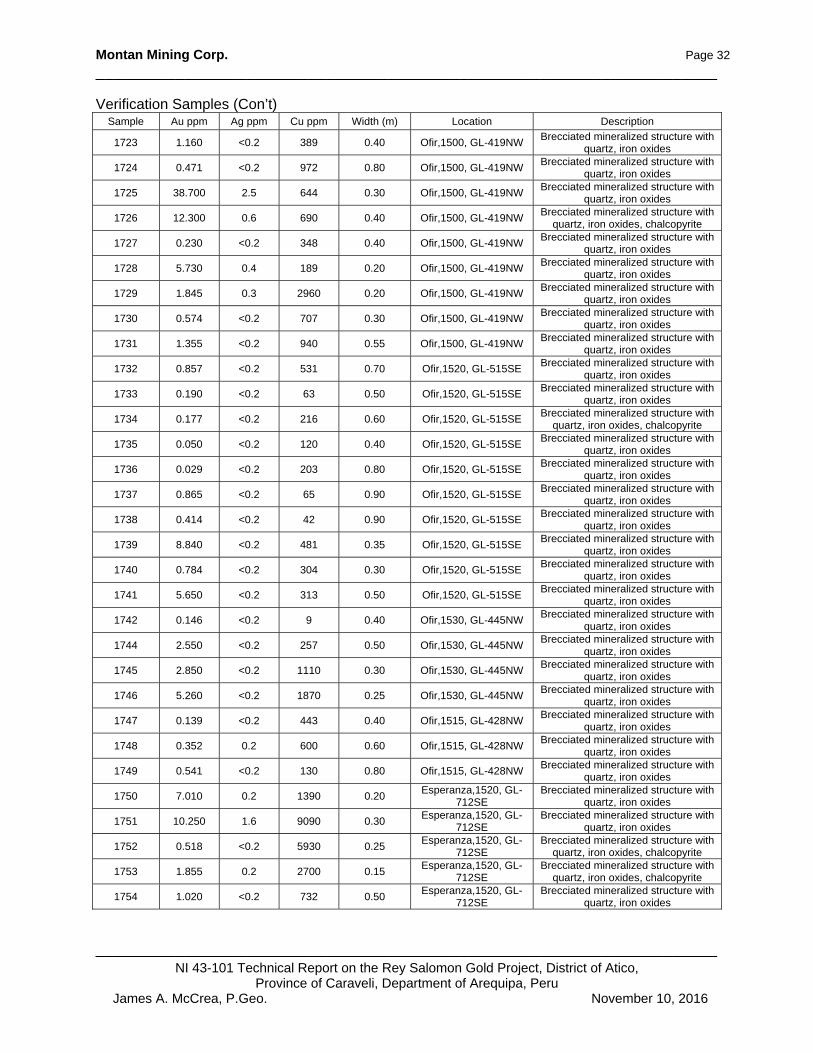
12.1 Verification Sampling Results The verification sampling, supervised by the author, was part of Montan’s due diligence supporting the purchase of the Property. The author is of the opinion that the data is adequate for the purposes used in this technical report. . The author’s verification sample results have been tabulated in Table 12.1. Sample locations are shown in Figure 12.1 to 12.10 and examples of veins from underground are shown Photographs 1 and 2. Data verifications for the report included examination and sampling of the mineral showings on the property, review of technical publications for the area and checking the Peruvian public registry to confirm title to the concessions. The author believes that these data verifications are sufficient for this exploration stage property.
Table 12.1: Verification Samples from Rey Salomon Sample Au ppm Ag ppm Cu ppm Width (m) Location Description
1701 2.940 <0.2 609 0.70 Ofir,1500, GL-419NW Brecciated mineralized structure with
quartz, iron oxides
1702 0.434 <0.2 435 0.50 Ofir,1500, GL-419NW Brecciated mineralized structure with
quartz, iron oxides
1703 1.125 <0.2 162 0.90 Ofir,1500, GL-419NW Brecciated mineralized structure with
quartz, iron oxides
1704 2.700 0.3 584 0.90 Ofir,1500, GL-419NW Brecciated mineralized structure with
quartz, iron oxides
1705 1.195 <0.2 272 0.60 Ofir,1500, GL-419NW Brecciated mineralized structure with
quartz, iron oxides
1706 0.334 <0.2 271 1.00 Ofir,1500, GL-419NW Brecciated mineralized structure with
quartz, iron oxides
1707 0.451 <0.2 257 0.60 Ofir,1500, GL-419NW Brecciated mineralized structure with
quartz, iron oxides
1708 0.161 <0.2 96 0.70 Ofir,1500, GL-419NW Brecciated mineralized structure with
quartz, iron oxides
1709 2.780 <0.2 168 0.80 Ofir,1500, GL-419NW Brecciated mineralized structure with
quartz, iron oxides
1710 0.672 <0.2 258 0.60 Ofir,1500, GL-419NW Brecciated mineralized structure with
quartz, iron oxides
1711 0.201 <0.2 431 0.40 Ofir,1500, GL-419NW Brecciated mineralized structure with
quartz, iron oxides, 0.15 m qz vn
1712 0.946 <0.2 277 0.40 Ofir,1500, GL-419NW Brecciated mineralized structure with
quartz, iron oxides
1713 0.492 <0.2 294 0.70 Ofir,1500, GL-419NW Brecciated mineralized structure with
quartz, iron oxides
1714 0.066 <0.2 506 0.80 Ofir,1500, GL-419NW Brecciated mineralized structure with
quartz, iron oxides
1715 1.675 <0.2 209 0.70 Ofir,1500, GL-419NW Brecciated mineralized structure with
quartz, iron oxides
1716 1.795 <0.2 689 0.60 Ofir,1500, GL-419NW Brecciated mineralized structure with
quartz, iron oxides, chalcopyrite
1717 0.951 <0.2 866 0.40 Ofir,1500, GL-419NW Brecciated mineralized structure with
quartz, iron oxides
1718 1.535 <0.2 411 0.40 Ofir,1500, GL-419NW Brecciated mineralized structure with
quartz, iron oxides
1719 0.822 <0.2 525 0.30 Ofir,1500, GL-419NW Brecciated mineralized structure with
quartz, iron oxides
1720 1.800 0.2 1020 0.40 Ofir,1500, GL-419NW Brecciated mineralized structure with
quartz, iron oxides, 0.20 m qz vn
1722 1.665 <0.2 471 0.40 Ofir,1500, GL-419NW Brecciated mineralized structure with
quartz, iron oxides
Montan Mining Corp. Page 32
______________________________________________________________________
______________________________________________________________________NI 43-101 Technical Report on the Rey Salomon Gold Project, District of Atico,
Province of Caraveli, Department of Arequipa, Peru James A. McCrea, P.Geo. November 10, 2016
Verification Samples (Con’t) Sample Au ppm Ag ppm Cu ppm Width (m) Location Description
1723 1.160 <0.2 389 0.40 Ofir,1500, GL-419NW Brecciated mineralized structure with
quartz, iron oxides
1724 0.471 <0.2 972 0.80 Ofir,1500, GL-419NW Brecciated mineralized structure with
quartz, iron oxides
1725 38.700 2.5 644 0.30 Ofir,1500, GL-419NW Brecciated mineralized structure with
quartz, iron oxides
1726 12.300 0.6 690 0.40 Ofir,1500, GL-419NW Brecciated mineralized structure with
quartz, iron oxides, chalcopyrite
1727 0.230 <0.2 348 0.40 Ofir,1500, GL-419NW Brecciated mineralized structure with
quartz, iron oxides
1728 5.730 0.4 189 0.20 Ofir,1500, GL-419NW Brecciated mineralized structure with
quartz, iron oxides
1729 1.845 0.3 2960 0.20 Ofir,1500, GL-419NW Brecciated mineralized structure with
quartz, iron oxides
1730 0.574 <0.2 707 0.30 Ofir,1500, GL-419NW Brecciated mineralized structure with
quartz, iron oxides
1731 1.355 <0.2 940 0.55 Ofir,1500, GL-419NW Brecciated mineralized structure with
quartz, iron oxides
1732 0.857 <0.2 531 0.70 Ofir,1520, GL-515SE Brecciated mineralized structure with
quartz, iron oxides
1733 0.190 <0.2 63 0.50 Ofir,1520, GL-515SE Brecciated mineralized structure with
quartz, iron oxides
1734 0.177 <0.2 216 0.60 Ofir,1520, GL-515SE Brecciated mineralized structure with
quartz, iron oxides, chalcopyrite
1735 0.050 <0.2 120 0.40 Ofir,1520, GL-515SE Brecciated mineralized structure with
quartz, iron oxides
1736 0.029 <0.2 203 0.80 Ofir,1520, GL-515SE Brecciated mineralized structure with
quartz, iron oxides
1737 0.865 <0.2 65 0.90 Ofir,1520, GL-515SE Brecciated mineralized structure with
quartz, iron oxides
1738 0.414 <0.2 42 0.90 Ofir,1520, GL-515SE Brecciated mineralized structure with
quartz, iron oxides
1739 8.840 <0.2 481 0.35 Ofir,1520, GL-515SE Brecciated mineralized structure with
quartz, iron oxides
1740 0.784 <0.2 304 0.30 Ofir,1520, GL-515SE Brecciated mineralized structure with
quartz, iron oxides
1741 5.650 <0.2 313 0.50 Ofir,1520, GL-515SE Brecciated mineralized structure with
quartz, iron oxides
1742 0.146 <0.2 9 0.40 Ofir,1530, GL-445NW Brecciated mineralized structure with
quartz, iron oxides
1744 2.550 <0.2 257 0.50 Ofir,1530, GL-445NW Brecciated mineralized structure with
quartz, iron oxides
1745 2.850 <0.2 1110 0.30 Ofir,1530, GL-445NW Brecciated mineralized structure with
quartz, iron oxides
1746 5.260 <0.2 1870 0.25 Ofir,1530, GL-445NW Brecciated mineralized structure with
quartz, iron oxides
1747 0.139 <0.2 443 0.40 Ofir,1515, GL-428NW Brecciated mineralized structure with
quartz, iron oxides
1748 0.352 0.2 600 0.60 Ofir,1515, GL-428NW Brecciated mineralized structure with
quartz, iron oxides
1749 0.541 <0.2 130 0.80 Ofir,1515, GL-428NW Brecciated mineralized structure with
quartz, iron oxides
1750 7.010 0.2 1390 0.20 Esperanza,1520, GL-
712SE Brecciated mineralized structure with
quartz, iron oxides
1751 10.250 1.6 9090 0.30 Esperanza,1520, GL-
712SE Brecciated mineralized structure with
quartz, iron oxides
1752 0.518 <0.2 5930 0.25 Esperanza,1520, GL-
712SE Brecciated mineralized structure with
quartz, iron oxides, chalcopyrite
1753 1.855 0.2 2700 0.15 Esperanza,1520, GL-
712SE Brecciated mineralized structure with
quartz, iron oxides, chalcopyrite
1754 1.020 <0.2 732 0.50 Esperanza,1520, GL-
712SE Brecciated mineralized structure with
quartz, iron oxides
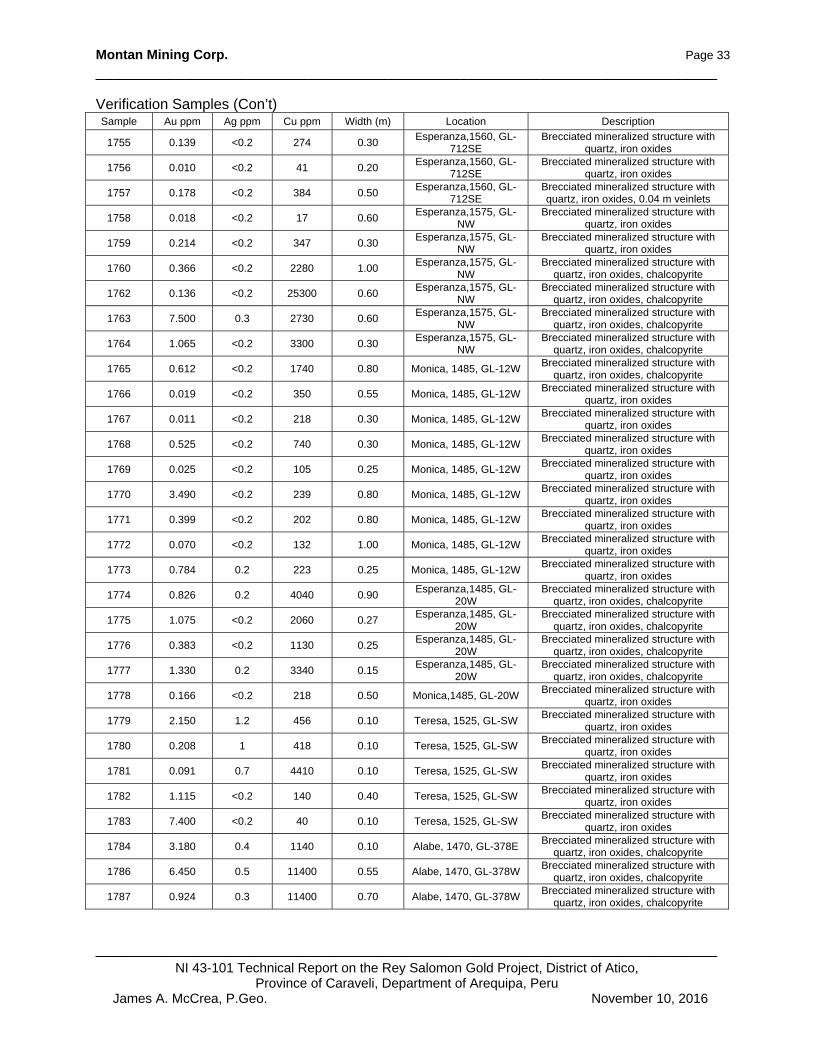
Montan Mining Corp. Page 33
______________________________________________________________________
______________________________________________________________________NI 43-101 Technical Report on the Rey Salomon Gold Project, District of Atico,
Province of Caraveli, Department of Arequipa, Peru James A. McCrea, P.Geo. November 10, 2016
Verification Samples (Con’t) Sample Au ppm Ag ppm Cu ppm Width (m) Location Description
1755 0.139 <0.2 274 0.30 Esperanza,1560, GL-
712SE Brecciated mineralized structure with
quartz, iron oxides
1756 0.010 <0.2 41 0.20 Esperanza,1560, GL-
712SE Brecciated mineralized structure with
quartz, iron oxides
1757 0.178 <0.2 384 0.50 Esperanza,1560, GL-
712SE Brecciated mineralized structure with quartz, iron oxides, 0.04 m veinlets
1758 0.018 <0.2 17 0.60 Esperanza,1575, GL-
NW Brecciated mineralized structure with
quartz, iron oxides
1759 0.214 <0.2 347 0.30 Esperanza,1575, GL-
NW Brecciated mineralized structure with
quartz, iron oxides
1760 0.366 <0.2 2280 1.00 Esperanza,1575, GL-
NW Brecciated mineralized structure with
quartz, iron oxides, chalcopyrite
1762 0.136 <0.2 25300 0.60 Esperanza,1575, GL-
NW Brecciated mineralized structure with
quartz, iron oxides, chalcopyrite
1763 7.500 0.3 2730 0.60 Esperanza,1575, GL-
NW Brecciated mineralized structure with
quartz, iron oxides, chalcopyrite
1764 1.065 <0.2 3300 0.30 Esperanza,1575, GL-
NW Brecciated mineralized structure with
quartz, iron oxides, chalcopyrite
1765 0.612 <0.2 1740 0.80 Monica, 1485, GL-12W Brecciated mineralized structure with
quartz, iron oxides, chalcopyrite
1766 0.019 <0.2 350 0.55 Monica, 1485, GL-12W Brecciated mineralized structure with
quartz, iron oxides
1767 0.011 <0.2 218 0.30 Monica, 1485, GL-12W Brecciated mineralized structure with
quartz, iron oxides
1768 0.525 <0.2 740 0.30 Monica, 1485, GL-12W Brecciated mineralized structure with
quartz, iron oxides
1769 0.025 <0.2 105 0.25 Monica, 1485, GL-12W Brecciated mineralized structure with
quartz, iron oxides
1770 3.490 <0.2 239 0.80 Monica, 1485, GL-12W Brecciated mineralized structure with
quartz, iron oxides
1771 0.399 <0.2 202 0.80 Monica, 1485, GL-12W Brecciated mineralized structure with
quartz, iron oxides
1772 0.070 <0.2 132 1.00 Monica, 1485, GL-12W Brecciated mineralized structure with
quartz, iron oxides
1773 0.784 0.2 223 0.25 Monica, 1485, GL-12W Brecciated mineralized structure with
quartz, iron oxides
1774 0.826 0.2 4040 0.90 Esperanza,1485, GL-
20W Brecciated mineralized structure with
quartz, iron oxides, chalcopyrite
1775 1.075 <0.2 2060 0.27 Esperanza,1485, GL-
20W Brecciated mineralized structure with
quartz, iron oxides, chalcopyrite
1776 0.383 <0.2 1130 0.25 Esperanza,1485, GL-
20W Brecciated mineralized structure with
quartz, iron oxides, chalcopyrite
1777 1.330 0.2 3340 0.15 Esperanza,1485, GL-
20W Brecciated mineralized structure with
quartz, iron oxides, chalcopyrite
1778 0.166 <0.2 218 0.50 Monica,1485, GL-20W Brecciated mineralized structure with
quartz, iron oxides
1779 2.150 1.2 456 0.10 Teresa, 1525, GL-SW Brecciated mineralized structure with
quartz, iron oxides
1780 0.208 1 418 0.10 Teresa, 1525, GL-SW Brecciated mineralized structure with
quartz, iron oxides
1781 0.091 0.7 4410 0.10 Teresa, 1525, GL-SW Brecciated mineralized structure with
quartz, iron oxides
1782 1.115 <0.2 140 0.40 Teresa, 1525, GL-SW Brecciated mineralized structure with
quartz, iron oxides
1783 7.400 <0.2 40 0.10 Teresa, 1525, GL-SW Brecciated mineralized structure with
quartz, iron oxides
1784 3.180 0.4 1140 0.10 Alabe, 1470, GL-378E Brecciated mineralized structure with
quartz, iron oxides, chalcopyrite
1786 6.450 0.5 11400 0.55 Alabe, 1470, GL-378W Brecciated mineralized structure with
quartz, iron oxides, chalcopyrite
1787 0.924 0.3 11400 0.70 Alabe, 1470, GL-378W Brecciated mineralized structure with
quartz, iron oxides, chalcopyrite

Montan Mining Corp. Page 34
______________________________________________________________________
______________________________________________________________________NI 43-101 Technical Report on the Rey Salomon Gold Project, District of Atico,
Province of Caraveli, Department of Arequipa, Peru James A. McCrea, P.Geo. November 10, 2016
Verification Samples (Con’t) Sample Au ppm Ag ppm Cu ppm Width (m) Location Description
1788 2.380 0.4 3860 0.60 Alabe, 1470, GL-378W Brecciated mineralized structure with
quartz, iron oxides, chalcopyrite, 0.1 m veinlets
1789 8.660 0.8 5100 0.38 Alabe, 1470, GL-378W Brecciated mineralized structure with quartz, iron oxides, chalcopyrite, 0.1
and 0.02 m veinlet
1790 4.410 0.3 3140 0.50 Alabe, 1470, GL-378W Brecciated mineralized structure with quartz, iron oxides, chalcopyrite, 0.04
m veinlet
1791 4.590 <0.2 2590 0.45 Alabe, 1470, GL-378W Brecciated mineralized structure with
quartz, iron oxides
1792 0.390 0.4 101 0.10 Melchora, NV 1, GL-1 Brecciated mineralized structure with
quartz, iron oxides
1793 0.069 <0.2 344 0.10 Melchora, NV 2, GL-2 Brecciated mineralized structure with
quartz, iron oxides
1794 0.169 <0.2 455 0.10 Mimi, 1800, GL-35SW Silicified hanging wall granodiorite with
pyrite
1795 10.650 0.8 405 0.15 Mimi, 1800, GL-35SW Brecciated mineralized structure with
quartz, iron oxides
1796 3.970 0.4 229 0.10 Mimi, 1800, GL-35SW Silicified foot wall granodiorite with
pyrite
1797 0.757 0.3 165 0.45 Mimi, 1800, GL-35SW Brecciated mineralized structure with
quartz, iron oxides
1798 0.669 0.2 9560 0.20 Alabe, 1615, GL-1 Brecciated mineralized structure with
quartz, iron oxides, chalcopyrite
1799 0.012 <0.2 346 0.10 Alabe, 1615, GL-2 Silicified hanging wall granodiorite with
pyrite and iron oxides
1800 0.223 <0.2 1140 0.10 Alabe, 1615, GL-3 Silicified foot wall granodiorite with
pyrite and iron oxides
1801 2.300 <0.2 5610 0.30 Yenni, 1520, GL-612SE Quartz vein with iron oxides and
chalcopyrite
1802 0.254 <0.2 244 0.30 Marion, 1520, GL-
659NW Quartz vein with iron oxides and
chalcopyrite
1803 0.017 <0.2 289 0.10 Marion, 1520, GL-
659NW Silicified hanging wall granodiorite with
pyrite, iron oxides and chalcopyrite
1804 0.071 <0.2 343 0.10 Marion, 1520, GL-
659NW Silicified foot wall granodiorite with
pyrite and iron oxides
1805 0.059 <0.2 357 0.10 Esperanza,1520, GL-
712SE Propylitic hanging wall granodiorite
with iron oxides – Sample 1750
1806 <0.005 <0.2 100 0.10 Esperanza,1520, GL-
712SE Propylitic foot wall granodiorite with
iron oxides – Sample 1750
1807 2.480 <0.2 1800 0.10 Ofir,1520, GL-515SE Propylitic foot wall granodiorite with
iron oxides – Sample 1737
1808 0.006 <0.2 123 0.10 Ofir,1520, GL-515SE Propylitic hanging wall granodiorite
with iron oxides – Sample 1737
1809 0.072 <0.2 223 0.10 Esperanza,1560, GL-
712SE Propylitic foot wall granodiorite with
iron oxides – Sample 1757
1810 0.034 <0.2 68 0.10 Esperanza,1560, GL-
712SE Propylitic hanging wall granodiorite
with iron oxides – Sample 1757
1811 0.062 <0.2 1270 0.10 Esperanza,1575, GL-
NW Propylitic foot wall granodiorite with
iron oxides – Sample 1761
1812 0.013 0.2 318 0.10 Esperanza,1575, GL-
NW Propylitic hanging wall granodiorite
with iron oxides – Sample 1761
1813 0.088 <0.2 1370 0.10 Ofir, 1530, GL-445NW Propylitic hanging wall granodiorite
with iron oxides – Sample 1743
1814 2.200 <0.2 291 0.10 Ofir, 1530, GL-445NW Propylitic foot wall granodiorite with
iron oxides – Sample 1743
1815 0.044 <0.2 556 0.20 Ofir, 1515, GL-428NW Propylitic foot wall granodiorite with
iron oxides – Sample 1749
1816 0.054 <0.2 855 0.20 Ofir, 1515, GL-428NW Propylitic hanging wall granodiorite
with iron oxides – Sample 1749
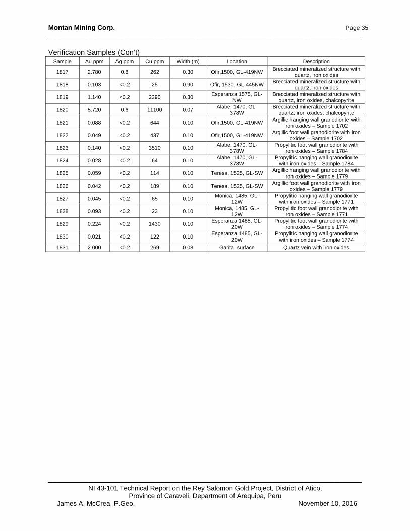
Montan Mining Corp. Page 35
______________________________________________________________________
______________________________________________________________________NI 43-101 Technical Report on the Rey Salomon Gold Project, District of Atico,
Province of Caraveli, Department of Arequipa, Peru James A. McCrea, P.Geo. November 10, 2016
Verification Samples (Con’t) Sample Au ppm Ag ppm Cu ppm Width (m) Location Description
1817 2.780 0.8 262 0.30 Ofir,1500, GL-419NW Brecciated mineralized structure with
quartz, iron oxides
1818 0.103 <0.2 25 0.90 Ofir, 1530, GL-445NW Brecciated mineralized structure with
quartz, iron oxides
1819 1.140 <0.2 2290 0.30 Esperanza,1575, GL-
NW Brecciated mineralized structure with
quartz, iron oxides, chalcopyrite
1820 5.720 0.6 11100 0.07 Alabe, 1470, GL-
378W Brecciated mineralized structure with
quartz, iron oxides, chalcopyrite
1821 0.088 <0.2 644 0.10 Ofir,1500, GL-419NW Argillic hanging wall granodiorite with
iron oxides – Sample 1702
1822 0.049 <0.2 437 0.10 Ofir,1500, GL-419NW Argillic foot wall granodiorite with iron
oxides – Sample 1702
1823 0.140 <0.2 3510 0.10 Alabe, 1470, GL-
378W Propylitic foot wall granodiorite with
iron oxides – Sample 1784
1824 0.028 <0.2 64 0.10 Alabe, 1470, GL-
378W Propylitic hanging wall granodiorite
with iron oxides – Sample 1784
1825 0.059 <0.2 114 0.10 Teresa, 1525, GL-SW Argillic hanging wall granodiorite with
iron oxides – Sample 1779
1826 0.042 <0.2 189 0.10 Teresa, 1525, GL-SW Argillic foot wall granodiorite with iron
oxides – Sample 1779
1827 0.045 <0.2 65 0.10 Monica, 1485, GL-
12W Propylitic hanging wall granodiorite
with iron oxides – Sample 1771
1828 0.093 <0.2 23 0.10 Monica, 1485, GL-
12W Propylitic foot wall granodiorite with
iron oxides – Sample 1771
1829 0.224 <0.2 1430 0.10 Esperanza,1485, GL-
20W Propylitic foot wall granodiorite with
iron oxides – Sample 1774
1830 0.021 <0.2 122 0.10 Esperanza,1485, GL-
20W Propylitic hanging wall granodiorite
with iron oxides – Sample 1774
1831 2.000 <0.2 269 0.08 Garita, surface Quartz vein with iron oxides
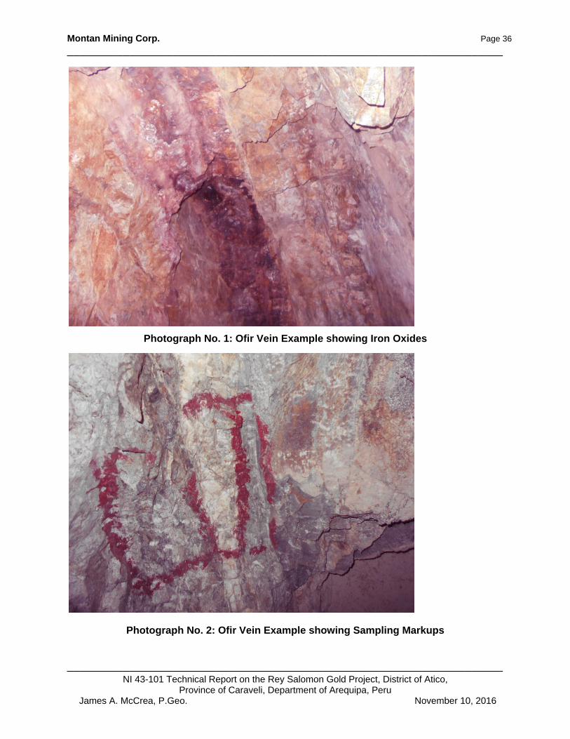
Montan Mining Corp. Page 36
______________________________________________________________________
______________________________________________________________________NI 43-101 Technical Report on the Rey Salomon Gold Project, District of Atico,
Province of Caraveli, Department of Arequipa, Peru James A. McCrea, P.Geo. November 10, 2016
Photograph No. 1: Ofir Vein Example showing Iron Oxides
Photograph No. 2: Ofir Vein Example showing Sampling Markups
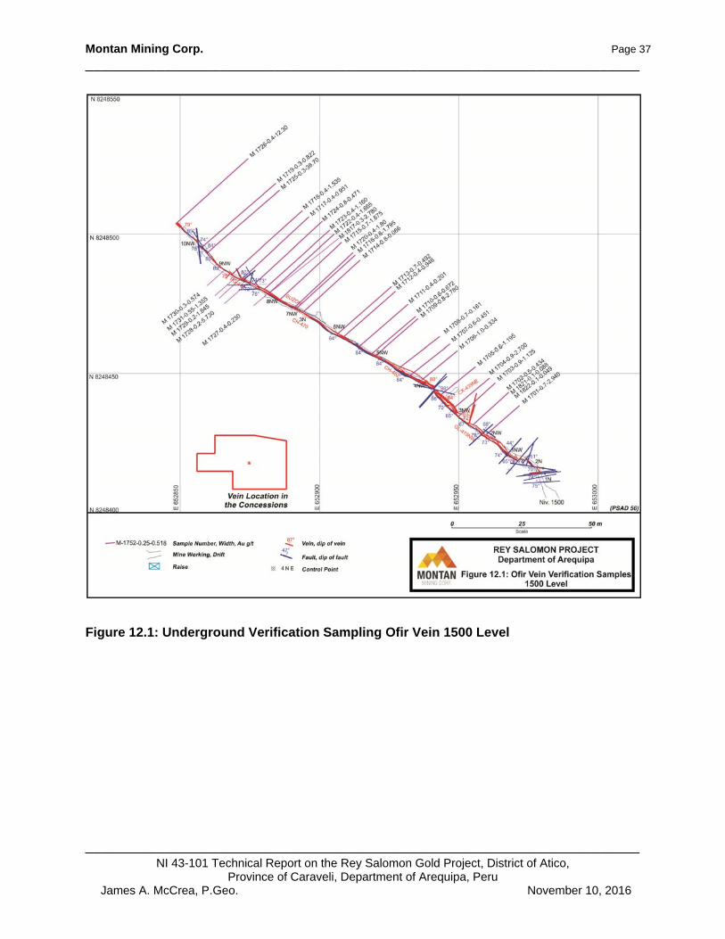
Montan Mining Corp. Page 37
______________________________________________________________________
______________________________________________________________________NI 43-101 Technical Report on the Rey Salomon Gold Project, District of Atico,
Province of Caraveli, Department of Arequipa, Peru James A. McCrea, P.Geo. November 10, 2016
Figure 12.1: Underground Verification Sampling Ofir Vein 1500 Level
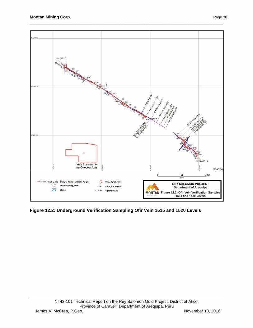
Montan Mining Corp. Page 38
______________________________________________________________________
______________________________________________________________________NI 43-101 Technical Report on the Rey Salomon Gold Project, District of Atico,
Province of Caraveli, Department of Arequipa, Peru James A. McCrea, P.Geo. November 10, 2016
Figure 12.2: Underground Verification Sampling Ofir Vein 1515 and 1520 Levels

Montan Mining Corp. Page 39
______________________________________________________________________
______________________________________________________________________NI 43-101 Technical Report on the Rey Salomon Gold Project, District of Atico,
Province of Caraveli, Department of Arequipa, Peru James A. McCrea, P.Geo. November 10, 2016
Figure 12.3: Underground Verification Sampling Ofir Vein 1530 Level
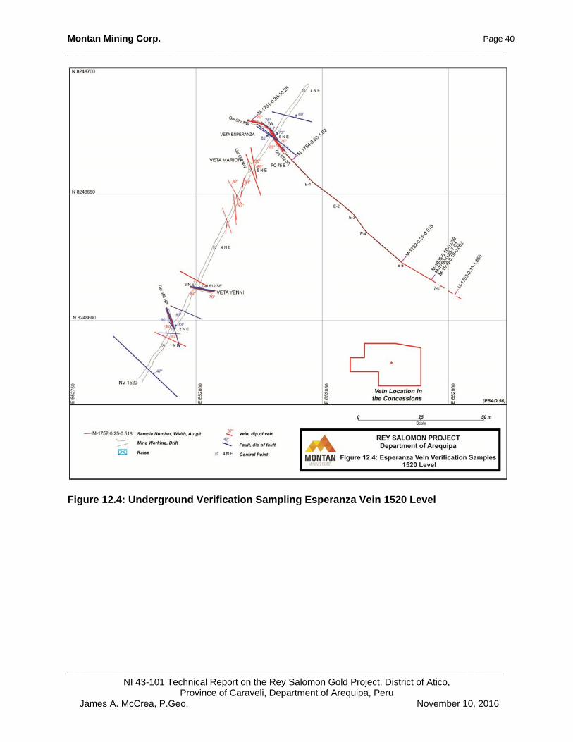
Montan Mining Corp. Page 40
______________________________________________________________________
______________________________________________________________________NI 43-101 Technical Report on the Rey Salomon Gold Project, District of Atico,
Province of Caraveli, Department of Arequipa, Peru James A. McCrea, P.Geo. November 10, 2016
Figure 12.4: Underground Verification Sampling Esperanza Vein 1520 Level
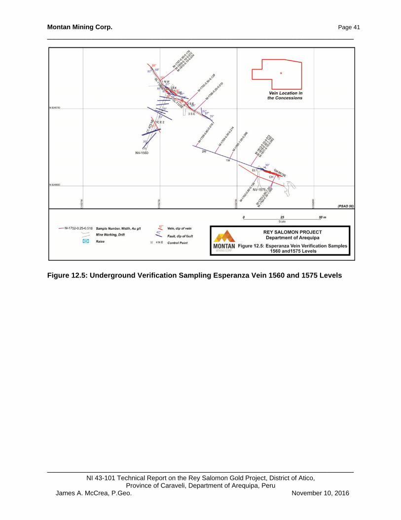
Montan Mining Corp. Page 41
______________________________________________________________________
______________________________________________________________________NI 43-101 Technical Report on the Rey Salomon Gold Project, District of Atico,
Province of Caraveli, Department of Arequipa, Peru James A. McCrea, P.Geo. November 10, 2016
Figure 12.5: Underground Verification Sampling Esperanza Vein 1560 and 1575 Levels

Montan Mining Corp. Page 42
______________________________________________________________________
______________________________________________________________________NI 43-101 Technical Report on the Rey Salomon Gold Project, District of Atico,
Province of Caraveli, Department of Arequipa, Peru James A. McCrea, P.Geo. November 10, 2016
Figure 12.6: Underground Verification Sampling Lower Esperanza and Monica Veins 1470 Level

Montan Mining Corp. Page 43
______________________________________________________________________
______________________________________________________________________NI 43-101 Technical Report on the Rey Salomon Gold Project, District of Atico,
Province of Caraveli, Department of Arequipa, Peru James A. McCrea, P.Geo. November 10, 2016
Figure 12.7: Underground Verification Sampling Alabe Vein 1470 Level

Montan Mining Corp. Page 44
______________________________________________________________________
______________________________________________________________________NI 43-101 Technical Report on the Rey Salomon Gold Project, District of Atico,
Province of Caraveli, Department of Arequipa, Peru James A. McCrea, P.Geo. November 10, 2016
Figure 12.8: Underground Verification Sampling Tereca Vein 1525 and 1540 Levels

Montan Mining Corp. Page 45
______________________________________________________________________
______________________________________________________________________NI 43-101 Technical Report on the Rey Salomon Gold Project, District of Atico,
Province of Caraveli, Department of Arequipa, Peru James A. McCrea, P.Geo. November 10, 2016
Figure 12.9: Underground Verification Sampling Marion and Yenni Veins 1520 Level

Montan Mining Corp. Page 46
______________________________________________________________________
______________________________________________________________________NI 43-101 Technical Report on the Rey Salomon Gold Project, District of Atico,
Province of Caraveli, Department of Arequipa, Peru James A. McCrea, P.Geo. November 10, 2016
Figure 12.10: Underground Verification Sampling Malchora Vein 1770, 1816 and 1826 Levels

Montan Mining Corp. Page 47
______________________________________________________________________
______________________________________________________________________NI 43-101 Technical Report on the Rey Salomon Gold Project, District of Atico,
Province of Caraveli, Department of Arequipa, Peru James A. McCrea, P.Geo. November 10, 2016
13.0 MINERAL PROCESSING and METALLURGICAL TESTING
There are currently no metallurgical studies for this property.

Montan Mining Corp. Page 48
______________________________________________________________________
______________________________________________________________________NI 43-101 Technical Report on the Rey Salomon Gold Project, District of Atico,
Province of Caraveli, Department of Arequipa, Peru James A. McCrea, P.Geo. November 10, 2016
14.0 MINERAL RESOURCE ESTIMATES
There are currently no 43-101-compliant Mineral Resource estimates for the subject property.
Montan Mining Corp. Page 49
______________________________________________________________________
______________________________________________________________________NI 43-101 Technical Report on the Rey Salomon Gold Project, District of Atico,
Province of Caraveli, Department of Arequipa, Peru James A. McCrea, P.Geo. November 10, 2016
23.0 ADJACENT PROPERTIES
The Atico Region of southern Peru has numerous small artisanal mining operations and many of them are close to the Rey Salomon property. The most noteworthy properties within 10 km (6 miles) that meet the criteria defined in NI 43-101, Section 1.1 are as follows:
Mina Calpa, which is a small, narrow vein, underground gold mine located eight km to the NE of the property.
Mina Esperanza, which is also a small, narrow vein, underground gold mine located 10 km WSW of the property
These examples are both, narrow vein, intrusive related gold deposits similar to the Rey Salomon Project but the veins are developed in the subvolcanic andesites rather than the granodiorites (Emilo Galvez, 2016, Personal Communication). The author has been unable to verified this information and that the information may not be indicative of the mineralization on the Property.
Montan Mining Corp. Page 50
______________________________________________________________________
______________________________________________________________________NI 43-101 Technical Report on the Rey Salomon Gold Project, District of Atico,
Province of Caraveli, Department of Arequipa, Peru James A. McCrea, P.Geo. November 10, 2016
24.0 OTHER RELEVANT DATA and INFORMATION
To the author’s best knowledge, all the relevant data and information has been provided in the preceding text.
Montan Mining Corp. Page 51
______________________________________________________________________
______________________________________________________________________NI 43-101 Technical Report on the Rey Salomon Gold Project, District of Atico,
Province of Caraveli, Department of Arequipa, Peru James A. McCrea, P.Geo. November 10, 2016
25.0 INTERPRETATION and CONCLUSIONS
The Rey Salomon Project has extensive historic underground exploration/development and displays styles of mineralization characteristic of orogenic or intrusive related gold (±Ag, Cu, Zn) veins, which are often called mesothermal veins. Mineralization is associated with intrusive rocks of the Cretaceous Coast Batholith Complex and in this case, the granodiorite phase of the Linga Superunit. Historic exploration/development on the property has, to date, identified 58 veins on the property with four principle veins having extensive underground workings. The developed veins are open at depth and along strike. Exploration on the property to date has mainly been for veins in the granodiorites. The subvolcanic andesites in the northwest area of the property have seen little work. Extensive local occurrences of intrusive related gold veins in the subvolcanic andesites have been documented (Galazra, 1967) at the Mina Calpa mine property eight km to the northeast of the property. The author has been unable to verify this information about Mina Calpa and the information may not be indicative of the mineralization on the Rey Salomon property. The Rey Salomon Project warrants further exploration for intrusive related gold veins. The property is perspective for the discovery of additional gold mineralization and with higher gold prices returning to the metal markets, the demand for this type of small-scale project should be high.

Montan Mining Corp. Page 52
______________________________________________________________________
______________________________________________________________________NI 43-101 Technical Report on the Rey Salomon Gold Project, District of Atico,
Province of Caraveli, Department of Arequipa, Peru James A. McCrea, P.Geo. November 10, 2016
26.0 RECOMMENDATIONS
The recommended exploration and work programs for the Rey Salomon Project are as follows: Phase I $30,000
Structural mapping and prospecting $10,000 Detailed structural mapping and sampling to identify additional vein structures on the property.
Geophysics, Drone Mag survey $20,000 Magnetometer survey to identify intrusive/geologic contacts and possible vein targets.
The Phase II program is not contingent on positive results from the Phase I program and following a thorough compilation and review by a qualified person the following Phase II program is recommended. Phase II $120,000
130 m of underground exploration/development Underground exploration on known veins to search for additional shoots of high-grade mineralization.
Montan Mining Corp. Page 53
______________________________________________________________________
______________________________________________________________________NI 43-101 Technical Report on the Rey Salomon Gold Project, District of Atico,
Province of Caraveli, Department of Arequipa, Peru James A. McCrea, P.Geo. November 10, 2016
27.0 REFERENCES
Acosta, J., 2006: Características Metalogenicas de Los Yacimientos Asociados a os Arcos Magnaticos Mesozoicos del Sur del Perú (Latitudes 16°-14°), p. 24. Alldrick, D. J.,1996: Intrusion-related Au Pyrrhotite Veins, in Selected British Columbia Mineral Deposit Profiles, Volume 2 Metallic Deposits, Lefebure, D.V. and Hõy, T, Editors, British Columbia Ministry of Employment and Investment, Open File 1996-13, p. 57-58. Ash, C. and Alldrick, D., 1996: Au-quartz Veins, in Selected British Columbia Mineral Deposit Profiles, Volume 2 - Metallic Deposits, Lefebure, D.V. and Hõy, T., Editors, British Columbia Ministry of Employment and Investment, Open File 1996-13, p. 53 - 56. Atherton, M.P., Aguirre, L., 1992: Thermal and geotectonic setting of Cretaceous volcanic rocks near Ica, Peru, in relation to Andean crustal thinning. J S Am Earth Sci 5 p. 47–69. Benavides-Caceres, V., 1999: Orogenic Evolution of the Perúvian Andes; in Geology and ore Deposits of the Central Andes, Society of Economic Geologists Special Publication Number 7, Skinner, B.J. (ed), p. 61 - 107 Chen, H., Clark, A.H., Kyser, T.K., Ullrich, T.D., Baxter, R., Chen, Y. and Moody, T.C., 2010: Evolution of the Giant Marcona-Mina Justa Iron Oxide-Copper-Gold District, South-Cental Peru: Economic Geology, v. 105, p. 155-185. Dalziel, I.W.D., 1986: Collision and Cordilleran orogenesis: an Andean perspective. In: Coward, M.P., Ries, A.C., (eds) Collision tectonics. Geol Soc Lond Spec Publ 19 p. 389–404. Dirección de Geología Económica y Prospección Minera, INGEMMET, Mayo 2002: Estudios de los Recursos Minerales del Perú, Franja N° 2, Boletín N° 11, Serie B. Galarza O, 1967: Estudio Zonal de la Mina Calpa. Boletín Sociedad Geológica del Perú N° 40, p. 73 – 90. Grocott, J., Taylor, G.K., 2002: Magmatic arc fault systems, deformation partitioning and emplacement of granitic complexes in the Coastal Cordillera, northern Chilean Andes (25o 30’ S to 27 o 00’ S). J Geol Soc Lond 159, p. 425–442. Instituto Geologico, Minero y Metalurgico (INGEMMET) Instituto Nacional de Concesiones y Catastro Minero (INACC) Jones, B., Fierro, J., and Lenzi, G., 2000: Antapaccay Project – geology [abs.]. Seminario Internaticional “Yacimientos tipo pórfido de Cu-Au”, Lima 2000: Facultad de Ingenería Geológica, Minera y Metalúrgica, Promoción de Geólogos 2000, Abstracts, v.11, p.1. Mpodozis, C., Ramos, V., 1990: The Andes of Chile and Argentina. In: Ericksen, G.E., Cañas Pinochet, M.T.and Reinemund, J.A. (eds) Geology of the Andes and its relation to hydrocarbon and mineral resources. Circum-Pacific Council Energy Min Resource Earth Science Ser 11 p. 59–90.

Montan Mining Corp. Page 54
______________________________________________________________________
______________________________________________________________________NI 43-101 Technical Report on the Rey Salomon Gold Project, District of Atico,
Province of Caraveli, Department of Arequipa, Peru James A. McCrea, P.Geo. November 10, 2016
Olchauski E, Diciembre 1980: Geología de los Cuadrángulos de Jaqui, Cora Cora, Chala y Cháparra. Boletín N° 34, Serie A INGEMMET. Peterson, U., 1999: Magmatic and Metallogenic Evolution of the Central Andes, in Geology and Ore Deposits of the Central Andes, B. J.Skinner Editor, p 114 - 116. Ramos, V.A., Aleman, A., 2000: Tectonic evolution of the Andes. In: Cordani, U.G., Milani, E.J., Thomaz Filho, A.,and Campos, D.A., (eds) Tectonic evolution of South America. In: Proc 31st Int Geol Congr, Rio de Janeiro, p 635–685. Rutland, R.W.R., 1971: Andean orogeny and ocean floor spreading. Nature 233 p. 252-255. Scheuber, E., Andriessen, P.A.M., 1990: The kinematic and geodynamic significance of the Atacama Fault Zone, northern Chile. J Struct Geol 12, p. 243–257 Sillitoe, R. H., 1985: Ore-related breccias in volcano plutonic arcs: Economic Geology, v 80, p. 1467 - 1514. Sillitoe, R. H., 1991: Intrusion related gold deposits. In: Foster, R.P., (editor), Gold Metallogeny and Exploration. Glasgow, Blackie and Son, p. 165 - 209. Sillitoe, R.H., 2003: Iron oxide-copper-gold deposits: An Andean view: Mineralium Deposita, v. 38, p. 787–812. Sillitoe, R. H., 2008: Special Paper: Major Gold Deposits and Belts of the North and South American Cordillera: Distribution, Tectonomagmatic Settings, and Metallogenic Considerations: Economic Geology, v. 103, p. 663 – 687. Sillitoe, R. H., 2010: Porphyry Copper Systems: Economic Geology, v 105, p. 3 - 41. Simmons, S.F., White, N.C., John, D.A., 2005: Geological Characteristics of Epithermal Precious and Base Metal Deposits: Economic Geology, v 100, p. 485 - 522. Shackleton, R.M., Ries, A.C., Coward, M.P. and Cobbold, P.R., 1979: Structure, metamorphism and geochronology of the Arequipa massif of coastal Peru. J Geol Soc. Lond 136 p. 195–214. Superintendencia Nacional de Registros Publicos (SUNARP) Thomson, G.A., 1812: The Geographical and Historical Dictionary of America and the West Indies, Vol. I, 109p. Torres, F., 2015: Evaluacion Geologica Proyecto Rey Salomon, 19p. Tumialán P, Febrero 2003: Compendio de Yacimientos Minerales del Perú. Wikipedia, 2010: http://en.wikipedia.org/wiki/Arequipa

Montan Mining Corp. Page 55
______________________________________________________________________
______________________________________________________________________NI 43-101 Technical Report on the Rey Salomon Gold Project, District of Atico,
Province of Caraveli, Department of Arequipa, Peru James A. McCrea, P.Geo. November 10, 2016
Appendix 1
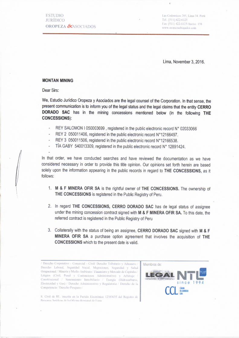
E S T U D I O J U R Í D I C O O R O P E Z A < S C : A S O C I A D O S
Las Codornices 285, Lima 34. Perú TeL: [511] 422-6123 Fax: [511] 422-6123/Anexo. 138 wmv.orope/aabogados. com
Lima, November3,2016.
MONTAN MINING
Dear Sirs:
We, Estudio Jurídico Oropeza y Asociados are ttie legal counsel of the Corporation. In that sense, the
present communication is to inform you of the legal status and the legal claims that the entity CERRO
DORADO SAC has in the mining concessions mentioned below (in the following THE
CONCESSIONS):
- R E Y SALOMON 1050003699 , registered in the public electronic record N° 02033066
- R E Y 2 050011406, registered in the public electronic record N°12166497.
- R E Y 3 050011506, registered in the public electronic record N°12166538.
- TIA G A B Y 540013309, registered in the public electronic record H° 12891424.
In that order, we have conducted searches and have reviewed the documentation as we have
considered necessary in order to próvido this title opinión. Our opinions set forth herein are based
solely upon the Information appearing in the public records in regard to THE CONCESSIONS, as it
follows:
1. M & F MINERA OFIR SA is the rightful owner of THE CONCESSIONS. The ownership of
THE CONCESSIONS is registered in the Public Registry of Perú.
2. In regard THE CONCESSIONS, CERRO DORADO SAC has de legal status of assignee
under the mining concession contract signad with M & F MINERA OFIR SA. To this date, the
referred contract is registered in the Public Registry of Perú
3. Collaterally with the status of being an assignee, CERRO DORADO SAC signad with M & F
MINERA OFIR SA a purchase option agreement that involves the acquisition of THE
CONCESSIONS which to the present date is valid.
.' Derecho Corporativo - Comercial - Civil' Derecho Tributario y Aduanero Derecho Laboral, Seguridad Social, Migraciones, Seguridad y Salud Ocupacional.' Mineiia y Medio Ambiente / Financiero y Mercado de Capitales Litigios (Civil, Penal y Contenciosos Administrativo) y Arbitraje Constitucional ,' Saneamiento Inmobiliario / Energía (Hiáocarburos, Electricidad y Gas) ,/ Derecho Administrativo y Regulatorio / Derecho de la Competencia / Derecho Pesquero /
S. Civil de RL. inscrita en la Partida Electrónica 12383635 del Registro de P e r s o n a s í i i r id i ras dp la O f í r i n a Rea is f ra l de ? i m a
Miembros de:
J e r w o r k s iHT«roottor-,c s i n c e 19 9 4
CCL cuun KCOHUO

E S T U D I O J U R Í D I C O O R O P E Z A ( S C A S O C I A D O S
l^s Codornices 285, Lima 34. Perú Tel.: [511] 422-6123 Fax: [5111422-6123,'Anexo, 138 «-«•w.orope/aabogados. com
4. CERRO DORADO SAC has exercised the purchase option in regard THE CONCESSIONS.
These opinions are rendered for the solé benefit of the intended recipient. They are rendered in
relation to the matter referred to hereinabove and may not be disclosed or used in whole or in part by
any other person or for any other purpose whatsoever without our prior written consent. These
opinions expressed herein are given as the date hereof and we disclaim any obligation and make no
undertaking to advise any person of any changa in law or fact which may come to our attention after
the date hereof.
Sincerely,
/ Derecho Coqiorativo - Comercial - Civil' Derecho Tributano y Aduanero Derecho laboral. Seguridad Social, Migraciones, Seguridad y Salud OcupacionalMinería y Medio Ambiente,' Financiero y Mercado de Capitales Litigios (Civil, Penal y Contenciosos Administrativo) y Arbitraje Constitucional / Saneamiento hunobiliario / Energía (Hidrocarburos. Electricidad y Gas) / Derecho Administrativo y Regulatorio ,' Deiecho de ki Competencia / Derecho Pesciuero /
Miembros de:
>m iMTiP s i n c e 19 9 4
S. Civil de RL. inscrita en la Partida Electrónica 12383635 del Registro de P e r s o n a s l i i r ídir í is He la O f í r i n a Reaií^tra} de í i m a