ni 43-101 technical report - otis gold corp. · ni 43-101 technical report geology, mineralization,...
TRANSCRIPT
NI 43-101 Technical Report
Geology, Mineralization, Resource Estimate and
Exploration Potential of the
Blue Hill Creek and Matrix Creek Gold-Silver Properties
Cassia County, Idaho, USA
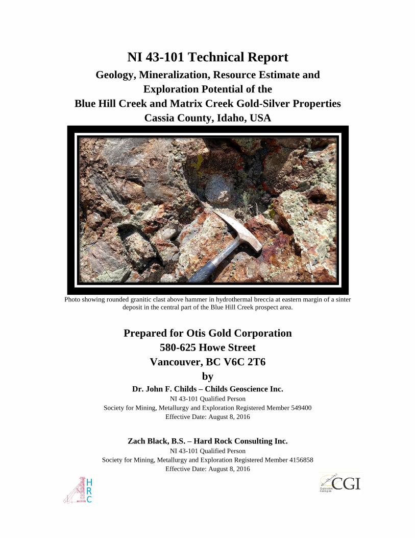
Photo showing rounded granitic clast above hammer in hydrothermal breccia at eastern margin of a sinter
deposit in the central part of the Blue Hill Creek prospect area.
Prepared for Otis Gold Corporation
580-625 Howe Street
Vancouver, BC V6C 2T6
by Dr. John F. Childs – Childs Geoscience Inc.
NI 43-101 Qualified Person
Society for Mining, Metallurgy and Exploration Registered Member 549400
Effective Date: August 8, 2016
Zach Black, B.S. – Hard Rock Consulting Inc.
NI 43-101 Qualified Person
Society for Mining, Metallurgy and Exploration Registered Member 4156858
Effective Date: August 8, 2016
2 | P a g e www.childsgeoscience.com
Table of Contents
1 SUMMARY .............................................................................................................................................. 6
1.1 PROPERTY DESCRIPTION ..................................................................................................................... 6
1.2 GEOLOGY AND MINERALIZATION ....................................................................................................... 6
1.3 STATUS OF EXPLORATION ................................................................................................................... 7
1.4 MINERAL RESOURCE ESTIMATES ........................................................................................................ 8
1.5 CONCLUSIONS AND RECOMMENDATIONS ........................................................................................... 8
2 INTRODUCTION AND TERMS OF REFERENCE ......................................................................... 10
3 RELIANCE ON OTHER EXPERTS ................................................................................................... 12
4 PROPERTY DESCRIPTION AND LOCATION............................................................................... 12
4.1 LOCATION.......................................................................................................................................... 12
4.2 OWNERSHIP ....................................................................................................................................... 15
4.3 EXPLORATION PERMITS AND JURISDICTIONS ................................................................................... 18
4.4 ENVIRONMENTAL LIABILITIES .......................................................................................................... 20
5 ACCESSIBILITY, CLIMATE, LOCAL RESOURCES, INFRASTRUCTURE, AND
PHYSIOGRAPHY .................................................................................................................................... 22
6 HISTORY ............................................................................................................................................... 25
7 GEOLOGICAL SETTING AND MINERALIZATION .................................................................... 28
7.1 BLUE HILL CREEK GEOLOGY AND MINERALIZATION ...................................................................... 32
7.2 MATRIX CREEK GEOLOGY AND MINERALIZATION ........................................................................... 40
8 DEPOSIT TYPES .................................................................................................................................. 43
8.1 HOT SPRINGS-TYPE PRECIOUS METAL DEPOSIT MODEL .................................................................... 44
8.2 HOT SPRINGS-TYPE PRECIOUS METAL MODEL APPLIED TO THE BHC GOLD PROPERTY ................... 47
9 EXPLORATION .................................................................................................................................... 50
10 DRILLING ........................................................................................................................................... 54
10.1 MERIDIAN MINERALS COMPANY DRILLING ................................................................................... 55
10.2 WESTERN GOLD EXPLORATION AND MINING CO. DRILLING ......................................................... 56
10.3 LATITUDE MINERALS INC. DRILLING.............................................................................................. 56
10.4 RADIUS GOLD DRILLING ................................................................................................................. 57
11 SAMPLE PREPARATION, ANALYSES AND SECURITY .......................................................... 60
11.1 MERIDIAN/LATITUDE ...................................................................................................................... 60
11.2 RADIUS GOLD .................................................................................................................................. 61
12 DATA VERIFICATION ..................................................................................................................... 64
13 MINERAL PROCESSING AND METALLURICAL TESTING ................................................... 65
14 MINERAL RESOURCE ESTIMATE ............................................................................................... 65
3 | P a g e www.childsgeoscience.com
14.1 GEOLOGIC MODEL .......................................................................................................................... 65
14.2 DATA USED FOR THE GRADE ESTIMATION ..................................................................................... 68
14.3 BLOCK MODEL PHYSICAL LIMITS ................................................................................................... 68
14.4 BULK DENSITY ................................................................................................................................ 68
14.5 ESTIMATION DOMAINS .................................................................................................................... 68
14.6 EXPLORATORY DATA ANALYSIS .................................................................................................... 70
14.7 CAPPING .......................................................................................................................................... 70
14.8 COMPOSITING .................................................................................................................................. 72
14.9 VARIOGRAMS .................................................................................................................................. 73
14.10 ESTIMATION METHODOLOGY ....................................................................................................... 75
14.11 MINERAL RESOURCE CLASSIFICATION ......................................................................................... 75
14.12 MODEL VALIDATION ..................................................................................................................... 75
14.13 COMPARISON WITH ORDINARY KRIGE AND NEAREST NEIGHBOR MODELS ................................. 76
14.13.1 Swath Plots ............................................................................................................................. 78
14.13.2 Sectional Inspection ............................................................................................................... 82
14.14 MINERAL RESOURCE TABULATION ............................................................................................... 83
23 ADJACENT PROPERTIES ............................................................................................................... 84
24 OTHER RELEVANT DATA AND INFORMATION ..................................................................... 84
25 INTERPRETATION AND CONCLUSIONS ................................................................................... 84
26 RECOMMENDATIONS ..................................................................................................................... 85
26.1 PHASE 1 EXPLORATION PLAN AND BUDGET ................................................................................... 85
26.2 PHASE 2 EXPLORATION PLAN AND BUDGET ................................................................................... 86
26.3 BLUE HILL CREEK EXPLORATION TARGETS AND RECOMMENDED DRILLING ............................... 87
27 REFERENCES ..................................................................................................................................... 89
28 CERTIFICATE OF AUTHORS......................................................................................................... 94
APPENDIX I ............................................................................................................................................. 98
APPENDIX II ............................................................................................................................................ 99
APPENDIX III ........................................................................................................................................ 101
DEFINITIONS ........................................................................................................................................ 101
4 | P a g e www.childsgeoscience.com
List of Figures
FIGURE 4-1 BLUE HILL CREEK AND MATRIX CREEK PROPERTY LOCATIONS .............................. 13
FIGURE 4-2 BLUE HILL CREEK AND MATRIX CREEK PROPERTY LOCATIONS ............................. 14
FIGURE 4-3 BLUE HILL CREEK AND MATRIX CREEK PROPERTY LOCATIONS ............................. 15
FIGURE 4-4 LAND MAP SHOWING THE EIGHTEEN ORIGINAL B&C CLAIMS ................................... 18
FIGURE 4-5 BLUE HILL CREEK AND MATRIX CREEK PROPERTY LAND STATUS........................... 19
FIGURE 4-6 MAP OF ACTIVE SAGE GROUSE LEKS AND NESTING HABITAT. ................................... 21
FIGURE 7-1 TECTONIC MAP OF THE REGION AROUND BLUE HILL CREEK .................................... 30
FIGURE 7-2 STRATIGRAPHIC SECTION OF THE BLUE HILL CREEK PROPERTY .............................. 31
FIGURE 7-3 GEOLOGIC MAP OF BLUE HILL CREEK AND MATRIX CREEK PROPERTIES ............... 34
FIGURE 7-4 SCHEMATIC CROSS SECTION OF BHC PROPERTY ...................................................... 35
FIGURE 7-5 BHC & MC CROSS SECTION LOOKING NE ............................................................... 36
FIGURE 8-1 SCHEMATIC DIAGRAM OF AN EPITHERMAL HOT SPRING GOLD DEPOSIT MODEL ....... 49
FIGURE 9-1 LOCATIONS OF SURFACE SAMPLES ............................................................................ 51
FIGURE 9-2 CSAMT SURVEY LINE LOCATIONS ........................................................................... 52
FIGURE 9-3 CSAMT SURVEY LINES FROM BLUE HILL CREEK. ................................................... 53
FIGURE 10-1 BLUE HILL CREEK DRILL COLLAR LOCATIONS ....................................................... 54
FIGURE 10-2 MATRIX CREEK DRILL COLLAR LOCATIONS ........................................................... 55
FIGURE 11-1 EXAMPLE OF BHC DRILL HOLE DATA VALIDATION ................................................. 61
FIGURE 11-2 RADIUS GOLD AU STANDARD PERFORMANCE (CDN-GS-8C) ................................ 62
FIGURE 11-3 RADIUS GOLD AU STANDARD PERFORMANCE (CDN-GS-P5C) ............................. 62
FIGURE 14-1 SECTION 4656400N.................................................................................................. 67
FIGURE 14-2 ESTIMATION DOMAINS (PLAN VIEW) ...................................................................... 69
FIGURE 14-3 GOLD LOG PROBABILITY PLOT ................................................................................ 71
FIGURE 14-4 COMPOSITE STUDY OF MEAN GOLD GRADES ......................................................... 72
FIGURE 14-5 SPHERICAL GOLD DIRECTIONAL VARIOGRAM ....................................................... 74
FIGURE 14-6 CUMULATIVE FREQUENCY PLOT - MODEL COMPARISON....................................... 77
FIGURE 14-7 EAST – WEST SWATH PLOT ..................................................................................... 79
FIGURE 14-8 NORTH - SOUTH SWATH PLOT ................................................................................ 80
FIGURE 14-9 ELEVATION SWATH PLOT ........................................................................................ 81
FIGURE 14-10 CROSS SECTION WITH COMPOSITE GRADES, ESTIMATED BLOCK GRADES, AND THE
OPTIMIZED PIT SHELL ............................................................................................................. 82
5 | P a g e www.childsgeoscience.com
List of Tables
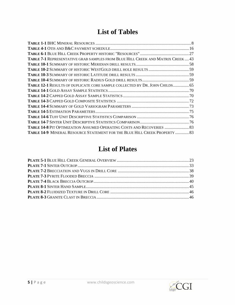
TABLE 1-1 BHC MINERAL RESOURCES .......................................................................................... 8
TABLE 4-1 OTIS AND B&C PAYMENT SCHEDULE .......................................................................... 16
TABLE 6-1 BLUE HILL CREEK PROPERTY HISTORIC "RESOURCES" .............................................. 27
TABLE 7-1 REPRESENTATIVE GRAB SAMPLES FROM BLUE HILL CREEK AND MATRIX CREEK .... 43
TABLE 10-1 SUMMARY OF HISTORIC MERIDIAN DRILL RESULTS. ................................................. 58
TABLE 10-2 SUMMARY OF HISTORIC WESTGOLD DRILL HOLE RESULTS ...................................... 59
TABLE 10-3 SUMMARY OF HISTORIC LATITUDE DRILL RESULTS .................................................. 59
TABLE 10-4 SUMMARY OF HISTORIC RADIUS GOLD DRILL RESULTS ............................................ 59
TABLE 12-1 RESULTS OF DUPLICATE CORE SAMPLE COLLECTED BY DR. JOHN CHILDS ............... 65
TABLE 14-1 GOLD ASSAY SAMPLE STATISTICS ............................................................................ 70
TABLE 14-2 CAPPED GOLD ASSAY SAMPLE STATISTICS .............................................................. 70
TABLE 14-3 CAPPED GOLD COMPOSITE STATISTICS .................................................................... 72
TABLE 14-4 SUMMARY OF GOLD VARIOGRAM PARAMETERS ...................................................... 73
TABLE 14-5 ESTIMATION PARAMETERS ........................................................................................ 75
TABLE 14-6 TUFF UNIT DESCRIPTIVE STATISTICS COMPARISON ................................................. 76
TABLE 14-7 SINTER UNIT DESCRIPTIVE STATISTICS COMPARISON .............................................. 76
TABLE 14-8 PIT OPTIMIZATION ASSUMED OPERATING COSTS AND RECOVERIES ....................... 83
TABLE 14-9 MINERAL RESOURCE STATEMENT FOR THE BLUE HILL CREEK PROPERTY ............. 83
List of Plates
PLATE 5-1 BLUE HILL CREEK GENERAL OVERVIEW .................................................................... 23
PLATE 7-1 SINTER OUTCROP ......................................................................................................... 33
PLATE 7-2 BRECCIATION AND VUGS IN DRILL CORE ................................................................... 38
PLATE 7-3 PYRITE FLOODED BRECCIA ......................................................................................... 39
PLATE 7-4 BLACK BRECCIA OUTCROP .......................................................................................... 40
PLATE 8-1 SINTER HAND SAMPLE................................................................................................. 45
PLATE 8-2 FLUIDIZED TEXTURE IN DRILL CORE .......................................................................... 46
PLATE 8-3 GRANITE CLAST IN BRECCIA ....................................................................................... 46

6 | P a g e www.childsgeoscience.com
1 SUMMARY
On June 22, 2016 Childs Geoscience Inc. (“CGI”) of Bozeman, Montana was contracted to
prepare a revised NI 43-101 report including a resource estimate by Hard Rock Consulting
(“HRC”) for the Blue Hill Creek Property. The Property includes an intermediate stage
exploration project area at Blue Hill Creek (“BHC”) containing 35 historical drill holes including
five core holes drilled in 2014 by Radius Gold Corporation (“Radius”) that had not formed part
of previous reports on the prospect. The BHC resource is open in several directions and is part of
a shallow epithermal system that includes stacked sinter layers. A second area immediately to the
south and southeast of the BHC Property is referred to as the Matrix Creek (“MC”) Property and
is characterized by breccias up to 12 meters (40 feet) thick consisting of angular fragments of
white quartzite set in a fine-grained matrix consisting of silica with abundant very-fine-grained
pyrite. This second style of mineralization is projected to extend at depth through the BHC
Property but the target has not been thoroughly tested at BHC. The BHC and MC properties have
been the subject of several drilling campaigns including a combined 49 core and reverse
circulation (“RC”) holes that will be summarized in the present report. Recommendations are
included to follow up on previous work on the BHC gold resource and on the silver-dominated
MC breccias.
1.1 Property Description
The BHC and MC Properties are located in Cassia County, Idaho approximately 24 kilometers
(15 miles) south of Oakley, Idaho and approximately 4 kilometers (2.4 miles) north of the border
with the state of Utah (Figure 4-1). The property consists of 36 federal lode mining claims
covering approximately 291 hectares (720 acres), plus a 32 hectare (80 acre) Idaho State Mineral
Lease, 100% controlled or owned by Otis Gold Corporation (“Otis”), John Carden and Mitchell
Bernardi (see section 4.1 for details) and comprising an approximate total property area of 324
hectares (800 acres). The adjacent MC Property consists of 41 federal lode mining claims
covering approximately 332 hectares (820 acres) plus a 129 hectare (320 acre) Idaho State
Mineral Lease which is also 100% controlled or owned by Otis, John Carden and Mitchell
Bernardi. The MC Property covers a total of about 461 hectare (1140 acres). The BHC and MC
Properties comprise a significant portion of what Otis refers to as the Oakley Project.
1.2 Geology and Mineralization
BHC occurs within a north-trending, five-mile-long by one-mile-wide zone of low-sulfidation,
hot spring-type gold occurrences along the western margin of the Albion Range metamorphic
core complex. The BHC sinters and related gold-silver mineralization were discovered in 1985
during regional exploration by Meridian Minerals (“Meridian”). The sinter and related
epithermal mineralization are hosted in Tertiary volcanic and sedimentary rocks of the Tertiary
Salt Lake formation (“Tsl”). The Salt Lake formation has been down-dropped by a series of
northwest- and northeast-trending normal faults which form a graben. Other grabens filled with
Tertiary volcanic and sedimentary rocks similar to those at BHC are found elsewhere along the
7 | P a g e www.childsgeoscience.com
western flank of the Albion Range. These normal faults appear to have cut the detachment zone
adjacent to the metamorphic core complex. The detachment zone is characterized by mineralized
siliceous breccias that can be traced for several miles both north and south along the western
margin of the core complex and is believed to be present at depth at BHC. The BHC mineralized
trend as currently defined is approximately 914 meters (3,000 feet) long and 366 meters (1,200
feet) wide.
Mineralization at BHC is open in multiple directions. Post-mineral Tertiary to Quaternary basin
filling volcano-sedimentary sediments may have obscured extensions of the BHC resource.
The MC Property is distinctive from BHC in terms of mineralization, host lithology and
structure. MC is located southeast and south of the BHC Property and is so named because it is
characterized by a distinctive carapace of breccia up to 12 meters (40 feet) thick.
The breccia consists of white quartzite fragments separated by black to dark grey aphanitic
matrix material consisting of extremely fine grained quartz and pyrite. The breccias are strongly
anomalous for both gold and silver (surface grab samples collected by Otis show values up to
2.61 ppm Au and 306 ppm Ag).
Little work has been done by Otis on the MC breccias and their origin remains enigmatic. It
seems likely that the breccias formed along a detachment fault associated with the exhumation of
the metamorphic core complex that forms the core of the Albion Range immediately to the east.
The relationship between the mineralization at MC and Blue Hill creek is ambiguous. The
breccias cut through both properties and may be much thicker in the subsurface at BHC than is
suggested by surface outcrop. The high-angle faults associated with the BHC graben cut and
displace the low angle MC detachment structure. The high-angle faults therefore post-date the
MC detachment system. Because these faults appear to cut through the mineralized detachment
at MC, the detachment may have served as a source of gold for the BHC hydrothermal system.
1.3 Status of Exploration
A total of 5,607 meters (18,397 feet) of drilling in a combination of reverse circulation and core
holes was conducted on the BHC and MC Properties by Meridian Minerals, West Gold and
Latitude Minerals from 1986-1998. In 2008, Otis conducted a CSAMT geophysical survey on
both the Blue Hill Property and on the Cold Creek prospect to the north. Based on the results of
the CSAMT survey, nine reverse circulation drill holes totaling 2,438 meters (8,000 feet) were
proposed at BHC. In 2014 Radius Gold Corp. drilled five core holes totaling 1,308 meters
(4,292 feet) in and around the resource area at BHC. These holes were designed to test the Otis
CSAMT anomaly, confirm the mineralized zone as it was understood at that time and step out
from the main mineralized zone.
8 | P a g e www.childsgeoscience.com
1.4 Mineral Resource Estimates
The mineral resources presented in this Technical Report are classified under the categories of
Measured, Indicated and Inferred in accordance with the standards defined by the Canadian
Institute of Mining, Metallurgy and Petroleum (“CIM”) “CIM Definition Standards - For
Mineral Resources and Mineral Reserves”, prepared by the CIM Standing Committee on
Reserve Definitions and adopted by CIM Council on May 10, 2014. These resource
classifications reflect the relative confidence of the grade estimates. HRC knows of no
environmental, permitting, legal, socio-economic, marketing, political, or other factors that may
materially affect the mineral resource estimate.
HRC estimated the mineral resource for the BHC Property from drill-hole data, using controls
from the main rock types with an Inverse Distance (“ID”) algorithm.
The resource estimate for the BHC property is presented in Table 1-1. The resources estimated
for this report have been classified as inferred based on the limited geologic evidence and lack of
metallurgical test work. Mineral resources are reported above a 0.31 g/t (0.009 opt) gold cut-off,
assuming an average gold price of US$1,200 per ounce Mineral resources are not mineral
reserves and may be materially affected by environmental, permitting, legal, socio-economic,
marketing, political, or other factors.
Table 1-1 BHC Mineral Resources
1.5 Conclusions and Recommendations
As a result of the work completed in compiling this report, CGI concludes that potential exists
within the BHC Property for upgrading the inferred resource as well as expanding the size of the
resource area. Recommended work to further explore the BHC Property includes in-fill drilling
within the resource area and step-out holes to test extensions of mineralization both laterally and
at depth.
The BHC mineralization and the mineralization in the MC black matrix breccias to the east was
first recognized and explored in 1985. The presence of gold and silver mineralization at the Cold
Creek Prospect to the north, extensive exposures of detachment related mineralization to the east
and south and the formerly productive mine in Utah farther south all point to a relatively
underexplored district scale zone of gold-silver mineralization that will require more detailed
mapping, sampling, and drilling.
Volume Tons Tonnes
opt g/t (x1000) (x1000) (x1000) opt g/t oz (x1000)
0.009 0.31 140,955 10,994 9,972 0.015 0.51 163
Blue Hill Creek Inferred Mineral Resources
Cutoff Gold

9 | P a g e www.childsgeoscience.com
The two phase program objectives and cost are outlined below:
Phase 1
Determine and drill-test the deep controls on mineralization at BHC
Test extensions of the inferred resource to the west and northwest through drilling
Drill-test the mineralization in the MC “Discovery Ridge” area east of BHC
Test for possible low-angle structures at depth to the west and northwest
Develop and drill-test new targets beneath post-mineral cover
Fluid inclusion, isotope and other studies $20,000
Additional land acquisition $20,000
Geological mapping $10,000
Geochemical sampling $50,000
Geophysical interpretation and additional surveys $40,000
Drill permitting $10,000
Road and pad prep $20,000
Drilling, including sample analysis $350,000
Project Management & other $60,000
Total: $580,000
Phase 2
Follow up drilling on the positive results of Phase 1
In-fill and extension drilling of the resource area and targets in the MC breccias
Trenching and drilling on new targets at Blue Hill Creek and MC
Drill permitting, trenching, and geochemistry $90,000
Drilling, including sample analysis $1,400,000
Resource Analysis $40,000
Project Management & other $300,000
Total: $1,830,000
10 | P a g e www.childsgeoscience.com
2 INTRODUCTION AND TERMS OF REFERENCE
This Technical Report on the BHC and MC Properties, Cassia County, Idaho was prepared at the
request of Otis. (“Otis”). This report is written in compliance with disclosure and reporting
requirements set forth in the Canadian Securities Administrators’ National Instrument 43-101
and Form 43-101F1, revised May 9, 2016.
On June 22, 2016, Otis Gold requested that CGI review all available data and incorporate all
newly acquired data that has become available since publication of the most recent NI 43-101
report published by Otis in 2008 (Pancoast, 2008) in an updated NI 43-101 technical report.
Work conducted subsequent to release of the report by Pancoast includes a CSAMT geophysical
survey performed in 2008, five core holes drilled in 2014 by Radius and limited field
examination, sampling and re-sampling of selected Radius core intervals by CGI principal, Dr.
John Childs.
The purpose of this report is to provide a summary of scientific material and technical
information concerning previous mineral exploration on the property, report the results of limited
surface and core sampling by the author and to make recommendations concerning further
exploration. This report is intended to satisfy an obligation by Otis Gold to file a technical report
as public information to inform interested parties of the material results of new drilling as
required under the policies of the various provincial Securities Commissions and the TSX
Exchange.
The authors believe that the data presented to them by Otis Gold is a reasonable and accurate
representation of the BHC and MC Properties. The authors carried out such independent
investigations of the data and of the property in the field, and in the core shed in Burley, Idaho as
has been deemed necessary in the professional opinion of the authors that they might reasonably
rely on this information. Consent is expressly given for submission of this Technical Report to
all competent regulatory agencies, including but not limited to the British Columbia Securities
Commission, the Ontario Securities Commission, the Alberta Securities Commission, the TSX-
Venture Exchange, and the Toronto Stock Exchange.
The authors sourced information from previous reports as cited in the text and summarized in
Section 27. A portion of the technical data was obtained from the following technical reports:
- Pancoast, L.E., 2008, 43-101 Technical Report, Blue Hill Creek Gold Project, Geology,
Mineralization, Resource and Exploration Potential, Cassia County, Idaho: Prepared for Otis
Capital Corp.
-Sturm, S., 2013, 43-101 Technical Report, Geology, Mineralization, Resource & Exploration
Potential of the Oakley Gold Property Cassia County Idaho, Prepared for Lateral Gold Corp.

11 | P a g e www.childsgeoscience.com
Additional property specific information was gathered from internal technical papers,
exploration reports, sample descriptions, drill logs, assay results and maps provided by Otis. The
authors cannot guarantee the quality, completeness, or accuracy of historical information nor
preparation of reports in accordance with CIM standards. Historical data sources are cited in
Section 27.
The first author, John Childs, conducted a personal inspection of the properties on June 28, 2016
in the company of Mitch Bernardi and Dr. John Carden of Otis. The author then spent June 29,
2016 examining and sampling core at the Otis core storage facility in Burley, Idaho. This work
provided an overview of the mineralization and alteration styles on the property, allowed
collection of surface rock samples, and included collection of duplicate samples from core holes
BHC14-1 and BHC14-4 that had been drilled in 2014 by Radius.
The second author, Zachary Black, visited the BHC Property on July 30, concentrating on the
surface geology in the area of the previous drilling which forms the basis of the inferred resource
included in the present report.
Monetary figures used in this report are in 2016 US dollars. Unless stated otherwise
measurements reported here are in Metric units with Imperial conversions in parenthesis. Unit
conversions and abbreviations used include:
1 foot = 0.3048 meters
1 short ton (U.S. ton) = 0.907 metric tonne
1 troy ounce = 31.1035 grams
1 acre = 0.04047 hectare
g/t – gram per metric tonne
opt – ounce per U.S. short ton

12 | P a g e www.childsgeoscience.com
3 RELIANCE ON OTHER EXPERTS
This report relied on non-technical information related to the BHC and MC Properties from the
following individuals:
Dr. John Carden, ownership, land agreements, and royalty information; electronic
correspondence and personal communication (August 4, 2016)
Rich McKamy, MT Bar Land Co – Idaho State Mineral Lease and federal mining claims,
electronic correspondence (August 8, 2016)
4 PROPERTY DESCRIPTION AND LOCATION
4.1 Location
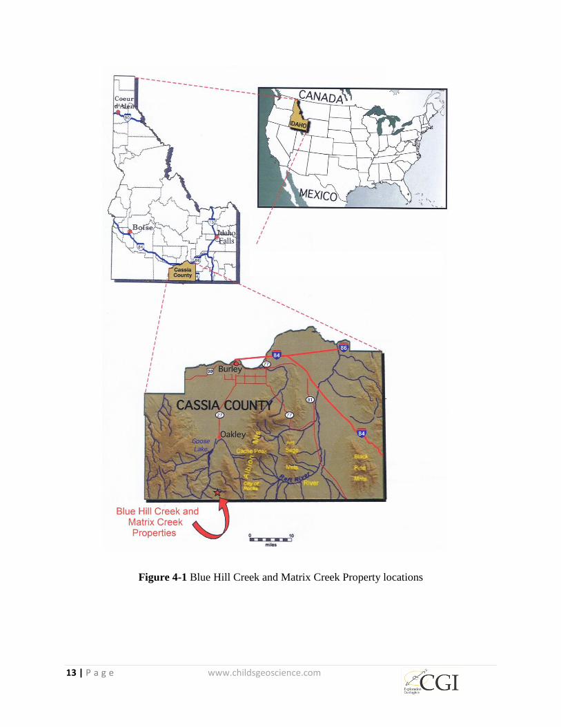
The BHC Property is located in Cassia County, Idaho approximately two miles north of the
historic California Trail and the Idaho-Utah state line. The center of the property is positioned at
approximately 260744 east, 4656411 north UTM Zone 12 on the western flank of Middle
Mountain (Figure 4-1, Figure 4-2, and Figure 4-3) and the Albion Range.
The BHC and MC Properties are located in Cassia County, Idaho approximately 24 kilometers
(15 miles) south of Oakley, Idaho and approximately 4 kilometers (2.4 miles) north of the border
with the state of Utah (Figure 4-1).
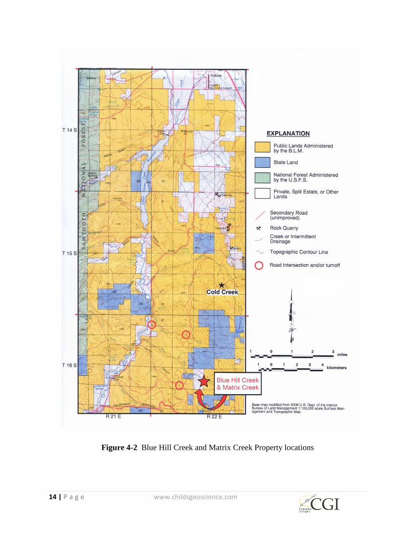
The BHC Property consists of thirty-six federal lode mining claims covering approximately 291
hectares (720 acres) and a 32 hectare (80 acre) Idaho State Mineral Lease, 9415, for a total area
of approximately 324 hectares (800 acres) (Figure 4-5). The MC Property consists of 41 claims
covering approximately 332 hectares (820 acres) plus the 129 hectare (320 acre) Idaho State
Mineral Lease 700030 for a total area of approximately 461 hectare (1,140 acres). All of the
mining claims and the state lease are 100% controlled or 100% owned by Otis and B&C.
Appendices I and II of this report are a list of federal lode mining claims forming part of the
BHC and MC Properties, respectively, including the claim names and federal identification
numbers.
13 | P a g e www.childsgeoscience.com
Figure 4-1 Blue Hill Creek and Matrix Creek Property locations
14 | P a g e www.childsgeoscience.com
Figure 4-2 Blue Hill Creek and Matrix Creek Property locations
15 | P a g e www.childsgeoscience.com
Figure 4-3 Blue Hill Creek and Matrix Creek Property locations
4.2 Ownership
On June 11, 2008, Otis Capital USA Corp. (a wholly owned subsidiary of Otis Gold Corp.)
entered into a formal agreement with Mitchell L. Bernardi and John R. Carden (“B&C”) and
Win Boom Enterprises Inc. to earn an exclusive right to a 100% interest in 18 unpatented mining
claims (Blue 1 through Blue 18), in addition to a 32 hectare (80 acre) Idaho State Lease #9415
(The “Property”) for an agreed upon scheduled payment of cash and stock to be delivered in
tranches. The Property is located in parts of Sections 20 and 21, Township 16 S, Range 22 E,
Cassia County, Idaho. A 1.6 kilometer (1 mile) area of interest was retained by B&C around the
18 original claims and State Lease (Figure 4-4 Land map showing the eighteen original B&C
claims (yellow) and the 32 hectare (80 acre) Idaho State Lease #9415. Note claim “Blue 33” is
no longer valid) such that any claims staked wholly or partly within one mile of the outer
boundaries of the property as it existed on May 8, 2008 is within an Area of Mutual Interest
(AMI) and become part of the property and subject to the existing ownership percentage and the
B&C net smelter royalty (NSR). Otis staked an additional 18 claims (Blue 19 through 32 and
Blue 39 through 42) within the AMI and these additional claims became part and parcel of the

16 | P a g e www.childsgeoscience.com
June 11 agreement (Figure 4-5). Winecup, Inc. of Oakley, Idaho owns the surface of the split
estate land in the West ½ of Section 21 that is covered by some of the original eighteen claims
comprising the property. Surface use of the split estate “Homestead” land is subject to an
agreement between Otis Gold and Winecup dated March 10, 2010. The agreement calls for an
annual payment of $2.00 per acre per year ($640) and compensation for surface disturbance
affecting productive ranching and grazing; it also includes a specific charge of $100 per drill site.
The term is for ten (10) years or so long thereafter as exploration, development and mining
activities are being conducted.
All claims staked within the AMI of the original 18 claims is subject to a 2.5% NSR payable to
Bernardi and Carden upon production of precious metals (i.e. gold and silver) from the Property.
The NSR, or a portion thereof, may be purchased at any time, for US$1,000,000 per percentage
point (i.e. $2,500,000 for the entire NSR). As stated above, the NSR also applies to any
additional claims located within the AMI within one mile of the original core group of eighteen
claims and Lease Land. A MOU agreement between Otis and B&C states: “should the
Agreement be terminated before the completion of the earn-in phase (which it was), the Vendors
(B&C) shall retain the entire 2.5% NSR in perpetuity that shall not be divided among the
Purchaser (Otis).”
In order to consummate the deal on BHC, on June 11, 2008, Otis agreed to the following
payment outlined in Table 4-1.
Year
Amount % Earned
(cumulative)
Payment Status
On Exchange Acceptance (2008) $40,000 10% Received by B&C
Year 1 (2009) $50,000 30% Received by B&C
Year 2 (2010) $60,000 50% Received by B&C
Year 3 (2011) $70,000 70% Received by B&C
Year 4 (2012) $80,000 (85%) No payment
Year 5 (2013) $100,000 (100%) No Payment
Table 4-1 Otis and B&C payment schedule
Early in 2012, the Otis Board of Directors informed the Vendors that the payment schedule for
years four and five would not be met. The 2012 and 2013 payments, therefore, were not made to
B&C and, consequently, Otis Gold only earned 70% of the Property.
On January 23, 2013, Otis entered into an agreement with Lateral Gold Corporation (“Lateral”).
Contingent upon that agreement is that Otis needed to secure another 10% of BHC with a path
toward 100% ownership. Upon the execution of the letter agreement and after the acceptance by
the TSX, Otis received $50,000 cash and 200,000 shares of LTG common stock. B&C were
paid $20,000 for sales of an additional 10% interest in BHC. Upon receipt of the payment by the
Vendors, an additional 10% was transferred to Otis and Otis owns a total of 80% of BHC. Thirty
17 | P a g e www.childsgeoscience.com
percent (30%) of the 200,000 shares were owed to B& C but were not transferred. B&C are
owed 60,000 shares of LTG. LTG stock was later rolled back 10:1 therefore B&C are currently
owed 3,000 shares, each, of LTG common stock or a total of 6,000 shares. When Lateral
dropped the property in 2014, no further interest could be purchased from the Vendors.
On July 14, 2014 Otis entered into an agreement with Radius, Otis received a $30,000 payment
from Radius. Even though B&C were 20% partners, B&C’s 20% share of the $30,000 payment
was never paid by Otis to B&C, therefore the $6,000 payment remains outstanding in addition to
the LTG stock mentioned above.
During late April and early May of 2014, Mitch Bernardi and John Carden performed some self-
funded research and exploration on the original AMI, as defined in the June 11, 2008 agreement.
During that work, B&C discovered ore-grade silver-gold mineralization cropping-out in what
appeared to be a detachment fault and staked twenty claims on a property they named “Matrix
Creek.” Furthermore, B&C acquired a 129 hectare (320 acre) Idaho State parcel (Lease 700030).
Because the claims fall within the AMI of the June 11, 2008 agreement, B&C offered the claims
to Otis for 80% of the actual out-of-pocket expenses. Otis acquired their share (80%) of the
claims for US$20,214.
Descriptions of the claims are given below, a map showing their relationship to surrounding
claims is included in Figure 4-5.
• Claims BC-15, 26, 27 and 28 located mostly in SE1/4 of Sec. 21 T16S, R22E BPM (Boise
Prime Meridian)
• Claims BC-16, 17 and 29 located mostly in the SW1/4 of Sec. 22, T16S, R22E BPM
• Claims BC-18 and 21 located mostly in the NE1/4 of Sec. 28, T16S, R22E BPM
• Claims BC-10 and 11 located mostly in the SE1/4 of Sec. 28, T16S, R22E BPM
• Claims BC-19, 20, 22 and 23 located mostly in the NW1/4 of Sec. 27 T16S, R22E BPM
• Claims BC-1, 2, 5, 6, and 4 located mostly in the SW1/4 of Sec 27, T16S, R22E BPM
Subsequent to the acquisition of the twenty BC claims, described above, an additional 21 “BC”
claims were staked within the AMI (Figure 4-5) by Otis. Because all the 41 “BC” claims and the
State Lease fall within the original AMI of the June 11, 2008 agreement, B&C own 20%, Otis
owns 80% and B&C retain a 2.5% NSR on all of the BC claims and State Lease 700030.

18 | P a g e www.childsgeoscience.com
Figure 4-4 Land map showing the eighteen original B&C claims (yellow) and the 32 hectare (80
acre) Idaho State Lease #9415. Note claim “Blue 33” is no longer valid
4.3 Exploration Permits and Jurisdictions
Legal access to the federal lode mining claims is provided by the US General Mining Act of
1872 plus its amendments, and the US Stock-Raising Homestead Act of 1916; for land covered
by the State Mineral Lease, legal access is provided by the lease. To retain the property, Otis
must pay federal maintenance fees, currently $155 per year, to the BLM and satisfy the
obligations of the State Mineral Lease.
The surface of the property is either: 1) federally owned and administered by the BLM; 2) split
estate whereby the surface is privately owned and minerals are owned by the Federal
Government; or 3) state owned and administered by the State of Idaho. Legal access to the

19 | P a g e www.childsgeoscience.com
private surface is provided by an agreement between Otis and the owner of the private surface
(Winecup, Inc.) dated March 10, 2010. Exploration programs on BLM administered and split
estate lands will be conducted under a Notice of Intent to Operate (NOI) permit, which allows
surface disturbance (access roads, drill sites, etc.) up to a maximum of two hectares (five acres),
and is guaranteed by a reclamation bond in an amount calculated by the BLM using standard
rates assigned to various types of disturbances such as drill pads and roads. Under a Notice of
Intent, the BLM makes recommendations to ensure that operations are carried out by the
operator in a manner consistent with applicable state and federal regulations. A Notice of
Exploration must also be submitted to the State of Idaho covering any activities planned on the
Idaho State Lease area.
Figure 4-5 Blue Hill Creek and Matrix Creek Property land status
Additional work, in excess of the 2 hectare (5 acre) limit, will require either reclamation of
earlier disturbance or the filing for the next level of disturbance called a Plan of Operations
(POO). This POO permit will require more detailed planning; environmental, archaeological and
cultural reviews of proposed areas of surface disturbance; and additional reclamation bonding.
20 | P a g e www.childsgeoscience.com
The bond amount will be related to the amount of proposed disturbance. Depending on the level
of disturbance proposed in the POO some level of environmental analysis by the BLM under the
National Environmental Policy Act (NEPA) may be required. No permits have yet been
obtained.
Work plans and development under an Idaho Notice of Exploration on State-owned lands are
administered by the Idaho Department of Lands. A Notice of Exploration is required for any
motorized exploration operations on projects involving contiguous surface disturbance up to two
hectares (five acres) or up to four hectares (ten acres) of non-contiguous disturbance. An Idaho
Reclamation Permit is required for any activities within a single project area that exceeds two
hectares (five acres) of contiguous disturbance or four hectares (ten acres) of non-contiguous
disturbance. Submission of a positive economic feasibility study is required prior to Department
approval of any commercial mining operation
4.4 Environmental Liabilities
To the extent known, the property is not subject to any environmental liabilities other than rules
imposed by the Greater Sage Grouse Conservation Plan. The BHC and MC Properties, along
with much of the surrounding region, fall within the habitat of the greater sage-grouse
(Centrocercus urophasianus), a candidate for listing under the Endangered Species Act (ESA).
Greater sage-grouse management in Idaho is currently dictated by the July 2006 Conservation
Plan for greater Sage-grouse, an annually updated working document of the Idaho Sage-grouse
Advisory Committee. Conservation management is coordinated through local working groups,
which maintain data, prioritize threats and identify appropriate conservation measures within
their jurisdiction, or sage-grouse Planning Area. The BHC and MC Properties fall within the
South Magic Valley Sage-Grouse Planning Area. At present, the Local Working Group
Management Plan for the South Magic Valley Sage-Grouse Planning Area is “in progress” and
the July 2006 Conservation Plan serves as the guiding document (Sherman, 2013). In June 2012,
the Idaho Governor’s office submitted a Draft Federal Alternative for Sage-Grouse Management
in Idaho (“Draft Alternative”) to the U.S. Secretary of the Interior and the U.S. Secretary of
Agriculture. According to this document, most of the BHC and MC Properties are located
within greater sage-grouse habitat classified as ‘Important’; the remainder is classified as
‘General’. According to Idaho BLM data, the property lies within an area classified as
‘Preliminary Priority Habitat’. The nearest known greater sage-grouse leks, or mating areas, are
located approximately 6 miles north and northeast of the property (Figure 4-6). The purpose of
Idaho’s Draft Alternative is to provide an Idaho specific direction for conservation and
management of sage-grouse on federal land. At this time, it is unclear how the Draft Alternative
will be employed. Insofar as present permitting, according to the Idaho BLM as reported by
Sherman (2013), a project’s proximity to greater sage-grouse habitat does not push permitting

21 | P a g e www.childsgeoscience.com
requirements from a Notice of Intent to a Plan of Operations. However, future regulatory
requirements posed by sage grouse conservation programs, possible sage grouse protection under
the Endangered Species Act and/or unforeseen requirements due to discovery and/or recognition
of environmental issues, endangered species and/or archaeological features potentially could
delay exploration and development of the BHC and MC Properties.
At present, according to the U.S. Fish and Wildlife Service (FWS), greater sage-grouse carry a
“warranted but precluded" listing status, essentially a ‘waiting list’ behind more critically
threatened species. The matter is a subject of significant debate and the influences and impacts
of greater sage-grouse conservation on resource planning and land use within the region are
evolving. At the state level, greater sage-grouse are the subject of a number of ongoing studies
and conservation programs. In September, 2015, the State of Idaho filed suit against the U.S.
Government over the federal rules governing sage grouse habitat. That case is ongoing so the
rules as they apply to Idaho are still being contested. In 2015, the U. S. Fish and Wildlife Service
published a map showing that the BHC and MC Properties are within an area designated as a
greater sage grouse Priority Area of Conservation. A separate U. S. Fish and Wildlife map
Figure 4-6 A considerable portion of the property is within 10 km of active sage grouse leks
and is therefore considered nesting habitat.
22 | P a g e www.childsgeoscience.com
shows the BHC and MC Properties are within the sage grouse nesting and late brood rearing
area. A buffer area of ten kilometers is required around a sage grouse lek under the current rules
(US Department of the Interior, 2015). This buffer distance may be reduced only if the entity
proposing the disturbance is able to provide mitigation that actually ensures a “net conservation
gain” for the birds. On September 22, 2015, after an unprecedented effort to preserve sage grouse
habitat by a variety of government and other groups, the U. S. Fish and Wildlife Service declared
that the sage grouse did not warrant listing under the Endangered Species Act (ESA). However,
there is concern that the rules promulgated to prevent listing under the ESA are actually more
onerous than if the birds were listed. In summary, the status of the restrictions on land use
relative to the greater sage grouse are in a state of flux and could have an impact on the work
recommended in the present report.
5 ACCESSIBILITY, CLIMATE, LOCAL RESOURCES,
INFRASTRUCTURE, AND PHYSIOGRAPHY
The BHC Property is accessible via paved, county-maintained gravel and unimproved dirt roads.
Specific directions to the property are as follows: Take exit 208 off Interstate 84 at Burley,
Idaho. Proceed through the town of Burley 35 kilometers (22 miles) south on State Route 27 to
Oakley. At the first stop sign encountered when entering Oakley, turn west (right) and proceed
approximately 0.8 kilometers (0.5 mile) to the Goose Creek Road turnoff on the west edge of
town. Turn south (left) onto the Goose Creek Road and follow it south for 22.5 kilometers (14.1
miles) to the Emery Creek Road turnoff. Turn east (left) onto Emery Creek Road and follow the
unimproved dirt road 1.8 miles to where the road “T’s” at a north-south dirt road.
To access the BHC Property, turn south (right) at the “T” and proceed 2.9 kilometers (2.4 miles)
across the Blue Hill Creek drainage to a rough drill access road on the east (left) side of the road
just before a sharp bend. Turn east (left) onto this road and proceed uphill east another mile into
the center of the project. This last mile of rough road is best navigated using a four-wheel drive
vehicle.
The climate of the BHC Property area is relatively mild. In Celsius, summer temperatures rise
into the 30s (90s F) and winters average -10 C (14 F). Precipitation falls as showers and
thunderstorms from spring through fall and as snow from November through March,
accumulating up to a meter (several feet) on lower benches and in bottomlands.
The closest infrastructure to the BHC Property is the small town of Oakley (population 763 in
the 2010 census) approximately fifteen miles to the north, where services include a restaurant,
grocery store, library, office, and motel. Power, telephone, and water are all accessible in the
Goose Creek drainage, located four miles west of the property. Mining in the form of open-pit
quarries for decorative quartzite building stone is a major local enterprise. At least six major
23 | P a g e www.childsgeoscience.com
operations mine and ship product from quarries dug into quartzite along the western flank of
Middle Mountain, approximately six miles north of the property boundary.
The topography of Cassia County is primarily high mountain desert with elevations ranging from
1,250 meters (4,100 feet) in the valley bottoms, where the topography is flat or gently rolling, to
2,438 meters (8,000 feet) in the mountainous areas of the Albion and Raft River Ranges. The
BHC Property lies on the western flank of Middle Mountain at elevations between 1,707 meters
and 1,951 meters (5,600 and 6,400 feet). The dominant drainages in the BHC area, from north to
south, are BHC and Devine Canyon, which generally drain from east to west into Goose Creek.
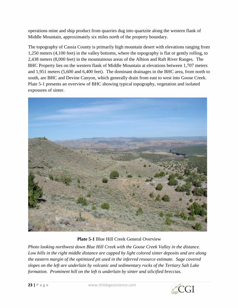
Plate 5-1 presents an overview of BHC showing typical topography, vegetation and isolated
exposures of sinter.
Plate 5-1 Blue Hill Creek General Overview
Photo looking northwest down Blue Hill Creek with the Goose Creek Valley in the distance.
Low hills in the right middle distance are capped by light colored sinter deposits and are along
the eastern margin of the optimized pit used in the inferred resource estimate. Sage covered
slopes on the left are underlain by volcanic and sedimentary rocks of the Tertiary Salt Lake
formation. Prominent hill on the left is underlain by sinter and silicified breccias.
24 | P a g e www.childsgeoscience.com
The BHC Property is covered by sagebrush-steppe/conifer-type vegetation generally composed
of grasslands and sagebrush punctuated with sparse juniper and isolated outcrops of volcanic
rocks and siliceous sinter. Some of the more common native plant species found on the property
include the Wyoming big sagebrush (Artemisia tridentata spp. wyomingensis), green rabbitbrush
(Chrysothamnus viscidiflorus), greasewood (Sarcobatus vermiculatus), bluebunch wheatgrass
(Pseudoroegneria spicata), Thurber’s needlegrass (Achnatherum thurberianum), Sandberg
bluegrass (Poa secunda), arrowleaf balsamroot (Balsamorhiza sagittata), Indian ricegrass
(Achnatherum hymenoides), some pinyon pine (Pinus cembroides), and juniper (Juniperus
scopulorum). Much of the rangeland is comprised of crested wheatgrass (Agropyron cristatum)
seedings with halogeton (Halogeton glomeratus) and cheatgrass (Bromus tectorum) dispersed
along roadways and disturbed sites. The area is home to many species of birds including greater
sage-grouse, hawks and other birds of prey. Mammals include occasional deer, coyote, and
small rodents. Domesticated cattle graze in the area and rattlesnakes are common.
Potential sites for mineral processing are present throughout the area if a production decision is
reached. An ample source of labor is available from the nearby towns of Burley and Oakley and
the surrounding rural population base.
25 | P a g e www.childsgeoscience.com
6 HISTORY
Geologist Stanton P. Dodd discovered the BHC Property and related mineralization in the
surrounding area in the summer of 1985 while conducting gold exploration in the Oakley,
Idaho region for Meridian Minerals Company (“Meridian”). Prior to the discovery, the
property contained no evidence of any major workings or modern-day exploration
activity, and no mention of mineralization or past production existed in the geologic
literature base. Dodd’s initial reconnaissance and ultimate discovery of the area was
based on field examination of rocks erroneously described in the literature as “rhyolites”
in the BHC area. These “rhyolites” are in fact typical examples of hot spring sinter
terrace deposits with variegated, blue and white banding. This distinctive pale-blue color
of the banded sinter is believed to be the derivation of the name BHC.
Meridian performed detailed sampling and mapping at a scale of 1 inch= 400 feet (Dodd
and Lehmann, 1985). Based on the results of that work, claims were staked and State of
Idaho Lease Land was acquired. In 1986, a work plan was permitted with the BLM and
Idaho State Lands Department and 731 meters (2,400 feet) of trenching was performed,
mostly in Paleozoic carbonates and siltstones east of the main sinter outcrops.
In 1986, Meridian drilled ten (10) reverse circulation holes totaling 1,128 meters (3,700
feet) at BHC and two (2) reverse circulation holes totaling 140 meters (460 feet) about
1.6 kilometers (1 mile) south of BHC. In 1987, Meridian drilled an additional eleven
(11) reverse circulation holes totaling 1,224 meters (4,017 feet) at BHC. In total, in 1986
and 1987, Meridian drilled 2,493 meters (8,178 feet) in 23 holes at BHC and the Matrix
Creek areas. Matrix Creek is an informal term coined by Otis referring to the areas
immediately east and south of the BHC claims and is characterized by distinctive
mineralized quartzite breccias that appear to occupy a gently dipping detachment fault in
that area (Schmuck, 1987). Little new geologic work has been completed in the MC area
since the original mapping was carried out by Meridian Minerals in the 1980s and the
area was drilled by Western Gold Exploration & Mining Co. LP (“WestGold”).
In 1988, when Meridian’s corporate attention was focused on development projects in
Nevada and California, it farmed out its exploration properties in the Oakley area to
WestGold. WestGold drilled seven (7) reverse circulation holes for a total of 427 meters
(1,400 feet) to the southwest of the MC target area and returned the properties to
Meridian in 1990 (Gehlen and Conway, 1989). Kennecott Exploration evaluated the
property briefly in 1993 but did not acquire the property.
On December 16, 1997, when the price of gold was $285 per ounce (source: kitco.com),
the area of the BHC Property was open for mineral entry and Carden and Bernardi, Inc.

26 | P a g e www.childsgeoscience.com
located twelve unpatented federal lode mining claims at BHC. In 1998, these claims
were leased to Latitude Minerals Corp (“Latitude”), which drilled eight (8) reverse
circulation holes totaling 1,245 meters (4,084 feet) and one (1) 135 meter (444-foot) core
hole at BHC during the 1998 field season. All nine holes intercepted significant
thicknesses of gold mineralization in the Tertiary volcanic and sedimentary section
ranging from 8 to 96 meters (25 to 315 feet) thick (Table 10-3) and confirmed the
mineralization described previously by Dodd (1990).
Latitude planned a follow up round of deeper drilling in 1999 to test the underlying
Paleozoic section for the presence of a carbonate rock-hosted gold system and to test for
high-grade feeders. However, this drilling was never performed because the precious
metals market hit a record low and many juniors, including Latitude, were not able to
raise sufficient capital to continue exploration.
On March 17, 2007, with gold selling for $650 per ounce (source: kitco.com), the area of
the BHC and MC Properties was again open for mineral entry and Mitchell L. Bernardi
commissioned the staking of eighteen unpatented federal lode mining claims comprising
146 hectares (360 acres) to cover the BHC target. Subsequently, Bernardi acquired an
additional 32 hectares (80 acres) in an Idaho State Mineral Lease and staked 53
unpatented federal lode mining claims comprising 648 hectares (1,060 acres) at Cold
Creek north of BHC.
On June 11, 2008, Bernardi, his partner John R. Carden and Win Boom Enterprises Inc.
entered into an agreement with Otis Capital Corp (later renamed Otis Gold Corp)
granting Otis a five-year option to acquire up to a 100% interest in the eighteen BHC
claims and the Idaho State Mineral Lease. BHC constituted Otis’s TSX Exchange
Qualifying Transaction, for which a Technical Report was prepared by Pancoast (2008).
The present report deals only with the BHC and MC Properties and does not cover the
Cold Creek, Emery Creek or Spring Creek Properties to the north, even though
mineralization on these other three properties bears similarities to BHC.
From October 9, 2008 to October 26, 2008, Zonge Geosciences (2008) performed a
sixteen-line kilometer, controlled-source, audio-frequency magnetotelluric (CSAMT)
survey on behalf of Otis at BHC and Cold Creek. In 2009, the Cold Creek CSAMT data
were interpreted by Griesel (2009), who earlier had conducted new geologic mapping on
the western flank of Middle Mountain at scales from 1:12,000 to 1:400.
In 2010, based on results of the CSAMT survey, Otis proposed, but never drilled, nine
RC holes totaling 2,438 meters (8,000 feet) at BHC.

27 | P a g e www.childsgeoscience.com
In 2014 Radius drilled five core holes at BHC to test the CSAMT anomaly, targeting
higher grade mineralization in the Cambrian rocks below the mineralized Tertiary
volcanic and sedimentary rocks, and to test for extensions of the previously defined
mineralization. These holes confirmed the mineralization defined by previous drilling in
the Tertiary section but were unsuccessful in extending the mineralization into the
underlying Cambrian rocks.
A historic “inferred” resource estimate has been completed on the BHC Property by
personnel employed by previous owner Meridian. (Table 6-1). In a 1990 internal
Meridian report, geologist S. Dodd estimated 10.0 MM tons of material grading 0.017 opt
Au (9.1 MM tonnes @ 0.58 g/t) comprising 170,000 ounces of gold
This resource estimate is not compliant with current CIM standards, has not been
independently verified by the authors, is not relevant to the mineral resource estimate
presented in this report, and is mentioned here for historical completeness only. The
mineral resource estimate and category does not comply with currently recognized
mineral resource methods and categories as defined by CIM, and is not suitable for more
than gross comparison with the resource estimate presented herein. The historic mineral
resource estimate is presented here simply to provide historical perspective regarding the
range of estimates produced using different data and no relationship with the current
mineral resource estimate is meant to be implied.
No gold production has ever come from the BHC or MC Properties.
Table 6-1 Blue Hill Creek Property historic "resource"
Year Source of Estimate Au Cutoff (opt) Tons Above Cutoff Contained Au (oz) Comments
1990 Stan Dodd unknown 10,000,000 170,000 unknown method
Historic "Inferred Resources"
28 | P a g e www.childsgeoscience.com
7 GEOLOGICAL SETTING AND MINERALIZATION
The BHC Property lies within a north-trending, five-mile-long by one-mile-wide belt of
precious metal occurrences along the western flank of Middle Mountain, a north-
trending, Basin-and-Range mountain block positioned along the westernmost extension
of the Albion Range metamorphic core complex (Figure 7-1). The mineralized belt
contains deformed and attenuated Paleozoic marine sedimentary rocks including
carbonates and quartzite breccias within the detachment zone, all underlain by
Precambrian crystalline rocks in the lower plate of a regional detachment fault exposed
along the eastern margin of the Goose Creek Basin. Tertiary sedimentary and volcanic
rocks of the Salt Lake formation fill the Goose Creek Basin. Early members of the basin-
filling sequence may have been deposited during detachment faulting although this
relationship appears to be poorly understood. Normal faults that cut the Tertiary
sequence define northwest trending grabens, one of which hosts the inferred resource at
BHC.
Regionally, the Albion Range metamorphic core complex and Goose Creek Basin to the
west lie in the northeastern part of the Basin-and-Range geologic province just south of
the Snake River Plain. This whole area is within the Cordilleran thermotectonic anomaly
(Eaton and others, 1976 and 1978), which is roughly coextensive with the Basin-and-
Range province and which is interpreted as the product of large-scale crustal extension
resulting in high heat flow, abundant volcanism throughout middle and late Cenozoic
time, and Basin-and-Range block faulting (Stewart, 1978).
Rocks exposed in and near the property range in age from Precambrian to Quaternary,
with progressively younger units exposed from east to west. Rocks in the core complex
include Precambrian through Mesozoic-age intrusive rocks, as well as schist and gneiss.
A series of brittle Paleozoic rocks, including quartzite, limestone, and minor phyllite are
exposed immediately west of, and structurally overlying, the core complex rocks.
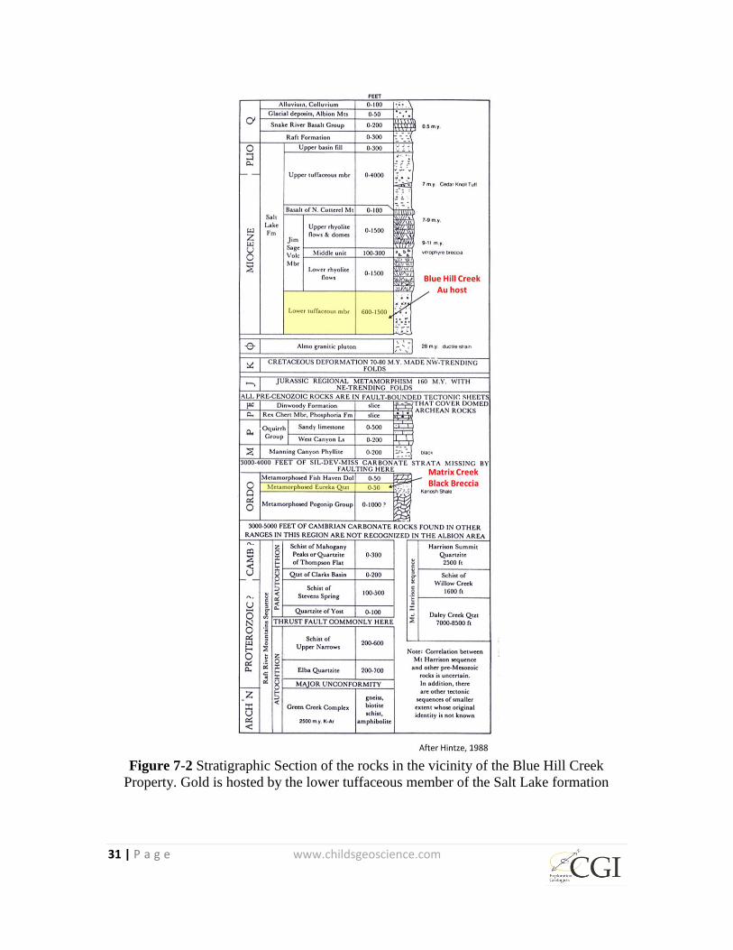
Permeable and porous tuffaceous siltstone, sandstone, conglomerate, and tuff of the
probable Lower Tuffaceous Member of Salt Lake formation (Figure 7-2) were deposited
in the subsiding, fault bounded Goose Creek Basin and are the hosts for much of the
mineralization recognized so far on the BHC Property.
The Salt Lake formation is dated as late Miocene, in part by a clustering of radiometric
ages of between approximately 7 and 11 million years on specific volcanic members
(Williams and others, 1982). Rhythmically-banded and bedded, gold-bearing siliceous
sinter deposits occur locally in the Salt Lake formation. The BHC mineralization is an
example of these shallow epithermal deposits that appear to have formed, at least in part,
at the surface. Sinters crop out at surface and also occur buried at depth within the
Tertiary stratigraphic section at BHC as evidenced in drill holes. Some of the youngest

29 | P a g e www.childsgeoscience.com
volcanic rocks of the Salt Lake formation probably post-date the mineralizing event(s)
although anomalous gold values are found in a white ash unit immediately below the
uppermost latite or rhyolite flow at BHC.
The hot spring systems were focused, in part, by northwest-trending Basin and Range
normal faults. Similar faults have down-dropped and preserved porous and permeable
units of the Salt Lake formation in several prospect areas along the eastern margin of the
Goose Creek basin. These basin-filling sediments and intercalated volcanic rocks define
grabens where they host disseminated and vein gold mineralization. The primary loci or
conduits for hydrothermal alteration and gold mineralization are along north to northeast-
trending faults and fractures that have little to no displacement. This trend may also
control presently active thermal springs in the Goose Creek Basin to the west (Piper,
1923).

30 | P a g e www.childsgeoscience.com
Figure 7-1 Map of the region around Blue Hill Creek showing the general tectonic
regime of the Albion Metamorphic Core Complex
31 | P a g e www.childsgeoscience.com
Figure 7-2 Stratigraphic Section of the rocks in the vicinity of the Blue Hill Creek
Property. Gold is hosted by the lower tuffaceous member of the Salt Lake formation
32 | P a g e www.childsgeoscience.com
Also of major importance are a series of northeast-trending, post-mineral normal faults,
which have offset and down dropped the grabens and their contained gold mineralization
to the north and northwest. Some of these latest faults may represent low-angle, listric
normal faults associated with exhumation of the metamorphic core complex immediately
to the east.
The BHC Property contains a low-sulfidation, hot spring system in which gold
mineralization is associated with clay alteration and silicification and 1 percent to 5
percent primary fine-grained disseminated pyrite, now mostly oxidized to various iron
oxides. At BHC, structurally controlled oxidation extends to the bottoms of many of the
drill holes. However locally abundant sulfides are still preserved in much of the drill
core, especially where silicification has been intense. At surface and at depth, primary
mineralization occurs as blebs and fine-grained disseminations of pyrite in sinter and as
typically thin stockwork veinlets of crystalline quartz and chalcedony cross-cutting the
sinter and adjacent silicified and clay altered sedimentary and tuffaceous rocks.
Hydrothermal breccias including rounded clasts are common in mineralized fault zones,
vein swarms, and probable breccia pipes.
Gold is the primary metal of interest, followed by silver. Precious metal mineralization is
associated with low levels of trace elements typically elevated in epithermal hot springs
systems, including arsenic, antimony, and mercury.
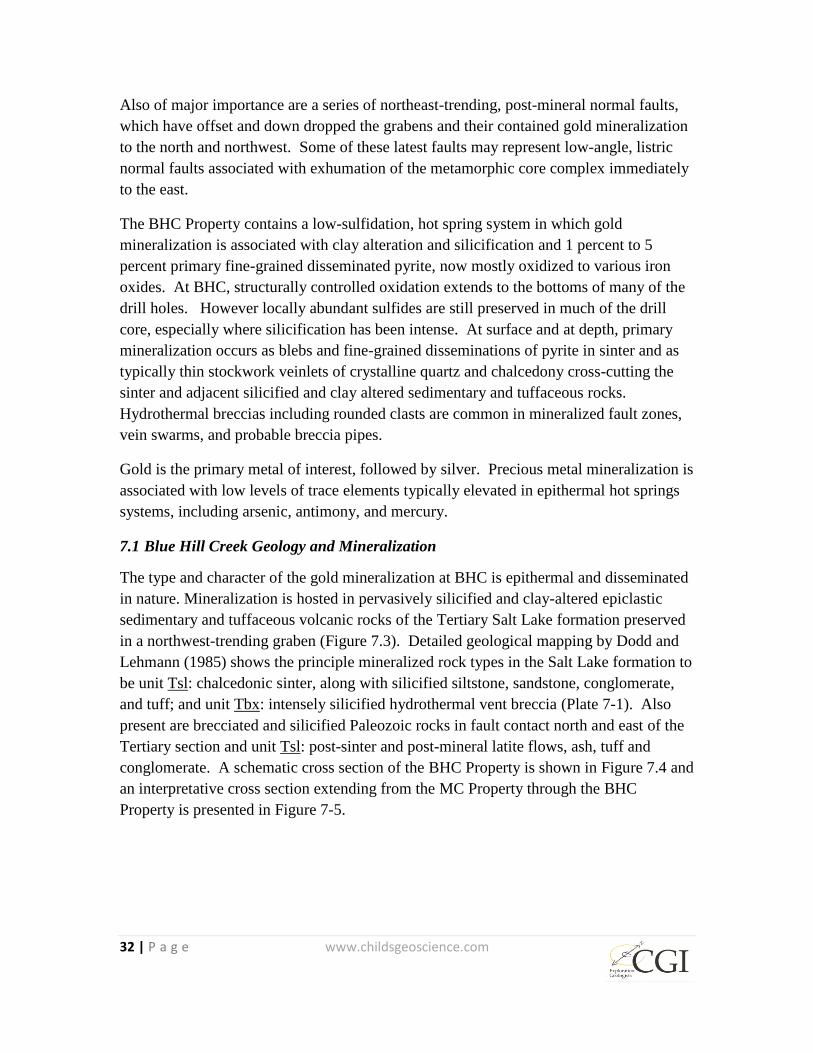
7.1 Blue Hill Creek Geology and Mineralization
The type and character of the gold mineralization at BHC is epithermal and disseminated
in nature. Mineralization is hosted in pervasively silicified and clay-altered epiclastic
sedimentary and tuffaceous volcanic rocks of the Tertiary Salt Lake formation preserved
in a northwest-trending graben (Figure 7.3). Detailed geological mapping by Dodd and
Lehmann (1985) shows the principle mineralized rock types in the Salt Lake formation to
be unit Tsl: chalcedonic sinter, along with silicified siltstone, sandstone, conglomerate,
and tuff; and unit Tbx: intensely silicified hydrothermal vent breccia (Plate 7-1). Also
present are brecciated and silicified Paleozoic rocks in fault contact north and east of the
Tertiary section and unit Tsl: post-sinter and post-mineral latite flows, ash, tuff and
conglomerate. A schematic cross section of the BHC Property is shown in Figure 7.4 and
an interpretative cross section extending from the MC Property through the BHC
Property is presented in Figure 7-5.
33 | P a g e www.childsgeoscience.com
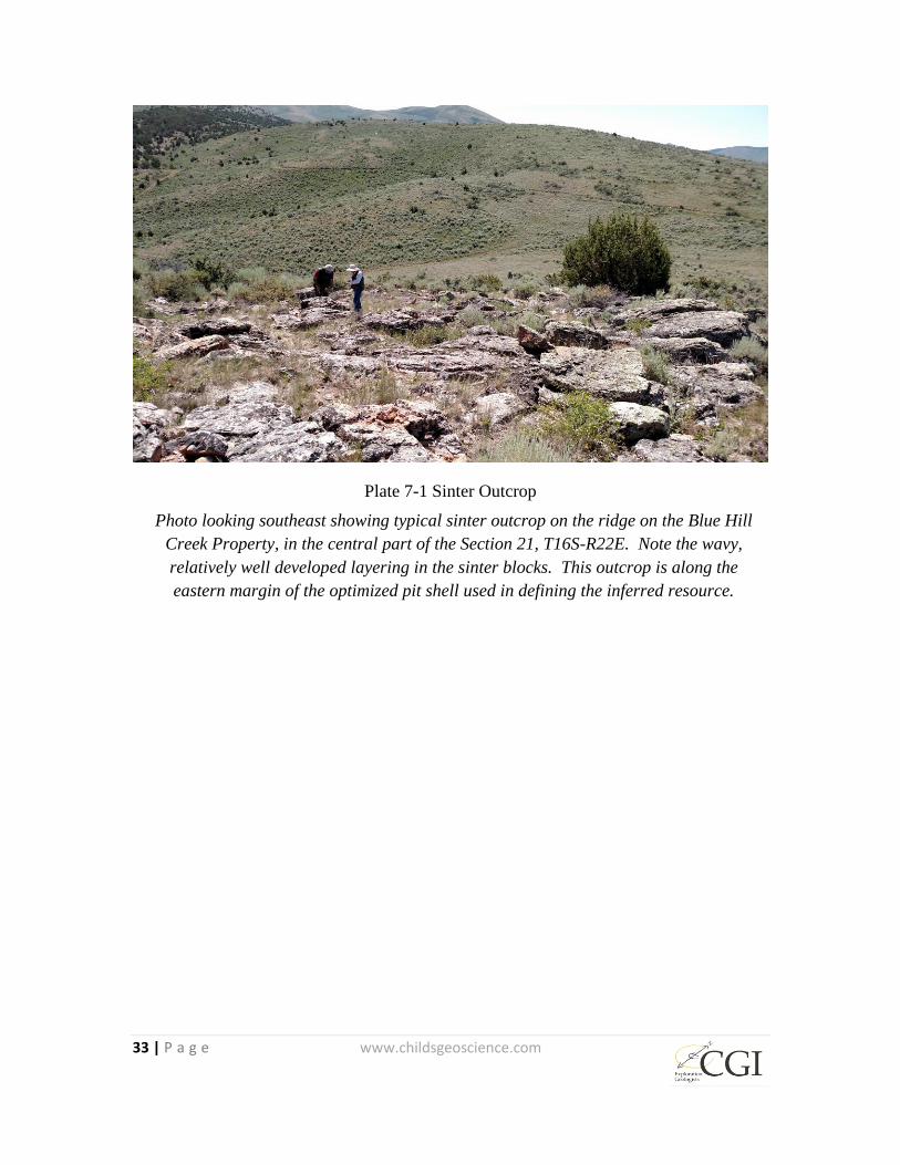
Plate 7-1 Sinter Outcrop
Photo looking southeast showing typical sinter outcrop on the ridge on the Blue Hill
Creek Property, in the central part of the Section 21, T16S-R22E. Note the wavy,
relatively well developed layering in the sinter blocks. This outcrop is along the
eastern margin of the optimized pit shell used in defining the inferred resource.
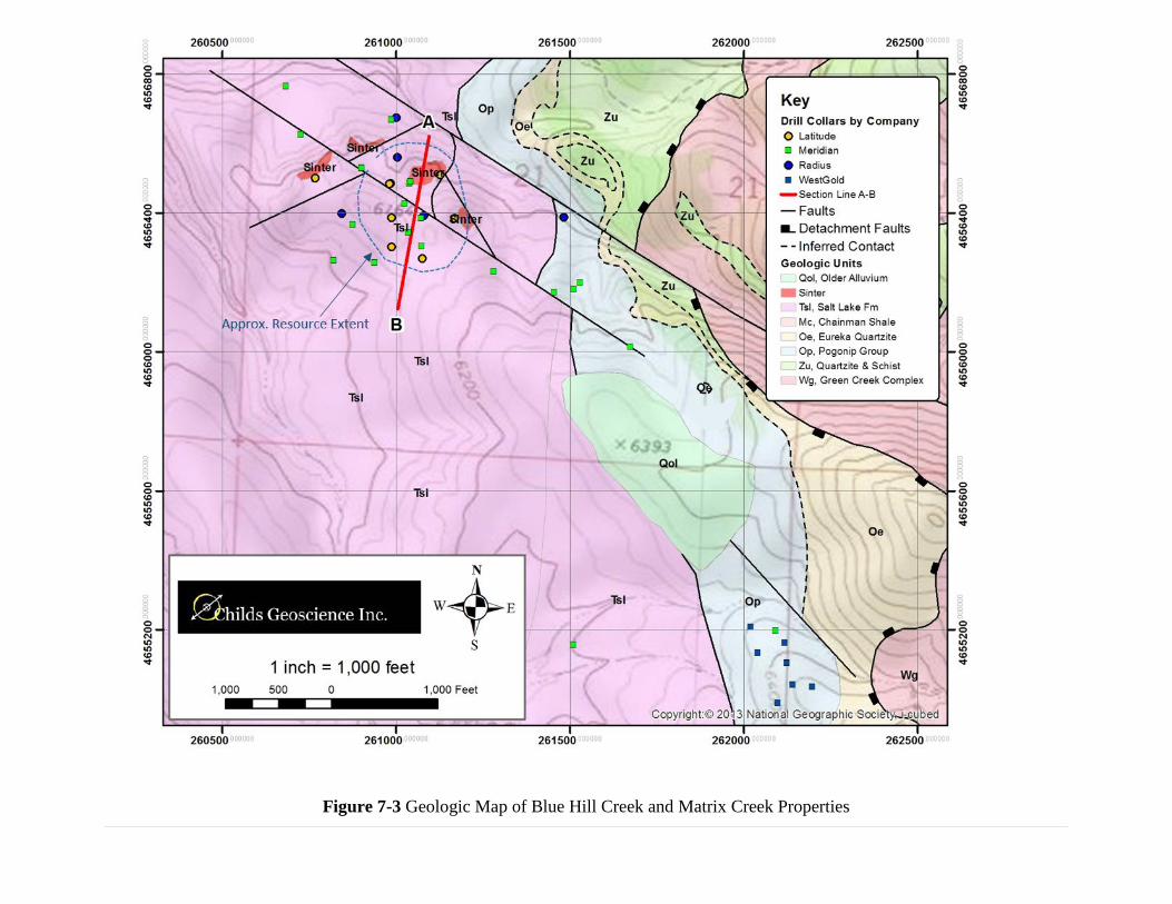
Figure 7-3 Geologic Map of Blue Hill Creek and Matrix Creek Properties

Figure 7-4 Schematic Cross Section of BHC Property
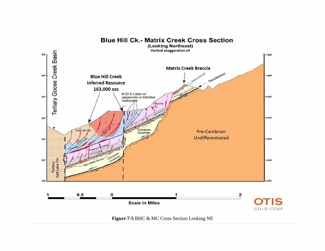
Figure 7-5 BHC & MC Cross Section Looking NE
37 | P a g e www.childsgeoscience.com
North- to northeast-trending dilatant faults and fractures within the northwest-trending
graben are believed to have focused the hydrothermal alteration and gold mineralization.
As presently known, the zone of mineralization is 914 meters (3,000 feet) long and up to
366 meters (1,200-feet) wide.
Sinter layering in surface outcrops strikes roughly north and dips approximately 20
degrees to the east. Northeast-trending post-mineral normal faults offset sinter and have
down dropped mineralized material to the northwest beneath post-mineral cover in the
direction of State Lease Land and Goose Creek Basin, as evidenced by blind step-out
drilling.
Geologic logs of the eight reverse circulation holes drilled by Meridian and Latitude
offer insights not readily apparent from surface outcrops and geologic mapping; all of the
following have been observed and recorded in the logs: quartz veinlets and quartz-lined
vugs, brecciated material indicating fault zones, interbedded sinter beds and stacked
sinters (to 96 meters (315 feet) deep in 98LBR-31), locally intense argillic alteration of
Tertiary host rocks, gold-bearing jasperoid breccia derived from Paleozoic carbonate rock
(below 172 meters (565 feet) in 98LBR-29), and gold-bearing aplitic dike rock with
multi-phase quartz veins (0.48 g/t Au (0.014 opt) from 184 meters to 187 meters (605 to
615 feet) in 98LBR-29 (Plate 7-2 & 7-3).

38 | P a g e www.childsgeoscience.com
Plate 7-2 Brecciation and Vugs in Drill Core
Core at 100 meters (327 feet) in Radius drill hole BHC-14-1. Complex
brecciation, re-healing and open space development in spectacular
chalcedonic sinter and vein breccias. Note the well-developed thin
chalcedonic banding. Sand grains and crude bedding are preserved in
coarse sandstone host rock at the left end of the core. The sandstone is
flooded with chalcedonic silica and very fine grained pyrite in this section
of core with pyrite most abundant in the coarser sandstone and pebble
conglomerate beds.

39 | P a g e www.childsgeoscience.com
Plate 7-3 Pyrite Flooded Breccia
Core between 102 and 103 meters (336 and 338 feet) in Radius drill hole
BHC-14-1. Medium- to coarse-grained sandstone is strongly silicified,
leached and impregnated with very fine grained pyrite. Note complex
collapse (?) breccias with chalcedonic and pyritic matrix and development
of irregular vugs.
The presence of altered dike material associated with structural zones and jasperoid
breccia at depth below the low-grade, bulk-tonnage target developed in the overlying
Tertiary rocks suggests the presence of high-angle, structurally-controlled, feeder-style
gold mineralization in the roots of the mineralizing system, with the dikes, jasperoid
breccia, and mineralization all localized in and along these deeper-seated structural
avenues. This observation is consistent with criteria currently used in exploration for
epithermal, hot spring-type, bulk-tonnage gold targets in the Basin-and-Range of Nevada
and elsewhere.
Maximum gold and silver values from surface samples of sinter and silicified Tertiary
sedimentary rock reach 2.1 ppm and 11.6 ppm, respectively at BHC. Sampling by
Pancoast (2008) suggests a silver to gold ratio in the 8:1 to 10:1 range. Associated trace
elements (As, Sb, Hg) are generally only weakly anomalous. Trace element geochemical
data from rock sampling of BHC sinter and silicified sedimentary rocks by Kennecott
indicate values ranging from 9 ppm to 159 ppm for As, less than 5 ppm to 19 ppm for Sb,
and less than 10 ppb to 489 ppb for Hg (Bourns, 1993). Multi-element geochemistry
obtained for core holes drilled in 2014 by Radius show that Hg, and Sb rarely exceed the
40 | P a g e www.childsgeoscience.com
1 ppm and 3 ppm respective detection limits for these elements. Maximum values for Pb,
Zn, As, Sb, Hg in the 2014 core are 419, 1,044, 639, 20, and 3 ppm respectively.
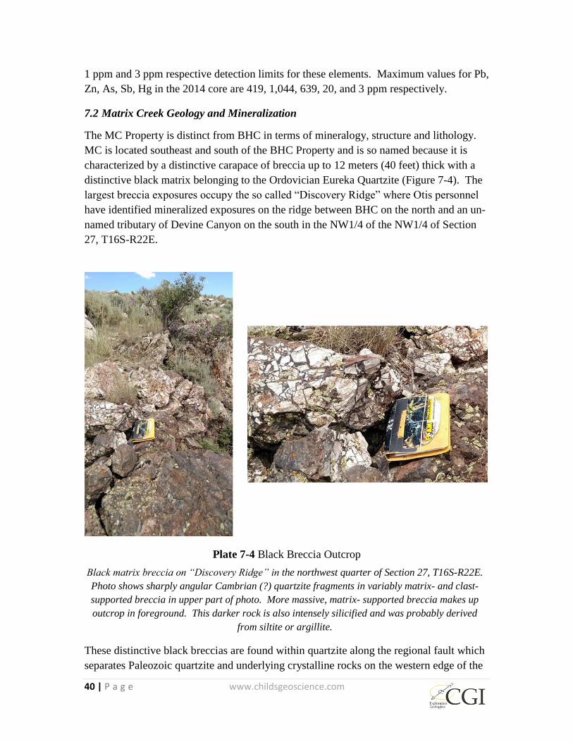
7.2 Matrix Creek Geology and Mineralization
The MC Property is distinct from BHC in terms of mineralogy, structure and lithology.
MC is located southeast and south of the BHC Property and is so named because it is
characterized by a distinctive carapace of breccia up to 12 meters (40 feet) thick with a
distinctive black matrix belonging to the Ordovician Eureka Quartzite (Figure 7-4). The
largest breccia exposures occupy the so called “Discovery Ridge” where Otis personnel
have identified mineralized exposures on the ridge between BHC on the north and an un-
named tributary of Devine Canyon on the south in the NW1/4 of the NW1/4 of Section
27, T16S-R22E.
Plate 7-4 Black Breccia Outcrop
Black matrix breccia on “Discovery Ridge” in the northwest quarter of Section 27, T16S-R22E.
Photo shows sharply angular Cambrian (?) quartzite fragments in variably matrix- and clast-
supported breccia in upper part of photo. More massive, matrix- supported breccia makes up
outcrop in foreground. This darker rock is also intensely silicified and was probably derived
from siltite or argillite.
These distinctive black breccias are found within quartzite along the regional fault which
separates Paleozoic quartzite and underlying crystalline rocks on the western edge of the
41 | P a g e www.childsgeoscience.com
Albion Mountains. Based on more recent interpretation of the Albion Mountains as a
metamorphic core complex, it appears likely that the brittle deformation characterizing
these extensive breccias is due to development in a detachment fault that formed as part
of the un-roofing of the core complex. Based on the limited sampling by the author
(Table 7-1 - sample numbers 97835, 97836, and 97837) and sampling in 2014 by Otis
personnel (Figure 9-1), the breccias are strongly anomalous for both gold and especially
silver. Based on drilling and surface mapping that has been done at BHC, the MC
breccias are cut by the faults that control mineralization in the Tertiary rocks at BHC. If
the MC mineralized breccias are cut by the BHC mineralized structures at depth as seems
likely, that the MC breccias represent a possible source of gold and silver that could have
been incorporated into the younger epithermal system. This interpretation, if correct, has
implications for younger gold-silver systems not only at BHC but elsewhere along the
west side of the Albion Range.
The black matrix breccias were first extensively sampled and mapped by Meridian.
Meridian’s mapping showed that the breccia continues north-northwest and crops out in a
narrow belt along the very eastern edge of the BHC claims. Meridian collected a handful
of rock chip samples from quartzite in this area but modest grades and narrow outcrop
width discouraged further investigation.
The breccias were intercepted in Meridian Minerals drill hole BHC 87-22, southeast of
the sinter deposits at Blue Hill. WestGold drilled seven short RC holes to the southwest
of “Discovery Ridge” in 1989. The logs for these holes are unavailable for review but a
summary table by Hudson (1989) indicates these holes did not intercept any significant
grade or thickness of gold. It should be noted that it does not appear that WestGold
measured Ag in any of these holes. More recently, Otis personnel resampled the breccias
on “Discovery Ridge” in the MC target area and found anomalous values of up to 2.1
ppm Au and of up to 306 ppm Ag.
During the author’s brief visit to the breccias, the following observations were made. The
breccias consist of angular to sub angular clasts of white quartzite and relatively minor
clasts and discontinuous layers of grey to black, thoroughly silicified material that may
have been siltstone and argillite prior to being silicified. The clasts make up a variable
portion of the rock. In some exposures the breccia consists of white quartzite fragments
separated by only approximately 10% aphanitic matrix material consisting of extremely
fine grained quartz and pyrite. Elsewhere the black matrix makes up 80 to 90 percent of
the rock with fragments of white quartzite comprising only 10 to 20%. Northeast
trending vertical fractures are locally abundant and some of these are actually micro-
veinlets and micro breccias of fine grained to very fine grained, locally vuggy, quartz and
pyrite. Hematite and jarosite staining is abundant on joints. The author is not aware of
any petrography or other detailed mineralogical or geochemical investigation of these
breccias.
42 | P a g e www.childsgeoscience.com
Layering in the breccias is only weakly developed and, where present, generally appears
to dip to the west and southwest at shallow angles. Several generations of silicification
and quartz veining are recognized in the breccias as evidenced by the presence of veinlets
internal to the clasts that terminate abruptly at the clast margins. Other veinlets of similar
material cut across both the clasts and the dark, sulfide-rich matrix.
Three representative grab samples numbered 97835 through 97837 were collected by the
author from the Matrix Creek breccias on “Discovery Ridge”. These are listed in Table
7-1 and the sample locations are shown Figure 9-1. The three breccia samples contained
72.8, 8.31, and 8.03 ppm silver and confirm the relative enrichment of the MC
mineralization in silver relative to that at the BHC Property. The 72.8 ppm number for
silver confirms that locally high grade silver is present in the distinctive black breccias at
MC. Gold values in the three samples from Discovery Ridge are 0.288, 0.287, and 1.475
ppm. These results are consistent with 2014 grab sampling by Otis. It is interesting to
note that these gold grades are higher than the three surface samples collected from the
BHC Property and the 1.475 ppm number indicates that relatively high gold values occur
at MC.
Little work has been done by Otis on the MC breccias and their origin remains enigmatic.
The fact that many of the quartzite fragments could be fitted back together if the silica-
pyrite matrix was removed suggests that the breccias are the result of brittle deformation
with little subsequent movement at the scale of individual quartzite blocks although the
cumulative displacement across the breccia zone is likely significant . The very angular
shape of the majority of the fragments also suggests brittle deformation and the lack of
mylonitic foliation or ductile features in the quartzite fragments also support a brittle
deformation style. The low-angle westerly dips and the geometry of the breccias in what
appears to be a westerly dipping carapace overlying poorly exposed Precambrian or
Paleozoic rocks suggests that the breccias formed along a low-angle fault that is dipping
to the west toward Goose Creek Valley. For this reason it seems likely that the breccias
formed along a detachment fault involved in the exhumation of the metamorphic core
complex that forms the core of the Albion Range immediately to the east.
The relationship between the mineralization at MC and BHC is ambiguous. The breccias
cut through both properties and may be thicker in the subsurface at BHC than is
suggested by surface outcrop. The high-angle faults associated with the BHC graben cut
and displace and are therefore younger than the low angle MC detachment structure.
Because these faults appear to cut through the mineralized detachment at MC, the
detachment may have served as a source of precious metals in the BHC hydrothermal
system.
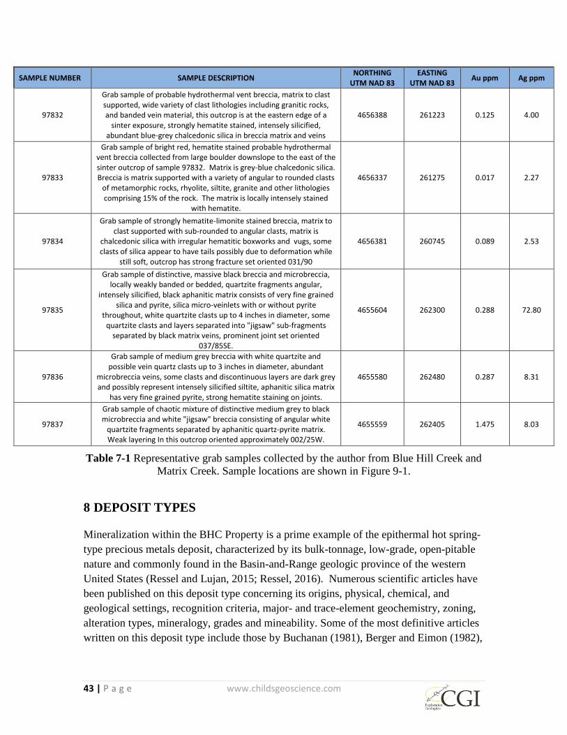
43 | P a g e www.childsgeoscience.com
SAMPLE NUMBER SAMPLE DESCRIPTION NORTHING
UTM NAD 83 EASTING
UTM NAD 83 Au ppm Ag ppm
97832
Grab sample of probable hydrothermal vent breccia, matrix to clast supported, wide variety of clast lithologies including granitic rocks, and banded vein material, this outcrop is at the eastern edge of a
sinter exposure, strongly hematite stained, intensely silicified, abundant blue-grey chalcedonic silica in breccia matrix and veins
4656388 261223 0.125 4.00
97833
Grab sample of bright red, hematite stained probable hydrothermal vent breccia collected from large boulder downslope to the east of the sinter outcrop of sample 97832. Matrix is grey-blue chalcedonic silica. Breccia is matrix supported with a variety of angular to rounded clasts
of metamorphic rocks, rhyolite, siltite, granite and other lithologies comprising 15% of the rock. The matrix is locally intensely stained
with hematite.
4656337 261275 0.017 2.27
97834
Grab sample of strongly hematite-limonite stained breccia, matrix to clast supported with sub-rounded to angular clasts, matrix is
chalcedonic silica with irregular hematitic boxworks and vugs, some clasts of silica appear to have tails possibly due to deformation while
still soft, outcrop has strong fracture set oriented 031/90
4656381 260745 0.089 2.53
97835
Grab sample of distinctive, massive black breccia and microbreccia, locally weakly banded or bedded, quartzite fragments angular,
intensely silicified, black aphanitic matrix consists of very fine grained silica and pyrite, silica micro-veinlets with or without pyrite
throughout, white quartzite clasts up to 4 inches in diameter, some quartzite clasts and layers separated into "jigsaw" sub-fragments
separated by black matrix veins, prominent joint set oriented 037/85SE.
4655604 262300 0.288 72.80
97836
Grab sample of medium grey breccia with white quartzite and possible vein quartz clasts up to 3 inches in diameter, abundant
microbreccia veins, some clasts and discontinuous layers are dark grey and possibly represent intensely silicified siltite, aphanitic silica matrix
has very fine grained pyrite, strong hematite staining on joints.
4655580 262480 0.287 8.31
97837
Grab sample of chaotic mixture of distinctive medium grey to black microbreccia and white "jigsaw" breccia consisting of angular white
quartzite fragments separated by aphanitic quartz-pyrite matrix. Weak layering In this outcrop oriented approximately 002/25W.
4655559 262405 1.475 8.03
Table 7-1 Representative grab samples collected by the author from Blue Hill Creek and
Matrix Creek. Sample locations are shown in Figure 9-1.
8 DEPOSIT TYPES
Mineralization within the BHC Property is a prime example of the epithermal hot spring-
type precious metals deposit, characterized by its bulk-tonnage, low-grade, open-pitable
nature and commonly found in the Basin-and-Range geologic province of the western
United States (Ressel and Lujan, 2015; Ressel, 2016). Numerous scientific articles have
been published on this deposit type concerning its origins, physical, chemical, and
geological settings, recognition criteria, major- and trace-element geochemistry, zoning,
alteration types, mineralogy, grades and mineability. Some of the most definitive articles
written on this deposit type include those by Buchanan (1981), Berger and Eimon (1982),
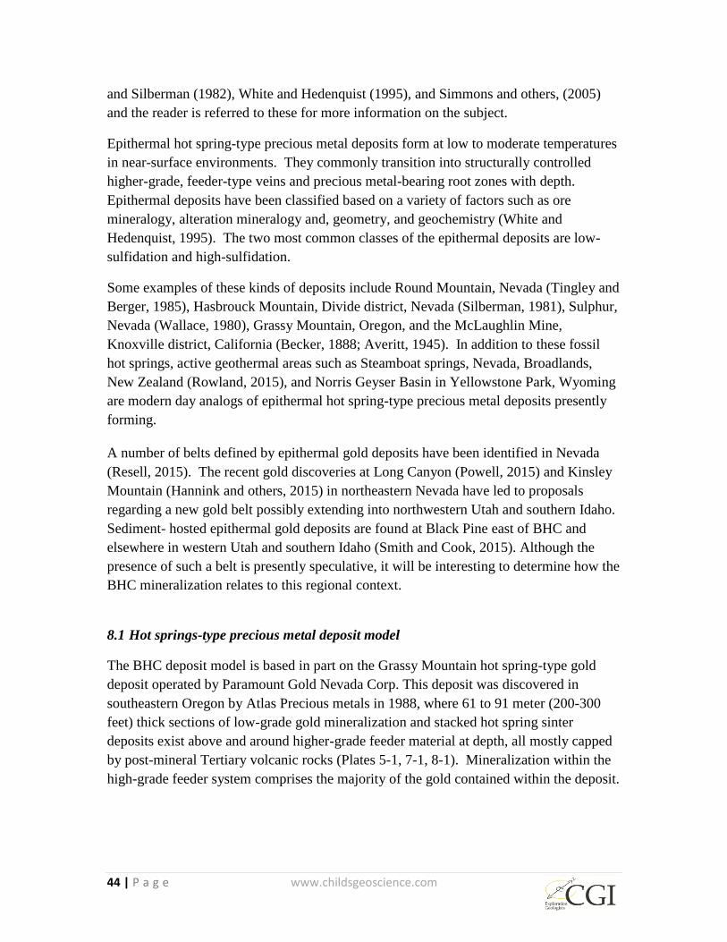
44 | P a g e www.childsgeoscience.com
and Silberman (1982), White and Hedenquist (1995), and Simmons and others, (2005)
and the reader is referred to these for more information on the subject.
Epithermal hot spring-type precious metal deposits form at low to moderate temperatures
in near-surface environments. They commonly transition into structurally controlled
higher-grade, feeder-type veins and precious metal-bearing root zones with depth.
Epithermal deposits have been classified based on a variety of factors such as ore
mineralogy, alteration mineralogy and, geometry, and geochemistry (White and
Hedenquist, 1995). The two most common classes of the epithermal deposits are low-
sulfidation and high-sulfidation.
Some examples of these kinds of deposits include Round Mountain, Nevada (Tingley and
Berger, 1985), Hasbrouck Mountain, Divide district, Nevada (Silberman, 1981), Sulphur,
Nevada (Wallace, 1980), Grassy Mountain, Oregon, and the McLaughlin Mine,
Knoxville district, California (Becker, 1888; Averitt, 1945). In addition to these fossil
hot springs, active geothermal areas such as Steamboat springs, Nevada, Broadlands,
New Zealand (Rowland, 2015), and Norris Geyser Basin in Yellowstone Park, Wyoming
are modern day analogs of epithermal hot spring-type precious metal deposits presently
forming.
A number of belts defined by epithermal gold deposits have been identified in Nevada
(Resell, 2015). The recent gold discoveries at Long Canyon (Powell, 2015) and Kinsley
Mountain (Hannink and others, 2015) in northeastern Nevada have led to proposals
regarding a new gold belt possibly extending into northwestern Utah and southern Idaho.
Sediment- hosted epithermal gold deposits are found at Black Pine east of BHC and
elsewhere in western Utah and southern Idaho (Smith and Cook, 2015). Although the
presence of such a belt is presently speculative, it will be interesting to determine how the
BHC mineralization relates to this regional context.
8.1 Hot springs-type precious metal deposit model
The BHC deposit model is based in part on the Grassy Mountain hot spring-type gold
deposit operated by Paramount Gold Nevada Corp. This deposit was discovered in
southeastern Oregon by Atlas Precious metals in 1988, where 61 to 91 meter (200-300
feet) thick sections of low-grade gold mineralization and stacked hot spring sinter
deposits exist above and around higher-grade feeder material at depth, all mostly capped
by post-mineral Tertiary volcanic rocks (Plates 5-1, 7-1, 8-1). Mineralization within the
high-grade feeder system comprises the majority of the gold contained within the deposit.
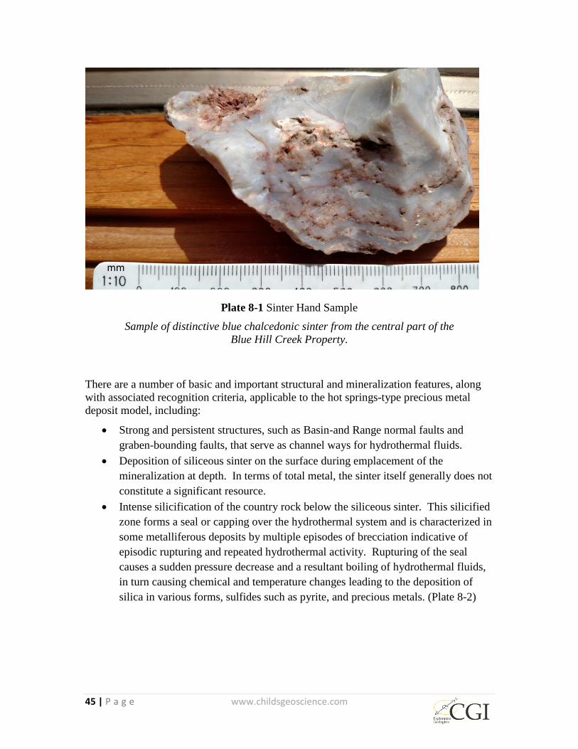
45 | P a g e www.childsgeoscience.com
Plate 8-1 Sinter Hand Sample
Sample of distinctive blue chalcedonic sinter from the central part of the
Blue Hill Creek Property.
There are a number of basic and important structural and mineralization features, along
with associated recognition criteria, applicable to the hot springs-type precious metal
deposit model, including:
Strong and persistent structures, such as Basin-and Range normal faults and
graben-bounding faults, that serve as channel ways for hydrothermal fluids.
Deposition of siliceous sinter on the surface during emplacement of the
mineralization at depth. In terms of total metal, the sinter itself generally does not
constitute a significant resource.
Intense silicification of the country rock below the siliceous sinter. This silicified
zone forms a seal or capping over the hydrothermal system and is characterized in
some metalliferous deposits by multiple episodes of brecciation indicative of
episodic rupturing and repeated hydrothermal activity. Rupturing of the seal
causes a sudden pressure decrease and a resultant boiling of hydrothermal fluids,
in turn causing chemical and temperature changes leading to the deposition of
silica in various forms, sulfides such as pyrite, and precious metals. (Plate 8-2)
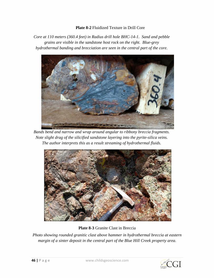
46 | P a g e www.childsgeoscience.com
Plate 8-2 Fluidized Texture in Drill Core
Core at 110 meters (360.4 feet) in Radius drill hole BHC-14-1. Sand and pebble
grains are visible in the sandstone host rock on the right. Blue-grey
hydrothermal banding and brecciation are seen in the central part of the core.
Bands bend and narrow and wrap around angular to ribbony breccia fragments.
Note slight drag of the silicified sandstone layering into the pyrite-silica veins.
The author interprets this as a result streaming of hydrothermal fluids.
Plate 8-3 Granite Clast in Breccia
Photo showing rounded granitic clast above hammer in hydrothermal breccia at eastern
margin of a sinter deposit in the central part of the Blue Hill Creek property area.

47 | P a g e www.childsgeoscience.com
Breccias are generally important in hot spring-type precious metal deposits.
Explosive breccias are common near the surface and beneath the silicified cap in
the form of vents, pipes, veins, and dikes (Plate 8-3). Breccia zones in the silica
cap can generally be followed downward beneath the cap into quartz stockwork
veining.
The main productive area of bulk-tonnage mineralization lies below the silica cap,
in the zone of acid-leaching where clay alteration and oxidation occur. Gases
evolved during boiling may re-condense in cooler aquifers near or at surface.
When the gases include H2S and CO2, they result in acid-sulfate solutions that
pervasively acid-leach the host rocks through downward percolation (Berger and
Eimon, 1982). Minerals commonly found in the acid-leached parts of hot spring-
type systems include quartz, k-feldspar (adularia), hydromica, kaolinite, alunite,
jarosite, and iron oxides, depending on the chemistry of the mineralizing system
and host rocks present.
Lower grade, bulk tonnage mineralization occurs as disseminations or
replacements generally in host rocks with a high degree of porosity, permeability
and/or chemical reactivity (Plates 7-2, 7-3, 8-2). Examples of such rocks include
epiclastic and tuffaceous sedimentary rocks, silty, thin-bedded, impure carbonate
sedimentary rocks, and volcanic tuffs.
Higher-grade, feeder-type, structurally controlled bonanza- and quartz-sulfide-
type vein mineralization normally lies below disseminated mineralization.
Steeply dipping to vertical structures control the emplacement of these veins and
their root-like shape and structure.
8.2 Hot springs-type precious metal model applied to the BHC Gold Property
Figure 8-1 is a schematic diagram showing the spatial relationships of alteration and the
more important structural components as they relate to the epithermal hot spring-type
gold model at BHC. The BHC Property has characteristics such as abundant sinter;
adularia (field identification only); abundant veins, stockworks; abundant chalcedony;
and multi-episode vein breccias; and open spaces that indicate a low-sulfidation origin.
However, some features at BHC such as widespread replacement of the host rock by
pyrite are more typical of high-sulfidation systems. Almost no detailed work such as
geochemistry, fluid inclusion studies, isotope analyses, petrography or any other work
has been done at BHC that would allow a better understanding of the deposit model. The
steep topography of the area around BHC might result in asymmetry of the alteration
envelope that may have favored lateral flow of the hydrothermal fluids and displacement
of the alteration and sinter zones down slope from the feeder system (White and
Hedenquist, 1995). This could be an important factor to consider in further exploring the
BHC mineralization, especially based on the presence of a pre-existing low angle

48 | P a g e www.childsgeoscience.com
detachment surface adjacent to and probably beneath the Tertiary volcanic and
sedimentary rocks that host the inferred resource.
The following features typical of the low-sulfidation epithermal hot spring-type
depositional model and recognition criteria as have been recognized at BHC:
Mineralization occurs at a major structural intersection of the north-trending
Albion Range metamorphic core complex with a northwest-trending structural
graben within the Goose Creek Basin.
Siliceous hot spring sinter crops out on the surface (Plates 7-1, 8-3) and forms
stacked and down-dropped bedded sinter deposits are present locally at depths up
to 916 meters (315 feet) as indicated by Latitude drill hole 98LBR-31.
Latitude’s drilling further reveals widespread silicification and silica cap
development throughout much of the upper 61 to 91 meters (200-300 feet) of the
mineralizing system, with abundant quartz stockwork veinlets/microveinlets and
breccia texture (Plate 7-2).
Hydrothermal vent breccia crops out on the surface where it is intensely silicified,
matrix supported, and is in turn, locally cut by northeast-trending silicified ribs
(Plates 5-1, 8-3). Brecciation increases with depth, until gold-bearing jasperoid,
developed from the alteration of Paleozoic carbonate basement rocks, and
interspersed aplitic dikes are encountered.
Below the zone of silicification, drilling reveals clay alteration, fine-grained mica
development and acid leaching to depths of 152 meters (500 feet) below surface.
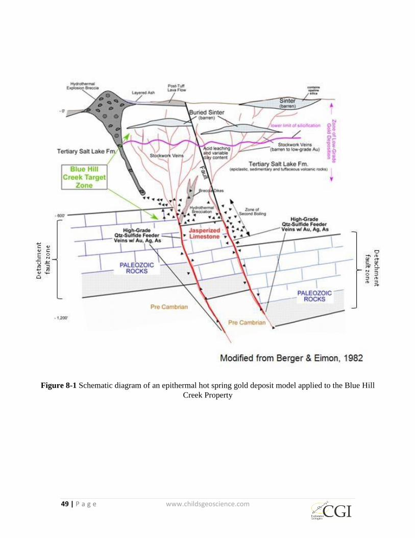
49 | P a g e www.childsgeoscience.com
Figure 8-1 Schematic diagram of an epithermal hot spring gold deposit model applied to the Blue Hill
Creek Property

50 | P a g e www.childsgeoscience.com
9 EXPLORATION
The BHC Property has been explored intermittently by a number of companies since
mineralization was first identified by Meridian Minerals. The locations of surface
samples and geophysical measurements are shown in Figure 9-1 and Figure 9-3.
Meridian conducted detailed regional field mapping and surface sampling in 1985 (Dodd
and Lehmann, 1985). This work identified a number of targets for further investigation
including the BHC area. Follow-up work in 1986 included approximately 229 meters
(750 feet) of trenching in an area just southeast of the BHC Property (Dodd, 1986). This
sampling consisted of chip, float and dump samples.
Kennecott collected limited surface grab samples and conducted geologic sketch mapping
at 1:1000 scale while evaluating the property in 1993. Kennecott’s samples were all
select grab samples.
In 1998 Latitude collected a limited set of samples along a traverse on the western edge
of the Tertiary mineralized zone. This traverse was approximately 200 meters (656 feet)
in length and the samples were all grab samples.
In 2008 Otis hired Zonge Geosciences to conduct a controlled-source audio
magnetotelluric (CSAMT) survey. A total of nine geophysical survey lines were run,
four at BHC, each 2000 meters (6,562 feet) long, for a total of 8,000 meters (26,248 feet);
and five at Cold Creek, each 1,600 meters (5,249 feet) long, for a total of 8,000 meters
(26,248 feet) (Figure 9.1). Cold Creek is not the subject of the present report and the
CSAMT lines there are only mentioned because they were run as part of the same
program as at BHC. Data were acquired using a 50 meters (164 feet) dipole along east-
west oriented lines spaced 400 meters (1,312 feet) apart and were presented as 2D
Smooth-Model Inversion plots; examples are included in Figure 9-3. Zonge did not
interpret the data; however the 2D plots show known near-surface mineralization to be
reflected by elevated resistivity values. Other areas of elevated resistivity occur near
surface and to depth in an apparently tabular body which dips to the west.
Upon acquiring the property in 2014, Radius collected a limited suite of surface samples
in the Matrix Creek area.

Figure 9-1 Locations of surface samples collected for the current report and historic sampling programs
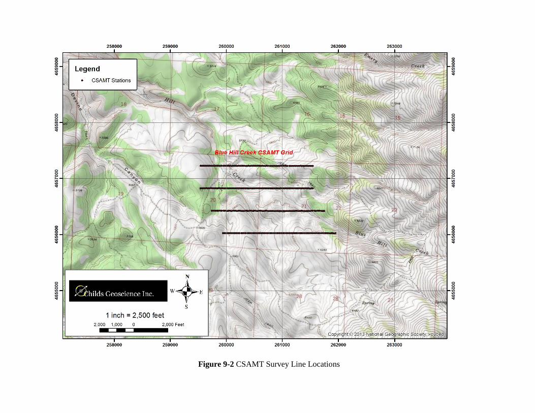
Figure 9-2 CSAMT Survey Line Locations

Figure 9-3 CSAMT Survey Lines from Blue Hill Creek (4656000N & 4656400N) 2D Smooth-Model Inversion.
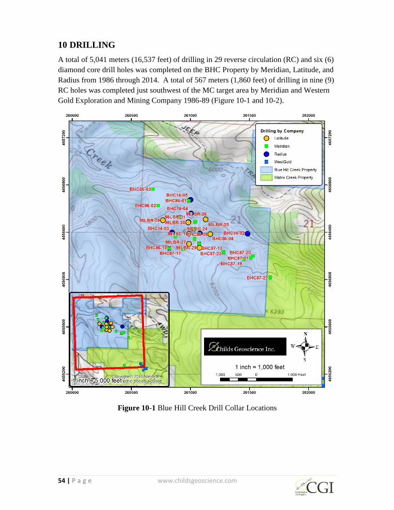
54 | P a g e www.childsgeoscience.com
10 DRILLING
A total of 5,041 meters (16,537 feet) of drilling in 29 reverse circulation (RC) and six (6)
diamond core drill holes was completed on the BHC Property by Meridian, Latitude, and
Radius from 1986 through 2014. A total of 567 meters (1,860 feet) of drilling in nine (9)
RC holes was completed just southwest of the MC target area by Meridian and Western
Gold Exploration and Mining Company 1986-89 (Figure 10-1 and 10-2).
Figure 10-1 Blue Hill Creek Drill Collar Locations
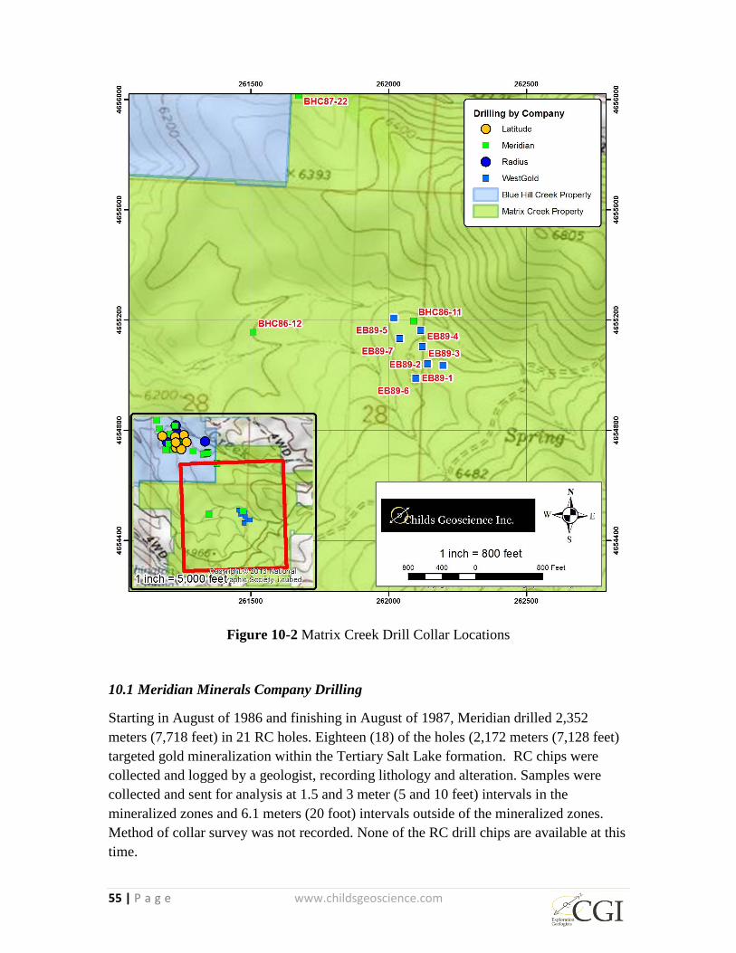
55 | P a g e www.childsgeoscience.com
Figure 10-2 Matrix Creek Drill Collar Locations
10.1 Meridian Minerals Company Drilling
Starting in August of 1986 and finishing in August of 1987, Meridian drilled 2,352
meters (7,718 feet) in 21 RC holes. Eighteen (18) of the holes (2,172 meters (7,128 feet)
targeted gold mineralization within the Tertiary Salt Lake formation. RC chips were
collected and logged by a geologist, recording lithology and alteration. Samples were
collected and sent for analysis at 1.5 and 3 meter (5 and 10 feet) intervals in the
mineralized zones and 6.1 meters (20 foot) intervals outside of the mineralized zones.
Method of collar survey was not recorded. None of the RC drill chips are available at this
time.
56 | P a g e www.childsgeoscience.com
Meridian was targeting gold mineralization within the Tertiary Salt Lake formation (Tsl)
with eighteen (18) of the holes totaling 2,172 meters (7,128 feet). Significant clay
alteration and zones of silicification along with quartz veining were intersected within the
Tsl. Eleven of the eighteen holes intersected anomalous gold mineralization. Difficult
ground conditions presented challenging drilling and as a result, several holes were
terminated before reaching the planned depth. Five holes ended in mineralization, with
Au values higher than 0.34 g/t (0.010 opt). Significant intersections include 128 m @
0.62 g/t Au (420 feet @ 0.018 opt) (BHC86-04), 88.4 m @ 0.58 g/t Au (290 feet @ 0.017
opt) (BHC86-05), 33.5 m @ 0.38 g/t Au (110 feet @ 0.011 opt) (BHC86-05), and 79.2 m
@ 0.82 g/t Au (260 feet @ 0.024 opt) Au (BHC86-09). Table 10-1 lists true widths of
significant intercepts based on the average geometry of the ore body (10° dip/210° dip
direction).
Meridian drilled 140 meters (460 feet) in two RC holes (BHC86-11 and BHC86-12) in
1986 in the MC area, and neither of these holes contained significant gold assays.
10.2 Western Gold Exploration and Mining Co. Drilling
During 1989 (specific dates unknown) WestGold drilled 427 meters (1,400 feet) in seven
RC holes targeting high angle structures in Paleozoic sediments just southwest of the MC
target area. The exact collar locations cannot be confirmed. Six of the seven holes
intersected short (< 4.6 meters (15 feet)) zones of anomalous Au (< 0.55 g/t (0.016 opt)).
These holes are included for historic significance only and have not been used in resource
estimation (Table 10-2).
10.3 Latitude Minerals Inc. Drilling
Between June and August of 1998 Latitude drilled 1,245 meters (4,084 feet) in eight (8)
RC holes and 135 meters (444 feet) in one core hole. RC chips were collected and split
using a Jones riffle splitter. When water was encountered, a rotating wet splitter was
used. Chips were logged by a geologist, recording lithology and alteration. Samples were
collected and sent for analysis at 1.5 meter (5 foot) intervals in the known mineralized
zones and at 3 meter (10 foot) intervals in some intervals in the known barren zones.
Portions of the barren intervals were not sampled. Drill core was recovered by the
drilling company employees and logged by a geologist recording lithology, alteration,
major structural information, and core recovery. Sample intervals were selected based on
lithologies and alteration and did not exceed 3 meters (10 feet). Core was split or sawed,
with half of the core sent for analysis and the remaining half retained. Collar locations
were surveyed using Brunton compass and tape in relation to established ground survey
points. None of the RC drill chips or core from drilling is available at this time.
The Latitude drilling program targeted north-trending feeders and explored for
mineralization within the Paleozoic carbonate basement units below the Salt Lake
formation (Sturm, 2013). As with the earlier Meridian drill program, difficult drilling

57 | P a g e www.childsgeoscience.com
conditions were encountered and, as a result, several holes did not reach planned depth.
Three of the nine drill holes intersected the underlying Paleozoic units.
All nine (9) of the drill holes intersected significant continuous zones of anomalous gold
and sinter intervals within the Tsl ranging from 7.6meters (25 feet) to 105 meters (345
feet). Significant downhole intersections include 74.7 m @ 0.48 g/t Au (245 feet @
0.014 opt) (98LBR-25), 96 m @ 0.55 g/t Au (315 feet @ 0.016 opt) (98LBR-26), and
79.2 m @ 0.45 g/t Au (260 feet @ 0.013 opt) (98LBR-27). Table 10-3 lists true widths of
significant intercepts based on the average geometry of the ore body (10° dip/210° dip
direction). These results confirm the presence of a large area of anomalous Au
mineralization within the Tertiary units similar to that defined by the Meridian drilling.
The mineralized intervals cited here are downhole lengths
The Latitude drilling, as with the earlier Meridian drilling, encountered poor drilling
conditions which prevented reaching planned depths in several holes. Four of the nine
holes ended in mineralized rock with values greater than 0.34 g/t (0.010 opt). The
recovery rate for the single core hole (98LBC-1) within the mineralized zone was poor
(50%). As a result of poor recovery and an unconfirmed collar location, this hole was not
included in the resource estimation database used in the present report.
10.4 Radius Gold Drilling
Between August and October of 2014, Black Rock Drilling contractors, under contract to
Radius, drilled 1,308 meters (4,292 feet) in five (5) diamond drill core holes sized
HQ/NQ. Drill core was recovered by the Black Rock Drilling employees and logged by a
geologist recording lithology, alteration, major structural information, rock quality
designation, and core recovery. Overall core recovery was 90%. Sample intervals were
selected based on lithologies and alteration and did not exceed 3 meters (10 feet). Core
was split or sawed, half of the core sent for analysis and the remaining half retained.
Collar locations were recorded in UTM using modern GPS instruments.
Three of the holes (BHC14-01, BHC14-02, BHC14-03) drilled by Radius were designed
to further test the Paleozoic units underlying the Tsl. These targets included several
resistivity anomalies identified by the 2008 CSAMT survey suggestive of possible
structural feeder systems. The two remaining holes targeted on strike extension of
mineralization within the Tsl.
Three of the holes confirmed the presence of mineralization within the Tsl with
significant downhole intersections including 126 m @ 0.069 g/t (413 feet @ 0.020 g/t)
(BHC14-01), 16.5 m @ 1.10 g/t (54.2 feet @ 0.032 opt) (BHC14-03), and 24.5 m @ 0.79
g/t (80.3 feet @ 0.023 opt) (BHC14-04) (Plates 7-2, 7-3, 8-2). Table 10-4 lists true
widths of significant intercepts based on the average geometry of the ore body (10°

58 | P a g e www.childsgeoscience.com
dip/210° dip direction). Though mineralization was not encountered in the Paleozoic
rocks, all five of the Radius holes intersected the Tertiary/Paleozoic contact.
It is the authors’ opinion that the quality and method of drill hole data collection is
adequate for use in estimating an inferred mineral resource.
Table 10-1 Summary of historic Meridian drill results for the Blue Hill Creek and Matrix
Creek Properties
Hole ID Type Easting Northing Az/Inclin. TD (m) Interval (m) True Width (m) Au (g/t)
BHC86-01 RC 260987 4656668 218/-54 122 - - NSA
BHC86-02 RC 260727 4656626 135/-58 85 3.0-15.2 5.9 0.48
BHC86-03 RC 260684 4656765 175/-69 91 - - NSA
BHC86-04 RC 261039 4656485 30/-68 152 3.0-131.1 67.8 0.62
BHC86-05* RC 261042 4656489 210/-58 134 3.0-91.4 33.1 0.58
100.6-134.1 12.6 0.38
BHC86-06 RC 260903 4656529 186/-58 104 42.7-45.7 1.2 0.38
64.0-67.1 1.2 0.38
91.4-100.6 3.5 0.34
BHC86-07 RC 260766 4656498 172/-68 98 24.4-36.6 3.0 0.62
64.0-85.3 5.2 0.48
BHC86-08 RC 261168 4656385 45/-68 104 27.4-30.5 8.0 0.41
45/-68 104 48.8-61.0 6.4 0.38
BHC86-09* RC 261035 4656344 -90 146 67.1-146.3 78.0 0.82
BHC86-10 RC 260821 4656263 -90 91 - - NSA
BHC86-11** RC 262092 4655197 -90 49 - - NSA
BHC86-12** RC 261510 4655156 -90 91 - - NSA
BHC87-13 RC 261075 4656304 -90 151 88.4-109.7 21.0 0.41
BHC87-14 RC 261026 4656426 225/-59 114 - - NSA
BHC86-15* RC 261073 4656385 218/-58 122 70.1-121.9 19.5 0.75
BHC87-16 RC 260992 4656387 -90 116 - - NSA
BHC87-17 RC 260939 4656256 45/-59 180 152.4-173.7 13.9 0.38
BHC86-18* RC 260876 4656366 45/-59 145 128.0-144.8 10.9 0.45
BHC87-19 RC 261455 4656171 77/-59 77 - - NSA
BHC87-20 RC 261530 4656199 -90 44 - - NSA
BHC87-21 RC 261512 4656181 255/-59 69 - - NSA
BHC87-22 RC 261675 4656015 273/-59 67 - - NSA
BHC86-23* RC 261281 4656230 181/-59 140 105.2-125.0 7.5 0.48
Total 2596
*Ends in Mineralization (< 0.34 g/t)
**Exact location unkown - not used in Resource Estimate
True Width based on ore body geometry (10° dip/210° dip direction)

59 | P a g e www.childsgeoscience.com
Table 10-2 Summary of historic WestGold drill hole results on the Matrix Creek
Property
Table 10-3 Summary of historic Latitude drill results on the Blue Hill Creek Property
Table 10-4 Summary of historic Radius Gold drill results on the Blue Hill Creek Property
Hole ID Type Easting Northing Az/Inclin. TD (m) Length (m)1 Au (g/t)
EB89-1** RC 262092 4655197 -90 61 1.5 0.38
4.6 0.45
EB89-2** RC 261510 4655156 -90 61 1.5 0.34
EB89-3** RC 262092 4655197 -90 61 1.5 0.45
EB89-4** RC 261510 4655156 -90 61 4.6 0.48
EB89-5** RC 262092 4655197 -90 61 1.5 0.41
EB89-6** RC 261510 4655156 -90 61 1.5 0.38
EB89-7** RC 261510 4655156 -90 61 NSA
Total 427
**Exact location unknown - not used in Resource estimate
1 Downhole length, true width unknown
Hole ID Type Easting Northing Az/Inclin. TD (m) Interval (m) True Width (m) Au (g/t)
98LBR-24 RC 261168 4656385 53/-50 183 39.6-68.6 21.9 0.55
129.5-166.1 27.6 0.58
98LBR-25 RC 261128 4656509 311/-75 177 7.6-82.3 31.6 0.48
98LBR-26 RC 261128 4656509 311/-50 140 10.7-106.7 73.5 0.55
98LBR-27* RC 260987 4656303 -90 177 36.6-115.8 78.0 0.45
98LBR28 RC 260767 4656501 -90 180 41.1-67.1 25.5 0.55
98LBR-29* RC 261076 4656269 266/-65 194 131.1-138.7 4.4 0.34
Includes 164.6-193.5 16.6 0.41
98LBR-30* RC 260981 4656483 210/-60 76 62.5-75.9 8.6 0.55
98LBR31 RC 260984 4656486 210/-80 119 59.4-96.0 12.4 0.55
98LBC-1* Core 260987 4656386 -90 135 111.3-135.3 23.7 0.6
Total
*Ends in Mineralization (< 0.34 g/t)
True Width based on ore body geometry (10° dip/210° dip direction)
Hole ID Type Easting Northing Az/Inclin. TD (m) Interval (m) True Width (m) Au (g/t)
BHC14-01 Core 261080 4656392 270/-65 397 59.7-185.6 42.5 0.69
BHC14-02 Core 261483 4656388 270/-75 294 - - NSA
BHC14-03 Core 260844 4656399 90/-65 288 129.7-146.2 8.2 1.10
Includes 129.7-133.6 3.9 1.75
BHC14-04 Core 261004 4656560 115/-55 198 24.4-48.9 14.1 0.79
Includes 44.2-48.9 4.6 1.47
BHC14-05 Core 261001 4656675 115/-55 131 - - NSA
Total
*Ends in Mineralization (< 0.34 g/t)
True Width based on ore body geometry (10° dip/210° dip direction)

60 | P a g e www.childsgeoscience.com
11 SAMPLE PREPARATION, ANALYSES AND SECURITY
All of the laboratories used by the companies cited here, including analyses requested by
previous operators and the present authors, are independent of the companies doing the
work on the properties and are ISO or otherwise certified.
11.1 Meridian/Latitude
Meridian RC drill samples were delivered to and analyzed by analytical labs Barringer
Laboratories Inc. (1986) and Intermountain Analytical Services (1987). Original
certificates of analysis document that gold content was determined by fire assay. No
sample preparation method was noted. Other than statement of delivery to the lab by
Meridian personnel, no record exists regarding sample chain of command.
Latitude geologists collected and retained drill samples on site and later transported
samples to the analytical lab Chemex Labs Inc. (ALS) in Reno, Nevada. (electronic
correspondence J. Carden 8/4/16). Samples were crushed, split, and pulverized (30g to
150mesh). Gold content was determined by the fire assay method.
Modern internal QA/QC protocols were not documented by Meridian or Latitude. For
this reason, hole lithologic logs and analytical results for several holes collared within
15.2 meters (50 feet) of each other were compared by the authors (Figure 11-1). Based on
these comparisons it is the authors’ opinion that the sample preparation, analyses, and
security employed by Meridian and Latitude are adequate for use in estimating an
inferred mineral resource.
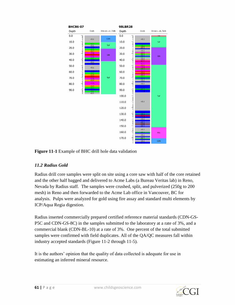
61 | P a g e www.childsgeoscience.com
Figure 11-1 Example of BHC drill hole data validation
11.2 Radius Gold
Radius drill core samples were split on site using a core saw with half of the core retained
and the other half bagged and delivered to Acme Labs (a Bureau Veritas lab) in Reno,
Nevada by Radius staff. The samples were crushed, split, and pulverized (250g to 200
mesh) in Reno and then forwarded to the Acme Lab office in Vancouver, BC for
analysis. Pulps were analyzed for gold using fire assay and standard multi elements by
ICP/Aqua Regia digestion.
Radius inserted commercially prepared certified reference material standards (CDN-GS-
P5C and CDN-GS-8C) in the samples submitted to the laboratory at a rate of 3%, and a
commercial blank (CDN-BL-10) at a rate of 3%. One percent of the total submitted
samples were confirmed with field duplicates. All of the QA/QC measures fall within
industry accepted standards (Figure 11-2 through 11-5).
It is the authors’ opinion that the quality of data collected is adequate for use in
estimating an inferred mineral resource.
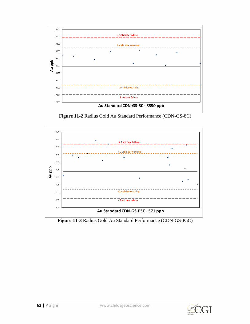
62 | P a g e www.childsgeoscience.com
Figure 11-2 Radius Gold Au Standard Performance (CDN-GS-8C)
Figure 11-3 Radius Gold Au Standard Performance (CDN-GS-P5C)
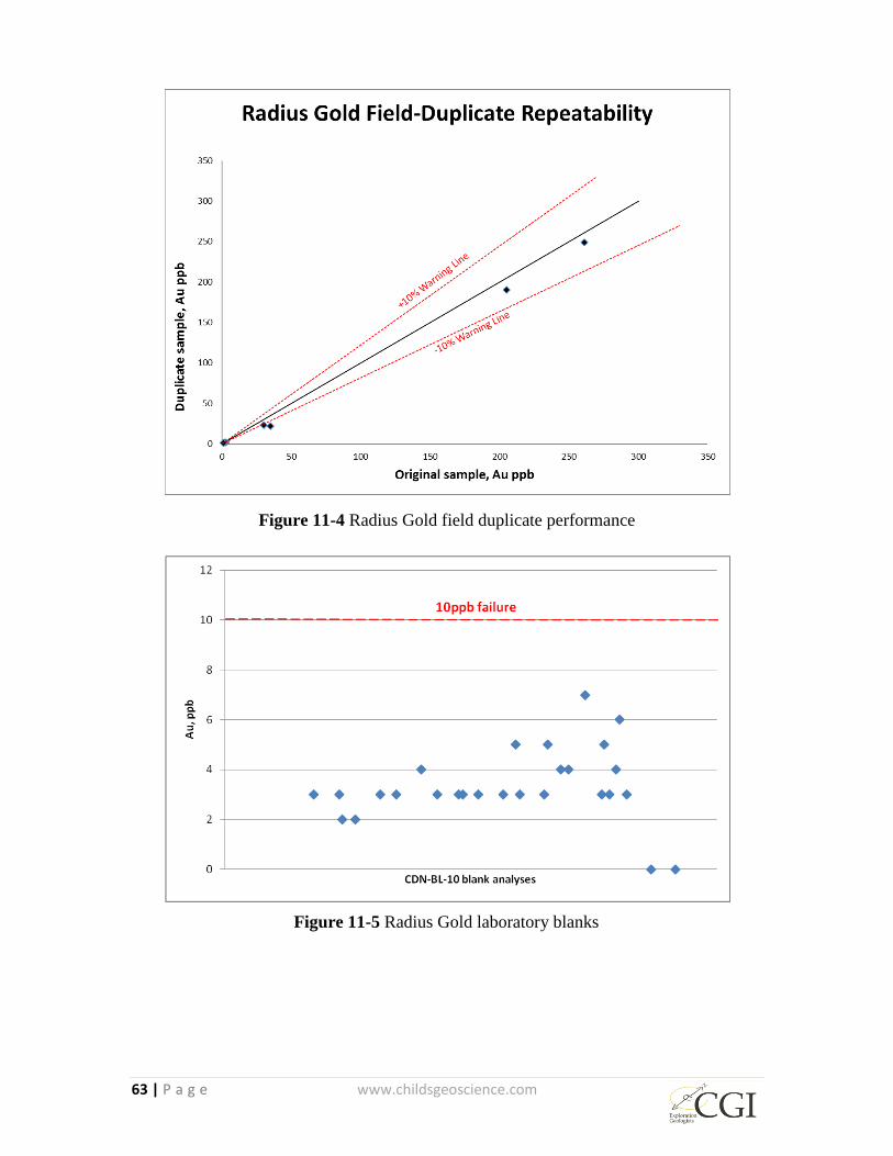
63 | P a g e www.childsgeoscience.com
Figure 11-4 Radius Gold field duplicate performance
Figure 11-5 Radius Gold laboratory blanks
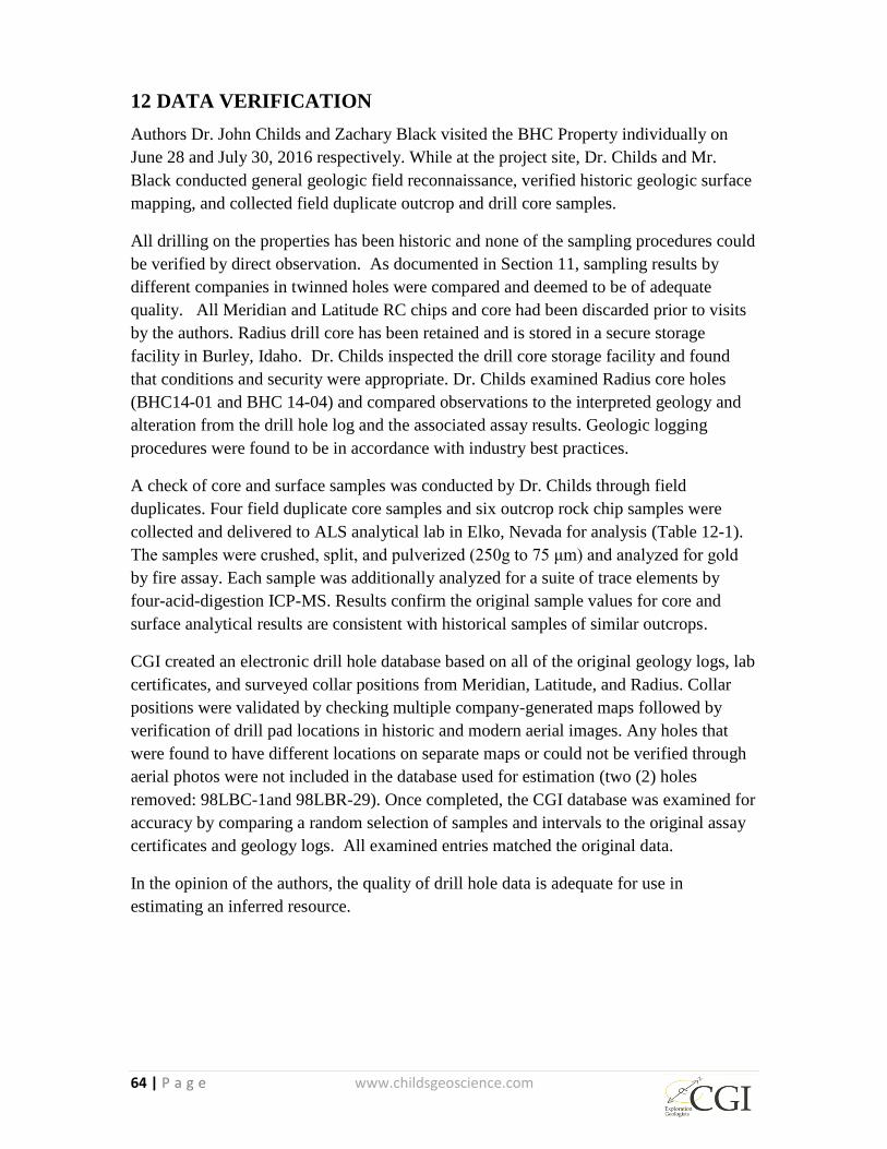
64 | P a g e www.childsgeoscience.com
12 DATA VERIFICATION
Authors Dr. John Childs and Zachary Black visited the BHC Property individually on
June 28 and July 30, 2016 respectively. While at the project site, Dr. Childs and Mr.
Black conducted general geologic field reconnaissance, verified historic geologic surface
mapping, and collected field duplicate outcrop and drill core samples.
All drilling on the properties has been historic and none of the sampling procedures could
be verified by direct observation. As documented in Section 11, sampling results by
different companies in twinned holes were compared and deemed to be of adequate
quality. All Meridian and Latitude RC chips and core had been discarded prior to visits
by the authors. Radius drill core has been retained and is stored in a secure storage
facility in Burley, Idaho. Dr. Childs inspected the drill core storage facility and found
that conditions and security were appropriate. Dr. Childs examined Radius core holes
(BHC14-01 and BHC 14-04) and compared observations to the interpreted geology and
alteration from the drill hole log and the associated assay results. Geologic logging
procedures were found to be in accordance with industry best practices.
A check of core and surface samples was conducted by Dr. Childs through field
duplicates. Four field duplicate core samples and six outcrop rock chip samples were
collected and delivered to ALS analytical lab in Elko, Nevada for analysis (Table 12-1).
The samples were crushed, split, and pulverized (250g to 75 μm) and analyzed for gold
by fire assay. Each sample was additionally analyzed for a suite of trace elements by
four-acid-digestion ICP-MS. Results confirm the original sample values for core and
surface analytical results are consistent with historical samples of similar outcrops.
CGI created an electronic drill hole database based on all of the original geology logs, lab
certificates, and surveyed collar positions from Meridian, Latitude, and Radius. Collar
positions were validated by checking multiple company-generated maps followed by
verification of drill pad locations in historic and modern aerial images. Any holes that
were found to have different locations on separate maps or could not be verified through
aerial photos were not included in the database used for estimation (two (2) holes
removed: 98LBC-1and 98LBR-29). Once completed, the CGI database was examined for
accuracy by comparing a random selection of samples and intervals to the original assay
certificates and geology logs. All examined entries matched the original data.
In the opinion of the authors, the quality of drill hole data is adequate for use in
estimating an inferred resource.
65 | P a g e www.childsgeoscience.com
13 MINERAL PROCESSING AND METALLURICAL TESTING
There are no known data regarding mineral processing and metallurgical testing.
14 MINERAL RESOURCE ESTIMATE
Zachary J. Black, SME-RM, a Resource Geologist with Hard Rock Consulting (“HRC”) is
responsible for the mineral resource estimate herein. Mr. Black is a qualified person as defined
by NI 43-101 and is independent of Otis. HRC estimated the mineral resource for the BHC
Property from drill-hole data, using controls from the main rock types with an Inverse Distance
(“ID”) algorithm.
The mineral resources presented in this Technical Report are classified under the categories of
Measured, Indicated and Inferred in accordance with the standards defined by the Canadian
Institute of Mining, Metallurgy and Petroleum (“CIM”) “CIM Definition Standards - For
Mineral Resources and Mineral Reserves”, prepared by the CIM Standing Committee on
Reserve Definitions and adopted by CIM Council on May 10, 2014. These resource
classifications reflect the relative confidence of the grade estimates. HRC knows of no
environmental, permitting, legal, socio-economic, marketing, political, or other factors that may
materially affect the mineral resource estimate.
14.1 Geologic Model
The BHC Property is dominated by disseminated and stockwork mineralization overprinted by
hydrothermal breccias, sinters, and clay-hosted mineralization. The mineralization is
predominately oxidized. The mineralization is open both along strike and down dip within the
Salt Lake formation lower units. A basal Paleozoic limestone is in fault contact with the Salt
Lake formation and to date is not recognized as a host rock for BHC. It is postulated that the
SAMPLE #
RADIUS
GOLD
SAMPLE
#
CHILDS
HOLE
NUMBE
R
INTERVA
L- ft.
Au ppb-
Radius 2014
Au ppb-
Childs 2016
Ag ppm-
Radius 2014
Ag ppm-
Childs 2016
2699009 98395 BHC-14-
1 46.8-51.5 323 348 1.5 2.32
2699046 98396 BHC-14-
1 205.5-210.1 645 572 1.4 4.42
2699072 98397 BHC-14-
1 321.5-328.0 3098 5050 14.1 25.5
2699787 98399 BHC-14-
4 396.0-404.0 417 418 15.2 6.91
Table 12-1 Results of duplicate core sample collected by Dr. John Childs
66 | P a g e www.childsgeoscience.com
fault contact is a detachment fault that has displaced the roots of the system from the upper
mineralization.
The geologic model was updated using Leapfrog Geo V3.1.1 from drill hole information. The
following process was used to generate the geologic model:
Import drill hole database;
Develop a 3-dimensional structural model from the surface geologic maps and drill hole
intercepts;
Select basal contacts of each formation;
Generate geologic surfaces using a linear interpolant based on the contact points within
individual fault compartments;
Generate Sinter shapes based on drill hole intercepts;
Adjust surfaces in areas that deviate substantially from Otis interpretation;
Create geologic solids for each formation.
Figure 14-1 is a South facing cross-section of the final BHC geologic model based on the drill
hole data and surface maps.
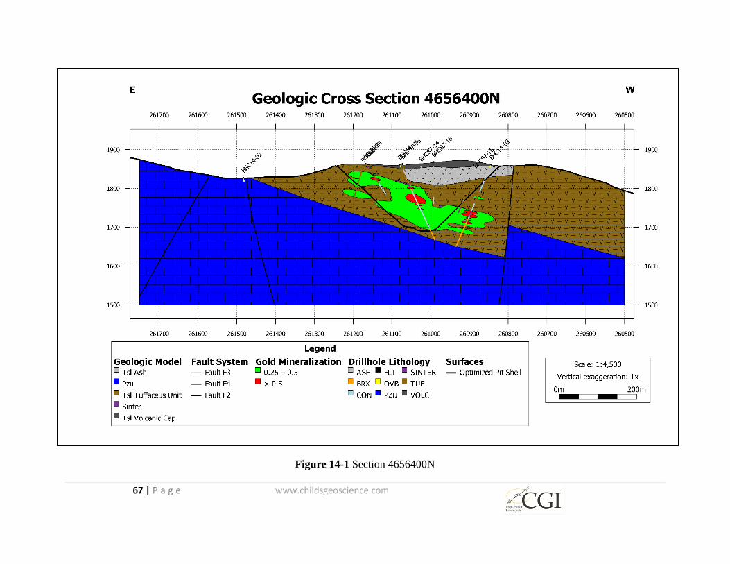
67 | P a g e www.childsgeoscience.com
Figure 14-1 Section 4656400N
68 | P a g e www.childsgeoscience.com
14.2 Data Used for the Grade Estimation
The present database has been built to include 5 core holes totaling 1,308 meters (4,292 feet) and
28 reverse circulation holes totaling 3,403 meters (11,167 feet). The drill hole database contains
gold assay analytical information for 2,224 sample intervals.
14.3 Block Model Physical Limits
HRC created a three-dimensional (“3D”) block model in MicroModel mining software. The
block model was created with individual block dimensions of 10 x 10 x 5 m (32.8 x 32.8 x 16.4
feet) (xyz). The model origin is located at 260,500 east, 4,655,950 north, and at an elevation of
1,500 meters (4,921 feet) above sea level (masl). The block model extends 1,250 meters (4,101
feet)-125 blocks) in the easting direction, 950 meters (3,117 feet)-95 blocks) in the northing
direction, and vertically 500 meters (1,640 feet) -100 blocks) to an elevation of 2,000 meters
(6,562 feet) 2,000 masl. All of the block model coordinates are stored as UTM NAD83, Zone 12
meters with elevations based on North American Vertical Datum (“NAVD”) 88. All property
and minerals within the block model extents are owned or claimed by Otis.
14.4 Bulk Density
No density tests have been completed on the project rock types to date. HRC used an average
specific gravity of 2.5 to calculate the tonnage of the mineral resources contained herein.
14.5 Estimation Domains
In order to accommodate statistical search parameters appropriate for individual mineralization
styles and structural orientations, the block model was divided into five fault compartments, only
two of which contain mineralization. Figure 14-2 shows the modeled fault compartments with
the blue and green areas representing the areas containing the mineralization. The zones were
delineated based on faults identified in the basal Paleozoic limestone unit.

69 | P a g e www.childsgeoscience.com
Figure 14-2 Estimation Domains (plan view)
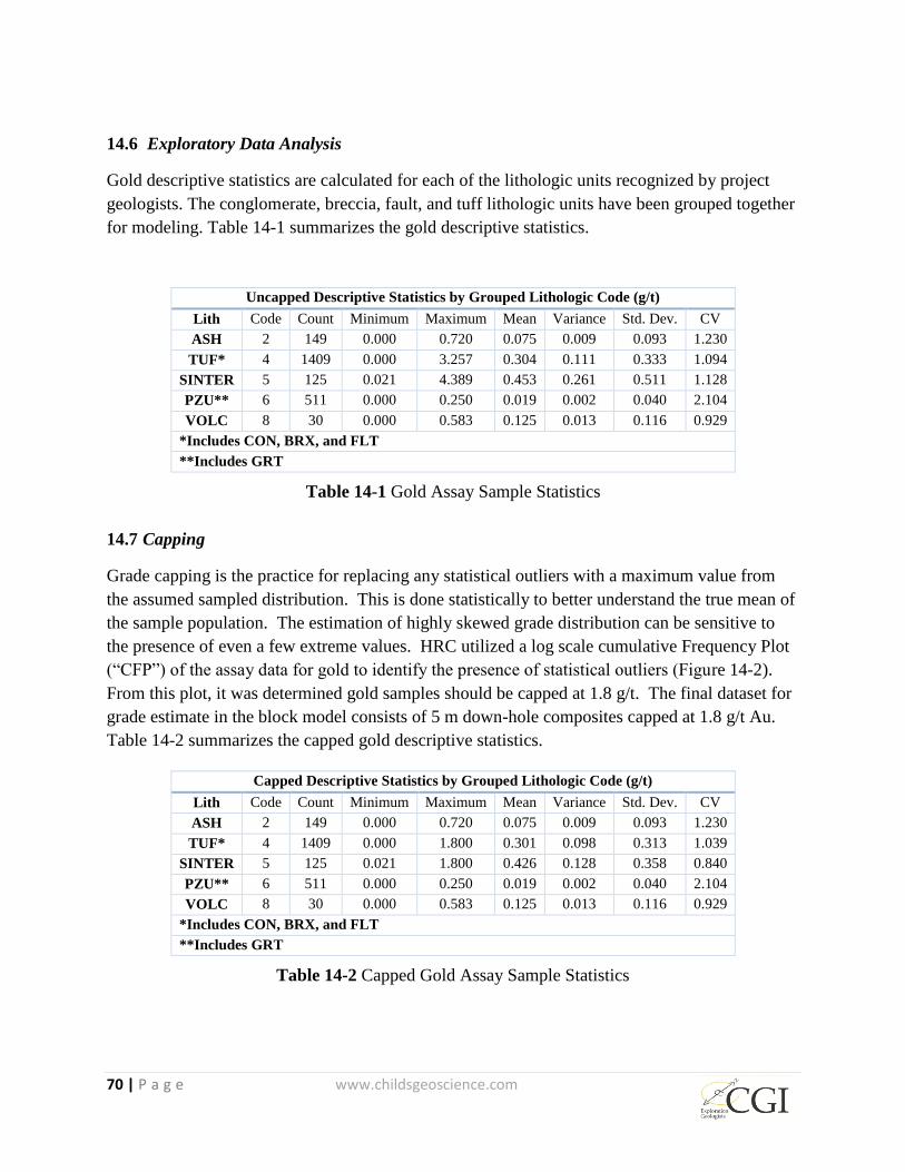
70 | P a g e www.childsgeoscience.com
14.6 Exploratory Data Analysis
Gold descriptive statistics are calculated for each of the lithologic units recognized by project
geologists. The conglomerate, breccia, fault, and tuff lithologic units have been grouped together
for modeling. Table 14-1 summarizes the gold descriptive statistics.
Uncapped Descriptive Statistics by Grouped Lithologic Code (g/t)
Lith Code Count Minimum Maximum Mean Variance Std. Dev. CV
ASH 2 149 0.000 0.720 0.075 0.009 0.093 1.230
TUF* 4 1409 0.000 3.257 0.304 0.111 0.333 1.094
SINTER 5 125 0.021 4.389 0.453 0.261 0.511 1.128
PZU** 6 511 0.000 0.250 0.019 0.002 0.040 2.104
VOLC 8 30 0.000 0.583 0.125 0.013 0.116 0.929
*Includes CON, BRX, and FLT
**Includes GRT
Table 14-1 Gold Assay Sample Statistics
14.7 Capping
Grade capping is the practice for replacing any statistical outliers with a maximum value from
the assumed sampled distribution. This is done statistically to better understand the true mean of
the sample population. The estimation of highly skewed grade distribution can be sensitive to
the presence of even a few extreme values. HRC utilized a log scale cumulative Frequency Plot
(“CFP”) of the assay data for gold to identify the presence of statistical outliers (Figure 14-2).
From this plot, it was determined gold samples should be capped at 1.8 g/t. The final dataset for
grade estimate in the block model consists of 5 m down-hole composites capped at 1.8 g/t Au.
Table 14-2 summarizes the capped gold descriptive statistics.
Capped Descriptive Statistics by Grouped Lithologic Code (g/t)
Lith Code Count Minimum Maximum Mean Variance Std. Dev. CV
ASH 2 149 0.000 0.720 0.075 0.009 0.093 1.230
TUF* 4 1409 0.000 1.800 0.301 0.098 0.313 1.039
SINTER 5 125 0.021 1.800 0.426 0.128 0.358 0.840
PZU** 6 511 0.000 0.250 0.019 0.002 0.040 2.104
VOLC 8 30 0.000 0.583 0.125 0.013 0.116 0.929
*Includes CON, BRX, and FLT
**Includes GRT
Table 14-2 Capped Gold Assay Sample Statistics

71 | P a g e www.childsgeoscience.com
Figure 14-3 Gold Log Probability Plot
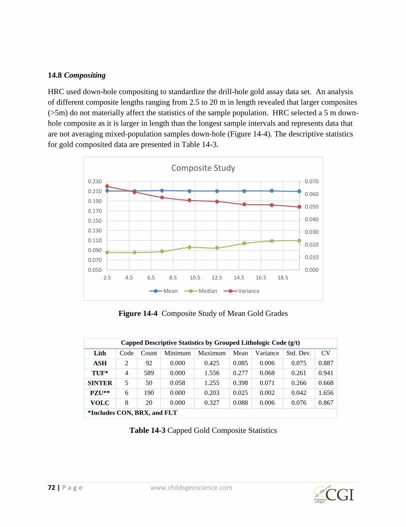
72 | P a g e www.childsgeoscience.com
14.8 Compositing
HRC used down-hole compositing to standardize the drill-hole gold assay data set. An analysis
of different composite lengths ranging from 2.5 to 20 m in length revealed that larger composites
(>5m) do not materially affect the statistics of the sample population. HRC selected a 5 m down-
hole composite as it is larger in length than the longest sample intervals and represents data that
are not averaging mixed-population samples down-hole (Figure 14-4). The descriptive statistics
for gold composited data are presented in Table 14-3.
Figure 14-4 Composite Study of Mean Gold Grades
Table 14-3 Capped Gold Composite Statistics
0.000
0.010
0.020
0.030
0.040
0.050
0.060
0.070
0.050
0.070
0.090
0.110
0.130
0.150
0.170
0.190
0.210
0.230
2.5 4.5 6.5 8.5 10.5 12.5 14.5 16.5 18.5
Composite Study
Mean Median Variance
Capped Descriptive Statistics by Grouped Lithologic Code (g/t)
Lith Code Count Minimum Maximum Mean Variance Std. Dev. CV
ASH 2 92 0.000 0.425 0.085 0.006 0.075 0.887
TUF* 4 589 0.000 1.556 0.277 0.068 0.261 0.941
SINTER 5 50 0.058 1.255 0.398 0.071 0.266 0.668
PZU** 6 190 0.000 0.203 0.025 0.002 0.042 1.656
VOLC 8 20 0.000 0.327 0.088 0.006 0.076 0.867
*Includes CON, BRX, and FLT
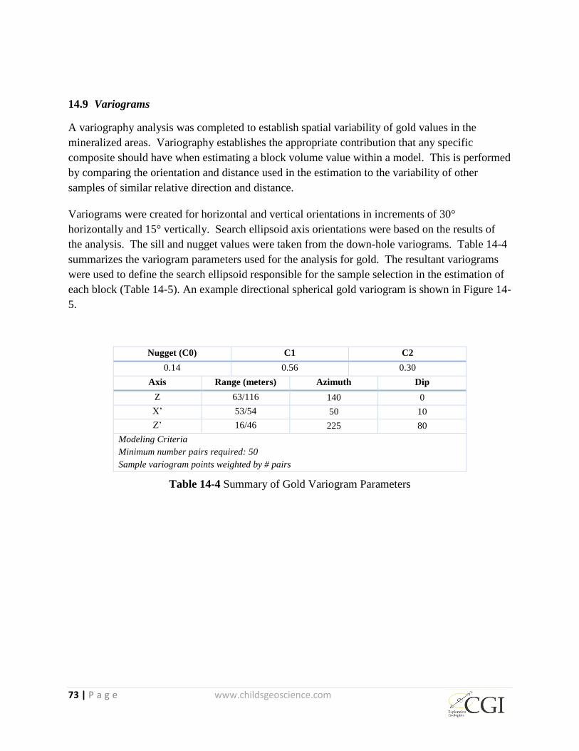
73 | P a g e www.childsgeoscience.com
14.9 Variograms
A variography analysis was completed to establish spatial variability of gold values in the
mineralized areas. Variography establishes the appropriate contribution that any specific
composite should have when estimating a block volume value within a model. This is performed
by comparing the orientation and distance used in the estimation to the variability of other
samples of similar relative direction and distance.
Variograms were created for horizontal and vertical orientations in increments of 30°
horizontally and 15° vertically. Search ellipsoid axis orientations were based on the results of
the analysis. The sill and nugget values were taken from the down-hole variograms. Table 14-4
summarizes the variogram parameters used for the analysis for gold. The resultant variograms
were used to define the search ellipsoid responsible for the sample selection in the estimation of
each block (Table 14-5). An example directional spherical gold variogram is shown in Figure 14-
5.
Nugget (C0) C1 C2
0.14 0.56 0.30
Axis Range (meters) Azimuth Dip
Z 63/116 140 0
X’ 53/54 50 10
Z’ 16/46 225 80
Modeling Criteria
Minimum number pairs required: 50
Sample variogram points weighted by # pairs
Table 14-4 Summary of Gold Variogram Parameters

74 | P a g e www.childsgeoscience.com
Figure 14-5 Spherical Gold Directional Variogram

75 | P a g e www.childsgeoscience.com
In grade modeling, the variograms were used to establish search distances. Comparisons were
made with ordinary kriging (“OK”) and inverse distance-squared (ID2.5
) methods. The ID2.5
method was selected for reporting due to better fit with drill-hole data throughout the model.
The search ellipse parameters used for estimation are shown in Table 14-5 below. These
parameters feature a major axis orientation striking 120 degrees and dipping 15 degrees to the
southwest.
14.10 Estimation Methodology
Gold grades were estimated in each domain by using incremental search ellipses oriented in the
direction of maximum continuity to provide an estimation of the gold grade. The estimation of
each block was based on a factor of the distance in an anisotropic direction as established by the
first structure range (Table 14-4) from the variogram model for the domain being estimated.
Inverse Distance to the power of 2.5 was used to estimate grade for all domains. Estimation
parameters for each of the domains are presented in Table 14-5.
Blue Hill Creek Estimation Parameters
No. of composites 1st
Pass
2nd
Pass
Minimum 4 3
Maximum 9 9
Max per DDH 4 3
Search Ellipsoid Distance (m)
Primary 63 20
Secondary 53 20
Tertiary 16 20
Table 14-5 Estimation Parameters
14.11 Mineral Resource Classification
The mineral resources estimated for this report have been classified as inferred based on the
limited geologic evidence and lack of metallurgical test work.
14.12 Model Validation
Overall, HRC utilized several methods to validate the results of the ID2.5
method. The combined
evidence from these validation methods validate the ID2.5
method estimation model results.
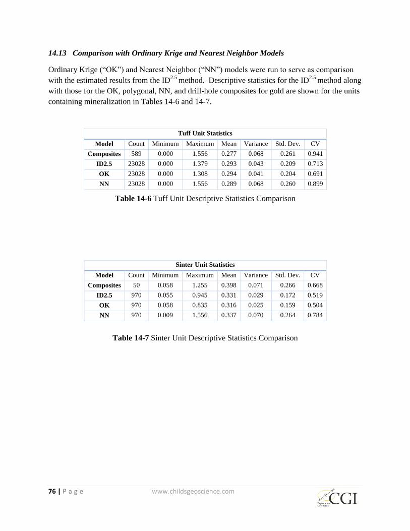
76 | P a g e www.childsgeoscience.com
14.13 Comparison with Ordinary Krige and Nearest Neighbor Models
Ordinary Krige (“OK”) and Nearest Neighbor (“NN”) models were run to serve as comparison
with the estimated results from the ID2.5
method. Descriptive statistics for the ID2.5
method along
with those for the OK, polygonal, NN, and drill-hole composites for gold are shown for the units
containing mineralization in Tables 14-6 and 14-7.
Tuff Unit Statistics
Model Count Minimum Maximum Mean Variance Std. Dev. CV
Composites 589 0.000 1.556 0.277 0.068 0.261 0.941
ID2.5 23028 0.000 1.379 0.293 0.043 0.209 0.713
OK 23028 0.000 1.308 0.294 0.041 0.204 0.691
NN 23028 0.000 1.556 0.289 0.068 0.260 0.899
Table 14-6 Tuff Unit Descriptive Statistics Comparison
Sinter Unit Statistics
Model Count Minimum Maximum Mean Variance Std. Dev. CV
Composites 50 0.058 1.255 0.398 0.071 0.266 0.668
ID2.5 970 0.055 0.945 0.331 0.029 0.172 0.519
OK 970 0.058 0.835 0.316 0.025 0.159 0.504
NN 970 0.009 1.556 0.337 0.070 0.264 0.784
Table 14-7 Sinter Unit Descriptive Statistics Comparison
77 | P a g e www.childsgeoscience.com
The overall reduction of the maximum, mean, standard deviation, and coefficient of variation
within the OK and ID2.5
models represent an appropriate amount of smoothing to account for the
point to block volume variance relationship. This is confirmed in Figure 14-6, comparing the
cumulative frequency plots of each of the models and drill-hole composites.
Figure 14-6 Cumulative Frequency Plot - Model Comparison (Composites – Green, NN –
Black, ID – Red, OK – Blue)

78 | P a g e www.childsgeoscience.com
14.13.1 Swath Plots
Swath plots were generated to compare average gold and silver grade in the composite samples,
estimated gold and silver grade from ID2.5
method and the two validation model methods (OK
and NN). The results from the ID2.5
model method, plus those for the validation OK model
method are compared using the swath plot to the distribution derived from the NN model method
and the composites used in the estimation. For comparison purposes, assay data from the 5-meter
composite samples are included in the swath plots along with the model results.
Six swath plots were generated:
Figure 14-7 shows average gold grade from west to east;
Figure 14-8 shows average gold grade from south to north;
Figure14-9 shows average gold grade in the 3-meter benches, from bottom to top.
Figure 14-7 East – West Swath Plot (Composites – Green, NN – Black, ID – Red, OK – Blue)

Figure 14-8 North - South Swath Plot (Composites – Green, NN – Black, ID – Red, OK – Blue)
Figure 14-9 Elevation Swath Plot (Composites – Green, NN – Black, ID – Red, OK – Blue)
82 | P a g e www.childsgeoscience.com
On a local scale, the NN model method does not provide a reliable estimate of grade, but on a
much larger scale, it represents an unbiased estimation of the grade distribution based on the total
data set. Therefore, if the ID2.5
model is unbiased, the grade trends may show local fluctuations
on a swath plot, but the overall trend should be similar to the distribution of grade from the NN.
Overall, there is good correlation between the grade models and the composite data, although
deviations occur near the edges of the deposit and in areas where the density of drilling is less.
14.13.2 Sectional Inspection
Bench plans, cross-sections, and long sections comparing modeled grades to the 5-meter
composites were reviewed by HRC as part of the model validation process. Figures 14-10 is an
example of a cross-section looking south located at 4656400 N. The figures show good
agreement between modeled grades and the composite grades. In addition, the modeled blocks
display continuity of grades along strike and down dip.
Figure 14-10 4,656,400N Cross Section with composite grades, estimated block grades, and the
optimized pit shell
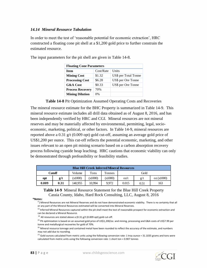
83 | P a g e www.childsgeoscience.com
14.14 Mineral Resource Tabulation
In order to meet the test of ‘reasonable potential for economic extraction’, HRC
constructed a floating cone pit shell at a $1,200 gold price to further constrain the
estimated resource.
The input parameters for the pit shell are given in Table 14-8.
Floating Cone Parameters
Item Cost/Rate Units
Mining Cost $1.32 US$ per Total Tonne
Processing Cost $6.28 US$ per Ore Tonne
G&A Cost $0.33 US$ per Ore Tonne
Process Recovery 70%
Mining Dilution 0%
Table 14-8 Pit Optimization Assumed Operating Costs and Recoveries
The mineral resource estimate for the BHC Property is summarized in Table 14-9. This
mineral resource estimate includes all drill data obtained as of August 8, 2016, and has
been independently verified by HRC and CGI. Mineral resources are not mineral
reserves and may be materially affected by environmental, permitting, legal, socio-
economic, marketing, political, or other factors. In Table 14-9, mineral resources are
reported above a 0.31 g/t (0.009 opt) gold cut-off, assuming an average gold price of
US$1,200 per ounce. This cut-off reflects the potential economic, marketing, and other
issues relevant to an open pit mining scenario based on a carbon absorption recovery
process following cyanide heap leaching. HRC cautions that economic viability can only
be demonstrated through prefeasibility or feasibility studies.
Table 14-9 Mineral Resource Statement for the Blue Hill Creek Property
Cassia County, Idaho, Hard Rock Consulting, LLC, August 8, 2016
*Notes: (1) Mineral Resources are not Mineral Reserves and do not have demonstrated economic viability. There is no certainty that all or any part of the Mineral Resources estimated will be converted into Mineral Reserves. (2) Inferred Mineral Resources captured within the pit shell meet the test of reasonable prospect for economic extraction and can be declared a Mineral Resource. (4) All resources are stated above a (0.31 g/t (0.009 opt) gold cut-off. (5) Pit optimization is based on an assumed gold price of US$1,200/oz. and mining, processing and G&A costs of US$7.99 per tonne and metallurgical recoveries for gold of 70%. (6) Mineral resource tonnage and contained metal have been rounded to reflect the accuracy of the estimate, and numbers may not add due to rounding. (7) Gold ounces calculated from metric units using the following conversion rate: 1 troy ounce = 31.1035 grams and tons were calculated from metric units using the following conversion rate: 1 short ton = 0.907 tonnes
Volume Tons Tonnes
opt g/t (x1000) (x1000) (x1000) oz/t g/t oz (x1000)
0.009 0.31 140,955 10,994 9,972 0.015 0.51 163
Blue Hill Creek Inferred Mineral Resources
Cutoff Gold

84 | P a g e www.childsgeoscience.com
23 ADJACENT PROPERTIES
There are no immediately adjacent properties which might materially affect the
evaluation or interpretation of the BHC and MC Properties.
24 OTHER RELEVANT DATA AND INFORMATION
The authors are unaware of additional information concerning the BHC and MC Property
pertinent to this technical report.
25 INTERPRETATION AND CONCLUSIONS
The authors have reviewed the available BHC and MC Properties data in detail and have
visited the site. The authors believe that the data made available by Otis provide an
accurate and reasonable representation of the BHC and MC Properties.
It is apparent that the BHC and MC Properties hosts an underexplored low-sulfidation,
gold-mineralized, hot spring system. Results of past exploration, and interpretation of
exploration information, show that good potential exists for the discovery of a bulk
tonnage gold deposit. Geologic modelling and estimation of an inferred resource indicate
that the known mineralization dips to the west at a gentle angle into an area with a
coincident CSAMT geophysical anomaly. High priority exploration targets include: 1)
undiscovered portions of the gold-mineralized hot spring system covered beneath post-
mineral rocks; 2) higher-grade, gold mineralization within feeders to the gold-
mineralized hot spring system; and 3) possible mineralization beneath and to the west of
the present resource related to gently west-dipping detachment-style faults that may have
acted as sources for the high-angle mineralization in the existing resource.
The hot spring system is large and only partially exposed at surface. Drilling reveals
widespread silicification and silica cap development throughout much of the upper 61 to
91 meters (200 to 300 feet) of the system, with quartz stockwork present and breccia
textures common. Below the zone of silicification, drilling reveals clay alteration and
mica development over a vertical depth of up to 152 meters (500 feet) below the surface.
Brecciation increases with depth, until jasperoid, developed from the alteration of
Paleozoic carbonate basement rocks, and interspersed altered aplite dike material are
encountered. Post-mineral latite flows cover down-dropped sections of the system.
At BHC, potential exists for the discovery of a bulk tonnage gold deposit down dip to the
west. This assessment of the potential is based upon the presence of drill holes that
terminated in mineralization at depth and other holes having mineralized intervals that
have not been offset by drilling down dip. Potential for expansion of the resource is also
supported by the CSAMT geophysical data that shows resistivity response down dip
similar to the response in the known resource area. Potential for gold mineralization
exists within underlying Paleozoic rocks including re-crystallized limestone, jasperoid,
85 | P a g e www.childsgeoscience.com
and the “black matrix breccias” that project from the MC area westward beneath the
presently recognized resource. Recent sampling by Otis and check sampling by John
Childs along “Discovery Ridge” in the NW ¼ of Section 27 to the east of BHC have
confirmed gold values up to 0.288 ppm and silver values up to 72.8 ppm in the black
matrix breccias.
The BHC mineralization and the mineralization in the MC black matrix breccias to the
east were first recognized and explored in 1985. The presence of gold and silver
mineralization at the Cold Creek Prospect to the north, extensive exposures of
detachment related mineralization to the east and south and the formerly productive
Vipont mine in Utah farther south all point to a relatively underexplored district scale
zone of gold-silver mineralization that will require more detailed mapping, sampling, and
drilling.
Despite encouraging exploration results, systematic exploration of the BHC and nearby
properties has been limited, due to internal competition for project funding within
previous operating companies and the inability of junior exploration companies to raise
equity funding during periods of low gold prices.
26 RECOMMENDATIONS
Additional exploration, including drilling, is recommended for the BHC Property in a
two-phase program, with second phase work contingent on receiving positive results
from the first. Expenditures of $580,000 are recommended for Phase 1 and expenditures
of $1,830,000 are recommended for Phase 2, for a total proposed expenditure of
$2,410,000.
26.1 Phase 1 Exploration Plan and Budget
Objectives of Phase 1 are as follows:
Determine and drill-test the deep controls on mineralization at BHC
Test extensions of the inferred resource to the west and northwest through drilling
Drill-test the mineralization in the MC “Discovery Ridge” area east of BHC
Test for possible low angle structures at depth to the west and northwest
Develop and drill test new targets beneath post-mineral cover
During Phase 1, CGI created GIS and drill hole databases should be supplemented with
new surface mapping and sampling. An attempt should be made to better understand the
temporal and kinematic relationships between detachment faulting and high angle fault
controls of epithermal mineralization. Additional land acquisition via staking and/or
lease may result from new geologic work. The CSAMT data collected by Zonge
Geosciences (2008) should be interpreted in more detail by a qualified geophysicist.
Depending on the results of that interpretation, additional geophysical surveys may be

86 | P a g e www.childsgeoscience.com
warranted. The time-horizon of mineralization, separating pre-mineral host rocks from
post-mineral cover, should be mapped within the Salt Lake formation. Soils developed
on pre-mineral rocks should be grid sampled; and biogeochemical and soil gas test
orientation surveys will be performed over areas covered by post-mineral rocks.
Drilling methods and drill sites should be selected based upon review of the database. It
is anticipated that at least 1,524 meters (5,000 feet) of drilling will be required to meet
Phase 1 goals, either as RC, core, or both. This drilling should include some twin holes
to better define the existing resource. Other holes will test extensions of the resource,
principally to the west and northwest. A systematic approach to descriptions of structures
and alteration will be important in establishing a predictive understanding of controls on
mineralization and alteration patterns in three dimensions. Once drill sites are selected,
drilling activities will need to be permitted and bonded via a Notice of Intent (NOI) with
the BLM. If State Lease lands will be disturbed, permits will need to be obtained from
the Idaho Department of Lands. Phase 1 is expected to require a full exploration season
lasting from April until October of the first year.
Consideration should be given to involving a Masters-level student in analyzing the BHC
and MC systems using modern exploration techniques including fluid inclusion
determination, oxygen and hydrogen isotope, and related studies. This work would be
directed at identifying potential boiling zones, sources of hydrothermal solutions and
detailed structural analysis to identify structures that control mineralization and
alteration.
Cost breakdown for Phase 1 is as follows:
26.2 Phase 2 Exploration Plan and Budget
Fluid inclusion, isotope and other studies $20,000
Additional land acquisition $20,000
Geological mapping $10,000
Geochemical sampling $50,000
Geophysical interpretation and additional surveys $40,000
Drill permitting $10,000
Road and pad prep $20,000
Drilling, including sample analysis $350,000
Project Management & other $60,000
Total: $580,000

87 | P a g e www.childsgeoscience.com
Objectives of Phase 2 are as follows:
Follow up drilling on the positive results of Phase 1
In-fill and extension drilling of the resource area and targets in the MC breccias
Trenching, and drilling on new targets at BHC and MC
The Phase 2 program is contingent upon receiving positive results from Phase 1. Work
will continue under modifications and extensions of prior permits by keeping disturbance
to less than two hectares (five acres) through on-going reclamation. It is expected that at
least 6,096 meters (20,000 feet) of core drilling will be required to meet Phase 2 goals.
Phase 2 will begin upon positive completion of Phase 1 and is expected to be complete
within 36 months thereafter.
Cost breakdown for Phase 2 is as follows:
Drill permitting, trenching, and geochemistry $90,000
Drilling, including sample analysis $1,400,000
Resource Analysis $40,000
Project Management & other $300,000
Total: $1,830,000
26.3 Blue Hill Creek Exploration Targets and Recommended Drilling
Based on existing information, the following exploration targets are recommended for
drilling at BHC:
A. New discovery of high-grade feeders to the resource
It is hoped that additional angle drilling will identify high-grade, feeder-style
mineralization at depth below and to the west and northwest of the existing resource at
BHC, analogous to the Grassy Mountain, Oregon deposit model described in Section 8
where the bulk of hot spring-type gold mineralization lies in feeders under areas of low-
grade mineralization and interbedded hot spring sinters. Drill holes should be drilled at
angles necessary to efficiently identify steeply dipping structural controls.
A possible surface expression of potential feeder zones may be represented by
hydrothermal vent breccias recognized in outcrop at BHC. Matrix-supported,
hydrothermal vent breccia exists within a nearly circular, pipe-like body along the
currently defined western edge of the main zone of mineralization and elsewhere at
surface. Both the matrix and enclosed clasts are pervasively and locally intensely
silicified, particularly near and within sub-vertical northeast-trending ribs, structures, and
shears cutting the vent breccia. Intensely silicified material displays jarosite staining and

88 | P a g e www.childsgeoscience.com
local fine-grained pyrite-rich clasts and clots embedded in a silicified fine-grained matrix,
mostly composed of tuffaceous sedimentary rock. Argillic alteration of the breccia is
common throughout portions of the outcrop area. Clastic material within the breccia
comprises numerous lithologies including tuff, quartzite, argillite and a host of
unidentified rock types. This breccia and other smaller breccias at BHC present drill
targets that can be refined with further structural analysis.
B. Extension of the resource area beneath post-mineral cover
Potential exists along the west and northwest of the present resource area where previous
drilling shows that post-mineral faulting has locally displaced and buried the mineralized
section. Specifically, northeast-trending normal faults have offset and down-dropped
mineralized material to the northwest towards State Lease Land and the Goose Creek
Basin under post-mineral cover. The geometry of the inferred resource support further
drilling to the west and northwest.
C. In-fill and extensions of the resource area
The zone of silicification containing anomalous gold values (> 0.34 g/t (0.010 opt) Au) is
up to 366 meters (1,200 feet) wide and the known gold resource area is open laterally in
multiple directions and at depth in some locations. The drill hole spacing is irregular
within the mineralized zone and will require regularly spaced infill drilling to further
define the resource and to convert it to the indicated and measured categories. Step-out
drilling should also be done to expand the resource down dip to the west and northwest
and to test the possibility for a higher grade feeder system at depth in that area.

89 | P a g e www.childsgeoscience.com
27 REFERENCES
Averitt, P., 1945, Quicksilver Deposits of the Knoxville District, Napa, Yolo, and
Lake Counties, California: California Journal of Mines and Geology, v.41, no. 2,
p.65-89.
Becker, G., 1888, Quicksilver Deposits of the Pacific Slope: U.S. Geological Survey
Monograph 13, 554 p.
Berger, B.R, and Eimon, P.I., 1982, Conceptual Models of Epithermal Precious Metal
Deposits: AIME preprint no. 82-13. SME-AIME meeting, Dallas, Texas.
Bernardi, M.L., and Carden, J.R., 1998, Summary Report – Blue Hill Creek Gold
Project, Cassia County, Idaho: Latitude Minerals Corporation Internal Company
Report, 20 p.
Bernardi, M.L., and Carden, J.R., 2007, Summary Report, Blue Hill Creek Gold
Project, Cassia County, Idaho: Otis Capital Corp Internal Company Report, 23 p.
Bourns, F.T., 1993, Geologic Mapping and Sampling of the Blue Hill Creek project
area: Kennecott Exploration Co., Interoffice Data. 8 p.
Buchanan, L.J., 1981, Precious Metal Deposits Associated with Volcanic
Environments in the Southwest, in Dickinson, W.R., and Payne, W.O., eds., Relations
of Tectonics to Ore Deposits in the Southern Cordillera: Arizona Geological Society
Digest, v. 14, p. 237-262.
Dodd, S.P., and Lehmann, J.H., 1985, Geologic Map of the Blue Hill Creek Gold
Target area, Cassia County, Idaho: Meridian Minerals Company, unpublished
geologic map, scale 1 inch = 400 feet.
Dodd, S.P., 1990, WestGold Submittal, Oakley Project, Cassia County, Idaho: Placer
Dome U.S., Inc., Interoffice Memo, 6 p.
Eaton, G.P., Prostka, H.J., Oriel, S.S., and Pierce, K.L., 1976, Cordilleran
Thermotectonic Anomaly: I. Geophysical and Geological Evidence of Coherent Late
Cenozoic Intraplate Magmatism and Deformation: Geological Society of America,
Abstracts with Programs, v. 8, no. 6, p. 850.
Eaton, G.P., Wahl, R.R., Prostka, H.J., Mabey, D.R., and Kleinkopf, M.D., 1978,
Regional Gravity and Tectonic Patterns: Their Relation to Late Cenozoic Epeirogeny
90 | P a g e www.childsgeoscience.com
and Lateral Spreading in the Western Cordillera, in R.B. Smith and G.P. Eaton,
editors, Cenozoic Tectonics and Regional Geophysics in the Western Cordillera:
Geological Society of America Memoir 152, p. 51-92.
Gehlen, W.T., and Conway, K.M., 1989, Oakley Project (649), Cassia County, Idaho,
1988 Progress Report: WestGold, Interoffice Report, 33 p.
Griesel, G., 2009, The Cold Creek Project: Otis Capital Corp Internal Company
Report, 43 p.
Hannink, R., Shabestari, P., Spalding, V., Raab, K., and Smith, M., 2015, The
Discovery and Geology of the Western Flank Zone at the Kinsley Mountain Project,
Elko County, Nevada in New Concepts and Discoveries, Pennell, W. M. and Garside,
L. J., eds., Geological Society of Nevada Symposium, Reno, Nevada, p. 57-58.
Hintze, L.F., 1988, Geologic History of Utah: Brigham Young University Geology
Studies Special Publication 7, 202 p.
Hintze, L.F. 1990, Stratigraphic Evolution of the Northeastern Great Basin, in
Shaddick, D.R., Kizis, J.A., Jr. and Hunsacker, E.L., III, ed., Geology and Ore
Deposits of the Northeastern Great Basin: Geological Society of Nevada p. 177-201.
Hudson, D.M., 1989, Oakley Project, Cassia County, Idaho, Final Report, 1989:
WestGold, Interoffice Report, 9 p.
Miller, David M., Armstrong, R.L., Compton, R.R., and Todd, V.R., 1983, Geology
of the Albion-Raft River-Grouse Creek Mountains area, northwestern Utah and
southern Idaho: in Gurgel, K.D., ed, Geologic excursions in the overthrust belt and
metamorphic core complexes of the Intermountain region: Utah Geological and
Mineral Survey Special Studies 59, p. 1-63.
Miller, D.M., 1990, Mesozoic and Cenozoic Tectonic Evolution of the Northeastern
Great Basin, in Shaddick, D.R., Kizis, J.A., Jr. and Hunsacker, E.L., III, ed., Geology
and Ore Deposits of the Northeastern Great Basin: Geological Society of Nevada, p.
202-228.
Mining Record (Author Unknown), 1998, Drilling on Blue Hill Creek Project
Confirms Resource: The Mining Record, September 23, 1998 issue, p. 3.
91 | P a g e www.childsgeoscience.com
Pancoast, L.E., 2008, 43-101 Technical Report, Blue Hill Creek Gold Project,
Geology, Mineralization, Resource and Exploration Potential, Cassia County, Idaho:
Prepared for Otis Capital Corp. 67 p.
Piper, A.M., 1923, Geology and Water Resources of the Goose Creek Basin, Cassia
County, Idaho, Idaho Bureau of Mines and Geology Bulletin, vol. 6, 82 p.
Powell, J., 2015, Geology and Mineralization of the Long Canyon Gold Deposit, Elko
County, Nevada, in New Concepts and Discoveries, Pennell, W. M. and Garside, L.
J., eds., Geological Society of Nevada Symposium, Reno, Nevada, p. 92.
Prescott, G.W., 1998, A Review and Evaluation of the Blue Hill Creek Property in
Cassia County, Idaho: Prepared for Latitude Minerals, 17 p.
Ressel, M. W. and Lujan, R., 2015, Shallow Expressions of Carlin-Type
Hydrothermal Systems: An Example from the Emigrant mine, Carlin Trend, Nevada
in New Concepts and Discoveries, Pennell, W. M. and Garside, L. J., eds., Geological
Society of Nevada Symposium, Reno, Nevada, p. 95.
Ressel, M.W., 2016, paradigms Lost: Geologic Thought as Driver of Exploration
Success for Nevada Gold, PowerPoint Presentation, Nevada Bureau of Mines and
Geology, Reno, Nevada.
Rowland, J. V., 2015, Tectonic Controls on the Epithermal Ore-forming
Environment, Northern New Zealand in New Concepts and Discoveries, Pennell, W.
M. and Garside, L. J., eds., Geological Society of Nevada Symposium, Reno, Nevada,
p. 98.
Schmuck, R.A., 1987, Blue Hill Creek, Cassia County, Idaho: Report to Meridian
Minerals, 16 p.
Sherman, M., 2013, Otis Project Permit Review, Enviroscientists, Inc., Memorandum
to Lateral Gold Corp, 25p.
Silberman, M.L., 1982, Hot Spring Type Large Tonnage, Low Grade Gold Deposits:
U.S. Geological Survey, Open-File Report 82-795, p.131-143.
Simmons, S. F., White, N. C., and John, D. A., 2005, Geological Characteristics of
Epithermal Precious and Base Metal Deposits in Hedenquist, J. W., Thompson, J. F.
H., Goldfarb, R. J., and Richards, J. P., Economic Geology One Hundredth
Anniversary Volume 1905-2005, Society of Economic Geologists, pp. 485-522.

92 | P a g e www.childsgeoscience.com
Smith, M. T. and Cook, H. E., 2015, Carlin on the Shelf? A Review of Sediment-
hosted Gold Deposits and their Settings in the Eastern Great Basin in New Concepts
and Discoveries, Pennell, W. M. and Garside, L. J., eds., Geological Society of
Nevada Symposium, Reno, Nevada, p. 106.
Stewart, J.H., 1978, Basin-Range Structure in Western North America: a Review, in
R.B. Smith and G.P. Eaton, editors, Cenozoic Tectonics and Regional Geophysics in
the Western Cordillera: Geological Society of America Memoir 152, p. 1-31.
Sturm, S., 2013, 43-101 Technical Report, Geology, Mineralization, Resource &
Exploration Potential of the Oakley Gold Property Cassia County Idaho, Prepared for
Lateral Gold Corp.
Tingley, J.V., and Berger, B.R., 1985, Lode Gold Deposits of Round Mountain,
Nevada: Nevada Bureau of Mines and Geology Bulletin 100, 62 p.
US Department of the Interior, 2015, Record of Decision and Approved Resource
Management Plan Amendments for the Great Basin Region, Including the Greater
Sage-Grouse Sub-Regions of Idaho and Southwestern Montana Nevada and
Northeastern California Oregon and Utah, 90 p.
Wallace, A., 1980, Geology of the Sulphur District, Southwestern Humboldt County,
Nevada: Society of Economic Geologists, Field Conference on Epithermal Deposits,
Guidebook, p. 80-91.
White, D.E., 1974, Diverse Origins of Hydrothermal Ore Fluids: Economic Geology,
v. 69, p. 954-973.
White, N. C. and Hedenquist, J. W., 1995, Epithermal Gold Deposits: Styles,
Characteristics, and Exploration: Society of Exploration Geologists Newsletter, No.
23, p. 1-9.
Williams, P.L., Mabey, D.R., Zohdy, A.A.R., Ackermann, Hans, Hoover, D.B.,
Pierce, K.L., and Oriel, S.S., 1976, Geology and Geophysics of the Southern Raft
River Valley Geothermal Area, Idaho, U.S.A., in United Nations Symposium on the
Development and Use of Geothermal Resources, 2nd
, San Francisco, California, May
20-29, 1975, Proceedings, v. 2, p. 1273-1282
Williams, P.L., Covington, H.R., and Pierce, K.I., 1982, Cenozoic Stratigraphy and
Tectonic Evolution of the Raft River Basin, Idaho, in Bill Bonnichsen and R.M.
93 | P a g e www.childsgeoscience.com
Breckenridge, editors, Cenozoic Geology of Idaho: Idaho Bureau of Mines and
Geology Bulletin 26, p. 491-504.
Zamudio, J.A., and Atkinson, W.W. Jr., 1990, Igneous Rocks of the Northeastern
Great Basin and Their Relation to Tectonic Activity and Ore Deposits, in Shaddick,
D.R., Kizis, J.A., Jr. and Hunsacker, E.L., III, ed., Geology and Ore Deposits of the
Northeastern Great Basin: Geological Society of Nevada p. 229-242.
Zonge Geosciences, 2008, CSAMT Survey on the Blue Hill Creek and Cold Creek
Prospects, Cassia County, Idaho, for Otis Capital Corporation, Data Acquisition
Report, Job Number 2008.175.
94 | P a g e www.childsgeoscience.com
28 CERTIFICATE OF AUTHORS
CERTIFICATE OF QUALIFIED PERSON
I, John F. Childs, do hereby certify that:
1. I am the President of:
Childs Geoscience, Inc.
1700 West Koch Street, Suite 6
Bozeman, Montana 59715
2. I graduated with a PhD in Geology from the University of California, Santa Cruz (1982).
I have a MSc from the University of British Columbia (1969) and a BSc from Syracuse
University (1966).
3. I am a member of the Geological Society of America, the Geological Association of
Canada, the Society of Economic Geologists, and the Association of Applied
Geochemists. I am a Registered Geologist in the States of Arizona, California and Idaho
and I am a Founding Registered Member of the Society for Mining, Metallurgy and
Exploration (Registered Member 549400).
4. I have practiced my profession as a geologist for more than 40 years since leaving
university.
5. I have read the definition of “qualified person” set out in the National Instrument 43-101
(“NI 43-101”) and certify that by reason of my education and past relevant work
experience, I fulfill with requirements to be a “qualified person” for the purposes of NI
43-101. This report is based on my visit to the Blue Hill Creek and Matrix Creek
Properties on June 28, 2016. I also reviewed and sampled core from the 2014 Radius
Gold Inc. drilling program at the Otis core storage facility in Burley, Idaho on June 29,
2016. I have reviewed drilling, mapping, assay, geochemical, geophysical and other
available data provided by the Issuer and took part in discussions with the Issuer’s
representatives. My relevant experience for the purpose of this report is: work in the
United States, Canada, Brazil, Mexico, Guyana, and other countries that has included
investigation of similar epithermal gold-silver deposits.
6. I am responsible for the preparation all sections of this technical report titled “Geology,
Mineralization, Resource Estimate and Exploration Potential of the Blue Hill Creek and
Matrix Creek Gold-Silver Properties, Cassia County, Idaho, USA” dated September 2,
95 | P a g e www.childsgeoscience.com
2016 with the exception of Sections 1.4 and 14. I visited the property on June 29, 2016
and collected six surface samples. I also reviewed and sampled core from the 2014
Radius Gold Inc. drilling program at the Otis core storage facility in Burley, Idaho on
June 29, 2016 and collected four core samples.
7. I have not had prior involvement with the properties that are the subject of this Technical
Report.
8. As of the date of this certificate, to the best of my knowledge, information and belief, this
Technical Report contains all scientific and technical information that is required to be
disclosed to make this Technical Report not misleading.
9. I am independent of the issuer applying all the tests in Section 1.5 of National Instrument
43-101.
10. I have read National Instrument 43-101 and Form 43-101F1, and this Technical Report
has been prepared in compliance with that instrument and form.
11. I consent to the filing of this Technical Report with any stock exchange and other
regulatory authority and any publication by them for regulatory purposes, including
electronic publication in the public company files on their websites accessible by the
public.
Dated September 2, 2016
Signature of Qualified Person
John F. Childs, SME-RM
Printed name of Qualified Person
96 | P a g e www.childsgeoscience.com
CERTIFICATE OF QUALIFIED PERSON
I, Zachary J. Black, SME-RM, do hereby certify that:
1. I am currently employed as Principal Resource Geologist by:
Hard Rock Consulting, LLC
7114 W. Jefferson Ave., Ste. 308
Lakewood, Colorado 80235 U.S.A.
2. I am a graduate of the University of Nevada, Reno with a Bachelor of Science in Geological
Engineering, and have practiced my profession continuously since 2005.
3. I am a registered member of the Society of Mining and Metallurgy and Exploration (No.
4156858RM)
4. I have worked as a Geological Engineer/Resource Geologist for a total of ten years since my
graduation from university; as an employee of a major mining company, a major engineering
company, and as a consulting engineer with extensive experience in structurally controlled
precious and base metal deposits.
5. I have read the definition of “qualified person” set out in National Instrument 43-101 (“NI
43-101”) and certify that by reason of my education, affiliation with a professional
association (as defined in NI 43-101) and past relevant work experience, I fulfill the
requirements to be a “qualified person” for the purposes of NI 43-101.
6. I personally inspected the Blue Hill Creek Property on July 30th
, 2016.
7. I am responsible for the preparation of the report titled “Geology, Mineralization, Resource
Estimate and Exploration Potential of the Blue Hill Creek and Matrix Creek Gold-Silver
Properties, Cassia County, Idaho, USA”, dated September 2, 2016, with an effective date of
August 8, 2016, with specific responsibility for Sections 1.4 and 14 of this report.
8. I have had no prior involvement with the property that is the subject of this Technical Report.
9. As of the date of this certificate and as of the effective date of the Technical Report, to the
best of my knowledge, information and belief, the Technical Report contains all scientific
and technical information required to be disclosed to make the report not misleading.
97 | P a g e www.childsgeoscience.com
10. I am independent of the issuer applying all of the tests in section 1.5 of NI 43-101.
11. I have read National Instrument 43-101 and Form 43-101F1, and the Technical Report has
been prepared in compliance with that instrument and form.
Dated September 2, 2016
Signature of Qualified Person
Zachary J. Black, SME-RM
Printed name of Qualified Person
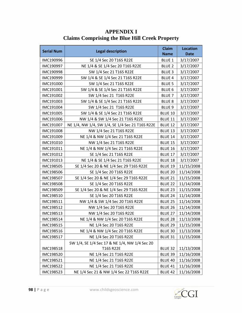
98 | P a g e www.childsgeoscience.com
APPENDIX I
Claims Comprising the Blue Hill Creek Property
Serial Num Legal description Claim Name
Location Date
IMC190996 SE 1/4 Sec 20 T16S R22E BLUE 1 3/17/2007
IMC190997 NE 1/4 & SE 1/4 Sec 20 T16S R22E BLUE 2 3/17/2007
IMC190998 SW 1/4 Sec 21 T16S R22E BLUE 3 3/17/2007
IMC190999 SW 1/4 & SE 1/4 Sec 21 T16S R22E BLUE 4 3/17/2007
IMC191000 SW 1/4 Sec 21 T16S R22E BLUE 5 3/17/2007
IMC191001 SW 1/4 & SE 1/4 Sec 21 T16S R22E BLUE 6 3/17/2007
IMC191002 SW 1/4 Sec 21 T16S R22E BLUE 7 3/17/2007
IMC191003 SW 1/4 & SE 1/4 Sec 21 T16S R22E BLUE 8 3/17/2007
IMC191004 SW 1/4 Sec 21 T16S R22E BLUE 9 3/17/2007
IMC191005 SW 1/4 & SE 1/4 Sec 21 T16S R22E BLUE 10 3/17/2007
IMC191006 NW 1/4 & SW 1/4 Sec 21 T16S R22E BLUE 11 3/17/2007
IMC191007 NE 1/4, NW 1/4, SW 1/4, SE 1/4 Sec 21 T16S R22E BLUE 12 3/17/2007
IMC191008 NW 1/4 Sec 21 T16S R22E BLUE 13 3/17/2007
IMC191009 NE 1/4 & NW 1/4 Sec 21 T16S R22E BLUE 14 3/17/2007
IMC191010 NW 1/4 Sec 21 T16S R22E BLUE 15 3/17/2007
IMC191011 NE 1/4 & NW 1/4 Sec 21 T16S R22E BLUE 16 3/17/2007
IMC191012 SE 1/4 Sec 21 T16S R22E BLUE 17 3/17/2007
IMC191013 NE 1/4 & SE 1/4 Sec 21 T16S R22E BLUE 18 3/17/2007
IMC198505 SE 1/4 Sec 20 & NE 1/4 Sec 29 T16S R22E BLUE 19 11/15/2008
IMC198506 SE 1/4 Sec 20 T16S R22E BLUE 20 11/14/2008
IMC198507 SE 1/4 Sec 20 & NE 1/4 Sec 29 T16S R22E BLUE 21 11/15/2008
IMC198508 SE 1/4 Sec 20 T16S R22E BLUE 22 11/14/2008
IMC198509 SE 1/4 Sec 20 & NE 1/4 Sec 29 T16S R22E BLUE 23 11/15/2008
IMC198510 SE 1/4 Sec 20 T16S R22E BLUE 24 11/14/2008
IMC198511 NW 1/4 & SW 1/4 Sec 20 T16S R22E BLUE 25 11/14/2008
IMC198512 NW 1/4 Sec 20 T16S R22E BLUE 26 11/14/2008
IMC198513 NW 1/4 Sec 20 T16S R22E BLUE 27 11/14/2008
IMC198514 NE 1/4 & NW 1/4 Sec 20 T16S R22E BLUE 28 11/13/2008
IMC198515 NE 1/4 Sec 20 T16S R22E BLUE 29 11/15/2008
IMC198516 NE 1/4 & NW 1/4 Sec 20 T16S R22E BLUE 30 11/13/2008
IMC198517 NE 1/4 Sec 20 T16S R22E BLUE 31 11/15/2008
IMC198518 SW 1/4, SE 1/4 Sec 17 & NE 1/4, NW 1/4 Sec 20
T16S R22E BLUE 32 11/13/2008
IMC198520 NE 1/4 Sec 21 T16S R22E BLUE 39 11/16/2008
IMC198521 NE 1/4 Sec 21 T16S R22E BLUE 40 11/16/2008
IMC198522 NE 1/4 Sec 21 T16S R22E BLUE 41 11/16/2008
IMC198523 NE 1/4 Sec 21 & NW 1/4 Sec 22 T16S R22E BLUE 42 11/16/2008
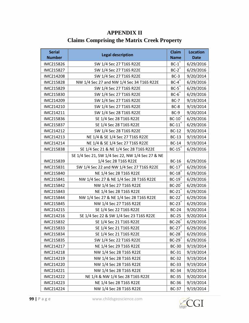
99 | P a g e www.childsgeoscience.com
APPENDIX II
Claims Comprising the Matrix Creek Property
Serial Number
Legal description Claim Name
Location Date
IMC215826 SW 1/4 Sec 27 T16S R22E BC-1* 6/29/2016
IMC215827 SW 1/4 Sec 27 T16S R22E BC-2* 6/29/2016
IMC214208 SW 1/4 Sec 27 T16S R22E BC-3 9/20/2014
IMC215828 NW 1/4 Sec 27 and NW 1/4 Sec 34 T16S R22E BC-4* 6/29/2016
IMC215829 SW 1/4 Sec 27 T16S R22E BC-5* 6/29/2016
IMC215830 SW 1/4 Sec 27 T16S R22E BC-6* 6/29/2016
IMC214209 SW 1/4 Sec 27 T16S R22E BC-7 9/19/2014
IMC214210 SW 1/4 Sec 27 T16S R22E BC-8 9/19/2014
IMC214211 SW 1/4 Sec 28 T16S R22E BC-9 9/20/2014
IMC215836 SE 1/4 Sec 28 T16S R22E BC-10* 6/29/2016
IMC215837 SE 1/4 Sec 28 T16S R22E BC-11* 6/29/2016
IMC214212 SW 1/4 Sec 28 T16S R22E BC-12 9/20/2014
IMC214213 NE 1/4 & SE 1/4 Sec 27 T16S R22E BC-13 9/19/2014
IMC214214 NE 1/4 & SE 1/4 Sec 27 T16S R22E BC-14 9/19/2014
IMC215838 SE 1/4 Sec 21 & NE 1/4 Sec 28 T16S R22E BC-15* 6/29/2016
IMC215839 SE 1/4 Sec 21, SW 1/4 Sec 22, NW 1/4 Sec 27 & NE
1/4 Sec 28 T16S R22E BC-16 6/29/2016
IMC215831 SW 1/4 Sec 22 and NW 1/4 Sec 27 T16S R22E BC-17* 6/29/2016
IMC215840 NE 1/4 Sec 28 T16S R22E BC-18* 6/29/2016
IMC215841 NW 1/4 Sec 27 & NE 1/4 Sec 28 T16S R22E BC-19* 6/29/2016
IMC215842 NW 1/4 Sec 27 T16S R22E BC-20* 6/29/2016
IMC215843 NE 1/4 Sec 28 T16S R22E BC-21* 6/29/2016
IMC215844 NW 1/4 Sec 27 & NE 1/4 Sec 28 T16S R22E BC-22* 6/29/2016
IMC215845 NW 1/4 Sec 27 T16S R22E BC-23* 6/29/2016
IMC214215 SE 1/4 Sec 22 T16S R22E BC-24 9/20/2014
IMC214216 SE 1/4 Sec 22 & SW 1/4 Sec 23 T16S R22E BC-25 9/20/2014
IMC215832 SE 1/4 Sec 21 T16S R22E BC-26* 6/29/2016
IMC215833 SE 1/4 Sec 21 T16S R22E BC-27* 6/29/2016
IMC215834 SE 1/4 Sec 21 T16S R22E BC-28* 6/29/2016
IMC215835 SW 1/4 Sec 22 T16S R22E BC-29* 6/29/2016
IMC214217 NE 1/4 Sec 29 T16S R22E BC-30 9/19/2014
IMC214218 NW 1/4 Sec 28 T16S R22E BC-31 9/19/2014
IMC214219 NW 1/4 Sec 28 T16S R22E BC-32 9/19/2014
IMC214220 NW 1/4 Sec 28 T16S R22E BC-33 9/19/2014
IMC214221 NW 1/4 Sec 28 T16S R22E BC-34 9/20/2014
IMC214222 NE 1/4 & NW 1/4 Sec 28 T16S R22E BC-35 9/20/2014
IMC214223 NE 1/4 Sec 28 T16S R22E BC-36 9/19/2014
IMC214224 NW 1/4 Sec 28 T16S R22E BC-37 9/19/2014
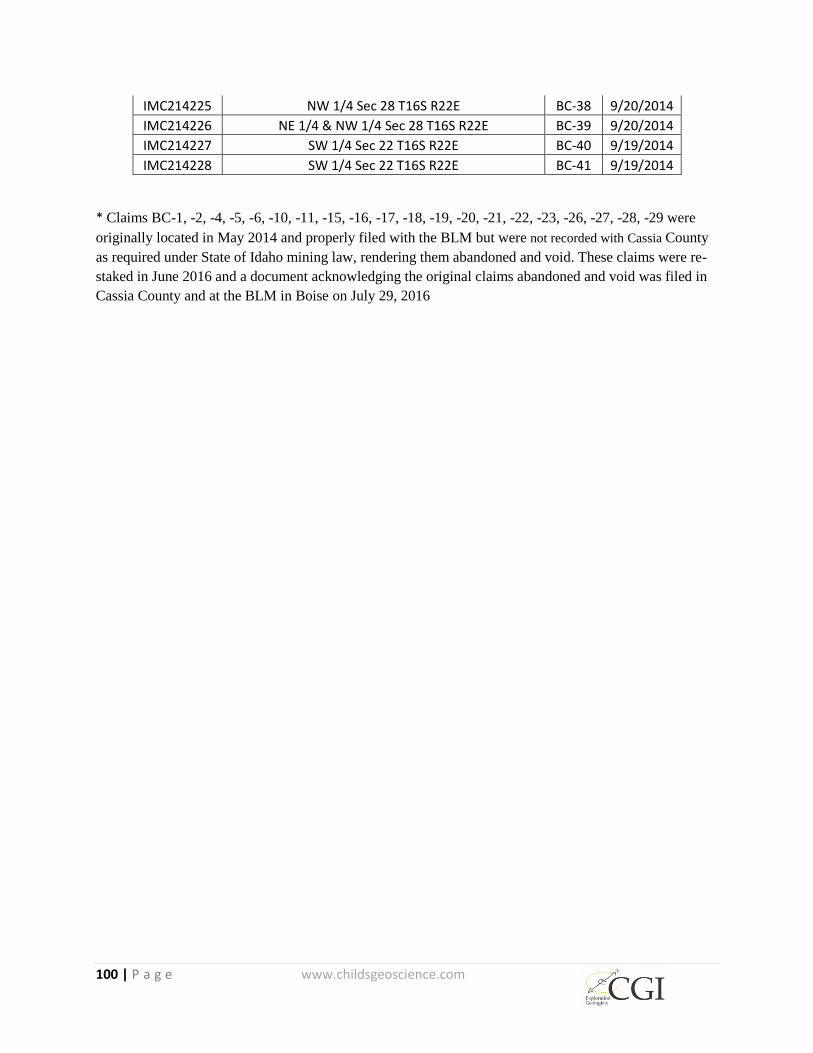
100 | P a g e www.childsgeoscience.com
IMC214225 NW 1/4 Sec 28 T16S R22E BC-38 9/20/2014
IMC214226 NE 1/4 & NW 1/4 Sec 28 T16S R22E BC-39 9/20/2014
IMC214227 SW 1/4 Sec 22 T16S R22E BC-40 9/19/2014
IMC214228 SW 1/4 Sec 22 T16S R22E BC-41 9/19/2014
* Claims BC-1, -2, -4, -5, -6, -10, -11, -15, -16, -17, -18, -19, -20, -21, -22, -23, -26, -27, -28, -29 were
originally located in May 2014 and properly filed with the BLM but were not recorded with Cassia County
as required under State of Idaho mining law, rendering them abandoned and void. These claims were re-
staked in June 2016 and a document acknowledging the original claims abandoned and void was filed in
Cassia County and at the BLM in Boise on July 29, 2016
101 | P a g e www.childsgeoscience.com
APPENDIX III
Definitions 1. adularia – a hydrothermal alteration mineral, KAlSi3O8
2. Ag – the chemical element silver
3. alunite – a hydrothermal alteration mineral, K2Al3(OH)6(SO4)3
4. aphanitic – a rock texture where in the crystals are too small to see without the aid of
a microscope
5. aplite (aplitic) – very fine-grained intrusive rock
6. argillic – a type of rock alteration by which original rock forming minerals are
partially converted to clay minerals
7. ash – fine particles carried by wind from a volcanic eruption
8. As – the chemical element arsenic, a common and classic trace indicator element
associated with epithermal hot spring-type precious metal deposits
9. Au – the chemical element gold
10. BHC- Blue Hill Creek Property
11. BLM – Bureau of Land Management
12. boxwork – the meshwork of porous oxide material left after much of the original
sulfide is leached away
13. breccia (brecciated) – a rock type composed of angular rock fragments; a rock
texture characterized by angular rock fragments
14. carbonate – a sedimentary rock composed of CaCO3 and/or MgCO3
15. Cenozoic – the present era of geologic time, beginning 65 million years ago
16. chalcedony – very fine-grained silica
17. conglomerate – a clastic sedimentary rock composed of rounded fragments
18. core – a method of drilling producing a cylinder of rock (also see: RC)
19. core complex – See: metamorphic core complex
20. CSAMT – controlled-source audio-frequency magnetotelluric, a surface-based
geophysical method that provides resistivity information on subsurface rock
21. dike – a tabular body of igneous rock that cuts across older rocks
22. ESA – Endangered Species Act, US legislation passed in 1973 aimed to provide
protection for species that are in danger of extinction and conserve the habitats on
which those species depend
23. epiclastic – a sedimentary rock formed through consolidation of pre-existing rock
fragments
24. feeders – main hydrothermal conduits of a hot spring system
25. ft. opt – foot-ounces-per-ton; See: grade x thickness
26. FWS – United States Fish and Wildlife Service
27. gangue – the less valuable minerals with which more valuable minerals are found
28. gneiss – a metamorphic rock with coarse mineral grains aligned in bands
29. graben – an elongated block bounded by sub-parallel geologic faults
102 | P a g e www.childsgeoscience.com
30. grade x thickness – a method of resource estimation; multiplication of the grade of a
mineral intercept times its length; e.g. multiplying (ounces per ton) times (feet
intercepted) yields units of foot-ounces-per-ton, or ft. opt
31. Grassy Mountain – a hot spring-type gold deposit located in Malheur County, Oregon
presently owned by Paramount Gold Nevada Corp./Calico Resources (NYSE: PZG)
32. Hg – the chemical element mercury, a common and classic trace indicator element
associated with epithermal hot spring-type precious metal deposits
33. hydromica – a hydrothermal alteration mineral,
(K,H3O)(Al,Mg,Fe)2(Si,Al)4O10[(OH)2,(H2O)]
34. IMC – Idaho Mining Claim
35. inferred resources – that part of a mineral resource for which quantity and grade or
quality can be estimated on the basis of geological evidence and limited sampling and
reasonably assumed, but not verified, geological and grade continuity. The estimate
is based on limited information and sampling gathered through appropriate techniques
from locations such as outcrops, trenches, pits, workings and drill holes
36. jarosite – a hydrothermal alteration mineral, KFe3(SO4)2(OH)6
37. jasperoid – a rock formed by the replacement of pre-existing minerals by silica,
iron-oxides and clays; See: silicification
38. kaolinite – a hydrothermal alteration mineral, Al2Si2O5(OH)4
39. Kennecott - Kennecott Utah Copper Corporation, a subsidiary of Rio Tinto
40. Lateral Gold – Lateral Gold Corp
41. latite – a volcanic rock with intermediate concentrations of silica, sodium and
potassium.
42. Latitude – Latitude Minerals Corporation
43. Lek- An area where birds gather during the breeding season for community courtship
displays to attract mates
44. listric fault – a curved, concave upward fault
45. LOI – Letter of Intent
46. low-sulfidation – a type of hydrothermal environment generally dominated by waters
percolating from surface to depth and then back toward surface as hot springs, in
contrast with high-sulfidation environments more directly influenced by magmatic
fluids rising above a buried, hot intrusive
47. MC – Matrix Creek
48. metamorphic core complex – deeply buried rocks exhumed by low-angle listric faults
in response to crustal extension
49. Mesozoic – an era occurring between 252 million and 66 million years ago
50. Meridian – Meridian Minerals Company, acquired by Yamana Gold TSX: YRI in
2007
51. Miocene – an epoch occurring from 23 million to 5 million years ago
52. NOI - Notice of Intent
103 | P a g e www.childsgeoscience.com
53. opt – ounces per ton
54. Paleozoic – an era occurring between 541 million and 252 million years ago
55. Otis– Otis Gold Corporation, Otis Capital Corp (renamed)
56. POO - Plan of Operations
57. post-mineral – younger than mineralization; on the Blue Hill Creek and Matrix Creek
Properties, post-mineral rocks obscure the location of gold mineralization
58. ppb – parts per billion
59. ppm – parts per million
60. Precambrian – an era ending 541 million years ago
61. pyrite – a hydrothermal gangue mineral, FeS2
62. quartz – a crystalline form of silica, SiO2
63. quartzite – a metamorphic rock consisting of quartz in interlocking grains
64. Quaternary – an era beginning 2.6 million years ago
65. RC – reverse circulation, a rotary drilling method by which rock is cut by a drill bit
and drill cuttings are returned to surface inside drill rods (See: core)
66. sandstone – a sedimentary rock consisting of sand-sized particles
67. Sb – the chemical element antimony, a common and classic trace indicator element
associated with epithermal hot spring-type precious metal deposits
68. schist – a metamorphic rock in which mineral grains are aligned in parallel, forming a
layered structure
69. silica – SiO2 (silicon dioxide); various forms include quartz, chalcedony and opal
70. silicification – a type of rock alteration by which original rock forming minerals are
partially converted to silica minerals; See: jasperoid
71. siltstone – a sedimentary rock consisting of silt-sized particles
72. sinter – a siliceous sedimentary rock chemically precipitated from mineral-rich waters
73. stockwork – a network of veins and veinlets
74. Tertiary – an era occurring between 66 million and 2.6 million years ago
75. Tsl – Tertiary Salt Lake formation. A mixed sedimentary-volcanic unit that hosts the
mineralization at Blue Hill Creek
76. tuff (tuffaceous) – a volcanic rock, formed by compaction and cementation of ash;
(containing tuff)
77. volcaniclastic – a sedimentary rock, composed chiefly of volcanic fragments
78. volcano-sedimentary- a sequence of layered rock consisting in part of volcanic flows
and ash and in part of sedimentary rocks including sandstone and conglomerate
79. WestGold – Western Gold Exploration & Mining Company LP, a former partnership
between Inspiration Resources Corporation of New York and Luxembourg based
Minorco