ni 43-101 technical report constellation copper corp. san ... · ni 43-101 technical report...
TRANSCRIPT
NI 43-101 Technical Report Constellation Copper Corp. San Javier Copper Project
San Javier, Sonora, México
Constellation Copper Corp. 3900 S. Wadsworth Blvd.
Suite 495 Lakewood, Co. 80235
720-228-0055
SRK Project Number 162304
7175 W. Jefferson Ave.
Suite 3000 Lakewood, CO 80235
Effective Date: December 31, 2006 Report Date: June 01, 2007
Contributor: Endorsed by QP’s: Leah Mach, MSc, CPG Leah Mach, MSc, CPG Allan Moran, R.G., C.P.G.
Project Consultants Qualified Persons
Constellation Copper Corp. I San Javier NI 43-101 Technical Report
Executive Summary (Item 3)
Property Description and Accessibility The Constellation Copper Corporation (CCC) San Javier Copper Project is located approximately 140km east-southeast of Hermosillo on the western flank of the Sierra Madre Occidental in Sonora, Mexico. The property is located south and east of the town of San Javier, and is accessible from Hermosillo by a paved and well-maintained two-lane highway.
The land position held by CCC consists of four separate options to purchase eight concessions totaling 687.2695ha. These concessions are 100% controlled by CCC and have no royalty attached.
The climate at San Javier is semi arid with a pronounced dry season from October to June and a monsoon season from June through September.
While the topography in the immediate vicinity of the three deposits is extremely rugged, there is a large area of flat to gently sloping topography immediately to the east of Cerro Verde sufficient for a heap leach and process facility. This area lies outside the concessions held by CCC but is within ground for which CCC hold surface exploration rights.
Geology and Mineralization The deposits being examined within the concessions have been interpreted to be of the iron-oxide-copper-gold (IOCG) style hosted within Laramide-age intermediate-to-felsic volcanic rocks.
Significant copper mineralization is hosted primarily within hydrothermal-tectonic breccias and associated stockworks. The breccias commonly exhibit massive specularite replacement. The degree of copper mineralization is strongly associated with specularite and with intense structural preparation.
Drilling demonstrates that the original sulfides, primarily chalcopyrite, have been oxidized to depths exceeding 200m below the existing topography. Within this oxidized zone, copper mineralization consists primarily of copper oxides, silicates, and carbonates as fracture filling and occupies sites of original sulfide mineralization. Chalcocite is also present in the oxidized and transitional zones.
The depth of oxidation appears to be highly variable and primarily controlled by structural penetration from the topographic surface.
Three deposits have been defined to date aligned along a southwest-northeast trend. From southwest to northeast, these are Cerro Verde, Mesa Grande and La Trinidad.
Exploration Cerro Verde is at an advanced exploration stage having been explored by previous owners including Phelps Dodge (eight core holes in 1996) and Peñoles (18 core holes in the 1960-1970’s). CCC has drilled a further 57 core and 14 reverse circulation drillholes at Cerro Verde in 2006; an additional 7 holes have been drilled at La Trinidad and Mesa Grande.
Surface mapping and sampling and drilling have demonstrated a zone of significant copper mineralization extending 1,200m along strike, 400 to 500m across strike and 200m deep.
SRK Consulting (US), Inc. June 01, 2007 San Javier.NI 43-101.162304.MA.05.doc
Constellation Copper Corp. II San Javier NI 43-101 Technical Report
The copper mineralization at Cerro Verde is extremely continuous with significantly mineralized intervals ranging from 20 to 200m in boreholes. Copper grade attenuates rapidly and often appears to be truncated by post mineral structural movement that may be related to basin and range extensional faulting.
The Mesa Grande deposit lies some 2km northeast of Cerro Verde and is yet poorly defined. Surface mapping has outlined significant areas of stockwork development and alteration bleaching; however drilling is still in early stages. A few drillholes on the eastern flank have returned significant oxidized copper mineralization.
The mineralization that has been identified at Mesa Grande is confined to the eastern area of the much larger mesa. While access for drill sites is not as problematic as at Cerro Verde the eastern face is sufficiently steep, with cliffs several 10’s of meters high, to warrant careful planning and design.
La Trinidad lies approximately 100m north of the northern extent of Mesa Grande. La Trinidad was mined for copper in the past using underground mining methods. The historic workings were mapped and sampled in 1994 by Orcana Resources Limited. The sample map shows an interpreted zone of mineralization of 20 to 30m in width trending to the northwest with grades ranging from 0.81% to 2.12% total copper. These results should be viewed with some caution as additional copper oxides may have been deposited by efflorescence on the surface of the workings subsequent to mining.
CCC does not have the historic production records for La Trinidad. The underground map prepared by Orcana outlines a stope of approximately 50m in length by 8m in width, however the vertical extent and dip of the mineralization is not shown and the extracted volume cannot be calculated.
Mineralization at La Trinidad appears to be hosted by a rhyolitic rather than andesitic host rock as at Cerro Verde or Mesa Grande, however the ore mineralogy and association of copper with specular hematite appears to be the same.
The current exploration program is designed to:
• Further delineate the Cerro Verde deposit to a level consistent with a pre-feasibility study in 2007;
• Advance Mesa Grande to the point of defining the extent and geometry of mineralization in order to assess the merits of proceeding to a comparable data density for incorporation into the Cerro Verde study. This may be concurrent or subsequent to the initial Cerro Verde study; and
• Undertake confirmatory exploration at La Trinidad to test the indications given by the Orcana investigation.
This work will include:
• Infill drilling to increase sample data density; verification and independent confirmation of the results of previous drilling results by previous holders of the property;
• Appropriate QA/QC verification on pre-CCC core when submitted for re-assay;
• Metallurgical testing of the various mineralized rock types identified to date; and
SRK Consulting (US), Inc. June 01, 2007 San Javier.NI 43-101.162304.MA.05.doc

Constellation Copper Corp. III San Javier NI 43-101 Technical Report
• Further petrographic studies to identify the various copper bearing minerals and understand the relationship between mineralogy and acid solubility.
As of the date of this report, CCC has not initiated any environmental studies, or applied for any permits in support of development or exploitation.
Resource Estimation and Statement The resource was estimated using a two-pass procedure of defining a grade shell at 0.1% copper with the use of indicator kriging and then estimating grade inside that shell with ordinary kriging, using only composites inside the shell.
A pit optimization was run using a floating cone algorithm with the following parameters:
• Copper Price - $2.40/lb; and
• Copper recovery based on ratio of the sum of acid soluble and cyanide copper to total copper.
SRK validated the model by visual examination of the composites and block grades in cross-section and plan view, confirming assay and composite statistics, and producing swath plots by northing, easting, and elevation. It is SRK’s opinion that the resource has been estimated according to industry standards.
The resource at Cerro Verde is entirely classified as inferred and is contained within an optimized pit at $2.40 copper. The resource is 85Mt at 0.35% copper, containing 629Mlbs of copper and is listed in Table 1.
Table 1: Mineral resource statement for Cerro Verde, San Javier Project Class Tonnes (Mt) tCu (%) Cu (Mlbs) Inferred 81.0 0.35 629.0
Conclusions and Recommendations The San Javier Project consists of an early stage development project at Cerro Verde and exploration targets at La Trinidad and Mesa Grande. A significant body of near surface, contiguous oxide copper mineralization has been delineated at Cerro Verde. This report contains a mineral resource estimation for the Cerro Verde deposit, which is entirely inferred at this stage of development. Exploration at the project is on-going.
The drilling that has been done consists of fans of core and RC holes with collars spaced at about 100m. The sample spacing therefore has a wide variability. The drill program that is in progress is designed to reduce the sample spacing and thereby increase the knowledge of geologic controls on mineralization.
The assaying has been conducted by a certified laboratory and a program of laboratory QA/QC has been instituted. CCC recognizes that some improvements could be made to the QA/QC procedures, particularly with the standard samples.
Data verification procedures have revealed some inconsistencies in recording values below detection limit. However, no errors were found in recording values above detection limit. SRK considers the database reliable for use in resource estimation.
SRK Consulting (US), Inc. June 01, 2007 San Javier.NI 43-101.162304.MA.05.doc

Constellation Copper Corp. IV San Javier NI 43-101 Technical Report
The resource estimation has been conducted within industry standards and has been validated by SRK.
SRK recommends that CCC review the database and correct the inconsistencies regarding the recording of values below detection limit.
Further metallurgical testwork should be done on the property. SRK acknowledges that CCC has column tests in progress that will help in establishing metallurgical recoveries.
Significant mineralization has been delineated at Cerro Verde. SRK recommends that CCC continue drilling and initiate a preliminary assessment on the project.
SRK Consulting (US), Inc. June 01, 2007 San Javier.NI 43-101.162304.MA.05.doc
Constellation Copper Corp. i San Javier NI 43-101 Technical Report
Table of Contents EXECUTIVE SUMMARY (ITEM 3) .................................................................................................. I 1 INTRODUCTION (ITEM 4)................................................................................................. 1-1
1.1 Terms of Reference and Purpose of the Report ......................................................... 1-1 1.2 Reliance on Other Experts (Item 5) ........................................................................... 1-1
1.2.1 Sources of Information ................................................................................ 1-1 1.3 Effective Date ............................................................................................................ 1-1 1.4 Price Strategy ............................................................................................................. 1-1 1.5 Qualifications of Consultant (SRK)........................................................................... 1-1
2 PROPERTY DESCRIPTION & LOCATION (ITEM 6) ...................................................... 2-1 2.1 Mineral Titles............................................................................................................. 2-1 2.2 Location of Mineralization ........................................................................................ 2-2 2.3 Royalty Agreements & Encumbrances...................................................................... 2-2 2.4 Surface Ownership..................................................................................................... 2-2 2.5 Permits ....................................................................................................................... 2-2
2.5.1 Required Permits & Status .......................................................................... 2-2 2.6 Environmental Liabilities........................................................................................... 2-3
3 ACCESSIBILITY, CLIMATE, LOCAL RESOURCES, INFRASTRUCTURE & PHYSIOGRAPHY (ITEM 7) ............................................................................................................ 3-1
3.1 Access to Property ..................................................................................................... 3-1 3.2 Climate....................................................................................................................... 3-1 3.3 Physiography.............................................................................................................. 3-1 3.4 Vegetation .................................................................................................................. 3-1 3.5 Local Resources & Infrastructure .............................................................................. 3-1
4 HISTORY (ITEM 8).............................................................................................................. 4-1 4.1 Ownership .................................................................................................................. 4-1 4.2 Past Exploration & Development .............................................................................. 4-1 4.3 Historic Mineral Resource Estimates......................................................................... 4-4 4.4 Historic Production .................................................................................................... 4-4
5 GEOLOGIC SETTING (ITEM 9) ......................................................................................... 5-1 5.1 Regional Geology ...................................................................................................... 5-1 5.2 Local Geology............................................................................................................ 5-1 5.3 Property Geology....................................................................................................... 5-3
5.3.1 Structure ...................................................................................................... 5-3 6 DEPOSIT TYPES (ITEM 10) ............................................................................................... 6-1 7 MINERALIZATION (ITEM 11)........................................................................................... 7-1 8 EXPLORATION (ITEM 12) ................................................................................................. 8-1 9 DRILLING (ITEM 13) .......................................................................................................... 9-3
9.1 CCC Drilling.............................................................................................................. 9-3 10 SAMPLING METHOD & APPROACH (ITEM 14) .......................................................... 10-1
10.1 Sampling Method..................................................................................................... 10-1 10.2 Sample Location ...................................................................................................... 10-1 10.3 Sample Quality......................................................................................................... 10-1
SRK Consulting (US), Inc. June 01, 2007 San Javier.NI 43-101.162304.MA.05.doc
Constellation Copper Corp. ii San Javier NI 43-101 Technical Report
11 SAMPLE PREPARATION, ANALYSES & SECURITY (ITEM 15) ............................. 11-1 11.1 Sample Security ....................................................................................................... 11-1 11.2 Sample Preparation & Assaying .............................................................................. 11-1 11.3 QA/QC ..................................................................................................................... 11-2
12 DATA VERIFICATION (ITEM 16) ................................................................................... 12-1 13 ADJACENT PROPERTIES (ITEM 17).............................................................................. 13-1 14 MINERAL PROCESSING & METALLURGICAL TESTING (ITEM 18)....................... 14-1 15 MINERAL RESOURCES & RESERVES (ITEM 19)........................................................ 15-1
15.1 Resource Database ................................................................................................... 15-1 15.2 Specific Gravity ....................................................................................................... 15-3 15.3 Topography.............................................................................................................. 15-5 15.4 Block Model............................................................................................................. 15-5 15.5 Geologic Model ....................................................................................................... 15-5 15.6 Compositing............................................................................................................. 15-5 15.7 Resource Estimation ................................................................................................ 15-7
15.7.1 Indicator Estimation .................................................................................. 15-7 15.7.2 Grade Estimation ..................................................................................... 15-11 15.7.3 Model Validation..................................................................................... 15-14
15.8 Mineral Resource Statement .................................................................................. 15-16 16 OTHER RELEVANT DATA & INFORMATION (ITEM 20) .......................................... 16-1 17 INTERPRETATION & CONCLUSIONS (ITEM 21) ........................................................ 17-1 18 RECOMMENDATIONS (ITEM 22) .................................................................................. 18-1 19 REFERENCES (ITEM 23) .................................................................................................. 19-1 20 GLOSSARY ........................................................................................................................ 20-1
20.1 Mineral Resources & Reserves................................................................................ 20-1 20.2 Glossary ................................................................................................................... 20-2
List of Tables Table 1: Mineral resource statement for Cerro Verde, San Javier Project ........................................ III
Table 2.1.1: List of Concessions Held by Constellation................................................................... 2-1
Table 9.1.1: CCC and PD Drilling at the San Javier Project ............................................................ 9-3
Table 15.1.1: Resource Database for the Cerro Verde Deposit ...................................................... 15-1
Table 15.1.2: Statistics for Total Copper in Resource Database .................................................... 15-3
Table 15.6.1: All Total Copper Composites in Cerro Verde .......................................................... 15-6
Table 15.6.2: All Total Copper Composites > 0.10% in Cerro Verde............................................ 15-7
Table 15.7.1.1: All Total Copper Composites within Grade Shell 0.10% in Cerro Verde........... 15-11
Table 15.8.1: Resource CoG Calculation for San Javier-Cerro Verde, Based on Recovered Copper15-16
Table 15.8.2: Mineral Resource Statement for Cerro Verde, San Javier Project ......................... 15-17
SRK Consulting (US), Inc. June 01, 2007 San Javier.NI 43-101.162304.MA.05.doc
Constellation Copper Corp. iii San Javier NI 43-101 Technical Report
SRK Consulting (US), Inc. June 01, 2007 San Javier.NI 43-101.162304.MA.05.doc
List of Figures Figure 2-1: Location of the San Javier Project, Sonora, Mexico...................................................... 2-4
Figure 2-2: Location of San Javier Concessions. CCC Concessions Shaded Pink, Remaining Concessions Held by Others .................................................................................................. 2-5
Figure 3-1: Location of Possible Pit and Mine Facilities within Concession Boundaries................ 3-3
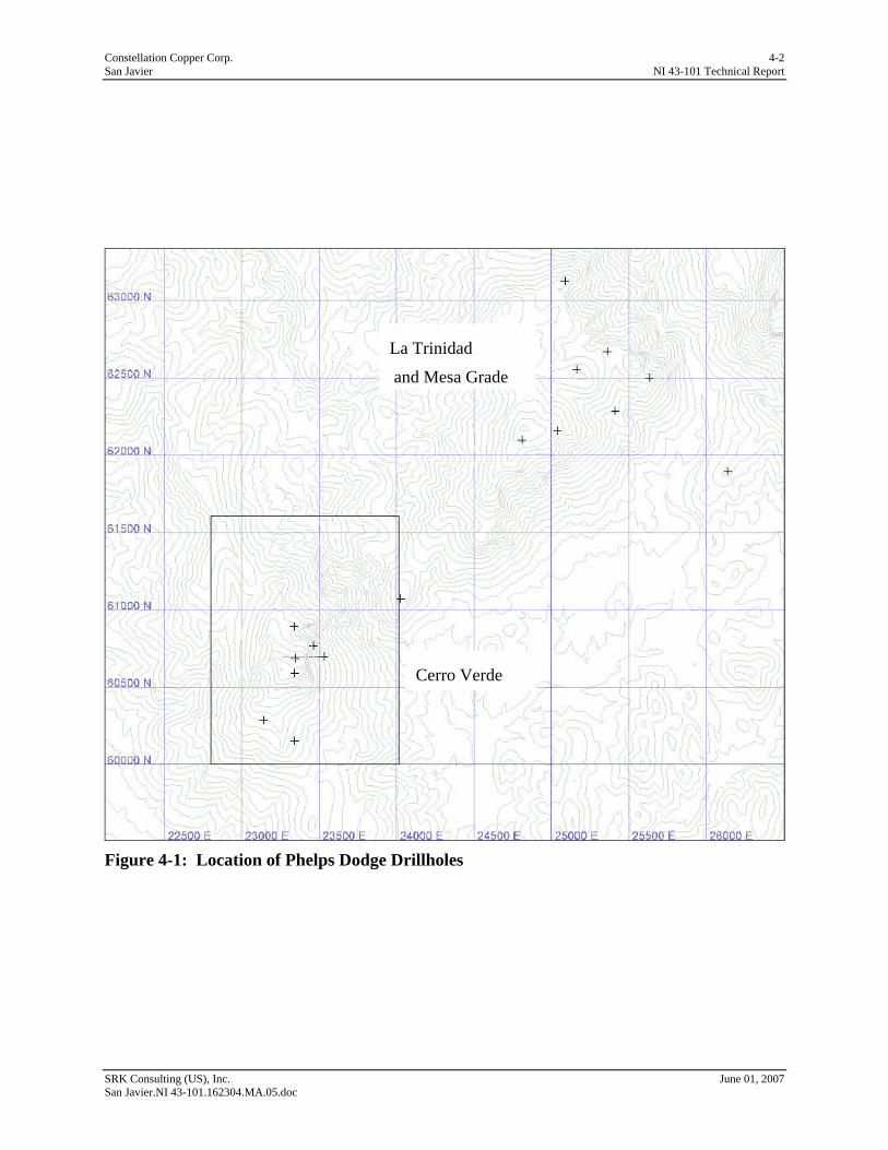
Figure 4-1: Location of Phelps Dodge Drillholes............................................................................. 4-2
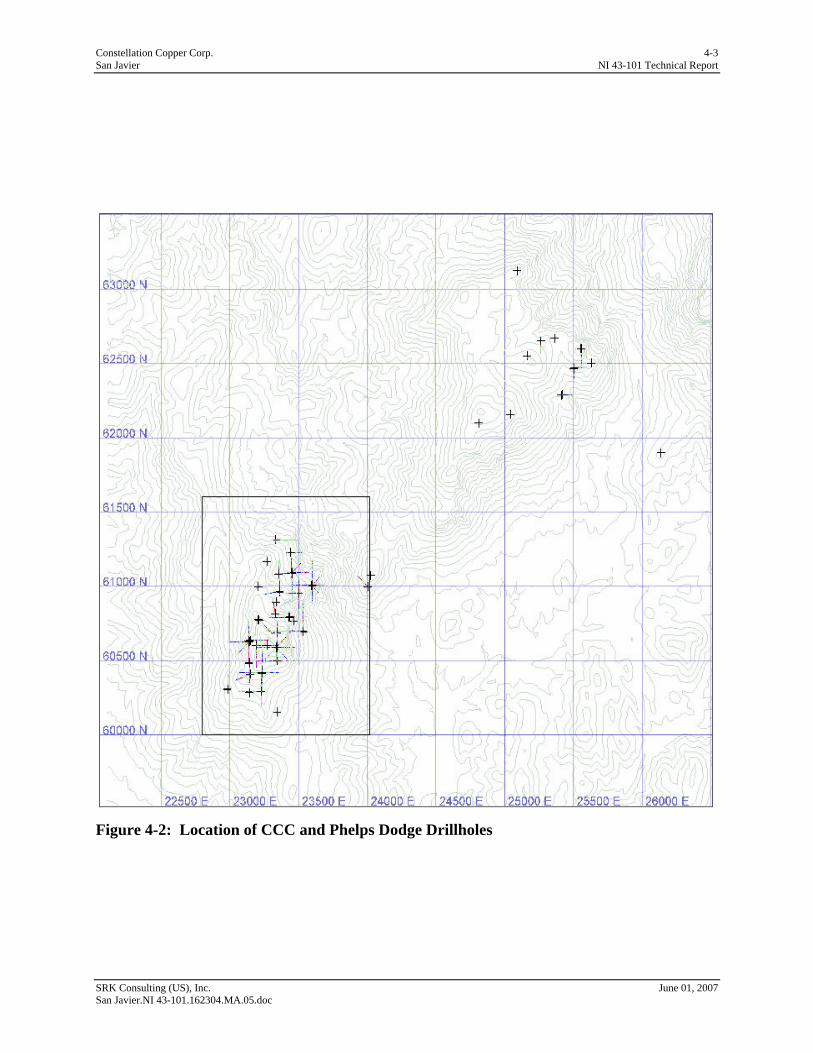
Figure 4-2: Location of CCC and Phelps Dodge Drillholes ............................................................. 4-3
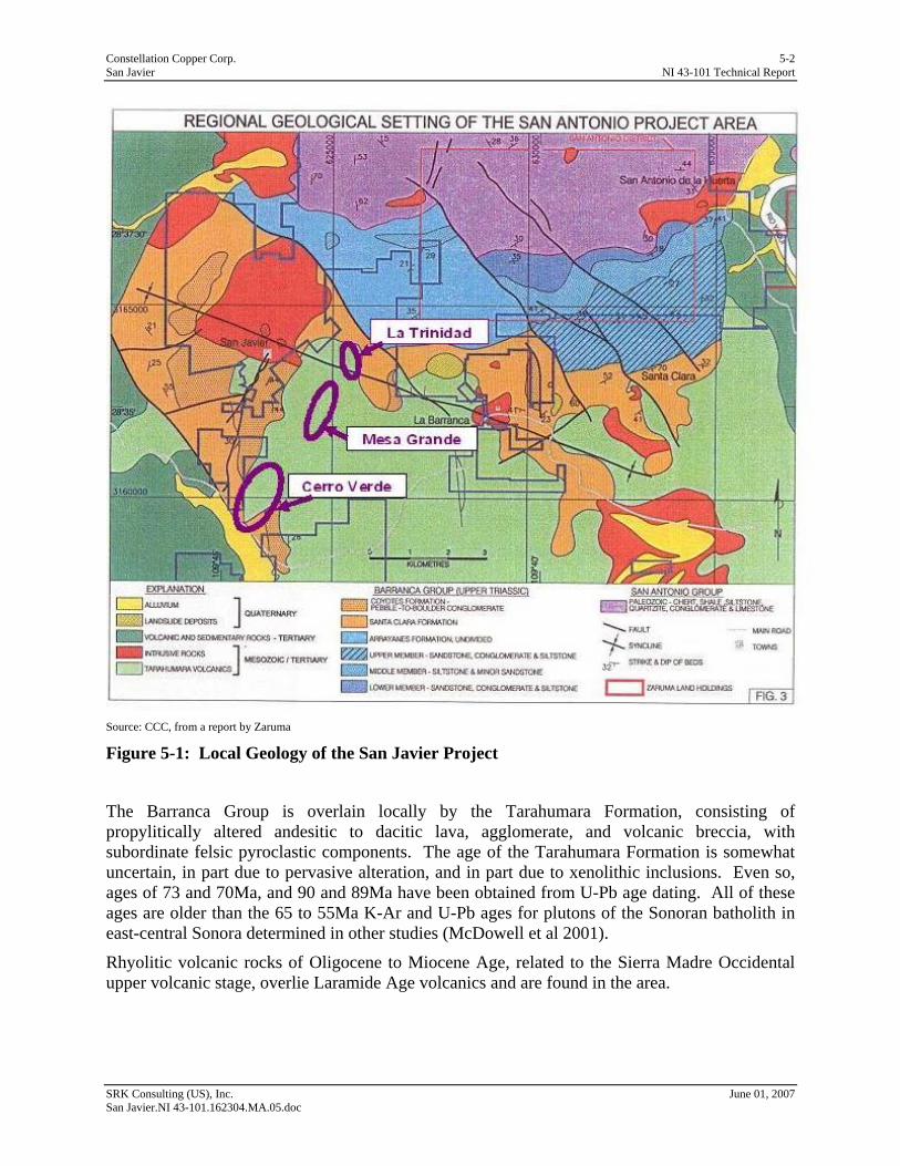
Figure 5-1: Local Geology of the San Javier Project........................................................................ 5-2
Figure 5-2: Local Geology of the Cerro Verde Deposit ................................................................... 5-4
Figure 9-1: CCC and Phelps Dodge Drilling.................................................................................... 9-5
Figure 9-2: East-west Cross-section A to A’ .................................................................................... 9-6
Figure 9-3: North-south Cross-section B to B’................................................................................. 9-6
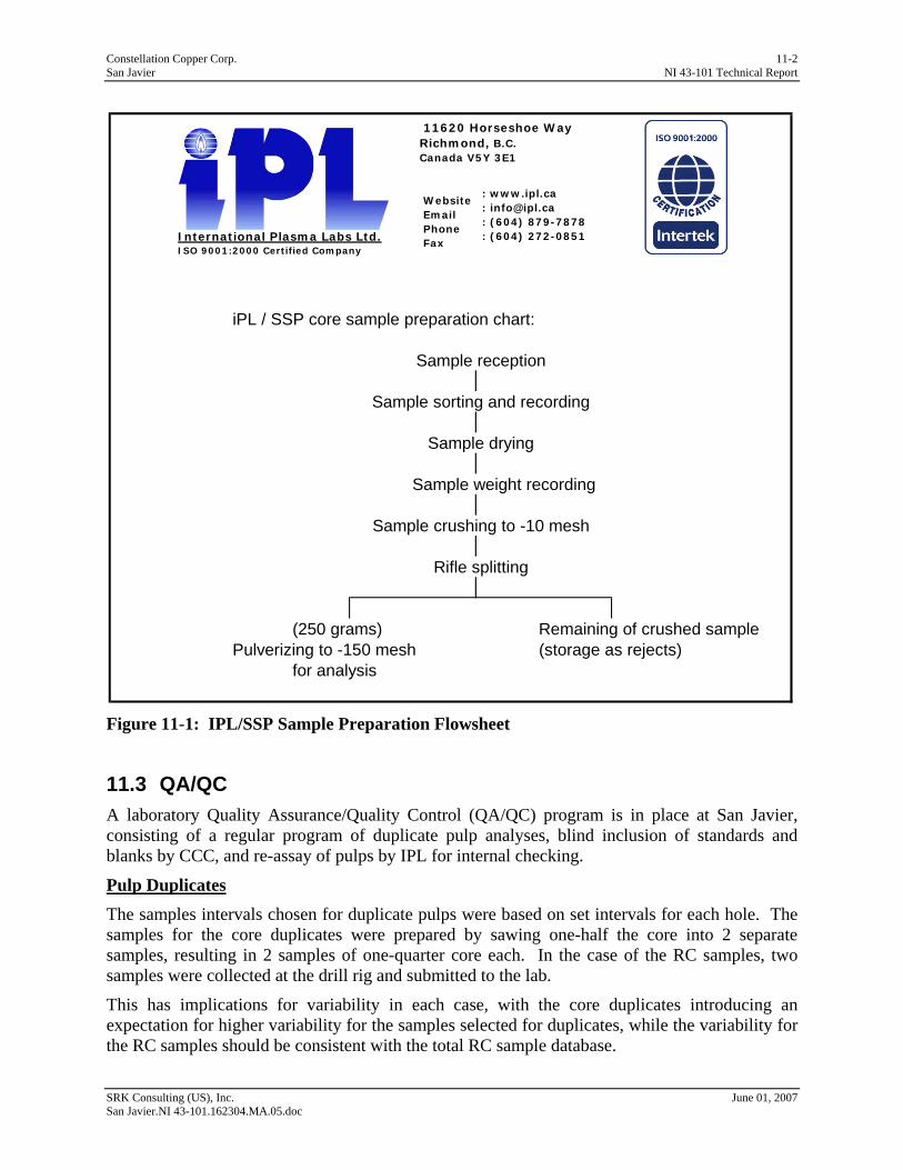
Figure 11-1: IPL/SSP Sample Preparation Flowsheet .................................................................... 11-2
Figure 11-2: Half Absolute Relative Difference Between Original Pulp and Duplicate Pulp ....... 11-3
Figure 11-3: Scatter Plot of tCu in Original Pulp Versus Duplicate Pulp ...................................... 11-4
Figure 11-4: Assay Results of Standard Versus Accepted Value................................................... 11-6
Figure 14-1: Comparison of Bottle Roll Tests and Recoveries Calculated from Sequential Copper Analysis....14-2
Figure 15-1: Drillholes used in Cerro Verde Resource Estimation, within the Boundary of the Block Model .......15-2
Figure 15-2: Histogram and Cumulative Frequency Plot of Total Copper, Cerro Verde............... 15-3
Figure 15-3: Scatter Plot of SG Versus Fe(%)................................................................................. 15-4
Figure 15-4: Histogram and Cumulative Frequency Plot of Total Copper, Cerro Verde............... 15-6
Figure 15-5: Histogram and Cumulative Frequency Plot of Total Copper > 0.10%, Cerro Verde 15-7
Figure 15-6: Directional Semi-variograms for 0.1% tCu Indicator Values..................................... 15-9
Figure 15-7: Histogram and Cumulative Frequency Plot of Total Copper Within 0.1% Grade Shell15-11
Figure 15-8: Global Semi-variogram for tCu ............................................................................... 15-12
Figure 15-9: East-West Cross-section Showing tCu Block Grades.............................................. 15-13
Figure 15-10: North-south Cross-section Showing tCu Block Grades......................................... 15-13
Figure 15-11: Swath Plots of tCu Grades by Easting ................................................................... 15-15
Figure 15-12: Swath Plots of tCu Grades by Northing................................................................. 15-15
Figure 15-13: Swath Plots of tCu Grades by Elevation................................................................ 15-16
Constellation Copper Corp. iv San Javier NI 43-101 Technical Report
SRK Consulting (US), Inc. June 01, 2007 San Javier.NI 43-101.162304.MA.05.doc
List of Appendices
Appendix A Certificates of Author
Appendix B Drillholes
Constellation Copper Corp. 1-1 San Javier NI 43-101 Technical Report
1 Introduction (Item 4) SRK Consulting (US), Inc. (SRK) was commissioned by Constellation Copper Corporation (CCC) to prepare a Technical Report on its San Javier Copper Project located in Sonora, Mexico to meet the requirements of Canadian National Instrument 43-101 (NI43-101). The project is wholly controlled by CCC.
1.1 Terms of Reference and Purpose of the Report This report is intended to provide CCC with an independent resource review and technical report that follows existing regulations in Canada. The report meets the requirements for NI43-101 and conforms to Form 43-101F1 for Technical Reports.
Resource definitions are as set forth in the Appendix to Companion Policy 43-101CP, ”Canadian Institute of Mining, Metallurgy and Petroleum – Definitions Adopted by CIM Council, August 20, 2000”.
1.2 Reliance on Other Experts (Item 5) SRK’s opinion contained here is based on information provided to SRK by CCC throughout the course of SRK’s investigations.
1.2.1 Sources of Information The underlying technical information upon which this Technical Report is based represents a compilation of work performed by CCC. The studies and additional references for this Technical Report are listed in Section 19. SRK has reviewed the project data and incorporated the results thereof, with appropriate comments and adjustments as needed, in the preparation of the Technical Report.
The authors reviewed data provided by CCC and conducted field investigations to confirm the data. The data sources include hard copy and digital files located at the offices of CCC in Lakewood, Colorado. In addition, drill core and chips were examined at the field site. The resource estimation was prepared by CCC and validated by SRK.
1.3 Effective Date The resource estimation includes all data received by CCC as of December 31, 2006.
1.4 Price Strategy The copper price used in this resource estimate is US$2.40/lb.
1.5 Qualifications of Consultant (SRK) The SRK Group is comprised of over 700 staff, offering expertise in a wide range of resource engineering disciplines. The SRK Group’s independence is ensured by the fact that it holds no equity in any project and that its ownership rests solely with its staff. This permits SRK to provide its clients with conflict-free and objective recommendations on crucial judgment issues. SRK has a demonstrated record of accomplishment in undertaking independent assessments of Mineral Resources and Mineral Reserves, project evaluations and audits, technical reports, and independent evaluations to bankable standards on behalf of exploration and mining companies and financial institutions worldwide. The SRK Group has also worked with a large number of
SRK Consulting (US), Inc. June 01, 2007 San Javier.NI 43-101.162304.MA.05.doc

Constellation Copper Corp. 1-2 San Javier NI 43-101 Technical Report
major international mining companies and their projects, providing mining industry consultancy service inputs.
This report has been prepared based on a technical and economic review by a team of consultants sourced principally from the SRK Group’s Denver, US office. These consultants are specialists in the fields of geology, exploration, mineral resource and mineral reserve estimation and classification, underground mining, mineral processing and mineral economics.
Neither SRK nor any of its employees and associates employed in the preparation of this report has any beneficial interest in CCC. SRK will be paid a fee for this work in accordance with normal professional consulting practice.
The individuals who have provided input to this technical report, who are listed below, have extensive experience in the mining industry and are members in good standing of appropriate professional institutions.
The key project personnel contributing to this report are Leah Mach and Allan Moran. Mr. Moran visited the property on March 25 and 26, 2007, at which time he confirmed the site data, including access, drilling and sampling methods and drillhole locations, and examined geology, alteration and mineralization in field outcrops and drill core. The Certificate and Consent forms are provided in Appendix A.
SRK Consulting (US), Inc. June 01, 2007 San Javier.NI 43-101.162304.MA.05.doc
Constellation Copper Corp. 2-1 San Javier NI 43-101 Technical Report
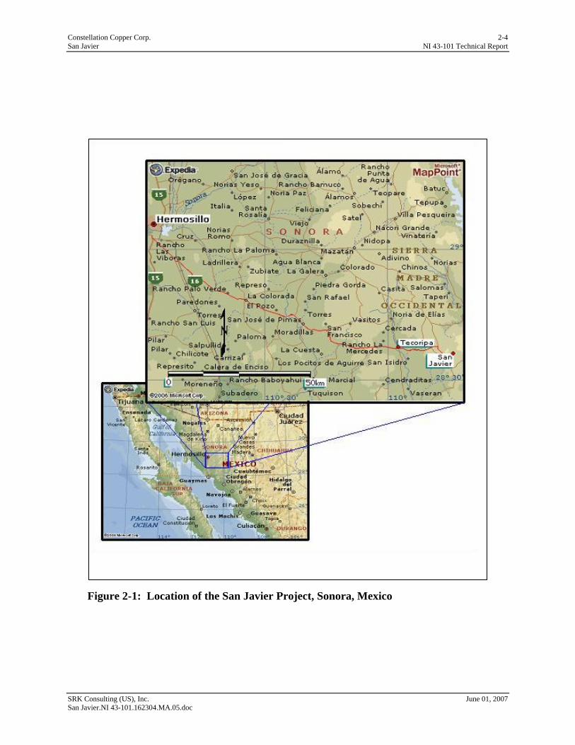
2 Property Description & Location (Item 6) The San Javier Property lies 140km east-southeast of Hermosillo in the state of Sonora, Mexico, and immediately adjacent to Mexican Highway 16, a paved two-lane road (Figure 2-1). The coordinates are 28º 34’ N; 109º 44’ 30’W. The property is approximately 3km southeast of the small town of San Javier.
The project consists of three separate areas, Cerro Verde, La Trinidad, and Mesa Grande. A resource estimate has been prepared for Cerro Verde and is presented in this report.
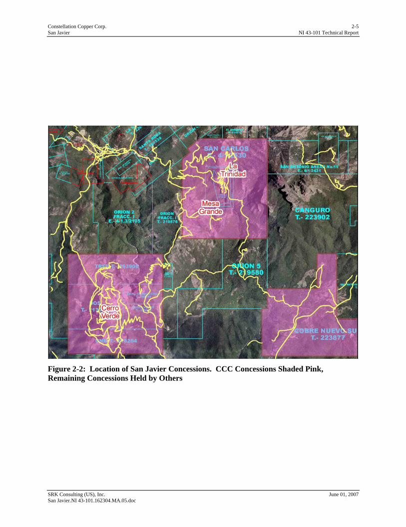
2.1 Mineral Titles The property consists of two non-contiguous groups of concessions (Figure 2-2) 100% controlled by CCC through an option to purchase agreement. Group 1 contains the Cerro Verde deposit and is 379.81ha in area and consists of five separate concessions. Group 2 contains the Mesa Grande and La Trinidad deposits, is 307.4595ha in area and consists of three separate concessions.
The properties have all been legally surveyed in accordance with Mexican requirements for a legal survey before granting title.
A complete listing of the concessions within each group is presented in Table 2.1.1 below.
Table 2.1.1: List of Concessions Held by Constellation Concession Name Title Type Expiration Date Area (ha) Group 1 Uno 218264 Exploitation 10/17/2052 95.0000 Dos 213905 Exploitation 7/6/2051 98.8900 Tres 213906 Exploitation 7/6/2051 113.9200 Ampl. Cerro Verde 185768 Exploitation 12/14/2039 32.0000 Cerro Verde 186010 Exploitation 12/14/2039 40.0000 Total Group 1 379.8100 Group 2 San Carlos 205558 Exploitation 9/19/2047 287.5789 Trinidad Frac 1 197350 Exploitation 9/3/2043 13.3806 Trinidad Frac 2 197676 Exploitation 9/13/2043 6.5000 Total Group 2 307.4595 Total 687.2695
CCC holds the rights to these concessions by purchase option agreements with the various claim holders. CCC must honor a set payment schedule to the holders in order to retain these rights. The concession status allows both exploration and exploitation. The underlying exploitation rights are valid for 50 years from the effective date and extend to, or beyond, the year 2040.
On August 29, 2006, Eduardo Robles, acting as Special Mexican Counsel to CCC, issued a letter of opinion to the underwriters, regarding the validity of the concessions. The statement of opinion from this letter is presented below:
“I do not know of any fact, reason, or law pursuant to which the Report, the Concessions, the 2005 Status Certificates, the Work Reports, the Receipts, the 2006 Status Certificates, and the Contracts (collectively, the “Opinion Documents”) would have ceased to be current or valid.
SRK Consulting (US), Inc. June 01, 2007 San Javier.NI 43-101.162304.MA.05.doc
Constellation Copper Corp. 2-2 San Javier NI 43-101 Technical Report
After having reviewed the Option Contracts, I have come to the conclusions (the “Conclusions”) (as qualified below and save for the information still missing) that (i) the Concessions are in good standing and marketable from a legal viewpoint, (ii) the Concessions grant their owners full mineral resources exploration and exploitation rights, subject only to the fulfillment of the requirements and obligations provided in the Mining Law and its Regulations, and (iii) Terrazas and SJC, either as owners of certain of the Concessions or as holders of exploration and exploitation rights under the Contracts or as holders of options to purchase certain of the Concessions pursuant to the Contracts, lawfully hold and exercise those mineral rights and lawfully hold the right to purchase the said Concessions, subject only to the provisions of the Mining Law and its Regulations and to the respective Contracts.”
2.2 Location of Mineralization The Cerro Verde mineralization is completely contained within the Group 1 set of concessions, as illustrated in Figure 2-2.
2.3 Royalty Agreements & Encumbrances CCC has informed SRK that there are no royalties or taxes for extraction of copper at the San Javier Project.
No usable facilities or property improvements exist on the concessions that are directly applicable for the mining and processing envisioned for the project. Access roads for exploration drilling were constructed by PD in support of their drilling. These roads provide access to Cerro Verde and Mesa Grande and have been used by CCC in their 2006 drilling campaign.
While small scale mining for silver, copper and gold in the vicinity was encouraged by the Mexican government, only the small underground workings at La Trinidad lie within the CCC concessions.
2.4 Surface Ownership The surface is owned by the Ejido of San Javier. CCC has an agreement with the Ejido for exploration activities.
2.5 Permits Permits will be required for construction and production approval. As of the date of this report, CCC has not initiated any environmental studies nor applied for any permits in support of development or exploitation.
2.5.1 Required Permits & Status CCC, in conjunction with its consultants, has identified all permits that will or are likely to be required for mining. In summary, the required permits and the issuing agencies are listed below:
• Letter of Authorization for Construction Activities. This is issued by Mexico’s lead environmental review agency, Secretaría de Medio Ambiente y Recursos Naturales (SEMARNAT), following a positive review of an Environmental Impact Evaluation and, if necessary, a Risk Assessment;
• Operating License. The documentation necessary to obtain an Operating Licence is typically developed during the construction period; SEMARNAT;
SRK Consulting (US), Inc. June 01, 2007 San Javier.NI 43-101.162304.MA.05.doc
Constellation Copper Corp. 2-3 San Javier NI 43-101 Technical Report
• Land Use Change Permit; Secretaría de la Reforma Agraria (SRA);
• A hazardous waste determination must be made for all process wastes generated. If hazardous characteristics are noted, then a formal plan to address/mitigate this material should be developed; the Secretaría de Desarrollo Urbano y Ecología (SEDUE);
• Water use, Comisíon Nacional del Aqua (CNA);
o All water concessions must be filed with the CNA. The following additional applications must be filed with the CNA along with the water concession,
o Permit for execution of works (pumping system, pipeline, etc.), and
o Authorization for the development and impact of a water course.
• Two explosives permits are needed, one for storage and one for use; Secretaría de la Defensa Nacional (SEDENA);
• It is anticipated that local agency permits and/or authorizations will be required for the following project facilities, if constructed;
o Non-hazardous waste landfill,
o Potable water system,
o Septic systems,
o Building permits for the process buildings and ancillary facilities, and
o Utility (water) easements/rights-of-way.
2.6 Environmental Liabilities CCC has informed SRK that there is a small amount of tailings left from a small milling operation unrelated to CCC’s activities and that CCC would not be responsible for those tailings. There are no other environmental liabilities associated with the property.
SRK Consulting (US), Inc. June 01, 2007 San Javier.NI 43-101.162304.MA.05.doc
Constellation Copper Corp. 2-4 San Javier NI 43-101 Technical Report
SRK Consulting (US), Inc. June 01, 2007 San Javier.NI 43-101.162304.MA.05.doc
Figure 2-1: Location of the San Javier Project, Sonora, Mexico
Constellation Copper Corp. 2-5 San Javier NI 43-101 Technical Report
SRK Consulting (US), Inc. June 01, 2007 San Javier.NI 43-101.162304.MA.05.doc
Figure 2-2: Location of San Javier Concessions. CCC Concessions Shaded Pink, Remaining Concessions Held by Others

Constellation Copper Corp. 3-1 San Javier NI 43-101 Technical Report
3 Accessibility, Climate, Local Resources, Infrastructure & Physiography (Item 7)
3.1 Access to Property The property is immediately accessible from paved Highway 16 and from the town of San Javier by unimproved ranch and exploration roads (Figure 2-1).
3.2 Climate The climate is semi-arid with a pronounced monsoonal season from June through September and is extremely dry the remainder of the year. Precipitation varies between 300 to 700mm/yr. The annual temperature varies from +12oC to +35oC.
Climate will not be factor regarding mine operations.
3.3 Physiography The property topography is extremely rugged with the three deposits located on steep to very steep hills rising as much as 300m above the plain to the west. The elevation of the area around San Javier ranges from 400 to 1,300m.
3.4 Vegetation Vegetation consists primarily of relatively thick scrub with small to medium sized trees lying along sheltered watercourses. The area is green during the three-month monsoon season and dry for the remainder of the year.
3.5 Local Resources & Infrastructure The property lies between 2 and 3km from the town of San Javier, population 304. The San Javier workforce is small and almost fully employed by the many small coal-mining operations in the immediate vicinity and cannot be considered a resource for a probable workforce. The larger town of Tecoripa lies 25km west of the project area and is a source of fuel, supplies and labor. However, most major supplies, including labor, will come from the capital city of Hermosillo.
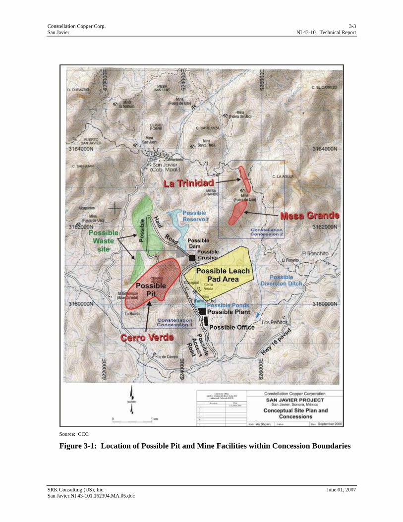
Despite the steep topography in the immediate vicinity of the deposits, a large gently sloped area lies immediately to the east that offers sites for leach pads and process facilities (Figure 3-1). A small perennial stream will either be diverted to the east to control drainage in the proposed facility area or will be dammed to form a small reservoir. Waste rock disposal would be largely incorporated as fill for ramps for access to the possible pit(s). However, additional waste dump sites have been identified as shown in Figure 3-1.
Electrical power is available from an existing line owned by the Federal Power Agency (CFE). The power line passes within 2km of the property and has the capacity to supply a small to medium sized operation.
Approximately 2km of unpaved road leading to the project from the highway will be upgraded to accommodate mine traffic.
SRK Consulting (US), Inc. June 01, 2007 San Javier.NI 43-101.162304.MA.05.doc
Constellation Copper Corp. 3-2 San Javier NI 43-101 Technical Report
Water will be supplied from wells that will be drilled and developed in the project area. CCC is conducting exploration for a ground water source and has permission from CNA to use whatever groundwater can be developed.
SRK Consulting (US), Inc. June 01, 2007 San Javier.NI 43-101.162304.MA.05.doc
Constellation Copper Corp. 3-3 San Javier NI 43-101 Technical Report
SRK Consulting (US), Inc. June 01, 2007 San Javier.NI 43-101.162304.MA.05.doc
Source: CCC
Figure 3-1: Location of Possible Pit and Mine Facilities within Concession Boundaries
Constellation Copper Corp. 4-1 San Javier NI 43-101 Technical Report
4 History (Item 8) 4.1 Ownership The San Javier properties were held by Servicios Industriales Peñoles S.A. De C.V. (Peñoles) from the late 1960’s through the mid-1970’s. Magma Copper Company (Magma) held the property briefly in 1994. Minera Corner Bay (Corner Bay) held the rights from 1994 to 1999 with Phelps Dodge (PD) being involved in a joint venture arrangement in1995-1998.
Also in 1994, the Finnish mining company Outukumpu Oyj (Outukumpu) participated in a brief joint venture with Orcana Resources Ltd (Orcana) and drilled a series of nine holes at La Trinidad.
4.2 Past Exploration & Development Exploration activity has consisted primarily of mapping and surface sampling with relatively minor drilling by Peñoles and PD.
Regional work done by PD, while exploring under a joint venture agreement with Laminco Resources Inc. (Laminco), now Zaruma Resources Inc. (Zaruma), consisted of geological and geophysical studies in an area which partially overlapped the San Javier Project. The results are presented in a report prepared in 2003 for Zaruma by Professor R.P. Viljoen of the Republic of South Africa and provides a general geological description and geological map as well as radiometric surveys for potassium, uranium, thorium and total magnetic field.
The La Trinidad deposit was worked underground on a small scale. CCC does not have the historic production records for La Trinidad. The underground map prepared for Orcana in 1994 outlines a stope of approximately 50m in length by 8m in width, however the vertical extent and dip of the mineralization is not shown and therefore the extracted volume cannot be calculated. Subsequent sampling of the underground workings was done in 1994 to test both the grade and the acid soluble component of the copper mineralization.
Peñoles drilled a total of 18 core holes, of which 12 have assay results composited to interpreted mineralized lengths. Unfortunately, neither the core nor the assay interval information is available to CCC. These drillholes are not be usable in resource estimation, however they are valuable for directing additional drillhole locations and orientations.
PD built a broad network of drill roads on Cerro Verde and to a lesser extent on Mesa Grande, and drilled a total of 18 core holes sampled on 2m intervals (Figure 4-1). CCC has the assay and geological data for 7 of these holes and remaining core halves for the 11 drillholes for which assay and geological data are missing.
CCC has undertaken a fairly aggressive campaign of both core and reverse circulation (RC) drilling from the available drill sites prepared by PD. These drillholes have been arranged in a fan pattern to maximize coverage in all directions (Figure 4-2). Additional sites will be needed for infill drilling. CCC drilling through December 2006 consists of 57 core holes and 21 reverse circulation (RC) holes. CCC’s drilling program is more fully described in Sections 8 and 9.
Assays have been performed for total copper (tCu) and 32 elements by ICP. Assay intervals with tCu > 0.1.0% have been followed by sequential analysis for acid soluble and cyanide soluble copper to provide information on the spatial distribution of acid solubility for an SX-EW process.
SRK Consulting (US), Inc. June 01, 2007 San Javier.NI 43-101.162304.MA.05.doc
Constellation Copper Corp. 4-2 San Javier NI 43-101 Technical Report
SRK Consulting (US), Inc. June 01, 2007 San Javier.NI 43-101.162304.MA.05.doc
Figure 4-1: Location of Phelps Dodge Drillholes
Cerro Verde
La Trinidad
and Mesa Grade
Constellation Copper Corp. 4-3 San Javier NI 43-101 Technical Report
SRK Consulting (US), Inc. June 01, 2007 San Javier.NI 43-101.162304.MA.05.doc
Figure 4-2: Location of CCC and Phelps Dodge Drillholes
Constellation Copper Corp. 4-4 San Javier NI 43-101 Technical Report
4.3 Historic Mineral Resource Estimates PD prepared a resource estimate for Cerro Verde by cross sectional polygonal means using both Peñoles and PD drillhole results. This resulted in an estimate of 96Mt at an average grade of 0.28%Cu. The basis for this estimate was not available for review by the author. This estimate was not prepared according to NI 43-101 guidelines and SRK cannot verify the results.
4.4 Historic Production The Mexican government encouraged small-scale mining for silver, copper, and gold in the vicinity, but the only production within the San Javier concessions was from small underground workings at La Trinidad. No production data is available for the operation. A map of the underground workings prepared for Orcana in 1994 outlines a stope of approximately 50m in length by 8m in width, however, the vertical extent, and dip of the mineralization is not shown and therefore the extracted volume cannot be calculated.
SRK Consulting (US), Inc. June 01, 2007 San Javier.NI 43-101.162304.MA.05.doc
Constellation Copper Corp. 5-1 San Javier NI 43-101 Technical Report
5 Geologic Setting (Item 9) 5.1 Regional Geology The San Javier project lies within the Sonoran Cu-Mo-W Province which represents the southeastern extension of the porphyry copper province of the southwestern United States.
The Sonoran Province is divided by the Mojave-Sonora Megashear which formed as left-lateral transform faults and oblique rift systems developed along a Jurassic Age volcanic arc complex of volcanics and basin sediments. This structure separates Precambrian rocks which are considered to be of two distinct age provinces (Anderson and Silver, 1979).
The Precambrian rock exposures in northern and eastern Sonora on the east side of the Sonoran Megashear consist of strongly deformed greenschist-grade volcanic and sedimentary rocks deposited about 1.7 Ga ago. On the west side of the Sonoran Megashear, in northwestern Sonora, the Precambrian rock consists of upper-amphibolite facies intrusives, schist, and feldspathic gneiss, with U-Pb zircon isotope ages between 1.7 and 1.8 Ga (Anderson et al., 1980).
Proterozoic basement rocks are overlain by Paleozoic and Mesozoic clastic and carbonate sedimentary rocks which are intruded and overlain by intermediate-to-felsic Laramide igneous rocks.
The region is structurally complex with Jurassic Age transform and rift faulting, Laramide Age compressional faulting and folding, and subsequent dissection by two or more episodes of extensional basin and range faulting in the Tertiary. Dominant regional structural trends are N-S, NW-SE and NE-SW.
The Sonoran Province hosts many metallic deposits including Laramide Cu-Mo porphyry systems and Tertiary precious metals deposits. Prominent mineral deposits in the region include the major porphyry copper deposits of Cananea and La Caridad, large volcanic-hosted precious-metal deposits throughout the Sierra Madre Occidental, and a number of other igneous-related and basin-related deposit (Staude et al, 2001).
5.2 Local Geology Figure 5-1 illustrates the local geology of the San Javier Project. Locally, the oldest rocks are the Upper Triassic Barranca Group, a 3,150m thick sequence of sandstones, conglomerates, siltstones, and shales with coal horizons. The Barranca Group appears to have been deposited in a single east-west trending basin 110km long and 40km wide surrounded by areas of irregular high relief which has been interpreted to represent a paleo-rift valley system.
The Barranca is comprised of three formations, from oldest to youngest, the 1,150m thick Arrayanes Formation, the 1,400m thick Santa Clara Formation, and the 600m thick Coyote Formation.
The Arrayanes and Santa Clara Formations are composed of fluvial and marine-deltaic sandstones, conglomerates, shales and siltstones, with the Santa Clara hosting horizons of coal and volcanic tuffs. The coal is mined locally in numerous small underground operations. The Coyote Formation is composed of alluvial fan deposits of poorly-sorted, clast-supported pebble to boulder conglomerates.
SRK Consulting (US), Inc. June 01, 2007 San Javier.NI 43-101.162304.MA.05.doc
Constellation Copper Corp. 5-2 San Javier NI 43-101 Technical Report
Source: CCC, from a report by Zaruma
Figure 5-1: Local Geology of the San Javier Project
The Barranca Group is overlain locally by the Tarahumara Formation, consisting of propylitically altered andesitic to dacitic lava, agglomerate, and volcanic breccia, with subordinate felsic pyroclastic components. The age of the Tarahumara Formation is somewhat uncertain, in part due to pervasive alteration, and in part due to xenolithic inclusions. Even so, ages of 73 and 70Ma, and 90 and 89Ma have been obtained from U-Pb age dating. All of these ages are older than the 65 to 55Ma K-Ar and U-Pb ages for plutons of the Sonoran batholith in east-central Sonora determined in other studies (McDowell et al 2001).
Rhyolitic volcanic rocks of Oligocene to Miocene Age, related to the Sierra Madre Occidental upper volcanic stage, overlie Laramide Age volcanics and are found in the area.
SRK Consulting (US), Inc. June 01, 2007 San Javier.NI 43-101.162304.MA.05.doc

Constellation Copper Corp. 5-3 San Javier NI 43-101 Technical Report
5.3 Property Geology Within the concessions held by CCC, outcrops consist of the Barranca Group and the Tarahumara Formation. Exposures of the Barranca within the concessions include at least both the Santa Clara and Coyote Formations. The copper mineralization is hosted by the Tarahumara formation.
The Tarahumara Formation is a thick volcanic sequence composed mainly of massive andesite volcanic breccias with intercalated layers of andesite flows and volcaniclastic sandstone and conglomerate. The volcanic breccias were probably deposited as laharic mudflow deposits, agglomerates, and avalanche debris flows. This is evidenced by the textures, and the fact that bedding or other primary planar features are almost never present.
The breccias consist of poorly-sorted, sub-angular fragments from a few millimeters to as much as 50 - 60cm in size. The igneous matrix of the breccias is usually porphyritic and consists of altered, subhedral plagioclase phenocrysts, 1 to 4mm in size, in a groundmass consisting of small feldspar laths, hornblende, and magnetite-ilmenite.
Within copper mineralized areas, much of the groundmass of mafic minerals has been hydrothermally altered to specular hematite. Porphyritic flow units are nearly identical to the andesite breccias, but lack fragments except for areas proximal to auto-brecciated flow margins.
Clasts in the andesitic breccias are usually volcanic in nature and consist predominantly of porphyritic andesite with lesser amounts of rhyolite and dacite. Volcanic breccias in the upper part of the section grade downward into a lower sequence of sedimentary breccias with a more clastic appearing matrix, containing subrounded fragments, and a exhibiting a more polymict character due to the presence of clasts of underlying Barranca Group sedimentary rocks (quartzite, chert, and mudstone).
While the Tarahumara Formation within the property consists primarily of andesite, more felsic, quartz-bearing units have been mapped at La Trinidad. The nature of the contact between this felsic rock and the andesite is not clear and may be gradational, however the pervasive alteration and hematite staining demand close observation for valid distinctions to be made. Exposures in a road cut at La Trinidad show what might be felsic feeder dikes crosscutting Barranca Group sedimentary rocks, although the lateral juxtaposition may also be the result of offset along closely spaced normal faults.
5.3.1 Structure Structural trends of identical orientation (NW-SE, N-S, and NE-SW) to the regional trends are expressed throughout the property. These appear to have acted as control on the location and orientation of brecciation and mineralization. In addition, high-angle east-west, and low angle structures of varying strike bound mineralized zones in a fashion that suggests post-mineral offset.
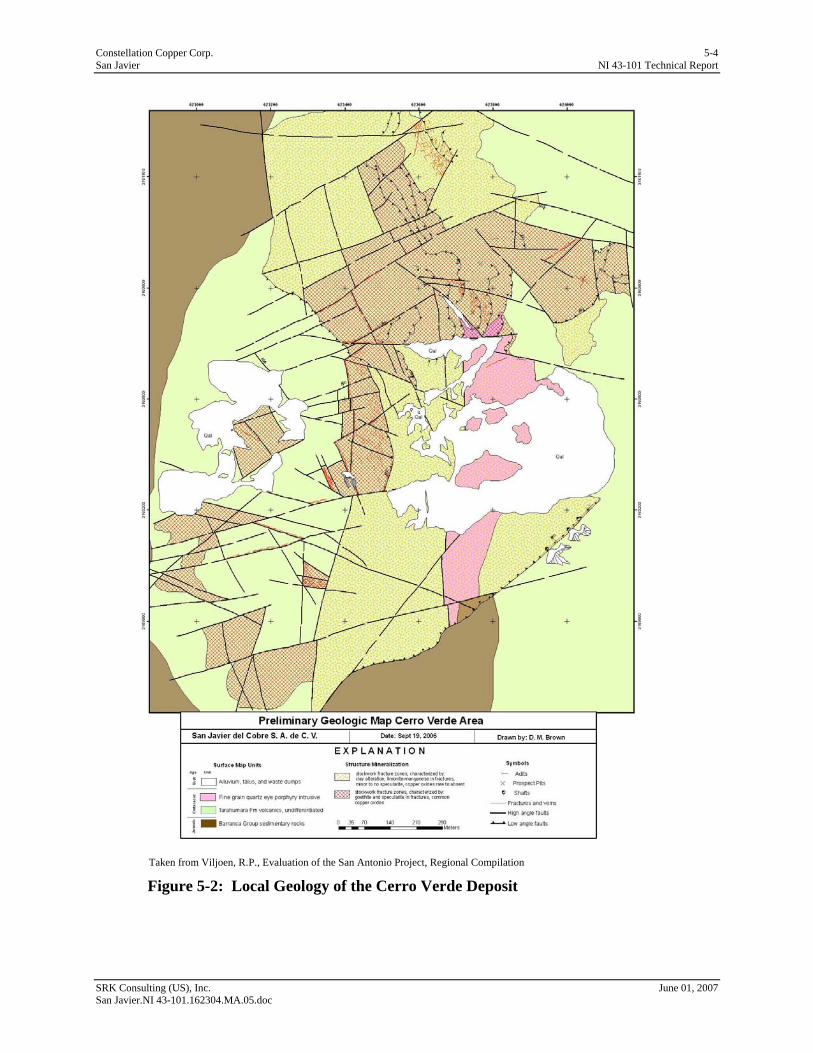
Figure 5-2 presents a preliminary map of the surface geology at Cerro Verde compiled by CCC’s site geologist. Surface mapping at Mesa Grande and La Trinidad is not yet sufficiently advanced to prepare a similar compilation from field maps.
SRK Consulting (US), Inc. June 01, 2007 San Javier.NI 43-101.162304.MA.05.doc
Constellation Copper Corp. 5-4 San Javier NI 43-101 Technical Report
Taken from Viljoen, R.P., Evaluation of the San Antonio Project, Regional Compilation
Figure 5-2: Local Geology of the Cerro Verde Deposit
SRK Consulting (US), Inc. June 01, 2007 San Javier.NI 43-101.162304.MA.05.doc
Constellation Copper Corp. 6-1 San Javier NI 43-101 Technical Report
6 Deposit Types (Item 10) The mineral deposits being investigated at San Javier have been identified as belonging to the Iron Oxide-Copper-Gold (IOCG) type. This style of deposit has become increasingly recognized as more significant deposits are being discovered. They have been broadly characterized by David V. Lefebure of the British Columbia Geological Survey (1995).
A number of IOCG style deposits have been discovered in western Mexico from the Baja Peninsula and Sonora in the north through Sinaloa and into Narayit to the south, as well as on the Baja peninsula. The occurrences in Mexico are typically associated with mafic to intermediate volcanics and range in age from Late Jurassic to Early Cretaceous. These deposits appear to belong to a middle Mesozoic belt of Fe-oxide (+Cu, Au) occurrences along the Cordillera (Barton and Johnson, 1996).
IOCG deposits exhibit a wide range of sizes and suites of economic metal. Recoverable metals may include Fe, Cu, Au, Ag, U, P and Rare Earth Elements (REE). Polymetallic IOCG deposits, e.g. Fe, Cu, +Au, are generally the more valuable. Deposits may exceed 1,000Mt grading greater than 20% Fe, but are more frequently in the 100 to 500Mt range. The Olympic Dam deposit in Australia has estimated reserves of 2,000Mt grading 1.6% Cu, 0.06% U3O8, 3.5gpt Ag and 0.6gpt Au. The Ernest Henry deposit in Australia is estimated to contain 100Mt at 1.6% Cu and 0.8g/t Au (Lefebure, D.V., 1995).
Some of the deposits, typically hematite rich, are characterized by breccias at all scales grading inward from weakly fractured host rock to iron oxide matrix-supported breccia (sometimes heterolithic) to zones of 100% Fe oxide in the core of the brecciation zone.
Breccia fragments are generally angular and range up to more than 10m in size, although they are more frequently less than 1m. Contacts with host rocks are frequently gradational over centimeters to meters (Lefebure, D.V., 1995).
SRK Consulting (US), Inc. June 01, 2007 San Javier.NI 43-101.162304.MA.05.doc

Constellation Copper Corp. 7-1 San Javier NI 43-101 Technical Report
7 Mineralization (Item 11) Mineralization is strongly structurally controlled by both high- and low-angle faults. Post-mineral structural displacement is responsible for the current geometry of mineralization.
The Tarahumara Formation exhibits pervasive propyllitic alteration throughout the property and beyond. Local zones of alteration within the CCC concessions include sericitic and potassic alteration associated with stockworks and specularite in veins and massively replacing the groundmass of the brecciated andesite. The location of the stockworks is often indicated at surface by locally intense bleaching of the rock.
Cerro Verde exhibits strong structural controls with regards to both specularite replacement and copper mineralization. This is consistent with the IOCG model described by Lefebure (1995) who lists as key characteristics:
• Strong structural control with emplacement along faults or contacts, particularly narrow grabens; and
• Hydrothermal activity on faults with extensive brecciation.
At Cerro Verde, a large core of hydrothermally brecciated, intensely specularitized and sericitized andesite that is mineralized with copper is exposed. Within this core zone, specularite may constitute over 50% of the rock as seen in hand specimens. Drilling indicates that this core zone extends as much as 200m below the surface. The mineralized zone trends about N40oE and is about 1,100m long and 400m wide.
The eastern margin of Mesa Grande exhibits similar alteration styles to Cerro Verde, although the dimensions of any brecciated core zone have not been yet been identified because of the more limited drilling and surface exposure in these areas. La Trinidad, however, does not exhibit the same styles of brecciation and specularite hematite infiltration as observed at Cerro Verde and Mesa Grande. The rocks at La Trinidad are intensely argillicly altered with more earthy hematite after pyrite, and mostly lack hydrothermal specularite breccias.
The zones of intense alteration served as favorable hosts for copper mineralization. There is a strong correlation between the degree of specularite replacement and the extent of copper mineralization.
Copper sulfide mineralization, observed in deep drillholes, consists of chalcopyrite as disseminated blebs and micro-fracture filling. Chalcocite is also present, and as an acid soluble sulfide, is more important to CCC. Other copper sulfide minerals common to IOCG deposits, such as bornite, have only been observed petrographically.
Iron alteration and copper mineralization are often found to attenuate sharply with transition from mineralized to un-mineralized rock occurring over the space a few meters to less than a meter. Sharper boundaries have been observed which suggest structural offset.
Nearly complete oxidation of sulfides is indicated in some drillholes to a depth of 200m from surface. Weathering and sulfide oxidation are important at San Javier as the current project is being investigated as a potential SX-EW process. The oxidation interface is indicated to be highly irregular and largely controlled by structural penetration from surface. Drilling may not be sufficient to capture this surface and consideration is being given to incorporating oxide and sulfide distinctions into a more encompassing acid recoverability model.
SRK Consulting (US), Inc. June 01, 2007 San Javier.NI 43-101.162304.MA.05.doc

Constellation Copper Corp. 7-2 San Javier NI 43-101 Technical Report
The relatively well-drilled Cerro Verde deposit appears to be capped by 10 to 15m of leached rock generally barren of significant copper mineralization. Only limited amounts of supergene enrichment has been indicated in drillhole sample assays, however. This is likely due to the generally sulfide-poor nature of the mineralized system which, upon oxidation, failed to establish acid-leaching conditions sufficient to mobilize copper. The extreme topographic contrast in the area may also have contributed by permitting the escape of dissolved metals to surface waters and thereby preventing fluid ponding; copper precipitation against a near-surface water table may have contributed as well. Surface mapping at Mesa Grande suggests that similar near-surface leaching may be present overlying the identified stockwork areas.
Within the oxidized zone, copper mineralization exists as secondary copper oxides and carbonates filling both pene-contemporaneous and post-mineral fractures. Minor disseminations and micro-veinlets exist within the specularite matrix probably represent sites of original sulfide mineralization.
The principal copper minerals in the oxide zone are malachite, azurite, and chrysocolla. Chalcocite has been observed in thin section and is believed to be a common interstitial constituent within felted specularite where high total copper assays were returned. The more visually obvious oxides, carbonates, and chalcopyrite are commonly observed in logging. It is not practically possible to distinguish chalcocite from specularite in the core.
Anomalous gold mineralization, sometimes exceeding 1ppm, has been found in multi-element analyses done on core samples. CCC does not consider gold mineralization to be potentially important for the project, due primarily to the envisaged process route for copper that would preclude gold recovery.
Uranium and rare earth elements are commonly associated with IOCG deposits. Regional airborne radiometrics done by PD have indicated the presence of anomalous uranium in some areas, consistent with other IOCG deposits. However, these anomalies lie outside of the concessions held by Constellation. Uranium is regarded by the Mexican government as a strategic element and its presence in potentially economic amounts may deter independent development for other metals.
SRK Consulting (US), Inc. June 01, 2007 San Javier.NI 43-101.162304.MA.05.doc
Constellation Copper Corp. 8-1 San Javier NI 43-101 Technical Report
8 Exploration (Item 12) CCC’s current exploration program consists of:
• Surface mapping and field analysis using Niton portable X-Ray fluorescence (XRF) multi-element element analysis;
• Diamond core and RC drilling; and
• Re-examination and re-analysis of existing core from previous lease holders.
The drilling program includes sampling the drillholes on 3m intervals and analysis for total copper and sequential analyses for acid soluble and cyanide soluble copper to provide an indication of potential SX-EW process recoverability.
The acid soluble assay indicates the proportion of copper oxides, carbonates and silicates easily dissolved in sulfuric acid. The cyanide soluble analysis indicates the proportion of copper resident as other copper minerals, primarily chalcocite, that are not easily dissolved in the laboratory, but which would be amenable to the SX-EW process.
A multi-element analysis is also done as part of the total copper analysis process.
During the logging of the core and chip samples, a NITON portable XRF analyzer is used to provide an early indication of copper mineralization. This analysis is indicative only and the results are not intended to be used for any quantitative purpose.
Five petrographic slides have been studied by Petrographic Consultants International (PCI) on core samples which have been selected based on the relationship between the sequential analysis results to better understand the underlying mineralogical relationship with recovery.
In addition, CCC is preparing bulk metallurgical samples from core for column testing to determine the amenability of the mineralization to acid leaching
As of the date of this report, a near surface, contiguous body of copper oxide mineralization has been identified at Cerro Verde. Significant copper oxide mineralization has been found in drillholes at Mesa Grande; however, the boundaries and extent of this mineralization have not yet been defined. A smaller contiguous body of copper oxide mineralization has been indicated by historical work at La Trinidad. CCC has not yet undertaken any systematic verification of the mineralization.
CCC is conducting their entire exploration program directly, using contract drilling and a commercial laboratory. The contracted core drilling company is Major Drilling de México S.A. de C.V. (Major), the reverse circulation (RC) drilling is conducted by Layne de México S.A. de C.V. (Layne) and the laboratory is International Plasma Laboratory Inc. (IPL) in Richmond, British Columbia, Canada and its contracted sample preparation laboratory, Sonora Sample Preparation Laboratory (SSP). A significant proportion of the historical data, primarily the core drilling done by Peñoles at Cerro Verde, are only usable as exploration guides and are not be usable for resource estimation. A proportion of the Phelps Dodge drilling can be used following re-logging and re-analysis of the remaining core, as well as the seven holes for which reliable assays are available. The Orcana/Otukumpu drilling at La Trinidad is expected to be usable pending re-logging and re-analysis of the remaining core.
SRK Consulting (US), Inc. June 01, 2007 San Javier.NI 43-101.162304.MA.05.doc

Constellation Copper Corp. 8-2 San Javier NI 43-101 Technical Report
CCC commissioned Cooper Aerial Surveys Co. (Cooper) to conduct an aerial survey of the area to produce topographic data of the concessions and areas outside the current exploitation rights to plan for potential mine facilities. This work has been completed and is incorporated into the resource model.
It is the SRK’s opinion that the work done to date by CCC is well conceived and has been executed to industry standards. The drilling procedures are more fully discussed in Section 9.
SRK Consulting (US), Inc. June 01, 2007 San Javier.NI 43-101.162304.MA.05.doc
Constellation Copper Corp. 9-3 San Javier NI 43-101 Technical Report
9 Drilling (Item 13) Several historic drilling campaigns have been undertaken on the San Javier targets by a number of previous leaseholders. Some of the information from these campaigns serves as general guides to CCC in focusing their present and planned efforts, as neither the original assay information nor the remaining core are available.
There were a total of 18 core holes drilled by PD during their tenure on the property. All PD drilling was HQ (63.5mm) sampled on nominal 2m intervals. Drillholes 1 through 7 from the PD drilling campaign have assays on 2m intervals with geologic logging; the remaining half core of these holes no longer exists. No assay or geologic logs exist for drillholes 8 through 18 from the PD campaign; however, complete core halves for these holes exist and are in CCC’s possession. CCC plans to re-log and re-assay these holes for inclusion in the drillhole database. These holes will be sampled on a 3m interval by CCC to correspond to their current sample spacing. Analysis will include the same total copper, sequential copper, and multi-element analyses currently being done by CCC on their drillhole samples. To date, two of the holes have been re-assayed and are included in the database; both are outside the Cerro Verde area.
CCC also possesses the core halves from the nine drillholes done by Orcana/Otukumpu at La Trinidad. This core will be re-assayed and re-logged for incorporation into the database.
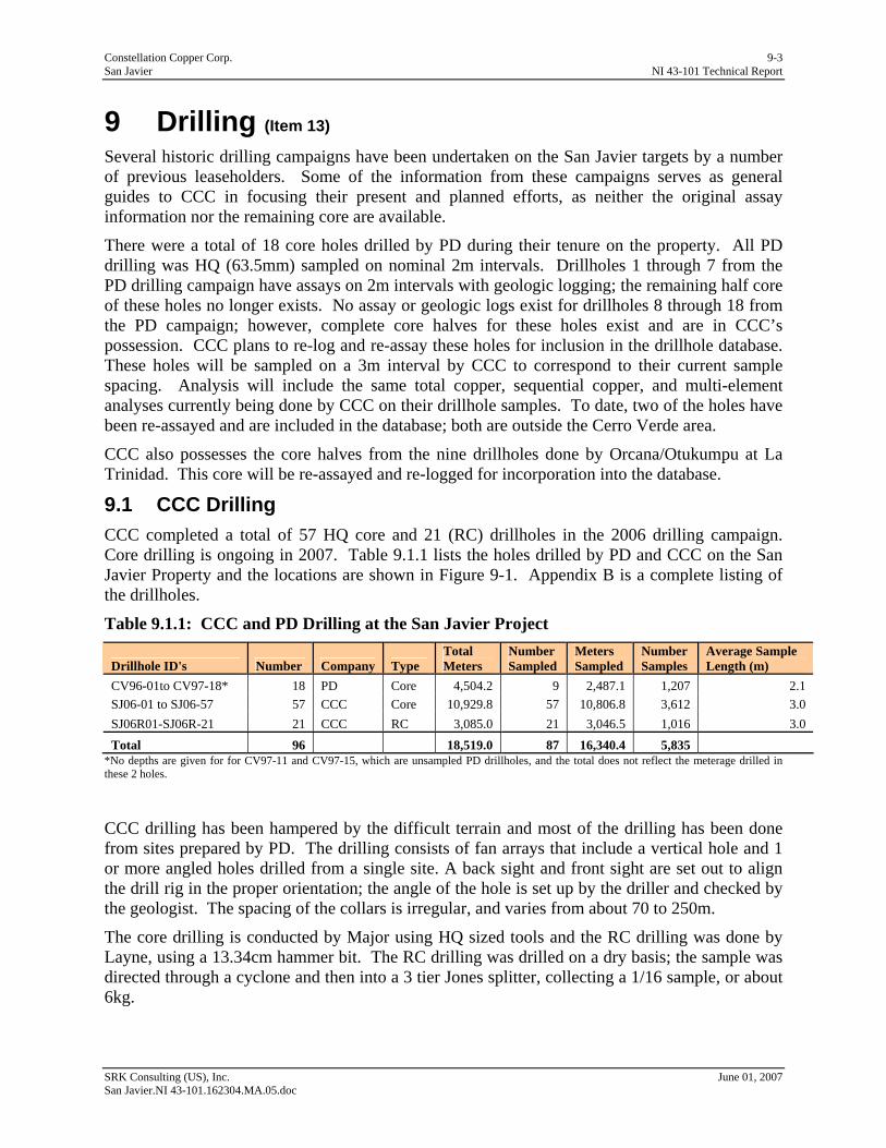
9.1 CCC Drilling CCC completed a total of 57 HQ core and 21 (RC) drillholes in the 2006 drilling campaign. Core drilling is ongoing in 2007. Table 9.1.1 lists the holes drilled by PD and CCC on the San Javier Property and the locations are shown in Figure 9-1. Appendix B is a complete listing of the drillholes.
Table 9.1.1: CCC and PD Drilling at the San Javier Project
Drillhole ID's Number Company Type Total Meters
Number Sampled
Meters Sampled
Number Samples
Average Sample Length (m)
CV96-01to CV97-18* 18 PD Core 4,504.2 9 2,487.1 1,207 2.1 SJ06-01 to SJ06-57 57 CCC Core 10,929.8 57 10,806.8 3,612 3.0 SJ06R01-SJ06R-21 21 CCC RC 3,085.0 21 3,046.5 1,016 3.0 Total 96 18,519.0 87 16,340.4 5,835
*No depths are given for for CV97-11 and CV97-15, which are unsampled PD drillholes, and the total does not reflect the meterage drilled in these 2 holes.
CCC drilling has been hampered by the difficult terrain and most of the drilling has been done from sites prepared by PD. The drilling consists of fan arrays that include a vertical hole and 1 or more angled holes drilled from a single site. A back sight and front sight are set out to align the drill rig in the proper orientation; the angle of the hole is set up by the driller and checked by the geologist. The spacing of the collars is irregular, and varies from about 70 to 250m.
The core drilling is conducted by Major using HQ sized tools and the RC drilling was done by Layne, using a 13.34cm hammer bit. The RC drilling was drilled on a dry basis; the sample was directed through a cyclone and then into a 3 tier Jones splitter, collecting a 1/16 sample, or about 6kg.
SRK Consulting (US), Inc. June 01, 2007 San Javier.NI 43-101.162304.MA.05.doc
Constellation Copper Corp. 9-4 San Javier NI 43-101 Technical Report
The drill collars are surveyed by a contracted professional surveyor from Hermosillo, using a stationary GPS base station and subsequent triangulations of drillholes with an accuracy of 0.1m. None of the holes has been surveyed for downhole deviation. The average depth of the CCC holes is about 180m and the deviation should not be significant for holes of this depth.
Core and RC samples are collected at the drill rig by CCC personnel and transported to a dedicated sample handling facility in San Javier. The core and RC chips are logged by the project geologist with a broad spectrum of lithological, structural, mineralogical, structural and alteration-associated observations.
After logging of the core by the geologist, the core is sawn at the core facility and one-half of the core is placed in plastic sample bags for transport to SSP in Hermosillo for sample preparation. The remaining core halves are replaced in their respective locations in the core boxes and stored on steel shelves at the core facility in San Javier.
The rock at San Javier is uniformly massive and core recovery is generally very good. Approximately 95% of the core samples have 75% or greater recovery, while 87% have 90% recovery or greater.
The mineralization is disseminated and not confined to a single horizon and thus, the relationship between drillhole intersection and true thickness is not relevant in this situation. The drillholes generally penetrate the mineralized material and occasionally bottom in the Barranca Formation. The drilling at Cerro Verde covers an area of about 1,200m x 500m, elongate in the northeast direction.
A drillhole location map is shown in Figure 9-1 and an east-west cross-section and a north-section are shown in figures 9-2 and 9-3.
SRK Consulting (US), Inc. June 01, 2007 San Javier.NI 43-101.162304.MA.05.doc
Constellation Copper Corp. 9-5 San Javier NI 43-101 Technical Report
SRK Consulting (US), Inc. June 01, 2007 San Javier.NI 43-101.162304.MA.05.doc
Figure 9-1: CCC and Phelps Dodge Drilling
Cerro Verde
La Trinidad and Mesa Grande
A A’
B’
B

Constellation Copper Corp. 9-6 San Javier NI 43-101 Technical Report
Figure 9-2: East-west Cross-section A to A’
Figure 9-3: North-south Cross-section B to B’
SRK Consulting (US), Inc. June 01, 2007 San Javier.NI 43-101.162304.MA.05.doc
Constellation Copper Corp. 10-1 San Javier NI 43-101 Technical Report
10 Sampling Method & Approach (Item 14)
10.1 Sampling Method Core and RC samples are collected at the drill rig by CCC personnel and transported to a dedicated sample handling facility in San Javier where the core is photographed. The project geologists log the core and chips for lithologic characteristics and the core is logged for such geotechnical qualities as core recovery, rock quality determination (RQD), and rock mass rating (RMR).
After logging is complete, the geologist marks the sample intervals on the core; the sample intervals are 3m unless there is a geological reason to change the length. The core is sawn lengthwise and one-half of the core is placed in plastic sample bags for transport to SSP in Hermosillo for sample preparation. The remaining core halves are replaced in their respective locations in the core boxes and stored on steel shelves at the core facility in San Javier. The RC samples are collected at the drill by the drilling contractor under supervision of CCC. A three tier Jones splitter is placed directly under the cyclone, resulting in a 1/16 split of the 3m sample. The sample bags are pre-marked with the drillhole ID and drill interval.
The samples are picked up by at the sample facility by SSP personnel or contractor.
10.2 Sample Location The drilling has been done from sites on existing roads. The spacing of the collars is irregular, and varies from about 70 to 250m (Figure 9-1). CCC has tried to maximize the use of the sites by fan drilling with the layout generally consisting of one or more inclined holes and a vertical hole. The spacing of the samples therefore varies considerably with depth. The area covered by the drilling is several hundred hectares over a length of 1,200m and a width of 500m and the samples are distributed throughout that area, although the sample distance is quite variable.
10.3 Sample Quality Given the nature of the mineralization in the oxidized zone and the hardness and solubility contrast between the country rock and oxide copper minerals there is potential for loss of mineralization or upgrading in RC drillhole samples. This potential will be especially present in wet holes, and logs should carefully note the presence and location of any water table. To date, no water has been encountered in any of the drillholes and there is no evidence that the RC samples have undergone the loss or upgrading of mineralization described above.
There are 5,835 samples in the drillhole database, including all the CCC holes and those PD holes for which there are assays. In the Cerro Verde resource area there are 5,486 samples. The length of the PD samples is 2m and the length of the CCC samples is 3m. The sample interval is appropriate for the massive type of mineralization.
The rock at San Javier is uniformly massive and core recovery is generally very good. Approximately 95% of the core samples have 75% or greater recovery, while 87% have 90% recovery or greater. Core recovery in the database is calculated in a spreadsheet and shows some evidence of instances of typographical errors in the recovered length column which should be checked.
Drilling methods and orientations of drillholes are appropriate for the topography and mineralization. The sampling and on-site sample handling of the core was observed by SRK and
SRK Consulting (US), Inc. June 01, 2007 San Javier.NI 43-101.162304.MA.05.doc

Constellation Copper Corp. 10-2 San Javier NI 43-101 Technical Report
was performed to industry standards and no biases are anticipated due to the sampling method. SRK did not observe the RC drilling as it was not being used at the time of the site visit. SRK also did not visit SSP or the IPL lab and cannot form an opinion of their adherence to official procedures, but notes that IPL is an accredited laboratory. SRK did not observe any negative factors that might affect the accuracy or reliability of the results.
SRK Consulting (US), Inc. June 01, 2007 San Javier.NI 43-101.162304.MA.05.doc
Constellation Copper Corp. 11-1 San Javier NI 43-101 Technical Report
11 Sample Preparation, Analyses & Security (Item 15)
The sample preparation on site is limited to sawing of the core in the case of core drilling and splitting of the sample in the case of RC drilling. All other sample preparation is performed by the independent laboratory, IPL and its contractor, SSP. The core sawing is done under the supervision of the site geologist by local employees of the company. The RC sample splitting and collection is done by the driller’s assistant.
The author does not believe that any aspect of the sample preparation was conducted by an officer, director, or associate of CCC.
11.1 Sample Security Core and RC samples are transported to CCC’s sample and core housing center in San Javier by CCC employees. This facility is an enclosed and partially roofed courtyard with access by way of a locking gate to the rear and a lockable door to the front.
The samples from core halves are prepared for shipping to SSP in Hermosillo at this facility. The samples are transported from San Javier to Hermosillo by employees or contractors of SSP.
Results from the analyses are transmitted by email directly to CCC’s office in Denver, and as signed paper assay certificates.
11.2 Sample Preparation & Assaying The SSP facility at Hermosillo prepares a pulp and forwards this on to IPL in the Vancouver area for assay. Figure 11-1 is a sample preparation and analysis flowsheet as used at the prep facility. The sample is crushed to -10 mesh and then riffle split to a 250g sample with the remainder retained as coarse reject. The 250g sample is pulverized to -150 mesh, packaged, and sent to IPL for analysis. A split of the 250g pulverized sample is retained by SSP.
IPL is officially registered with and certified by the BC Ministry of Environment, Lands and Parks (BCMOE) and the Canadian Association for Environmental Analytical Laboratories (CAEAL); it also has ISO9001:2000 certification. IPL’s analytical procedures comply with the applicable requirements of the BCMOE, Environment Canada, American Society for Testing and Materials (ASTM), American Water Works Association (AWWA) and United States Environmental Protection Agency (USEPA).
IPL’s analysis consists of 4 acid digestion of the sample with total copper analyzed by Atomic Absorption (AA) and a 32-element ICP package. Samples that return a total copper value greater than 0.1% undergo a sequential digestion copper analysis of acid soluble copper, cyanide soluble copper and residual copper. These measures correspond closely to the proportion of oxide/carbonate, secondary chalcocite, and primary sulfide proportions of the total Cu mineralization. The total of acid soluble and cyanide soluble components approximate the proportion of Cu that may be anticipated to be recoverable under commercial heap leach conditions.
SRK Consulting (US), Inc. June 01, 2007 San Javier.NI 43-101.162304.MA.05.doc
Constellation Copper Corp. 11-2 San Javier NI 43-101 Technical Report
iPL / SSP core sample preparation chart:
Sample weight recording
(250 grams) Remaining of crushed samplePulverizing to -150 mesh (storage as rejects)
for analysis
Rifle splitting
Sample reception
Sample sorting and recording
Sample drying
Sample crushing to -10 mesh
11620 Horseshoe Way Richmond, B.C.Canada V5Y 3E1
Website Email Phone FaxInternational Plasma Labs Ltd.
ISO 9001:2000 Certified Company
: www.ipl.ca: [email protected]: (604) 879-7878: (604) 272-0851
Figure 11-1: IPL/SSP Sample Preparation Flowsheet
11.3 QA/QC A laboratory Quality Assurance/Quality Control (QA/QC) program is in place at San Javier, consisting of a regular program of duplicate pulp analyses, blind inclusion of standards and blanks by CCC, and re-assay of pulps by IPL for internal checking.
Pulp Duplicates The samples intervals chosen for duplicate pulps were based on set intervals for each hole. The samples for the core duplicates were prepared by sawing one-half the core into 2 separate samples, resulting in 2 samples of one-quarter core each. In the case of the RC samples, two samples were collected at the drill rig and submitted to the lab.
This has implications for variability in each case, with the core duplicates introducing an expectation for higher variability for the samples selected for duplicates, while the variability for the RC samples should be consistent with the total RC sample database.
SRK Consulting (US), Inc. June 01, 2007 San Javier.NI 43-101.162304.MA.05.doc

Constellation Copper Corp. 11-3 San Javier NI 43-101 Technical Report
SRK notes that a better procedure would be to randomly select the intervals for duplicate pulp preparation and that the samples be submitted with blind sample numbers to the laboratory. To date, 206 pulp duplicates from 5452 assay intervals have been analyzed for total copper. These duplicates demonstrate a correlation coefficient of 89% for all data and 96% with the removal of 1 obvious outlier. Half absolute relative difference (HARD) analysis of the pulp duplicates reveals that 80% of the duplicates show less than 14.3% relative difference from the original assay values, while 90% show less than 20.6% relative difference (Figure 11-2). Figure 11-3 is a scatter plot of tCu in the pulp duplicate versus tCu in the original sample. These results confirm a level of reproducibility acceptable for resource estimation.
San Javier - Total Cu%HARD Originals vs Pulp Duplicates
0
20
40
60
80
100
120
0 10 20 30 40 50 60 70 80 90 100
% Samples
% R
elat
ive
Diff
Figure 11-2: Half Absolute Relative Difference Between Original Pulp and Duplicate Pulp
SRK Consulting (US), Inc. June 01, 2007 San Javier.NI 43-101.162304.MA.05.doc

Constellation Copper Corp. 11-4 San Javier NI 43-101 Technical Report
San Javier QA-QC - Pulp duplicates
Scatter plot of total Cu %r=89%; (r=96% minus one outlier outlined in red)
Y = 0.965007 X + 0.0042
0.00
0.20
0.40
0.60
0.80
1.00
1.20
1.40
1.60
0.00 0.20 0.40 0.60 0.80 1.00 1.20 1.40 1.60
Original tCu%
Dup
licat
e tC
u%
Figure 11-3: Scatter Plot of tCu in Original Pulp Versus Duplicate Pulp
In addition 92 pulp duplicates have been run for acid soluble, cyanide soluble and residual copper. These exhibit correlation coefficients of 96%, 95%, and 94% respectively for all of the duplicates. HARD analyses show that 80% of the samples show less than 14.3%, 20%, and 15.6% relative difference, respectively, and that 90% of the samples show less than 27%, 33%,
SRK Consulting (US), Inc. June 01, 2007 San Javier.NI 43-101.162304.MA.05.doc
Constellation Copper Corp. 11-5 San Javier NI 43-101 Technical Report
and 22% relative difference, respectively. In part, the lower reproducibility is due to the smaller data set, but some component will be due the higher inherent variability of the value being tested.
Standard Samples The standards program requires improvement. Too many standards have been used in the program so far and the total numbers of analyses for each are too small for statistically valid analysis Figure 11-4). In addition, the standard samples were prepared from material taken from another CCC mine so that none of the standards is from San Javier itself. That said, the IPL standards exhibit excellent reproducibility with variation of no more than 0.01% from the accepted value in 16 samples analyzed.
SRK Consulting (US), Inc. June 01, 2007 San Javier.NI 43-101.162304.MA.05.doc
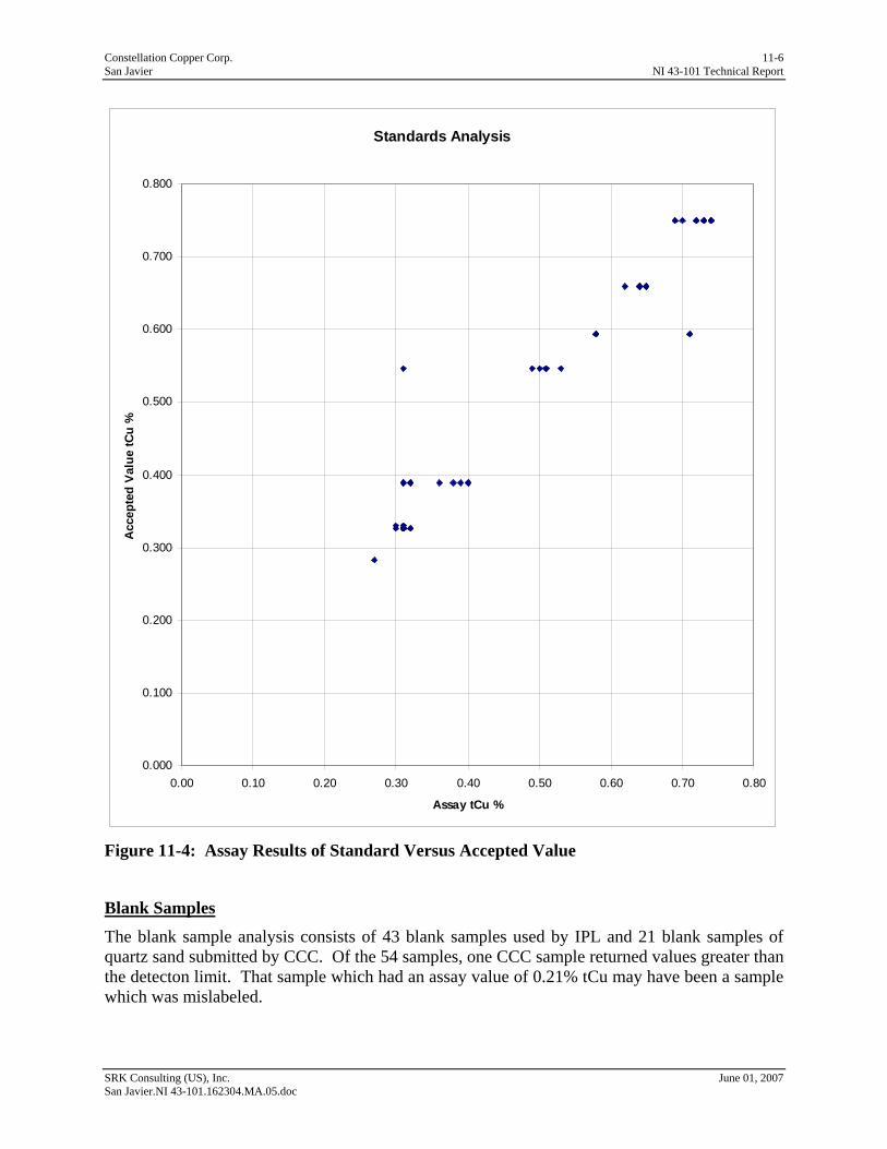
Constellation Copper Corp. 11-6 San Javier NI 43-101 Technical Report
Standards Analysis
0.000
0.100
0.200
0.300
0.400
0.500
0.600
0.700
0.800
0.00 0.10 0.20 0.30 0.40 0.50 0.60 0.70 0.80
Assay tCu %
Acc
epte
d V
alue
tCu
%
Figure 11-4: Assay Results of Standard Versus Accepted Value
Blank Samples
The blank sample analysis consists of 43 blank samples used by IPL and 21 blank samples of quartz sand submitted by CCC. Of the 54 samples, one CCC sample returned values greater than the detecton limit. That sample which had an assay value of 0.21% tCu may have been a sample which was mislabeled.
SRK Consulting (US), Inc. June 01, 2007 San Javier.NI 43-101.162304.MA.05.doc

Constellation Copper Corp. 12-1 San Javier NI 43-101 Technical Report
12 Data Verification (Item 16) The drilling database is compiled directly from spreadsheets sent from IPL to CCC’s Denver office, thus eliminating the errors associated with manual data input.
SRK compared the database assays and the IPL assay certificates of 10 drillholes from the database of 97 holes. The following errors were found:
• Values below detection limit for acid soluble copper, cyanide soluble copper and residual copper were not recorded in the database for 8 of the 10 holes;
• Iron values in 2 holes were not recorded in the database; and
• Total copper below detection limit was not recorded for 1 hole.
Values below detection limit should be given a value, typically one-half of the detection limit. If the value is not recorded, then it is usually treated as not assayed and is ignored in the estimation process.
The pulp duplicates were averaged in the database. Although this is not incorrect, the more common method is to record the first value and then use the second in a QA/QC analysis. There were no other significant errors found in the database.
SRK suggests that CCC should thoroughly review its database for consistency in recording of values below detection limit and for inclusion of all variables used in the resource estimation, calculation of specific gravity, and copper recovery. SRK also notes that these errors would not have a significant impact on the resource estimation provided in this report.
No independent samples from existing core were taken for analysis by SRK because the copper oxide mineralization is visible at hand specimen scale.
SRK Consulting (US), Inc. June 01, 2007 San Javier.NI 43-101.162304.MA.05.doc
Constellation Copper Corp. 13-1 San Javier NI 43-101 Technical Report
13 Adjacent Properties (Item 17) Numerous small-scale deposits adjacent to the concessions have been exploited in the past. These operations were subsidized by the Mexican Government by construction in the 1950’s of a small flotation mill in the valley east of Cerro Verde for treating sulfide-based metal ores.
No production records are available that present tonnes and grade of the material mined. For the most part, these deposits were small narrow-vein precious metal deposits hosted in the Barranca Group sediments, and are therefore unrelated to the deposit style being investigated at San Javier by CCC.
SRK Consulting (US), Inc. June 01, 2007 San Javier.NI 43-101.162304.MA.05.doc
Constellation Copper Corp. 14-1 San Javier NI 43-101 Technical Report
14 Mineral Processing & Metallurgical Testing (Item 18)
The metallurgical test work for San Javier is preliminary at this stage which is consistent with the project level. CCC had sequential digestion analyses done on samples where tCu was greater than 0.1% in the original assay. This analysis is fundamentally a metallurgical test which quantifies the proportion of copper that would be recoverable under SX-EW process. The theoretical recovery is obtained by adding acid soluble copper and cyanide soluble copper and dividing the result by the total copper. The principal advantage of this test is that it establishes metallurgical characteristics at the scale of individual drillhole assay intervals.
In addition to the sequential digestion analyses, a total of 37 48-hour bottle roll tests on pulverized material were completed in March 2007. Four were bulk samples taken at the surface and 33 were composites assembled from core. The samples were selected by CCC in conjunction with their metallurgical consultant, Process Engineering, LLC. The samples were prepared by SSP and the test work was conducted by Metcon Research of Tucson, AZ.
The bulk samples ranged in grade from 0.41% to 2.81% tCu and the core composites ranged from 0.13 to 1.28% tCu. In general, the bottle roll test recoveries correlated well with the recoveries calculated from the sequential digestion assay. The results are shown in Figure 14-1.
SRK Consulting (US), Inc. June 01, 2007 San Javier.NI 43-101.162304.MA.05.doc
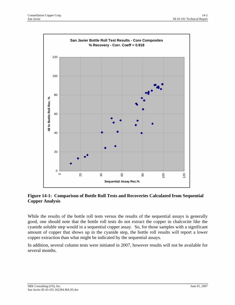
Constellation Copper Corp. 14-2 San Javier NI 43-101 Technical Report
San Javier Bottle Roll Test Results - Core Composites% Recovery - Corr. Coeff = 0.918
0
20
40
60
80
100
1200 20 40 60 80 100
120
Sequential Assay Rec.%
48 h
r Bot
tle R
oll R
ec. %
Figure 14-1: Comparison of Bottle Roll Tests and Recoveries Calculated from Sequential Copper Analysis
While the results of the bottle roll tests versus the results of the sequential assays is generally good, one should note that the bottle roll tests do not extract the copper in chalcocite like the cyanide soluble step would in a sequential copper assay. So, for those samples with a significant amount of copper that shows up in the cyanide step, the bottle roll results will report a lower copper extraction than what might be indicated by the sequential assays.
In addition, several column tests were initiated in 2007, however results will not be available for several months.
SRK Consulting (US), Inc. June 01, 2007 San Javier.NI 43-101.162304.MA.05.doc

Constellation Copper Corp. 15-1 San Javier NI 43-101 Technical Report
15 Mineral Resources & Reserves (Item 19) CCC has completed a resource estimation for the Cerro Verde portion of the San Javier Project, using Techbase software. The database includes all drilling completed through December 31, 2006; the resource estimate was completed as of March 31, 2007. The general approach for grade estimation was to define a grade shell using indicator kriging at a cut-off of 0.10% total copper (tCu). Grades were estimated inside the grade shell, using only composites inside the grade shell. All blocks were considered to be Inferred for this report.
The resources are reported within a pit shell developed by CCC, using a floating cone algorithm. The mining and process costs are consistent with a large-scale open pit heap leach SX-EW operation in Mexico. The Cu price used was $2.40/lb and the recovery was based on the ratio between the sum of acid and cyanide soluble copper and total copper.
SRK has reviewed the database, the estimation parameters, and grade estimation results and has validated the model by visual comparison of the composite grades to the block model grade and by construction of swath plots comparing composite and block grades.
15.1 Resource Database The database for the San Javier Project was furnished to SRK as a Microsoft Excel Spreadsheet consisting of four worksheets with the following information:
• Collars and orientations – dhid, easting, northing, elevation, total depth, azimuth, and inclination;
• Assays – dhid, from, to, total copper(%), acid soluble copper(%), cyanide soluble copper(%), residual copper(%), copper solubility(%), acid consumption(kg/t), and iron(%);
• Composites – dhid, from, to, mid-x, mid-y, mid-z, total copper(%), acid soluble copper(%), cyanide soluble copper(%), copper recovery(%), acid consumption(kg/t), iron(%), indicator, and estimated indicator; and
• Block model data – midx, midy, midz, total copper(%), SG, tonnes, copper indicator, copper recovery(%), Fe(%), recovered Cu(%), various economic values.
The resource database used for the Cerro Verde estimation is a subset of the entire drillhole database described in Section 9; a summary is presented in Table 15.1.1 and the drillholes are illustrated in Figure 15-1.
Table 15.1.1: Resource Database for the Cerro Verde Deposit
Drillhole ID's Number Company Type Total Number Meters Number Average Sample
Meters Sampled Sampled Samples Length (m)
CV96-01to CV96-07 7 PD Core 2,496.8 7 2,274.1 1,136 2.0 SJ06-01 to SJ06-57 57 CCC Core 10,929.8 57 10,806.8 3,612 3.0
SJ06R01-SJ06R-14 14 CCC RC 2,253.0 14 2,214.0 738 3.0
Total 78 15,679.6 78 15,294.9 5,486
SRK Consulting (US), Inc. June 01, 2007 San Javier.NI 43-101.162304.MA.05.doc
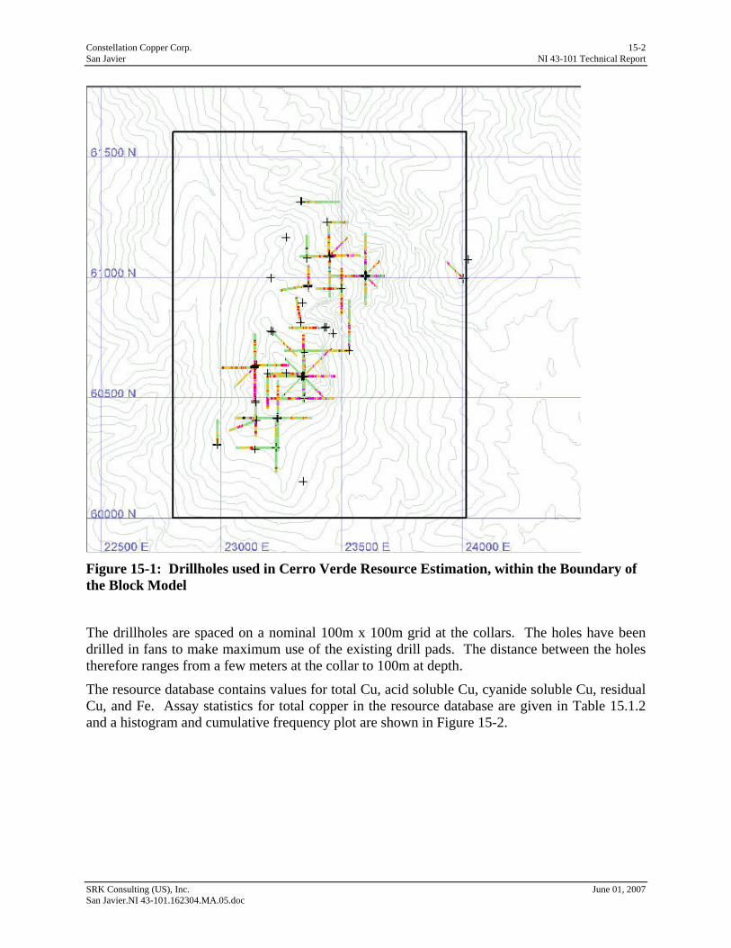
Constellation Copper Corp. 15-2 San Javier NI 43-101 Technical Report
Figure 15-1: Drillholes used in Cerro Verde Resource Estimation, within the Boundary of the Block Model
The drillholes are spaced on a nominal 100m x 100m grid at the collars. The holes have been drilled in fans to make maximum use of the existing drill pads. The distance between the holes therefore ranges from a few meters at the collar to 100m at depth.
The resource database contains values for total Cu, acid soluble Cu, cyanide soluble Cu, residual Cu, and Fe. Assay statistics for total copper in the resource database are given in Table 15.1.2 and a histogram and cumulative frequency plot are shown in Figure 15-2.
SRK Consulting (US), Inc. June 01, 2007 San Javier.NI 43-101.162304.MA.05.doc
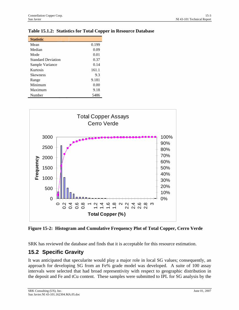
Constellation Copper Corp. 15-3 San Javier NI 43-101 Technical Report
Table 15.1.2: Statistics for Total Copper in Resource Database
Statistic Mean 0.199 Median 0.09 Mode 0.01 Standard Deviation 0.37 Sample Variance 0.14 Kurtosis 161.1 Skewness 9.3 Range 9.181 Minimum 0.00 Maximum 9.18 Number 5486
Total Copper AssaysCerro Verde
0
500
1000
1500
2000
2500
3000
00.
20.
40.
60.
8 11.
21.
41.
61.
8 22.
22.
42.
62.
8 3
Total Copper (%)
Freq
uenc
y
0%10%20%30%40%50%60%70%80%90%100%
Figure 15-2: Histogram and Cumulative Frequency Plot of Total Copper, Cerro Verde
SRK has reviewed the database and finds that it is acceptable for this resource estimation.
15.2 Specific Gravity It was anticipated that specularite would play a major role in local SG values; consequently, an approach for developing SG from an Fe% grade model was developed. A suite of 100 assay intervals were selected that had broad representivity with respect to geographic distribution in the deposit and Fe and tCu content. These samples were submitted to IPL for SG analysis by the
SRK Consulting (US), Inc. June 01, 2007 San Javier.NI 43-101.162304.MA.05.doc
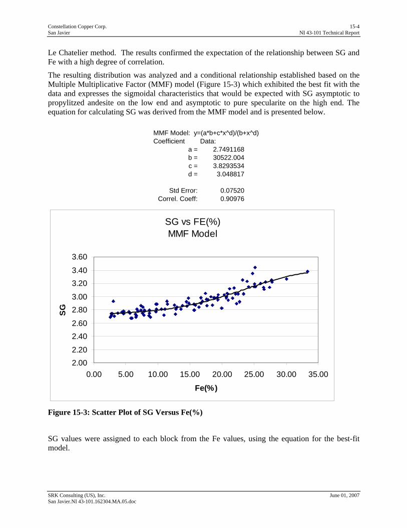
Constellation Copper Corp. 15-4 San Javier NI 43-101 Technical Report
Le Chatelier method. The results confirmed the expectation of the relationship between SG and Fe with a high degree of correlation.
The resulting distribution was analyzed and a conditional relationship established based on the Multiple Multiplicative Factor (MMF) model (Figure 15-3) which exhibited the best fit with the data and expresses the sigmoidal characteristics that would be expected with SG asymptotic to propylitzed andesite on the low end and asymptotic to pure specularite on the high end. The equation for calculating SG was derived from the MMF model and is presented below.
MMF Model: y=(a*b+c*x^d)/(b+x^d)Coefficient Data:
a = 2.7491168b = 30522.004c = 3.8293534d = 3.048817
Std Error: 0.07520Correl. Coeff: 0.90976
SG vs FE(%)MMF Model
2.002.20
2.402.60
2.803.00
3.203.40
3.60
0.00 5.00 10.00 15.00 20.00 25.00 30.00 35.00
Fe(%)
SG
Figure 15-3: Scatter Plot of SG Versus Fe(%)
SG values were assigned to each block from the Fe values, using the equation for the best-fit model.
SRK Consulting (US), Inc. June 01, 2007 San Javier.NI 43-101.162304.MA.05.doc
Constellation Copper Corp. 15-5 San Javier NI 43-101 Technical Report
15.3 Topography Initial topography at the site was at a relatively low resolution and drillhole collars were located by GPS only. Locational errors between drillhole collars and topography ranged from 0 to 120m. CCC commissioned an aerial survey of topography and a resurvey of collar locations which was carried out in December 2006 by Cooper. The new topography is much improved with a resolution of + 2m. The drillhole collars are generally in very good agreement with topography with the exception of several holes that appeared correct in northing and easting but incorrect with respect to elevation. The elevations of these holes were adjusted to match topography.
15.4 Block Model A block model was constructed with the block size of 15m square in plan view and 10m high. The coordinates of the model are shown below:
• East: 22807.5 to 24022.5;
• North: 60007.5 to 61612; and
• Elevation: 565 to 1065.
The block dimensions in X and Y are generally too small for the current data spacing, resulting in an average number of block numbers between samples of approximately five and a maximum of approximately seven. Small blocks relative to data spacing will result in significant over-smoothing and poor local estimation for the majority of blocks. However, the size selected is convenient for mine simulation and preliminary production scheduling, and will be more appropriate for the anticipated sample spacing once infill drilling is completed with an average number of blocks between samples of less than three.
15.5 Geologic Model The mineralization is hosted in the volcanic breccias and flows of the Tarahumara Formation. The drillholes generally do not penetrate the contact with the underlying Barranca Formation. The geological model used in this estimation is based on the characteristics of a structurally-controlled IOCG deposit having mineralized zones associated with breccia and stockwork development. The width of the stockwork and breccias range from a few 10’s of meters to over 200m. The primary structural orientation indicated by brecciation and specularite mineralization appears to be north-northeast and subvertical, however a strong secondary orientation trending northwest appears to be a significant, if not the primary, control on copper mineralization.
The sparse drilling combined with widely varied drillhole orientation precludes development of a deterministic model for controlling grade estimation. For this reason, a probabilistic approach was taken to define volumes representing significant mineralization. The procedure used an indicator at 0.1% copper to define the mineralized blocks and is described more fully in the grade estimation section below.
15.6 Compositing The drillholes were composited on 5m intervals starting at the top of the hole; if the last interval at the bottom of the hole was less than 5m in length it was excluded from the composite file. A histogram of all total copper composites is shown in Figure 15-4 and the statistics are given in
SRK Consulting (US), Inc. June 01, 2007 San Javier.NI 43-101.162304.MA.05.doc
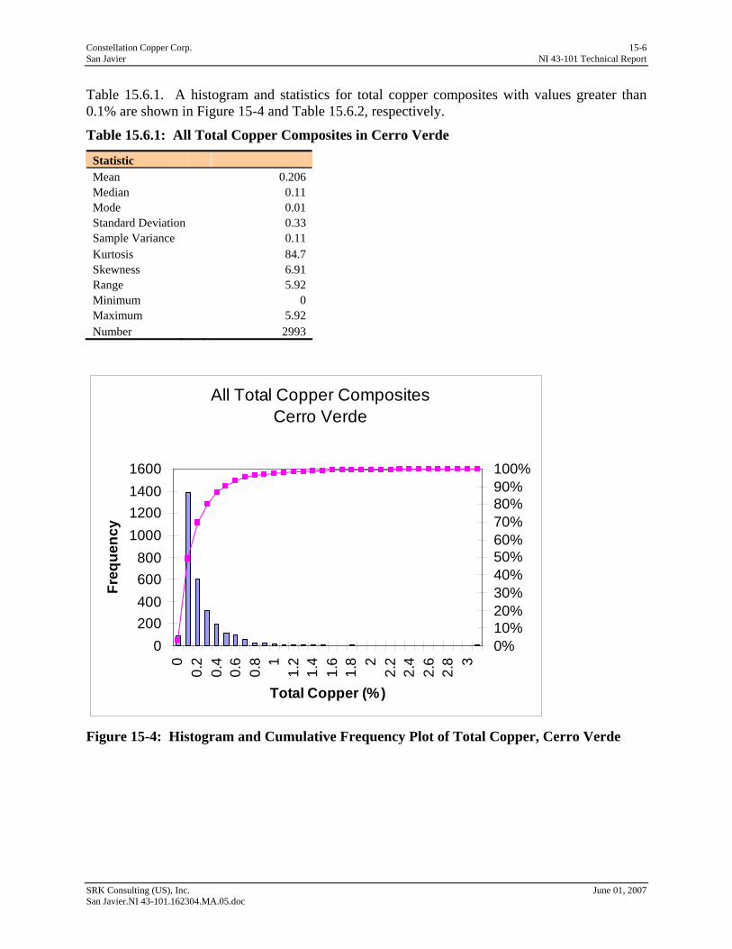
Constellation Copper Corp. 15-6 San Javier NI 43-101 Technical Report
Table 15.6.1. A histogram and statistics for total copper composites with values greater than 0.1% are shown in Figure 15-4 and Table 15.6.2, respectively.
Table 15.6.1: All Total Copper Composites in Cerro Verde
Statistic Mean 0.206 Median 0.11 Mode 0.01 Standard Deviation 0.33 Sample Variance 0.11 Kurtosis 84.7 Skewness 6.91 Range 5.92 Minimum 0 Maximum 5.92 Number 2993
All Total Copper CompositesCerro Verde
0200400600800
1000120014001600
00.
20.
40.
60.
8 11.
21.
41.
61.
8 22.
22.
42.
62.
8 3
Total Copper (%)
Freq
uenc
y
0%10%20%30%40%50%60%70%80%90%100%
Figure 15-4: Histogram and Cumulative Frequency Plot of Total Copper, Cerro Verde
SRK Consulting (US), Inc. June 01, 2007 San Javier.NI 43-101.162304.MA.05.doc
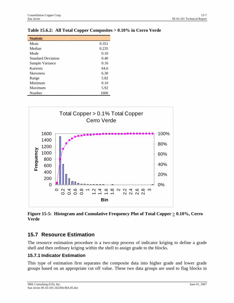
Constellation Copper Corp. 15-7 San Javier NI 43-101 Technical Report
Table 15.6.2: All Total Copper Composites > 0.10% in Cerro Verde
Statistic Mean 0.351 Median 0.235 Mode 0.10 Standard Deviation 0.40 Sample Variance 0.16 Kurtosis 64.6 Skewness 6.30 Range 5.82 Minimum 0.10 Maximum 5.92 Number 1600
Total Copper > 0.1% Total CopperCerro Verde
0200400600800
1000120014001600
00.
20.
40.
60.
8 11.
21.
41.
61.
8 22.
22.
42.
62.
8 3
Bin
Freq
uenc
y
0%
20%
40%
60%
80%
100%
Figure 15-5: Histogram and Cumulative Frequency Plot of Total Copper > 0.10%, Cerro Verde
15.7 Resource Estimation The resource estimation procedure is a two-step process of indicator kriging to define a grade shell and then ordinary kriging within the shell to assign grade to the blocks.
15.7.1 Indicator Estimation This type of estimation first separates the composite data into higher grade and lower grade groups based on an appropriate cut off value. These two data groups are used to flag blocks in
SRK Consulting (US), Inc. June 01, 2007 San Javier.NI 43-101.162304.MA.05.doc

Constellation Copper Corp. 15-8 San Javier NI 43-101 Technical Report
the model based on their proximity to the higher or lower grade composites. Once this is achieved all the higher-grade blocks are estimated using only the higher-grade composites and lower grade blocks estimated using the lower grade composites. This technique precludes the necessity of manually creating very complex grade shells to control grade assignment.
For the San Javier data, a range of indicator values were examined ranging from 0.05% tCu to 0.30% tCu. The 0.1% tCu indicator value was selected based on examination of down-hole grade profiles and variance contour plots. The first step was to flag all of the composites below 0.1% with a value of 0 and those above with a value of 1. This procedure effectively subdivides the composites into upper and lower grade data sets. Variograms were constructed on the indicator values in order to determine appropriate search directions and ranges for the indicator model. Figure 15-6 shows the directional variograms for the 0.1% indicator value.
SRK Consulting (US), Inc. June 01, 2007 San Javier.NI 43-101.162304.MA.05.doc
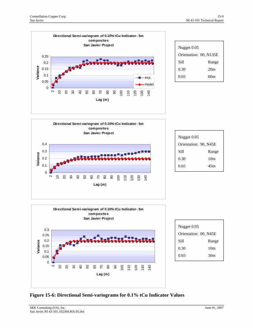
Constellation Copper Corp. 15-9 San Javier NI 43-101 Technical Report
Directional Semi-variogram of 0.10% tCu Indicator- 5m composites
San Javier Project
0
0.05
0.1
0.15
0.2
0.252 10 20 30 40 50 60 70 80 90 100
110
120
130
140
Lag (m)
Varia
nce
exp.
model
0.30 20m
0.65 60m
Nugget 0.05
Orientation: 90, N45E
Sill Range
0.30 10m
0.65 45m
Nugget 0.05
Orientation: 00, N45E
Sill Range
0.30 10m
0.65 30m
Nugget 0.05
Orientation: 00, N135E
Sill Range
Directional Semi-variogram of 0.10% tCu Indicator- 5m composites
San Javier Project
0
0.1
0.2
0.3
0.4
2 10 20 30 40 50 60 70 80 90 100
110
120
130
140
Lag (m)
Varia
nce
Directional Semi-variogram of 0.10% tCu Indicator- 5m composites
San Javier Project
00.050.1
0.150.2
0.250.3
3 10 20 30 40 50 60 70 80 90 100
110
120
130
140
Lag (m)
Varia
nce
Figure 15-6: Directional Semi-variograms for 0.1% tCu Indicator Values
SRK Consulting (US), Inc. June 01, 2007 San Javier.NI 43-101.162304.MA.05.doc
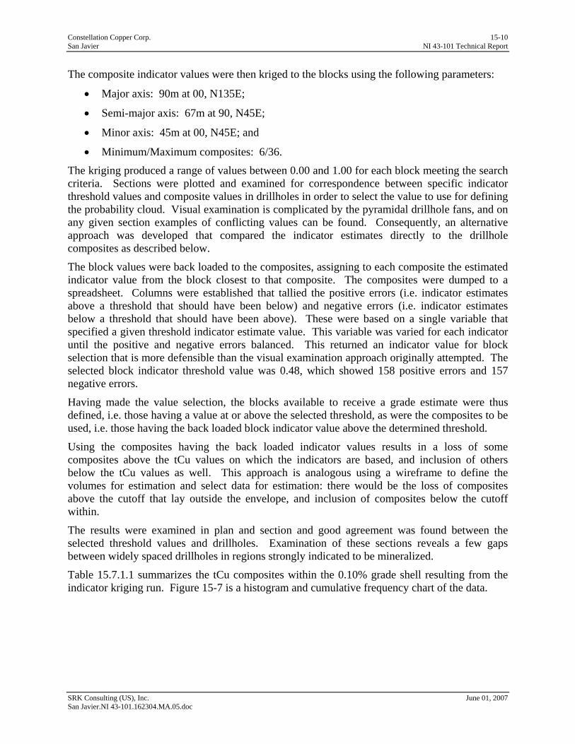
Constellation Copper Corp. 15-10 San Javier NI 43-101 Technical Report
The composite indicator values were then kriged to the blocks using the following parameters:
• Major axis: 90m at 00, N135E;
• Semi-major axis: 67m at 90, N45E;
• Minor axis: 45m at 00, N45E; and
• Minimum/Maximum composites: 6/36.
The kriging produced a range of values between 0.00 and 1.00 for each block meeting the search criteria. Sections were plotted and examined for correspondence between specific indicator threshold values and composite values in drillholes in order to select the value to use for defining the probability cloud. Visual examination is complicated by the pyramidal drillhole fans, and on any given section examples of conflicting values can be found. Consequently, an alternative approach was developed that compared the indicator estimates directly to the drillhole composites as described below.
The block values were back loaded to the composites, assigning to each composite the estimated indicator value from the block closest to that composite. The composites were dumped to a spreadsheet. Columns were established that tallied the positive errors (i.e. indicator estimates above a threshold that should have been below) and negative errors (i.e. indicator estimates below a threshold that should have been above). These were based on a single variable that specified a given threshold indicator estimate value. This variable was varied for each indicator until the positive and negative errors balanced. This returned an indicator value for block selection that is more defensible than the visual examination approach originally attempted. The selected block indicator threshold value was 0.48, which showed 158 positive errors and 157 negative errors.
Having made the value selection, the blocks available to receive a grade estimate were thus defined, i.e. those having a value at or above the selected threshold, as were the composites to be used, i.e. those having the back loaded block indicator value above the determined threshold.
Using the composites having the back loaded indicator values results in a loss of some composites above the tCu values on which the indicators are based, and inclusion of others below the tCu values as well. This approach is analogous using a wireframe to define the volumes for estimation and select data for estimation: there would be the loss of composites above the cutoff that lay outside the envelope, and inclusion of composites below the cutoff within.
The results were examined in plan and section and good agreement was found between the selected threshold values and drillholes. Examination of these sections reveals a few gaps between widely spaced drillholes in regions strongly indicated to be mineralized.
Table 15.7.1.1 summarizes the tCu composites within the 0.10% grade shell resulting from the indicator kriging run. Figure 15-7 is a histogram and cumulative frequency chart of the data.
SRK Consulting (US), Inc. June 01, 2007 San Javier.NI 43-101.162304.MA.05.doc

Constellation Copper Corp. 15-11 San Javier NI 43-101 Technical Report
Table 15.7.1.1: All Total Copper Composites within Grade Shell 0.10% in Cerro Verde
Statistic Mean 0.338 Median 0.22 Mode 0.16 Standard Deviation 0.40 Sample Variance 0.16 Kurtosis 63.48 Skewness 6.20 Range 5.91 Minimum 0.01 Maximum 5.92 Number 1628
Total Copper%, Ind > 0.48Cerro Grande
0
100
200
300
400
500
600
00.
20.
40.
60.
8 11.
21.
41.
61.
8 22.
22.
42.
62.
8 3
Total Copper(%)
Freq
uenc
y
0%10%20%30%40%50%60%70%80%90%100%
Figure 15-7: Histogram and Cumulative Frequency Plot of Total Copper Within 0.1% Grade Shell
15.7.2 Grade Estimation Copper Estimation Interpretable directional variograms are not yet possible for the total Cu value. Consequently, the global variogram for total copper was used to estimate total Cu within the blocks identified as eligible for estimation. This global variogram (Figure 15-8) has a range of 100m, which insured
SRK Consulting (US), Inc. June 01, 2007 San Javier.NI 43-101.162304.MA.05.doc

Constellation Copper Corp. 15-12 San Javier NI 43-101 Technical Report
SRK Consulting (US), Inc. June 01, 2007 San Javier.NI 43-101.162304.MA.05.doc
that any block eligible to receive an estimate by being above the selected indicator threshold did so. Conversely, limiting the blocks eligible to receive an estimate by use of the indicators, removed the opportunity for over-extrapolation.
Global Semi-variogram tCu % - 5m composites
San Javier Project
0
0.05
0.1
0.15
0.2
0.25
2 10 20 30 40 50 60 70 80 90 100
110
120
130
140
Lag (m)
Varia
nce
exp.
model
Figure 15-8: Global Semi-variogram for tCu
The tCu values were then kriged to the blocks using the following parameters:
• Major, semi-major and minor axes: 100m at 90, N00E; and
• Minimum/Maximum composites: 2/12.
No detailed analysis for grade capping was done; however, only 6% of the metal resides in blocks having estimates > 1.0% tCu. Of the 1,628 composites used in estimation, 72 were above 1.0% tCu, which equates to 6% of the metal deriving from 4.4% of the data. This simple analysis strongly suggests that outliers are not an issue.
CCC did not estimate tCu in blocks that were below the indicator threshold in this estimation. SRK suggests that this should be done in future estimations.
The mean grade of the block estimates above a 0.1% tCu is 0.340%. This is nearly an exact agreement of the mean grade of all composites used in estimation of 0.338% tCu, with a difference of only 0.59%. This metric, while comparing a naive statistic against one informed by spatial distribution relative to the variograms, is nonetheless strongly indicative of an unbiased overall estimate.
Cross-sections of the block grades, corresponding to the cross-sections of the drillholes shown in Figures 9-3 and 9-4, are shown in Figures 15-9 and 15-10.
Nugget 0.154
Orientation: 00, N45E
Sill Range
0.577 25m
0.269 100m
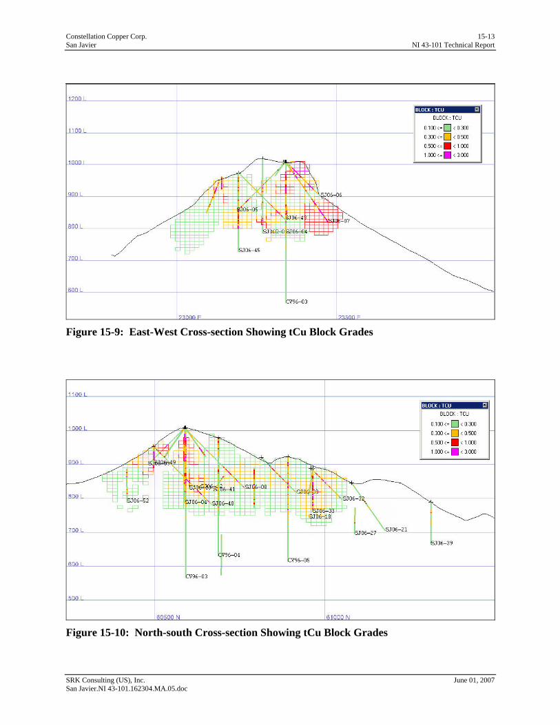
Constellation Copper Corp. 15-13 San Javier NI 43-101 Technical Report
SRK Consulting (US), Inc. June 01, 2007 San Javier.NI 43-101.162304.MA.05.doc
Figure 15-9: East-West Cross-section Showing tCu Block Grades
Figure 15-10: North-south Cross-section Showing tCu Block Grades
Constellation Copper Corp. 15-14 San Javier NI 43-101 Technical Report
Copper Recovery Estimation The value for Cu recovery was calculated in the composites according to the formula:
Cu Recovery = ((Acid sol. Cu + CN sol. Cu)/ tCu) This value was then kriged in estimation. In general this approach is less than optimal, and ideally acid soluble and cyanide soluble Cu will be estimated separately with Cu recovery being calculated in the block model from the three separate estimates. There is no direct correlation between acid soluble Cu which derives from Cu oxides and carbonates and cyanide soluble Cu which derives from chalcocite.
The results were examined in plan and section and despite shortcomings of the approach, were found to agree well with drillhole data and expectations of the geometry of Cu recovery.
Fe and SG Estimation Fe was estimated into the model to use in assigning SG to the individual blocks. Fe and SG are highly correlated as described in Section 15.2. Fe estimation was not constrained by the indicator envelopes as the SG of waste is as important as the SG of ore, and the imperfect correspondence between specularite breccia and Cu mineralization. The variance of Fe% was examined and well-structured directional variograms were developed which formed the basis for estimation.
The blocks were then assigned an SG value based on the Fe grade and the equation shown in Section 15.2. The Le Chatelier SG approach is done on pulps and consequently represents a maximum value without consideration of natural void space in the rock. In general, the rock mass at San Javier is very compact and tight; however, a 3% downgrade factor was applied to account for fracture voids
15.7.3 Model Validation SRK model validation consisted of:
• Confirmation of assay and composite statistics;
• Compositing the database to compare to the CCC composites;
• Variogram checks;
• Review of estimation procedures and parameters;
• Visual examination of composite and block grades in cross-section and plan views; and
• Swath plots of the tCu grades by easting, northing and elevation (Figures 15-11 through 15-13).
SRK’s validation procedures confirmed the validity of the resource estimation, but notes that the block grades are slightly higher than the composite grades in the three swath plots.
SRK Consulting (US), Inc. June 01, 2007 San Javier.NI 43-101.162304.MA.05.doc

Constellation Copper Corp. 15-15 San Javier NI 43-101 Technical Report
Swath Cuts - East
0.000.050.100.150.200.250.300.350.400.450.50
22900 23000 23100 23200 23300 23400 23500 23600 23700
Easting
Cu
BlocksComposites
Figure 15-11: Swath Plots of tCu Grades by Easting
Swath Cuts North
0.00
0.10
0.20
0.30
0.40
0.50
0.60
6000
060
100
6020
060
300
6040
060
500
6060
060
700
6080
060
900
6100
061
100
6120
061
300
Northing
Cu
BlocksComposites
Figure 15-12: Swath Plots of tCu Grades by Northing
SRK Consulting (US), Inc. June 01, 2007 San Javier.NI 43-101.162304.MA.05.doc
Constellation Copper Corp. 15-16 San Javier NI 43-101 Technical Report
Swath Cut Elevation
0.00
0.20
0.40
0.60
0.80
1.00
555 605 655 705 755 805 855 905 955 1005
Elevation
Cu
BlocksComposites
Figure 15-13: Swath Plots of tCu Grades by Elevation
15.8 Mineral Resource Statement The entire resource is classified as inferred due to the wide spaced drilling and the preliminary nature of the metallurgical testwork.
To produce a resource statement, CCC conducted a floating cone analysis using economic parameters consistent with large-scale open pit mining in Mexico and Cu SX-EW process. The parameters are presented below in the context of a cut-off calculation based upon recoverable Cu grade. Recoverable copper is the ration between the sum of acid soluble Cu and cyanade soluble Cu divided by tCu. CCC and SRK have not yet developed costs that would apply specifically to the San Javier deposit but the costs used in this statement of inferred resources are reasonable.
Table 15.8.1: Resource CoG Calculation for San Javier-Cerro Verde, Based on Recovered Copper
Recovered Cu Grade Basis $2.40/lb Cu
Cost/unit Cost/ore tonne Contributor to Cut-
off % of Contribution to Total
CoG Copper Price ($/lb) $ 2.40 Cu Rec (%)* % 100% Mining ($/t) Fixed $ 0.80 $0.800 0.017 20.9% Crush ($/t) Fixed $ 0.40 $0.400 0.008 10.4% Process ($/t) Fixed $ 0.40 $0.400 0.008 10.4% Acid ($/t) Fixed $ 1.60 $1.600 0.033 41.7% G&A ($/t) Fixed $ 0.33 $0.330 0.007 8.6% SXEW ($/lb) Variable $ 0.20 $0.303 0.006 7.9% Total Cost at External Cut-off ($/t) $ $3.833 0.080 Total Cost at Internal Cut-off ($/t) $ $3.033 0.063
Notes: $/lb costs vary by grade. Pit slope was 50º inter-ramp in all directions. *Cu Rec is 100% because recovery is already factored into this variable.
SRK Consulting (US), Inc. June 01, 2007 San Javier.NI 43-101.162304.MA.05.doc
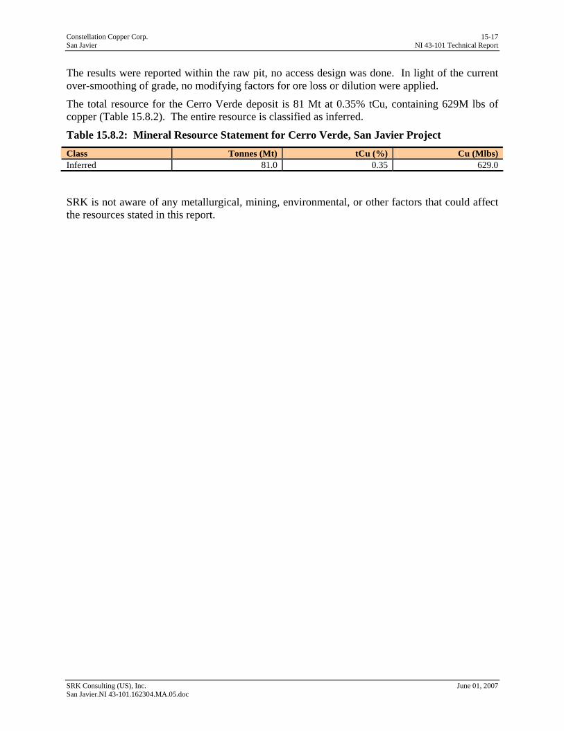
Constellation Copper Corp. 15-17 San Javier NI 43-101 Technical Report
The results were reported within the raw pit, no access design was done. In light of the current over-smoothing of grade, no modifying factors for ore loss or dilution were applied.
The total resource for the Cerro Verde deposit is 81 Mt at 0.35% tCu, containing 629M lbs of copper (Table 15.8.2). The entire resource is classified as inferred.
Table 15.8.2: Mineral Resource Statement for Cerro Verde, San Javier Project Class Tonnes (Mt) tCu (%) Cu (Mlbs) Inferred 81.0 0.35 629.0
SRK is not aware of any metallurgical, mining, environmental, or other factors that could affect the resources stated in this report.
SRK Consulting (US), Inc. June 01, 2007 San Javier.NI 43-101.162304.MA.05.doc
Constellation Copper Corp. 16-1 San Javier NI 43-101 Technical Report
16 Other Relevant Data & Information (Item 20) No other relevant data or information is presented here.
SRK Consulting (US), Inc. June 01, 2007 San Javier.NI 43-101.162304.MA.05.doc

Constellation Copper Corp. 17-1 San Javier NI 43-101 Technical Report
17 Interpretation & Conclusions (Item 21) The San Javier Project consists of an early stage development project at Cerro Verde and exploration targets at La Trinidad and Mesa Grande. A significant body of near-surface, contiguous oxide copper mineralization has been delineated at Cerro Verde. This report contains a mineral resource estimation for the Cerro Verde deposit, which is entirely inferred at this stage of development. Exploration at the project is on-going.
The drilling that forms the basis of the resource database consists of fans of core and RC holes with collars spaced at about 100m. The sample spacing therefore has a wide variability. The drill program that is in progress is designed to reduce the sample spacing and thereby increase the knowledge of geologic controls on mineralization.
The assaying has been conducted by a certified laboratory and a program of laboratory QA/QC has been instituted. CCC recognizes that come improvements could be made to the QA/QC procedures, particularly with the standard samples.
Data verification procedures have revealed some inconsistencies in recording values below detection limit. However, no errors were found in recording values above detection limit. SRK considers the database reliable for use in this resource estimation.
The resource estimation has been conducted within industry standards and has been validated by SRK.
SRK Consulting (US), Inc. June 01, 2007 San Javier.NI 43-101.162304.MA.05.doc
Constellation Copper Corp. 18-1 San Javier NI 43-101 Technical Report
18 Recommendations (Item 22) SRK recommends that CCC review the database and correct the inconsistencies regarding the recording values below detection limit.
Further metallurgical testwork should be done on the property. SRK acknowledges that CCC has column tests in progress that will help in establishing metallurgical recoveries.
Significant mineralization has been delineated at Cerro Grande. SRK recommends that CCC continue drilling and initiate a preliminary assessment on the project.
SRK Consulting (US), Inc. June 01, 2007 San Javier.NI 43-101.162304.MA.05.doc
Constellation Copper Corp. 19-1 San Javier NI 43-101 Technical Report
19 References (Item 23) Anderson, T.H. and Silver, L.T. (1980) The role of the Mojave Sonora megashear in the tectonic
evolution of northern Sonora, in Anderson, T.H., and Roldan-Quintana, J., eds., Geology of northern Sonora; Geological Society of America Annual Meeting Guidebook, Field Trip 2: San Diego, California, San Diego State University, p. 59–68.
Barton, M.D., and Johnson, D.A. (1996) An evaporitic source model for igneous-related Fe-oxide (-REE-Cu- Au-U) mineralization: Geology, v. 24, p. 259–262.
Brown, David, San Javier Project Geologist, Oral and written communication.
Lefebure, D.V. (1995) Iron Oxide Breccias and Veins P-Cu-Au-Ag-U, in Selected British Columbia Mineral Deposit Profiles, Volume 1 - Metallics and Coal, Lefebure, D.V. and Ray, G.E., Editors, British Columbia Ministry of Energy of Employment and Investment, Open File 1995-20, pages 33-36.
McDowell, Fred W., Roldán-Quintana, Jaime, Connelly, James N. (2001) Duration of Late Cretaceous–early Tertiary magmatism in east-central Sonora, Mexico, Issn: 0016-7606 Journal: Geological Society of America Bulletin Volume: 113, Issue: 4 Pages: 521-531
McHale, K. Barry, Lohman, G. (1994) Summary Report on the San Carlos Property, Prepared for Orcana Resources Limited, p 1-10.
Mordaunt, Peter (1996), Summary Report on the Cerro Verde Property, Prepared for Minera Corner Bay S.A. de C.V. p. 1-8
Parkison, Gary, VP Exploration and Development, Constellation Copper Corp. Oral and written communication.
Staude, John-Mark G., Barton, Mark D. (October 2001), Jurassic to Holocene tectonics, magmatism, and metallogeny of northwestern Mexico, Geological Society of America Bulletin, v. 113; no. 10; p. 1357–1374;
Tanaka, William (2006) NI43-101 Technical Report San Javier Copper Project, San Javier, Sonora, Mexico;.
Thompson, Jeremy (2005) Evaluation of the San Javier Copper Deposit, Unpublished Senior Thesis, Colorado School of Mines Department of Mining Engineering, p. 1-27.
Viljoen, R.P. (June 2003) Evaluation of the San Antonio Project, Mexico, Prepared for Zaruma Resources Inc., p. 1-33.
SRK Consulting (US), Inc. June 01, 2007 San Javier.NI 43-101.162304.MA.05.doc
Constellation Copper Corp. 20-1 San Javier NI 43-101 Technical Report
20 Glossary 20.1 Mineral Resources & Reserves Mineral Resources The mineral resources and mineral reserves have been classified according to the “CIM Standards on Mineral Resources and Reserves: Definitions and Guidelines” (August 2000). Accordingly, the Resources have been classified as Measured, Indicated or Inferred, the Reserves have been classified as Proven, and Probable based on the Measured and Indicated Resources as defined below.
A Mineral Resource is a concentration or occurrence of natural, solid, inorganic or fossilized organic material in or on the Earth’s crust in such form and quantity and of such a grade or quality that it has reasonable prospects for economic extraction. The location, quantity, grade, geological characteristics and continuity of a Mineral Resource are known, estimated or interpreted from specific geological evidence and knowledge.
An ‘Inferred Mineral Resource’ is that part of a Mineral Resource for which quantity and grade or quality can be estimated on the basis of geological evidence and limited sampling and reasonably assumed, but not verified, geological and grade continuity. The estimate is based on limited information and sampling gathered through appropriate techniques from locations such as outcrops, trenches, pits, workings and drillholes.
An ‘Indicated Mineral Resource’ is that part of a Mineral Resource for which quantity, grade or quality, densities, shape and physical characteristics can be estimated with a level of confidence sufficient to allow the appropriate application of technical and economic parameters, to support mine planning and evaluation of the economic viability of the deposit. The estimate is based on detailed and reliable exploration and testing information gathered through appropriate techniques from locations such as outcrops, trenches, pits, workings and drillholes that are spaced closely enough for geological and grade continuity to be reasonably assumed.
A ‘Measured Mineral Resource’ is that part of a Mineral Resource for which quantity, grade or quality, densities, shape, physical characteristics are so well established that they can be estimated with confidence sufficient to allow the appropriate application of technical and economic parameters, to support production planning and evaluation of the economic viability of the deposit. The estimate is based on detailed and reliable exploration, sampling and testing information gathered through appropriate techniques from locations such as outcrops, trenches, pits, workings and drillholes that are spaced closely enough to confirm both geological and grade continuity.
Mineral Reserves A Mineral Reserve is the economically mineable part of a Measured or Indicated Mineral Resource demonstrated by at least a Preliminary Feasibility Study. This Study must include adequate information on mining, processing, metallurgical, economic and other relevant factors that demonstrate, at the time of reporting, that economic extraction can be justified. A Mineral Reserve includes diluting materials and allowances for losses that may occur when the material is mined.
SRK Consulting (US), Inc. June 01, 2007 San Javier.NI 43-101.162304.MA.05.doc
Constellation Copper Corp. 20-2 San Javier NI 43-101 Technical Report
A ‘Probable Mineral Reserve’ is the economically mineable part of an Indicated, and in some circumstances a Measured Mineral Resource demonstrated by at least a Preliminary Feasibility Study. This Study must include adequate information on mining, processing, metallurgical, economic, and other relevant factors that demonstrate, at the time of reporting, that economic extraction can be justified.
A ‘Proven Mineral Reserve’ is the economically mineable part of a Measured Mineral Resource demonstrated by at least a Preliminary Feasibility Study. This Study must include adequate information on mining, processing, metallurgical, economic, and other relevant factors that demonstrate, at the time of reporting, that economic extraction is justified.
20.2 Glossary Assay: The chemical analysis of mineral samples to determine the metal
content.
Capital Expenditure: All other expenditures not classified as operating costs.
Composite: Combining more than one sample result to give an average result over a larger distance.
Concentrate: A metal-rich product resulting from a mineral enrichment process such as gravity concentration or flotation, in which most of the desired mineral has been separated from the waste material in the ore.
Crushing: Initial process of reducing ore particle size to render it more amenable for further processing.
Cut-off Grade (CoG): The grade of mineralized rock, which determines as to whether or not it is economic to recover its gold content by further concentration.
Dilution: Waste, which is unavoidably mined with ore.
Dip: Angle of inclination of a geological feature/rock from the horizontal.
Fault: The surface of a fracture along which movement has occurred.
Footwall: The underlying side of an orebody or stope.
Gangue: Non-valuable components of the ore.
Grade: The measure of concentration of gold within mineralized rock.
Hangingwall: The overlying side of an orebody or slope.
Haulage: A horizontal underground excavation which is used to transport mined ore.
Igneous: Primary crystalline rock formed by the solidification of magma.
Kriging: An interpolation method of assigning values from samples to blocks that minimizes the estimation error.
Level: Horizontal tunnel the primary purpose is the transportation of personnel and materials.
Lithological: Geological description pertaining to different rock types.
SRK Consulting (US), Inc. June 01, 2007 San Javier.NI 43-101.162304.MA.05.doc
Constellation Copper Corp. 20-3 San Javier NI 43-101 Technical Report
LoM Plans: Life-of-Mine plans.
LRP: Long Range Plan.
Material Properties: Mine properties.
Milling: A general term used to describe the process in which the ore is crushed and ground and subjected to physical or chemical treatment to extract the valuable metals to a concentrate or finished product.
Mineral/Mining Lease: A lease area for which mineral rights are held.
Mining Assets: The Material Properties and Significant Exploration Properties.
Ongoing Capital: Capital estimates of a routine nature, which is necessary for sustaining operations.
Ore Reserve: See Mineral Reserve.
Pillar: Rock left behind to help support the excavations in an underground mine.
RoM: Run-of-Mine.
Sedimentary: Pertaining to rocks formed by the accumulation of sediments, formed by the erosion of other rocks.
Shaft: An opening cut downwards from the surface for transporting personnel, equipment, supplies, ore and waste.
Sill: A thin, tabular, horizontal to sub-horizontal body of igneous rock formed by the injection of magma into planar zones of weakness.
Smelting: A high temperature pyrometallurgical operation conducted in a furnace, in which the valuable metal is collected to a molten matte or doré phase and separated from the gangue components that accumulate in a less dense molten slag phase.
Stope: Underground void created by mining.
Stratigraphy: The study of stratified rocks in terms of time and space.
Strike: Direction of line formed by the intersection of strata surfaces with the horizontal plane, always perpendicular to the dip direction.
Sulfide: A sulfide bearing mineral.
Tailings: Finely ground waste rock from which valuable minerals or metals have been extracted.
Thickening: The process of concentrating solid particles in suspension.
Total Expenditure: All expenditures including those of an operating and capital nature.
Variogram: A statistical representation of the characteristics (usually grade).
Abbreviations
SRK Consulting (US), Inc. June 01, 2007 San Javier.NI 43-101.162304.MA.05.doc
Constellation Copper Corp. 20-4 San Javier NI 43-101 Technical Report
The metric system has been used throughout this report unless otherwise stated. All currency is in U.S. dollars. Market prices are reported in US$2.40 per pound copper. Tonnes are metric of 1,000kg, or 2,204.6lbs. The following abbreviations are used in this report.
Abbreviation Unit or Term A ampere
AA atomic absorption
A/m2 amperes per square meter
ANFO ammonium nitrate fuel oil
Ag silver
Au gold
AuEq gold equivalent grade
°C degrees Centigrade
CCD counter-current decantation
CIL carbon-in-leach
CoG Cut-off-Grade
cm centimeter
cm2 square centimeter
cm3 cubic centimeter
cfm cubic feet per minute
ConfC confidence code
CRec core recovery
CSS closed-side setting
CTW calculated true width
Cu Copper
° degree (degrees)
dia. diameter
EIS Environmental Impact Statement
EMP Environmental Management Plan
FA fire assay
Fe Iron
ft foot (feet)
ft2 square foot (feet)
ft3 cubic foot (feet)
SRK Consulting (US), Inc. June 01, 2007 San Javier.NI 43-101.162304.MA.05.doc
Constellation Copper Corp. 20-5 San Javier NI 43-101 Technical Report
g gram
gal gallon
g-mol gram-mole
gpm gallons per minute
gpt grams per tonne
ha hectares
HDPE Height Density Polyethylene
hp horsepower
HTW horizontal true width
ICP induced couple plasma
ID2 inverse-distance squared
ID3 inverse-distance cubed
IFC International Finance Corporation
ILS Intermediate Leach Solution
kA kiloamperes
kg kilograms
km kilometer
km2 square kilometer
koz thousand troy ounce
kt thousand tonnes
ktpd thousand tonnes per day
ktpy thousand tonnes per year
kV kilovolt
kW kilowatt
kWh kilowatt-hour
kWh/t kilowatt-hour per metric tonne
l liter
lps liters per second
lb pound
LHD Long-Haul Dump truck
LLDDP Linear Low Density Polyethylene Plastic
LOI Loss On Ignition
LoM Life-of-Mine
SRK Consulting (US), Inc. June 01, 2007 San Javier.NI 43-101.162304.MA.05.doc
Constellation Copper Corp. 20-6 San Javier NI 43-101 Technical Report
lps liters per second
m meter
m2 square meter
m3 cubic meter
masl meters above sea level
MARN Ministry of the Environment and Natural Resources
MDA Mine Development Associates
mg/l milligrams/liter
mm millimeter
mm2 square millimeter
mm3 cubic millimeter
MME Mine & Mill Engineering
Moz million troy ounces
Mt million tonnes
MTW measured true width
MW million watts
m.y. million years
NGO non-governmental organization
NI 43-101 Canadian National Instrument 43-101
OSC Ontario Securities Commission
oz troy ounce
% percent
PLC Programmable Logic Controller
PLS Pregnant Leach Solution
PMF probable maximum flood
ppb parts per billion
ppm parts per million
QA/QC Quality Assurance/Quality Control
RC reverse circulation drilling
RoM Run-of-Mine
RQD Rock Quality Description
SEC U.S. Securities & Exchange Commission
s second
SRK Consulting (US), Inc. June 01, 2007 San Javier.NI 43-101.162304.MA.05.doc
Constellation Copper Corp. 20-7 San Javier NI 43-101 Technical Report
SG specific gravity
SPT standard penetration testing
st short ton (2,000 pounds)
t tonne (metric ton) (2,204.6 pounds)
tph tonnes per hour
tpd tonnes per day
tpy tonnes per year
TSF tailings storage facility
TSP total suspended particulates
µ micron or microns
V volts
VFD variable frequency drive
W watt
XRD x-ray diffraction
yr year
SRK Consulting (US), Inc. June 01, 2007 San Javier.NI 43-101.162304.MA.05.doc
Appendix A Certificates of Author

Group Offices in: North American Offices: Australia Denver 303.985.1333 North America Elko 775.753.4151 Southern Africa Reno 775.828.6800 South America Tucson 520-544-3688 United Kingdom Toronto 416.601.1445 Vancouver 604.681.4196 Yellowknife 867-699-2430
SRK Consulting (U.S.), Inc. 7175 West Jefferson Avenue, Suite 3000 Lakewood, Colorado USA 80235 e-mail: [email protected] web: www.srk.com Tel: 303.985.1333 Fax: 303.985.9947
CERTIFICATE of AUTHOR
I, Leah Mach, CPG., do hereby certify that:
1. I am Principal Resource Geologist of:
SRK Consulting (US), Inc. 7175 W. Jefferson Avenue, Suite 3000 Lakewood, CO USA 80235
2. I graduated with a Master of Science degree in Geology from the University of Idaho in 1986.
3. I am a member of the American Institute of Professional Geologists. 4. I have worked as a Geologist for a total of 20 years since my graduation in minerals
exploration, mine geology, project development and resource estimation. 5. I have read the definition of “qualified person” set out in National Instrument 43-101
(“NI 43-101”) and certify that by reason of my education, affiliation with a professional association (as defined in NI 43-101) and past relevant work experience, I fulfill the requirements to be a “qualified person” for the purposes of NI 43-101.
6. I am responsible for the overall preparation of the Technical Report titled NI 43-101
Technical Report, Constellation Copper Corp. San Javier Copper Project, San Javier, Sonora, Mexico, and dated June 1, 2007 (the “Technical Report”) relating to the San Javier Project.
7. I have not had prior involvement with the property that is the subject of the Technical Report.
8. I am not aware of any material fact or material change with respect to the subject matter
of the Technical Report that is not reflected in the Technical Report, the omission to disclose with makes the Technical Report misleading.
9. I am independent of the issuer applying all of the tests in Section 1.5 of National
Instrument 43-101.
10. I have read National Instrument 43-101 and Form 43-101F1, and the Technical Report has been prepared in compliance with that instrument and form.
SRK Consulting Page 2 of 2
Certificate of Author 162702 LM.doc
11. I consent to the filing of the Technical Report with any stock exchange and other regulatory authority and any publication by them for regulatory purposes, including electronic publication in the public company files on their websites accessible by the public, of the Technical Report.
Dated this 1st Day of June, 2007.
(Sealed) CPG 10940 (Signed) Leah Mach, CPG
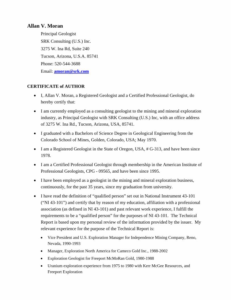
Allan V. Moran Principal Geologist
SRK Consulting (U.S.) Inc.
3275 W. Ina Rd, Suite 240
Tucson, Arizona, U.S.A. 85741
Phone: 520-544-3688
Email: [email protected]
CERTIFICATE of AUTHOR
• I, Allan V. Moran, a Registered Geologist and a Certified Professional Geologist, do hereby certify that:
• I am currently employed as a consulting geologist to the mining and mineral exploration industry, as Principal Geologist with SRK Consulting (U.S.) Inc, with an office address of 3275 W. Ina Rd., Tucson, Arizona, USA, 85741.
• I graduated with a Bachelors of Science Degree in Geological Engineering from the Colorado School of Mines, Golden, Colorado, USA; May 1970.
• I am a Registered Geologist in the State of Oregon, USA, # G-313, and have been since 1978.
• I am a Certified Professional Geologist through membership in the American Institute of Professional Geologists, CPG - 09565, and have been since 1995.
• I have been employed as a geologist in the mining and mineral exploration business, continuously, for the past 35 years, since my graduation from university.
• I have read the definition of “qualified person” set out in National Instrument 43-101 (“NI 43-101”) and certify that by reason of my education, affiliation with a professional association (as defined in NI 43-101) and past relevant work experience, I fulfill the requirements to be a “qualified person” for the purposes of NI 43-101. The Technical Report is based upon my personal review of the information provided by the issuer. My relevant experience for the purpose of the Technical Report is:
• Vice President and U.S. Exploration Manager for Independence Mining Company, Reno, Nevada, 1990-1993
• Manager, Exploration North America for Cameco Gold Inc., 1988-2002
• Exploration Geologist for Freeport McMoRan Gold, 1980-1988
• Uranium exploration experience from 1975 to 1980 with Kerr McGee Resources, and Freeport Exploration

• Experience in the above positions working with and reviewing resource estimation methodologies, in concert with resource estimation geologist and engineers.
• As a consultant, I completed several NI 43-101 Technical reports, 2003-2006.
• I am responsible for contributing to the geology sections of the Technical Report titled “NI 43-101 Technical Report, Constellation Copper Corp. San Javier Copper Project, San Javier, Sonora, Mexico, and dated June 1, 2007 (the “Technical Report”) relating to the San Javier Project. I have personally visited the San Javier Copper Project in the field during the period March 25 through 26, 2007.
• I have not had prior involvement with the property that is the subject of the Technical Report.
• As of the date of this certificate, to the best of my knowledge, information and belief, the Technical Report contains all the scientific and technical information that is required to be disclosed to make the Technical Report not misleading.
• I am not aware of any material fact or material change with respect to the subject matter of the Technical Report that is not reflected in the Technical Report, for which the omission to disclose would make the Technical Report misleading.
• I am independent of the issuer applying all of the tests in Item 1.4 of National Instrument 43-101.
• I have read National Instrument 43-101 and Form 43-101F1, and the Technical Report has been prepared in compliance with that instrument and form.
• I consent to the filing of the Technical Report with any stock exchange and other regulatory authority and any publication by them, including electronic publication in the public company files on their websites accessible to the public, of the Technical Report.
Dated in Tucson, Arizona, June 1, 2007.
Signature of Qualified Person
Allan V. Moran (signed)
Printed Name of Qualified Person (Sealed)
Appendix B Drillholes
DHID Easting Northing Elevation Total DepthCV96-01 23531 60696 824 385.0CV96-02 23341 60152 828 298.1CV96-03 23342 60591 1008 442.6CV96-04 23343 60687 979 349.3CV96-05 23338 60892 923 309.7CV96-06 23465 60766 882 209.7CV96-07 23140 60285 881 288.7CV97-08 25633 62501 875 269.2CV97-09 25413 62286 802 374.9CV97-10 25042 62155 980 206.4CV97-11 24835 62703 957 -9.0CV97-12 25164 62552 935 239.9CV97-13 24812 62098 1005 232.6CV97-14 25363 62669 876 251.2CV97-15 24753 62992 975 -9.0CV97-16 25090 63124 925 200.3CV97-17 26139 61897 705 232.9CV97-18 24026 61073 730 213.7SJ06-01 23533 60695 824 300.2SJ06-02 23435 60793 922 200.9SJ06-03 23330 60813 922 150.6SJ06-04 23342 60589 1007 222.5SJ06-05 23340 60589 1007 215.9SJ06-06 23344 60589 1007 150.6SJ06-07 23343 60589 1007 230.1SJ06-08 23342 60588 1007 251.5SJ06-09 23340 60587 1007 152.1SJ06-10 23341 60590 1007 231.3SJ06-11 23342 60588 1007 164.3SJ06-12 23147 60635 968 193.4SJ06-13 23139 60630 967 216.1SJ06-14 23140 60623 967 247.8SJ06-15 23140 60623 967 210.0SJ06-16 23431 60792 921 216.1SJ06-17 23499 60954 849 201.3SJ06-18 23499 60954 849 151.8SJ06-19 23499 60954 849 191.4SJ06-20 23499 60954 849 151.5SJ06-21 23357 61079 846 173.1SJ06-22 23594 61005 786 203.3SJ06-23 23596 61005 786 179.2SJ06-24 23598 61003 786 209.4SJ06-25 23601 61007 786 157.6SJ06-26 23598 61009 785 246.7SJ06-27 23447 61089 816 173.0SJ06-28 23451 61085 816 242.6SJ06-29 23451 61091 816 167.0SJ06-30 23451 61092 816 181.4SJ06-31 23448 61090 816 181.4SJ06-32 23361 60959 889 132.6SJ06-33 23361 60964 889 129.2SJ06-34 23361 60966 888 171.4SJ06-35 23599 61009 785 146.0SJ06-36 23597 61006 785 149.4SJ06-37 23440 61229 782 143.3SJ06-38 23441 61229 782 155.1
DHID Easting Northing Elevation Total DepthSJ06-39 23332 61313 789 125.0SJ06-40 23333 61313 789 226.5SJ06-41 23213 60772 964 200.6SJ06-42 23141 60629 967 252.7SJ06-43 23194 60601 974 206.4SJ06-44 23194 60601 974 209.7SJ06-45 23194 60601 974 246.9SJ06-46 23344 60497 953 179.2SJ06-47 23344 60497 953 212.5SJ06-48 23344 60497 953 243.5SJ06-49 23344 60497 953 51.5SJ06-50 23232 60418 935 246.6SJ06-51 23233 60418 935 161.5SJ06-52 23233 60418 935 207.0SJ06-53 23234 60412 933 191.4SJ06-54 23233 60415 934 224.9SJ06-55 23227 60293 893 163.5SJ06-56 23227 60293 893 149.3SJ06-57 23227 60293 893 240.2SJ06R-01 23338 60590 1007 147.0SJ06R-02 23340 60588 1007 183.0SJ06R-03 23335 60587 1008 168.0SJ06R-04 23270 60602 1019 234.0SJ06R-05 23207 60775 963 150.0SJ06R-06 23206 60998 923 150.0SJ06R-07 23269 61166 901 162.0SJ06R-08 23143 60488 922 150.0SJ06R-09 23143 60482 922 201.0SJ06R-10 22983 60307 849 150.0SJ06R-11 22983 60305 849 132.0SJ06R-12 23148 60406 928 174.0SJ06R-13 24004 60995 711 150.0SJ06R-14 24005 60994 710 102.0SJ06R-15 25556 62601 907 114.0SJ06R-16 25557 62599 907 165.0SJ06R-17 25507 62465 853 102.0SJ06R-18 25503 62463 852 115.0SJ06R-19 25507 62468 854 102.0SJ06R-20 25421 62289 802 108.0SJ06R-21 25264 62652 892 126.0
Constellation Copper Corp. Technical Report San Javier dated June 1, 2007.
Dated this 01, June 2007.
__________________________
Leah Mach, MSc, CPG
__________________________
Allan V. Moran, R.G., C.P.G.