ngal tama rawaho . waltangl659 · e. the orthodox story ... judgement reaffirms the ngai tama...
TRANSCRIPT

,
TE WHENUA 0 TE KUPUWHAKAARI
NGAl TAMA RAWAHO
. WAlTANGl659

NGAI TAMA RAWAHO REPORT
AN OVERVIEW REPORT COMMISSIONED BY
THE WAITANGI TRIBUNAL
NA TE ROPU WHAKA NOARAUPATU 0 NGAI TAMA RAWAHO
GEORGE MATUA EVANS
OCTOBER 1997

2
A REPORT ON NGAI TAMA RA WAHO
WAI 659 CLAIM
A report commissioned by the Waitangi Tribunal
for the Tauranga claim (Wai 215)
Any conclusion drawn or opinions expressed
are those of the author

Part 1
Partn
Partm
Part IV
Part V
3
CONTENT
INTRODUCTION
1. 1 Acknowledgments 1.2 The author 1. 3 The claim
NGAI TAMA RA WAHO
2.1 Te Pou Toko Manawa 2.2 Kinonui 2.3 Ngai Tama Rawaho Hapu 2.4 Contempory Settlement 2.5 Ngai Tama Rawaho, Nga Whenua Toenga (The remanent lands) 2.6 Te Rii 0 Ngai Tama Rawaho 2.7 Ahu Whenua 2.8 Taonga KumaraIMaara 2.9 Estuaries Taonga Kaimoana
TE MURU 0 TE PAPA
3 . 1 The Church Missionary Society's acquisition of Te Papa 3.2 Governor Gore Brown's Despatch to the Duke of Newcastle 3 .3 Lands Claims Ordinance 1841 3.4 Turton's Deeds 3.5 Brown's Letters to Williams
NGAI TAMA RAW ABO AND KINGITANGA
4.1 Kingitanga 4.2 Enactments which impacted uponNgai Tama Rawaho 4.3 Kawanatanga 4.4 Military intervention 4.5 The Cession, its impact upon Ngai Tama Rawaho 4.6 Tirohanga, Ruritia (To view, to site noting aspect - to survey) 4.7 Ngai Tama Rawaho mai Kinonui, Ngaiterangi ki Te Kawana (from
Kinonui Ngaiterangi is to the Crown) 4.8 Te Hoko 0 Te Puna Katikati Block 4.9 Crown Grants to Maori - Otumoetai
PRIV ATISATION OF THE TRIBAL ESTATE
5.1 Reserves and allotments 5.2 Partitions identifying allotments returned to Ngai Tama Rawaho 5.3 The return of Taumata and other blocks 5.4 Timber cutting rights acquired by The Rakau Coy 5.5 Allotments 536 and 535

Part VI
Part VII
4
TOENGA TAONGA 0 TE RAUPATU, KO TE MOANA
6.1 Nga Taonga ite Moana (The treasures of the sea) 6.2 Inner Harbour specific to Ngai Tama Rawaho 6.3 Taonga Moana Ki Te Whenua (property rights to the sea and to the
land) 6.4 The Loss of the Moana
LEGISLATION
7.1 Background To The Tauranga Moana Trust Board Act 1981 7.2 Review of the Maori Trust Board Act 1955 7.3 Some final thoughts 7.4 Treaty of Waitangi Act 197 5 (as amended)
Part VIII TAURANGA DISTRICT COUNCIL
8.1 Statistical Information 8.2 Property Values within Tauranga District Council 8.3 Council Policies on Maori Claimants/Claims 8.4 The Tauranga Town Hall Affair 8.5 Recent Statistics
CONCLUSION
APPENDICES:
A. A 1 Statement of claim A2 Particulars ofthe claim A3 Nga Poutokomanawa 0 Te Rohe Ngai Tama Rawaho A 4 Principle Acts of cession A5 Relief sought
B. B.1 Waitangi Tribunal Commission
c. C. Confiscated Lands - Tauranga Submissions by Dr. Pei Te H Jones
D. D.1 Rangihoaia Matthews Affidavit D.2 Waitangi Tribunal Claim No. 86
E. The orthodox story not only holds the raupatu Compiled by Piripi Winiata 14 May 1997

1.1 Acknowledgments
5
PART I
INTRODUCTION
The Wai 659 Report endeavours to capture the Ngai Tama Rawaho comprehension of the
plight of its hapu: the events leading up to the cession by the Crown of their tribal lands since
the arrival of the Church Missionary Society and the subsequent effects of colonisation. For
many years Ngai Tama Rawaho harboured the anguish of their loss which was well
documented by the late Dr Maharaia Winiata. Kua tatu tono wawata, rna te Kawana
whakatu ano he Tripunara ki te whakarongo, ki te wananga ite nako 0 tono whanau. Kua
tae mai te wa. (It has been his long desire for the Government to commission a Tribunal, to
convene, to hear, to debate, to recall the long held anxieties of his whanau. The time has
now come) His documents and personal records, will now be made public at the Waitangi
Tribunal hearings for the claim. His whanau recognise the Waitangi Tribunal hearings to be
the appropriate forum to present the Ngai Tama Rawaho story.
This report, i whakau mai runga ite whakapono ite tino rangatiratanga 0 Ngai Tama Rawaho
(its genesis is founded upon belief and the enduring greatness of Ngai Tama Rawaho). The
comprehensive records of Dr. Maharaia Winiata kept by the whanau will provide the
substantive evidence for the claim. The financial cost born by the individuals of the whanau
has been high, they cherish their independence and self reliance, a trait they esteem. This
character sets them apart from other claimants in the Tauranga Moana Rohe.
Des Tata, Peri Kohu, Piripi Winiata, the Whakaturou Trustees are singled out for their
encouragement and support to complete this report despite the fiscal restraint and the

6
requirement of the Waitangi Tribunal to comply with its schedules. Des Tata had
accumulated over many years valuable reference material now included in the data
accompanying this report.
1.2 The Author
My name is George Matua Evans, an Associate of New Zealand Institute of Valuers and a
Registered Valuer, with an annual practicing certificate. I qualified as a Registered Valuer
on 1 June 1965, completing the examinations set by the New Zealand Institute of Valuers.
Was admitted as an Associate Member of New Zealand Institute of Valuers 5 July 1965,
received a certificate of registration No. 1252 on 27 March 1968, from the Valuers
Registration Board. During my career as a valuer I have acquired a good knowledge of land
and property legislation, especially in relation to Maori land.
I was a recipient of a Churchill Fellowship and a director of the New Zealand Wool Board, a
founding director of the New Zealand Rural Bank and Finance Corporation.
1.3 The Claim
The claim was lodged by Desmond Matakokiri Tata on behalf ofNgai Tama Rawaho on the
24 of January 1997, and was registered by the Waitangi Tribunal on 10 March 1997as Wai
659. The claim concerns the raupatu area that the Crown retained to compensate the militia
for their use following the battle of Gate Pa and Te Ranga. It was the most important area
of the Ngai Tama Rawaho estate. The estate in the claim is determined by referring to the
South Auckland District cadastral map, NZMS 261 sheet V14 Tauranga, and NZMS 261
sheet V15 Ngongotaha.
The Survey Blocks are -
Tauranga S D Blocks ll, m, V, VI, IX, Xill, and XIV

7
Otanewainuku SD Blocks II, m, VI, Vll, VIII, X, XII, XIV, XV and XVI
Rotorua SD Blocks II and ill
Tapapa East SD Blocks Vll and IX.
The tribal land is fixed by the Waimapu Stream in the east and the Wairoa River in the west,
the sea to the north east and Mangorewa River to the south.
The outstanding feature of the estate is the Kopurererua Stream which divides the land mass,
arising from tributaries from the maunga tipuna Otanewainuku. Other tributaries arise from
the maunga tipuna Puwhenua which flow into the Wairoa River which empties into the
Oreanui Estuary. The claim totals 25,000 hectares, within the survey blocks detailed, which
are acknowledged as being the very fabric of taonga whenua, moana, awa, ngahere, roto, me
na mea katoa i runga, i raro i era takiwa.
Part two identifies the genesis ofNgai Tama Rawaho and their ancestral ties to Kinonui a
ancestral chief. It notes the occupation rights of the hapu identifying the land and the
estuaries which provided sustenance. Importantly included is a recent Maori Land Court
judgement reaffirms the Ngai Tama Rawaho claim to their tribal estate.
Part three covers the acquisition of the Church Missionary Society of Te Papa, and the
Turtons Deeds identifying the Ngai Tama Rawaho tipuna who were involved in the cession.
The Deeds of the cession are examined closely for the Maori text notes what Maori
understood to be the alienated. The CMS correspondence reveal the concerns about the
acquisition ofTe Papa.
Part four introduces Kingitanga and the reasons for the support given to the King
movement by Ngai Tama Rawaho. It reviews the battles of Gate Pa and Te Runga and the

8
enactments of the colonial government used to acquire the Maori estate. It details the sale
of the Te PunalKatikati block soon after the Pacification meeting in August 1864.
Part five covers the return of areas to Ngai Tama Rawaho as Crown Grants and the creation
of reserves. It records the allotments created within the Raupatu area and the issue of
Certificates of Title in favour of the Ngai Tama Rawaho descendants. The sales of the
Taumata blocks to the Crown is identified which further eroded the estate of Ngai Tama
Rawaho
Part six covers the importance of the Tauranga harbour and the estuaries which are of
cultural significance to Ngai Tama Rawaho. The ownership rights to the harbour and
estuaries and the intrusion of development since colonisation is addressed.
Part seven covers the founding of the Tauranga Moana Trust Board, the review of the
Maori Trust Board Act 1955 and importantly the Treaty of Waitangi Act 1975 (as
amended). The long held belief of Ngai Tama Rawaho in the importance of the tino
rangatiratanga is affirmed.
Part eight covers the response from the Tauranga District Council in response to an inquiry
regarding its stance about the Ngai Tama Rawaho claim to the Waitangi Tribunal. It
includes statistical information detailing the wealth and growth of real estate within
Tauranga

2.1 Te POll Toko Manawa
9
PART II
NGAITAMARAWAHO
The Kinonui tahu (line of decent) identifies Kinotaraia (Tamarawaho). The tino rangatira
whose pa was Otamataha, he begat Tuaurutapu a tino rangatira whose pa was Motu 0 Pae,
.who begat Pareaoana a tino rangatira whose pa was Rangipani (Huria).
The Kinonui tahu (line of decent) identifies Tahuriwakanui ka moe (married) Taumata and
begat Waikohua (t). Waikohua ka moe (married) Arona from the Kinonui tahu heke (direct
decent). Te uri (issue) of this union was Rauhea Koikoi, ka moe Matatu, nga uri ko
Hakaraia (killed in the battle of Gate Pa), Maora (t), Te Hikuwai Ct), Ngawhetu (t), Te
Auetu (t), Nga Kumama (t), Te Rangiwhakarewa (t), and Te Rauhea (m). They are the
principal whanau of the Ngai Tama Rawaho hapu.
Hikuwai ka moe i Whakaturou their son Nepia fought in the battle of Gate Pa along with his
father, his uncle Hakaraia and his grandfather Rauhea Koikoi. Following the Battle of Gate
Pa, the whanau ite mutunga 0 te pakanga ka tapa ratou te ingoa mou mahara mo ratou ko
Ngati Mate Pu (this family to record in memorial the event of the battle of Gate pa became
known by Ngati mate pu) and since then are known to this day as the issue of those who
died by the gun, the principal families are the Kohu, Tata, Nepia and the Matthew families). 1
1 The detail of the Ohu-Ariki of the Ranginui-Kinonui whakapapa was briefed to the writer by Peri Kohu

10
Pride of place upon the toko pou tabu (front ridgepost upon which rests the ridgepole) of
the Tamateapokaiwhenua marae at Huria stand the tekoteko of the warrior rangatira of
Ngai Tama Rawaho, Tahuriwakanui. With taiaba in hand he looks to Mauao and across the
sea alert to the threat of invading forces, he features in the Kinonui ohu ariki whakapapa.

Tutereonga Kaponga
Kahuwhaia
Pata TahupotiId Tamarakei
PaId Tahuriwakanui
Mokoroa Piripi Homai
Kuraroa
Tutereinga Kaponga Kahupaea
Pata Tahupotiki
Matangi Takiri
Papawhakairi (t)
Te Mapihi Tahuri
RANGINUI
OHU-ARIKl
Koropu Te Wehi
Tuhimata Tohuariki
Kokiri Waitawhiti (t)
Te Maanga (t)
Taumata (t) TeMoko Pirpi te
Kaponga Ranginui te Kaponga
WHAKAP AP A KINONUI
KINONUI Hangarau Kinotaraia Kinotaraia Hangarau Kohurupo Weka Tuaurutapu Waikarere
Tuhimata KoIdri Takorohape Pareaoana Poutama
Waitawhiti Maki Te Autahi = Hikuroa =Hei Maanga Wehi Marua
Hinehou Hoataua Hineoro = Papawhakairi TeHono Pahii
= Taumata (f) TeHurinui Rourou Kiriwhakarewa Waikohua (f) Arona Waiohotu
Rakera Paraone Koikoi ===================================== Matatu Rahipere = Maora Hikuwai Ngawhetu Auetu Ngakumama Rauhea
Morehu
Hei =Tahupotiki Waitangi Tamarakei
Takiri PaI!awhakairi =Paki
Tahuriwakanui = TeMako I
Rangiwhakarewa

12
2.2 Kinonui
The Ngai Tama Rawaho Ohu-Ariki is recorded in the Native Land Court records, and
private notes kept by Tipuna. The principle Ohu-Ariki for Ngai Tama Rawaho is taken from
Tauranga Minute Book Number 2, page 97, is representative ofthe Wai 659 claim.
The information presented, brief as it may be, captures the Ohu-Ariki of the descendants of
the Ngai Tama Rawaho. We can revisit the Rangatiratanga of the respective tipuna and
whanau which in tum constitute the Hapu.
The respective whanau of the Kinonui, in tum constitutes the Ngai Tama Rawaho Hapu.
The contemporary Rangatira are the principles scheduled in the Kinonui Ohu-Ariki, are the
constituent kin of the Wai 659 claim. Especially, Tahuri Wakanui, Te Moko, Piripiri te
Kaponga and Ranginui te Kaponga.
Subsequent to the Raupatu, the Crown enforced individual customary title to whenua
effecting a change to a land title system which had endured for centuries, and by doing so, it
ravaged a well founded property right. Tino Rangatiratanga under threat was relegated by
the transfer of authority sacrosanct to rangatira to minors once the property right was vested
in them. The authority of the Rangatiratanga was lost and a new culture now dominated
Maori society.
It was a move which the colonists nurtured, it was worth advantaging, it permitted the
intrusion into the ancestral rights of maara and papatipu. At the tum of this century the
mana of Te Kaponga had been undermined by the Crown. The effect of Raupatu had

13
destroyed a hierarchy nurtured and respected over many centuries. It permitted the
acquisition by the Crown the vast and valued estate ofNgai Tama Rawaho.
2.3 Ngai Tama Rawaho Hapu
Ngai Tama Rawaho is a hapu ofKinonui. Their common Tipuna Tamateapokaiwhenua was
a Ariki of the Takitimu waka which whakatauaki record came form Hawaiki and landed in
the vicinity of Te Awanui (hereinafter known as the Tauranga harbour). Their history is
detailed in whakaiaro, kowhaiwhai and tukutuku in the whare tipuna Tamateapokaiwhenua
at Huria.
Ko Takitimu, Te Waka
Ko Tamateapokaiwhenua, Te tangata
Ko Te Awhirorangi, Te Toki
Ko Rapanga-i-te-ata-a-nuku, Te Hoe
1
I
Ngai Tama Rawaho through their contempory tipuna the patriarch Haurea Koikoi and the 'I
matriarch Matatu, claim the Waikareao and the Oreanui estuary with its environs are an
integral part of their ancestral home. They were not signatories to the Treaty of Waitangi
and have consistently asserted their tino rangatiratanga and mana whenua of their ancestors
as detailed in whakapapa. The Kinonui tipuna the progenitor Ohu ariki of the Ngai Tama
Rawaho hapu over time multiplied the kinship with other Ohu ariki who developed their
own identity. They in tum evolved and founded new hapu, the identity of each whanau with
in the hapu preserved their kinship by way of whakapapa identifYing to the common tipuna
Kinonui. The ancestral thread existed for the kin folk the hierarchy of each was determined
by a tuakana or taina relationship.

14
With regularity taumau (arranged marriages) were effected by the elders, cousin married
cousin, a nephew married an aunt, an uncle married a niece a custom to ensure
Rangatiratanga controlled the ancestral lands.
Today hapu which identifY to Kinonui, and others with Ngai Tama Rawaho, who had
developed their own distinct hapu in a defined geographical area. It was not out of respect
for Kinonui rather its was a means to be identified with a particular rohe. The hapu ofNgai
Tama Rawaho are of Kinonui but owing to their long association and continued habitation
of a select region they distinguished themselves as Ngai Tama Rawaho.
The hapu of Ngai Tama Rawaho occupied the region defined in the earlier part of this
report. It is with out doubt the origins ofNgai Tama Rawaho are founded in whakatauaki
when the Ohu tipuna settled at Mauao and their close relationship with the sea dominating
their lifestyle.
The Williams Dictionary of Maori Language records Rawaho as the "wind from the sea" ka
whiti te Rawaho, na kua tae mai te kakara ki te ihu 0 Tinirau, a cultural hero who lived on a
. sacred isle ofMotutapu. Ngai Tama Rawaho persona did not exist but identifies instead the
Kinonui hapu association with the treasures of Tinirau, domiciling Mauao, the inner harbour
and the hinterland to Mangorewa. The rohe and hapu became known as Ngai Tama
Rawaho.
There is a common ancestral kinship between Ngai Tama Rawaho, Hangarau and Waitaha,
on a hapu to hapu basis, he taura whitikiranga, (the bonds that bound) however N gai Tama
Rawaho exists as a separate and distinct hapu.

15
The commissioners of the Crown during the 1800' s bereft of Maori tikanga and kaupapa
were ill equipped to determine the customary rights of tangata whenua. Instead they were
resolute, classifYing all Maori in the Tauranga rohe to be of Ngaiterangi, an inapplicable
designation indeed.
It was exploited to suite a purpose, nevertheless Ngai Tama Rawaho as a hapu existed, its
rohe was well founded and was not extinguished. The Crown latched on to the use of tribe
as a collective pronoun it is a misnomer, the closest equivalent in Maori, is a collective
adjective a prefix, such as Ngai, Nga, Aitanga, Hapu and Whanau.
2.4 Contemporary Settlement
The significance of the Court Order vesting Te Ranga in the tipuna in Rauhea Te Koikoi and
Matatu Rauhea validates the Ngai Tama Rawaho claim recorded in past petitions to the
Crown. 2
A contemporary settlement determined by the Maori Land Court on 24 May 1993, vests the
Te Ranga Battle Site Historic Reserve in tipuna Ngai Tama Rawaho. The Court minute
records:
Date: Monday 24 May 1993
Application: 37 File 56952
Re: Allotment 728 TE PAPA PARISH (NZG 1980 P 3274 PLAN 45239)
TE RANGA BATTLE SITE HISTORIC RESERVE
2 See Document Bank Wai 659 No: 3B - Minute Book MB52 Tauranga 68 - 72 Order Revesting Land Acquired for Public Works

16
Section 436/53
This is an historic occasion. The Court pleased to be involved in this application which
was worked out between the Crown and the people of Ngai Tama Rawaho. When I look at
the file and see what is there and what has been done, I can see that it has not been easy.
There has been a lot of work behind the scene and it has led to this application today. I
welcome you all to the Court and thank you for showing your interest, concern and support
for the application. There is an Order under Section 436 vesting the land described in the
application, the short description of which is 3. 7989 hectares more or less being Allotment
728 Parish of Te Papa being all the land in Survey Office plan 45239 in Rauhea Paraone
Te Koikoi and Matatu. Then acting under the provision of Section 27(2}/53 the Court
makes a further Order under Section 437(4} vesting the land in the Te Runanga 0 Ngai
Tama Rawaho Incorporated as trustee to administer the land as a wahi tapu for the benefit
ofNgai Tama Rawaho.
The Court records that this later order is intended as an interim measure so as to provide
somebody who is capable of administering the land. It is understood that consideration
will be given to the creation of this land as a Maori Reservation under Section 439 and the
intention is that the Section 437 Trust would be cancelled when the Section 439 Reservation
is made and a trustee or trustees appointed under that section. Kia ora. 3
3 Tauranga Minute Book, Volume 52 Folio 72 - See Data Wai 659 Folio

17
2.5 Ngai Tama Rawaho, Nga Whenua Toenga (The remanent lands)
Ngai Tama Rawaho are descendants of Kinonui about the time a volcanic eruption spread
throughout his tribal land the parent Kaharoa soils of Otumoetai and Te Papa around 800
years ago.
During the last 250 years Ngai Tama Rawaho Hapu identified themselves within the rohe
earlier defined, striking its takiwa as realty founded on whakatauaki. The history of Ngai
Tama Rawaho takiwa is documented in the whakaiaro in Whare Tipuna Tamatea
Pokaiwhenua at Matarawa.(Huria Marae at Judea).4
Scheduled are the principle rangatira of the of Ngai Tama Rawaho ancestral pa which had
strong ancestral affinity with Tangaroa.
Ko ki Tauranga
I u mai a Takitimu ki Tauranga nei.
Ka noho iho Tamateapokaiwhenua me tana whanau i Papamoa.
Kei reira to ratou Pa i tenei ra.
Ko otira te mahinga ika, ko Owharo te maara kumara.
I haere atu a Kahungunu i Papamoa noho rawa mai i Te Tairawhiti
Ka tupu nga uri 0 Tamateapokaiwhenua ka wehewehe haere ki te whenua.
Ka hanga i 0 ratou Pa.
Ka noho a Ranginui ki Pukewhanake
Ko Kinonui, ko Heremanuhiri i noho ki Maunganui
Ko Kinomoerua i noho i Matuaiwi
4 ibid, August 1974 Dr Maharaia Winiata P.32 - 36

18
Ko Kuraroa ki Otumoetai
Ko te Kaponga ki Tutarawananga ki Poike5
Raho of Ngamarama was pursued by Tuimata kitemanga Kopikopiko. There he lost him but
eventually came across his footprints and traced them to the Te Rerenga Stream, now
known as Te Rerenga or Raho. Its boundaries are set by Maunga Kopikopiko, Arapakapaka
o Manawa ki Puwhenua, Waiopohutu, Opoutihi, Ngatawai, Whaiti Kuranui and Te
Takapou 0 whareana.6
These areas define the southern rii (boundary) 0 Kereru me Tuaurutapu. Tuaurutapu lived
upon this land as agreed between himself and Kereru a contempory. A dispute arose
between them in respect of their rights, which resulted in Kereru leaving Rotorua with a ope
Taua (warriors) to move into the Taumata blocks. There he met women and children of
Tuaurutapu gathering food they were taken as prisoners and persuaded to escort the ope
Taua to their pa.
Tuaurutapu, aware of the ope Taua, evacuated the pa and intercepted Kereru and his ope
Taua, realising the women and children of his whanau were captives he elected not to
engage in battle. A settlement was negotiated and Kereru agreed to determine a boundary
between themselves of Arawa and Tuaurutapu at the Mangorewa gorge. It became known
as Te Rii 0 Kereru and Tuaurutapu.7
5 See Appendices translation 6 National Archives of New Zealand, Maori Land Court Minute Book - Appendices F 7 Rotorua Minute Book 3 - 12/7/82 P.313 See Data 22/1/96 Registrar of the Court ref 44/7/29

19
Nga uri 0 Tamateapokaiwhenua were seafarers steeped in Tangaroa and its whakatauaki,
were depended upon the moana for food and transport. They identified with the legendary
Tinirau (kaitiaki tohora) who's pet was a whale, he as well depended on the rawaho
(katabatic breeze) to make land fall. Ka whiti te rawaho, na kua tae te kakara ki te ihu 0
Tinirau rna reira paeheretia ai ki te moana. ( offshore sea breeze with all its associated scent
of the land once detected by Tinirau it was his assurance of his bonds with the land)
Te nohoanga 0 Ngai Tama Rawaho reflects the ancestral paeheretanga ki te moana. (The
resiting, dwelling place ofNgai Tama Rawaho is bonded to the ancestral lands founded by
tipuna)
Tamatea a legendary mariner had high respect for the ocean and in his journeys to Mauao he
encountered the rawaho a weather phenomena experienced across the Tauranga inner
harbour. Mauao( Mount Maunganui) and the harbour configuration ideally suited the
elements to promote the offshore breeze with its own unique qualities. The offshore breeze
in tum is promoted by the gradual elevation of the land which cools at night, from sea level
to 600 metres over 30 kilometres inland to the peaks of Taumata
Ngai Tama Rawaho descendants were identified in 1868 (see Deed dated 1868 Matapihi)
and by Commissioner Brabant 1881 during the reportioning of the Taumata Blocks, whenua
taunaha mai te Raupatu ite Kawanatanga.
2.6 Te Rii 0 Ngai Tama Rawaho
He Patere na Te Kaporangi

Kia marama taku titiro ki Tauranga
E ko Ranginui, e ko Te Rangihouhiri,
ki Rangataua ko Tamapahore.
20
Kia tu rangatira tonu au i runga 0 Waimapu,
na Kahuwhaia ko Tahuriwhakanui,
Piki ana au i Te Taumata i te Rii a Tamarawaho
Ngai Tama Rawaho, in July 1865 met at Matapihi to decide how to preserve the remnant
lands of Taumata. They sought a lease of the area. The signatories to this deed
authenticates the Wai 659 claim and dispels the claims by pretenders to Ngai Tama Rawaho
whenua tipuna.
Of the 33 tipuna, Anam and 16 others who signed the Matapihi deed relating to the balance
areas ofTaumata on 8 July 1867 .. They are also scheduled in land blocks assigned in favour
ofNgai Tama Rawaho by commissioner Brabant following the hearings of March 1881.8
The Ngai Tama Rawaho rohe lies within the Wairoa River to the north, the Waimapu River
to the east and the Mangorewa River to the south. The customary boundary extends out
across the Tauranga Harbour to Tuhua and beyond. The tribal estate specifically lies
between the Omanawa River, Waiorohi Stream and the Hukanui Stream, arising in the
ranges to the south. The Omanawa River arising beyond Puwhenua, 2030 feet above sea
level, and the Waiorohi Stream arise from the peaks of Otanewainuku, 2085 feet above sea
level. These two ancestral taonga are eight kilometres apart, in between the two taonga

21
maunga IS the Tautau Stream, arising from Otanewainuku, which gIves nse to the
Kopurererua Stream.
The Wairoa River empties into Oreanui Estuary to the Tauranga Harbour. The Kopurererua
empties into Waikareao Estuary then into the harbour. Between the two estuaries is the
peninsular ofOtumoetai and east of the Waikareao is the peninsular Te Papa. The rivers and
the streams are taonga which feature in the Ngai Tama Rawaho whakatauaki. Over the
centuries the rivers have carved the landscape leaving precipitous gullies and deep gorges.
The estuaries of Oreanui and Waikareao were a major food supply for Ngai Tama Rawaho
and once had an abundance of kaimoana. The entrance to the Tauranga harbour between
Panepane on Matakana, and Mauao on the Maunganui is opposite the isthmus of Otumoetai
The mountain fed rivers and streams ensured a plentiful supply of fresh water to maintain a
balance in salinity levels of the inner harbour waters, creating a unique habitat.
The unpolluted waters, free of sediment and debris, at particular times of the year provided
an ideal habitat for the masses of spawning kahawai.9 They were the principle species of a
long food chain which extended well beyond Tuhua. 10 The migration pattern of fish
determined the Ngai Tama Rawaho social interaction with other hapu, marking the seasons
to allow inland hapu the opportunity to partake in the harvest of seafood. Sadly today this is
not the situation. The haste of the slash and bum policy of the settlers to create a pastoral
8 Brabants Report on Lands Returned (AJHR 1886, G 10) The Inland Blocks. Minutes of the Commissioners Courts held at Tauranga under the Tauranga District Lands Acts 1867 and 1868. See Appendices C. 9 Journal of the Tauranga Historical Society Inc. March 1966 - P.19- 21 David B Borell IP 10 ibid, May 1976 - Map of fishing grounds P.25

22
based economy put paid to the pristine waters. Erosion and sedimentation is evident to this
day, a legacy of irresponsible land use.
For Ngati Raukawa, Ngati Haua and Ngati Whakaue, Tauranga was the centre of customary
trade, cementing bonds of kinship with mutual interdependency. Inland whanau of Ngai
Tama Rawaho relied on kaimoana for survival and other inland hapu relied on kaimoana the
only source of essential vitamins and trace elements especially iodine which prevented goitre.
This papatipu of Ngai Tama Rawaho, from the earliest sightings by Europeans, was sought
for its unique qualities, and its importance to the economy of New Zealand today manifests
the extent to which its has been coveted. The sheltered harbour today allows shipping
companies to trade in safety as it did in the past for Maori a highway to communicate to the
north to Katikati, to the boundaries ofNgati Maru, and beyond ..
Early missionaries records (1830's) state Te Papa and the Otumoetai Peninsular were clear
of native trees and areas not cultivated were grew strong, healthy aruhe (bracken fern).
Prior to the raupatu Ngai Tama Rawaho actively participated in the settler economy. The
true worth of Maori agricultural advancement during the 1850's was reflected in their efforts
to prepare the soil, to cultivate, to manage and hand harvest vast quantities of wheat. (At
the commencement of hostilities in 1864 the district disposed of 100,000 bushels of wheat
(2678 tonnes) and there was already stacked a further 100,0000 bushels around the Maori
villages. 11) The magnitude of the industry dispels any criticism of Maori who labelled as
heathens; their skills of ahu whenua (knowledge of soils) climate and seasons was
11 ibid, August 1967 - Population figures - J P Porter P.27

25
To the north of the Wairoa River the soils are identified as the Waihi Suite. These consist of
Waihi ash, identified as the Whakamarama sandy loam and the Whakamarama sandy loam
hill soils. The Waihi ash soils are less fertile than the Kaharoa soils and are brown, sandy
loam about 100mm in depth. The Waihi ash soils are much older than the Kaharoa ash and
are about 8000 years old. They may have originated from the eruption of Tuhua (Mayor
island). Where weathering is evident Taupo ash is exposed, laid about 2000 years ago.
Kaharoa ash soils are free draining with good tillage, are friable and respond to low
applications offertiliser. Natural fertility is high and is easily maintained. Nutritive elements
are freely released and the natural ph range is between 5.6 and 5.8 - ideal for root and grain
crops. Early Maori discovered centuries ago the value of these soils to maintain the valued
kumara, the chief source of vegetable protein, digestible fibre, sugars and carbohydrates.
The Te Papa promontory is frost free and it allowed crops to be sown ahead of most other
areas. There was a ready supply of fresh water from the Kopurererua for irrigation during
the early stages of growth.
The Taumata clay loams are not as free draining. They tend to require more fertiliser, trace
elements, in particular cobalt. The Mangorewa soils had a recent layer of ash from the
Rotokawa eruption its soils are highin molybdenum and are oflow fertility.
For the past 800 years the descendants ofKinonui, in particular Ngai Tama Rawaho, realised
the importance of the Kaharoa ash soils providing them with an abundance of root cropS.17
17 Soils of North Island, New Zealand - Soil Bureau Bulletin (n.s.) P.38, 63, 74, 78, 100 Fertilisers and Soils in New Zealand Farming - C During P. 238

24
The upper profile of the soils comprise light brown or yellow pumiceous silts and sands of
the younger volcanic ashes to depths of four metres. Those sediments overlay stiff clays
with a base of light grey-white finer silts. The upper four metres of the younger ashes may
be subvertical and slabbing may occur as these soils dry out or due to support movement
from below.
The principle soil types are known as the Kaharoa Suite which is rated as one of the most
valued soil types within the known soils of New Zealand. The Kaharoa Suite extends from
the Wairoa River in the west to the Waimapu River through to Paengaroa and inland to Te
Puke.
The Kaharoa Suite is derived from deposits of volcanic ejecta identified as Kaharoa ash
which occurred 800 years ago. Its greatest depth can be 240mm of blackish brown, medium
sandy loam overlying a yellowish loamy sand. Along the banks of the Waiorohi Stream it is
identified as an Oropi sand and towards the southern areas it is known as a Mangorewa
sand, which comprises 100mm of Kaharoa ash upon Rotokawa ash. The Mangorewa sand
. overlies the brown sandy loams of the Rotokawa ash.
Further inland the Taumata clay loam soil is derived from green sandstone and mudstone,
with some calcareous mudstone.
15 ibid, June 1982 Lot 384,383 P.7 16 ibid, December 1972 P.21

23
unquestionably superior to those of the colonists. To produce 100,000 bushel's of wheat it
required at least 1500 acres to be cultivated, plus a further 1500 acres in fallow, a large tract
of land to be worked by horses to plough, disc and harrow. Maori bonded to the soil and
knew its worth it was protected and revered a tie to be severed if the Crown was to acquire
their land.
2.7 Abu Wbenua
It is appropriate now to look at the peninsula of Te Papa, Otumoetai and Greerton upon
which Tauranga city is built, an area of 3000 hectares. This promontory is the most valued
land of the Ngai Tama Rawaho estate, its profile and soil fertility accounted for the high
population density ofthe whanau who settled here.
The area was sought by, ope Taua of Kauhangariri,( a battle field of warring factions) who
coveted the bounty of this area but to no avail - it was well defended by the coastal pa
(fortress) of Otamatahal2, Waikareao, Otumoetai,13 Matua Iwil4, Matarawa, 15
Tutarawananga and Oreanui16 to name a few.
However colonisation by European, the musket and the canon destroyed those bastions of
sanctuary, it was wanted by the missionaries, provincial councils, entrepreneurial land
dealers and the Crown as well to satiate their own needs Specific enactments, especially the
New Zealand Settlement Act assured the expulsion of Ngai Tama Rawaho from its prime
real estate soon after the battles of Gate Pa and Te Ranga.
12 Journal ofthe Tauranga Historical Society Inc. December 1974 P. OT3 13 ibid, Oct-Dec 1965 J P Porter - P.10 14 ibid, December 1968 P.ll

26
The Oropi Mangorewa and Kaharoa soils derived from volcanic ash supported a broadleaf
podocarp forest and a preponderance of tawa. However the Taumata clay loam soils
supported broadleaf podocarp forest of puriri, kauri, rimu, matai, puriri, pukatea, whinau,
mairi, miro, manuka and kanuka. The trees of ngahere (inland native bush) grew in specific
groves ranging in area from one acre to five acres each named to identify the bird-life
particular to its habitat. They were referred to as 'ko te pa 0 ngahere miro, whinau, karaka,
titoki and so on have long gone with the removal of the forests.
Ngai Tama Rawaho practised a system of controlled harvesting of manu (birds) to ensure
the species survived, the kereru were taken during late April or early May when the miro
berries were at their ripest. Once the birds moved on to other trees to feed, such as the
whinau and the nikau, snaring of the birds ceased.
Rimu and totara were selected to produce waka a taonga and akekake for weaponry. It
took many hundreds of years to grow the trees of the right diameter and length to produce a
waka and the pa rimu and totara were managed carefully.
Conservation of the environment, the management of ngahere and the coastal lowlands
developed a culture unique to Maori not readily understood by the colonists. Their
indiscriminate clear felling and burning off of the podocarp forests destroyed an ecosystem
and depleted the natural soil fertility This clear-fell policy replaced native bush with pastures
in the process exposed the soil to erosion destroyed tikanga and kaupapa which sustained a
culture fostered by Ngai Tama Rawaho for many generations.

27
2.8 Taonga Kumaral Maara
Te Papa and Otumoetai supported extensive kumara maara was held in high esteem by Ngai
Tama Rawaho due to the unique soil types, treasured as the food basket for the tangata
whenua. The eMS in acquiring the land failed to recognise the importance and the
significance of the maara to Ngai Tama Rawaho. 18
The 1921 Waiapu minute book records: referring to maara in the Te Araroa Native
Township.
"The Appellate Court expressed its opinion that the principle adopted by the Native Land
Court was wrong, and annulled the decision before and remitted the matter back to the
Native Land Court stating that as far as practicable it should decide the ownership for the
various maara.
The Land Court decided that before it could proceed it was necessary to define a maara
and came to the conclusion that:
a maara is a cultivation which, owing to the exclusive nature of its use either by
individuals or group of individuals becomes, by that very fact as it were, a separate and
distinct papatipu detached from the general domains of the tribe.
It loses its identity as tribal property in favour of the individual or group, the ancestors of
the future, just as the individual of the past by acts of appropriation, peaceful or otherwise,
become the ancestor of the present.
18 See Admiralty Chart 2521
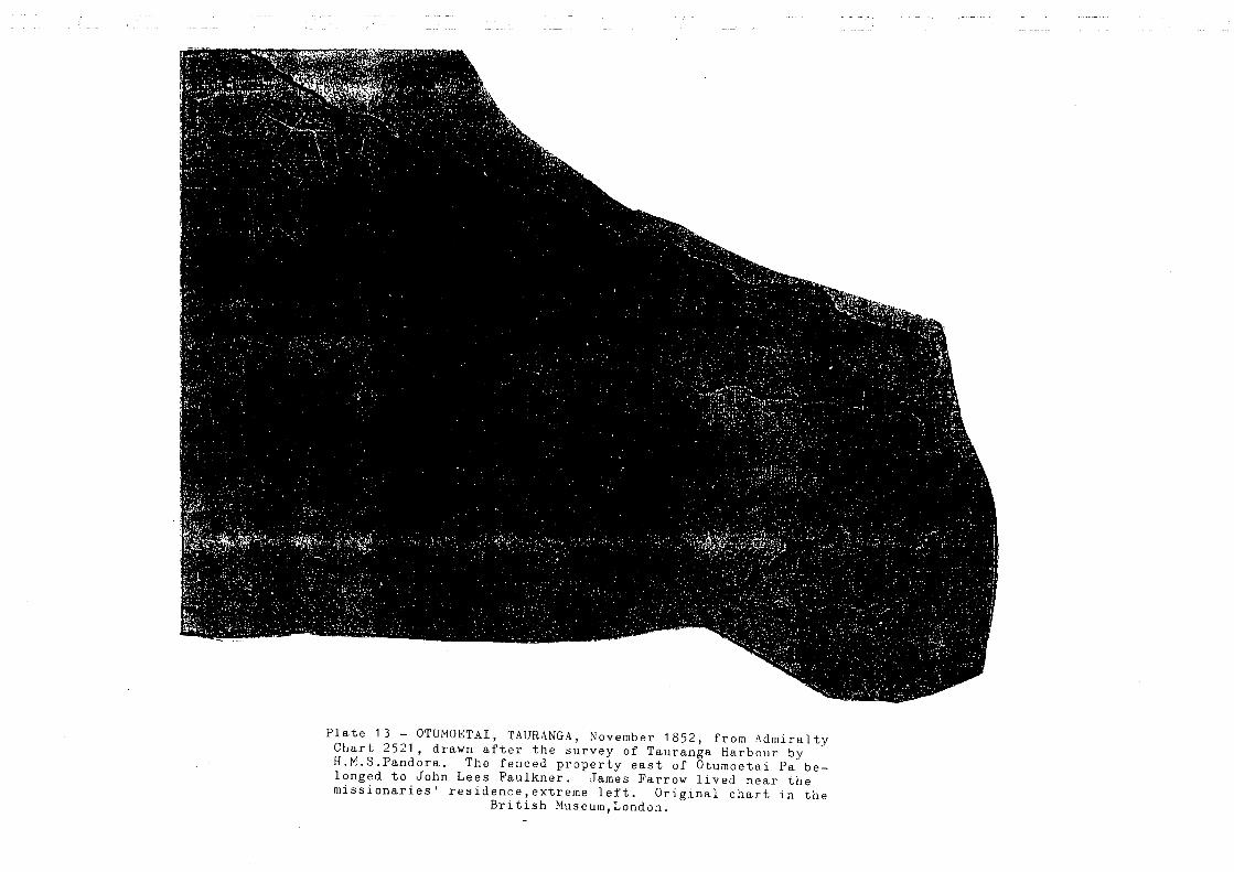
Plate 13 - OTUMOETAI, TAURANGA, November 1852, from Admiralty Chart 2521, drawn after the survey of Tauranga Harbour by H.M.S.Pandora. The fenced property east of Otumoetai Pa belonged to John Lees Faulkner. James Farrow lived near the missionaries' residence, extreme left. Original chart in the
British Museum,London.

28
The right of the individual to a maara becomes paramount and his right of disposal
exclusive, subject to no interference from the tribe excepting only in the public interest. ,,}9
This decision of the Native Land Court clearly distinguishes the difference between maara
and papatipu, Te Papa and Otumoetai although being papatipu were also exclusively maara.
Kumara was an important taonga ofNgai Tama Rawaho, providing their diet with the main
source of carbohydrates, vegetable protein and fibre .. Ngai Tama Rawaho grew four main
species ofkumara - te rahi pere (Tauranga red) te hutihuti, te pokena, me te reka maru?O
The deep rooting fern tapped the subsoil minerals and burning off provided a natural source
of phosphate and potash - essential elements for the growing of kumara. A rotational
cropping system ensured the resources were never depleted. The land was cleared
systematically and regenerating fern (aruhe) was encouraged to grow on areas suited for
maara (soils free draining friable suited for cultivation) extending over most of the 3400
hectares ofTe Papa
. The Kaharoa sands and ash with natural fertility provided the maara with unique qualities
which in turn provided for needs of tangata whenua. The kumara was propagated from
plants (tipu) in large nursery beds prepared for the purpose. One tenth of the annual crop
harvested was set aside as purapura (seed stock), bedded down in select areas that were
warm and free draining to generate the new plants for the early planting's. The maara
19 Kawakawa - Mai - Tawhiti Te Araroa - An East Coast Community, A History P.218

29
enclosed by the inner harbour eliminated the risk of late frost which often destroyed whole
crops.
The kumara tipu laid in August-September grew regenerating plants to be harvested
continuously and were distributed far and wide to outlying hapu. It permitted those hapu to
establish their main crops as soon as the frost season was past, the maara of Tauranga was a
large nursery for other tribal areas of Arawa, Hauraki and Tainui.
Reverend A.N Brown's journals note the planting of kumara at the end of November and
early December in Matamata the early planting's were set by the availability of tipu. Te
Papa soils provided early mature plants and enjoyed an advantage over other maara. The
main crops required long sunshine hours to swell the tubers with increased sugar levels To
propagate the tipu whaka aeka (special plots) were laid with selected tubers to ensure the
tipu plants would grow vigorously. They were free draining, elevated above the normal
ground level and required frequent watering.
Tipu once harvested were tied into bundles of 100 plants and kept in special flax kits packed
with moss to retain moisture to retain vigour over distant journeys. During the Second
World War the demand for tipu from Ngati Porou was considerable, to supply kao to the
Maori Battalio~ especially in Egypt. The kao involved a unique process to preserve
20 AT Tata, Kaumatua Tauranga - refer enclosed Admiralty Chart 2521 displays the respective areas cropped in kumara and the individual plots clearly defining the rows of kumara. Each plot owned by respective whanau.

30
kumara. Selected kumara were scraped, ka tauraki, ka maroke, then baked in a hangi again
ka tauaraki ano, then packed for transport. 21
The extensive maara sustained Ngai Tama Rawaho were protected along the coastline by pa
at Oreanui, Matua Iwi, Otumoetai, Omanawa and Matarawa. They were impregnable, to the
battle strategy of early Maori, they protected the maara and there close proximity allowed
ample time for people to retreat to the safety of the fortifications. The largest Otumoetai Pa,
a situated near the coastline extending from W oods Avenue to Beach Road to Levers Road.
This particular pa was impressive. It was a impregnable fortress, even to the canon of later
years the remains of this pa is occupied still by the Matheson family who purchased the
allotment as Crown grant in 1870.
The peace stone (mizpah) to commemorate the settlement of peace between Ngai Te Rangi,
Ngati Whakaue and Tangata Whenua Tauranga, lies within the present gateway at the
entrance to the site. 22 A magnificent site and all credit must go to the Matheson family for
resisting the pressures of development and the likely desecration of this taonga, me ki he
taonga tuturn. (a treasure which ranks above others)
Sections of Otumoetai and Levers Roads with exposed embankments reveal the remnant
kumara rna, the high density confirms the wealth of the area as a maara and the importance
of kumara. In May 1997, two kumara rna were excavated and backfilled with pumice on the
21 Cure by exposure to the sun 22 Journal of the Tauranga Historical Society Inc. December 1965 - J P Porter P.16 - Mizpah is biblicalWatchtower

31
Otumoetai Pa site they were of unique design., one was' a bell shaped and the other had four
underground chambers. 23.
The latter rna was 2.5 metres below ground level and each chamber complemented the
other, were 1.65m high 1.42m wide and 1.42m deep. The corners of all chambers had
drainage holes angled into the Taupo ash layer, the floors were covered with fine beach sand
40 mm thick. To back fill the chambers after excavation the larger rua required in excess of
25 cubic meters of pumice a huge storage capacity indicating the crop yields of the adjacent
maara.
Ngai Tama Rawaho aware of the areas micro climate and unique soil types benefiting from
the plentiful supply of fresh water from the Wairoa, Kopurererua and the Waimapu Rivers,
developed their own rituals and customs in the cultivation of kumara.
The survival of the hapu was founded on taonga whenua and the maara. Today those skills
are lost, the maara has disappeared and the competence learned over generations is no
longer practised. The maara was destroyed, the land was confiscated and exploited. It is
now taken up by buildings and roads.
2.9 Estuaries Taonga Kaimoana
The estuaries provided the kaimoana. Tangaroa provided the vast fish species to supplement
the staple kumara, a fat free nutritive diet, the fish protein with the essential vitamins and
trace elements sustained Ngai Tama Rawaho. Rangatiratanga was sacrosanct to ensure
23 ibid, June 1982 "Arawa Farm" P.25

32
taonga whenua, papatipu, maara, taunga ika (fishing areas) was successful the hapu
hierarchy remained intact but it was soon exploited and all was 10st.24
A new order arrived with colonisation. Dietary habits changed and disease ravaged the
Maori population. The missionaries introduced their biblical doctrines, the traders the
musket, gunpowder, and waipiro (alcohol) which violated rangatiratanga, destroying its
authority and dignity. It pitched Maori against Maori and precipitated the destruction of
mana, kaupapa, and tikanga leading to fragmentation and destitution.
24 Take _ base of a hill or a post to mark a boundary, chief head of a hapu. Taunaha - bespeak, of several persons, already spoken for.

33
PART III
TE MURU 0 TE PAPA
3.1 The Church Missionary Society's Acquisition OfTe Papa
The Ngai Tama Rawaho claim is based on the precise and informative records of the early
history of Tauranga. Some of those records predate the signing of the Treaty ofWaitangi,
and the later anecdotal records combined with the recent Waitangi Tribunal reports detail
the loss of taonga whenua from tangata whenua.
Turtons Deeds record the precise areas of Te Papa ceded and the perceived settlement
achieved by the C. M. S As well as the payment for purchase of the land. The area was
approximately 1300 acres was purchased in two parcels with separate Deeds identifying
each sale. The Deeds no. 410 and no. 411 detail the boundaries of the takiwa (boundary)
fixed by wahi tapu 0 Ngai Tama Rawaho but omit to set the actual area.25
During initial negotiations the Reverend Alfred Nesbit Brown met resistance from tangata
whenua who opposed the alienation, but were prepared to let the hahi mihinare (the Church
of England) use the land. Brown, like his contemporaries, misunderstood and failed to
comprehend Maori kaupapa and tikanga. He pursued his own course of action to acquire
the land in accordance with the principles of conveyance as he understood them to be.
The Maori view is the same today as it has always been, land is inalienable a property right
not enjoyed by the individual However in their anxiety to welcome the missionaries as
25 Turton's Deeds - See Data Wai 659 Folio C No. 10

34
settlers, heralding new philosophies and covenants, they agreed to a deal on Te Papa to
achieve the objectives promised, te ao hou26.
The Deeds are clear. The transaction was indefinite as to area and those involved did not
truly represent the whole of the Hapu, the Deed stating "Ida hoko Ida aha noa, Ida aha noa
i te whenua no 0 matou tupuna, no matou hold" (to sell for what ever purpose within one's
power the land belonging to us alone of our ancestors) "na ko te kaha tenei" ( this is the
extent within the line agreed to) Which clearly states it was their own piece of land and no
one else's land was to be included in the deal. Brown assured Ngai Tama Rawaho, for both
Kaponga and Tahu were of the hapu and present, while the price was relative the real benefit
had come from the settlement of the missionaries and colonists.
The conveyance was not a legal, apart from the undescriptive areas in the deed, transaction
because goods were offered in place of legal tender to the alienees which included a heifer
calf 27
''Maori kawa is founded on the sanctity of papatipu it was everlasting and enduring unlike
the mortal beast, a heifer calf offered. The milk of human kindness does not flow to the
transaction of an animal as a means of depriving people of their very inheritance". 28
Te Papa was never surveyed until 1851 by G D Ormsby. (original area claimed by the C. M.
S. was 1030 acres the survey proved it to be 1333 acres). The Ormsby survey enabled the
26 Translation - a new awakening an initiation for better things

35
Crown to issue grant in favour of the C M S. on the 16 July 1852 some 14 years after
acquiring the land from Ngai Tama Rawaho. Even then Ngai Tama Rawaho still used the
land for maara firmly believing it was theirs.
3.2 Governor Gore Brown's Despatch to the Duke of Newcastle
Governor Gore Brown in his dispatch to the Duke of Newcastle in relation to the Maori
tenure of land referred to Manorial, Seignorial, Tribal and Feudal Rights. Stated; "persons
used these expressions with ideas more or less distinct attached to them, taking it for
granted that corresponding ideas exist in the minds of Maori. I question whether if many
of the Maoris are better informed on such points now than they were at the time of the
Treaty of Waitangi; but it is very certain that at that time no Maori entertained the idea of
a right existing in one party which implied an obligation upon all other parties to respect
it. No one conceived the idea of authority carrying with it the corresponding obligation of
obedience. Such rights and obligations are the creation of Law, and can not subsist
without it. The Maori had no law but the law of the strongest. ,,29
He further explaining the understanding of the Status of the Chief prior to the establishment
of British Sovereignty as: "the power of a Chief in his tribe depended as much on his
courage and skill in war, and his ability in council, as on rank by birth or on territorial
possessions. It often happened that the most powerful chiefwas a small land owner. Their
law was the right of the strong arm. "
27 The Te Papa Block: A History of Church Missionary Society and Crown Dealings 1838 and 1867 - Vincent O'Malley P.2l. Payment included; One calf, 40 Adzes, 60 large blankets, 40 axes, 40 hoes, 40 shirts, 40 trousers, 12 spades, 100 pipes, 70 pounds oftobacco, 24 scissors, 24 razors, 24 plane irons and 100 fish hooks. 28 G D Ormsby 1851 Forgotten Men - The Survey of Tauranga and District 1864-1869 29 "Seignorial Right" No.2 AJHR 1861 E No.1 - See Data Wai 659 Folio A NO.4

36
Archdeacon Hadfield in 1845 said: "the Chief of the tribe, since he has no absolute right
- over the territory of the various hapu, law over the lands of the individual free men of his
own hapu, can not sell any lands but his own, or those belonging to the tribe which are
undoubtedly wastelands. " 30
From these early observations the sale ofTe Papa abrogated Maori law.
Nevertheless the society retained the land and despite Maori protestations continued
occupation of Te Papa. During the late 1850's Pakeha use of Te Papa took a new and
dramatic tum., the colonists and provincial government, recognising the immense value of
the area for strategic, political, and realty values, exerted pressure on the C.M.S. to sell Te
Papa.31
The matter was resolved by military intervf''1tion. Initially the C. M. S resorted to a sale and
lease arrangement. The C.M.S. tried to retain its title but was unable to do so for events of
the military took over, the land was surveyed in quarter acre allotments by PC Frasi in1866
in preparation to for miliary settlement. The C.M.S. retained allotments designated within
the survey but they too were sold off, Ngai Tama Rawaho did not benefit from these
alienations.
The posturing and horse trading between the C M S, the military officers and agents of the
Crown even to threatening to invoke the New Zealand Settlement Act to cede to the Crown
the greater part of Te Papa, paid scant regard to the Maori principles of papatipu. The
30 ibid

37
eventual cession to the Crown was interpreted by Maori as the harbinger of ill will, for it was
not the te ao hou which the C.M. S, promised. It heralded the fall off in Maori support of the
Christian faith, Maori religions gained momentum along with support for the King
movement.
Distrust pervaded, relationships became strained and a trespass line across Pukehinahina was
constructed to preclude encroachment and the further cession of papatipu. The southern
boundary of Te Papa had been determined by survey and the balance area was still the Ngai
Tama Rawaho estate. Kati (to close oft) was determined by pou (significant post often
carved with tribal markings) setting the perimeter of take (survey) taunaha (ancestral
inheritance). The kati was translated by Pakeha as a gate, and history records the battle of
Pukehinahina as the Battle of Gate Pa. Ka aukatingia a Te Papa, it was the boundary line,
the no go zone, to become the cornerstone of the history of Tauranga, Gate Pa.
The Bay of Plenty Times of November 1863, notes that during the negotiations the CMS
tried to settle with the Crown and offered its share of Te Papa to the Crown for £10,000 a
vast amount given the pittance offered tangata whenua for the whole of the block.. 32
3.3 Land Claims Ordinance 1841
Soon after the Treaty ofWaitangi was signed in 1840, Governor Hobson enacted the Land
Claims Ordinance Act 184l. The Governor appointed Commissioners from New South
Wales to review Pakeha land purchase and its impact on the "Natives". The primary
purpose of the legislation was not to protect Maori interests but to achieve fair distribution
31 See Brown to Burrows 19 April 1864, Browns papers MS-Copy-Micro 92
38
of land amongst Europeans by defeating the extravagant claims to millions of acres, in a
single transaction. The NZ Lands Claim ordinance set a maximum of 2560 acres for one
claimant unless the Government allowed more.33
On 2 July 1852, the Land Claims Commission granted the C.M.S 1333 acres in the Te Papa
claim. This claim was one of many brought before the Commission by the CMS during the
period of its office the claims were located in the following districts:
Waimate, Kaitaia, Kororareka, Paihia, Manukau, Waikato, Thames, Rotorua, Opotiki,
Waikare and the Bay ofIslands, the total area exceeded 17,500 acres. Well in excess of the
allowable entitlement of 2560 acres
By 1 November 1859, the total grant to the society was 7241 acres, the Crown retaining the
balance of the 17,500 acres for its own use. The principle and underlying the maximum
grant of 2560 acres was wrong, it was based on land area alone and did not consider
commercial and strategic values, and totally disregarded the cultural value to Maori as a
Maara and Papatipu.
The 1333 acres ofTe Papa exceeded in value and quality of other areas. The commissioners
failed to consider its maara value and its loss to Ngai Tama Rawaho of their prime heritage.
The "purchase left whanau landless. The grant to the claimants was unfair and inequitable
for the C.M.S. had already been granted 5907 acres in its earlier claims.34
32 Journal ofthe Tauranga Historical Society Inc. - August 1970, P 34 33 The ordinance stipulated that the maximum grant was to be 2,560 acres. Report of the Land Claims Commissioner 8 July 1862 - Ordinance of New Zealand Vol 1 and 21841 for legislation re OLC 34 Claims Commissioner Turton's Deeds 8 July 1862 The writer understands that the' claim by anyone person or organisation could be validated up to 2,560 acres and in the case of the CMS its collective holdings exceeded 5907 acres approved by the Commission.

39
The Commissioners contravened Colonial Secretary Lord Normanby's instructions to
Hobson on 14 August 1839:
"It will be your duty to obtain by fair and equal contracts with the natives, the cession to
the Crown of such wastelands as may be progressively required for the occupation of
settlers.
All dealings with the aborigines for their lands must be conducted on the same principles of
sincerity, justice and good faith, as must govern your transactions with them for the
recognition of Her Majesty's Sovereignty in the Islands.
They must not be permitted to enter into any contracts in which they might be the ignorant
and unintentional authors of injuries to themselves. You will not, for example, purchase
from them any territory, the retention of which by them would be essential, or highly
conducive, to their own comfort, safety or subsistence.
The acquisition of land by the Crown for the future settlement of British subjects must be
confined to such districts as the natives can alienate, without distress or serious
inconvenience to themselves. To secure the observance of this and will be one of the first
duties of their official protector. 35
Considering the sizeable land holdings granted the society throughout the North Island, the
commissioners failed in their deliberations to account for the 7241 acres granted the C.M.S.
already far exceeded the maximum 2560 acres set by the ordinance. As well as the cession
ofthe surplus 10,259 acres. land of the society land which they seized for the Crown.
35 Journal of the Tauranga Historical Society Inc. - August 1967 P.26

40
The Crown's grant in favour of the Church Mission Society was the first Raupatu suffered
by Ngai Tama Rawaho.
With the benefit of the Muriwhenua Land Report 1997, the process of cession of the tribal
land is explained. In brief that report enunciates Maori user rights as a distinct property
right akin to ownership as understood by Pakeha. The user right was transferable within the
whanau but could never be alienated outside of the kin group. There was no equivalent
understanding of hoko (sale) and alienation of papatipu (ancestral land) where the prime
consideration was use for the sustenance of the whanau.36
The validation of the Te Papa title by Crown grant 20 years after its cession despite the
concerns ofNgai Tama Rawaho affirms the Crown transgressed the principles found in the
Muriwhenua Land Report. Clearly the Crown acted improperly and prejudicially to the
interests ofNgai Tama Rawaho.
Within a few short period the Crown acquired the whole of Te Papa and then proceeded in
1864 to survey allotments issuing Crown grants to military settlers, the C. M .S and friendly
Maori.
The Te Papa boundaries are clearly determined by wahi tapu of the Waikareao Estuary and
Motuopae the urupa of tip una the basis of claim, Ngai Tama Rawaho expects the loss ofTe
Papa to be made good given the loss inflicted upon its people over the past century and a
half.
36 Muri Whenua Land Report. Waitangi Tribunal Report 1997 P.106
41
3.4 Turton's Deeds
Turton's Deeds are reviewed at the hearings by the commissioners and notes the granting of
titles to the CMS on 2 July 1852 of 1333 acres. The Deeds do not define the area but
takiwa (a undefined area) instead, which in the opinion of the writer affirms the Ngai Tama
Rawaho understanding of the alienation. The takiwa related specifically to the individual
whanau areas of maara in particular not the whole of the rohe of the hapu. The Turton
Deeds No.410 and 411,lists those of the whanau who were present at the signing.37 Which
included whanau ofNgai Tama Rawaho and in particular Kaponga and Matiu Tahu.38 Matiu
Tahu was a tohunga held in high esteem by Reverend A N Brown. Included also as an
owner was a child of Taureka, tikanga (custom) did not permit a child to usurp the rights of
the elders.
Kaponga a Ngai Tama Rawaho rangatira did endorse the Deed, was of the Ohu ariki 0
Kinonui, his son Ranginui T e Kaponga, then a student, attended the Mission school at
Otumoetai. Kaponga later plead to the Crown to create reservations for Ngai Tama
Rawaho knowing if that was not done they would loose their hapu identity.
Each maara were sacrosanct, there areas ranging from one acre to three acres, Te Papa
would have supported at least 800 whanau members and they all did not approve the
transfer to the C.M.S. Those who did were not truly representative of the tangata whenua
37 See Appendices A Turtons Deeds 410 - 411 - See Data Wai 659 Folio C No. 10 38 Journal of the Tauranga Historical Society Inc. A H Matheson - December 1973 P.23 Also Otumoetai Tauranga November 1852 Admiralty Chart 2521 See Data Wai 659 Folio D No. 14

42
The loss of Te Papa initiated the relocation ofNgai Tama Rawaho whanau they were forced
to re settle away from their maara. They were literary pushed into exile to live subservient
with other whanau throughout the eastern Bay of Plenty whilst some went to hinterland to
live a harsh existence.
3.5 Brown's Letters To Williams
It is opportune at this juncture to quote from Brown's letters to Burrows 19 April 1864, in
which he comments about Te Papa:
"Their Bill is not yet law, there be more obstacles in their anti-sale through their
occupancy of Naboth 's Vineyard ,,39
Brown in his letters to Burrows, who was empowered to act on behalf of the C.M. S to
dispose of society property, was keen to sell or lease areas of Te Papa to obtain funds for
the Society. He was aware the New Zealand Settlement Act 1863 empowered the Crown to
take land and he wanted to effect an alienation before the military seised T e Papa. 40
Te Papa was referred to as Naboth's Vineyard by Brown in his letters to Williams, regarding
Burrows action to dispose of Te Papa. Williams preferred the area be leased rather than be
sold a practice he introduced to Ngati Porou which managed to keep the bulk of the Ngati
Porou estate within the tribal ownership.
39 The Bill referred to was the New Zealand Land Settlement Act 1863 although approved by the Colonial Parliament technically was still in the bill form for it had to have Royal accent at that time. 40 Burrows in his letters to Williams was confused as to their ownership for Maori continued to occupy parts of Te Papa and deemed still part of the estate. Colonel Carey let it known to the CMS if they did not cooperate he would take it under the Act anyway.

43
Later, Williams' letters to Brown 17 May 1864 he informed Brown he considered the
society had been given so much into Mr Burrows hands that he fancied there'd be no limit:
"It is quite possible that Te Papa may cease to be a missionary station, is indeed probable
because it happens to be Naboth the Jezre-el-ite 's Vineyard ,,41
It is appropriate to examine 1 Kings 21 which influenced Brown's thoughts in his writings
and those of Williams alluding to Naboths vineyard.
The Bible verse reads: "Let me have your vineyard.,>42
Because royal power in Israel was limited by covenant law, Ahab (a King of Sa-mari-a)was
unable simply to confiscate privately held land, as was customary with Canaanite Kings.
(refer Kings 21-3)
Naboth's refusal to dispose of his land was based on the conviction the land was the Lord's,
that he had granted a perpetual lease to each Israelite family which had been jealously
preserved as the family'S permanent inheritance in the Promised Land. (Kings 21-4)
the verse relates how Ahab went home, sullen and angry because Naboth the Jezreelite had
said: "] will not give you the inheritance of my Fathers." He lay on his bed sulking and
refused to eat. 43
Brown's journals relate the ready acceptance of the gospel throughout the Bay of Plenty,.
Prophetic indeed are the words he and Williams wrote regarding Naboth's Vineyard. The
41 See Brown to Burrows 19 April1864, Browns papers MS-Copy-Micro 92 42 And Ahab spake unto Naboth, saying, give me thy vineyard, that I may have it for a garden of herbs because it is near unto my house: - read verse 2 - 14 43 Dates Annotated Reference Bible, Kings 21-4

44
Maori understanding in regard to the land and its inheritance for it belongs to the current and
future generations to come.
Maori understood the Christian message and the gospels and its doctrines empathising with
the values of, ''tikanga and kaupapa i tuku iho mai nga Tipuna mo ratou, take taunaha.
(rights and understanding ofland proprietorship is inherited from one generation to another,
it is predestined).
Kaua e mau kinongia te Whenua, na te Atua e homai ki nga Tipuna he taonga mo tatou ki
noho ora ai tatou i tenei ra me nga ra kei te haere mai ake tonu atu.( "If my people which
are called by my name, shall humble themselves, and pray, and seek my face and tum from
wicked ways, then will I hear from heaven, and will forgive , their sin and will heal the
land,)44
Today the Waitangi Tribunal is requested to revisit Te Papa, Naboth's Vineyards, because
the inheritance ofNgai Tama Rawaho has to be restored. The Crown deprived the rightful
owners of their estate whose inheritance is inscribed not only in Canon law but also Maori
customary law.
3.6 Petitions by Ngai Tama Rawaho
The Ngai Tama Rawaho claim to Te Papa, Otumoetai, and the area included in the Raupatu
is well documented in the petitions of
44 The Maori version 11 Nga Whakapapa 7 14 is related often by Maori in Kakakia (prayer)

45
• Paraone Koikoi in 1865 to the Commissioner which resulted in the Crown grant of lot
115 of 100 acres now part of the Huria reserve.
• George R Hall and nine other in 1920, Nepia Kohu and 628 members of the hapu in 1923
and Sam Kohu in 1935. " praying for relief from oppression caused by the erroneous
inclusion of their lands in the Tauranga confiscated district. Report referred to the
Crown for consideration ,,45
The significant petition was first that of Rauhea Koikoi and George Hall a son ofTe Owetu
ofNgai Tama Rawaho who married a pakeha Hall of the Militia who fought against maori at
Gate pa ..
Nepia Kohu died in 1935 he had the support of 628 members of his whanau to petition the
Crown for the loss of land, and the wrong inflicted upon his people. Nepia Kohu was 14
years old when he fought in the battle of Gate Pa with his uncle Ihakara who was killed
during the battle. His knowledge of the Raupatu was first hand and he knew the importance
of the petition to regain what he believed to be true. Credit is be paid to him for his initiative,
he sought and gained the support of 628 whanau members to pursue the grievance they bore.
This memorial testifies the Ngai Tama Rawaho pursuit for justice, 1935 may not of been the
right year for the petition but it was the right time to launch the appeal, to re kindle the
embers of the ahi Ka, to be ready for the right time. Which is now.
45 The Aftermath of Tauranga Raupatu 1964-1981, Vincent O'Malley P.216-217

46
Who were these people? They were of the ohu ariki ofNgai Tama Rawaho. Rauhea Koikoi
married Matatu OfNgai Tama Rawaho 0 raua uri ko (the issue) 46
(I)Maora (t) ka moe Rahipere (II) Hikuwai (t) ka moe Whakaturou (Kohu) (III) Ngakumama
(t) ka moe Reweti (IV) Ngawhetu (t) ka moe Mikaere (V) Nga Rangiwhakarewa (t) ka moe
Waitara (VI) Te Auetu (t) ka moe Hall (VII) Rauhea (VIII) ka moe Ngatikohu and (IV)
Ihakara (m) killed in the battle of Gate Pa.
The Koikoi-Matatu whanau lived at Te Papa and Matarawa along what is now Cameron road
and Huria The whanau Tama Rawaho faced with the impending encroachment by pakeha
upon their ancestral lands, helped to build the Pukehinahina pa. A physical barrier to prevent
the trespass further into their areas instead it later was used as a fortification, a battle field
where they defended their rights. The supreme sacrifice was paid to defend those rights by the
loss of their very close kin.
It is without doubt the petitioners (623) of Nepia Kohu (1923) whanau, are the principle
claimants on behalf of Ngai Tama Rawaho to the area of the raupatu. The Ngai Tama Rawaho
claim for Te Papa is well founded given their continued plea for reparation and their many
submissions to the Crown to make good the wrong have been consistent The Kohu petitions
during the 1920's and those represented to the on 13 December 1944, Petition No 125 1944 is
testimony to the determination ofNgai Tama Rawaho to seek justice for its hapu. 47
46 See Kinonui-Whakapapa (following) 47 The Petition was lodged by H H Piahana and 93 others The petition in the Raupatu Document Bank vol 138 and 139

47
Members of the Kohu, Rahipere and Piahana whanau lived for many years during the early part
of this century on the Taumata blocks. During the 1920's and early 1930's members of the
whanau returned to live on allotments of Te Papa to join with other members already there.
But they were constantly shifted from one area to another as the encroachment of the city of
Tauranga developed around them They were shifted to areas of Otumoetai in the mid 1930's
where they lived until after the Second World War. Again urban development forced their
relocation to Huria and when urbanisation caught up with them there they moved to Te Reti
(Wahi/Cambridge Road area) Their tipuna professed Te Papa was always their maara and
papatipu.

48
PARTN
NGAI TAMA RAWAHO AND KINGITANGA
4.1 Kingitanga
The Mihinare (Missionaries) and the Kingitanga ( followers of the King movement) heralded
the changes in maori society. Initially Maori found new values in the work of the
missionaries where English was taught with philosophies founded on the teachings of a
civilisation much older than theirs. Later the faith waned as result of the promises agreed to
in the Treaty of Waitangi were being transgressed especially in the cession of land by the
Crown. Maori sought the sanctity of the King movement
The great Maori leader Te Waharoa ofNgati Haua, encouraged the missionaries during the
1831-33 period to have an Anglican missionary resident at Matamata. 48 A mission station
was established at Puriri, near the mouth of the Waihou River. In 1835 Brown arrived to
take residence at Matamata to be joined by J A Wilson in July of the same year. One of the
first students to attend the mission school was Tarapipi, son of Te Waharoa, who perceived
the potential use of literacy skills the missionaries taught as means of diplomacy to preserve
the peace with Ngati Maru.
Waharoa developed an alliance with Ngai Tama Rawaho. The access to Tauranga Harbour
was now of great importance following the development of new trade. This trade was built
around the harvest of flax from the Mangapouri swamps, between the Waitoa and the
Waihou River. It was important for mana of Waharoa to trade to acquire muskets and
48 The People of Many Peaks, The Maori Biographies 1769 - 1869 P.288

49
gunpowder from the trading posts established at Otumoetai and Matamata to match the
important trading post of Arawa at Maketu.
The sack of Maketu on May 1836, and the destruction of Tapsell's Trading Station was a
milestone in the relationship between Ngati Haua and the Tauranga Maori. Fear of reprisals
from Arawa necessitated the closing off of the Church Missionary Society's station at
Matamata in 1836. Brown therefore moved to Te Papa.
In 1838 Waharoa, on his death bed at Omokoroa, requested he be returned to Matamata to
die, where he died in September. This is significant, it corroborates tikanga, although
Waharoa had rights to occupy Tauranga whenua, to traverse it with ope taua (Fighting
forces) to trade, and to harvest kai moana. It did not extend to a right of ownership.
His request to be returned to his papatipu is important, he elected to return to his
turangawaewae despite the many years of pakanga i nga Kauhangariri( living upon areas
renowned as the battle fields). He never presumed or strove to take over the Tauranga lands
for ownership of his tribe, Ngati Haua. Ownership by conquest does not over-ride the
proprietorship of tangata whenua.
His son Tarapipi was baptised by Brown and named Wiremu Tamihana in June 183949.
Tamihana's baptism into the Christian faith, rewarded his long association with the
49 ibid, P.290

50
missionaries and the wish of his father equipped him well for the task he chose. His wisdom
and understanding of the Scriptures, fitted him well to be the King Maker. 50
He was the most influential young chief of the tribe, having inherited the mana of his father,
displaying qualities of bravery and eloquence. He believed Christ to be a more powerful
Atua and he no longer dreaded the Atua Maori.
He taught Ngati Haua the Pakeha systems of living, introduced farming to his communities
trading surplus product to Pakeha settlers in Auckland. During this period the European
diseases were taking a heavy toll on his people and maori in Tauranga ..
Maori were industrious, adopting Pakeha systems to produce wheat, maize and other
cultivated products a positive move from their traditional foods they were competent in most
things. Tamihana believed in establishing his own codes of law and the effective
administration of those laws was a high priority.
During the 1850's Tamihana became involved in the King movement, he became known as
the King Maker and Peacemaker. He believed in the law as a means of determining equity
and justice.
He was adamant:
"lfyou mean that I shall agree to the ture (law), that will be well; but if you mean that I am
to give up my mana to the Queen I say no, I will not give up my mana, no not one particle
50 Journal ofthe Tauranga Historical Society Inc. - August 1967, J P Porter P.22

51
of it. I have told you the King (representing Kingiianga) and Queen will stand together
and the ture shall be over both of them. "
During this period he maintained close liaison with the Tauranga people and Brown
especially at the Otumoetai and the Te Papa mission schools. He believed the establishment
of Maori Kingship would provide effective order and laws, unlike the Pakeha government
which allowed Maori to kill each other, and only involved itself when Pakeha were being
killed.
Tamihana provided a statement of laws based on the laws of God. The King would exercise
power over people and lands, over chiefs and councils of all the tribes. The tribes would
continue to live on their own lands and the King would protect them from aggression.
The establishment of the Maori government within the King movement involved a lot of his
time to maintain tribal relationships, against a background of increasing suspicion of Pakeha
motives. When the tensions were starting to rise, Tamihana tried to broker peace, he fearing
reprisals, referred to the Scripture's and Maori metaphor, the King movement was an
organisation to control Maori people and was not in contlict with the Queen's sovereignty.
His letters were addressed to the Governor, expressed his concern about the construction of
roads across maori land and the building of redoubts between Auckland and the Northern
Waikato. It came to a head in July 1863, when Domett, the Premier, wrote to Grey saying:
"It is not now beyond all question that the Native tribes of Waikato, the most powerful in

52
New Zealand, resolve to attempt to drive out or destroy the Europeans of the North Island
and to establish a Native Kingdom under a Native King". 51
He demanded that Mainwaring, the Registered Magistrate of the upper Waikato, hold an
inquiry run by 'Just Judges" into the whole origin of the maori wars, and as pleaded the
injustice of the Waikato war and that all Waikato land should be returned. 52
Ngai Tama Rawaho moved from the Christian faith to pursue Tamihana and the King
movement they sent warriors to the Taranaki and Waikato Wars. They became associated
with the emerging religious maori faith, the Ringatu, the Hauhau and Paimarire. They saw
the destructive force and the carnage inflicted by the Imperial troops in the Waikato wars.
They sensed they would be next and retreated to Tauranga to prepare for the imminent
assault upon their own lands. After the battle of Rangiriri in November 1863, Tamihana
sought to negotiate peace with Cameron, but to no avail. The Waikato campaign continued
into 1864 then shifted to Tauranga with the battles at Gate Pa in April and Te Ranga in
1864.53 Tamihana off'eredto mediate but was ignored.
The genesis of Kingitanga among Ngai Tama R.awaho is founded on the Scriptures. The
missionaries preached and spread the gospel through Bible teachings extolling the
importance of baptism to be saved. The parables were used to great eff'ect and in sonie
cases they were taken literally.
51 The Maori King - John Gorst 52 Journal of the Tauranga Historical Society Inc. - J P Porter, August 1967 P.23 53 ibid, December 1967 P.2l

53
It is from the teachings the Kingitanga began to manifest itself, particularly when the land
wars began. Deutronomy 17;14,and Proverbs 19,4 its entitlement the King. notes "When
you enter the land the Lord your God has given you, and you have taken possession of it
and settled in it and you say let us set a King over us, like all the nations around us. 54 Be
sure to appoint over you the King the Lord your God chooses. He must be from among
your own brothers.
Do not place a foreigner over you, one who is not a brother Israelite. The King moreover
must not acquire a great number of horses for himself or make the people return to Egypt
to get more of them for the Lord has told you, you are not to go back that way again". 55
Tamihana interpreted the passages from the bible literary to provide the founding material
for the King movement. In this case he understood the Scriptures better than some of the
settlers, who as a matter of convenience interpreted the movement as a threat to what they
aspired to. It provided the legislature with the excuse to enact law to counter the
movement, to seise land, to confiscate the land and to extinguish customary maori title.
Both Tainui, Ngai Tama Rawaho and other hapu suffered as a consequence.
4.2 Enactments which impacted upon Ngai Tama Rawaho
During the Waikato campaigns of late 1863 the General Assembly of Parliament effected the
Suppression of Rebellion Act 1863 in tandem with the New Zealand Settlement Act 1863,
54 The Maori King - John Gorst, P.4l. 55 Dates Annotated Reference Bible, Deutronomy 17-14

54
both were passed on the same day. These Acts rate as among the most draconian in New
Zealand law, were designed to accelerate the disinheritance oftaonga whenua. S6
The Acts sets out the trial for offences under its authority proceedings and the powers of
court martials to pass sentences where deemed to be justified.
The NZ Settlements Act 1863 was selective relating only to the North Island because of the
where the large maori population. The Act authorised the commissioners to confiscate
maori land, detailing the procedures to be adopted and how to vest the confiscated lands.
In the process it deemed maori land to be Crown land, free from all title interests or claim, as
soon as the Governor declared the land was required for settlement. Soon after its
enactment it real impact was felt in Tauranga. There was provision for compensation but
Ngai Tama Rawaho had splintered into whanau groups and was weak. They sought shelter
from reprisals seeking support for their cause elsewhere, some eked out an existence in the
forests of the hinterland but were pursued by the militia and killed They moved to other
areas to living subservient with other hapu. They missed important Native Land Court
hearings due to the relocation and only returned from the exile often as tupapaku ( dead to
be interned in ancestral urupa) The loss of Ngai Tama Rawaho was the greatest, they
received little or no comfort from the Crown.
The Suppression of Rebellion Act 1863 and the New Zealand Settlement Acts 1863 were
specifically used to dispossess the tribes, in the North Island of their land. The laws were
56 See Appendices B - New Zealand Settlement Act and Suppression of Rebellion Act 1863

55
required to support the Crown's desire to settle and develop the country as they saw fit.
Ngai Tama Rawaho were among many hapu left landless.
The rout of Pukehinahina should not have taken place from the Ngai Tama Rawaho
perspective but it was necessary to satisty the needs of central and provincial government.
It had been the most effective system contrived by the Crown to achieve two primary
objectives one objective was to acquire the extra land required by the colonial government
to underpin its settlement policies and the other had to quell once and for all the perceived
uprising among Maori tribes who were protesting about the loss of taonga whenua. A show
of might and power was necessary to instil fear among those who contemplated to break
Pakeha and imperial law. It did work but at what cost to the Maori?
Tauranga was prime real estate far more valuable in the hands of the settler government than
in those of the Maori. The New Zealand Settlement Act 1863 was put to good use by the
Crown to covert the Ngai Tama Rawaho and other hapu of Tauranga lost estate by
extinguishing customary title. The Crown ignored the kawaneta of the Treaty which
provided the sanctity of tino rangatiratanga of taonga for maori.
Political ambitions of the executive of the Provincial Councils within the colony strove for
economic dominance oftheir respective provinces, coveted adjoining territories to control as
a means to extend their authorities and governance considered it vital to suppress Maori.
Tauranga was acquire by the Auckland province in the process soon after the battle of Gate
pa

56
Ngai Tama Rawaho had in excess of 21,000 hectares within its tribal estate prior to the
enforcement of the above acts which saw the prime estate taken (raupatu) 13,633 ha, leaving
the inhospitable Taumata lands of 7724 ha for the tribe to survive upon.
4.3 Kawanatanga
Within twenty years the Treaty of Waitangi was ignored. It was shredded meticulously by
enactments promoting the acquisition of taonga whenua. The 16 November 1840 charter
for establishing the colony of New Zealand, and creating legislative and executive councils
was issued by the Crown, Maori believed imperialism to be the control and protection
afforded by the Queen under the charter of the Treaty of Waitangi. However colonialism
developed its own authority emerging to replace the that of the Queen and the Governor. 57.
A legislative council was created and "it shall make and as guaranteed in Article 3 and
ordain all such laws and ordinances as may be required for the peace, order and good
government of the said colony of New Zealand and in the making all such laws and
ordinances the said Legislature shall conform and observe all such instruction as we, with
the advice of our Privy Council shall from time to time make for their guidance therein.
Nothing in these our Letters Patent contained shall affect the rights or be construed defect
to effect the rights of any aboriginal natives of the said Colony of New Zealand to the
actual occupation or enjoyment in their own persons, or in the persons of their
descendants, of any lands in the said colony now actually occupied and enjoyed by such
natives".
57 Speeches and Documents by David McIntyre and W J Gardiner, Crown Colony Government P.54

57
By 1846 the Crown began a Land Register and the country was temporarily divided into
provincial and aboriginal districts. Interests focused on the settlement of the public lands
which were deemed to be part of the royal domain and "the state of the aborigines therein.
The laws and customs of the native New Zealander even though repugnant to our own laws
ought if not at variance with general principles of humanity to be for the present
maintained for their government in all their relations to and dealings with each other and
that particular districts should be set apart within which such customs should be
observed ,,58
The concept developed provincial districts to be eventually divided into vanous
municipalities with an increasing British population "with the advance on the natives in the
arts of civilised life the provincial will progressively extend into the aboriginal, until at
length, the distinction shall have entirely disappeared"
In the meantime, it stated:
"The provincial districts and they alone will be the seats of Courts and Magistracies"
"The aboriginal districts will be governed by such methods as are in use among the native
New Zealanders. The chiefs or others, according to their usages should be allowed to
interpret and to administer their own laws"
"With the increase of Christian knowledge of civilisation, of the use of the English tongue
and the mutual confidence between the two races, these distinctions of law, and of legal
custom will become unnecessary and obsolete. "
58 ibid, P.54

58
Governor Grey opposed the move, saying that "the natives at present are certainly not
fitted to take a share in the representative form of government but each year they will
become more fitted to do so. Each year the numerical difference between the two races will
become less striking so that a greater advantage would be gained by delaying even for a
few years the introduction of the proposed Constitution into the northern parts of New
Zealand"
By 1848 it was recommended that European subjects of her Majesty who could read and
write and who owned land would have the right to vote at elections. 59
The governing process for New Zealand did not involve Maori. Those like Ngai Tama
Rawaho were unaware of the importance of what was happening in the area of law making.
Ignorant of the legislative process and uninformed they were completely unprepared as to
the consequence of the changes. It did impact upon them in years to come and it was the
fundamental process that stripped them of their inheritance.
In August 1851, Governor Grey stressed the separation of the settlements, "the obstacles in
the way of a general legislature" and warned the colonial office about the military
advantages possessed by the North Island Maoris.
The European population then was estimated at 26,000, chiefly British subjects, but also
some Americans, French, and Germans. The Maori population was approximately 120,000.
59 ibid, P.65

59
Grey said the Maori were generally armed and skilled with rifles or double barrelled muskets
and that they were addicted to war. 60
"Despite that, the Maori possessed other remarkable traits of character" he stated.
"Nearly the whole nation was now converted to Christianity.
They were fond of agriculture and took great pleasure in the care and management of
cattle and horses. They liked the sea and made good sailors with many coastal vessels of
their own, manned by Maori crews"
"They were attached to Europeans and admire their customs and manners; are extremely
ambitious of rising in civilisation and becoming skilled in European arts; they are apt at
learning, in many respects extremely conscientious and observant of their world; are
ambitious of honours, and are probably the most covetous Race in the world Many Maori,
due to the value of their property, had a large stake in the wealth of the country". Grey's
comments described the Ngai Tama Rawaho hapu very well by the mid 1850's the hapu
were adapt seafarers and traded arge quantities of food to the developing city of Auckland.
By 30 June 1852, the provinces were established, namely Auckland (the largest), New
Plymouth, Wellington, Nelson, Canterbury and Otago, each with its own superintendent and
Provincial Council. Maori did not feature in the Provincial Councils Tauranga was part of
the Auckland Province. Every man over the age of 21 was allowed to vote provided he had
a clear value of £50, (above all charges and encumbrances) in his estate within law and
60 ibid, P.69

60
equity.61 Maori were disenfranchised their land was customary land and the interests were
not defined.
By the late 1850's the political climate was changing. There was a move away from
provincial government to central government and the need to introduce a responsible
government. In the debates which ensued difficulties arose about the administration of
native affairs the actions of the Governor as the representative of the Crown, who controlled
and administrator of the natives.
There was confusion in the government about the administration of the Native Affairs, which
resulted in the 1861 despatch from Grey to the Duke of Newcastle to discontinue the current
process whereby the Governor's responsibilities for Maori Affairs had to end.
It was heeded, and the responsibility for the governance of Maori was passed on to the
general assembly.62 This major constitutional change highlights the precarious position of
Maori who were excluded for the past 21 years from the legislative processes (since the
signing of the Treaty ofWaitangi).
It marked the beginning of the end for Maori protection under the Queen and during the
ensuing three years the so-called Land Wars of Taranaki, Waikato, Gate Pa and Te Ranga
resulted in bloodshed and brutality on a unprecedented scale.
61 ibid, P.73 62 ibid, P.106 - 108

61
Maori ignorant of colonial legislative processes which excluded them found it difficult to
accept a system of governance which denied them any input to protect their interests. Maori
owned all the land but the lawmakers insisted on controlling it to repay the rising national
debt and the most expedient means to accomplish Crowns objectives was to sever the ties of
protection afforded by the authority of the Governor.
4.4 Military Intervention
Grey and Lieutenant General Cameron arrived from the Waikato on 18 April 1864, a
consequence of the threatening aspect of affairs in Tauranga. At their disposal were 1595
officers and men, excluding personal staff. 63
The Imperial troops consisted of two regiments from the 24th Light Infantry, who had
embarked from Calcutta on the 10 December 1863, a total force of 667. The 68th Light
Infantry came from Rangoon in three detachments a total force of 847 rank and file, on 21
January 1864, 623. rank and file were sent to Tauranga under the command of Colonel
Carey. The total Tauranga maori male population was 542, about half were deemed to have
joined the Maori resistance under the influence of William Thomson. (Wiremu Tamihana) 64
The battle of Pukehinahina began on 28 April 1864. Using Armstrongs and Howitzer guns
the British blasted the Maori fortifications. Against all odds it was a was resounding victory
for Maori at Pukehinahina On 21 June 1864, the Battle of Te Ranga took place and there
Maori was defeated their casualty list exceeded 108. The assault was led by Colonel Greer.
Nevertheless the militia in authority stamped their control over the land and Maori following
63 Journal of the Tauranga Historical Society Inc - The Story of Gate Pa - F M Pinfold - May 1964, P.9-17

62
the battles by implementing the New Zealand Settlement Act 1863 to confiscation (raupatu)
the whole of the Tauranga lands.
Brown wrote in his journal for 27 June 1864, detailing some of the offic~al communications
reflecting the engagement at Te Ranga. He wrote "the first Waikato Militia are finally
expecting their allotments to be immediately laid out to what they call the confiscated
line".65
"I hope the military will not be guilty of a haste which history will recall as a mistake and
Napoleon would have called a blunder.
Let us not have a renewal of the Taranaki scenes connected with surveying. Let us try to
procure sessional territory rather than keep alive the indignant feelings of natives by
wresting it from them and above all let ample provisions be made for widows and those we
have made orphans. I write this freely because you were appeased to express a wish to
hear from me and also say what my comments were, should be confidential"
This was Brown's letter to the Governor: "On Wednesday I buried 188 natives in the
trenches which they so gallantly defended and have since buried 15 others who have died of
their wounds at Te Papa. Twentywill be embarked for Auckland today and thus leave all
about 10 of the worse cases; amputations etc. Casualties on the part of the English were
about 30 of whom I have buried 10 soldiers".
"All the other cases I am happy to say are doing well"
64 ibid, December 1978 - "RAUPATU" T R Te Kani P.2 65 ibid, March 1964 Story of Gate Pa F M Pinfold. P.7
I
63
The 188 could have been an error. Following the Battle of Gate Pa we note the letters of
Brown to Williams to the society Land Board expressing views and concerns about the
future ofTe Papa.
Frederick Whittaker of the William Fox government coalition contrived with Governor Grey
to confiscate maori land during wars of the 1860s and pushed for the settlement of
Tauranga. It had rewarded the forces of the Waikato Militia for carrying out the instructions
of the colonial government. The Whittaker's provincial government exerted pressure upon,
the C.M S and they capitulated agreeing to the cession ofTe Papa by the Crown.
The Society's negotiations completely collapsed and they elected to hand over four fifths of
their land interests to the Crown, retaining one fifth for its own use. No attempt was made
to create reserves for Ngai Tama Rawaho, instead allotments were granted to maori who
supported the Crown.
4.5 The Cession, its impact upon Ngai Tama Rawaho
Under the provisions of the NZ Settlements Act 1863 the Crown appointed Commissioners
to determine which land would be returned to Tauranga Maori. Ngai Tama Rawaho deemed
the cession of their land by the Crown, was raupatu (confiscation). The Commissioners
were required to return land to Maori ignoring to consider the economic impact it would
have upon Maori and in particular Ngai Tama Rawaho. For they had lost the most.
The Commissioners were influenced by the instruction of the Crown which was to settle the
best deal for the settlers and the military. The idea was to create a secure haven for the

64
settlers, to provide facilities, to establish a commercial centre, to attract trade, to satisfy the
central and provincial governments needs. The Provincial Executive of Auckland recognised
the importance of increasing the number of settlers in the Bay of Plenty area as potential
voters to enhance its electorate.
Maori were to be relieved of customary rights to land. Tribalism which was a concern
needed subjugating. Nevertheless despite the imminent threats Maori were immutable and
clung to tikanga and the promised covenants of the Treaty of Waitangi would be delivered.
They pleaded with the Governor for his assistance to uphold the promises made in the
Treaty of Waitangi. However 27 years later, by 1867, the Treaty seen as an impost by the
settlers wished for its appraisement to annul its authority to enable them to achieve their
primary objective, the acquisition of land.
The survey of the Ngai Tama Rawaho estate into allotments to reward the 1st Waikato
Regiment of the Armed Constabulary was not to be thwarted, the rewards of the Te Ranga
rout were not to be lost; no consideration was given to the likely effect it would have on
tangata whenua.
The military victory was not to be wasted: the enemy now vanquished and in disarray were
to be relieved of their land it was the price they had to pay for inciting the so called
rebellion.. The remaining land excluded from the raupatu was made indefeasible by the issue
of Crown grants and registering titles, an instrument of law to facilitate alienations without
having to fire another shot. Te Ranga, apart from being a military exercise, was necessary a
catalyst which deprived Ngai Tama Rawaho oftaonga whenua.

65
However, the greatest impact was the loss of the ancestral maara which were being
intensively cultivated, with kumara, com and potatoes. The cession removed Ngai Tama
Rawaho from its land - the very heart of their commercial and spiritual existence.
The maara was gone and they were driven to the inhospitable lands miles inland, to the
Taumata Blocks, to a high rainfall area of podzolic soil types supporting a broad1eaf
(podocarpus) native forest with harsh, cold winters. 66
Between the coastline and the hinterland was a no go zone for Ngai Tama Rawaho for the
land was now Crown Land. The wrench of its prime real estate traumatised the hapu and its
effects still linger today. Clearing of the lowlands moved progressively inland to
Okakapaka, south into the Taumata, exposing the soils to the high rainfall, combined with
the colder temperatures Ngai Tama Rawaho were unable to grow the traditional root crops.
The land in the south of the raupatu area soon reverted to scrub and could not sustain the
militia who drew allotments they were disappointed and could not survive upon their grants,
which were too small and uneconomic.
Once the forest was clear felled the natural cover destroyed the habitat which nature had
built up over the centuries was tragically ruined. The removal of the native tree cover
exposed the soils to leaching and the dropoff in soil fertility was dramatic.
66 .Podzolic soils are soils where the fertility levels are low being leached to the. lower stratums which have high ph. values.

66
Worse still, it could not support sheep and cattle, which suffered ill thrift and died, due to
the lack of the trace element cobalt. It was not until the 1940's-1950's that the practicability
of applying superphosphate was realised. The husbandry oflivestock then became economic.
However the damage had been done.
Soon after the raapatu, Ngai Tama Rawaho had to adjust to a new lifestyle, adding to the
misery of subjugation they tried deperatly to adopted new activities to manage the remnant
land in their estate. However they were forced to live elsewhere to survive as expatriates in
other tribal areas ..
In 1867, Ngai Tama Rawaho tried to lease areas of its remnant lands of Taumata but was
unsuccessful (see deed of agreement). It is great credit indeed to those descendants ofNgai
Tama Rawaho to have left this deed to testify the to the fate of their inheritance.
The Crown, flushed with its success, pursued the objective of creating a settler estate,
surveyed off areas following a grid pattern with allotments neatly planned. But they failed to
appreciate or consult with tangata whenua about the land or its best use. Founded on
ignorance and avarice the miliary settlement was a disaster, it failed to accommodate the
need of the settlers it failed them, and it failed the tangata whenua. It should never have
happened. Consultation with Maori was ignored and an effective settlement did not
eventuate. But it divided the Maori and Pakeha-a legacy which tragically exists to this day.

67
4.6 Tirohanga, Ruritia (To view, to site noting aspect - to survey)
The letter written by Mr Reale Surveyor to the Defence Minister, Auckland 7th of April
1865 captures the state of affairs in Tauranga which followed the military coup.
The communique by Reale relates the confused state of affairs expressed by Maori and the
impact raupatu had upon them. It graphically illustrates the concerns about surveying the
district to meet the requirement of the military settlers and his understanding that the area
for settlement will be only the frontland. The benefits he thought would soon render the
"small Ngaiterangi tribe the richest in New Zealand" and he advocated the necessity to
invoke the Settlements Act to acquire the whole territory. Re urged the importance of a
satisfactory settlement for the present uncertainty is a crying injustice to the Natives.
History records his advice was not adhered to and problems for Maori, in particular Ngai
Tama Rawaho only compounded. The cultural insensitivity and misunderstanding of the
Maori hierarchy, culture, tikanga and kaupapa in relation to taonga, whenua was ignored
despite their plea for justice.67
4.7 Ngai Tama Rawaho mai Kinonui, Ngaiterangi ki Te Kawana (from Kinonui,
Ngaiterangi is to the Crown)
The following schedules relative to the affairs of Tauranga, are detailed verbatim to illustrate
the events which effected the sale of the KatikatiiTe Puna Block by loyalists of Ngaiterangi.
The sales were initiated in the month of the pacification meeting (august 1864). The
expeditious manner underlying the conveyance illustrates the disregard given the tribal
67 Refer to the papers of the negotiations for peace with the Ngaiterangi Tribe

68
interests ofKinonui, although Ngai Tama Rawaho were acknowledged as the original owners
the vendors sought the sanctity of the cloak ofNgaiterangi to conduct clandestine practice.
The enclosures, one to six, bear testimony to the benefits that flowed to a few at the expense
of the masses. Credit must lie with the authorities for having kept the documentation intact
to identify those responsible for the demise ofNgai Tama Rawaho.
Enclosure 1 in No.6
Report on Te Moananui's and Ngaiterangi claims to Lands at Katikati, District of
Tauranga:
Messrs H T Clarke and J Mackay junior were the arbitrators appointed in this case, the
former on behalf of the tribe Ngaiterangi, the later on the part of Te Moananui, and his
people of the tribe Ngatitamatera. 68
The case occupied five days and the parties concerned behaved in a most orderly and
praiseworthy manner throughout. Te Moananui was the spokesman on the one side, and
Hohepa Hikutaia and Te Harawira the speakers on the other.
Decision of the Arbitrators
1. That Te Moananui claims the block of land commencing on the sea coast at Te
Kahakaha, then go to the upper end of the Opeope Swamp; hence by the edge of the swamp
to Teroa on the inner side of Katikati Harbour; thence by the coast to Motukoura; thence
inland to the summit of Tohureo; thence to the summit of TeAroha Range; thence along
that range in a northerly direction to a point inland from Te Kahakaha; thence to the point
68 See Data Wai 659 Folio G No. 23 - Papers Affairs of Tauranga Wellington 1867 AJHR A20 1867

69
of commencement on the sea coast. He also claims a small piece situated on the inner side
of Katikati Head, extendingfrom Tuaheka to Gpotold, known as Paparahangi Block.
2. That Ranginui and Waitaha were the original owners of the Tauranga District.
That Te Moananui is descended from Ranginui, and that his title is not disputed in that
respect, and that Ngaiterangi admit his title by inheritance.
3. That Ngaiterangi came from Hakuranui, south of Maketu, and fought with the
various branches of the Ranginui and Waitaha tribes, and then located themselves at
Tauranga. 69
4. That Ngaiterangi proper have no claims by right of inheritance to lands in the
District of Tauranga, but they have their claims on right of conquest only.
5. That Ngaiterangi frequently fought against the ancestors of Te Moananui; that on
some occasions the former were victorious, and on others the latter were the conquerors.
That Ngaiterangi occupied Katikati .on several occasions. That in dispute of these conflicts
and occupations Te Moananui was personally in possession of the land now claimed by
him, immediately antecedent to Hongi Held's invasion of Tauranga.
6. That Te Moananui left the land now claimed by him just before Hongi's invasion
and that neither he (A1oananui) or Ngaiterangi have ever permanently resided on it since
that date. That since Hongi's invasion Ngaiterangi have exercised certain rights of
ownership over the land in question. That Te Moananui has also exercised similar rights,
but not to the same extent.
Recommended that the block of land described in clause No.1, with the exception of the
piece laying between Te Kahakaha and Ngakuriawhaare, should be surveyed and valued,
69 ibid

70
and that this amount of the purchase money should be equally divided between
Ngaiterangi and Ngaititamatara.
21h December 1864
Henry T Clarke
Civil Commissioner, Tauranga
James MacKay Junior
Civil Commissioner, Hauraki
Arbitrators
It having been pOinted out that there are some burial grounds within the block, it has been
agreed to reserve these from sale.
2t1h December, 1864 James MacKay, Junior
AFFAIRS AT TAURANGA
Enclosure 1 in No.1 0
Report on Te Tawera and Ngaiterangi Claims to land in the District of Tauranga.
On 7 December 1864, a petition was forwarded to the House of Representatives by certain
Natives of the Tawera tribe claiming lands at Tauranga, which they alleged had been
wrongfully sold to the Government by the Ngaiterangi. Messrs J MacKay jun. and Henry T
Clarke were requested by the Hon F Weld to investigate the title of the Tawera to lands in
the Tauranga District, and report on the same to him.
The investigation occupied four days. The spokesman on the part of Tawere were - Te
Pamini and Wiremu Te Whareire. Those on the part of Ngaiterangi were Hohepa Hikutaia,
Hamiora Tu, and Eruera Tamapahore. Many other natives of both tribes were present.
Facts elicited

71
1. Te Tawera claims that block of land commencing at Te Puna, in the Tauranga
Harbour, thence to Wairere, thence running in a southerly direction to Puwhenua, thence
in an easterly direction to the starting point, Te Puna.
2. That Ranginui and Waitaha were the original owners of the Tauranga District -
That the Tawera is descendedfrom Waitaha. This the Ngaiterangi admit.
3. That the Ngaiterangi came from Hakuranui (near Tamapahore) and fought with
the various hapus of Ranginui and Waitaha, and finally located themselves at Tauranga,
where they remain to this day.
4. The Ngaiterangi claim solely by right of conquest.
5. That the Ngaiterangi and Te Tawera frequently fought against each other, and
finally the Ngaiterangi, Ngatihe, and Ngatihoke tribes united and drove the Tawera from
Tauranga - the two last mentioned hapus being descended from Waitaha and closely
related to Te Tawera. This occurred about 70 years ago (Te Ronorehua now a very old
man being then a little boy).
6. That immediately after the expulsion of Te Tawera, the Ngaiterangi, Ngatihe, and
Ngaiterangi divided the land amongst them.
7. That the year 1855 a dispute arose between Ngatihe (Maihe Pohepohe) and
Ngaiterangi (Rawiri Puhiraki) about an "eel pa," which resulted in a war (1857). On this
occasion the Ngatihe and Ngatihoke invited the Tawera to return to Tauranga, and
reinstated them on a small portion of their original claims.
Recommended
That the Tawera can only fairly claim those portions of land of which they have retained
possession, or which have been returned to them by their former conquerors.

72
James Mackay, Jun
Henry T Clarke
4.8 Te Hoko 0 Te Puna Katikati Block
Although Wai 659 is specific as to rohe its genesis is attributed to the original Wai 42 claim
and Ngai Tama Rawaho reserves its right to revisit Wai 42. The opportunity is now taken
to call on the tipuna ancestral rights to the Te Puna-Katikati rohe. Ngai Tama Rawaho
claims its right to the whenua tipuna, which were sold by Pirirakau, Ngaiterangi, and Ngati
Pukenga.
The sale of Te Puna-Katikati was initiated by the payment of £1000 a down payment to the
recipients (schedule A) on the 26 August 1864, following the Pacification hui, of the agreed
price of£7700. The deal was struck in Auckland (note 40) long before any survey had been
determined to establish the several areas involved. It was concluded long before the New
Zealand Settlement Act was invoked in May 1865. (Although negotiations carried on until
1867)
Te PunaIKatikati Block - 26 August 1864 Auckland
List of natives and hapus who received the £1000 from Henry Clarke
Enoka Ngatipoua 373 Hohepa N gaitukairangi 91 Parera Ngaitumawhawa 91 Turere Patutahora 91 Turere TePatu 91 Tomika Ngaituwhiwhia 91 Raniera Te Materawaha 91 Hamiora Tu Do 91 Tamati Mawao Do 91
£ 1000

73
This payment was made 20 days after the Pacification meeting of 5 and 6 August 1864, and
further sums of £700 on 10 December 1866, £3000 on 21 June 1867 and £3000 (the final
amount) on 23 January 1868, was paid to Ngaiterangi.
Evidence shows by the end of 1868 the survey had not been completed: instead a compiled
plan sketching the rohe was produced to complete the alienation. 70
The final payment was £8900. The same beneficiaries were further rewarded by Crown
grants of prime allotments in Otumoetai rohe. 71 Whilst Ngai Tama Rawaho received
Matarawa a result of the petition ofRauhea Koikoi.
The Turton's Deed numbers 458,459, 460, 461 and 462 detail the alienation of the Te Puna
and Katikati block numbers 1,2,3 and 4 in April 1866 and number 5 in April 1871.72
The 1927 Royal Commission on Confiscated Lands and other Native Grievances concluded
in relation to the Te Puna IKatikati land purchases 290,000 acres were affected compared
with earlier records of 214,000 - an increase of 76,000 acres (26.2 % error). The
Commission noted the area of the Te Puna-Katikati purchase was 93,188 acres rather than
the 66,000 the estimate of 1864f3
70 See sketch plan over page this is the original sketch plan which occupied the deeds 458,459,460461 and 462 obtained from the Land Information NZ, Hamilton 71 See Data Wai 659 Folio G No. 20 - Crown Grants Te Papa Lots 72 See Data Wai 659 Folio C No. 10 - Turton Deeds 73 The Aftermath of the Tauranga Raupatu 1864 - 1981, Vincent O'Malley P.5

BAYOFPLENTY DISTRICT
[TAURANCAj
\
},
.1 ,~ \.: , .: . \
, ~ .. i .... ,~ , .• { ,I r'
\_. / 'J I. (Jl"
/' l r t~ I ,,or- t. .-, I, i"1J'
J
.'

74
Turtons No Payment Date Recipients
458 Hgatihura 0 Ngatipaoa 9 100.00 10 Aug1866 459 Tawera 0 Ngatipukenga 18 500.00 14 Aug1866 460 Ngatimaru 0 Ngatitamatera 12 1,130.00 3 Sept 1866 461 N gaiterangi 5 700.00 10 Dec 1866
N gaiterangi 20 3,000.00 21 Jun 1867 Ngaiterangi 25 3,000.00 23 Jan 1868
462 Pirirakua 0 N gatihinerangi 6 471.00 16 May 1871 £ 8,901.00
The above sales and transmissions are unique and lacked credibility, areas were not stated in
the documentation. The Turton Deeds and the Bay of Plenty District [Tauranga] dated 3
Sept.1866 do not record the actual areas transacted and it is evident the Crown and the
vendors failed to appreciate the omissions.
The Crown, in pursuit of its own cause of action to gain further territories, given the
willingness of the sellers to cash in on the Katikati-Te Puna deal denied Ngai Tama Rawaho
the opportunity to establish their rights to papatipu. Prudence gave way to avarice. (See
compiled plan)
The Katikati-Te Puna deeds, record takiwa, wahi, taua whenua as adjectives to prefix the
rohe which in fact were settlements specific areas within the rohe. Matou is a collective
pronoun meaning we us, ours alone and no one else's. Evidently the sellers were concerned
with areas which were exclusively theirs and not areas belonging to others.

75
The vendors believed the areas were their exclusive property and acted accordingly, but to
consummate their deal the Crown insisted the conveyance was to extend over the whole of
the rohe which was estimated to contain 66,000 acres.
Often the takiwa (area) wahi (place) and taua (dual personal pronoun you and me)whenua
overlayed each other where settlements were in close proximity and did not apply to the
whole of the rohe, in this case the 66,000 acres. Takiwa, wahi, taua whenua are indefinable.
They can be a resting place( nohoanga) which are considered to be exclusive property or
maara.
The rohe as defined in Turton's Deeds is explicit and delineates the rohe boundaries by
known geographic landmarks to include takiwa, wahi and taua whenua. Whilst the deeds
are explicit as to takiwa there is no reference to the areas of land involved in the
transactions. Which raises the question of the validity of the sales given that no areas were
defined at all.
Ngai Tama Rawaho argue that Ngaiterangi (Turton Deed 461) and Pirirakau (Turton Deed
462) are the principle players in the sell off of the Te Puna - Katikati rohe. It is evident
other recipients of the final payments were not included in the Schedule. (26 August 1864
No.4) They were Paratene, Maungapohatu, Te Moananui, Akuhata Tupaea and Hori
Ngatai.
The Crown purchase of the Te Puna-Katikati expropriated the Ngai Tama Rawaho estate in
the rohe rendering its constituent whanau landless. The sellers exercised their personal
rights and ignored the right of the hapu.

76
It was the third raupatu. Ngai Tama Rawaho requests the Waitangi Tribunal to revisit the
Turton's Deeds and make good the loss oftaonga whenua to restore to Ngai Tama Rawaho
its rightful heritage.
Individuals ofNgaiterangi profited from the transactions, apart from receiving the cash they
benefited from the generous Crown grants for their exclusive use a substantial areas. 74 The
land ranged in size from 25 acres to 500 acres, a total of 5,554 acres, deemed to be included
as part of 9200 acres returned to or reserved for Maori. This privilege did not extended to
whanau ofNgai Tama Rawaho.
These transactions are appalling, for the question remains unanswered, how was the price
fixed in 1864 when the land mass was unknown? And who had the mandate to sell?
It was not until 1927 before the 1927 Royal Commission on Confiscated Lands and other
Native Grievances revealed the area of 93,188 acres constituted the Te Puna -Katikati
purchase. The price paid for the land was one shilling and nine pence per acre. It is clearly
evident the Te Puna-Katikati purchase was inequitable and unjust. The Crown and minority
beneficiaries profited from the transaction.
Unquestionably the payments motivated the alienation. If the imminent sale had been
canvassed to involve full participation of tangata whenua the outcome would have been
different. The long held belief of Ngai Tama Rawaho is affirmed the rohe did not all belong
74 Scheduled as "List of Lands Returned to Natives" signed by Hanson H Turton, Wellington January 12 1875

77
to Ngaiterangi and Pirirakau nor did they have the authority to sell. The lack of consultation
with Ngai Tama Rawaho transgressed tikanga and kaupapa.
The outcome was that Ngaiterangi profited at the expense of Ngai Tama Rawaho.
Furthermore the significance of tikanga, takiwa, wahi, taua whenua and rohe must never be
underestimated.
The reputation of Ngai Tama Rawaho and the validity of its claim is based on the
interpretation and understanding of the deeds. Those who sold had no hapu mandate to
alienate 93,188 acres. It did not belong to them.

78
4.9 Crown Grants to Maori - Otumoetai
The Crown grants to Maori in Otumoetai in the Parish of Te Papa during the 1860's and
1870's were:
Lot Date Area Grantee Purchaser Number Acres III & 112 19/12/67 43 Hamiora Tu H W Brabant - 22/08/78 105 & 109 1860's 109 Tomika Te Mutu Edmond Foley -1869
107 1860's 2.3 Hori R Matheson - 1881 Ngatai,Renata, Toriri
110 1860's 80 Enoka Te Wanake . 102 1860's 100 Turei, Turere,Henare Joseph Henry - 18/10/90
Putu Matualwi 100 1860's 52 Hamiora Tu& Acquired European 1870's
Ngamana Oreanui 117 22/03/66 80 AnaruHaua Philip Harrington - 14/02/73 103 20/08/78 110 Hori Tupaea & Te Succession order sold to
Ninihi Joseph Henry - 19/09/89 116 1871 85 Riripeti Piahana, Succession order 116a &
Henare Piripi, Raiha 116b 1888 18 1878 10 Hamura te Paki Succession order - Sold to
European 115 18/11/66 100 Paraone Koikoi & David London - 17/2/72
Wairoa-o-te Hau 26 18/11/66 77 Hamiora Tu& Thomas Craig - 1869
Raniera te Hia Ria 21 & 108 25/04/71 82 Hori Ngati & Renata Succession orders, sold to
Toriri - Trust European, Y oungson, Cooney,
5,6&517 25/04/71 140 Rika, Hohi, Riripeti James Booth - 28/08/72 Whakana?
15, 17 & 5/1/69 30 Wiremu Paura Joseph Gellibrand - 25/10/79 113 Hohepa Wharaia :
1100
106 1860's 11 Crown R Matheson 1870-0tumoetai Pa
4 1860's 88 Faulkners Succession order - Sold to European
14 & 114 25/06/78 105 Leased to R Jordon Education Endowment - 1896 Otumoetai College
452 7/11/84 41 Natives - 112 Succession order 25/4/1910 to III Maori Huia
79
The above spreadsheets were prepared by the writer, the detail of the deeds are included in
the Wai 659 Data base - folio F - Crown Grants Te Papa. 75
The schedule lists the payments made to natives and hapus who contrived with the Crown in
its pursuit to purchase the Te Puna-Katikati Block. Harniora Tu, a native assessor, was well
rewarded for his efforts along with other Ngaiterangi descendants who were exploited and
rewarded for their collaboration with the Crown.
The Crown grants in Otumoetai were to: Enoka Wanaka 80 acres, Harniora Tu 177 acres,
Turere 100 acres, Hohepa 30 acres, Tornika 109 acres, Hori Ngatai 84 acres, Hori Tupaea
110 acres. (close to 1000 acres). All were ofNgaiterangi descent.
Included are the valued lands of Oreanui and Matuaiwi, the Crown grants destroyed maara it
allowed the exploitation by land dealers, encouraging further privatisation of taonga whenua.
Ngai Tama Rawaho claim the area defined in W AI 659 through take taunaha is indisputable.
it is the very basis and fabric upon which ancestral rights secure the inheritance of land.
A contemporary case to illustrate the issue of disinheritance reveals the difficulty faced by
whanau or hapu who are relocated away from their rightful inheritance. The relocation of
the Kahungunu ki Wairarapa Maori following the Crown Empowering Act seizure of Lake
Wairarapa in the 1890's, transferred the tribe's equivalent inheritance at Ngati Raukawa land
acquired by the Crown at Mangakino.
The deal involved an exchange of 35,000 acres of Lake Wairarapa for a similar land area at
Mangakino. Today there are no more than six families living in Mangakino of the hapu
75 See Wai 659 Folio F, number 20.

80
affected by the relocation, they consider the land 'at Mangakino is not their ancestral
inheritance, and the majority of the hapu still live within the precincts of their ancestral lands
in the Wairarapa. When deaths of beneficiaries occur in Mangakino the bodies are returned
to their ancestral lands in the Wairarapa to be interred.
In pre European times battles in the past between warring tribes resulted in both the
conquered or the vanquished still retaining their land, as in the case ofNgai Tama Rawaho.
Conquest unless followed by possession, gives no title. Maori did not forfeit their territory
by being carried into captivity.

81
PART V
PRIVATISATION OF THE TRIBAL ESTATE
5.1 Reserves And Allotments
The survey ofTe Papa was the first step in the privatisation of the communal estate,. Maori
reserves were surveyed off. Once the survey of the commercial allotments for the township
further subdivisions were completed those allotments were again partitioned into smaller
sections (now the city's central business district) and sold.
The settlement of the town allotments and the surrounding area was initially unsuccessful.
The settlers on the rural allotments could not adapt to the isolation, and could not sustain a
living off the land. Indicative prices reveal the quarter acre lots in 5th and 6th avenue sold
between £10 and £22 per allotment. One acre sections at Gate Pa had a fixed price of six
pounds. 76 The 50 acre farm properties along the Waimapu River sold for £17 to £20
pounds per allotment. One hundred acre blocks at Otumoetai purchased directly from Maori
were £200-£250 each. One hundred acres at Wairoa cost £200, 50 acres at Omanawa was
£30. Among the most prominent purchasers of the day was Colonel Harrington and Captains
Toveys and Tonks who seemed to have done a brisk business with the men under their
command. 77 Their favoured position and foresight bought them and their successors rich
rewards when conditions improved. The prime real estate they had accumulated, rose in
value as the settler population increased.
76 A Centennial History of Tauranga - Gifford and Williams, P.260 77 ibid, P.268

82
The survey of the town was completed in 1867.78 In May the Provincial Superintendent
visited Tauranga and remained a fortnight and announced his intentions to proclaim the
township be made a port, a promise which was not fulfilled until 1873. The growth in
wealth of Tauranga is noted in the Centennial Book which details the rateable value
(£38,000) of the town representing 187 residential households who had voting rights79
The survey for the raupatu area taken under the NZ Settlements Act and The Tauranga Land
Settlements Act is well documented. It is not intended to redefine the boundaries, but to
examine specifically the tribal estate ofNgai Tama Rawaho.
The southern traverse of the tribal estate was from the peak of Puwhenua to Otanewainuku,
running to the coastline extending from Otanewainuku in a north easterly direction through
the Waitaha blocks, the Otara peak, and Maungatutu to end at a trig known as Wairakei on
the Papamoa Beach.
The initial survey found the terrain within the Puwhenua-Otanewainuku region unsuitable for
the military settlement and it was decided to seek land elsewhere in the Te Puna area to
replace the abandoned areas. The initial survey was shifted 5.5 kilometres north, parallel
with the Puwhenua-Otanewainuku traverse establishing a new boundary from Tawhereama
trig to Rotokotuku, crossing the Omanawa River to the Whataroa Stream.
The net effect of this was to partition off areas of the Taumata, Paengaroa, Ahiroa,
Moukunui, Weraroa, Otauna and other blocks from the original confiscation block.
78 Forgotten Men - The Survey of Tauranga and District 1864 - 1869 H J Jenks, P.2S

83
The areas discarded were: 80
Paengaroa No 2 block 2890
Taumata No 1 Block 3062
Taumata No 2 Block 2279
Oropi No 1 Block 2250
Oropi No 2 Block 600
Waoku No 1 Block 1778
Waoku No 3 Block 500
Waoku No.2 Blocks. 1391
TeAhiroa 496
Moukunui 221
Weraroa 182
Total area 15,649 acres (6333ha)
The abandoned area was replaced by the area acquired at Te Puna and the raupatu
effectively extinguished the maori customary titles, the discarded lands were to become the
principal areas subject to the Brabant inquiry of 1881.
The first comprehensive survey of the area (1889) estimates the raupatu area retained by the
Crown to contain 50,000 acres.
79 A Centennial History of Tauranga - Gifford and Williams, P.341 80 Brabants Report on Lands Returned (AlHR. 1886, GlO) The Inland Blocks. Minutes of the Commissioners Courts held at Tauranga under the Tauranga District Lands Acts 1867 and 1868. See Appendices C.

84
The rural allotments were principally 50 acre blocks, some areas varying in size according to
the topography with larger allotments interspersed. Surveyors encountered difficulties when
surveying the steep gorge country in the enclosure.
Within the final survey, was the raupatu area within which were three significant allotments;
No. 534 and 535 and 536, they were declared as Native reserves under the Native Reserves
Act, reserved in perpetuity. 81 These allotments 1795 acres (726 ha) were understood by
Ngai Tama Rawaho to be inalienable adjoined Crown allotments.
The most valuable land in the Kopurererua, Greerton, and Otumoetai areas were surveyed in
allotments of 200 and 100 acres as Crown grants were assigned to friendly Maoris and to
the officers of the militia.
Land within the Ngai Tama Rawaho claim is defined by natural boundaries. However for the
purposes ofWai 659 claim there is a necessity to be more specific.
It is best to address each as a compartment within the total land mass. The enclosure can be
divided into seven principal areas according to the differing topographic features and soil
types. (N Z map grid 265.000 to 275.000 Easting)82
The first area lies N Z Map grid 705.000 southing within the Te Papa
Parish, Mauao in the north and the Puketoromiro Pa and
Tutarawananga Pa to the south on the banks of the Kopurererua near
81 See Data Wai 659 Folio G No.21 and 22

85
Greerton. This area including the Waikareao and the Oreanui Estuary
approximates -
The second area extends to N Z Map Grid 700.000 southing within
the Wairoa River and the Waiorohi Stream a rectangular block of land
approximates -
The third block, almost rectangular in shape, extends to NZ Map Grid
695.000 southing within the Omanawa River and the Waiorohi Stream
and is -
The fourth block beyond extends to N Z Map Grid 690.000 southing.
This is rectangular again, within the Omanawa River and Waiorohi
Stream, and is -
The fifth block extends to the final confiscation line within the N Z
Map Grid 685.000 southing and covers -
The total land claim of Ngai Tama Rawaho within the final
confiscation block is -
(32,864 acres)
The sixth block extending from N Z Map Grid 690.000 to 680.000
southing is rectangular and is set upon the high plateau which ends
abruptly in the Ohaupara Stream and the Mangorewa River.
This area approximates closing off the southern rohe 0 Ngai Tama
Rawaho.
It represents the abandoned areas of Taumata attended to by the
Brabant commission, as well as the balance of the Taumata which
82 New Zealand Cadastral Map 261 UI4 Tauranga and UI5 Ngongotaha
3400 ha
3100 ha
3000 ha
2000 ha.
1800 ha.
13,300 ha
7785 ha

86
were to be leased by the Matapihi deed. All these areas were
eventually acquired by the Crown before the tum of this century. 83
The customary interests ofNgai Tama Rawaho in the Wai 659, which
includes the estuaries, is approximates 21,085 ha
(52,100 acres.)
This land identified by past petitioners to the Crown by the hapu, was set by them to be
50,000 acres. Here it approximates 52,100 acres. The area within the original Raupatu
block was adjusted downwards by 6,333. ha.(15,649) when the surveyors of the Crown
discovered the land was unsuitable.
5.2 Partitions identifying allotments returned to Ngai Tama Rawaho
The Huria E Reserve taonga tipuna 0 Matarawa was the first block vested in Ngai Tama
Rawaho. A consolidation order of 15 October 1991 defines 10.4531 hectares belonged to
206 original owners with 18,100 shares and now there are 250 owners .. 84
Taumata Blocks Nos 1 and 2 were identified in Commissioner Brabant's inquiry of 188,
which was of the original confiscation. Taumata Block 1 had been a Native Reserve, and as
such Ngai Tama Rawaho understood it would be set aside in perpetuity for their use. This
did not happen. Other blocks identified as Native Reserves were No's 534, 535 and 536,
within the confiscation block, a total of 726 hectares.
83 See Deeds of Conveyance - Appendices E and Land Information Memo 21 July 1997 84 See Data Wai 659 Folio F No. 20 Crown Grants Te Papa

87
However the Native Land Court issued Certificates of Titles for these reserves in 1906 and
scheduled the list of owners as the proprietors directly from the Brabant Schedules of the
Taumata Blocks of August 1881. All were ofNgai Tama Rawaho.
Partition Orders were issued in May 1916 for No.536 identifYing a block of 107 acres, the
successors were of Ngai Tama Rawaho. The file list of owners as at 28 January 1986,
identifies 437 shareholders owning 111.000 shares.
The adjoining block No. 536 B2 was partitioned on 28 July 1937 and vested in 34 owners
and the succession order dated 13 January 1983, lists 165 beneficiaries of Ngai Tama
Rawaho.
Block No. 535 was seized by the Public Works Act in the 1950s, the owners on the
Certificate of Title dated 1906 lost what was once a Native Reserve belonging to Ngai Tama
Rawaho. 85
The 536 allotment is in two Trusts No. 536A is the Rahipere Trust and No. 536B is the
Whakaturou Trust. 86 The Native Land Court effected successions to permit a lease of the
land to allow a timber company to mill its native timber and to provide an easement to
transport timber. The Court order confirmed the proprietorship of Ngai Tama Rawaho in
the Native Reserves within the raupatu rohe.
85 See Data Wai 659 Folio A, 3 - Certificate of Title 260/183 86 ibid, - Appendices H

87
88
The Court order anchors the Wai 659 claim. The designation of Native Reserves, although
extinguished, was sufficient to reposition Ngai Tama Rawaho upon the raupatu land. It
reaffirmed original tangata whenua rights.
Later the Public Works Act dispossess Ngai Tama Rawaho of its estate when the local
authority seeking the water rights seised the catchment of the Waiorohi and the Waimapu
Rivers 87.
The acquisition by councillors under the Public Works Act ''for the public good" reveals the
insensitivity of local government to the plight of Ngai Tama Rawaho by further stripping
them of their tribal estate. A lease arrangement would have sufficed. Once the title was
seized the pastoral foreland was immediately leased to a pakeha farmer. A similar fate (a
requirement for waterworks) affected lands south of the raupatu with the taking of the
Weraroa, Otauna, Moukunui, Ahiroa and Oropi Blocks.
Herbert W Brabant was assigned as Commissioner of the Court to identify beneficiaries to
the Taumata and adjoining blocks in the early 1880's. The hearings commenced in
Tauranga. The allotments were Taumata No.1, No.2, Taumata No. 3B east, Taumata No.
3C west, Taumata No. 3C east. The land is between 1000 and 2000 feet above sea level, its
western boundary set by the Omanawa River and its tributary Te Whakamaunga or the
Hukanui Stream. Its eastern boundary was the Waiorohi Stream.

89
The Waiorohi Stream also fixed the eastern boundary for the Oropi No.1 Block to the
Akeake road.(the Rotorua-Tauranga inland road) next to the Taumata Blocks extending to
the rii 0 Ngai Tama Rawaho the Mangorewa River and the Ohaupara Stream.
Puwhenua and Otanewainuku with the Taumata Blocks all feature in the whakatauaki of
Ngai Tama Rawaho. The Taumata and the Paengaroa Blocks extending to the west and
south of the Puwhenua although within the Pateretere survey district is claimed as part of the
hapu estate. The final traverse and plot were determined for Taumata as a matter of
expediency and the dictates of the terrain.
5.3 The Return of Taumata and Other Blocks
A school slate belonging to Ranginui Te Kaponga is held by Alister Matheson, the present
owner of the remnant Otumoetai Pa, lot 106 & 107. close by was the society mission school.
Ranginui Te Kaponga was the principal chief relied upon by Herbert W H Brabant,
Commissioner during the 1880's hearings of the Court to identifY beneficiaries when the
Crown grants were issued to Maori. He played a key role in the settlement of the Maori
reserve lands as well.
In Brabant Minute Book No.1 Te Kaponga says: ''1 am the only counter-claimant in this
case for the boundary between Te Taumata and Paengaroa. I am appearing for
Ngaitamarawaho ,,88
88 Brabants Report on Lands Returned (AlHR. 1886, G 10) The Inland Blocks. Minutes of the Commissioners Courts held at Tauranga under the Tauranga District Lands Acts 1867 and 1868. See Appendices C.

90
After being shown the boundaries he was satisfied they were correct. He withdrew his
counter-claim for Paengaroa No.2 Block agreeing that the land was Ngati Hangarau,
demurring to Te Mete and Te Pohoi, on the 16 August 1881.
On 24 August 1881, Te Mete Raukawa handed in a list of names to be approved by the
Court for Paengaroa. He, along with Nikora Hikatapu, were appointed as trustees with 51
others named in the list, including 24 children and nine women. On 28 March 1881, the
Court recommenced hearings for Te Ahiroa, Moukunui, Otauna, Te Wera, Te Weraroa and
the Taumata Block.
On 20 August 1881 Te Kaponga in evidence said: HI aclmowledge Tamati Tu to Te Ahiroa
but not to Tu Rururu. I acknowledge Te Mete, Hohepa Hikutaia, Irango Ihaere and others
to Te Taumata as belonging to Ngaitamarawaho. "
This statement is interesting for, during the hearings, of the Paengaroa No.2 Block, Te
Kaponga declined to be included in that block and acknowledged that it was Ngati Hangarau
land, whose Rangatira was Te Mete Raukawa. Four days later Te Kaponga acknowledged
Te Mete as belonging to Ngai Tama Rawaho. There Maori tikanga and kaupapa is evident.
Ngati Hangarau and Ngai Tama Rawaho share the same ancestry and whakapapa in the
Taumata and the Paengaroa Block.
Ngati Hangarau in the Paengaroa No.2 Block were tuakana(senior bood-line) and Ngai
Tama Rawaho teina.Gunior blood-line). Ngai Tama Rawaho in Taumata were tuakana and
the descendants of Ngati Hangarau are teina, the boundary being Whakamaunga the
Hukanui Stream was arbitrarily fixed by Judge Brabant's judgement on 22 August 1881.

91
Taumata, 5310 acres, was adjudged to Te Kaponga and other members of Ngai Tama
Rawaho as descendants ofNgai Tama Rawaho and Hangarau. The boundary was set at the
Hukanui Stream (or Te Whakamaunga) the order made grants for Te Ahiroa of 468 acres,
Moukunui of206 acres, Otauna of209 acre~, Weraroa No.1 - 102Yz acres, Weraroa No.2 -
102Y2 acres.
The original Te Ahiroa of 468 acres was vested in 20 males and 25 other male and female
adults and children. Moukunui of 206 acres was vested in 22 males and 11 females and no
children, Otauna of 209 acres was vested in 22 males and 11 females and no children.
Weraroa No.3 was vested in four males and eight females including one female child. Te
Weraroa No.2 of two acres two roods was vested in Hereaka Wikiriwhi. Weraroa No.1 of
100 acres was vested in 29 males and 22 females, again no children.
On 27 August 1881, 2326 acres of Taumata was vested in 62 males 62 females and no
children. On the 29 August 1881, the question of reserves for Taumata were heard: Te
Kaponga wished to have 20 acres cut offWeraroa No.2 to be vested in the list of names
already before the Court to exclude Hereaka Wikiriwhi.
Te Kaponga suggested the Taumata Block be cut from west to east towards the road to the
river to create a Native reserve of 3000 acres. On 30 August 1881, a plan presented to the
Court set the reserves in Taumata and Weraroa No.2 which was left to the Court to fix.
The list of beneficiaries was read and passed the day previously and included 29 males and
nine females with two additions noted on 5 June 1882. The list also included 37 male and
22 female children.

92
It is not evident whether trustees were appointed for the Taumata Reserve or where the
actual reserve was in relation to the parent block. A later map obtained dated 1889 notes
Taumata No.1 as 3062 acres (maybe the reserve) and Taumata No.2 Block of 2279 acres
(noted in the Minutes of27 August 1881 as 2326 acres). The Taumata Reserve Block, the
children exceeded the adult males and females. This land bounds the confiscation line to the
north to link with the Crown land and the Native Reserves 536 and 535.
The proceedings did not address of to the balance Taumata area to the Ohaupara Stream and
the Mangorewa River or the Taumata No.2 Block of 485 hectares west of Taumata No.3.

93
5.4 Taumata ki Mangorewa
The Taumata Blocks south of the Puwhenua-Otanewainuku survey is referred to in the
Matapihi Deed where the owners agreed to lease the balance area of Taumata.89 The Deed
identifies the owners of the remanent lands ofNgai Tama Rawaho and they again appear in
the later sales of the Taumata Blocks in the 1880's.90
The respective blocks are detailed in the memorandum of conveyance are:
• Taumata 3C West dated 12 May 1893 - 526 acres - consideration £106. There were 33
owners recorded (signatures were obtained over a period from 1889 to 1890).
• Taumata 3B East - the Deed was approved by the Court on 11 May 1894 - the area was
1717 acres - consideration £343 with 32 owners - approvals were obtained during 1889.
• Taumata 3B West - Deed was approved on 13 May 1893 - the area was 2470 acres - the
consideration was £494, number of owners was 88 and their signatures were obtained
during 1889.
• Taumata 3C East was approved by the Court on 13 May 1893 - total area 526 acres -
consideration was £106 - the signatures for approval were obtained from 1890 to 1892.
The number of owners was 25.
89 See Data Wai 659 Folio A No.2 90 Obtained from Land Information New Zealand, will be included in Wai 659 Document Bank

94
• Taumata 3C East was further subdivided into two blocks of 260 acres each noted as A
andB.
The total area identified in the deed was 7867 acres (3183 hectares). Each block was ceded
to the Crown at an average price of four shillings per acre. The logistics of distributing
payment to the 178 owners would had its own problems.
The August 1881 Crown grants of Commissioner Brabant identified the owners in the above
Taumata Blocks ceded by the Crown (1893).
The total area of Taumata and other blocks ceded to the Crown approximates 19,086 acres
(7724 hectares) and included Taumata No.2 Block, 1198 acres (485 hectares) within the
Pateretere Survey district. The Deed for No.2 Block cannot be found from the National
Archives. 91
The principle beneficiary in the adjudication of Commissioner Brabant was Ie Kaponga, and
he features as well in the sale of the balance areas of the Taumata Blocks. The Taumata and
other blocks of 19,086 acres acquired the Crown areas. Were on sold and the balance
retained for the conservation estate.
Evidently, the Crown and its agents set out to acquire the balance of the Ngai Tama Rawaho
rohe for their own use knowing the vast timber resources were of immense value. By the
turn ofthis century Ngai Tama Rawaho was virtually stripped of all its land holdings.
91 See Data Wai 659 Folio E, "Letter Land Information New Zealand",

95
With the loss of 13,633 hectares to Raupatu and the further loss of 7724 hectares of the
Taumata whenua, a total of 21,357 hectares (52,77 4 acres) was acquired by the Crown.
Alienation of the Taumata and other Blocks
Block Area CIT Price S Date
Taumata No 1 3062 1823 Deed 612 17110/83 Taumata No 2 A Deed No 1822 1948 73/187 213 17110/83 Taumata No 2 B Deed No 1822 331 89/286 213 17110/83 Taumata No 3 C West 526 1820 Deed 106 12/05/93 Taumata No 3 BEast 1717 1819 Deed 343 11105/94 Taumata No 3 C East A & B 526 1819-B Deed 106 13/05/93 Taumata No 3 B West 2470 1818-Ai Deed 494 13/05/93 Taumata No 3 A 2 B 2258 27/16 PR 73 21111195 Taumata No 2 1199 32/226 0 15/07/83 Taumata No 3 A No 1 900 19/72 180 21111195 TeAhiroa 496 76/202 32 17110/83 Moukunui 221 76/201 16 17110/83 Oropi No 1 2550 21/15 1200 22/06/82 Oropi No 2 600 24/236 24 20105/82 WeraroaNo 1 100 76/200 9 17/10/83 Weraroa No 2 82 761199 8 17110/83 Ngawaro 100 32/92 PR 3 02/05/84
TOTAL 19086 3632
The deeds and certificate of titles will accompany this report with the Wai 659 Data.
Of the 19,086 acres sold, Oropi No 1 and No 2 blocks were private sales, the balance area of
15,936 acres was acquired by the Crown.
The total area identified by the writer from NZMS Sheet U 14 was 7785 ha (19,236 acres).
However the Deeds and the Certificate of Titles obtained reveal and area of 7724 ha (19,086
acres). A difference of 0.8% (61 acres) in the areas.

96
The price paid was 4 shillings per acre (if the £1200 paid privately for C.T 21115 is removed
for 2550 acres) the average price would be three shillings per acre, identifying a price disparity
between the Crown and private purchases of Maori land.
Brabant set aside Taumata No 1, as a native reserve expressly requesting that the reserve be
banked in perpetuity. In the schedule of beneficiaries many children were included. Once the
Crown purchased the land set aside as a reserve it partitioned off Taumata No 1 B of382 acres
as a reserve and noted on the title the perpetuity requirement, but it too was sold off by the
Crown.
The survey of the blocks was an imposition considered a necessity by the Crown and all the
associated charges related to the surveys were born by the owners. The memorandums of
transfer record court orders obtained by the official assignee to recover liens registered against
the title by financiers funding the survey costs. In most cases the recall of the survey liens were
enforced sales to recover costs. The liens accelerated the loss ofland92.
Taumata No: 3A No.2 section B of 2250 acres were vested by the Native Land Court in Her
Majesty the Queen on 21 November 1895. The certificate of title lists Ngatirangiwewehi,
beneficiaries as owners. The original title deed cannot be located however this area was
originally within the Ngai Tama Rawaho rohe. The Crown grant gave the loyalist title, but
the Crown resumed ownership of the land to satisfy a survey lien.
92 See Data Wai 659 Folio D No. 16, Folio E No. 17, 18 - Land Information New Zealand - ref 6900/1459

97
Taumata grew prime native forest of rimu and other native species that were sought after by
the timber merchants they exerted pressure to acquire the cutting rights. Approvals were
obtained from the Waiariki District Maori Land Board which in tum recommend to the Native
Land court the applicability of the alienations, by lease or sale.
The transfers clearly support the methods adopted to achieve a sale evidencing the Ngai Tama
Rawaho hapu estate beyond the confiscation block. The transfers confirm the relentless
exploitation by the Crown to enhance its land portfolio by acquiring the valued timber resource
upon the land.
However, the most damaging and lasting effect of the raupatu was to isolate the Ngai Tama
Rawaho beneficiaries upon the inland Taumata from their coastal maara.. A mutual
interdependency between the two areas existed, the coastal foreland provided ready access to
kaimoana and comfortable existence whilst the hinterland provided its own bountiful supply of
manu and kai 0 nga here ( food special of the forest). Along with timber for waka, whare, Pa
tools and weaponry. The severance destroyed a life style and replace it with hardship
Given the vast contribution of the Ngai Tama Rawaho hapu, in the area taken as the final
raupatu. The need to acquire more land from their tribal estate was unnecessary. The Crown
failed to use the leasing option by sharing the technology of the colonists to allow the owners
to participate in cutting and milling rights of the native timber upon their land.
It would of developed an economic base for Ngai Tama Rawaho, instead the colonists
practised an exclusive economic culture . The Crown aware of the importance to secure the
timber resources, to create timber reserves to meet the huge demand for timber 'products in the
98
province of Auckland proceeded to buy up the Taumata Blocks. The timber industry created
markets and jobs in the developing city of Auckland to benefit its own economy and export
markets to Australia. The wealth in the Timber was alluded to by Heale page 64 where he
states .93
"But were the front land were taken by the Government and occupied in strength by the
military, then the back land would form avast fund out of which all inequalities could be
adjusted"
5.4 Timber cutting rights acquired by THE RAKAU Coy.
The Rakau company secured the freehold title to 1678 acres and 14,187 acres more or less of
Crown forest leases, which were subsequently acquired by the Tauranga Rimu Company. The
area of the cutting rights in the prospectus, dated Fifth day of August 1914, states "carries
some of the finest Mountain Rimu in this Dominion. The quality of the timber is almost
unique, being very hearty, and containing very little sap, which doubtless is attributable to the
altitude in which the trees are growing. 94 The enormous quality of standing bush, estimated
at not less than Two Hundred and Forty Millions".
An independent estimate made in January 1919 estimated the cubic log measure to be nearer
70 Million log ft. from 10,000 acres of the total of 19,500 acres held by the company.95
93 See Data Wai 659 Folio G No.23 - Papers Relative Affairs ofTauranga Wellington'l867 94 See Data Wai 659 Folio C No. 12 - Tauranga Rimu Company Limited Documents 95 ibid, - Hans Peter Knutzen report - January 1919

99
5.5 Allotments 536 And 535
Allotments 536 and 535 were designated Native Reserves in 1889. The District Land
Registrar issued a Certificate of Title (Warrant No. 1326, in the Registrar Book Volume 260
and Volume 185) for 536. It was 636.3 acres.(257.7805 hectares).
The Certificate of Title dated 28 October 1904, in the Land Registration District of
Auckland, lists Aboriginal Natives in NZ are the Maori beneficiaries, as Tenants in Common.
The certificate of title made retrospective to the 24 August 1881 the day of Commissioner
Brabant's review was vested in 111 beneficiaries of Ngai Tama Rawaho. The return was
effected by the Tauranga District Land Act 1867 and 1868. The Native Reserve status was
expunged.
The change in status was implemented by the Maori Land Board under part of the Native
Land Act of 1909 to exploit of new commercial opportunities. The Court approved a lease
to the Tauranga Rimu Co. Ltd for 50 years from 15 February 1917.96 The lessee needed to
construct an easement 12 feet wide to extend a tramway originating on the other Taumata
Blocks to transport timber to its mill situated at the lower Wairoa River, near the area
known today as Tauriko.
During the first five years of this lease the Tauranga Timber Company had the right to take
whatever timber off the land for their own use. The lessee paid £50 up front and a further
£50 as royalty on the execution of the lease and agreed to pay to the board an annual rent of
96 ibid

100
one shilling for the land each year during the term of the 50 years. The lessee paid £5 per
cent of each of the two sums of £50 to cover charges the board may have incurred.
These allotments are now part of the Rahipere and the Whakaturou Trust with 107 acres and
114 acres respectively. The determination of the Court was a landmark decision which:
(a) Individualised the titles and vested the land in the beneficial owners of Ngai Tama
Rawaho.
(b) Relocated Ngai Tama Rawaho beneficiaries within the raupatu.
Members of the Kohu whanau lived close to the native bush line of the Whakaturou Trust
property up to the early 1930's, before returning to live on Te Papa which is now part of the
central business district of Tauranga.
On allotment 535, is an urupa, a wahi tapu, as well as a remnant Marae site which identifies
the nohoanga (to settle or dwell or live) used by Ngai Tama Rawaho during their journeys
from Taumata to Te Papa.

101
PART VI .
TOENGA TAONGA 0 TE RAUPATU, KO TE MOANA97
6.1 Nga Taonga ite Moana (the treasures of the sea)
Tauranga, literally the landing place, is renowned for its expansive, sheltered harbour and
plentiful supply of kaimoana. The New Zealand Settlement Act 1863 addressed the land
acquisition by the Crown but the sea bed and the moana were not included in the Act.
According to Ngai Tama Rawaho they believe the inner harbour, specifically the area
bounding their land holdings were exempt from the punitive confiscation of 1864. The land
and sea boundary is a continuous, the raupatu may of seised the land but the sea was not
taken.
Ngai Tama Rawaho considered the moana to be a continuum of their land rights.
Territorially the land and the sea are inseparable: the moana was revered and respected. It
provided quick and easy transport, and a plentiful supply of kaimoana. The inner harbour
was renowned for its mataitai (shellfish, pipis, tuatua, flounder, mullet, kahawai) and its
safety, predictable tides and unpolluted waters supported the tribal needs, then as now.
History records the abundance of seafood within the inner harbour. Unfortunately with
colonisation, and the development of the city with its discharge water, sewerage and
industrial waste, the habitat of the inner harbour has been contaminated and the unique food
supply threatened with extinction.
97 The remanent property excluded from the raupatu the sea and its environs

102
Whilst control measures have been enacted to protect the habitat, the process to reverse the
loss is not apparent. The destruction of this vital traditional resource impacted upon the
well being of tangata whenua and the need to find an appropriate substitute has imposed a
cost upon the whanau.
6.2 Inner Harbour Specific To Ngai Tama Rawaho
Ngai Tama Rawaho identifies specifically with the Oreanui Estuary (312 ha) and the
Waikareao Estuary (250 ha). Both estuaries are noted in the tribal history (whakatauaki)
and have always considered the seabed to be still part of their tribal estate.
The inner harbour 3100 ha extending from the Tutarawananga Pa to the harbour entrance at
Mauao (Mount Maunganui), approximating the Waikareao and Oreanui Estuaries, is
deemed an extension of the tribal estate.
The seabed has an area of3662 ha which is identified as tribal estate bounds areas belonging
to other hapu. Because the area overlaps with other hapu it provided corridors of access
and communication for all. This use was respected and the pa of Otamataha,
Tutarawananga, Otumoetai, Matua iwi and Oreanui were strategically placed to ensure the
respect of others for the use provided by the inner harbour.98
98 Otamataha Document Bank Wai 580/Al, Wai 215 A43 By Rachael Willan

103
6.3 Taonga Moana Ki Te Whenua (property rights to the sea and to the land)
To a technologically unsophisticated people the position of land ownership, and the spiritual
and practical value attached to it, was a matter of survival in both the physical and ethereal
sense.
Not only was the land a dwelling place, the surrounding sea was also an irreplaceable source
of food and the mana or prestige of a hapu depended on its ability to provide kaimoana for
hui or tangi. The capacity of the land and waterways to yield food to a people whose
economy consisted of hunting and gathering was of inestimable significance. The magnitude
of the Tauranga harbour and open ocean as a means of communication, in the centuries
before roads were formed cannot be overestimated
And because of its waahi tapu, its sacred places, and the urupa which are the resting places
of their tupuna, the land has a meaning that transcends European definitions of importance.
Many of the places in and around the harbour, and out as far as Tuhua (Mayor Island), and
Motititi, are rich in symbolism and sacredness to Ngai Tama Rawaho.
On the summit of Mauao, Tamatea Arikinui planted the Mauri, or life force, having arrived
from Hawaiki in the Takitimu Waka. Mangatawa Otanewainuku Puwhenua were important
land marks from which maori seafarer took their bearings. The Tuhua, or obsidian, taken
from Mayor Island, was a treasured commodity of trade, pieces having been found as far
away as the Chatham Islands and Southland. And all around the harbour Pa sites occupied
most of the headlands for many generations until the European arrived.

104
The land around Tauranga Harbour was among the first parts of New Zealand to be settled
by our early tupuna and the land has been continuously occupied for more than seven
centuries. Ngai Tama Rawaho have not let their cooking fires (Abi ka) go out: their concern
for their land and water has not been diluted by the passing years.
The traditional concept of ownership, respected by Ngai Tama Rawaho, was that waterways
- whether marine, lakes, or rivers-could be, and were, respected as belonging to them within
their tribal boundaries (rohe). The boundaries did not end at high water mark as they do
under modern expectations.
Ngai Tama Rawaho submit that the future of the moana should factor strongly in
determining a settlement of the raupatu. Both whenua and moana are inextricably linked:
they cannot be dealt with as separate. issues. 99
6.4 The Loss Of The Moana
From the early days of colonisation the Crown deemed the ocean to be free for all to use as
part of the transport system of the colony. It considered itself to be the proprietor of the
seabed and the ocean, ceding to itself Maori property rights. Maori were given, until
recently, the freedom to take from the mataitai (seafood obtained from the inner harbour)
sufficient seafood to maintain their families.
99 See Data Wai 659 Folio H - No. 26

105
Since the arrival of the first settlers the inner harbour has been developed to serve the needs
of commercial and recreational maritime activities which have altered the character of the
harbour dramatically.
With the introduction of licenses and quota to take kaimoana those rights to harvest
kaimoana have been severely eroded. The plundering of the seas, to meet commercial needs
necessitates control measures to conserve and restore kaimoana and to restore traditional
Maori values
Tangata whenua, throughout the process of change, have been ignored and as a
consequence aggrieved by the changes to the harbour and the manner in which this beautiful
waterway has been exploited.
The reclamation of land to accommodate commercial needs, the development of port
facilities, the construction and leasing of marinas for pleasure craft, have all impacted upon
the harbour habitat and the traditional values ofthe Ngai Tama Rawaho .
Leachate from industrial waste flows into the harbour, destroying the habitat built up over
the centuries. The toxic environment is hostile to the marine food chain. It is the loss of
that food resource which tangata whenua has suffered. The planners and developers have
relentlessly pursued their own objectives and failed completely to confer with tangata
whenua about their requirements. It is due to the cavalier disregard for the rights and
feelings of Maori people that Ngai Tama Rawaho is here today before the Waitangi
Tribunal

106
The Crown and its agencies are responsible for the changes effected, although the recent
Resource Management Act 1991 provides a consultative process for all concerned about
the future of the harbour. However, the input from tangata whenua has seldom been
afforded more than token significance due to the lack of funding to enable them to carry out
the necessary research and prepare effective submissions
On the other hand commercial interests appear to spare no expense in preparing their
arguments to achieve their objectives.
Examples include:
• the expansion of the port facilities and fertiliser works,
• taking over oflarge areas of harbour for boat marinas
• land reclamation for industrial and motorway purposes
• use of public waterway for private purposes such as building extensions and jetties. 100
100 Refer to Data Wai 659 Folio H, 26 - Early History of the Port of Tauranga obtained from the Port of Tauranga Limited by G M Evans
107
PART VII
LEGISLATION
7.1 Background Tauranga Moana Trust Board Act 1981
The Vincent O'Malley Report ''The Aftermath of The Tauranga Raupatu" details the genesis
of the Trust Board Act and it is not intended to reproduce his report here. It is sufficient to
state the report is well researched. 101
Nevertheless the Ngai Tama Rawaho position reiterates their stance taken when the Trust
Board Act was first proposed which was their total disagreement with the settlement
package determined within the Act. The Act failed to consider their loss of taonga whenua
which was confiscated absolutely by the Crown for its use with the extinguishment of the
Ngai Tama Rawaho and other Tauranga hapu papatipu.
Given the benefits already extended by the Crown to Ngaiterangi and others in the Tauranga
district with the return of93,188 acres along with the cash for the purchase of the Te Puna
Katikati Block. The diminution of the Ngai Tama Rawaho entitlement, given their vast
contribution in the raupatu, the Trust Boards Act constituted a further violation of their
rights.
The resignation ofNgai Tama Rawaho from the Tauranga Moana Trust Board made clear to
the Crown their dissatisfaction with the 1981 Settlement.
101 The Aftermath of The Tauranga Raupatu, 1864 - 1981 Vincent O'Malley P. 152

108
7.2 Review Of The Maori Trust Board Act 1955
The Te Puni Kokiri commissioned a team of four, headed by Judge Ken Mason, to review
the Trust Board Act and to report to the Minister of Maori Affairs no later than May 1994.
The report was completed in August 1994.
Terms of Reference:
The writer has included the terms of reference to highlight the Ngai Tama Rawaho concern
about the preservation of the mana of their hapu.
"A. Taking the position that the Maori Trust Board Act 1955 has as its primary focus the
relationship between the Minister of Maori Affairs and a trust board, provide advice on the
following matters:
(i) if the accountability to the Minister of Maori Affairs was removed, what would be the
appropriate accountability of the Board;
(ii) what recourse would be available to those to whom a fiduciary duty is owed by the
Board;
(iii) what legislative framework would be appropriate for the fiduciary relationship
envisaged in A(i) above;
B. What would be the nature of the Board's reporting responsibilities and would this be
subject to audit.
C. How would members of the Board be determined
D. Should the Board have authorisation to undertake business or an aspect of their business
through sub-entities, ego Companies and trusts; and
(i) what should the accounting and reporting of these entities be;
(ii) what would be the extent of their delegated authority.

109
E. Re-examine the constitutional framework of the Board under the assumption of A(i) above
and in that context define its operations and constitutional objectives.
F. Advise on any other significantly relevant matter which the team deems necessary for the
purposes of this review.
G. A written report on the above matters will be furnished by the Review Team to the Chief
Executive of Te Puni Kokiri for consideration of the Minister of Maori Affairs no later than
2 May 1994.
H. The Review Team will comprise:
Judge Ken Mason (Leader)
Mrs Jane Jackson
Mr TamaNikora
Mr Sid Ashton102 "
7.3 Some Final Thoughts
The following extract is taken from the report before the recommendations were made
captures the sentiments ofNgai Tama RawahO. 103
"The recommendations in this report are intended to meet the needs and aspirations of
Maori. They also address the needs of Government in a way which enables it to redefine its
role and responsibilities in Maori development, particularly with respect to Maori
development through Iwi structures. We have seen our role as reviewing outdated
legislation and creating new legislation which better reflects the existing relationship
between Government and Iwi.
102 Report of the Mason Committee on Maori Trust Boards August 1994 103 ibid

110
We share the widely held view that the Maori Trust Board Act 1955 is an anachronism
created during a period of considerable Maori dependency and State paternalism. Today
both Government and Iwi are calling for changes that reflect the shifts occurring in society
and the maturing of the relationship.
Any legislative changes must reflect the new agendas, needs and requirements of
Government, as well taking into account Iwi aspirations for a greater level of self
determination. We therefore believe that the interests of Iwi and Government will not be
best served in the long term by merely tinkering with the current Act. "
7.4 Treaty OfWaitangi Act 1975 (as amended)
Section 3 of the Act, Jurisdiction of Tribunal to consider claims,
"(1) Where any Maori claims that he or she, or any group of Maoris, of which he or she is a
member, is or is likely to be prejudicially affected -
"(a) By any ordinance of the General Legislative Council of New Zealand, or any ordinance of
the Provincial Legislative Council of New Munster, or any provincial ordinance, or any Act
(whether or not still inforce), passed at any time on or after the 6th day of February 1840;
or
(b) By any regulations, order, proclamation, notice, or other statutory instrument made,
issued, or given at any time on or after the 6th day of February 1840 under any ordinance
or Act referred to in paragraph (a) of this subsection; or
(c) By any policy or practice (whether or not still in force) adopted by or on behalf of the
Crown, or by any policy or practice proposed to be adopted by or on behalf of the Crown;
or

111
(d) By any act done or omitted at any time on or after the 6th day of February 1840, or
proposed to be done or omitted, by or on behalf of the Crown, and that the ordinance or
Act, or the regulations, order, proclamation, notice, or other statutory instrument, or the
policy or practice, or the act or omission, was or is inconsistent with the principles of the
Treaty, he or she may submit that claim to the Tribunal under this section. "
Conclusion
Section three, in the opinion ofNgai Tama Rawaho, replace the objectives of the Tauranga
Moana Trust Board Act 1981.
We consider the Tauranga Moana Trust Board has outlived its usefulness and the respective
hapu deemed to be represented by the Board should be free to proceed with their own
business and to negotiate directly with the Crown to resolve their individual outstanding
gnevances.

112
PART VIII
TAURANGA DISTRICT COUNCIL
8.1 Statistical Information
The earliest statistical record of the Tauranga Borough Council, which was formed in 1882,
had a total rate revenue of£1400. The population was 1258 and there were 250 households.
It does not indicate whether Maori ratepayers were separately defined. The comparative
figure for the year ended 95/96 determines 33,002 ratepayers and an annual rate take of
$30,241,210. 104
The soaring rates over the past 105 years reflect the growth of property values throughout
the district. Its growth was predicted by the early settlers. The Raupatu denied tangata
whenua the opportunity to share the new found wealth.
The area that is rateable by the Tauranga District Council is 12,742 ha of which Maori
multiple-ownership holdings comprise of 1723 ha. From this land $361,699 is collected as
the annual rate. There is no land held by the Ngai Tama Rawaho within this area reflecting
the sad loss of the once extensive tribal territories.
8.2 Property Values Within Tauranga District Council.
The table reflects the values as at March 1997.
AREA WITIllN LAND VALUE VALUE OF CAPITAL VALUE TDC IMPROVEMENTS
12,742 $2.509 Billion $6.576 Billion $9.085 Billion
VALUEPERHA $196,907 $516,088 $712,996
104 See Data Wai 659 Folio B NO.6 Tauranga District Council letter of response re Treaty Stance and Addison J determination letter to G M Evans dated 12 August 1997

113
The areas vested in reserves is 25.1881 ha, with a capital value of $2.934 million or
$116,483 per hectare. There are 10 wahi tapu including urupa within the above area. 105
8.3 Council Policies On Maori Claimants/Claims
The district council advised, since the passing of the Treaty of Waitangi Act 1975 (and its
amendments), it has not had any specific policy regarding Maori claimants and claims.
However in 1988, it signed the Huria Accord with Ngai Tama Rawaho and a second accord
was entered into in 1995. Council staff are unable to find any information about a
subcommittee established to deal with Treaty ofWaitangi issues.
Despite the 1988 Huria Accord and the request to set up a pae noho tahitanga Goint
working committee) of 10 members, five from Ngai Tama Rawaho and five from the
Council, the strategy proved no more than a superficial attempt at reconciliation.
If the accord had been sincere then Ngai Tama Rawaho would have participated in the
development of the Waikareao Expressway and the issue would of been resolved without
acnmony.
Instead, the Crown on 29 December 1989 legislated the Tauranga District Council
(Waikareao Expressway) Empowering Act to seize 14 hectares of the Waikareao Estuary,
. . d h'gh f h 106 glvmg no regar to ten ts 0 tangata w enua.
The councils' high handed attitude in this affair has done little to engender harmonious
relations between the hapu and itself
105 Data and Information Sourced Tauranga District Council 12 August 1997.

114
Understandably the second accord, in 1995, was reliant upon the council resolving the grave
impasse imposed upon Ngai Tama Rawaho when the Empowering Act compulsorily
acquired part of its tribal estate without compensation.
8.4 The Tauranga Town Hall Affair
The judgement of Anderson J in the High Court in June 1988 relates to the entry "by certain
members ofNgai Tama Rawaho into the Town Hall building on about 14 September 1987."
The occupation came about because Ngai Tama Rawaho knew the building had to be
demolished and the land used for other purposes. This allotment was occupied by the
whanau during the period of the CMS, and they had requested of the district council to
restore their ancestral rights, which they thought was justified given the recent amendments
to the Treaty ofWaitangi Act 1975. The Chief Executive of Tauranga City Council, Alan
Bickers, on the 16 September,1987;sought the assistance of the Police in ejecting those of
Ngai Tama Rawaho who were in peaceful occupation of the vacant public hall.
The Judge referred to Professor Kawharau's published works Waitangi: Maori and Pakeha
Prospective of the Treaty ofWaitangi:
"Land Claims, for example are already reliant on such subjects as history, law, and
anthropology. Then there are operational procedures to be considered, for example
parliamentary, bureaucratic, legal and tribal. Principles of loss quantification, economic
and town planning, land recording systems, comparative overseas developments and the
like. Fisheries and environmental issues broaden the range. Finally negotiating a
106 See Data Wai 659 Folio A NO.5 Empowering Act 29 December 1989 - Taking of Waikareao Estuary

115
settlement is not likely to depend simply on knowledge of what is or has been but also on
what ought to be. ,,107
To Ngai Tama Rawaho the Town Hall issue resembled a repetition, in modem times, of the
raupatu of the last century.
The Town Hall, which occupied ancestral land that was under Waitangi Tribunal Claim, had
to be demolished and the property used for commercial purposes. Ngai Tama Rawaho saw
this as symbolic of the disdainful way they had been treated over the last 150 years, and a
number of their members occupied the building to emphasis their concerns. This could have
been the opportunity to establish, through negotiation, a lasting reconciliation between the
hapu whose intentions were entirely peaceful and legitimate, and the authorities.
However the Tauranga District Council, in true colonialist fashion, aided by the police, used
forceful tactics to evict members of the hapu, thereby exacerbating the situation.
The reason for dismissing the trespass action are well documented. Nevertheless the
Tauranga District Council should have taken notice of Judge Anderson's judgement and
sought a negotiated settlement for the Waikareao Estuary rather than act in the imperious
manner it did.
In view of the council's admission that it has no specific policy regarding Maori claimants
and claims, we consider the time is long overdue for the council to face up to its
responsibilities to tangata whenua.
107 See Data Wai 659 Folio B NO.6

116
For the last 150 years Ngai Tama Rawaho has been' a voice in the wilderness as regards
compensation for the unlawful cession of taonga and the district council has made no
contribution to the righting of this grave injustice. The hapu have been ignored, or at best,
treated patronisingly by local government, for so long now: unfortunately the matter must
now be placed before the Waitangi Tribunal for resolution.
8.5 Recent Statistics
The Bay of Plenty Times, Wednesday 20 August 1997, details information released by
Statistics New Zealand. "Overall the census found that 58.6% of adults earn less than
$20,000 a year but in the Western Bay district (referring to Tauranga and its precincts) that
figure is 63.5% and among local Maori it is an overwhelming 73.7% ."
The census figures provide three fairly good pointers as to why that should be the case.
First in New Zealand as a whole 34.8% of adults have a tertiary qualification but in the
Western Bay as a whole that number drops to 32.7% and among local Maori it is only
21.7%. Secondly across the country 19.6% of adults reported having received having a
benefit in the past twelve months, and for the Western Bay the figure was 19.2% but for
local Maori it was a frightening 41.1 %. And thirdly the unemployment rate nationally is
7.7% and the Western Bay generally it is 7.6%, but among the districts Maori it is 19.3 % A
significant are the number of residents are poor, heavily reliant on benefits, and lack the
qualifications necessary for a good job. The figures indicate that that group contains a
disproportionately large number of Maori. 108
108 See Data Wai 659 Folio A - Bay of Plenty Times article "Why are Bay Maori doing so badly" August 20 1997

117
Indeed statistics show that in terms of education, employment, income and reliance on
benefits Western Bay Maori are more badly placed than Maori in the rest of the country.
Many questions are asked as to why this is so.
This can be directly attributed as a legacy of the abrogation of the Treaty of Waitangi and
the expropriation of the tribal estate with the enforcement of the New Zealand Settlement
Act 1863, the Raupatu.

118
CONCLUSION
This report examines the detail of the Ngai Tama Rawaho hapu and its tribal estate. The
raupatu virtually extinguished the maara rights and the papatipu rights of the Ngai Tama
Rawaho hapu. During the subjugation the Crown ignored the primogeniture rank and
leadership of the senior hapu of Kinonui and his tuakana Kinonui. Instead the Crown sought
the allegiance of Ngaiterangi. However Ngai Tama Rawaho had not relinquished the mana
of their tipuna and have kept the matauranga through whakapapa, whakatauaki, and take
taunaha (title by heritage) to determine their long presence in Tauranga long before the
coming of the Pakeha.
In spite of the past centuries of invasions and conquests of other hapu, and the recent battle
of Gate Pa, te ahi-ka mai Te Papa ki Otanewainuku - Puwhenua 0 Taumata, kei te mura
tono nga ngarehu kahore ano i poko. (the fires of our occupancy are to be rekindled, from
Te Papa to Otanewainuku, Puwhenua of Taumata the embers are still glow). The
opportunity to fan those embers so as they could burst into flame has now arrived.
Part two of the report details the takiwa (the boundaries) ofNgai Tama Rawaho identifying
those geographical features which distinguish the rii from that of adjoining hapu. The soil
and its unique qualities set the occupation rights of their tipuna. It was managed by them
through use with each whanau managing their own respective maara. They were able to
develop the selection and growing of kumara to a very high level of efficiency, its
commercial value played an important role in their society and were able to achieve a mana
which was respected by the inland hapu.

119
The geographic features of Te Papa lying within the inner Tauranga harbour benefited from
its proximity to the sea, was afforded the protection of the inland Kaimai ranges from the
vagaries of the climate. Its micro-climate allowed the production of high yielding crops with
surety of maturity. The Admiralty Chart 2521 dated November 1852 within the report, its
importance could not be overstated it captures the individual layout of the kumara maara of
the Otumoetai Peninsular. Each maara is distinguished by its own shape, the rarangi
(moulded rows) of kumara completing a mosaic identifying each whanau mahinga
( cultivations).
The known and recent kumara rna, (underground pits) to store the tubers sustained the
popUlation over the winter months, the reserves ofpurapura (seed stock) were sufficient to
support the crops for the years ahead.
The estuaries provided kaimoana to complement the stable diet of kumara, fulfilling the
needs of the large hapu population which inhabited the takiwa.
Part three of the report compliments the other well documented and comprehensive reports
already within the office of the Waitangi Tribunal. However this report expands on the
understanding of tangatawhenua having accepted the Church Missionary Society and the
person of Alfred Nesbitt Brown. He expounded the Christian ethic and the te ao hou.
The indiscriminate slaughter of Maori, where Maori was pitted against Maori, a result of the
musket and gunpowder in the early days of colonisation, decimated the local population.
The salvation which the Christians promised saw Maori adopt the faith in their thousands.

120
Brown chose the leaders of each whanau and taught them to read and to write and
understand the Scriptures. He baptised them into the faith giving them his own name along
with those of the disciples a plethora of Browns (Paraone), Phillips (piripi), Matthew
(Maitu) and the like resulted. The baptisms extinguished the traditional names of tipuna it
eroded the practise of retaining the ohu ariki through whakapapa (genealogy). As a mark of
good faith, the local rangatira allowed the society to acquire some of their property for its
use to build a mission station and to grow the new crops the Pakeha had introduced. From
the fledging nurseries maize, potatoes, wheat, oats and barley were grown, the practise soon
spread throughout the Bay of Plenty area.
Turton's Deeds are explicit, Maori understood they were parting with their own particular
area of maara within the extended area (takiwa) of the hapu to the missionaries. They gave
the missionaries a base to develop the new culture they were bringing to benefit the hapu. A
right which did not extend beyond the individual whanau who were a party to the deeds.
The report dwells on Browns letters to Williams and the concerns of alienation raised about
the of the heritage of Maori people. The reference to Naboths Vineyard is significant for
the missionaries knew that Maori believed the long term alienation of all their land was never
an intention.
The petitions by Ngai Tama Rawaho record the long term concern of the hapu about the
loss of their taonga whenua and is introduced here to clearly demonstrate that Ngai Tama
Rawaho in the early part of the century was the dominant hapu of the takiwa. The
whakapapa detail the whanau of Kinonui, the ohu ariki (the principle blood lines) can

121
withstand the test of any challenge or scrutiny. The ·contempory settlement acknowledges
the importance of their tipuna Paraone Koikoi and Matatu, the recognition that they be the
proprietors of the remanent pa site of the battle ofTe Ranga of 1864 consolidates the Ngai
Tama Rawaho claim to the takiwa.
Part four of the report introduces the shift of tangata whenua from the religious faith
indoctrinated by the society to the King Movement. The new Maori religious sects which
were immerging as a result. They embraced the Kingitanga fearful of the relentless pursuit
by Pakeha to acquire their land, abdicating the missionaries whose promises of unity was
being broken. Maori adopted the old Testament parables and identified with the plight of
the tribes through Egypt, Israel and the Middle East who sought the sanctity of a King to
preserve their inheritance.
Two major enactments which the colonial government introduced were the Suppression of
Rebellion Act and the New Zealand Settlement Act 1863. Local Maori were never party to
those Acts being excluded from the political system of the day. Insidious, within those Acts
was the power the Governor exercised to pre-empt the royal ascent by calling in the militia
from different parts of the world to subjugate the perceived over throw by Maori of the
colony.
Ngai Tama Rawaho lost its tribal estate by confiscation the power those enactments gave
the Governor. The capitulation ofNgaiterangi following the pacification hui in August 1864
further alienated Ngai Tama Rawaho from its taonga whenua. However Ngaiterangi had
won favour with the Governor and his agents and were able to sell off to the Crown large
areas of the Ngai Tama Rawaho estate. Identified are the accolades rewarded to those who

122
capitulated, which include most value part of the Otumoetai peninsula as Crown grants to
Maori. Those grants effectively removed Ngai Tama Rawaho from their valued maara.
Part five covers the privatisation of the Ngai Tama Rawaho tribal estate, a requirement of
the Crown effected the need to complete the survey and to issue certificates of titles for
Maori land. The title deeds, and certificate of title issued by the Native Land Court identify
the Ngai Tama Rawaho interest in the Taumata blocks, outside of the raupatu. The return
of the Taumata and adjoining blocks by the Commission Brabant to the beneficiaries ofNgai
Tama Rawaho is evidence of their proprietorship over the whole of the area.
The fate of the Taumata blocks is documented with the cession of the land by the Crown.
The Taumata blocks end abruptly in the Mangorewa Gorge and the Ohaupara Stream in the
south the rii with Ngatirangiwewehi ofRotorua. The southern boundary (rii) at Mangorewa
Gorge is examined in this claim which confirms the geological feature which severs the tribal
boundaries between Ngai Tama Rawaho and Arawa.
The milling of timber and its processing was a real growth industry in the city of Auckland
by the tum ofthe century. Timber merchants were seeking cutting rights of the large native
reserves to extract rimu a favoured wood to process. The Rakau Company acquired cutting
rights to areas of Taumata and negotiated a processing deal with the Tauranga Rimu
company. Over a period of thirty years the extraction ofrimu and other timber species soon
exhausted the massive reserves of the Taumata area. The Ngai Tama Rawaho beneficiaries
were excluded from participating in the commercial wealth of their land.

123
Allotments 535 and 536 designated as native reserves soon lost its protective status with the
reinvestment in the original owners by the Native Land Court to expedite the extraction of
the timber reserves. Timber was extracted from these reserves and as well as provided the
easement over which the timber was transported to the Tauriko mill sighted at the Wairoa
River.
Part six exammes the inner harbour of Tauranga, and its huge contribution to the
development of the city of Tauranga and adjoining regions. Although the raupatu
commandeered the land ofNgai Tama Rawaho, it did not remove their rights to the moana,
it was always part of their domain The Early History of the Port of Tauranga is a
chronology of the history of the port from 1290AD until 1996. The enactments which
legislated against the rights of tangatawhenua failed to consider the ancestral rights of
Maori. The expansion of the port, confirms the view held by Ngai Tama Rawaho, that is
that the colonists needed to establish a strong hold on the harbour to complement their land
based economies on the Te Papa Otumoetai peninsula
The exploitation of the harbour, the expansion of industrial activities, urbanisation, and
commercial expansion the once pristine harbour is now contaminated with toxic waste. It
has distroyed kaimoana which Maori had nurtured for many centuries.
Part seven is about the concern of Ngai Tama Rawaho during the establishment of the
Tauranga Moana Trust Board, in their view the Board capitulated to the Crown by
accepting once and for all the settlement for the raupatu. They withdrew their support
protesting to the board about its actions which were contrary to tikanga.

124
The review of the Trust Board Act identified inadequacies in the Act, noting that some of
the provisions in the Act had been overtaken by the Treaty of Waitangi Act 1975 (as
amended). Ngai Tama Rawaho believed the Treaty of Waitangi Act 1975 (as amended)
gives them the opportunity to be heard by the Waitangi Tribunal, to reaffirm the mana and
the tino rangatiratanga of their tipuna Kinonui.
Part eight contains information relative to the development of the city of Tauranga
highlighting the wealth of the real estate upon the Te Papa and Otumoetai peninsula and
other areas close by. The Wai 659 Data B6 attached to this report details the response of
the council to the writer, noting that it has no specific policy regarding Treaty of Waitangi
claims, an admission which is incomprehensible given the raupatu and the valued estate of
Ngai Tama Rawaho upon which the city of Tauranga is founded.
Wai 659 Data A contains the compiled plan of the Waikareao Expressway upon the
adjoining tipuna estuary, (area being 10.1760 ha), taken by the District Council under an
Empowering Act 1989, a certificate oftide 51B-645 was issued, later cancelled by Gazette
Notice 17 February 1994 setting the land apart as declared road. The Empowering Act
failed to consider the tikanga of tangatawhenua, this cession of papatipu is further evidence
of the disregard afforded tangatawhenua by the Crown.

125
APPENDICES A
A.I Statement Of Claim
The 13 September 1987 Wai 42 claim was incomplete in respect of the various hapu
objectives within the confines of the Ngati Ranginui rohe.
The Crown's current requirement is for greater specificity. Therefore the hapu lodged a new
claim with the Waitangi Tribunal to illustrate specific issues.
The Waitangi Tribunal recently acknowledged the claimants of Ranginui whanau could
pursue individual claims relative to their own requirement, which permit Ngai Tama Rawaho
to focus upon its own issues.
A.2 Particulars Of Claim
The Ngai Tama Rawaho claim is validated by the mandate of the Treaty of Waitangi Act
1975 (as amended) Section 3 of the act viz Jurisdiction of Tribunal to consider claims:
(1) Where any Maori claims that he or she, or any group of Maori, of which he or she is a
member, is or is likely to be prejudicially affected-
(a) By any ordinance of the General Legislative Council of New Zealand, or any ordinance of
the Provincial Legislative Council of New Munster, or any provincial ordinance, or any Act
(whether or not still in force), passed at any time on or after the 6th day of February 1840; or
(b) By any regulations, order, proclamation, notice, or other statutory instrument made, issued,
or given at any time on or after the 6th day of February 1840, under any ordinance or Act
referred to in paragraph (a) of this subsection; or

126
(c) By any policy or practice (whether or not still in force) adopted by or on behalf of the
Crown, or by any policy or practice proposed to be adopted by or on behalf of the Crown;
or
(d) By any act done or omitted at any time on or after the 6 day of February 1840, or proposed
to be done or omitted, by or on behalf of ~he Crown, and that the ordinance or Act, or the
regulations, order, proclamation, notice, or other statutory instrument, or the policy or
practice, or the act or omission, was or is inconsistent with the principles of the Treaty, he or
she may submit that claim to the Tribunal under this section.
The amendment to the Act prescription is appropriate for our claim since it captures the acts
and omissions of Brown which subjugated and deprived Ngai Tama Rawaho of its tribal
estate. We seek leave of the Tribunal to prepare detailed submissions regarding the loss of
taonga, the abrogation of tino rangatiratanga, its legacy and its effect upon Ngai Tama
Rawaho, to submit to the hearings once they commence.
A.3 Nga Poutokomanawa 0 Te Robe Ngai Tama Rawabo
The principle ancestral pa are:
Otumoetai, Kaiarero, Matuaiwi, Oreanui, Otuatara the remnant pa situated on Matua
Peninsula
Otamataha, Orangipouri, Tutarawanganga, Puketoromiro, Torariri, Pukehinahina Te Papa
Mauao remanent Pa Tauranga
Taumata, Akeake, Kakaroa along Pyes Pa road no longer exist
Geographical features:
The southern boundary with Arawa being the Mangorewa River.
Two prominent landscape features of the hinterland are Puwhenua and Otanewainuku.
127
Mauao (Mount Maunganui) in the north east at the entrance to the harbour.
Pukehinahina (Gate Pa) Cameron Road, north of Greerton.
Te Ranga on Pyes Pa Road.
A.4 Principle Acts Of Cession
The New Zealand Settlement Act 1863 and the Tauranga District Lands Act ceded
Tauranga lands to the Crown (since 1840) transferred from the Ngai Tama Rawaho estate
its domain, cessions which deprived the hapu of its total land area. To meet its own
requirements for what the Crown promised the military Settlers land confiscated from Ngai
Tama Rawaho and other Tauranga hapu.
Further land was taken for use and habitation to meet specific use and settlement of the
colonists. Other hapu within the Tauranga rohe were given the bulk of the Maori estate as
Crown grants, following the Raupatu.
Although allotments for reserves as Crown grants were created within our tribal estate but
they were of little commercial or economic value. later and even these reserves were
expropriated.
The Te Papa Peninsula was acquired by the Church Missionary Society prior to 1840, from
our ancestors. We, like our tipuna, continue to contest its cession despite the validation by
the Crown and the consequential Crown grant to the C.M.S.

128
Te Papa will always be regarded as take (title) taunaha109 (bespeak). He wahine, he whenua
I mate ai te tangata. (Women and land are the reasons why men die.)
The corroboration of the Crown and the C M S resulted in the issue of titles with total
disregard to the fate of Ngai Tama Rawaho. The Crown used the prime real estate to
bankroll its policies and aspirations to found the city of Tauranga.
A.5 Relief Sought
We acknowledge the policy of the Crown, with its commitment to preserve title in fee
simple, is sacrosanct, therefore the loss oftaonga ofNgai Tama Rawaho must be treated as
a separate special case if the Treaty of Waitangi Act 1975 and its 1985 amendment is to
address our loss.
Given the recent case history of Treaty settlements, we believe the scant land remanent
within our rohe which is still part of the Crown Estate should be re-vested in the Ngai Tama
Rawaho. In addition we would require sufficient funds to enable Ngai Tama Rawaho to
acquire an endowment to:
• yield a return on investments to establish an enduring capital base
• provide sufficient funds to meet the social, cultural and educational needs of the hapu
• make good the loss by subjugation suffered by Ngai Tama Rawaho as a result of events
prior to, and consequential to the pivotal date of Friday 5 August 1864, the Pacification
Meeting.
Like other hapu of Aotearoa who suffered the deprivation of Raupatu and who have
successfully negotiated a settlement with the Crown, we too would expect a similar
reparation.
109 The Coming ofthe Maori - Te Rangi Riroa Sir Peter BuckP.380

B.l Waitangi Tribunal Commission
28 April 1997
129
APPENDICES B
This commission is on behalf of the Wai 659 claimants to complete a brief research into the
following matters:
(a) Whakapapa and the rohe of the Ngai Tama Rawaho;
(b) Location and identity of significant sites mentioned in the statement of the claim together
with an explanation of the significance of the Kopurererua Stream to Ngai Tama Rawaho;
(c) Impact of the Raupatu on the rohe ofNgai Tama Rawaho and the subsequent alienation of
the land within the rohe since the Raupatu;
(d) Impact of the Church Missionary Society's purchase ofTe Papa on the hapu ofNgai Tama
Rawaho
( e) Present state of the hapu both inside and outside the rohe, including the state of the
traditional and new marae, kohanga, reo, kurakaupapa, and kokiri (where appropriate), hapu
lands still held by Ngai Tama Rawaho and any hapu based economic development;
(f) Current issues regarding representation on local bodies, boards and similar organisations and
associations, consultations and partnership arrangements in resource management and
conservation, and other involvement in the policies and legislation of the Crown;
(g) Other matters believed to be of significance in relation to the claim.

Mr Prime Minister
130
APPENDICES C
CONFISCA TED LANDS - TAURANGA
SUBMISSIONS BY DR. PEl TE H. JONES
It is as a Ngati Mahuta tribesman of Waikato (Whakapapa lodged) I come before you, Sir,
as a member of this important Tauranga tribal delegation, and I deem it a privilege to speak
in support of the claim for compensation for lands confiscated following on the Tauranga
War of 1864.
The Tauranga War was not an isolated revolt, but part of the Wars of the 1860's which
began in Taranaki in 1860, spread to Waikato in 1863 and to Tauranga in 1864. The people
ofWaikato have a very deep Maori kinship feeling because of the extension of the fighting in
Waikato into Tauranga. The verdict of history is that in the main it was a conflict over land.
There is a great mass of historical literature on the land wars of the 1860' s, and the
subsequent wholesale confiscation of tribal lands. The conflict began with Te Reira's sale of
tribal land at Waitara, which was disputed by Wiremu Kingi. The Government later
admitted that Wiremu Kingi was justified in his defence of his people's land. (G-7 1928
N.Z. p.8 Para 6)
The Waikato War of 1863 is usually linked with the land leagues and the Maori King
Movement. Originating in Taranaki a league was formed by a number of tribes against
further selling of land. To weld this league together certain powerful Waikato chiefs
determined - in the 1850's - to have a king, and the Ngati Mahuta paramount chief, Potatau,
was duly elected and set up as the first Maori King.

131
Historians have accepted the injustice of the Waikato War. The Government of the day in
1863,fiustrated in its policy of acquiring Waikato land, issued a proclamation under the
hand of the Governor, Sir George Grey, ordering the "rebel" Maori Kingites to fall back and
to allow troops under General Cameron to ~et up military posts in the Waikato and adjoining
districts.
The General had already commenced the invasion of Waikato, by crossing the Mangatawhiri
stream on the 15th July 1869, before the proclamation - in the Maori language - reached the
Maoris.
Sir John Gorst has described the date, 11th July 1863, of the proclamation as ''fallacious''. In
his book "The Maori King", he relates the following account, "I met the messenger, carrying
the first copies printed in the Maori language, on the evening of July 14th, at dusk. He was
then on the road between Auckland and Otahuhu, and did not reach the Waikato until after
the battle of Koheroa, which was fought on the 15th as to the final result of the Waikato
War, Sir John Gorst wrote; "the result ofthe war may appear satisfactory; but to those who
know. 110 The blunders of the British Government, the war appears unjust, and the victory
ignominious. "
During the course of the advance of General Cameron's army into the Waikato, the Domett
ministry issued a Memorandum, in October 1863, which contained a scheme to confiscate
"all the 'rebel' Maori land north of a line between Raglan and Tauranga."
110 "The Maori King", J.E.Gorst, 1864, p.245.

132
Therefore, although hostilities in the Waikato did not end until the fall of Orakau on the 2nd
April 1864 and the movement of troops on to the shores of Tauranga harbour did not take
place until January 1864, a scheme to confiscate the lands of the tribes of Tauranga was
already planned.
Wiremu Tamehana the King-maker who was closely related to the Piri-rakau (1) people of
Tauranga, and who owned land at Omokoroa, called on the tribes of Tauranga to help their
Waikato relatives to defend themselves against unjust attack and to defend their own land -
for many of the Tauranga families owned land at Hinuera near Matamata. These lands were
in the tribal domain of the Ngati Haua, the tribe of which Wiremu Tamehana was paramount
chief.
There are strong kinship ties, as shown in the Whakapapa which forms part of my
submissions, which bind the Waikato with the Tauranga people. Because of this relationship
the Waikato people have always felt that the involvement of the Tauranga tribes in the War
in 1864 and the subsequent confiscation of land was not only unjust, but was the tragic
outcome of their participation in the fighting in Waikato in answer to the call for help from
their kinsmen.
The whole sorry business of the prolonged and unsatisfactory outcome of the Tauranga
peace negotiations, which were based upon a Deed of Cession which was executed under
duress by the demoralised survivors of the battles of the Gate Pa and Te Ranga, is
remembered with sorrow by the Waikato people. In the earlier wars the Taranaki and
Waikato people did not negotiate for peace nor did they execute Deeds of Cession.

133
The record of the extent of the confiscation in Tauranga, on which the Royal Commission of
1927 based its finding, when subjected to a close examination, is really misleading, this
submission is the result of adding two sets of figures together which gives - to our way of
thinking - the total area which the Tauranga people lost by way of confiscation, as follows:
1. Te Puna - Katikati Crown Purchases
2. Area treated as "finally confiscated"
by the Royal Commission 1927 49,750
(G - 7 1928 N.Z p. 19 para. 42)
93,188 acres
142,938 acres
The total area which the Commission should have treated as finally confiscated should have
been 142,938 acres according to our reckoning.
Our reasoning in this regard is founded on similar transactions and arrangements in respect
of title grants of confiscated lands in the Waikato and elsewhere, where title was given to
strangers to the land - usually loyalists or friendly Maoris who had ingratiated themselves
with the Government, and in some cases were ancient foes of the people who were being
dispossessed of their lands. All such arrangements ended in the new owners of the land
seeling as soon as the titles were issued.
On close examination of the Purchase Deeds (TURTON'S Bay of Plenty Deeds - Numbers
458, 459, 460, 461, 462 and 463) of the Te Puna - Katikati Crown purchases revealed the
fact the grantees were individuals with no ancestral rights, and following the usual pattern in
such cases as soon as titles were issued no time was lost in selling to the Crown. Many of

134
the sellers were well-known chiefs of the Coromandel - Hauraki tribes as Te Moananui,
Taraia, Taipari, and Haora.
On hind-sight it appears that there were prior understandings that, on the titles being issued,
the new owners would sell to the Crown as soon as possible. In the light of these
disclosures there is an element of irony in an account of the aftermath of war as given in
Volume 2, pages 483 and 484 of the Encyclopaedia of New Zealand (1966), which reads as
follows:
"Ngati Haua, who fought at Rangiriri, lost very little; and Ngaiterangi, the defenders of Gate
Pa, had most of their land returned. Ngati Haua and Ngaiterangi surrendered and cooperated
with the Government; only to sell most of their land recklessly within a few years."
The Waikato people were deeply disappointed at the outcome of the proceedings of the
1927 Royal Commission which reported in 1928 on the Tauranga Confiscation as follows:
'We think, therefore, that the confiscation was justified and was not excessive, and that the
Natives have not made out any case for the inquiry asked for by them."
The Waikato - Maniapoto claim was settled in 1946 with the Acting Minister of Maori
Affairs, the Honourable Mr Rex Mason, and the Minister of Maori Affairs, the Right
Honourable Prime Minister Peter Fraser. I was elected chairman of the Tainui Maori Trust
Board, which administers the funds paid annually by the Government under the settlement.
At its first meeting, which was attended by King Koroki and his aunt, Princess Te Puea, the
Board resolved that the Tauranga people were to share in the Government grant.

135
The Tainui Board members and the Waikato elders who went to Tauranga to make payment
were hospitably received, but the tribal elders of Tauranga declined the share offered. They
expressed themselves as being deeply touched by the offer to participate in the Waikato
grant, but said that their claim for compensation was still a very much live issue, and that it
had become a matter of tribal honour to be vindicated and sacred duty for their people to
persevere with their claim.
Following on that historic meeting there has been a happy and renewed rapport between the
Waikato and Tauranga people. On the insistence of Princess Te Puea the Tainui Maori
Trust Board made payments by way of educational assistance for Dr Maharaia Winiata who
had set as his political goal the settlement ofthe Tauranga claim. For many years now there
have been annual reunion meetings of the Waikato and Tauranga people held at the Judea
marae.
The people of Tauranga have suffered wrong for over a century and we ofWaikato look to
the Government to treat their claim as a special one for generous treatment by way of
compensation for the wrongs of the past. We firmly believe that the Tauranga people should
not be been denied relief by the 1927 Royal Commission in its 1928 Report, when in the
same report it recommended a yearly sun ofL300 (G - 7 1928 Para. 58 p 22) in respect of
confiscation which were the outcome of the murder of Mr Volkner and the murder of Mr
Fulloon. For their gallant and honourable conduct at the epic battle of the Gate Pa alone the
Tauranga people deserved better treatment than was meted out to them.
According to ancient and time-honoured traditions of the Maori the duty of obtaining
redress for wrongs inflicted on one's tribe can only be honourably undertaken by one who

136
belongs. Son on this note, Mr Prime Minister, I want to conclude by wishing Mr Reweti,
Member of Parliament for Eastern Maori, every success in his endeavours on behalf of his
Tauranga people.
HE PATERE NA TE KAPORANGI
(Kaumatua 0 Ngatiranginui, 0 Ngatitawhaki)
E noho ana ano ahau i te koko ki Ohiwa
Whakarongorua aku taringa ki te tai 0 tua ra 0 Karewa
E aki mai ana ki uta ra ki te whanau a Tairongo
Kei Tauwhare ko te kopua 0 Te Ururoa
Ko te kai ra i rari noa mai te raweketia e te ringaringa
Me whakarangi pukohu e au ki Tititangiao ki te Aitanga na Wheturoa
Kia whitikiria taku hope ki te maurea whiritoi
Kia noho au ki Puhinui ki te Maungarongo 0 te Rangianiwaniwa
Kia tiawhera taku haere ki nga tihi tapu
Ki Maungapohatu ko Taiturakina
Ka titiro iho ki raro ra
Ko Hamua, ko Rangitane, ko Muaupoko
Ka hurira taku haere ki te Taihauauru ki te puaha 0 Whanganui
Ko Ngati Hau, piki ana ahau i Taranaki ko Te Atiawa
Rere tika Tonu taku haere ki te rerengawairua ki a N gapuhi
Nana i noho mai te hiku 0 te ika
Pakia mai au e te marangai
Tu ana ahau i te puaha 0 Waikato, e ko Tainui

137
Ka titiro atu au ki Taupiri, ko Kiingi Potatau
Ko te mauri 0 te motu, he tupua, he taniwha .....
Me huri noa ake au ki te Kahuroa, e ko Mahanga, ko Wharepuhunga,
e ko Raukawa,
Ka tiawhera taku haere nga tahuna ki Hauraki, ko Marutuehu
Tapapa ana ahau ki te hiki ki Moehau
Kia marama taku titiro ki Tauranga,
E ko Ranginui, e ko Te Rangihouhiri, ki Rangataua ko Tamapahore
Kia tu rangatira tonu au i runga 0 Waimapu, na Kahuwhaia ko Tahuriwakanui
Piki ana ahau i Te Ahikoura,
Noho ana au i Te Taumata i te Ri a Tamarawaho
Ka titiro atu au ki rangiuru e ko Waitaha,e ko Tapuika,
Tu ana ahau i te ihu 0 Te Arawa
Ko Matatua, ko Putauaki, kia Ngatiawa
Ka tawhiua ki a Tangiharuru ko te rae ra 0 Kohi
Ki a Awatope, a ko te manukatutahi ki Whakatane
Ki a Apanui ki te mauri i haria mai nei hei whakaoho I taku moe
E kokoia e ara e ............... "

138
Appendices D
D.I Rangihoaia Matthews Affidavit
The views, feelings and emotions of Ngai Tama Rawaho are expressed in the following
affidavit to the High Court on 28 September 1987 by a kuia of Ngai Tama Rawaho,
RANGlliOAIA MATTHEWS stating:
"I was born at Huria, (Judea) Tauranga on 12 May 1914. My grandmother was Maora, one
of the six sisters of our hapu ofNgai Tama Rawaho. We are born of the land of Tauranga,
this land is our mother. Even though the land was taken from us by the Kawana (Governor)
it .remains the land of our ancestors. We cannot go to someone else's land and call it ours.
This is our land belonging to Ngai Tama Rawaho.
The mana of our tupuna is always with us. However, my heart is sad. I don't want to have
to express the deep sadness that we feel within our families for these things since the fighting
between us. Especially our differences with Ngai Tama Rawaho because of the dealings
with the Government over our lands and other matters. There have been some bad things
done between the tribes but we would rather leave it there. At this time our problem is with
the Government and the Council.
Our koroua (elders) have fought hard for the return of our lands. Yet still it has not been
achieved. We collected money together to go to Wellington but when our men got there
they were not listened to. One of us was very knowledgeable in some of these things and he
worked hard to get our lands back. His name was George Hall. He was a mokopuna of Te
Auetu (my grandmother's sister). He got some small areas back for us because all our land

139
had been taken from Otumoetai, including all the Town of Tauranga, up the Waimapu, right
back up to the bush and back down the awa Te Wairoa to the moana. These are all
ancestral lands belonging to Ngai Tama Rawaho. They have been taken. All the land we
had left was a few acres at Huria and Te Reti and our kainga at Taumata.
Because of this, most of us were separated and scattered - there was no land for us. This is
why we are still trying to get our land back in the same way as our parents. Otherwise
where will our uri (descendants), our mokopuna (grandchildren) go to live? It is right that
we should continue to seek a correct path for resolving these issues, just as our pakeke
(parents and elders) did.
The took all of our land. It was unjust. It was a heavy punishment for our people for
defending our rights and our homes. All we want is for the tikanga (principles) of our
pakeke ( old people) to be upheld.
These lands that were confiscated were our lands there is no mistake about hat. We were
thrown in a swamp and only had a few acres for us. The spring tide used to come in and
cover this land. Yet we have worked hard and developed a playing field here for our
children and today we have a sports club. We have dome all this ourselves, no one helped
us. This is the only place in the city that still belongs to us. (Referring to Huria E Block)
Because of this we have suffered and we have had great difficulty. We have been like this
for may generations now and it will never finish because our children are taking it up just
like we were told to carry it on for our land. Only now we have found an avenue for it to be
sorted out through the Waitangi Tribunal.

140
We are the Rangatira of the lands that were taken. Ngati Ranginui and Waitaha were the
original owners and occupants of Tauranga but we have been excluded by the laws and
others have used that to their advantage so that many people think that they are the
Rangatira of Tauranga. Our people were always excluded out of the involvement in the
matters concerning our lands.
We feel the loss of Rangatiratanga. When we think about it, we are a people who have not
been well known. This is one of the consequences. Not many people make mention of
Ngati Ranginui. It was not until the time of Te Hare Piahana and Dr Maharaia Winiata that
this wrong was righted. It happened through Waikato and Kingitanga, and also through the
building of our Tupuna Whare (Meeting House) Tamateapokaiwhenua (opened 1956) and
our Kuia Whare, Iwipupu and Ihuparapara. These are our Tupuna and they remind us who
we are. These are symbols of our Rangatiratanga. Ngati Ranginui and Takitimu waka
(canoe) were hardly mentioned until the opening of these buildings.
We are closely connected to Waikato and Taranaki. Some of our tupuna went to Taranaki
during the Land wars to support our relations. Many others also went to Waikato to assist
during the land wars there. This had hold on to our lands and our homes.
We are humble people, and we feel the loss of our mana and rangatiratanga but we have
always tried to help ourselves. When I read the petitions, I know all these people who put
our take (claim) to the Government, they are my close relations. You can see this in the
petitions and other evidence. Now it has fallen to us and the younger generation of today.
We have never given up our rangatiratanga and our mana despite the loss ofland.

141
Our rangatiratanga has been ignored many times but we cannot forget because of the words
of our pakeke. Since the time of the Battle of Gate Pa our people have been pushed off our
lands and moved from one place to another. Many were punished and killed so they
retreated to Taumata and into the bush and to other places.
There are many grievances that cause us sadness. Right up to the present day. We cannot
forget them. Some of these things are:
Loss of kaimoana and through pollution and changing of the moana by nga tikanga pakeha
(rules and regulations), eg pipi, titiko, tuangi, kuku, me nga kai moana katoa;
no land for gardens to feed ourselves; no farms and no income;
desecrating our wahi tapu (sacred grounds) and urupa (burial places);
taking our few remnant lands for public works.
None of these things are right. I have been behind the family in the claims for our lands and
I support the young people for their stand for the return of the Town Hall land. There is no
place for us, for our people in the City.
Te tikanga e whai nei tatou, te rangatiratanga 0 matou tupuna mo a tatou whenua. (To
pursue our rangatiratanga for our land is what we are about.)
Our rangatiratanga is expressed in the following ngeri ofNgati Ranginui:
I te ngaro, i te ngaro Ranginui
Ka kitea, ka kitea, ka kitea
Ko Ranginui e nguru nei

142
Au au aue ha
Ko Ngati Ranginui
Ko Tamatea Pokaiwhenua te tangata
Ko Takitimu te waka
D.2 Waitangi Tribunal Claim No. 86
On 10 October 1988 Peri Kohu, Parihaka Kohy-Fry, Morgan Key, George Rikirangi, Martin
Matthews, Mere Tawa, Patrick Kuka and Samuel Togo filed a claim with the Waitangi
Tribunal.
(Wai 86) on behalf of themselves and Ngai Tama Rawaho claiming to be prejudicially
affected by the planning, policies, proposals and decisions of the Tauranga City Council, the
Department of Conservation and other statutory bodies authorities and agencies of the
-
Crown. It was in respect to the proposed construction of arterial roads in the Waikareao
Estuary of the Tauranga Harbour (Route P) and through the Kainga of Te Reti (Route J).
They state that both of these areas are the property and ancestral lands of their tribe and that
such acts or policies or practice or authorisations were inconsistent with the treaty of
Waitangi. They sought by way of redress:
a. recommendations from the Tribunal that the acts, policies and proposals which are the
subject of their claim were inconsistent with the treaty ofWaitangi, and
b. the full restoration of the mana, use and control guaranteed by the Treaty ofWaitangi of all
whenua, wahi tapu, kainga and taonga which are the subject of their claim.
On 12 December 1989 the Tauranga District Council (Waikareao Estuary Expressway)
Empowering Act, to empower the Tauranga District Council to reclaim land along the
eastern foreshore of the Waikareao Estuary and to provide for the construction of a road

143
generally within the bounds of the Tauranga harbour was passed by Parliament. Despite the
appearance of Ngai Tama Rawaho the Department of Conservation, and others had
appeared before the Select Committee of the Rouse of Parliament and objections to the Bill.
On 21 March 1990 Anaru Kohu, Alex Tata, Matiu Tarawa, Maurice Ngatoko, Manu Te
Pere, Renare Rahiri, Tamehana Rewiti, Albert Brown, Thomas McCausland and Renare Te
Koari, kaumatua of Ngai Tama Rawaho, filed a claim dated 16 March 1990 with the
Waitangi Tribunal (also received as Wai 86) claiming to be prejudicially affected by the
Tauranga District Council (Waikareao Estuary Expressway) Empowering Act 1989 and
claiming that this Act was inconsistent with the Treaty ofWaitangi. They asked the Tribunal
to recommend:
a that no action be taken in respect of the exercise of the powers under the Act;
b that the Act be repealed;
c that the Crown consider the return of the Waikareao Estuary to Ngati Ranginui Whanui;
d payment of compensation in respect of the land being taken for motorway purposes.
At a judicial conference on 31 July 1990 both claims were referred to mediation.
Throughout the mediation process the views expressed by the claimants in their claims to the
Tribunal have been consistently asserted:
a that Ngai Tama Rawaho has never ceded mana whenua of the estuary and its environs to
anyone;
b that the Crown has consistently failed in its duty to hui-a-Iwi (consult) Ngai Tama Rawaho
in its proposals for reclamation of the estuary and construction of the proposed expressway;
c their right to compensation for the loss of their land and the "kete kai".
They also state that the estuary and its environs have specific spiritual and cultural
significance for them and that the proposed reclamation and construction works will impact

144
adversely and illegally on their lands, their fisheries and their taonga; notably their sacred
island ofMotu-o-Pae.
Throughout the mediation the Crown and the Tauranga District Council have claimed that
construction of the proposed expressway is a matter of vital local, regional and national
importance and that any impending of its construction would have irreversible consequences
for the development ofthe region and its people and the interests of the nation generally.
The claimants state that by virtue of their claim Wai 86 and the judicial conference of 3 1 July
1990 they have entered into this agreement as a working document for this mediation
process. They state that this agreement does not prejudice in any way the claims by Ngai
Tama Rawaho of mana whenua and tangata whenua over Waikareao Estuary and its
envlfons.
Ngai Tama Rawaho have acknowledged that the Tauranga District Council through its
Mayor and officers have been involved with te Runanga 0 Ngai Tama Rawaho in discussions
about the Waikareao Expressway and the effects of the construction work on the Estuary
and its environs. As a result of these consultations, specific conditions were agreed upon in
order that the proposed reclamation and construction proceed.
The Bay of Plenty Regional Council was established by Order in Council dated 13 June
1989. Under the terms of the Resource Management Act 1991 the Regional Council is
responsible for the maintenance and enhancement of the quality of, and the maintenance of
the quantity of water in the Waikareao Estuary. In conjunction with the Minister of
Conservation the regional Council also has a responsibility to control activities which may

145
take place on the surface water and the occupation of space on the bed of the estuary,
including the extraction of any natural material from the estuary.
Definitions
In this agreement:
"Motu-o-Pae Island" Means the area of land described as allotment 15 Te Papa Parish,
Block X, Tauranga SD S.O. Plan 428A2;
"Route P Expressway" means the proposed expressway to be constructed along the
eastern foreshore of the Waikareao Estuary in the Tauranga Harbour as authorised by the
Tauranga District Council (Waikareao Estuary Expressway) Empowering Act 1989 and as
set out in Tauranga District Council plans at the date of this agreement and any subsequent
amendments;
"Kopurererua Stream" is that waterway feeding into the Waikareao Estuary which has its
beginnings in the Mamaku Ranges above Pyes Pa and was carved out by the Ngai Tama
Rawaho tipuna, Taurikura, also known as Kopurererua.
"Ngai Tama Rawaho" means the Ngati Ranginui hapu that is descended from Paraone
Koikoi and Matatu. Ngai Tama Rawaho has been the traditional name for this Hapu.
However, due to historical events other names have been donned over the years such as:
Ngati Mate Pu (the battle of Pukehinahina-Gate Pa; killed by the musket),Matarawa
(traditional name of the land upon which Ngai Tama Rawaho stands), and Huria. The
greater Ngai Tama Rawaho also includes names such as Matahoroa, Poike, Waimapu and
Taumata.
"Waikareao Estuary" includes any area reclaimed for the purpose of the construction of
the Route P expressway, and includes the Kopurererua Stream to a point upstream five (5)
times the width of the Kopurererua Stream, this being consistent with the definition of
marine coastal waters in the Resource Management Act 1991;

146
"Route J" means the proposed expressway to be constructed down through the Te Reti
block owned by Ngai Tama Rawaho to link up with Route P.
"mana whenua" means customary authority exercised by an iwi or hapu in an identified
area.
"kaitiakitanga" means the exercise of guardianship; and in relation to a resource, includes
the ethic of stewardship based on the nature of the resource itself
"tangata whenua" in relation to a particular area, means the iwi, or hapu, that holds mana
whenua over that area.
The Crown's Undertakings
The Minister of Justice will instruct the appropriate government agencies to take all steps
necessary to ensure that:
a) a proposed amendment to the Tauranga District Council (Waikareao Expressway)
Empowering Act 1989 ("the Act") is placed forthwith before Parliament for its
consideration, such amendment
i) to incorporate the obligation of the Tauranga District Council to implement in a positive and
enforceable way so far as the Council's statutory powers enable and its financial resources
and priorities permit and subject to prevailing environmental restrictions the control,
reduction and elimination of sources of pollution of the Waikareao Estuary with the
objective of
a enhancing the water quality of the estuary and its environs;
b bringing it back to its natural state;
c ensuring that this natural state is then always maintained,
and that such obligations shall also include producing an Environmental Impact Report
on the Waikareao Estuary and a Strategic Plan that will address the environmental

147
concerns of the Waikareao Estuary, such plan to include input from Ngai Tama
Rawaho.
ii) to provide for the Tauranga District Council and Ngai Tama Rawaho to co-operate in the
protection of Motu-o-Pae Island from any adverse effects of the reclamation, construction
and use of the Route P expressway in the manner agreed to by Te Runanga 0 Ngai Tama
Rawaho and the Tauranga District Council.
b the fee simple ofMotu-o-Pae Island is forthwith vested in Paraone Koikoi and Matatu,
both deceased, eponymous ancestors ofNgai Tama Rawaho.
c Crown officials assist Ngai Tama Rawaho to reach agreement with appropriate local
authorities in relation to their participation in the management ofWaikareao Estuary.
d no further expansion and development of Route P is undertaken.
e Ngai Tama Rawaho receive 10% of the gross income from the Toll Gate, effective
from the date of this agreement and that when Tolls are no longer charged, equitable
financial compensation shall be allowed for the maintenance of Route P.
f Ngai Tama Rawaho receives equivalent land for land taken for the construction of the
expressway in the Waikareao Estuary.
g Ngai Tama Rawaho receives practical assistance in the restoration and development
project for their marae and Whare(s) Tamatea Pokai Whenua and Iwipupu
Ihuparapara.
h the ownership of the kaumatua flats and the land upon which they are built at Hurai,
currently owned by Te Puni Kokiri, be vested to Ngai Tama Rawaho.
restoration of Motu-o-Pae be continuous to the extent necessary to prevent or repair
ongoing erosion possibly attributable to construction or maintenance or use of the
expressway in the Waikareao Estuary.

148
J in respect of any manual work undertaken in the Waikareao Estuary, Ngai Tama
Rawaho be actively involved and effectively consulted.
k the Crown support the return of the Historic land site of the Te Ranga Battle to Ngai
Tama Rawaho.
Resource Management
The CROWN as party to this agreement and the TAURANGA DISTRICT COUNCIL not
as party but nevertheless by affixing their Common Seal to this agreement as evidence that
theyalso:-
a along with the Bay of Plenty Regional Council as evidenced by the attached Memorandum
of Understanding recognise Ngai Tama Rawaho as:
tangata whenua over the Waikareao Estuary and its environs;
11 having mana whenua over the Waikareao Estuary and its environs; and
111 kaitiaki of the Waikareao Estuary and its environs;
b note that all entities, including Local Authorities, who exercise any powers or functions
under the Resource Management Act 1991 which affect the Waikareao Estuary are required
to hui a iwi with Ngai Tama Rawaho who are tangata whenua of the Estuary;
c acknowledge that it is of national regional and local importance to restore and preserve the
natural character of the coastal environment of the Waikareao Estuary and will actively
assist in the restoration of the relationship of the tangata whenua, their culture and traditions
(including collection of mataitai) with their ancestral waters and lands, wahi tapu and other
taonga in the estuary;
d acknowledge that the Waikareao Estuary is regarded by Ngai Tama Rawaho as "te kete kai
o Ngai Tama Rawaho " and undertake, to hui a iwi (consult) with Te Runanga 0 Ngai Tama
Rawaho or its successor, to ensure, so far as their respective statutory powers, financial
resources and priorities enable, that practical strategies are put in place for the sustainable

149
management of the fisheries in the estuary and that sufficient financial resources are
committed for this purpose in the recognition of the national, regional and local importance
of the Waikareao Estuary and its environs, including;
restoration of all kaimoana (the children of Tangaroa) and wildlife to their original
health, and
11 Ngai Tama Rawaho to have total control of all "kete kaimoana: titiko, tio, pupu,
scallop, tuangi, Te Whangai 0 Ngai Tama Rawaho, Te Ukaipo 0 Ngai Tama Rawaho,
flounder, kahawai, mullet, herring, eels (electric eel and blind eel), inanga, crayfish,
trout, karengo, shrimp, whitebait and papaka. (These kaimoana are used by Ngai Tama
Rawaho to feed themselves nurture and as medicinal agents, and to feed our manuhiri.
Strict conservation by the people of Ngai Tama Rawaho was placed over this rich
resource.
e note the relationship of Ngai Tama Rawaho and their culture and traditions with their
ancestral lands, water, sites, wahi tapu, and other taonga.
The CROWN as party to this agreement notes that, by the attached Memorandum of
Understanding, the Bay of Plenty Regional Council in managing the Waikareao Estuary;
a has to recognise and provide for, as a matter of national interest, the relationship of Maori
and their culture and traditions with their ancestral lands, water, sites, wahi tapu and other
taonga and have particular regard to the kaitiakitanga ofNgai Tama Rawaho in relation to
the Waikareao Estuary and its environs;
b has to hui a iwi (consult) with Ngai Tama Rawaho in the preparation of the Tauranga
Harbour management plan which will set down policies and objectives for the whole of the
Tauranga Harbour including the Waikareao Estuary.

150
The Crown will undertake to ensure that the appropriate Government agencies will consult
and work with Te Runanga 0 Ngai Tama Rawaho in the effectiveness and sustainable
management of the Waikareao Estuary and that such consultation will take place before any
action is taken on matters affecting the Estuary.
Naming Rights
The Crown notes and endorses the intention of the Tauranga District Council to confer, in
accordance with terms of the New Zealand Geographic Board Act 1946, exclusive naming
rights on Te Runanga 0 Ngai Tama Rawaho for the Route P expressway, walkways and
other points of interest in and around the estuary subject to the endorsement of such names
by the Tauranga District Council.
Compensation and Other Claims
The parties acknowledge that the present agreement is without prejudice to the rights of
Ngai Tama Rawaho to pursue before the Waitangi Tribunal those parts of their claim not
covered in this mediation, including;
a ownership of the Waikareao Estuary foreshore;
b the Tauranga Moana Raupatu claim;
c the construction of the highway know as Route J;
and if successful to seek recommendation from the Waitangi Tribunal as to possible
remedies which may include compensation arising from this claim involving the foreshore.
Declaration
The Kaumatua of Te Runanga 0 Ngai Tama Rawaho wish it to be recorded for future
generations of Ngai Tama Rawaho that they have never supported the Route P project.
They have expressed a desire not to stand in the way of progress, in this case the Route P
project, although they assert that in the planning process their rights an interests have been
ignored.

151
By affixing its seal to the agreement Te Runanga 0 Ngai Tama Rawaho expect that the
implementation of all the said parts of this agreement will establish the goodwill between
partners that was envisioned under the Treaty ofWaitangi.
This Deed was submitted to both the Crown. and the Tauranga District Council and has never
been attended to we there submit it to the Waitangi Tribunal for its endorsement.

152
Appendices E
THE ORTHODOX STORY NOT ONLY HOLDS THE
RAUPATU
E.1 Compiled By Piripi Winiata 14 May 1997
1. The Raupatu is the Raupatu of Grey not Tauranga Moana, Ranginui or Ngai Tama Rawaho.
2. Grey is the man that introduced and implemented the Raupatu.
3. Grey is the man Ngai Tama Rawaho hold responsible.
4. The Raupatu is held in place by the so called sanitised history of the new order Grey created.
This history also has the ability to last for ever and maintain the Raupatu ad infinitum.
5. The Ngai Tama Rawaho intent therefore is to introduce the suppressed third storyline of
Tauranga.
6. This suppressed storyline is the key to unravelling the Raupatu.
ISSUE 1:
The so called sanitised orthodox storyline of the Crown and Ngai Te Rangi tells of the
goodwill settlement between the Crown and a people repent~t and beaten.
• The first issue identifies the generic grouping Ngai Te Rangi as Crown employees and the
ex-rebels of Henry Taratoa's sacred Runanga.
• This group was the only umbrella group the Crown would recognise, reward or treat. Ngai
Tama Rawaho chose not to be known as Ngai Te Rangi or give up their lands or to receive
reward under the N gai Te Rangi banner.

153
ISSUE 2:
The Crown had created a new order and settled the District with new titles and white settlers
not in conflict with Maori.
* The Crown required:
a treatise partner who could be controlled
a military force to crush all opposition
the treatise partner was required to bring title of the land to the table
in return, the Crown offered a sole agency in tenns of Maori tribal recognition.
* The agreement to seal the bargain was:
split into east-west harbourside
protection of the east harbourside people and lands
protection in return for giving up west harbourside and destruction of the bond between the
land and the people ofthe west harbourside.
* Recognition of the Crown then held the deal in place - and has the ability to remain in place
forever.
ISSUE 3: Who were the "N gai Te Rangi" of the day?
In 1858 the west harbourside Hapu of Ngati Ranginui saw their future as lying with the
traditional alliances, the ideals of the Kingitanga and the social and cultural structures that
had served them well for so long. The instability was on the Ngai Te Rangi side not the
Ngati Ranginui side (refer Arawa-Te ..... over the period 1830-1860).

154
N gai T e Rangi on the other hand saw their future outside the traditional Maori society of
alliance and obligation because they were not in a position to draw on help. They instead
turned to the Grey Runanga for protection, survival and payments.
The third political grouping in the lead up to the 1864 cession was the sacred Runanga of
Henry Tarata which had the ability to cross boundaries of both the Crown supporters and
the Kingite supporters. Taratoa's people were at the Battle's of Gate Pa and Te Ranga, but
after Taratoa's death, joined the Crown side.
Because the generic grouping Ngai Te Rangi was the only recognised group, all Crown
support was designated Ngai Te Rangi. In passing, there was a fourth group of neutralists
who retired to Rangiwaea and their position was upheld by all parties.
The Crown wanted Tauranga as the only deep water point between Auckland and Napier.
In addition, it was the key gateway to the hinterland of the Waikato Valley and Rotorua. In
Tauranga, the "Jewel in the Crown" were the lands ofNgai Tama Rawaho and these were
the lands targeted because of the people - Kingitanga - strongest tribe - access and control of
the hinterland gateways.
ISSUE 4: The Conquest Story
The basis of the Crown-Ngai Te Rangi treatise agreement on the transfer of title is the so
called story of conquest by Ngai Te Rangi over Ngati Ranginui Hapu. At the lore of this
story is a point of tikanga not known by Pakeha and deliberately overlooked by Ngai Te
Rangi. If the attack was made after the hakari the conquest story is not a point of honour
but a story of treachery deserving of derision. If prior to the hakari - which it was not, this

155
would be culturally acceptable. The first scenario would in effect bring only shame to Ngai
Te Rangi and could from the tribal perspective only be claimed as Utu.
(Refer Maharaia notes: see records of subsequent defeats of Ngai Te Rangi: Refer notes
from Thesis of Refuting in a national forum eg Ratana forums.)
ISSUE 5: What is the Raupatu?
The Raupatu of Grey is best expressed as the synergy of the following components:
The Raupatu is defined as the severing of the bond between the land and its people.
The Raupatu is the impact of the severance of the land being taken to become the basis of
the new order without the people.
The Raupatu is the impact of the severance when the people murdered by Acts of State
genocide and survivors condemned to a landless life of poverty and despair.
The Raupatu is the 1867-1868 legislation which wrote us out of history and tried to remove
all trace of us from the land.
The Raupatu which in all cases is the Raupatu of Grey is the continuance (intact after 133
years) and its ability - under current circumstance to continue ad infinitum.
The Raupatu can be best seen from inside Ngai Tama Rawaho by its cloak of invisibility
outside Ngai Tama Rawaho.

156
The Raupatu of Grey has affected every generation 'collectively and individually and has
already contaminated the future of our future mokopuna.
ISSUE 6: What are the most important steps in resolving the Raupatu?
* To have a forum for the first time.
* To speak without parameters.
* To expect an outcome.
Given these requirements, we then seek to be heard and our story accepted as the third
storyline in the recent (last 133 years) history of Tauranga.
* The dead people of the tribe will speak.
* The Kaumatua and Kuia will confirm.
* Those imbued will present the story.
Issue 6 is really concerned with (in marketing terms) the presentation position and
accommodation of the Ngai Tama Rawaho storyline as the third historical strand of the past
133 years - under the title of the suppressed history.
The example of the clock face is used.
ISSUE 7: The Issue of the Ahi Kaa.
Using Alan Ward's reference to General Cameron's citing of the ancient Romans in
Lombardy. Cameron stated that the creation of the new order in Lombardy was affected in
a few short years. The only reason the Lombardy fate hasn't overtaken Ngai Tama Rawaho
is because of the Ahi Kaa held within the tribe and registered by ongoing petitions.

157
An example of the Ahi Kaa is the rakau in the mouth of the taniwha. The taniwha is unable
to snap its jaws shut and end the Raupatu forever. The Ngai Tama Rawaho are surviving
the Raupatu but at horrendous cost in a state of poverty and suppression. These are the
explanations as given.
In the end, the record and information of the Ahi Kaa will prevail. The Ahi Kaa is best
explained in terms of the people, the land and the whakapapa; and therefore is only raised
as an issue in terms of its importance. However, we have remained, we do remain, we exist
in all the cultural definitions.
ISSUE 8: How the land was taken in chronological order.
The local Crown Runanga employees struck an agreement with the Colonial Secretary and
the Attorney General through Smith, to:
* give up the harbourside lands
* in order to retain protection over the east harbour.
This agreement was alluded to in letters in April and June 1864. This deal had been
executed by the Colonial Government under the provisions of the Suppression of Rebellion
Act and the New Zealand Settlements Act 1863. Grey in the first instance agreed and sent
the Carey Invasion Force to carry out destruction of the west harbourside. This was initially
stopped by Grey.
The action that succeeded was the post battle surrender and subsequent cession arranged by
Grey in conjunction with the Cardwell Principles. Grey was given the option of
appropriating the lands he wanted by a cession with clemency or confiscating the lands under
the provisions of the NZ Settlements Act.

158
The difference meant that the cession with clemency placed the lands under Queen Victoria
and in return clemency was offered that would allow an agreement to be worked out with
Crown supporters. To be acceptable to Cardwells office and the Home Government, the
cession had conditions which were adhered to by the Crown employees and ex-rebels.
Some 10 months later Grey issued a Proclamation (May 1865) as the result of further
Cardwell instructions (despatch of26 January 1865) to transfer the Tauranga ceded lands to
the Colonial Government via the provisions of the NZ Settlements Act and subsequent
amendments.
Because of stated doubts as to the legality of the action, the next step was delayed until the
legislation of 1867-1868 - the Tauranga District Lands Act and its Amendment Act.
In these Acts, Ngai Te Rangi recognition was enshrined into legislation, firstly as the only
tribe,
which wrote Ngati Ranginui Hapu out of history,
secondly, as the title holders to a specific territory,
which removed or severed Ngai Tama Rawaho bonds from the land.
From the time of the death of Tamihana and the resignation of Cameron, the attacks on Ngai
Tama Rawaho began and lasted for almost a decade in terms of unprovoked attacks at
Mair's leisure or attacks in association with Te Kooti's movements.
ISSUE 9: The Ngai Te Rangi/Ngati Ranginui
From the Ngai Tama Rawaho perspective, we were never conquered; a peace settlement:
according to Maharaia Winiata would have been concluded at Poike.

159
There is a significance of the Marae Ngai Te Rangi claim marriages to and Maungatapu and
Hairini on this side. That is not heard. The Ngai Te Rangi were in historical terms trying to
marry into both Waitaha (Maungatapu) and Ngati Ranginui to cement their position, but it
seems that their slave origins has always been close to the surface and is a constant issue to
legitimacy in outlook, actions and deed.
From a pre-1864 map it is easy to locate Ngai Te Rangi. They are the meat in the sandwich
between Ngati Ranginui with the harbour buffer and the Ngati Ranginui partner Waitaha.
The expansion (present day) of Ngai Te Rangi come more as a result of Tauwhao joining
Ngai Te Rangi and the Crown recognition than anything else.
ISSUE 10: The definition of the Crown in Raupatu terms
The actions of the Crown centred on Grey who on the one hand held the office as. the
Queen's representative and the other was the Governor in Council. As Governor in Council
he controlled the Executive Council of:
the Attorney General
the Colonial Secretary
the Colonial Treasurer.
A further connection with the Executive Council at the time was Whittaker's partner Russell
as Minister of Defence and founding director of the Bank of New Zealand. The Crown also
included the military under Cameron and later Chute as well as the Howe Government in
England.
The interplay of these components really indicates national and international interests playing
out national level politics and finance issues in the local district.

160
ISSUE 11: How did the Cession work?
The first step was a blanket cession under which Grey stated, he was as the representative of
the Queen, to hold an unfettered title for the Queen. In return the Queen would offer
clemency for support and loyalty. Grey was then free to reward and punish across the whole
region. The one quarter (was approximately 50,000 acres according to reports of the day)
to be retained was referred to as the punishment block and was located on the Ngai Tama
Rawaho Hapu lands and later spilt over the Wairoa.
ISSUE 12: What is the extent of the Tauranga Claims?
These lands are described in the 1958 Poukai Brochure and includes lands not recognised as
yet by the Crown today.
1. The Punishment Block
2. The area from the confiscation block to the Mangorewa Gorge
3. The Town
4. Otumoetai-Matua
5. Inland following the eastern boundaries of Hangar au and Ngati Kahu.
ISSUE 13: Structure of the Settlement process
The Settlement process is to be structured in the following way:
1. All material relating to Ngai Tama Rawaho is to be restricted by injunction for use by
this Hapu.
2. The Crown Settlement is to be a Hapu Settlement not a Moana Settlement or a Tribal
Settlement.

161
3. The vehicle for Ngai Tama Rawaho Settlement is to be exclusive and restricted to Ngai
Tama Rawaho bloodline beneficiaries; as are the shares and other benefits.
4. To respond to tribal responsibilities, Kingitanga responsibilities and Wait aha
commitments and responsibilities, specific clauses will be introduced.
ISSUE 14: The significance of the Tupuna Whare
The case pertaining to the Ngai Tama Rawaho is contained with the writings of Maharaia
Winiata and Pei Te Hurinui Jones in two brochures. The first is the brochure of the Official
opening of the Tupuna Whare. The second is the Celebration of the first Poukai.

162
TE PATERE 0 TE KAPORANGI
KAUMATUA 0 KINONUI ME RANGINUI
E Noho ana ahau ki te koko ki Ohiwa Here I sit again at the comer of Ohiwa
Whakarongo rua aku taring a ki te tai 0 tau ra 0 I listen to the tides beyond Karewa
Karewa They lap upon the shores of the Ancestral
E aki mai ana ki uta ki te whanau a Tairongo Children of Tairongo
Kei Tauwhare ko te Kopua 0 te Ururoa Tauwhare is the place of great depth where
Ko te kai ra rari noa mai te rawawekatia e te Ururoa abides.
ringaringa The food there is noted by an uproar when
Me wahaka rangi pukuho e au ki te Atainga-na touched by human hands and courses the sky to
Wheturoa cloud at Tititangiao where Wheturoa was born.
Kia whitiki taku hope ki te mauria whititoi I Gird my waist with carex lucida I sit at
Kia noho au ki Puhinui ki te Maungarongo 0 Puhinui to the peacefulness ofRangianiwaniwa.
te-Rangianiwaniwa Kia aiwhera taku haere ki
ngatihitapu I walk with spread feet to the sacred summit of
Ki Maungapohatu ko Taiturakina Maungapohatu and Taiturakina As I look
Katitiro iho ki raro ra Ko Hamua, ko down below me at Humua, Rangitane,and
Rangitane, ko Muaupoko Muauapoko then tum to Taihanauru at the
Ka huirira taku haereki te taihauauru ki puaha mouth of Whanganui.

163
o Whanganui
Ko Ngati-Hau, piki ana i Taranaki ko te Atiawa The place ofNgati Hau, As I climb to the peak
Rere tika tonu taku haere ki rerengawairua ki a of Taranaki, ofTe Atiawa. I go to the home of
N gapuhi the spirits at N ga Puhi where the tail of the fish
Nana i noho mai te hiku 0 te ika abides.
Pakia mai au ete marangai
Tu ana ahau i te puaha 0 Waikato I'm deluged with rain I when I regain my feet
Ka titiro atu au ki Taupiri, ki Kiingi Potatau I'm at the mouth of the Waikato of Tainui. I
Ko te mauri ote motu, he tupua, he taniwaha look toward Taupiri and I see Potatau.
Me huri noa ake au ki te Kahuroa, e ko
Mahanga, Ko- Wharepuhanga e ko Raukawa He is man of the land, the ancestor and the
Ka tiawhera taku haere nga tahuna ki Hauraki protector. I tum to Kahuroa and Mahanga,
Ko- Marutuehui Tapapa ana ahau kite hiwi ki Wharepuhunga and Raukawa I walk with feet
Moehau apart the hills to Hauraki to Marutuehui Tapapa
Kia marama taku titiro ki Tauranga and the ridges of Moehau. So I can see clearly
E ko Rangi nui, e ko Te Rangihouhiri, ki Tauranga there I see Ranginui yonder is Rang
Rangataua-ko Tamapahore houriri and Rangataua yonder is Tamapohore.
Kia tu rangitira tonu au ki runga 0 Waimapu-na I stand chiefly upon Waimapu of Kuhuwhaia
Kahuwhaia KoTahuri Wakanui and yonder is Tahuri-Wakanui. I climb

164
Piki tonu ahau i te Ahikoura Ahikoura and rest upon Taumata at the
Noho ana au I Te Taumata I te Rii a boundary of Ngai Tama Rawaho. I then look
Tamarawaho upon Rangiuru yonder to Waitaha, yonder to
Ka titro atu ki Rangiuru e ko Waitaha e ko Tapuika. I stand at the nose of Te Arawa
Tapuika yonder is Mataatua, yonder is Putuaki then to
Tuana ahau i te ihu 0 Te Arawa Ngati awa. I bring together to Tangiharuru the
Ko Mataatua, ko Putauaki, kia Ngatiawa forehead ofKohi to Awatope the noble place to
Ka tawhiua ki a Tangiharuru ki Whakatane Whakatane, then to Apanui. The life force
Kia Apanui ki te mauri hara mai nei hei now returns to me to awaken from my travels
Whakaoho-taku moe to all comers.
E kokoia e ara e.