next generation positioning infrastructure - · pdf filenext generation positioning...
TRANSCRIPT

1
18 June, 2014CREATIVE GEOSENSING SPRL-S
Engineering Geodesy Consultancy
CREATIVE GEOSENSING SPRL-SEngineering Geodesy Consultancy
Next Generation Positioning Infrastructure
The GNSS Network in the 21st
CenturyJoel VAN CRANENBROECK & Partners
Beyond East & West GeoSensing Community

2
18 June, 2014CREATIVE GEOSENSING SPRL-S
Engineering Geodesy Consultancy
INFRASTRUCTURE "The installations that form the basis for any operation or system".
18 June, 2014CREATIVE GEOSENSING SPRL-S
Engineering Geodesy Consultancy
GNSS RTK is High Precision Survey

3
18 June, 2014CREATIVE GEOSENSING SPRL-S
Engineering Geodesy Consultancy
GNSS SINGLE RTK
Accuracy, Reliability, Availability
Good Bad
18 June, 2014CREATIVE GEOSENSING SPRL-S
Engineering Geodesy Consultancy
Distance Dependency
Range Error
Distance
true corrections
ε
Reference
εR
transmitted corrections
εR
Rover
εM
δM Quality Degradation with Distance
Practical Limit of RTK

4
18 June, 2014CREATIVE GEOSENSING SPRL-S
Engineering Geodesy Consultancy
Derived Observation Corrections
Longitude and Latitude of the Mobile ( x,y )
Residuals are used to derive an interpolation
model
Typically ~ 80 km
Phase and Code Corrections
( ) ( ) ( )( )RRRr EN ϕλλϕϕαδ cos000 −+−=
( ) ( ) ( )( )RRRr ENH ϕλλϕϕβδ cos111 −+−⋅=
rk RR δ−=
18 June, 2014CREATIVE GEOSENSING SPRL-S
Engineering Geodesy Consultancy
Network Corrections
Ran
ge E
rror
Distance
true corrections
Reference
εR
transmitted corrections
Rover
δM
Quality Degradation from Interpolation
With a GNSS Network RTK (interpolation & extrapolation) no more distance dependency. The choice of the Master Station can be any Reference
station selected within the cell.
Reference
εR

5
18 June, 2014CREATIVE GEOSENSING SPRL-S
Engineering Geodesy Consultancy
GNSS Network RTK
Accuracy, Reliability, Availability
Good Bad
18 June, 2014CREATIVE GEOSENSING SPRL-S
Engineering Geodesy Consultancy
GNSS NETWORK BENEFITS
Single RTK
NETWORK RTK

6
18 June, 2014CREATIVE GEOSENSING SPRL-S
Engineering Geodesy ConsultancyPASSIVE GEODETIC
NETWORKACTIVE GEODETIC
NETWORK
18 June, 2014CREATIVE GEOSENSING SPRL-S
Engineering Geodesy Consultancy
GNSS NETWORK RTK

7
18 June, 2014CREATIVE GEOSENSING SPRL-S
Engineering Geodesy Consultancy
COMMUNITY
18 June, 2014CREATIVE GEOSENSING SPRL-S
Engineering Geodesy Consultancy
Positioning Infrastructure
Building Construction Utilities Sector
Emergency Services
GPS Monitoring
Precise VehicleTracking
Land Surveying
Machine Control
Port Operations
Agriculture
8
18 June, 2014CREATIVE GEOSENSING SPRL-S
Engineering Geodesy Consultancy
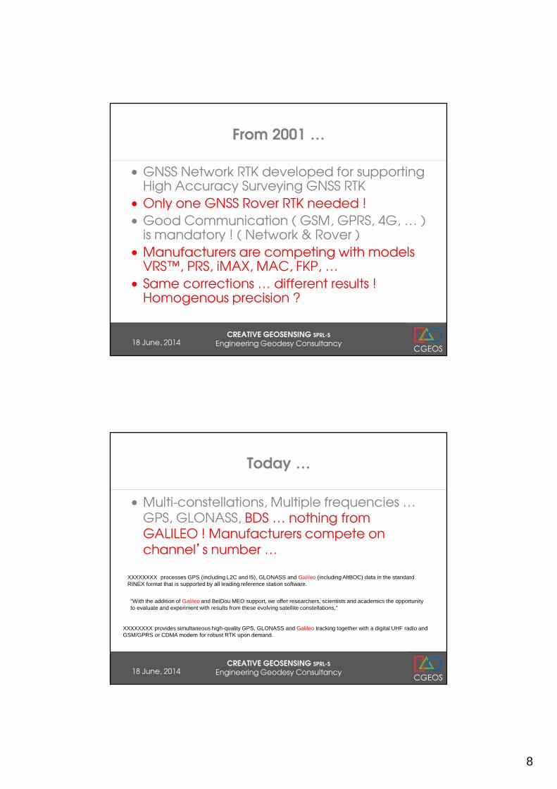
From 2001 …
• GNSS Network RTK developed for supporting High Accuracy Surveying GNSS RTK
• Only one GNSS Rover RTK needed !
• Good Communication ( GSM, GPRS, 4G, … ) is mandatory ! ( Network & Rover )
• Manufacturers are competing with models VRS™, PRS, iMAX, MAC, FKP, …
• Same corrections … different results ! Homogenous precision ?
18 June, 2014CREATIVE GEOSENSING SPRL-S
Engineering Geodesy Consultancy
Today …
• Multi-constellations, Multiple frequencies … GPS, GLONASS, BDS … nothing from GALILEO ! Manufacturers compete on channel’s number …
XXXXXXXX processes GPS (including L2C and l5), GLONASS and Galileo (including AltBOC) data in the standard RINEX format that is supported by all leading reference station software.
"With the addition of Galileo and BeiDou MEO support, we offer researchers, scientists and academics the opportunity to evaluate and experiment with results from these evolving satellite constellations,"
XXXXXXXX provides simultaneous high-quality GPS, GLONASS and Galileo tracking together with a digital UHF radio and GSM/GPRS or CDMA modem for robust RTK upon demand.

9
18 June, 2014CREATIVE GEOSENSING SPRL-S
Engineering Geodesy Consultancy
GPS + GLONASS + COMPASS/BEIDOU
05 June, 2014CREATIVE GEOSENSING SPRL-S
Engineering Geodesy Consultancy
First Trial in Belgium

10
05 June, 2014CREATIVE GEOSENSING SPRL-S
Engineering Geodesy Consultancy
First trial in Belgium
05 June, 2014CREATIVE GEOSENSING SPRL-S
Engineering Geodesy Consultancy
11
18 June, 2014CREATIVE GEOSENSING SPRL-S
Engineering Geodesy Consultancy
18 June, 2014CREATIVE GEOSENSING SPRL-S
Engineering Geodesy Consultancy
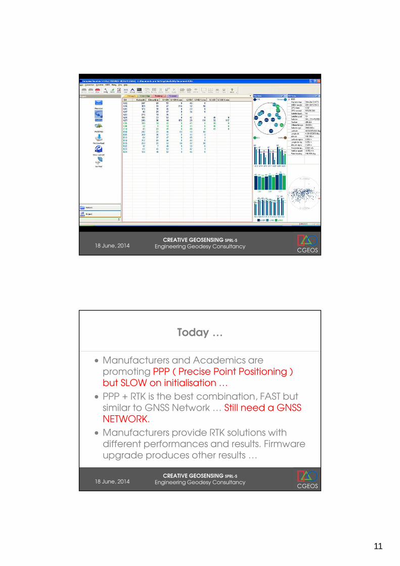
Today …
• Manufacturers and Academics are promoting PPP ( Precise Point Positioning ) but SLOW on initialisation …
• PPP + RTK is the best combination, FAST but similar to GNSS Network … Still need a GNSS NETWORK.
• Manufacturers provide RTK solutions with different performances and results. Firmware upgrade produces other results …
12
18 June, 2014CREATIVE GEOSENSING SPRL-S
Engineering Geodesy Consultancy
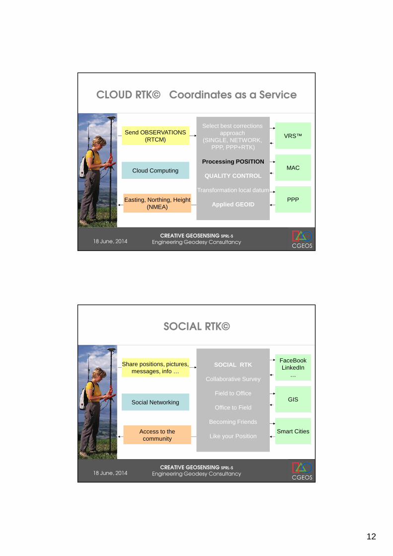
CLOUD RTK© Coordinates as a Service
Send OBSERVATIONS(RTCM)
Easting, Northing, Height(NMEA)
Select best corrections approach
(SINGLE, NETWORK, PPP, PPP+RTK)
Processing POSITION
QUALITY CONTROL
Transformation local datum
Applied GEOID
Cloud Computing
VRS™
MAC
PPP
18 June, 2014CREATIVE GEOSENSING SPRL-S
Engineering Geodesy Consultancy
SOCIAL RTK©
Share positions, pictures,messages, info …
Access to thecommunity
SOCIAL RTK
Collaborative Survey
Field to Office
Office to Field
Becoming Friends
Like your Position
Social Networking
FaceBookLinkedIn
…
GIS
Smart Cities

13
18 June, 2014CREATIVE GEOSENSING SPRL-S
Engineering Geodesy Consultancy
GNSS … the Truth !
• GPS, GLONASS, BDS are positioning tools for DEFENSE APPLICATIONS never designed for Surveyors !
• In the cities (urban canyons), under ground, indoor … GNSS is not working !
• The GNSS signals can be easily jammed !
05 June, 2014CREATIVE GEOSENSING SPRL-S
Engineering Geodesy Consultancy
GNSS is vulnerable !
• In the US the company “Light Square” setup communication network along the highway on the same frequency than GPS !
• With the idea to track everything (cars, trucks, people, …) now people are considering GPS Jammer to get their privacy.
• Jamming GNSS signals is EASY and UNDETECTABLE …

14
05 June, 2014CREATIVE GEOSENSING SPRL-S
Engineering Geodesy Consultancy
GPS JAMMERS
05 June, 2014CREATIVE GEOSENSING SPRL-S
Engineering Geodesy Consultancy
GPS Jammers and Battlefield
15
05 June, 2014CREATIVE GEOSENSING SPRL-S
Engineering Geodesy Consultancy
05 June, 2014CREATIVE GEOSENSING SPRL-S
Engineering Geodesy Consultancy
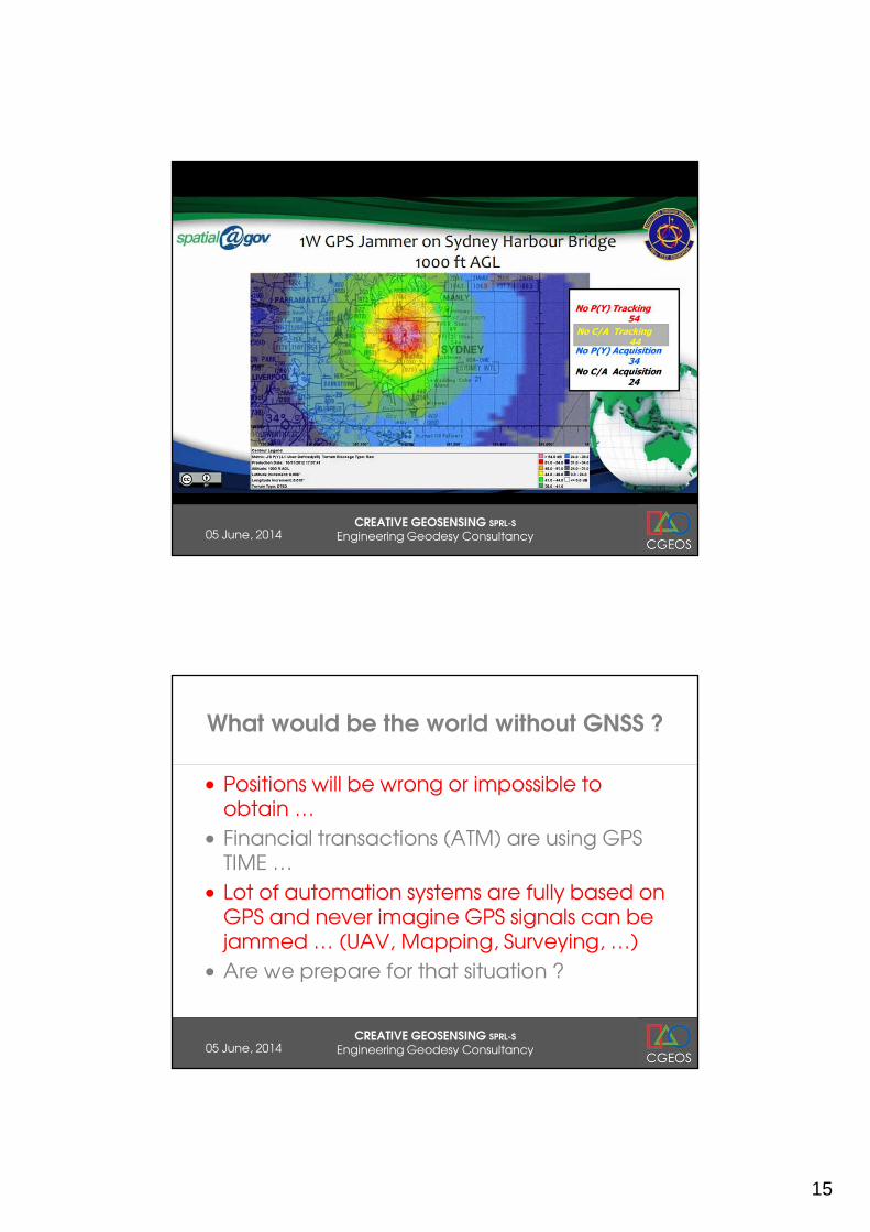
What would be the world without GNSS ?
• Positions will be wrong or impossible to obtain …
• Financial transactions (ATM) are using GPS TIME …
• Lot of automation systems are fully based on GPS and never imagine GPS signals can be jammed … (UAV, Mapping, Surveying, …)
• Are we prepare for that situation ?

16
05 June, 2014CREATIVE GEOSENSING SPRL-S
Engineering Geodesy Consultancy
18 June, 2014CREATIVE GEOSENSING SPRL-S
Engineering Geodesy Consultancy
17
18 June, 2014CREATIVE GEOSENSING SPRL-S
Engineering Geodesy Consultancy
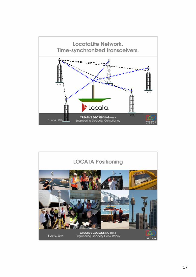
LocataLite Network.Time-synchronized transceivers.
XYZ
XYZ
XYZ
18 June, 2014CREATIVE GEOSENSING SPRL-S
Engineering Geodesy Consultancy
LOCATA Positioning

18
18 June, 2014CREATIVE GEOSENSING SPRL-S
Engineering Geodesy Consultancy
SAR INTERFEROMETRY
Persistent Scattered SAR Interferometry present a geodetic network of opportunity but the “points” are not marked.
Outside urbanised area’s PS is not possible without Corner Reflector.
Researches are conducted (DELFT) to validate if Compact Active Transponders can be a valuable alternative to Passive Corner Reflectors.
18 June, 2014CREATIVE GEOSENSING SPRL-S
Engineering Geodesy Consultancy
CATS AND CR EXTRACT

19
18 June, 2014CREATIVE GEOSENSING SPRL-S
Engineering Geodesy Consultancy
GNSS NETWORK RTK
New GNSS ANTENNA METEO sensors
New GNSS RECEIVER
CATS ( InSAR Active CC )
LOCATA
LEVELLING
COMMUNICATION
PILLAR, CABINET, POWER
18 June, 2014CREATIVE GEOSENSING SPRL-S
Engineering Geodesy Consultancy
COMMUNITY
CLOUD RTK©
GPS + GLONASS + BDS
GNSS + LOCATA
SOCIAL NETWORK
20
18 June, 2014CREATIVE GEOSENSING SPRL-S
Engineering Geodesy Consultancy
Positioning Infrastructure New Generation
• GNSS Network RTK has proven to be effective to support GNSS RTK surveying (no need local base station) and GNSS monitoring operations. Can a GNSS Network locates a jamming source ? Can disable a GNSS constellation that is failing ( 2nd of April 2014 ) ?
• Must move from “corrections” as service to “coordinates” as service ( Cloud computing RTK ).
• Today GNSS receivers are not tuned to provide highest grade of measurements ( ME same than others ). Next Generation is coming … New GNSS Antenna (VRAY) to counter jamming.
• Compact active transponders (CATs) for SAR Interferometry will benefit greatly of being host.
• LOCATA ground to ground location systems proves they will join• Is there any other sensors to be considered as part of such
positioning infrastructure ?
18 June, 2014CREATIVE GEOSENSING SPRL-S
Engineering Geodesy Consultancy
Not only for Surveyors … new users !

21
18 June, 2014CREATIVE GEOSENSING SPRL-S
Engineering Geodesy Consultancy
Digital & Smart Cities
18 June, 2014CREATIVE GEOSENSING SPRL-S
Engineering Geodesy Consultancy
Digital & Smart Cities
HOW TO INTERACT WITH A DIGITAL MODEL EVEN A SMART ONE ?
22
18 June, 2014CREATIVE GEOSENSING SPRL-S
Engineering Geodesy Consultancy
18 June, 2014CREATIVE GEOSENSING SPRL-S
Engineering Geodesy Consultancy

23
18 June, 2014CREATIVE GEOSENSING SPRL-S
Engineering Geodesy Consultancy
To hyperlink the geo-spatial object
Indentify the object
Survey ( x, y, z )
Associate INFO
Processing
Upload TAG
SURVEY TAG
http://www.tree-talking.com
18 June, 2014CREATIVE GEOSENSING SPRL-S
Engineering Geodesy Consultancy

24
18 June, 2014CREATIVE GEOSENSING SPRL-S
Engineering Geodesy Consultancy
18 June, 2014CREATIVE GEOSENSING SPRL-S
Engineering Geodesy Consultancy
It’’’’s all about Geo-tags !
QUICK CODE RFID

25
18 June, 2014CREATIVE GEOSENSING SPRL-S
Engineering Geodesy Consultancy
18 June, 2014CREATIVE GEOSENSING SPRL-S
Engineering Geodesy Consultancy
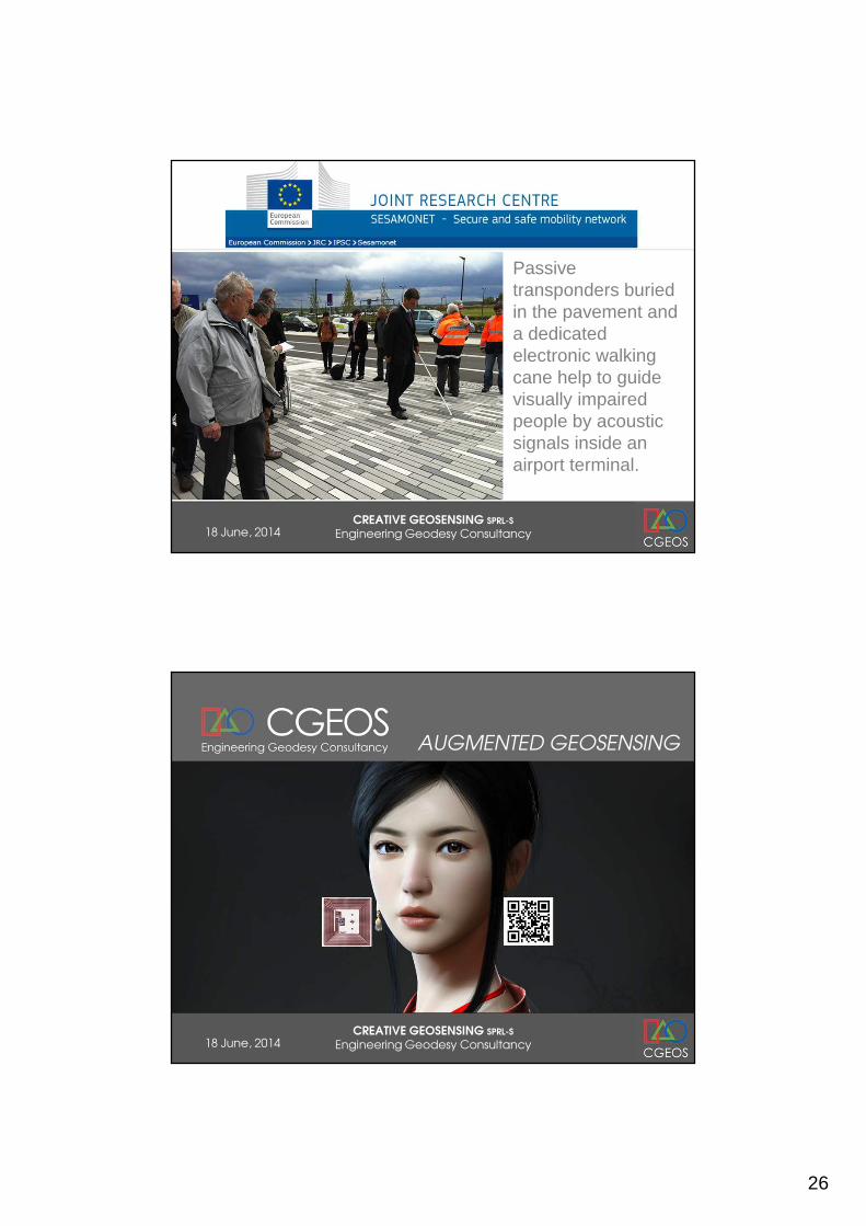
The idea consists in using RFID (Radio Frequency Identification) passive transponders (i.e. microchips) to create a path guiding a visually impaired person through a location. The walking stick has an embedded antenna (with a bluetooth transmitter) which detects/reads the RFID transponders.Each transponder sends a signal via the antenna to a Smart Phone equipped with a database with information on the location.
26
18 June, 2014CREATIVE GEOSENSING SPRL-S
Engineering Geodesy Consultancy
Passive transponders buried in the pavement and a dedicated electronic walking cane help to guide visually impaired people by acoustic signals inside an airport terminal.
18 June, 2014CREATIVE GEOSENSING SPRL-S
Engineering Geodesy Consultancy
AUGMENTED GEOSENSING

27
18 June, 2014CREATIVE GEOSENSING SPRL-S
Engineering Geodesy Consultancy
Most of the GNSS Network RTK projects have been developed by the economical justification that an active geodetic network would reduce the cost of
maintaining a traditional geodetic network where the maintenance of the benchmarks and the control survey were a significant part of the owner’s
budget.
18 June, 2014CREATIVE GEOSENSING SPRL-S
Engineering Geodesy Consultancy
Conclusion
• Next Generation Positioning Infrastructure will rock with millions of active geodetic marks and new signals, new receivers …
• GPS, GLONASS, BDS and … LOCATA is the 4th
constellation !
• GNSS receivers & Antenna must be re-engineered … totally !
• Positioning Infrastructure as a Service ( Cloud RTK© )
• GNSS is vulnerable and we have to address that !
• What we do need is PI 2.0 !

28
CREATIVE GEOSENSING SPRL-SEngineering Geodesy Consultancy
Thank you so much !
Creativity and passion will refresh Engineering Geodesy and
Surveying in the 21st Century by GEOSENSING the World
18 June, 2014CREATIVE GEOSENSING SPRL-S
Engineering Geodesy Consultancy
Beyond East & West GeoSensing Community
JOEL VAN CRANENBROECK – [email protected]