newland developers pty ltd level 1 inspection and testing, … · in all areas the subgrade...
TRANSCRIPT

Newland Developers Pty Ltd Level 1 Inspection and Testing, Stage 106, Warralily Armstrong Creek development 754-GEOTABTF08569AE
06 April 2020

This page has been left intentionally blank
Coffey Services Australia Pty Ltd
ABN 55 139 460 521 i
Stage 106, Warralily Armstrong Creek development
Prepared for Newland Developers Pty Ltd
Prepared by
Coffey Services Australia Pty Ltd
Level 1, 436 Johnston Street
Abbotsford
Vic 3067 Australia
t: +61 3 9290 7000 f: +61 3 9290 7499
ABN 55 139 460 521
06 April 2020
GEOTABTF08569AE-DX
Quality information
Revision history
Revision Description Date Originator Reviewer Approver
0 Level 1 report 06/04/2020 Dilshan Senarathne
Ganesh Manivannan
Sotir Stojcevski
Distribution
Report Status No. of copies Format Distributed to Date
Report v.0 1 PDF Martin O’ Hanlon 06/04/2020
Report v.0 1 PDF Coffey Library 06/04/2020
Coffey Services Australia Pty Ltd ABN 55 139 460 521
ii
Table of contents
1. Introduction .................................................................................................................................. 1
2. Project Summery ......................................................................................................................... 1
2.1. Included areas ................................................................................................................... 1
2.2. Excluded areas.................................................................................................................. 2
3. Specifications/work instructions .................................................................................................. 2
4. Fill Material .................................................................................................................................. 2
5. Earthworks ................................................................................................................................... 2
5.1. Subgrade assessment ...................................................................................................... 3
5.2. Fill Construction................................................................................................................. 3
5.3. Survey data and fill thickness ............................................................................................ 3
5.3.1. Eastern pad including Creek area ........................................................................ 4
5.3.2. Western pad including Creek area ....................................................................... 4
6. Testing & Results ........................................................................................................................ 4
7. Statement of compliance ............................................................................................................. 5
Appendix A - Laboratory Results ........................................................................................................ 2
Appendix B - “Stage 106” drawings .................................................................................................... 3
Appendix C - Extract from specification by SMEC .............................................................................. 4
Tables
Table 1: Level 1 GITA works – Dates on site
Table 2: Fill pads on Stage 106
Table 3: Fill levels at selected spot locations in Stage 106
Level 1 Inspection and Testing, Stage 106, Warralily Armstrong Creek Development
Coffey
GEOTABTF08569AE-DX
6 April 2020
1
1. Introduction
This report presents the results of the Level 1 Inspection and Testing for fill placement within the
Stage 106 of the Warralily Estate Armstrong Creek Development, undertaken by Coffey Services
Australia Pty Ltd (Coffey).
The works were commissioned by Martin O’Hanlon of Newland Developers Pty Ltd (Newland).
2. Project Summery
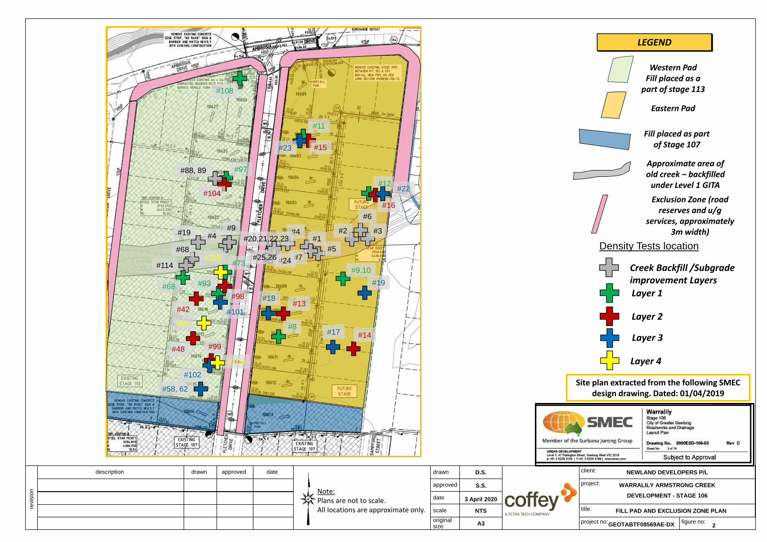
We understand that Newland requires fill placement within Stage 106 of the Warralily Armstrong Creek Development in the area as shown in Figure 1, to be constructed under Level 1 Inspection and Testing undertaken by a Geotechnical Inspection and Testing Authority (GITA).
Level 1 Inspection and Testing, as defined in AS3798-2007 “Guidelines on Earthworks for Commercial and Residential Development,” provides for full time inspection of the construction of controlled fill and field and laboratory testing in accordance with AS1289 “Methods of Testing Soils for Engineering Purposes.”
The Level 1 Inspection for Stage 106 was undertaken by geotechnical professionals from Coffey over the period of several months as shown in Table 1.
Table 1: Level 1 GITA works – Dates on site
Month Dates
April 2018 18, 20, 23
May 2018 22, 24
June 2018 2, 4, 7, 13, 28, 29, 30
July 2018 3, 4, 5, 6, 10, 13
May 2019 15, 16, 17, 18, 20
July 2019 08, 09, 10, 11, 12, 15, 16, 17, 18
The earthworks contractor for the project was Winslow Constructors Pty Ltd (Winslow). Coffey undertook the field density testing and the compaction control testing in their laboratory, as part of the Level 1 Inspection and Testing process.
2.1. Included areas
This report is applicable to fill placed by Winslow within Stage 106 of the Warralily Development in the area shown in Figure 1. The filling areas encompass two fill Pads of Stage 106 as follows.
Table 2: Fill pads on Stage 106
Fill Pad Residential Lot #
Eastern Pad #10614 to #10626 Note: Fill constructed as part of Stage #113 works in 2018
Western Pad #10601 to #10612

Level 1 Inspection and Testing, Stage 106, Warralily Armstrong Creek Development
Coffey
GEOTABTF08569AE-DX
6 April 2020
2
2.2. Excluded areas
This report does not include fill other than where mentioned in this report or any other fill that may be placed during this period or subsequent periods at or surrounding the subject site. Excluded works comprise road construction, trench backfill, foot paths, landscaping fill and placement of topsoil.
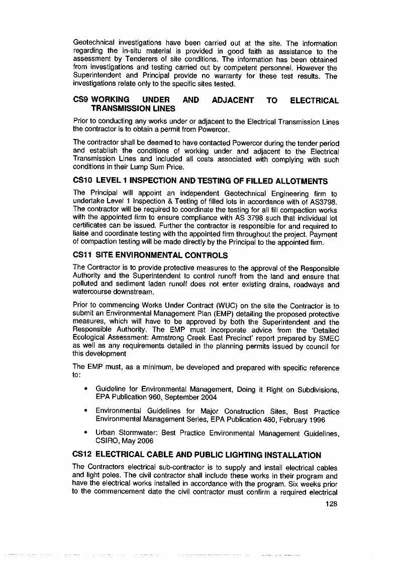
3. Specifications/work instructions
The specification for the project was prepared by SMEC Australia Pty Ltd (SMEC) for Armstrong
Creek Development Corporation Pty Ltd under reference number 0557ESB-24. An extract of the
specification was provided to Coffey in an email sent by Shane McGlynn from SMEC on 5 October
2012. The extract from the specification forwarded to Coffey is provided in Appendix C and a short
summary is provided below:
- All filling in excess of 200mm depth within the building envelope of allotments shall be
undertaken to specifications satisfying the requirements of AS 3798-2007 “Guidelines on
Earthworks for Commercial and Residential Development”;
- All such filling works shall be undertaken with supervision to the standard detailed as “Level 1
Inspection and Testing” in AS 3798-2007, such that the supervisor will issue a notice detailing
that the works comply with the specifications and drawings;
- Material to be used for fill construction shall satisfy the requirements of AS 3798-2007;
- Fill to be compacted in near horizontal layers not exceeding 300mm loose thickness;
- Compaction to achieve a dry density ratio of at least 95% Standard; and
- Moisture content of the fill material is to be within ±3% of the Standard Optimum Moisture
Content (SOMC).
4. Fill Material
Fill used for the construction of Stage 106 comprised locally sourced clay from the existing stages
within the Armstrong Creek Development. Any observed organic or deleterious matter including any
oversize particles was removed during the fill placement within the engineered fill platforms.
5. Earthworks
The earthworks for this project included the following:
• Stripping of topsoil,
• Stripping of uncontrolled fill from base of a creek running though the site,
• Assessment, remediation and proof rolling of subgrade, and;
• Placement and compaction of fill to construct the engineered fill areas.
Level 1 Inspection and Testing, Stage 106, Warralily Armstrong Creek Development
Coffey
GEOTABTF08569AE-DX
6 April 2020
3
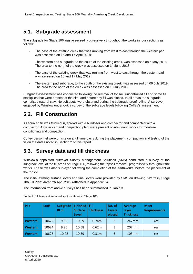
5.1. Subgrade assessment
The subgrade for Stage 106 was assessed progressively throughout the works in four sections as follows:
- The base of the existing creek that was running from west to east through the western pad was assessed on 16 and 17 April 2018;
- The western pad subgrade, to the south of the existing creek, was assessed on 5 May 2018. The area to the north of the creek was assessed on 14 June 2018.
- The base of the existing creek that was running from west to east through the eastern pad was assessed on 16 and 17 May 2019;
- The eastern pad subgrade, to the south of the existing creek, was assessed on 09 July 2019. The area to the north of the creek was assessed on 10 July 2019.
Subgrade assessment was conducted following the removal of topsoil, uncontrolled fill and some fill stockpiles that were present at the site, and before any fill was placed. In all areas the subgrade comprised natural clay. No soft spots were observed during the subgrade proof rolling. A surveyor engaged by Winslow undertook a survey of the subgrade levels following Coffey’s assessment.
5.2. Fill Construction
All sourced fill was trucked in, spread with a bulldozer and compactor and compacted with a
compactor. A water cart and compaction plant were present onsite during works for moisture
conditioning and compaction.
Coffey personnel were on site on a full time basis during the placement, compaction and testing of the fill on the dates noted in Section 2 of this report.
5.3. Survey data and fill thickness
Winslow’s appointed surveyor Survey Management Solutions (SMS) conducted a survey of the
subgrade level of the fill areas of Stage 106, following the topsoil removal, progressively throughout the
works. The fill was also surveyed following the completion of the earthworks, before the placement of
the topsoil.
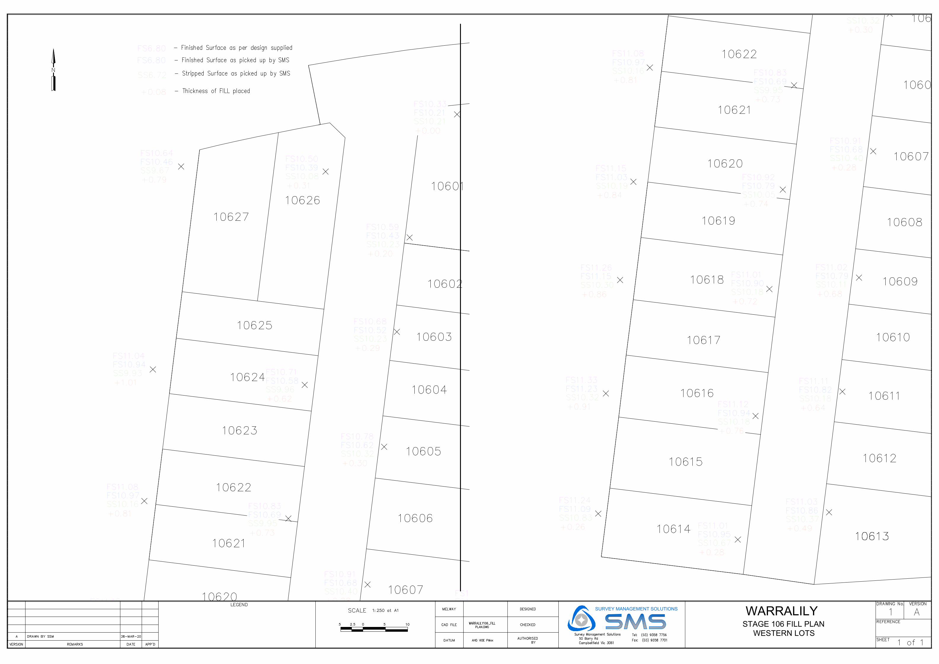
The initial existing surface levels and final levels were provided by SMS on drawing “Warralily Stage
106 Fill Plan” dated 26 April 2019 (attached in Appendix B).
The information from above surveys has been summarised in Table 3.
Table 1: Fill levels at selected spot locations in Stage 106
Pad Lot# Subgrade RLm
Finished Surface Level
Fill Thickness
No. of Layers placed
Average layer Thickness
Meet Requirements
Western 10622 9.95 10.69 0.74m 3 247mm Yes
Western 10624 9.96 10.58 0.62m 3 207mm Yes
Western 10626 10.08 10.39 0.31m 3 103mm Yes

Level 1 Inspection and Testing, Stage 106, Warralily Armstrong Creek Development
Coffey
GEOTABTF08569AE-DX
6 April 2020
4
Pad Lot# Subgrade RLm
Finished Surface Level
Fill Thickness
No. of Layers placed
Average layer Thickness
Meet Requirements
Western 10620 10.05 10.79 0.74m 7 106mm Yes
Western 10618 10.18 10.9 0.72m 4 180mm Yes
Western 10616 10.18 10.94 0.76m 4 190mm Yes
Eastern 10611 9.85 10.6 0.75m 3 250mm Yes
Eastern 10607 9.69 10.47 0.78m 5 156mm Yes
Eastern 10603 9.65 10.49 0.84m 3 280mm Yes
5.3.1. Eastern pad including Creek area
Based on the survey data, the fill thickness within the Eastern Pad ranged between 0.38m to 0.79m, except for the creek backfill areas where the fill thickness should be exceeding 1m (these levels are not shown on the survey drawings). Coffey have observed up to 7 layers of fill being constructed within most parts of the Eastern Pad area, and up to 5 layers within the creek backfill. Based on the survey data and the number of layers placed in these areas, the fill thickness is generally compliant with the project specifications.
5.3.2. Western pad including Creek area
Based on the survey data, the fill thickness within the Western Pad ranged between 0.20m to 0.79m, except for the creek backfill areas where the fill thickness should be exceeding 1m (these levels are not shown on the survey drawings). Coffey has observed up to 3 layers of fill being constructed within most parts of the Eastern Pad area, and up to 5 layers within the creek backfill. Based on the survey data and the number of layers placed in these areas, the fill thickness is generally compliant with the project specifications.
6. Testing & Results
Field density testing was undertaken progressively during construction on the compacted fill. Testing
was undertaken under the frequencies listed below, subject to the area and volume worked on the
day of testing:
- 1 test per material type per layer per 2500m2 or 1 test per 500m3 distributed reasonably
evenly or 3 tests per lot – whichever requires the most tests in accordance with Type 1
Earthworks (large scale operations) as defined in Table 8.1 of the AS 3798-2007;
- 1 test per layer per 1,000m² or 1 test per 200m³ distributed reasonably evenly or 1 test per
residential lot - whichever requires the most tests in accordance with Type 2 Earthworks
(small scale operations) as defined in Table 8.1 of the AS 3798-2007;
- 1 test per layer per 500m² or 1 test per 100m³ distributed reasonably evenly or 3 tests per visit
- whichever requires the most tests in accordance with Type 3 Earthworks (concentrated
scale operations) as defined in Table 8.1 of the AS 3798-2007;

Level 1 Inspection and Testing, Stage 106, Warralily Armstrong Creek Development
Coffey
GEOTABTF08569AE-DX
6 April 2020
5
- 1 test per 2 layers per 50m² distributed reasonably evenly throughout the fill depth –in
accordance with Type 4 Earthworks (confined operations) as defined in Table 8.1 of the AS
3798-2007.
The field density testing was conducted by Coffey’s personnel on site using a Nuclear Density Gauge
in accordance with AS1289.5.8.1 ‘Determination of field density and field moisture content of a soil
using a nuclear surface Moisture – Density Gauge’.
The laboratory testing was performed at Coffey’s laboratory and Ground Science Laboratory. A Hilf
Rapid compaction test was performed for each field density test in accordance with AS1289.5.7.1
‘Soil compaction and density tests—Compaction control test—Hilf density ratio and Hilf moisture
variation (rapid method)’.
The location of the field density tests was determined by use of the GPS on the construction plant
operated by the contractor on site. For each of the field density tests, the following items were
recorded on the field sheets: test location, layer number, layer thickness, test depth, soil type, time
and date of testing.
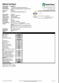
A total of 48 density tests were performed during the earthworks in the locations as presented in
Figures 2. Of the 48 tests, 2 did not meet the specified criteria. These areas were subsequently re-
worked and re-tested. Once re-tested, the 2 test results met the specified dry density ratio criteria of
95% Standard compactive effort and moisture variation of ±3% of the Optimum Moisture Content
(OMC).
A summary of the test results obtained from the field density testing within Stage 106 are provided in a table presented as Figure 3. The laboratory test reports of the field density tests are presented in Appendix A.
7. Statement of compliance
Coffey personnel have provided Level 1 inspection and testing services during the construction of the engineered fill areas within Stage 106 as shown in SMS survey drawing in Appendix B. A geotechnical professional from Coffey (Level 1 Inspector) was on site on a full time basis during the construction of the engineered fill platforms and observed the construction techniques adopted for the dates noted in section 2 of this report.
Based on observations made by Coffey’s Level 1 Inspector and the results of field and laboratory tests, Coffey consider that the engineered fill areas within Stage 106 as indicated in the SMS survey drawing in Appendix B, constructed by Winslow to the levels indicated in Section 5.3 of this report, as far as we have been able to reasonably determine, have been placed in general accordance with the intent of the specification.
Figures
Figure 1 – Site Plan indicating Fill Pads and Exclusion Zones
Figure 2 – Field Density Tests Locations
Figure 3 – Table – Summary of Density Test Results

drawn
approved
date
scale
originalsize
client:
project:
title:
project no: figure no:A3
dateapproveddrawndescription
revis
ion
0 5 10 20 30
Horizontal Scale (metres)
0 5 10 20 30
Vertical Scale (metres)
D.S.
NTS
GEOTABTF08569AE-DX 1
FILL PAD AND EXCLUSION ZONE PLAN
Note:Plans are not to scale.All locations are approximate only.
NEWLAND DEVELOPERS P/L
WARRALILY ARMSTRONG CREEK
DEVELOPMENT - STAGE 106
S.S.
3 April 2020
LEGEND
Site plan extracted from the following SMEC design drawing. Dated: 01/04/2019
Eastern Pad
Fill placed as part of Stage 107
Exclusion Zone (road reserves
and u/g services, approximately
3m width)
Approximate area of old creek –
backfilled under Level 1 GITA
Western PadFill placed as a
part of stage 113
Stage 106 perimeter
drawn
approved
date
scale
originalsize
client:
project:
title:
project no: figure no:A3
dateapproveddrawndescription
revis
ion
0 5 10 20 30
Horizontal Scale (metres)
0 5 10 20 30
Vertical Scale (metres)
D.S.
NTS
GEOTABTF08569AE-DX 2
FILL PAD AND EXCLUSION ZONE PLAN
Note:Plans are not to scale.All locations are approximate only.
NEWLAND DEVELOPERS P/L
Western PadFill placed as a
part of stage 113
WARRALILY ARMSTRONG CREEK
DEVELOPMENT - STAGE 106
S.S.
3 April 2020
LEGEND
Site plan extracted from the following SMEC design drawing. Dated: 01/04/2019
Eastern Pad
Fill placed as part of Stage 107
Exclusion Zone (road reserves and u/g
services, approximately 3m width)
Approximate area of old creek – backfilled
under Level 1 GITA
Layer 1
Layer 2
Density Tests location
Creek Backfill /Subgrade improvement Layers
Layer 3
#1#2 #3#4
#5
#6
#7
#8
#9,10
#11
#12
#13
#14
#15
#16
#17
#18
#19
#24
#23
#22
#20,21,22,23
#25,26
#108
#97
#104
#88, 89
#4
#68
#9#19
#114
#99#48
#42
#93
#98
#73
#68
#110
#101
#69
#58, 62
#109
#102
Layer 4

FIGURE 3 SUMMARY OF FIELD DENSITY TEST RESULTS AT STAGE 106
Newland Developers
Test Retest Day Layer Lot HILF Moisture Pass
of / / Density Variation /
Test Date Location Ratio of OMC Fail
# # # # % %
1 Friday, May 17, 2019 1 10607 106.5 -4.0 Pass
2 Friday, May 17, 2019 1 20m West of 10607 103.0 -2.0 Pass
3 Saturday, May 18, 2019 3 20m East of 10606 104.0 -1.0 Pass
4 Saturday, May 18, 2019 4 10606 100.0 -0.5 Pass
5 Saturday, May 18, 2019 6 10607 99.0 0.0 Pass
6 Monday, May 20, 2019 7 15m East of 10606 106.0 +0.5 Pass
7 Monday, May 20, 2019 8 10607 102.5 +0.5 Pass
8 Wednesday, July 10, 2019 1 10610 96.0 -2.0 Pass
9 Wednesday, July 10, 2019 1 15m East of 10607 98.0 #REF! Fail
10 9 Thursday, July 11, 2019 1 10m East of 10607 96.0 #REF! Pass
11 Thursday, July 11, 2019 1 10602 98.5 #REF! Pass
12 Thursday, July 11, 2019 1 20m East of 10604 98.0 0.0 Pass
13 Thursday, July 11, 2019 2 10609 100.5 0.0 Pass
14 Thursday, July 11, 2019 2 20m East of 10611 97.0 #REF! Pass
15 Friday, July 12, 2019 2 10602 98.0 #REF! Pass
16 Friday, July 12, 2019 2 30m East of 10604 97.5 0.0 Pass
17 Monday, July 15, 2019 3 5m East of 10610 99.0 #REF! Pass
18 Monday, July 15, 2019 3 10609 99.5 #REF! Pass
19 Monday, July 15, 2019 3 25m East of 10608 104.5 #REF! Pass
20 Tuesday, July 16, 2019 1 West of 10607 97.5 #REF! Pass
21 Tuesday, July 16, 2019 2 West of 10607 104.0 #REF! Pass
22 Tuesday, July 16, 2019 3 25m East of 10604 97.0 0.0 Pass
23 Tuesday, July 16, 2019 3 10603 97.0 0.0 Pass
24 Tuesday, July 16, 2019 3 West of 10607 97.5 0.0 Pass
25 Wednesday, July 17, 2019 4 West of 10607 96.0 0.0 Pass
26 Thursday, July 18, 2019 5 West of 10607 102.0 #REF! Pass
4 Wednesday, April 18, 2018 2 2m East of 11307 102.5 -2.0 Pass
9 Friday, April 20, 2018 3 10m East of 11306 101.5 -3.0 Pass
19 Monday, April 23, 2018 4 2m East of 11306 99.5 -2.5 Pass
42 Tuesday, May 22, 2018 2 8m East of 11309 106.5 -1.5 Pass
48 Thursday, May 24, 2018 2 7m East of 11310 99.0 0.0 Pass
58 Saturday, June 2, 2018 3 9m East 0f 11312 94.5 0.0 Fail
62 58 Monday, June 4, 2018 3 9m East 0f 11312 100.5 -0.5 Pass
68 Thursday, June 7, 2018 1 11308 97.5 -0.5 Pass
69 Thursday, June 7, 2018 4 9m East of 11310 105.0 -0.5 Pass
73 Wednesday, June 13, 2018 1 5m East of 11307 95.0 0.0 Pass
88 Thursday, June 28, 2018 Subgrade 11308 99.0 +2.1 Pass
90 Friday, June 29, 2018 Subgrade (L2) 11306 100.0 -2.0 Pass
93 Saturday, June 30, 2018 1 5m East of Fletcher Drive 102.5 -0.5 Pass
97 Tuesday, July 3, 2018 1 10m East of 11304 102.0 -2.5 Pass
98 Tuesday, July 3, 2018 2 5m west of Fletcher drive 98.0 0.0 Pass
99 Tuesday, July 3, 2018 2 12m East of 11311 97.0 -0.5 Pass
101 Wednesday, July 4, 2018 3 5m West of Fletcher Drive 99.5 -1.0 Pass
102 Wednesday, July 4, 2018 3 13m East of 11311 102.5 -0.5 Pass
104 Thursday, July 5, 2018 2 10m East of 11304 103.5 -2.5 Pass
108 Friday, July 6, 2018 1 10m East of 11301 108.0 -2.0 Pass
109 Tuesday, July 10, 2018 4 14m East of 11311 102.5 -0.5 Pass
114 Friday, July 13, 2018 6 7m East of 11307 106.5 -0.5 Pass
Test conducted as a part of Stage 113
Test conducted as a part of Stage 113
Test conducted as a part of Stage 113
Test conducted as a part of Stage 113
Test conducted as a part of Stage 113
Project Number
Project Name
Location
Moisture content within ± 3% of OMC
Contractor
Engineer
Specifications
GEOTABTF08569AE
Warralily Armstrong Creek Development
Warralily, VIC
Winslow
SMEC
Density Ratio ≥ 95% of Max Dry Density
Client
Retest #
/
Comment
Approved by the manager
Retest # 10
Test conducted as a part of Stage 113
Test conducted as a part of Stage 113
Test conducted as a part of Stage 113
Test conducted as a part of Stage 113
Test conducted as a part of Stage 113
Test conducted as a part of Stage 113
Test conducted as a part of Stage 113
Test conducted as a part of Stage 113
Test conducted as a part of Stage 113
Test conducted as a part of Stage 113
Test conducted as a part of Stage 113
Test conducted as a part of Stage 113
Test conducted as a part of Stage 113
Test conducted as a part of Stage 113
Test conducted as a part of Stage 113
Test conducted as a part of Stage 113
Test conducted as a part of Stage 113
GEOTABTF08569AE-DX Figure 3 - Field Density test Results - Warralily Stage 106 6 APRIL 2020

Appendix A - Laboratory Results

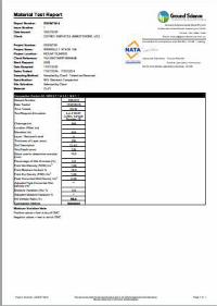
Sample DetailsLocation: Warralily, VIC - GRANGEClient Request ID:Specification Requirements: MINIMUM HILF DENSITY RATIO OF 95% of Standard Compaction and Moisture variation to be within
3% of OMC(as advised by client)Field Test procedures: AS 1289.5.8.1Laboratory Test procedures: AS 1289.5.7.1, AS 1289.2.1.1Sampling Method: AS1289.1.2.1 Clause 6.4 (b)Source:Material: FillSample DataSample ID MELB19S-00564 MELB19S-00565Field Sample ID 00251 00252Client Sample ID 1 2Date Tested 17/05/2019 17/05/2019Time Tested 10:30 01:45LOT Number 10607 20m West of 10607Layer 1 1Level (m) -2.5 -2.5Field and Laboratory DataDepth of Test (mm) 275 275Depth of Layer (mm) 300 300Field Moisture Content (%) 12.5 17.3Field Moisture Content Method AS 1289.2.1.1 AS 1289.2.1.1Field Wet Density (t/m³) 2.16 2.12Field Dry Density (t/m³) 1.92 1.81Peak Converted Wet Density* (t/m³) 2.03 2.06Optimum Moisture Content (%) 16.5 19.0Compactive Effort Standard StandardMoisture Ratio (%) 76.0 90.0Moisture Variation (%) 4.0 dry 2.0 dryHilf Density Ratio (%) 106.5 103.0legend * adjusted for oversize material . .
Sample DataSample ID MELB19S-00564 MELB19S-00565Field Sample ID 00251 00252Client Sample ID 1 2Date Tested 17/05/2019 17/05/2019Time Tested 10:30 01:45LOT Number 10607 20m West of 10607Layer 1 1Level (m) -2.5 -2.5Field and Laboratory DataDepth of Test (mm) 275 275Depth of Layer (mm) 300 300Field Moisture Content (%) 12.5 17.3Field Moisture Content Method AS 1289.2.1.1 AS 1289.2.1.1Field Wet Density (t/m³) 2.16 2.12Field Dry Density (t/m³) 1.92 1.81Peak Converted Wet Density* (t/m³) 2.03 2.06Optimum Moisture Content (%) 16.5 19.0Compactive Effort Standard StandardMoisture Ratio (%) 76.0 90.0Moisture Variation (%) 4.0 dry 2.0 dryHilf Density Ratio (%) 106.5 103.0legend * adjusted for oversize material . .
11/07/2019
HILF Density Ratio ReportReport No: HDR:MELB19W00153
Issue No: 1
Client:
Date of Issue:431Approved Signatory: Stephen Pender(Senior Geotechnician)Project Name: 754-GEOTABTF08569AE - Warralily Estate
ABN 55 139 460 521Melbourne LaboratoryCoffey Services Australia Pty Ltd15 Marine ParadeMelbourne VIC 3067 Phone: +61 418 691 682
Project No.: 754-MELB00012AAPrincipal: Newland Developers
Lot No.: TRN:
Level 1, 436 Johnston StreetAbbotsford VIC 3067Coffey Services Australia Pty Ltd (Abbotsford)
Page 1 of 1Form No: 18996, Report No: HDR:MELB19W00153 © 2000-2016 QESTLab by SpectraQEST.com
Comments

Sample DetailsLocation: Warralily, VIC - GRANGEClient Request ID:Specification Requirements: MINIMUM HILF DENSITY RATIO OF 95% of Standard Compaction (as advised by client)Field Test procedures: AS 1289.5.8.1Laboratory Test procedures: AS 1289.5.7.1, AS 1289.2.1.1Sampling Method: AS1289.1.2.1 Clause 6.4 (b)Source:Material: FillSample DataSample ID MELB19S-00566 MELB19S-00567 MELB19S-00568Field Sample ID 00253 00254 00255Client Sample ID 3 4 5Date Tested 18/05/2019 18/05/2019 18/05/2019Time Tested 10:00 12:00 12:45LOT Numnber 20m East of 10606 10606 10607Layer 3 4 6Level (m) -1.9 -1.6 -1.1Field and Laboratory DataDepth of Test (mm) 275 275 275Depth of Layer (mm) 300 300 300Field Moisture Content (%) 19.0 14.3 14.4Field Moisture Content Method AS 1289.2.1.1 AS 1289.2.1.1 AS 1289.2.1.1Field Wet Density (t/m³) 2.15 2.07 2.09Field Dry Density (t/m³) 1.81 1.81 1.83Peak Converted Wet Density* (t/m³) 2.07 2.07 2.11Optimum Moisture Content (%) 20.0 14.5 14.0Compactive Effort Standard Standard StandardMoisture Ratio (%) 96.0 97.5 101.0Moisture Variation (%) 1.0 dry 0.5 dry 0.0Hilf Density Ratio (%) 104.0 100.0 99.0legend * adjusted for oversize material . . .
Sample DataMELB19S-00566 MELB19S-00567 MELB19S-00568
00253 00254 002553 4 5
18/05/2019 18/05/2019 18/05/201910:00 12:00 12:45
20m East of 10606 10606 10607 3 4 6
-1.9 -1.6 -1.1Field and Laboratory Data
275 275 275300 300 30019.0 14.3 14.4
AS 1289.2.1.1 AS 1289.2.1.1 AS 1289.2.1.12.15 2.07 2.091.81 1.81 1.832.07 2.07 2.1120.0 14.5 14.0
Standard Standard Standard96.0 97.5 101.0
1.0 dry 0.5 dry 0.0104.0 100.0 99.0
. . .
Sample DataSample ID MELB19S-00566 MELB19S-00567 MELB19S-00568Field Sample ID 00253 00254 00255Client Sample ID 3 4 5Date Tested 18/05/2019 18/05/2019 18/05/2019Time Tested 10:00 12:00 12:45LOT Numnber 20m East of 10606 10606 10607Layer 3 4 6Level (m) -1.9 -1.6 -1.1Field and Laboratory DataDepth of Test (mm) 275 275 275Depth of Layer (mm) 300 300 300Field Moisture Content (%) 19.0 14.3 14.4Field Moisture Content Method AS 1289.2.1.1 AS 1289.2.1.1 AS 1289.2.1.1Field Wet Density (t/m³) 2.15 2.07 2.09Field Dry Density (t/m³) 1.81 1.81 1.83Peak Converted Wet Density* (t/m³) 2.07 2.07 2.11Optimum Moisture Content (%) 20.0 14.5 14.0Compactive Effort Standard Standard StandardMoisture Ratio (%) 96.0 97.5 101.0Moisture Variation (%) 1.0 dry 0.5 dry 0.0Hilf Density Ratio (%) 104.0 100.0 99.0legend * adjusted for oversize material . . .
11/07/2019
HILF Density Ratio ReportReport No: HDR:MELB19W00154
Issue No: 1
Client:
Date of Issue:431Approved Signatory: Stephen Pender(Senior Geotechnician)Project Name: 754-GEOTABTF08569AE - Warralily Estate
ABN 55 139 460 521Melbourne LaboratoryCoffey Services Australia Pty Ltd15 Marine ParadeMelbourne VIC 3067 Phone: +61 418 691 682
Project No.: 754-MELB00012AAPrincipal: Newland Developers
Lot No.: TRN:
Level 1, 436 Johnston StreetAbbotsford VIC 3067Coffey Services Australia Pty Ltd (Abbotsford)
Page 1 of 1Form No: 18996, Report No: HDR:MELB19W00154 © 2000-2016 QESTLab by SpectraQEST.com
Comments

Sample DetailsLocation: Warralily, VIC - GRANGEClient Request ID:Specification Requirements: MINIMUM HILF DENSITY RATIO OF 95% of Standard Compaction and Moisture variation to be within
3% of OMC (as advised by client)Field Test procedures: AS 1289.5.8.1Laboratory Test procedures: AS 1289.5.7.1, AS 1289.2.1.1Sampling Method: AS1289.1.2.1 Clause 6.4 (b)Source:Material: FillSample DataSample ID MELB19S-00572 MELB19S-00573Field Sample ID 00256 00257Client Sample ID 6 7Date Tested 20/05/2019 20/05/2019Time Tested 10:30 12:00LOT Number 15m East of 10606 10607Layer Number 7 8Level (m) -.0.825m to 0.85m -.70m to -0.55mField and Laboratory DataDepth of Test (mm) 250 275Depth of Layer (mm) 300 300Field Moisture Content (%) 18.5 15.7Field Moisture Content Method AS 1289.2.1.1 AS 1289.2.1.1Field Wet Density (t/m³) 2.26 2.21Field Dry Density (t/m³) 1.91 1.91Peak Converted Wet Density* (t/m³) 2.13 2.15Optimum Moisture Content (%) 18.0 15.0Compactive Effort Standard StandardMoisture Ratio (%) 104.0 104.5Moisture Variation (%) 0.5 wet 0.5 wetHilf Density Ratio (%) 106.0 102.5legend * adjusted for oversize material . .
Sample DataSample ID MELB19S-00572 MELB19S-00573Field Sample ID 00256 00257Client Sample ID 6 7Date Tested 20/05/2019 20/05/2019Time Tested 10:30 12:00LOT Number 15m East of 10606 10607Layer Number 7 8Level (m) -.0.825m to 0.85m -.70m to -0.55mField and Laboratory DataDepth of Test (mm) 250 275Depth of Layer (mm) 300 300Field Moisture Content (%) 18.5 15.7Field Moisture Content Method AS 1289.2.1.1 AS 1289.2.1.1Field Wet Density (t/m³) 2.26 2.21Field Dry Density (t/m³) 1.91 1.91Peak Converted Wet Density* (t/m³) 2.13 2.15Optimum Moisture Content (%) 18.0 15.0Compactive Effort Standard StandardMoisture Ratio (%) 104.0 104.5Moisture Variation (%) 0.5 wet 0.5 wetHilf Density Ratio (%) 106.0 102.5legend * adjusted for oversize material . .
11/07/2019
HILF Density Ratio ReportReport No: HDR:MELB19W00156
Issue No: 1
Client:
Date of Issue:431Approved Signatory: Stephen Pender(Senior Geotechnician)Project Name: 754-GEOTABTF08569AE - Warralily Estate
ABN 55 139 460 521Melbourne LaboratoryCoffey Services Australia Pty Ltd15 Marine ParadeMelbourne VIC 3067 Phone: +61 418 691 682
Project No.: 754-MELB00012AAPrincipal: Newland Developers
Lot No.: TRN:
Level 1, 436 Johnston StreetAbbotsford VIC 3067Coffey Services Australia Pty Ltd (Abbotsford)
Page 1 of 1Form No: 18996, Report No: HDR:MELB19W00156 © 2000-2016 QESTLab by SpectraQEST.com
Comments


Appendix B - “Stage 106” drawings


WARRALILY
STAGE 106 FILL PLAN
SURVEY MANAGEMENT SOLUTIONS
PR
OD
UC
ED
B
Y A
N A
UT
OD
ES
K S
TU
DE
NT
V
ER
SIO
N
PRODUCED BY AN AUTODESK STUDENT VERSION
PR
OD
UC
ED
B
Y A
N A
UT
OD
ES
K S
TU
DE
NT
V
ER
SIO
N
PRODUCED BY AN AUTODESK STUDENT VERSION
WARRALILY
STAGE 106 FILL PLAN
SURVEY MANAGEMENT SOLUTIONS
WESTERN LOTS
PR
OD
UC
ED
B
Y A
N A
UT
OD
ES
K S
TU
DE
NT
V
ER
SIO
N
PRODUCED BY AN AUTODESK STUDENT VERSION
PR
OD
UC
ED
B
Y A
N A
UT
OD
ES
K S
TU
DE
NT
V
ER
SIO
N
PRODUCED BY AN AUTODESK STUDENT VERSION
Appendix C - Extract from specification by SMEC


This page has been left intentionally blank