new science to model perennial vegetation more accurately in response to haying and grazing giulio...
TRANSCRIPT

RUSLE2 New-style Perennial Vegetation & Management Records
New science to model perennial vegetation more accurately in response to haying and
grazing
Giulio Ferruzzi, WNTSC Agronomist (NRCS RUSLE2 science lead)Linda Scheffe, NSSC Agronomist (NRCS RUSLE2 database manager)Steve Boetger, ENTSC AgronomistSteve Woodruff, ENTSC Agronomist/Forage Specialist

Perennial vegetation records as you knew them…

Perennial vegetation records as you knew them…

New perennial vegetation records look like this, on the surface
This new button is where the new information is
found!

New perennial vegetation records…

New perennial vegetation records…

New perennial vegetation records…
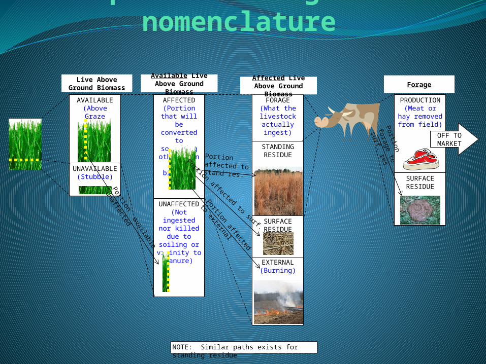
New perennial vegetation nomenclature
AVAILABLE(Above Graze
Height)
UNAVAILABLE(Stubble)
Live Above Ground Biomass
AFFECTED(Portion that will be converted to something other
than live biomass)
UNAFFECTED(Not ingested
nor killed due to soiling or vicinity to manure)
PRODUCTION(Meat or hay removed from
field)
SURFACE RESIDUE
FORAGE(What the livestock
actually ingest)
EXTERNAL(Burning)
STANDING RESIDUE
SURFACE RESIDUE
Available Live Above Ground Biomass
OFF TO MARKET
Affected Live Above Ground Biomass
Forage
NOTE: Similar paths exists for standing residue
Portion affected to surf. res.
Portion affected to stand res.
Portion available unaffected
Portion affected to external
Portion forage
to surf. res.

New perennial vegetation parameters to adjust

New perennial vegetation nomenclature defined
Parameter Definition# yrs to maturity years from establishment to maturity
Abs pot cut ht cutting height for optimal management (used to determine "potential" forage yield)
Ann total biomass prod target user specified target of total annual NPP
Envelope midpt portion fraction of maximum biomass resulting from repeatedly cutting at half of Hmax (=0.5 if not sod forming)
Existing rootmass biomass of live woody roots when beginning growth in the presence of existing perennial vegetation
Fastest growth in overall cycle occurs
Part of season with fastest growth during establishment (EARLY, MIDDLE, LATE)
How specified prod over year specify either total biomass or total forage production to moded the vegetation
Ht at max mass no cut user specified vegetation full canopy height if uncut (not maximum inflorescence height)
Max fall height @ maturityMax fall height is a single, representative maximum distance that a raindrop falls to the soil surface after being intercepted by canopy.
Normal seeding date normal seeding date (default = not specified, full-year calculations begin on 1/1)
Prod portion Monthly Production Fraction: Fraction of the total production occurring in a month.
RS*:target root/shoot ratio12 monthly estimates of RS*:target root/shoot ratio (default=2.0 for perennial vegetations and default=0.5 for annuals)
Shoot lifespan 12 monthly average lifespan values for above ground live biomass
Smallest biomass to give full cover
The smallest amount of biomass that can achieve 100% canopy cover
Start live above ground biomass
initial value of above ground live biomass when seeded (0 = treat as mature)
Start rootmass initial value of active root when seeded (0 = treat as mature)
Start storage biomass initial value of storage biomass when seeded (0 = treat as mature)
Vegetation type either annual or perennial (no woody roots created for annuals)

What information you need to develop your own Perennial vegetation records
• First, you will need to determine which types of systems you would like to have available for the field offices. Some examples are:

What information you need to develop your own Perennial vegetation records
• Secondly, you will need to obtain the forage production information for those vegetations from reputable sources (e.g. NRCS grazing lands specialists, Land Grant Universities, etc.).

What information you need to develop your own Perennial vegetation records• Next, along with your Regional Agronomist, you will create
vegetation and associated management records for the appropriate Forage Production Zone(s).
• Finally, you will coordinate with your neighboring State Agronomists and Grazing Lands Specialists to determine the extent of the area for which the new records apply. That is, you will draw/edit/verify the boundaries of the Forage Production Zone(s) and create new ones if necessary.New Forage Production Zones