new ny bridge shared use path - village of south...
TRANSCRIPT

Accommodating the New NY Bridge Shared‐Use Path Report to the Village of South Nyack Board of Trustees
November 24, 2015
Village of South Nyack Tappan Zee Bridge Task Force
Bonnie Christian –Mayor
Connie Coker
Jerry Ilowite
Richard Kohlhausen
Greg Toolan
Nancy Willen

SUP Report – November 24, 2015 Page 2 of 29
Background
When the State announced that the replacement Tappan Zee Bridge would include a pedestrian and
bicycle path, South Nyack began to plan to not just mitigate negative impacts on the Village, but to
attempt to find ways the new path could be an asset to the Village and bring long‐term benefits to South
Nyack and the river villages region.
The New NY Bridge’s Shared Use Path (SUP) is expected to be more than just a way for people to walk or
bike to the other side of the river. The beauty of the Hudson River’s Tappan Zee is expected to draw
recreational visitors who wish to partake of the incredible views the SUP will afford.
Residents and officials of the Village of South Nyack have maintained that without proper
accommodation of the SUP, the Village will be faced with only burdens from the influx of visitors. These
burdens include such issues as wear and tear on our streets, excessive parking on Village streets, lack of
restroom facilities, and pedestrian and bicycle safety. It was also determined early‐on that the majority
of traffic traversing our village roads to access the bridge entrance is from vehicles coming up from the
south and accessing the Thruway from South Broadway. Furthermore, there are no other interchanges
along the NYS Thruway that connect to a village road; all connections are to State or County roads
because of the road construction requirements to carry large volumes of traffic.

SUP Report – November 24, 2015 Page 3 of 29
Smith Avenue terminus (2012)
The original approved New NY Bridge plans from 2012 had the SUP terminating at Smith Avenue, which
is a quiet, residential, dead‐end street. The Village has long maintained that this terminus was
unacceptable and would impose substantial negative impacts on the Village.
In February, 2013 the Board of Trustees appointed a group of Village residents to the newly formed
Tappan Zee Bridge Task Force. These residents would serve on a volunteer basis to be the liaison
between the Village and the Thruway Authority (TA) and New NY Bridge (NNYB) team. Under the
leadership of the Mayor, the Task Force was charged with negotiating to obtain appropriate location,
parking, and facilities for the SUP terminus in South Nyack.

SUP Report – November 24, 2015 Page 4 of 29
Village Hall Site Concept (2013)
Village Hall Site Concept
In late 2013 a concept was developed to bring the SUP out to the corner of Cornelison Avenue and
South Broadway with a small parking lot where Village Hall is currently located. The concept was
presented to the Board of Trustees in January, 2014 and then to the public in March, 2014. At the public
meeting in March, 2014 many residents highlighted problems with the concept. Neighborhood residents
thought the terminus and parking would overwhelm their neighborhood. Many were concerned that
adding pedestrian traffic to the intersection would be much too dangerous, since it includes a Thruway
entrance ramp. Residents expressed that the Task Force should find a way to move the terminus and
parking into the Interchange 10 area.

SUP Report – November 24, 2015 Page 5 of 29
“Catchment area” of potential visitors
Visitors expected during peak hour
Visitors likely to arrive by car
People are in each car (occupancy rate)?
Parking spaces needed to meet the estimated parking demand
Tarrytown parking spaces needed
South Nyack parking spaces needed
15 miles
473
59%
1.85
151
97
54
SUP Parking Demand Study (2014)
Parking Demand
There was no consensus on estimates of how many visitors could be expected to use the new SUP. The
notion that the path would be used only for transportation was belied by the fact that the design
included lookout points (known as belvederes) with placards about local points of interest. Some people
thought thousands of people would visit it, like at the Walkway Over the Hudson or New York City’s High
Line. Others thought it would be so unattractive that few people would use it. At the Task Force’s
request the NNYB team agreed to conduct a usage study. The results of the usage study were presented
to the Task Force in November, 2014. It suggests that South Nyack would need parking for 54 cars.

SUP Report – November 24, 2015 Page 6 of 29
Concepts from 2014
During the summer of 2014, the Task Force worked with TA engineers to explore possible solutions.
Concept A1 (2014)
Several concepts were developed by Thruway engineers that relied upon either on‐street parking or
parking in downtown Nyack. These were viewed by the Task Force as not meeting the Village’s
objectives to move the SUP terminus and parking into Interchange 10.
The Task Force was concerned that even with placing the parking within Interchange 10, if the SUP
terminus remained at Cornelison human nature would make people still try to park on South Broadway
and the adjacent Village streets near the SUP entrance. The Task Force asked the NNYB team to develop
alternatives that would terminate the path within Interchange 10 and provide a better connection to the
Esposito Trail and routes to downtown Nyack. The NNYB team said they received several suggestions
from residents and would examine them. The Mayor also formed a parking task force to explore
formulating new parking regulations to defend the neighborhood and Village.
SUP Report – November 24, 2015 Page 7 of 29
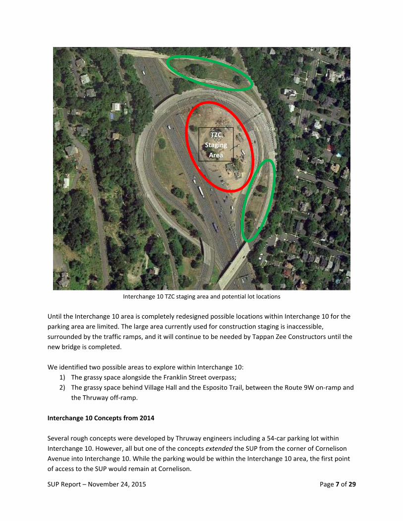
Interchange 10 TZC staging area and potential lot locations
Until the Interchange 10 area is completely redesigned possible locations within Interchange 10 for the
parking area are limited. The large area currently used for construction staging is inaccessible,
surrounded by the traffic ramps, and it will continue to be needed by Tappan Zee Constructors until the
new bridge is completed.
We identified two possible areas to explore within Interchange 10:
1) The grassy space alongside the Franklin Street overpass;
2) The grassy space behind Village Hall and the Esposito Trail, between the Route 9W on‐ramp and
the Thruway off‐ramp.
Interchange 10 Concepts from 2014
Several rough concepts were developed by Thruway engineers including a 54‐car parking lot within
Interchange 10. However, all but one of the concepts extended the SUP from the corner of Cornelison
Avenue into Interchange 10. While the parking would be within the Interchange 10 area, the first point
of access to the SUP would remain at Cornelison.
TZC
Staging
Area

SUP Report – November 24, 2015 Page 8 of 29
Concept B1 (2014)
Concept B2 (2014)
In Concepts ‘B1’ and ‘B2’, the parking lot would be placed in the grassy space alongside the Franklin
Street overpass. The intersection of the Thruway exit and the Franklin Street overpass would be
redesigned with a new traffic light. A pedestrian crossing would be needed to connect the parking area
to the Esposito Trail. In Concept ‘B1’ a ramp from the Esposito Trail connects to the Cornelison SUP
entrance. Concept ‘B2’ relies upon local streets to get to the SUP.

SUP Report – November 24, 2015 Page 9 of 29
Concept D (2014)
In Concept ‘D’ the existing Route 9W Thruway entrance ramps, along with the adjacent grassy area
would be used for the parking lot. This concept repurposed the South Broadway Thruway entrance for
non‐vehicular access between the parking area and the SUP. A new Thruway entrance employing a
roundabout would be built at the Franklin Street overpass. The Route 9W traffic was rerouted to
continue north on Route 9W from Shadyside to the Franklin Street overpass. Traffic that used the South
Broadway Thruway entrance would also be rerouted to the new Franklin Street entrance. Vehicles
would enter the parking lot from southern end of the Route 9W ramp. They would exit the parking lot
using the existing ramp to Franklin Street.

SUP Report – November 24, 2015 Page 10 of 29
Concept E (2014)
Concept ‘E’ uses the same parking area as Concepts ‘B1’ and ‘B2’, but this was the only concept that
moved the SUP entrance away from Cornelison Avenue. An elevated pedestrian bridge is provided to
carry visitors from the Esposito trail over the entrance ramp. Then a switchback of ramps brings users
down to Thruway grade and to the SUP via a tunnel under the South Broadway overpass.
At the November 2014 meeting the NNYB team representatives told the Task Force that they were
moving ahead with the SUP terminus at Cornelison. They planned to exclude any concepts using the
tunnel and terminating the SUP within Interchange 10 as not practical and too expensive. The Thruway
Authority then published to the public several of the concepts – including two of the more ambitious
concepts that they had said were to be excluded – and initiated a formal environmental review process
with the Federal Highway Administration. The Village objected and requested that the environmental
review be suspended until additional concepts could be developed that met the Village’s objectives.

SUP Report – November 24, 2015 Page 11 of 29
Interchange 10 Concepts from 2015
In March 2015, the newly appointed Executive Director of the Thruway Authority, along with a
representative from Governor Cuomo ’s office, renewed discussions with the Task Force, pledging to
work out a solution that would be acceptable to the Village. The formal environmental review was
suspended.
The Task Force established the following objectives for the project:
1. Locate the SUP terminus, parking, and facilities within Interchange 10 2. Minimize impacts on the community. 3. Provide and maintain sufficient off‐street parking accommodations for shared use path
visitors based on reasonable estimates of parking demand. 4. Minimize the potential for shared use path visitors to park on local streets. 5. Provide and maintain adequate restroom facilities for shared use path visitors. 6. Provide safe pathways and crossings for shared use path visitors. 7. Provide emergency service access to the shared use path and terminus facilities. 8. Provide a solution that does not preclude the Village of South Nyack’s initiative for
economic development at NYS Thruway Interchange 10.
Throughout the summer of 2015, the Task Force worked with a Thruway Authority engineer to develop
and explore variations on concepts that would locate the terminus and parking within the area of
Interchange 10.
It was clear that the path terminus could not be at Corenlison. Getting the path into Interchange 10
presented a challenge: It had to go either over or under South Broadway. As the SUP comes off the
bridge it follows the highway grade. It would be impractical to get the path up and over the South
Broadway overpass. That would require a tremendous grade change and a towering overpass.

SUP Report – November 24, 2015 Page 12 of 29
Concept E (2014)
However, Concept “E”, developed in 2014, included a tunnel under South Broadway through the
overpass abutment. As new concepts were developed they all incorporated this tunnel.
Fairly early on, the Task Force expressed that placing the parking area next to the Franklin Street
overpass, as in Concept ‘E’, was not preferred because of its distance from the SUP’s first point of
access. The first point of access would be the staircase from South Broadway to the Esposito Trail. We
reasoned that if the parking lot were not immediately adjacent to the SUP’s first point of access, human
nature would cause drivers to attempt to park closer to the entrance on Village streets, including South
Broadway and the nearby side streets. The Franklin Street overpass parking area did not meet the
objective to minimize the potential for shared use path visitors to park on local streets.
Concept ‘E’ also requires visitors to cross the Interchange 10 exit ramp where it intersects with the
Franklin Street overpass. This presents the same safety issues that residents found objectionable with
the Cornelison terminus.
The Task Force and TA engineers continued to develop alternative concepts that would use parking
locations similar to the previous Concept ‘D’. These concepts continued to repurpose the South
Broadway Thruway on‐ramp to connect the SUP to the parking area.

SUP Report – November 24, 2015 Page 13 of 29
Concept D+E (2015)
Concepts ‘D+E’ and ‘T’ were developed further from Concept ‘D’. These placed the parking area directly
adjacent to the SUP. The Route 9W traffic was rerouted to continue north on Route 9W from Shadyside
to the Franklin Street overpass. Vehicular access to the parking area would be from a reconstructed
intersection of Route 9W at Shadyside Avenue. The only difference between Concepts ‘D+E’ and ‘T’ is
that Concept ‘D+E’ employs a roundabout whereas Concept ‘T’ uses a stoplight controlled intersection.

SUP Report – November 24, 2015 Page 14 of 29
Concept K (2015)
Concept R (2015)

SUP Report – November 24, 2015 Page 15 of 29
Concepts ‘K’ and ‘R’ retain the Route 9W Thruway on‐ramps. A major consideration with this parking
location is that the location is separated from the Esposito Trail by the on‐ramps, which carry a
substantial amount of traffic. Providing some sort of pedestrian crossing of Route 9W to the parking
area was deemed as too dangerous, so these include a ramp from the Esposito Trail to the SUP.
Vehicular access to the parking area would also be from a reconstructed intersection of Route 9W at
Shadyside Avenue. The only difference between concepts ‘K’ and ‘R’ is that Concept ‘R’ employs a
roundabout whereas Concept ‘K’ uses a stoplight controlled intersection.
Thruway Engineers took these concepts and began to flesh them out in more detail. They also
conducted traffic counts of the existing traffic and estimated what would happen to the traffic for each
of the proposed new concepts.
Please note that at this point, in the interest of simplicity, the Thruway engineers renamed the refined
concepts. Concept ‘D+E’ is now called Concept “D”, Concept ‘K’ is now called Concept ‘F’, and Concept
‘T’ is now called Concept ‘H’. We will use these names going forward.
Concept ‘R’ proved to not be feasible because the topography at the intersection of Route 9W and
Shadyside Avenue made it impossible to build a roundabout.
We narrowed our considerations to four concepts: ‘D’, ‘H’, ‘F’, and ‘E’.

SUP Report – November 24, 2015 Page 16 of 29
Rerouting Vehicular Traffic
Several of the concepts reroute vehicular traffic heading to and from the Thruway. This is not a specific
goal of this project, but rather a consequence of the various concept designs. The rerouting, though,
does provide additional benefits to South Nyack. Clinton Avenue and South Broadway currently handle a
substantial volume of traffic heading for the bridge, particularly when the bridge becomes backed up.
This traffic takes a heavy toll on our local streets. These streets must be repaved much more often than
would normally be required and this is at the expense of Village taxpayers.
Concept E (refined) (2015)
Concept ‘E’ retains the existing South Broadway on‐ramp, so there would be no change to the Thruway
bound traffic on Village streets.
SUP Report – November 24, 2015 Page 17 of 29
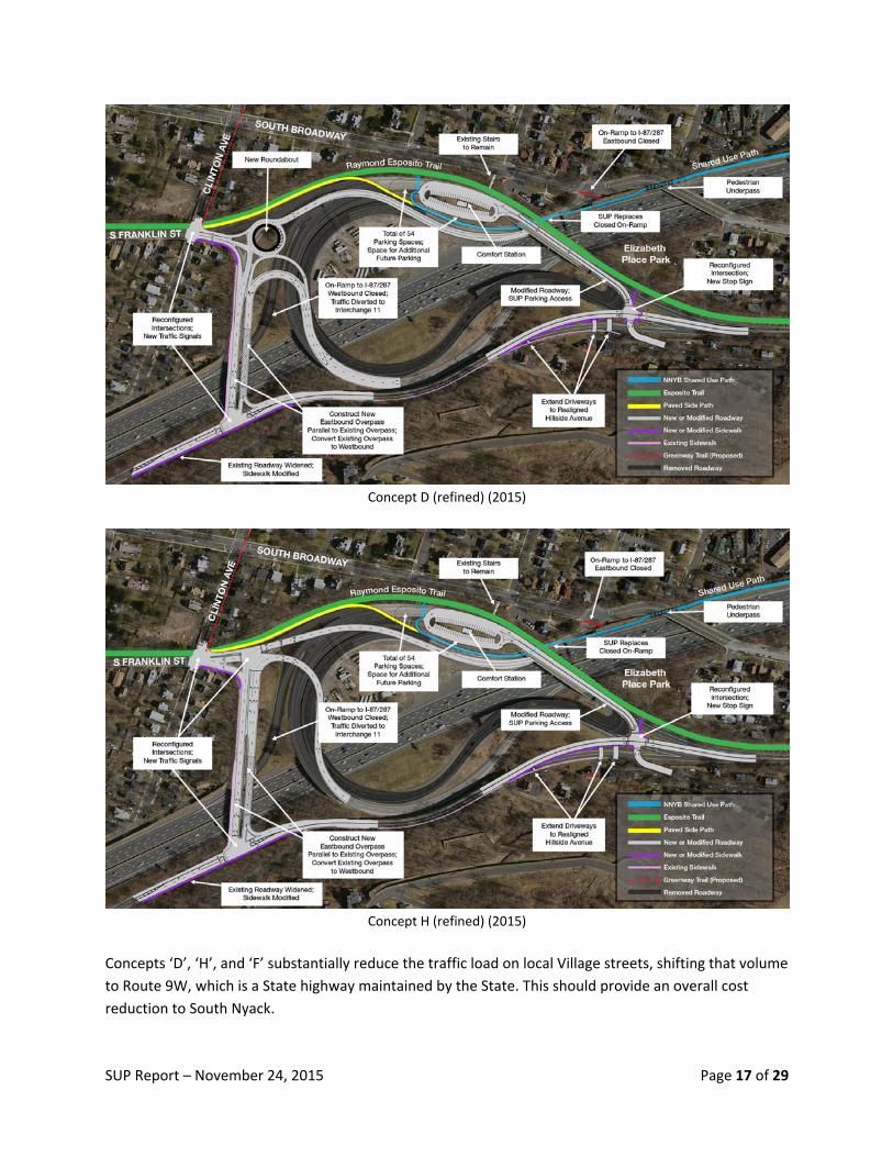
Concept D (refined) (2015)
Concept H (refined) (2015)
Concepts ‘D’, ‘H’, and ‘F’ substantially reduce the traffic load on local Village streets, shifting that volume
to Route 9W, which is a State highway maintained by the State. This should provide an overall cost
reduction to South Nyack.

SUP Report – November 24, 2015 Page 18 of 29
In Concepts ‘D’ and ‘H’, the South Broadway on‐ramp is repurposed for the SUP. Traffic that is currently
headed to the South Broadway on ramp would instead head to the new entrance at Franklin Street. The
majority of commuter traffic entering Interchange 10 is from the south. That traffic, which currently
crosses the Franklin Street overpass and heads around to the South Broadway entrance, would be able
to enter the Thruway using the new entrance via Route 9W and the Franklin Street overpass.
The large looping ramps that take the traffic coming north on Route 9W would be closed. All of that
traffic would be rerouted to continue north along Route 9W. Traffic heading for the bridge would turn
right onto the overpass to get to the new Franklin Street entrance.
Traffic exiting the bridge and heading to Route 9W south would cross over the overpass and turn left to
Route 9W south.
In these two concepts the TA engineers concluded that the increased traffic volume on the Franklin
Street overpass would necessitate adding a new second, parallel overpass in order to handle the
increased traffic volume.
The difference between Concepts ‘D’ and ‘H’ is that Concept ‘D’ employs a roundabout while Concept
‘H’ uses a T standard intersection
In Concepts ‘D’ and ‘H’, the TA engineers also found that the topography did not allow for a ramp to the
northbound Thruway. Furthermore, the traffic studies indicated that the use of that northbound ramp is
negligible even now. The ability to enter the Thruway heading north is eliminated. Traffic wanting to go
north would be redirected to Interchange 11.
A new controlled intersection is provided where Route 9W intersects Shadyside Avenue. This provides
access to the parking area.

SUP Report – November 24, 2015 Page 19 of 29
Concept F (refined) (2015)
In Concept ‘F’, the looping 9W Thruway on‐ramp is retained. A new controlled intersection is provided
where Route 9W intersects Shadyside Avenue. The South Broadway on‐ramp is repurposed for the SUP.
Traffic that is currently headed to the South Broadway on ramp would instead go across the Franklin
Street overpass, turn left onto Route 9W south and access the looping on‐ramps via the new
intersection at Shadyside.
Traffic exiting the Thruway and wising to head either north on 9W or towards Franklin Street currently
make a U‐turn. Instead, a new traffic ramp would route the traffic directly onto Route 9W north.
In all of the concepts, a traffic light is added at the intersection of Franklin Street and Clinton Avenue,
replacing the current blinking light.

SUP Report – November 24, 2015 Page 20 of 29
Bicycles and Pedestrians
South Nyack currently sees large volumes of long distance bicyclists come through our Village. The SUP
is expected to be very attractive to these riders. The Task Force was concerned about managing how
long‐distance bikers and local pedestrians could both access the SUP safely.
All of the concepts include a paved side‐path along the Esposito Trail from the intersection of Franklin
Street and Clinton Avenue to the SUP. This is to safely separate bicyclists from walkers. The Esposito
Trail is left unpaved with its current stone dust surface.
Concept D (refined) (2015)
In Concepts ‘D’ and ‘H’, the side path connects to the SUP at the parking area. Local pedestrians would
have a separate path connecting the Esposito Trail to the SUP. A new pedestrian crossing is provided at
Shadyside Avenue to connect the hillside neighborhood to the Esposito Trail and the SUP.

SUP Report – November 24, 2015 Page 21 of 29
Concept F (refined) (2015)
In Concept ‘F’, the looping Route 9W Thruway on‐ramp is retained. A new ramp “spur” behind Village
Hall connects the Esposito Trail to the SUP. The paved side‐path for bicyclists would extend to the spur.
A new pedestrian crossing is provided at Shadyside Avenue to connect the hillside neighborhood to the
SUP parking area.

SUP Report – November 24, 2015 Page 22 of 29
Concept E (refined) (2015)
In Concept ‘E’, the intersection of the Thruway exit and the Franklin Street overpass would be
redesigned with a new traffic light. A pedestrian crossing would be needed to connect the parking area
to the Esposito Trail.
The South Broadway Thruway entrance ramp is retained. A pedestrian/bicycle bridge is provided to
carry visitors from the Esposito trail over the Thruway entrance ramp. Then a switchback of ramps
brings users down to the tunnel under South Broadway. The paved side‐path for bicyclists would extend
to the bridge.
Concept ‘E’ does not provide for a pedestrian crossing from Shadyside Avenue.

SUP Report – November 24, 2015 Page 23 of 29
Comfort Stations
All of the concepts provide a comfort station along with welcoming and directional signage. The size and
design for these have not been explored yet.
Emergency Access
In Concepts ‘D’, ‘H’, and ‘F’, emergency access to the SUP would be directly from the parking area.
In Concept ‘E’, the switchback does not accommodate vehicles, so an emergency entrance gate would
be provided at the end of Smith Avenue.
Construction, Ownership, Operation, and Maintenance
No property takings are proposed. The new parking and facilities are proposed to be constructed by the
Thruway Authority entirely within the current Thruway or State highway rights‐of‐way (with the
exception to improvements at local intersections). The TA would own, operate, and maintain the lot and
facilities. The State Police would patrol the lot.
No fees for parking in the lot are proposed. Parking time limits are being considered to discourage the
lot from being used for commuter parking. Further discussions between the TA and the Village will
refine these issues.
Comparison of Concepts
The Task Force compared the various concepts to identify their advantages and disadvantages:

SUP Report – November 24, 2015 Page 24 of 29
Concept D (refined) (2015)
Concept “D”
Advantages Disadvantages
Parking lot is adjacent to SUP’s first point of access.
Has room for expanding parking capacity.
Parking has direct connection to Esposito Trail; No crossing traffic; Avoids separate SUP “spur”.
Paved Esposito Trail side path for bicycles connects directly to SUP.
Removes the majority of morning commuter traffic from Broadway, Clinton Avenue, Cornelison, and River Road; has little impact on traffic on Franklin.
Traffic circle expected to smooth traffic flow onto and off of the bridge.
Adds pedestrian crossing from Shadyside Avenue to Esposito Trail.
Route 9W moved slightly farther away from homes near corner of Shadyside Avenue.
Eliminates portions of existing looping ramps.
Requires new Franklin Street overpass.
Closes Thruway northbound entrance.
Increases traffic on Route 9W between Franklin Street and Shadyside Avenue.

SUP Report – November 24, 2015 Page 25 of 29
Concept H (refined) (2015)
Concept “H”
Advantages Disadvantages
Parking lot is adjacent to SUP’s first point of access.
Has room for expanding parking capacity.
Parking has direct connection to Esposito Trail; No crossing traffic; Avoids separate SUP “spur”.
Paved Esposito Trail side path for bicycles connects directly to SUP.
Removes the majority of morning commuter traffic from South Broadway, Clinton Avenue, Cornelison, and River Road; has little impact on traffic on Franklin.
Adds pedestrian crossing from Shadyside Avenue to Esposito Trail.
Route 9W moved slightly farther away from homes near corner of Shadyside Avenue.
Eliminates portions of existing looping ramps.
Requires new Franklin Street overpass.
Closes Thruway northbound entrance.
Increases traffic on Route 9W between Franklin Street and Shadyside Avenue.

SUP Report – November 24, 2015 Page 26 of 29
Concept F (refined) (2015)
Concept “F”
Advantages Disadvantages
Parking lot is adjacent to SUP’s first point of access.
Has room for expanding parking capacity.
Paved Esposito Trail side path for bicycles connects directly to SUP.
Removes the majority of morning commuter traffic from South Broadway, Clinton Avenue, Cornelison, and River Road; has little impact on traffic on Franklin.
Adds pedestrian crossing from Shadyside Avenue to SUP parking area.
Route 9W moved slightly farther away from homes near corner of Shadyside Avenue.
No direct connection of lot to Esposito Trail; Requires separate SUP “spur”.
Increases traffic on Route 9W between Franklin Street and Shadyside Avenue.

SUP Report – November 24, 2015 Page 27 of 29
Concept E (refined) (2015)
Concept “E”
Advantages Disadvantages
Least amount of construction.
Paved Esposito Trail side path for bicycles connects directly to SUP.
Does not close Thruway northbound entrance.
Parking is further from SUP first point of access (i.e. staircase to South Broadway). May not discourage vehicle parking on South Broadway.
Morning commuter traffic will continue as is on South Braodway, Clinton Avenue, Cornelison and River Road.
No room for expanding parking capacity.
Requires crossing traffic to get to Esposito Trail.
Proximity to Clinton neighborhood (impacts such as lights, proximity of restrooms, etc.).
Overhead switchback ramps may be visually massive above South Broadway at Cornelison, and may include lighting.

SUP Report – November 24, 2015 Page 28 of 29
Future Development
South Nyack is currently studying the feasibility of redeveloping Thruway Interchange 10 as a means to
provide economic and cultural sustainability for the Village. Our initiative includes seeing if there is a
way to leverage the SUP with an Interchange 10 redevelopment plan. Ideally, the design for the SUP
would have been designed in conjunction with a new comprehensive design for Interchange 10.
While the feasibility study is currently underway, its results will not be known until well into 2016. Any
design plans for Interchange 10 stemming from the study’s recommendations would be several years in
the future. In the meantime, the New NY Bridge project has the SUP opening to the public in 2018.
Recognizing this, South Nyack officials lobbied the State to provide parking and facilities for the SUP that
would accommodate SUP visitors when the new bridge is completed. The facilities would need to at the
very least, mitigate negative impacts of the SUP on the Village. While we are hopeful any solution
implemented now would be interim until a new Interchange 10 plan is developed, we have to allow for
the possibility that our study may conclude that a comprehensive Interchange 10 redesign is not
feasible. If that turns out to be the case, whatever SUP facilities are implemented now would be
permanent. In any case, this plan will need to serve the Village for many years.
We need to strike a careful balance: The SUP terminus design needs to be acceptable to the Village as a
permanent facility, but it should not preclude the possibility of reworking it into a future redeveloped
Interchange 10.

SUP Report – November 24, 2015 Page 29 of 29
Conclusions
The Task Force believes Concept ‘F’ is the best choice because it reasonably addresses the concerns
expressed by residents and officials of South Nyack while requiring a moderate amount of construction.
Concepts ‘D’ and ‘H’ are very complex, requiring an excessive amount of new infrastructure.
Concept ‘E’ would require the least amount of new construction, but does not meet the concerns of the
residents. This concept is too far from the SUP’s first point of access and it presents safety concerns at
the crossing of the Thruway exit ramp.
Environmental Review
This project is required to be reviewed for environmental impact under the provisions of SEQRA and
NEPA. The Thruway Authority intends to submit this project as an amendment to the environmental
review that was conducted for the replacement bridge. The Federal Highway Administration and the
Thruway Authority are co‐lead agencies for the process. Public hearings will solicit comments from the
public.
Recommendations
The Task Force recommends:
The Board of Trustees consider Concept ’F’ to be the Village’s preferred concept.
Concept ‘E’ should be excluded from further consideration.
New parking regulations should still be enacted to discourage SUP visitors from parking on
South Broadway and nearby Village streets.