new jersey department of transportation … · new jersey historic bridge data ... design rim...
TRANSCRIPT

NEW JERSEY DEPARTMENT OF TRANSPORTATION
NEW JERSEY HISTORIC BRIDGE DATABUREAU OF ENVIRONMENTAL SERVICES
MILEPOINT 0.0CO PASSAICNAME & FEATURE INTERSECTED
GREGORY AVENUE OVER PASSAIC RIVER FACILITY GREGORY AVENUE
TOWNSHIP PASSAIC CITY
OWNER COUNTY
CONSTRUCTION DT 1906 SOURCE COUNTY RECORDS
MATERIAL SteelTYPE SWING SPANLENGTH 245 ft WIDTH 28.8 ft# SPANS 2
DESIGNER/PATENT PASSAIC COUNTY HIGHWAY DEPT
SETTING / CONTEXT
The bridge carries a 2-lane street and sidewalks over the Passaic River at the boundary between Passaic and Bergen counties. It is located in an industrial section with car lots and an oil storage facility.
1995 SURVEY RECOMMENDATION Not Eligible
PHOTO: 142:3-8 (04/92) REVISED BY (DATE):
DESIGN RIM BEARING
BUILDER OWEGO BRIDGE COMPANY
CONSULT STATUS Individually Eligible.
QUAD: Weehawken
SUMMARY The thru truss rim-bearing swing span bridge on an ashlar substructure was erected in 1906 by the Owego Bridge Co. It is of riveted construction with the exception of the center tower, which has pinned top chords composed of stamped eye bars. The bridge has been altered. In 1985 the operating machinery and operator's house located above the roadway were removed. The flooring system was replaced, and additional section was bolted onto some verticals and diagonals. However, the changes do not preclude the individual eligibility of this structure for listing in the National Register of Historic Places under Criterion C as a representative example of a through truss rim-bearing span. All of the key visual elements of the bridge - the trusses by the Owego Bridge Company, the center pier, the wheels that run on a track making it a rim - bearing span, and the ashlar abutments retain integrity.
STRUCTURE # 1600002
ALTERATION DT 1985
INFOR MATION
CONSULT DOCUMENTS SHPO Letter 03/12/01
HISTORIC BRIDGE MANAGEMENT PLAN ( EVALUATED ) No
Page 1 A. G. Lichtenstein & Associates, Inc. performed initial survery. NJDOT updated data 03-01-2001.
Correction Updates Etc should be sent to [email protected]
November 12 , 2002

NEW JERSEY DEPARTMENT OF TRANSPORTATION
NEW JERSEY HISTORIC BRIDGE DATABUREAU OF ENVIRONMENTAL SERVICES
MILEPOINT 0.0CO PASSAICNAME & FEATURE INTERSECTED
MARKET STREET OVER PASSAIC RIVER FACILITY MARKET STREET
TOWNSHIP PASSAIC CITY
OWNER COUNTY
CONSTRUCTION DT 1930 SOURCE PLAQUE
MATERIAL SteelTYPE DOUBLE LEAF BASCULELENGTH 307 ft WIDTH 30 ft# SPANS 3
DESIGNER/PATENT STRAUSS BASCULE BRIDGE COMPANY
SETTING / CONTEXT
The bridge is located in a late-19th and early-20th century industrial area of Passaic. It carries a 2-lane street and sidewalks over the Passaic River at the boundary between Passaic and Bergen counties.
1995 SURVEY RECOMMENDATION Not Eligible
PHOTO: 142:37-41 (04/92) REVISED BY (DATE):
DESIGN
BUILDER F. W.SCHWIERS,JR. CO., NYC
CONSULT STATUS Not Individually Eligible.
QUAD: Weehawken
SUMMARY The main span of the 3-span bridge is a Strauss underneath counterweight double-leaf girder bascule. The approaches are encased deck girders with concrete balustrades while the movable leafs have metal railings. A fairly late example of what by 1930was a common type, the span was altered ca. 1977 when the motors and controls were removed and the bridge was fixed. The gearing and octagonal houses remain, but the span has been significantly altered which diminishes its technological significance.
STRUCTURE # 1600003
ALTERATION DT 1977ca
INFOR MATION
CONSULT DOCUMENTS SHPO Letter 6/30/95
HISTORIC BRIDGE MANAGEMENT PLAN ( EVALUATED ) No
Page 2 A. G. Lichtenstein & Associates, Inc. performed initial survery. NJDOT updated data 03-01-2001.
Correction Updates Etc should be sent to [email protected]
November 12 , 2002

NEW JERSEY DEPARTMENT OF TRANSPORTATION
NEW JERSEY HISTORIC BRIDGE DATABUREAU OF ENVIRONMENTAL SERVICES
MILEPOINT 0.0CO PASSAICNAME & FEATURE INTERSECTED
EIGHTH STREET OVER PASSAIC RIVER FACILITY EIGHTH STREET
TOWNSHIP PASSAIC CITY
OWNER COUNTY
CONSTRUCTION DT 1915 SOURCE COUNTY RECORDS
MATERIAL SteelTYPE SINGLE LEAF BASCULELENGTH 292 ft WIDTH 32.1 ft# SPANS 3
DESIGNER/PATENT STRAUSS BASCULE BRIDGE COMPANY
SETTING / CONTEXT
The bridge carries a 2-lane road, 2 sidewalks, and a utility pipe over the Passaic River on the boundary between Passaic and Bergen counties in an industrial section of Passaic. It is one of 3 moveable spans in Passaic.
1995 SURVEY RECOMMENDATION Eligible
PHOTO: 142:42-2 (04/92) REVISED BY (DATE):
DESIGN STRAUSS OVERHEAD
BUILDER F. R.LONG-W.G.BROADHURST CO.
CONSULT STATUS Individually Eligible.
QUAD: Weehawken
SUMMARY The main span of the 3-span riveted Warren pony truss bridge is an 86' Strauss overhead articulated counterweight bascule span. It is supported on a concrete substructure. While the superstructure is complete, the operating controls and equipment was removed ca. 1977. The operator's house was removed after that. The gearing remains. Although altered, the span retains enough of its original fabric to maintain its technological significance as a rare example of an important moveable type.
STRUCTURE # 1600004
ALTERATION DT 1977ca
INFOR MATION
Bibliography:Passaic County Engineers Office. Bridge File: 4.Waddell, J.A.L. Bridge Engineering. 1925.
Physical Description: The main span of the 229'-long riveted Warren pony truss bridge is 85'-long is a Strauss articulated overhead counterweight single leaf bascule span. The entire bridge is supported on a concrete substructure. The lift span is a rivet-connected Warren pony truss span with a 32' roadway. It is traditionally composed of built-up members as are the trunnion columns, braced counterweight tower, and counterweight linkages that permit the counterweight to pivot and move parallel to itself during operation of the bridge. The steel grid deck was installed in 1965 as part of an upgrading of the floor system. The most significant alteration to the bridge has been the demolition of the operators shanty and operating controls for the electric-motor powered span some time between 1976 and 1979. The bridge has been fixed in the closed position, but the gear sets and shafts are still in place as is the chain-operated manual operation. Plans for the original mechanical systems is preserved in the County Engineers office. The original metal sidewalk railings are still place.
Historical and Technological Significance: The 1915 Strauss overhead articulated counterweight bascule bridge designed by the Strauss Bascule and Concrete Bridge Company of Chicago, Illinois, is one of the few examples of the technologically important bridge type remaining in the state. Despite the fact that it was once the most popular moveable bridge type in the country in the early 20th century, about six built between 1907 and 1938 remain in the entire state. Because of the diminishing number, each example that retains the technologically innovative patented articulated counterweight detail are considered as technologically and historically important.
J. B. Strauss (1870-1938) invented the pivoting counterweight linkage used at the Eighth Street bridge, and he applied for a patent in 1905, the same year the first bridge of this type was built in Cleveland. That year he also founded the Strauss Bascule and Concrete Bridge Company in Chicago to market his bridge designs. Strauss went on to become the most widely respected moveable-span bridge engineer of the pre-World War II era.
Strauss reasoned that if, unlike the traditional trunnion bridge, which operates like a seesaw and moves in a vertical plane on a horizontal steel pivot, the entire weight of the counterweight could be concentrated at the end (tail) of the moveable leaf, it would then be possible to use a lighter counterweight. Such an arrangement also meant a shorter tail end to the leaf, thus saving on materials that the "counterweight could be made in such shape that no pit is required to receive it when the leaf is in the upright position'" (Waddell, p. 704). The patented linkage, or arms, ensures that the counterweight will always move in a series of parallel positions and thus maintain the position of the weight at the tail end of the leaf.
This example is altered, but not to the degree that the technologically significant elements have been lost. The span was fixed about 1976, and the operators house and controls were removed by 1979. Despite the loss of the operator's house, the superstructure survives in a remarkably complete state of preservation making this bridge one of the most important of its type in New Jersey. Much of the gearing and the counterweight linkage survive as does the uncommon chain-driven manual operation. A machinery plan for the bridge survives, so how the operating mechanism was arranged is well documented.
Boundary Description and Justification: The bridge is evaluated as significant on its own merits. The surroundings do not contribute to the significance of the span, so the boundary is the limits of the span itself. This includes the structure and the superstructure.
CONSULT DOCUMENTS SHPO Finding 11/23/94, Letter 6/30/95.
HISTORIC BRIDGE MANAGEMENT PLAN ( EVALUATED ) No
Page 3 A. G. Lichtenstein & Associates, Inc. performed initial survery. NJDOT updated data 03-01-2001.
Correction Updates Etc should be sent to [email protected]
November 12 , 2002

NEW JERSEY DEPARTMENT OF TRANSPORTATION
NEW JERSEY HISTORIC BRIDGE DATABUREAU OF ENVIRONMENTAL SERVICES
MILEPOINT 0.0CO PASSAICNAME & FEATURE INTERSECTED
FAIR LAWN AVENUE OVER PASSAIC RIVER FACILITY FAIR LAWN AVENUE
TOWNSHIP PATERSON CITY
OWNER COUNTY
CONSTRUCTION DT 1905 SOURCE COUNTY RECORDS
MATERIAL SteelTYPE THRU TRUSSLENGTH 270 ft WIDTH 19.5 ft# SPANS 2
DESIGNER/PATENT UNKNOWN
SETTING / CONTEXT
The bridge carries two lanes over the Passaic River at the boundary between Bergen and Passaic counties at a T intersection. The Passaic County side is adjacent to a late-19th century industrial plant now used for chemical production while the Bergen County side is dominated by early-20th century detached homes in the suburban community of Fair Lawn.
1995 SURVEY RECOMMENDATION Eligible
PHOTO: 136:17-21 (04/92) REVISED BY (DATE):
DESIGN PRATT HALF HIP
BUILDER UNKNOWN
CONSULT STATUS Individually Eligible.
QUAD: Paterson
SUMMARY The 2-span pin-connected Pratt thru truss bridge supported on concrete abutments and a cutwater pier is a well-preserved example of its type. Aside from impact damage and the 1925 and mid-1960s replacement of the sidewalk brackets and stringers, the span is largely unaltered. The original lattice railings survive. The undocumented bridge was built after the disastrous 1903 flood that claimed most of the bridges in the Paterson area. It is one of 3 significant thru truss bridges in the county.
STRUCTURE # 1600009
ALTERATION DT
INFOR MATION
Bibliography:Passaic County Engineer. Bridge File, 9.Minutes Passaic County Board of Chosen Freeholders. 1903-1905."Flood Damage to Bridges at Paterson, N.J. Engineering News. Vol. L, No. 18 (October 29, 1903), pp. 377-378.
Physical Description: The skewed 2-span pin-connected and riveted Pratt thru truss bridge with a cantilevered sidewalk on the downstream side is supported on concrete abutments with wingwalls and a center cutwater pier. The top chords and inclined end posts are built-up box members with lacing on the underside. The verticals are laced toe-out channels, and the diagonals and bottom chords are stamped eye bars. The span marks the transition from pinned to riveted field connections. The upper panel points are pinned while the lower panel points have pins for the bottom chords and rivets for connecting the floor beams to the verticals. The floor beams are built up and set on the skew. The lattice portal brace has been strengthened by the addition of plate corner braces welded in place in the mid 1960s. One of the most significant features of the bridge is the survival of the handsome lattice railings set inside the truss lines. The railings are accented with rosette bosses. The deck is a modern steel grid deck placed in the mid 1960s.
Historical and Technological Significance: The well-preserved 2-span pin-connected and riveted Pratt thru truss bridge built in 1905 to replace a span lost in the October, 1903 flood, ranks as the only example of its type in the county. It is also significant in that it marks the transition from pinned to riveted field connections. Its location in an urban area makes its a remarkable survivor form an era when load and traffic needs were much different. Despite some impact damage, the bridge remains in service on a busy intercounty road appearing and functioning much as it did in 1905 when it was completed. It survives as a good representative example of its truss type and fabrication technology (criterion C).
The bridge is one of four thru truss spans in the county, and it is the only one that has pin connections. It is a late example of a pin-connected bridge. By 1905 most metal thru truss bridges had riveted field connections. No original plans survive, and the fabricator is not documented in the county engineer's records. The bridge is one of many in Passaic County that were built after the 1903 flood that carried away ten bridges on the section of the Passaic River between the Great Falls in Paterson and Dundee dam in Clifton, about two miles downstream from the falls.
Boundary Description and Justification The bridge is individually significant. No significant cultural resources are contiguous to the bridge. Therefore, the boundary is limited to the substructure and superstructure of the span itself.
CONSULT DOCUMENTS SHPO Letter 6/30/95
HISTORIC BRIDGE MANAGEMENT PLAN ( EVALUATED ) No
Page 4 A. G. Lichtenstein & Associates, Inc. performed initial survery. NJDOT updated data 03-01-2001.
Correction Updates Etc should be sent to [email protected]
November 12 , 2002

NEW JERSEY DEPARTMENT OF TRANSPORTATION
NEW JERSEY HISTORIC BRIDGE DATABUREAU OF ENVIRONMENTAL SERVICES
MILEPOINT 0.0CO PASSAICNAME & FEATURE INTERSECTED
MAPLE AVENUE (CR 507) OVER PASSAIC RIVER FACILITY MAPLE AVENUE (CR 507)
TOWNSHIP PATERSON CITY
OWNER COUNTY
CONSTRUCTION DT 1907 SOURCE PLAQUE
MATERIAL Reinforced Concrete
TYPE DECK ARCHLENGTH 325 ft WIDTH 26.6 ft# SPANS 3
DESIGNER/PATENT UNKNOWN
SETTING / CONTEXT
The bridge carries a 2-lane road, a utility pipe under the south side sidewalk, and sidewalks over the Passaic River in an late-19th & early-20th century industrial section of Paterson that is dominated by brick buildings. The river serves as the boundary between Passaic and Bergen counties. Utility poles have been added along the south fascia.
1995 SURVEY RECOMMENDATION Not Eligible
PHOTO: 136:22-24 (04/92) REVISED BY (DATE):
DESIGN ELLIPTICAL
BUILDER SCHWIERS & SUTTON COMPANY
CONSULT STATUS Not Individually Eligible.
QUAD: Paterson
SUMMARY The 1907 3-span elliptical reinforced concrete deck arch bridge is a large example of its type, but it is not early nor is it well preserved. Significant detailing has been lost through deterioration and impact damage. What remained of the pipe railings with cylindrical cast iron posts was removed in 1993. Large sections of the stepped cap have been lost. The span was rehabed in 1993. More complete deck arch bridges survive in Paterson (1600390). This one is too altered to be noteworthy.
STRUCTURE # 1600010
ALTERATION DT 1992
INFOR MATION
CONSULT DOCUMENTS SHPO Letter 6/30/95
HISTORIC BRIDGE MANAGEMENT PLAN ( EVALUATED ) No
Page 5 A. G. Lichtenstein & Associates, Inc. performed initial survery. NJDOT updated data 03-01-2001.
Correction Updates Etc should be sent to [email protected]
November 12 , 2002

NEW JERSEY DEPARTMENT OF TRANSPORTATION
NEW JERSEY HISTORIC BRIDGE DATABUREAU OF ENVIRONMENTAL SERVICES
MILEPOINT 0.0CO PASSAICNAME & FEATURE INTERSECTED
LINCOLN AVENUE (CR 653) OVER PASSAIC RIVER FACILITY LINCOLN AVENUE (CR 653)
TOWNSHIP PATERSON CITY
OWNER COUNTY
CONSTRUCTION DT 1926 SOURCE PLAQUE/COUNTY RECORD
MATERIAL SteelTYPE DECK GIRDERLENGTH 390 ft WIDTH 29.7 ft# SPANS 6
DESIGNER/PATENT GARWOOD FERGUSON, CO. ENGINEER
SETTING / CONTEXT
The bridge carries a busy 3-lane road, two sidewalks, and a utility pipe over the Passaic River at the boundary between Passaic and Bergen counties. It passes between Paterson and Fair Lawn in a commercial area dominated by modern buildings including gas stations and a restaurant.
1995 SURVEY RECOMMENDATION Not Eligible
PHOTO: 136:25-26 (04/92) REVISED BY (DATE):
DESIGN ENCASED
BUILDER PARKER & GRAHAM INC.
CONSULT STATUS Not Individually Eligible.
QUAD: Paterson
SUMMARY The encased 6-span deck plate girder bridge with cantilevered sidewalks is supported on concrete abutments and cutwater piers. The curving approaches are marked by low octagonal posts and paneled parapets while the sidewalks on the bridge are enclosed with standard-design balustrades. A representative example of a common bridge type, the span is neither historically nor technologically distinguished.
STRUCTURE # 1600011
ALTERATION DT
INFOR MATION
CONSULT DOCUMENTS SHPO Finding 7/5/91
HISTORIC BRIDGE MANAGEMENT PLAN ( EVALUATED ) No
Page 6 A. G. Lichtenstein & Associates, Inc. performed initial survery. NJDOT updated data 03-01-2001.
Correction Updates Etc should be sent to [email protected]
November 12 , 2002
NEW JERSEY DEPARTMENT OF TRANSPORTATION
NEW JERSEY HISTORIC BRIDGE DATABUREAU OF ENVIRONMENTAL SERVICES
MILEPOINT 0.0CO PASSAICNAME & FEATURE INTERSECTED
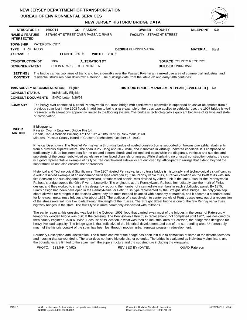
STRAIGHT STREET OVER PASSAIC RIVER FACILITY STRAIGHT STREET
TOWNSHIP PATERSON CITY
OWNER COUNTY
CONSTRUCTION DT 1907 SOURCE COUNTY RECORDS
MATERIAL SteelTYPE THRU TRUSSLENGTH 255 ft WIDTH 28.8 ft# SPANS 1
DESIGNER/PATENT COLIN R. WISE, CO. ENGINEER
SETTING / CONTEXT
The bridge carries two lanes of traffic and two sidewalks over the Passaic River in an a mixed use area of commercial, industrial, and residential structures near downtown Paterson. The buildings date from the late-19th and early-20th centuries.
1995 SURVEY RECOMMENDATION Eligible
PHOTO: 133:5-9 (04/92) REVISED BY (DATE):
DESIGN PENNSYLVANIA
BUILDER UNKNOWN
CONSULT STATUS Individually Eligible.
QUAD: Paterson
SUMMARY The heavy rivet-connected 6-panel Pennsylvania thru truss bridge with cantilevered sidewalks is supported on ashlar abutments from a previous span lost in the 1903 flood. In addition to being a rare example of the truss type applied to vehicular use, the 1907 bridge is well preserved with alterations apparently limited to the flooring system. The bridge is technologically significant because of its type and state of preservation.
STRUCTURE # 1600014
ALTERATION DT
INFOR MATION
Bibliography:Passaic County Engineer. Bridge File 14.Condit, Carl. American Building Art The 19th & 20th Century. New York, 1960.Minutes. Passaic County Board of Chosen Freeholders. October 15, 1903.
Physical Description: The 6-panel Pennsylvania thru truss bridge of riveted construction is supported on brownstone ashlar abutments from a previous superstructure. The span is 255' long and 30.7' wide, and it survives in virtually unaltered condition. It is composed of traditionally built-up box members for the top and bottom chords and inclined end posts while the diagonals, verticals and sub ties and sub struts of the center subdivided panels are either laced channels or angles. While displaying no unusual construction details, the span is a good representative example of its type. The cantilevered sidewalks are enclosed by lattice-pattern railings that extend beyond the superstructure and also enclose the approaches.
Historical and Technological Significance: The 1907 riveted Pennsylvania thru truss bridge is historically and technologically significant as a well-preserved example of an uncommon truss type (criterion C). The Pennsylvania truss, a Parker variation on the Pratt truss with sub ties (tension) and sub diagonals (compression), or subdivided panels, was devised by Albert Fink in the late 1860s for the Pennsylvania Railroad's bridge across the Ohio River at Louisville. The engineers at the Pennsylvania Railroad immediately saw the merit of Fink's design, and they worked to simplify his design by reducing the number of intermediate members in each subdivided panel. By 1875, Fink's design had been developed in the Pennsylvania, or Petit, truss type represented by the Straight Street bridge. The polygonal top chord allowed for strength in the trusses where they are most needed balanced with economy of material, and it became a standard detail for long-span metal truss bridges after about 1875. The addition of a subdivision to center panels of Pratt trusses grew out of a recognition of the stress reversal from live loads through the length of the trusses. The Straight Street bridge is one of the few Pennsylvania truss highway bridges in the state. The truss type is more commonly associated with railroads.
The earlier span at this crossing was lost in the October, 1903 flood that carried away most of the bridges in the center of Paterson. A temporary wooden bridge was built at the crossing. The Pennsylvania thru truss replacement, not completed until 1907, was designed by then county engineer Colin R. Wise. Because of its location in what was then an industrial area of Paterson, the bridge was designed for heavy live load capacity. The bridge type is thus reflective of the historical development and use of the surrounding area. Unfortunately, much of the historic context of the span has been lost through modern urban renewal program redevelopment.
Boundary Description and Justification: The historic context of the bridge has been lost due to demolition of some of the historic factories and housing that surrounded it. The area does not have historic district potential. The bridge is evaluated as individually significant, and the boundaries are limited to the span itself, the superstructure and the substructure including the wingwalls.
CONSULT DOCUMENTS SHPO Letter 6/30/95
HISTORIC BRIDGE MANAGEMENT PLAN ( EVALUATED ) No
Page 7 A. G. Lichtenstein & Associates, Inc. performed initial survery. NJDOT updated data 03-01-2001.
Correction Updates Etc should be sent to [email protected]
November 12 , 2002

NEW JERSEY DEPARTMENT OF TRANSPORTATION
NEW JERSEY HISTORIC BRIDGE DATABUREAU OF ENVIRONMENTAL SERVICES
MILEPOINT 0.0CO PASSAICNAME & FEATURE INTERSECTED
ARCH STREET OVER PASSAIC RIVER FACILITY ARCH STREET
TOWNSHIP PATERSON CITY
OWNER COUNTY
CONSTRUCTION DT 1905 SOURCE COUNTY RECORDS
MATERIAL SteelTYPE THRU TRUSSLENGTH 185 ft WIDTH 28 ft# SPANS 1
DESIGNER/PATENT
SETTING / CONTEXT
The bridge originally carried two lanes of traffic and two sidewalks over the Passaic River, but the roadway has been closed to vehicular traffic. It, like the other bridges in Paterson, serves as a link between the late-19th and early-20th century residential districts on the west side of the river from the industrial east side. The bridge contributes to the historic character of the area.
1995 SURVEY RECOMMENDATION Eligible
PHOTO: 133:10-12 (04/92) REVISED BY (DATE):
DESIGN PARKER
BUILDER OWEGO BRIDGE COMPANY.
CONSULT STATUS Individually Eligible.
QUAD: Paterson
SUMMARY The 11-panel pin-connected Parker thru truss bridge supported on coursed ashlar abutments is a large and well preserved example of the truss type that is not common. Parker trusses are more commonly found on rail lines rather than city streets. The span is technologically distinguished because of its type, a polygonal top chord variation of a Pratt truss, and its state of preservation. It is also historically notable as one of the significant Paterson bridges built after the 1903 flood.
STRUCTURE # 1600015
ALTERATION DT
INFOR MATION
CONSULT DOCUMENTS SHPO Finding 5/26/89, Letter 6/30/95.
HISTORIC BRIDGE MANAGEMENT PLAN ( EVALUATED ) No
Page 8 A. G. Lichtenstein & Associates, Inc. performed initial survery. NJDOT updated data 03-01-2001.
Correction Updates Etc should be sent to [email protected]
November 12 , 2002

NEW JERSEY DEPARTMENT OF TRANSPORTATION
NEW JERSEY HISTORIC BRIDGE DATABUREAU OF ENVIRONMENTAL SERVICES
MILEPOINT 0.0CO PASSAICNAME & FEATURE INTERSECTED
MAIN STREET OVER PASSAIC RIVER FACILITY MAIN STREET
TOWNSHIP PATERSON CITY
OWNER COUNTY
CONSTRUCTION DT 1900 SOURCE PLAQUE
MATERIAL Cast Iron, Steel
TYPE 3 HINGE ARCHLENGTH 231 ft WIDTH 30.2 ft# SPANS 3
DESIGNER/PATENT F. R. LONG COMPANY
SETTING / CONTEXT
The bridge carries a 2-lane city street and two sidewalks over the Passaic River in downtown Paterson, a city rich in 19th-century industrial history. The land on both sides of the bridge has been cleared of historic structures, and the west side has been redeveloped with modern brick high-rise apartments. The historic setting of the bridge has been lost.
1995 SURVEY RECOMMENDATION Eligible
PHOTO: 133:28-33 (04/92) REVISED BY (DATE):
DESIGN ELLIPTICAL
BUILDER F. R. LONG COMPANY
CONSULT STATUS Individually Eligible.
QUAD: Paterson
SUMMARY The well-preserved metal 3-span 3-hinge arch bridge built in 1900 is supported on an ashlar substructure. It ranks as one of the technologically most significant spans in the region. Designed and fabricated by F.W. Long (1856-1911), a noted local contractor who formerly worked for Dean & Westbrook of NYC as their agent in Bergen & Passaic counties. The plaque identifies him as the designer of this unique and early example of the bridge type which is also significant for its fine detailing.
STRUCTURE # 1600016
ALTERATION DT
INFOR MATION
Bibliography:The Evening Record (Hackensack, N.J.), August 30, 1911.Condit, Carl. American Building Art 19th Century. New York, 1960.
Physical Description: The handsome 3-span, 231'-long, ribbed three-hinge steel arch bridge with braced spandrels is supported on ashlar abutments and cutwater piers. Each elliptically shaped arch is composed of 5 arch ribs. The spandrel braces on the fascia arches are detailed in the classical taste as an arcade with the column-like verticals set on richly molded cast bases, and the arch spandrel is filled with a quatrefoil pierced panel. The hinges are located at each skewback and at the crown of each rib. The arch ribs are composed of built up members of angles and web plate. The cantilevered sidewalks on each side of the well-proportioned span are enclosed by metal railings that date to 1915. The originals were lost in the 1903 flood. The bridge appears to be unaltered.
Historical and Technological Significance: The three-hinge ribbed arch bridge built over the Passaic River at Paterson in 1900 ranks as the most distinguished example of the uncommon bridge type in the state (criterion C). In addition to its technological significance, the well-preserved span designed and fabricated by the F.R. Long Company of Hackensack is one of the most architectonic spans in the region. The detailing and workmanship of the castings is unmatched in the period.
The three-hinge metal arch was introduced into this country by Philadelphia engineer John M. Wilson, an engineer with the Pennsylvania Railroad, in 1869. It had been used in Europe about 20 years prior to its American appearance, and it was preferred over hingeless arches because of its ability to accommodate strains from expansion, contraction, and settlement. Few three-hinge arch bridges were built in the 1870s, but in the 1880s and 1890s, several significant examples, like the 1892 Strawberry Mansion span in Fairmont Park in Philadelphia and the 1896-1897 Panther Hollow Bridge in Pittsburgh were erected. While not an early nor a long or dramatically sited example of its type, the Main Street Bridge in Paterson ranks as one of the most handsome and richly detailed bridges of the turn-of-the-century era in northern New Jersey. The architectonic castings for the classically detailed spandrel columns on the fascia arches are of particular note.
The bridge is the product of the F.R. Long Company of New York. Frank R. Long (1856-1911) was born in Philadelphia. He was an apprentice at the William Sellers & Company iron foundry in Philadelphia, and then secured a position with the Pottstown Iron Company. In 1889 he went to New York City to join the nationally prominent bridge fabricating firm of Dean & Westbrook (founded in 1884). He served as their agent in Bergen & Passaic counties until 1896 when he left to go into business for himself. In 1898 he formed the F.R. Long Company with a yard in Hackensack (Bergen County). The company built bridges in northern New Jersey. In 1908 he was appointed to the New York & New Jersey Interstate Bridge Commission for one term. In addition to his professional activities, Long was active in civic and social affairs in Hackensack. He left no children.
Long is representative of the age of the entrepreneur/bridge designer who, in the era before the consulting engineer or the professional county engineer, designed as well as built the bridge to meet the construction specifications defined by the county boards of freeholders. No original plans for the bridge were located in the county engineer's files.
Boundary Description and Justification: Alterations and demolitions have drastically altered the historic setting of the bridge. The bridge is evaluated as individually distinguished, so the boundary is limited to the span itself.
CONSULT DOCUMENTS SHPO Letter 6/30/95
HISTORIC BRIDGE MANAGEMENT PLAN ( EVALUATED ) No
Page 9 A. G. Lichtenstein & Associates, Inc. performed initial survery. NJDOT updated data 03-01-2001.
Correction Updates Etc should be sent to [email protected]
November 12 , 2002

NEW JERSEY DEPARTMENT OF TRANSPORTATION
NEW JERSEY HISTORIC BRIDGE DATABUREAU OF ENVIRONMENTAL SERVICES
MILEPOINT 0.0CO PASSAICNAME & FEATURE INTERSECTED
WEST BROADWAY OVER PASSAIC RIVER FACILITY WEST BROADWAY
TOWNSHIP PATERSON CITY
OWNER COUNTY
CONSTRUCTION DT 1897 SOURCE PLAQUE
MATERIAL SteelTYPE DECK ARCHLENGTH 290 ft WIDTH 35 ft# SPANS 3
DESIGNER/PATENT KEEPERS & THACHER
SETTING / CONTEXT
The bridge carries a 2-lane city street and two sidewalks over the Passaic River in downtown Paterson, a city rich in 19th century industrial history. The historic setting on both sides of the bridge has been largely demolished. The area on the west side has been redeveloped with modern brick high-rise apartment buildings, and the east side has some modern commercial development.
1995 SURVEY RECOMMENDATION Eligible
DESIGN ELLIPTICAL
BUILDER KEEPERS & THACHER
CONSULT STATUS Individually Eligible.
SUMMARY When built in 1897, the well-proportioned 3-span elliptical deck arch bridge with a patented Melan reinforcing system encased in concrete was not only one of the longest built by noted engineer Edwin Thacher, the American licensee of Melan's innovative designs, but it ranks as one of the earliest. The span, with its ashlar spandrel walls, is one of the most technologically significant steel and concrete bridges in the state based on its designer, type, date, and state of preservation.
STRUCTURE # 1600017
ALTERATION DT
INFOR MATION
Bibliography:"Three-Span Melan Arch Bridge Across the Passaic River, Paterson, NJ." Engineering News. March 16, 1899, p. 175."Flood Damage To Bridges at Paterson, N.J." Engineering News. Vol. L, No. 18 (October 29, 1903), pp. 377-378.Jackson, Donald. Great American Bridges and Dams. The Preservation Press, 1988.
Physical Description: The handsome, well-proportioned 233'-long, 3-span, Melan steel and concrete elliptical arch bridge has coursed brownstone ashlar-faced spandrel walls and cutwater piers. They are backed by concrete. It is 54'-wide and carries a 2-lane city street flanked by wide sidewalks enclosed by metal railings with lattice panels on the bottom. The railings were installed in 1937 replacing the original. Each of the cinder-filled arch spans is approximately 89' long, and the rise is 9.5'. The bridge is built on the Melan system with 10" I-beams set 3' on center and embedded in concrete that varies in thickness from 15" at the crown to 66" at the skewbacks. Expansion joints are built in the spandrel walls over the piers to provide for thermal changes. The southernmost two spans were damaged in the 1903 flood and were repaired in kind at that time. The bridge is well preserved.
Historical and Technological Significance: When completed in 1898, the handsome elliptical arch bridge was the second longest Melan-type bridge in the country, ranking after a similar span in Topeka, Kansas completed in 1896-97. Industrial Historian Donald C. Jackson states that the Topeka bridge, completed about one year before the similar arch at Paterson, was the "first major reinforced concrete arch bridge in the United States" (p. 35). Thacher's bridge at Paterson is one of the most important concrete-steel spans in the Northeast based on its date, structural type, and remarkably complete state of preservation (criterion C). It is a nationally significant example of the Melan arch bridge technology, and it was designed by noted civil engineer Edwin Thacher. Thacher was a proponent of the Melan arch which is a series of parallel iron or steel I-beams curved to the profile of the soffit and encased in plain concrete. Joseph Melan, a Viennese engineer, was granted an American patent for his design in 1894. Fritz von Emperger, a German-born engineer, built the first Melan arch in the United States at Rock Rapids, Iowa, and he is credited with popularizing the design in this country. Emperger made additions to the Melan system, adding a beam to the deck and joining the deck and arch beams by means of bars set on radial lines. He was granted a patent in 1897 for the changes to Melan's patent.
Edwin Thacher and William Mueser formed the Concrete-Steel Engineering Company in New York City in 1901, and the firm was responsible for many important Melan-type bridges in the country, including the 8-span Grand Avenue Viaduct, Milwaukee, Wisconsin, built in 1907; a 7-span Melan arch built at Wichita, Kansas, built in 1911; the 6-span Hudson River bridge at Glens Falls, New York, built in 1914-15; the bridge over the Mississippi River at Minneapolis composed of five 231' spans built in 1907. Thacher was a versatile engineer who received many patents including one for the "Thacher Cylindrical Slide-Rule," the "Thacher Steel Bridge Truss," the "System of Concrete Steel Arches," and the "Thacher Combination Bridge Truss" among others. He held positions of chief engineer for the Decatur Bridge Company of Decatur, Alabama, and the Keystone Bridge Company of Pittsburgh before opening his own consulting firm in Louisville, Kentucky. He was responsible for the 1891 Walnut Street bridge across the Mississippi River at Chattanooga and the 1892 Costilla Crossing bridge over the Rio Grande in Colorado which was an example of the Thacher truss patented in 1884 and designed to reduce the effect of temperature stresses on truss members. Thacher formed a partnership with W.H. Keepers in 1894 at Detroit, and the partnership lasted as Thacher and Keepers until October of 1899. It was this firm that designed the West Broadway bridge at Paterson. Thacher remained with the Concrete-Steel Engineering Company until his retirement in 1912. The Melan arch was replaced in popularity in this country by the reinforced concrete arch span.
The Thacher & Keepers-designed Melan-type arch bridge is one of two in the state designed by Edwin Thacher. The other is located in Branch Brook Park in Newark (Essex County) (0700101). It was designed by the Concrete-Steel Engineering Company in 1905. Both are technologically and historically important as examples of the experimentation associated with the introduction of concrete and steel arch bridges in this country.
Boundary Description and Justification: The bridge is evaluated as individually distinguished. The area around it has been redeveloped and has lost most of its historic character. Consequently, the historic setting for the technologically distinguished span has been lost. The boundary is limited to the span itself.
CONSULT DOCUMENTS SHPO Letter 6/30/95
HISTORIC BRIDGE MANAGEMENT PLAN ( EVALUATED ) No
Page 10 A. G. Lichtenstein & Associates, Inc. performed initial survery. NJDOT updated data 03-01-2001.
Correction Updates Etc should be sent to [email protected]
November 12 , 2002

NEW JERSEY DEPARTMENT OF TRANSPORTATION
NEW JERSEY HISTORIC BRIDGE DATABUREAU OF ENVIRONMENTAL SERVICES
PHOTO: 133:22-27 (04/92) REVISED BY (DATE): QUAD: Paterson
Page 11 A. G. Lichtenstein & Associates, Inc. performed initial survery. NJDOT updated data 03-01-2001.
Correction Updates Etc should be sent to [email protected]
November 12 , 2002

NEW JERSEY DEPARTMENT OF TRANSPORTATION
NEW JERSEY HISTORIC BRIDGE DATABUREAU OF ENVIRONMENTAL SERVICES
MILEPOINT 0.0CO PASSAICNAME & FEATURE INTERSECTED
LACKAWANNA AVENUE OVER PASSAIC RIVER FACILITY LACKAWANNA AVENUE
TOWNSHIP WEST PATERSON BOROUGH
OWNER COUNTY
CONSTRUCTION DT 1894 SOURCE COUNTY BRIDGE FILE
MATERIAL SteelTYPE THRU GIRDERLENGTH 305 ft WIDTH 17.5 ft# SPANS 3
DESIGNER/PATENT
SETTING / CONTEXT
The narrow bridge carries two lanes of traffic and one sidewalk over the Passaic River in a mixed use area of mid-20th century single family houses and light industrial structures.
1995 SURVEY RECOMMENDATION Not Eligible
PHOTO: 143:13-16 (04/92) REVISED BY (DATE):
DESIGN
BUILDER
CONSULT STATUS Not Individually Eligible.
QUAD: Paterson
SUMMARY In 1894 a 3-span thru truss bridge on an ashlar substructure was built at the crossing. In 1965 one span was lost and replaced with wide-flange rolled I-section girders from which the original built-up floor beams were suspended. In 1976 the other two thru truss spans were lost and replaced with similar girder-floor beams spans. It was intended as a temporary span. The cantilevered sidewalk is enclosed by a chain-link fence. The bridge is not historically or technologically noteworthy.
STRUCTURE # 1600021
ALTERATION DT 1965, 1976
INFOR MATION
CONSULT DOCUMENTS SHPO Letter 6/30/95
HISTORIC BRIDGE MANAGEMENT PLAN ( EVALUATED ) No
Page 12 A. G. Lichtenstein & Associates, Inc. performed initial survery. NJDOT updated data 03-01-2001.
Correction Updates Etc should be sent to [email protected]
November 12 , 2002

NEW JERSEY DEPARTMENT OF TRANSPORTATION
NEW JERSEY HISTORIC BRIDGE DATABUREAU OF ENVIRONMENTAL SERVICES
MILEPOINT 0.0CO PASSAICNAME & FEATURE INTERSECTED
UNION AVENUE OVER PASSAIC RIVER FACILITY UNION AVENUE (BEATTIE BRIDGE)
TOWNSHIP LITTLE FALLS TOWNSHIP
OWNER COUNTY
CONSTRUCTION DT 1890 SOURCE PLAQUE
MATERIAL Wrought IronTYPE DECK TRUSSLENGTH 132 ft WIDTH 22.2 ft# SPANS 1
DESIGNER/PATENT
SETTING / CONTEXT
The bridge carries 2 lanes of traffic, utility pipes, and one narrow sidewalk over the Passaic River in Little Falls just below the Little Falls in the river. The southwesterly quadrant is next to the historically significant Beattie Carpet Mill complex, established at the Falls in 1846. The buildings have been converted to residential use, but the historic setting of the bridge remains. The north side of the bridge is wooded. Mill complex was found eligible in a SHPO opinion 12/12/79.
1995 SURVEY RECOMMENDATION Eligible
PHOTO: 134:26-28,143:33 (04/92) REVISED BY (DATE):
DESIGN PRATT
BUILDER PASSAIC ROLLING MILL COMPANY
CONSULT STATUS Bridge was Individually Eligible.
QUAD: Paterson
SUMMARY The 9-panel riveted Pratt deck truss bridge erected in 1890 by the Passaic Rolling Mills is remarkably well preserved. Supported on high ashlar abutments and located next to a historic Beattie Carpet mill complex dating to 1848, the span ranks as one of the most distinguished examples of its type in the state. The roadway was widened in 1966 by incorporating the downstream sidewalk. The bridge is technologically and historically significant.
STRUCTURE # 1600022
ALTERATION DT Demolished
INFOR MATION
Bibliography:Passaic County Engineer. Bridge File: 22.Schriner, Charles. Paterson, Illustrated. Paterson, NJ: The Press Printing & Publishing Company, 1890.Darnell, Victor. Directory of American Bridge Builders. 1984.
Physical Description: The one span, 132'-long rivet-connected Pratt deck truss bridge over the Passaic River below Little Falls is supported on high ashlar abutments. The bridge is made up of nine panels, and although there has been some strengthening of the original members, the trusses still perform as originally designed. The upper chords and verticals are toe-out channel with lacing and the diagonals are angles set back-to-back. The lateral and sway bracing are also composed of angle section as are the bottom chords. In 1966 one of the sidewalks was incorporated into the widened roadway. New floor beams and stringers were placed at that time. The original lattice railing was lost on the widened side, but it is in place on the cantilevered sidewalk on the other side. In 1975 welded strengthening was added to some truss members. The abutments have been sensitively rebuilt.
Historical and Technological Significance: The riveted deck truss bridge built in 1890 ranks as one the earliest and most complete examples of its type in the state (criterion C). It is also an early example of riveted field connections. Only two deck truss bridges from the 19th century were identified during the 1991-1993 New Jersey Historic Bridge Survey. The other example (1400084) is pin connected. The fabricator, the Passaic Rolling Mill of Paterson, is one of the important late-19th century iron manufactures and rolling mills in the country, but few bridges New Jersey bridges have been documented as their work. In addition to its individual technological and historical significance, the bridge is adjacent to the well-preserved Beattie Carpet Mill complex that dates to 1846. It was originally water powered and was in operation until the 1970s. The complex was determined eligible in SHPO finding in 1979.
The Passaic Rolling Mill at Paterson was chartered in 1869. In 1873 the company began rolling iron I beams and channel section. Many of the beams were used in building the country's early "skyscrapers" and the New York state capitol building at Albany. The company recognized the application of their products to bridge building, and they erected metal truss bridges for counties and railroads, especially the local Erie Railroad and the Delaware Lackawanna & Western Railroad. They also supplied iron for the New York City elevated street railways. By 1890 their bridge division had grown enormously, and bridges were being shipped to every state in the union and Central and South America.
Passaic Rolling Mill began producing steel in 1889. In 1890 the company employed about 1,000 persons, and in 1903 its output was 60,000 long tons. Steel became a more significant product, and by 1903, the company changed its name to the Passaic Steel Company. Later in the 1910s it was changed again to the Passaic Structural Steel Company. The yard was located on Straight Street at the Erie Railroad tracks. Despite the size of the and longevity of the mill, few bridges have been identified as their work. Some of their iron and steel sections and beams have been identified in other fabricator's bridges.
Boundary Description and Justification: The bridge is adjacent to a mill complex that has been determined to meet National Register criteria. The bridge was built within the period of significance of that mill complex, but it is significant independent of any association with the mill complex. The bridge is significant on its own merits, but its setting appears to be composed of contiguous significant resources.
CONSULT DOCUMENTS SHPO Letter 6/30/95
HISTORIC BRIDGE MANAGEMENT PLAN ( EVALUATED ) No
Page 13 A. G. Lichtenstein & Associates, Inc. performed initial survery. NJDOT updated data 03-01-2001.
Correction Updates Etc should be sent to [email protected]
November 12 , 2002

NEW JERSEY DEPARTMENT OF TRANSPORTATION
NEW JERSEY HISTORIC BRIDGE DATABUREAU OF ENVIRONMENTAL SERVICES
MILEPOINT 0.0CO PASSAICNAME & FEATURE INTERSECTED
PATERSON-HAMBURG TURNPIKE OVER PEQUANNOCK RIVER
FACILITY PATERSON-HAMBURG TURNPIKE
TOWNSHIP POMPTON LAKES BOROUGH
OWNER COUNTY
CONSTRUCTION DT 1939 SOURCE PLAQUE/COUNTY RECORD
MATERIAL SteelTYPE STRINGERLENGTH 98 ft WIDTH 40 ft# SPANS 2
DESIGNER/PATENT GARWOOD FERGUSON, CO. ENGINEER
SETTING / CONTEXT
The bridge carries a 2-lane road and sidewalks over a river in a mixed-use area at the boundary of Morris and Passaic Counties. Structures adjacent to the bridge include a well-preserved 19th-century home, a tract of 1950s capes, and modern commercial buildings. The road, the Paterson-Hamburg Turnpike, was incorporated in 1806, and it remains a major link from the rural northern part of the county to the county seat at Paterson.
1995 SURVEY RECOMMENDATION Not Eligible
PHOTO: 139:34-35 (04/92) REVISED BY (DATE):
DESIGN ENCASED
BUILDER ELL DORER CONTRACTING CO.
CONSULT STATUS Not Individually Eligible.
QUAD: Pompton Plains
SUMMARY The 2-span encased stringer bridge is typical of the pre-World War II bridges with concrete used for the substructure, deck, sidewalks, and balustrades. A 1971 flood cracked and tilted the center pier and scoured part of the foundation of the west abutment. A reinforced concrete hammerhead pier was installed in 1972 to replace the original pier. The bridge is a representative example of a common bridge type and style and is not historically or technologically distinguished.
STRUCTURE # 1600028
ALTERATION DT 1972
INFOR MATION
CONSULT DOCUMENTS SHPO Letter 6/30/95
HISTORIC BRIDGE MANAGEMENT PLAN ( EVALUATED ) No
Page 14 A. G. Lichtenstein & Associates, Inc. performed initial survery. NJDOT updated data 03-01-2001.
Correction Updates Etc should be sent to [email protected]
November 12 , 2002

NEW JERSEY DEPARTMENT OF TRANSPORTATION
NEW JERSEY HISTORIC BRIDGE DATABUREAU OF ENVIRONMENTAL SERVICES
MILEPOINT 14.4CO PASSAICNAME & FEATURE INTERSECTED
PATERSON-HAMBURG TURNPIKE OVER PEQUANNOCK RIVER
FACILITY PATERSON-HAMBURG TURNPIKE
TOWNSHIP BLOOMINGDALE BOROUGH
OWNER COUNTY
CONSTRUCTION DT 1925 SOURCE INSCRIPTION
MATERIAL SteelTYPE THRU GIRDERLENGTH 158 ft WIDTH 30 ft# SPANS 2
DESIGNER/PATENT NJ STATE HWY DEPT BRIDGE DIV
SETTING / CONTEXT
The bridge carries a 2-lane road and one sidewalk over a river in a lightly wooded setting with 20th-century residential and modern commercial uses. The road itself was established in 1806 as the Paterson-Hamburg Turnpike. When the old turnpike became part of the state highway system in 1917, sections like this one were realigned. This section of road has now been bypassed by a new state highway, and the bridge has been transferred to county jurisdiction.
1995 SURVEY RECOMMENDATION Not Eligible
PHOTO: 139:36-37 (04/92) REVISED BY (DATE):
DESIGN ENCASED
BUILDER UNKNOWN
CONSULT STATUS Not Individually Eligible.
QUAD: Wanaque
SUMMARY The skewed, 2-span encased thru girder with floor beams bridge with a cantilevered sidewalk is supported on a concrete substructure. The sidewalk is enclosed by a standard-design metal railing, and the square concrete end posts at the girders were originally fitted with cast metal land standards, all but one of which have been removed. Pipe railing remains at one approach. The bridge is a representative example of a design that is common in the state. It is not technologically notable.
STRUCTURE # 1600029
ALTERATION DT
INFOR MATION
CONSULT DOCUMENTS SHPO Letter 6/30/95
HISTORIC BRIDGE MANAGEMENT PLAN ( EVALUATED ) No
Page 15 A. G. Lichtenstein & Associates, Inc. performed initial survery. NJDOT updated data 03-01-2001.
Correction Updates Etc should be sent to [email protected]
November 12 , 2002

NEW JERSEY DEPARTMENT OF TRANSPORTATION
NEW JERSEY HISTORIC BRIDGE DATABUREAU OF ENVIRONMENTAL SERVICES
MILEPOINT 0.0CO PASSAICNAME & FEATURE INTERSECTED
MAIN STREET OVER PEQUANNOCK RIVER FACILITY MAIN STREET
TOWNSHIP BLOOMINGDALE BOROUGH
OWNER COUNTY
CONSTRUCTION DT 1915 SOURCE COUNTY RECORDS
MATERIAL Reinforced Concrete
TYPE DECK ARCHLENGTH 115 ft WIDTH 35 ft# SPANS 1
DESIGNER/PATENT GARWOOD FERGUSON & WM. KING
SETTING / CONTEXT
The bridge carries a 2-lane city street and two sidewalks over a river in a former turn-of-the-century residential area that has largely been converted to commercial use. The buildings are extensively altered. The river is the boundary between Passaic and Morris counties.
1995 SURVEY RECOMMENDATION Not Eligible
PHOTO: 140:2-3 (04/92) REVISED BY (DATE):
DESIGN ELLIPTICAL
BUILDER UNKNOWN
CONSULT STATUS Not Individually Eligible.
QUAD: Wanaque
SUMMARY The attenuated reinforced concrete deck arch bridge is earth-filled and has plain spandrel walls. In 1948 the curb-to-curb width of the span was increased from 30' to 35' and cantilevered sidewalks were added to each face. The metal picket-like railing also dates from 1948. The bridge is a representative example of what by 1915 was a common bridge type. It is not historically or technologically noteworthy.
STRUCTURE # 1600030
ALTERATION DT 1948
INFOR MATION
CONSULT DOCUMENTS SHPO Letter 6/30/95
HISTORIC BRIDGE MANAGEMENT PLAN ( EVALUATED ) No
Page 16 A. G. Lichtenstein & Associates, Inc. performed initial survery. NJDOT updated data 03-01-2001.
Correction Updates Etc should be sent to [email protected]
November 12 , 2002

NEW JERSEY DEPARTMENT OF TRANSPORTATION
NEW JERSEY HISTORIC BRIDGE DATABUREAU OF ENVIRONMENTAL SERVICES
MILEPOINT 0.0CO PASSAICNAME & FEATURE INTERSECTED
PATERSON-HAMBURG TURNPIKE OVER PEQUANNOCK RIVER
FACILITY PATERSON-HAMBURG TURNPIKE
TOWNSHIP BLOOMINGDALE BOROUGH
OWNER COUNTY
CONSTRUCTION DT 1924 SOURCE INSCRIPTION
MATERIAL SteelTYPE THRU GIRDERLENGTH 96 ft WIDTH 31.7 ft# SPANS 1
DESIGNER/PATENT NJ STATE HWY DEPT BRIDGE DIV
SETTING / CONTEXT
The bridge carries a realigned section of the 2-lane with shoulders Paterson-Hamburg Turnpike over a river in a mixed use area of modern commercial, multi-family and single-family dwellings. The old turnpike, chartered in 1806, was incorporated into the state highway system in 1917 as Route 8 from Montclair to Unionville, NY. Now that 1917 section of state highway has been bypassed.
1995 SURVEY RECOMMENDATION Not Eligible
PHOTO: 140:4-5 (04/92) REVISED BY (DATE):
DESIGN ENCASED
BUILDER UNKNOWN
CONSULT STATUS Not Individually Eligible.
QUAD: Wanaque
SUMMARY The skewed single-span encased thru girder with floor beams bridge is supported on concrete abutments. The concrete end posts are inscribed. The bridge is a representative example of a common pre-1927 State Highway Department bridge type and design, and it is neither historically or technologically distinguished. Examples of the same bridge type and design are located throughout the state.
STRUCTURE # 1600032
ALTERATION DT
INFOR MATION
CONSULT DOCUMENTS SHPO Letter 6/30/95
HISTORIC BRIDGE MANAGEMENT PLAN ( EVALUATED ) No
Page 17 A. G. Lichtenstein & Associates, Inc. performed initial survery. NJDOT updated data 03-01-2001.
Correction Updates Etc should be sent to [email protected]
November 12 , 2002

NEW JERSEY DEPARTMENT OF TRANSPORTATION
NEW JERSEY HISTORIC BRIDGE DATABUREAU OF ENVIRONMENTAL SERVICES
MILEPOINT 0.0CO PASSAICNAME & FEATURE INTERSECTED
HILLERY STREET OVER PASSAIC RIVER FACILITY HILLERY STREET
TOWNSHIP TOTOWA BOROUGH
OWNER COUNTY
CONSTRUCTION DT 1898 SOURCE COUNTY RECORDS
MATERIAL SteelTYPE PONY TRUSSLENGTH 353 ft WIDTH 30 ft# SPANS 4
DESIGNER/PATENT UNKNOWN
SETTING / CONTEXT
The bridge carries a busy 2-lane city street and sidewalks over the Passaic River where it serves as the boundary between the Boro's of Totowa and West Paterson. The surrounding area is a mix of 20th-century commercial and residential structures.
1995 SURVEY RECOMMENDATION Eligible
PHOTO: 143:21-25 (04/92) REVISED BY (DATE):
DESIGN PRATT
BUILDER UNKNOWN
CONSULT STATUS Individually Eligible.
QUAD: Paterson
SUMMARY The 4-span riveted Pratt pony truss bridge is made up of trusses 8 panels in length. It is supported on an ashlar abutments and piers and has cantilevered sidewalks. The chords are built-up members, and the diagonals are angles with battens. The most unusual detail of the well-preserved span are the verticals with web plate knee braces. The floor beams are also built-up. The lattice railings are original. Original plans do not survive. The span is significant for its design, size, & condition.
STRUCTURE # 1600039
ALTERATION DT Various
INFOR MATION
Bibliography:Passaic County Engineer: Bridge File 39.
Physical Description: The 4-span, 8-panels each, riveted Pratt pony truss bridge is supported on brownstone ashlar abutments and piers. The top chord and inclined end posts are built-up members with angles, top cover plate and web plate. The verticals and diagonals fit inside the top chord with plate reinforcing for the rivets at the panel points. The verticals are angles with the triangular-shaped braces of plate at the inside face. Diagonals are composed of toe-down angles joined by battens. Some of the original built-up floor beams have been replaced by rolled section, wide flange beams. The sidewalks are cantilevered on brackets and enclosed by the original lattice-pattern railings with bolted outrigger braces. There are minor welded and bolted repairs to small sections of the trusses, and some verticals have been replaced by rolled section. On the whole, the bridge, now fitted with a steel grid deck and new stringers, is well preserved.
Historical and Technological Significance: The 4-span rivet-connected Pratt pony truss bridge built over the Passaic River in 1898 is technologically significant as the only example of its type in the county or the region (criterion C). That significance is enhanced by the fact that it is a multi-span bridge. It is well preserved, and it is one of the few truss bridges in the county to predate the 1903 flood. No plans for the span survive in the county engineers records, so the designer and fabricator are undocumented. The Pratt truss in the pin-connected version emerged as the most common late-19th century truss bridge type, but riveted Pratt pony truss bridges are not frequent. An unusual construction detail is the plate knee braces that are an integral part of the verticals. They add lateral stability to the truss lines. The span also retains its early sidewalk railings which add to its technological and historical significance.
Boundary Description and Justification: Because the bridge is evaluated as individually distinguished, the boundary is limited to the span itself, superstructure and substructure, including the abutments and wingwalls.
CONSULT DOCUMENTS SHPO Letter 6/30/95
HISTORIC BRIDGE MANAGEMENT PLAN ( EVALUATED ) No
Page 18 A. G. Lichtenstein & Associates, Inc. performed initial survery. NJDOT updated data 03-01-2001.
Correction Updates Etc should be sent to [email protected]
November 12 , 2002

NEW JERSEY DEPARTMENT OF TRANSPORTATION
NEW JERSEY HISTORIC BRIDGE DATABUREAU OF ENVIRONMENTAL SERVICES
MILEPOINT 0.0CO PASSAICNAME & FEATURE INTERSECTED
PATERSON-HAMBURG TURNPIKE OVER RAMAPO RIVER
FACILITY PATERSON-HAMBURG TURNPIKE
TOWNSHIP POMPTON LAKES BOROUGH
OWNER COUNTY
CONSTRUCTION DT 1929 SOURCE COUNTY RECORDS
MATERIAL SteelTYPE STRINGERLENGTH 124 ft WIDTH 40 ft# SPANS 3
DESIGNER/PATENT GARWOOD FERGUSON, CO. ENGINEER
SETTING / CONTEXT
The bridge is located in a commercial area at the boundary of Wayne Township and Pompton Lakes Borough. It carries 4 lanes of traffic and sidewalks over the Ramapo River just below the Pompton Falls. The road was incorporated in 1806 as the Paterson-Hamburg Turnpike.
1995 SURVEY RECOMMENDATION Not Eligible
PHOTO: 139:17-18 (04/92) REVISED BY (DATE):
DESIGN ENCASED
BUILDER BROOKS BROTHERS
CONSULT STATUS Not Individually Eligible.
QUAD: Pompton Plains
SUMMARY The 3-span encased steel stringer bridge supported on a concrete substructure is finished with standard-design balustrades. A representative example of a common type and design used by both the county and state, it is one of over 33 encased stringer bridges designed for the county under county engineer Garwood Ferguson. The only alteration appears to be the removal of 8 light standards, the bases of which remain atop the posts. The bridge is neither historically or technologically noteworthy.
STRUCTURE # 1600040
ALTERATION DT
INFOR MATION
CONSULT DOCUMENTS SHPO Finding 12/07/89
HISTORIC BRIDGE MANAGEMENT PLAN ( EVALUATED ) No
Page 19 A. G. Lichtenstein & Associates, Inc. performed initial survery. NJDOT updated data 03-01-2001.
Correction Updates Etc should be sent to [email protected]
November 12 , 2002
NEW JERSEY DEPARTMENT OF TRANSPORTATION
NEW JERSEY HISTORIC BRIDGE DATABUREAU OF ENVIRONMENTAL SERVICES
MILEPOINT 0.0CO PASSAICNAME & FEATURE INTERSECTED
PATERSON-HAMBURG TURNPIKE OVER WANAQUE RIVER
FACILITY PATERSON-HAMBURG TURNPIKE
TOWNSHIP POMPTON LAKES BOROUGH
OWNER COUNTY
CONSTRUCTION DT 1910 SOURCE PLAQUE
MATERIAL Reinforced Concrete
TYPE DECK ARCHLENGTH 95 ft WIDTH 39.7 ft# SPANS 1
DESIGNER/PATENT GARWOOD FERGUSON, CO. ENGINEER
SETTING / CONTEXT
The bridge carries a 2-lane street with narrow shoulders and two sidewalks over a river in a residential area dominated by 1930-1950s houses. The east side of the bridge is a small park known as Wilderness Island Park.
1995 SURVEY RECOMMENDATION Not Eligible
PHOTO: 139:19-22 (04/92) REVISED BY (DATE):
DESIGN ELLIPTICAL
BUILDER F. W.SCHWIERS, JR.
CONSULT STATUS Not Individually Eligible.
QUAD: Pompton Plains
SUMMARY Built in 1910, the slightly skewed reinforced concrete deck arch span was widened inkind on both sides (10' on the north and 28' on the south) in 1925. The standard-design concrete balustrades also date from 1925. Seams from the additions are clearly visible on the intrados. The altered span is a representative example of a common bridge type, and while well-proportioned, it is not a technologically or historically noteworthy.
STRUCTURE # 1600042
ALTERATION DT 1925
INFOR MATION
CONSULT DOCUMENTS SHPO Letter 6/30/95
HISTORIC BRIDGE MANAGEMENT PLAN ( EVALUATED ) No
Page 20 A. G. Lichtenstein & Associates, Inc. performed initial survery. NJDOT updated data 03-01-2001.
Correction Updates Etc should be sent to [email protected]
November 12 , 2002
NEW JERSEY DEPARTMENT OF TRANSPORTATION
NEW JERSEY HISTORIC BRIDGE DATABUREAU OF ENVIRONMENTAL SERVICES
MILEPOINT 0.0CO PASSAICNAME & FEATURE INTERSECTED
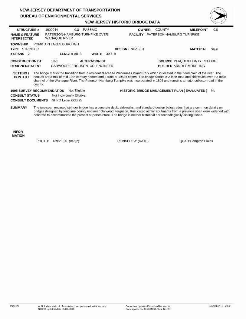
PATERSON-HAMBURG TURNPIKE OVER WANAQUE RIVER
FACILITY PATERSON-HAMBURG TURNPIKE
TOWNSHIP POMPTON LAKES BOROUGH
OWNER COUNTY
CONSTRUCTION DT 1925 SOURCE PLAQUE/COUNTY RECORD
MATERIAL SteelTYPE STRINGERLENGTH 88 ft WIDTH 39.6 ft# SPANS 2
DESIGNER/PATENT GARWOOD FERGUSON, CO. ENGINEER
SETTING / CONTEXT
The bridge marks the transition from a residential area to Wilderness Island Park which is located in the flood plain of the river. The houses are a mix of mid-19th century homes and a tract of 1950s capes. The bridge carries a 2-lane road and sidewalks over the main channel of the Wanaque River. The Paterson-Hamburg Turnpike was incorporated in 1806 and remains a major collector road in the county.
1995 SURVEY RECOMMENDATION Not Eligible
PHOTO: 139:23-25 (04/92) REVISED BY (DATE):
DESIGN ENCASED
BUILDER ARNOLT-MORE, INC.
CONSULT STATUS Not Individually Eligible.
QUAD: Pompton Plains
SUMMARY The two-span encased stringer bridge has a concrete deck, sidewalks, and standard-design balustrades that are common details on bridges designed by longtime county engineer Garwood Ferguson. Rusticated ashlar abutments from a previous span were widened with concrete to accommodate the present superstructure. The bridge is neither historical nor technologically distinguished.
STRUCTURE # 1600044
ALTERATION DT
INFOR MATION
CONSULT DOCUMENTS SHPO Letter 6/30/95
HISTORIC BRIDGE MANAGEMENT PLAN ( EVALUATED ) No
Page 21 A. G. Lichtenstein & Associates, Inc. performed initial survery. NJDOT updated data 03-01-2001.
Correction Updates Etc should be sent to [email protected]
November 12 , 2002

NEW JERSEY DEPARTMENT OF TRANSPORTATION
NEW JERSEY HISTORIC BRIDGE DATABUREAU OF ENVIRONMENTAL SERVICES
MILEPOINT 0.0CO PASSAICNAME & FEATURE INTERSECTED
RINGWOOD AVENUE OVER WANAQUE RIVER FACILITY RINGWOOD AVENUE
TOWNSHIP WANAQUE BOROUGH
OWNER COUNTY
CONSTRUCTION DT 1924 SOURCE PLAQUE/COUNTY RECORD
MATERIAL SteelTYPE STRINGERLENGTH 108 ft WIDTH 30 ft# SPANS 2
DESIGNER/PATENT GARWOOD FERGUSON, CO. ENGINEER
SETTING / CONTEXT
The bridge is located just below the mid-1920s Raymond Dam of the Wanaque Reservoir. It was built for a realignment of Ringwood Avenue to accommodate construction of the reservoir complex which was executed in granite. The stone serves as a stylistic motif visually unifying the reservoir complex. The bridge carries two lanes of traffic and two sidewalks over the river just below the spillway. The bridge is not part of the reservoir complex.
1995 SURVEY RECOMMENDATION Not Eligible
PHOTO: 192:27-32,141:6-7 (04/92) REVISED BY (DATE):
DESIGN ENCASED
BUILDER DANSEN CONSTRUCTION CO.
CONSULT STATUS Not Individually Eligible. Historic District Status Unresolved.
QUAD: Wanaque
SUMMARY The 2-span encased stringer bridge is a representative example of a common type and design. The use of concrete for the substructure, sidewalks, and balustrades is typical the era. The span is not connected with the Wanaque Reservoir. Built on a realignment mandated by the reservoir project, it was built by the county (reservoir was not), and it is of a different finish material than the reservoir. The delineation between the two is clear. It is an undistinguished, independent structure.
STRUCTURE # 1600046
ALTERATION DT
INFOR MATION
CONSULT DOCUMENTS SHPO Letter 6/30/95
HISTORIC BRIDGE MANAGEMENT PLAN ( EVALUATED ) No
Page 22 A. G. Lichtenstein & Associates, Inc. performed initial survery. NJDOT updated data 03-01-2001.
Correction Updates Etc should be sent to [email protected]
November 12 , 2002

NEW JERSEY DEPARTMENT OF TRANSPORTATION
NEW JERSEY HISTORIC BRIDGE DATABUREAU OF ENVIRONMENTAL SERVICES
MILEPOINT 0.0CO PASSAICNAME & FEATURE INTERSECTED
PASSAIC STREET OVER WEASEL BROOK FACILITY PASSAIC STREET
TOWNSHIP PASSAIC CITY
OWNER COUNTY
CONSTRUCTION DT 1892 SOURCE PLAQUE
MATERIAL BrickTYPE BRICK ARCHLENGTH 40 ft WIDTH 30.2 ft# SPANS 1
DESIGNER/PATENT D. DEMAREST, ARCHITECT
SETTING / CONTEXT
The bridge carries a 2-lane city street and two sidewalks over a brook in an urban area of Passaic with late-19th century brick industrial buildings and county buildings. The bridge is just north and in full view of the elevated, limited access NJ 21. Utility pipes pass through the intrados of the arch. A chain-link pedestrian fence has been added atop the parapets. The setting does not have historic district potential.
1995 SURVEY RECOMMENDATION Eligible
PHOTO: 136:14-16 (04/92) REVISED BY (DATE):
DESIGN BARREL
BUILDER ADRIAN WENTINK
CONSULT STATUS Individually Eligible.
QUAD: Weehawken
SUMMARY The well-proportioned 40'-long brick arch span has rusticated-finish coursed ashlar spandrel walls, and the arch ring is accented with ringstones. Some sections of the south parapet are missing. The parapets are capped with bluestone. The handsome bridge is the most complete example of the three in the county, and as such it is technologically distinguished. Brick arches were commonly used in north Jersey in 1874-1905.
STRUCTURE # 1600050
ALTERATION DT
INFOR MATION
Bibliography:Paterson City Directory. 1890-1896.Pape, William. History of Passaic. 1899.
Physical Description: The handsome, well-proportioned 40'-long brick arch bridge with rusticated ashlar spandrel walls is finished with rusticated ashlar voussoirs in an alternating header and stretcher pattern. The parapets are topped with blue stone cap stones. A plaque is set in the north parapet. Utility pipes have been added. Some of the south side parapet is missing. A chain-link fence pedestrian barrier has been added atop the cap stones.
Historical and Technological Significance: The well-proportioned brick arch bridge is a handsome and documented example of its type. The brick arch was used in northern New Jersey from approximately 1870 through the 1890s, but few examples are as complete as this one. An earlier brick arch span built in Haledon in 1875 (1600124) was altered in 1924 when it was widened with a stringer addition. The other brick arch span in Passaic County in Clifton over the Third River (1600081) was also widened, and it has lost its integrity of original design from deterioration. The span is thus technologically significant as a well-preserved example of the type that was important in the evolution of bridge building in northern New Jersey (criterion C). No information was located on D. Demarest who is identified on the plaque as the "architect" of the bridge. It is known that he did not practice in Paterson. No original plans for the bridge survive.
Boundary Description and Justification: The bridge is evaluated as individually significant. The boundary is thus limited to the span itself.
CONSULT DOCUMENTS SHPO Letter 6/30/95
HISTORIC BRIDGE MANAGEMENT PLAN ( EVALUATED ) No
Page 23 A. G. Lichtenstein & Associates, Inc. performed initial survery. NJDOT updated data 03-01-2001.
Correction Updates Etc should be sent to [email protected]
November 12 , 2002

NEW JERSEY DEPARTMENT OF TRANSPORTATION
NEW JERSEY HISTORIC BRIDGE DATABUREAU OF ENVIRONMENTAL SERVICES
MILEPOINT 0.0CO PASSAICNAME & FEATURE INTERSECTED
DAVIDSON STREET OVER WEASEL BROOK FACILITY DAVIDSON STREET
TOWNSHIP CLIFTON CITY
OWNER COUNTY
CONSTRUCTION DT 1931 SOURCE COUNTY RECORDS
MATERIAL SteelTYPE STRINGERLENGTH 30 ft WIDTH 24.3 ft# SPANS 1
DESIGNER/PATENT GARWOOD FERGUSON, CO. ENGINEER
SETTING / CONTEXT
The bridge carries a 24'-wide street with one-directional traffic and shoulders over a channelized stream in residential area of multiple-family homes, mainly late 19th-century and early 20th-century structures that lack integrity. The area does not have historic district potential because of the alterations to most of the buildings.
1995 SURVEY RECOMMENDATION Not Eligible
PHOTO: 135:9-10 (04/92) REVISED BY (DATE):
DESIGN ENCASED
BUILDER UNKNOWN
CONSULT STATUS Not Individually Eligible.
QUAD: Orange
SUMMARY The concrete-encased stringer bridge is supported on concrete abutments that are contiguous to brownstone coursed ashlar retaining walls that line the curving stream. The stream floor is lined with Belgian block pavers installed in 1943. The date of the brownstone retaining walls is not known. The pipe railing dates to the original construction of the span. One of over 33 remaining stringer bridges built when Garwood Ferguson was county engineer, it is not technologically distinguished.
STRUCTURE # 1600056
ALTERATION DT
INFOR MATION
CONSULT DOCUMENTS SHPO Letter 6/30/95
HISTORIC BRIDGE MANAGEMENT PLAN ( EVALUATED ) No
Page 24 A. G. Lichtenstein & Associates, Inc. performed initial survery. NJDOT updated data 03-01-2001.
Correction Updates Etc should be sent to [email protected]
November 12 , 2002

NEW JERSEY DEPARTMENT OF TRANSPORTATION
NEW JERSEY HISTORIC BRIDGE DATABUREAU OF ENVIRONMENTAL SERVICES
MILEPOINT 0.0CO PASSAICNAME & FEATURE INTERSECTED
HOPE AVENUE OVER WEASEL BROOK FACILITY HOPE AVENUE
TOWNSHIP CLIFTON CITY
OWNER COUNTY
CONSTRUCTION DT 1916 SOURCE INSCRIPTION
MATERIAL SteelTYPE STRINGERLENGTH 31 ft WIDTH 39.5 ft# SPANS 1
DESIGNER/PATENT GARWOOD FERGUSON, CO. ENGINEER
SETTING / CONTEXT
The bridge carries a 2-lane street and sidewalks over a channelized stream in a predominantly early-20th century residential area of Clifton with both apartments and duplexes. There are also modern infill structures. The area does not have the integrity to be evaluated as a potential historic district. The stream is carried in a culvert on the upstream side. The downstream side of the bridge is the culvert outlet.
1995 SURVEY RECOMMENDATION Not Eligible
PHOTO: 141:23-24 (04/92) REVISED BY (DATE):
DESIGN ENCASED
BUILDER UNKNOWN
CONSULT STATUS Not Individually Eligible.
QUAD: Orange
SUMMARY The skewed encased stringer bridge is supported on concrete abutments that are contiguous with coursed ashlar retaining walls that line Weasel Brook through this section. Only the downstream side of the bridge is exposed (upstream hidden by culvert), and it is finished with a paneled fascia that is spalled. The pipe railings that mark the limits of the bridge are original. The upstream culvert was placed ca. 1957. The bridge is neither historically nor technologically noteworthy.
STRUCTURE # 1600057
ALTERATION DT
INFOR MATION
CONSULT DOCUMENTS SHPO Letter 6/30/95
HISTORIC BRIDGE MANAGEMENT PLAN ( EVALUATED ) No
Page 25 A. G. Lichtenstein & Associates, Inc. performed initial survery. NJDOT updated data 03-01-2001.
Correction Updates Etc should be sent to [email protected]
November 12 , 2002

NEW JERSEY DEPARTMENT OF TRANSPORTATION
NEW JERSEY HISTORIC BRIDGE DATABUREAU OF ENVIRONMENTAL SERVICES
MILEPOINT 0.0CO PASSAICNAME & FEATURE INTERSECTED
CENTER STREET OVER WEASEL BROOK FACILITY CENTER STREET
TOWNSHIP CLIFTON CITY
OWNER COUNTY
CONSTRUCTION DT 1914 SOURCE COUNTY RECORDS
MATERIAL SteelTYPE STRINGERLENGTH 30 ft WIDTH 33.8 ft# SPANS 1
DESIGNER/PATENT GARWOOD FERGUSON, CO. ENGINEER
SETTING / CONTEXT
Located in an early-20th century residential area of altered duplexes, apartment buildings, and numerous modern infill structures, the bridge carries a 2-lane street and sidewalks over a channelized stream. A culvert hides the original upstream side of the bridge.
1995 SURVEY RECOMMENDATION Not Eligible
PHOTO: 136:11-12 (04/92) REVISED BY (DATE):
DESIGN ENCASED
BUILDER UNKNOWN
CONSULT STATUS Not Individually Eligible.
QUAD: Orange
SUMMARY The skewed encased stringer bridge on a concrete substructure was altered in 1949 as part of the Weasel Brook improvements when the channel was narrowed and deepened. A concrete wall was placed in front east abutment to improve stream alignment, and the west abutment was underpinned with concrete. The steel railing on the south side dates from 1973, the year the bridge was widened inkind to the north. The altered bridge is neither historically nor technologically distinguished.
STRUCTURE # 1600059
ALTERATION DT 1949, 1973
INFOR MATION
CONSULT DOCUMENTS SHPO Letter 6/30/95
HISTORIC BRIDGE MANAGEMENT PLAN ( EVALUATED ) No
Page 26 A. G. Lichtenstein & Associates, Inc. performed initial survery. NJDOT updated data 03-01-2001.
Correction Updates Etc should be sent to [email protected]
November 12 , 2002

NEW JERSEY DEPARTMENT OF TRANSPORTATION
NEW JERSEY HISTORIC BRIDGE DATABUREAU OF ENVIRONMENTAL SERVICES
MILEPOINT 0.0CO PASSAICNAME & FEATURE INTERSECTED
LEXINGTON AVENUE OVER WEASEL BROOK FACILITY LEXINGTON AVENUE
TOWNSHIP CLIFTON CITY
OWNER COUNTY
CONSTRUCTION DT 1903 SOURCE COUNTY RECORDS
MATERIAL SteelTYPE STRINGERLENGTH 30 ft WIDTH 40 ft# SPANS 1
DESIGNER/PATENT WILLIAM WHITMORE, CO. ENGINEER
SETTING / CONTEXT
The bridge carries a 2-lane city street over a channelized stream in an early-20th century mixed-use section of Clifton. The street is lined with neighborhood commercial businesses. There are many late-20th century infill structures, like the large apartment complex on the downstream side, in the area that was originally developed with 2- and 3-story apartment buildings and frame duplexes. Both sides of the bridge are next to culverts, so the stream is not visible.
1995 SURVEY RECOMMENDATION Not Eligible
PHOTO: 136:41-43 (04/92) REVISED BY (DATE):
DESIGN ENCASED
BUILDER HERBERT SANDFORD
CONSULT STATUS Not Individually Eligible.
QUAD: Orange
SUMMARY According to the county engineer, the nucleus of the encased rolled stringer bridge on a concrete substructure was placed in 1905. It was altered in 1949 when an invert slab was added, and the fasciae were hidden by culverts. The inlet for the culvert is behind the buildings that front on the street the bridge carries. No bridge railings survive. The altered span, now part of a long culvert, is neither historically nor technologically significant.
STRUCTURE # 1600060
ALTERATION DT 1949
INFOR MATION
CONSULT DOCUMENTS SHPO Letter 6/30/95
HISTORIC BRIDGE MANAGEMENT PLAN ( EVALUATED ) No
Page 27 A. G. Lichtenstein & Associates, Inc. performed initial survery. NJDOT updated data 03-01-2001.
Correction Updates Etc should be sent to [email protected]
November 12 , 2002

NEW JERSEY DEPARTMENT OF TRANSPORTATION
NEW JERSEY HISTORIC BRIDGE DATABUREAU OF ENVIRONMENTAL SERVICES
MILEPOINT 0.0CO PASSAICNAME & FEATURE INTERSECTED
CENTRAL AVENUE OVER WEASEL BROOK FACILITY CENTRAL AVENUE
TOWNSHIP CLIFTON CITY
OWNER COUNTY
CONSTRUCTION DT 1911 SOURCE COUNTY RECORDS
MATERIAL SteelTYPE STRINGERLENGTH 30 ft WIDTH 41.8 ft# SPANS 1
DESIGNER/PATENT GARWOOD FERGUSON, CO. ENGINEER
SETTING / CONTEXT
The bridge carries a 2-lane street and sidewalks over a channelized stream in a mixed use area with a scrap metal yard, under which the stream flows, to the west and a county-maintained playground to the east. Multi-family housing is also in the vicinity. The bridge is one of several over the channelized stream that flows through Clifton.
1995 SURVEY RECOMMENDATION Not Eligible
PHOTO: 136:44-2 (04/92) REVISED BY (DATE):
DESIGN ENCASED
BUILDER UNKNOWN
CONSULT STATUS Not Individually Eligible.
QUAD: Orange
SUMMARY The encased stringer bridge is supported on a concrete substructure that has been altered. The original railings were replaced with modern metal railings ca. 1957, and cut off walls were added at the abutment footings when an invert slab was placed in 1957. The west side of the structure has been enclosed. The channel is directed through concrete retaining walls lining the banks. An undistinguished example of a common bridge type, the span is neither historically or technologically noteworthy.
STRUCTURE # 1600061
ALTERATION DT 1957
INFOR MATION
CONSULT DOCUMENTS SHPO Letter 6/30/95
HISTORIC BRIDGE MANAGEMENT PLAN ( EVALUATED ) No
Page 28 A. G. Lichtenstein & Associates, Inc. performed initial survery. NJDOT updated data 03-01-2001.
Correction Updates Etc should be sent to [email protected]
November 12 , 2002

NEW JERSEY DEPARTMENT OF TRANSPORTATION
NEW JERSEY HISTORIC BRIDGE DATABUREAU OF ENVIRONMENTAL SERVICES
MILEPOINT 0.0CO PASSAICNAME & FEATURE INTERSECTED
MAIN AVENUE OVER WEASEL BROOK FACILITY MAIN AVENUE
TOWNSHIP CLIFTON CITY
OWNER COUNTY
CONSTRUCTION DT 1905 SOURCE COUNTY RECORDS
MATERIAL SteelTYPE STRINGERLENGTH 29 ft WIDTH 40 ft# SPANS 1
DESIGNER/PATENT WILLIAM L. WHITMORE
SETTING / CONTEXT
The bridge is located in a mixed-use area just south of the central business district. The neighborhood is comprised of commercial, light industrial and multiple-unit dwellings, all of which lack integrity. To the west the brook flows in a deep channel, but culvertized under a swim club to the east. The bridge currently carries four lanes of city traffic and two sidewalks over the brook. When constructed, the bridge also carried two pairs of trolley tracks.
1995 SURVEY RECOMMENDATION Not Eligible
PHOTO: 136:7-8 (04/92) REVISED BY (DATE):
DESIGN
BUILDER UNKNOWN
CONSULT STATUS Not Individually Eligible.
QUAD: Orange
SUMMARY The encased stringer bridge designed by William L. Whitmore, former county engineer, replaced a structure destroyed in the 1903 flood. The bridge was altered in the Weasel Brook Improvement Project in 1957. Concrete alterations include cut-off walls in front of the footings, 2' thick walls in front of the abutments, and a slab form the channel invert 3' below the original floor as well as a new steel railing. The bridge is not historically or technologically significant.
STRUCTURE # 1600062
ALTERATION DT 1957
INFOR MATION
CONSULT DOCUMENTS SHPO Letter 6/30/95
HISTORIC BRIDGE MANAGEMENT PLAN ( EVALUATED ) No
Page 29 A. G. Lichtenstein & Associates, Inc. performed initial survery. NJDOT updated data 03-01-2001.
Correction Updates Etc should be sent to [email protected]
November 12 , 2002

NEW JERSEY DEPARTMENT OF TRANSPORTATION
NEW JERSEY HISTORIC BRIDGE DATABUREAU OF ENVIRONMENTAL SERVICES
MILEPOINT 0.0CO PASSAICNAME & FEATURE INTERSECTED
SECOND STREET OVER WEASEL BROOK FACILITY SECOND STREET
TOWNSHIP CLIFTON CITY
OWNER COUNTY
CONSTRUCTION DT 1919 SOURCE INSCRIPTION
MATERIAL SteelTYPE STRINGERLENGTH 30 ft WIDTH 79 ft# SPANS 1
DESIGNER/PATENT GARWOOD FERGUSON, CO. ENGINEER
SETTING / CONTEXT
The bridge is part of a larger culvert that directs a minor stream through a residential area of primarily altered early-20th century dwellings and modern infill structures. The top of concrete culvert is utilized as a play yard on the east and a driveway/garage floor on the west. The bridge carries two lanes of traffic, two parking lanes, and two wide sidewalks over the channelized stream.
1995 SURVEY RECOMMENDATION Not Eligible
PHOTO: 136:3-4 (04/92) REVISED BY (DATE):
DESIGN ENCASED
BUILDER UNKNOWN
CONSULT STATUS Not Individually Eligible.
QUAD: Orange
SUMMARY The skewed, 79'-wide encased-stringer bridge was built in 1919 on stone abutments from an earlier span. It is finished with standard-design concrete parapets and paneled fascias. Culverts were added at each side of the bridge as part of the Weasel Brook Improvement program in 1957. The span is a representative example of a common county bridge type, and it is neither historically nor technologically distinguished.
STRUCTURE # 1600063
ALTERATION DT
INFOR MATION
CONSULT DOCUMENTS SHPO Letter 6/30/95
HISTORIC BRIDGE MANAGEMENT PLAN ( EVALUATED ) No
Page 30 A. G. Lichtenstein & Associates, Inc. performed initial survery. NJDOT updated data 03-01-2001.
Correction Updates Etc should be sent to [email protected]
November 12 , 2002

NEW JERSEY DEPARTMENT OF TRANSPORTATION
NEW JERSEY HISTORIC BRIDGE DATABUREAU OF ENVIRONMENTAL SERVICES
MILEPOINT 0.0CO PASSAICNAME & FEATURE INTERSECTED
THIRD STREET OVER WEASEL BROOK FACILITY THIRD STREET
TOWNSHIP CLIFTON CITY
OWNER COUNTY
CONSTRUCTION DT 1938 SOURCE PLAQUE/COUNTY RECORD
MATERIAL SteelTYPE STRINGERLENGTH 24 ft WIDTH 36 ft# SPANS 1
DESIGNER/PATENT GEORGE HEWITT, CO. ENGINEER
SETTING / CONTEXT
The bridge is located in a mixed-use neighborhood of altered single- and multiple-family dwellings dating from the early to mid-19th century, a large industrial structure, and the county-owned Weasel Brook Park. The brook is channeled to the east of the bridge, and the concrete culvert serves as a front yard, driveway, and garage floor. The bridge carries a two-lane street with shoulders and sidewalks over the brook.
1995 SURVEY RECOMMENDATION Not Eligible
PHOTO: 136:5-6 (04/92) REVISED BY (DATE):
DESIGN ENCASED
BUILDER UNION BUILDING & CONST. CO.
CONSULT STATUS Not Individually Eligible.
QUAD: Orange
SUMMARY The encased-stringer bridge is carried on a concrete substructure. It is enclosed with standard-design concrete balustrades. The stream is carried in a concrete flume, and a concrete culvert was added at the downstream side of the bridge in 1957. The bridge is a representative example of a common type in the county, and it is neither historically important nor technologically innovative.
STRUCTURE # 1600064
ALTERATION DT
INFOR MATION
CONSULT DOCUMENTS SHPO Letter 6/30/95
HISTORIC BRIDGE MANAGEMENT PLAN ( EVALUATED ) No
Page 31 A. G. Lichtenstein & Associates, Inc. performed initial survery. NJDOT updated data 03-01-2001.
Correction Updates Etc should be sent to [email protected]
November 12 , 2002

NEW JERSEY DEPARTMENT OF TRANSPORTATION
NEW JERSEY HISTORIC BRIDGE DATABUREAU OF ENVIRONMENTAL SERVICES
MILEPOINT 0.0CO PASSAICNAME & FEATURE INTERSECTED
RIVER ROAD OVER THIRD RIVER FACILITY RIVER ROAD
TOWNSHIP CLIFTON CITY
OWNER COUNTY
CONSTRUCTION DT 1903 SOURCE COUNTY RECORDS
MATERIAL SteelTYPE DECK GIRDERLENGTH 91 ft WIDTH 28.5 ft# SPANS 2
DESIGNER/PATENT WILLIAM L. WHITMORE
SETTING / CONTEXT
The bridge carries a two-lane road, utility pipes, and sidewalks over a minor river in a wooded setting in a mixed use area dominated by modern residential and corporate development. A late-19th or early-20th century brick factory is also near the bridge. The river has been dammed to create a mill pond.
1995 SURVEY RECOMMENDATION Not Eligible
PHOTO: 131:9-11 (04/92) REVISED BY (DATE):
DESIGN JACK ARCH (CONCRETE)
BUILDER CYCLOPEAN IRON WORKS
CONSULT STATUS Not Individually Eligible.
QUAD: Orange
SUMMARY The 2-span continuous multi deck girder bridge on concrete abutments and pier was built to replace a 3-span arch bridge washed out in the 1903 flood. The built-up girders support transverse beams with concrete jack arches and a concrete deck. The original railings were replaced with the present one in 1948. The bridge is similar to 4 built over Molly Ann's Brook after the flood. They are more complete than this example, all evaluated by the SHPO as not eligible. This span is not distinguished.
STRUCTURE # 1600080
ALTERATION DT
INFOR MATION
CONSULT DOCUMENTS SHPO Finding 10/03/90
HISTORIC BRIDGE MANAGEMENT PLAN ( EVALUATED ) No
Page 32 A. G. Lichtenstein & Associates, Inc. performed initial survery. NJDOT updated data 03-01-2001.
Correction Updates Etc should be sent to [email protected]
November 12 , 2002
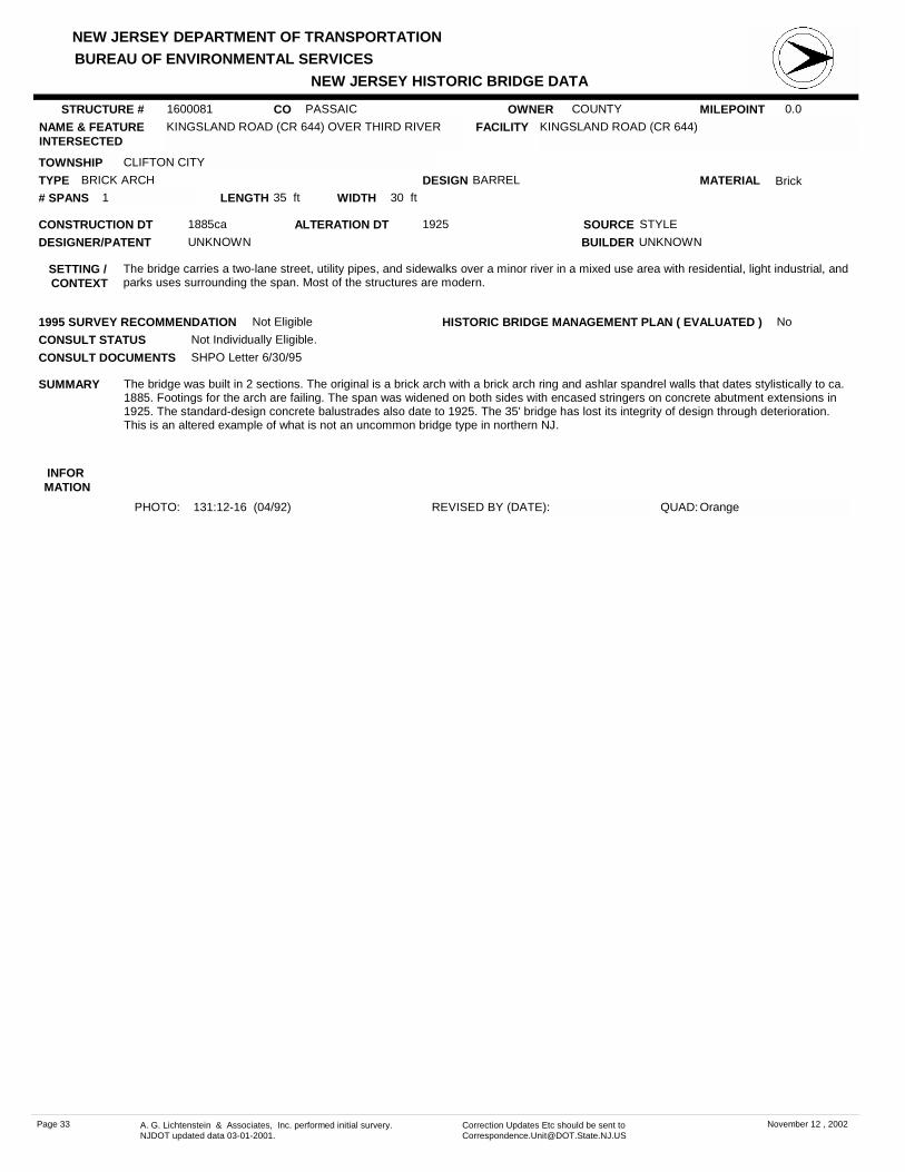
NEW JERSEY DEPARTMENT OF TRANSPORTATION
NEW JERSEY HISTORIC BRIDGE DATABUREAU OF ENVIRONMENTAL SERVICES
MILEPOINT 0.0CO PASSAICNAME & FEATURE INTERSECTED
KINGSLAND ROAD (CR 644) OVER THIRD RIVER FACILITY KINGSLAND ROAD (CR 644)
TOWNSHIP CLIFTON CITY
OWNER COUNTY
CONSTRUCTION DT 1885ca SOURCE STYLE
MATERIAL BrickTYPE BRICK ARCHLENGTH 35 ft WIDTH 30 ft# SPANS 1
DESIGNER/PATENT UNKNOWN
SETTING / CONTEXT
The bridge carries a two-lane street, utility pipes, and sidewalks over a minor river in a mixed use area with residential, light industrial, and parks uses surrounding the span. Most of the structures are modern.
1995 SURVEY RECOMMENDATION Not Eligible
PHOTO: 131:12-16 (04/92) REVISED BY (DATE):
DESIGN BARREL
BUILDER UNKNOWN
CONSULT STATUS Not Individually Eligible.
QUAD: Orange
SUMMARY The bridge was built in 2 sections. The original is a brick arch with a brick arch ring and ashlar spandrel walls that dates stylistically to ca. 1885. Footings for the arch are failing. The span was widened on both sides with encased stringers on concrete abutment extensions in 1925. The standard-design concrete balustrades also date to 1925. The 35' bridge has lost its integrity of design through deterioration. This is an altered example of what is not an uncommon bridge type in northern NJ.
STRUCTURE # 1600081
ALTERATION DT 1925
INFOR MATION
CONSULT DOCUMENTS SHPO Letter 6/30/95
HISTORIC BRIDGE MANAGEMENT PLAN ( EVALUATED ) No
Page 33 A. G. Lichtenstein & Associates, Inc. performed initial survery. NJDOT updated data 03-01-2001.
Correction Updates Etc should be sent to [email protected]
November 12 , 2002

NEW JERSEY DEPARTMENT OF TRANSPORTATION
NEW JERSEY HISTORIC BRIDGE DATABUREAU OF ENVIRONMENTAL SERVICES
MILEPOINT 0.0CO PASSAICNAME & FEATURE INTERSECTED
WAGARAW ROAD (CR 504) OVER GOFFLE BROOK FACILITY WAGARAW ROAD (CR 504)
TOWNSHIP HAWTHORNE BOROUGH
OWNER COUNTY
CONSTRUCTION DT 1926 SOURCE PLAQUE/COUNTY RECORD
MATERIAL SteelTYPE STRINGERLENGTH 31 ft WIDTH 40.2 ft# SPANS 1
DESIGNER/PATENT GARWOOD FERGUSON, CO. ENGINEER
SETTING / CONTEXT
The bridge carries a 2-lane city street and sidewalks over a minor stream in a lightly wooded area dotted with commercial and light industrial buildings dating from the late-19th century to the present.
1995 SURVEY RECOMMENDATION Not Eligible
PHOTO: 133:2-3 (04/92) REVISED BY (DATE):
DESIGN ENCASED
BUILDER DANSEN CONSTRUCTION CO.
CONSULT STATUS Not Individually Eligible.
QUAD: Paterson
SUMMARY The single span encased stringer bridge with a standard design balustrade is supported on a concrete substructure. One post is set with a metal bridge plaque. A representative example of the most common pre-World War II bridge type in the state, the span is neither historically or technologically distinguished. It is one of over 33 stringer bridges dating from before 1946 in Passaic County.
STRUCTURE # 1600103
ALTERATION DT
INFOR MATION
CONSULT DOCUMENTS SHPO Letter 6/30/95
HISTORIC BRIDGE MANAGEMENT PLAN ( EVALUATED ) No
Page 34 A. G. Lichtenstein & Associates, Inc. performed initial survery. NJDOT updated data 03-01-2001.
Correction Updates Etc should be sent to [email protected]
November 12 , 2002

NEW JERSEY DEPARTMENT OF TRANSPORTATION
NEW JERSEY HISTORIC BRIDGE DATABUREAU OF ENVIRONMENTAL SERVICES
MILEPOINT 0.0CO PASSAICNAME & FEATURE INTERSECTED
DIAMOND BRIDGE AVENUE OVER GOFFLE BROOK FACILITY DIAMOND BRIDGE AVENUE
TOWNSHIP HAWTHORNE BOROUGH
OWNER COUNTY
CONSTRUCTION DT 1904 SOURCE COUNTY RECORDS
MATERIAL SteelTYPE STRINGERLENGTH 43 ft WIDTH 30.1 ft# SPANS 1
DESIGNER/PATENT WILLIAM L. WHITMORE, CO. ENG
SETTING / CONTEXT
The bridge carries a 2-lane road and sidewalks over a minor stream in a casually landscaped Goffle Brook Park in Hawthorne Borough. The primarily open park is surrounded by homes from the last quarter of the 19th century to the present. A footpath that parallels the stream also is crossed by the road-carrying bridge. It is one of two bridges in the park. 1600105 is an undistinguished 1929 encased stringer.
1995 SURVEY RECOMMENDATION Eligible
PHOTO: 133:43-1 (04/92) REVISED BY (DATE):
DESIGN ENCASED
BUILDER FRANK SISCO
CONSULT STATUS Individually Eligible.
QUAD: Paterson
SUMMARY The encased stringer bridge supported on a concrete substructure is nicely detailed with pebble-dash finish panels on the abutments, fascias, and posts. It is a relatively early example of what would become the most common mid-century bridge type in the state. Because of its age, custom detailing, and good state of preservation, the span is technologically and historically distinguished in the state context.
STRUCTURE # 1600104
ALTERATION DT
INFOR MATION
Bibliography:Passaic County Engineer. Bridge File: 104.
Physical Description: The well-detailed 43'-long encased stringer bridge over a minor stream and parallel footpath in a small park is supported on a concrete substructure. The fascia stringers are finished with bush-hammer textured panels that match those that accent the posts of the concrete balustrades. The same detail is repeated at the corners of the abutments. The bridge carries a two-lane road and two sidewalks. It is well preserved.
Historical and Technological Significance: The bridge is technologically significant as an early and well detailed example of an encased stringer bridge. Built in 1904 to replace a bridge lost in the 1903 flood that claimed many bridges in the Paterson area, this span marks the transition from metal truss bridges to encased rolled stringers, the bridge type that would go on to dominate the 1915-1945 era (criterion C). In addition to being an early example of its type, the bridge is also well detailed, and its fine accenting with bush-hammer finished panels reflects the philosophy of the City Beautiful movement that encouraged aesthetic as well as functional considerations in civic projects. The custom detailing is in deference to the park setting of the span. It is located in Goffle Brook Park. The Passaic County engineers adopted stringer bridge technology earlier than most of their counterparts throughout the state.
Boundary Description and Justification: The bridge has been evaluated as significant on its own merits. The park in which it is located does not meet National Register criteria. It is small and does not have notable landscaping. The boundary is thus limited to the span itself.
CONSULT DOCUMENTS SHPO Letter 6/30/95
HISTORIC BRIDGE MANAGEMENT PLAN ( EVALUATED ) No
Page 35 A. G. Lichtenstein & Associates, Inc. performed initial survery. NJDOT updated data 03-01-2001.
Correction Updates Etc should be sent to [email protected]
November 12 , 2002

NEW JERSEY DEPARTMENT OF TRANSPORTATION
NEW JERSEY HISTORIC BRIDGE DATABUREAU OF ENVIRONMENTAL SERVICES
MILEPOINT 0.0CO PASSAICNAME & FEATURE INTERSECTED
WARBURTON AVENUE OVER GOFFLE BROOK FACILITY WARBURTON AVENUE
TOWNSHIP HAWTHORNE BOROUGH
OWNER COUNTY
CONSTRUCTION DT 1929 SOURCE PLAQUE/COUNTY RECORD
MATERIAL SteelTYPE STRINGERLENGTH 44 ft WIDTH 30 ft# SPANS 1
DESIGNER/PATENT GARWOOD FERGUSON, CO. ENGINEER
SETTING / CONTEXT
The bridge carries a 2-lane road and sidewalks over a minor stream in a casually landscaped park in Hawthorne Borough. It is one of two bridges in the park (1600104 is other). A modern school complex is located to the northeast of the span. The park is surrounded by late-19th and 20th century homes.
1995 SURVEY RECOMMENDATION Not Eligible
PHOTO: 136:29-30 (04/92) REVISED BY (DATE):
DESIGN ENCASED
BUILDER F. W. SCHWIERS JR. CO., NY
CONSULT STATUS Not Individually Eligible.
QUAD: Paterson
SUMMARY The single span encased stringer bridge on a concrete substructure is finished with arched fasciae to give the appearance of an arch span. Battered octagonal posts mark the limits of the span, which is finished with a standard-design balustrade. The date and county are inscribed in the fascia walls. Original lamps and standards have been removed. While more detailed than most other stringer spans in the region, the bridge is a late example of the most common bridge type in the state.
STRUCTURE # 1600105
ALTERATION DT
INFOR MATION
CONSULT DOCUMENTS SHPO Letter 09/98 03/12/01.
HISTORIC BRIDGE MANAGEMENT PLAN ( EVALUATED ) No
Page 36 A. G. Lichtenstein & Associates, Inc. performed initial survery. NJDOT updated data 03-01-2001.
Correction Updates Etc should be sent to [email protected]
November 12 , 2002
NEW JERSEY DEPARTMENT OF TRANSPORTATION
NEW JERSEY HISTORIC BRIDGE DATABUREAU OF ENVIRONMENTAL SERVICES
MILEPOINT 0.0CO PASSAICNAME & FEATURE INTERSECTED
LAFAYETTE AVENUE OVER GOFFLE BROOK FACILITY LAFAYETTE AVENUE
TOWNSHIP HAWTHORNE BOROUGH
OWNER COUNTY
CONSTRUCTION DT 1911 SOURCE COUNTY RECORDS
MATERIAL SteelTYPE STRINGERLENGTH 30 ft WIDTH 36.1 ft# SPANS 1
DESIGNER/PATENT GARWOOD FERGUSON
SETTING / CONTEXT
The bridge carries a two-lane road with shoulders and sidewalks over a minor stream in a mixed use area. One side is on the limits of Goffle Park and the Hawthorne water supply facility. The other side is next a car dealership.
1995 SURVEY RECOMMENDATION Not Eligible
PHOTO: 136:27-28 (04/92) REVISED BY (DATE):
DESIGN JACK ARCH (CONCRETE)
BUILDER UNKNOWN
CONSULT STATUS Not Individually Eligible.
QUAD: Paterson
SUMMARY The encased stringer bridge with concrete jack arch arches is supported on a concrete substructure. One of over 33 stringer bridges designed by longtime county engineer Garwood Ferguson, the span is nicely detailed with paneled fascias and wingwalls and standard-design concrete balustrades. It is a representative example of a common bridge type and is not historically nor technologically distinguished.
STRUCTURE # 1600110
ALTERATION DT
INFOR MATION
CONSULT DOCUMENTS SHPO Finding 11/22/92
HISTORIC BRIDGE MANAGEMENT PLAN ( EVALUATED ) No
Page 37 A. G. Lichtenstein & Associates, Inc. performed initial survery. NJDOT updated data 03-01-2001.
Correction Updates Etc should be sent to [email protected]
November 12 , 2002
NEW JERSEY DEPARTMENT OF TRANSPORTATION
NEW JERSEY HISTORIC BRIDGE DATABUREAU OF ENVIRONMENTAL SERVICES
MILEPOINT 0.0CO PASSAICNAME & FEATURE INTERSECTED
TOTOWA AVENUE OVER MOLLY ANN'S BROOK FACILITY TOTOWA AVENUE
TOWNSHIP PATERSON CITY
OWNER COUNTY
CONSTRUCTION DT 1939 SOURCE PLAQUE/COUNTY RECORD
MATERIAL SteelTYPE STRINGERLENGTH 43 ft WIDTH 40 ft# SPANS 1
DESIGNER/PATENT GARWOOD FERGUSON, CO. ENGINEER
SETTING / CONTEXT
The bridge carries a 2-lane street and sidewalks over a minor stream in a mid-20th century residential area of Paterson adjacent to JFK High School, a modern building, and West Side Park, a small, casually landscaped park with tennis courts.
1995 SURVEY RECOMMENDATION Not Eligible
PHOTO: 135:23-24 (04/92) REVISED BY (DATE):
DESIGN ENCASED
BUILDER UNION BUILDING & CONST. CO.
CONSULT STATUS Not Individually Eligible.
QUAD: Paterson
SUMMARY The 43'-long encased steel stringer bridge is supported on a concrete substructure and is finished with standard-design balustrades with paneled posts and paneled fascias. The wingwalls are scored. The bridge is a common design and type in the county, and it is neither historically or technologically distinguished.
STRUCTURE # 1600112
ALTERATION DT
INFOR MATION
CONSULT DOCUMENTS SHPO Finding 9/24/92
HISTORIC BRIDGE MANAGEMENT PLAN ( EVALUATED ) No
Page 38 A. G. Lichtenstein & Associates, Inc. performed initial survery. NJDOT updated data 03-01-2001.
Correction Updates Etc should be sent to [email protected]
November 12 , 2002

NEW JERSEY DEPARTMENT OF TRANSPORTATION
NEW JERSEY HISTORIC BRIDGE DATABUREAU OF ENVIRONMENTAL SERVICES
MILEPOINT 0.0CO PASSAICNAME & FEATURE INTERSECTED
UNION AVENUE OVER MOLLY ANN'S BROOK FACILITY UNION AVENUE
TOWNSHIP PATERSON CITY
OWNER COUNTY
CONSTRUCTION DT 1904 SOURCE COUNTY RECORDS
MATERIAL SteelTYPE THRU GIRDERLENGTH 66 ft WIDTH 45 ft# SPANS 1
DESIGNER/PATENT WILLIAM L. WHITMORE
SETTING / CONTEXT
The bridge carries a two-lane city street, shoulders, and sidewalks over a stream in a mixed-use but predominantly residential area of Paterson. Many of the late-19th century vernacular buildings have been converted to commercial use. The area does not have the integrity to be evaluated as a potential historic district.
1995 SURVEY RECOMMENDATION Not Eligible
PHOTO: 135:14-20 (04/92) REVISED BY (DATE):
DESIGN JACK ARCH (CONCRETE)
BUILDER UNKNOWN
CONSULT STATUS Not Individually Eligible.
QUAD: Paterson
SUMMARY The well-preserved thru girder with built-up floor beams bridge has concrete jack arches set between the stringers. The sidewalks are also a girder arrangement with jack arches between the transverse beams. They are enclosed by nicely detailed cast-and wrought-iron railings. The bridge, one of 4 similar spans built to replace those over the feature lost in the 1903 flood, is a good unaltered example of a prominent mid-1900s type and design in the county.
STRUCTURE # 1600113
ALTERATION DT
INFOR MATION
CONSULT DOCUMENTS SHPO Finding 12/07/89
HISTORIC BRIDGE MANAGEMENT PLAN ( EVALUATED ) No
Page 39 A. G. Lichtenstein & Associates, Inc. performed initial survery. NJDOT updated data 03-01-2001.
Correction Updates Etc should be sent to [email protected]
November 12 , 2002
NEW JERSEY DEPARTMENT OF TRANSPORTATION
NEW JERSEY HISTORIC BRIDGE DATABUREAU OF ENVIRONMENTAL SERVICES
MILEPOINT 0.0CO PASSAICNAME & FEATURE INTERSECTED
BERKSHIRE AVENUE OVER MOLLY ANN'S BROOK FACILITY BERKSHIRE AVENUE
TOWNSHIP PATERSON CITY
OWNER COUNTY
CONSTRUCTION DT 1931 SOURCE COUNTY RECORDS
MATERIAL SteelTYPE STRINGERLENGTH 43 ft WIDTH 36 ft# SPANS 1
DESIGNER/PATENT GARWOOD FERGUSON, CO. ENGINEER
SETTING / CONTEXT
The bridge carries a 2-lane street and sidewalks over a minor stream in a formerly residential area dating to the late-19th and early-20th centuries that has undergone change to commercial use. The buildings are extensively altered.
1995 SURVEY RECOMMENDATION Not Eligible
PHOTO: 135:21-22 (04/92) REVISED BY (DATE):
DESIGN PARTIALLY ENCASED
BUILDER UNKNOWN
CONSULT STATUS Not Individually Eligible.
QUAD: Paterson
SUMMARY The steel stringer bridge is supported on a concrete substructure. Interior stringers are encased while the fascia stringers are not. County records indicate that the bridge was not widened, but the original balustrades, now present only on the approaches, were replaced with modern metal ones in 1971. The span is an altered example of a common type. It is not historically or technologically distinguished.
STRUCTURE # 1600114
ALTERATION DT 1971
INFOR MATION
CONSULT DOCUMENTS SHPO Finding 9/24/92
HISTORIC BRIDGE MANAGEMENT PLAN ( EVALUATED ) No
Page 40 A. G. Lichtenstein & Associates, Inc. performed initial survery. NJDOT updated data 03-01-2001.
Correction Updates Etc should be sent to [email protected]
November 12 , 2002

NEW JERSEY DEPARTMENT OF TRANSPORTATION
NEW JERSEY HISTORIC BRIDGE DATABUREAU OF ENVIRONMENTAL SERVICES
MILEPOINT 0.0CO PASSAICNAME & FEATURE INTERSECTED
SHERWOOD AVENUE OVER MOLLY ANN'S BROOK FACILITY SHERWOOD AVENUE
TOWNSHIP PATERSON CITY
OWNER COUNTY
CONSTRUCTION DT 1931 SOURCE COUNTY RECORDS
MATERIAL SteelTYPE STRINGERLENGTH 30 ft WIDTH 35.8 ft# SPANS 1
DESIGNER/PATENT GARWOOD FERGUSON, CO. ENGINEER
SETTING / CONTEXT
The bridge, located at an intersection, carries a 2-lane street and sidewalk over a channeled stream. The bridge serves as the inlet for the channelized stream that then passes underground. The surroundings are a mix of industrial, processing, and commercial structures and multi-family residential buildings. A bypass culvert was added to the northeasterly side in 1957.
1995 SURVEY RECOMMENDATION Not Eligible
PHOTO: 137:28-30 (04/92) REVISED BY (DATE):
DESIGN PARTIALLY ENCASED
BUILDER UNKNOWN
CONSULT STATUS Not Individually Eligible.
QUAD: Paterson
SUMMARY The skewed, steel stringer bridge supported on a concrete substructure has encasement on all but the bottom flanges and the easterly fascia stringer. The original balustrades were replaced by modern metal ones about 1970. An altered example of a common type, the bridge is neither historically or technologically distinguished.
STRUCTURE # 1600115
ALTERATION DT 1970ca
INFOR MATION
CONSULT DOCUMENTS SHPO Finding 9/24/92
HISTORIC BRIDGE MANAGEMENT PLAN ( EVALUATED ) No
Page 41 A. G. Lichtenstein & Associates, Inc. performed initial survery. NJDOT updated data 03-01-2001.
Correction Updates Etc should be sent to [email protected]
November 12 , 2002

NEW JERSEY DEPARTMENT OF TRANSPORTATION
NEW JERSEY HISTORIC BRIDGE DATABUREAU OF ENVIRONMENTAL SERVICES
MILEPOINT 0.0CO PASSAICNAME & FEATURE INTERSECTED
REDWOOD AVENUE OVER MOLLY ANN'S BROOK FACILITY REDWOOD AVENUE
TOWNSHIP PATERSON CITY
OWNER COUNTY
CONSTRUCTION DT 1903 SOURCE COUNTY RECORDS
MATERIAL SteelTYPE THRU GIRDERLENGTH 70 ft WIDTH 30 ft# SPANS 1
DESIGNER/PATENT WILLIAM L. WHITMORE
SETTING / CONTEXT
The bridge carries a two-lane street, utility pipe, and sidewalks over a stream in a highly altered late-19th and early-20th century residential area of Paterson. The span is one of several built to replace those over the brook lost in the 1903 flood. The bridge was demolished and replaced with a new span on the existing alignment in 1993.
1995 SURVEY RECOMMENDATION Not Eligible
PHOTO: 137:31 (04/92) REVISED BY (DATE):
DESIGN JACK ARCH (CONCRETE)
BUILDER BOGERT & CARLOUGH COMPANY
CONSULT STATUS Not Individually Eligible.
QUAD: Paterson
SUMMARY The thru girder with floor beams bridge supported on a concrete substructure is one of about 4 similar spans built by the county over the brook after the 1903 flood. It has built-up floor beams and concrete jack arches set between the stringers. The cantilevered sidewalks also have the jack arch detail, and they are enclosed by nicely detailed wrought iron railings. The bridge is an unaltered example of its type. It was evaluated by the SHPO as not eligible. It has been removed and replaced.
STRUCTURE # 1600117
ALTERATION DT Demolished: 1993
INFOR MATION
CONSULT DOCUMENTS SHPO Finding 9/24/92
HISTORIC BRIDGE MANAGEMENT PLAN ( EVALUATED ) No
Page 42 A. G. Lichtenstein & Associates, Inc. performed initial survery. NJDOT updated data 03-01-2001.
Correction Updates Etc should be sent to [email protected]
November 12 , 2002
NEW JERSEY DEPARTMENT OF TRANSPORTATION
NEW JERSEY HISTORIC BRIDGE DATABUREAU OF ENVIRONMENTAL SERVICES
MILEPOINT 0.0CO PASSAICNAME & FEATURE INTERSECTED
CLINTON STREET OVER MOLLY ANN'S BROOK FACILITY CLINTON STREET
TOWNSHIP HALEDON BOROUGH
OWNER COUNTY
CONSTRUCTION DT 1904 SOURCE COUNTY RECORDS
MATERIAL SteelTYPE THRU GIRDERLENGTH 59 ft WIDTH 29 ft# SPANS 1
DESIGNER/PATENT WILLIAM L. WHITMORE
SETTING / CONTEXT
The bridge carries a two-lane city street and sidewalks over a stream in a mixed use area of altered late-19th and early-20th century houses, modern neighborhood commercial establishments, and some light industrial and service businesses. It does not have the integrity to be evaluated as a potential historic district. Haledon is a working-class borough that developed around silk mills.
1995 SURVEY RECOMMENDATION Not Eligible
PHOTO: 137:35-39 (04/92) REVISED BY (DATE):
DESIGN JACK ARCH (CONCRETE)
BUILDER UNKNOWN
CONSULT STATUS Not Individually Eligible.
QUAD: Paterson
SUMMARY The thru girder with floor beams bridge has cantilevered sidewalks enclosed with the original picket fence-like railings. Concrete jack arches are set between the stringers. The bridge is similar in type and design to others built to replace spans over Molly Ann's Brook lost in the 1903 flood. This one is a representative example of what was a locally popular type. It is not individually distinguished and is not technologically innovative.
STRUCTURE # 1600121
ALTERATION DT
INFOR MATION
CONSULT DOCUMENTS SHPO Finding 9/24/92
HISTORIC BRIDGE MANAGEMENT PLAN ( EVALUATED ) No
Page 43 A. G. Lichtenstein & Associates, Inc. performed initial survery. NJDOT updated data 03-01-2001.
Correction Updates Etc should be sent to [email protected]
November 12 , 2002

NEW JERSEY DEPARTMENT OF TRANSPORTATION
NEW JERSEY HISTORIC BRIDGE DATABUREAU OF ENVIRONMENTAL SERVICES
MILEPOINT 0.0CO PASSAICNAME & FEATURE INTERSECTED
ROE STREET OVER MOLLY ANN'S BROOK FACILITY ROE STREET
TOWNSHIP HALEDON BOROUGH
OWNER COUNTY
CONSTRUCTION DT 1935 SOURCE PLAQUE/COUNTY RECORD
MATERIAL SteelTYPE STRINGERLENGTH 34 ft WIDTH 30.2 ft# SPANS 1
DESIGNER/PATENT GEORGE HEWITT, CO. ENGINEER
SETTING / CONTEXT
The bridge carries a 2-lane street and a sidewalk over a minor stream in a residential area with both single- and multi-family dwellings and some institutional structures including a Masonic hall. The area does not have historic district potential.
1995 SURVEY RECOMMENDATION Not Eligible
PHOTO: 137:32-34 (04/92) REVISED BY (DATE):
DESIGN ENCASED
BUILDER RICHARD S. SOWERBUTT
CONSULT STATUS Not Individually Eligible.
QUAD: Paterson
SUMMARY The 1935 encased steel stringer bridge is supported on concrete abutments built in front of the masonry abutments of an earlier span. Standard-design concrete balustrades are used on the span while the approaches are marked by original pipe railings. A representative example of the most common pre-World War II bridge type in the state, the span is not historically or technologically distinguished.
STRUCTURE # 1600122
ALTERATION DT
INFOR MATION
CONSULT DOCUMENTS SHPO Finding 9/24/92
HISTORIC BRIDGE MANAGEMENT PLAN ( EVALUATED ) No
Page 44 A. G. Lichtenstein & Associates, Inc. performed initial survery. NJDOT updated data 03-01-2001.
Correction Updates Etc should be sent to [email protected]
November 12 , 2002

NEW JERSEY DEPARTMENT OF TRANSPORTATION
NEW JERSEY HISTORIC BRIDGE DATABUREAU OF ENVIRONMENTAL SERVICES
MILEPOINT 0.0CO PASSAICNAME & FEATURE INTERSECTED
IDA STREET OVER MOLLY ANN'S BROOK FACILITY IDA STREET
TOWNSHIP HALEDON BOROUGH
OWNER COUNTY
CONSTRUCTION DT 1937 SOURCE PLAQUE/COUNTY RECORD
MATERIAL SteelTYPE STRINGERLENGTH 36 ft WIDTH 30.2 ft# SPANS 1
DESIGNER/PATENT GEORGE HEWITT, CO. ENGINEER
SETTING / CONTEXT
The bridge carries a 2-lane street and sidewalks over a minor stream in a residential area composed of homes from the 1920s through the 1960s. Most of the earlier houses have been altered. There is no historic district potential.
1995 SURVEY RECOMMENDATION Not Eligible
PHOTO: 137:40-42 (04/92) REVISED BY (DATE):
DESIGN ENCASED
BUILDER RICHARD S. SOWERBUTT
CONSULT STATUS Not Individually Eligible.
QUAD: Paterson
SUMMARY The encased steel stringer bridge is supported on a concrete substructure. Adjacent to the abutments are rubble stone retaining walls lining the stream banks. The bridge is finished with standard-design concrete balustrades with paneled posts and pipe railings marking the approaches. A representative example of a common type and design, the bridge is neither historically or technologically distinguished.
STRUCTURE # 1600123
ALTERATION DT
INFOR MATION
CONSULT DOCUMENTS SHPO Finding 9/24/92
HISTORIC BRIDGE MANAGEMENT PLAN ( EVALUATED ) No
Page 45 A. G. Lichtenstein & Associates, Inc. performed initial survery. NJDOT updated data 03-01-2001.
Correction Updates Etc should be sent to [email protected]
November 12 , 2002

NEW JERSEY DEPARTMENT OF TRANSPORTATION
NEW JERSEY HISTORIC BRIDGE DATABUREAU OF ENVIRONMENTAL SERVICES
MILEPOINT 0.0CO PASSAICNAME & FEATURE INTERSECTED
HALEDON AVENUE (CR 504) OVER MOLLY ANN'S BROOK
FACILITY HALEDON AVENUE (CR 504)
TOWNSHIP HALEDON BOROUGH
OWNER COUNTY
CONSTRUCTION DT 1875 SOURCE KEYSTONE INSCRIPTION
MATERIAL BrickTYPE BRICK ARCHLENGTH 46 ft WIDTH 43 ft# SPANS 2
DESIGNER/PATENT UNKNOWN
SETTING / CONTEXT
The bridge carries a two-lane city street and sidewalks over a minor stream in a mid- to late-20th century mixed use area with single family homes and neighborhood commercial establishments, including service stations and a shopping center. The area does not have the integrity to be evaluated as having historic district potential.
1995 SURVEY RECOMMENDATION Not Eligible
PHOTO: 137:43-2 (04/92) REVISED BY (DATE):
DESIGN ELLIPTICAL
BUILDER UNKNOWN
CONSULT STATUS Not Individually Eligible.
QUAD: Paterson
SUMMARY The skewed 2-span bridge was built in two sections. The original portion is a brick arch with ashlar abutments and spandrel walls dating to 1875. It was widened in 1924 on the upstream side with encased stringers on concrete abutment and pier extensions. Both sides were finished with standard-design concrete balustrades. A metal walkway and steps provides pedestrian access to the bank on the upstream side. This appears to be a 1924 detail. The span is an late and altered example of its type.
STRUCTURE # 1600124
ALTERATION DT 1924
INFOR MATION
CONSULT DOCUMENTS SHPO Finding 9/24/92
HISTORIC BRIDGE MANAGEMENT PLAN ( EVALUATED ) No
Page 46 A. G. Lichtenstein & Associates, Inc. performed initial survery. NJDOT updated data 03-01-2001.
Correction Updates Etc should be sent to [email protected]
November 12 , 2002

NEW JERSEY DEPARTMENT OF TRANSPORTATION
NEW JERSEY HISTORIC BRIDGE DATABUREAU OF ENVIRONMENTAL SERVICES
MILEPOINT 0.0CO PASSAICNAME & FEATURE INTERSECTED
CHURCH STREET (CR 677) OVER MOLLY ANN'S BROOK
FACILITY CHURCH STREET (CR 677)
TOWNSHIP HALEDON BOROUGH
OWNER COUNTY
CONSTRUCTION DT 1930 SOURCE PLAQUE/COUNTY RECORD
MATERIAL SteelTYPE STRINGERLENGTH 29 ft WIDTH 40 ft# SPANS 1
DESIGNER/PATENT GARWOOD FERGUSON, CO. ENGINEER
SETTING / CONTEXT
The bridge carries a 2-lane road and sidewalks over a minor stream adjacent to a modern school and school yard with athletic fields and a large chemical plant. The chemical plant has as its nucleus a late-19th century complex, but it has been extensively altered and expanded. Haledon was noted as a silk manufacturing center.
1995 SURVEY RECOMMENDATION Not Eligible
PHOTO: 137:3-4 (04/92) REVISED BY (DATE):
DESIGN ENCASED
BUILDER JOHN H. MAGEE
CONSULT STATUS Not Individually Eligible.
QUAD: Paterson
SUMMARY The skewed, encased steel stringer bridge is supported on a concrete substructure and is finished with standard-design concrete balustrades. The approaches are marked by pipe railings. A representative example of a common bridge type and design, the span is neither historically nor technologically distinguished.
STRUCTURE # 1600125
ALTERATION DT
INFOR MATION
CONSULT DOCUMENTS SHPO Finding 9/24/92
HISTORIC BRIDGE MANAGEMENT PLAN ( EVALUATED ) No
Page 47 A. G. Lichtenstein & Associates, Inc. performed initial survery. NJDOT updated data 03-01-2001.
Correction Updates Etc should be sent to [email protected]
November 12 , 2002

NEW JERSEY DEPARTMENT OF TRANSPORTATION
NEW JERSEY HISTORIC BRIDGE DATABUREAU OF ENVIRONMENTAL SERVICES
MILEPOINT 0.0CO PASSAICNAME & FEATURE INTERSECTED
OVERLOOK AVENUE (CR 664) OVER MOLLY ANN'S BROOK
FACILITY OVERLOOK AVENUE (CR 664)
TOWNSHIP NORTH HALEDON BOROUGH
OWNER COUNTY
CONSTRUCTION DT 1939 SOURCE PLAQUE/COUNTY RECORD
MATERIAL SteelTYPE STRINGERLENGTH 24 ft WIDTH 30.3 ft# SPANS 1
DESIGNER/PATENT GARWOOD FERGUSON, CO. ENGINEER
SETTING / CONTEXT
The bridge carries a 2-lane road and sidewalks over a minor stream in a mid- to late-20th century residential area adjacent to the borough building in Haledon.
1995 SURVEY RECOMMENDATION Not Eligible
PHOTO: 137:5-7 (04/92) REVISED BY (DATE):
DESIGN ENCASED
BUILDER ELL DORER CONTRACTING CO.
CONSULT STATUS Not Individually Eligible.
QUAD: Paterson
SUMMARY The short encased steel stringer span is supported on a concrete substructure. The bridge has standard-design balustrades with paneled posts. A representative example of the most common pre-World War II bridge type in the state, the span is not historically or technologically distinguished.
STRUCTURE # 1600126
ALTERATION DT
INFOR MATION
CONSULT DOCUMENTS SHPO Letter 6/30/95
HISTORIC BRIDGE MANAGEMENT PLAN ( EVALUATED ) No
Page 48 A. G. Lichtenstein & Associates, Inc. performed initial survery. NJDOT updated data 03-01-2001.
Correction Updates Etc should be sent to [email protected]
November 12 , 2002
NEW JERSEY DEPARTMENT OF TRANSPORTATION
NEW JERSEY HISTORIC BRIDGE DATABUREAU OF ENVIRONMENTAL SERVICES
MILEPOINT 0.0CO PASSAICNAME & FEATURE INTERSECTED
SQUAW BROOK ROAD OVER MOLLY ANN'S BROOK FACILITY SQUAW BROOK ROAD
TOWNSHIP NORTH HALEDON BOROUGH
OWNER COUNTY
CONSTRUCTION DT 1905 SOURCE COUNTY RECORDS
MATERIAL SteelTYPE STRINGERLENGTH 36 ft WIDTH 28.5 ft# SPANS 1
DESIGNER/PATENT WILLIAM L. WHITMORE
SETTING / CONTEXT
The bridge carries a 2-lane road and sidewalks over a minor stream in a wooded residential area dominated by 1950s and 1960s one-story houses.
1995 SURVEY RECOMMENDATION Not Eligible
PHOTO: 137:8-11 (04/92) REVISED BY (DATE):
DESIGN JACK ARCH (CONCRETE)
BUILDER CYCLOPEAN IRON WORKS
CONSULT STATUS Not Individually Eligible.
QUAD: Paterson
SUMMARY The steel stringer and concrete jack arch bridge is supported on concrete abutments. Abutments were extended in concrete ca. 1960 to accommodate the added stringer sidewalks. The downstream sidewalk also has steel bent supports. The metal railings also date to ca. 1960. While the underside of the bridge is complete, the upper portion does not retain its original appearance. The span is one of over 10 in the county with jack arches, and it is not historically or technologically distinguished.
STRUCTURE # 1600127
ALTERATION DT 1960ca
INFOR MATION
CONSULT DOCUMENTS SHPO Letter 6/30/95
HISTORIC BRIDGE MANAGEMENT PLAN ( EVALUATED ) No
Page 49 A. G. Lichtenstein & Associates, Inc. performed initial survery. NJDOT updated data 03-01-2001.
Correction Updates Etc should be sent to [email protected]
November 12 , 2002

NEW JERSEY DEPARTMENT OF TRANSPORTATION
NEW JERSEY HISTORIC BRIDGE DATABUREAU OF ENVIRONMENTAL SERVICES
MILEPOINT 0.0CO PASSAICNAME & FEATURE INTERSECTED
SICOMAC ROAD OVER MOLLY ANN'S BROOK FACILITY SICOMAC ROAD
TOWNSHIP NORTH HALEDON BOROUGH
OWNER COUNTY
CONSTRUCTION DT 1905ca SOURCE STYLE
MATERIAL SteelTYPE STRINGERLENGTH 27 ft WIDTH 30 ft# SPANS 1
DESIGNER/PATENT UNKNOWN
SETTING / CONTEXT
The bridge carries a 2-lane road and sidewalks over a minor stream in a suburban area adjacent to scattered houses and modern commercial development, including a large shopping center. Utility pipes pass through the abutments.
1995 SURVEY RECOMMENDATION Not Eligible
PHOTO: 137:12-15 (04/92) REVISED BY (DATE):
DESIGN ENCASED
BUILDER UNKNOWN
CONSULT STATUS Not Individually Eligible.
QUAD: Paterson
SUMMARY The encased steel stringer bridge is supported on a concrete substructure. The concrete parapets and fascia panels have bush-hammered finished panels. No plans for the bridge remain, but it is dated ca. 1905 based on its stylistic similarity with the 1905 Diamond Bridge Road bridge (1600104) built in 1905. The representative but undocumented example of a common local bridge type and design is not as complete as the other. The span is neither historically or technologically distinguished.
STRUCTURE # 1600129
ALTERATION DT
INFOR MATION
CONSULT DOCUMENTS SHPO Letter 6/30/95
HISTORIC BRIDGE MANAGEMENT PLAN ( EVALUATED ) No
Page 50 A. G. Lichtenstein & Associates, Inc. performed initial survery. NJDOT updated data 03-01-2001.
Correction Updates Etc should be sent to [email protected]
November 12 , 2002

NEW JERSEY DEPARTMENT OF TRANSPORTATION
NEW JERSEY HISTORIC BRIDGE DATABUREAU OF ENVIRONMENTAL SERVICES
MILEPOINT 0.0CO PASSAICNAME & FEATURE INTERSECTED
MCBRIDE AVENUE (CR 639) OVER PECKMAN RIVER
FACILITY MCBRIDE AVENUE (CR 639)
TOWNSHIP WEST PATERSON BOROUGH
OWNER COUNTY
CONSTRUCTION DT 1905ca SOURCE PLAQUE/COUNTY RECORD
MATERIAL SteelTYPE STRINGERLENGTH 38 ft WIDTH 67.3 ft# SPANS 1
DESIGNER/PATENT GARWOOD FERGUSON
SETTING / CONTEXT
The bridge carries a 2-lane street and two sidewalks over a river in a mixed use 20th century area with a range of building types and styles ranging from ca. 1910 houses to 1980s office buildings.
1995 SURVEY RECOMMENDATION Not Eligible
PHOTO: 143:19-20 (04/92) REVISED BY (DATE):
DESIGN ENCASED
BUILDER LOGAN CONSTRUCTION CO.,INC.
CONSULT STATUS Not Individually Eligible.
QUAD: Paterson
SUMMARY The encased steel stringer bridge is supported on ashlar abutments from an earlier span. They were extended with concrete and also have concrete toe walls. The railing is a low concrete geometric balustrade over the clear span and plain parapet over the wingwalls. Pipe railings survive at some approaches. The bridge was widened twice; 12'-6" to the east in 1914 and 18'-6" to the west in 1924. No plans for the original span survive. The bridge is an altered example of a common bridge type.
STRUCTURE # 1600130
ALTERATION DT 1914, 1924
INFOR MATION
CONSULT DOCUMENTS SHPO Letter 6/30/95
HISTORIC BRIDGE MANAGEMENT PLAN ( EVALUATED ) No
Page 51 A. G. Lichtenstein & Associates, Inc. performed initial survery. NJDOT updated data 03-01-2001.
Correction Updates Etc should be sent to [email protected]
November 12 , 2002

NEW JERSEY DEPARTMENT OF TRANSPORTATION
NEW JERSEY HISTORIC BRIDGE DATABUREAU OF ENVIRONMENTAL SERVICES
MILEPOINT 0.0CO PASSAICNAME & FEATURE INTERSECTED
LACKAWANNA AVENUE OVER PECKMAN RIVER FACILITY LACKAWANNA AVENUE
TOWNSHIP WEST PATERSON BOROUGH
OWNER COUNTY
CONSTRUCTION DT 1941 SOURCE PLAQUE/COUNTY RECORD
MATERIAL SteelTYPE STRINGERLENGTH 45 ft WIDTH 30.3 ft# SPANS 1
DESIGNER/PATENT GARWOOD FERGUSON, CO. ENGINEER
SETTING / CONTEXT
The bridge carries a two-lane road and shoulders over a channelized stream in an industrial park area with active factories. The industrial park is known as Lackawanna Park. The bridge replaces an earlier span that was narrower and located on a curve.
1995 SURVEY RECOMMENDATION Not Eligible
PHOTO: 143:17-18 (04/92) REVISED BY (DATE):
DESIGN ENCASED
BUILDER KUCHAR BROTHERS, INC.
CONSULT STATUS Not Individually Eligible.
QUAD: Paterson
SUMMARY The encased steel stringer bridge is supported on concrete abutments with wingwalls. A portion of the earlier stone wingwall remains at the southwest end. The bridge is finished with standard-design concrete balustrades with paneled posts. One of many encased stringer bridges in the county, the 1941 span is neither historically nor technologically distinguished.
STRUCTURE # 1600131
ALTERATION DT
INFOR MATION
CONSULT DOCUMENTS SHPO Letter 6/30/95
HISTORIC BRIDGE MANAGEMENT PLAN ( EVALUATED ) No
Page 52 A. G. Lichtenstein & Associates, Inc. performed initial survery. NJDOT updated data 03-01-2001.
Correction Updates Etc should be sent to [email protected]
November 12 , 2002

NEW JERSEY DEPARTMENT OF TRANSPORTATION
NEW JERSEY HISTORIC BRIDGE DATABUREAU OF ENVIRONMENTAL SERVICES
MILEPOINT 0.0CO PASSAICNAME & FEATURE INTERSECTED
EAST MAIN STREET OVER PECKMAN RIVER FACILITY EAST MAIN STREET
TOWNSHIP LITTLE FALLS TOWNSHIP
OWNER COUNTY
CONSTRUCTION DT 1913 SOURCE COUNTY RECORDS
MATERIAL SteelTYPE STRINGERLENGTH 79 ft WIDTH 29.8 ft# SPANS 2
DESIGNER/PATENT GARWOOD FERGUSON
SETTING / CONTEXT
1995 SURVEY RECOMMENDATION Not Eligible
PHOTO: 138:15 (04/92) REVISED BY (DATE):
DESIGN
BUILDER KUCHAR BROS.
CONSULT STATUS Not Individually Eligible.
QUAD: Paterson
SUMMARY The 1913 stringer bridge was removed in 1992.
STRUCTURE # 1600132
ALTERATION DT Demolished: 1992
INFOR MATION
CONSULT DOCUMENTS SHPO Letter 6/30/95
HISTORIC BRIDGE MANAGEMENT PLAN ( EVALUATED ) No
Page 53 A. G. Lichtenstein & Associates, Inc. performed initial survery. NJDOT updated data 03-01-2001.
Correction Updates Etc should be sent to [email protected]
November 12 , 2002

NEW JERSEY DEPARTMENT OF TRANSPORTATION
NEW JERSEY HISTORIC BRIDGE DATABUREAU OF ENVIRONMENTAL SERVICES
MILEPOINT 0.0CO PASSAICNAME & FEATURE INTERSECTED
PREAKNESS AVENUE OVER SINGAC BROOK FACILITY PREAKNESS AVENUE
TOWNSHIP WAYNE TOWNSHIP
OWNER COUNTY
CONSTRUCTION DT 1928 SOURCE PLAQUE/CO. RECORDS
MATERIAL SteelTYPE STRINGERLENGTH 35 ft WIDTH 40.2 ft# SPANS 1
DESIGNER/PATENT GARWOOD FERGUSON, CO. ENGINEER
SETTING / CONTEXT
The bridge carries a two-lane road and one sidewalk over a minor stream in a wooded 20th-century residential area.
1995 SURVEY RECOMMENDATION Not Eligible
PHOTO: 138:24-26 (04/92) REVISED BY (DATE):
DESIGN ENCASED
BUILDER KUCHAR BROTHERS
CONSULT STATUS Not Individually Eligible.
QUAD: Paterson
SUMMARY The encased steel stringer bridge is supported on concrete abutments. The span is enclosed by standard-design concrete balustrades. It was built on a slightly new alignment to replace a narrower span constructed in 1903. In 1960 a steel stringer footbridge supported on steel bents was added at the north fascia. One of over 50 encased stringer spans built in the county between 1905-1945, the bridge is neither historically nor technologically distinguished.
STRUCTURE # 1600136
ALTERATION DT 1960
INFOR MATION
CONSULT DOCUMENTS SHPO Letter 6/30/95
HISTORIC BRIDGE MANAGEMENT PLAN ( EVALUATED ) No
Page 54 A. G. Lichtenstein & Associates, Inc. performed initial survery. NJDOT updated data 03-01-2001.
Correction Updates Etc should be sent to [email protected]
November 12 , 2002

NEW JERSEY DEPARTMENT OF TRANSPORTATION
NEW JERSEY HISTORIC BRIDGE DATABUREAU OF ENVIRONMENTAL SERVICES
MILEPOINT 0.0CO PASSAICNAME & FEATURE INTERSECTED
PATERSON-HAMBURG TURNPIKE (CR 504) OVER SINGAC BROOK
FACILITY PATERSON-HAMBURG TURNPIKE (CR 504)
TOWNSHIP WAYNE TOWNSHIP
OWNER COUNTY
CONSTRUCTION DT 1920 SOURCE COUNTY RECORDS
MATERIAL SteelTYPE STRINGERLENGTH 27 ft WIDTH 40.3 ft# SPANS 1
DESIGNER/PATENT GARWOOD FERGUSON, CO. ENGINEER
SETTING / CONTEXT
The bridge carries a striped 4-lane county road over a minor stream in a commercial area of modern office buildings and strip malls. There are also apartment complexes in the area.
1995 SURVEY RECOMMENDATION Not Eligible
PHOTO: 138:27-29 (04/92) REVISED BY (DATE):
DESIGN ENCASED
BUILDER UNKNOWN
CONSULT STATUS Not Individually Eligible.
QUAD: Paterson
SUMMARY The encased steel stringer bridge was altered in 1959 when the 1920 concrete balustrades were removed and replaced with metal railings to accommodate widening the traffic lanes. Encasement was also removed from the fascia stringers. The bridge is one of over 50 examples of its type built in the county between 1905 and 1945. It is an altered example, and it is neither historically nor technologically distinguished.
STRUCTURE # 1600140
ALTERATION DT 1959
INFOR MATION
CONSULT DOCUMENTS SHPO Letter 6/30/95
HISTORIC BRIDGE MANAGEMENT PLAN ( EVALUATED ) No
Page 55 A. G. Lichtenstein & Associates, Inc. performed initial survery. NJDOT updated data 03-01-2001.
Correction Updates Etc should be sent to [email protected]
November 12 , 2002

NEW JERSEY DEPARTMENT OF TRANSPORTATION
NEW JERSEY HISTORIC BRIDGE DATABUREAU OF ENVIRONMENTAL SERVICES
MILEPOINT 0.0CO PASSAICNAME & FEATURE INTERSECTED
RINGWOOD AVENUE OVER POST BROOK FACILITY RINGWOOD AVENUE
TOWNSHIP POMPTON LAKES BOROUGH
OWNER
CONSTRUCTION DT 1922 SOURCE INSCRIPTION/COUNTY
MATERIAL SteelTYPE STRINGERLENGTH 29 ft WIDTH 30 ft# SPANS 1
DESIGNER/PATENT GARWOOD FERGUSON, CO. ENGINEER
SETTING / CONTEXT
The bridge carries a two-lane road and narrow sidewalks over a minor stream in a mixed-use area with modern apartment complexes and commercial establishments. It is located at a T intersection and is contiguous to 1600142, built the same time and in the same style as this span.
1995 SURVEY RECOMMENDATION Not Eligible
PHOTO: 139:26-28 (04/92) REVISED BY (DATE):
DESIGN ENCASED
BUILDER UNKNOWN
CONSULT STATUS Not Individually Eligible.
QUAD: Wanaque
SUMMARY The encased stringer bridge is supported on a concrete substructure that incorporates the stone abutments of the previous bridge. The clear-span portion of the bridge is framed by concrete balustrades while the approaches are marked by flared paneled parapets. One of over 50 encased stringer bridges in the county that were built between 1905 and 1945, the bridge is neither historically nor technologically distinguished.
STRUCTURE # 1600141
ALTERATION DT
INFOR MATION
CONSULT DOCUMENTS SHPO Letter 6/30/95
HISTORIC BRIDGE MANAGEMENT PLAN ( EVALUATED ) No
Page 56 A. G. Lichtenstein & Associates, Inc. performed initial survery. NJDOT updated data 03-01-2001.
Correction Updates Etc should be sent to [email protected]
November 12 , 2002

NEW JERSEY DEPARTMENT OF TRANSPORTATION
NEW JERSEY HISTORIC BRIDGE DATABUREAU OF ENVIRONMENTAL SERVICES
MILEPOINT 0.0CO PASSAICNAME & FEATURE INTERSECTED
BROAD STREET OVER POST BROOK FACILITY BROAD STREET
TOWNSHIP POMPTON LAKES BOROUGH
OWNER COUNTY
CONSTRUCTION DT 1922 SOURCE INSCRIPTION/COUNTY
MATERIAL SteelTYPE STRINGERLENGTH 27 ft WIDTH 45 ft# SPANS 1
DESIGNER/PATENT GARWOOD FERGUSON, CO. ENGINEER
SETTING / CONTEXT
The bridge carries a two-lane street and two narrow sidewalks over a minor stream in a mixed use area with modern commercial establishments, like gas stations, and apartment complexes. It is located at a T intersection and is contiguous to 1600141, built at the same time and in the same style.
1995 SURVEY RECOMMENDATION Not Eligible
PHOTO: 139:29-30 (04/92) REVISED BY (DATE):
DESIGN ENCASED
BUILDER UNKNOWN
CONSULT STATUS Not Individually Eligible.
QUAD: Wanaque
SUMMARY The encased stringer bridge is supported on concrete abutments with wingwalls which are flared. The clear span-portion of the bridge is marked by low concrete balustrades while the flared wingwalls have paneled parapets of the same height. The bridge is unaltered, but it one of over 50 encased stringers from the 1905-1945 period in the county. It is an example of a common bridge type and design and is neither historically nor technologically distinguished.
STRUCTURE # 1600142
ALTERATION DT
INFOR MATION
CONSULT DOCUMENTS SHPO Letter 6/30/95
HISTORIC BRIDGE MANAGEMENT PLAN ( EVALUATED ) No
Page 57 A. G. Lichtenstein & Associates, Inc. performed initial survery. NJDOT updated data 03-01-2001.
Correction Updates Etc should be sent to [email protected]
November 12 , 2002
NEW JERSEY DEPARTMENT OF TRANSPORTATION
NEW JERSEY HISTORIC BRIDGE DATABUREAU OF ENVIRONMENTAL SERVICES
MILEPOINT 0.0CO PASSAICNAME & FEATURE INTERSECTED
WILLARD STREET OVER POST BROOK FACILITY WILLARD STREET
TOWNSHIP POMPTON LAKES BOROUGH
OWNER COUNTY
CONSTRUCTION DT 1918 SOURCE COUNTY RECORDS
MATERIAL Reinforced Concrete
TYPE SLABLENGTH 25 ft WIDTH 30 ft# SPANS 1
DESIGNER/PATENT GARWOOD FERGUSON, CO. ENGINEER
SETTING / CONTEXT
The bridge carries a 2-lane road and sidewalks over a minor stream in a residential section of Pompton Lakes. The east side has ca. 1900 2-story vernacular duplexes that appear to be mill-related housing while the west side of the bridge is an area of modern houses and apartments. The duplexes have all been significantly altered. Pompton Lakes was a water-powered industrial community that had, among other concerns, a DuPont gunpowder plant and textile mills in 1912.
1995 SURVEY RECOMMENDATION Not Eligible
PHOTO: 139:31-33 (04/92) REVISED BY (DATE):
DESIGN
BUILDER UNKNOWN
CONSULT STATUS Not Individually Eligible.
QUAD: Wanaque
SUMMARY The slab bridge is supported on a concrete substructure. The concrete balustrades have plain posts. There is some spalling. Although unaltered, the span is a representative example of a common bridge type. It is one of three slab spans in the county designed under the direction of Garwood Ferguson, long-time county engineer. The span is neither historically nor technologically distinguished.
STRUCTURE # 1600143
ALTERATION DT
INFOR MATION
CONSULT DOCUMENTS SHPO Letter 6/30/95
HISTORIC BRIDGE MANAGEMENT PLAN ( EVALUATED ) No
Page 58 A. G. Lichtenstein & Associates, Inc. performed initial survery. NJDOT updated data 03-01-2001.
Correction Updates Etc should be sent to [email protected]
November 12 , 2002
NEW JERSEY DEPARTMENT OF TRANSPORTATION
NEW JERSEY HISTORIC BRIDGE DATABUREAU OF ENVIRONMENTAL SERVICES
MILEPOINT 0.0CO PASSAICNAME & FEATURE INTERSECTED
UNION AVENUE (CR 511) OVER POST BROOK FACILITY UNION AVENUE (CR 511)
TOWNSHIP WANAQUE BOROUGH
OWNER COUNTY
CONSTRUCTION DT 1929 SOURCE INSCRIPTION/COUNTY
MATERIAL SteelTYPE STRINGERLENGTH 26 ft WIDTH 34 ft# SPANS 1
DESIGNER/PATENT GARWOOD FERGUSON
SETTING / CONTEXT
The bridge carries a two-lane road and sidewalks over a minor stream in an area dominated by light industrial and material storage establishments.
1995 SURVEY RECOMMENDATION Not Eligible
PHOTO: 138:30-32 (04/92) REVISED BY (DATE):
DESIGN ENCASED
BUILDER FREDERICK J. WRIGHT CO.
CONSULT STATUS Not Individually Eligible.
QUAD: Wanaque
SUMMARY The encased stringer bridge is supported on a concrete substructure. The span is framed by standard-design concrete balustrades with plain posts. There is considerable spalling evident. A deteriorated example of a very common bridge type, the span is neither historically nor technologically distinguished.
STRUCTURE # 1600144
ALTERATION DT
INFOR MATION
CONSULT DOCUMENTS SHPO Finding 11/29/90
HISTORIC BRIDGE MANAGEMENT PLAN ( EVALUATED ) No
Page 59 A. G. Lichtenstein & Associates, Inc. performed initial survery. NJDOT updated data 03-01-2001.
Correction Updates Etc should be sent to [email protected]
November 12 , 2002

NEW JERSEY DEPARTMENT OF TRANSPORTATION
NEW JERSEY HISTORIC BRIDGE DATABUREAU OF ENVIRONMENTAL SERVICES
MILEPOINT 0.0CO PASSAICNAME & FEATURE INTERSECTED
DOTY ROAD OVER POST BROOK FACILITY DOTY ROAD
TOWNSHIP WANAQUE BOROUGH
OWNER COUNTY
CONSTRUCTION DT 1920 SOURCE INSCRIPTION/COUNTY
MATERIAL SteelTYPE STRINGERLENGTH 32 ft WIDTH 20.3 ft# SPANS 1
DESIGNER/PATENT GARWOOD FERGUSON, CO. ENGINEER
SETTING / CONTEXT
The bridge carries a 2-lane road over a minor stream in a wooded residential area built in the 1920s-1950s. There are also some commercial establishments along the road. The bridge is at the intersections with Old Lakeside Road and New Lakeside Road.
1995 SURVEY RECOMMENDATION Not Eligible
PHOTO: 138:33-34 (04/92) REVISED BY (DATE):
DESIGN ENCASED
BUILDER UNKNOWN
CONSULT STATUS Not Individually Eligible.
QUAD: Wanaque
SUMMARY The encased stringer bridge built in 1920 was designed by longtime county engineer Garwood Ferguson, and is one of over 33 such spans he did between 1905 and 1943. It is finished with concrete balustrades over the clear span and parapets at the approaches. The design is a common Ferguson detail. The stringers are supported on stone abutments with concrete caps. The bridge is a representative example of a common type and is not historically nor technologically distinguished.
STRUCTURE # 1600146
ALTERATION DT
INFOR MATION
CONSULT DOCUMENTS SHPO Letter 6/30/95
HISTORIC BRIDGE MANAGEMENT PLAN ( EVALUATED ) No
Page 60 A. G. Lichtenstein & Associates, Inc. performed initial survery. NJDOT updated data 03-01-2001.
Correction Updates Etc should be sent to [email protected]
November 12 , 2002

NEW JERSEY DEPARTMENT OF TRANSPORTATION
NEW JERSEY HISTORIC BRIDGE DATABUREAU OF ENVIRONMENTAL SERVICES
MILEPOINT 0.0CO PASSAICNAME & FEATURE INTERSECTED
BELMONT AVENUE OVER MEADOW BROOK FACILITY BELMONT AVENUE
TOWNSHIP WANAQUE BOROUGH
OWNER COUNTY
CONSTRUCTION DT 1931 SOURCE COUNTY RECORDS
MATERIAL SteelTYPE STRINGERLENGTH 43 ft WIDTH 24 ft# SPANS 1
DESIGNER/PATENT GARWOOD FERGUSON, CO. ENGINEER
SETTING / CONTEXT
The bridge carries a 2-lane road and narrow sidewalks over a minor stream in a late-20th century residential area with both single family homes and apartments. The setting is wooded.
1995 SURVEY RECOMMENDATION Not Eligible
PHOTO: 141:44-2 (04/92) REVISED BY (DATE):
DESIGN ENCASED
BUILDER UNKNOWN
CONSULT STATUS Not Individually Eligible.
QUAD: Wanaque
SUMMARY The skewed encased stringer bridge supported on a concrete substructure has been altered. The original balustrades/parapets have been replaced with steel railings ca. 1950, and modern beam guide rails have been welded to them. The fascia stringers are paneled. The bridge is an altered example of the most common pre-1945 bridge type in the county. It is not historically or technologically significant.
STRUCTURE # 1600158
ALTERATION DT 1950ca
INFOR MATION
CONSULT DOCUMENTS SHPO Letter 6/30/95
HISTORIC BRIDGE MANAGEMENT PLAN ( EVALUATED ) No
Page 61 A. G. Lichtenstein & Associates, Inc. performed initial survery. NJDOT updated data 03-01-2001.
Correction Updates Etc should be sent to [email protected]
November 12 , 2002

NEW JERSEY DEPARTMENT OF TRANSPORTATION
NEW JERSEY HISTORIC BRIDGE DATABUREAU OF ENVIRONMENTAL SERVICES
MILEPOINT 0.0CO PASSAICNAME & FEATURE INTERSECTED
CLINTON ROAD OVER MASSMAN'S BROOK FACILITY CLINTON ROAD
TOWNSHIP WEST MILFORD TOWNSHIP
OWNER COUNTY
CONSTRUCTION DT 1912 SOURCE COUNTY RECORDS
MATERIAL Reinforced Concrete
TYPE SLABLENGTH 20 ft WIDTH 26.6 ft# SPANS 1
DESIGNER/PATENT GARWOOD FERGUSON, CO. ENGINEER
SETTING / CONTEXT
The bridge carries a 2-lane road and narrow shoulders over a channel of a minor stream. It is one span in a span-span structure that includes a pre-1900 stone arch span of less than 20'. The date of construction of the arch was not documented. The bridge is located in a sparsely developed wooded area at the head of the Clinton Reservoir.
1995 SURVEY RECOMMENDATION Not Eligible
PHOTO: 140:12-14 (04/92) REVISED BY (DATE):
DESIGN
BUILDER UNKNOWN
CONSULT STATUS Not Individually Eligible.
QUAD: Newfoundland
SUMMARY The slab span on ashlar abutments was built in 1912 as a replacement span at an earlier 2-span stone bridge. What the original span was is not documented on the 1912 plans, but it was removed to accommodate the 20'-long 1912 slab span which was finished with pipe railings. Those railings were replaced with beam guide rail railings in 1955. The altered bridge is not technologically distinguished. The stone arch was not surveyed because it is less than 20' long and thus not a bridge.
STRUCTURE # 1600175
ALTERATION DT 1955
INFOR MATION
CONSULT DOCUMENTS SHPO Letter 6/30/95
HISTORIC BRIDGE MANAGEMENT PLAN ( EVALUATED ) No
Page 62 A. G. Lichtenstein & Associates, Inc. performed initial survery. NJDOT updated data 03-01-2001.
Correction Updates Etc should be sent to [email protected]
November 12 , 2002

NEW JERSEY DEPARTMENT OF TRANSPORTATION
NEW JERSEY HISTORIC BRIDGE DATABUREAU OF ENVIRONMENTAL SERVICES
MILEPOINT 0.0CO PASSAICNAME & FEATURE INTERSECTED
ELLISON STREET OVER PASSAIC RIVER RACEWAY
FACILITY ELLISON STREET
TOWNSHIP PATERSON CITY
OWNER COUNTY
CONSTRUCTION DT 1912 SOURCE PLAQUE/COUNTY RECORD
MATERIAL SteelTYPE STRINGERLENGTH 45 ft WIDTH 24 ft# SPANS 1
DESIGNER/PATENT GARWOOD FERGUSON, CO. ENGINEER
SETTING / CONTEXT
The bridge carries a two-lane street and narrow sidewalks over a mill tail race in the Society of Useful Manufacturers Historic District, the historic industrial heart of Paterson. The district, dominated by well-preserved late-19th century brick mills and works, was established in the 1790s and was powered initially by water from the Passaic River delivered thru a series of power canals and races used until about 1900. The power source was converted to electricity in 1912-14.
1995 SURVEY RECOMMENDATION Not Eligible
PHOTO: 133:13-14 (04/92) REVISED BY (DATE):
DESIGN ENCASED
BUILDER F. W. SCHWIERS CO., NYC
CONSULT STATUS Not Individually Eligible. Listed. Society for Useful Manufacturers Historic District 04/17/1970. Noncontributing.
QUAD: Paterson
SUMMARY The encased stringer bridge on an ashlar substructure with some concrete repairs was built at the end of the water-power era in the SUM district, but it does cross an original feature of the canal system. It is a noncontributing element based on its' alteration. The span was finished with a concrete balustrade with paneled end posts. One side has been replaced with ca. 1970 beam guide rail set between the original curved posts. The altered span is not distinguished in its own right.
STRUCTURE # 1600211
ALTERATION DT 1970ca
INFOR MATION
Bibliography:ONJH. National Register File: Passaic County; Paterson; SUM Historic District, 1970. HAER. "Great Falls/ S U M Survey A Report on the First Summer's Work," 1973."The Great Falls Amble." Great Falls Preservation and Development Corporation, nd.
Physical Description: The undistinguished 45'-long encased stringer bridge is supported on ashlar abutments with some concrete repairs. The stone abutments predate this span. It was originally finished with a concrete balustrades with paneled end posts. One balustrade has been removed and replaced with modern beam guide rail.
Historical and Technological Significance: The altered encased stringer bridge is not individually technologically distinguished. It is a representative example of the most common pre-1946 bridge type in the state. But, it is located within the Society for the Establishment of Useful Manufactures Historic District, listed in the National Register and designated a National Historic Landmark district. Located at the great falls of the Passaic River, the S.U.M., as the area came to be known, was one of the pioneer industrial corporations in the county. It relied on a sophisticated system of canals to provide water to turn water wheels to power the factories. The three-tiered canal system that delivered water to turn the water wheels, the source of power for the factories and mills in the district, was in place in 1846.
The water powered industrial district was succeeded by the areas along the Erie and Paterson and Hudson railroads where more versatile steam was used to power the mills. By 1900 it was apparent that the individual water wheels using water from the raceway was generally less efficient than a central station generated by a hydroelectric plant on the river. The water wheels were inefficient unless all the mills on a raceway were operating at full capacity. Additionally, water was being used more in the industrial process, especially for the wet-spinning process at the Dolphin Jute mill and the Barbour flax-spinning mill, than in powering the mills. In 1910 the S.U.M. planned a hydroelectric plant to supply electricity to power the mills, and it was built between 1912-1914 closing the water-powered era in the district.
The bridge on Ellison Street crosses one of the historically significant power canals in historic district, but it was built after water had been superseded as the power source in the district. Thus it is not associated with the historical significance of the district. The bridge is also an altered structure and does not appear as it did in 1912 as a result of the loss of an entire balustrade line. Thus, the Ellison Street bridge is not historically related to the period of significance of the district. It is evaluated as a noncontributing resource.
CONSULT DOCUMENTS SHPO Letter 6/30/95
HISTORIC BRIDGE MANAGEMENT PLAN ( EVALUATED ) No
Page 63 A. G. Lichtenstein & Associates, Inc. performed initial survery. NJDOT updated data 03-01-2001.
Correction Updates Etc should be sent to [email protected]
November 12 , 2002

NEW JERSEY DEPARTMENT OF TRANSPORTATION
NEW JERSEY HISTORIC BRIDGE DATABUREAU OF ENVIRONMENTAL SERVICES
MILEPOINT 0.0CO PASSAICNAME & FEATURE INTERSECTED
LA RUE ROAD OVER CLINTON BROOK FACILITY LA RUE ROAD
TOWNSHIP WEST MILFORD TOWNSHIP
OWNER COUNTY
CONSTRUCTION DT 1941 SOURCE PLAQUE/COUNTY RECORD
MATERIAL SteelTYPE STRINGERLENGTH 38 ft WIDTH 34 ft# SPANS 1
DESIGNER/PATENT GARWOOD FERGUSON, CO. ENGINEER
SETTING / CONTEXT
The bridge carries a 2-lane road over a minor stream in a sparsely developed wooded area.
1995 SURVEY RECOMMENDATION Not Eligible
PHOTO: 140:10-11 (04/92) REVISED BY (DATE):
DESIGN ENCASED
BUILDER FREDERICK J. WRIGHT CO.
CONSULT STATUS Not Individually Eligible.
QUAD: Newfoundland
SUMMARY The encased stringer bridge built in 1941 is supported on scored concrete abutments with flared wingwalls. It is finished with standard-design concrete balustrades with paneled end posts. One of over 50 steel stringer bridges built in the county between 1905 and 1945, the span is a representative example of a common type and design. It is neither historically nor technologically distinguished.
STRUCTURE # 1600255
ALTERATION DT
INFOR MATION
CONSULT DOCUMENTS SHPO Letter 6/30/95
HISTORIC BRIDGE MANAGEMENT PLAN ( EVALUATED ) No
Page 64 A. G. Lichtenstein & Associates, Inc. performed initial survery. NJDOT updated data 03-01-2001.
Correction Updates Etc should be sent to [email protected]
November 12 , 2002

NEW JERSEY DEPARTMENT OF TRANSPORTATION
NEW JERSEY HISTORIC BRIDGE DATABUREAU OF ENVIRONMENTAL SERVICES
MILEPOINT 0.0CO PASSAICNAME & FEATURE INTERSECTED
OLD TURNPIKE ROAD OVER SINGAC BROOK FACILITY OLD TURNPIKE ROAD
TOWNSHIP WAYNE TOWNSHIP
OWNER COUNTY
CONSTRUCTION DT 1905ca SOURCE STYLE/COUNTY RECORDS
MATERIAL SteelTYPE STRINGERLENGTH 34 ft WIDTH 33.6 ft# SPANS 1
DESIGNER/PATENT GARWOOD FERGUSON, CO.ENG(1914)
SETTING / CONTEXT
The bridge carries a two-lane road over a minor stream in a wooded area with commercial establishments related to bulk storage.
1995 SURVEY RECOMMENDATION Not Eligible
PHOTO: 135:12-13 (04/92) REVISED BY (DATE):
DESIGN ENCASED
BUILDER UNKNOWN
CONSULT STATUS Not Individually Eligible.
QUAD: Paterson
SUMMARY The steel stringer bridge on stone abutment was built ca. 1905. It was widened 12'in 1914 with the additional stringers placed on concrete abutment extensions. Only the fascia stringers are encased, and they are finished with flat panels. The altered span is one of many such bridges in the county, and it is neither historically nor technologically noteworthy.
STRUCTURE # 1600325
ALTERATION DT 1914
INFOR MATION
CONSULT DOCUMENTS SHPO Finding 8/2/90
HISTORIC BRIDGE MANAGEMENT PLAN ( EVALUATED ) No
Page 65 A. G. Lichtenstein & Associates, Inc. performed initial survery. NJDOT updated data 03-01-2001.
Correction Updates Etc should be sent to [email protected]
November 12 , 2002
NEW JERSEY DEPARTMENT OF TRANSPORTATION
NEW JERSEY HISTORIC BRIDGE DATABUREAU OF ENVIRONMENTAL SERVICES
MILEPOINT 0.0CO PASSAICNAME & FEATURE INTERSECTED
TERHUNE DRIVE (US 202) OVER HAYCOCK BROOK FACILITY TERHUNE DRIVE (US 202)
TOWNSHIP WAYNE TOWNSHIP
OWNER COUNTY
CONSTRUCTION DT 1904 SOURCE COUNTY RECORDS
MATERIAL SteelTYPE STRINGERLENGTH 24 ft WIDTH 38.7 ft# SPANS 1
DESIGNER/PATENT WILLIAM WHITMORE, CO. ENGINEER
SETTING / CONTEXT
The bridge carries a two-lane road with narrow shoulders over a minor stream in a mid-20th century residential area. The road is a busy highway.
1995 SURVEY RECOMMENDATION Not Eligible
PHOTO: 139:15-16 (04/92) REVISED BY (DATE):
DESIGN PARTIALLY ENCASED
BUILDER CORNELIUS POARTFLEET
CONSULT STATUS Not Individually Eligible.
QUAD: Pompton Plains
SUMMARY Built in 1904 to replace a bridge lost in the 1903 flood, the encased stringer span on a concrete substructure was widened in kind to each side in 1931. The pipe railings date to 1931. One of over 50 stringer bridges in the county from the 1904-1945 era, the span is neither historically nor technologically distinguished.
STRUCTURE # 1600332
ALTERATION DT 1931
INFOR MATION
CONSULT DOCUMENTS SHPO Letter 6/30/95
HISTORIC BRIDGE MANAGEMENT PLAN ( EVALUATED ) No
Page 66 A. G. Lichtenstein & Associates, Inc. performed initial survery. NJDOT updated data 03-01-2001.
Correction Updates Etc should be sent to [email protected]
November 12 , 2002

NEW JERSEY DEPARTMENT OF TRANSPORTATION
NEW JERSEY HISTORIC BRIDGE DATABUREAU OF ENVIRONMENTAL SERVICES
MILEPOINT 0.0CO PASSAICNAME & FEATURE INTERSECTED
PATERSON-HAMBURG TURNPIKE (CR 504) OVER PREAKNESS BROOK
FACILITY PATERSON-HAMBURG TURNPIKE (CR 504)
TOWNSHIP WAYNE TOWNSHIP
OWNER COUNTY
CONSTRUCTION DT 1915 SOURCE COUNTY RECORDS
MATERIAL SteelTYPE STRINGERLENGTH 26 ft WIDTH 44.5 ft# SPANS 1
DESIGNER/PATENT GARWOOD FERGUSON, CO. ENGINEER
SETTING / CONTEXT
The bridge carries a 4-lane road over a minor stream in a late-20th century commercial area with modern office buildings and a large shopping center. A large modern apartment complex is also nearby. The road was originally developed as the Paterson-Hamburg Turnpike that was chartered in 1806. None of the 19th century character of the roadway survives in this section.
1995 SURVEY RECOMMENDATION Not Eligible
PHOTO: 192:33-34 (11/92) REVISED BY (DATE):
DESIGN PARTIALLY ENCASED
BUILDER UNKNOWN
CONSULT STATUS Not Individually Eligible.
QUAD: Paterson
SUMMARY The skewed encased stringer bridge on a concrete substructure was built in 1915, but it was more than doubled in width as the result of an inkind widening to the downstream side in 1961. The original concrete balustrades were removed at that time, and the present welded steel railings date to 1961. Encasement of the fascia stringers has been removed. The altered bridge has little integrity of original design and is not historically nor technologically significant.
STRUCTURE # 1600348
ALTERATION DT 1961
INFOR MATION
CONSULT DOCUMENTS SHPO Letter 6/30/95
HISTORIC BRIDGE MANAGEMENT PLAN ( EVALUATED ) No
Page 67 A. G. Lichtenstein & Associates, Inc. performed initial survery. NJDOT updated data 03-01-2001.
Correction Updates Etc should be sent to [email protected]
November 12 , 2002

NEW JERSEY DEPARTMENT OF TRANSPORTATION
NEW JERSEY HISTORIC BRIDGE DATABUREAU OF ENVIRONMENTAL SERVICES
MILEPOINT 0.0CO PASSAICNAME & FEATURE INTERSECTED
PROSPECT AVENUE OVER MEADOW BROOK FACILITY PROSPECT AVENUE
TOWNSHIP WANAQUE BOROUGH
OWNER COUNTY
CONSTRUCTION DT 1936 SOURCE PLAQUE/COUNTY RECORD
MATERIAL SteelTYPE STRINGERLENGTH 33 ft WIDTH 20 ft# SPANS 1
DESIGNER/PATENT GEORGE HEWITT, CO. ENGINEER
SETTING / CONTEXT
The bridge carries a 2-lane street and sidewalks over a minor stream in a residential area of detached homes that date primarily to the 1960s and 1970s. There are also some Craftsman bungalows and an 1880s Italianate house in the vicinity. The earlier houses were built when Wanaque was noted as a summer community.
1995 SURVEY RECOMMENDATION Not Eligible
PHOTO: 141:3-5 (04/92) REVISED BY (DATE):
DESIGN ENCASED
BUILDER THOMAS ADAMETZ
CONSULT STATUS Not Individually Eligible.
QUAD: Wanaque
SUMMARY The encased stringer bridge is supported on a concrete substructure. It is finished with standard-design concrete balustrades with paneled end posts and paneled fascia stringers. Some of the pipe railings at the approaches survive while other sections have been replaced with modern beam guide rails. The span is one of over 50 stringer bridges in the county dating from 1904 to 1945, and it is neither historically nor technologically distinguished.
STRUCTURE # 1600363
ALTERATION DT
INFOR MATION
CONSULT DOCUMENTS SHPO Letter 6/30/95
HISTORIC BRIDGE MANAGEMENT PLAN ( EVALUATED ) No
Page 68 A. G. Lichtenstein & Associates, Inc. performed initial survery. NJDOT updated data 03-01-2001.
Correction Updates Etc should be sent to [email protected]
November 12 , 2002

NEW JERSEY DEPARTMENT OF TRANSPORTATION
NEW JERSEY HISTORIC BRIDGE DATABUREAU OF ENVIRONMENTAL SERVICES
MILEPOINT 0.0CO PASSAICNAME & FEATURE INTERSECTED
SNAKE DEN ROAD OVER WEST BROOK FACILITY SNAKE DEN ROAD
TOWNSHIP WEST MILFORD TOWNSHIP
OWNER COUNTY
CONSTRUCTION DT 1925ca SOURCE NJDOT
MATERIAL SteelTYPE STRINGERLENGTH 26 ft WIDTH 17.2 ft# SPANS 1
DESIGNER/PATENT UNKNOWN
SETTING / CONTEXT
The bridge carries one lane of a lightly traveled road over a minor stream in a sparsely developed wooded area. It is adjacent to the T-intersection with West Brook Road.
1995 SURVEY RECOMMENDATION Not Eligible
PHOTO: 141:42-43 (04/92) REVISED BY (DATE):
DESIGN
BUILDER UNKNOWN
CONSULT STATUS Not Individually Eligible.
QUAD: Wanaque
SUMMARY Originally built as a 1-span steel stringer bridge supported on concrete abutments, the span has been modified. At an undetermined date, it was underpinned with timber pile bents added to support the interior stringers. The present railings were composed of modern beam guide rails. The bridge has lost its integrity of original design. It is neither historically nor technologically distinguished.
STRUCTURE # 1600368
ALTERATION DT Unknown
INFOR MATION
CONSULT DOCUMENTS SHPO Finding 11/29/90
HISTORIC BRIDGE MANAGEMENT PLAN ( EVALUATED ) No
Page 69 A. G. Lichtenstein & Associates, Inc. performed initial survery. NJDOT updated data 03-01-2001.
Correction Updates Etc should be sent to [email protected]
November 12 , 2002

NEW JERSEY DEPARTMENT OF TRANSPORTATION
NEW JERSEY HISTORIC BRIDGE DATABUREAU OF ENVIRONMENTAL SERVICES
MILEPOINT 0.0CO PASSAICNAME & FEATURE INTERSECTED
MARGARET KING AVENUE OVER RINGWOOD BROOK
FACILITY MARGARET KING AVENUE
TOWNSHIP RINGWOOD BOROUGH
OWNER COUNTY
CONSTRUCTION DT 1931 SOURCE PLAQUE/COUNTY RECORD
MATERIAL SteelTYPE STRINGERLENGTH 35 ft WIDTH 29.5 ft# SPANS 1
DESIGNER/PATENT GARWOOD FERGUSON, CO. ENGINEER
SETTING / CONTEXT
The bridge carries a 2-lane road and utility pipes over a minor river in a wooded setting adjacent to Ringwood State Park and a municipal recreation area.
1995 SURVEY RECOMMENDATION Not Eligible
PHOTO: 140:18-19 (04/92) REVISED BY (DATE):
DESIGN ENCASED
BUILDER A. VANDERMADE
CONSULT STATUS Not Individually Eligible.
QUAD: Greenwood Lake
SUMMARY The skewed encased stringer bridge is supported on a concrete substructure. It is finished with a concrete balustrade with paneled posts and scored abutments. Although unaltered, the bridge is not technologically nor historically distinguished. It is one of many stringer bridges designed by longtime county engineer Garwood Ferguson, who served most of the years from 1904 until 1943.
STRUCTURE # 1600371
ALTERATION DT
INFOR MATION
CONSULT DOCUMENTS SHPO Letter 6/30/95
HISTORIC BRIDGE MANAGEMENT PLAN ( EVALUATED ) No
Page 70 A. G. Lichtenstein & Associates, Inc. performed initial survery. NJDOT updated data 03-01-2001.
Correction Updates Etc should be sent to [email protected]
November 12 , 2002

NEW JERSEY DEPARTMENT OF TRANSPORTATION
NEW JERSEY HISTORIC BRIDGE DATABUREAU OF ENVIRONMENTAL SERVICES
MILEPOINT 0.0CO PASSAICNAME & FEATURE INTERSECTED
SPRUCE STREET OVER MIDDLE RACEWAY FACILITY SPRUCE STREET
TOWNSHIP PATERSON CITY
OWNER COUNTY
CONSTRUCTION DT 1903 SOURCE COUNTY RECORDS
MATERIAL Reinforced Concrete
TYPE DECK ARCHLENGTH 46 ft WIDTH 40 ft# SPANS 1
DESIGNER/PATENT F. R. LONG COMPANY
SETTING / CONTEXT
The bridge carries a 2-lane street, shoulders, and sidewalks over the Middle Raceway in the Society of Useful Manufactures industrial district (A National Historic Landmark) in Paterson adjacent to the Great Falls of the Passaic River. The district is dominated by well-preserved 3- and 4-story brick mid- to late-19th century mills and works that were originally powered by water supplied by the canal system. The area is of tremendous historical significance.
1995 SURVEY RECOMMENDATION Eligible
PHOTO: 133:19-21 (04/92) REVISED BY (DATE):
DESIGN ELLIPTICAL
BUILDER F. R. LONG COMPANY
CONSULT STATUS Individually Eligible. Listed. Society for Useful Manufacturers Historic District 04/17/1970. Contributing.
QUAD: Paterson
SUMMARY Built to replace a span washed out in the 1903 flood, the reinforced concrete deck arch span with ashlar spandrel walls was built after plans by noted local builder F.R. Long. A cantilevered sidewalk was added to the west side in 1913, and both sides are finished with pipe railings dating to 1913. The bridge was built within the period of significance of the Society of Useful Manufactures district. It is also significant in its own right as an early local application of concrete technology.
STRUCTURE # 1600390
ALTERATION DT 1913
INFOR MATION
Bibliography:ONJH. National Register File: Passaic County; Paterson: Society for Useful Manufactures Historic District, 1970.HAER. "Great Falls S U M Survey A Report on the First Summer's Work." 1973.Passaic County Engineer: Bridge File #390.
Physical Description: The graceful one-span reinforced elliptical concrete deck arch bridge appears to have been built on the Monier reinforcing system. It is finished with ashlar spandrel walls which are probably concrete-backed. The spandrels are capped with blue stone and finished with pipe railings with handsome cast posts with ball finials. The railing is used elsewhere along the power canal. The sidewalk on the downstream side is original, but the cantilevered one on the upstream side was added in 1913. The bridge appears to be unaltered.
Historical and Technological Significance: The reinforced concrete deck arch bridge built in 1903 to replace a span lost in the October, 1903 flood, is individually distinguished as an early example of its type in the county. It was designed and built by noted local engineer and contracting firm F. R. Long of Hackensack (Bergen County) (criterion C). It is the second oldest bridge of its type in the county with only the 1898 3-span arch at West Broadway in Paterson designed by Edwin Thacher being older (1600017). Reinforced concrete was introduced into this country for bridge construction in the early 1890s, and it gained currency because of its low maintenance and economy in the first few years of the 20th century. By 1906 reinforced concrete arch bridges were common in New Jersey, but in 1903, the bridge type was just establishing its foothold. Fred R. Long (1850-1911), the designer and contractor, worked with Dean & Westbrook of New York City before going into business on his own in 1896. His office was in New York, but his yard and residence were in Hackensack, and he built many bridges in Bergen and Passaic counties.
In addition to its technological significance, the Spruce Street bridge is located within the Society for Useful Manufactures Historic District, listed in the National Register of Historic Places in 1970 and also designated a National Historic Landmark. Located at the great falls on the Passaic River, the area, with its sophisticated three-tiered power canal system, was developed as the model water-powered industrial district in the first half of the 19th century. Despite economic ups and downs, the district did prosper and remained active into the first decade of this century, although water power was less important as the 20th century approached. In 1910 the S U M developed plans to convert to hydroelectric power, and in 1912-1914 a hydroelectric generating plant was built at the falls. The electricity was used by the factories in the district. Thus, the Spruce Street bridge, which crosses the middle canal, was built at the end of the period of significance of the water-powered era. Because of its date of construction and state of preservation it is evaluated as a contributing resource.
Boundary Description and Justification: The bridge, while individually distinguished, is also evaluated as a contributing resource in the historic district based on its date of construction and appearance. It is situated well within the district, so the area on all quadrants are evaluated as significant.
CONSULT DOCUMENTS SHPO Letter 6/30/95
HISTORIC BRIDGE MANAGEMENT PLAN ( EVALUATED ) No
Page 71 A. G. Lichtenstein & Associates, Inc. performed initial survery. NJDOT updated data 03-01-2001.
Correction Updates Etc should be sent to [email protected]
November 12 , 2002

NEW JERSEY DEPARTMENT OF TRANSPORTATION
NEW JERSEY HISTORIC BRIDGE DATABUREAU OF ENVIRONMENTAL SERVICES
MILEPOINT 0.0CO PASSAICNAME & FEATURE INTERSECTED
MAGEE ROAD OVER WEST BROOK FACILITY MAGEE ROAD
TOWNSHIP RINGWOOD BOROUGH
OWNER COUNTY
CONSTRUCTION DT 1915ca SOURCE STYLE
MATERIAL SteelTYPE PONY TRUSSLENGTH 49 ft WIDTH 16.3 ft# SPANS 1
DESIGNER/PATENT UNKNOWN
SETTING / CONTEXT
The bridge carries a two-lane road over a minor stream in a rural area with active farms.
1995 SURVEY RECOMMENDATION Eligible
PHOTO: 140:27-31,141:37-39 (04/92) REVISED BY (DATE):
DESIGN WARREN
BUILDER UNKNOWN
CONSULT STATUS Individually Eligible.
QUAD: Wanaque
SUMMARY The 4-panel riveted Warren pony truss bridge with original knee brace-like verticals has rolled I-section floor beams placed on top of the lower gusset plates instead of being attached to them. This was done in 1954. No original plans survive, but physical evidence suggests that the unorthodox arrangement appears to be an original detail. The bridge is technologically significant as an example of experimentation inherent in hybrid truss designs. It is the only example of the floorbeam detail identified in the bridge survey.
STRUCTURE # 1600404
ALTERATION DT 1954
INFOR MATION
Bibliography:Passaic County Engineers Office: Bridge Files.
Physical Description: The 4-panel, 49'-long riveted construction Warren pony truss bridge is unusual in that the rolled I-section floor beams are placed above the lower chord and rest on the gusset plate at the lower panel points. There is no physical evidence to suggest this configuration is not original, but it appears that the flooring system was modified in 1954 when new rolled I-section floor beams and stringers, welded to the top flange of the floor beams, were placed. The depth of the original floor beams is not known. Welding the stringers to the floor beams distributes live load throughout the truss. The original outriggers are connected to the top flange of the replacement floor beams that extend beyond the panel point, and they serve to brace the top chord. The top chord members are composed of toe-in channels with lacing on the upper face and battens on the bottom. Cover plate is used only at the connection between the inclined end posts and the bearings. The diagonals and bottom chords are a pair of angles with battens. The stone abutments have been raised or rebuilt with concrete extensions upon which the stringers and the small, end-panel floor beams bear. The pipe railings in the roadway faces of the trusses are attached by the original cast brackets. There is no scaring to indicate that the railings were ever in a different position. Aside from the new flooring system, the bridge appears to be well preserved.
Historical and Technological Significance: The undocumented Warren pony truss bridge is technologically significant as an example of a hybrid design. It is dated ca. 1910 based on the fact that it is of riveted construction, and it is known from the County Engineer's records that other pony trusses of this design were built in Passaic County. No plans for the bridge survive. The span represents the experimentation inherent in hybrid truss designs as thoughts on improved economy of material and transfer of loads were worked out in variations on the standard Pratt and Warren truss designs (criterion C). Nothing is known about the designer or the intent of the unusual design, but it does conform to fact that placing floor beams above the lower chord provides a stiffer truss. It also appears that the use of the outriggers and the wide spacing of the diagonals was an attempt at economy and efficiency.
The flooring system (floor beams, stringers, and deck) were replaced in 1954, and the composition and dimensioning of the original is not known. There is no evidence on the trusses themselves to suggest, however, that the unusual configuration of the truss dates from 1954. The pipe railings at the inside faces appear to have always been in their present location. They and their mounting brackets appear to be original.
Thus the bridge survives as one of the most unusual Warren pony truss designs in the state. It reflects idiosyncratic thinking about metal truss bridges. What is noteworthy about this span is that it is applied to riveted bridges. Hybrid designs are more often associated with the early days of metal truss bridge development and pin-connected spans rather than ones with riveted field connections that date to after 1895. By that time the efficiency and economy of the Pratt and Warren trusses with floor beams placed below the bottom chord was well established and acknowledged.
Boundary Description and Justification: The bridge is evaluated as individually distinguished. Therefore, the boundary is limited to the substructure and superstructure. The substructure is noteworthy on this span because it was modified to accommodate the present flooring system.
CONSULT DOCUMENTS SHPO Letter 11/22/95
HISTORIC BRIDGE MANAGEMENT PLAN ( EVALUATED ) No
Page 72 A. G. Lichtenstein & Associates, Inc. performed initial survery. NJDOT updated data 03-01-2001.
Correction Updates Etc should be sent to [email protected]
November 12 , 2002

NEW JERSEY DEPARTMENT OF TRANSPORTATION
NEW JERSEY HISTORIC BRIDGE DATABUREAU OF ENVIRONMENTAL SERVICES
MILEPOINT 0.0CO PASSAICNAME & FEATURE INTERSECTED
OSBORNE TERRACE OVER PACKANACK LAKE OVERFLOW
FACILITY OSBORNE TERRACE
TOWNSHIP WAYNE TOWNSHIP
OWNER COUNTY
CONSTRUCTION DT 1925ca SOURCE STYLE/COUNTY RECORDS
MATERIAL SteelTYPE MULTI GIRDERLENGTH 64 ft WIDTH 23.9 ft# SPANS 4
DESIGNER/PATENT UNKNOWN
SETTING / CONTEXT
The bridge carries a 2-lane road over an outlet from a recreational lake in a low-density wooded residential area initially developed in the 1920s as a cottage community. Some 1920s and 1930s rustic-style cottages remain, but the area is dominated by modern year round homes. Packanack Lake was created by an earth dam located parallel to the road. The overflow is at one corner of the lake. A sidewalk is carried on a separate stringer span on the lake side of the bridge.
1995 SURVEY RECOMMENDATION Not Eligible
PHOTO: 192:35-38 (04/92) REVISED BY (DATE):
DESIGN
BUILDER UNKNOWN
CONSULT STATUS Not Individually Eligible.
QUAD: Pompton Plains
SUMMARY The bridge is composed of 2- and 4-span rolled I section multi-girders supported on a concrete substructure. The lake side girders are 4 span while those on the downstream side are 2 span. The girders support transverse beams that support the rolled stringers and corrugated deck pans placed in 1952. The bridge is framed by modern guide rail railings. The sidewalk is a separate 2-span stringer structure added in 1965. Sluice gates have been removed. The span is not technologically distinguished.
STRUCTURE # 1600420
ALTERATION DT 1952
INFOR MATION
CONSULT DOCUMENTS SHPO Letter 6/30/95
HISTORIC BRIDGE MANAGEMENT PLAN ( EVALUATED ) No
Page 73 A. G. Lichtenstein & Associates, Inc. performed initial survery. NJDOT updated data 03-01-2001.
Correction Updates Etc should be sent to [email protected]
November 12 , 2002

NEW JERSEY DEPARTMENT OF TRANSPORTATION
NEW JERSEY HISTORIC BRIDGE DATABUREAU OF ENVIRONMENTAL SERVICES
MILEPOINT 0.0CO PASSAICNAME & FEATURE INTERSECTED
UNION VALLEY ROAD OVER GREEN BROOK FACILITY UNION VALLEY ROAD
TOWNSHIP WEST MILFORD TOWNSHIP
OWNER COUNTY
CONSTRUCTION DT 1930 SOURCE COUNTY RECORDS
MATERIAL Reinforced Concrete
TYPE CULVERTLENGTH 34 ft WIDTH 36.6 ft# SPANS 2
DESIGNER/PATENT UNKNOWN
SETTING / CONTEXT
The bridge carries a 2-lane road and sidewalks over a minor stream in a residential area of post-World War II single-family houses.
1995 SURVEY RECOMMENDATION Not Eligible
PHOTO: 140:14-15 (04/92) REVISED BY (DATE):
DESIGN 2 CELL
BUILDER UNKNOWN
CONSULT STATUS Not Individually Eligible.
QUAD: Greenwood Lake
SUMMARY The reinforced concrete 2-cell culvert span was widened with steel stringers supported on concrete abutments in 1964. The original railings were removed at that time and replaced with modern metal railings, now protected with beam guide rails. The altered structure is neither historically nor technologically distinguished.
STRUCTURE # 1600434
ALTERATION DT 1964
INFOR MATION
CONSULT DOCUMENTS SHPO Letter 6/30/95
HISTORIC BRIDGE MANAGEMENT PLAN ( EVALUATED ) No
Page 74 A. G. Lichtenstein & Associates, Inc. performed initial survery. NJDOT updated data 03-01-2001.
Correction Updates Etc should be sent to [email protected]
November 12 , 2002

NEW JERSEY DEPARTMENT OF TRANSPORTATION
NEW JERSEY HISTORIC BRIDGE DATABUREAU OF ENVIRONMENTAL SERVICES
MILEPOINT 0.0CO PASSAICNAME & FEATURE INTERSECTED
VALLEY VIEW ROAD OVER QUARRY RUNOFF FACILITY VALLEY VIEW ROAD
TOWNSHIP HALEDON BOROUGH
OWNER COUNTY
CONSTRUCTION DT 1927 SOURCE PLAQUE/COUNTY RECORD
MATERIAL SteelTYPE STRINGERLENGTH 39 ft WIDTH 22.7 ft# SPANS 1
DESIGNER/PATENT GARWOOD FERGUSON, CO. ENGINEER
SETTING / CONTEXT
The bridge carries a two-lane road and one closed sidewalk over a minor stream in a wooded, undeveloped area. A stone quarry owned by Stone Industries, Inc. of nearby Haledon is to the north of the bridge, and a former hospital converted to offices to the south.
1995 SURVEY RECOMMENDATION Not Eligible
PHOTO: 138:22-23 (04/92) REVISED BY (DATE):
DESIGN ENCASED
BUILDER JOHN H. MAGEE
CONSULT STATUS Not Individually Eligible.
QUAD: Paterson
SUMMARY The encased steel stringer bridge is supported on a concrete substructure. It is finished with a standard-design concrete balustrade which was originally fitted with cast iron light standards (only some bases remain). Concrete Jersey-barriers have been placed in front of the balustrades. The substructure is spalling. The span is one of over 30 encased stringer bridges designed by longtime county engineer Garwood Ferguson, and it is neither historically nor technologically distinguished.
STRUCTURE # 1600437
ALTERATION DT
INFOR MATION
CONSULT DOCUMENTS SHPO Finding 8/2/90
HISTORIC BRIDGE MANAGEMENT PLAN ( EVALUATED ) No
Page 75 A. G. Lichtenstein & Associates, Inc. performed initial survery. NJDOT updated data 03-01-2001.
Correction Updates Etc should be sent to [email protected]
November 12 , 2002

NEW JERSEY DEPARTMENT OF TRANSPORTATION
NEW JERSEY HISTORIC BRIDGE DATABUREAU OF ENVIRONMENTAL SERVICES
MILEPOINT 0.0CO PASSAICNAME & FEATURE INTERSECTED
WEST BROOK ROAD OVER WEST BROOK FACILITY WEST BROOK ROAD
TOWNSHIP WEST MILFORD TOWNSHIP
OWNER COUNTY
CONSTRUCTION DT 1936 SOURCE COUNTY RECORDS
MATERIAL SteelTYPE STRINGERLENGTH 24 ft WIDTH 29.8 ft# SPANS 1
DESIGNER/PATENT GEORGE HEWITT, CO. ENGINEER
SETTING / CONTEXT
The bridge carries a 2-lane road and narrow shoulders over a minor stream in a wooded area with sparse residential development.
1995 SURVEY RECOMMENDATION Not Eligible
PHOTO: 141:40-41 (04/92) REVISED BY (DATE):
DESIGN ENCASED
BUILDER UNKNOWN
CONSULT STATUS Not Individually Eligible.
QUAD: Wanaque
SUMMARY The skewed encased stringer bridge is supported on concrete-capped fieldstone abutments from a previous span. The bridge is finished with beam guide rail railings installed in 1947. The bridge is an undistinguished example of a very common bridge type, and it is neither historically nor technologically noteworthy.
STRUCTURE # 1600460
ALTERATION DT 1947
INFOR MATION
CONSULT DOCUMENTS SHPO Finding 12/07/89
HISTORIC BRIDGE MANAGEMENT PLAN ( EVALUATED ) No
Page 76 A. G. Lichtenstein & Associates, Inc. performed initial survery. NJDOT updated data 03-01-2001.
Correction Updates Etc should be sent to [email protected]
November 12 , 2002
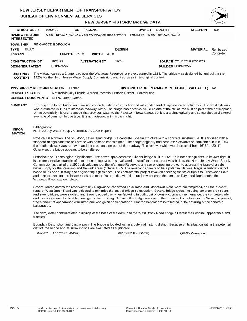
NEW JERSEY DEPARTMENT OF TRANSPORTATION
NEW JERSEY HISTORIC BRIDGE DATABUREAU OF ENVIRONMENTAL SERVICES
MILEPOINT 0.0CO PASSAICNAME & FEATURE INTERSECTED
WEST BROOK ROAD OVER WANAQUE RESERVOIR FACILITY WEST BROOK ROAD
TOWNSHIP RINGWOOD BOROUGH
OWNER COUNTY
CONSTRUCTION DT 1926-28 SOURCE COUNTY RECORDS
MATERIAL Reinforced Concrete
TYPE T BEAMLENGTH 505 ft WIDTH 20 ft# SPANS 7
DESIGNER/PATENT UNKNOWN
SETTING / CONTEXT
The viaduct carries a 2-lane road over the Wanaque Reservoir, a project started in 1923. The bridge was designed by and built in the 1920s for the North Jersey Water Supply Commission, and it survives in its original context.
1995 SURVEY RECOMMENDATION Eligible
PHOTO: 140:22-24 (04/92) REVISED BY (DATE):
DESIGN
BUILDER UNKNOWN
CONSULT STATUS Not Individually Eligible. Agreed Potential Historic District. Contributing.
QUAD: Wanaque
SUMMARY The 7-span T-beam bridge on a low rise concrete substructure is finished with a standard-design concrete balustrade. The west sidewalk was eliminated in 1974 to increase roadway width. The bridge has historical value as one of the structures built as part of the development of the potentially historic reservoir that provides water to the Paterson-Newark area, but it is a technologically undistinguished and altered example of common bridge type. It is not noteworthy in its own right.
STRUCTURE # 1600491
ALTERATION DT 1974
INFOR MATION
Bibliography:North Jersey Water Supply Commission. 1925 Report.
Physical Description: The 505'-long, seven span bridge is a concrete T-beam structure with a concrete substructure. It is finished with a standard-design concrete balustrade with paneled end sections. The bridge originally had concrete sidewalks on both sides, but in 1974 the south sidewalk was removed and the area became part of the roadway. The roadway width was increased from 16'-6" to 20'-1". Otherwise, the bridge appears to be unaltered.
Historical and Technological Significance: The seven-span concrete T-beam bridge built in 1926-27 is not distinguished in its own right. It is a representative example of a common bridge type. It is evaluated as significant because it was built by the North Jersey Water Supply Commission as part of the 1920s development of the Wanaque Reservoir, a major engineering project to address the issue of a safe water supply for the Paterson and Newark areas (criteria A, C). The reservoir appears to be a potential National Register historic district based on its social history and engineering significance. The controversial project involved securing the water rights to Greenwood Lake and then to planning to relocate roads and other features that would be under water once the concrete Raymond Dam across the Wanaque River was completed.
Several routes across the reservoir to link Ringwood/Greenwood Lake Road and Stonetown Road were contemplated, and the present route of West Brook Road was selected to minimize the cost of bridge construction. Several bridge types, including concrete arch spans and steel bridges, were studied, and it was decided that when factoring in both cost of construction and maintenance, the concrete girder and pier bridge was the best technology for the crossing. Because the bridge was one of the prominent structures in the Wanaque project, "the element of appearance warranted and was given consideration." That "consideration" is reflected in the detailing of the concrete balustrades.
The dam, water control-related buildings at the base of the dam, and the West Brook Road bridge all retain their original appearance and function.
Boundary Description and Justification: The bridge is located within a potential historic district. Because of its situation within the potential district, the bridge and its surroundings are evaluated as significant.
CONSULT DOCUMENTS SHPO Letter 6/30/95
HISTORIC BRIDGE MANAGEMENT PLAN ( EVALUATED ) No
Page 77 A. G. Lichtenstein & Associates, Inc. performed initial survery. NJDOT updated data 03-01-2001.
Correction Updates Etc should be sent to [email protected]
November 12 , 2002

NEW JERSEY DEPARTMENT OF TRANSPORTATION
NEW JERSEY HISTORIC BRIDGE DATABUREAU OF ENVIRONMENTAL SERVICES
MILEPOINT 0.0CO PASSAICNAME & FEATURE INTERSECTED
OLD LAKESIDE AVENUE OVER POSTS BROOK FACILITY OLD LAKESIDE AVENUE (GREENWOOD AVENUE)
TOWNSHIP WANAQUE BOROUGH
OWNER COUNTY
CONSTRUCTION DT 1920ca SOURCE STYLE/ORAL HISTORY
MATERIAL Reinforced Concrete
TYPE ARCHLENGTH 34 ft WIDTH 17.5 ft# SPANS 6
DESIGNER/PATENT UNKNOWN
SETTING / CONTEXT
The bridge carries pedestrian traffic over the spillway of manmade Rainbow Valley Lake, built in the mid-1920s as part of a subdivision. Development of the lakefront subdivision was halted by the Depression, and only about 20 houses had been built by 1942. The war again stopped building. After the war development was completed with modern ranch-type houses. The bridge is closed to vehicular traffic, which now is carried on New Lakeside Avenue located 500' to the west (1600146).
1995 SURVEY RECOMMENDATION Not Eligible
PHOTO: 138:35-39 (04/92) REVISED BY (DATE):
DESIGN BARREL
BUILDER E. J. RICKER
CONSULT STATUS Not Individually Eligible.
QUAD: Wanaque
SUMMARY The 34'-long 6-span reinforced concrete bridge is composed of 2 short arch spans flanked by 2-cell culverts with varying invert elevations. The abutments and wingwalls are also concrete. The bridge is not technologically distinguished. It was built a part of the development of a manmade lake and corresponding subdivision, but the area does not possess the architectural or historical significance to be evaluated as a potential historic district.
STRUCTURE # 1600502
ALTERATION DT
INFOR MATION
CONSULT DOCUMENTS SHPO Letter 6/30/95
HISTORIC BRIDGE MANAGEMENT PLAN ( EVALUATED ) No
Page 78 A. G. Lichtenstein & Associates, Inc. performed initial survery. NJDOT updated data 03-01-2001.
Correction Updates Etc should be sent to [email protected]
November 12 , 2002

NEW JERSEY DEPARTMENT OF TRANSPORTATION
NEW JERSEY HISTORIC BRIDGE DATABUREAU OF ENVIRONMENTAL SERVICES
MILEPOINT 0.0CO PASSAICNAME & FEATURE INTERSECTED
DAWES HIGHWAY OVER RAMAPO RIVER FACILITY DAWES HIGHWAY (COLFAX BRIDGE)
TOWNSHIP POMPTON LAKES BOROUGH
OWNER COUNTY
CONSTRUCTION DT 1928 SOURCE MORRIS CANAL RECORDS
MATERIAL Reinforced Concrete
TYPE DECK ARCHLENGTH 92 ft WIDTH 24.3 ft# SPANS 1
DESIGNER/PATENT CORNELIUS VERMEULE, CONS. ENG.
SETTING / CONTEXT
The bridge carries a 2-lane street and sidewalks over a river in a wooded residential area that dates to the 1960s. The Federal-style house adjacent to the bridge was reportedly moved to the site in the 1960s or 1970s. The span is one of several bridges built on state highways as part of the abandonment agreement of the Morris Canal, which was closed to navigation in 1924 and subsequently filled in many areas.
1995 SURVEY RECOMMENDATION Eligible
PHOTO: 139:10-14 (04/92 JPH (5/96)) REVISED BY (DATE):
DESIGN ELLIPTICAL
BUILDER WINSTON & CO., INC.
CONSULT STATUS Not Individually Eligible. Listed. Morris Canal. 10/01/1974. Contributing.
QUAD: Pompton Plains
SUMMARY The elliptical deck arch bridge with a vertical crest to the roadway and paneled parapets set between massive end posts is a late example of the bridge type. It was built in 1928 as part of the 1924-28 Morris Canal abandonment that was designed and directed by consulting engineer C. Vermeule. Closing the 88-mile long canal involved filling most of the canal and buildings some bridges, culverts, and dams. This span is one of the major bridges, and it crosses a river used for canal navigation. The bridge is not individually eligible for listing in the National Register, but is a contributing element of the Morris Canal Historic District eligible under Criteria A and C.
STRUCTURE # 1600503
ALTERATION DT
INFOR MATION
Bibliography:Vermeule, C., Jr. Morris Canal and Banking Company Final Report of Consulting and Directing Engineer. 1929.
Physical Description: The well-proportioned 92'-long reinforced concrete deck arch bridge with a vertical profile is detailed with massive end posts that mark the limits of the clear span. They are paneled to match those used to give scale to the concrete parapets. The approaches are marked by a similar paneled parapets. The bridge appears to be unaltered.
Historical and Technological Significance: Built in 1928 as part of the of the Morris Canal abandonment, the reinforced concrete deck arch bridge is historically significant because of its association with the abandonment campaign. The ambitious abandonment was designed and directed by Cornelius C. Vermeule, a consulting engineer from East Orange, New Jersey who was hired by the Morris Canal and Banking Company board of directors. The project closed and disposed of the 88-mile long right-of-way and all the structures related to the canal that was completed in 1824 between Phillipsburg and Elizabeth and later Jersey City.
Under an 1836 agreement with Revolutionary war officer William Colfax, the Morris Canal and Banking Company built and maintained a bridge near this crossing. The Ramapo River was canalized for navigation at this point. When it became necessary to replace the narrow, wooden bridge with a permanent structure as part of the abandonment, the residents requested that the new bridge be located downstream so that approaches and roadway width could be improved. Passaic County contributed $11,500. to the building of the new span, and construction began in 1928. Thus the 1928 span, known as the Colfax Bridge, stands as witness to the canal that was one of the important early transportation networks in the state. Although the bridge is not original to the canal, it is one of the major structures built as part of the elimination of the canal and is thus historically linked to one of the significant engineering feats in the state (criterion A). The bridge is not technologically distinguished, but it is significant for its association with the history of the Morris Canal and the statewide improvement campaign to remove it. The Colfax Bridge is one of seven that were built under the abandonment campaign.
Boundary Description and Justification: The bridge is evaluated as significant because of its historical association with the Morris Canal and the abandonment campaign. The canal right-of-way, which is the river at this location, was listed in the National Register 10/1/74, but none of the structures that intersect the historic right-of-way were addressed in the nomination. The boundary of this resource is limited to the structure itself. It should be noted that this bridge is not on the location of the historic one it replaced. The original crossing is upstream from this span.
CONSULT DOCUMENTS SHPO Letter 03/12/01
HISTORIC BRIDGE MANAGEMENT PLAN ( EVALUATED ) No
Page 79 A. G. Lichtenstein & Associates, Inc. performed initial survery. NJDOT updated data 03-01-2001.
Correction Updates Etc should be sent to [email protected]
November 12 , 2002

NEW JERSEY DEPARTMENT OF TRANSPORTATION
NEW JERSEY HISTORIC BRIDGE DATABUREAU OF ENVIRONMENTAL SERVICES
MILEPOINT 1.25CO PASSAICNAME & FEATURE INTERSECTED
NJ 3 OVER BROAD STREET (CR 509) FACILITY NJ 3
TOWNSHIP CLIFTON CITY
OWNER NJDOT
CONSTRUCTION DT 1945 SOURCE
MATERIAL SteelTYPE STRINGERLENGTH 101 ft WIDTH 126 ft# SPANS 2
DESIGNER/PATENT NJ STATE HWY DEPT BRIDGE DIV
SETTING / CONTEXT
The bridge carries a divided 8-lane state highway over a divided county road in a residential area of Clifton that is dominated by single-family mid-20th century houses.
1995 SURVEY RECOMMENDATION Not Eligible
PHOTO: 131:18-19 (04/92) REVISED BY (DATE):
DESIGN PARTIALLY ENCASED
BUILDER
CONSULT STATUS Not Individually Eligible.
QUAD: Orange
SUMMARY Built in 1945 as a grade crossing elimination, the encased stringer span on concrete abutments and column bents was widened on both sides with stringers on concrete abutment and pier extensions in 1959. The concrete parapets with pipe railings were placed at that time. An altered example of the most common pre-1946 bridge type in the state, the span is neither historically nor technologically distinguished.
STRUCTURE # 1601151
ALTERATION DT 1959
INFOR MATION
CONSULT DOCUMENTS SHPO Letter 6/30/95
HISTORIC BRIDGE MANAGEMENT PLAN ( EVALUATED ) No
Page 80 A. G. Lichtenstein & Associates, Inc. performed initial survery. NJDOT updated data 03-01-2001.
Correction Updates Etc should be sent to [email protected]
November 12 , 2002

NEW JERSEY DEPARTMENT OF TRANSPORTATION
NEW JERSEY HISTORIC BRIDGE DATABUREAU OF ENVIRONMENTAL SERVICES
MILEPOINT 0.0CO PASSAICNAME & FEATURE INTERSECTED
BARCLAY STREET OVER RAILROAD RELIEF FACILITY BARCLAY STREET
TOWNSHIP PATERSON CITY
OWNER CITY
CONSTRUCTION DT 1927 SOURCE PLAQUE
MATERIAL SteelTYPE THRU GIRDERLENGTH 329 ft WIDTH 30 ft# SPANS 1
DESIGNER/PATENT DL&W RR OFF. OF CHIEF ENGINEER
SETTING / CONTEXT
The viaduct carries a 2-lane street and sidewalks over an abandoned railroad right-of-way and a vehicle storage area. Located in an older mixed-use (residential and neighborhood commercial) area of Paterson, the west end of the bridge is contiguous to and was altered to accommodate an entrance ramp to NJ 19.
1995 SURVEY RECOMMENDATION Not Eligible
PHOTO: 134:33-39 (04/92) REVISED BY (DATE):
DESIGN ENCASED
BUILDER AMERICAN BRIDGE COMPANY
CONSULT STATUS Not Individually Eligible.
QUAD: Paterson
SUMMARY The skewed viaduct is composed of 13 slab approach spans and a 75' thru girder with encased floor beams main span, all supported on a concrete substructure with stub abutments and column bents. The sidewalks, enclosed with standard-design DL&WRR parapets, are cantilevered. Some Neo-Classical light standards remain. The west end was altered in 1964 when 2 approach spans were removed and replaced with a short slab span to accommodate an intersection. The span is not historically distinguished.
STRUCTURE # 1601461
ALTERATION DT 1964
INFOR MATION
CONSULT DOCUMENTS SHPO Letter 6/30/95
HISTORIC BRIDGE MANAGEMENT PLAN ( EVALUATED ) No
Page 81 A. G. Lichtenstein & Associates, Inc. performed initial survery. NJDOT updated data 03-01-2001.
Correction Updates Etc should be sent to [email protected]
November 12 , 2002

NEW JERSEY DEPARTMENT OF TRANSPORTATION
NEW JERSEY HISTORIC BRIDGE DATABUREAU OF ENVIRONMENTAL SERVICES
MILEPOINT 18.81CO PASSAICNAME & FEATURE INTERSECTED
NEW YORK SUSQUEHANNA & WESTERN RR OVER NJ 20
FACILITY NEW YORK SUSQUEHANNA & WESTERN RR
TOWNSHIP PATERSON CITY
OWNER RAILROAD
CONSTRUCTION DT 1937 SOURCE INSCRIPTION
MATERIAL SteelTYPE DECK GIRDERLENGTH 94 ft WIDTH 27 ft# SPANS 2
DESIGNER/PATENT
SETTING / CONTEXT
The bridge carries two active tracks over a divided 6-lane highway through an industrial area with modern bulk processing facilities and some commercial establishments. The right-of-way was initially developed in the late 1860s as the New Jersey Midland Railway, a conglomerate of local lines, and became part of the New York Susquehanna & Western about 1875. The line was double-tracked by 1887. The line was leased to the Erie Railroad in 1898, but separated in 1940.
1995 SURVEY RECOMMENDATION Not Eligible
PHOTO: 141:8-9 (04/92) REVISED BY (DATE):
DESIGN
BUILDER
CONSULT STATUS Not Individually Eligible.
QUAD: Paterson
SUMMARY The 2-span built up thru girder with floor beams and ballasted deck span is supported on concrete abutments with tapered wingwalls and a center pier bent. A channel has been attached to the top flange of the three girders that make up the bridge. A representative example of a common bridge type, the span is neither historically nor technologically distinguished. The thru girder was used by railroads for grade crossing elimination in New Jersey since the 1890s.
STRUCTURE # 1602150
ALTERATION DT
INFOR MATION
CONSULT DOCUMENTS SHPO Letter 6/30/95
HISTORIC BRIDGE MANAGEMENT PLAN ( EVALUATED ) No
Page 82 A. G. Lichtenstein & Associates, Inc. performed initial survery. NJDOT updated data 03-01-2001.
Correction Updates Etc should be sent to [email protected]
November 12 , 2002

NEW JERSEY DEPARTMENT OF TRANSPORTATION
NEW JERSEY HISTORIC BRIDGE DATABUREAU OF ENVIRONMENTAL SERVICES
MILEPOINT 4.52CO PASSAICNAME & FEATURE INTERSECTED
NJ 23 OVER PASSAIC RIVER FACILITY NJ 23
TOWNSHIP LITTLE FALLS TOWNSHIP
OWNER NJDOT
CONSTRUCTION DT 1916 SOURCE NJDOT RECORDS
MATERIAL Reinforced Concrete
TYPE DECK ARCHLENGTH 303 ft WIDTH 44 ft# SPANS 3
DESIGNER/PATENT H. RAFF, CONSULT.ENG. (1916)
SETTING / CONTEXT
The bridge carries a 4-lane state highway and sidewalks over the Passaic River in the commercial district of Singac. Buildings from the early-20th century through the present are in the vicinity.
1995 SURVEY RECOMMENDATION Not Eligible
PHOTO: 135:6-7 (04/92) REVISED BY (DATE):
DESIGN ELLIPTICAL
BUILDER UNKNOWN
CONSULT STATUS Not Individually Eligible.
QUAD: Paterson
SUMMARY The 3-span concrete deck arch bridge originally built by the county in 1916 has been altered several times by the state. The original classical balustrade was removed when the state widened the span by 4' on each side in 1923. It was widened again by extending the cantilevered sections in 1990. The modern parapets presently in place date to the 1990 widening. The bridge is not an early example of its type in the county, nor is it well preserved. It is not technologically distinguished.
STRUCTURE # 1604150
ALTERATION DT 1923, 1990
INFOR MATION
CONSULT DOCUMENTS SHPO Letter 6/30/95
HISTORIC BRIDGE MANAGEMENT PLAN ( EVALUATED ) No
Page 83 A. G. Lichtenstein & Associates, Inc. performed initial survery. NJDOT updated data 03-01-2001.
Correction Updates Etc should be sent to [email protected]
November 12 , 2002
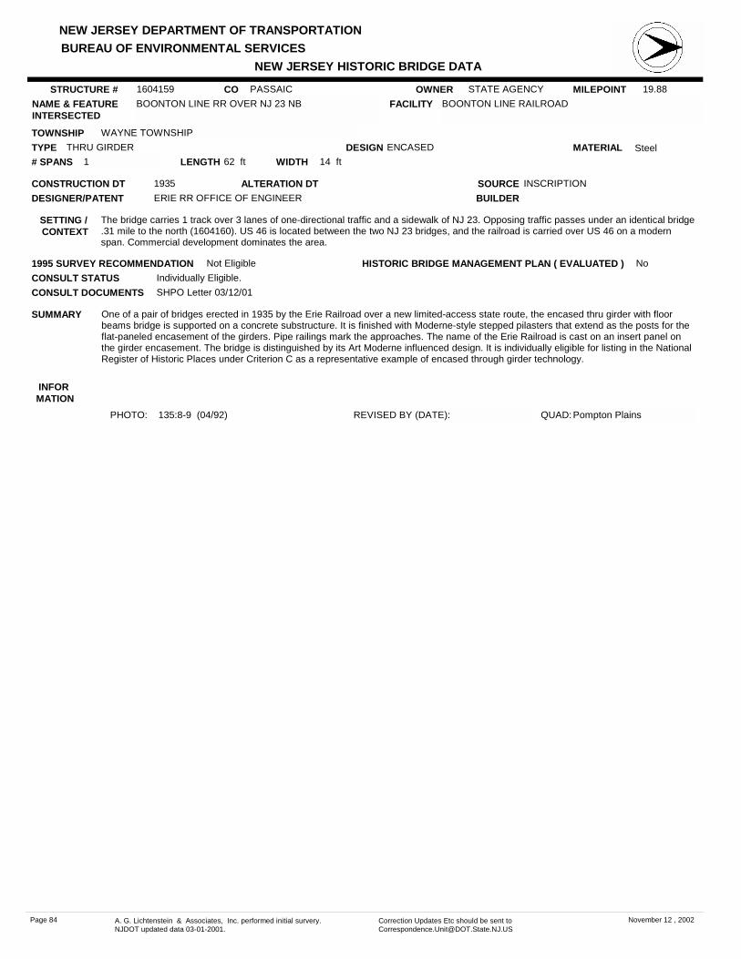
NEW JERSEY DEPARTMENT OF TRANSPORTATION
NEW JERSEY HISTORIC BRIDGE DATABUREAU OF ENVIRONMENTAL SERVICES
MILEPOINT 19.88CO PASSAICNAME & FEATURE INTERSECTED
BOONTON LINE RR OVER NJ 23 NB FACILITY BOONTON LINE RAILROAD
TOWNSHIP WAYNE TOWNSHIP
OWNER STATE AGENCY
CONSTRUCTION DT 1935 SOURCE INSCRIPTION
MATERIAL SteelTYPE THRU GIRDERLENGTH 62 ft WIDTH 14 ft# SPANS 1
DESIGNER/PATENT ERIE RR OFFICE OF ENGINEER
SETTING / CONTEXT
The bridge carries 1 track over 3 lanes of one-directional traffic and a sidewalk of NJ 23. Opposing traffic passes under an identical bridge .31 mile to the north (1604160). US 46 is located between the two NJ 23 bridges, and the railroad is carried over US 46 on a modern span. Commercial development dominates the area.
1995 SURVEY RECOMMENDATION Not Eligible
PHOTO: 135:8-9 (04/92) REVISED BY (DATE):
DESIGN ENCASED
BUILDER
CONSULT STATUS Individually Eligible.
QUAD: Pompton Plains
SUMMARY One of a pair of bridges erected in 1935 by the Erie Railroad over a new limited-access state route, the encased thru girder with floor beams bridge is supported on a concrete substructure. It is finished with Moderne-style stepped pilasters that extend as the posts for the flat-paneled encasement of the girders. Pipe railings mark the approaches. The name of the Erie Railroad is cast on an insert panel on the girder encasement. The bridge is distinguished by its Art Moderne influenced design. It is individually eligible for listing in the National Register of Historic Places under Criterion C as a representative example of encased through girder technology.
STRUCTURE # 1604159
ALTERATION DT
INFOR MATION
CONSULT DOCUMENTS SHPO Letter 03/12/01
HISTORIC BRIDGE MANAGEMENT PLAN ( EVALUATED ) No
Page 84 A. G. Lichtenstein & Associates, Inc. performed initial survery. NJDOT updated data 03-01-2001.
Correction Updates Etc should be sent to [email protected]
November 12 , 2002

NEW JERSEY DEPARTMENT OF TRANSPORTATION
NEW JERSEY HISTORIC BRIDGE DATABUREAU OF ENVIRONMENTAL SERVICES
MILEPOINT 19.95CO PASSAICNAME & FEATURE INTERSECTED
BOONTON LINE RR OVER NJ 23 SB FACILITY BOONTON LINE RAILROAD
TOWNSHIP WAYNE TOWNSHIP
OWNER STATE AGENCY
CONSTRUCTION DT 1935 SOURCE INSCRIPTION
MATERIAL SteelTYPE THRU GIRDERLENGTH 60 ft WIDTH 14 ft# SPANS 1
DESIGNER/PATENT ERIE RR OFFICE OF ENGINEER
SETTING / CONTEXT
The bridge carries one active railroad track over two lanes of one-directional traffic and one sidewalk in an area dominated by mid-to late-20th century commercial development. Opposing traffic passes under an identical span 400' to the south (1604159). The area between the NJ 23 bridges is filled by US 46 which is crossed by the railroad on a modern bridge.
1995 SURVEY RECOMMENDATION Not Eligible
PHOTO: 135:10-11 (04/92) REVISED BY (DATE):
DESIGN ENCASED
BUILDER UNKNOWN
CONSULT STATUS Individually Eligible.
QUAD: Pompton Plains
SUMMARY One of a pair of bridges erected in 1935 by the Erie Railroad over a new limited-access state route, the encased thru girder with floor beams bridge is supported on a concrete substructure. It is finished with Moderne-style stepped pilasters that extend as the posts for the flat-paneled encasement of the girders. Pipe railings mark the approaches. The name of the Erie Railroad is cast on an insert panel on the girder encasement. The bridge is distinguished by its Art Moderne influenced design. It is individually eligible for listing in the National Register of Historic Places under Criterion C as a representative example of encased through girder technology.
STRUCTURE # 1604160
ALTERATION DT
INFOR MATION
CONSULT DOCUMENTS SHPO Letter 03/12/01
HISTORIC BRIDGE MANAGEMENT PLAN ( EVALUATED ) No
Page 85 A. G. Lichtenstein & Associates, Inc. performed initial survery. NJDOT updated data 03-01-2001.
Correction Updates Etc should be sent to [email protected]
November 12 , 2002

NEW JERSEY DEPARTMENT OF TRANSPORTATION
NEW JERSEY HISTORIC BRIDGE DATABUREAU OF ENVIRONMENTAL SERVICES
MILEPOINT 21.95CO PASSAICNAME & FEATURE INTERSECTED
NJ 23 SB OVER PEQUANNOCK RIVER FACILITY NJ 23 SOUTHBOUND
TOWNSHIP WEST MILFORD TOWNSHIP
OWNER NJDOT
CONSTRUCTION DT 1924 SOURCE INSCRIPTION
MATERIAL SteelTYPE STRINGERLENGTH 104 ft WIDTH 30 ft# SPANS 2
DESIGNER/PATENT NJ STATE HWY DEPT BRIDGE DIV
SETTING / CONTEXT
The bridge carries two lanes of one-directional traffic over a meandering river in a wooded setting dominated by modern commercial development. Opposing traffic is carried over the same feature on a bridge built after 1947. The two spans are separated by a wide grassy and wooded median.
1995 SURVEY RECOMMENDATION Not Eligible
PHOTO: 140:8-9 (04/92) REVISED BY (DATE):
DESIGN ENCASED
BUILDER
CONSULT STATUS Not Individually Eligible.
QUAD: Newfoundland
SUMMARY The 2-span encased stringer bridge is supported on a concrete substructure with horizontal scoring. A low-standard-design balustrade frames the bridge, and modern beam guide rail has been attached to the inner face. The bridge is a representative example of a common bridge type of which there are over 50 examples built between 1904 and 1945 in Passaic County alone. It is neither historically nor technologically distinguished.
STRUCTURE # 1605161
ALTERATION DT
INFOR MATION
CONSULT DOCUMENTS SHPO Finding 4/10/90
HISTORIC BRIDGE MANAGEMENT PLAN ( EVALUATED ) No
Page 86 A. G. Lichtenstein & Associates, Inc. performed initial survery. NJDOT updated data 03-01-2001.
Correction Updates Etc should be sent to [email protected]
November 12 , 2002
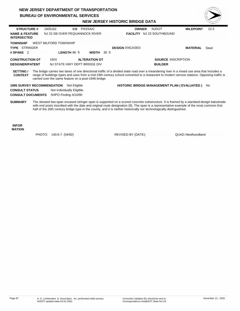
NEW JERSEY DEPARTMENT OF TRANSPORTATION
NEW JERSEY HISTORIC BRIDGE DATABUREAU OF ENVIRONMENTAL SERVICES
MILEPOINT 22.5CO PASSAICNAME & FEATURE INTERSECTED
NJ 23 SB OVER PEQUANNOCK RIVER FACILITY NJ 23 SOUTHBOUND
TOWNSHIP WEST MILFORD TOWNSHIP
OWNER NJDOT
CONSTRUCTION DT 1924 SOURCE INSCRIPTION
MATERIAL SteelTYPE STRINGERLENGTH 86 ft WIDTH 30 ft# SPANS 2
DESIGNER/PATENT NJ STATE HWY DEPT BRIDGE DIV
SETTING / CONTEXT
The bridge carries two lanes of one directional traffic of a divided state road over a meandering river in a mixed use area that includes a range of buildings types and uses from a mid-19th century school converted to a restaurant to modern service stations. Opposing traffic is carried over the same feature on a post-1946 bridge.
1995 SURVEY RECOMMENDATION Not Eligible
PHOTO: 140:6-7 (04/92) REVISED BY (DATE):
DESIGN ENCASED
BUILDER
CONSULT STATUS Not Individually Eligible.
QUAD: Newfoundland
SUMMARY The skewed two-span encased stringer span is supported on a scored concrete substructure. It is framed by a standard-design balustrade with end posts inscribed with the date and original route designation (8). The span is a representative example of the most common first half of the 20th century bridge type in the county, and it is neither historically nor technologically distinguished.
STRUCTURE # 1605162
ALTERATION DT
INFOR MATION
CONSULT DOCUMENTS SHPO Finding 4/10/90
HISTORIC BRIDGE MANAGEMENT PLAN ( EVALUATED ) No
Page 87 A. G. Lichtenstein & Associates, Inc. performed initial survery. NJDOT updated data 03-01-2001.
Correction Updates Etc should be sent to [email protected]
November 12 , 2002

NEW JERSEY DEPARTMENT OF TRANSPORTATION
NEW JERSEY HISTORIC BRIDGE DATABUREAU OF ENVIRONMENTAL SERVICES
MILEPOINT 57.9CO PASSAICNAME & FEATURE INTERSECTED
US 46 OVER PASSAIC RIVER & RIVERVIEW DRIVE FACILITY US 46
TOWNSHIP LITTLE FALLS TOWNSHIP
OWNER NJDOT
CONSTRUCTION DT 1939 SOURCE INSCRIPTION
MATERIAL Reinforced Concrete
TYPE OPEN SPANDREL RIBBED ARCHLENGTH 476 ft WIDTH 92 ft# SPANS 5
DESIGNER/PATENT NJ STATE HWY DEPT BRIDGE DIV
SETTING / CONTEXT
The bridge carries a divided 6-lane state road over the Passaic River and a 2-lane local street. The highway is lined with modern commercial establishments.
1995 SURVEY RECOMMENDATION Eligible
PHOTO: 143:8-12 (04/92) REVISED BY (DATE):
DESIGN ELLIPTICAL
BUILDER BATES & ROGERS CONTRTORS, NYC
CONSULT STATUS Individually Eligible.
QUAD: Paterson
SUMMARY The 5-span open spandrel ribbed arch bridge, one of 10 designed between 1929 and 1939 by the bridge division under the direction of Morris Goodkind, is a large and well preserved example of the technologically noteworthy bridge type. They combine economy of material with great elegance and were selected by the state for highly visible large crossings. The bridge is an important example of its type.
STRUCTURE # 1606158
ALTERATION DT
INFOR MATION
CONSULT DOCUMENTS SHPO Finding 02/08/90 02/21/97, Letter 6/30/95.
HISTORIC BRIDGE MANAGEMENT PLAN ( EVALUATED ) Yes
Page 88 A. G. Lichtenstein & Associates, Inc. performed initial survery. NJDOT updated data 03-01-2001.
Correction Updates Etc should be sent to [email protected]
November 12 , 2002

NEW JERSEY DEPARTMENT OF TRANSPORTATION
NEW JERSEY HISTORIC BRIDGE DATABUREAU OF ENVIRONMENTAL SERVICES
MILEPOINT 58.05CO PASSAICNAME & FEATURE INTERSECTED
US 46 OVER MCBRIDE AVENUE FACILITY US 46
TOWNSHIP LITTLE FALLS TOWNSHIP
OWNER NJDOT
CONSTRUCTION DT 1939 SOURCE INSCRIPTION
MATERIAL SteelTYPE STRINGERLENGTH 65 ft WIDTH 90 ft# SPANS 1
DESIGNER/PATENT NJ STATE HWY DEPT BRIDGE DIV
SETTING / CONTEXT
The bridge carries a divided 6-lane, limited access state road over a two-lane local street and sidewalks. The highway is lined with modern commercial establishments. The local street has access ramps to the state road. The route was designated as State Route 6 in 1939.
1995 SURVEY RECOMMENDATION Not Eligible
PHOTO: 143:6-7 (04/92) REVISED BY (DATE):
DESIGN ENCASED
BUILDER
CONSULT STATUS Not Individually Eligible.
QUAD: Paterson
SUMMARY The encased stringer bridge is supported on a scored concrete substructure articulated with shallow pilasters and inset lights. The concrete balustrade with some inkind replacement sections is a standard design of the period. The bridge is a representative example of the most common pre-World War II bridge type in the state, and it is not historically nor technologically distinguished.
STRUCTURE # 1606159
ALTERATION DT
INFOR MATION
CONSULT DOCUMENTS SHPO Letter 6/30/95, Finding 2/21/97.
HISTORIC BRIDGE MANAGEMENT PLAN ( EVALUATED ) No
Page 89 A. G. Lichtenstein & Associates, Inc. performed initial survery. NJDOT updated data 03-01-2001.
Correction Updates Etc should be sent to [email protected]
November 12 , 2002

NEW JERSEY DEPARTMENT OF TRANSPORTATION
NEW JERSEY HISTORIC BRIDGE DATABUREAU OF ENVIRONMENTAL SERVICES
MILEPOINT 58.3CO PASSAICNAME & FEATURE INTERSECTED
US 46 OVER PECKMAN RIVER FACILITY US 46
TOWNSHIP LITTLE FALLS TOWNSHIP
OWNER NJDOT
CONSTRUCTION DT 1939 SOURCE INSCRIPTION
MATERIAL SteelTYPE STRINGERLENGTH 52 ft WIDTH 114 ft# SPANS 1
DESIGNER/PATENT NJ STATE HWY DEPT BRIDGE DIV
SETTING / CONTEXT
The bridge carries a barrier-divided 6-lane state road and sidewalks over a minor stream through a commercial and industrial area. The state road is limited access.
1995 SURVEY RECOMMENDATION Not Eligible
PHOTO: 143:4-5 (04/92) REVISED BY (DATE):
DESIGN ENCASED
BUILDER
CONSULT STATUS Not Individually Eligible.
QUAD: Paterson
SUMMARY The skewed encased stringer bridge is supported on concrete abutments with wingwalls. The standard-design balustrade is set between paneled posts, and the end ones are incised with the date of construction and original route designation (6). The northwest end post is a replacement. A representative example of the most common state-designed bridge from the era between the two world wars, the span is neither historically nor technologically distinguished.
STRUCTURE # 1606160
ALTERATION DT
INFOR MATION
CONSULT DOCUMENTS SHPO Letter 6/30/95, Finding 2/21/97.
HISTORIC BRIDGE MANAGEMENT PLAN ( EVALUATED ) No
Page 90 A. G. Lichtenstein & Associates, Inc. performed initial survery. NJDOT updated data 03-01-2001.
Correction Updates Etc should be sent to [email protected]
November 12 , 2002

NEW JERSEY DEPARTMENT OF TRANSPORTATION
NEW JERSEY HISTORIC BRIDGE DATABUREAU OF ENVIRONMENTAL SERVICES
MILEPOINT 58.7CO PASSAICNAME & FEATURE INTERSECTED
US 46 OVER BROWERTOWN ROAD FACILITY US 46
TOWNSHIP LITTLE FALLS TOWNSHIP
OWNER NJDOT
CONSTRUCTION DT 1939 SOURCE INSCRIPTION
MATERIAL SteelTYPE STRINGERLENGTH 51 ft WIDTH 116 ft# SPANS 1
DESIGNER/PATENT NJ STATE HWY DEPT BRIDGE DIV
SETTING / CONTEXT
The bridge carries a barrier-divided, 6-lane state highway over a 2-lane street. The state highway is lined with modern commercial establishments while the local street is a mix of commercial and residential uses.
1995 SURVEY RECOMMENDATION Not Eligible
PHOTO: 143:44-1 (04/92) REVISED BY (DATE):
DESIGN ENCASED
BUILDER
CONSULT STATUS Not Individually Eligible.
QUAD: Paterson
SUMMARY The encased stringer bridge is supported on vertically scored concrete abutments articulated with shallow panels and retaining the original inset round lights. The concrete balustrades are a standard state design of the period, and the paneled end posts are have inset faience tile letters identifying the date and route (6). The bridge is a representative example of the most common pre-World War II type in the state, and it is not historically nor technologically distinguished.
STRUCTURE # 1606163
ALTERATION DT
INFOR MATION
CONSULT DOCUMENTS SHPO Letter 6/30/95, Finding 2/21/97.
HISTORIC BRIDGE MANAGEMENT PLAN ( EVALUATED ) No
Page 91 A. G. Lichtenstein & Associates, Inc. performed initial survery. NJDOT updated data 03-01-2001.
Correction Updates Etc should be sent to [email protected]
November 12 , 2002

NEW JERSEY DEPARTMENT OF TRANSPORTATION
NEW JERSEY HISTORIC BRIDGE DATABUREAU OF ENVIRONMENTAL SERVICES
MILEPOINT 59.06CO PASSAICNAME & FEATURE INTERSECTED
US 46 OVER LOWER NOTCH ROAD FACILITY US 46
TOWNSHIP LITTLE FALLS TOWNSHIP
OWNER NJDOT
CONSTRUCTION DT 1939 SOURCE INSCRIPTION
MATERIAL SteelTYPE STRINGERLENGTH 52 ft WIDTH 116 ft# SPANS 1
DESIGNER/PATENT NJ STATE HWY DEPT BRIDGE DIV
SETTING / CONTEXT
The bridge carries a barrier-divided, 6-lane limited access highway over a 2-lane local street. The highway is lined with modern commercial establishments while the local street is in a wooded 20th-century residential area.
1995 SURVEY RECOMMENDATION Not Eligible
PHOTO: 143:2-3 (04/92) REVISED BY (DATE):
DESIGN ENCASED
BUILDER
CONSULT STATUS Not Individually Eligible.
QUAD: Paterson
SUMMARY The encased stringer span is supported on concrete abutments articulated with shallow panels and retaining the original inset round lights openings (luminaries removed). It is finished with standard-design concrete balustrades that have end posts with faience tile characters of the date and route designation (6). The bridge is a representative example of the most common pre-World War II type in the state, and it not historically nor technologically distinguished.
STRUCTURE # 1606165
ALTERATION DT
INFOR MATION
CONSULT DOCUMENTS SHPO Letter 6/30/95, Finding 2/21/97.
HISTORIC BRIDGE MANAGEMENT PLAN ( EVALUATED ) No
Page 92 A. G. Lichtenstein & Associates, Inc. performed initial survery. NJDOT updated data 03-01-2001.
Correction Updates Etc should be sent to [email protected]
November 12 , 2002

NEW JERSEY DEPARTMENT OF TRANSPORTATION
NEW JERSEY HISTORIC BRIDGE DATABUREAU OF ENVIRONMENTAL SERVICES
MILEPOINT 0.0CO PASSAICNAME & FEATURE INTERSECTED
RIFLE CAMP ROAD OVER US 46 FACILITY RIFLE CAMP ROAD
TOWNSHIP WEST PATERSON BOROUGH
OWNER NJDOT
CONSTRUCTION DT 1939 SOURCE INSCRIPTION
MATERIAL SteelTYPE STRINGERLENGTH 102 ft WIDTH 42 ft# SPANS 2
DESIGNER/PATENT NJ STATE HWY DEPT BRIDGE DIV
SETTING / CONTEXT
The bridge carries a two-lane road and sidewalks over a barrier divided, 6-lane limited access highway with grass sidewalks. The highway is lined with modern commercial establishments while the road is in a lightly wooded residential district.
1995 SURVEY RECOMMENDATION Not Eligible
PHOTO: 143:43 (04/92) REVISED BY (DATE):
DESIGN ENCASED
BUILDER
CONSULT STATUS Not Individually Eligible.
QUAD: Paterson
SUMMARY The 2-span encased stringer bridge is supported on a concrete substructure. The abutments are articulated with shallow panels with recessed lighting (luminaries removed), and the tapered wingwalls are scored. The bridge is finished with standard-design concrete balustrades. The end posts have faience tile characters identifying the date and route designation (6). Although unaltered, the bridge is a representative example of a common pre-1942 type in the state and is not technologically notable.
STRUCTURE # 1606167
ALTERATION DT
INFOR MATION
CONSULT DOCUMENTS SHPO Letter 6/30/95, Finding 2/21/97.
HISTORIC BRIDGE MANAGEMENT PLAN ( EVALUATED ) No
Page 93 A. G. Lichtenstein & Associates, Inc. performed initial survery. NJDOT updated data 03-01-2001.
Correction Updates Etc should be sent to [email protected]
November 12 , 2002

NEW JERSEY DEPARTMENT OF TRANSPORTATION
NEW JERSEY HISTORIC BRIDGE DATABUREAU OF ENVIRONMENTAL SERVICES
MILEPOINT 60.05CO PASSAICNAME & FEATURE INTERSECTED
US 46 OVER VALLEY ROAD FACILITY US 46
TOWNSHIP CLIFTON CITY
OWNER NJDOT
CONSTRUCTION DT 1939 SOURCE INSCRIPTION
MATERIAL SteelTYPE STRINGERLENGTH 75 ft WIDTH 109 ft# SPANS 2
DESIGNER/PATENT NJ STATE HWY DEPT BRIDGE DIV
SETTING / CONTEXT
The bridge carries a barrier-divided, 6-lane, limited access highway over a 4 -lane road in a mixed use modern commercial and residential area.
1995 SURVEY RECOMMENDATION Not Eligible
PHOTO: 142:22-23 (04/92) REVISED BY (DATE):
DESIGN ENCASED
BUILDER
CONSULT STATUS Not Individually Eligible.
QUAD: Orange
SUMMARY The 2-span encased stringer bridge is supported on concrete substructure. The abutments have shallow panels and round lights (luminaries removed). The bridge is framed by standard-design concrete balustrades with end posts that are extensions of the corner pilasters of the abutments. The span is a representative example of the most common pre-1945 bridge type in the state. It is neither historically nor technologically distinguished.
STRUCTURE # 1606172
ALTERATION DT
INFOR MATION
CONSULT DOCUMENTS SHPO Letter 6/30/95, Finding 2/21/97.
HISTORIC BRIDGE MANAGEMENT PLAN ( EVALUATED ) No
Page 94 A. G. Lichtenstein & Associates, Inc. performed initial survery. NJDOT updated data 03-01-2001.
Correction Updates Etc should be sent to [email protected]
November 12 , 2002

NEW JERSEY DEPARTMENT OF TRANSPORTATION
NEW JERSEY HISTORIC BRIDGE DATABUREAU OF ENVIRONMENTAL SERVICES
MILEPOINT 60.19CO PASSAICNAME & FEATURE INTERSECTED
US 46 OVER NJ 3 WB FACILITY US 46
TOWNSHIP CLIFTON CITY
OWNER NJDOT
CONSTRUCTION DT 1939 SOURCE INSCRIPTION
MATERIAL SteelTYPE STRINGERLENGTH 72 ft WIDTH 58 ft# SPANS 1
DESIGNER/PATENT NJ STATE HWY DEPT BRIDGE DIV
SETTING / CONTEXT
The bridge carries a guide rail-divided, 4-lane, limited access highway and narrow sidewalks over two lanes of one directional (westbound) traffic of another state highway. The interchange was built as part of the a road improvement campaign to ease access to the Lincoln Tunnel, opened in 1938. The highways pass through mixed use areas with a predominance of modern commercial establishments.
1995 SURVEY RECOMMENDATION Not Eligible
PHOTO: 142:20-21 (04/92) REVISED BY (DATE):
DESIGN ENCASED
BUILDER
CONSULT STATUS Not Individually Eligible.
QUAD: Orange
SUMMARY Built as part of a breakout of a new short route to help access the Lincoln Tunnel, the skewed, encased stringer bridge is supported on concrete abutments accented with shallow panels and corner pilasters. The standard-design balustrades have paneled posts. The bridge is not technologically distinguished, and the interchange of which it is a part is not innovative or historically noteworthy. It is a typical state design solution to common traffic engineering problems in northern New Jersey.
STRUCTURE # 1607151
ALTERATION DT
INFOR MATION
CONSULT DOCUMENTS SHPO Letter 6/30/95, Finding 2/21/97.
HISTORIC BRIDGE MANAGEMENT PLAN ( EVALUATED ) No
Page 95 A. G. Lichtenstein & Associates, Inc. performed initial survery. NJDOT updated data 03-01-2001.
Correction Updates Etc should be sent to [email protected]
November 12 , 2002

NEW JERSEY DEPARTMENT OF TRANSPORTATION
NEW JERSEY HISTORIC BRIDGE DATABUREAU OF ENVIRONMENTAL SERVICES
MILEPOINT 0.0CO PASSAICNAME & FEATURE INTERSECTED
VAN HOUTEN AVENUE OVER US 46 FACILITY VAN HOUTEN AVENUE
TOWNSHIP CLIFTON CITY
OWNER NJDOT
CONSTRUCTION DT 1939 SOURCE INSCRIPTION
MATERIAL SteelTYPE STRINGERLENGTH 82 ft WIDTH 40 ft# SPANS 2
DESIGNER/PATENT NJ STATE HWY DEPT BRIDGE DIV
SETTING / CONTEXT
The bridge carries a 2-lane street with shoulders and narrow sidewalks over a four-lane, median-divided, limited access highway and narrow sidewalks in Clifton. An access ramp to US 46 WB is at the south end of the overpass. The surrounding area is dominated by mid-20th century residential development and a school. US 46 was developed initially after 1927 as Rt 6 linking the Ben Franklin and George Washington bridges. This section was upgraded in 1939.
1995 SURVEY RECOMMENDATION Not Eligible
PHOTO: 135:5,427:7-9 (04/92) REVISED BY (DATE):
DESIGN ENCASED
BUILDER
CONSULT STATUS Not Individually Eligible.
QUAD: Orange
SUMMARY The 2-span encased stringer bridge is supported on concrete abutments accented with shallow panels and a central concrete octagonal-column bent. The bridge is finished with standard-design concrete balustrades with paneled posts, and the abutments have shallow corner pilasters. The bridge is a typical of the 1930s State Highway Department spans and is neither historically nor technologically distinguished. It is a representative example of a very common bridge type and design.
STRUCTURE # 1607152
ALTERATION DT
INFOR MATION
CONSULT DOCUMENTS SHPO Letter 6/30/95, Finding 04/15/93 2/21/97.
HISTORIC BRIDGE MANAGEMENT PLAN ( EVALUATED ) No
Page 96 A. G. Lichtenstein & Associates, Inc. performed initial survery. NJDOT updated data 03-01-2001.
Correction Updates Etc should be sent to [email protected]
November 12 , 2002
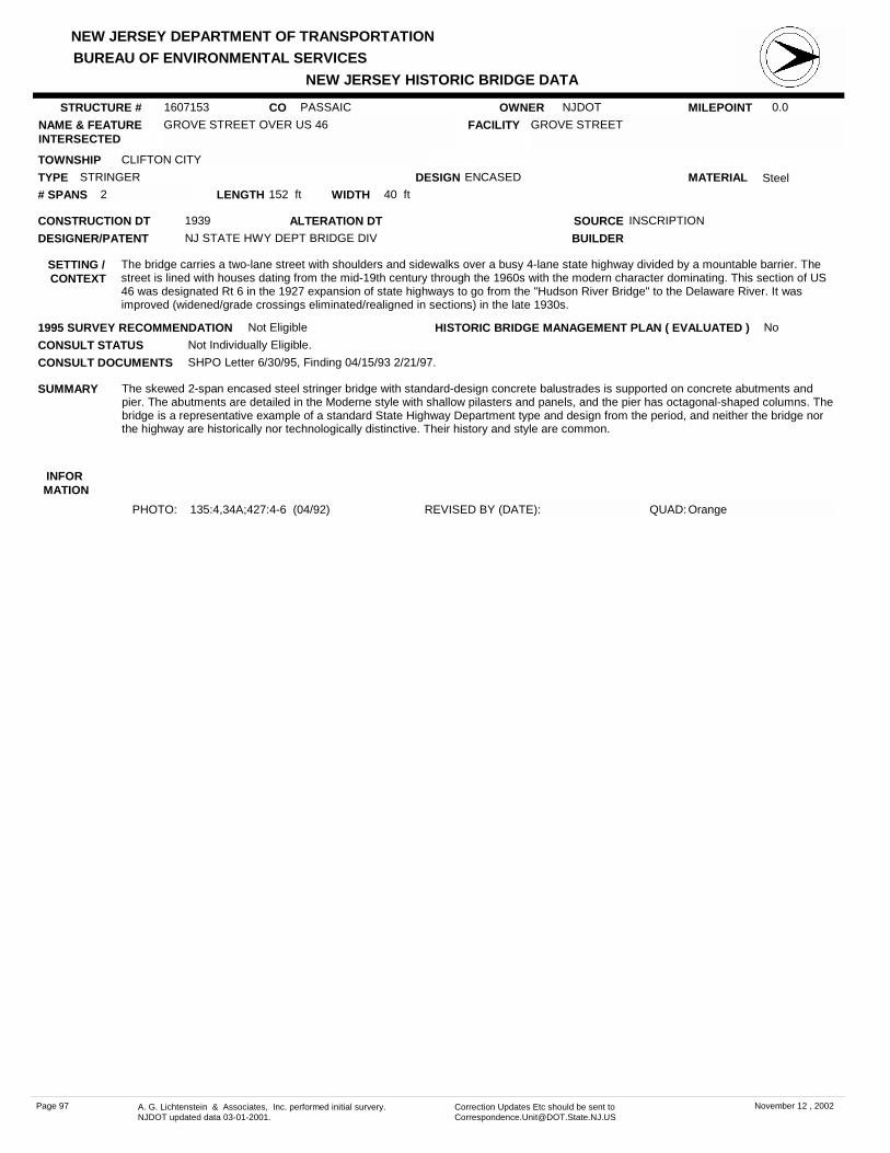
NEW JERSEY DEPARTMENT OF TRANSPORTATION
NEW JERSEY HISTORIC BRIDGE DATABUREAU OF ENVIRONMENTAL SERVICES
MILEPOINT 0.0CO PASSAICNAME & FEATURE INTERSECTED
GROVE STREET OVER US 46 FACILITY GROVE STREET
TOWNSHIP CLIFTON CITY
OWNER NJDOT
CONSTRUCTION DT 1939 SOURCE INSCRIPTION
MATERIAL SteelTYPE STRINGERLENGTH 152 ft WIDTH 40 ft# SPANS 2
DESIGNER/PATENT NJ STATE HWY DEPT BRIDGE DIV
SETTING / CONTEXT
The bridge carries a two-lane street with shoulders and sidewalks over a busy 4-lane state highway divided by a mountable barrier. The street is lined with houses dating from the mid-19th century through the 1960s with the modern character dominating. This section of US 46 was designated Rt 6 in the 1927 expansion of state highways to go from the "Hudson River Bridge" to the Delaware River. It was improved (widened/grade crossings eliminated/realigned in sections) in the late 1930s.
1995 SURVEY RECOMMENDATION Not Eligible
PHOTO: 135:4,34A;427:4-6 (04/92) REVISED BY (DATE):
DESIGN ENCASED
BUILDER
CONSULT STATUS Not Individually Eligible.
QUAD: Orange
SUMMARY The skewed 2-span encased steel stringer bridge with standard-design concrete balustrades is supported on concrete abutments and pier. The abutments are detailed in the Moderne style with shallow pilasters and panels, and the pier has octagonal-shaped columns. The bridge is a representative example of a standard State Highway Department type and design from the period, and neither the bridge nor the highway are historically nor technologically distinctive. Their history and style are common.
STRUCTURE # 1607153
ALTERATION DT
INFOR MATION
CONSULT DOCUMENTS SHPO Letter 6/30/95, Finding 04/15/93 2/21/97.
HISTORIC BRIDGE MANAGEMENT PLAN ( EVALUATED ) No
Page 97 A. G. Lichtenstein & Associates, Inc. performed initial survery. NJDOT updated data 03-01-2001.
Correction Updates Etc should be sent to [email protected]
November 12 , 2002

NEW JERSEY DEPARTMENT OF TRANSPORTATION
NEW JERSEY HISTORIC BRIDGE DATABUREAU OF ENVIRONMENTAL SERVICES
MILEPOINT 61.28CO PASSAICNAME & FEATURE INTERSECTED
US 46 OVER BROAD STREET FACILITY US 46
TOWNSHIP CLIFTON CITY
OWNER NJDOT
CONSTRUCTION DT 1939 SOURCE INSCRIPTION
MATERIAL SteelTYPE STRINGERLENGTH 86 ft WIDTH 54 ft# SPANS 2
DESIGNER/PATENT NJ STATE HWY DEPT BRIDGE DIV
SETTING / CONTEXT
The bridge carries a barrier-divided, 4-lane, limited access highway with sidewalks over a median-divided, 4-lane street in a light industrial/commercial area of Clifton. The area behind the modern commercial development is mid-20th century single-family houses. The road was initially developed in the 1920s as Route 6 linking the Ben Franklin and George Washington bridges. It was upgraded and made a limited access road in the late 1930s.
1995 SURVEY RECOMMENDATION Not Eligible
PHOTO: 135:2-3 (04/92) REVISED BY (DATE):
DESIGN ENCASED
BUILDER
CONSULT STATUS Not Individually Eligible.
QUAD: Paterson
SUMMARY The 2-span encased stringer bridge is supported on a concrete substructure. Pilasters accent the corners of the abutments, and the roadway is framed by standard-design concrete balustrades with paneled posts. Faience tile characters are inset into the posts to identify the date and route. The well-detailed bridge is consistent in design and type with the many other overpasses on the busy route, and it is neither historically nor technologically distinguished in its own right.
STRUCTURE # 1607154
ALTERATION DT
INFOR MATION
CONSULT DOCUMENTS SHPO Letter 6/30/95, Finding 2/21/97.
HISTORIC BRIDGE MANAGEMENT PLAN ( EVALUATED ) No
Page 98 A. G. Lichtenstein & Associates, Inc. performed initial survery. NJDOT updated data 03-01-2001.
Correction Updates Etc should be sent to [email protected]
November 12 , 2002

NEW JERSEY DEPARTMENT OF TRANSPORTATION
NEW JERSEY HISTORIC BRIDGE DATABUREAU OF ENVIRONMENTAL SERVICES
MILEPOINT 61.6CO PASSAICNAME & FEATURE INTERSECTED
US 46 OVER ERIE-LACKAWANNA RR FACILITY US 46
TOWNSHIP CLIFTON CITY
OWNER NJDOT
CONSTRUCTION DT 1939 SOURCE INSCRIPTION
MATERIAL SteelTYPE STRINGERLENGTH 139 ft WIDTH 54 ft# SPANS 3
DESIGNER/PATENT NJ STATE HWY DEPT BRIDGE DIV
SETTING / CONTEXT
The bridge carries a median-divided, limited access, 4-lane highway and narrow sidewalks over one track of the former Erie Lackawanna Railroad in a commercial and industrial area. US 46 was initially developed as Route 6 linking the Ben Franklin and George Washington bridges. This section was upgraded in 1939.
1995 SURVEY RECOMMENDATION Not Eligible
PHOTO: 134:3-4 (04/92) REVISED BY (DATE):
DESIGN ENCASED
BUILDER
CONSULT STATUS Not Individually Eligible.
QUAD: Paterson
SUMMARY The 3-span encased stringer bridge is supported on concrete stub abutments and high column bents with crash walls. The span is finished with standard-design concrete balustrades with paneled posts. Those on the end are set with faience tile characters identifying the date and route. Although unaltered, the bridge is a representative example of a common state type and design. It is neither historically nor technologically distinguished.
STRUCTURE # 1607156
ALTERATION DT
INFOR MATION
CONSULT DOCUMENTS SHPO Letter 6/30/95, Finding 2/21/97.
HISTORIC BRIDGE MANAGEMENT PLAN ( EVALUATED ) No
Page 99 A. G. Lichtenstein & Associates, Inc. performed initial survery. NJDOT updated data 03-01-2001.
Correction Updates Etc should be sent to [email protected]
November 12 , 2002
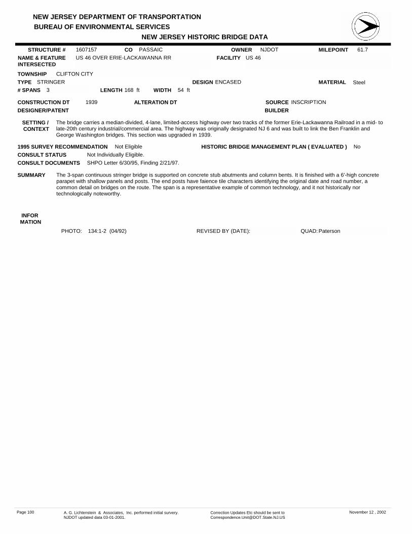
NEW JERSEY DEPARTMENT OF TRANSPORTATION
NEW JERSEY HISTORIC BRIDGE DATABUREAU OF ENVIRONMENTAL SERVICES
MILEPOINT 61.7CO PASSAICNAME & FEATURE INTERSECTED
US 46 OVER ERIE-LACKAWANNA RR FACILITY US 46
TOWNSHIP CLIFTON CITY
OWNER NJDOT
CONSTRUCTION DT 1939 SOURCE INSCRIPTION
MATERIAL SteelTYPE STRINGERLENGTH 168 ft WIDTH 54 ft# SPANS 3
DESIGNER/PATENT
SETTING / CONTEXT
The bridge carries a median-divided, 4-lane, limited-access highway over two tracks of the former Erie-Lackawanna Railroad in a mid- to late-20th century industrial/commercial area. The highway was originally designated NJ 6 and was built to link the Ben Franklin and George Washington bridges. This section was upgraded in 1939.
1995 SURVEY RECOMMENDATION Not Eligible
PHOTO: 134:1-2 (04/92) REVISED BY (DATE):
DESIGN ENCASED
BUILDER
CONSULT STATUS Not Individually Eligible.
QUAD: Paterson
SUMMARY The 3-span continuous stringer bridge is supported on concrete stub abutments and column bents. It is finished with a 6'-high concrete parapet with shallow panels and posts. The end posts have faience tile characters identifying the original date and road number, a common detail on bridges on the route. The span is a representative example of common technology, and it not historically nor technologically noteworthy.
STRUCTURE # 1607157
ALTERATION DT
INFOR MATION
CONSULT DOCUMENTS SHPO Letter 6/30/95, Finding 2/21/97.
HISTORIC BRIDGE MANAGEMENT PLAN ( EVALUATED ) No
Page 100 A. G. Lichtenstein & Associates, Inc. performed initial survery. NJDOT updated data 03-01-2001.
Correction Updates Etc should be sent to [email protected]
November 12 , 2002

NEW JERSEY DEPARTMENT OF TRANSPORTATION
NEW JERSEY HISTORIC BRIDGE DATABUREAU OF ENVIRONMENTAL SERVICES
MILEPOINT 61.75CO PASSAICNAME & FEATURE INTERSECTED
US 46 OVER PAULISON AVENUE FACILITY US 46
TOWNSHIP CLIFTON CITY
OWNER NJDOT
CONSTRUCTION DT 1939 SOURCE INSCRIPTION
MATERIAL SteelTYPE STRINGERLENGTH 54 ft WIDTH 54 ft# SPANS 1
DESIGNER/PATENT NJ STATE HWY DEPT BRIDGE DIV
SETTING / CONTEXT
The bridge carries a median-divided, 4-lane, limited access highway over a 2-lane street and sidewalks in Clifton. The highway is lined with industrial buildings while the street services a single-family detached house residential area dating from the mid-20th century. US 46 was developed initially as Route 6 linking the Ben Franklin and George Washington bridges.
1995 SURVEY RECOMMENDATION Not Eligible
PHOTO: 134:43-44 (04/92) REVISED BY (DATE):
DESIGN ENCASED
BUILDER
CONSULT STATUS Not Individually Eligible.
QUAD: Paterson
SUMMARY The one-span encased stringer bridge is supported on concrete abutments accented with shallow panels and corner pilasters. It is framed by a concrete balustrade with paneled posts. The detailing is consistent with other bridges built on US in 46 in 1939, and it is a representative example of a standard state design and bridge type, and it is not historically nor technologically distinguished.
STRUCTURE # 1607158
ALTERATION DT
INFOR MATION
CONSULT DOCUMENTS SHPO Letter 6/30/95, Finding 2/21/97.
HISTORIC BRIDGE MANAGEMENT PLAN ( EVALUATED ) No
Page 101 A. G. Lichtenstein & Associates, Inc. performed initial survery. NJDOT updated data 03-01-2001.
Correction Updates Etc should be sent to [email protected]
November 12 , 2002
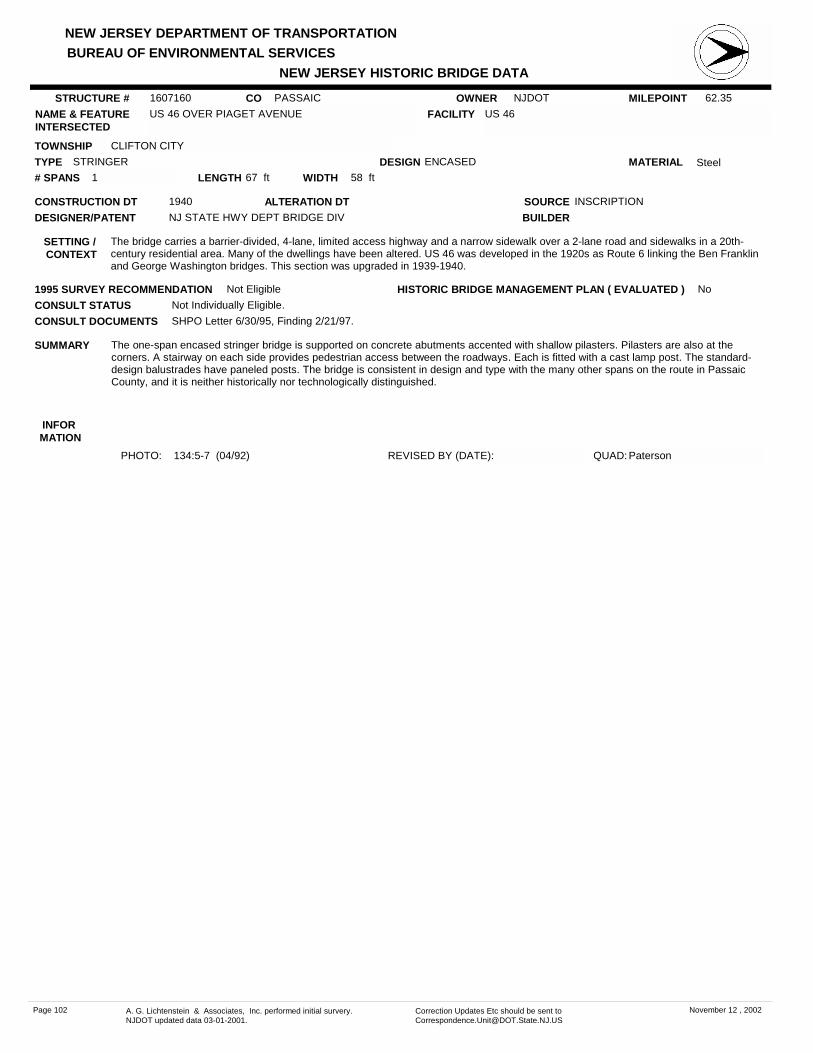
NEW JERSEY DEPARTMENT OF TRANSPORTATION
NEW JERSEY HISTORIC BRIDGE DATABUREAU OF ENVIRONMENTAL SERVICES
MILEPOINT 62.35CO PASSAICNAME & FEATURE INTERSECTED
US 46 OVER PIAGET AVENUE FACILITY US 46
TOWNSHIP CLIFTON CITY
OWNER NJDOT
CONSTRUCTION DT 1940 SOURCE INSCRIPTION
MATERIAL SteelTYPE STRINGERLENGTH 67 ft WIDTH 58 ft# SPANS 1
DESIGNER/PATENT NJ STATE HWY DEPT BRIDGE DIV
SETTING / CONTEXT
The bridge carries a barrier-divided, 4-lane, limited access highway and a narrow sidewalk over a 2-lane road and sidewalks in a 20th-century residential area. Many of the dwellings have been altered. US 46 was developed in the 1920s as Route 6 linking the Ben Franklin and George Washington bridges. This section was upgraded in 1939-1940.
1995 SURVEY RECOMMENDATION Not Eligible
PHOTO: 134:5-7 (04/92) REVISED BY (DATE):
DESIGN ENCASED
BUILDER
CONSULT STATUS Not Individually Eligible.
QUAD: Paterson
SUMMARY The one-span encased stringer bridge is supported on concrete abutments accented with shallow pilasters. Pilasters are also at the corners. A stairway on each side provides pedestrian access between the roadways. Each is fitted with a cast lamp post. The standard-design balustrades have paneled posts. The bridge is consistent in design and type with the many other spans on the route in Passaic County, and it is neither historically nor technologically distinguished.
STRUCTURE # 1607160
ALTERATION DT
INFOR MATION
CONSULT DOCUMENTS SHPO Letter 6/30/95, Finding 2/21/97.
HISTORIC BRIDGE MANAGEMENT PLAN ( EVALUATED ) No
Page 102 A. G. Lichtenstein & Associates, Inc. performed initial survery. NJDOT updated data 03-01-2001.
Correction Updates Etc should be sent to [email protected]
November 12 , 2002

NEW JERSEY DEPARTMENT OF TRANSPORTATION
NEW JERSEY HISTORIC BRIDGE DATABUREAU OF ENVIRONMENTAL SERVICES
MILEPOINT 0.0CO PASSAICNAME & FEATURE INTERSECTED
MAIN AVENUE OVER US 46 FACILITY MAIN AVENUE
TOWNSHIP CLIFTON CITY
OWNER NJDOT
CONSTRUCTION DT 1939 SOURCE INSCRIPTION
MATERIAL SteelTYPE STRINGERLENGTH 76 ft WIDTH 40 ft# SPANS 2
DESIGNER/PATENT NJ STATE HWY DEPT BRIDGE DIV
SETTING / CONTEXT
The bridge carries a grade-level 2-lane local street and sidewalks over a barrier-divided, 4-lane, limited access highway and sidewalks on a slightly depressed roadway. The street is in a mixed light-industrial and commercial area of Clifton. The highway is lined by a narrow greenbelt.
1995 SURVEY RECOMMENDATION Not Eligible
PHOTO: 135:36-38 (04/92) REVISED BY (DATE):
DESIGN ENCASED
BUILDER
CONSULT STATUS Not Individually Eligible.
QUAD: Paterson
SUMMARY The 2-span encased stringer bridge is supported on a concrete substructure accented with shallow paneled panels and Modern-style pilasters that extend into the posts of the concrete balustrades. The elevated sidewalks flanking the highway are defined by pipe railings. Similar in type and design with the other bridges that take US 46 through the county, the span is neither historically nor technologically noteworthy.
STRUCTURE # 1607161
ALTERATION DT
INFOR MATION
CONSULT DOCUMENTS SHPO Finding 12/07/89 2/21/97, Letter 6/30/95.
HISTORIC BRIDGE MANAGEMENT PLAN ( EVALUATED ) No
Page 103 A. G. Lichtenstein & Associates, Inc. performed initial survery. NJDOT updated data 03-01-2001.
Correction Updates Etc should be sent to [email protected]
November 12 , 2002

NEW JERSEY DEPARTMENT OF TRANSPORTATION
NEW JERSEY HISTORIC BRIDGE DATABUREAU OF ENVIRONMENTAL SERVICES
MILEPOINT 13.07CO PASSAICNAME & FEATURE INTERSECTED
PASSAIC SPUR RAILROAD OVER US 46 FACILITY PASSAIC SPUR RAILROAD
TOWNSHIP CLIFTON CITY
OWNER RAILROAD
CONSTRUCTION DT 1939 SOURCE PLANS
MATERIAL SteelTYPE THRU GIRDERLENGTH 79 ft WIDTH 50 ft# SPANS 2
DESIGNER/PATENT ERIE RR OFFICE OF ENGINEER
SETTING / CONTEXT
The bridge carries 3 active sets of railroad tracks over a barrier-divided, 4-lane, limited access highway and elevated sidewalks in a mid- to late-20th century industrial area.
1995 SURVEY RECOMMENDATION Not Eligible
PHOTO: 135:39-41 (04/92) REVISED BY (DATE):
DESIGN ENCASED
BUILDER
CONSULT STATUS Not Individually Eligible.
QUAD: Paterson
SUMMARY The 2-span encased thru girder with floor beams bridge is supported on a concrete substructure. It is composed of 5 girders with concrete encasing the entire floor system. Original concrete light standards have been removed. The plain concrete parapets include the outside girders. Grade-level sidewalks are enclosed by pipe railings. The bridge with a concrete deck is a representative example of a common type. The span is neither historically nor technologically distinguished.
STRUCTURE # 1607162
ALTERATION DT
INFOR MATION
CONSULT DOCUMENTS SHPO Letter 6/30/95, Finding 12/07/89 2/21/97.
HISTORIC BRIDGE MANAGEMENT PLAN ( EVALUATED ) No
Page 104 A. G. Lichtenstein & Associates, Inc. performed initial survery. NJDOT updated data 03-01-2001.
Correction Updates Etc should be sent to [email protected]
November 12 , 2002

NEW JERSEY DEPARTMENT OF TRANSPORTATION
NEW JERSEY HISTORIC BRIDGE DATABUREAU OF ENVIRONMENTAL SERVICES
MILEPOINT 63.0CO PASSAICNAME & FEATURE INTERSECTED
US 46 OVER LAKEVIEW AVENUE FACILITY US 46
TOWNSHIP CLIFTON CITY
OWNER NJDOT
CONSTRUCTION DT 1939 SOURCE INSCRIPTION
MATERIAL Reinforced Concrete
TYPE OPEN SPANDREL ARCHLENGTH 82 ft WIDTH 59.3 ft# SPANS 1
DESIGNER/PATENT NJ STATE HWY DEPT BRIDGE DIV
SETTING / CONTEXT
The bridge carries a barrier-divided, 4-lane, limited access highway over a 2-lane street and sidewalks in a ca. 1900 residential and neighborhood commercial area of Clifton. The buildings are altered. US 46 was originally developed as Route 6 linking the George Washington and Ben Franklin bridges. It was upgraded in this area in 1939.
1995 SURVEY RECOMMENDATION Eligible
DESIGN
BUILDER
CONSULT STATUS Individually Eligible.
SUMMARY The one span open spandrel arch bridge with spandrel columns and stepped pilasters with tile decoration is the shortest of the approximately 10 bridges of the type designed by the state between 1929 and 1939. It is one of 3 in the county. It is significant because it is a well-preserved example of a technologically important bridge type that is not common. The bridge reflects the successful integration of aesthetics and innovative engineering.
STRUCTURE # 1607163
ALTERATION DT
INFOR MATION
Bibliography:NJDOT. Plan File; 1607168.Condit, Carl. American Building Art 20th Century. 1960.Hess, Jeffrey & Frame, Robert. "Wisconsin Stone Arch and Concrete Arch Bridges." 1986.Plowden, David. Bridges: The Spans of North America. 1974.
Physical Description: The 82'-long single span open spandrel arch bridge of reinforced concrete is well proportioned and well detailed. It is finished with spandrel columns and Modern-style stepped pilasters that define the span limits. The outside face of the end posts is decorated with a mosaic tile seal of the state. The deck is concrete, and the wearing surface is bituminous concrete. Sidewalks are framed by standard-design concrete balustrades. The bridge appears to be well preserved.
Historical and Technological Significance: The concrete open spandrel arch bridge built in 1939 is significant as a well-preserved example of the technologically noteworthy and aesthetically impressive works of Morris Goodkind (1869-1968) produced throughout his career as State Bridge Engineer (Criterion C). It is one of approximately 8 open-spandrel arch bridges in New Jersey, a bridge type that defines the highest level of refinement in reinforced concrete arch technology. It is one of three on NJ 46 in Passaic County (1607168, 1607158). The well-preserved bridge represents Goodkind's emphasis in the New Jersey State Highway Department Bridge Division to create aesthetically pleasing concrete structures prior to World War II. The moldable qualities of the material were used to create an architectural masterpiece at the same time that its structural qualities were used to efficiently carry a major highway across feature requiring a long clear span. The reinforced concrete arch was capable of relatively long spans while providing graceful and dynamic forms.
Around the turn of the century, reinforced concrete arches were generally limited to relatively short and often single span bridges. The dead load carried by the arches was reduced with the introduction of open spandrel arches. The lighter structures were capable of longer spans and more aesthetically pleasing large bridges. The Walnut Lane bridge (1906-8) over Wissahickon Creek in Philadelphia was a forerunner of the type. A massive structure, the open spandrel arches of that structure span 233 feet with virtually no steel reinforcement in the two ribs. In the first two decades of the 20th century, railroads began using reinforced concrete to construct large viaducts across rivers and valleys to eliminate steep grade changes. The length and number of spans increased to create massive structures that dominated the landscape. The Tunkhannock Viaduct (completed 1915 and designed by A. Burton Cohen, 1883-1956) of the Delaware Lackawanna & Western RR in Nicholson, Pennsylvania remains one of the greatest bridges in America. It is a ten-span open spandrel reinforced concrete arch, 2375 feet in total length, each span 180 feet in clear span, and rising 240 feet above the creek bed in the valley floor.
The US 1 Bridge, completed 14 years later in 1929, but comparable in size and beauty, was the first of Goodkind's open-spandrel concrete arch bridges in New Jersey. The bridge type was repeated with equal success at major crossings on major roads throughout the northern half of the state through the 1930s. NJ 46 was upgraded in the late 1930s to serve as a major link between the Hudson River crossings into Manhattan and the west portion of the state, especially Morris and Passaic counties.
Morris Goodkind, designer of the bridge, was a graduate of Columbia University. He worked for the New York City Public Service Commission in the development of the subway system before working on bridge designs for engineering firms and Mercer County, NJ. In 1922 he joined the New Jersey Highway Department, and became the Chief Bridge Engineer in 1925, a post he held through 1955 when he retired to private practice.
The 1920s and 1930s were a time of great expansion of the state's highway system which required many bridges to be built. Goodkind emphasized the need for aesthetically pleasing as well as structurally sound bridges. He brought in Arthur Lichtenburg to develop an architectural section in the Bridge Department. Many of the grade elimination bridges of the 1930s and 1940s in congested areas were detailed with Moderne and Deco pilasters and entablature due to the influence of Goodkind and Lichtenburg. The same structures had encased stringers, the most common type built during Goodkind's term. He emphasized the encasement for protection of the steel from the elements, a valid assertion considering the number and condition of such structures remaining in New Jersey.
CONSULT DOCUMENTS SHPO Letter 6/30/95, Finding 2/21/97.
HISTORIC BRIDGE MANAGEMENT PLAN ( EVALUATED ) Yes
Page 105 A. G. Lichtenstein & Associates, Inc. performed initial survery. NJDOT updated data 03-01-2001.
Correction Updates Etc should be sent to [email protected]
November 12 , 2002

NEW JERSEY DEPARTMENT OF TRANSPORTATION
NEW JERSEY HISTORIC BRIDGE DATABUREAU OF ENVIRONMENTAL SERVICES
PHOTO: 135:42-1 (04/92) REVISED BY (DATE): QUAD: Paterson
While working for the state, he served as a consultant on bridge construction for the War Department. Upon his retirement as Chief Bridge Engineer, Goodkind became a consultant with the firm of Goodkind and O'Dea in Manhattan. He was internationally known and respected for his bridge engineering. He had been active in local and national engineering societies, and won several awards for the designs of bridges.
Goodkind was awarded the Phoebe Hobson Fowler Architectural Award by the American Society of Civil Engineers for the design of the US 1 bridge. To recognize the contribution which Goodkind made to the State of New Jersey, the name of the bridge was officially changed from the College Bridge to The Morris Goodkind Bridge on April 25, 1969, following his death the previous September.
Of the approximately 8 pre-1946 open-spandrel arch bridges in the state, all but one (1213150) have been evaluated as significant.
Boundary Description and Justification: The bridge is evaluated as individually significant, and the boundaries are thus limited to the span itself. NJ 46 was improved in the mid- to late-1930s as a major artery handling Morris County and Passaic County traffic approaching the Hudson River crossings. The road is dominated by what by the mid-1930s were standard solutions to common engineering problems.
Page 106 A. G. Lichtenstein & Associates, Inc. performed initial survery. NJDOT updated data 03-01-2001.
Correction Updates Etc should be sent to [email protected]
November 12 , 2002
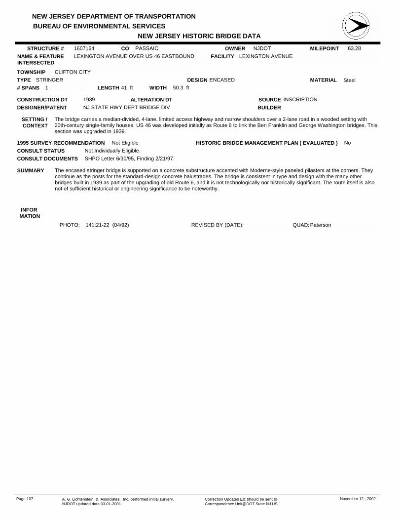
NEW JERSEY DEPARTMENT OF TRANSPORTATION
NEW JERSEY HISTORIC BRIDGE DATABUREAU OF ENVIRONMENTAL SERVICES
MILEPOINT 63.28CO PASSAICNAME & FEATURE INTERSECTED
LEXINGTON AVENUE OVER US 46 EASTBOUND FACILITY LEXINGTON AVENUE
TOWNSHIP CLIFTON CITY
OWNER NJDOT
CONSTRUCTION DT 1939 SOURCE INSCRIPTION
MATERIAL SteelTYPE STRINGERLENGTH 41 ft WIDTH 50.3 ft# SPANS 1
DESIGNER/PATENT NJ STATE HWY DEPT BRIDGE DIV
SETTING / CONTEXT
The bridge carries a median-divided, 4-lane, limited access highway and narrow shoulders over a 2-lane road in a wooded setting with 20th-century single-family houses. US 46 was developed initially as Route 6 to link the Ben Franklin and George Washington bridges. This section was upgraded in 1939.
1995 SURVEY RECOMMENDATION Not Eligible
PHOTO: 141:21-22 (04/92) REVISED BY (DATE):
DESIGN ENCASED
BUILDER
CONSULT STATUS Not Individually Eligible.
QUAD: Paterson
SUMMARY The encased stringer bridge is supported on a concrete substructure accented with Moderne-style paneled pilasters at the corners. They continue as the posts for the standard-design concrete balustrades. The bridge is consistent in type and design with the many other bridges built in 1939 as part of the upgrading of old Route 6, and it is not technologically nor historically significant. The route itself is also not of sufficient historical or engineering significance to be noteworthy.
STRUCTURE # 1607164
ALTERATION DT
INFOR MATION
CONSULT DOCUMENTS SHPO Letter 6/30/95, Finding 2/21/97.
HISTORIC BRIDGE MANAGEMENT PLAN ( EVALUATED ) No
Page 107 A. G. Lichtenstein & Associates, Inc. performed initial survery. NJDOT updated data 03-01-2001.
Correction Updates Etc should be sent to [email protected]
November 12 , 2002

NEW JERSEY DEPARTMENT OF TRANSPORTATION
NEW JERSEY HISTORIC BRIDGE DATABUREAU OF ENVIRONMENTAL SERVICES
MILEPOINT 63.85CO PASSAICNAME & FEATURE INTERSECTED
US 46 EB OVER NJ 20 NB FACILITY US 46 EASTBOUND
TOWNSHIP CLIFTON CITY
OWNER NJDOT
CONSTRUCTION DT 1936 SOURCE INSCRIPTION
MATERIAL SteelTYPE STRINGERLENGTH 50 ft WIDTH 30 ft# SPANS 1
DESIGNER/PATENT NJ STATE HWY DEPT BRIDGE DIV
SETTING / CONTEXT
The bridge carries one lane and one shoulder of one-directional (eastbound) traffic over two lanes of one directional traffic in a wooded setting with some modern commercial establishments. The span is paired with 1607167 which carries westbound traffic. Both spans cross the west end of NJ 20. This bridge carries traffic flowing from eastbound US 46 to northbound NJ 20. The original designations were Route 4 over Route 3.
1995 SURVEY RECOMMENDATION Not Eligible
PHOTO: 141:10-11 (04/92) REVISED BY (DATE):
DESIGN ENCASED
BUILDER
CONSULT STATUS Not Individually Eligible.
QUAD: Paterson
SUMMARY The skewed encased stringer bridge is supported on a concrete substructure accented with Moderne-style paneled pilasters that continue as the standard-design balustrade posts. The end posts are inscribed with date and route. The bridge is one of many built in the late-1930s to make the route limited access. It is not historically nor technologically distinguished as it is consistent in type and style with other spans on the road.
STRUCTURE # 1607166
ALTERATION DT
INFOR MATION
CONSULT DOCUMENTS SHPO Letter 6/30/95, Finding 2/21/97.
HISTORIC BRIDGE MANAGEMENT PLAN ( EVALUATED ) No
Page 108 A. G. Lichtenstein & Associates, Inc. performed initial survery. NJDOT updated data 03-01-2001.
Correction Updates Etc should be sent to [email protected]
November 12 , 2002

NEW JERSEY DEPARTMENT OF TRANSPORTATION
NEW JERSEY HISTORIC BRIDGE DATABUREAU OF ENVIRONMENTAL SERVICES
MILEPOINT 63.85CO PASSAICNAME & FEATURE INTERSECTED
US 46 WB OVER NJ 20 NB FACILITY US 46 WESTBOUND
TOWNSHIP PATERSON CITY
OWNER NJDOT
CONSTRUCTION DT 1936 SOURCE INSCRIPTION
MATERIAL SteelTYPE STRINGERLENGTH 63 ft WIDTH 30 ft# SPANS 1
DESIGNER/PATENT NJ STATE HWY DEPT BRIDGE DIV
SETTING / CONTEXT
The bridge carries two lanes of one-directional traffic (westbound) of a limited access, wide grass median-divided highway (US 46) over two lanes of one directional traffic (northbound) of a similar state highway. The bridge is paired with 1607166 which carries US 46 in the opposite direction. The routes were originally designated Route 4 over Route 3. The overpass is located in a wooded setting with scattered modern commerical establishments.
1995 SURVEY RECOMMENDATION Not Eligible
PHOTO: 141:19-20 (04/92) REVISED BY (DATE):
DESIGN ENCASED
BUILDER
CONSULT STATUS Not Individually Eligible.
QUAD: Paterson
SUMMARY The skewed encased stringer bridge is supported on a concrete substructure accented with Moderne-style stepped pilasters that continue into the concrete balustrades as posts. The balustrades and corresponding posts are also used on the approaches. The span is one of many built on US 46 in the late-1930s when the route was improved as a limited access highway with few grade crossings. It is consistent in type and style with the other spans on the route and is not technologically distinguished.
STRUCTURE # 1607167
ALTERATION DT
INFOR MATION
CONSULT DOCUMENTS SHPO Letter 6/30/95, Finding 2/21/97.
HISTORIC BRIDGE MANAGEMENT PLAN ( EVALUATED ) No
Page 109 A. G. Lichtenstein & Associates, Inc. performed initial survery. NJDOT updated data 03-01-2001.
Correction Updates Etc should be sent to [email protected]
November 12 , 2002

NEW JERSEY DEPARTMENT OF TRANSPORTATION
NEW JERSEY HISTORIC BRIDGE DATABUREAU OF ENVIRONMENTAL SERVICES
MILEPOINT 63.98CO PASSAICNAME & FEATURE INTERSECTED
US 46 OVER PASSAIC RIVER FACILITY US 46
TOWNSHIP PATERSON CITY
OWNER NJDOT
CONSTRUCTION DT 1937 SOURCE INSCRIPTION
MATERIAL Reinforced Concrete
TYPE OPEN SPANDREL RIBBED ARCHLENGTH 538 ft WIDTH 48 ft# SPANS 5
DESIGNER/PATENT NJ STATE HWY DEPT BRIDGE DIV
SETTING / CONTEXT
The bridge carries a barrier-divided, 4-lane, limited access highway and sidewalks over the Passaic River, the feature that marks the division between Bergen and Passaic counties. It was built as part of the late-1930s improvement of Route 6, the road linking the Ben Franklin and George Washington bridges.
1995 SURVEY RECOMMENDATION Eligible
DESIGN
BUILDER
CONSULT STATUS Individually Eligible.
SUMMARY The 5-span open spandrel ribbed arch bridge built in 1939 is one of approximately 8 such bridges designed and built by the state on its major routes between 1929 and 1939. Representing the apex of concrete bridge technology of its day, the open-spandrel bridge is as handsome as it is technologically distinguished. This large and well-preserved example ranks as one of the most significant highway spans in the state and it is historically and technologically noteworthy.
STRUCTURE # 1607168
ALTERATION DT
INFOR MATION
Bibliography:NJDOT. Plan File; 1607168.Condit, Carl. American Building Art 20th Century. 1960.Hess, Jeffrey & Frame, Robert. "Wisconsin Stone Arch and Concrete Arch Bridges." 1986.Plowden, David. Bridges: The Spans of North America. 1974.
Physical Description: The 5-span open spandrel ribbed arch bridge of reinforced concrete is well proportioned and well detailed. Each span is composed of six arch ribs. The bridge is finished with spandrel columns and Modern-style stepped pilasters that define the span limits. Each end pilaster is topped by a battered concrete lamp standard and a mosaic tile seal of the state. The deck is concrete, and the wearing surface is bituminous concrete. Sidewalks are framed by standard-design concrete balustrades. The bridge appears to be well preserved.
Historical and Technological Significance: The concrete open spandrel ribbed arch bridge built in 1937 is significant as a well-preserved example of the technologically noteworthy and aesthetically impressive works of Morris Goodkind (1869-1968) produced throughout his career as State Bridge Engineer (Criterion C). It is one of approximately 8 open-spandrel arch bridges in New Jersey, a bridge type that defines the highest level of refinement in reinforced concrete arch technology. It is one of three on NJ 46 in Passaic County (1607163, 1607158). The well-preserved bridge represents Goodkind's emphasis in the New Jersey State Highway Department Bridge Division to create aesthetically pleasing concrete structures prior to World War II. The moldable qualities of the material were used to create an architectural masterpiece at the same time that its structural qualities were used to efficiently carry a major highway across a wide river. The reinforced concrete arch was capable of relatively long spans while providing graceful and dynamic forms.
Around the turn of the century, reinforced concrete arches were generally limited to relatively short and often single span bridges. The dead load carried by the arches was reduced with the introduction of open spandrel arches. The lighter structures were capable of longer spans and more aesthetically pleasing large bridges. The Walnut Lane bridge (1906-8) over Wissahickon Creek in Philadelphia was a forerunner of the type. A massive structure, the open spandrel arches of that structure span 233 feet with virtually no steel reinforcement in the two ribs. In the first two decades of the 20th century, railroads began using reinforced concrete to construct large viaducts across rivers and valleys to eliminate steep grade changes. The length and number of spans increased to create massive structures that dominated the landscape. The Tunkhannock Viaduct (completed 1915 and designed by A. Burton Cohen, 1883-1956) of the Delaware Lackawanna & Western RR in Nicholson, Pennsylvania remains one of the greatest bridges in America. It is a ten-span open spandrel reinforced concrete arch, 2375 feet in total length, each span 180 feet in clear span, and rising 240 feet above the creek bed in the valley floor.
The US 1 Bridge, completed 14 years later in 1929, but comparable in size and beauty, was the first of Goodkind's open-spandrel concrete arch bridges in New Jersey. The bridge type was repeated with equal success at major crossings on major roads throughout the northern half of the state through the 1930s. NJ 46 was upgraded in the late 1930s to serve as a major link between the Hudson River crossings into Manhattan and the west portion of the state, especially Morris and Passaic counties.
Morris Goodkind, designer of the bridge, was a graduate of Columbia University. He worked for the New York City Public Service Commission in the development of the subway system before working on bridge designs for engineering firms and Mercer County, NJ. In 1922 he joined the New Jersey Highway Department, and became the Chief Bridge Engineer in 1925, a post he held through 1955 when he retired to private practice.
The 1920s and 1930s were a time of great expansion of the state's highway system which required many bridges to be built. Goodkind emphasized the need for aesthetically pleasing as well as structurally sound bridges. He brought in Arthur Lichtenburg to develop an architectural section in the Bridge Department. Many of the grade crossing elimination bridges of the 1930s and 1940s in congested areas were detailed with Moderne and Deco pilasters and entablature due to the influence of Goodkind and Lichtenburg. The same structures had encased stringers, the most common type built during Goodkind's term. He emphasized the encasement for protection of the steel from the elements, a valid assertion considering the number and condition of such structures remaining in New Jersey.
CONSULT DOCUMENTS SHPO Finding 10/03/90 02/21/97, Letter 6/30/95.
HISTORIC BRIDGE MANAGEMENT PLAN ( EVALUATED ) Yes
Page 110 A. G. Lichtenstein & Associates, Inc. performed initial survery. NJDOT updated data 03-01-2001.
Correction Updates Etc should be sent to [email protected]
November 12 , 2002
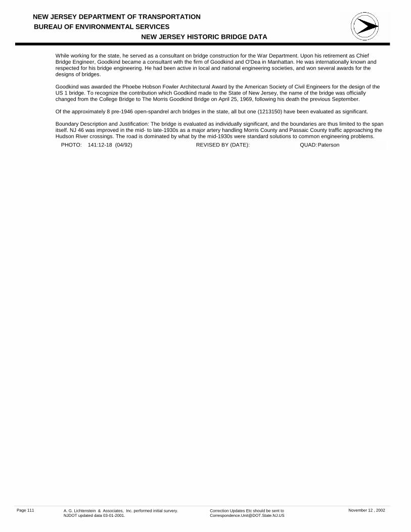
NEW JERSEY DEPARTMENT OF TRANSPORTATION
NEW JERSEY HISTORIC BRIDGE DATABUREAU OF ENVIRONMENTAL SERVICES
PHOTO: 141:12-18 (04/92) REVISED BY (DATE): QUAD: Paterson
While working for the state, he served as a consultant on bridge construction for the War Department. Upon his retirement as Chief Bridge Engineer, Goodkind became a consultant with the firm of Goodkind and O'Dea in Manhattan. He was internationally known and respected for his bridge engineering. He had been active in local and national engineering societies, and won several awards for the designs of bridges.
Goodkind was awarded the Phoebe Hobson Fowler Architectural Award by the American Society of Civil Engineers for the design of the US 1 bridge. To recognize the contribution which Goodkind made to the State of New Jersey, the name of the bridge was officially changed from the College Bridge to The Morris Goodkind Bridge on April 25, 1969, following his death the previous September.
Of the approximately 8 pre-1946 open-spandrel arch bridges in the state, all but one (1213150) have been evaluated as significant.
Boundary Description and Justification: The bridge is evaluated as individually significant, and the boundaries are thus limited to the span itself. NJ 46 was improved in the mid- to late-1930s as a major artery handling Morris County and Passaic County traffic approaching the Hudson River crossings. The road is dominated by what by the mid-1930s were standard solutions to common engineering problems.
Page 111 A. G. Lichtenstein & Associates, Inc. performed initial survery. NJDOT updated data 03-01-2001.
Correction Updates Etc should be sent to [email protected]
November 12 , 2002

NEW JERSEY DEPARTMENT OF TRANSPORTATION
NEW JERSEY HISTORIC BRIDGE DATABUREAU OF ENVIRONMENTAL SERVICES
MILEPOINT 0.0CO PASSAICNAME & FEATURE INTERSECTED
MADISON AVENUE OVER PASSAIC SPUR RAILROAD
FACILITY MADISON AVEMUE
TOWNSHIP PATERSON CITY
OWNER UNKNOWN
CONSTRUCTION DT 1929 SOURCE PLAQUE
MATERIAL SteelTYPE THRU GIRDERLENGTH 125 ft WIDTH 55 ft# SPANS 2
DESIGNER/PATENT ERIE-LACKAWANNA RR OFF OF ENG
SETTING / CONTEXT
The bridge carries a two-lane street, sidewalks, and utility pipes over 3 tracks of the former Erie-Lackawanna Railroad in an industrial area of Paterson. The factory and storage buildings date from the early through the late 20th century.
1995 SURVEY RECOMMENDATION Not Eligible
PHOTO: 134:30-32 (04/92) REVISED BY (DATE):
DESIGN PARTIALLY ENCASED
BUILDER AMERICAN BRIDGE COMPANY
CONSULT STATUS Not Individually Eligible.
QUAD: Paterson
SUMMARY The skewed, 2-span, simply supported thru girder with floor beams bridge is supported on concrete abutments and a built-up steel bent with lateral bracing. The cantilevered sidewalks are enclosed by metal, picket fence-like railings. The banked approaches are enclosed by concrete parapets. Access to the track level is provided by riveted construction steel staircases on each side of the bridge. The span is a representative example of a common type and is not notable.
STRUCTURE # 1650160
ALTERATION DT
INFOR MATION
CONSULT DOCUMENTS SHPO Letter 6/30/95
HISTORIC BRIDGE MANAGEMENT PLAN ( EVALUATED ) No
Page 112 A. G. Lichtenstein & Associates, Inc. performed initial survery. NJDOT updated data 03-01-2001.
Correction Updates Etc should be sent to [email protected]
November 12 , 2002

NEW JERSEY DEPARTMENT OF TRANSPORTATION
NEW JERSEY HISTORIC BRIDGE DATABUREAU OF ENVIRONMENTAL SERVICES
MILEPOINT 0.0CO PASSAICNAME & FEATURE INTERSECTED
PIAGET AVENUE (CR 628) OVER PASSAIC SPUR RAILROAD
FACILITY PIAGET AVENUE (CR 628)
TOWNSHIP CLIFTON CITY
OWNER UNKNOWN
CONSTRUCTION DT 1926 SOURCE INSCRIPTION
MATERIAL SteelTYPE THRU GIRDERLENGTH 125 ft WIDTH 30 ft# SPANS 3
DESIGNER/PATENT ERIE RR OFFICE OF ENGINEER
SETTING / CONTEXT
The bridge carries a two-lane street and sidewalks over two tracks and one siding spur of the former Erie Railroad in a mixed-use area of Clifton with commercial and light industrial establishments lining the tracks and 20th-century houses and modern apartments behind. The area does not have historic district potential due to alterations to the older buildings. The railroad line was initially developed in the 1830s as the Paterson & Hudson River RR and acquired by the Erie in 1852.
1995 SURVEY RECOMMENDATION Not Eligible
PHOTO: 134:8-10 (04/92) REVISED BY (DATE):
DESIGN PARTIALLY ENCASED
BUILDER
CONSULT STATUS Not Individually Eligible.
QUAD: Paterson
SUMMARY The skewed 3-span bridge is composed of an encased thru girder with floor beams main span and T-beam approaches supported on concrete stub abutments and pier bents. It is finished with a jack arch-supported concrete deck with a bituminous wearing surface. Inner girder faces have been filled with concrete. The cantilevered sidewalks are enclosed by metal fence-like railings. Although unaltered, the 1926 bridge is neither historically nor technologically significant.
STRUCTURE # 1650161
ALTERATION DT
INFOR MATION
CONSULT DOCUMENTS SHPO Letter 6/30/95
HISTORIC BRIDGE MANAGEMENT PLAN ( EVALUATED ) No
Page 113 A. G. Lichtenstein & Associates, Inc. performed initial survery. NJDOT updated data 03-01-2001.
Correction Updates Etc should be sent to [email protected]
November 12 , 2002

NEW JERSEY DEPARTMENT OF TRANSPORTATION
NEW JERSEY HISTORIC BRIDGE DATABUREAU OF ENVIRONMENTAL SERVICES
MILEPOINT 0.0CO PASSAICNAME & FEATURE INTERSECTED
MINISINK ROAD (CR 642) OVER TOTOWA SPUR RAILROAD
FACILITY MINISINK ROAD (CR 642)
TOWNSHIP TOTOWA BOROUGH
OWNER UNKNOWN
CONSTRUCTION DT 1916 SOURCE NJDOT
MATERIAL Reinforced Concrete
TYPE DECK ARCHLENGTH 68 ft WIDTH 32.5 ft# SPANS 1
DESIGNER/PATENT DL&W RR OFFICE OF ENGINEER
SETTING / CONTEXT
The bridge carries a 2-lane road over one track of the former DL&W RR's Boonton line that was put into service about 1870.
1995 SURVEY RECOMMENDATION Not Eligible
PHOTO: 143:26-27 (04/92) REVISED BY (DATE):
DESIGN ELLIPTICAL
BUILDER
CONSULT STATUS Not Individually Eligible.
QUAD: Paterson
SUMMARY The elliptical concrete deck arch bridge with a standard-design concrete balustrade is neither an early nor a well-detailed example of its type. Built by the DL&W RR in 1916, it is one of at least 50 similar type bridges the line erected in the state. The span is unaltered, but it is not historically nor technologically distinguished.
STRUCTURE # 1651161
ALTERATION DT
INFOR MATION
CONSULT DOCUMENTS SHPO Letter 6/30/95
HISTORIC BRIDGE MANAGEMENT PLAN ( EVALUATED ) No
Page 114 A. G. Lichtenstein & Associates, Inc. performed initial survery. NJDOT updated data 03-01-2001.
Correction Updates Etc should be sent to [email protected]
November 12 , 2002

NEW JERSEY DEPARTMENT OF TRANSPORTATION
NEW JERSEY HISTORIC BRIDGE DATABUREAU OF ENVIRONMENTAL SERVICES
MILEPOINT 0.0CO PASSAICNAME & FEATURE INTERSECTED
RIVERVIEW DRIVE OVER TOTOWA SPUR RAILROAD
FACILITY RIVERVIEW DRIVE
TOWNSHIP TOTOWA BOROUGH
OWNER UNKNOWN
CONSTRUCTION DT 1941 SOURCE NJDOT/PLANS
MATERIAL SteelTYPE THRU GIRDERLENGTH 378 ft WIDTH 50 ft# SPANS 7
DESIGNER/PATENT NJ STATE HWY DEPT BRIDGE DIV
SETTING / CONTEXT
The bridge carries 4 lanes of traffic and sidewalks over one railroad track. The area is composed of a modern industrial park.
1995 SURVEY RECOMMENDATION Not Eligible
PHOTO: 143:28-32 (04/92) REVISED BY (DATE):
DESIGN
BUILDER
CONSULT STATUS Not Individually Eligible.
QUAD: Paterson
SUMMARY The skewed 7-span bridge was originally composed of built-up deck girder approaches and a thru girder with floor beams main span supported on a concrete substructure. The concrete columns supporting the main span continued to form posts protecting the girder ends. In 1978 it was nearly doubled in width by a rolled stringer addition to the west side. The addition is enclosed by a barrier-like concrete parapet with cap railings. The altered span is not historically or technologically noteworthy.
STRUCTURE # 1651162
ALTERATION DT 1978
INFOR MATION
CONSULT DOCUMENTS SHPO Letter 6/30/95
HISTORIC BRIDGE MANAGEMENT PLAN ( EVALUATED ) No
Page 115 A. G. Lichtenstein & Associates, Inc. performed initial survery. NJDOT updated data 03-01-2001.
Correction Updates Etc should be sent to [email protected]
November 12 , 2002

NEW JERSEY DEPARTMENT OF TRANSPORTATION
NEW JERSEY HISTORIC BRIDGE DATABUREAU OF ENVIRONMENTAL SERVICES
MILEPOINT 0.0CO PASSAICNAME & FEATURE INTERSECTED
PARISH DRIVE OVER TOTOWA SPUR RAILROAD FACILITY PARISH DRIVE
TOWNSHIP WAYNE TOWNSHIP
OWNER UNKNOWN
CONSTRUCTION DT 1938 SOURCE NJDOT
MATERIAL SteelTYPE THRU GIRDERLENGTH 326 ft WIDTH 30 ft# SPANS 6
DESIGNER/PATENT DL&W RR OFFICE OF ENGINEER
SETTING / CONTEXT
The bridge carries a two-lane road and one sidewalk over one track of the former DL&W RR's Boonton Line that was put into service about 1870 and a 2-lane street in a mixed-use area that includes a post office and fire department. When the bridge was built in 1938, much of the surrounding land was still owned by the Parish family for whom the road is named.
1995 SURVEY RECOMMENDATION Not Eligible
PHOTO: 139:6-9 (04/92) REVISED BY (DATE):
DESIGN PARTIALLY ENCASED
BUILDER UNKNOWN
CONSULT STATUS Not Individually Eligible.
QUAD: Pompton Plains
SUMMARY The skewed 6-span viaduct is composed of a thru girder with encased floor beams main span and multi-girder approach spans with built up haunched fascia girders. It is supported on a concrete substructure. The sidewalk and roadway are enclosed by flat-paneled concrete parapets with chamfered tops, and a concrete staircase is located off the east elevation of the bridge. Although unaltered, the bridge is a late example of a common type, and it is not historically nor technologically distinguished
STRUCTURE # 1651163
ALTERATION DT
INFOR MATION
CONSULT DOCUMENTS SHPO Letter 6/30/95
HISTORIC BRIDGE MANAGEMENT PLAN ( EVALUATED ) No
Page 116 A. G. Lichtenstein & Associates, Inc. performed initial survery. NJDOT updated data 03-01-2001.
Correction Updates Etc should be sent to [email protected]
November 12 , 2002

NEW JERSEY DEPARTMENT OF TRANSPORTATION
NEW JERSEY HISTORIC BRIDGE DATABUREAU OF ENVIRONMENTAL SERVICES
MILEPOINT 0.0CO PASSAICNAME & FEATURE INTERSECTED
HAZEL STREET OVER ERIE MAIN LINE RAILROAD FACILITY HAZEL STEET
TOWNSHIP CLIFTON CITY
OWNER STATE AGENCY
CONSTRUCTION DT 1915ca SOURCE STYLE
MATERIAL Reinforced Concrete
TYPE SLABLENGTH 40 ft WIDTH 36.3 ft# SPANS 1
DESIGNER/PATENT ERIE RR OFFICE OF ENGINEER
SETTING / CONTEXT
The bridge carries a 2-lane road with sidewalks over one railroad track. The area is dominated by light industrial and commerical establishments. The bridge crosses the Erie Railroad's Newark Branch that was initially developed in 1869.
1995 SURVEY RECOMMENDATION Not Eligible
PHOTO: 134:40-42 (04/92) REVISED BY (DATE):
DESIGN
BUILDER
CONSULT STATUS Not Individually Eligible.
QUAD: Paterson
SUMMARY The ca. 1915 skewed slab bridge is supported on a substructure composed of the random ashlar abutments from a previous span and concrete extensions with wingwalls. The bridge is finished with a concrete parapet accented with contrasting bush-hammer finish panels. No plans for the bridge appear to survive. It is dated ca. 1915 based on its type and design. It is not historically nor technologically distinguished.
STRUCTURE # 1661152
ALTERATION DT
INFOR MATION
CONSULT DOCUMENTS SHPO Letter 6/30/95
HISTORIC BRIDGE MANAGEMENT PLAN ( EVALUATED ) No
Page 117 A. G. Lichtenstein & Associates, Inc. performed initial survery. NJDOT updated data 03-01-2001.
Correction Updates Etc should be sent to [email protected]
November 12 , 2002