new hampshire hampshire state trails plan i-1 executive summary new hampshire has a significant...
TRANSCRIPT

New Hampshire State Trails Plan May 20, 2005 New Hampshire Department of Transportation Prepared by: Rizzo Associates Alta Planning + Design

NEW HAMPSHIRE STATE TRAILS PLAN
i-1
EXECUTIVE SUMMARY
New Hampshire has a significant number of multi-use facilities throughout the state. They include rail-trails, community paths, and other off-street facilities. These facilities are used for recreation, by both residents and visitors, as well as for transportation purposes, such as commuting and access to schools and village centers.
The New Hampshire Department of Transportation (NHDOT), in collaboration with the Department of Resources and Economic Development (DRED), has undertaken the development of the New Hampshire State Trails Plan. This plan is intended to identify existing multi-use trails and corridors with the potential to be developed or improved as multi-use trails, describe the conditions and potential of these trails and corridors for future trail use, and propose guidance for trail development.
The State Trails Plan has four principal components:
Identification and description of the abandoned railroad corridors that are owned by the State of New Hampshire
Catalog of other (non-railroad) off-street trails and pedestrian / bicycle oriented projects throughout the state
A summary of planning studies and documents that address off-street trails, pedestrian accommodations, and bicycle facilities
Guidelines for developing trails
The State Trails Plan was developed under the direction of NHDOT and DRED, with the active participation of a study Advisory Committee, and with an inclusive public participation process. The study Advisory Committee included representatives of many important trail constituencies, including all of New Hampshire’s Regional Planning Commissions (RPCs), the New Hampshire Statewide Trails Committee, the New Hampshire Bicycle and Pedestrian Transportation Advisory Board (BPTAB), the Granite State Wheelmen (statewide bicycle advocacy group), and the Granite State ATV Association. The Advisory Committee met five times and provided feedback over the course of the study. The public process included five public meetings throughout New Hampshire, at which the study’s findings were presented, and public input was solicited, both at the meetings and in writing for about a month after the meetings.
State-Owned Rail Corridors
Abandoned railroad corridors represent special opportunities for developing multi-use trails. The State of New Hampshire has purchased railroad corridors from rail companies that discontinued rail service and abandoned the corridors. NHDOT owns most of these corridors, and acquired them principally to protect the corridor for potential future railroad service.

NEW HAMPSHIRE STATE TRAILS PLAN
i-2
These corridors can also serve as multi-use trails, and provide transportation and recreation utility. Most of these NHDOT corridors are managed by DRED for interim trail use. Some of these corridors have been improved for use by a wide variety of user groups, while most of the abandoned railroad corridor mileage is unimproved.
The State Trails Plan has identified the state-owned railroad corridors throughout the state. There are a total of 23 such corridors, totaling over 300 miles. The plan includes detailed information on each corridor, including location, length, condition, surface type, allowed uses, nearby destinations and natural features, and future plans, including the potential for rail service restoration and trail development. These rail corridors have also been mapped and provided to NHDOT in a geographic information system (GIS) format.
Other Off-Road Trail Projects
The state-owned abandoned railroad corridors are not the only existing or potential multi-use trails in New Hampshire. There are other off-road trail projects that have been proposed or completed in the state. These trail projects include abandoned or inactive rail corridors owned by entities other than the state, trails that have been improved to accommodate transportation and recreation uses, facilities that provide off-street access to special facilities such as schools or libraries, and bridges and tunnels for non-motorized users.
The majority of these projects have been developed using federal funds allocated through the Transportation Enhancement (TE) and Congestion Mitigation and Air Quality (CMAQ) programs. Working with NHDOT, other state agencies, RPC representatives, and representatives from municipalities, the appropriate off-road trail facilities were identified, described, and mapped in a GIS format.
Planning Context
The State Trails Plan includes a summary of relevant plans and studies, and their findings and recommendations related to off-road trails, as well as planning for bicycle and pedestrian facilities. The plans and studies reviewed and summarized include the NH Statewide Bicycle and Pedestrian Plan, the 2003 – 2007 Statewide Comprehensive Outdoor Recreation Plan (SCORP), A Plan for Developing New Hampshire’s Statewide Trail System for ATVs and Trail Bikes 2004 – 2008, the Comprehensive Statewide Trails Study, the current plans for each Regional Planning Commission (RPC) or Metropolitan Planning Organization (MPO) (depending upon which entity has the governing plan for a given region of the state), and the Salem to Concord Bikeway Feasibility Study.
These plans and studies provide background information and describe the planning context, both regionally and at a statewide level, relative to planning and developing multi-use trails. The statewide planning documents include policy recommendations that are designed to improve pedestrian and bicycle access, and enhance outdoor recreational resources throughout the state. The regional and metropolitan plans include more detailed descriptions of existing pedestrian and bicycle facilities, pedestrian and bicycle needs, and recommendations for specific bicycle and pedestrian projects.
Guidelines for Facility Development The State Trails Plan proposes a set of guidelines for future facilities development, maintenance, and management, based on the study research, the planning context, and input from NHDOT, DRED, other state agencies, the Advisory Committee, and the general public. The public input came through the five public meetings held throughout the state (in Keene, Bethlehem, Lebanon, Portsmouth, and Concord), as well as through a total of 257 written comment forms and letters. These public comments were reviewed carefully and taken into consideration in drafting the trail development guidelines. The guidelines were drafted using the public input as a basis, while still ensuring that the interests of all parties and interest groups are reflected.

NEW HAMPSHIRE STATE TRAILS PLAN
i-3
The following are the key issues that were reviewed in establishing the facility development guidelines:
Facility use and user type. As the name suggests, multi-use facilities may be traversed by a wide variety of user types, including walkers, joggers, bicyclists, equestrians, snowmobilers, cross-country skiers, wheelchairs, all terrain vehicle (ATV) riders, dog sleds, and in-line skaters. Many different user types can coexist on multi-use trails, however, there may be some conflicts among user types related to surface type, trail design, environmental considerations, seasonal issues, and enforcement. When multi-use trails are developed, different user groups should be involved in planning the trail design, regulations, and enforcement.
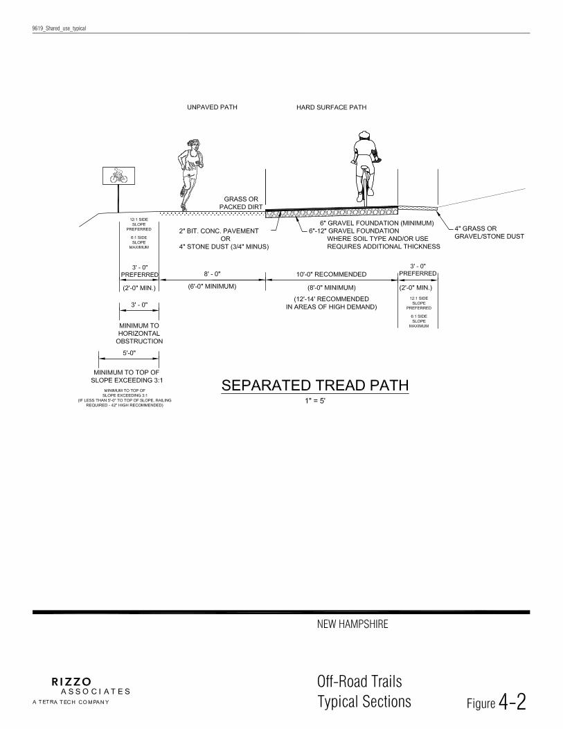
Facility design. Facility design will vary according to corridor condition, user types, and expected usage patterns. Facility designs should safely accommodate all users that are permitted, and should also be sensitive to cost of trail development and ongoing maintenance. The State Trails Plan includes guidelines and typical sections for the design of a variety of facility types, including paved paths, unpaved paths, separate tread paths, and rail-with-trail.
Corridor ownership, management and maintenance. Facilities throughout New Hampshire have a variety of ownership, management, and maintenance structures. Most of the major state-owned abandoned rail corridors in New Hampshire are owned by NHDOT, and managed by DRED, which has experience and institutional structures for trail management. In its role of providing for safe and efficient transportation in all modes, NHDOT should retain ownership of these corridors, and be actively involved in the development and improvement of trails, as well as the preservation of the corridors for potential future rail needs. DRED should remain involved in trail management, and RPCs and municipalities should participate in trail planning, development, and enforcement.
Future needs. A principal objective in acquiring abandoned rail corridors has been NHDOT’s goal of maintaining corridors for future rail use. However, multi-use trail development serves important transportation and recreation functions as well. The state-owned abandoned rail corridors should be improved where possible for trail use, either as an alternate use to future rail service, as an interim use, or as an adjunct use (i.e. future rail-with-trail). Regional planning commissions, municipalities, and private sector partners should be involved in trail development in state-owned rail corridors as well as other linear corridors that could support multi-use trail development.

NEW HAMPSHIRE STATE TRAILS PLAN
1-1
1. INVENTORY OF ABANDONED RAIL CORRIDORS
Abandoned rail corridors offer excellent opportunities for developing multi-use trails. After railroad service has been discontinued, the abandoned railroad corridors have ideal characteristics for multi-use trails: they provide continuous linear corridors, often for many miles, with relatively flat grades, bridges over water bodies and roads, and track beds that can be converted to trails. In addition, these corridors typically provide connections to population centers, but between the population centers the corridors may pass through areas that are undeveloped and appealing for recreation and transportation.
The State of New Hampshire owns over 300 miles of abandoned railroad corridors, in 23 different railroad corridors. These were acquired by the State in most cases to preserve the corridors for future rail use. ‘Abandonment’ is a legal proceeding through which the US Surface Transportation Board relieves a railroad of its obligation to provide freight rail service. Most of the corridors are owned by the New Hampshire Department of Transportation and are currently managed for interim recreation use by the Department of Resources and Economic Development (DRED). The corridors are used at present primarily as snowmobile trails. Other recreation uses such as hiking take place but generally the corridors have not been improved to the extent that they can serve as non-motorized transportation facilities. A list of the major state-owned abandoned railroad corridors is provided in Table 1. Several of these corridors have strong potential for future rail use, which limits their potential for active recreational trail development.
Table 1-1 State-owned Abandoned Rail Corridors
No. Railroad Name Limits Length (miles)
1 Berlin Branch, Southern section Haverhill to Littleton 18.9 2 Berlin Branch, Northern Section Jefferson to Gorham 18.3 3 Upper Coos Railroad Whitefield to Jefferson 1.9 4 Upper Coos Railroad – Beecher Falls Branch Colebrook to Beecher Falls 8.7 5 Profile Railroad Bethlehem 2.0 6 Conway Branch Ossipee to Conway 21.3 7 Wolfeboro Railroad Wakefield to Wolfeboro 11.4 8 Northern Railroad, Eastern Section Boscawen to Danbury 34.0 9 Northern Railroad, Western Section Danbury to Lebanon 25.0 10 Sugar River Railroad Newport to Claremont 10.5 11 Manchester and Lawrence Branch* Salem to Manchester 23.0 12 Portsmouth Branch Newfields to Manchester 27.4 13 Fremont Branch, Southern Section Hudson to Fremont 22.1 14 Fremont Branch, Northern Section Fremont to Epping 4.5 15 Hampton Branch Seabrook to Hampton 4.2 16 Lakeport Branch Rochester 1.5 17 Farmington Branch Rochester to Farmington 6.8 18 Ashuelot Branch Hinsdale to Keene 21.5 19 Cheshire Branch Fitzwilliam to Walpole 42.0 20 Fort Hill Branch Hinsdale 8.7 21 Hillsborough Branch Hillsborough to Bennington 7.8 22 Monadnock Branch Rindge to Jaffrey 7.2 23 Greenville Branch Mason to Greenville 2.2 Total Rail Corridor Mileage 330.9 * mileage of this corridor includes some municipal and railroad owned segments

NEW HAMPSHIRE STATE TRAILS PLAN
1-2
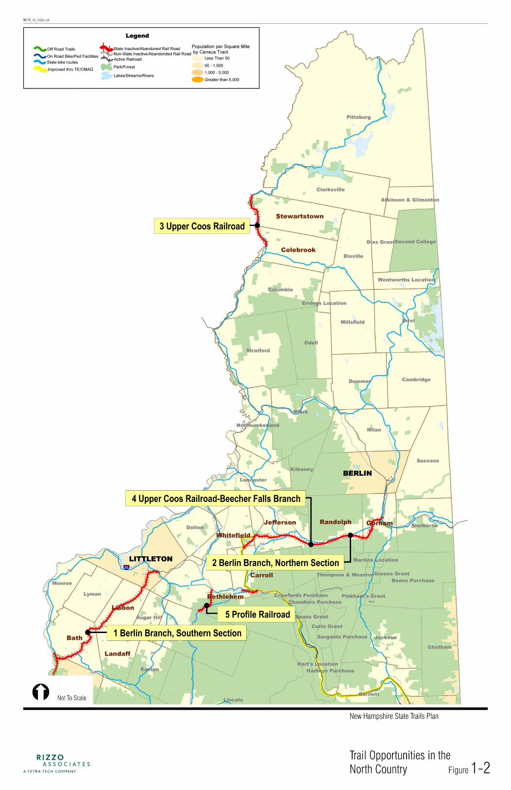
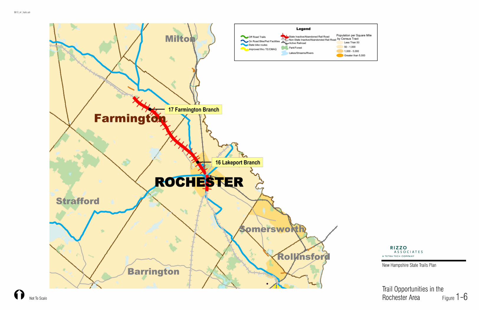
These 23 state-owned abandoned railroads are shown on an overall state map in Figure 1-1. There are also six larger scale maps of different regions of the state, with more detailed representations of the rail corridors and the connections that they make. These regional maps precede the detailed descriptions of the rail corridors within each region.
Research was conducted on each of the 23 state-owned abandoned railroads. This included an examination of railroad valuation plans, most of which were prepared in the early 20th century. These ‘val plans’ show the surveyed railroad right-of-way and key features including railroad structures and road crossings. A one-page summary sheet was prepared for each of the 23 state-owned abandoned rail corridors. Each sheet lists the following information:
Summary of Existing Conditions
Railroad Name Trail Name (if any) Begin Station (railroad stationing system) Begin Location End Station (railroad stationing system) End Location Length in miles Region(s) in which railroad is located Town(s) in which railroad is located Owner Management agreement with DRED (if any) Non-winter uses allowed Winter motorized uses allowed (Non-motorized-Transportation-NMT, All Terrain Vehicles-ATVs) Parallels State Bicycle Route (US, State Highway, or local roads) Corridor surface (description of surface condition) Connects to [trail name if any] Number of rail bridges Maintained by (often snowmobile or trail organization) Typical right-of-way (ROW) widths Lake(s) abutting railroad (if any) River(s) crossed by railroad (if any) Railroad History
Summary of historically significant events
Possible Future Rail Use
Passenger or Freight Rail Service listed (if applicable) Plans for Trail Development
Summary of any local, regional or state plans to improve trail (if applicable)
These rail corridors vary widely in condition and current use. Some of these corridors have been improved, and even have paved segments, such as the section of the Cheshire Branch in Keene. Most of the corridors, however, have not been improved significantly since they were abandoned by the railroads. When the railroads abandoned these corridors, the rails were typically removed and used for scrap, and the wooden ties were usually removed, although even the ties remain in some corridors.
Most of the rail corridors currently have unimproved railroad ballast surfaces. This railroad ballast is the surface that the rail ties sat in to keep them stable, and it is typically gravel from the surrounding area. These gravel trails

NEW HAMPSHIRE STATE TRAILS PLAN
1-3
provide a good surface for snowmobiles (when covered with snow), but generally not for non-motorized users. However, this gravel ballast would serve as a good trail foundation if covered with compacted stone dust or asphalt pavement (where appropriate). Some trails have sections where the ballast has been covered with stone dust or packed dirt; these trails provide better surfaces for pedestrians and mountain bikes.

NEW HAMPSHIRE STATE TRAILS PLAN
1-4
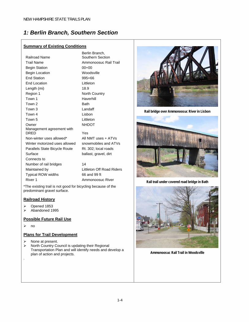
1: Berlin Branch, Southern Section Summary of Existing Conditions
Railroad Name Berlin Branch, Southern Section
Trail Name Ammonoosuc Rail Trail Begin Station 00+00 Begin Location Woodsville End Station 995+66 End Location Littleton Length (mi) 18.9 Region 1 North Country Town 1 Haverhill Town 2 Bath Town 3 Landaff Town 4 Lisbon Town 5 Littleton Owner NHDOT Management agreement with DRED Yes Non-winter uses allowed* All NMT uses + ATVs Winter motorized uses allowed snowmobiles and ATVs Parallels State Bicycle Route Rt. 302; local roads Surface ballast, gravel, dirt Connects to Number of rail bridges 14 Maintained by Littleton Off Road Riders Typical ROW widths 66 and 99 ft River 1 Ammonoosuc River
*The existing trail is not good for bicycling because of the predominant gravel surface.
Railroad History Opened 1853 Abandoned 1995
Possible Future Rail Use no
Plans for Trail Development None at present. North Country Council is updating their Regional
Transportation Plan and will identify needs and develop a plan of action and projects.
.
Rail bridge over Ammonoosuc River in Lisbon
Rail trail under covered road bridge in Bath
Ammonoosuc Rail Trail in Woodsville

NEW HAMPSHIRE STATE TRAILS PLAN
1-5
2: Berlin Branch, Northern Section
Railroad Name Berlin Branch, Northern Section
Trail Name Presidential Rail Trail Begin Station 325+03 Begin Location Jefferson End Station 1291+20 End Location Gorham Length (mi) 18.3 Region 1 North Country Town 1 Jefferson Town 2 Randolph Town 3 Gorham Owner NHDOT Management agreement with DRED Yes Non-winter uses allowed* all NMT uses Winter motorized uses allowed snowmobiles and ATVs Parallels State Bicycle Route US 2; Rt. 115; Rt. 115A Surface ballast, gravel, dirt Connects to Pondicherry Rail Trail Number of rail bridges 14 Maintained by DRED Typical ROW widths 99 to 120 ft River 1 Israel’s River South River 2 Moose River
*The existing trail is not good for bicycling because of the predominant gravel surface. Railroad History Opened 1851 Abandoned 1996
Possible Future Rail Use No
Plans for Trail Development None at present. North Country Council is updating their Regional Transportation
Plan and will identify needs and develop a plan of action and projects.
Advisory Committee members noted that trail improvements to better accommodate bicycles would provide an alternative to Route 2 which is not a good road for cycling in part due to heavy truck traffic, a lack of shoulders in some sections, and steep grades.
An improved trail may provide a boost to area economy through increased tourism.
Presidential Range Rail Trail
Boxed Pony Truss Bridge on Rail Trail
Presidential Range Rail Trail

NEW HAMPSHIRE STATE TRAILS PLAN
1-6
3: Upper Coos Railroad
Railroad Name Upper Coos Railroad Trail Name Pondicherry Rail Trail Begin Station Whitefield Begin Location 33+00 End Station Jefferson End Location 133+69 Length (mi) 1.9 Region 1 North Country Town 1 Whitefield Town 2 Jefferson Owner NHDOT Management agreement with DRED Yes Non-winter uses allowed* none Parallels State Bicycle Route US 3; Rt. 116 Winter motorized uses allowed snowmobiles and ATVs Surface rail Connects to Presidential Rail Trail Number of rail bridges 0 Maintained by DRED Typical ROW widths 99 ft
*railroad is active in non-winter months. Railroad History Opened 1889 Abandoned 1977
Possible Future Rail Use Freight rail
Plans for Trail Development None at present. North Country Council is updating their Regional Transportation
Plan and will identify needs and develop a plan of action and projects.

NEW HAMPSHIRE STATE TRAILS PLAN
1-7
4: Upper Coos Railroad – Beecher Falls Branch
Railroad Name Upper Coos Railroad –
Beecher Falls Branch Trail Name Begin Station Colebrook Begin Location 2457+43.4 End Station Stewartstown End Location 2918+50 Length (mi) 8.7 Region 1 North Country Town 1 Colebrook Town 2 Stewartstown Owner NHDOT Management agreement with DRED Yes Non-winter uses allowed* walking Winter motorized uses allowed snowmobiles and ATVs Parallels State Bicycle Route Rt. 3 Surface Rail Connects to Number of rail bridges 1 Maintained by DRED Typical ROW widths 66 River 1 Connecticut River
*Since the rail is still in place, the only significant non-winter use is walking. Railroad History Opened 1891 Out of service 1989
Possible Future Rail Use no
Plans for Trail Development None at present. North Country Council is updating their Regional Transportation
Plan and will identify needs and develop a plan of action and projects.

NEW HAMPSHIRE STATE TRAILS PLAN
1-8
5: Profile Railroad
Railroad Name Profile Railroad Trail Name Profile Recreation Trail Begin Station Begin Location Bethlehem End Station End Location Franconia Length (mi) 2.0 Region 1 North Country Region 2 Town 1 Bethlehem Town 2 Owner DRED Management agreement with DRED n/a Non-winter uses allowed all NMT uses Winter motorized uses allowed snowmobiles and ATVs Parallels State Bicycle Route Trudeau Road Surface Dirt Connects to Number of rail bridges
Maintained by DRED Typical ROW widths 99 ft Lake 1 River 1
Railroad History Opened 1879 Abandoned 1921
Possible Future Rail Use no
Plans for Trail Development None at present. North Country Council is updating their Regional
Transportation Plan and will identify needs and develop a plan of action and projects.
Profile Railroad corridor in Bethlehem

NEW HAMPSHIRE STATE TRAILS PLAN
1-9
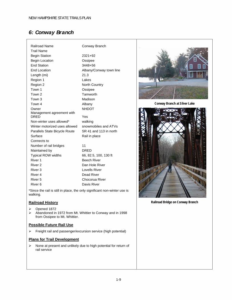
6: Conway Branch
Railroad Name Conway Branch Trail Name Begin Station 2321+92 Begin Location Ossipee End Station 3448+56 End Location Albany/Conway town line Length (mi) 21.3 Region 1 Lakes Region 2 North Country Town 1 Ossipee Town 2 Tamworth Town 3 Madison Town 4 Albany Owner NHDOT Management agreement with DRED Yes Non-winter uses allowed* walking Winter motorized uses allowed snowmobiles and ATVs Parallels State Bicycle Route SR 41 and 113 in north Surface Rail in place Connects to Number of rail bridges 11 Maintained by DRED Typical ROW widths 66, 82.5, 100, 130 ft River 1 Beech River River 2 Dan Hole River River 3 Lovells River River 4 Dead River River 5 Chocorua River River 6 Davis River
*Since the rail is still in place, the only significant non-winter use is walking. Railroad History Opened 1872 Abandoned in 1972 from Mt. Whittier to Conway and in 1998
from Ossipee to Mt. Whittier.
Possible Future Rail Use Freight rail and passenger/excursion service (high potential)
Plans for Trail Development None at present and unlikely due to high potential for return of
rail service
Conway Branch at Silver Lake
Railroad Bridge on Conway Branch

NEW HAMPSHIRE STATE TRAILS PLAN
1-10
7: Wolfeboro Railroad
Railroad Name Wolfeboro Railroad Trail Name Cotton Valley Trail Begin Station 9+50 Begin Location Wakefield End Station 611+84.2 End Location Wolfeboro Length (mi) 11.4 Region 1 Lakes Town 1 Wakefield Town 2 Brookfield Town 3 Wolfeboro Owner NHDOT Management agreement with DRED Yes Non-winter uses allowed all NMT uses + speeder cars on RR Winter motorized uses allowed snowmobiles and ATVs Parallels State Bicycle Route Rt. 109; local roads Surface gravel, dirt, stone dust Connects to Number of rail bridges 3
Maintained by TRAC and Cotton Valley Rail Trail Club
Typical ROW widths 66 ft Lake 1 Wentworth
Railroad History Opened 1870 Abandoned 1986 The railroad’s tracks are still in place (and owned by the State of
NH). The Wolfeboro Railroad is the only place in New England where old “speeder” cars (antique railroad maintenance vehicles) are allowed to operate. A club helps maintain the tracks.
Possible Future Rail Use No
Plans for Trail Development None at present. Check on status of any planned improvements in Brookfield and
Wakefield.
Rail with trail section in Wolfeboro
Area between rails filled in for trail use
Speeder car of the type that uses the Wolfeboro
Railroad

NEW HAMPSHIRE STATE TRAILS PLAN
1-11
8: Northern Railroad, Eastern Section
Railroad Name Northern Railroad, Eastern SectionBegin Station 383+59.4 Begin Location Boscawen End Station 2190+15 End Location Danbury Length (mi) 34 Region 1 Lakes Region 2 Central Town 1 Boscawen Town 2 Franklin Town 3 Andover Town 4 Danbury Owner NHDOT Management agreement with DRED Yes Non-winter uses allowed* all NMT uses Winter motorized uses allowed snowmobiles and ATVs Parallels State Bicycle Route US 4; Rt. 11; Rt. 132; local roads Surface Ballast, cinder, gravel Connects to Number of railroad bridges 36
Maintained by
Mascoma Sno-Travelers, Andover Snowmobile Club, Mt. Cardigan Snowmobile Club, Townline Trail Dusters
Typical ROW widths 82.5 and 99 ft River 1 Merrimack River River 2 Blackwater River
*The existing trail is not good for bicycling in sections with gravel surface, such as shown in Boscawen. Railroad History Opened 1847 Abandoned 1992
Possible Future Rail Use Boston – Montreal High Speed
Plans for Trail Development Existing trail could be extended south a short distance to serve
Town of Boscawen recreational fields (Boscawen is in Central Region).
Northern Railroad, Boscawen
Railroad ballast, Northern Railroad, Boscawen
Rail corridor in Wilmot
Rail bridge over Roy Ford Road in Danbury

NEW HAMPSHIRE STATE TRAILS PLAN
1-12
9: Northern Railroad, Western Section
Railroad Name Northern Railroad, Western SectionTrail Name Northern Rail Trail Begin Station 2190+15 Begin Location Danbury End Station 3515+69 End Location Lebanon Length (mi) 25 Region 1 Upper Valley Town 1 Danbury Town 2 Grafton Town 3 Orange Town 4 Canaan Town 5 Enfield Town 6 Lebanon Owner NHDOT Management agreement with DRED Yes Non-winter uses allowed* all NMT uses Winter motorized uses allowed snowmobiles and ATVs Parallels State Bicycle Route** US 4 Surface Ballast, cinder, gravel Connects to Number of rail bridges 46 Maintained by Friends of the Northern Rail Trail Typical ROW widths 82.5 and 99 ft Lake 1 Mascoma Lake River 1 Smith River River 2 Indian River River 3 Mascoma River River 4 Connecticut River
*The existing trail is not good for bicycling in many sections esp those with soft surface/ballast **UVLSPC notes that Rt. 4 is a high-speed, high volume roadway, which greatly limits its utility to many potential users. In contrast, the Northern Rail Trail, and rail trails in general, are ideal facilities for children and less experienced cyclists. Railroad History Opened 1847 Abandoned 1992
Possible Future Rail Use Boston – Montreal High Speed
Plans for Trail Development Upper Valley Trails Alliance is studying the feasibility of developing a rail-
with-trail on active portion of Northern Railroad including bridge over the Connecticut River.
Upper Valley Lake Sunapee Regional Planning Commission (UVLSRPC) notes that upgrading trail surface, width and drainage in Lebanon and between Lebanon and Enfield could increase transportation utility of trail. The connection along the rail corridor between downtown Lebanon and West Lebanon village / White River Junction (VT) would be a heavily used facility and that the connection would help to address some of the goals in the City of Lebanon Pedestrian and Bicycle Plan.
Any major investment in trail improvements must be weighed against the likelihood and timing of Boston – Montreal rail service.
Northern Rail Trail, Lebanon
Northern Rail Trail, Lebanon
NEW HAMPSHIRE STATE TRAILS PLAN
1-13
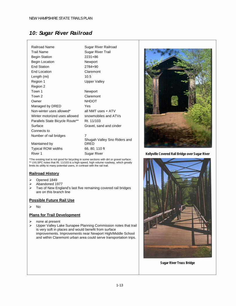
10: Sugar River Railroad
Railroad Name Sugar River Railroad Trail Name Sugar River Trail Begin Station 2231+86 Begin Location Newport End Station 2784+90 End Location Claremont Length (mi) 10.5 Region 1 Upper Valley Region 2 Town 1 Newport Town 2 Claremont Owner NHDOT Managed by DRED Yes Non-winter uses allowed* all NMT uses + ATV Winter motorized uses allowed snowmobiles and ATVs Parallels State Bicycle Route** Rt. 11/103 Surface Gravel, sand and cinder Connects to Number of rail bridges 7
Maintained by Shugah Valley Sno Riders and DRED
Typical ROW widths 66, 80, 110 ft River 1 Sugar River
*The existing trail is not good for bicycling in some sections with dirt or gravel surface. ** UVLSPC notes that Rt. 11/103 is a high-speed, high volume roadway, which greatly limits its utility to many potential users, in contrast with the rail trail. Railroad History Opened 1849 Abandoned 1977 Two of New England’s last five remaining covered rail bridges
are on this branch line
Possible Future Rail Use No
Plans for Trail Development none at present Upper Valley Lake Sunapee Planning Commission notes that trail
is very soft in places and would benefit from surface improvements. Improvements near Newport High/Middle School and within Claremont urban area could serve transportation trips.
Kellyville Covered Rail Bridge over Sugar River
Sugar River Truss Bridge


NEW HAMPSHIRE STATE TRAILS PLAN
1-14
11: Manchester and Lawrence Branch
Railroad Name Manchester & Lawrence Branch Trail Name Begin Station 1567+28 Begin Location Salem End Station 2780+36 End Location Manchester Length (mi) 23.0 Region 1 Rockingham Region 2 Southern Town 1 Salem Town 2 Windham Town 3 Derry Town 4 Londonderry Town 5 Manchester Owner 1 NHDOT Owner 2 Town of Derry Owner 3 City of Manchester Owner 4 Guilford Owner 5 Private Quarry Owner Management agreement with DRED
parts in Windham, Salem and Londonderry
Non-winter uses allowed* all NMT uses Winter motorized uses allowed snowmobiles and ATVs Parallels State Bicycle Route Local roads
Surface Rail, gravel, sand, dirt, paved, grass
Connects to Number of rail bridges 11 Maintained by Derry Pathfinders Typical ROW widths 82.5 and 99 ft River 1 River 2
Massabesic River Spickett River (Salem)
*The existing trail is not good for bicycling in some sections especially those with soft surface, ballast or rails. Railroad History Opened 1851 Abandoned 1983
Possible Future Rail Use commuter rail and freight rail
Plans for Trail Development State is in process of acquiring last remaining section owned by
Guilford in Salem. Trail improvements in this corridor are recommended in Salem –
Concord Bikeway Feasibility Study and supported by most of the municipalities involved. Segments in City of Manchester are funded and in design. Sections in Derry are built.
Manchester and Lawrence Branch in Windham
Stone Rail Bridge, Windham
Rail Bridge over Massabesic River, Manchester

NEW HAMPSHIRE STATE TRAILS PLAN
1-15
12: Portsmouth Branch
Railroad Name Portsmouth Branch or Manchester – Portsmouth Branch
Trail Name Rockingham Recreation Trail Begin Station 522+57 Begin Location Newfields End Station 1967+15.5 End Location Manchester Length (mi) 27.4 Region 1 Rockingham Region 2 Southern Town 1 Newfields Town 2 Epping Town 3 Raymond Town 4 Candia Town 5 Auburn Town 6 Manchester Owner 1 NHDOT Owner 2 City of Manchester (west of Page St) Management agreement with DRED Yes Non-winter uses allowed* all NMT uses Winter motorized uses allowed snowmobiles only Parallels State Bicycle Route Rt. 27; Rt. 87; local roads Surface gravel, dirt Connects to Fremont Branch Trail Number of rail bridges 11
Maintained by
So. NH Snow Stickers, Rockingham Rec Trail and Massabesic Mushers Association
Typical ROW widths 66 ft Lake 1 Massabesic Lake River 1 Pawtuckaway River River 2 Lamprey River River 3 Scribner's River
*The existing trail is not good for bicycling in some sections with dirt or gravel surface. Railroad History Opened 1862 Abandoned 1982 Though regular passenger service ended in 1954, passengers were
allowed in the cabooses of freight trains until the early 1960’s.
Possible Future Rail Use No
Plans for Trail Development City of Manchester has plans to improve its section of the trail. Town of Candia supports protection of corridor and development of
town wide trail system.
Rail Bridge over Lamprey River
Rockingham Trail between Epping and
Raymond
Rockingham Trail at Raymond Station
NEW HAMPSHIRE STATE TRAILS PLAN
1-16
13: Fremont Branch, Southern Section
Railroad Name Fremont Branch, Southern Section Trail Name Rockingham Recreation Trail Begin Station 2508+40 Begin Location Hudson End Station 3672+90 End Location Fremont Length (mi) 22.1 Region 1 Rockingham Region 2 Nashua Town 1 Windham Town 2 Derry Town 3 Hampstead Town 4 Sandown Town 5 Danville Town 6 Fremont Owner DRED Management agreement with DRED NA
Non-winter uses allowed
All NMT uses. All Terrain Vehicles (ATVs) permitted in non-snow seasons on segment of Fremont Branch from Route 28 (Derry) to Route 107 (Fremont)
Winter motorized uses allowed snowmobiles and ATVs Parallels State Bicycle Route Local roads Surface Connects to Rockingham Trail Number of rail bridges 8
Maintained by Derry Pathfinders and So. NH Trail Blazers
Typical ROW widths 82.5 and 99 ft River 1 Exeter River
Railroad History Opened 1874 Abandoned 1982
Possible Future Rail Use no
Plans for Trail Development None at present. The segment of the Fremont Branch west of I-93 is no longer owned
by the State of NH. Three miles of the trail from I-93 to Route 111 is owned by the Town
of Windham and is designated for non-motorized uses. West of Route 111, the rail corridor has been used for the
realignment of Route 111, and is no longer available for trail use.
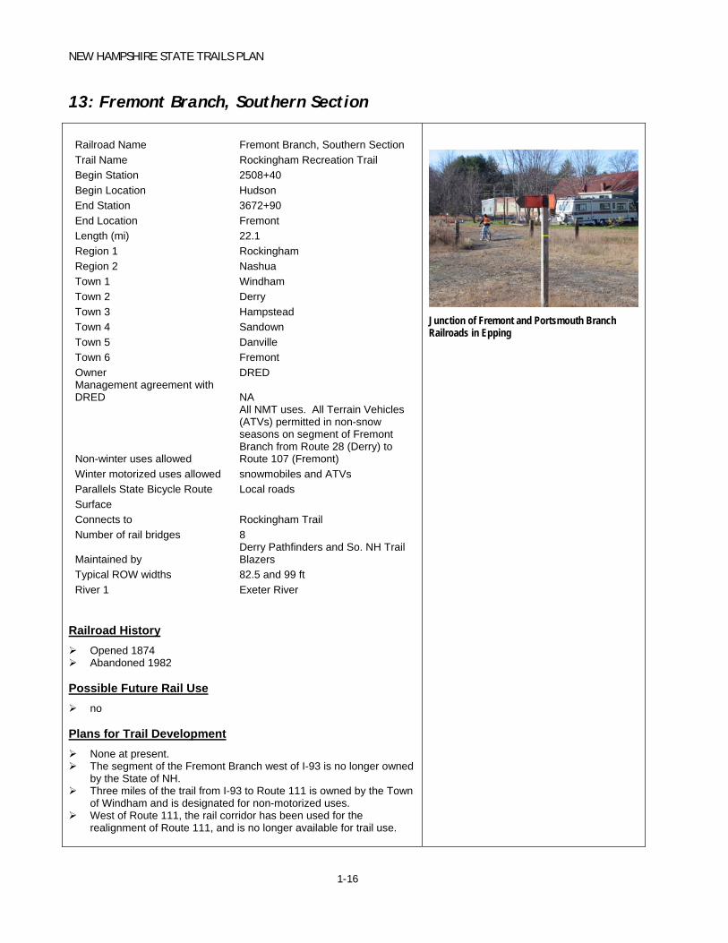
Junction of Fremont and Portsmouth Branch Railroads in Epping

NEW HAMPSHIRE STATE TRAILS PLAN
1-17
14: Fremont Branch, Northern Section
Railroad Name Fremont Branch, Northern Section Trail Name Rockingham Recreation Trail Begin Station 3672+88 Begin Location Fremont End Station 3907+93 End Location Epping Length (mi) 4.5 Region 1 Rockingham Region 2 Town 1 Fremont Town 2 Epping Owner NHDOT Management agreement with DRED Yes
Non-winter uses allowed all NMT uses + ATVs [Rt 28 to Rt 107]
Winter motorized uses allowed snowmobiles and ATVs Parallels State Bicycle Route Rt. 125; local roads Surface gravel, dirt Connects to Rockingham Trail Number of rail bridges 1
Maintained by Derry Pathfinders and So. NH Trail Blazers
Typical ROW widths 82.5 and 99 ft Lake 1 Spruce Swamp River 1 Piscassic River
Railroad History Opened 1874 Abandoned 1982 This was a short segment of the famed Worcester, Nashua &
Portland Division of the Boston & Maine Railroad, and the route of the famous “name train” Bar Harbor which took passengers to that resort. It was also the busiest unsignaled single track line in the U.S.
Possible Future Rail Use no
Plans for Trail Development none at present Fremont Corridor runs through the Spruce Swamp in Fremont
(immediately north of Route 107). The Town of Fremont has approved and applied to the state for designation of the Spruce Swamp as a “Prime Wetland.” Fremont residents have expressed concern about ATVs (which are permitted on the trail south of Route 107, but not in the Spruce Swamp) seeking to operate in the Spruce Swamp.
The Town of Epping is investigating improving the section of trail between downtown Epping and the Route 125 commercial corridor.
Fremont Branch looking north approaching junction
with Rockingham Trail in Epping
NEW HAMPSHIRE STATE TRAILS PLAN
1-18
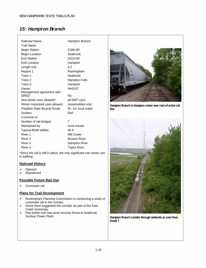
15: Hampton Branch
Railroad Name Hampton Branch Trail Name Begin Station 2188+85 Begin Location Seabrook End Station 2412+50 End Location Hampton Length (mi) 4.2 Region 1 Rockingham Town 1 Seabrook Town 2 Hampton Falls Town 3 Hampton Owner NHDOT Management agreement with DRED No Non-winter uses allowed* all NMT uses Winter motorized uses allowed snowmobiles only Parallels State Bicycle Route Rt. 1A; local roads Surface Rail Connects to Number of rail bridges 7 Maintained by none known Typical ROW widths 66 ft River 1 Mill Creek River 2 Browns River River 3 Hampton River River 4 Taylor River
*Since the rail is still in place, the only significant non-winter use is walking. Railroad History Opened Abandoned
Possible Future Rail Use Commuter rail
Plans for Trail Development Rockingham Planning Commission is conducting a study of
commuter rail in the corridor. Some have suggested this corridor as part of the East
Coast Greenway. Rail and/or trail may pose security threat at Seabrook
Nuclear Power Plant.
Hampton Branch in Hampton center near start of active rail line
Hampton Branch corridor through wetlands as seen from Route 1

NEW HAMPSHIRE STATE TRAILS PLAN
1-19
16: Lakeport Branch
Railroad Name Lakeport Branch Trail Name Lilac City Greenway Begin Station 434+69 Begin Location Rochester End Station 512+90 End Location Rochester Length (mi) 1.5 Region 1 Strafford Town 1 Somersworth Town 2 Rochester Owner NHDOT Management agreement with DRED No Non-winter uses allowed all NMT uses Winter motorized uses allowed snowmobiles only
Parallels State Bicycle Route Rt. 108; Rt. 125; local roads
Surface asphalt, gravel Connects to Farmington Branch Number of rail bridges 1 Maintained by DRED Typical ROW widths 66 and 99 ft
Railroad History Opened 1851 Abandoned 1993
Possible Future Rail Use no
Plans for Trail Development Shared-use path in center of Rochester, parallel to Route
125 to Main Street; construction is nearing completion. Paved from Upham Street to Lowell Street; packed gravel from Lowell Street to Old Dover Road.
Paved section of the Lakeport Branch parallel to Route 125 in Rochester
NEW HAMPSHIRE STATE TRAILS PLAN
1-20
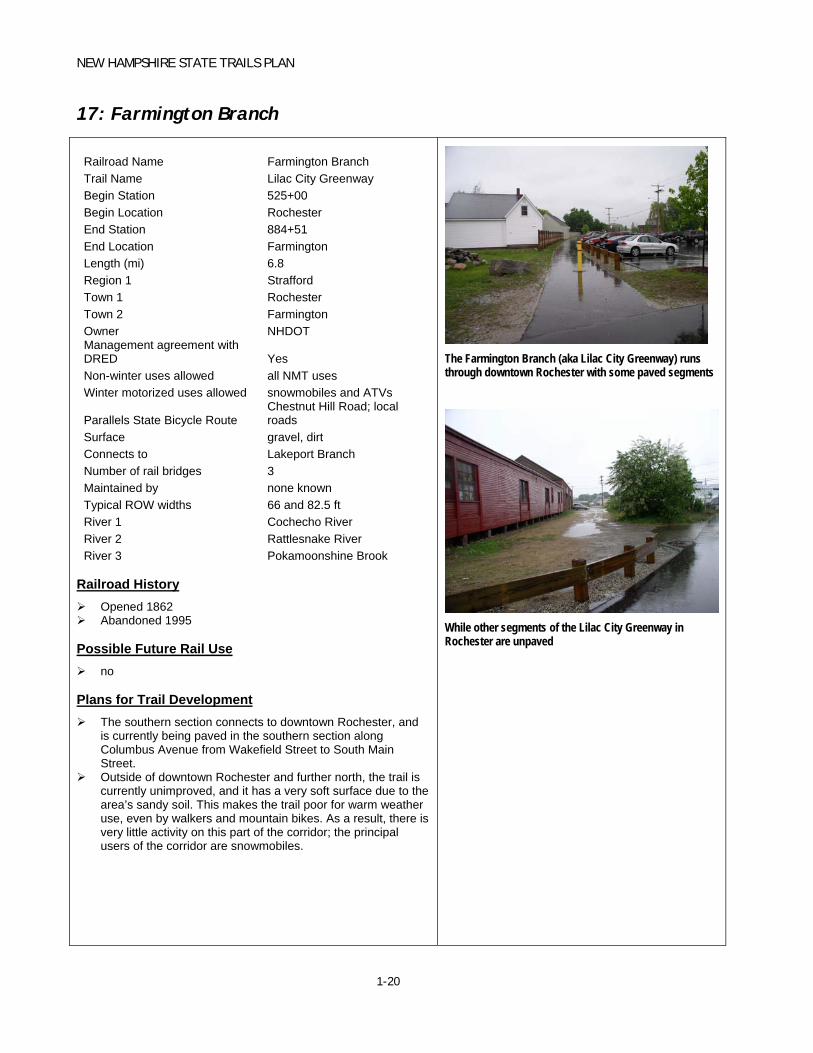
17: Farmington Branch
Railroad Name Farmington Branch Trail Name Lilac City Greenway Begin Station 525+00 Begin Location Rochester End Station 884+51 End Location Farmington Length (mi) 6.8 Region 1 Strafford Town 1 Rochester Town 2 Farmington Owner NHDOT Management agreement with DRED Yes Non-winter uses allowed all NMT uses Winter motorized uses allowed snowmobiles and ATVs
Parallels State Bicycle Route Chestnut Hill Road; local roads
Surface gravel, dirt Connects to Lakeport Branch Number of rail bridges 3 Maintained by none known Typical ROW widths 66 and 82.5 ft River 1 Cochecho River River 2 Rattlesnake River River 3 Pokamoonshine Brook
Railroad History Opened 1862 Abandoned 1995
Possible Future Rail Use no
Plans for Trail Development The southern section connects to downtown Rochester, and
is currently being paved in the southern section along Columbus Avenue from Wakefield Street to South Main Street.
Outside of downtown Rochester and further north, the trail is currently unimproved, and it has a very soft surface due to the area’s sandy soil. This makes the trail poor for warm weather use, even by walkers and mountain bikes. As a result, there is very little activity on this part of the corridor; the principal users of the corridor are snowmobiles.
The Farmington Branch (aka Lilac City Greenway) runs through downtown Rochester with some paved segments
While other segments of the Lilac City Greenway in Rochester are unpaved


NEW HAMPSHIRE STATE TRAILS PLAN
1-21
18: Ashuelot Branch
Railroad Name Ashuelot Branch Trail Name Begin Station 3+20 Begin Location Hinsdale End Station 1134+65 End Location Keene Length (mi) 21.5 Region 1 Southwest Town 1 Hinsdale Town 2 Winchester Town 3 Swanzey Town 4 Keene Owner NHDOT Management agreement with DRED Yes Non-winter uses allowed all NMT uses Winter motorized uses allowed snowmobiles and ATVs Parallels State Bicycle Route Rt. 119; local roads Surface ballast, gravel, dirt, cinder, sand Connects to Number of rail bridges 8
Maintained by Keene Sno-Riders, Winchester Trail Riders, Pisgah Mt. Trail Riders
Typical ROW widths 66 ft River 1 Ashuelot River
Railroad History Opened 1851 Abandoned 1983 Hinsdale, NH is one of a few places in the U.S. where the railroad
station sits on a hill overlooking the town it served.
Possible Future Rail Use no
Plans for Trail Development
Rail bridge abutment
Station on Ashuelot Branch

NEW HAMPSHIRE STATE TRAILS PLAN
1-22
19: Cheshire Branch
Railroad Name Cheshire Branch Trail Name Begin Station 569+58.5 Begin Location Fitzwilliam End Station 2784+05 End Location Walpole Length (mi) 42 Region 1 Southwest Town 1 Fitzwilliam Town 2 Marlborough Town 3 Swanzey Town 4 Keene Town 5 Surry Town 6 Westmoreland Town 7 Walpole Owner 1 NHDOT Owner 2 City of Keene Management agreement with DRED Yes Non-winter uses allowed all NMT uses Winter motorized uses allowed snowmobiles and ATVs Parallels State Bicycle Route SR 12 Surface gravel, dirt Connects to Number of rail bridges 36
Maintained by Monadnock Sno-Moles, Keene Snow Riders, Hooper Hill Hoppers
Typical ROW widths 82.5 and 99 ft River 1 Ashuelot River
Railroad History Opened 1849 Abandoned 1972 Due to its lack of overhead obstructions, it was the preferred hi and
wide (over-dimensional) route from Boston to Montreal.
Possible Future Rail Use no
Plans for Trail Development
Rail Station and Trail on Cheshire Branch (above)
Cheshire Branch Rail Trail in Keene
NEW HAMPSHIRE STATE TRAILS PLAN
1-23
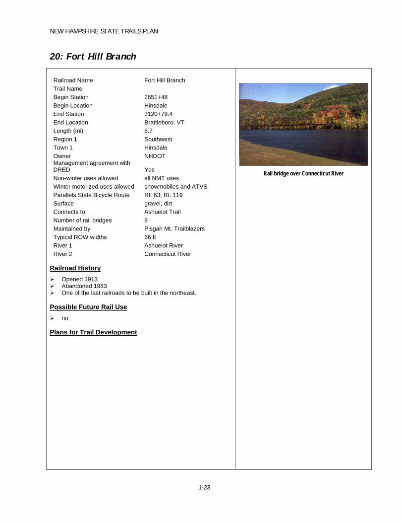
20: Fort Hill Branch
Railroad Name Fort Hill Branch Trail Name Begin Station 2651+48 Begin Location Hinsdale End Station 3120+79.4 End Location Brattleboro, VT Length (mi) 8.7 Region 1 Southwest Town 1 Hinsdale Owner NHDOT Management agreement with DRED Yes Non-winter uses allowed all NMT uses Winter motorized uses allowed snowmobiles and ATVS Parallels State Bicycle Route Rt. 63; Rt. 119 Surface gravel, dirt Connects to Ashuelot Trail Number of rail bridges 8 Maintained by Pisgah Mt. Trailblazers Typical ROW widths 66 ft River 1 Ashuelot River River 2 Connecticut River
Railroad History Opened 1913 Abandoned 1983 One of the last railroads to be built in the northeast.
Possible Future Rail Use no
Plans for Trail Development
Rail bridge over Connecticut River

NEW HAMPSHIRE STATE TRAILS PLAN
1-24
21: Hillsborough Branch
Railroad Name Hillsborough Branch Trail Name Begin Station 787+77 Begin Location Hillsborough End Station 1197+06 End Location Bennington Length (mi) 7.8 Region 1 Southwest Town 1 Hillsborough Town 2 Deering Town 3 Bennington Owner NHDOT Management agreement with DRED Yes Non-winter uses allowed all NMT uses + ATVs Winter motorized uses allowed snowmobiles and ATVs Parallels State Bicycle Route Rt. 202 Surface gravel, dirt Connects to State Bicycle Route Number of rail bridges 3
Maintained by
TriCounty OHRV summer and Knight Riders, Inc Snowmobile Club.
Typical ROW widths 66 ft River 1 Contoocook River
Railroad History Opened 1878 Abandoned 1979
Possible Future Rail Use no
Plans for Trail Development

NEW HAMPSHIRE STATE TRAILS PLAN
1-25
22: Monadnock Branch
Railroad Name Monadnock Branch Trail Name Begin Station 2014+62 Begin Location Rindge End Station 2395+67 End Location Jaffrey Length (mi) 7.2 Region 1 Southwest Town 1 Rindge Town 2 Jaffrey Owner 1 NHDOT Owner 2 Town of Jaffrey Management agreement with DRED Yes Non-winter uses allowed all NMT uses Winter motorized uses allowed snowmobiles and ATVs Parallels State Bicycle Route Rt. 202 Surface gravel, dirt, stone dust Connects to Number of rail bridges 1 Maintained by Monadnock Sno-Moles Typical ROW widths 80 ft Lake 1 River 1 Contoocook River
Railroad History Opened 1870 Abandoned 1984 Line was the location of the last scheduled service steam
locomotives in New England in the 1950’s. Photographers came from far and wide.
Possible Future Rail Use no
Plans for Trail Development
NEW HAMPSHIRE STATE TRAILS PLAN
1-26
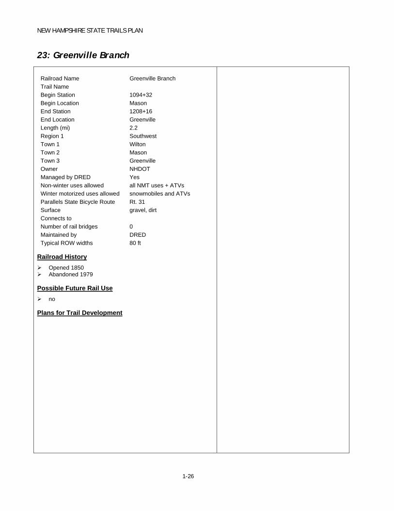
23: Greenville Branch
Railroad Name Greenville Branch Trail Name Begin Station 1094+32 Begin Location Mason End Station 1208+16 End Location Greenville Length (mi) 2.2 Region 1 Southwest Town 1 Wilton Town 2 Mason Town 3 Greenville Owner NHDOT Managed by DRED Yes Non-winter uses allowed all NMT uses + ATVs Winter motorized uses allowed snowmobiles and ATVs Parallels State Bicycle Route Rt. 31 Surface gravel, dirt Connects to Number of rail bridges 0 Maintained by DRED Typical ROW widths 80 ft
Railroad History Opened 1850 Abandoned 1979
Possible Future Rail Use no
Plans for Trail Development
NEW HAMPSHIRE STATE TRAILS PLAN
2-1
2. OTHER TRAIL PROJECTS
New Hampshire’s State-owned abandoned rail corridors, described in detail in the last chapter, have the potential to form the backbone of New Hampshire’s off-road multi-use trail system. However, these State-owned abandoned rail corridors are not the only off-road corridors that have been improved as multi-use trails, or have the potential to be improved in such a manner. There are many other off-street trail projects that are proposed, designed, or complete throughout New Hampshire. This chapter briefly describes other types of off-street trail projects, and the data gathering and mapping effort that has been undertaken for this study.
These other multi-use trails encompass a variety of different types of facilities, including the following:
Abandoned or inactive railroad corridors owned by entities other than the state (such as a municipality or a private owner)
Trails or informal paths that have been improved to accommodate a range of transportation and recreational users
Right-of-way adjacent to roadways, but separate from the roadway
Bridges dedicated for non-motorized use, or vehicular bridges that have been enhanced to provide dedicated non-motorized accessibility
The majority of these trail projects have been developed using Federal Highway Administration (FHWA) funds that are made available by NHDOT through two specific funding programs: Transportation Enhancements (TE) and Congestion Mitigation and Air Quality (CMAQ).
The TE program is designed to fund transportation-related projects that improve quality of life and community livability. A large portion of TE funding is used for bicycle and pedestrian projects, although the TE program funds transportation-related scenic, educational, historic, and cultural projects as well. The CMAQ program is intended to reduce automobile travel, congestion, and air pollution by funding a range of projects that includes bicycle and pedestrian improvements, traffic and roadway improvements that reduce congestion without encouraging increased traffic, travel demand management measures, and public transit operational improvements. Most of the off-road bicycle and pedestrian projects included in the state trail database have been developed through the TE program. The TE program is a more typical source of funding for bicycle and pedestrian projects, and CMAQ funding is typically used for other types of projects.
The State Trails Plan process developed a database of off-street trail projects by researching and soliciting input from a variety of sources. The NHDOT database of TE and CMAQ projects was reviewed, and all projects that include an off-street component were identified. Then, input was solicited from state agency representatives, regional planning commission (RPC) representatives, and municipal representatives about these projects and any other critical off-street trail projects. These representatives provided information about project characteristics,
NEW HAMPSHIRE STATE TRAILS PLAN
2-2
trail ownership and management, trail locations and connections, universal access, surface type, trail condition, and project status.
Once the appropriate database of projects was identified, geographic information for these projects was obtained from many different sources, including NHDOT, the RPCs, and municipalities. If geographic information was not readily available for a given project, that project was researched, and the location of the trail project was approximated. The geographic information for each project was linked to that project record, and all of the projects were mapped in a Geographic Information System (GIS) that was submitted to NHDOT.
A total of approximately 200 projects are included in the non-rail corridor database. These projects are shown in the map in Figure 2-1. Most of these projects are relatively small-scale projects that do not create a trail of significant length to be visible in the statewide map; other projects are not shown yet in the statewide map because they are still in the planning or design stage. Some of the projects, however, are of a significant length. Table 2-1 summarizes the characteristics of some of the major off-street trails that have been completed in the state. This is not a comprehensive list, but instead offers a sampling of some of the major off-street facilities.

NEW HAMPSHIRE STATE TRAILS PLAN
2-3
Table 2-1 Sample of Trail Improvement Projects State # Town Description LOCATION Status Owner Surface
Type Maintenance RPC
11918 Nashua Pedestrian bike path on Nashua Branch RR corridor [93-36TE]
Pedestrian/ Bike path
Construction complete
Nashua
NRPC_4 Milford Shared-use trail connecting Milford and Brookline (3 miles)
Granite Town Rail Trail
Construction Complete, Improvements Needed
Town of Milford
Gravel Conservation Commission
Nashua
NRPC_4B
Brookline Shared-use trail connecting Milford and Brookline (6 miles)
Granite Town Rail Trail Ext
1.5 miles of easements in place
Town of Brookline / Various
Gravel Conservation Commission
Nashua
12641 Wolfeboro Trail along the Wolfeboro branch line railroad from Fernald Station to Cotton Valley. This is a portion of a larger project to connect Wolfeboro, Brookfield and Wakefield [96-34TE]
Multi-use Path
State of New Hampshire
Unpaved Town of Wolfeboro
Lakes
12273 Wolfeboro Alternative transportation path along abandoned RR corridor from Whitten Neck Rd to NH 109 [94-14TE]
Multi-use Trail
State of New Hampshire
Unpaved Town of Wolfeboro
Lakes
12140 Laconia 3600’ of 5’ wide sidewalk along Union Ave and 1300’ of 8’ wide bike path on abandoned RR corridor [94-46TE]
Union Avenue
Construction complete
City of Laconia
Paved City of Laconia
Lakes Region
12138 Bath 13.5 mile bike / ped transportation corridor connecting 5 villages, residential and commercial areas [94-23TE]
North Country
12652 Manchester Acquisition of abandoned RR corridor in Manchester, part of Manchester – Lawrence Branch for recreational purposes [96-02TE]
Southern NH
13093 Goffstown Purchase approximately 5.0 miles of abandoned B&M RR corridor [98-48TE]
Southern NH
13103 Manchester 2.0 miles of 8’ wide path within RR corridor owned by NHDOT [98-47TE]
Pedestrian/ Bike path
Under construction
Southern NH
13493 Manchester Refurbish utility bridge for trail connection [00-59TE]
Southern NH
12133 B Fitzwilliam to Walpole
Cheshire Branch Railroad corridor acquisition from Fitzwilliam through Troy, Marlborough, Swanzey, Keene & Surrey to Walpole - 43.2 miles [94-03TE]
Acquisition complete
State of New Hampshire
unpaved State of New Hampshire
Southwest
12133 C Keene to Hinsdale
Ashuelot Railroad corridor acquisition from Hinsdale through Winchester & Swanzey to Keene [94-03TE]
Acquisition complete
State of New Hampshire
unpaved State of New Hampshire
Southwest
12166 Keene Bike / ped path through downtown Keene [94-02TE]
Gilbo Avenue
Construction complete
City of Keene
paved City of Keene Southwest
12680 Peterborough Construct Riverwalk to be used as multi-use transportation pathway connecting businesses to outlying areas [96-67TE]
Construction complete
Town of Peterborough
paved / unpaved
Town of Peterborough
Southwest
11922 Rochester Construct bike / ped path on acquired B&M RR corridor [93-11TE]
Strafford
12296 Portsmouth Construct bike / ped bridge spanning Spaulding Turnpike from Ashland Road Ramp [94-62TE]
Rockingham Bridge
Completed in 1998
Rockingham Planning Commission


NEW HAMPSHIRE STATE TRAILS PLAN
3-1
3. PLANNING CONTEXT
This chapter summarizes selected state and regional plans and other documents as they relate to bicycle, pedestrian and trail systems generally and rail trails specifically where appropriate. This review of key planning documents provides background and context for the State Trails Plan by describing some of the state planning priorities, and the regional and local projects and implementation goals.
State of New Hampshire Documents
New Hampshire Statewide Bicycle and Pedestrian Plan:
Introduction The New Hampshire Statewide Bicycle and Pedestrian Plan was adopted in May of 2000 as an element of the State’s Long Range Statewide Transportation Plan. One of the goals of the New Hampshire Department of Transportation—and the overriding goal of the New Hampshire Statewide Bicycle/Pedestrian Plan—is to recognize, support and encourage bicycling and walking as alternatives to motorized forms of transportation.1 The plan was developed through public input and the recommendations of the Bicycle Pedestrian Transportation Advisory Board.
Development Process The NHDOT has been purchasing abandoned railroad rights of way using federal/state funds for the preservation of rail corridors for future transportation needs. One of the identified uses for these rail corridors is for bicycle and pedestrian use. A Rails to Trails program to convert abandoned railroad corridors to usable trails is being developed. The New Hampshire Statewide Bicycle and Pedestrian Plan does not incorporate many of these trails since the trails are still under development.2
Funding Categories, Levels, and Availability Surface Transportation Program (STP) funds can be used for basically the same types of projects as the National Highway System (NHS) monies. Within the program, 10 percent of the funds are required to be used for Transportation Enhancements ($ 3.2 million each year) …this portion of the STP funds can be used for:
- Bicycle and Pedestrian facilities
- Preservation of abandoned railway corridors
Projects under the Transportation Enhancement program are not limited to construction of bicycle lanes or paths or pedestrian walkways. These funds can also be used to provide shelters, lockers, and other amenities to accommodate bicyclists or pedestrians. In addition, these funds can be used for bicycle/pedestrian planning activities.3
1 New Hampshire Statewide Bicycle and Pedestrian Plan May 2000, pg. 2 2 Ibid, pg. 14 3 Ibid, pg. 15

NEW HAMPSHIRE STATE TRAILS PLAN
3-2
New Hampshire Outdoors, 2003-2007 Statewide Comprehensive Outdoor Recreation Plan (SCORP):
Introduction New Hampshire Outdoors, 2003-2007 is New Hampshire's Statewide Comprehensive Outdoor Recreation Plan (SCORP). It serves as the State's official plan for outdoor recreation for the ensuing five years. The SCORP identifies major issues and challenges concerning the state's recreation and natural resources and offers a series of recommendations to address those issues. In some cases, the recommendations are guidelines; in others, they give direction for specific action, particularly for State agencies.4
Stewardship of the Natural Resource Base for Outdoor Recreation Protection of existing greenways and trail corridors has become an increasing challenge due to changes
in land ownership, private land closures, and increased development (Comprehensive Statewide Trails Study, 1997).5
Recommendations: Insure that the quality and quantity of the natural resource base is maintained or enhanced as recreation
pressures increase.6
Continue to support efforts to identify and protect open space lands. - Support comprehensive statewide and regional planning for open space, recreation corridors, and greenways (e.g. State, regional, and local open space plans, trail plans etc.)7
Providing Different, Sometimes Competing, Recreational Opportunities The 1997 Comprehensive Statewide Trails Study completed by the Office of State Planning found that
existing trails are inadequate to meet the current range of recreational activities.8
Impacts of Existing Land Use Patterns on Recreational Opportunities Many current land use development patterns negatively impact local and regional opportunities for trails
and recreation corridors.9
Respondents in the Statewide Outdoor Recreation Needs Assessment (UNH, 1997) said that about 50 percent of their outdoor recreational activity takes place within 10 miles of home.10
Recreation corridors can also serve as alternative transportation corridors.11
An important part of growing smarter includes preserving open space and parks, creating networks of trails and greenways that link community resources, and promoting bicycle/pedestrian friendly communities. All of these goals have a positive effect on local recreational opportunities and have solid links to transportation, health and land use planning goals.12
4 New Hampshire Outdoors, 2003-2007 Statewide Comprehensive Outdoor Recreation Plan (SCORP) March 2003, pg. 1 5 New Hampshire Outdoors, 2003-2007 Statewide Comprehensive Outdoor Recreation Plan (SCORP) Summary Report
June 2003, pg. 9 6 Ibid, pg. 10 7 Ibid. 8 Ibid, pg. 12 9 Ibid, pg. 21 10 Ibid. 11 Ibid. 12 Ibid.
NEW HAMPSHIRE STATE TRAILS PLAN
3-3
Recommendations: Promote interagency coordination to address regional recreation, trail and open space needs (e.g.
explore expanding the role of the Statewide Trails Advisory Committee in addressing regional trail needs).13
Encourage Regional Planning Commissions to coordinate and develop multi-community recreation and open space plans (e.g. Central New Hampshire Regional Planning Commission open space and trail planning assistance).14
Promote local development that is sensitive to protecting and enhancing local land and water-based recreation and natural and cultural resource protection opportunities. - Support efforts to create local and regional networks of trails and greenways. - Support efforts that link community resources via trails and improve the overall connectivity of trails. - Better incorporate open space and trails planning efforts into local and regional planning and land use decisions. - Promote “Walk to School” and other “Walk to” or “Bike to” programs.15
Educate communities about the importance and economic and non-economic benefits of local, close to home recreational opportunities. -Educate the public about the economic value of recreational opportunities in local communities.16
Importance of Local Outdoor Recreation Opportunities and Open Space Protection in Promoting Increased Health and Wellness Providing open space, parks, trails, and greenways for "recreation” can be an important part of larger
community efforts to develop more livable/walkable communities.17
Providing outdoor recreation opportunities within neighborhoods and communities and providing better access to information about recreational opportunities have been identified as important tools to address obesity and lack of physical activity.18
Nationwide initiatives and partnerships are also in place to promote use of trails as 'pathways to health' and to promote community partnerships aimed at encouraging physical fitness. Promoting trails and trail use is seen as a way of reaching the largest segments of the community. Walking/trail activities are the most popular recreational pursuits in the US, even among those 60 + years of age.19
Recommendations: Build connections with the NH Department of Transportation, local public works departments, and
local boards to promote bicycling and pedestrian connectivity and non-motorized transportation networks.20
Improve existing and new recreation opportunities by enhancing non-motorized (bicycle/pedestrian) accessibility and connectivity. Non-motorized access is particularly important to youth, elderly and disabled populations.21
13 Ibid, pg. 22 14 Ibid. 15 Ibid, pg. 23 16 Ibid. 17 Ibid, pg. 24 18 Ibid. 19 Ibid. 20 Ibid, pg. 25 21 Ibid, pg. 26

NEW HAMPSHIRE STATE TRAILS PLAN
3-4
Friends of the Northern Rail Trail Volunteer groups often make up the difference between a good idea and a success story. In 1996, the State acquired 60 miles of the old Boston & Maine Railroad Northern Line for recreation purposes. But acquiring the corridor proved to be just the beginning. The old rail line needed a great deal of work before it could be transformed into a year-round rail trail. The State had funds available to assist in such efforts but lacked the staffing or resources to undertake the necessary trail directly. That is where the Friends of the Northern Rail Trail in Grafton County (FNRT) stepped in. Using state recreational trail grant monies, private fundraising and foundation grants, FNRT paired these funds with a great deal of volunteer time and effort to start the corridor’s transformation into a recreation trail. So far, through an impressive volunteer effort, a 23 mile section of trail starting in Lebanon is open to foot traffic, bicycling, skiing, horseback riding, and snowmobiling. Volunteers removed rail ties, decked bridges, re-graded existing surface, and in some cases resurfaced sections of the trail to make it accessible to year round use. The group has also prepared a Rail Trail brochure for distribution and will continue to work on the remaining sections of trail down to Boscawen. Without such a coordinated volunteer effort, the Northern Rail Trail would still be in its infancy.22
A Plan for Developing New Hampshire’s Statewide Trail System for ATVs and Trail Bikes 2004 – 2008 December 2003:
Introduction In the span of a few short years, the use of all-terrain vehicles (ATVs) and trail bikes, otherwise known as wheeled off-highway recreational vehicles (OHRVs), has come to the forefront of New Hampshire’s recreational management issues. Concerns expressed by both wheeled OHRV supporters and opponents are warranted as the number of participants is expected to increase in the coming years. In recognition of both its popularity and its accompanying controversy, public land managers have consequently determined that providing safe and well managed wheeled motorized recreation in New Hampshire is an appropriate task and in alignment with statewide recreational goals. This document serves as the New Hampshire Department of Resources and Economic Development’s Statewide Trails Plan for ATVs and Trail Bikes (the Plan). As such, it calls for providing designated seasonal trails for ATVs and trail bikes, identifies major issues relayed to developing and managing these trails for use by wheeled OHRV during the snow-free months, and offers suggestions for addressing these issues.23
Plan Purpose and Need All-terrain vehicle (ATV) users and non-users often disagree over management of ATV use on public lands. Supporters of their use feel that the current trail availability in New Hampshire does not adequately provide for the current number of participants. According to the report, ATV users also feel that the state has expended insufficient effort toward increasing and improving trail access, despite an annual wheeled ATV registration fee that is one of the highest in the country. Concerned opponents of this form of recreation offer a different view and regard ATV use as an increasing problem. As its popularity continues to grow, non-users contend that ATV use is a significant source of negative impacts on the environment, trail conditions, the outdoor experiences of others, and on adjoining property owners. In addition, there is an overall concern for other issues such as trespassing and regulatory enforcement. It can be argued that ATV users, unlike other trail user groups, have not enjoyed extensive trail systems on public land in New Hampshire. For example, well-maintained hiking trails are found throughout the state on both state and federally owned land. Also for comparison, snowmobile trails make up the majority of trail mileage in the state. There are more than 6,830 miles of snowmobile trails providing roughly 0.12 miles for each of the 55,000 registered snowmobiles. The relatively few managed ATV facilities in the state are receiving increased use and subsequent impacts, to the extent that these areas are
22 New Hampshire Outdoors, 2003-2007 Statewide Comprehensive Outdoor Recreation Plan (SCORP) June 2003, pg. 91 23 A Plan for Developing New Hampshire’s Statewide Trail System for ATV’s and Trail Bikes 2004-2008 December 2003 Woodlot Alternatives, pg. i

NEW HAMPSHIRE STATE TRAILS PLAN
3-5
determined by some users to no longer provide enjoyable riding opportunities. This is particularly true of the most popular trails in the southern part of the state, such as the Rockingham Recreational Trail.24
Existing Conditions: Trails Designated for ATV Access ATVs have access to all snowmobile trails on DRED lands and those federal lands under DRED recreation management during full snow cover except one railroad grade (see Table 2).25
Table 3-1 Summary of ATV Trails Designated by the State of New Hampshire26
Trail Town County Ownership Trail Maintenance Organization
Surface and Use Description
Total Mileage
Estimated Wheeled ATV use
Trail Condition
Ammonoosuc River Rail Trail
Littleton, Haverhill, Bath, Lisbon
Grafton State-DOT Ammonoosuc Valley ATV Club; the Bureau
Multi-use rail trail, open year-round
29 Moderate Fair
Greenville Rail Trail
Greenville, Wilton
Hillsborough State-DOT The Bureau Multi-use rail trail, open year-round with mud season restriction
3 Light Good
Hillsborough-Bennington Rail Trail
Hillsborough, Bennington
Hillsborough State-DOT Tri-County ATV Club, Hillsborough; the Bureau
Multi-use rail trail, open year-round with mud season restriction
8 Moderate Good
Rockingham Recreational Trail
Derry, Sandown, Hampstead, Fremont
Rockingham State-DOT Rockingham County ATV Assn., Sandown; NH ATV Club, Auburn; the Bureau
Multi-use rail trail, open year-round
12 Heavy Fair
Sugar River Trail
Newport, Claremont
Sullivan State-DOT Sullivan County ATV Club; the
Bureau
Multi-use rail trail, open year-round
8 Heavy Good
Warren Rail Trail
Warren Grafton State-DOT The Bureau Multi-use rail trail, open year-round with mud season restriction
7 Light Poor
Designing the Finite Trail System To provide sizeable riding networks, the Bureau should seek to link two or three riding areas within each region. The first locations to investigate possible trail connections would be within existing municipal, state, and federal 24 Ibid, pg. 2 25 Ibid, pg. 7 26 Ibid, pg. 9-10

NEW HAMPSHIRE STATE TRAILS PLAN
3-6
holdings. Gaining and designating access to parcels that are in proximity to each other and existing ATV trails have high potential for improving trail opportunities, particularly those parcels with historical pathways. Previously created corridors, such as old roads or paths, should be evaluated for their potential to provide linkages between existing trails to prevent the occurrence of new disturbances.27
Abandoned railroad beds are ideal locations for developing trail networks. They provide unique transects of the landscape and remarkable scenery. Railroad rights-of-ways also tend to link communities so riding rail beds is often compatible with other activities. Although abandoned rail beds are trails, they were not constructed for recreation, especially wheeled motorized recreation, and would need to be enhanced to prevent damage to the bed. It is a common fallacy that an abandoned rail bed will eventually become a trail; however, adopting rail corridors for public trails is not as easy as it seems. These public rights-of-way are preserved to retain the bed for the possibility of returning rail service. Also, the railroad corridors are a unique contribution to New Hampshire’s historical legacy. Any rail bed adoption procedure should consider carefully their value as cultural resources.28
Suggested sites with potential for adding riding opportunities to the existing state trail system are listed in Table 3-2. Linking the existing systems in the South and Central Regions would provide large networked areas to sites with heavy riding pressure.29 In New Hampshire, a specialized ATV riding area would be ideally located near another heavily used trail, such as the one at Pisgah State Park or the Rockingham Recreational Trail. This situation could potentially relieve some of the riding pressure that these two trails currently experience.30
Table 3-2 Suggestions for ATV Trail Expansion Locations for Years 2004-2008.31
Site Towns Possibly Affected
Benefits to Expansion
Increased
Opportunities
Facilitators Obstacles
Linking Existing Systems
Sugar River and Claremont Trails
Claremont, Newport Connect a single segment with a large contained system
Diverse terrain One organized club currently maintains both trails
None known
Warren Line to Ammonoosuc Rail Trail
Benton, Haverhill Connect a shorter trail with longer trail
Flat terrain Existing railroad corridor could serve as link
Few facilities; possibly need participation of an additional club
Expanding Existing Trails
Rockingham Trail Freemont, Epping Lengthen a heavily used trail
Popular trail; flat, safe riding
Existing rail bed Residential areas
Greenville Line Wilton, Mason Lengthen a short trail Needed trail expansion in South Region
Existing rail bed Few facilities; high potential for public opposition; may require participation of a club
27 Ibid, pg. 24 28 Ibid. 29 Ibid, pg. 29 30 Ibid. 31 Ibid, pg. 31

NEW HAMPSHIRE STATE TRAILS PLAN
3-7
Comprehensive Statewide Trails Study, June 1997, New Hampshire Office of State Planning:
Introduction The Office of State Planning (OSP) in cooperation with the Department of Resources and Economic Development (DRED), Division of Parks and Recreation (DPR), and the Bureau of Trails (BT) conducted a year long study of the state trail system focusing on existing and potential trails throughout the state. The study was conducted under the guidance of Statewide Trails Advisory Committee representing public and private trail organizations. The primary purpose of the 1997 Statewide Comprehensive Trails Study is to address future trail needs, establish a recreation planning framework, analyze economic impacts and funding, discuss management and maintenance problems, identify priorities for protection and make recommendations.32
Background Despite maintenance setbacks, interest in trails across New Hampshire continues to grow. While hiking in the mountain regions has a long history, multi-use trails closer to urban centers continue to gain in popularity. In the future, trail users would like to find trails within a 15 minute drive from town. In order to accomplish this, trails should be planned as part of the state’s infrastructure, in the same category as highways and utilities and should be accessible to users’ homes and workplaces…Another effective tool to meet this objective is to convert abandoned rail beds and river ways into an expanded trail system. The State has been active in acquiring rail beds since the 1974 study [1974 Statewide Trails Study].33
Trail User Survey Most respondents to the 1996 questionnaires stated that multi-use trails were a wise investment and noted they felt ‘comfortable’ with other classes of users particularly when the rights-of-way is wide enough to accommodate other users.34
While several trails exist in the central and northern section of the State…there is a need for some dog sled trails in the southern section of the state, which the New England Sled Dog Association (NESDA) has recommended. Currently, dog sled operators in the southern section of the State are using the Rockingham Recreational Trail.35
Developing Trails The 1974 Statewide Trail Study discussed the potential use of abandoned railroad rights-of-way as links in the trail system. As noted in the study, these rights-of-way, ‘lend themselves to a wide variety of trail uses even if these uses are not compatible for all trail uses.’ Since the last study was completed, the State of New Hampshire, Bureau of Railroads has obtained title to thirteen lines…the 1974 Study recommended that each rail bed be ‘Trail Zoned’ for the various uses to be served, and provisions be made for trail maintenance, access, and linkage to other trails. In some instances a management agreement has been instituted between the Department of Transportation and the Department of Resources and Economic Development for the management of these rights-of-ways for recreational purposes. Potential discontinued rail lines that could be converted into rail-trails include the following:
Ashuelot Branch – The local rails to trails group, Ashuelot Rails-to-Trails (ARTA), has been active in planning and surveying the line for recreational use.
Manchester and Lawrence Branch – …there are no immediate plans for its development into a multi-use trail.
32 Comprehensive Statewide Trails Study, June 1997, New Hampshire Office of State Planning, pg. VII 33 Ibid, pg. 2-3 34 Ibid, pg. 17 35 Ibid, pg. 20

NEW HAMPSHIRE STATE TRAILS PLAN
3-8
Northern Branch – It has potential to become a major spur of the New Hampshire Heritage Trail. Of all the available rail beds this line has the greatest potential for development primarily because of its location in relation to existing trails.
Sugar River Recreation Trail – The 1974 Statewide Trail Study identified the entire 42 miles of rail bed as a potential trail corridor.36
Some examples of existing linkages could include connecting the old Concord to Claremont line, which includes the Sugar River section, with the Monadnock-Kearsage-Ragged Greenway. These linkages would assure recreational access for future generations as well as corridors for wildlife and plants.37
The acquisition of rail beds for multi use trails would provide an excellent mountain bike resource.38 Yet another possibility might be to harden one side of the abandoned North Branch rail bed to accommodate touring bikes. This same technique might also be applied to the Rockingham Recreation Trail.39
Issues, Goals, and Recommendations Issue 1: Protection of Resources DRED should continually work toward developing multi-use trails on abandoned rail lines as they become available. Coordination should be established and maintained with the New Hampshire Department of Transportation, Bureau of Rail and Public Transit.40
Summary One of the more important findings of the chapter on economic impacts was that significant revenue and jobs are created as a result of trails activities.41
Hiking has a long and honored tradition in the more remote mountain regions of the state. However, close-to-home multi-use trails are increasingly being recognized by the trails community that envisions trail within 15 minutes of home. Rails-to-trails, and greenway projects appear to be the primary approach for expanding the growing network of trailway systems. Community based trails projects are evidence of a strong grass roots trails movement in the state.42
Regional Planning Commissions (RPCs)
The following are summaries of the regional plans, as they relate to pedestrian, bicycle, trail, and off-street transportation and recreation planning. These plans are executed by the regional planning commissions (RPCs), the officially designated planning entities for each region of New Hampshire.
Lakes Region Planning Commission
The LRPC is currently working with an advisory committee on a Regional Bicycle and Pedestrian Plan. The plan will be the first of its type and primarily focus on policy. Goals and objectives will be developed and opportunities for trail development will be identified. LRPC staff and the advisory committee see a direct tie in between bicycling and walking and the region’s primary industry—tourism. They envision a network of existing and improved roads and off-road paths encircling Lake Winnipesaukee with spur routes to the village centers
36 Ibid, pg. 26-28 37 Ibid, pg. 32 38 Ibid. 39 Ibid, pg. 33 40 Ibid, pg. 61 41 Ibid, pg. VII 42 Ibid.
NEW HAMPSHIRE STATE TRAILS PLAN
3-9
and other destinations. The plan will also document existing municipal bicycle and pedestrian path projects including rail-to-trail and rail-with-trail projects in Northfield, Tilton, Franklin, Belmont and Laconia.
Southwest Region Planning Commission
There is strong support for designated bicycle routes to serve recreational and commuting traffic in the Southwest Region. The NH DOT in conjunction with the Regional Planning Commissions and interested citizens has developed a state bike route system that routes cyclists on a network of state highways and little used back roads. Keene has an established bicycle network used for recreational and daily trips by residents. Peterborough is also developing a bike path through town. These village systems are integral with the region’s Rails-to-Trails network.
Opportunities for recreational hiking and biking within the region are numerous with the presence of an extensive Rails-to-Trails system and several long distance trails, most notably, the Appalachian Trail. The Southwest Region Rails-to-Trails network comprises the abandoned Cheshire, Ashuelot, Fort Hill, Monadnock and Chesham railroad. This network connects 16 Southwest Region towns. Rail Trail development is undertaken by NH DRED, area trail user groups such as snowmobilers and cyclists, regional conservation organizations and municipalities.43
While the Hillsboro Branch rail line is inactive, the physical condition of the track as rated in the 1991 New Hampshire State Rail Plan is as follows:
Ties: Fair to Good
Surface: Fair to Good
Ballast: Cinder, stone, gravel – good
Drainage: Fair – good
Track Bridges: Fair to good
Abutments: Fair to good
Culverts: good
Crossings: fair44
Local Pedestrian and Bicycle Planning Pedestrian and bicycle planning at the municipal level is administered through Municipal Master Plans. Master Plans ideally summarize the extent and condition of facilities and articulate the municipalities’ policy regarding pedestrian and bicycle opportunities within the community. Municipalities are responsible for maintaining the municipal sidewalk network (on state and local roads) and municipal trail networks. Local Recreation Committees and Conservation Commissions are often active in planning and promoting enhanced pedestrian and bicycle access. Municipal budgets serve as the primary funding source for maintaining pedestrian and bicycle facilities. In the past several decades, pedestrian and bicycle access has been incidental to road development. Recently, there has been a noticeable increase in the demand for designated safe bicycle and pedestrian facilities in many Southwest Region towns. Many communities in the Southwest Region have identified this system deficiency in their Master Plans and are committed to finding ways to improve the system.
43 Southwest Region Transportation Plan 2001 Update, Southwest Region Planning Commission, pg. 26 44 Ibid, pg. 29

NEW HAMPSHIRE STATE TRAILS PLAN
3-10
The Southwest Region population, employment and service centers support the development of a local network of sidewalks and bike trails using municipal funds, volunteer organization fund-raising and Transportation Enhancement funding. The City of Keene has established a bicycle network for recreational and commuter activity. The towns of Peterborough and Jaffrey are developing bike paths through town and enhancing pedestrian facilities in the town center. The towns of Antrim, Greenfield and Hinsdale are also improving pedestrian access in their town centers. 45
Rail Corridors NHDOT has committed to a policy of preserving New Hampshire’s extensive network of abandoned railroad corridors for possible active rail use in the future and assisting in securing funding for the rehabilitation of remaining active lines. Abandoned rail lines acquired by the State in the Southwest Region for interim recreational trail use are the Cheshire Line, the Ashuelot Line, the Fort Hill Line, and the Monadnock Line.
1992 Southwest Region Transportation Plan The Planning Commission developed the 1992 Southwest Region Transportation Plan at the request of NH DOT and the Governor’s Advisory Committee on Intermodal Transportation in fulfillment of the requirements under ISTEA, as the Region’s contribution to the statewide transportation plan. Among the high priority recommendations identified in the 1992 Plan is to
Support analysis and development of pedestrian and bicycle systems in the Region’s population and village centers46
The mobility needs of the Southwest Region are served almost exclusively by personal motorized passenger vehicles and commercial trucking of freight. There is an increasing demand for facilities to support pedestrian and bicycle transportation both within densely developed centers and between. Several communities (e.g. Greenfield, Hinsdale, Jaffrey, Keene, and Peterborough) have undertaken comprehensive design and reconstruction projects to provide safe and meaningful connections in their centers for pedestrians and bicycles – both as an alternative to automobiles and in conjunction with car trips (a park-and-walk environment).47
Southern New Hampshire Planning Commission
The Southern New Hampshire Planning Commissions main purpose is to increase communication, cooperation and coordination among the local governments in the 13 communities that comprise the SNHPC. The Southern New Hampshire Planning Commission promotes inter-municipal cooperation between planning boards and local officials; promotes coordinated development of the region; prepares and adopts regional plans, including policies and strategies for the region; and performs other acts or functions as it deem appropriate to fulfill its duties. Regional Transportation Plan In response to the provisions of the Transportation Equity Act for the 21st Century (TEA-21), the Southern New Hampshire Planning Commission has prepared a long range, multi-modal transportation plan. The plan was recently updated in the spring of 2004. The Southern New Hampshire Regional Transportation Plan includes a Bikeways and Pedestrian Facilities component. The goal of this component is to create a transportation system that incorporates bicycles and the accommodation of pedestrians throughout the region.
45 Ibid, pg. 42-43 46 Ibid, pg. 49-50 47 Ibid, pg. 57

NEW HAMPSHIRE STATE TRAILS PLAN
3-11
The Objectives: • Increase the use of bicycles for people movement throughout the region. • Provide pedestrian-way and encourage their use.
The Policies:
• Provide bicycle/bicyclist facilities associated with routes. • Provide maps (guides) and publicity as to bicycle routes and their advantages. • Coordinate planning and transportation projects with bicycle interests. • Pursue funding opportunities. • Incorporate pedestrian-way planning (circulation) in the transportation element of the municipal master
plans. • Establish a local greenway/pedestrian corridor task force/committee in each municipality to oversee a
pedestrian-way development program. • Provide technical planning and construction detailing assistance to municipalities by state and regional
agencies. In addition, within the Railroad component, there is a policy that states that abandoned railroad right-of-ways should be acquired and preserved for other public users. Regional Bicycle and Pedestrian Plan The Southern New Hampshire Planning Commission updated the Regional Bicycle and Pedestrian Plan in the spring of 2003. The plan offers an overview of how the Southern New Hampshire Planning Commission region can become a safer, more inviting, and more practical place for people to walk ride bicycles. It serves as an update of the 1994 SNHPC region Bikeway and Pedestrian Master Plan, responds to a growing demand for bicycle and pedestrian facilities, and fulfills requirements specified in the federal Transportation Equity Act for the 21st Century. The plan’s overriding goal is to facilitate and encourage bicycling and walking as convenient, safe and practical forms of transportation throughout the Southern New Hampshire Planning Commission region. The goal is supported by a series of objectives that emphasize the regional biking and walking network, safety, appropriate design, education and promotion, and planning and maintenance. The goals and objectives of the plan envision the region’s future as one where many people walk and bicycle for both utilitarian and recreational purposes. It is a healthy and safe place to live, with vibrant city and town centers and calm rural areas. The long-range goal and objectives of the region’s pedestrian and bicycle strategy follow below. The objectives and policies reflect those of the current Regional Transportation Plan and further clarify the pedestrian and bicycle goals therein. The Regional Network Goal as stated in the Regional Bicycle and Pedestrian Plan: To establish a continuous and coordinated regional bikeway and pedestrian walkway system, ensuring that this regional system is well linked with local systems in municipalities and abutting towns and regions.
• Accommodate bicycle lanes on roads of sufficient width. • Modify sidewalks and intersections to facilitate pedestrian circulation. • Construct separate (dedicated) facilities where desirable and possible, and link new and existing trails
with on-street facilities. • Coordinate the design and construction of routes between local jurisdictions and adjacent regions to
ensure continuity. • Design the regional system to function as part of the overall transportation system; include appropriate
bicycle and pedestrian facilities in every project.

NEW HAMPSHIRE STATE TRAILS PLAN
3-12
Upper Valley Lake Sunapee Regional Planning Commission
Regional Plan Volume 2 Regional Transportation Plan (Feb. 5, 2004)
The Upper Valley Lake Sunapee Regional Bikeway System Plan recommends a network that incorporates bicycle lanes and paths along highways and abandoned railroad rights-of-way, based on available right-of-way widths and traffic conditions. The Plan provides a fairly well integrated bike system that should be augmented in urban and village areas with additional local routes. State and local transportation projects should provide the necessary infrastructure improvements on all highway and trail projects to support Regional and local bikeway system plans, where feasible.48
A number of recommendations in the Regional Bikeway System Plan have been implemented. For instance, numerous roadway projects throughout the Region have included shoulder widening to encourage greater bicycle accessibility. A number of Transportation Enhancement-funded projects have added bicycle infrastructure in communities in this Region and other improvements are planned for the future. In addition, inactive rail corridors have been turned into multi-use paths that serve as great recreational and transportation assets to residents of this Region. However, much work is needed to provide continuity of existing bicycle routes, linking existing facilities to the communities and providing bicycling infrastructure for children and less experienced cyclists who will not ride on highways. Particular consideration should be given to connecting important civic places, such as schools, recreation centers and libraries, with residential areas. Cycling should also be considered as a viable form of transportation for employee commutes and the appropriate on-site facilities should be provided by employers to encourage such behavior. In addition, it is important to provide good bicycling access to tourist destination.49 The overarching goal is to provide a safe, integrated network of bikeways throughout the Region for transportation and recreation.50
Bicycle facility planning should consider design features to encourage safe use. For instance, many highway corridors with more than 8000 Average Daily Traffic (ADT) would benefit from paths segregated from the roadway with a sufficient landscaped buffer to separate the bike path from the roadway. The Vermont Pedestrian and Bicycle Facility Planning and Design Manual contains suggestions for appropriate facility type based on average daily traffic and motor vehicle travel speed.51
Abandoned Rail Corridors Inactive rail corridors should be preserved for future use and for other uses, as has been the case with the Northern Rail Trail and the Sugar River Rail Trail. Unlike an air route, for example, which can be abandoned and reestablished without difficulty, selling parcels of a rail corridor results in the effective loss of that line. Thus, keeping these corridors intact should be given a high priority. As these corridors close or reopen, consideration should be given to sharing the line with recreation and other transportation modes when appropriate. Rail with Trail options should be considered along all rail corridors that can support such multi-use while not precluding current or future rail operations. VTrans recently evaluated the feasibility of a rail-with-trail along the Berlin line route which spans from Wells River to White River Junction, Vermont. The Region and individual communities can benefit from the recreation and transportation use of these shared rail lines.52
Northern Railroad: Boston and Maine Railroad The line was abandoned by Guilford Industries, the owner of the Boston and Maine Railroad, and purchased by NHDOT with Enhancement Funds, in order to assure preservation of this corridor. The abandonment of this
48 Regional Plan Volume 2 Regional Transportation Plan (Feb 5, 2004), Upper Valley Lake Sunapee Regional Planning Commission, pg. 21 49 Ibid, pg. 21 50Ibid, pg. 23 51 Ibid. 52 Draft Regional Plan 2003 Volume 2 Regional Transportation Plan, Upper Valley Lake Sunapee Regional Planning Commission, pg. 44

NEW HAMPSHIRE STATE TRAILS PLAN
3-13
line does not include a one mile section in Lebanon east from the Vermont line to approximately the Glen Road bridge. This section is currently operated by the Claremont-Concord Railroad with freight service.53
Sugar River: Claremont-Concord Railroad The Claremont-Concord Railroad right-of-way, from Pleasant Street in Claremont east to downtown Newport, was abandoned several years ago, with the State acquiring the right-of-way for rail banking purposes and converting it into a recreational trail. The remainder from Newport through Newbury was abandoned at an earlier date and was not preserved.54
Railroad Goals, Policies, and Recommendations Urge that NHDOT and VAOT actively preserve the integrity of all railroad rights-of-way indefinitely for transportation purposes. Preservation of intact rail corridors, even if temporarily abandoned to public uses such as recreation, should be given a high priority.55
UVLSRPC and state agencies should encourage multiple uses of rail corridors where appropriate.56
Preserve all existing railroad rights-of-way, whether abandoned, inactive or in service. NHDOT and VTrans should actively preserve the integrity of all railroads rights-of-way indefinitely for transportation (rails-with-trails and rails-to-trails), recreation and utility purposes.57
North Country Council
The North Country Council recognizes the challenges in trying to increase and diversify economic development while balancing any land use changes with the existing transportation infrastructure. New, high draw commercial ventures such as industrial parks or national retailers provide jobs and income for host communities. Seasonal fluctuations in numbers of visitors to our scenic North Country swell the number of vehicles on the roads, slowing traffic and increasing safety concerns. Bicyclists often have to vie with four-wheeled traffic for a piece of pavement on shoulder-less roads. Former rail corridors seek new incarnations as rail/trails and local airports are poised for expansion.
North Country Council's long-term relationship with the New Hampshire Department of Transportation and local officials provides hands-on partnering to solve current transportation problems and identify future mobility challenges.
Regional Transportation Plan Update The Regional Transportation Planner and the North Country Transportation Committee have begun working on the rewrite of the North Country’s Regional Transportation Plan. The plan will include statistics and accounts of existing conditions, the unmet needs regarding our transportation systems and services, and a plan of actions and projects to be included in future Transportation Improvement Programs and Transportation Enhancement Programs that will address those needs. The update will occur within the next two years. The Regional Transportation Planner and the Transportation Committee have already begun researching pertinent data and are working on a format for public information gathering meetings to be held in the spring of 2004.
Ten Year Plan Priorities Due to the funding constraints explained to the region by the New Hampshire Department of Transportation, the North Country Transportation Committee voted to not solicit for new projects this year to be included in the Ten Year Plan. The Committee instead focused on the review and prioritization of projects currently existing in the Ten Year Plan. The following projects received high priority from the Transportation Committee
53 Ibid, pg. 43 54 Ibid. 55 Ibid, pg. 42 56 Ibid, pg. 24 57 Ibid, pg. 45

NEW HAMPSHIRE STATE TRAILS PLAN
3-14
and were submitted as high priorities to the New Hampshire Department of Transportation in the Regional Transportation Improvement Program.
Milan to Dummer and Dummer to Erroll – Rt. 16 projects – road is in dire need of improvements. It is banned in the spring time every year providing no north to south traffic from Erroll south to Berlin.
Conway Bypass – This bypass has been in the plan for 20+ years. There are phases that have been completed and they are in the process of beginning new phases but the overall completion of the bypass is a top priority.
Warren - Wentworth Bridge – very dangerous bridge. There is a sharp corner going into and coming out of the bridge which makes it difficult for large trucks to stay on their side of the striped line. There was a fatal accident at this bridge involving two state troopers and the prisoner in their car. It is on schedule to be done in the next two – three years.
Bath and Lisbon Rt. 302 projects – there are several projects along Rt. 302 from Littleton down to Haverhill. The Committee ranks the improvement project high but prefers to see the bypass projects considered at a later date due to the fact that they need to be redesigned. The Committee feels the safety improvement projects should be done while NHDOT redesigns the bypass options.
Gorham Intersection of Rt.2 and Rt. 16 – currently there is no signalization at this intersection. These are two of the most significant roads in the North Country and they intersect in downtown Gorham. There is no light there and you have people turning in all directions, south and north on Rt. 2 and from the south and north of Rt. 2 turning onto Rt. 16. This project has been put off into "Future Considerations" and the committee feels there will be some terrible and possibly fatal accidents there if something is not done sooner.
Jefferson – Randolph Rt. 2 project – not only has a corridor study been done for the entire length of Rt. 2 but the design work for this project is nearly complete. NHDOT and other state agencies have held several public meetings and plan on hold their public hearing this spring. This section of Rt. 2 is narrow and dangerous for automobiles facing logging trucks at the posted speed limit.
Central New Hampshire Regional Planning Commission
A major component of the CNHRPC work program is transportation planning. Generally speaking, most analysis related to trail development done by the CNHRPC has been part of the transportation planning effort. The following two recent studies have addressed trails in the Central region:
The Regional Multi-Use Trail System Plan
This plan, completed in February 2003, was intended to be used as an advisory guide for creating new trails and expanding and maintaining existing trails. It was designed to be a resource for Selectmen, Conservation Commissions, municipal planners, Recreation Departments, and other citizens interested in trail development. The plan:
Defines trail types Summarizes trail planning efforts in the Central New Hampshire Region Outlines steps in developing a local multi-use trail system Explains trail etiquette Relates the trail planning process to other municipal planning efforts such as master plans Describes municipal authority to create designated trails Explains the legal issues surrounding municipal trail development Provides trail design and construction standards And, suggests funding sources for trails projects.

NEW HAMPSHIRE STATE TRAILS PLAN
3-15
Regional Bicycle and Pedestrian Plan
This plan, completed in April 2001, proposes a regional bicycle network for the Central New Hampshire Region and suggests ways that communities can implement bicycle and pedestrian projects. The goals of the plan are to:
Encourage the planning and development of a safe and accessible regional bicycle/pedestrian system for recreational and commuting purposes Establish a continuous, coordinated non-motorized transportation network that will increase
the incidence of bicycling and walking Reduce the number of bicycle and pedestrian accidents, injuries, and fatalities, particularly those
that involve motorist. Create a traveling environment in which bicycling and walking are attractive alternatives. Promote public awareness of bicycling and walking as modes of transportation for all
destination-oriented trips Encourage organizations with appropriate interests or authority to improve traffic safety
education and enforcement Integrate the consideration of the needs of pedestrians and bicyclists with other travel modes
into the regular routines and programs of all agencies involve in the transportation planning process Recommend the development of a system that promotes the use of non-motorized modes of
transportation that do not pollute the environment And, help communities in the planning, implementation, and evaluation of local bicycle and
pedestrian plans and projects.
Work will begin on the transportation element of the Regional Master Plan in summer 2004. This will likely be the next CHRPC endeavor that will address potential trail development in the Central New Hampshire Region.
Railroad Corridors In the mid-1850’s, the industrial age was beginning to take shape throughout the country with the advent of the railroad. New Hampshire was home to 1,200 miles of newly-constructed railroad track by the mid-1880’s. Not only did the arrival of the train era bring the ability to export local timber resources and textiles, it also allowed for the convenient moving of people. After the arrival of the automobile, the dependency on railroads in New Hampshire diminished. Due to the decline in railroad use, many railroad corridors were abandoned or dismantled; the State of New Hampshire has claimed some of these former rights-of-way and so have abutting landowners. By design, these corridors are ideal for multi-use recreational trails. They are typically flat, hard-packed, straight beds that run continuously for miles. Railroad corridors provide a good resource for developing networks of trails and greenways. The right-of-way is compatible with a variety of activities and also has the advantage of linking up many communities. After abandonment, the railroad owner is sometimes willing to sell their land or grant trails easements for recreational and transportation uses. The Rails-to-Trails Conservancy keeps track of abandoned railroads and soon to be abandoned railroads.
Abandoned railroad corridors are also good locations for the state to consider for trail development. For example, in 1996, the State of New Hampshire acquired 60 miles of the Boston and Maine Northern Line using Federal Transportation Enhancement funds. Community groups in Grafton County converted 23 miles of the corridor into the Northern Rail Trail, a recreational trail open to hiking, bicycling, horse back riding, cross country skiing and snowmobiling. The trail begins in Lebanon and follows the abandoned railroad bed of the Northern Line along scenic rivers, lakes and historic villages. Rails with Trails (RWT) describes a shared use path located on or directly adjacent to an active railroad corridor. About 60 Rails with Trails are in existence in the United States and range from trails located next to active rail lines that have a few slow-moving short haul freight trains weekly to over 100 Amtrak trains per day. In New Hampshire, there is a Rail with Trail segment

NEW HAMPSHIRE STATE TRAILS PLAN
3-16
between the towns of Tilton and Laconia. The trail segment is fenced in order to keep it separate from the railroad.58
Nashua Regional Planning Commission
Nashua Metropolitan Area Long-Range Transportation Plan (2003 – 2022)
The Nashua Metropolitan Area Long-Range Transportation Plan (the “Plan”) is guided by nine goals, six of which mention pedestrians and/or bicycles. Although none explicitly address trail facilities, several address bicycle and pedestrian access, open space preservation, promoting non-motorized travel, and economic development, all of which are applicable to trail development.
1. New highways and new road connections should establish shorter routes to cross natural boundaries, relieve traffic congestion, and create a logical progression in increasing the connectivity of the existing road network. The road network should provide for the most efficient circulation of vehicles. Response time for fire apparatus and emergency vehicles at the local and regional level should be reduced through improvements in the road network. The expansion of the road network should be achieved in ways that respect neighborhood cohesiveness, conserve open space (including woodlands and wetlands), and encourage pedestrian and bicycle travel. Consideration should be given to lessen the impact of secondary growth due to new highways, which in turn can lead to the re-emergence of traffic congestion.
2. Promote transportation demand management practices and the development of a transportation management association to relieve traffic congestion and increase circulation and efficiency in the existing highway network.
3. Encourage the use of access management techniques in commercial highway corridors to preserve capacity, increase safety, and improve the aesthetic environment. Support and encourage the redesign of areas and highway corridors that have experienced strip mall development so that they can better accommodate bicycle, pedestrian, and transit use.
4. Encourage transportation improvements in urban centers and town centers away from the urban fringe to improve transportation efficiency. Improve convenience and service, and therefore the ridership, of the transit system through the targeting of segments of the market that are not currently part of Citybus patronage. Promote the extension of transit service to urbanized areas in the towns and the expansion of sidewalk and pedestrian facilities in town centers.
5. Encourage multi-modal use and the integration of alternative modes, coordinated with land use and zoning practices that reduce dependency on the automobile and encourage pedestrian oriented and transit oriented development.
6. Encourage local planning that supports an efficient and cost effective transportation system including the development of site review regulations that encourage access management techniques and the inter-connection between sites and the accommodation of cars, bicycles, and pedestrians.
7. Establish inter-city transit connections including passenger rail service.
8. Promote access to transportation for the under-served and include plans and projects that ensure that the needs of transit users, bicyclists, and pedestrians are met. Promote plans and projects that link the jobless with jobs on a regional level. Improve the safety and quality of life in low-income areas and minority neighborhoods by reducing traffic congestion and implementing traffic calming techniques.
58 Central New Hampshire Regional Planning Commission 2002 Multi-Use Trail System Report, pg. 4-5
NEW HAMPSHIRE STATE TRAILS PLAN
3-17
9. Encourage public/private sector partnerships and private sector participation in the financing of transportation projects and services. Establish a transportation system that provides for orderly economic growth while preserving the environmental and cultural resources of the region.
The Plan observes that in recent years, there has been an increase in construction of sidewalks and bicycle paths, especially in urban centers, but that many inter-city roadway facilities that might be appropriate for non-motorized transportation access do not have adequate sidewalks or shoulders for bicycles or pedestrians.59 The Plan also reports that the Nashua RPC is currently updating its 1995 regional bicycle and pedestrian plan.
Municipalities in the Nashua RPC region have also participated in the Transportation Enhancements (TE) and Congestion Mitigation and Air Quality (CMAQ) programs, and have developed bicycle and pedestrian projects through these programs. Projects in the Nashua RPC region that have been completed include:
The Nashua segment of the statewide Heritage Trail, built on the Nashua Branch railroad
Shared-use path along Albuquerque Avenue in Litchfield
The Granite Town Rail Trail linking Milford and Brookline – Extension of the Nashua/Worcester Rail Trail from the Massachusetts/New Hampshire state line to NH 111A in Nashua
Applications for extensions to these trails, and for other bicycle and pedestrian projects, have been submitted to the NHDOT.
Salem – Plaistow – Windham Metropolitan Planning Organization
The Salem – Plaistow – Windham Metropolitan Planning Organization (MPO) is the recognized planning entity for this three-town area. The MPO is staffed by the Rockingham Planning Commission, the RPC which contains these three towns.
2003 – 2022 Long-Range Transportation Plan
The Salem – Plaistow – Windham MPO’s Long-Range Transportation Plan (Draft: November 27, 2002) includes chapters on bicycle facilities and pedestrian access. The Plan includes a series of overall goals, several of which relate to bicycle and pedestrian facilities, including the following goals:
Goal 1. Develop a transportation system that affords mobility for all and provides good access to employment, housing, services, and recreation areas
Goal 3. Develop, maintain, and encourage the use of viable alternatives to the single occupant vehicle.
Goal 4. Promote transportation policies and improvements that support protection of cultural and natural resources, and provide mitigation for unavoidable impacts.
Goal 5. Encourage better integration of land use and transportation planning.
Goal 6. Establish a transportation system that facilitates economic development.
Goal 9. Assure adequate transportation funding.
The Plan states that some of the major roadways in the MPO area, notably NH Route 125 and NH Route 111, have adequate shoulder width for bicycle travel, and Route 111 is designated as a state bicycle route. However, these roadways also have high traffic volumes and frequent curb cuts. At the same time, less congested roadways have inconsistent and/or substandard shoulder widths. 60
59 Nashua Metropolitan Area Long-Range Transportation Plan 2003 – 2022, p. 2-8. 60 Salem – Plaistow – Windham MPO 2003 – 2022 Long-Range Transportation Plan, Draft 11/27/02, p. 6-2.

NEW HAMPSHIRE STATE TRAILS PLAN
3-18
The Plan also states that there are currently no off-road shared-use paths in the MPO region, but that the abandoned rail line from Salem Depot to Derry could be developed as a trail.61 This abandoned rail line is a segment of the state-owned Manchester and Lawrence Branch, which has been designated as a segment of the recommended Salem to Concord bikeway.
The plan also includes a series of recommendations for supporting the development of bicycle and pedestrian facilities; non-motorized transportation education, outreach and enforcement; and appropriate design of roadways, pavement markings, and signage. The Plan also recommends a series of specific bicycle and pedestrian projects. These recommended projects are principally on-road facilities: improved shoulders for better bicycle access, and new or improved sidewalks for pedestrian access. There are no specific recommendations for off-street trails.
Seacoast Metropolitan Planning Organization
The Seacoast Metropolitan Planning Organization (MPO) covers the Strafford Regional Planning Commission area and most of the Rockingham Planning Commission area. The Seacoast MPO is staffed by these two RPCs.
2003 – 2022 Long-Range Transportation Plan
The Seacoast MPO’s January 2003 Draft Long-Range Transportation Plan (the “Plan”) includes components that bicycle facilities and pedestrian facilities.
The Plan includes a series of pedestrian and bicycle objectives, and makes recommendations to support the development of bicycle and pedestrian facilities; non-motorized transportation education, outreach and enforcement; and appropriate design of roadways, pavement markings, and signage.
The Plan identifies bicycle and pedestrian improvements that have been completed in the Seacoast MPO area. These include bicycle improvements in Dover and shoulder widenings on NH Route 108 in Dover and NH Route 27 in Exeter, along with two principal off-street trail projects:
The 1.5-mile Lakeport Branch rail-trail in downtown Rochester
The Pease Tradeport bicycle path
In addition, the Plan identifies future bicycle and pedestrian improvements in the Seacoast MPO, including shoulder widenings on NH Routes 108, 111, 27, and 1A and sidewalk projects in town centers throughout the Seacoast MPO area. The Plan also identifies proposed off-road shared-use trails, including:
The Newington Branch Rail Trail in Dover. This 2.1 mile trail will run along the abandoned Newington Branch from the Dover Transportation Center in downtown Dover south to Central Avenue. It is an approved CMAQ project that is expected to be in design in the fall of 2004, and begin construction in spring 2005. The City of Dover is also pursuing funding for a 1.5-mile extension of the trail across the Bellamy River, where it will connect to Bellamy Park, Dover High School, and the shoulder widening project on Route 108 from Back River Road to the Madbury town line.
The Wagon Track Bicycle Route in Durham and Madbury, a shared-use trail connecting Route 108 to Route 4.
61 Ibid, p. 6-2.
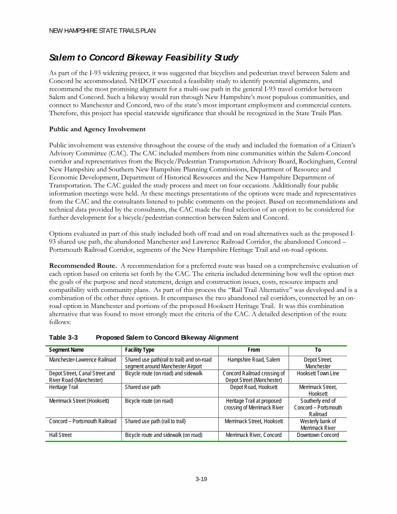
NEW HAMPSHIRE STATE TRAILS PLAN
3-19
Salem to Concord Bikeway Feasibility Study
As part of the I-93 widening project, it was suggested that bicyclists and pedestrian travel between Salem and Concord be accommodated. NHDOT executed a feasibility study to identify potential alignments, and recommend the most promising alignment for a multi-use path in the general I-93 travel corridor between Salem and Concord. Such a bikeway would run through New Hampshire’s most populous communities, and connect to Manchester and Concord, two of the state’s most important employment and commercial centers. Therefore, this project has special statewide significance that should be recognized in the State Trails Plan. Public and Agency Involvement Public involvement was extensive throughout the course of the study and included the formation of a Citizen’s Advisory Committee (CAC). The CAC included members from nine communities within the Salem-Concord corridor and representatives from the Bicycle/Pedestrian Transportation Advisory Board, Rockingham, Central New Hampshire and Southern New Hampshire Planning Commissions, Department of Resource and Economic Development, Department of Historical Resources and the New Hampshire Department of Transportation. The CAC guided the study process and meet on four occasions. Additionally four public information meetings were held. At these meetings presentations of the options were made and representatives from the CAC and the consultants listened to public comments on the project. Based on recommendations and technical data provided by the consultants, the CAC made the final selection of an option to be considered for further development for a bicycle/pedestrian connection between Salem and Concord. Options evaluated as part of this study included both off road and on road alternatives such as the proposed I-93 shared use path, the abandoned Manchester and Lawrence Railroad Corridor, the abandoned Concord – Portsmouth Railroad Corridor, segments of the New Hampshire Heritage Trail and on-road options. Recommended Route. A recommendation for a preferred route was based on a comprehensive evaluation of each option based on criteria set forth by the CAC. The criteria included determining how well the option met the goals of the purpose and need statement, design and construction issues, costs, resource impacts and compatibility with community plans. As part of this process the “Rail Trail Alternative” was developed and is a combination of the other three options. It encompasses the two abandoned rail corridors, connected by an on-road option in Manchester and portions of the proposed Hooksett Heritage Trail. It was this combination alternative that was found to most strongly meet the criteria of the CAC. A detailed description of the route follows: Table 3-3 Proposed Salem to Concord Bikeway Alignment
Segment Name Facility Type From To Manchester-Lawrence Railroad Shared use path(rail to trail) and on-road
segment around Manchester Airport Hampshire Road, Salem Depot Street,
Manchester Depot Street, Canal Street and River Road (Manchester)
Bicycle route (on road) and sidewalk Concord Railroad crossing of Depot Street (Manchester)
Hooksett Town Line
Heritage Trail Shared use path Depot Road, Hooksett Merrimack Street, Hooksett
Merrimack Street (Hooksett) Bicycle route (on road) Heritage Trail at proposed crossing of Merrimack River
Southerly end of Concord – Portsmouth
Railroad Concord – Portsmouth Railroad Shared use path (rail to trail) Merrimack Street, Hooksett Westerly bank of
Merrimack River Hall Street Bicycle route and sidewalk (on road) Merrimack River, Concord Downtown Concord

NEW HAMPSHIRE STATE TRAILS PLAN
3-20
Phasing
Phasing for the development of the Salem – Concord Bikeway is broken into short-term, mid-term and long-term components. In the short term effort should be made to secure land not currently owned by municipalities or the state. Design and construction of the portion of the trail located within the Manchester–Lawrence abandoned rail corridor would follow. Lastly, the design and construction of the portions of the trail north of Manchester including the Concord –Portsmouth corridor and Hooksett Heritage Trail would be completed.

NEW HAMPSHIRE STATE TRAILS PLAN
4-1
4. GUIDELINES FOR FACILITY DEVELOPMENT
New Hampshire has a considerable network of multi-use trails, community paths, and corridors with the potential for use as recreational and transportation systems throughout the state. The previous chapters describe the status of many of these corridors, with a particular focus on state-owned abandoned rail corridors. The condition and use of these corridors vary widely in terms of level of improvement, surface material, drainage and soil conditions, maintenance, and types of users, including what types of uses are permitted, feasible, and actually present in the corridor.
The data and findings from the previous chapters have been reviewed by the New Hampshire Department of Transportation (NHDOT), Department of Resources and Economic Development (DRED), and the Advisory Committee. It was also presented to the general public at a series of five public meetings conducted throughout the state, and was available through the study website.
This chapter includes a set of guidelines for future trail development, maintenance, and management. The guidelines are based on the current status of the trails and potential trail corridors, as well as input from NHDOT, DRED, the study Advisory Committee, and the general public, through comments made at public meetings and written comment forms. The following are the key issues that were reviewed in establishing the trail development guidelines:
Facility use and user type
Facility design
Corridor ownership, management and maintenance
Future needs
The following is a brief discussion of the public participation process and a summary of the comments received. This is followed by a discussion of each of the facility development topics, the study’s findings and recommended guidelines for facility development, and related considerations.
Public Participation and Comments The information on the state-owned abandoned railroad corridors and other off-street trails was assembled and presented to the general public at five meetings, held at various locations throughout the state:
Keene – May 3, 2004 (attendance = 100+) Bethlehem – May 5, 2004 (attendance = 31) Lebanon – May 6, 2004 (attendance = 17) Portsmouth – May 11, 2004 (attendance = 27) Concord – May 13, 2004 (attendance = 47)

NEW HAMPSHIRE STATE TRAILS PLAN
4-2
At these meetings, members of the public were encouraged to provide information regarding condition and usage of the trails and potential trail corridors with which they are familiar. In addition, members of the public were invited to make comments at these meetings, and to submit written comments either in person at the meetings, by mail, or by e-mail.
A total of 257 written comment forms or letters were received. The written comments are fairly representative of the issues that were raised and the comments that were made at the public meetings. A wide variety of user groups were represented at the meetings, and among the written responses. The following are some of the key findings from reviewing the public comments.
Most respondents expressed an opinion on the general type of vehicle that should be allowed on multi-use trails
o Non-Motorized Vehicles, Snowmobiles, and ATVs (49 respondents). These respondents support leaving the facilities open to a broad range of users, including motorized users. Many of these respondents were ATV owners who feel that they should also be able to use a public resource such as a multi-use facility.
o Non-Motorized Users and Snowmobiles, NO ATVs (38 respondents). These respondents supported allowing snowmobiles on multi-use facilities during the winter months, but reserving the facilities for non-motorized users during non-winter months. Many of these respondents stated that ATVs tear up the trail surfaces, while snowmobiles do not. In addition, due to the seasonal use patterns, snowmobiles do not interfere with most non-motorized users. Some snowmobile riders who responded opposed ATV use because the snowmobile clubs do trail maintenance, and ATV use makes maintenance more difficult.
o Non-Motorized Users ONLY (168). These respondents oppose any motorized use of the facilities at any time. The principal reasons cited for opposing motorized use of the trails are that motorized vehicles make too much noise; generate pollution; cause physical damage to the trails (creating ruts, “tearing up” the trail surface); and create conflicts and safety problems due to high vehicle speeds. Many of these respondents supported creating separate trails for motorized users (perhaps adjacent to highways and major roads), to be maintained by the motorized users.
All respondents expressed support for developing and improving trails, as would be expected from people who take the time to attend meetings of the State Trails Plan and submit comments on the plan. Most respondents (163) favor improving corridors throughout the state. Other respondents cited specific trails where they favor improvements. The following trails were identified specifically by the following number of respondents:
o Cheshire and Ashuelot (27) – commonly cited together; high number of respondents reflects high attendance at Keene meeting
o Seacoast Area Trails (14) o Northern Rail Trail (11) o President Rail Trail (10) o Manchester to Seacoast (6) o Pondicherry Rail Trail (5) o Lebanon to Concord (4) o Concord Area Trails (3) o Keene Area Trails (3) o Conway Branch (2) o Profile Railroad (2) o Gorham to Whitefield (2)
NEW HAMPSHIRE STATE TRAILS PLAN
4-3
o Lebanon to Boscawen (2) o Rockingham Recreation Trail (1) o Pisgah Trail (1) o Lakes Region / Wolfeboro (1) o Warren Railroad Bed (1)
Most respondents observed that many trails and potential trail corridors have physical shortcomings that should be addressed in order to improve the facilities and encourage higher levels of transportation and recreational use. Respondents raised the following issues related to physical condition of trail corridors; each issue is followed by a response based on the study findings:
o Issue: Should facilities be paved or unpaved? o Response: The majority of public comments indicated that in most cases the facilities should be
kept in a more natural, unpaved state using crushed stone, packed dirt, or small gravel for the trail surface. It may be preferable to pave facilities through more populated areas, to make connections with schools and village centers, or in heavily-used recreational areas to encourage walking and biking.
o Issue: Existing bridges will need to be evaluated to ensure they are safe. For underpasses or culverts what is the minimum clearance needed?
o Response: Horse owners suggested at least 15 feet is needed for head clearance.
o Issue: Are drainage improvements necessary along abandoned railroad corridors? o Response: Most rail corridors have gravel/ballast foundations that provide some drainage
benefits. However, drainage improvements are still needed along most trails to provide year-round accessibility and to prevent erosion.
o Issue: Should railroad ties be removed? o Response: Railroad ties have been removed from some of the abandoned rail corridors, but
they still remain along other corridors. Removing the ties would make travel, maintenance and grooming easier throughout the year. However, disposal of railroad ties is costly.
Respondents also noted regulatory and enforcement issues with existing facilities and corridors, including:
o Issue: Do ATVs have speed limits, and how are ATV speed limits enforced? o Response: ATVs have speed limits which are enforced by the Department of Fish & Game.
Public comments indicate there is a need for more enforcement.
o Issue: How can people be better informed about the type of uses allowed on different facilities? o Response: Better signage is needed to inform ATVs and snowmobiles when and where they
can and cannot ride on the facilities.
o Issue: How can noise from motorized vehicles on trails be reduced in populated areas? o Response: Some respondents have proposed installing sound barriers between homes and the
facility where motorized vehicles would travel. However, these barriers are expensive, and many people find them unattractive.
o Issue: Where should motorized off-road vehicles be permitted to operate? o Response: As the discussion in the previous section suggests, this is a contentious issue with a
disparity of opinions. Some users favor prohibiting all motorized vehicles from multi-use facilities, and proposed creating separate facilities for them adjacent to highways (where cars already create noise and pollution). Other respondents, in contrast, favored allowing ATVs and
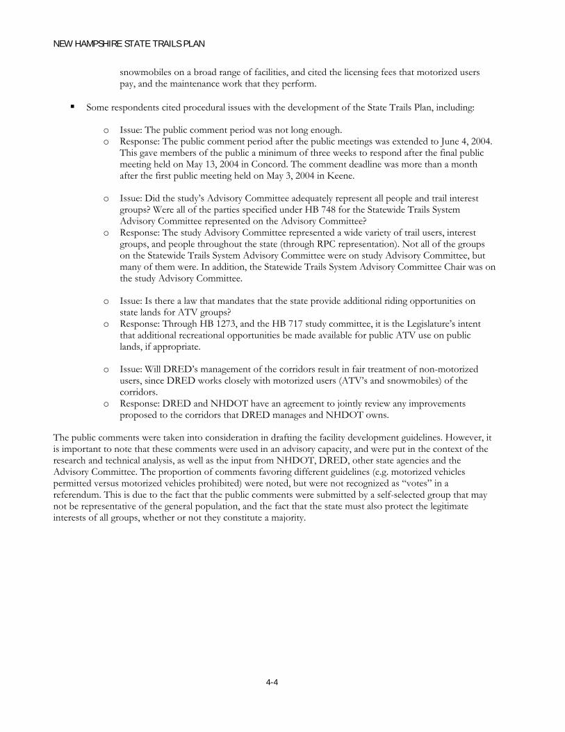
NEW HAMPSHIRE STATE TRAILS PLAN
4-4
snowmobiles on a broad range of facilities, and cited the licensing fees that motorized users pay, and the maintenance work that they perform.
Some respondents cited procedural issues with the development of the State Trails Plan, including:
o Issue: The public comment period was not long enough. o Response: The public comment period after the public meetings was extended to June 4, 2004.
This gave members of the public a minimum of three weeks to respond after the final public meeting held on May 13, 2004 in Concord. The comment deadline was more than a month after the first public meeting held on May 3, 2004 in Keene.
o Issue: Did the study’s Advisory Committee adequately represent all people and trail interest groups? Were all of the parties specified under HB 748 for the Statewide Trails System Advisory Committee represented on the Advisory Committee?
o Response: The study Advisory Committee represented a wide variety of trail users, interest groups, and people throughout the state (through RPC representation). Not all of the groups on the Statewide Trails System Advisory Committee were on study Advisory Committee, but many of them were. In addition, the Statewide Trails System Advisory Committee Chair was on the study Advisory Committee.
o Issue: Is there a law that mandates that the state provide additional riding opportunities on state lands for ATV groups?
o Response: Through HB 1273, and the HB 717 study committee, it is the Legislature’s intent that additional recreational opportunities be made available for public ATV use on public lands, if appropriate.
o Issue: Will DRED’s management of the corridors result in fair treatment of non-motorized users, since DRED works closely with motorized users (ATV’s and snowmobiles) of the corridors.
o Response: DRED and NHDOT have an agreement to jointly review any improvements proposed to the corridors that DRED manages and NHDOT owns.
The public comments were taken into consideration in drafting the facility development guidelines. However, it is important to note that these comments were used in an advisory capacity, and were put in the context of the research and technical analysis, as well as the input from NHDOT, DRED, other state agencies and the Advisory Committee. The proportion of comments favoring different guidelines (e.g. motorized vehicles permitted versus motorized vehicles prohibited) were noted, but were not recognized as “votes” in a referendum. This is due to the fact that the public comments were submitted by a self-selected group that may not be representative of the general population, and the fact that the state must also protect the legitimate interests of all groups, whether or not they constitute a majority.

NEW HAMPSHIRE STATE TRAILS PLAN
4-5
Facility Use and User Type
Discussion
The public identified a diverse number of potential trail users. The three principal reasons for using trails are for recreation, transportation, and exercise. Tourism is also identified as a purpose for using the Facilities. These different purposes may imply different ways of using the trails, and different types of users. Many different uses have been identified as well, including:
Walking/Jogging
Universal Accessibility
Mountain biking
Road biking (with narrow tires)
Horseback riding
Cross country skiing
Dog sledding
Snowmobiling
Riding All Terrain Vehicles (ATVs)
In-line skating
Comments generally support allowing as many different users access to facilities as is feasible and appropriate. However, combining some of these user types can create conflicts. These include:
Surface and Type
Certain types of users prefer specific surface type. Road bikers and in-line skaters prefer paved surfaces. However, paved surfaces may be less desirable for equestrians, joggers, and snowmobilers, who prefer unpaved surfaces. Snow melts more quickly on paved trails than on unpaved trails, which is problematic for snowmobilers and skiers.
Environmental
All Terrain Vehicles (ATVs) and Snowmobiles are louder and faster than non-motorized uses and could have air quality impacts, which may create a conflict for some non-motorized users and trail abutters. The discussion at many of the public meetings focused largely on these conflicts.
Seasonal Conflicts
There is also the potential for wintertime motorized – non-motorized conflicts between cross country skiers and snowmobiles or ATVs.
Enforcement

NEW HAMPSHIRE STATE TRAILS PLAN
4-6
Comments from ATV users and non-motorized users indicated that many conflicts result from misuse of machines, such as riding on sections of trail where they are prohibited.
Guidelines
1. All facilities (new and/or improved) should accommodate as many user types as possible. However, recognizing that there may be some conflicts (both perceived and real), the entity that develops or improves the facility should involve representatives of all user types.
2. The types of users that are permitted and accommodated will vary by trail. Permitted trail usage should be prescribed by land owners/managers. Facility development will depend on several factors, including:
Financial constraints
Public input
Physical constraints (width, existing trail condition, soil conditions, drainage)
Abutters and adjacent uses
Environmental considerations
Potential for facility to make a critical link for certain user types (e.g. connection to the state bicycle network, or a link to motorized use areas).
In addition to the differences between user groups, there is also considerable diversity in usage characteristics within a given user group.
3. Associations and clubs are encouraged to work with entities that are developing or improving a facility in order to identify key segments that provide links to high use areas.
Facility Design
Discussion
Facility use is currently limited by poor conditions, including drainage, foliage encroachment, continuing presence of railroad ties and/or large diameter ballast. These conditions make facility use difficult for universal accessibility and users such as pedestrians and bicyclists. The public identified a number of locations where facility improvements are needed.
Guidelines
1. Municipalities, Regional Planning Commissions (RPCs), local user groups, and other trail proponents are encouraged to build upon the facility inventory included in this study, and work with NHDOT and DRED to pursue trail improvements.
2. Facilities should be designed to safely accommodate all users that are permitted on the trail. Recommended references for safe and appropriate design guidelines are the American Association of State Highway and Transportation Officials (AASHTO) Guidelines for Design of Bicycle and Pedestrian Facilities and the Federal Highway Administration (FHWA) Designing Sidewalks and Trails for Access.

NEW HAMPSHIRE STATE TRAILS PLAN
4-7
3. Rail-with-trail may be pursued on state-owned railroad corridors in appropriate circumstances (e.g. where rail traffic is light and adequate corridor width is available). Developing rail-with-trail requires the permission of the railroad owner and close coordination with NHDOT. The NHDOT will provide detailed requirements for such projects with input from operating railroads. Sponsors of these projects must address issues such as safe clearance and separation for trail users, railroad, maintenance requirements that may include temporary trail closure, maintenance and policing of trails, reimbursement of added railroad costs, and insurance, bonding, and indemnification of the state and operating railroads. This report includes typical sections for rail-with-trail, but the dimensions and topography of railroad corridors vary and designs must be adjusted accordingly.
4. Proposed improvements to a trail in a rail corridor that may have rail service restored in the future should be fully evaluated since that trail could have many years of use that would justify the expenditure. This evaluation should include a feasibility study and an order-of-magnitude cost estimate for rail-with-trail or an alternate trail location in the event that the rail service is restored, so that the trail connection is not lost.
5. Maintenance of the facility must be a key component of any design.
6. NHDOT and DRED may provide technical and institutional support for development and improvement of multi-use trails. This report proposes design guidance for development and improvement of multi-use trails, including typical cross-sections addressing differing corridor conditions, trail requirements, and constraints. Typical sections have been included for several general cases, which are shown in Figures 4-1, 4-2, and 4-3. These typical sections address the following critical design issues.
Trail Design Guidelines – Typical Sections
Unpaved Path – A trail with a stone dust / crushed stone surface.
Paved Path – A trail with a bituminous asphalt surface.
Separate Path Trail – A trail with two parallel surfaces: a hard surface (pavement or stone dust) for users such as bicyclists and wheelchair users, and a soft surface (grass or compacted soil) for users such as horseback riders and joggers. It is desirable to provide separate paths where there is user demand for an alternate surface, and where width is available.
Rail with Trail, Unconstrained Width – A trail that runs parallel to an active rail line, through a corridor that has adequate width to provide optimal separation and buffering between the rail line and the path (34 feet between the track center line and the edge of the trail shoulder).
Rail with Trail, Constrained Width – A trail that runs parallel to an active rail line, but has physical width constraints that reduce the buffer between the rail line and the path to a minimum width (20 feet between the track center line and the edge of the trail shoulder).
The following are some of the key issues and design considerations for shared-use paths. All facilities are assumed to support two-way travel. These guidelines are based principally on the American Association of State Highway and Transportation Officials (AASHTO) Guidelines for Design of Bicycle and Pedestrian Facilities.

NEW HAMPSHIRE STATE TRAILS PLAN
4-8
Trail width • 10 feet recommended (where site constraints preclude 10-foot width, 8-foot
minimum width may be acceptable on a case by case basis) • 12 – 14 feet recommended in areas of high demand • Parallel unpaved path (where applicable): 6 feet minimum, 8 feet recommended –
where parallel unpaved path is present, width of paved path may be reduced where overall trail width is adequate
Vertical clearance • 10 feet minimum for horseback riders • Other uses may require higher clearances – local conditions and uses should be
evaluated for vertical clearance requirements
Trail foundation design • 6 to 12-inch gravel foundation. Thicker foundation is recommended in areas where
there will be frequent access by motor vehicles, such as maintenance vehicles, park patrols, and/or emergency vehicles, or where soil conditions are poor
• 6-inch gravel foundation minimum (acceptable in areas where motor vehicle traffic will be infrequent and soil conditions are good)
Trail surface • Unpaved
o Hard Surface - 4-inch thick compacted stone dust (available from quarries, typically ¾-inch maximum diameter prior to compaction)
o Soft Surface – Grass or packed dirt • Paved – 2-inch thick bituminous concrete
Trail shoulders • Width
o 2 feet minimum o 3 feet recommended o 3 feet minimum to horizontal obstruction (e.g. sign, fence, tree) o 5 feet minimum to vertical hazard (i.e. vertical drop of 2.5 feet or more, top of
vertical slope exceeding 3:1) – if less than 5 feet is available, a fence is recommended (with a 3-foot clearance)
• Slope o 20:1 (run : rise) recommended o 12:1 acceptable for limited trail segments o 6:1 maximum o 3 feet minimum to horizontal obstruction (e.g. sign, fence, tree) o 5 feet minimum to vertical hazard (i.e. vertical drop of 2.5 feet or more, top of
vertical slope exceeding 3:1) – if less than 5 feet is available, a fence is recommended (with a 3-foot clearance)
General cost estimates for trail construction have also been developed. These cost estimates focus on the costs of converting a typical abandoned rail corridor (no major obstructions, rails and ties already removed, ballast in place, no major drainage issues) to a typical multi-use trail (10-foot width, 3-foot shoulders, unpaved with crushed stone surface). The unit costs are based on NHDOT Weighted Average Unit Prices for projects bid in 2003. This cost estimate uses costs from urban projects, which tend to have somewhat higher costs than rural projects. Therefore, these cost estimates are somewhat conservative.

NEW HAMPSHIRE STATE TRAILS PLAN
4-9
Table 4-1 Typical Rail to Trail Conversion Cost Estimate
Item Description Unit Cost Unit Trail Cost per Linear Foot
201.1 Clearing $ 5,692.31 acre $ 2.09 207.3 Earthwork and Excavation $ 11.65 cubic yd $ 6.90 209.4 Granular Backfill (Gravel Base) $ 11.50 cubic yd $ 6.81 304.3 Crushed Gravel $ 18.23 cubic yd $ 2.25
Slope Stabilization $ 2.00 Subtotal $ 20.06 Contingency (35%) $ 7.02 Total $ 27.08
This results in a cost of approximately $27 per linear foot for an unpaved trail, or $145,000 per mile. For a paved trail, the cost would increase to about $42 per linear foot, or $225,000 per mile. This does not include the cost of any structures, which may be significant; bridge structures for a multi-use path could cost approximately $1,000 per linear foot.
Corridor Ownership, Management and Maintenance
Discussion
The ownership and management structure of trails and corridors that could be developed or improved are important in determining what uses are permitted on a trail, how the trail is developed or improved, and how it is maintained. The trail system in New Hampshire has a variety of owners, management structures, and maintenance arrangements.
NHDOT owns the majority of the state-owned abandoned railroad corridors: 20 of the 23 corridors listed in Table 1 and described in Chapter 1 of this report. DRED owns the remaining three abandoned railroad corridors: the Profile Railroad, the Fremont Branch (the southern portion from Windham to Fremont), and the Greenville Branch.
Because DRED has the historical role and institutional structure for overseeing trails, it supervises the administration and maintenance of recreational uses along these inactive railroad corridors, including the NHDOT-owned corridors. A cooperative agreement between the two agencies spells out their respective roles. Most of the trail maintenance is done by local user groups and clubs, in particular snowmobile and ATV clubs. DRED programs that are supported by snowmobile and ATV licenses fund much of this maintenance, as well as minor trail improvements.
Guidelines
1. The State of New Hampshire should work to ensure that the state owned abandoned rail corridors are reserved for current and future transportation and recreation uses. These uses may include multi-use trail functions as well as future rail service. In order to achieve this, the state-owned corridors should not be sold off to abutters: the State should retain ownership.

NEW HAMPSHIRE STATE TRAILS PLAN
4-10
2. NHDOT should continue to allow the abandoned railroad corridors to be managed by DRED (through a cooperative agreement) for recreational use when there is no present need for transportation use. NHDOT and DRED should continue to coordinate on planning, design, and usage issues for these corridors where there is a cooperative agreement.
3. The NHDOT should remain involved in trail planning for the abandoned rail corridors. For those corridors where there is a cooperative agreement between NHDOT and DRED, and the latter agency provides recreational management, any proposed improvements by a Town will be reviewed with DRED Trails Bureau. The Trails Bureau will review the proposal for consistency with Statewide Trails program, and a supplemental agreement would be executed between the Town and both state agencies.
4. State and local enforcement must be a consideration of facility management.
Future Needs
Discussion
In its early stages, the State Trails Plan study process included a discussion of identifying “high priority” corridors on a statewide basis for development and/or improvement as multi-use trails. However, as research and discussion revealed the complexity of the issues and the variability of corridor conditions, it became apparent that this type of priority setting was not a realistic expectation at this time. The inventory developed as part of this plan will be updated as appropriate and will assist in future facility planning.
The State Trails Plan includes general information about each corridor gathered through the nine regional transportation plans and the knowledge of the state agencies, Advisory Committee and the general public. Some responses suggested improvements to specific rail corridors. Many focused on washouts and other drainage problems, which impede trail use. Others focused on conflicts in facility uses – between motorized and non-motorized modes. A general need is to make surface improvements to better accommodate different uses. Where ballast remains in the rail bed, many recommended a surface of crushed stone. In areas where the ballast was mined, a gravel base would also be needed to make the trail accessible to a full array of users.
The NHDOT Bureau of Rail and Transit has identified the following corridors having potential for the resumption of rail service:
Upper Coos Railroad (Whitefield to Jefferson) – freight rail
Conway Branch – freight and passenger (excursion)
Northern Railroad – Boston to Montreal High Speed passenger rail service
Manchester and Lawrence Branch – freight and passenger (commuter)
Hampton Branch – passenger (commuter)
Guidelines
1. Regional planning commissions, municipalities, trail user groups, and the general public are encouraged to collectively assess the transportation, tourism and recreation potential of each of the state-owned abandoned rail corridors with the State. The process should include site walks of the corridors by state and local officials and interest groups. Public input should be considered.

NEW HAMPSHIRE STATE TRAILS PLAN
4-11
2. Trail improvements should focus on areas with the greatest potential for use and value to users, including:
a. Trails within villages (example: Blackmount Branch in Woodsville)
b. Trails between communities
c. Trails to important scenic and recreational areas (example: Berlin Branch)
d. Linkages to existing networks
3. NHDOT/DRED should help to facilitate trail development in abandoned rail corridors especially where the trail involves multiple jurisdictions and is of regional or statewide significance.
4. Trail related improvements to abandoned rail corridors should continue even if rail service may return in the future. Improvements such as drainage and brush clearing are consistent with State policy on rail preservation.
5. Funding alternatives for involving local private/public partnerships for facility development and other bicycle and pedestrian transportation projects should be found. Currently the primary funding sources Transportation Enhancement (TE) and Congestion Mitigation and Air Quality (CMAQ) are available in limited amounts.
6. As and when future rail corridors become available, the State should consider them for state ownership or assist communities in purchasing them.
7. Future facility planning should consider conflicts between different user groups and address their varying needs.