new geologi map of the point sur 30’x60’ quadrangle, a triute to lew ... · new geologi map of...
TRANSCRIPT
NEW GEOLOGIC MAP OF THE POINT SUR 30’X60’ QUADRANGLE, A TRIBUTE TO LEW ROSENBERGC.J. Wills
California Geological Survey, Sacramento CA, 95814, [email protected]
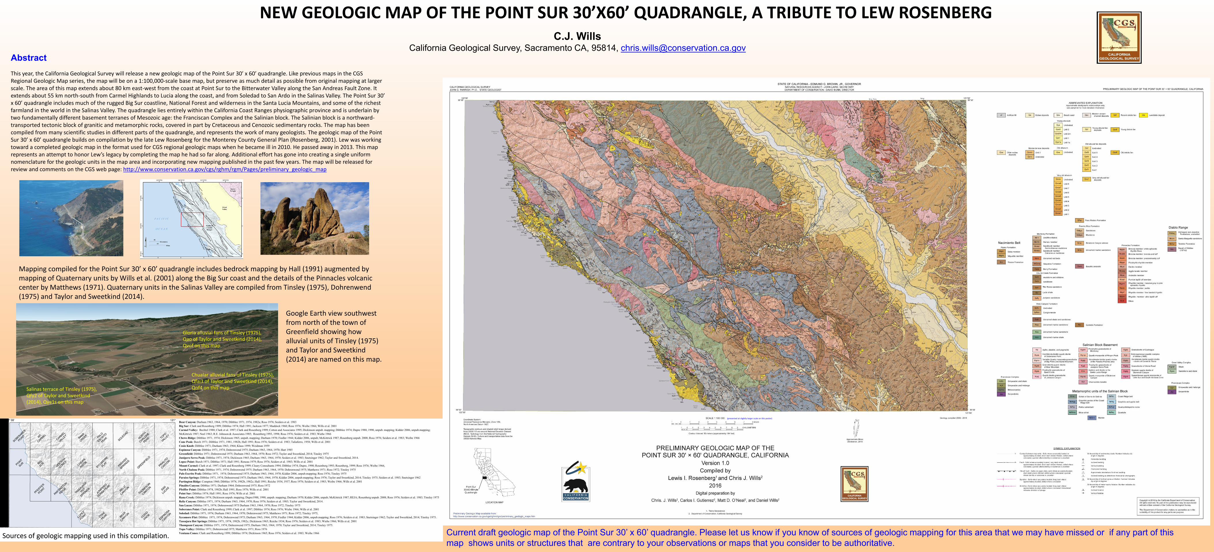
This year, the California Geological Survey will release a new geologic map of the Point Sur 30′ x 60′ quadrangle. Like previous maps in the CGS Regional Geologic Map series, the map will be on a 1:100,000-scale base map, but preserve as much detail as possible from original mapping at larger scale. The area of this map extends about 80 km east-west from the coast at Point Sur to the Bitterwater Valley along the San Andreas Fault Zone. It extends about 55 km north-south from Carmel Highlands to Lucia along the coast, and from Soledad to San Ardo in the Salinas Valley. The Point Sur 30’ x 60’ quadrangle includes much of the rugged Big Sur coastline, National Forest and wilderness in the Santa Lucia Mountains, and some of the richest farmland in the world in the Salinas Valley. The quadrangle lies entirely within the California Coast Ranges physiographic province and is underlain by two fundamentally different basement terranes of Mesozoic age: the Franciscan Complex and the Salinian block. The Salinian block is a northward-transported tectonic block of granitic and metamorphic rocks, covered in part by Cretaceous and Cenozoic sedimentary rocks. The map has been compiled from many scientific studies in different parts of the quadrangle, and represents the work of many geologists. The geologic map of the Point Sur 30’ x 60’ quadrangle builds on compilation by the late Lew Rosenberg for the Monterey County General Plan (Rosenberg, 2001). Lew was working toward a completed geologic map in the format used for CGS regional geologic maps when he became ill in 2010. He passed away in 2013. This map represents an attempt to honor Lew’s legacy by completing the map he had so far along. Additional effort has gone into creating a single uniform nomenclature for the geologic units in the map area and incorporating new mapping published in the past few years. The map will be released for review and comments on the CGS web page: http://www.conservation.ca.gov/cgs/rghm/rgm/Pages/preliminary_geologic_map
Current draft geologic map of the Point Sur 30’ x 60’ quadrangle. Please let us know if you know of sources of geologic mapping for this area that we may have missed or if any part of this
map shows units or structures that are contrary to your observations or maps that you consider to be authoritative.
Mapping compiled for the Point Sur 30’ x 60’ quadrangle includes bedrock mapping by Hall (1991) augmented by mapping of Quaternary units by Wills et al. (2001) along the Big Sur coast and the details of the Pinnacles volcanic center by Matthews (1971). Quaternary units in the Salinas Valley are compiled from Tinsley (1975), Dohrenwend(1975) and Taylor and Sweetkind (2014).
Bear Canyon: Durham 1963, 1964, 1970; Dibblee 1971, 1974, 1982a; Ross 1976; Seiders et al. 1983
Big Sur: Clark and Rosenberg 1999; Dibblee 1974; Hall 1991; Jackson 1977; Maddock 1960; Ross 1976; Weibe 1966; Wills et al. 2001
Carmel Valley: Bechtel 1988; Clark et al. 1997; Clark and Rosenberg 1999; Cotton and Associates 1995; Dickinson unpub. mapping; Dibblee 1974; Dupre 1988, 1990, unpub. mapping; Kidder 2006, unpub.mapping;
McKittrick 1987; Neel 1963; R.E. Johnson & Associates 1985; Rosenberg 1993, 1998; Ross 1976; Seiders et al. 1983; Wiebe 1966
Chews Ridge: Dibblee 1971, 1974; Dickinson 1965, unpub. mapping; Durham 1970; Fiedler 1944; Kidder 2006, unpub; McKittrick 1987; Rosenberg unpub. 2008; Ross 1976; Seiders et al. 1983; Weibe 1966
Cone Peak: Burch 1971; Dibblee 1971, 1981, 1982b, Hall 1991; Ross 1976; Seiders et al. 1983; Taliaferro, 1958; Wills et al. 2001
Cosio Knob: Dibblee 1971; Durham 1963; 1964; Klaus 1999; Weidman 1959
Espinosa Canyon: Dibblee 1971, 1974; Dohrenwend 1975; Durham 1963, 1964, 1970; Hart 1985
Greenfield: Dibblee 1971; Dohrenwend 1975; Durham 1963, 1964, 1970; Ross 1972; Taylor and Sweetkind, 2014; Tinsley 1975
Junipero Serra Peak: Dibblee 1971, 1974; Dickinson 1965; Durham 1963, 1964, 1970; Seiders et al. 1983; Snetsinger 1962; Taylor and Sweetkind, 2014.
Lopez Point: Burch 1971; Dibblee 1971; Hall 1991; Reneau 1979; Ross 1976; Seiders et al. 1983; Wills et al. 2001
Mount Carmel: Clark et al. 1997; Clark and Rosenberg 1999; Cleary Consultants 1994; Dibblee 1974; Dupre, 1990; Rosenberg 1993; Rosenberg, 1999; Ross 1976; Weibe 1966,
North Chalone Peak: Dibblee 1971, 1974; Dohrenwend 1975; Durham 1963, 1964, 1970; Dohrenwend 1975; Matthews 1971; Ross 1972; Tinsley 1975
Palo Escrito Peak: Dibblee 1971, 1974; Dohrenwend 1975; Durham 1963, 1964, 1970; Kidder 2006, unpub.mapping; Ross 1976; Tinsley 1975
Paraiso Springs: Dibblee 1971, 1974; Dohrenwend 1975; Durham 1963, 1964, 1970; Kidder 2006, unpub.mapping; Ross 1976; Taylor and Sweetkind, 2014; Tinsley 1975; Seiders et al. 1983; Snetsinger 1962
Partington Ridge: Compton 1960; Dibblee 1974, 1982b, 1982c; Hall 1991; Reiche 1934, 1937; Ross 1976; Seiders et al. 1983; Weibe 1966; Wills et al. 2001
Pinalito Canyon: Dibblee 1971; Durham 1964; Dohrenwend 1975; Ross 1972
Pfeiffer Point: Dibblee 1974, 1982b; Hall 1991; Ross 1976; Wills et al. 2001
Point Sur: Dibblee 1974; Hall 1991; Ross 1976; Wills et al. 2001
Rana Creek: Dibblee 1974; Dickinson unpub. mapping; Dupre1988, 1990, unpub. mapping; Durham 1970; Kidder 2006, unpub; McKittrick 1987; REJA; Rosenberg unpub. 2008; Ross 1976; Seiders et al. 1983; Tinsley 1975
Reliz Canyon: Dibblee 1971, 1974; Durham 1963, 1964, 1970; Ross 1976; Seiders et al. 1983; Taylor and Sweetkind, 2014.
San Lucas: Dibblee 1971, 1974; Dohrenwend 1975 Durham 1963, 1964, 1970; Ross 1972; Tinsley 1975
Soberanes Point: Clark and Rosenberg 1999; Clark et al. 1997; Dibblee 1974; Ross 1976; Wiebe 1966; Wills et al. 2001
Soledad: Dibblee 1971, 1974; Durham 1963, 1964, 1970; Dohrenwend 1975; Matthews 1971; Ross 1972; Tinsley 1975,
Sycamore Flat: Dibblee 1971, 1974, Dohrenwend 1975; Durham 1963, 1964, 1970; Fiedler 1944; Kidder 2006, unpub.mapping; Ross 1976; Seiders et al. 1983; Snetsinger 1962; Taylor and Sweetkind, 2014; Tinsley 1975.
Tassajara Hot Springs: Dibblee 1971, 1974, 1982b, 1982c; Dickinson 1965; Reiche 1934; Ross 1976; Seiders et al. 1983; Wiebe 1966; Wills et al. 2001
Thompson Canyon: Dibblee 1971, 1974; Dohrenwend 1975; Durham 1963, 1964, 1970; Taylor and Sweetkind, 2014; Tinsley 1975.
Topo Valley: Dibblee 1971; Dohrenwend 1975; Matthews 1971; Ross 1976
Ventana Cones: Clark and Rosenberg 1999; Dibblee 1974; Dickinson 1965; Ross 1976; Seiders et al. 1983; Weibe 1966
Google Earth view southwest from north of the town of Greenfield showing how alluvial units of Tinsley (1975) and Taylor and Sweetkind(2014) are named on this map.
Salinas terrace of Tinsley (1975), Qfy2 of Taylor and Sweetkind(2014), Qya1s on this map
Chualar alluvial fans of Tinsley (1975), Qfai3 of Taylor and Sweetkind (2014), Qof4 on this map
Gloria alluvial fans of Tinsley (1975), Qao of Taylor and Sweetkind (2014), Qvof on this map
Sources of geologic mapping used in this compilation.
(presented at slightly larger scale on this poster)