new developments in the investigation of … · the theme of this year’s conference is “new...
TRANSCRIPT

European RegionC O N F E R E N C E & E X H I B I T I O N
PRINCESA SOFIA HOTEL, BARCELONA 13-15 MAY 2014
AbstractsNEW DEVELOPMENTS IN THE INVESTIGATION OF
CONVENTIONAL AND UNCONVENTIONAL PETROLEUM SYSTEMS IN EUROPEAN BASINS
SPONSORED BY: PARTNERED WITH: ENDORSED BY:

Dear Colleagues,
On behalf of the AAPG and our conference partners the Spanish Association of Petroleum Geologists and Geophysicists and the Universities of Barcelona and Zaragoza I am delighted to welcome you to the ninth AAPG European Regional Conference. This is the second year in succession that we have held our annual conference in Barcelona and I would encourage all of you to explore this fascinating city during your time here. I would like to especially thank those of you who are giving either a verbal or poster presentation during the next three days. Conferences such as this depend entirely upon your enthusiasm and expertise and your support is greatly appreciated.
The theme of this year’s conference is “New Developments in the Investigation of Conventional and Unconventional Petroleum Systems in European Basins” and the conference organising and technical committees are to be congratulated on putting together such an excellent programme of field trips, oral and poster sessions.
On Tuesday evening the AAPG European Region will hold its Annual General Meeting and I would encourage all AAPG members to attend this meeting. The AGM is an excellent opportunity for you to see the full spectrum of AAPG activities and the range opportunities that exist for members to get involved in the AAPG and help direct the future of the largest global body of professional geoscientists.
Finally, this event is only possible thanks to the sterling work of the staff of the AAPG Regional office. They will be around the venue throughout the course of the conference making sure everything runs smoothly. If any of you meet them in the next three days please take time out to thank them; their hard work and dedication often goes unseen, but is essential for the successful running of conferences such as this.
Enjoy Barcelona!
Keith Gerdes
President of the European Region
American Association of Petroleum Geologists
AAPG European Regional Committee:President Keith GerdesSecretary Helen CromieTreasurer Knut Henrik JakobssonActive Past President Vlastimila DvorakovaActive Past President & IBA Chair David Cook International DL Chair Frank WielandStudents & Young Professionals Chair Camille PoliCorporate Liaison & Sponsorship John BrooksNewsletter & Publications Viki WoodIBA Committee Charlotte HamiltonMembership Committee Chair Sigrunn JohnsenEducation Committee Chair Ailsa MesserConference Chair Neil FrewinDivisions Liaison Steve Veal
Session Chairmen:Attilio Schiavone Pablo GranadoOscar Fernandez Tomas ZapataLluis CabreraJean GerardAlex Marcuello Andre Vayssaire Josep MunozRamon SalasBonnie Milne- Andrews

1
CONTENTS
Keynote Presentations 2
Basin Analysis 5
Case Studies 8
Conventional Plays 14
Deep Water Clastic Environments 16
Exploration in European Alpine Fold and Thrust Belts 18
Exploration in Passive Margins 24
Extensional Basins 27
Fractured Reservoirs 29
Hot Spots 30
Modelling of Geological Processes 31
Non-Seismic Geophysical Techniques 37
Salt Basin Studies 39
Unconventional Plays 41

2
Seismicity registered in the vicinity of Castor UGS
C. BARAT, E. UGS and R. DEL POTRO, E. UGS
The offshore Castor UGS commenced the injection of cushion gas in June 2013. By September 2013, during the second phase of injection, associated seismicity was registered in the surroundings of Castor. We explore the causes of the seismicity (stress- and fluid-triggering) through improved seismological analyses and statistical seismology. The results of our studies suggest that seismicity occurred on a small critically-stressed pre-existing fault and was probably fluid triggered.
Unconventional prospects in places with no unconventional a history
T. ENGELDER, Professor of Geosciences.
The Pennsylvania State University, University Park, PA 16802
Production from the Marcellus gas shale generated international interest when methane accumulated in the surface housing of a water well pump and exploded. The Pennsylvania Department of Environmental Protection (PA-DEP) immediately investigated and determined the cement had insufficiently isolated shallow methane-bearing sands (not the Marcellus gas shale) and methane from these sands was leaking into ground water. The media immediately seized upon the story and painted a picture of an industry unable to manage risk. The reputation of gas shale was further darkened by a Hollywood polemic called, Gasland, a documentary based loosely on facts. Later there were two highly publicized blowouts from Marcellus wells and some surface spills that added strength to those who argued against industry. The biggest public fear was the frack fluid could, somehow, flow uphill more than 2000 meters to contaminate groundwater. Of course, there are a number of physical laws such as the law of gravity and the law of buoyancy that prevent this from happening. Since the initial hype by the media, studies by both the US Environmental Protection Agency (EPA) and PA-DEP have shown beyond a shadow of a doubt that no frack fluids have contaminated groundwater in the vicinity of the methane leaking from casing. Microseismic surveys have since shown that fracture stimulations travel laterally as much 300 m but are generally restricted in vertical growth to 100 m. The focus of the fracking debate has since shifted to overlap with the climate debate. The debate was further sharpened by academic studies claiming such a high rate of methane leakage during completion that the effect on global warming would be substantial even though burning methane releases about half the CO2 relative to that released by coal on a BTU basis.

3
Continental Carbonates in Rift Basins: the Role of Climate Versus Tectonics
A. M. A. ZARZA1
1 Departamento de Petrología y Geoquímica, Fac., CC., Geológicas, Universidad Complutense de Madrid, Instituto de Geociencias, UCM, CSIC, C/José Antonio Novais, 28040, Madrid, Spain.
Continental carbonates in rift basins have become an outstanding research topic, especially since the discoveries of the large hydrocarbon reservoirs in the South Atlantic. The variety of environments and deposits of continental carbonates is huge. The process domain includes subaerial and subaqueous deposits with transitional environments between them. In addition, some rift carbonates are the result of the modification of previous sediments or rocks under meteoric diagenetic conditions. Some of the most characteristics deposits can form in both subaerial and subaqueous environments, which makes a relatively complex panorama. Continental carbonates form in six main environments: Springs (subaerial and subaqueous domain), Fluvial and Lakes are mostly subaqueous, Calcretes and Karst which are subaerial, and Palustrine which is transitional between subaerial and subaqueous.
There are a large number of differences between continental and their marine counterparts which deals with the lateral extension and variety of the sedimentary environments, thickness of the sedimentary sequences, biota, stronger climate controlled, varied geochemistry of the sedimentary and diagenetic waters, association with siliciclastics and other “chemical” and “biochemical” deposits or the large influence of the catchment areas, amongst many others. The result is that it is not easy to establish general models to predict the evolution and architecture of rift basin dominated by continental carbonate sedimentation and most the models deal with siliciclastic deposits. Here we try to show than in many cases it is not possible to separate the role of climate and tectonics as both may control the large and small sequence stratigraphy of carbonate rift basins. In addition the geology of the catchment needs also to be considered. Eustacy may be important in basins even far away from, but connected with the ocean, as it drives the base level which is critical to fluvial systems, erosion, and sedimentation rates.
The structural asymmetry of the margins of the basin is the main tectonic control on the distribution of sedimentary environments and facies, as in continental basins the water volume is finite and so tilting of the valley floor redistributes the lake water towards the side of tectonic subsidence, controlling so the location of lacustrine carbonate depocenters in the nearby of the main fault. Long-term sedimentary cycles have been commonly attributed to the activity of the main basin faults which created the accommodation space. However climate may alter the sediment and water discharges and so lake level fluctuations, giving place to major forced regressions detectable seismically. Some shallowing/drying upwards cycles of decimetre to metre scale have been interpreted as astronomically induced climatic changes related to the different scale Milankovitch cycles, but similar scale sequences may be the result of short-term subsidence episodes. Many examples of continental carbonates in rift basins have catchment areas with a dominance of carbonate rocks. However, all types of continental carbonates can form in non-carbonate catchments as deep, crustal or mantle, CO2 fluids contribute to travertine formation in volcanic and nonvolcanic areas with active faults.

4
What are computer models for?
D. WALTHAM1
1 Department of Earth Sciences, Royal Holloway, University of London
davidwaltham.com
Since computer models of near-surface processes were first developed more than four decades ago, the ability of the Earth Science community to produce increasingly sophisticated, multi-process simulations of geological processes has grown massively. Despite this, such computer models are rarely used in E&P and are not part of the standard suite of tools we would expect industry to routinely use. Why not? I believe we may have promised too much and, as a result of failure to deliver on inflated expectations, there is a danger we modellers will remain marginalized.
In this talk, I will discuss the very real and continuing problems associated with using computer models for “inversion” (e.g. searching for a forward model which matches well-data and then using the model output to predict away from the wells). The key issues are uniqueness (are there many solutions?), completeness (are we including all the right processes?) and cost (can I have an answer before I retire?). These problems are not insurmountable but do represent a considerable barrier to wider use of computer models for such purposes.
However, there are other ways to use computer modelling which do not have the same difficulties and which are, if anything, even more useful than inversion. Computer models can be used to test concepts (can proposed geological processes really account for observations?) to facilitate exploration of ideas (what are the knock-on effects of the proposed processes) and for training purposes (e.g. how do sediment supply, sealevel and tectonics interact to produce observed stratigraphy). For these purposes generic models, which do not pretend to reproduce observational constraints in more than broad outline, are sufficient. Such generic models are generally much faster and easier to operate and to produce. Furthermore, because they do not pretend to be precise models incorporating all necessary details, end-users of generic models are less likely to have unrealistic expectations about the detailed accuracy of the results. Instead, they can integrate the model outputs with their geological common-sense and experience to produce intelligent inferences and predictions.
This talk will illustrate these ideas using real-world examples taken from several decades of working with industry.

5
New Geological and Geophysical Perspectives on the Subsurface Structure of the Northern Tunisian Margin – Impacts on Petroleum Exploration Strategy
M. SOUSSI1, S. RIAHI1, A. JIMÉNEZ BERROCOSO2, C. SAKHER2 and M. MEKKI3
1 Université de Tunis-El Manar, Faculté des Sciences de Tunis, Département de Géologie, Campus Universitaire 2092 Tunis, Tunisia 2 Repsol Exploración, Calle Méndez Álvaro 44, 28045 Madrid, Spain. 3 Petroleum Exploration Consulting, 11 Rue Astragale, 1074 Mourouge 2, Tunis, Tunisia.
Petroleum exploration in the northern Tunisian margin has long been encouraged by both the widespread occurrence of oil seeps onshore and the gas/oil discoveries in the nearby geological provinces (e.g., Sicily and southern Italy). The exploratory works, however, have been compromised by the relative lack and low quality of onshore and offshore subsurface data and the complex structural geology of northern Tunisia, which is part of the southern sector of the Maghrebide-Apennine fold-thrust belt. Striking points of intense debate and uncertainty are: (1) whether mechanical or stratigraphic contacts exist between the main stratigraphic units, (2) if deformation was so intense that produced vertical duplication of the major units, (3) the role of the African (metamorphosed) Paleozoic basement in controlling the overlying structures, (4) the geographical patterns of source-rock maturation, and (5) offshore extrapolation of onshore geology. To shed more insights into these questions, we present recently acquired onshore and offshore geological and geophysical data in northern Tunisia and propose subsurface models that suggest deep carbonate targets should be within reach of onshore and/or offshore drilling.
Detailed onshore structural and stratigraphic observations confirm the existence of two main tectono-stratigraphic units that are separated by a major thrust front. These units are (1) the ~2500-3000 m-thick, turbiditic facies of the Numidian Flysch Formation (Fm.) (Oligocene to lower Miocene clastic target), and (2) the underlying Tellian units (i.e., Jurassic to Oligocene marine carbonates and mudstones, including the carbonate targets of the Upper Cretaceous Abiod Fm. and the lower Eocene Bou Dabbous Fm.). Our data indicate that, in surface exposures, the major thrust front is frequently outlined by Palaeogene mudstones and also by Triassic evaporites, which are proposed as major detachment levels at depth and whose main activity probably occurred during the middle Miocene as a result of the opening of the Western Mediterranean. Consequence to this deformational phase, the Numidian Flysch Fm. exhibits NE-SW, relatively extensive thrusts and back-thrusts (up to ~150 km long), together with faulted synclines and anticlines (up to 0.5-2 km wide). Importantly, though, sedimentological and biostratigraphic data indicate that there is no major vertical duplication of the Numidian Flysch Fm. onshore and suggest its thrusts and back-thrusts may be rooted on the major thrust front just above the Tellian units. In other words, our model supports the Numidian Flysch Fm. is an allochthonous unit in northern Tunisia.
Below, the Tellian units are interpreted to have relatively intense deformational degree compared to the Numidian Flysch Fm., as they experienced at least Mesozoic rifting (with associated movement of Triassic evaporites) followed by compressional stages during the late Eocene and the middle Miocene. Onshore seismic quality is low but titled blocks with intensely faulted anticlines and synclines are interpreted in the Tellian units, resulting from these deformational events. In surface exposures, both Numidian Flysch Fm. and Tellian units are affected by NW-SE strike-slip faults, whose activity could be intensified during the middle Miocene thrusting and continued during Pliocene deformational events.
What is novel in our study is that, using new offshore gravity/magnetic and 2D seismic surveys, we tried to constrain offshore the position of the main NE-SW onshore thrusts. Regionally extensive offshore gravity anomalies (i.e., basement highs and lows) are detected and follow the same NE-SW orientation seen in the main structures onshore. Main thrusts in offshore seismic sections seem to be above basement gravity anomalies. Thus, offshore thrusts may be related to basement topography. Furthermore, the new offshore data are being used to refine: (1) the depth to basement, (2) the position of the orogenic front (i.e., limit of the European-derived Kabylie basement with the African basement), and (3) the occurrence of igneous intrusions within the sedimentary cover.
Finally, if our onshore estimate of ~2500-3000 m-thick Numidian Flysch Fm. is confirmed offshore, an implication is that the underlying carbonate targets of the Tellian units (i.e., Abiod Fm. and Bou Dabbous Fm.), which are proven fractured reservoirs in nearby provinces, are within reach of (onshore and/or offshore) drilling. Other petroleum elements (e.g., hydrocarbon expulsion, migration pathways, and timing with trap formation) have to be considered. Yet, the former implication adds exploratory value to the northern Tunisia fold-thrust belt.
6
The role of previous rift basin geometry in the postrift and contractional evolution of the Organyà basin and the Bóixols thrust sheet, South-central Pyrenees
J. MENCOS1, N. CARRERA1, and J. ANTON MUÑOZ1
1 Institut de Recerca Geomodels, Dept. de Geodinàmica i Geofísica, Universitat de Barcelona, c/ Martí i Franquès s/n, 08028 Barcelona, Spain.
The Early Cretaceous extensional period in the Bay of Biscay-Pyrenean domain is well known and has been object of several studies (Berástegui et al., 1990; García-Senz, 2002; Jammes et al., 2009; Carola et al., 2013). The extensional features developed during this period had influenced the subsequent Late Cretaceous contractional Alpine structures of the Pyrenean Orogen (Muñoz, 2002).
The Lower Cretaceous rift system of the Pyrenees show a right-lateral stepped geometry with different basins (García-Senz, 2002).The Organyà basin constitutes one of the most important basins of this rift system, which is located in the Southern Central Pyrenees. The inversion of its W-E southern margin has been related to the development of the Bóixols thrust sheet, the northernmost of the South-Pyrenean thrust sheets (Bond and McClay, 1995; García-Senz, 2002).
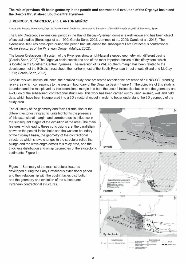
Despite this well-known influence, the detailed study here presented revealed the presence of a NNW-SSE trending relay area which corresponds to the western boundary of the Organyà basin (Figure 1). The objective of this study is to understand the role played by this extensional margin into both the postrift facies distribution and the geometry and evolution of the subsequent contractional structures. This work has been carried out by using seismic, well and field data, which have been incorporated into a 3D structural model in order to better understand the 3D geometry of the study area.
The 3D study of the geometry and facies distribution of the different tectonostratigraphic units highlights the presence of this extensional margin, and corroborates its influence in the subsequent stages of the evolution of the area. The main features which lead to these conclusions are: the parallelism between the postrift facies belts and the western boundary of the Organyà basin, the geometry of the contractional structures which shows changes in the structural relief, the plunge and the wavelength across this relay area, and the thickness distribution and onlap geometries of the syntectonic sediments (Figure 1).
Figure 1: Summary of the main structural features developed during the Early Cretaceous extensional period and their relationship with the postrift facies distribution and the geometry and evolution of the subsequent Pyrenean contractional structures.

7
References
Berastegui, X., Garcia-Senz, J., and Losantos, M. (1990). Tecto-sedimentary evolution of the Organyà extensional basin (central south Pyrenean unit, Spain) during the Lower Cretaceous. Bulletin De La Societe Geologique De France, 6(2), 251-264.
Bond, R. M. G., and McClay, K. R. (1995). Inversion of a Lower Cretaceous extensional basin, south central Pyrenees, Spain. In Buchanan, J.G. and Buchanan P.G. (Eds.), Basin Inversion. Geological Society Special Publications, 88, 415-431.
Carola, E., Tavani, S., Ferrer, O., Granado, P., Quinta, A., Butille, M., and Munoz, J. A. (2013). Along-strike extrusion at the transition between thin- and thick-skinned domains in the Pyrenean Orogen (northern Spain). Special Publication - Geological Society of London, 377(1), 119-140, 23.
García-Senz, J. M. (2002): Cuencas extensivas del Cretácico Inferior en los Pirineos Centrales, formación y subsecuente inversión. PhD thesis, University of Barcelona.
Jammes, S., Manatschal, G., Lavier, L., and Masini, E. (2009). Tectono-sedimentary evolution related to extreme crustal thinning ahead of a propagating ocean; example of the Western Pyrenees. Tectonics, 28(4), 0-TC4012.
Muñoz, J. A. (2002). The Pyrenees In Gibbons W., Moreno T. (Eds.): Geology of Spain. Geological Society, London, 370-385
Seismic and paleomagnetic constraints on the development of the Burgalesa Platform salient (Western Basque Pyrenees)
E. CAROLA1, E, BEAMUD1, 2, E. ROCA1, J. A. MUÑOZ1, Y. ALMAR2 and F. ESCOSA1
1 GEOMODELS Research Institute. Universitat de Barcelona.
2 Laboratori de Paleomagnetisme CCiTUB-CSIC.
The Basque Pyrenees involves a large and thick Jurassic to Upper Cretaceous basin (the Basque Cantabrian Basin) that was inverted during the building of the Pyrenees. Its southern frontal structure, detached at Upper Triassic evaporites, is a roughly E-W trending major thrust which defines a broad thrust salient with the eastern and western edges trending NE-SW and NW-SE respectively. To the east, the footwall of this Basque-Cantabrian thrust front corresponds to the Ebro foreland basin. However, to the west another structural unit occupies an intermediate position between the foreland and the main Basque-Cantabrian thrust front. This unit, known as Burgalesa Platform, also shows a thrust salient concave to the north, although asymmetric and more pronounced than the previously described one. It developed during the Oligocene and Early Miocene times and inverted an Upper Jurassic-Lower Cretaceous extensional basin.
In order to better understand and constrain the evolution of these thrust salients and the role played by the initial configuration of the Mesozoic rift basins, interpretation of seismic lines and a paleomagnetic study have been carried out. The seismic data are located in the Burgalesa Platform and in the adjacent Ebro and Duero foreland basins. The paleomagnetic study was focused on identifying and quantifying vertical-axis rotations from 62 sampled sites, with a mean of 10 samples per site, widely distributed in the Burgalesa Platform and surroundings. The sampled materials include Lower Cretaceous fluvio-deltaic fine grained sandstones, Upper Cretaceous marine limestones and marls and Cenozoic syn-orogenic and post-orogenic fluvio-lacustrine red clays and limestones. Laboratory procedures include stepwise thermal demagnetization and measurement of the NRM, IRM acquisition and 3 axis IRM demagnetization. In addition, fold tests have been performed in order to test the stability of magnetization. IRM measurements reveal that hematite is the main remanence carrier in the Lower Cretaceous sandstones and the Cenozoic red clays, whereas (titano)magnetite dominates in the Upper Cretaceous marls and limestones. Characteristic components have been used to calculate the mean directions at site level revealing significant clockwise and counterclockwise vertical-axis rotations within the bended tips of the thrust salient.
The results of this study denote that the present salient shape of the Burgalesa Platform and its associated foreland basins records a complex evolution linked to the inversion of pre-existent Mesozoic arched structures. Our interpretations indicate that salt-cored folds, developed during the Mesozoic extension, were later deformed during early stages of the Pyrenean contraction. This inherited configuration limited the southward displacement forcing the southeast lateral extrusion of the Burgalesa Platform.
8
Challenges Exploring Unconventionals in Emerging Areas, North Africa Case Study
E. FIGARI NEGRI, M. BAENA GARRIDO, L. CAMESELLE RAMOS, M. GONZALEZ FERNANDEZ and C. GARRIDO
1 REPSOL EXPLORACION, Madrid.
Shale plays are moving from the well-known and explored USA ones to those belonging to not so mature areas. Such new areas are offering us a more frontier objectives in terms of exploration.
A regional screening has been conducted by REPSOL in Europe and North Africa in order to identify favorable geologic areas for unconventional targets in onshore basins.
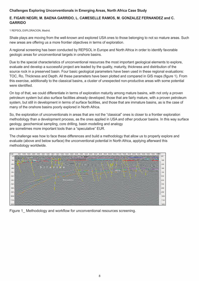
Due to the special characteristics of unconventional resources the most important geological elements to explore, evaluate and develop a successful project are leaded by the quality, maturity, thickness and distribution of the source rock in a preserved basin. Four basic geological parameters have been used in these regional evaluations: TOC, Ro, Thickness and Depth. All these parameters have been plotted and compared in GIS maps (figure 1). From this exercise, additionally to the classical basins, a cluster of unexpected non-productive areas with some potential were identified.
On top of that, we could differentiate in terms of exploration maturity among mature basins, with not only a proven petroleum system but also surface facilities already developed; those that are fairly mature, with a proven petroleum system, but still in development in terms of surface facilities, and those that are immature basins, as is the case of many of the onshore basins poorly explored in North Africa.
So, the exploration of unconventionals in areas that are not the “classical” ones is closer to a frontier exploration methodology than a development process, as the ones applied in USA and other producer basins. In this way surface geology, geochemical sampling, core drilling, basin modelling and analogy are sometimes more important tools than a “speculative” EUR.
The challenge was how to face these differences and build a methodology that allow us to properly explore and evaluate (above and below surface) the unconventional potential in North Africa, applying afterward this methodology worldwide.
Figure 1_ Methodology and workflow for unconventional resources screening.
9
New model of structure and evolution of the Lower Paleozoic Baltic Basin in N Poland based on regional seismic data
P. KRZYWIEC1, P. LIS2, V. BUFFENMYER3, M. MALINOWSKI4 and M. LEWANDOWSKI1
1 Institute of Geological Sciences, Polish Academy of Sciences, Warsaw, Poland 2 GeoFuture Consulting, Warsaw, Poland 3 ION Geophysical, Denver, CO, USA 4 Institute of Geophysics, Polish Academy of Sciences, Warsaw, Poland
The western edge of the East European Craton in Poland has recently been the focus of intense exploration efforts for unconventional hydrocarbons. Results of early exploration wells clearly demonstrate that there are still many unknowns regarding various aspects of the unconventional petroleum system, including structure and depositional architecture of the Lower Paleozoic succession. Seismic data from a recent high-effort regional deep reflection survey has allowed for a better understanding of the complex tectono-sedimentary history of the Baltic Basin.
The Lower Paleozoic basin in Poland is located above the southwestern edge of the East European Craton, northwest from the Teisseyre – Tornquist Zone which is separating the cratonic plate from the West European Platform. During the Precambrian/Cambrian, the cratonic edge underwent extension and rifting of the Rodinia supercontinent, while Cambrian – Ordovician subsidence was driven by a post-rift lithospheric thermal cooling. In the Silurian times, the cratonic edge was incorporated into the Caledonian foredeep basin. This has been very well documented on newly acquired regional seismic data that precisely imaged entire Mesozoic - Paleozoic sedimentary cover.
Within the Baltic Basin the Cambrian – Ordovician passive margin succession is plunging towards the southwest to the depth of 9 – 10 km. It contains one potential conventional reservoir: Upper Cambrian sandstones deposited in the shoreface-offshore setting.
Caradoc shales form one of two main unconventional targets in the Baltic Basin. They were deposited within the distal part of the basin during the final stages of development of the passive margin of the Tornquist Ocean, are characterized by low sedimentation rate and could be interpreted as highstand system tract deposits. As proven by seismic data, they are characterized by subtle lateral thickness variations and seismic amplitude changes, possibly reflecting also lateral TOC variations.
Cambro-Ordovician passive margin succession is unconformably covered by the Silurian foredeep sequence of up to 6-7 km (present-day i.e. after substantial Late Paleozoic erosion) total thickness. Silurian deposition was dominated by fine-grained organic rich shales, generally derived from the eroded orogenic wedge. Seismically defined large-scale geometry of the entire Silurian (Llandovery – Pridoli) succession reflects progressive progradation of the foredeep infill towards the east-southeast.
Llandovery basal shales form second unconventional target of the Baltic basin. They were deposited in a very distal part of the basin and are characterized by small thickness; only within the most southwestern part of the basin some thickening towards the – already non-existing - orogenic belt could be observed on seismic data. Wenlock, Ludlow and Pridoli are characterized by larger thickness related to enhanced subsidence triggered by increased flexure of the foreland plate beneath the Caledonian orogenic belt.
Regional fault pattern within the Lower Paleozoic succession identified on seismic data could be attributed to minor Cambrian – Ordovician faulting within the passive margin of the Tornquist Ocean, Silurian flexural extension of the lower plate associated to the evolution of the foredeep basin, Late Paleozoic reverse faulting related to uplift of the Mazury High and finally regional Late Triassic normal faulting within the northeastern flank of the Permo-Mesozoic Mid-Polish Trough that developed above the Teisseyre – Tornquist Zone.
Regional PSDM seismic data allowed for the quantitative reconstruction of the consecutive stages of development of the Baltic Basin, including the passive margin stage and the foredeep basin stage.
The geometry of Caradoc and Llandovery shale gas reservoirs mentioned above has been, despite their small thickness, successfully imaged using the recently-acquired regional seismic data. Their identification was based on a precise well-to-seismic tie derived from synthetic seismograms calculated using pseudo-sonic and pseudo-density logs created for key deep research wells located within the study area. Regional interpretation has provided insight into geometry, tectonics and subtle lateral thickness variations of Cambrian conventional reservoirs as well as Ordovician and Silurian unconventional reservoirs, and has enhanced the understanding of the play.

10
Linkage between the Southern and Eastern Carpathians: structural scenarios for the Bend Zone
J.J. ARISTIZABAL1 and O. FERNANDEZ1
1 Repsol Exploration, c/ Mendez Alvaro 44, 28045 Madrid, SPAIN
The Carpathian Bend Zone (BZ) defines the area of transition between the roughly N-S trending Eastern Carpathians and the E-W trending Southern Carpathians. The BZ is located along the southward termination of the main structures observed in the outcropping nappes of the Eastern Carpathians (Tarcau, Marginal) which bend from a N-S to a roughly NE-SW trend. Towards the west, the BZ has been informally defined to end against the Intra-Moesian Fault (IMF), one of the faults of Dobogrea area which belongs to the southern extension of the Tornquist-Teisseyre Zone. The IMF is a basement-related feature defined by geophysical anomalies, with present-day seismic activity.
The BZ is characterized by the generalized outcrop of Oligocene-Early Miocene rocks and the presence of abundant diapirs and walls formed by Burdigalian and Badenian salt. The structure of the area is difficult to interpret due to the abundant presence of salt at different structural levels and its structural complexity. Structural understanding of the BZ is further hindered by the difficulty of understanding the termination of eastern Carpathian tectonic units and the apparent disconnection of the BZ from the Southern Carpathians due to the IMF.
Despite these obstacles, analysis of available data (geologic maps, published cross sections, gravity and magnetic maps) provides powerful insights into the details of the structural linkage between the Southern and Eastern Carpathians across the BZ. Map relationships make it possible to correlate the key structural elements of the Eastern Carpathians (Tarcau and Marginale nappes and Burdigalian wedge) with equivalent structures in the BZ. The main difference between both domains is that towards the south and southwest there is a significant loss of displacement on the Tarcau nappe and a significant narrowing of the Marginale nappe. Furthermore, in the BZ, there is an increased presence of salt structures, potentially related to oblique slip on the key thrusts. The combination of the southward termination of structures and the interference of salt tectonics leads to structures becoming less laterally continuous and an overall plunge towards the SW. On the other hand, the Peri-Carpathian thrust and its hangingwall (the Burdigalian wedge) are observed to be almost identical in character in both zones.
Correlation towards the west into the Southern Carpathians is also possible. As occurs towards the north, the Peri-Carpathian thrust and the Burdigalian wedge are almost perfectly continuous between the BZ and the Southern Carpathians, calling into doubt the role of the IMF during its emplacement. As for the Tarcau and Marginale nappes, these continue to lose displacement and width, to the point where they conform a very narrow band of deformation in the Southern Carpathians, associated to high-angle inversion structures (as opposed to the low-angle thrusts observed in the BZ and Eastern Carpathians). This transition across the IMF is interpreted to be related to the control of this deep fault on the location of a regional-scale, shallow lateral ramp during thrust emplacement. The result is the present-day apparent lateral offset on the shallower thrust units (Tarcau and Marginale) and the increase in topographic relief to the east.
The correlation of structural units across the BZ opens exploration opportunities in deep sub-thrust plays in which Oligo-Miocene reservoirs have undergone a similar depositional, burial and tectonic history to those reservoirs currently producing in shallow thrust units of the BZ.

11
Undiscovered petroleum resources in the South-Eastern part of the Norwegian Barents Sea
A. RAMIREZ, M. BJØRHEIM, T. HØY, P. BLYSTAD, B. HENRIKSEN, I. HELENE MADLAND and K. OFSTAD
Norwegian Petroleum Directorate, P. O. Box 600, N-4003 Stavanger, Norway
One of the Norwegian Petroleum Directorate’s (NPD) most important tasks is to produce estimates of undiscovered resources on the Norwegian Continental Shelf (NCS). The NPD has access to all petroleum data from the NCS, and accordingly possesses the best basis for preparing an independent and well-qualified estimation of the total resource potential.
After the treaty with Russia on maritime delimitation and collaboration in the Barents Sea and the Arctic Ocean came into force in 2011, work began on a process to open the South eastern part of the Norwegian part of the Barents Sea for petroleum activities. The sea area covered by this process embraces some 44 000 square kilometers. The NPD has mapped the geology of the area and estimated its resource potential.
Five large regional geological elements define the structural picture in the South eastern part of the Norwegian part of the Barents Sea. One of the biggest challenges in this area is the sealing potential. Also presence of source rocks that could have formed sufficient quantities of oil and gas to fill the structures is uncertain.
Whether petroleum exists in an unexplored area is always uncertain. Calculating resources in plays takes account of this uncertainty by risk-assessing the various parameters of significance for the presence and retention of petroleum. Plays are also defined with uncertainty distributions for different reservoir and liquid parameters. The petroleum potential and uncertainties are modeled and calculated by use of geological dependencies and risks between plays and sub-plays.
The remaining undiscovered resources reflect the exploration potential with today’s knowledge and understanding. Expected recoverable resources for Barents Sea South-East are estimated to be about 300 million scm oe, with a downside (P95) of 55 million scm oe and an upside (P05) of 565 million scm oe.

12
Application of chemostratigraphy and palynostratigraphy to the Mississippian of well Siciny-2, Poland
D. A. RILEY1, D. MCLEAN2, L. HUBERT3, P. ZWOLIŃSKI3, R. KLISCHIES1 and T. J. PEARCE1
1 Chemostrat Ltd, Unit 1 Ravenscroft Court, Buttington Cross Enterprise Park, Welshpool, Powys, U.K. SY21 8SL, UK 2 MB Stratigraphy Ltd. Unit 11 Clement Street, Sheffield, S9 5EA, UK 3 San Leon (Poland) Sp. z o.o. ul. Mokotowska 100-640 Warszawa, Poland
This case study presents a multidiscipline approach applied to the Polish well Siciny-2, located in the Carboniferous Variscan foreland basin of the Fore-Sudetic Monocline, SW Poland. The area is structurally complex, being heavily affected by the Variscan orogeny, and later inversion events. Sequences are heavily faulted and may also even show repetition. Furthermore, the succession itself is characterised by featureless wireline logs making petrophysical correlation complicated. As a result it was deemed necessary to undertake a multidisciplinary stratigraphy methodology in order to unravel the structural complexity of this succession.
Palynostratigraphy divides assigns the Carboniferous (Mississippian) strata penetrated in Siciny-2 into six biozones ranging from Arnsbergian to Brigantian, with possible Asbian at TD. Overall the preservation is good towards the top of the section, although poorly preserved successions were encountered towards the bottom. Consequently a moderate to high level of confidence can be applied to the palynostratigraphy, providing a chronostratigraphic framework for the carboniferous succession. In addition, palynofacies analysis indicate open marine deposition with high terrestrial/freshwater input and dysoxic conditions at the sediment/water interface throughout the Mississippian. Parts of the section indicate changes in redox but these never achieve the suboxic or anoxic states associated with restricted marine basins.
Chemostratigraphy was also applied to mudstones in order to validate and enhance the palynostratigraphy. Samples collected every 10 metres over a 1730 metre interval were analysed by ICP-OES and ICP MS providing a full suite of major elements, trace elements and rare earth element data. The application of chemostratigraphy to the study interval has highlighted four chemostratigraphic sequences and eighteen chemostratigraphic packages. The geochemical zonations are applied to changes in; clay mineralogy (i.e. changes in weathering and paleoclimate), heavy minerals (i.e. provenance changes), feldspar abundances, and organic matter preservation. The chemostratigraphic zonation applied to the mudstone lithologies had the highest correlation potential. Furthermore, the chemostratigraphy also allows differentiation of the overlying Permian, revises the top Carboniferous pick, highlights candidate marine bands, based on changes in organic matter preservation, and highlights the occurrence altered trachyandesite volcanics within the Permian. In addition, a chemostratigraphic analysis of the coarser lithologies (turbidite facies) demonstrates a chemostratigraphic zonation, which most likely reflects a variation in provenance. While this zonation has lower correlation potential than that developed within the mudstone, should other wells be drilled in the basin which consisting of predominantly sandstone lithologies it has the potential to be used to characterise those wells and correlate to them.
The combination of biostratigraphy and chemostratigraphy in a multidiscipline approach has now developed a chronostratigraphic zonation for this study well, which as a type section can be applied to other wells drilled in this basin, possibly even at wellsite, developing a chronostratigraphic framework for this area.

13
Regional 3D basin and Petroleum System Modeling Study of the Murzuq Basin, Libya
A. VAYSSAIRE1
1 Repsol, Madrid
A 3D basin and petroleum system modeling study of the Murzuq basin was performed at regional scale. Despite of the abundance of well and seismic data, little information was found to constrain the dynamics of the basin and their associated fluids. Temperature and vitrinite were calibrated from a selection of key wells. AFTA data and fluid inclusions were used to better constrain the past history of the thermal regime. Seven erosion phases were also taken into account since they play a crucial role in the petroleum system history (reservoir and trap shape, source rock deposition, maturity and hydrocarbon migration).
The patchy distribution of the thin but very rich Silurian hot shale, with initial TOC that can exceed 20%, has always been considered as a major exploration risk. By reconstructing the sea-level rise and the paleo-topography that resulted from the Late Ordovician glaciation of Gondwana we could delineate the paleo-depressions where the organic matter may have been better preserved. The overpressure generated during kerogen cracking is the principal driving mechanism for moving hydrocarbon downward and inside the Mamuniyat (upper Ordovician) and Hawaz (middle Ordovician) formations. Three source rock areas with fair to excellent generative potential were identified. The most prolific is located in the North.
From these expulsion pods hydrocarbon migrated laterally inside the permeable layers following gravity driven mechanism. The expulsion stopped at the Austrian uplift (end of Early Cretaceous) except in the South-East of the studied area where it continued until the Tertiary Alpine uplift.
The Austrian event tilted the basin and caused the shift of its depocenter from North to South. Until Early Cretaceous, the depocenter was at the North of the basin, today it sits at the South of it. We note that the largest discoveries are located along the hinge line of this basin tilt. This could be explained by a favorable location for hydrocarbon charge. These structures were first charged by hydrocarbons coming from the North and after the Austrian event, they might have also been charged from the South.

14
Sandtrak: a new tool to further the understanding of sands within reservoir systems
A. FINLAY, I. SEVASTJANOVA, C. ROACH, T. MORGAN and T. PEARCE
Heavy mineral analysis and detrital zircon geochronology are commonly used as sediment provenance tools within academia and the petroleum industry. Heavy mineral analysis gives insights into lithological composition of the source geology and detrital zircon geochronology provides information on the ages of initial igneous source rocks. In addition to identifying the ages of zircons, analysis of zircon geochemistry (e.g. U and Th ratios) can split different source units that are the same age. Furthermore, analysis of the morphology of individual zircons can provide information about the history of reworking of sediment. However, provenance studies require sizable data sets to maximise the understanding of sediment pathways from identified sources. Additionally they need to be fully integrated with other geological information (e.g. the stratigraphic framework) to be fully effective.
Chemostrat now offers Sandtrak which enable large detrital zircon and heavy mineral datasets to be analysed and obtained for provenance studies in a matter of weeks. Sandtrak came online as a commercial service on the 1st July 2013. Since then it has successfully processed ~200 predominantly cutting samples comprising ~4500 concordant zircons for detrital zircon geochronology and ~100 heavy mineral and mineral typological samples.
This paper will illustrate through the use of case studies from the West of Shetland, West of Ireland, Southern North Sea and Voring basins, how the large data sets produced by Sandtrak can be utilised to aid the petroleum industry. In addition it will demonstrate how the integration of these new techniques with standard stratigraphic tools can generate a wide variety of information to further the understanding of reservoirs and reservoir systems. Furthermore, these case studies will span a range of scales from understanding large scale sediment pathways along the western Atlantic margin to sediment input points at the basin scale and identifying sand on sand contacts within individual reservoirs.
Reservoir characterization and sedimentological modeling of Lower Cretaceous, Leushinskaya and Vikulovo formations, based on log and core analysis. West Siberian basin, Shaim Region
C. ZAVALA, M. J. ARCURI, J. R. CARBALLO1, V. GOITÍA1, R. ISMAGILOV1, A. MAKAROVA1 , E. EVDOKIMOVA1, R. AKMETZYANOV1 and M. RAVILOV1
1 Eurotek-Yugra-Repsol Russia
Lower Cretaceous Leushinskaya and Vikulovo formations have recently tested oil and gas for the first time in the Shaim Region located in the western border of West Siberian Basin. Before that, these formations were known as hydrocarbon reservoirs only in Krasnoleninskoye region (Kamennoye field) where they produce oil from Vikulovo sandstones and siltstones [1] Presence of commercial gas accumulation in Cretaceous section in this part of the basin is also new as no gas fields had been discovered before 2013.
The aim of this paper is presenting the results of the reservoir characterization study of Leushinskaya and Vikulovo formations based on new log and core data. The data has been obtained during the 2012-2013 drilling campaign performed by Eurotek-Yugra (100% Repsol) in Karabashskiy area in Shaim Region.
As a result of the integration of core, thin section description and interpretation with logging and seismic data, a new facies and sequence stratigraphic model of Neocomian-Aptian reservoirs is presented. This model provides a predictive tool for assessing the quality and distribution of these reservoirs in the westernmost part of Shaim Region.

15
Peculiarities of migration of hydrocarbons in geological conditions of the South Caspian basin
A. A. FEYZULLAYEV1
1 Institute of Geology of the Azerbaijan National Academy of Sciences
Based on results of theoretical and experimental worldwide studies, analyses of lithofacial characteristics, macro- and micro-features of texture of the Oligocene-Miocene source rocks, thermo-dynamic conditions of their occurrence, main forms, phases, directions and distance of migration of hydrocarbons in geological conditions of the SCB were examined. These were allowed to draw the following basic conclusions:
1. The transport of oil in the form of molecular solution in connate waters cannot be considered in the SCB as a potential mechanism of primary migration of oil because bulk of these waters was discarded up to the depth of 3-4 km, but oil window is situated at depths interval 5-9 km.
2. Occurring of overpressures in the Baku archipelago is one of the evident signatures of hindered expulsion of hydrocarbons generated in the source rocks. Possibly, this can explain the low efficiency of prospecting of commercial accumulations of hydrocarbons in this area. In this conditions primary oil migration unlike the classic concept will probably has pulse/explosive character
3. In massive source rock sequences hydrocarbons moved mainly laterally upwards up to highly permeable vertical fractures, faults, conduit of mud volcanoes and then due sub vertical migration along this pathways to carrier rocks/reservoir.
4. Presence in main Low Pliocene reservoir of SCB of the fault systems, feeding structures by hydrocarbons from underlying sediments was established.
5. Discovering in a several fields the commercial petroleum accumulations in the Quaternary and Upper Pliocene suites is an indicator of re-formation of underlying hydrocarbon accumulations in main reservoir. 6. The process of destruction of hydrocarbon accumulations is expressed by multiple large-scale hydrocarbon macro seepages, related with deep faults and mud volcanoes. The tertiary micro flows of hydrocarbons are manifested by formation of epigenetic gas anomalies above commercial petroleum accumulations.

16
Prediction of reservoir quality of turbidite systems in steep passive margins: a challenge for deepwater exploration
J. GERARD1
1 Deepwater Clastics Advisor, Repsol Exploraciòn SA, Madrid-Spain
Prediction of presence of turbidite reservoirs is highly facilitated by detailed imaging of depositional deepwater systems by high quality 3D seismic surveys. In addition, outcrop studies of deepwater sediments provide a better understanding of deepwater depositional facies and related processes and their relation with reservoir architecture. Nevertheless, prediction of reservoir quality remains a key risk in deepwater exploration. In a few recently drilled exploration wells, reservoir quality issues were experienced and interpreted to result from immature turbidite sediments and consequently from drastic diagenetic processes downgrading petrophysical properties of the reservoirs. Slope morphology and drainage area were considered to be the main controlling factors on sediment immaturity and related poor reservoir quality.
Deep-water hydrocarbon exploration results across the slope and the basin are strongly influenced by the morphology of the shelf to basin relief and more importantly by the dip of the slope. Brittle substrate and ductile substrate are the two mechanical end-members which govern the basin typology across the shelf break down to the base of slope. Presence of thick mobile shale or salt section has a direct implication on the confinement of the basin. Continental margins where mobile section is intensely deformed by younger prograding shelfal sediments favor the development of ponded basins.
Steep slopes which are locally fault-controlled seem to favor the incorporation of rip-up clasts and clay flakes in the gravity flow, dominated by immature sediments rather than mature quart-rich sediments. Combination of rip-up clasts (constitutional clay) and clay flakes in the pore network (disperse clay) affect drastically the permeability of turbidite reservoirs.
Small drainage areas with a steep gradient coupled with a short distance from the hinterland to the deepwater basin seem to be the geomorphic elements having a strong negative impact on deepwater reservoir characteristics.

17
Identification of sand injectites in log and seismic data
J. GERARD1, N. ANTICH-CORTES2 and S. ADRIANTO2
1 Deepwater Clastics Advisor, Repsol Exploraciòn SA, Madrid-Spain, 2 Regional Studies Group, Repsol Exploraciòn SA, Madrid-Spain
Stratigraphic sections in sedimentary basins consist of wide range of lithologies. Deposition of clay, particularly where sedimentation rate is high, commonly provides thick stratigraphic units which prevent from dewatering of the underlying section as they have a seal behavior. During burial, fluid pressure increases and might become larger than lithostatic pressure and the fluids will breach the seal. Then reorganization of the sediments resulting from water displacement makes various types of structures ranging from cm-sized contorted- and convolute-bedding to metre- to km-sized network of remobilized sand intruding shaley host rock.
Lessons learned from outcrop analogs indicate that sand injectites consist most commonly of a complex network in 3D of sills and dykes involving a small volume of poorly connected sands likely non-economic, rather than a large volume of porous rock bearing significant producible hydrocarbon reserves. Nevertheless, sand injectites might have contributed to petroleum systems during hydrocarbon charge and also dismigration during geological times.
Both Academia and Industry have paid attention to these large complexes of sand injectites as identification of sedimentary sills and dykes in EandP projects is vital to avoid launching expensive operations such as testing, interference test, completion, water injection and others… Wireline responses of sand injectites look similar to thick stratified sandstone beds with low Gamma-Ray, and commonly a porous response in other logs (DT, NPHI-RHOB…) with fair to good saturation on resistivity logs (So or Sg) if intense diagenesis has not cemented the sand.
A subsurface case study provides a good example of identification in a production well of two “apparently” thick clean sand beds, embedded in a thick shaley section. Top and Base of this shaley section have been interpreted on 3D seismic data. This section shows significant soft deformation and clear evidence of low net to gross as attested by all the other wells drilled through the section. The two sand beds are out of sequence in that shaley section as no thickening-up and no thinning-up trend is observed neither at the base nor at the top respectively. In addition, correlation of all the other wells in the area indicates a lack of sand in that section. At well location, these two sand “beds” overlie a thick confined massive channel fill which is interpreted as the “feeder” for the sand injectites. A complex architecture is anticipated away from the wellbore as suggested by the seismic data and crudely drawn on the seismic line, all outcrop data indicating a high complexity of an almost unpredictable architecture of the injectite network.

18
The role of regional play based exploration in recent exploration success in the Dinarides
J. DE VERA, M. WEALE, K. GERDES, P. WAGNER and E. CLARKE
All Shell International
A recent company re-entry into Albania and subsequent discovery of hydrocarbons in the Dinarides was underpinned by a regional prospectivity assessment of the Greater Adriatic region. The area of interest is located on the European Plate and has undergone a complex tectonic evolution which commenced with regional Mesozoic Tethyan extension and culminated in compression associated with the collision of Africa and Eurasia leading to the Tertiary Alpine orogeny. This region which extends from eastern Italy to the Balkans is a proven hydrocarbon province that contains some of the largest onshore oil fields in Europe, such as the Val D’Agri field in the southern Apennines and the Patos-Marinza field in Albania.
The present day structure of the region consists of two NW-SE-trending fold and thrust belts that are separated by a narrow underfilled foreland basin, which is partially overlain by the present day Adriatic Sea. The variation in current basin architecture was mapped using a broad grid of regional seismic and potential field data tied to the available well data and onshore geological mapping. This revealed new insights into the nature and timing of the sedimentary fill and structural evolution of the region. Dry hole analyses using well and seismic data isolated structural deformation caused by halokinesis from that caused by regional compressional stresses.
Regional charge is provided by a suite of prolific Mesozoic source rocks. A re-interpretation of the available geochemical database led to the division of the region into a suite of play domains. Thrust geometries, in some cases using weaknesses inherited from the Mesozoic rift architecture, and the position of the basal decollement exert a fundamental role on charge access. Reservoirs consist mainly of Triassic to Paleogene platformal to basinal carbonates and Oligocene to Pleistocene siliciclastics. Within the fold and thrust belt significant effective porosity is associated with the presence of pervasive fracture networks. The region shows a wide range of trapping geometries including both structural thrust and sub-thrust traps and stratigraphic trapping configurations in younger sequences. Regionally mappable first order unconformities control in large part the distribution of sealing sequences.
The study identified a suite of distinct play elements and petroleum systems which vary in their presence and importance across the region. This new interpretation of the petroleum potential of the region identified multiple distinct plays and enabled the company to customize the subsequent re-entry into the country.

19
New hydrocarbon plays in inverted Jurassic extensional basins of the Bohemian Alpine foreland (Eastern Alps, Austria)
P. GRANADO1, W. THÖNY2, J. ANTON MUÑOZ1, and P. STRAUSS2
1 Institut de Recerca Geomodels, Dept. de Geodinàmica i Geofísica, Universitat de Barcelona, c/ Martí i Franqués s/n, 08028 Barcelona, Spain. 2 OMV Exploration and Production, Trabrennstrasse 6-8, A-1020 Vienna
Austria hosts large reserves of hydrocarbons trapped in varying structural domains and reservoirs types. This study concentrates on the regional structure and stratigraphy of the Lower Austria region (north of Vienna). A particular emphasis is given to the Autochthonous Mesozoic cover developed onto the stretched European continental margin. The studied area is located at the Alpine thrust front, where the tilted Bohemian foreland is overridden by imbricated foreland deposits (i.e., Flysch and Molasse) as well as a series of N-NW directed thrust sheets of Apulian affinity. These upper plate units rest on top of the Alpine Tethys European continental margin whose structure is characterized by a series of S-SE directed Jurassic half-grabens. These half-grabens are showing thick syn-rift siliciclastic wedges and a SE-prograding post-rift carbonate platform with facies transitions towards a marly slope and deeper water sediments. In this Mesozoic succession, source rocks locate in the Doggerian pre- to syn-rift Gresten Gp. and in the post-rift Malmian Mikulov Fm. Main reservoirs locate in the Gresten Gp. quartzites and in the cherty dolomites of the post-rift Höflein Fm. Top Seal is provided by shales of Lower Miocene Molasse sediments and the underlying Mikulov Fm marls. Careful interpretation of structure and sediment architecture from 3D depth-converted seismic data has revealed that the half-grabens underwent mild inversion upon Cenozoic shortening, but also that the lower plate underwent extension coevally with shortening in the foreland region. Evidences for mild thin- and thick-skinned tectonic inversion of the Bohemian foreland are: gentle folding of the syn-rift clastic wedges, the local low-angle reverse offset of the basement top reflectors or its sub-horizontal attitude. Syntectonic Molasse sediments onlapping onto the scarps of the external most basement extensional faults and their hanging-walls suggest that these basement faults were active upon shortening. Miocene extension also took place in the upper plate as shown by the development of the Vienna Basin. Miocene extension might have also reactivated the basement extensional faults formed in Jurassic times. Such new interpretations of the Lower Austria Bohemian basement have implications for the estimation of hydrocarbon reserves, and open potential new plays and opportunities for a mature hydrocarbon province.
Structural elements and petroleum exploration on the Apulian platform, Hellenic Fold and Thrust Belt, Zakynthos Island (western Greece)
A. MARAVELIS1, A. VASSILIOU2, P. TSEROLAS3 and A. ZELILIDIS3
1 School of Environmental and Life Sciences, University of Newcastle, Callaghan 2308 NSW, Australia. 2 GeoEnergy, Inc., Houston 77042 Texas, USA. 3 Laboratory of Sedimentology, Department of Geology, University of Patras, Greece.
The Fold and Thrust Belt in the western part of the Hellenic foreland, has been examined with respect to its geotectonic evolution and source rock potential. The upper Miocene to Pliocene clastic sedimentary sequence provides a great opportunity to reconstruct the regional Fold and Thrust development and to estimate its oil and gas generation potential. The occurrence of a late Oligocene in age, slumped interval suggests intense slope instability. This interval was initially accumulated in a deep water depositional environment, as evidenced by the common occurrence of both complete and incomplete Bouma sequences and is most likely related to the Ionian thrust activity. It is thus envisaged that the Ionian thrust should be positioned further westwards of the Zakynthos Island. The former Ionian thrust should most likely correspond to a younger, smaller scale and of local influence tectonic event. A total number of twenty seven mudstone samples were analyzed using Rock-Eval pyrolysis method. Organic geochemical data indicate that the containing organic matter is present in sufficient abundance and with good enough quality to be regarded as potential source rocks. The present Rock-Eval pyrolytic yields and calculated values of hydrogen and oxygen indexes imply that the recent organic matter is of types II and III kerogen. The observed kerogen types suggest both gas and oil generation potential. The thermal maturity assessed from Tmax suggests an immature stage of the organic material along with the occurrence of layers having reached the very early mature stage.

20
From Foreland to Forearc in Greece – New Opportunities for Offshore Hydrocarbon Exploration
J. Fürstenau1, M. Schjeldsøe Berg1, Ø. Lie1, G. Tsifoutidis2 and S. Bellas2
1 Petroleum Geo-Services, Lilleakerveien 4C, P.O. Box 251, Lilleaker, 0216 Oslo, Norway 2 Greek Ministry of Environment, Energy and Climate Change (YPEKA), 119 Mesogion Av., 10192 Athens, Greece
Exploration efforts in Greece are strongly gaining momentum. In the second half of 2014, YPEKA (Greek Ministry of Environment, Energy and Climate Change) is expected to announce an international licensing round for hydrocarbon exploration and exploitation. The database available for the license round will be 12,500 km of new regional 2D broadband seismic and gravity-magnetic data offshore western and southern Greece, in addition to 9,000 km of reprocessed legacy seismic data and a number of wells.
The broadband data set allows the interpreter a clearer image of the subsurface with particular reference to imaging of the Mesozoic carbonate succession, resolving structures deeper in the section and an exceptional fine resolution of the shallow clastic intervals. The offshore Greece area exhibits a broad variety of sedimentary basins. These basins are associated with a series of different structural settings. They range from the forearc succession south of Crete, comprising the Hellenic trench system, up to the outermost part of the fold-and-thrust belt of the External Hellenides in western Greece and the corresponding foreland. The latter is mainly underlain by the westward overthrusted Apulian platform.
In and around Greece, numerous petroleum systems are proven, and indications for additional ones, such as oil shows and seeps are promising. The External Hellenides are proven to be prospective for hydrocarbons in fractured Cretaceous to Paleogene limestones in Albania and there has also been success in Greece with the Katakolon oil discovery. The Italian and Albanian sectors of the Apulian platform host oil and gas discoveries in a number of plays, which are associated with the large Apulian platform carbonate system. Fractured, karstified and/or resedimented Cretaceous limestones provide the reservoirs for these discoveries. Hydrocarbons are generally reported to be generated from Triassic and Jurassic organic rich layers, while the Katakolon oil specifically points towards multiple source rocks (Jurassic/Cretaceous). Regional sealing is provided by the thick overlying clastic Mio-Pliocene and locally an Oligocene succession, which in addition offers potential for biogenic gas plays as have been discovered offshore Italy and Albania.

21
Tectonics of the Western Black Sea back-arc basin as reveled by the architecture of its sedimentary fill
M. IOAN1, M. LIVIU2, I GEORGE1, D CORNELIU3 and C SIERD2
1 Repsol, Exploration Europa del Este, Calle Méndez Álvaro Nº 44, 28045, Madrid, Spain 2 Utrecht University, Department of Earth Sciences, Budapestlaan 4, 3584CD Utrecht, The Netherlands. 3 University of Bucharest, Department of Geology, Vuia Traian 6, 020956, Bucharest, Romania
Architecture of the sedimentary basin fills reflects the tectonic processes that created enlarged and subsequent closed sedimentary basins. Depicting the geometry and litho-stratrigraphy of basin fills can provide useful insights for unraveling the tectonic evolution of both the basins and the adjacent orogen where the direct observation is hampered by uplift and erosion, such as in the case of back-arc domains.
Back-arc basin evolution is driven by processes active at the main subduction zone typically assuming the transition from an extensional back-arc, during the roll-back of a mature slab, to a contractional basin, during high-strain collisional processes. A similar type of transition is observed in the Black Sea Basin evolution, from an extensional domain during Cretaceous-Early Paleogene resulting from the roll-back of a mature slab associated with the N-ward subduction of Neothetys Ocean under the Rhodope-Pontides Arc, to a gradually inverted basin during Late Paleogene – Pliocene times after the collision between Pontides and Taurides continental units.
The Cretaceous-Paleogene extension resembles in a series of graben, tilted block and prograding passive margin like structures, with associate wedge shape geometry of the syn-extensional deposits. Basinward these deposits are younger in age, demonstrating the migration of extension from basin margin (offshore Romania-Ukraine shelf in the North and onshore Pontides in the South), towards basin center (offshore Bulgaria and Turkey). This extensional geometry played an important role in the subsequent inversion, which transformed the Black Sea into a compressional back-arc basin.
The shortening started during Late Eocene gradually affected all areas of the Western Black Sea Basin during Oligocene and Pliocene times as reveled by syn-tectonic sedimentation, on its western margin. In terms of sediments lithology this marks a shift form carbonate passive margin to a clastic “foreland” like sedimentation, such as in the case of Kamkya (Late Eocene-Lower Miocene) and Histria (Oligocene-Upper Miocene) depressions. The mechanism of this generalized inversion was the transmission of strain from the collision recorded in the Pontides –Balkanides orogens into the Black-Sea back-arc basin.
The architecture of the “anomalous” thick uppermost Miocene-Pliocene sedimentary pile on the north-western part of the basin, shows the far field effect of two tectonic processes; one that provide the sediments related with uplift and erosion of the Carpathian Orogen, and the second one which created the accommodation space and was related with continuous subsidence in the Western Black Sea center.
22
Stratigraphic re-evaluation of the Oligocene-Lower Miocene formations in the Diapiric Fold Zone, Eastern Carpathian, Romania
M. IOAN1, P. DANIELA2, B. VERONICA2, D. SONIA2, M. VIORICA2 and I. GEORGE1
1 Repsol, Exploration Europa del Este, Calle Méndez Álvaro Nº 44, 28045, Madrid, Spain 2 OMV-Petrom S.A., Exploration Division, Pannonic and Gethic Department, 22 Coralilor Street, 013329, Bucharest, Romania
The thrust and folded belts are prolific areas for the hydrocarbon exploration as well for the development new geological concepts and processes. The relation between the academia and industry in Romania has been of crucial importance in the exploration of Eastern Carpathian. The southernmost part of the Eastern Carpathians is known as the Diapiric Fold Zone, the place where the salt diapirc concept was first developed and the first commercial oil production, in the world, was reported 150 years ago.
The Eastern Carpathian thrust and folded belt, as part of the Carpathian Orogen, has unique double bend geometry and its present day shape is the product of the Alpine deformation. The East Carpathians can been dived into two domains, the internal thick skinned (involving the stack of basement nappes with crystalline rocks and a Mesozoic sedimentary cover, Median Dacides); and the external one involving a thin-skinned nappe system, i.e., the Ceahlau nappe (Outer Dacides), Convolute Flysch, Audia/Macla, Tarcau and Marginal Folds and Subcarpathian nappes (Moldavides). The main thrusting event took place during Mid-Late Cretaceous times, in case of the Outer Dacides and during Paleogene-Miocene in case of the Moldavides. Miocene thrusting culminated in the Sarmatian (Middle Miocene) when the Subcarpathian nappe was thrust on top of the sedimentary cover of the apparently “undeformed” foreland (European, Scythian and Moesian platforms). With the Sarmatian, deformation by thrusting ceased in the most of the belt, with the exception of the East Carpathian Bend Zone, where deformation continued during Pliocene- Quaternary culminating with salt diapirs, some of them piercing the entire sedimentary sequence and are now outcropping (Diapiric Folds Zone). These rather continue deformation, with formation and then destruction of foreland and piggy-back basins has left its mark over the sedimentary architecture which remarks itself by large lateral and across the belt facies change. Adding to that the endemic evolution of the faunas these makes the stratigraphic correlation even more difficult.
For a long period of time, discrepancies existed between academia surface and industry subsurface dating of the Oligocene-Miocene sequences. The first one has been rapidly updated to new stratigraphic schemes, benefiting from the easy access by numerous researchers, while the later one has been tied to the official age of the reservoirs and remain basically unchanged. However, from time to time the industry must adjust itself to the recent development, on both stratigraphic and tectonic concepts. This is the case of the Eastern Carpathian Bend Zone where an important effort by a multidisciplinary team has been recently undertaken for the stratigraphic re-evaluation of Oligocene-Miocene deposits, based on core data. The re-dating has shown that the previous Oligocene deposits are rather spanning across Oligocene-Lower Burdigalian times. This correlation is in agreement with the outcrop based studies showing that the Maikop facies, widely recognized in the Eastern Parathetys basins, starts in the uppermost Eocene and ends with Lower Miocene times. The revised Lower Burdigalian age for the salt breccia formation (previous interpreted as Aquitanian in age) has major implications in terms of depositional environment and tectonic evolution. Hence recognizing the same restrictive evaporitic environment in both the East and South Carpathian forelands (e.g. Getic Depression) at equivalent stratigraphic levels, one can interpret that both have been shared a similar depositional environmental conditions and even the same basin. The change in depositional environment from deep sea turbiditic facies, in Oligocene- early Lower Miocene, to shallow water evaporitic in late Early Miocene, can be interpreted as an evidence for tectonic activity that has led to the deposition of Salt Breccia Formation in restrictive foreland and/or piggy back basins with important afflux of detritic material from uplifting hanging-wall or fore bulge uplifted areas. The subsequent compressional deformation used the salt formation as decolement level during Miocene-Quaternary times.

23
The Geological Framework of the Offshore Greece (-Hellenides and Hellenic Arc until eastern Crete): a Novel Insight from a New Regional Seismic Survey
V. CARAYON1, L. MONTADERT1, F. ROURE2 and P. HELGE SEMB3
1 Beicip-Franlab, Rueil-Malmaison, France 2 IFPEN, Rueil-Malmaison, France 3 PGS, Lysaker, Norway
The geological framework of the Offshore Greece from the Dinarides to the Hellenic Arc is the result of a complex tectonic history. It started by the fragmentation of the Pangea with formation of margins and deep basins by rifting from the Triassic to the Middle Jurassic and spreading in the Upper Jurassic and Lower Cretaceous. The resulting thick Mesozoic basins are still preserved in the Eastern Mediterranean with the Levant Basin and in the offshore Greece, the western Herodotus Basin and the Ionian Basin. As in the whole Tethys realm, a major change occurred in the Upper Cretaceous with the change of motion of Africa relative to Eurasia leading to a compressional regime. Subduction of Africa below Eurasia, creation of back-arc basins and collision resulted in fold and thrust belts.
Another change occurred at the Late Eocene-Early Oligocene (30-35 Ma), when the northward motion of Africa decreased and the subducting slab started to retreat southward with migration of the trench, beginning of the formation of the Mediterranean Ridge accretionary complex and extension in the Aegean region. From the Late Miocene- to- Present, the Anatolian plate was individualized, moving to the West and Southwest in the Aegean area. It is bounded to the North by the North Anatolian strike-slip Fault which crosses the Aegean until the Offshore Greece through the Corinth graben, cutting the Apulian Platform until the Ionian deep basin, along the Keffalonia Fault Zone, where it is bounding westward the Mediterranean Ridge. During this period, the front of the thrust wedge of the Mediterranean Ridge came in contact with the Cyrenaica Promontory. Offshore Greece was also affected in its NE part by the development from the late Miocene to Present, of the Calabrian Arc and its accretionary prism to the SE, linked to the subduction of the Ionian basin. The development of the Mediterranean Ridge and of the Messina Cone resulted in the almost disappearance of the Ionian Mesozoic Basin which, however can extend below these wedges.
The Messinian salinity crisis affected the Offshore Greece with deposition of thick evaporites in the deep basin undisturbed in the remnant Ionian Basin but imbedded in the accretionary prisms which developed during their deposition. Of importance for Exploration is the fact that the whole slope of the Hellenic Arc constituted by a thick stack of thrusts was sub aerially exposed with probable karstification of the carbonates composing the thrusts.
As a result of this complex history, the Offshore Greece along the Hellenic Arc is subdivided into several panels of different structural complexity and water depths. The first regional seismic survey acquired by PGS shed a new light on the Offshore Greece and will allow its hydrocarbon assessment.

24
Exploration Pathways for Western Portugal – an Integrated Look to the Lusitanian and the Peniche Basins
R. PENA DOS REIS1, 3 and N. PIMENTEL2, 3
1 Centro de Geociências, Coimbra University, Portugal. 2 Centro de Geologia, Lisbon University, Portugal. 3 Margins Exploration Group www.meg.ipn.pt
Introduction
The Lusitanian Basin is one of the Western Iberian Margin sedimentary basins related with the opening of the North Atlantic. These basins have their counterparts in the eastern Canada Jeanne D’Arc and Whale Basins, as part of the Iberia-Newfoundland conjugate margins complex. In the Canadian basins, the intense exploration led to several good production and development results, but the Iberian basins did not have, so far, similar positive results.
The Lusitanian Basin corresponds to the most proximal margin, whereas the Peniche basin (deep offshore) is located at the distal margin. Both sedimentary infills show similarities, related with its contiguous basin evolution. The same major tectono-sedimentary packages, erosion and inversion events may be recognized in both basins.
This presentation deals with the evolution of the mainly onshore Lusitanian Basin and its petroleum systems, in order to establish an analogue for other nearby offshore basins, aiming to contribute to a better regional framework for exploration in the North-East Atlantic region.
Petroleum Systems
From the analysis of the petroleum system elements and its articulation in space and time, three main petroleum systems may be considered in the Lusitanian Basin (Fig.1): i) A pre-salt petroleum system, sourced by meta-sedimentary Palaeozoic rocks feeding Upper Triassic siliciclastic reservoirs and sealed by the Hettangian evaporitic clays; ii) A second petroleum system with Lower Jurassic source-rocks, namely the Sinemurian and Pliensbachian organic-rich marls, feeding mainly Cretaceous siliciclastics, using diapiric structures as migration pathways; iii) A third petroleum system with Upper Jurassic transitional to coastal marine Oxfordian source-rocks, feeding mainly Upper Jurassic fractured limestones and fluvio-deltaic to turbiditic siliciclastics. A fourth potential petroleum system may be considered, related to Cenomanian-Turonian marine marls, locally maturated and feeding tertiary siliciclastics, acting as reservoir and seal.
Both the Lusitanian and Peniche basins present sufficient maturation for the Lower and Upper Jurassic source-rocks. The presence of those source-rocks, as well as reservoirs and seals, is proven for the Lusitanian basin but it is, for the moment, speculative for the Peniche basin. Petroleum systems charts show similarities but improved subsidence in the deep offshore Peniche basins contributed to earlier and more intense maturation. This situation may also alow for the maturation of an eventual Late Cretaceous source-rock, which would feed thicker tertiary siliciclastics, with good reservoir and sealing properties.
Conclusions
1. The Lusitanian Basin is well known outcropping basin and may be used as an analogue to the Peniche Basin.
Figure 1 – Simplified Petroleum Systems Chart for the Lusitanian Basin.

25
2. The petroleum systems in both basins may be approached within the same geodynamic and stratigraphic framework.
3. Basement nature and structure seem to have strong influence on located subsidence and increased overburden areas.
4. Different positions within the North Atlantic opening margin, promoted different rfiting, overburden and maturation timings in both basins.
5. Globally, maturation in the deep offshore Peniche Basin is expected to be: i) more recent; ii) more intense, comparing with the onshore basins.
6. The influence of inversion issues must be stressed on any approach to the Peniche Basin. Although it helped in creating folds- and fault-related migration pathways, its impact on seal integrity may have been critical.
7. De-risking strategies for the West Iberian margin offshore basins must include basin and petroleum systems analysis based on detailed outcrop studies.

26
Mesozoic tectonic and paleogeographic evolution of the Gulf of Cadiz and Algarve basins, and implications for hydrocarbon exploration
A. RAMOS1, O. FERNÁNDEZ2, P. TERRINHA3, J. ANTON MUÑOZ1 and Á. ARNAIZ2
1 Geomodels, Departament de Geodinàmica i Geofísica, Universitat de Barcelona, Barcelona, Spain
2 Grupo de Disciplinas Geológicas, REPSOL Exploración, Madrid, Spain.
3 InstitutoPortuguês do Mar e da Atmosfera, Divisão de Geologia e Georecursos Marinhos, Lisboa, Portugal
The Gulf of Cadiz and its western extension, the Algarve Basin, are located along the eastern termination of the Azores-Gibraltar Fault Zone (AGFZ), a diffuse transforming plate boundary between Iberia and Africa (Sartori et al, 1994). This area has experienced significant hydrocarbon exploration in the past dealing with both the Mesozoic platform carbonates and the Tertiary units of the Gulf of Cadiz, the latter related to the deposition of Guadalquivir-sourced sediments and contourites.
Over the last years several models have been proposed for the regional geodynamic evolution of the Gulf of Cadiz (e.g. Tortella et al., 1997, Maldonado et al., 1999; Gutsch et al, 2002; Gràcia et al., 2003) that generally coincide in defining two main phases of evolution. The Gulf of Cadiz began to develop as a rift basin along the SW margin of the Iberian plate from the Jurassic to the Cretaceous (Terrinha 1998, Maldonado et al., 1999; Matias et al., 2005; Mohriak 2005, Mohriak et al., 2008). The basin underwent tectonic inversion episodes between phases of rifting (Terrinha et al., 2002). During the Late Cretaceous to the Holocene, the area underwent contraction normal and oblique to the extensional margin due to convergence between Africa and Iberia.
Regional seismic data, well data, field data from onshore Portugal and gravity and magnetic data have been integrated to define a coherent regional structural framework to explain the Mesozoic evolution of the SW Iberian margin. Firstly this passive margin underwent NNW-SSE (in present-day coordinates) mild extension during the Early Jurassic, with a regional system of kilometer-scale extensional faults and associated basins defining multiple isolated depocenters with limited subsidence. From the Middle Jurassic through the Early Cretaceous, extension progressed and developed basin-scale faults defining depocenters that accommodated subsidence of 100s to over 1000 meters. This major Mesozoic extensional event marks the onset of salt mobilization throughout the basin, resulting in multiple diapirs, and culminating in the emplacement of an allochthonous salt body during the Late Jurassic-Early Cretaceous transition. The basins were bounded to the south by the offshore Guadalquivir Bank.
Extensional features and salt structures were reactivated during the Late Cretaceous to Tertiary convergence of Iberia and Africa. In some cases, this resulted in complex inversion structures which have been poorly understood until now, and in the contractional reactivation of salt diapirs and structures. This tectonic event is also responsible for the late uplift of the Guadalquivir Bank.
Our observations depocenter orientations and sedimentary polarity indicate that during the Mesozoic the Central Algarve and Gulf of Cadiz opened towards the present-day south-east. This is consistent with this region being the western continuation of the Tethyan domain between Iberia and Africa. On the other hand, the basin’s westernmost segment (western Algarve and Sagres area) marks the transition to the Boreal domain.
The structural framework defined in this paper provides strong constraints on the possible development of, up to now unproven, Mesozoic hydrocarbon systems. Jurassic facies and depocenters were strongly controlled by the developing half-grabens and salt structures, and source rock distribution in addition to subsequent maturation was strongly controlled by ongoing subsidence and Cretaceous sedimentation.

27
The Aptian Shu’aiba reservoir (eastern Arabian Plate) compared to outcrop analogues from the Maestrat Basin (eastern Iberian Plate)
T. BOVER-ARNAL1, R. SALAS1, J. GUIMERÀ2 and J. ANTON MORENO-BEDMAR3
1 Departament de Geoquímica, Petrologia i Prospecció Geològica, Facultat de Geologia, Universitat de Barcelona. Martí i Franquès s/n, 08028 Barcelona, Spain 2 Departament de Geodinàmica i Geofísica, Facultat de Geologia, Universitat de Barcelona. Martí i Franquès s/n, 08028 Barcelona, Spain 3 Instituto de Geología, Universidad Nacional Autónoma de México, Ciudad Universitaria, Coyoacán, 04510 México D.F., Mexico
The Aptian Shu’aiba Formation is a giant carbonate reservoir located at the southern part of the Arabian Plate. These reservoir rocks correspond to platform top to slope limestones, which pass basinwards to organic- or clay-rich carbonates. Fossil content is dominated by rudist bivalves, corals, orbitolinids, microbialites and Lithocodium aggregatum. Subsurface seismic data display aggrading to/or prograding sequence sets of normal regressive deposits, which were partly subaerially exposed and incised due to base-level fall. During subsequent transgression, the incised-valley system was back-filled with an estuarine succession. In the Maestrat Basin (E Iberian Chain), similar sedimentary results of Aptian long-term sea-level trends are observable in outcrop. In this regard, seismic-scale continuous platform-to-basin cross-sections and isolated rock exposures giving rise to kilometre-long hillocks are formed by highstand and lowstand normal regressive carbonate deposits, which exhibit prograding clinoforms, downlapping stratal terminations, and a comparable vertical and lateral lithofacies evolution. Lowstand platforms were drowned and buried by basinal marls during subsequent transgression. Highstand platforms terminated by subaerial exposure. Two forced regressive stages of relative sea level of Aptian age are identifiable. During relative sea-level fall, seismic-scale erosional incisions originated under subaerial conditions at the platform tops as a result of stream-cutting erosion and lateral planation. Later, incised valleys were back-filled with transgressive peritidal to shallow subtidal deposits. Incisions display a maximum down-cutting of 115 m into the Aptian succession (Fig. 1). The pace and magnitude of the two long-term drops in relative sea level identified fall within the glacio-eustatic domain. In eastern Iberia, terrestrial palynofacies indicate that the late Early and Late Aptian climate was cooler than the lower part of the Early Aptian and the Albian. In summary, the outcrops from the Maestrat Basin allow examination of the heterogeneity of rocks and stratal architecture resulting of Aptian changes in depositional trends of Tethyan significance within a comparatively reduced area. These rock exposures are of importance because the sedimentary expressions of these Aptian changes in accommodation are commonly only recognizable on seismic profiles such as for the Arabian Plate.
Hydrocarbon Discovery Potential in Colombian Basins: Creaming Curve Analysis
O. BOHORQUEZ, M. ZAPATA and T. REPSOL
An analysis of historical results on Colombian hydrocarbon exploration activity highlights a pattern with respect to the sequence of reserve discoveries. This pattern is identified by plotting the cumulative reserves of each discovery versus the number of historically drilled wells. This chart illustrates that greater discoveries are made at the beginning of exploratory activity and eventually exploration tends to find smaller reserves. This curve was described by Meisner and Demirmen (1981) as the Creaming Curve and is used as an indicator of the maturity of a petroleum basin. By using numerical methods it is possible to associate the resulting curve with a tangent, which can be projected from historical data to estimate potential undiscovered reserves.
Using public historical data (IHS: 1907-2013) and applying the Creaming Curve method, it is possible to describe hydrocarbon potential in the Colombian productive basins. The results of this analysis facilitate the evaluation of investment alternatives for future exploration focusing the activity into areas that still have remaining potential. Plotting the reserves depicts that great discoveries (>400 MBbls) were achieved after extensive exploration activity. It identifies two periods of significant discoveries, during the 20´s with fields like Infantas and the 80´s with fields like Caño Limon, Cusiana, Rubiales and Apiay. Each new period generates a new Creaming Curve and a new projection of potential resources.
Through the implementation of the Creaming Curve method, it is found that the potential of remaining reserves for Colombia are more than 1,624 MBbls and 457 wells are required to be drilled to achieve this potential. The most attractive hydrocarbon areas are Llanos and VMM with 74% of the total oil potential reserves. The results evaluated from an economical and a statistical standpoint suggest onshore potential prospective resources to be discovered and materialized in the short and medium term, without discarding the potential of unevaluated basins to be developed offshore and unconventional exploration discoveries.

28
Analysis of an Unsuccessful Petroleum System formed in the Iberian Rift (Cameros Basin, N of Spain):
What We Can Learn from a Paleo-Play?
Conventional Plays Petroleum System
S. OMODEO-SALÉ1,3, J. Arribas1,3 and R. Mas,2,3
1 Dpt. Petrología y Geoquímica, Universidad Complutense de Madrid. C/ José Antonio Novais 2, 28040 Madrid, Spain
([email protected]) 2 Dpt. Estratigrafía, Universidad Complutense de Madrid. C/ José Antonio Novais 2, 28040 Madrid, Spain 3 Instituto de Geociencias IGEO (CSIC, UCM). C/ José Antonio Novais 2, 28040 Madrid, Spain
In the last decades large attention has been paid on the petroleum systems developing in rift basins, as they represent a third of the global hydrocarbon resources. In fact, in the rift basin, the general slow tectonic activity and the high to medium subsidence rates allow accumulation of thick sedimentary succession and favorable conditions for organic matter accumulation and preservation. High burial rates and the setting of high heat flow due to lithosphere stretching during the rift, favorite source rock maturation. During the Mesozoic several rift basins formed in the Iberian plate, due to the opening of the Western Tethys and North Atlantic domains (Mesozoic Iberian Rift System). In some of these basins favorable conditions allow the formation and activation of petroleum systems. Unfortunately only few commercial oil fields were found.
Herein with a multidisciplinary approach (organic petrology, geochemistry and 2D basin thermal modeling) the elements and the processes of the petroleum system of the westernmost Mesozoic Iberian Rift basin, the Cameros Basin, are reconstructed.
The potential source rocks of the petroleum system are suggested, on the base of organic petrology and geochemistry data. Timing of source rocks thermal maturation, hydrocarbons expulsion, traps formation and accumulation are reconstructed by thermal modeling (Fig.1). Therefore, hypothesis on the possible failure causes of this petroleum system are determined.
In addition to contribute the understanding of the conditions and mechanisms which determine the activation of petroleum systems in the Mediterranean Alpine Tethys region, this work improves the knowledge of the causes which determine a successful or unsuccessful evolution of a petroleum system in a rift setting.
Fig.1: 2D Modelling of the petroleum system of the Cameros Basin

29
From mechanical modeling to seismic imaging of faults: A synthetic workflow to study the impact of faults on seismic
S. HARDY1, C. BOTTER2, N. CARDOZO2, I. LECOMTE3 and A. ESCALONA2
1 Institució Catalana de Recerca i Estudis Avançats (ICREA), Catalonia, Spain 2 Department of Petroleum Engineering, University of Stavanger, 4036 Stavanger, Norway 3 NORSAR, Gunnar Randers vei 15, 2007 Kjeller, Norway
Abstract: Faults are narrow zones of highly and heterogeneously strained rocks, with petrophysical properties differing from the host rock. We present a synthetic workflow to evaluate the potential of seismic data for imaging fault structure and properties. The workflow consists of discrete element modeling (DEM) of faulting, empirical relations to modify initial acoustic properties based on volumetric strain, and a ray-based algorithm simulating prestack depth migration (PSDM). We illustrate the application of the workflow to a 100 m displacement normal fault in a 2D kilometer size sandstone-shale sequence at 1.5 km depth. Two DEM simulations with particle assemblages of similar bulk mechanical behavior but different particle size, one with coarse (1-3 m particle radii) and the other with fine (0.5-1.5 m particle radii) particles are shown. Both simulations produce realistic but different fault geometries and strain fields, with the finer particle size model displaying narrower fault zones and fault linkage at later stages. Seismic images of these models are highly influenced by illumination direction and wave frequency. Specular illumination highlights flat reflectors outside the fault zone, but fault related diffractions are still observable. Footwall directed illumination produces low amplitude images. Hanging wall directed illumination images the shale layers within the main fault segment and the lateral extent of fault related deformation. Resolution and the accuracy of the reflectors are proportional to wave frequency. Wave frequencies of 20 Hz or more are necessary to image the different fault structure of the coarse and fine models. At 30-40 Hz wave frequencies, there is a direct correlation between seismic amplitude variations and the input acoustic properties after faulting. At these high frequencies, seismic amplitude variations predict both the extent of faulting and the changes in rock properties in the fault zone.
Application of Pyrenean Fractured Carbonate Outcrops for Reservoir Characterisation
J. GUTMANIS1 and L. ARDEVOL I ORO2
1 GeoScience Ltd, Falmouth Business Park, Bickland Water Rd, Falmouth, UK TR11 4SZ 2 Geoplay Pyrenees Ltd, Nerets 10, 25620, Tremp, Catalonia, Spain
Fractured reservoirs such as tight carbonates, clastics and basements, are often highly heterogeneous in terms of open fracture distributions and connectivity, as well as hydrocarbon or fluid distributions. Working on sub-surface data without the benefits of relevant analog exposure and the application of geological principles based on field knowledge, can lead to mis-interpretation of well or seismic data as well as the results derived from techniques such as curvature analysis or seismic attribute analysis. This poster picks on some good-quality analog exposures in the Spanish Pyrenees to examine the following issues:
1. The often major influence of mechanical stratigraphy on fracture distribution, connectivity and style
2. The problem of how to include sub-seismic scale fractures in reservoir models and meaningful simulations
3. The common assumption that faults and their damage zones are a good drilling target in fractured reservoirs

30
Structural Modelling for Shenzi Field Development
C. AUGUSTO AGÜERO LOZANO, S. RAJARAM, A. MARÍA YAGÜE CUESTA, L. JUDITH ESTRADA MALLQUI, A. CAMARERO TORRE.
The Shenzi Field is a well-known sub-salt play located in the northern Gulf of Mexico Basin, production in the field is mainly from the Early Miocene DD, EE and FF turbidite reservoirs, which are generally found between 23,500-28,500 feet TVD. A petrophysical study has been carried out showing that the three reservoirs that vary in thickness from 20-180 feet have an average porosity and permeability of 21% and 500-700md, respectively.
Structural interpretation was based on pre-stack, depth migrated, rich azimuth 3D seismic data acquired in 2006. The quality of the seismic data was limited due to the presence of the salt body. A high level of uncertainty was involved when identifying the top and base of reservoir sands, since the seismic vertical resolution is around 150ft. Interpre-tation of the horizons was controlled by well markers and the deeper Top Oligocene reflector associated with a high impedance contrast limestone package. Halokinesis has led to the generation of a complex structure, having normal and reverse faults with Jurassic detachment planes. Analysis of pressure data revealed that these faults are most like-ly sealing. Three main isolated blocks were recognized and supported by MDT data, indicating three different oil-water contacts in the area.
Evidences of salt tectonics around the Guadalquivir bank, Gulf of Cádiz (SW Iberia)
C. GIRALDO¹, W. HERMOZA¹, B. AMIGO¹, R. ROCCA¹, C. MARTINEZ¹, Y. MALCROMA¹, C. ROSALES¹, R. BAUDINO¹, A. MARTÍN-MONGE¹, O. FERNANDEZ¹, H. WELSINK¹, L. CASCONE¹, A. OLAIZ¹, C. GARCÍA-MOJONERO¹ and A. ARNÁIZ ¹
1 Repsol Exploración, Méndez Álvaro 44 28045, Madrid (España)
The geology of offshore southwestern Iberia can be summarized into:
1. Pre-Cambrian / Paleozoic basement 2. Triassic - Early Jurassic rifting, 3. Mesozoic platform passive margin 4. Paleogene fold-thrust belt (Olistostrome chaotic unit) 5. Neogene sedimentary cover.
During the Quaternary, an important number of submarine mounds have been generated around Gulf of Cádiz by halokinesis (Late Triassic - Early Jurassic evaporites) and argilokinesis (over-pressured Miocene shales). The Guadalquivir bank located in the Algarve basin covers an area of approximately 40 km² ( 250 -300 meters water depth) and it has been traditionally interpreted as a basement - Mesozoic outcrop in agreement with dredged samples containing lithological associations ranging from Paleozoic to Upper Miocene ages. This bank lies above the northeast - southwest Guadalquivir – Albufeira basement structural high running for more than 100 kms along the westernmost side of Gulf of Cádiz.
Preliminary analysis of similar submarine mounds around the area suggested that they correspond to halokinetic features associated with salt-diapirs triggered from Late Triassic - Early Jurassic evaporites remobilized during the Late Tertiary – Quaternary.
A possible halokinetic origin of the Guadalquivir bank is proposed here using 2D / 3D seismic lines interpretation. The resulting geological model has been calibrated with gravimetric and magnetic data suggesting that basement – Mesozoic units traditionally interpreted as in situ outcrops, would not reach the sea-bottom. The discrepancy between the in situ origin for the basement - Mesozoic outcrops along the Guadalquivir bank and our model could be explained considering at least, two hypotheses:
- Samples belong to Tertiary conglomeratic outcrops, or - Samples belong to exotic blocks extruded by halokinetic processes.
Maximum horizontal stress (NNW-SSE) could be responsible of faults reactivation and basement uplift underneath tertiary units (“thick-skin” tectonics). Active halokinesis and argilokinesis processes are probably triggered by Quaternary stress field.
Acknowledgments: We acknowledge Partex Oil and Gas geosciences staff for strong interaction and fruitful discussions.

31
Predicting plays in the former disputed zone of the Barents Sea – the value of sequence stratigraphy
O. Ralph1
1 Neftex Petroleum Consultants Ltd.
Following the maritime delimitation of the former disputed zone of the Barents Sea in 2011 the region is set to become accessible for petroleum exploration in 2014 as part of the 23rd licencing round. This underexplored south-eastern sector of the Norwegian Barents Sea is likely to play a key role in the future of Norwegian offshore petroleum exploration, with a possible 300 million Sm3 oil equivalent recoverable resources in this region (NPD, 2013), yet geological data, and hence understanding, in the region are limited. Here we show how using a comprehensive data set for the Barents as a whole, within a sequence stratigraphic and geodynamic framework for the wider Arctic region, provides insight into the likely play elements of the South East Barents Sea.
The Barents Sea was affected by three major tectonic phases, the Late Silurian Caledonian Orogeny, the Late Paleozoic-Mesozoic Uralian Orogeny and structural changes associated with break-up and rifting of the Eurasia Basin and the Norwegian Seaway. The likely impact of these events upon the South East Barents Sea lithostratigraphy and play elements will be assessed. As an example, Triassic sediments derived from the Uralian Orogeny prograded across the Barents Sea as a series of north-westerly dipping clinoforms clearly visible in both seismic and well data. The transgressive regressive cycles within this package of sediments can be correlated regionally. Analysis of geochemical data shows a correlation of organic-rich units, with the potential to act as source rocks, with transgressive and maximum flooding intervals. Using this framework we are also able to predict where coarse clastic reservoir targets are likely to interfinger with these potential source rocks during intervening lowstands.
The sequence stratigraphic and geodynamic framework also provides insights into Palaeozoic plays similar to that recently highlighted by the Gohta discovery on the southern flank of the Loppa High. The reservoir target comprises a series of predominantly tropical carbonate facies which evolved into a series of cool water carbonates with periodic karst development. Similar karst horizons within the equivalent of the Gohta carbonates can be predicted during the Permo-Carboniferous across the Barents Sea during regionally significant lowstand intervals. We will evaluate a range of play elements including Devonian-Carboniferous syn-rift and early post-rift successions, Permian carbonates, Triassic transgressive-regressive systems and Jurassic clastics.
Propagation of blind normal faults to the surface in strong, cohesive stratigraphic sequences: Insights from 2D discrete element modelling
S. HARDY1
1 ICREA (Institució Catalana de Recerca i Estudis Avançats) and Facultat de Geologia, Universitat de Barcelona,
08028 Barcelona, Catalonia, Spain.
A discrete element model is used to investigate the progressive deformation of strong cohesive cover overlying a pre-existing, blind, normal fault as it propagates to the surface. The cover materials are homogenous, strong and display elastic-brittle material behaviour. Cover deformation is seen to evolve through a series of distinct stages. Initial displacement on the underlying fault produces a very gentle, monoclinal, flexure. With continued displacement, open fractures develop at the monocline surface and propagate downwards, whilst the deeper fault propagates upwards. Simultaneously, a series of fractures, in the future hanging-wall of the main fault, develop in the upper part of the cover. The monoclinal flexure is then cut by these structures, producing a surficial fault- and fracture-bounded wedge. Finally,a prominent surface fracture and the upward-propagating fault link, cutting the entire cover sequence. This fault is dilatant in the upper c. 100 metres of the cover, has a significant surface aperture and forms a prominent fault scarp. Many of the key model results are strikingly similar to those seen in natural settings, and emphasise that the occurrence of dilatant faults, open fractures and cavities/caves in extensional settings is not necessarily restricted to the very shallow section but can extend to several hundred meters depth. Therefore, the results have implications for permeability and fluid flow in such settings. Comparison is also made with a weak cover experiment, using granular materials with no cohesion or tensile strength, similar to the dry sand used in many analogue modelling studies.

32
Vilomara Composite Sequence numerical modelling
R. CLAVERA-GISPERT 1, 4, O. GRATACÓS 2,4 and M. LÓPEZ-BLANCO 3,4
1 Abtailung Geologie. Universität Bayreuth, Germany 2 Dept. Geodinàmica i Geofísica. Universitat de Barcelona. Spain. 3 Dept. Estratigrafia i Paleontologia. Universitat de Barcelona. Spain. 4 Institut de recerca Geomodels. Spain.
Vilomara composite sequence (VCS) was deposited during the regressive part of the transgressive–regressive megasequence of the Sant Llorenç del Munt fan-delta complex (SLM). The VCS comprises an alternation of detrital sediments interbedded with subordinate carbonate platform deposits. The facies associations in the VCS are from proximal to distal: proximal alluvial fan, distal alluvial fan, fan-delta front, carbonate platform, and fan-delta slope and prodelta.
The VCS is structured into seven repetitive, metre-scale transgressive–regressive fundamental sequences. These sequences are bounded by maximum regressive surfaces, which correspond to the time of regressive- to-transgressive turn around of the shoreline, located at the first indication of upward deepening following a regression. These sequences are made up of a transgressive systems tract (TST), overlain by a regressive systems tract (RST), separated by a maximum flooding surface (MFS). They record fluctuations in detrital input, most probably related to a combination of allocyclic (periodic to episodic, relative sea-level changes, tectonic pulses and Milankovitch climatic oscillations) and autocyclic factors (variations in the organization of distributary channels). TSTs develop during periods of low terrigenous input and/or increasing accommodation; RSTs are a response to episodes of high terrigenous input and/or decreasing accommodation space.
From the previous geological settings, the architectural organization has been interpreted as controlled by fluctuations in the sediment supply rate and changes in accommodation. In this contribution, the SIMSAFADIM-CLASTIC program (a process-based forward numerical modelling program created to model sedimentary basins), is used to model the VCS. It models clastic transport and sedimentation, including carbonate production. The program obtains a 3D output that allows to study the geometry and the interrelationships between the different parameters modelled.
The results obtained using SIMSAFADIM-CLASTIC can help to discuss which of both parameters, fluctuations in the sediment supply rate and/or changes in accommodation, has great influence on the geometry and on the facies distribution. From field data, 3 different models have been done taking into account the affection of three different parameters: sediment supply (model A); sea level change (model B); and the combination of both (model C).
From these models, model C is the most accurate model and has a direct correlation with the data obtained in the field. However, model A shows similar structure, despite thickness and some distributions differs, and model C is really different, concluding that the sediment supply play a more important role than accommodation space in the observed sedimentary architecture.

33
Drainage network dynamics in an accretionary wedge: an experimental approach
M. VIAPLANA1, J. BABAULT1, J. VAN DEN DRIESSCHE2, S. DOMINGUEZ3 and X. LEGRAND4
1 Dpto. de Geología Universitat Autònoma de Barcelona 08193 Bellaterra (Barcelona)
Erosion rates in mountain ranges control the flux of clastic sediments transported by the drainage network and deposited in foreland basins. Changes in clastic sedimentary flux are classically interpreted as variations of erosion rates driven by Tectonics and/or climate. Using an experimental approach, we tested the interactions between deformation, rainfall rate and the intrinsic dynamics of a geomorphological system defined by an accretionary prism submitted to erosion and sedimentation. We show that rising structures in the frontal part of a prism may deviate channels leading to the formation of longitudinal reaches (parallel to the main structures) later incorporated passively in the prism. Ongoing shortening leads to the formation of transverse channels that incise the external slopes of uplifting thrust units. Experiments show that headward erosion in these transverse channels can result in the capture of perched longitudinal channels previously transported in the prism interior. Such captures induce a sudden lowering of the base level in the captured channels, which results in an increase of the downstream slopes at the capture point, i.e., in the formation of a knickpoint that later propagates upstream in the drainage network. A capture also induces an increase of the drainage area and discharge of the captor channel. The increase of drainage area and the wave of erosion associated to knickpoint migration result in a substantial increase of the sediment supply at the outlet of a transverse channel. Our experimental results confirm the view that early longitudinal-dominated networks are progressively replaced by transverse-dominated rivers during mountain building (Babault et al., 2012; 2013). They also suggest that not only Tectonics and/or climate but also the intrinsic dynamics of the drainage network can modulate the clastic sedimentary flux that fills the foreland basins.
Bibliography
Babault, J., J. Van Den Driessche, and A. Teixell (2012), Longitudinal to transverse drainage network evolution in the High Atlas (Morocco): The role of tectonics, Tectonics, 31, TC4020, doi:10.1029/2011TC003015.
Babault, J., Teixell, A., Struth, L., Van Den Driessche, J., Arboleya, M.L. and Tesón, E., 2013, Shortening, structural relief and drainage evolution in inverted rifts: insights from the Atlas Mountains, the Eastern Cordillera of Colombia and the Pyrenees. In: Michal Nem�ok, Andres Mora and John W. Cosgrove (Eds), Thick-Skin-Dominated Orogens: From Initial Inversion to Full Accretion. J Geol Soc London Spec Pub 2013, 377, pp. 18., doi.org/10.1144/SP377.14
Continental topographic evolution integrating thin sheet tectonics, river transport, and climate. A numerical perspective.
D. GARCIA-CASTELLANOS, I. JIMENEZ-MUNT and J. VERGÉS
How much does the erosion and sedimentation at the crust’s surface influence on the patterns and distribution of tectonic deformation? This question has been widely addressed from a numerical modelling perspective, at scales ranging from local to orogenic. We present modelling results that aim at constraining this phenomenon at larger continental scales. With this purpose, we couple a thin-sheet viscous model of continental deformation with a stream-power surface transport model. The model then incorporates flexural isostatic compensation that permits the formation of large sedimentary foreland basins and a precipitation model that reproduces basic climatic effects such as continentality and orographic rainfall and rain shadow. We quantify the feedbacks between these 4 processes in a synthetic scenario inspired by the India-Asia collision. The model reproduces first-order trends of the growth of the Tibetan Plateau as a result of the Indian indentation. A large intramountain basin (comparable to the Tarim Basin) develops when predefining a hard inherited area in the undeformed foreland (Asia). The amount of sediment trapped in this intra-continental basin, and the timing of sediment accumulation, is very sensitive to climatic parameters, particularly to evaporation, because it crucially determines the level of the lakes and its endorheic/exorheic drainage. We also identify some degree of feedback between the deep and the surface processes that leads locally to a <40% increase in deformation rates if orographic precipitation is accounted for (relative to a reference model with evenly-distributed precipitation). These enhanced deformation and thickening of the crust is most pronounced in areas of concentrated precipitation and steep slope, i.e., at the upwind flank of the growing plateau.

34
Modelling Syntectonic Sedimentation in a Relay Ramp of an Extensional Fault System
A. CARMONA1, R. CLAVERA-GISPERT1, 2, O.GRATACÓS1, S. HARDY1, 3 and J. ANTON MUÑOZ DE LA FUENTE3
1 GEOMODELS Research Institute, Departament de Geodinàmica i Geofísica, Universitat de Barcelona, Barcelona, Catalonia, Spain 2 Abteilung Geologie, Facultat für Biologie, cheime und Geowissenschaften, Universität Bayreuth, Bayreuth, Germany 3 Icrea, Institució Catalana de Recerca i Estudis Avançats, Catalonia, Spain
The sedimentary infill under an active extensional fault system with a relay ramp is controlled by different factors (e.g., the source area or the fault system geometry). The main purpose of this contribution is to analyse the affection of different geological scenarios in the sedimentary infill considering a shallow water extensional system. The study is carried out using a novel program that merges a discrete element (DE) code for tectonic deformation, and a stratigraphic modelling code (the SIMSAFADIMCLASTIC program) for sedimentation. The former is widely used to study deformation in the upper crust, both small and large scale, due to tectonic movements. The latter models fluid flow, sub-aquatic clastic sediment transport and sedimentation, and carbonate sediment production. The combination of these two models allows us to reproduce syntectonic sedimentation.
To perform the study a system of two normal faults and a relay ramp has been designed. Various parameters of the DE configuration can be modified (the position of the faults, movement rates, the overlap distance of the two faults as well as the distance between them). The scenario has been considered as initially submerged. The sedimentation program allows us to play also with different parameters: different boundary conditions (e.g., positions for the incoming water and sediments), different initial conditions (e.g., different types and incoming rates for sediment materials) and also variations of the sea level position, among others.
Figure 1 shows the results of one possible configuration for this initial design. In this example the fluid flow (fig 1A) has the same direction than the main deformation direction (fig 1D). Consequently, the sediment material is transported mainly in the same direction.
It is worthy to note in figure 1C an asymmetric deposition pattern due to the position of the two faults. We can observe how sedimentation migrates basinwards and it takes place mainly in the region where subsidence is more relevant since more accommodation space is available (fig 1F). In the figure 1G it is observed the deformation of the pretectonic materials due the influence of a relay ramp (fig 1D) created between the two faults. New syntectonic materials also cover this area.
Fig 1- Results of modelling syntectonic sedimentation in a two normal faults system for a specific configuration. A- Initial conditions for the sedimentary model. B- Initial configuration for the deformation model. C- Final stage of the deformation model with the addition of the new materials added by the sedimentary model. D- Final stage of the boundary box of the DE model, in order to show position and movement of the two faults as well as the relay ramp. E- Final stage showing the two cross-sections below specified. D- Cross-section of the final stage cutting perpendicularly the two faults planes at the midpoint of the overlap region. E- Cross-section of the final stage cutting the relay ramp between the two faults planes.

35
Fault kinematics and basin geometries in early stages of rifting: outcrop analogues from the western High Atlas of Morocco
M. DOMÈNECH1, A. TEIXELL, J. BABAULT and M.L. ARBOLEYA
1 Departament de Geologia, Facultat de Ciències, Universitat Autònoma de Barcelona 08193 Bellaterra (Barcelona).
The High Atlas of Morocco is a classic example of intracontinental mountain belt formed by tectonic inversion of rift troughs. The Atlas rifting initiated in the Triassic and continued into the Jurassic, when several thousands of meters of syn-rift sediments accumulated. During the Cenozoic inversion, the Atlas experienced moderate shortening strain which is least in the western segments of the chain, in spite of high topography and exhumation (associated to large-scale, mantle-driven uplift). Such conditions, combined with outstanding exposure, make the western High Atlas an ideal area to investigate the oldest features of the Atlas rift, which involve the basement and early syn-rift deposits of Triassic age, providing valuable field analogues for geometrical features of deep rifts that are usually poorly resolved by seismic profiling and analogue modelling.
A detailed field study of the western High Atlas documents fault and basin geometries of the Tirknit, Tizi n’Test and Tizi n’Tacht-Imlil Triassic basins. The Triassic basins are currently bounded by major ENE-WSW faults, traditionally interpreted as major strike slip faults (leading to pull-apart basin opening) reactivated as thrusts during the compressional stage. Our study suggests that only a few of the major Triassic faults were reactivated during the compression, and they mostly keep an original dip-slip character, with minor strike-slip component: many faults remain in net extension and preserve second-order stretching structures (e.g., extensional drag folds). Basin-bounding extensional faults were strongly segmented, linked by relay ramps. Minor syn-sedimentary normal faults are abundant at different scales, and are consistent with the large-scale kinematic pattern. During the compressional mountain building stage, the main shortening mechanisms of the western Atlas rift are a) long-wavelength folding of the Triassic basins and their basement alike, apparently with little mechanical contrast between them, and b) the neo-formation of short-cut and by-pass thrust faults, which contribute to the tilting of basement and Triassic rocks and to the rotation of the former extensional faults, with minor obliteration of the earlier rifting features.

36
Process-based forward modelling of sedimentary basins: the SIMSAFADIM-CLASTIC approach
R. CLAVERA-GISPERT1, 4, O.GRATACÓS2, 4, A. CARMONA2, 4 and R. TOLOSANA-DELGADO3
1 Abtailung Geologie. Universität Bayreuth, Germany. 2 Dept. Geodinàmica i Geofísica. Universitat de Barcelona. Spain. 3 Department of Modelling and Valuation, Helmholtz Institute Freiberg for Resource Technology. Germany. 4 Institut de recerca Geomodels. Spain
Nowadays, numerical modelling is a significant tool used both by researchers and the industry in the study of sedimentary basins. It allows to quantify the simulated processes and to determine the interaction among them. One of such programs is SIMSAFADIM-CLASTIC, a 3D forward-model process-based code. During the last 10 years the program has undergone several revisions and updates to implement better modelled processes. All these processes are based in theoretical and mathematical well-founded models and implemented with the most efficient numerical techniques.
The last improvements in fluid flow, sediment transport, carbonate production, and accommodation space are presented. Relating to fluid flow, sea level variation improvement is coded. It permits a sealevel changes combining a linear trend with 3 sinusoidal trends. This feature requires taking into account the presence of subaerial areas or nodes. Therefore requires changes mainly in the initial defined boundary conditions that are used in the numerical method for fluid flow and transport model.
The limit of the number of sediments has changed and unlimited number of siliciclastic sediments and carbonate producing species now is possible. Regarding to carbonate production, existing environmental parameters (water depth and nutrients affection) are improved and two new parameters are added: the affection of flow velocity, and bottom slope. There are two ways to combine these parameters: minimal value way and multiplicative way.
New processes to generate accommodation space are included. Isostasy (using the Airy’s hypothesis) and compaction of deposited sediments are modelled. Other new features are also presented, such as code parallelization using OpenMP API, standard temporal series visualization output using VTK files, and a friendly graphical user interface to generate input files.
All these updates, improvements, and new characteristics allow a more efficient program and permit to obtain more realistic results in the sedimentary basin modelling in more reasonable computational times.

37
Mapping the structure of the Faroe-Shetland Margin using a newly merged high resolution gravity and magnetic dataset
S. RIPPINGTON1, J. WARNER1 and S. MAZUR1, 2
1 ARKeX, UK 2 Getech, UK
The Faroe-Shetland Margin is a challenging exploration environment, complicated by environmental challenges and a long, diverse geological history. The region is inherently structurally complex, having undergone compression during the Caledonian and Variscan orogenies, and several phases of extension and rifting since the middle Paleozoic (Ritchie et al., 2011; Coward et al., 2003). Final breakup between Northwest Europe and Greenland occurred in the Eocene, and was accompanied on the Faroe-Shetland Margin by the emplacement of voluminous basalts, attributed to the North Atlantic Igneous Province (White and McKenzie, 1989).
Seismic imaging of the sub-basalt structural framework on the Margin proves challenging, primarily because of the high impendence contrast between the sediments and shallow basalts, which can cause strong seismic events that obscure deeper and weaker reflections (White et al., 1999). Despite the application of experimental wide-angle seismic reflection studies (e.g. Roberts, White, and Christie, 2009), the deep crustal architecture of the Faroe-Shetland region remains uncertain. Consequently, determining the location, shape and depth of key geological features which underpin hydrocarbon exploration (sedimentary basins, basement highs, and basaltic flows / sills) remains a key objective for the appraisal of hydrocarbon potential and reduction of exploration risk in the region.
Gravity and magnetic data record variations in the density and susceptibility of the entire crust, and are therefore not hindered by the presence of basalts when being used to interpret deeper geological structure. Instead, the principal challenge is to try and distinguish between superposed bodies, with different densities and susceptibilities, from the combined gravity and magnetic anomalies.
In this study, high resolution gravity and magnetic data from PGS and DECC were merged by ARKeX, and used to produce 2D models along several key seismic lines from the PGS FSB MegaSurveyPlus and CRRG-11 seismic surveys. By combining the strengths of seismic data and its interpretation to understand the shallow part of the section, with the strengths of gravity and magnetic data to model the deeper sub-basalt and crustal part of the section, a set of consistent density, velocity and susceptibility models were produced. These models help to assess the contribution of each modelled layer to the gravity and magnetic signal, which can then be used to aid in determining a potential morphology of crystalline basement and likely distribution of igneous bodies/basalts along each line. These observations were then extrapolated, using the merged high resolution datasets and public domain data wherever possible.
We present a new structural and kinematic interpretation of the geology of the region (and potential impacts of this for future exploration), and propose an asymmetric simple shear model for the Faroe-Shetland segment of the UK Atlantic Margin.
References Cited
Coward, M.., Dewey, J.F., Hempton, M., and Holroyd, J., 2003, Tectonic evolution, in Evans, D., Graham, C.G., Armour, A., and P, B. eds., Millenium Atlas: petroleum geology of the central and northern North Sea, Geological Society of London. Ritchie, J.D., Ziska, H., Johnson, H., and Evans, D., 2011b, Structure, in Ritchie, J.D., Ziska, H., Johnson, H., and Evans, D. eds., Geology of the Faroe-Shetland Basin and adjacent areas, British Geological Survey, Faroeses Earth and Energy Directorate, p. 9–70. Roberts, A.W., White, R.S., and Christie, P.A.F., 2009, Imaging igneous rocks on the North Atlantic rifted continental margin: Geophysical Journal International, v. 179, no. 2, p. 1024–1038, doi: 10.1111/j.1365-246X.2009.04306.x. White, R.S., Fruehn, J., Richardson, K.R., Cullen, E., Kirk, W., and Latkiewicz, C., 1999, Faeroes Large Aperture Research Experiment ( FLARE ): imaging through basalt, in Fleet, A.J. and Boldy, S.A.R. eds., Petroleum Geology of Northwest Europe and Global Perspectives: Proceedings of the 5th Conference, Geological Society of London, p. 1243–1252. White, R., and McKenzie, D., 1989, Magmatism at Rift Zones: The Generation of Volcanic Continental Margins: Journal of Geophysical Research, v. 94, no. B6, p. 7685–7729.

38
How geomechanics leads to safer and faster drilling operations
E. LÓPEZ PUIGGENÉ1, N. A. GONZÁLEZ MOLANO1, A. DÍAZ AGUADO1, J. ALVARELLOS IGLESIAS1 and M. R. LAKSHMIKANTHA2
1 Repsol, S. A. Technology Center, Móstoles, Madrid, Spain. 2 Repsol USA, Ltd. Technology Hub, The Woodlands, Houston, USA.
Geomechanics is a discipline that is becoming increasingly relevant. When a new well is drilled, there is some uncertainty since there is not a lot of direct information of the local drilling conditions. The geomechanical study of the area and drilling history of the wells formerly drilled around this new emplacement improve the knowledge of the geomechanical problems that the driller can face. To be aware of the issues that happened in neighbor wells provides enough information for faster and safer drilling.
The defined workflows can be used for reducing the uncertainty in terms of drilling and defining the different stresses and strains among other geomechanical properties to define areas of compaction and subsidence.
The first approach to characterize a planned trajectory is to analyze and classify all the events that took place in previous drilling operations. Afterwards, 1D Geomechanical Models can be performed for the drilled and planned wells. Stability of the wellbore can be also analyzed to check which sections of a trajectory can be problematic. On the other hand, a trajectory can be better defined in order to avoid conflictive zones such as overpressured formations.
Apart from the 1D analysis, also 3D geomechanical models can be performed to define the in-situ stresses in the studied area as well as the generation of strains and the evolution of stresses during drilling operations. This kind of analyses through time is useful to optimize well trajectory and to study specific problems such as compaction and subsidence. In addition, the use of reliable constitutive models to represent the geomaterials behavior considering relevant features as anisotropy, elasto-plastic behavior, ductile/brittle response, dilatancy effects, among others, will allow to improve the stability analysis of the wellbore and optimize the well trajectory.
SUPRIMIR The objective of this paper is to present the importance of geomechanics and the advances on this field that is becoming more and more relevant.
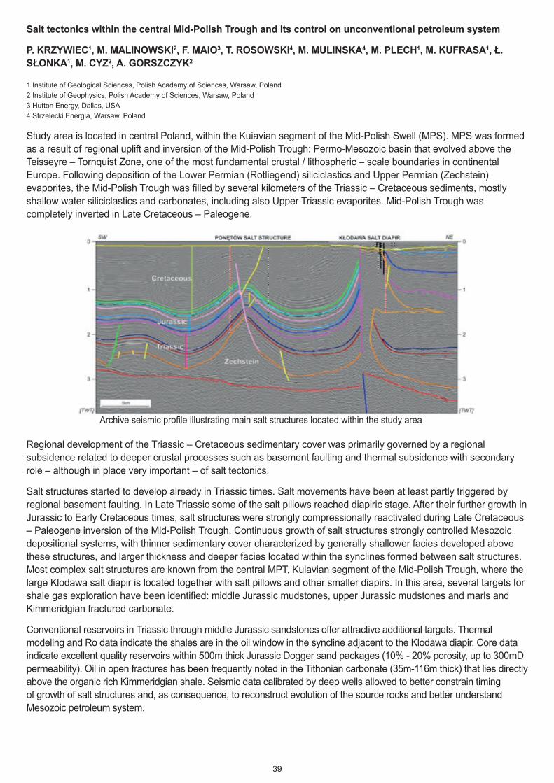
39
Salt tectonics within the central Mid-Polish Trough and its control on unconventional petroleum system
P. KRZYWIEC1, M. MALINOWSKI2, F. MAIO3, T. ROSOWSKI4, M. MULINSKA4, M. PLECH1, M. KUFRASA1, Ł. SŁONKA1, M. CYZ2, A. GORSZCZYK2
1 Institute of Geological Sciences, Polish Academy of Sciences, Warsaw, Poland 2 Institute of Geophysics, Polish Academy of Sciences, Warsaw, Poland 3 Hutton Energy, Dallas, USA 4 Strzelecki Energia, Warsaw, Poland
Study area is located in central Poland, within the Kuiavian segment of the Mid-Polish Swell (MPS). MPS was formed as a result of regional uplift and inversion of the Mid-Polish Trough: Permo-Mesozoic basin that evolved above the Teisseyre – Tornquist Zone, one of the most fundamental crustal / lithospheric – scale boundaries in continental Europe. Following deposition of the Lower Permian (Rotliegend) siliciclastics and Upper Permian (Zechstein) evaporites, the Mid-Polish Trough was filled by several kilometers of the Triassic – Cretaceous sediments, mostly shallow water siliciclastics and carbonates, including also Upper Triassic evaporites. Mid-Polish Trough was completely inverted in Late Cretaceous – Paleogene.
Regional development of the Triassic – Cretaceous sedimentary cover was primarily governed by a regional subsidence related to deeper crustal processes such as basement faulting and thermal subsidence with secondary role – although in place very important – of salt tectonics.
Salt structures started to develop already in Triassic times. Salt movements have been at least partly triggered by regional basement faulting. In Late Triassic some of the salt pillows reached diapiric stage. After their further growth in Jurassic to Early Cretaceous times, salt structures were strongly compressionally reactivated during Late Cretaceous – Paleogene inversion of the Mid-Polish Trough. Continuous growth of salt structures strongly controlled Mesozoic depositional systems, with thinner sedimentary cover characterized by generally shallower facies developed above these structures, and larger thickness and deeper facies located within the synclines formed between salt structures. Most complex salt structures are known from the central MPT, Kuiavian segment of the Mid-Polish Trough, where the large Klodawa salt diapir is located together with salt pillows and other smaller diapirs. In this area, several targets for shale gas exploration have been identified: middle Jurassic mudstones, upper Jurassic mudstones and marls and Kimmeridgian fractured carbonate.
Conventional reservoirs in Triassic through middle Jurassic sandstones offer attractive additional targets. Thermal modeling and Ro data indicate the shales are in the oil window in the syncline adjacent to the Klodawa diapir. Core data indicate excellent quality reservoirs within 500m thick Jurassic Dogger sand packages (10% - 20% porosity, up to 300mD permeability). Oil in open fractures has been frequently noted in the Tithonian carbonate (35m-116m thick) that lies directly above the organic rich Kimmeridgian shale. Seismic data calibrated by deep wells allowed to better constrain timing of growth of salt structures and, as consequence, to reconstruct evolution of the source rocks and better understand Mesozoic petroleum system.
Archive seismic profile illustrating main salt structures located within the study area

40
Salt Tectonics in the Northern Lusitanian Basin: An example of Interplay between Late-Variscan Heritage and Regional and Local Stress Fields
C. RUELA NOGUEIRA1, 2 and F. ORNELAS MARQUES1
1 Dep. Geology, Faculty of Sciences, University of Lisbon, Portugal 2 Instituto Dom Luiz, University of Lisbon, Portugal
Salt structures can play an important role in the tectono-sedimentary evolution of basins. In west Iberia, the Alpine regional stress field had a horizontal maximum compressive stress striking NNW-SSE, related to the Late Miocene inversion event. However, this stress field cannot produce most of the observed and mapped structures in the onshore of the northern Lusitanian Basin.
Therefore, we paid special attention to diapir tectonics, which can impose a local stress field (vertical maximum compressive stress) and be responsible for significant vertical movements of Mesozoic and Cenozoic cover rocks.
Based on fieldwork, tectonic analysis and interpretation of geological maps (Portuguese Geological Survey, 1:50000 scale), our work shows: (1) the presence of high angle faults and anticlines with N-S, NNE-SSW, ENE-WSW or WNW-ESE trends, which cannot be the result of Alpine compression; (2) some structures can be related to late-Variscan fracturing, by reactivation of basement faults with NNE-SSW and ENE-WSW trends; (3) the anticlines show radial faulted Jurassic cores which points to diapir upward pushing; (4) some anticlines are aligned with exposed salt diapirs, showing lateral continuity between these structures; (5) geometry and sedimentary filling (up to the Pliocene) of basins show relationship to salt-related anticlines, with salt withdrawal from the base of the basin (subsidence) and movement into the neighbouring anticlines/diapirs; and (6) unconformities and folded unconformities, which means that there have been several deformation events prior to the Late Miocene Alpine event.
These data suggest that: (1) most of these structures result from local diapir tectonics, initiated before the Cretaceous; (2) some of the structures may be related to reactivation of inherited late-Variscan basement fracturing; and (3) considerable vertical movements can be deduced from salt-related anticlines and neighbouring basins.
The Central High Atlas in Morocco: a snapshot of a Jurassic diapiric rifted basin
EDUARD SAURA1, JAUME VERGÉS1 , GRÉGOIRE MESSAGER1,3, JUAN DIEGO MARTÍN-MARTIN1, MAR MOR-AGAS1, PHILIPPE RAZIN2, CARINE GRÉLAUD2, RÉMI JOUSSIAUME2, MANON MALAVAL2, DAVID W. HUNT3
1. Group of Dynamics of the Lithosphere (GDL), Institute of Earth Sciences Jaume Almera (ICTJA), CSIC, Barcelona, Spain.
2. ENSEGID - IPB, Bordeaux University, Pessac, France.
3. TPD RD, Statoil, Bergen, Norway.
The Central High Atlas in Morocco exposes an inverted Triassic-Jurassic rift basin with major ENE-WSW northern and southern compressive boundaries. Internally, the Moroccan High Atlas is constituted by long and continuous NE-SW trending ridges (anticlines), which are oblique to the present limits of the compressive range. Most of these ridges show Triassic argillites, evaporites and basalts in their cores, which are commonly intruded by Jurassic gabbros. Typ-ically, these ridges show strongly dipping and subparallel flanks and in most cases showing different Jurassic strati-graphic sequences on each limb. Bed thinning, onlaps, truncations and/or sedimentary facies changes decreasing in paleowater depth towards the axis of the ridges are also characteristic features.
We interpret these structural ridges as linked to elongated diapiric walls and coeval sedimentation as halokinetic. Some of these diapiric walls are welded diapirs. The interpretation of geological maps, confirmed by remote sensing mapping and fieldwork, indicates a secondary NW-SE trending system of diapir walls and welds. These are interfer-ing with the major NE-SW system resulting in a polygonal pattern of thick Jurassic minibasins. While some diapiric structures like the Tazoult ridge were partially inactive during the earliest Middle Jurassic, migration of mobile material continued though Middle-Upper Jurassic times developing 2-3 km-thick sedimentary minibasins in the Imilchil region (Lake Plateau and Ikkou minibasins). This diapiric region in High Atlas may represent a well-exposed example of Jurassic diapiric growth reported in the Atlas in Algeria and Tunisia but buried at depth.

41
Inorganic geochemistry as a tool to improve the understanding of shale gas plays
T.R.Q. MORGAN, A.J. FINLAY and J. MARTIN
Chemostrat Ltd., 1 Ravenscroft Court, Buttington Cross Enterprise Park, Welshpool, Powys, SY21 8SL
The rapid increase in interest in exploring shale units for shale oil and gas has highlighted the need to develop a thorough understanding of shale units. Not only does possessing a detailed understanding of shale stratigraphy enable accurate volume calculations to be undertaken, but, knowing the mineralogical composition of shale can provide information on rock mechanics to enable greater well completion success. In addition, a comprehensive understanding of anoxia proxies can be used to identify sweet spots in the play. All of this information can be potentially provided through the use of inorganic geochemical techniques.
This paper will discuss a range of techniques from rapid and non-destructive analysis by hand held X-Ray fluorescence to highly precise and accurate data produced by inductively coupled plasma mass spectrometers. In addition we will show how inorganic geochemical analysis can be integrated with other techniques such as XRD and TOC analysis. Importantly we do not rely on samples to be provided from drill core, but also we can analyse side wall core or drill chippings.
This paper will utilise case studies from to UK onshore Bowland shale sections and the key US shales to demonstrate the wide variety of ways that the inorganic geochemical data produced can be utilised to aid in the understanding of shale gas plays. More specifically, how the bulk inorganic geochemistry can be employed to model the mineralogy of these successions. In turn the mineralogy can be used to better understand the rock mechanics and estimated TOC contents of the intervals over which analyses have been conducted. The predicted brittleness of the intervals penetrated allow for intervals that have been identified as optimal for hydraulic fracturing coupled with a high estimated TOC content to be targeted with increased confidence.

42
Challenges in the research of the unconventional tight oil play in SW Pannonian basin (Croatia)
K. KRIZMANIĆ and S. TROGRLIĆ
Over the years INA researchers have reinterpreted almost every play in Croatia and finally came out with three promising areas for unconventional exploration. One of them is Sava basin within the exploration oil filed Ivanić, where completely new borehole has been set, primary targeted to examine Middle Miocene deposits of marl (marlstone) intercalated with thin layers of several types of sandstone which by the reservoir characteristics belong to the unconventional reservoirs.
Unconventional resource invites unconventional methods. Unconventional reservoirs must be stimulated to enhance the hydrocarbon production in order to reach economically acceptable amounts. We have decided to engage hydraulic fracturing, totally aware of the fact that this means not only implementation of new technologies in well construction and operations, but responsible and safe attitude to the nature respectively. INA’s recent well Iva-2D is designed to fulfill all planed technical and environmental demands, together with numerous research tasks. Its main purpose is to verify seismic projection, correlate and calibrate various wireline logs and gain as much data as possible to help prepare successful hydraulic fracturing of tight-oil/source rock prospect. Besides many ordinary and extraordinary activities, three continuous oriented cores were drilled.
Total of 27.2 meters were recovered (interval: 2450.0 – 2477.2 m). Cores were approached multidisciplinary. After simple technical activities (e.g. cleaning, marking, photographing...), petrophysical measurements (total and spectral gamma, porosity, permeability, bulk and grain density) were carried out. Complete examination under the ultraviolet light to detect the presence of hydrocarbons followed. Geochemical investigations, predominantly in order to define organic facies, kerogen type and maturity as well as generative potential were performed. Cores and drill cuttings were analyzed for total organic carbon and all samples with TOC ≥ 0.3% were pyrolysed. The most interesting samples were submitted to extraction, column liquid chromatography, gas chromatography, microscopic examination, and analysis of sulphur and stable carbon isotopes in kerogen and bitumen. The acid solubility test was made on particular samples. Detailed geological analyses were performed as well. Petrographical analyses of thin sections gathered information on mineralogy, diagenesis, lithofacies and even microporosity by the analyses of slides impregnated with blue dye epoxy resin. Biostratigtraphical (micropaleontological and palynological) analyses provided the information on age, fossil assemblage and palaeoenvironment. Together with sedimentological observations, the depositional environment has been established. Certain core samples were analyzed by SEM to define mineral composition, clay minerals and pore space geometry. According to crystallographic forms of the minerals and identification of peaks in the energetic spectrum of x-rays (EDS) mineral identification has been done. The same samples were submitted to the semi-quantitative XRD analyses. By the X-ray powder diffraction analyses mineral content and more importantly, clay mineral identification and quantification in core samples were defined. Geomechanical ultrasonic velocity measurements were carried out on selected core plugs. Dynamic elastic constants, dynamic Poisson’s ratio (Νd), dynamic shear modulus (Gd) and Young’s modulus (Ed), were calculated from the test results. Cores were oriented and therefore recorded on DMT CoreScan II. Obtained data were analyzed in CoreLog Integra presenting the results of the structural element analyses. All data were evaluated and then integrated in the complex final interpretation of Iva-2D unconventional Tight Oil Play.
Key words: Croatia, unconventional reservoir, tight oil, core analyses, XRD analysis, SEM/EDS analysis, kerogen, core image structural element analysis

43
Fig 1- Results of modelling syntectonic sedimentation in a two normal faults system for a specific configuration.
A- Initial conditions for the sedimentary model. B- Initial configuration for the deformation model. C- Final stage of the deformation model with the addition of the new materials added by the sedimentary model. D- Final stage of the boundary box of the DE model, in order to show position and movement of the two faults as well as the relay ramp. E- Final stage showing the two cross-sections below specified. D- Cross-section of the final stage cutting perpendicularly the two faults planes at the midpoint of the overlap region. E- Cross-section of the final stage cutting the relay ramp between the two faults planes.
Fig 1- Results of modelling syntectonic sedimentation in a two normal faults system for a specific configuration. A- Initial conditions for the sedimentary model. B- Initial configuration for the deformation model. C- Final stage of the deformation model with the addition of the new materials added by the sedimentary model. D- Final stage of the boundary box of the DE model, in order to show position and movement of the two faults as well as the relay ramp. E- Final stage showing the two cross-sections below specified. D- Cross-section of the final stage cutting perpendicularly the two faults planes at the midpoint of the overlap region. E- Cross-section of the final stage cutting the relay ramp between the two faults planes.
a a’
Fault 2Fault 1
Relay rampFault 1
Fault 1
Fault 2
Fault 2
a’
a b’
b
Initial stage
b b’
Final stageFinal stage
Final stage
Relay ramp
Pretectonic sediments
Syntectonic sediments
A
Fluid flow directionWater input location Sediment input location
B C
D E
F
G
Relay ramp

44
Gas shale: Why does so little frack fluid flow back out of the ground?
T. ENGELDER1
1 Professor of Geosciences, The Pennsylvania State University, University Park, PA 16802
More than 2 x 10⁴ m3 of water containing additives is commonly injected into a typical horizontal well in gas shale to open fractures and allow gas recovery. Less than half of this treatment water is recovered as flowback or later production brine, and in many cases recovery is < 30%. While recovered treatment water is safely managed at the surface, the water left in place, called residual treatment water (RTW), slips beyond the control of engineers. Some have suggested that this RTW poses a long term and serious risk to shallow aquifers by virtue of being free water that can flow upward along natural pathways, mainly fractures and faults. These concerns are based on single phase Darcy Law physics which is not appropriate when gas and water are both present. In addition, the combined volume of the RTW and the initial brine in gas shale is too small to impact near surface aquifers even if it could escape. When capillary and osmotic forces are considered, there are no forces propelling the RTW upward from gas shale along natural pathways. The physics dominating these processes ensure that capillary and osmotic forces both propel the RTW into the matrix of the shale, thus permanently sequestering it. Furthermore, contrary to the suggestion that hydraulic fracturing could accelerate brine escape and make near surface aquifer contamination more likely, hydraulic fracturing and gas recovery will actually reduce this risk. We demonstrate this in a series of STP counter-current imbibition experiments on cuttings recovered from the Union Springs Member of the Marcellus gas shale in Pennsylvania and on core plugs of Haynesville gas shale from NW Louisiana.

Role of salt in the geometry of extensional ramp synclines: insights from analogue models
M. ROMA1; O. PLA 1; F. ESCOSA1; O. FERRER 2; O. GRATACÓS1; E. ROCA1; A. MUÑOZ1; AND M. BUTILLÉ1
[email protected] 1GEOMODELS Research Institute - Group of Geodynamics and Basin Analysis. Departament de Geodinàmica i
Geofísica, Facultat de Geologia, Universitat de Barcelona. Barcelona, Spain. 2Fault Dynamics Research Group. Department of Earth Sciences. Royal Holloway University of London. Egham, TW20
0EX, United Kingdom.
The widespread extensional deformation that took place in the Western Europe and north-Atlantic during the Jurassic to Cretaceous resulted in the formation of several rift systems that, in some cases, evolved to oceanic realms (i.e., Tethys and Atlantic oceans). Later, during uppermost Cretaceous to Cenozoic some of these basins were partially inverted and in some cases incorporated into different orogens as the Pyrenees. Some of these extensional basins show a broad syncline-shape filled by thick sedimentary successions deposited overlying an extremely thinned crust (i.e., Parentis, Voring, More, Orphan, Organyà or Columbrets basins). The development of these syncline basins has been associated to the displacement of low-angle lithospheric-scale extensional faults that, with a ramp/flat geometry, controlled the formation of the so-called hangingwall ramp synclines. The shape and kinematics of such lithospheric-scale faults have been usually established using the architecture of the syn-kinematic layers that reflect changes in the fold geometry and depocenter location. Almost all of these interpretations assume a complete coupling of the hangingwall rocks and a layer parallel flexural slip deformation mechanism. But these basins could include evaporitic layers, which act as an effective décollement and control the development of salt structures. During a subsequent shortening stage, the main extensional faults were inverted and part of this contractional deformation was also observed by the evaporites acting as a contractional detachment. When this occurs, the extensional basins are transported and in the most extreme cases incorporated into the orogen (eg. Organyà Basin in Pyrenees). The GEOMODELS Analogue Laboratory (University of Barcelona) in combination with the Numerical and 3D Modelling Laboratory provides to the GEOMODELS Research Institute a powerful tool that allow to simulate a wide variety of tectonic settings: extension, compression, strike-slip, basement faults, inversion tectonics, double-wedges, salt tectonics, gravitational movements, etc… The analogue experiments presented in this work have been carried outthanks to the modular modeling table of this laboratory. Using an experimental approach (scaled sandbox models) the aim of this work is threefold: 1) to determine the geometrical features of the hangingwall above convex upwards ramp of a low angle extensional fault, and consequently, of the syn-kinematic layers filling the developing ramp syncline; 2) to decipher the role

played by the presence of a pre-kinematic salt layer in the development of these syncline basins; and 3) to characterize the contractional deformation that took place in the syncline to solve the role of the detachment layer during the inversion. To achieve this goal and experimental program including four different sand-box models has been carried out in the GEOMODELS Analogue Modelling Laboratory, University of Barcelona. The experimental setup consisted in an horizontal box with two end walls, one of them fixed whereas the other was moved by a motor-driven worm-screw at a displacement rate of 4 mm/hour. A rigid wooden footwall formed by two panels with different dips flattening at depth was attached to the fixed wall. Above the footwall, a flexible plastic sheet stuck to the moving wall acted as a detachment. The hangingwall was modeled with two different infill configurations: one only using dry quartz-sand and other including a silicone layer at the upper part of the pre-kinematic unit. The model that includes silicone layer was repeated applying two different amounts of extension and also inversion. Our results show that, effectively, the flat/ramp shape of the low angle extensional fault controls the geometry and the kinematic evolution of hangingwall ramp synclines. Regarding this, the experiments also demonstrate that the presence of a viscous silicone interlayer changes significantly the kinematic of the basin: the sand successions located above the silicone layer show a different structure with a different migration path of the basin depocenters. Thus, in models without silicone, antithetic faults formed in the hangingwall rollovers affect the entire model and the syn-kinematic layers show a lateral migration of the depocenters towards the fixed wall. By contrast, in models with silicone, hangingwall faults do not propagate above this layer, there are salt structures developed in both syncline margins and the location of the depocenters remain invariable until the depletion of the viscous layer in the syncline limbs. After this depletion that produces the formation of primary welds, the kinematics of this model becomes similar to the model without silicone. During the inversion, models show that low shortening produces basically the contractional reactivation of the main fault uplifting the synclinal basin. In this scenario, if salt is rather continuous, occurs an incipient reactivation of the silicone layer as a contractional detachment. By contrast, high shortening produces the total inversion of the detachment faults and the pop-up of the extensional basin.

From Conventional Outcrop Datasets to Flow Simulation: the Fluvial Strata in Pont de
Montanyana (Ypresian, Southern Pyrenees)
Maria Murillo1, David Domínguez
2, 3, Patricia Cabello
3, Pau Arbues
3
(1) [email protected], (2) Presently at Schlumberger Information Solutions, Kirkhill
House, AB21 OLQ, Aberdeen, United Kingdom (3) Dept. Estratigrafia, Paleontologia i
Geociències Marines. Geomodels Institute, Universitat de Barcelona, 08028, Barcelona, España
The Pont de Montanyana Outcrop is located some 400 m north of the Pont de Montanyana
village (Huesca Province, Aragón). The exposed succession is part of the Montllobat Fm., in turn
part of the infill of the Tremp-Graus piggy-back basin, on top of the Montsec thrust sheet, one of
the main southwards displaced thrust sheets in southern Pyrenees. This outcrop, wellknown from
several studies, beautifully exposes point-bar deposits and is one of the classical Pyrenean
outcrops used by industry and academia on fieldtrips.
The map dimensions of Pont the Montanyana outcrop are about 160 m x 600 m. It has ideal
characteristics to be used as a reservoir analogue, allowing for the 3D characterization of this
type of deposits. The main goals of this work are: a) to illustrate the depositional and
architectural characteristics of the outcropping point-bar deposits by use of digital outcrop
models; b) to build a very detailed 3D facies model of this outcrop; and c) to flow simulate these
models in order to understand the role of facies heterogeneity on hydrocarbon recovery. The base
dataset integrates conventional outcrop data and digital outcrop models (LiDAR and Multiview
3D).
Two main channel-fill bodies with lateral accretion were distinguished, separated by a mudstone-
predominant, overbank interval. Measurements of channel body dimensions report widths in the
range of 100 to 200 m, and thicknesses of 5-7 m, which would be related to meandering fluvial
systems with sinuosity of 2.62. The 3D facies model focused on capturing the facies
heterogeneity in the uppermost channel-fill body. The modelling started by constructing six
horizons with architectural meaning. This was followed by the creation of a 3D grid designed to
reproduce the bedding characteristic of each channel evolution’s stage. A combination of
stochastic methods was used to create a facies model which was constrained to 5 field-measured
stratigraphic logs and 126 pseudowells derived from the digital outcrop model, in order to
accurately capture the actual heterogeneity. The obtained model reproduces a lateral change from
coarse and very coarse-grained sandstones at the base of the accretional units to very fine-
grained bioturbated sandstones developed at the bar platforms. Afterwards, the 3D grid was
populated with petrophysical data from point-bar reservoirs available in the literature and
constrained to the facies model. Moreover, several flow simulations, based on water injection
strategies, were performed.
The results show that more than 20% of moveable oil is trapped at the upper part of the point-bar
deposits, revealing the strong control of the facies distribution on the efficiency of this type of
reservoirs. In addition, the results also point out that the location of the injection-production
wells exerts an important impact on the recovery efficiencies.

Geometry and facies heterogeneities of an Upper Jurassic oolitic-siliciclastic shoal (Ricla, Spain): a 3D outcrop reconstruction at reservoir scale J. VAL, M. AURELL & B. BÁDENAS Departamento Ciencias de la Tierra, Universidad de Zaragoza, Spain
The Kimmeridgian (Upper Jurassic) outcrops of Ricla (Iberian Ranges, NE Spain) expose the shallow areas of a mixed siliciclastic-carbonate (i.e., oolitic) platform in different dip to strike-oriented sections. Extensive fieldwork on these outcrops has resulted in a precise facies reconstruction of an oolitic-siliciclastic sand-shoal complex, across a 4 x 1 km (downdip x strike) square area. Lithofacies and geometries were mapped using continuous photomosaics, including paleocurrent measurements and logging and sampling for detailed facies reconstruction. The studied sedimentary body is up to 22 m-thick in proximal (Northern) areas and phinches out basinward (to the South), down to 5 m-thick in distal localities. A number of facies types dominated by different cross-bedded structures have been mapped across the down-dip and strike sections. In the more proximal localities the succession consists of two vertically stacked shallowing-upward sequences. Planar cross-bedded units, with sets from 0.5 to 3 m-thick, form the larger volume of these two sequences. Southeast to southwest oriented paleocurrents measured on these planar cross-bedded units, indicates a dominant offshore migration of large-scale bedforms due to unidirectional storm-induced return currents. The upper (shallower) part of the sequences show more dispersed palaeocurrent measures, indicating a significant contribution of the inshore and alongshore currents in the origin of the cross-bedded units. The composition of the cross-bedded units (either dominated by sand-size quartz grains or by ooids) has been also mapped in detail. The observed facies architecture was the result of a rapid sand-shoal progradation, which has been related to the stage of stillstand of sea level observed across the Iberian basin at the onset of the Late Kimmeridgian (i.e., late regressive stage of the third-order Kim-1 Sequence). The studied outcrop has potential use as a reference analogue for sand-shoal hydrocarbon reservoirs such as the Upper Jurassic reservoirs found in the Jurassic Smackover and Arab formations.
Please consider the following abstract for the Deep Water Clastic Environments, Massflow/turbidite systems session. Depositional and Architectural Evolution of a Turbidite Channel System from Outcrop and Behind-the-outcrop Data: the Solitary Channel Complex (Miocene, Tabernas Basin, SE Spain). Marco De Matteis1,2,┼, Pau Arbués1,2, Patricia Cabello1,2, Pablo Granado2,3, Miguel López-Blanco1,2, Vitor Abreu4, Timothy Demko4, Mariano Marzo1,2, Josep Anton Muñoz2,3 1. Departament d'Estratigrafia, Palentologia i Geociències Marines, Universitat de Barcelona, C/ Martí i Franquès s/n 08028 Barcelona, Spain. 2. Geomodels Institut de Recerca, Universitat de Barcelona, C/ Martí i Franquès s/n 08028 Barcelona, Spain. 3. Departament de Geodinàmica i Geofisica, Universitat de Barcelona, C/ Martí i Franquès s/n 08028 Barcelona, Spain. 4. Exxon-Mobil Upstream Research Company, Houston, TX, United States. ┼. [email protected], +34 934035957 The Solitary Channel developed as a slope to base-of slope turbidite channel complex in a back-arc basin in the context of the evolution of the Betic Chain. Exceptional outcrops with multiple orientations allow for both sedimentologic detail as well as a reasonably constrained depiction of the 3D internal architecture of the channel complex. The outcrop description was substantiated by means of the integration of conventional outcrop data and the interpretation of Digital Outcrop Models. The Solitary Channel dataset was furthermore complemented with two wells drilled behind the outcrop, which produced core recovered at about complete, plus downhole geophysical data. Our data show that most of the channel-fill is made up of sandstones, with minor amounts of conglomerate and less than 5% mudstone. Distribution grading, traction carpet laminae and massive and parallel laminated divisions, all indicate that most sedimentation took place primarily from turbidity currents passing from high to low density conditions. A/B plane clast imbrication is frequent in the coarse-sand and gravelly sandstone beds. This can be observed in outcrop and quantified in drillcore studies. The results indicate bedload transportation and bedforms accreting perpendicular to channel axes, which can be related to high flow velocity in a high-gradient setting. Disorganized gravelly sandstones and sandy conglomerates are a lesser occurrence and correspond to debrites. Architectural analysis, following accurate 3D horizon reconstruction and facies modelling, evidences that the dominant fundamental architectural element corresponds to vertically-stacked beds bounded by closely juxtaposed erosional surfaces. These elements can be interpreted as representing avulsion or incision followed by infill. Groupings of the avulsion-erosion-infill elements are found as arranged into channel complexes, each carrying a significant southeastwards stepping of the channel complex, which can be interpreted as fault-driven accommodation. This is supported by an open fold, minor faults and slide features affecting the channel-fill. We acknowledge financial support from ExxonMobil and Project MODELGEO (CGL2010-15294). Schlumberger is also acknowledged by donation of Petrel software licenses.

State-of-the-Art ion milling ablation applied to shale gas sample preparation. LAURA GARCÍA1; MIGUEL ÁNGEL CAJA1, JORDI TRITLLA2, VIRGINIA SÁNCHEZ1, IRENE GONZÁLEZ1, F.J. GÓMEZ1
, SANTIAGO QUESADA 1 1 Repsol Technology Center, Madrid, Spain. [email protected]
2 Repsol Exploration, Madrid, Spain.
Gas shales are a promising unconventional source of hydrocarbons to meet the increasing demand of energy. However, our scientific understanding of shales is still limited. In the literature, many studies suggest that porosity in shale gas rocks is mainly related to intercrystalline matrix, intraparticles and organic matter with pores dimensions in the range of nanometers. Thus, it is necessary the application of high resolution microscopy techniques as FIB-SEM or FESEM, where sample preparation is critical due to: (i) increase the shale rock sample polishing quality in order to be able to visualize clean nanoporosity; (ii) to avoid generation of artificial pores during grinding, and (iii) to preserve the original microstructure of the shale rock sample. The ion milling technique consists in Ar+ bombardment onto the rock surface to remove material at the atom level. As a test, several shale gas rock samples were selected and prepared using a LEICA EM TIC 3X with triple ion beam available at the Repsol Technology Centre facilities (Mostoles, Spain). The use of a triple ion beam considerably reduces cost, milling time and artifacts generated when using a single ion beam. Once prepared, the selected samples were studied using a FEI ESEM Quanta FEG 650, focusing on the observation of the general abundance of organic matter in the silty mudstone/shale. Organic matter components typically present abundant porosity ranging from 5 to 1000 nanometers, which are especially important because they can absorb gases and store free gases. Total organic matter pore volume can be calculated from individually-calculated porosity in macerals and total organic carbon (TOC). Considering this, average porosity from the sample image area can be calculated and then it can transformed TOC values from weight percent to volume percent, thus allowing the porosity value to be applied to the total organic matter in the sample.

Figure 1

Application of Pyrenean Fractured Carbonate Outcrops for Reservoir Characterisation JON GUTMANIS1 AND LLUIS ARDEVOL I ORO2
1. GeoScience Ltd, Falmouth Business Park, Bickland Water Rd, Falmouth, UK TR11 4SZ 2. Geoplay Pyrenees Ltd, Nerets 10, 25620, Tremp, Catalonia, Spain
Fractured reservoirs such as tight carbonates, clastics and basements, are often highly heterogeneous in terms of open fracture distributions and connectivity, as well as hydrocarbon or fluid distributions. Working on sub-surface data without the benefits of relevant analog exposure and the application of geological principles based on field knowledge, can lead to mis-interpretation of well or seismic data as well as the results derived from techniques such as curvature analysis or seismic attribute analysis. This poster picks on some good-quality analog exposures in the Spanish Pyrenees to examine the following issues:
The often major influence of mechanical stratigraphy on fracture distribution, connectivity and style
The problem of how to include sub-seismic scale fractures in reservoir models and meaningful simulations
The common assumption that faults and their damage zones are a good drilling target in fractured reservoirs

The West Mediterranean Salt Basin – Prospects and Plays in and around the North Balearic Basin, Offshore Spain.
GLYN ROBERTS (1), TROND CHRISTOFFERSEN (1), OLGA SHTUKERT (2), CARMINE SILENZIARIO (2) & ANDREW BISHOP (2).
(1)Spec Partners Ltd; (2) Schlumberger Multiclient
This paper looks at hydrocarbon potential in and around the North Balearic Basin, offshore Spain.
Fig 1: Location of proposed Multi-Client seismic survey – North Balearic Basin, Spain
The Basin is part of the ‘West Mediterranean Salt Basin’ (Roberts & Christoffersen, 2013). The salt is of Messinian age and is typically over 1000m thick and seen to exhibit classic extension (salt welding and rollover anticlines), translation (salt

pillows) and contraction (salt diapirs). Its nature is the key to the post salt plays which can be seen (many with DHI’s). As well as evidence for a biogenic post-salt gas system, there is evidence (from satellite seep studies and seismic data) pointing to an active thermogenic (presumably) oil generating province. The presentation is based on work carried out by the authors and their colleagues in the planning of a new long offset multi-client seismic survey in the North Balearic Basin (fig 1). For this, vintage seismic data was obtained and reprocessing and depth conversion carried out; together with petroleum system modelling (including ties with the proven Gulf of Valencia petroleum system).
In the study area three petroleum systems have been recognised:
A) Pliocene/Quaternary - biogenic source: Post Rift/Post Salt plays: deltaics, turbidites and channel sands in structural and stratigraphic traps.
B) Pre Messinian (Oligocene/Miocene) - sourced from Oligocene/Miocene sapropels (ie organic rich muds - Pawlewicz 2004) and shales. Post Rift/Pre Salt plays: deltaic/ turbidites sealed by Miocene shales and Messinian salt. Syn Rift: canyon sands and deltaics.
C) Pre Tertiary: on the margins of the Basin. Pre-Rift plays: possible basement plays as seen in the Casablanca field area – sourced from overlying Oligocene shales or from the Mesozoic (as in the Amposta field).
The paper will discuss these in further detail and be illustrated by numerous seismic sections (example fig 2).

Fig 2: Vintage seismic data example (Display courtesy of Schlumberger Multiclient)
References:
Roberts, G.F & Christoffersen, T (2013): The West Mediterranean Salt Basin – A Future Petroleum Producing Province. Search and Discovery Article #50791 (Adapted from an extended abstract prepared in conjunction with a poster presentation at the AAPG Annual Convention and Exhibition, Pittsburgh, Pennsylvania, 2013). Pawlewicz, M (2004): The Pre-Messinian Total Petroleum System of the Provence Basin, Western Mediterranean Sea. U.S. Geological Survey Bulletin 2204–A

Sedimentary facies in carbonate spring and fluvial environments in volcanic settings. Is it possible to predict porosity distribution? RODRĺGUEZ-BERRIGUETE1,2; J. CAMUERA1; A.I. CASADO1; R. MARTÍN-GARCÍA1; A.M. ALONSO-ZARZA1,2*
1: Petrology and Geochemistry Department, Faculty of Geological Sciences, Univ. Complutense de Madrid. Jose Antonio Novais st., 2, 28040, Madrid, Spain. E-mails: [email protected]; (*) [email protected] 2: Instituto de Geociencias, CSIC. Jose Antonio Novais st., 2, 28040, Madrid, Spain. Spring and fluvial carbonates (i.e. travertines and tufas) are common in continental basins worldwide and volcanic settings. These deposits have usually low preservation potentials being more identifiable in Neogene and Quaternary basins. Although there is not a common consensus in the use of the terms travertine versus tufa, a “classical” approach consider that tufas have higher porosity than travertines. The use of these terms is not easy due to two main reasons: 1) the downward change of many hot-spring carbonate deposits (travertines) to fluvial-like carbonates (tufas), and 2) diagenetic processes can take place rapidly in these deposits modifying the initial porosity distribution. The volcanic Gran Canaria Island (Spain) contains some ravines with excellent outcrops in which the transition from hot water spring (travertines) to fluvial carbonates (tufa) can be analysed, providing so a good analogue for porosity evolution along these systems. These sedimentary environments are very discontinuous in space and they contain some components (spherulites, shrubs, coated bubbles,...) that are very specific and usually not considered in the standard limestone/porosity classifications. In addition many of the facies may occur in different subenvironments. In the ravines of Gran Canary Island the spring/fluvial carbonate systems have three zones: proximal, medial and distal. The proximal zones are constituted by crystalline aragonite crusts deposited by feeding channels, and by aragonite + calcite waterfall deposits constituted by speleothems, framestones and laminated microfabrics. Porosity in these carbonates varies between 5% (the crusts) to 40% (the framestones). The medial areas include also waterfall and pool deposits. Coated bubbles, rafts, shrubs, spherulites and coated grains mostly of aragonite formed in quiet to agitated pools. These components leave between them high interparticle and intraparticle porosity, which ranges between 10 to 60%. Distal areas are constituted by cascade, pool and channel deposits all calcitic. Bryophyte and crystalline stem framestones deposited in cascades. Laminated mudstones deposited in quiet pools and micritic stem framestones developed in channels. Mean porosity of the sediments of these areas is 20%, being higher in the framestones. The most common porosity types observed are: interparticle, intraparticle, moldic, fenestral, growth-framework, intercrystal (fabric selective), fracture and vug (not fabric selective), following the Choquette and Pray (1970) classification.

Identification of primary facies is key to characterise porosity evolution, because early diagenetic processes tend to occlude primary porosity mainly by cementation. Aragonite travertines have higher porosity than their calcitic counterparts. However, calcite cementation and aragonite to calcite transformation leads to a decrease in primary porosity. Other common processes such dissolution and fracturation generates secondary porosity. The downflow general trends in this kind of systems are a) changes in mineralogy from travertine (aragonitic and calcitic-aragonitic) to tufa (mainly calcitic) and a subsequent, b) changes in primary facies from crystalline-dominated (travertine) to plant mould-dominated (tufa), c) changes in the effects of early diagenesis, from strong (travertine) to slight (tufa) diagenesis, and d) changes in type of porosity, with tufa being dominated by moldic and growth framework porosity. Our work shows the high variability of facies and its porosity along these travertine-tufa deposits, which makes difficult to obtain an accurate model for the prediction of porosity-permeability. However the study case can be used as a good analogue for these types of deposits which are not very well know in terms or porosity predictability.

Geoelectrical characterization of fluid in hydrocarbon reservoirs: case study on the deep saline aquifer of Hontomín. XÈNIA OGAYA1, ALEX MARCUELLO1, PILAR QUERALT1, JUANJO LEDO1, ELOI VILAMAJÓ1, DAVID BOSCH1, FABIAN BELLMUNT1, MAGDALENA ESCALAS1, PERLA PIÑA1 1. Geomodels. Dept. Geodinàmica i Geofísica. Universitat de Barcelona. Barcelona. Spain
To know the physical properties of fluid contained on the reservoir rocks is a key point on the assessment for its exploration or its use as a gas storage. Electrical conductivity is a transport property of the medium, which is sensitive to the rock constituents (its minerals) but also to the characteristics of the pore space; it depends on fluid salinity, temperature, porosity, pore connectivity, saturation and pressure, and it is more sensitive to oil and gas saturation compared to other properties. In this context Archie’s law describes reasonably well the bulk electrical conductivity of the rock as a function of these parameters.
This contribution presents a summary of the geoelectrical characterization of the deep saline aquifer of Hontomín from magnetotelluric data. The Hontomín site is located at the southern sector of the Basque-Cantabrian Basin (Western Pyrenees, Spain). Exploration activities have provided geological and geophysical information of the area since 60s. It is a smooth Jurassic domed anticline structure cored by Upper Triassic evaporites. The stratigraphic sequence shows several reservoir and seal units at different ages. The primary reservoir (saline aquifer) and seal units are Jurassic in age.
The magnetotelluric (MT) data were acquired on a grid of 109 closely-spaced broadband MT soundings covering an area of 3x5 km2. The 3D inversion of the data in the frequency range of 1000 – 0.1 Hz provided the geoelectrical structure of the site, which was correlated with the different lithologies and formations. The model shows the more conductive behavior of the primary reservoir-seal system as it contains the saline aquifer, and the more resistive behavior of the secondary reservoir-seal system. The electrical resistivity of the primary reservoir indicates porosity values between 9% and 17% according to Archie’s law. The model also images an EW fault in the south associated to the Ubierna Fault.

Important Dates
APPEX Regional 2014Istanbul Congress Centre, Istanbul, Turkey14th - 17th September 2014
APPEX Global 2015: Prospect and Property Conference & ExhibitionBusiness Design Centre, London, UK3rd - 5th March 2015
Imperial Barrell Awards 2015Dorint Hotel Don Giovanni, Prague, Czech Republic18th - 20th March 2015
European Regional Conference & Exhibition 2015Lisbon, Portugal18th - 19th May 2015
To ensure you are the first to know about our events, email [email protected] with your details so we can add you to our mailing list. Alternatively, visit our website: europe.aapg.org and uncover a portal of events specifically designed
to promote technology and inspire further learning and understanding.
3P Arctic 2015Park Inn by Radisson, Pribaltiyskaya, St. Petersburg6th - 9th October 2015
Jeremy Richardson, Director, AAPG EuropeFionn Devine, Events Manager, AAPG EuropeFrancesca Ghigi, Conference Producer, AAPG EuropeAlice Beaden, Marketing Manager, AAPG Europe
AAPG EuropeLondon Office
Tel: +44 (0)207 434 1399Fax: 44 (0)207 434 1386
Email: [email protected]: europe.aapg.org

European RegionC O N F E R E N C E & E X H I B I T I O N
europe.aapg.org
LISBON 18-19 MAY 2015
SAVE THE DATETethys–Atlantic interaction along the
European-Iberian–African plate boundaries
2015
The AAPG 2014 International Conference and Exhibition will incorporate AAPG’s Regional Prospect and Property Expo, offering its own exploration themed presentations and exhibition area.
14-17 SeptemberIstanbul Congress Center
Istanbul, Turkey