new bedford fairhaven harbor - united states ... to be the best solution for navigational dredging....
TRANSCRIPT

NEW BEDFORDFAIRHAVEN HARBOR

Rt 195
hurricane barrier
Aerovox facility
Three parts to tonight’s presentation:1. Navigational dredging update2. Superfund cleanup: background & this year’s work3. Update on EPA’s analyses of potential alternatives

New Bedford/Fairhaven HarborNavigational Dredging
What is Navigational Dredging?Why is it important?
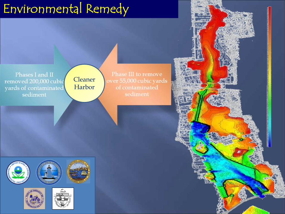
Environmental Remedy
Cleaner Harbor

Supports Maritime Industries
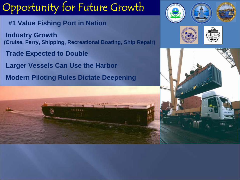
#1 Value Fishing Port in Nation
Industry Growth (Cruise, Ferry, Shipping, Recreational Boating, Ship Repair)
Trade Expected to Double
Larger Vessels Can Use the Harbor
Modern Piloting Rules Dictate Deepening
Opportunity for Future Growth

Harbor Plan
Dredge Materials Management Plan
Committee of City and Town Officials, and State and Federal Regulators Meets Monthly
How Decisions are Made

Phase III Navigational DredgingUpper Harbor
Complete

FAIRHAVEN
NEW BEDFORD
CAD CELL
Phase III Navigational Dredging: Lower/Inner Harbor
Underway: June 30 target completion date

The Story to DatePhase I, II, III


In 2003, DEP and CZM In 2003, DEP and CZM Published a Study calledPublished a Study calledthe DMMP:the DMMP:The Study found CAD The Study found CAD Cells to be the best solution for Cells to be the best solution for Navigational Dredging.Navigational Dredging.
Fact: Sediments Throughout the Fact: Sediments Throughout the Harbor Contain Some Level of Harbor Contain Some Level of Contamination.Contamination.

WHAT IS A WHAT IS A CAD CELL?CAD CELL?
Confined Aquatic Confined Aquatic Disposal CellDisposal Cell

“Environmental and human health risk assessment of the CAD cell alternative has shown that it can provide one of the lowest risk options compared with other alternatives (Kane-Driscoll et al, 2002).”
From Paper Presented at 2005 3rd International Conference on Remediation of Contaminated Sediment, by Thomas J. Fredette,US Army Corps of Engineers – New England District


Successful Disposal of Upper Harbor Material

Aerovox
Part 2 - the Superfund harbor PCB cleanup
Electronic capacitor facilityreleased an estimated 275tons of PCBs from the1940s to the 1970s
Cornell-DubilierSecond capacitor facilityin outer harbor

the upper harbor, looking north
Aerovox

hurricane barrier
Rt 195
Aerovox
> 4,000 ppm501 to 4,000 ppm51 to 500 ppm10 to 50 ppm<10 ppm
Color coded sediment PCB levels(prior to dredging)
Cornell-Dubilier

The 1979 statefishing ban -due to PCBs(covers 18,000 acres)
Do NOT eat bottom feeding fish

Key-- PCB sediments to be
dredgedCDF – confined disposal
facility
Cornell- Dubilier
Aerovox
Hurricane barrier
Rt 195
Dewateringfacility
app. one mile
A
A Desanding facility
rail yard
1998 Superfund Cleanup Plan:
Sediments in red require cleanup.app. 900,000 cubic yardsapp. 270 acres

Acushnet shoreline cleanup – 1999-2000
QUICK look at progress to date

NSTAR Power Cable Relocation – 2001

Dewatering facility bulkhead - 2002/03

Dewatering facility and rail spur - 2002-04

Landside view of rail spur and dewatering building

Combined sewer overflow (CSO) pipe relocationsto make room for the dewatering facility - 2002-04
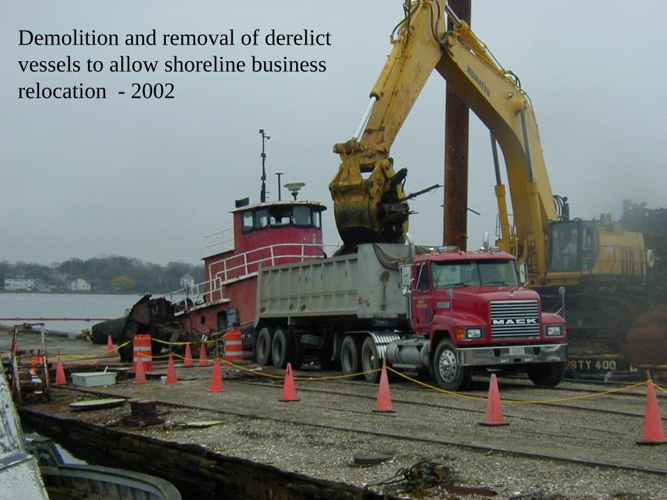
Demolition and removal of derelict vessels to allow shoreline business relocation - 2002

North of Wood Street cleanup – 2002/03

The restored river and stream banks (2008)

2005 - pilot underwater cap near Cornell-Dubilier mill

Aerovox shoreline cleanup - spring/summer 2008

Key-- PCB sediments to be
dredgedCDF – confined disposal
facility
A
pilot underwater cap
New Bedford Harbor
Rt 195
dewateringfacility
railyard
Aerovox
Cornell-Dubilier
app. one mile
pump station
Hurricane barrier
A dredge
A desandingfacility
Adredge pipelines
Superfund Full Scale Dredging Process- performed annually
since 2004
rail yard

Superfund dredging and disposal operations
1. Dredging in upper harbor 2. Desanding
3. Dewatering 4. Loading to rail for offsite disposal

Key-- PCB sediments to be
dredgedCDF – confined disposal
facility
A
A
Cornell-Dubilier
rail yard
Aerovox
Hurricane barrier
Rt 195
Desanding facility
Dewateringfacility
Areas dredged to date shown here in yellow
app. one mile
pilot cap

Key-- PCB sediments to be
dredgedCDF – confined disposal
facility
A
A
Cornell- Dubilier
rail yard
Aerovox
Hurricane barrier
Rt 195
Desandingfacility
Dewateringfacility
This year’s dredging areas (including stimulus funds) shown in green:
app. one mile
Will also relocatesubmerged high voltage cables to allow dredging in this area

health-based exposure “budget”
Monitored exposure to date
Comparing Coffin Ave air monitoring data to health-based “budget”
.05
.10
.15.20.25
.30.35.40
.45
.50
.55
.60.65
CumulativeExposure
(mg/m3-day)
Time Since Start of Work (years)
1 2 3 4 5
Actual Exposures Have Been Well Below the Health-Based Budget Level

Cost and Schedule Estimates for Current Approach3.5% annual inflation assumed; 2006 dollars
Annual funding level Years to complete Cost to complete
$80 million 4 to 5 $341 million$30 million 18 $540 million$15 million 38 $1,056 million
Section 3 Update on EPA’s Evaluation of Potential Alternatives

1. Harbor bottom as is 2. Excavation of silts 3. Excavation of sand and gravel
4. Placement of dredgedsediments into the CAD cell
5. Placement of clean cap (after consolidation)
glacial sand and gravel
organic siltsharbor water
contaminatedsediment
cap
bedrockglacial till/weathered bedrock
Onealternative:use CADcells todispose ofsome of thesediment.

N H
V T
M A
C TR I
NorwalkProvidence
Hyannis
Boston
New Bedford
New London
Existing and Planned CAD Sites in New England
(825,000 cy)
(550,000 cy)
(105,000 cy)
(23,000 cy)
(25,000 cy)
(130,000 cy thru 4/09)

Boston Harbor CAD Cells
CR
500 0 500 MetersChelsea River Inset

Providence In-Channel
CAD Locations

New Bedford’s CAD cell “#1” being excavated in 2005(for navigational dredging)

On-going CAD cell evaluation: preliminary results
• Significant savings in time AND cost to complete
• Other urban harbors have successfully used CAD cells
• computer modeling will evaluate protectiveness
• environmental monitoring of City’s navigational CAD cell (work in progress)

(2003)
(2005)
(2008)
Any Superfund CAD cell in the lower harbor would be in the same general area as the City’s existing navigational CAD cells.
Rt. 6
EPA dewateringfacility

Next step for public comment and decision making for any changes to the harbor cleanup:
• Winter 2009/2010 for potential lower harbor CAD cell
(again, still in the evaluation phase)

Questions?