network analyst: an introduction - esri.com · network analyst: an introduction, 2020 federal gis...
TRANSCRIPT

Andrew King
Network Analyst: An Introduction

Routing this Session
Agenda
FundamentalsArcGIS Pro Workflows
Running a Solver
Deeper Dive into Solvers
Mobile Solutions

Getting to Know the Basics
Network Analyst Fundamentals

ArcGIS Network Analyst
• Benefits
- Less Gas
- Less Maintenance
- Less Driver Overtime/Overhead
- More Customers Serviced
• Find the optimal locations for
facilities or remove redundant
facilities
• Improve Response Times

Solving Complex Routing Problems
Network Analyst Solvers

Network Analyst Solvers
Route Closest Facility Origin-Destination
Cost Matrix
Point-to-Point Routing
Vehicle Routing
ProblemLocation-AllocationService Area
Coverage Optimization

Route Solver
Find the best route for visiting a series of stops with minimum cost-Specify time windows on stops
-Find best sequence of stops
-Analyze for different times of the day

Closest Facility Solver
Find the nearest facilities
from each incident
-Limit the search distance
-Limit the number of facilities
to find
-Travel from the facility to the
incident
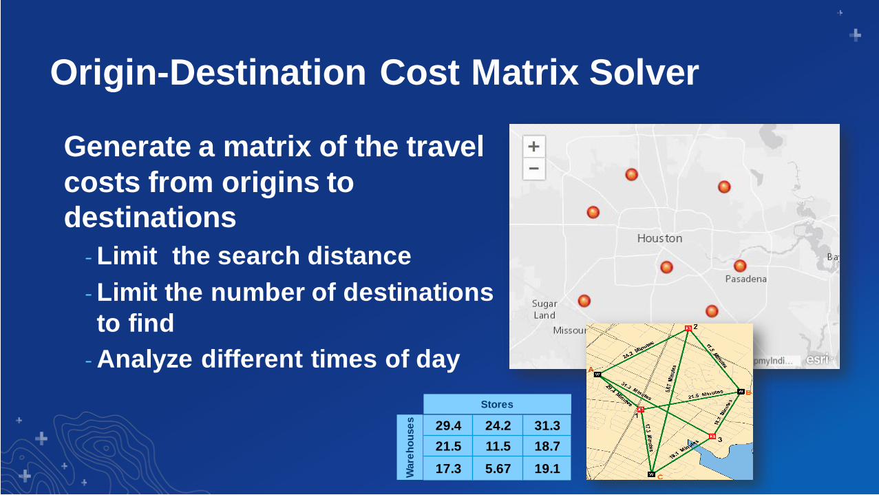
Origin-Destination Cost Matrix Solver
Generate a matrix of the travel
costs from origins to
destinations
-Limit the search distance
-Limit the number of destinations
to find
-Analyze different times of day
StoresW
are
ho
use
s
29.4 24.2 31.3
21.5 11.5 18.7
17.3 5.67 19.1

Service Area Solver
Find the area you can reach
from a facility
-Solve for many facilities
-Use multiple break values
-Specify the direction of travel
-Output lines or polygons
-Analyze for different times of
the day

Location-Allocation Solver
Determine the best location
for a facility, based on
demand conditions
-Choose from many different
analysis types
-Limit the capacity of facilities
-Analyze for different times of
day
Proposed New Facility

Vehicle Routing Problem Solver
Route a fleet of vehicles to
service a set of orders
-Vehicle capacities
-Driver specialties
-Work day rules
- Breaks
- Maximum hours
-Time windows on orders
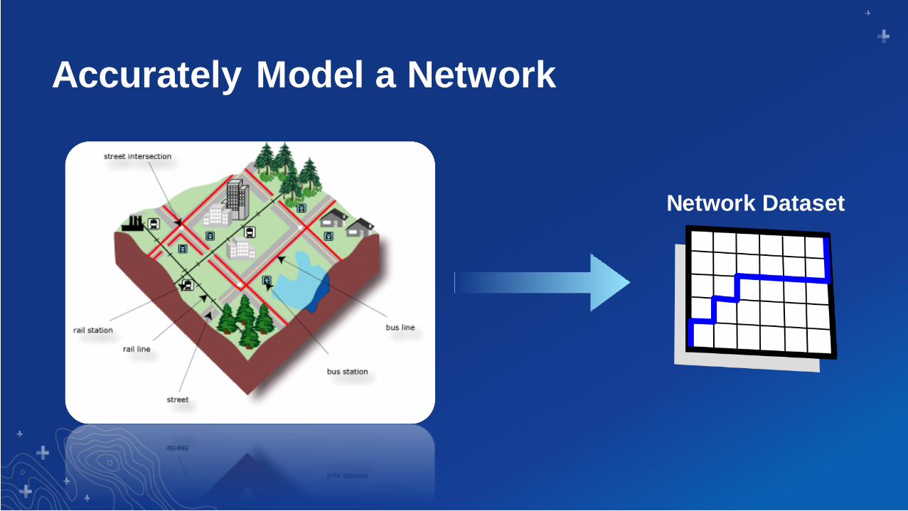
Accurately Model a Network
Network Dataset

Spanning the Platform
Network Analyst Capabilities
ArcGIS Desktop
ArcGIS Online
ArcGIS Enterprise
ArcGIS Apps
ArcGIS for Developers
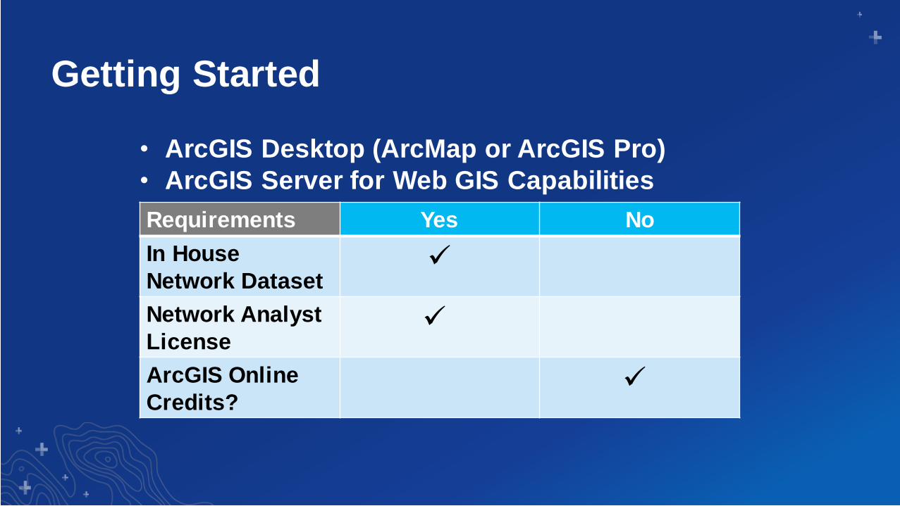
Getting Started
Requirements Yes No
In House
Network Dataset✓
Network Analyst
License✓
ArcGIS Online
Credits?✓
• ArcGIS Desktop (ArcMap or ArcGIS Pro)
• ArcGIS Server for Web GIS Capabilities

Getting Started
Requirements Yes No
In House
Network Dataset✓
Network Analyst
License✓
ArcGIS Online
Credits?✓
• ArcGIS Online Services
• Ready-to-Use Services in ArcGIS Pro

Ready-to-Use Services in ArcGIS Pro
Ready to Use Tools
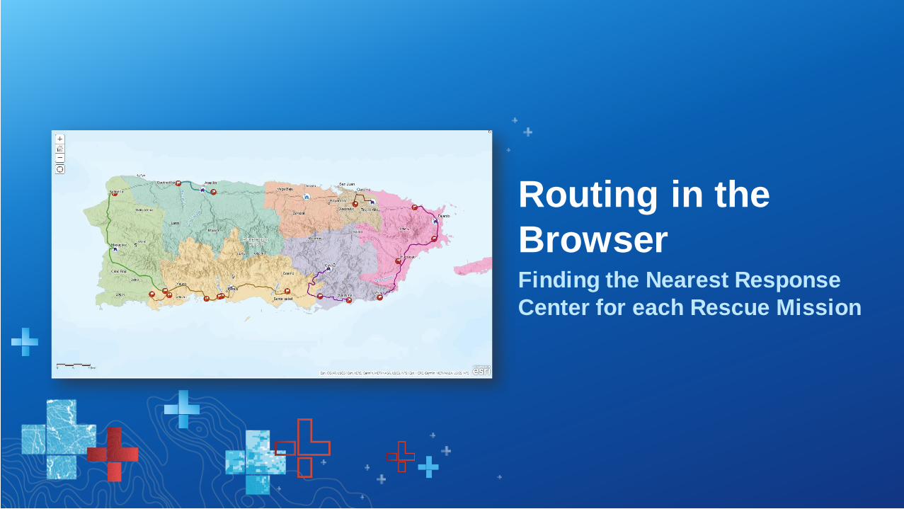
Finding the Nearest Response
Center for each Rescue Mission
Routing in the
Browser

A Deeper Dive into Routing Solutions in Pro
Network Analyst Workflows

Network Analyst in ArcGIS Pro
Network Analysis in the Ribbon

Workflow
Network Analysis Layer
- Inputs
- Outputs
- Analysis Properties
1
23
4

Routing in ArcGIS Pro
Creating a Route

Configuring a Routing Solutions
Network Analyst Configurations

Travel Modes
• Modify Standard Travel
Modes
• Configure Custom Travel
Modes
-Type: Truck, Car, Bike, Walk
-Travel Costs
- Impedance: Time vs Distance

Travel Modes - Continued
• Restrictions
-Vehicle Characteristics
-Size, Weight, Height, Length,
Axle Count
-Road Characteristics
-Avoid Private Roads, Gates,
Unpaved Roads, Carpool
Lanes
-Prefer, Avoid, & ProhibitONE WAY
12’- 6”

Travel Modes - Continued
-Turns Restrictions
-Model Turning Movements in
a Network
5 Seconds
5 Seconds 15 Seconds
A
B
Total Time:
10 SecondsTotal Time:
25 Seconds
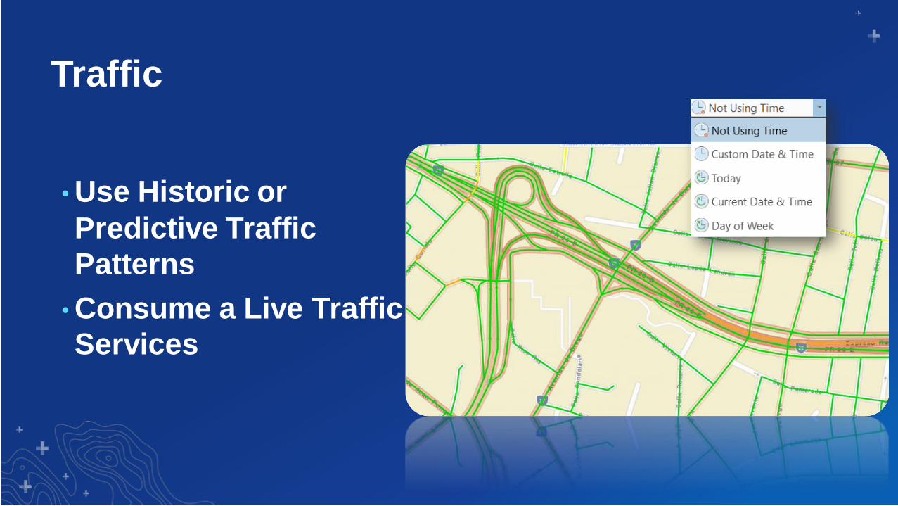
Traffic
• Use Historic or
Predictive Traffic
Patterns
• Consume a Live Traffic
Services

Avoid Obstructions, Events, and Geographies
Routing with Barriers
Floods ClosuresGovernment Regulations
Snow Road Work Special Events
Barriers

Side of the Road

Model Travel in 3D
• Buildings
- Indoor Wayfinding with ArcGIS
Indoors
• Underground Subways
• Overpasses & Underpasses
• Ground Slope
8%

Hurricane Workflows
Network Analyst &
Disaster Response

Utilizing a Mobile Map Package (mmpk)
Network Analyst on a Mobile
Device

Navigator for ArcGIS
Route with Travel Modes
Turn by turn driving directions
Use your own maps, asset inventory, and custom roads
Find and navigate to assets while offline

Navigator for ArcGIS
Connect to a pre-planned route and follow route geometry
AGOL or Enterprise
Route Layer
• Share easily with drivers
• Update when things change
• Consistent across the organization
DownloadSave
VRP
Route
ClosestFacility
API’s & SDK’sMap ViewerEnterpriseDesktop
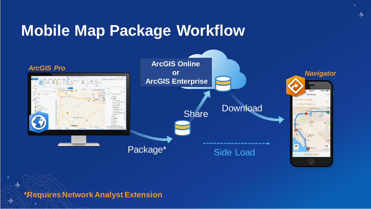
Mobile Map Package Workflow
*Requires Network Analyst Extension
Package* Side Load
ArcGIS Online
or
ArcGIS Enterprise
Download Share
ArcGIS ProNavigator

Responding to the Call
Navigator for ArcGIS

Print Your Certificate of Attendance
Print Stations Located in 150 Concourse Lobby
Tuesday12:30 pm – 6:30 pm
Expo
Hall B
5:15 pm – 6:30 pm
Expo Social
Hall B
Wednesday10:45 am – 5:15 pm
Expo
Hall B
6:30 pm – 9:30 pm
Networking Reception
Smithsonian National Museum
of Natural History

Download the Esri
Events app and find your event
Select the session
you attended
Scroll down to
“Survey”
Log in to access the
survey
Complete the survey
and select “Submit”
Please Share Your Feedback in the App