nestucca / neskowin watersheds culvert …
TRANSCRIPT

N E S T U C C A / N E S K O W I N W A T E R S H E D S
C U L V E R T P R I O R I T I Z A T I O N A N D
A C T I O N P L A N F O R F I S H P A S S A G E
Tillamook County
Soil & Water Conservation District
Nestucca/NeskowinWatersheds Council

Prepared For:
Bureau of Land Management
Prepared By:
Rachel Hoffman Environmental Project Manager Tillamook Estuaries Partnership
The Tillamook Estuaries Partnership is a non-profit organization dedicated to the conservation and restoration of the five Tillamook County estuaries and the watersheds that sustain them.
May 2006

ACKNOWLEDGEMENTS
The completion of this document was accomplished through the combined efforts of: Darrin Neff (Bureau of Land Management), Russ Chapman (Bureau of Land Management), Matt Walker (Bureau of Land Management), Kami Ellingson (US Forest Service), John Casteel (US Forest Service), Janet Moser (US Forest Service), Robert Bradley (Oregon Department of Fish and Wildlife), Michelle Long (Oregon Department of Fish and Wildlife), Carol Bickford (Nestucca/Neskowin Watersheds Council), Pat Oakes (Tillamook County), Dan Weber (Oregon Department of Transportation), Mitch Parker (Green Diamond Resource Co.), Dana Clay (Green Diamond Resource Co.), Jon Wehage (Stimson Lumber Co.), Les Helgeson (private citizen), Dale Buck (private citizen), and Rachel Hoffman (Tillamook Estuaries Partnership).
PURPOSE The intent of this document is to identify high and medium priority fish passage barriers and offer strategies for their replacements. Clustering schemes in the Action Plan describe potential strategies by which partners can leverage resources to implement barrier replacements efficiently and economically (‘bang for the buck’). This prioritization was meant to be simple and utilize existing data. Extensive costs can be expended in developing prioritizations, estimating culvert replacement costs, and conducting analyses. For this prioritization, extensive analyses were not conducted since partners implementing the projects would be conducting them prior to implementation, regardless of whether the information was available in this document. This Action Plan is not a numbered list of which barrier is the best one to replace of all the culverts in the Nestucca and Neskowin watersheds, followed by the second, and so on. Watershed partners have different goals, needs, and available funds, often with ties to land use or ownership. As such, this Plan provides available culvert data and potential clustering strategies for implementation. The landowner or user of this Plan is responsible for determining which culvert or cluster should be replaced based upon their goals. NOTE: It is likely that some fish barriers were unintentionally overlooked or not surveyed and have therefore been excluded from this document. The Neskowin Watershed is included in this prioritization, but culvert data is incomplete. Tidegates and dams are excluded. Overlooked and un-surveyed culverts, and tidegates and dams are mentioned in the culvert summary narratives where they may influence restoration efforts of high or medium priority culverts. Not all the data used in developing this prioritization has been field verified, but it should be prior to initiating a project. Landowners listed in the Plan are current at the completion of this document. It is important to verify current landowners prior to contacting them for projects. Since spring chinook and summer steelhead have similar biological characteristics and habitat needs as fall chinook and winter steelhead, it is understood that analysis of fall chinook and winter steelhead cover the requirements of spring chinook and summer steelhead.
For more information about this prioritization or to obtain copies of this document, contact: Tillamook Estuaries Partnership
613 Commercial Street – PO Box 493Garibaldi, Oregon 97118
(503) 322-2222 www.tbnep.org
Bureau of Land Management 4610 Third Street
Tillamook, Oregon 97141 (503) 842-1100
OR
1

TABLE OF CONTENTS I. INTRODUCTION..............................................................................................................3 II. CULVERT PRIORITIZATION DEVELOPMENT ......................................................5
Phase 1: Barrier Determination Model ...............................................................................5
Phase 2: Prioritization Model..............................................................................................5
Phase 3: Trial Run...............................................................................................................5
Phase 4: Finalize the Model & Analyze Culverts...............................................................6
Table 1. Culvert Prioritization Model..................................................................6
Phase 5: Analysis ................................................................................................................7
Table 2. Culvert Inventory Summaries and Resultant Fish Pipes .......................7
Phase 6: Results Presentation..............................................................................................8
Table 3. High and Medium Ranked Culverts .......................................................9
III. CULVERT PRIORITIZATION DEVELOPMENT ....................................................11
Table 4. Culvert Replacement Clustering Strategy ...........................................12
Table 5. Culvert Replacement Projects Underway............................................14
Culvert Summaries.............................................................................................................15
IV. NEXT STEPS ...................................................................................................................71
APPENDIX
BLM Coarse Screen Filter Version 2.2
2

I. INTRODUCTION In the Nestucca and Neskowin watersheds agencies and organizations have identified, surveyed, prioritized, and replaced fish passage barriers according to their internal goals, rather than from a watershed perspective. These activities have resulted in a jumble of data collected using different methods, compiled into multiple databases, and used to prioritize culverts for replacements with divergent objectives. Specific problems include: • Data Collection and Compatibility: Culvert survey data is likely collected by a method not
consistent with other watershed partners’, making it difficult to compile data into one database for analysis and prioritization.
• Data Availability: Each agency likely has some compilation of data pertaining to culverts residing on their lands. Inaccessible data makes watershed-scale prioritization difficult and time consuming.
• Analysis and Prioritization Methods: Inconsistent analysis and prioritization methods increase the probability of duplicated efforts that may result in fewer benefits and unnecessary costs. If we cannot prioritize fish passage barriers within our watersheds, high probability exists that culverts with minimal watershed benefits will be replaced. A prioritization scheme for the Nestucca/Neskowin watersheds has not been developed that has been used or accepted by watershed partners.
As a result of these problems, incompatible data has made analysis and prioritization nearly impossible at the watershed level. Fish passage projects are expensive, so it is essential that funds are spent implementing high priority projects. Funds currently being spent on low priority projects could be utilized to implement collaborative projects that will generate maximum natural resource benefits. New Approach In 2004, the Tillamook Estuaries Partnership (TEP) and Bureau of Land Management (BLM) identified the need for a new approach and aimed to make fish passage throughout the Nestucca/Neskowin watersheds a priority, consistent with such plans as the Tillamook Bay Comprehensive Conservation and Management Plan (CCMP) completed in December 1999 by the TEP. The TEP and BLM were interested in cooperatively developing a large scale prioritization of fish passage barriers across ownerships in the Nestucca/Neskowin watersheds. By taking a basin-wide management approach, partners can collaborate on barrier prioritization to ensure that the expenditure of funds used on projects generate maximum natural resource benefits (“bang for your buck”). This approach provides positive benefits to both watershed partners and the resources that we are charged with protecting. Benefits include the following:
• Watershed partners can assist each other in receiving funds for priority fish passage barrier upgrades.
• Critical habitats are made accessible to adult and juvenile salmon species. • Public funds are spent effectively and time is used efficiently. • This prioritization model, created for internal use, can be distributed and utilized in other
watersheds. The BLM and US Forest Service (USFS) have collected comprehensive passage data for the Nestucca Watershed. As a federally-designated National Estuary Project, TEP is responsible for fostering collaboration among watershed partners to implement the CCMP. On this project, TEP led the
3

collaborative effort that developed methods for analyzing and prioritizing culverts that impede fish passage, and leveraging funds to implement high priority fish passage barrier replacements. The TEP and BLM sought to ensure the prioritization process developed was supported by and applicable to watershed partners. As such, resource managers and private citizens throughout the Nestucca/Neskowin watersheds were invited to participate in developing the systematic, basin-wide prioritization of fish passage barriers. The new approach to this collaborative effort had five objectives, all of which have been completed. 1) Compile all available culvert data for the Nestucca/Neskowin watersheds into one central database. 2) Develop a prioritization process that can be utilized by all watershed partners. 3) Determine appropriate analysis methods to be utilized for prioritization. 4) Analyze all culverts in the database. 5) Develop an Action Plan to guide partner efforts and facilitate resource leveraging. BLM Culvert Inventory This prioritization was driven by an inventory initiated by the BLM in 2002. Between 2002 and 2004, BLM completed an inventory of all culverts across land ownerships throughout the Nestucca Watershed. BLM used GIS to create a modeled stream crossing layer that identified all stream crossings in the basin with a gradient less than 15%. (A 15% gradient is generally accepted as the probable end of fish use.) Culvert crossings with upstream and/or downstream channel gradients of greater than 15% were excluded. Fish distribution GIS layers were not used because upper extents of fish distribution are often incomplete. The modeled layer was then used to field check all modeled culverts. BLM contracted with the Tillamook County Soil and Water Conservation District to identify and contact landowners adjacent to the modeled culverts in order to obtain permission for BLM staff to conduct an inspection or survey. Any culverts that were not in the model, but after field checking were determined to have a high probability of fish use, were also surveyed and added to the database. BLM inspected all 885 modeled stream crossings (channel gradients <15%) throughout the Nestucca Watershed. A total of 154 culverts were surveyed and data entered into a Microsoft Access database. The surveyed number differs from the modeled number because some of the modeled culverts were bridges, were removed, or were not located on fish bearing streams (channel gradient >15% but the crossing was <15%). The new database was merged with an existing USFS database containing 428 Nestucca culverts, resulting in a comprehensive database of 582 Nestucca Watershed culverts. The BLM was cognizant of the existing USFS database and cautious to avoid duplication efforts. The inventory did not include tidegates, dams, or other potential fish passage barriers. Nestucca/Neskowin Watersheds Council’s Rapid Bio-AssessmentSimultaneously with the BLM’s Culvert Inventory, the Nestucca/Neskowin Watersheds Council (NNWC) contracted with Bio-Surveys, LLC to conduct a ‘Rapid Bio-Assessment’ (RBA). Beginning in 2002, this three-year assessment surveyed juvenile salmonid distribution and abundance throughout the Nestucca and Neskowin watersheds. It was the intent of these two basin-wide surveys (Culvert Inventory and RBA) to identify fish passage barriers and critical habitat areas in order to facilitate the prioritization of watershed enhancement efforts among partners. This document summarizes the identification of these barriers and habitat areas.
4

II. CULVERT PRIORITIZATION DEVELOPMENT In spring 2005, BLM contracted with TEP to develop a prioritization process to analyze the 582 culverts. The BLM and TEP collaborated with other resource managers (identified under the Acknowledgements) to further implement this new approach. This approach had six key phases:
1) Identify the ‘barrier determination model’ to use in the prioritization model. 2) Create a preliminary culvert prioritization model to test on a subset of culverts. 3) Conduct a trial run on a subset of culverts and present results to watershed partners. 4) Finalize the prioritization model. 5) Analyze all 582 culverts. 6) Present the final model and analyzed culverts to partners.
Phase 1: Barrier Determination Model Before developing a prioritization process, partners determined it was necessary to identify or develop an appropriate ‘barrier determination model’. This model would determine the culvert barrier type (full, partial, none). The determination would then be plugged into the culvert prioritization model. TEP accumulated three models and comparison revealed that the BLM Coarse Screen Filter Version 2.2 (see Appendix), a juvenile passage model, was the best model available for the purposes of determining whether or not a culvert is a barrier, given the existing data available. TEP found other models not as stringent as the BLM model. For example, the Oregon Department of Fish and Wildlife (ODFW) determines a culvert a juvenile barrier if there is a 6-inch outlet drop, with appropriate pool depth (ODFW Fish Passage Criteria, October 2004). However, BLM’s filter identified a 4-inch drop as a juvenile barrier. It is acknowledged that the selected model has flaws. However, it most closely met the objectives for developing a prioritization. Determinations resultant from the model are not absolute. For example, if the model determines a culvert is a barrier to juvenile passage at any flows, it may actually pass juveniles at some flows. For this prioritization, culverts were evaluated only for juvenile salmon passage. If culverts are evaluated only for adult passage, a high likelihood exists that many priority culverts will be overlooked. Phase 2: Prioritization Model After selecting a barrier determination model, TEP compiled various culvert prioritization models to develop a new one meeting our goals. Unlike selecting a barrier determination model, prioritization models were either too complex, too simple, or lacked information partners considered important. Eleven models from the Pacific Northwest were summarized and compared for the utilization capability of determining relative culvert replacement priorities. Comparison of the models led to the selection of a few models based on feasibility of using the model and ecologically important criteria within the model. Criteria from the selected models were merged into one new model which uses a sum-total point system. Phase 3: Trial Run Before ranking all 582 culverts, TEP conducted a trial run on 30 BLM culverts (5% sample) to evaluate the new model. BLM culverts were selected since they had the most complete data and any data gaps could be filled easily with BLM staff already assisting TEP in the process. Several trial runs were made with the preliminary model, making minor adjustments to criteria after each trial. Trial runs resulted in the following conclusions: • Stream order does not significantly influence the ranking, especially when fish presence and habitat
length are already parameters. [Stream order eliminated from the model.]
5
• Fish presence/absence as a ‘yes’ or ‘no’ correlates exactly with the length of habitat above, even though the length of habitat above is based on stream gradient. [Fish presence/absence as a ‘yes’ or ‘no’ eliminated from the model.]
• Separating fish presence into ‘anadromous’, ‘non-anadromous’, and ‘no fish’ does not alter the ranking significantly, but we suspect it will on a watershed scale. [No change to parameter.]
• Fish species does not significantly influence the ranking. [Change parameter to ‘Additional Consideration’.]
• Probably the most important revelation after conducting the trial runs was that developing a prioritization model need not be complex or ideal. All that is needed is a model to identify fish passage barrier priorities relative to others in the watershed.
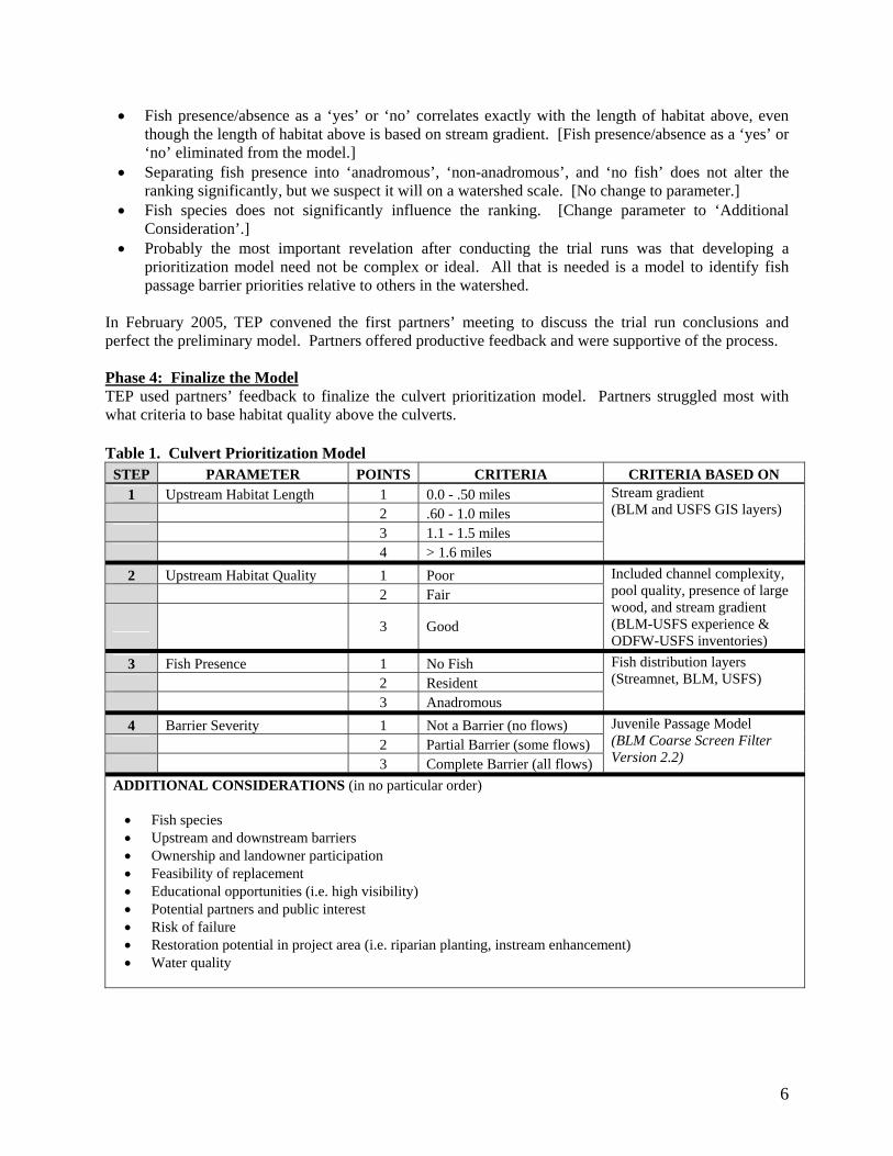
In February 2005, TEP convened the first partners’ meeting to discuss the trial run conclusions and perfect the preliminary model. Partners offered productive feedback and were supportive of the process. Phase 4: Finalize the Model TEP used partners’ feedback to finalize the culvert prioritization model. Partners struggled most with what criteria to base habitat quality above the culverts. Table 1. Culvert Prioritization Model
STEP PARAMETER POINTS CRITERIA CRITERIA BASED ON 1 Upstream Habitat Length 1 0.0 - .50 miles 2 .60 - 1.0 miles 3 1.1 - 1.5 miles 4 > 1.6 miles
Stream gradient (BLM and USFS GIS layers)
2 Upstream Habitat Quality 1 Poor 2 Fair
3 Good
Included channel complexity, pool quality, presence of large wood, and stream gradient (BLM-USFS experience & ODFW-USFS inventories)
3 Fish Presence 1 No Fish 2 Resident 3 Anadromous
Fish distribution layers (Streamnet, BLM, USFS)
4 Barrier Severity 1 Not a Barrier (no flows) 2 Partial Barrier (some flows) 3 Complete Barrier (all flows)
Juvenile Passage Model (BLM Coarse Screen Filter Version 2.2)
ADDITIONAL CONSIDERATIONS (in no particular order) • Fish species • Upstream and downstream barriers • Ownership and landowner participation • Feasibility of replacement • Educational opportunities (i.e. high visibility) • Potential partners and public interest • Risk of failure • Restoration potential in project area (i.e. riparian planting, instream enhancement) • Water quality
6

Phase 5: Analysis To begin the final analysis, TEP compiled all available data into one database. Data was available from the following sources: BLM, USFS, ODOT, and Pioneer Engineering Corp. culvert inventory data; Bio-Surveys Rapid Bio-Assessment 2002-2004 Final Report; stream gradient and fish distribution GIS layers; and ODFW and USFS stream habitat survey data. After the database was created data gaps were identified and filled with assistance from BLM, USFS, and NNWC. Further investigation of the 428 USFS culverts revealed that numerous pipes were either not on fish bearing streams, lacked fish habitat, or two pipes at one crossing were recorded individually. While filling data gaps and conducting field checks, it was recognized that some culverts should be added or removed. Table 2 below summarizes this process. Table 2. Culvert Inventory Summaries and Resultant Fish Pipes*
Data Source Total Culverts
Surveyed in Original Merged Database
Added Culverts
Culled Non-Fish Pipes &
Duplicates
Remaining Fish Pipes
BLM 154 1 155 USFS 428 321 107 ODOT 83 18 65 Pioneer Engineering Corp. Neskowin Assessment
11 11
TOTALS 582 95 339 338 42 (High) 40 (Medium) 256 (Low)
*For the purposes of this prioritization, a ‘Fish Pipe’ is defined as a culvert that currently has fish present. A ‘Non-Fish Pipe’ is defined as a culvert that does not currently have fish present and surrounding habitat is not, or does not have potential to, support fish. Next, BLM used GIS layers to map stream gradients above the 338 culverts. Based on gradients, staff ranked all culverts into high (0-3%), medium (4-5%), and low (>6%) potential quality habitats. Extensive BLM and USFS knowledge of these watersheds also weighed heavily in making this first cut. Low-ranking culverts received no further evaluation. It is important to note that there may be low priority culverts that are replaced before high priority culverts based on their structural condition or susceptibility for failure, which could have significant impacts to downstream fish populations. Additional data was collected for the high and medium priority culverts in order to rank culverts using the new model. Habitat quantity was based on stream gradients derived from BLM and USFS GIS layers. Gradients above 5% were determined not to be priority anadromous salmon habitat. [It is recognized that steelhead and cutthroat populations inhabit higher gradient stream reaches.] Habitat quality was based on attributes including, but not limited to, channel complexity, pool quality, presence of large wood, and stream gradient. ODFW Aquatic Inventory survey data was utilized where available, as well as BLM and USFW professional knowledge and experience. Fish distribution data was derived from BLM, USFS, and Streamnet (a cooperative project that provides natural resource data online). Barrier severity was based on culvert attributes such as outlet drop and slope (refer to Appendix). With a complete database of the high and medium priority culverts, the culverts were analyzed and points assigned to each culvert. NOTE: After finalizing the model, all 338 culverts were broken into high, medium, and low rankings based on stream gradient and BLM and USFS knowledge and experience. After data gaps on the medium
7

and highs were filled, the final prioritization model was applied to identify relative priorities within the medium and high ranked culverts. In these watersheds, extensive experience was available and utilized to reduce the number of culverts to a manageable level (i.e. not ranking the lows). If experience is unavailable, it is recommended that the prioritization model be applied, followed by field verification. It was beneficial for this prioritization to utilize knowledge and experience prior to applying the model. Phase 6: Results Presentation In June 2005 TEP convened a second meeting, which 11 partners attended, to review and discuss the prioritization process and resultant draft culvert list. TEP led a productive open discussion about how culverts were classified into rankings, the accuracy of the rankings, and a summary of the subsequent Action Plan and clustering strategy for leveraging resources. Table 3 summarizes the final list of high and medium priority culverts. The large number of low priority culverts led to their exclusion from this Plan. Data is available upon request.
8
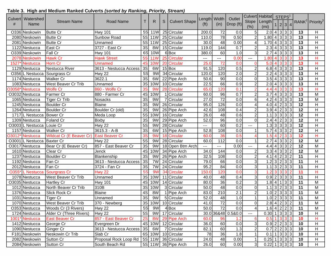
Table 3. High and Medium Ranked Culverts (sorted by Ranking, Priority, Stream)
1 2 3 4
O336 Neskowin Butte Cr Hwy 101 5S 11W 25 Circular 200.0 72 0.0 5 2.0 4 3 3 3 13 H2080 Neskowin Butte Cr Sunbow Road 5S 11W 25 Circular 110.0 78 0.50 2 1.80 4 3 3 3 13 H2081 Neskowin Butte Cr Unnamed 5S 11W 25 Circular 30.0 48 0.00 4 1.70 4 3 3 3 13 H1122 Nestucca East Cr 3727 - East Cr 3S 8W 15 Circular 119.0 144 0.7 2 2.3 4 3 3 3 13 HO339 Neskowin Fall Cr Hwy 101 6S 10W 6 Box 380.0 60 1.0 3 2.7 4 3 3 3 13 H2078 Neskowin Hawk Cr Hawk Street 5S 11W 25 Circular --- --- 0.00 --- 1.80 4 3 3 3 13 H
1527* Nestucca Horn Cr Unnamed 4S 10W 20 Circular 25.0 72 0.0 0 5.0 4 3 3 3 13 H1129 Nestucca Nestucca River 3613 - Nestucca Access 3S 6W 15 Box 91.5 120 0.5 2 6.8 4 3 3 3 13 HO356 L Nestucca Sourgrass Cr Hwy 22 5S 9W 34 Circular 120.0 120 2.0 2 2.2 4 3 3 3 13 H1174 Nestucca Walker Cr 3622.1 3S 6W 22 Pipe Arch 50.6 90 0.0 0 3.5 4 3 3 3 13 H1083 Nestucca West Beaver Cr Trib Unnamed 3S 10W 10 Circular 22.5 66 0.9 2 2.0 4 3 3 3 13 H
O3058* Nestucca Wolfe Cr 860 - Wolfe Cr 3S 9W 28 Circular 65.0 120 0.1 2 4.4 4 3 3 3 13 HO3032 Nestucca Farmer Cr 880 - Farmer Cr 4S 10W 1 Circular 60.0 96 0.7 2 3.7 4 3 3 3 13 M
1065 Nestucca Tiger Cr Trib Nosacks 3S 9W 7 Circular 27.0 72 0.0 6 4.2 4 3 3 3 13 M1245 Nestucca Boulder Cr Blaine 3S 9W 26 Circular 95.0 126 0.0 4 4.0 4 2 3 3 12 H1264 Nestucca Boulder Cr Boulder Cr (old) 3S 9W 26 Pipe Arch 42.6 108 0.4 2 3.9 4 2 3 3 12 H1717 L Nestucca Bower Cr Meda Loop 5S 10W 16 Circular 26.0 48 0.6 2 1.1 3 3 3 3 12 H1309 Nestucca Foland Cr Bixby 3S 9W 29 Pipe Arch 52.0 96 0.0 0 2.4 4 2 3 3 12 H
O3003 L Nestucca Louie Cr Hwy 22 5S 9W 28 Circular --- 60 0.2 --- 1.3 3 3 3 3 12 H1157 Nestucca Walker Cr 3615.3 - A-B 3S 6W 15 Pipe Arch 52.8 108 0.0 1 5.7 4 3 3 2 12 H
O3012* Nestucca Wildcat Cr (E Beaver Cr) East Beaver Cr 3S 9W 18 Circular 60.0 36 0.5 4 1.5 4 2 3 3 12 HO3001 L Nestucca Baxter Cr Hwy 22 5S 9W 28 Circular 60.0 112 0.0 1 2.7 4 3 3 2 12 MO3017 Nestucca Bear Cr (E Beaver Cr) 857 - East Beaver Cr 3S 9W 18 Open Btm Arch --- --- 0.00 --- 4.4 4 3 3 2 12 M
1610 Nestucca Clear Cr Jenck 4S 10W 34 Pipe Arch 34.0 144 0.0 2 3.3 4 3 3 2 12 M1237 Nestucca Boulder Cr Blankenship 3S 9W 26 Pipe Arch 32.5 108 0.0 2 4.1 4 2 3 2 11 H1192 Nestucca Fan Cr 3613 - Nestucca Access 3S 7W 24 Circular 79.0 66 0.0 3 1.2 3 2 3 3 11 H2012 Nestucca Fan Cr 3724 - Fan Cr 3S 7W 24 Circular 95.2 84 0.0 3 1.1 3 2 3 3 11 H
O355* L Nestucca Sourgrass Cr Hwy 22 5S 9W 34 Circular 150.0 120 0.0 3 1.2 3 3 3 2 11 H1078 Nestucca West Beaver Cr Trib Unnamed 3S 10W 11 Circular 40.0 48 0.4 3 0.9 2 3 3 3 11 H
O3035 Nestucca Hartley Cr Hwy 101 4S 10W 14 Circular 80.0 36 0.2 3 1.8 4 1 3 3 11 M1012 Nestucca North Beaver Cr Trib 310B 3S 10W 3 Circular 50.0 48 0.0 0 1.1 3 2 3 3 11 M1376 Nestucca Slick Rock Cr Blaine 4S 8W 1 Pipe Arch 83.0 210 2.1 2 1.0 2 3 3 3 11 M1031 Nestucca Tiger Cr Unnamed 3S 9W 5 Circular 52.0 48 1.0 1 1.0 2 3 3 3 11 M1070 Nestucca West Beaver Cr Trib 370 - Newberg 3S 10W 10 Circular 41.0 72 0.0 0 2.8 4 2 3 2 11 MO353 Nestucca Woods Cr (3 Rivers) Hwy 22 5S 9W 4 Box 50.0 72 0.0 4 1.6 4 2 2 3 11 M1724 Nestucca Alder Cr (Three Rivers) Hwy 22 5S 9W 17 Circular 30.0 36&48 0.5&0.0 --- 0.30 1 3 3 3 10 H
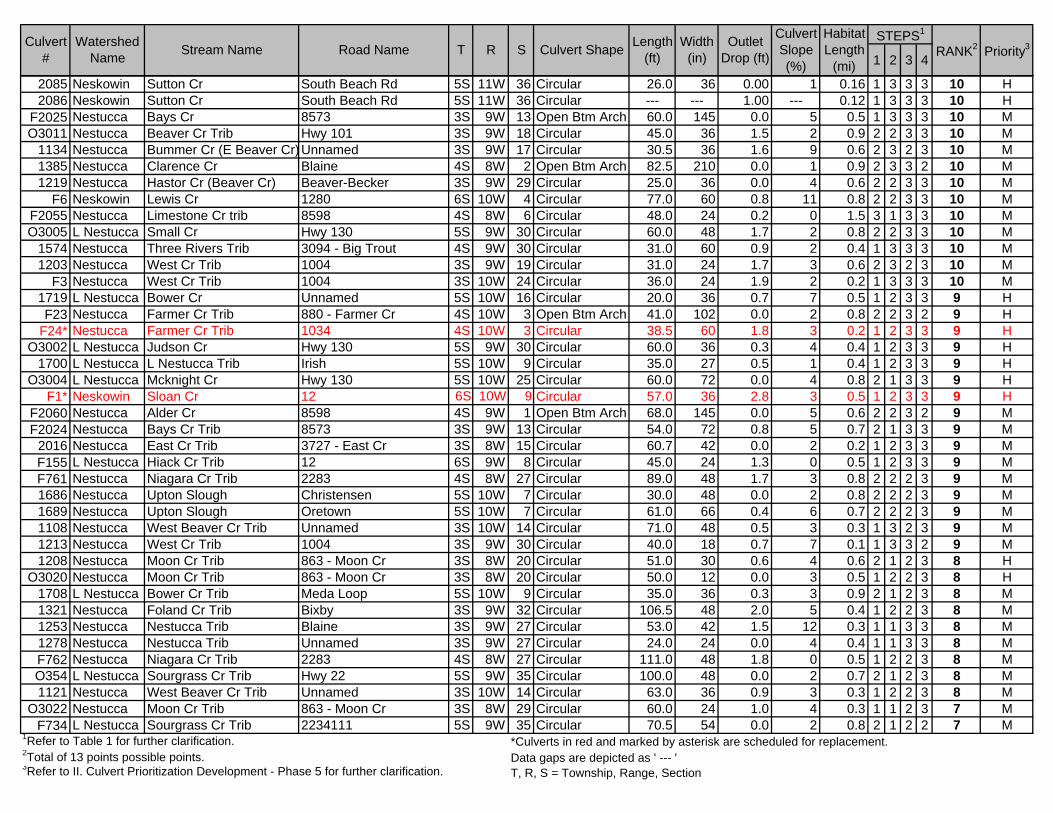
1001* Nestucca East Beaver Cr 857 - East Beaver Cr 2S 8W 29 Pipe Arch 60.0 96 1.2 6 0.5 1 3 3 3 10 H1412 Nestucca George Cr Evergreen Dr 4S 10W 12 Circular 36.0 60 0.0 3 0.9 2 2 3 3 10 H1090 Nestucca Ginger Cr 3613 - Nestucca Access 3S 6W 7 Circular 82.1 60 1.3 2 0.7 2 2 3 3 10 HF181 Neskowin Neskowin Cr Trib Slab Cr 6S 10W 10 Circular 78 36 1.8 1 0.1 1 3 3 3 10 H2082 Neskowin Sutton Cr Proposal Rock Loop Rd 5S 11W 36 Circular 24.0 48 0.00 1 0.25 1 3 3 3 10 H2084 Neskowin Sutton Cr South Beach Rd 5S 11W 36 Pipe Arch 26.0 60 0.00 3 0.22 1 3 3 3 10 H
Length (ft)T R S Culvert ShapeCulvert
#Watershed
Name Stream Name Road Name RANK2 Priority3Width (in)
Outlet Drop (ft)
Culvert Slope (%)
Habitat Length
(mi)
STEPS1
1 2 3 4Length
(ft)T R S Culvert ShapeCulvert #
Watershed Name Stream Name Road Name RANK2 Priority3Width
(in)Outlet
Drop (ft)
Culvert Slope (%)
Habitat Length
(mi)
STEPS1
2085 Neskowin Sutton Cr South Beach Rd 5S 11W 36 Circular 26.0 36 0.00 1 0.16 1 3 3 3 10 H2086 Neskowin Sutton Cr South Beach Rd 5S 11W 36 Circular --- --- 1.00 --- 0.12 1 3 3 3 10 H
F2025 Nestucca Bays Cr 8573 3S 9W 13 Open Btm Arch 60.0 145 0.0 5 0.5 1 3 3 3 10 MO3011 Nestucca Beaver Cr Trib Hwy 101 3S 9W 18 Circular 45.0 36 1.5 2 0.9 2 2 3 3 10 M
1134 Nestucca Bummer Cr (E Beaver Cr)Unnamed 3S 9W 17 Circular 30.5 36 1.6 9 0.6 2 3 2 3 10 M1385 Nestucca Clarence Cr Blaine 4S 8W 2 Open Btm Arch 82.5 210 0.0 1 0.9 2 3 3 2 10 M1219 Nestucca Hastor Cr (Beaver Cr) Beaver-Becker 3S 9W 29 Circular 25.0 36 0.0 4 0.6 2 2 3 3 10 M
F6 Neskowin Lewis Cr 1280 6S 10W 4 Circular 77.0 60 0.8 11 0.8 2 2 3 3 10 MF2055 Nestucca Limestone Cr trib 8598 4S 8W 6 Circular 48.0 24 0.2 0 1.5 3 1 3 3 10 MO3005 L Nestucca Small Cr Hwy 130 5S 9W 30 Circular 60.0 48 1.7 2 0.8 2 2 3 3 10 M
1574 Nestucca Three Rivers Trib 3094 - Big Trout 4S 9W 30 Circular 31.0 60 0.9 2 0.4 1 3 3 3 10 M1203 Nestucca West Cr Trib 1004 3S 9W 19 Circular 31.0 24 1.7 3 0.6 2 3 2 3 10 M
F3 Nestucca West Cr Trib 1004 3S 10W 24 Circular 36.0 24 1.9 2 0.2 1 3 3 3 10 M1719 L Nestucca Bower Cr Unnamed 5S 10W 16 Circular 20.0 36 0.7 7 0.5 1 2 3 3 9 HF23 Nestucca Farmer Cr Trib 880 - Farmer Cr 4S 10W 3 Open Btm Arch 41.0 102 0.0 2 0.8 2 2 3 2 9 H
F24* Nestucca Farmer Cr Trib 1034 4S 10W 3 Circular 38.5 60 1.8 3 0.2 1 2 3 3 9 HO3002 L Nestucca Judson Cr Hwy 130 5S 9W 30 Circular 60.0 36 0.3 4 0.4 1 2 3 3 9 H
1700 L Nestucca L Nestucca Trib Irish 5S 10W 9 Circular 35.0 27 0.5 1 0.4 1 2 3 3 9 HO3004 L Nestucca Mcknight Cr Hwy 130 5S 10W 25 Circular 60.0 72 0.0 4 0.8 2 1 3 3 9 H
F1* Neskowin Sloan Cr 12 6S 10W 9 Circular 57.0 36 2.8 3 0.5 1 2 3 3 9 HF2060 Nestucca Alder Cr 8598 4S 9W 1 Open Btm Arch 68.0 145 0.0 5 0.6 2 2 3 2 9 MF2024 Nestucca Bays Cr Trib 8573 3S 9W 13 Circular 54.0 72 0.8 5 0.7 2 1 3 3 9 M
2016 Nestucca East Cr Trib 3727 - East Cr 3S 8W 15 Circular 60.7 42 0.0 2 0.2 1 2 3 3 9 MF155 L Nestucca Hiack Cr Trib 12 6S 9W 8 Circular 45.0 24 1.3 0 0.5 1 2 3 3 9 MF761 Nestucca Niagara Cr Trib 2283 4S 8W 27 Circular 89.0 48 1.7 3 0.8 2 2 2 3 9 M1686 Nestucca Upton Slough Christensen 5S 10W 7 Circular 30.0 48 0.0 2 0.8 2 2 2 3 9 M1689 Nestucca Upton Slough Oretown 5S 10W 7 Circular 61.0 66 0.4 6 0.7 2 2 2 3 9 M1108 Nestucca West Beaver Cr Trib Unnamed 3S 10W 14 Circular 71.0 48 0.5 3 0.3 1 3 2 3 9 M1213 Nestucca West Cr Trib 1004 3S 9W 30 Circular 40.0 18 0.7 7 0.1 1 3 3 2 9 M1208 Nestucca Moon Cr Trib 863 - Moon Cr 3S 8W 20 Circular 51.0 30 0.6 4 0.6 2 1 2 3 8 H
O3020 Nestucca Moon Cr Trib 863 - Moon Cr 3S 8W 20 Circular 50.0 12 0.0 3 0.5 1 2 2 3 8 H1708 L Nestucca Bower Cr Trib Meda Loop 5S 10W 9 Circular 35.0 36 0.3 3 0.9 2 1 2 3 8 M1321 Nestucca Foland Cr Trib Bixby 3S 9W 32 Circular 106.5 48 2.0 5 0.4 1 2 2 3 8 M1253 Nestucca Nestucca Trib Blaine 3S 9W 27 Circular 53.0 42 1.5 12 0.3 1 1 3 3 8 M1278 Nestucca Nestucca Trib Unnamed 3S 9W 27 Circular 24.0 24 0.0 4 0.4 1 1 3 3 8 MF762 Nestucca Niagara Cr Trib 2283 4S 8W 27 Circular 111.0 48 1.8 0 0.5 1 2 2 3 8 MO354 L Nestucca Sourgrass Cr Trib Hwy 22 5S 9W 35 Circular 100.0 48 0.0 2 0.7 2 1 2 3 8 M1121 Nestucca West Beaver Cr Trib Unnamed 3S 10W 14 Circular 63.0 36 0.9 3 0.3 1 2 2 3 8 M
O3022 Nestucca Moon Cr Trib 863 - Moon Cr 3S 8W 29 Circular 60.0 24 1.0 4 0.3 1 1 2 3 7 MF734 L Nestucca Sourgrass Cr Trib 2234111 5S 9W 35 Circular 70.5 54 0.0 2 0.8 2 1 2 2 7 M
1Refer to Table 1 for further clarification. *Culverts in red and marked by asterisk are scheduled for replacement.2Total of 13 points possible points. Data gaps are depicted as ' --- '3Refer to II. Culvert Prioritization Development - Phase 5 for further clarification. T, R, S = Township, Range, Section

III. ACTION PLAN After the final meeting, TEP developed this collaborative Action Plan to facilitate the replacement of fish passage barrier culverts in the watersheds. Collectively, replacing all the high and medium ranked culverts in this Plan would improve access to an estimated 89.4 miles of salmon spawning and rearing habitat throughout the Nestucca and Neskowin watersheds. The primary goal of this Plan is to enable resource leveraging during project implementation. Many of the potential projects residing in this Plan are likely to be replaced through grant funding. Numerous federal grant funding sources exist, but they are often accompanied by tough matching requirements (i.e. 1:1 from a non-federal source). Limited sources of non-federal grant funds complicate the problem. However, if properly planned and strategized, these problems can be resolved. Other sources of non-federal funding exist that are often overlooked while planning a project. For instance, a private industrial landowner decommissioning a road at their expense could leverage the replacement of a County road culvert led by a local watershed council in the same watershed. Combine the decommissioning project with in-kind (donated) time County staff may spend reviewing plans and inspecting the project, and several thousands of dollars can be accrued in non-federal match, thereby leveraging a federal grant. Resources available for match can include donated supplies, equipment, technical assistance, labor, or other services that may otherwise be contracted and paid for through grant funds. Partnering on projects not only helps meet match requirements, but it reduces the overall grant request, making the project more competitive, and facilitates the implementation of larger projects. This plan not only identifies the high and medium priority fish passage barrier culverts to replace, it ‘clusters’ them together to facilitate project development. Barriers are grouped primarily on a watershed scale. Obviously, one culvert can be replaced independent of the rest of the cluster. However, the cluster table is provided as a tool to facilitate leveraging of funds and match, or to gain on-the-ground project implementation efficiencies. Table 4 illustrates the clustering strategy that is the foundation of the individual culvert summaries. All high priority culverts are listed in this clustering strategy. Medium priority culverts in the vicinity of each other or in the vicinity of high priority culverts are also listed in this strategy. Remaining medium priority culverts are lumped into the 'Non-Clustered Culverts' category. These culverts are isolated on the landscape and there is no justifiable clustering strategy. The clusters are listed by location, beginning in the upper watershed. The number before the cluster name does not state or imply a priority among clusters.
11

Table 4. Culvert Replacement Clustering Strategy
CLUSTER CULVERT # PRIORITY STREAM UPSTREAM HABITAT
NESTUCCA MAINSTEM
1 - Walker Creek 1129 H Nestucca River 1157 H Walker Creek 1174 H Walker Creek
6.8 miles
2 - Upper Nestucca 1090 H Ginger Creek
1192 H Fan Creek 2012 H Fan Creek
1.9 miles
3 - Slick Rock Creek / Clarence Creek 1376 M Slick Rock Creek
1385 M Clarence Creek 1.9 miles
4 - Upper Niagara Creek F761 M Niagara Creek Trib
F762 M Niagara Creek Trib 1.3 miles
5 - Moon Creek 1208 H Moon Creek Trib
O3020 H Moon Creek Trib O3022 M Moon Creek Trib
1.4 miles
6 - East Creek 1122 H East Creek
2016 M East Creek Trib 2.3 miles
7 - Bays Creek F2024 M Bays Creek Trib
F2025 M Bays Creek 1.2 miles
8 - Boulder Creek 1237 H Boulder Creek
1245 H Boulder Creek 1264 H Boulder Creek
4.1 miles
9 - Unnamed Tribs 1253 M Nestucca Trib
1278 M Nestucca Trib 0.7 miles
10 - Wolfe Creek O3058 H Wolfe Creek 4.4 miles
11 - Foland Creek 1309 H Foland Creek
1321 M Foland Creek Trib 2.8 miles
12 - East Beaver Creek 1001 H East Beaver Creek
O3012 H Wildcat Creek O3017 M Bear Creek 1134 M Bummer Creek
7.0 miles
12

13 - West Beaver Creek 1031 M Tiger Creek
1065 M Tiger Creek Trib 1012 M North Beaver Creek Trib 1070 M West Beaver Creek Trib 1078 H West Beaver Creek Trib 1083 H West Beaver Creek Trib 1108 M West Beaver Creek Trib 1121 M West Beaver Creek Trib
12.0 miles
14 - West Creek F3 M West Creek Trib
1203 M West Creek Trib 1213 M West Creek Trib
0.9 miles
15 - Farmer Creek O3032 M Farmer Creek
F23 H Farmer Creek Trib F24 H Farmer Creek Trib
3.7 miles
16 - George Creek 1412 H George Creek 0.9 miles
17 - Three Rivers O353 M Woods Creek
1574 M Three Rivers Trib 1724 H Alder Creek
2.3 miles
18 - Horn Creek 1527 H Horn Creek 5.0 miles
LITTLE NESTUCCA
19 - Sourgrass Creek O355 H Sourgrass Creek O356 H Sourgrass Creek F734 M Sourgrass Creek Trib O354 M Sourgrass Creek Trib
2.2 miles
20 - Louie Creek / Baxter Creek O3001 M Baxter Creek
O3003 H Louie Creek 4.0 miles
21 - Little Nestucca River Road Tribs O3002 H Judson Creek
O3004 H McKnight Creek O3005 M Small Creek
2.0 miles
22 - Little Nestucca River Trib 1700 H Little Nestucca Trib 0.4 miles
23 - Bower Creek 1708 M Bower Creek Trib
1717 H Bower Creek 1719 H Bower Creek
2.0 miles
24 - Upton Slough 1686 M Upton Slough
1689 M Upton Slough 0.8 miles
13

NESKOWIN 25 - Fall Creek O339 H Fall Creek 2.7 miles
26 - Upper Neskowin F6 M Lewis Creek
F1 H Sloan Creek F181 H Neskowin Creek Trib
1.4 miles
27 - Hawk Creek / Butte Creek 2078 H Hawk Creek
O336 H Butte Creek 2080 H Butte Creek 2081 H Butte Creek
3.8 miles
28 - Sutton Creek 2082 H Sutton Creek
2084 H Sutton Creek 2085 H Sutton Creek 2086 H Sutton Creek
0.3 miles
NON-CLUSTERED CULVERTS 1219 M Hastor Cr (Beaver Cr) 0.6 miles F155 M Hiack Creek Trib 0.5 miles F2055 M Limestone Cr Trib 1.5 miles F2060 M Alder Cr (Nestucca River) 0.6 miles O3011 M Beaver Cr Trib 0.9 miles O3035 M Hartley Cr 1.8 miles 1610 M Clear Creek 3.3 miles TOTAL MILES 89.4 miles
While developing this Plan, partners initiated several projects. Table 5 lists the culvert replacement projects currently underway. Table 5. Culvert Replacement Projects Underway
Culvert #
Watershed Name Stream Name Road Name
Habitat Length
(mi) Rank Priority Project
Lead Project Status
1001 Nestucca East Beaver Cr 857 - East Beaver Cr 0.5 10 H BLM Engineering underway Planned 2006 completion
O3058 Nestucca Wolfe Cr 860 - Wolfe Cr 4.4 13 H TEP Engineering underway Planned 2007 completion
1527 Nestucca Horn Cr Unnamed 5.0 13 H NNWC Engineering complete Planned 2007 completion
O3012 Nestucca Wildcat Cr East Beaver Cr 1.5 12 H NNWC Engineering complete Planned 2007 completion
O355 L Nestucca Sourgrass Cr Hwy 22 1.2 11 H ODOT Engineering complete Planned 2007 completion
F24 Nestucca Farmer Cr Trib USFS 1034 0.2 9 H USFS Engineering complete No estimated completion
F1 Neskowin Sloan Cr USFS 12 0.5 9 H USFS Engineering complete No estimated completion
2078 Neskowin Hawk Cr Hawk Street 1.8 13 H NNWC Project initiated Planned 2008 completion
14

Culvert Summaries The following is a series of tables containing data on each high and medium priority culvert. The tables are organized by cluster, as listed in Table 4. A short narrative and map accompanies each cluster. Culverts other than ones that are part of the map’s cluster of focus may be shown. The end point of the fish distribution layers does not necessarily indicate that fish are absent upstream of the end point. Total miles, listed at the beginning of each cluster, refers to the total miles of habitat available upstream if access was improved through replacing or modifying all the culverts listed in that cluster. If two culverts are located on one stream, upstream habitat miles are only recorded for the lower culvert. Counting habitat above both culverts would result in duplication of miles. Potential partners listed refers to entities that could provide any of the following activities, including but not limited to, overall management and coordination (shown as the ‘lead’ on some clusters), grant writing, administration, contract management, education, supplies, equipment, or implementing additional enhancements (i.e. riparian or large woody debris projects). The following terms are used throughout the summaries and are defined here for consistency: Inlet Gradient %: Channel gradient from the inlet of the culvert, upstream one pipe diameter. Upstream Gradient: Channel gradient beginning at a point upstream of the inlet (above the culvert-influence area) and ending approximately 50 feet upstream of that point. Bankfull Width: Bankfull flow is a winter high or peak flow that usually occurs on average every 1 to 2 years. Look for indicators of the highest annual water scour marks on each bank, such as a change in vegetation, bank topography, or the size of streambed material. Other indicators include a line defining the lower limit of lichen colonization, exposed roots, a stain line visible on bare substrate, or an undisturbed line of organic debris on the ground. These measuring points should be well above any influence the stream crossing may have on channel width. Bankfull Ratio: [Inlet Width / Bankfull Width] The bankfull ratio is a measure of channel constriction as water flows into the culvert. In order for a culvert crossing structure to meet the criteria for stream simulation, this ratio must be one or greater. Structures that do not constrict the channel at most flows are generally more successful at passing fish and other biota. Co: coho Stw: winter steelhead Chf: fall chinook Ct: cutthroat
15

16
1 – WALKER CREEK Total Habitat Gained: 6.8 miles These three culverts are located in the uppermost extent of anadromous fish distribution in the Nestucca Watershed on BLM-managed roads and land. In 2005, BLM replaced a fish passage barrier culvert with a bridge on the mainstem Nestucca, just below Walker Creek’s confluence. However, just below the new bridge is fish barrier culvert #1129. Replacing or modifying this culvert, along with replacing #1157 and #1174, will allow unrestricted access to salmon habitat in the Walker Creek watershed. Potential Partners: BLM (lead), TEP, NNWC, City of McMinnville
LOCATION INFO CULVERT # 1129 PRIORITY H
Watershed Nestucca Stream Name Nestucca River Township-Range-Section-1/4 3S – 6W – S15 – SW of NW UTM Easting / Northing 467208 / 5017400 Road Name 3613 – Nestucca Access Road Road/Culvert Owner BLM Adjacent Landowners City of McMinnville
CULVERT INFO CHANNEL INFO Shape Box Inlet Gradient (%) 2.0 Material Concrete Upstream Gradient (%) 2.0 Length (ft) 91.5 Bankfull Width (ft) 22.0 Width (in) 120.0 Bankfull Ratio 0.5 Height (in) 120.0 Outlet Drop (ft) 0.5 Slope (%) 2.0
PRIORITIZATION ANALYSIS Habitat Length 6.8 miles (1) Habitat Pts 4 Habitat Quality good (2) Habitat Quality Pts 3 Fish Species co stw ct (3) Fish Pts 3 Barrier Type RED (4) Barrier Pts 3 Prioritization Total Pts 13
NOTES: This culvert is located in Yamhill County. Wood baffles (4’x4’s) have been placed in the culvert. BLM has completed an Environmental Assessment for replacement of this culvert (i.e. NEPA).
OUTLET

17
LOCATION INFO CULVERT # 1157 PRIORITY H
Watershed Nestucca Stream Name Walker Creek Township-Range-Section-1/4 3S – 6W – S15 – SE of SW UTM Easting / Northing 467477 / 5016513 Road Name 3615.3 – A-B Road Road/Culvert Owner BLM Adjacent Landowners BLM
CULVERT INFO CHANNEL INFO Shape Pipe arch Inlet Gradient (%) 3.0 Material Corrugated metal Upstream Gradient (%) 1.0 Length (ft) 52.8 Bankfull Width (ft) 16.9 Width (in) 78.0 Bankfull Ratio 0.5 Height (in) 108.0 Outlet Drop (ft) 0.0 Slope (%) 1.0
PRIORITIZATION ANALYSIS Habitat Length 5.7 miles (1) Habitat Pts 4 Habitat Quality good (2) Habitat Quality Pts 3 Fish Species co stw ct (3) Fish Pts 3 Barrier Type GREY (4) Barrier Pts 2 Prioritization Total Pts 12
NOTES: This culvert is located in Yamhill County. BLM has completed an Environmental Assessment for the replacement.
LOCATION INFO CULVERT # 1174 PRIORITY H
Watershed Nestucca Stream Name Walker Creek Township-Range-Section-1/4 3S – 6W – S22 – SW of NW UTM Easting / Northing 467407 / 5015715 Road Name 3622.1 Road/Culvert Owner BLM Adjacent Landowners BLM
CULVERT INFO CHANNEL INFO Shape Pipe arch Inlet Gradient (%) 8.0 Material Corrugated metal Upstream Gradient (%) 2.0 Length (ft) 50.6 Bankfull Width (ft) 17.0 Width (in) 90.0 Bankfull Ratio 0.4 Height (in) 69.0 Outlet Drop (ft) 0.0 Slope (%) 0.0
PRIORITIZATION ANALYSIS Habitat Length 3.5 miles (1) Habitat Pts 4 Habitat Quality good (2) Habitat Quality Pts 3 Fish Species co stw ct (3) Fish Pts 3 Barrier Type RED (4) Barrier Pts 3 Prioritization Total Pts 13
NOTES: This culvert is located in Yamhill County. BLM has completed an Environmental Assessment for the replacement.
OUTLET
OUTLET
INLET


18
2 – UPPER NESTUCCA Total Habitat Gained: 1.9 miles
These three culverts are located on BLM-managed roads and land. Although the Ginger Creek and Fan Creek culverts are in different sub-watersheds, they have been included in the same cluster because the potential exists to gain efficiencies if concurrently implemented on-the-ground. Culverts #1090 and #1192 both cross the Nestucca Access Road and are relatively close in proximity. Instream enhancements, planned by BLM for future implementation, will improve habitat quality from fair to good. Ginger Creek was historically one of the most productive steelhead stream in the entire upper Nestucca. Potential Partners: BLM (lead), TEP, NNWC
LOCATION INFO CULVERT # 1090 PRIORITY H
Watershed Nestucca Stream Name Ginger Creek Township-Range-Section-1/4 3S – 6W – S7 – NE of SE UTM Easting / Northing 463721 / 5018630 Road Name 3613 – Nestucca Access Road Road/Culvert Owner BLM Adjacent Landowners BLM
CULVERT INFO CHANNEL INFO Shape Circular Inlet Gradient (%) 21.0 Material Corrugated metal Upstream Gradient (%) 10.0 Length (ft) 82.1 Bankfull Width (ft) 20.0 Width (in) 60.0 Bankfull Ratio 0.3 Height (in) 60.0 Outlet Drop (ft) 1.3 Slope (%) 2.0
PRIORITIZATION ANALYSIS Habitat Length 0.7 miles (1) Habitat Pts 2 Habitat Quality fair (2) Habitat Quality Pts 2 Fish Species co stw chf ct (3) Fish Pts 3 Barrier Type RED (4) Barrier Pts 3 Prioritization Total Pts 10
NOTES: Located at Ginger Creek’s confluence with the mainstem Nestucca, this culvert is adjacent to a very productive salmon spawning reach. BLM has completed an Environmental Assessment for the replacement. Approximately 400’ upstream is a 6’ bedrock jump, created from past debris torrents, that appears to stop adult and juvenile passage. Although this barrier currently truncates anadromous distribution, the barrier is not permanent.
OUTLET
INLET

19
LOCATION INFO CULVERT # 1192 PRIORITY H
Watershed Nestucca Stream Name Fan Creek Township-Range-Section-1/4 3S – 7W – S24 – NE of SW UTM Easting / Northing 461059 / 5015442 Road Name 3613 – Nestucca Access Road Road/Culvert Owner BLM Adjacent Landowners BLM
CULVERT INFO CHANNEL INFO Shape Circular Inlet Gradient (%) 6.0 Material Corrugated metal Upstream Gradient (%) 4.0 Length (ft) 79.0 Bankfull Width (ft) 16.0 Width (in) 66.0 Bankfull Ratio 0.3 Height (in) 66.0 Outlet Drop (ft) 0.0 Slope (%) 3.0
PRIORITIZATION ANALYSIS Habitat Length 1.2 miles (1) Habitat Pts 3 Habitat Quality fair (2) Habitat Quality Pts 2 Fish Species co stw ct (3) Fish Pts 3 Barrier Type RED (4) Barrier Pts 3 Prioritization Total Pts 11
NOTES: In the 1980’s, log weirs were placed below the outlet to facilitate fish access to the culvert. BLM has completed an Environmental Assessment for the replacement.
LOCATION INFO CULVERT # 2012 PRIORITY H
Watershed Nestucca Stream Name Fan Creek Township-Range-Section-1/4 3S – 7W – S24 – NE of SW UTM Easting / Northing 461029 / 5015573 Road Name 3724 – Fan Creek Road Road/Culvert Owner BLM Adjacent Landowners BLM
CULVERT INFO CHANNEL INFO Shape Circular Inlet Gradient (%) 4.0 Material Corrugated metal Upstream Gradient (%) 3.0 Length (ft) 95.0 Bankfull Width (ft) 16.0 Width (in) 84.0 Bankfull Ratio 0.4 Height (in) 84.0 Outlet Drop (ft) 0.0 Slope (%) 3.0
PRIORITIZATION ANALYSIS Habitat Length 1.1 miles (1) Habitat Pts 3 Habitat Quality fair (2) Habitat Quality Pts 2 Fish Species co stw ct (3) Fish Pts 3 Barrier Type RED (4) Barrier Pts 3 Prioritization Total Pts 11
NOTES: BLM has completed an Environmental Assessment for the replacement. This culvert appears to be a full barrier to coho as the last coho observed were in the outlet pool.
OUTLET
INLET
OUTLET


20
3 – SLICK ROCK CREEK / CLARENCE CREEK Total Habitat Gained: 1.9 miles
These two culverts are located on Blaine Road, which is managed by Tillamook County, and they have been prioritized as mediums because current passage conditions are relatively good and the cost of replacement is high. Since their replacement would be driven by fish passage, rather than failure risk or hydraulic capacity, it is unlikely that Tillamook County would be leading an effort for their replacements. As such, other partners will need to take the lead while the County has a supportive role. Similar to the Ginger and Fan Creek culverts, these culverts should be replaced concurrently to gain potential on-the-ground efficiencies. Potential Partners: Tillamook County, TEP, NNWC, ODFW, private landowners
LOCATION INFO CULVERT # 1376 PRIORITY M
Watershed Nestucca Stream Name Slick Rock Creek Township-Range-Section-1/4 4S – 8W – S1 – SE of NW UTM Easting / Northing 451373 / 5011137 Road Name Blaine Road Road/Culvert Owner Tillamook County Adjacent Landowners Alicia Boicken, Wendell Larrew
CULVERT INFO CHANNEL INFO Shape Pipe arch Inlet Gradient (%) 17.0 Material Corrugated metal Upstream Gradient (%) 4.0 Length (ft) 83.0 Bankfull Width (ft) 22.3 Width (in) 210.0 Bankfull Ratio 0.8 Height (in) 150.0 Outlet Drop (ft) 2.1 Slope (%) 2.0
PRIORITIZATION ANALYSIS Habitat Length 1.0 mile (1) Habitat Pts 2 Habitat Quality good (2) Habitat Quality Pts 3 Fish Species co stw chf ct (3) Fish Pts 3 Barrier Type RED (4) Barrier Pts 3 Prioritization Total Pts 11
NOTES: A 60’ barrier falls exists 1.0 mile upstream. According to the RBA, coho distribution terminates 0.3 miles below the falls at a series of 6’ bedrock slides.
OUTLET
INLET

21
LOCATION INFO CULVERT # 1385 PRIORITY M
Watershed Nestucca Stream Name Clarence Creek Township-Range-Section-1/4 4S – 8W – S2 – NW of SW UTM Easting / Northing 449668 / 5010921 Road Name Blaine Road Road/Culvert Owner Tillamook County Adjacent Landowners Glen Wilding, Glen Van de Voort
CULVERT INFO CHANNEL INFO Shape Open bottom pipe arch Inlet Gradient (%) 7.0 Material Corrugated metal Upstream Gradient (%) 4.0 Length (ft) 82.5 Bankfull Width (ft) 24.0 Width (in) 210.0 Bankfull Ratio 0.7 Height (in) 150.0 Outlet Drop (ft) 0.0 Slope (%) 1.0
PRIORITIZATION ANALYSIS Habitat Length 0.9 miles (1) Habitat Pts 2 Habitat Quality good (2) Habitat Quality Pts 3 Fish Species co stw chf ct (3) Fish Pts 3 Barrier Type GREY (4) Barrier Pts 2 Prioritization Total Pts 10
NOTES: A definitive barrier falls exists 0.9 miles upstream of the culvert.
OUTLET
INLET


22
4 – UPPER NIAGARA CREEK Total Habitat Gained: 1.3 miles
These crossings, located on a USFS-managed road and land, are two of the four culverts in the low road density Niagara Creek watershed. All downstream crossings on the mainstem are bridges. The two culverts are on different tributaries that join about 100 yards downstream. Both culverts are undersized, have partially plugged inlets with water ponded over the entrance, and there is evidence of deposition in the upstream floodplains. Neither culvert currently passes fish. The crossings present a risk to aquatic resources should the culverts plug completely resulting in a road fill failure. Potential Partners: USFS (lead), TEP, NNWC
LOCATION INFO CULVERT # F761 PRIORITY M
Watershed Nestucca Stream Name Niagara Creek tributary Township-Range-Section-1/4 4S – 8W – S27 – SW of SW UTM Easting / Northing 448144 / 5004228 Road Name 2283 Road/Culvert Owner USFS Adjacent Landowners USFS
CULVERT INFO CHANNEL INFO Shape Circular Inlet Gradient (%) 3.0 Material Corrugated metal Upstream Gradient (%) 2.0 Length (ft) 89.0 Bankfull Width (ft) 11.8 Width (in) 48.0 Bankfull Ratio 0.3 Height (in) 48.0 Outlet Drop (ft) 1.7 Slope (%) 3.0
PRIORITIZATION ANALYSIS Habitat Length 0.8 miles (1) Habitat Pts 2 Habitat Quality fair (2) Habitat Quality Pts 2 Fish Species ct (3) Fish Pts 2 Barrier Type RED (4) Barrier Pts 3 Prioritization Total Pts 9
LOCATION INFO CULVERT # F762 PRIORITY M
Watershed Nestucca Stream Name Niagara Creek tributary Township-Range-Section-1/4 4S – 8W – S27 – SW of SW UTM Easting / Northing 448109 / 5004132 Road Name 2283 Road/Culvert Owner USFS Adjacent Landowners USFS
CULVERT INFO CHANNEL INFO Shape Circular Inlet Gradient (%) 44.0 Material Corrugated metal Upstream Gradient (%) 2.0 Length (ft) 111.0 Bankfull Width (ft) 7.8 Width (in) 48.0 Bankfull Ratio 0.5 Height (in) 48.0 Outlet Drop (ft) 1.8 Slope (%) 0.0
PRIORITIZATION ANALYSIS Habitat Length 0.5 miles (1) Habitat Pts 1 Habitat Quality fair (2) Habitat Quality Pts 2 Fish Species ct (3) Fish Pts 2 Barrier Type RED (4) Barrier Pts 3 Prioritization Total Pts 8
OUTLET
INLET
UPSTREAM


23
5 – MOON CREEK Total Habitat Gained: 1.4 miles
All three culverts are located on Moon Creek Road, the lower end of which is managed by Tillamook County. With the potential failure risk of O3022, the County could take the lead on a replacement project. Replacement of the other culverts may need to be facilitated by partners. Riparian enhancements could improve the habitat quality along all three tributaries. According to the RBA, coho are broadly distributed in low densities throughout 5 miles of the Moon Creek watershed. Potential Partners: Tillamook County, TEP, NNWC, ODFW, private landowners
LOCATION INFO CULVERT # 1208 PRIORITY H
Watershed Nestucca Stream Name Moon Creek tributary Township-Range-Section-1/4 3S – 8W – S20 – SW of SW UTM Easting / Northing 444987 / 5015146 Road Name 863 – Moon Creek Road Road/Culvert Owner Tillamook County Adjacent Landowners John Luciano
CULVERT INFO CHANNEL INFO Shape Circular Inlet Gradient (%) 22.0 Material Concrete Upstream Gradient (%) 4.0 Length (ft) 51.0 Bankfull Width (ft) 6.0 Width (in) 30.0 Bankfull Ratio 0.4 Height (in) 30.0 Outlet Drop (ft) 0.6 Slope (%) 4.0
PRIORITIZATION ANALYSIS Habitat Length 0.6 miles (1) Habitat Pts 2 Habitat Quality poor (2) Habitat Quality Pts 1 Fish Species ct (3) Fish Pts 2 Barrier Type RED (4) Barrier Pts 3 Prioritization Total Pts 8
LOCATION INFO CULVERT # O3020 PRIORITY H
Watershed Nestucca Stream Name Moon Creek tributary Township-Range-Section-1/4 3S – 8W – S20 – NW of NW UTM Easting / Northing 44890 / 5016400 Road Name 863 – Moon Creek Road Road/Culvert Owner Private Adjacent Landowners Lyle Bledsoe
CULVERT INFO CHANNEL INFO Shape Circular Inlet Gradient (%) --- Material Corrugated metal Upstream Gradient (%) 5.0 Length (ft) 50.0 Bankfull Width (ft) --- Width (in) 12.0 Bankfull Ratio --- Height (in) 12.0 Outlet Drop (ft) 0.0 Slope (%) 3.0
PRIORITIZATION ANALYSIS Habitat Length 0.5 miles (1) Habitat Pts 1 Habitat Quality fair (2) Habitat Quality Pts 2 Fish Species ct (3) Fish Pts 2 Barrier Type RED (4) Barrier Pts 3 Prioritization Total Pts 8
NOTES: One plastic culvert has recently been installed, adjacent to the metal pipe, and is now carrying most of the streamflow.
OUTLET
INLET
OUTLET
INLET
24
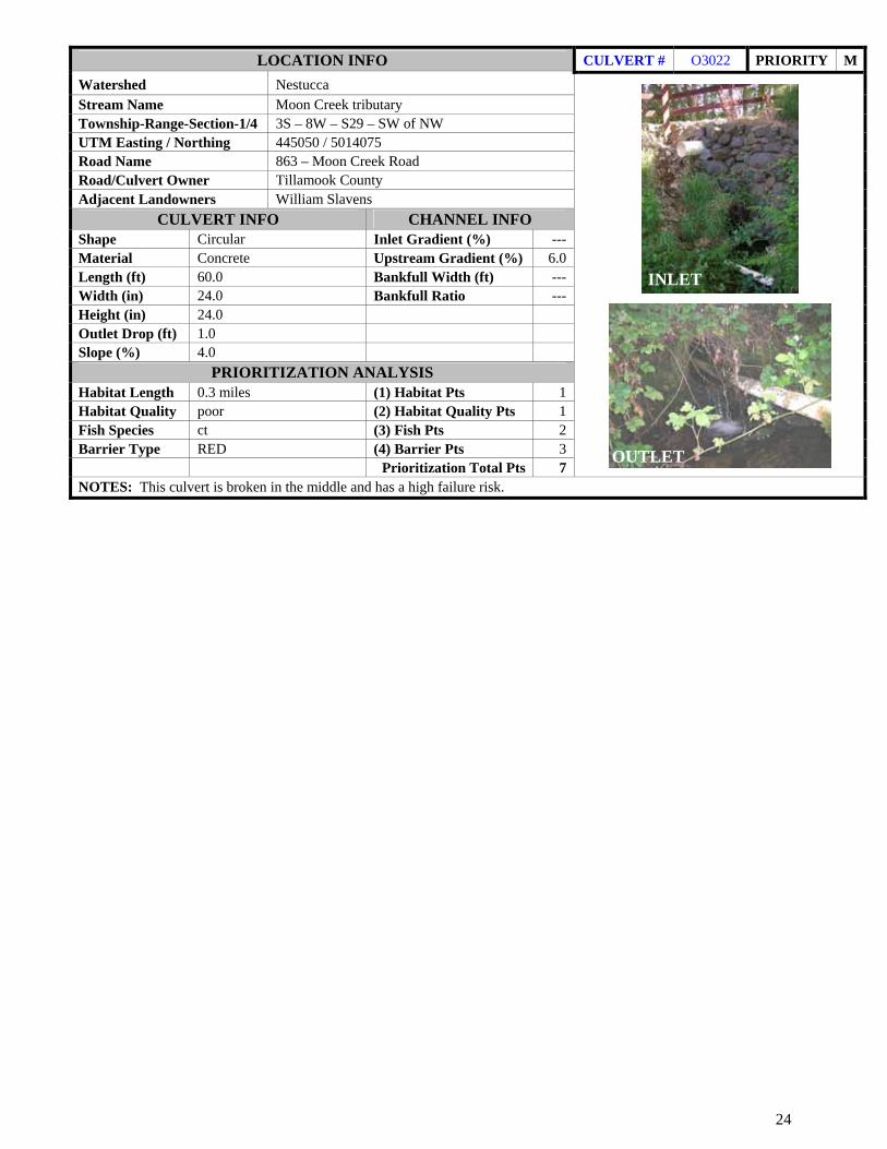
LOCATION INFO CULVERT # O3022 PRIORITY M
Watershed Nestucca Stream Name Moon Creek tributary Township-Range-Section-1/4 3S – 8W – S29 – SW of NW UTM Easting / Northing 445050 / 5014075 Road Name 863 – Moon Creek Road Road/Culvert Owner Tillamook County Adjacent Landowners William Slavens
CULVERT INFO CHANNEL INFO Shape Circular Inlet Gradient (%) --- Material Concrete Upstream Gradient (%) 6.0 Length (ft) 60.0 Bankfull Width (ft) --- Width (in) 24.0 Bankfull Ratio --- Height (in) 24.0 Outlet Drop (ft) 1.0 Slope (%) 4.0
PRIORITIZATION ANALYSIS Habitat Length 0.3 miles (1) Habitat Pts 1 Habitat Quality poor (2) Habitat Quality Pts 1 Fish Species ct (3) Fish Pts 2 Barrier Type RED (4) Barrier Pts 3 Prioritization Total Pts 7
NOTES: This culvert is broken in the middle and has a high failure risk.
OUTLET
INLET

25
6 – EAST CREEK Total Habitat Gained: 2.3 miles
Both culverts are located on BLM-managed roads and land. The lower culvert on the mainstem marks the beginning of a highly productive salmon reach upstream. In 2005, Tillamook County upgraded the bridge at East Creek’s confluence with Moon Creek. Potential Partners: BLM (lead), TEP, NNWC
LOCATION INFO CULVERT # 1122 PRIORITY H
Watershed Nestucca Stream Name East Creek (Moon Creek) Township-Range-Section-1/4 3S – 8W – S15 – SW of NW UTM Easting / Northing 447919 / 5017594 Road Name 3727 – East Creek Road Road/Culvert Owner BLM Adjacent Landowners BLM
CULVERT INFO CHANNEL INFO Shape Circular Inlet Gradient (%) 3.0 Material Corrugated metal Upstream Gradient (%) 3.0 Length (ft) 119.0 Bankfull Width (ft) 47.0 Width (in) 144.0 Bankfull Ratio 0.3 Height (in) 144.0 Outlet Drop (ft) 0.7 Slope (%) 2.0
PRIORITIZATION ANALYSIS Habitat Length 2.3 miles (1) Habitat Pts 4 Habitat Quality good (2) Habitat Quality Pts 3 Fish Species co stw chf ct (3) Fish Pts 3 Barrier Type RED (4) Barrier Pts 3 Prioritization Total Pts 13
NOTES: BLM has completed an Environmental Assessment for replacement of this culvert.
LOCATION INFO CULVERT # 2016 PRIORITY M
Watershed Nestucca Stream Name East Creek tributary Township-Range-Section-1/4 3S– 8W – S15 – NE of NW UTM Easting / Northing 448137 / 5017918 Road Name 3727 – East Creek Road Road/Culvert Owner BLM Adjacent Landowners BLM
CULVERT INFO CHANNEL INFO Shape Circular Inlet Gradient (%) 3.0 Material Corrugated metal Upstream Gradient (%) 5.0 Length (ft) 60.0 Bankfull Width (ft) 15.2 Width (in) 42.0 Bankfull Ratio 0.2 Height (in) 42.0 Outlet Drop (ft) 0.0 Slope (%) 2.0
PRIORITIZATION ANALYSIS Habitat Length 0.2 miles (1) Habitat Pts 1 Habitat Quality fair (2) Habitat Quality Pts 2 Fish Species co stw ct (3) Fish Pts 3 Barrier Type RED (4) Barrier Pts 3 Prioritization Total Pts 9
OUTLET
INLET
OUTLET

26
7 – BAYS CREEK Total Habitat Gained: 1.2 miles
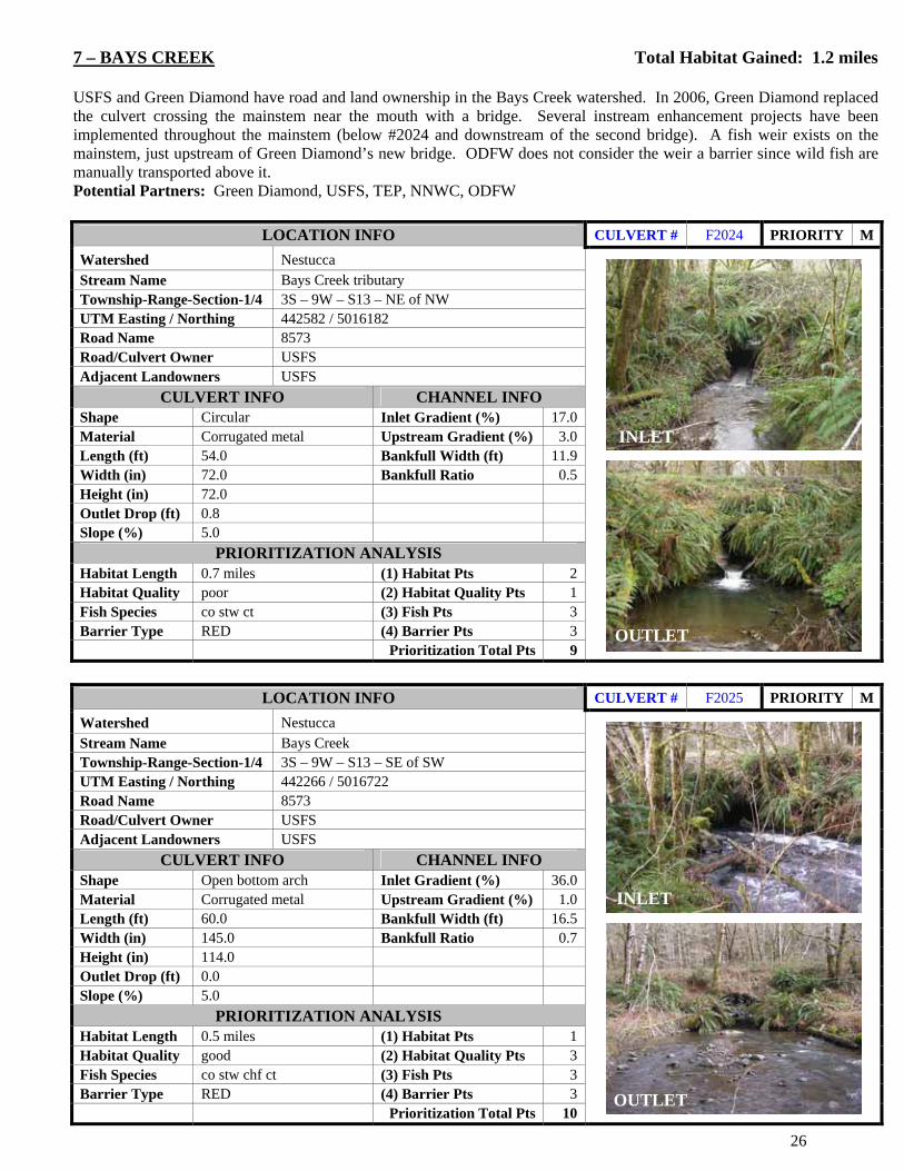
USFS and Green Diamond have road and land ownership in the Bays Creek watershed. In 2006, Green Diamond replaced the culvert crossing the mainstem near the mouth with a bridge. Several instream enhancement projects have been implemented throughout the mainstem (below #2024 and downstream of the second bridge). A fish weir exists on the mainstem, just upstream of Green Diamond’s new bridge. ODFW does not consider the weir a barrier since wild fish are manually transported above it. Potential Partners: Green Diamond, USFS, TEP, NNWC, ODFW
LOCATION INFO CULVERT # F2024 PRIORITY M
Watershed Nestucca Stream Name Bays Creek tributary Township-Range-Section-1/4 3S – 9W – S13 – NE of NW UTM Easting / Northing 442582 / 5016182 Road Name 8573 Road/Culvert Owner USFS Adjacent Landowners USFS
CULVERT INFO CHANNEL INFO Shape Circular Inlet Gradient (%) 17.0 Material Corrugated metal Upstream Gradient (%) 3.0 Length (ft) 54.0 Bankfull Width (ft) 11.9 Width (in) 72.0 Bankfull Ratio 0.5 Height (in) 72.0 Outlet Drop (ft) 0.8 Slope (%) 5.0
PRIORITIZATION ANALYSIS Habitat Length 0.7 miles (1) Habitat Pts 2 Habitat Quality poor (2) Habitat Quality Pts 1 Fish Species co stw ct (3) Fish Pts 3 Barrier Type RED (4) Barrier Pts 3 Prioritization Total Pts 9
LOCATION INFO CULVERT # F2025 PRIORITY M
Watershed Nestucca Stream Name Bays Creek Township-Range-Section-1/4 3S – 9W – S13 – SE of SW UTM Easting / Northing 442266 / 5016722 Road Name 8573 Road/Culvert Owner USFS Adjacent Landowners USFS
CULVERT INFO CHANNEL INFO Shape Open bottom arch Inlet Gradient (%) 36.0 Material Corrugated metal Upstream Gradient (%) 1.0 Length (ft) 60.0 Bankfull Width (ft) 16.5 Width (in) 145.0 Bankfull Ratio 0.7 Height (in) 114.0 Outlet Drop (ft) 0.0 Slope (%) 5.0
PRIORITIZATION ANALYSIS Habitat Length 0.5 miles (1) Habitat Pts 1 Habitat Quality good (2) Habitat Quality Pts 3 Fish Species co stw chf ct (3) Fish Pts 3 Barrier Type RED (4) Barrier Pts 3 Prioritization Total Pts 10
OUTLET
INLET
OUTLET
INLET


27
8 – BOULDER CREEK Total Habitat Gained: 4.1 miles
All three culverts occur on Tillamook County-managed roads (Blankenship and Blaine), with adjacent private landowners. Due to the very close proximity of these culverts, this is an ideal situation to utilize on-the-ground and planning efficiencies. Since these culverts are not currently failing, but instead pose fish passage problems, a partner other than Tillamook County will likely need to lead enhancement efforts. Potential Partners: Tillamook County, TEP, NNWC, ODFW, private landowners
LOCATION INFO CULVERT # 1237 PRIORITY H
Watershed Nestucca Stream Name Boulder Creek Township-Range-Section-1/4 3S – 9W – S26 – SW of NE UTM Easting / Northing 441128 / 5014415 Road Name Blankenship Road Road/Culvert Owner Tillamook County Adjacent Landowners Walter Blankenship, Tillamook County
CULVERT INFO CHANNEL INFO Shape Pipe arch Inlet Gradient (%) 9.0 Material Corrugated metal Upstream Gradient (%) 7.0 Length (ft) 32.5 Bankfull Width (ft) 17.0 Width (in) 108.0 Bankfull Ratio 0.5 Height (in) 72.0 Outlet Drop (ft) 0.0 Slope (%) 2.0
PRIORITIZATION ANALYSIS Habitat Length 4.1 miles (1) Habitat Pts 4 Habitat Quality fair (2) Habitat Quality Pts 2 Fish Species co stw chf ct (3) Fish Pts 3 Barrier Type GREY (4) Barrier Pts 2 Prioritization Total Pts 11
LOCATION INFO CULVERT # 1245 PRIORITY H
Watershed Nestucca Stream Name Boulder Creek Township-Range-Section-1/4 3S – 9W – S26 – SW of NE UTM Easting / Northing 441870 / 5014283 Road Name Blaine Road Road/Culvert Owner Tillamook County Adjacent Landowners Lowell Schrock, Tillamook County
CULVERT INFO CHANNEL INFO Shape Circular Inlet Gradient (%) 11.0 Material Corrugated metal Upstream Gradient (%) 3.0 Length (ft) 95.0 Bankfull Width (ft) 24.5 Width (in) 126.0 Bankfull Ratio 0.4 Height (in) 126.0 Outlet Drop (ft) 0.0 Slope (%) 4.0
PRIORITIZATION ANALYSIS Habitat Length 4.0 miles (1) Habitat Pts 4 Habitat Quality fair (2) Habitat Quality Pts 2 Fish Species co stw chf ct (3) Fish Pts 3 Barrier Type RED (4) Barrier Pts 3 Prioritization Total Pts 12
OUTLET
INLET
OUTLET
INLET

28
LOCATION INFO CULVERT # 1264 PRIORITY H
Watershed Nestucca Stream Name Boulder Creek Township-Range-Section-1/4 3S – 9W – S26 – SW of NE UTM Easting / Northing 441315 / 5014134 Road Name Boulder Creek Road (old) Road/Culvert Owner Tillamook County Adjacent Landowners Lowell Schrock, Reuben Schrock
CULVERT INFO CHANNEL INFO Shape Pipe arch Inlet Gradient (%) 2.0 Material Corrugated metal Upstream Gradient (%) 4.0 Length (ft) 42.6 Bankfull Width (ft) 23.6 Width (in) 108.0 Bankfull Ratio 0.4 Height (in) 96.0 Outlet Drop (ft) 0.4 Slope (%) 2.0
PRIORITIZATION ANALYSIS Habitat Length 3.9 miles (1) Habitat Pts 4 Habitat Quality fair (2) Habitat Quality Pts 2 Fish Species co stw chf ct (3) Fish Pts 3 Barrier Type RED (4) Barrier Pts 3 Prioritization Total Pts 12
OUTLET
INLET


29
9 – UNNAMED TRIBUTARIES Total Habitat Gained: 0.7 miles
Culverts #1253 and #1278 are on unnamed tributaries to the mainstem Nestucca River. Although ranked as medium priorities, their proximity to each other has offered a clustering opportunity. Potential Partners: Tillamook County, TEP, NNWC, ODFW, private landowners
LOCATION INFO CULVERT # 1253 PRIORITY M
Watershed Nestucca Stream Name Nestucca River tributary Township-Range-Section-1/4 3S – 9W – S27 – SW of NW UTM Easting / Northing 438633 / 5014230 Road Name Blaine Road Road/Culvert Owner Tillamook County Adjacent Landowners Doris Sorenson Trust
CULVERT INFO CHANNEL INFO Shape Circular Inlet Gradient (%) 9.0 Material Concrete/Corrugated metal Upstream Gradient (%) 4.0 Length (ft) 53.0 Bankfull Width (ft) 11.0 Width (in) 42.0 Bankfull Ratio 0.3 Height (in) 42.0 Outlet Drop (ft) 1.5 Slope (%) 12.0
PRIORITIZATION ANALYSIS Habitat Length 0.3 miles (1) Habitat Pts 1 Habitat Quality poor (2) Habitat Quality Pts 1 Fish Species co ct (3) Fish Pts 3 Barrier Type RED (4) Barrier Pts 3 Prioritization Total Pts 8
LOCATION INFO CULVERT # 1278 PRIORITY M
Watershed Nestucca Stream Name Nestucca River tributary Township-Range-Section-1/4 3S – 9W – S27 – NW of SW UTM Easting / Northing 438599 / 5014078 Road Name Unnamed Road/Culvert Owner Private Adjacent Landowners Doris Sorenson Trust
CULVERT INFO CHANNEL INFO Shape Circular Inlet Gradient (%) 12.0 Material Corrugated metal Upstream Gradient (%) 2.0 Length (ft) 24.0 Bankfull Width (ft) 6.0 Width (in) 24.0 Bankfull Ratio 0.3 Height (in) 24.0 Outlet Drop (ft) 0.0 Slope (%) 4.0
PRIORITIZATION ANALYSIS Habitat Length 0.4 miles (1) Habitat Pts 1 Habitat Quality poor (2) Habitat Quality Pts 1 Fish Species co ct (3) Fish Pts 3 Barrier Type RED (4) Barrier Pts 3 Prioritization Total Pts 8
OUTLET
OUTLET
INLET

30
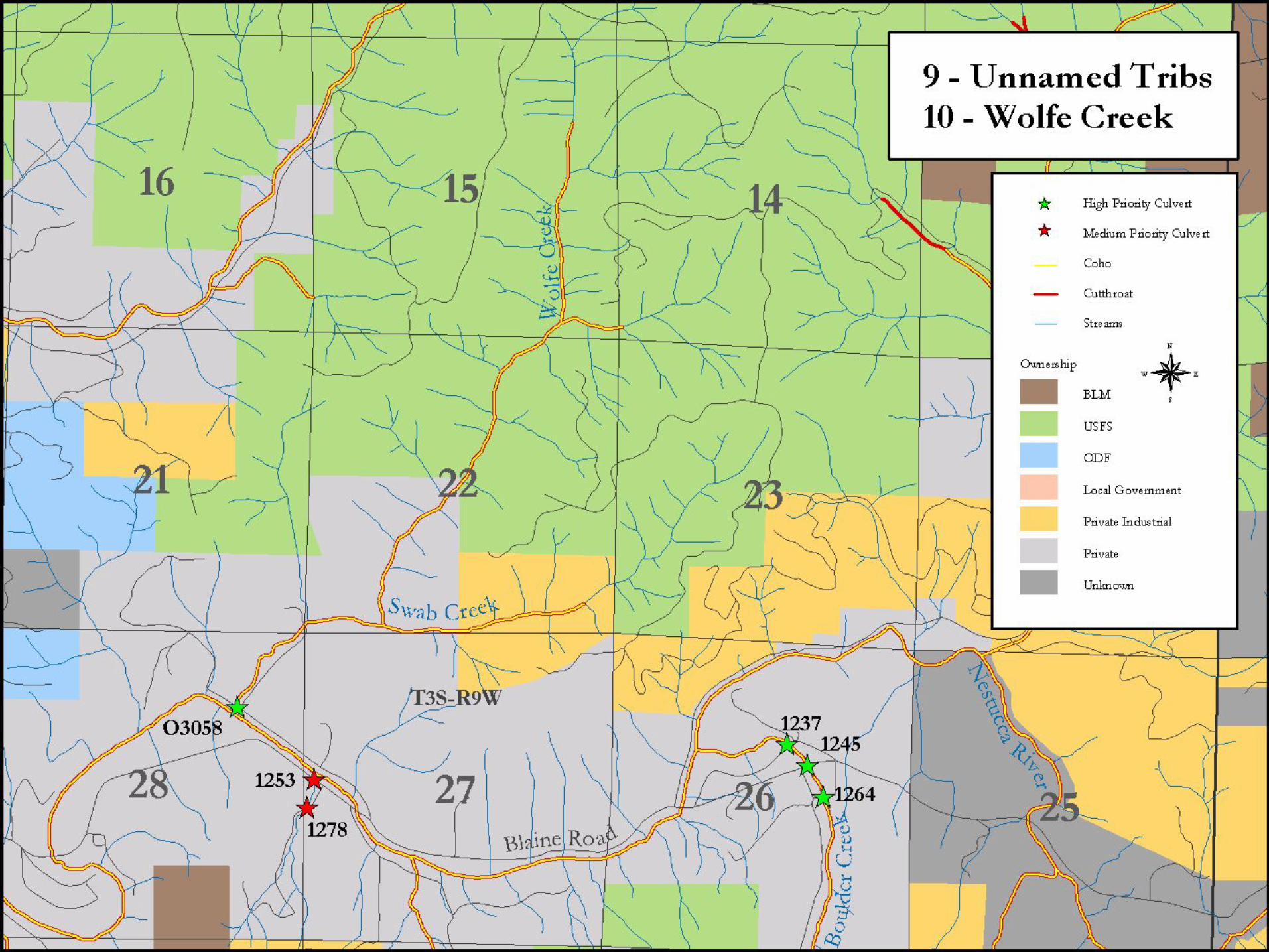
10 – WOLFE CREEK Total Habitat Gained: 4.4 miles
Engineering for replacing this culvert is underway and on-the-ground construction is scheduled for 2007. Along with the culvert replacement, adjacent landowners have agreed to extensive instream and riparian enhancements. ODFW is assisting with instream enhancement designs and the NNWC is assisting with riparian enhancements. All partners listed below are contributing match to the project. Potential Partners: TEP (lead), Tillamook County, USFS, NNWC, ODFW, private landowners
LOCATION INFO CULVERT # O3058 PRIORITY H
Watershed Nestucca Stream Name Wolfe Creek Township-Range-Section-1/4 3S – 9W – S28 – NE of NE UTM Easting / Northing 438210 / 5014600 Road Name 860 – Wolfe Creek Road Road/Culvert Owner Tillamook County Adjacent Landowners Thomas Deyoe, Bryan Measor
CULVERT INFO CHANNEL INFO Shape Circular Inlet Gradient (%) 3.0 Material Corrugated metal Upstream Gradient (%) 4.0 Length (ft) 65.0 Bankfull Width (ft) 30.0 Width (in) 120.0 Bankfull Ratio 0.3 Height (in) 120.0 Outlet Drop (ft) 0.1 Slope (%) 2.0
PRIORITIZATION ANALYSIS Habitat Length 4.4 miles (1) Habitat Pts 4 Habitat Quality good (2) Habitat Quality Pts 3 Fish Species co stw chf ct (3) Fish Pts 3 Barrier Type RED (4) Barrier Pts 3 Prioritization Total Pts 13
DOWNSTREAM
OUTLET
31
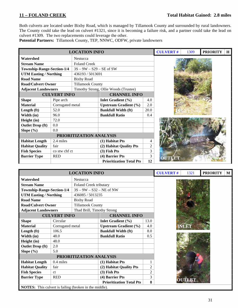
11 – FOLAND CREEK Total Habitat Gained: 2.8 miles
Both culverts are located under Bixby Road, which is managed by Tillamook County and surrounded by rural landowners. The County could take the lead on culvert #1321, since it is becoming a failure risk, and a partner could take the lead on culvert #1309. The two replacements could leverage the other. Potential Partners: Tillamook County, TEP, NNWC, ODFW, private landowners
LOCATION INFO CULVERT # 1309 PRIORITY H
Watershed Nestucca Stream Name Foland Creek Township-Range-Section-1/4 3S – 9W – S29 – SE of SW UTM Easting / Northing 436193 / 5013691 Road Name Bixby Road Road/Culvert Owner Tillamook County Adjacent Landowners Timothy Strong, Ollie Woods (Trustee)
CULVERT INFO CHANNEL INFO Shape Pipe arch Inlet Gradient (%) 4.0 Material Corrugated metal Upstream Gradient (%) 2.0 Length (ft) 52.0 Bankfull Width (ft) 20.0 Width (in) 96.0 Bankfull Ratio 0.4 Height (in) 72.0 Outlet Drop (ft) 0.0 Slope (%) 0.0
PRIORITIZATION ANALYSIS Habitat Length 2.4 miles (1) Habitat Pts 4 Habitat Quality fair (2) Habitat Quality Pts 2 Fish Species co stw chf ct (3) Fish Pts 3 Barrier Type RED (4) Barrier Pts 3 Prioritization Total Pts 12
LOCATION INFO CULVERT # 1321 PRIORITY M
Watershed Nestucca Stream Name Foland Creek tributary Township-Range-Section-1/4 3S – 9W – S32 – NE of NW UTM Easting / Northing 436085 / 5013235 Road Name Bixby Road Road/Culvert Owner Tillamook County Adjacent Landowners Thad Brill, Timothy Strong
CULVERT INFO CHANNEL INFO Shape Circular Inlet Gradient (%) 13.0 Material Corrugated metal Upstream Gradient (%) 4.0 Length (ft) 106.5 Bankfull Width (ft) 8.0 Width (in) 48.0 Bankfull Ratio 0.5 Height (in) 48.0 Outlet Drop (ft) 2.0 Slope (%) 5.0
PRIORITIZATION ANALYSIS Habitat Length 0.4 miles (1) Habitat Pts 1 Habitat Quality fair (2) Habitat Quality Pts 2 Fish Species ct (3) Fish Pts 2 Barrier Type RED (4) Barrier Pts 3 Prioritization Total Pts 8
NOTES: This culvert is failing (broken in the middle).
OUTLET
INLET
OUTLET
INLET


32
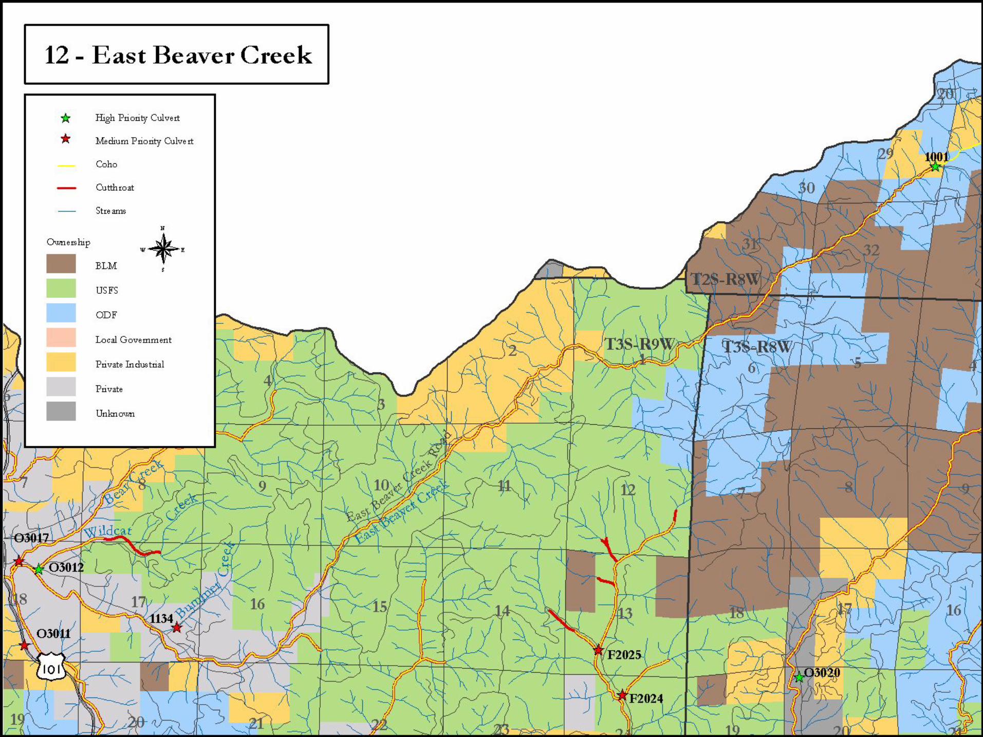
12 – EAST BEAVER CREEK Total Habitat Gained: 7.0 miles
Although #1001 is located on the mainstem in the upper watershed, no other crossings, other than bridges, exist downstream. Culverts #O3012, #O3017, and #1134 are on tributaries to East Beaver Creek in the lower watershed. With the replacement of #1001 in 2006 and #O3012 in 2007, opportunities to replace #O3017 and #1134 within the same time frame should be investigated. Potential Partners: Tillamook County, BLM, Green Diamond, USFS, TEP, NNWC, ODFW, private landowners
LOCATION INFO CULVERT # 1001 PRIORITY H
Watershed Nestucca Stream Name East Beaver Creek Township-Range-Section-1/4 2S – 8W – S29 – NE of SE UTM Easting / Northing 446698 / 5023125 Road Name 857 – East Beaver Creek Road Road/Culvert Owner BLM Adjacent Landowners Green Diamond
CULVERT INFO CHANNEL INFO Shape Pipe arch Inlet Gradient (%) 16.0 Material Corrugated metal Upstream Gradient (%) 9.0 Length (ft) 60.0 Bankfull Width (ft) 24.5 Width (in) 96.0 Bankfull Ratio 0.3 Height (in) 67.0 Outlet Drop (ft) 1.2 Slope (%) 6.0
PRIORITIZATION ANALYSIS Habitat Length 0.5 miles (1) Habitat Pts 1 Habitat Quality good (2) Habitat Quality Pts 3 Fish Species co stw ct (3) Fish Pts 3 Barrier Type RED (4) Barrier Pts 3 Prioritization Total Pts 10
NOTES: BLM has completed an Environmental Assessment for the replacement and is implementation is scheduled for 2006.
OUTLET
INLET

33
LOCATION INFO CULVERT # O3012 PRIORITY H
Watershed Nestucca Stream Name Wildcat Creek (East Beaver Creek) Township-Range-Section-1/4 3S – 9W – S18 – NW of NE UTM Easting / Northing 434925 / 5017825 Road Name East Beaver Creek Road Road/Culvert Owner Tillamook County Adjacent Landowners Richard Clark, James Kessinger
CULVERT INFO CHANNEL INFO Shape Circular Inlet Gradient (%) --- Material Corrugated metal Upstream Gradient (%) 5.0 Length (ft) 60.0 Bankfull Width (ft) --- Width (in) 36.0 Bankfull Ratio --- Height (in) 36.0 Outlet Drop (ft) 0.5 Slope (%) 4.0
PRIORITIZATION ANALYSIS Habitat Length 1.5 miles (1) Habitat Pts 4 Habitat Quality fair (2) Habitat Quality Pts 2 Fish Species co stw ct (3) Fish Pts 3 Barrier Type RED (4) Barrier Pts 3 Prioritization Total Pts 12
NOTES: Low priority culvert #1971 and #1972 are upstream but are not barriers. USFS has completed a design for the replacement of this culvert. NNWC is leading implementation, which is scheduled for 2007.
LOCATION INFO CULVERT # O3017 PRIORITY M
Watershed Nestucca Stream Name Bear Creek (East Beaver Creek) Township-Range-Section-1/4 3S – 9W – S18 – NE of NW UTM Easting / Northing 434665 / 5017925 Road Name 857 – East Beaver Creek Road Road/Culvert Owner Tillamook County Adjacent Landowners James Kessinger, William Miles
CULVERT INFO CHANNEL INFO Shape Open bottom arch Inlet Gradient (%) --- Material Corrugated metal Upstream Gradient (%) --- Length (ft) --- Bankfull Width (ft) --- Width (in) --- Bankfull Ratio --- Height (in) --- Outlet Drop (ft) 0.0 Slope (%) ---
PRIORITIZATION ANALYSIS Habitat Length 4.4 miles (1) Habitat Pts 4 Habitat Quality good (2) Habitat Quality Pts 3 Fish Species co stw chf ct (3) Fish Pts 3 Barrier Type GREY (4) Barrier Pts 2 Prioritization Total Pts 12
OUTLET
OUTLET
INLET
INLET

34
LOCATION INFO CULVERT # 1134 PRIORITY M
Watershed Nestucca Stream Name Bummer Creek (East Beaver Creek) Township-Range-Section-1/4 3S – 9W – S17 – NE of SE UTM Easting / Northing 436721 / 5017066 Road Name Unnamed Road/Culvert Owner Private Adjacent Landowners Curt Schonbrod, Mary Tattoed
CULVERT INFO CHANNEL INFO Shape Circular Inlet Gradient (%) 34.0 Material Corrugated metal Upstream Gradient (%) 6.0 Length (ft) 30.5 Bankfull Width (ft) 10.0 Width (in) 36.0 Bankfull Ratio 0.3 Height (in) 36.0 Outlet Drop (ft) 1.6 Slope (%) 9.0
PRIORITIZATION ANALYSIS Habitat Length 0.6 miles (1) Habitat Pts 2 Habitat Quality good (2) Habitat Quality Pts 3 Fish Species ct (3) Fish Pts 2 Barrier Type RED (4) Barrier Pts 3 Prioritization Total Pts 10

35
13 – WEST BEAVER CREEK Total Habitat Gained: 12.0 miles
Eight culverts are grouped in this cluster, only two of which are ranked as high priorities. However, replacing several medium priority culverts in the same watershed will result in significant watershed improvements. It is unlikely that all eight culverts will be replaced within the same time frame, but smaller clusters can be broken out to leverage replacements. Several opportunities exist within this cluster to replace barriers on lands where owners (private timber companies) regularly implement replacements. Numerous culverts were replaced with the recent completion of the County’s Sandlake-Galloway Road Project. Potential Partners: Green Diamond, Stimson, TEP, NNWC
LOCATION INFO CULVERT # 1031 PRIORITY M
Watershed Nestucca Stream Name Tiger Creek (Beaver Creek) Township-Range-Section-1/4 3S – 9W – S5 – NW of SE UTM Easting / Northing 436455 / 5020165 Road Name Unnamed Road/Culvert Owner Private Adjacent Landowners LaFond Construction
CULVERT INFO CHANNEL INFO Shape Circular Inlet Gradient (%) 3.0 Material Corrugated metal Upstream Gradient (%) 1.0 Length (ft) 52.0 Bankfull Width (ft) 4.5 Width (in) 48.0 Bankfull Ratio 0.9 Height (in) 48.0 Outlet Drop (ft) 1.0 Slope (%) 1.0
PRIORITIZATION ANALYSIS Habitat Length 1.0 miles (1) Habitat Pts 2 Habitat Quality good (2) Habitat Quality Pts 3 Fish Species co stw ct (3) Fish Pts 3 Barrier Type RED (4) Barrier Pts 3 Prioritization Total Pts 11
LOCATION INFO CULVERT # 1065 PRIORITY M
Watershed Nestucca Stream Name Tiger Creek tributary (Beaver Creek) Township-Range-Section-1/4 3S – 9W – S7 – NE of NW UTM Easting / Northing 434430 / 5019555 Road Name Nosacks Road (unofficial name) Road/Culvert Owner Green Diamond Adjacent Landowners Green Diamond
CULVERT INFO CHANNEL INFO Shape Circular Inlet Gradient (%) 1.0 Material Corrugated metal Upstream Gradient (%) 1.0 Length (ft) 27.0 Bankfull Width (ft) 12.6 Width (in) 72.0 Bankfull Ratio 0.5 Height (in) 72.0 Outlet Drop (ft) 0.0 Slope (%) 6.0
PRIORITIZATION ANALYSIS Habitat Length 4.2 miles (1) Habitat Pts 4 Habitat Quality good (2) Habitat Quality Pts 3 Fish Species co stw ct (3) Fish Pts 3 Barrier Type RED (4) Barrier Pts 3 Prioritization Total Pts 13
OUTLET
INLET
INLET

36
LOCATION INFO CULVERT # 1012 PRIORITY M
Watershed Nestucca Stream Name North Beaver Creek tributary Township-Range-Section-1/4 3S – 10W – S3 – SE of NW UTM Easting / Northing 429932 / 5020960 Road Name 310B Road/Culvert Owner Stimson Lumber Adjacent Landowners Stimson Lumber
CULVERT INFO CHANNEL INFO Shape Circular Inlet Gradient (%) 2.0 Material Concrete Upstream Gradient (%) 2.0 Length (ft) 50.0 Bankfull Width (ft) 16.7 Width (in) 48.0 Bankfull Ratio 0.2 Height (in) 48.0 Outlet Drop (ft) 0.0 Slope (%) 0.0
PRIORITIZATION ANALYSIS Habitat Length 1.1 miles (1) Habitat Pts 3 Habitat Quality fair (2) Habitat Quality Pts 2 Fish Species co, stw, ct (3) Fish Pts 3 Barrier Type RED (4) Barrier Pts 3 Prioritization Total Pts 11
NOTES: Stimson intends to replace in 2007 or 2008.
LOCATION INFO CULVERT # 1070 PRIORITY M
Watershed Nestucca Stream Name West Beaver Creek tributary Township-Range-Section-1/4 3S – 10W – S10 – SE of NE UTM Easting / Northing 430664 / 5019464 Road Name 370 – Newberg Road Road/Culvert Owner Stimson Lumber Adjacent Landowners Stimson Lumber
CULVERT INFO CHANNEL INFO Shape Circular Inlet Gradient (%) 30.0 Material Corrugated metal Upstream Gradient (%) 3.0 Length (ft) 41.0 Bankfull Width (ft) 7.0 Width (in) 72.0 Bankfull Ratio 0.9 Height (in) 72.0 Outlet Drop (ft) 0.0 Slope (%) 0.0
PRIORITIZATION ANALYSIS Habitat Length 2.8 miles (1) Habitat Pts 4 Habitat Quality fair (2) Habitat Quality Pts 2 Fish Species co stw ct (3) Fish Pts 3 Barrier Type GREY (4) Barrier Pts 2 Prioritization Total Pts 11
OUTLET
INLET

37
LOCATION INFO CULVERT # 1078 PRIORITY H
Watershed Nestucca Stream Name West Beaver Creek tributary Township-Range-Section-1/4 3S – 10W – S11 – NE of SE UTM Easting / Northing 432085 / 5019056 Road Name Unnamed Road/Culvert Owner Green Diamond Adjacent Landowners Green Diamond
CULVERT INFO CHANNEL INFO Shape Circular Inlet Gradient (%) 21.0 Material Corrugated metal Upstream Gradient (%) 4.0 Length (ft) 40.0 Bankfull Width (ft) 18.0 Width (in) 48.0 Bankfull Ratio 0.2 Height (in) 48.0 Outlet Drop (ft) 0.4 Slope (%) 3.0
PRIORITIZATION ANALYSIS Habitat Length 0.9 miles (1) Habitat Pts 2 Habitat Quality good (2) Habitat Quality Pts 3 Fish Species co stw ct (3) Fish Pts 3 Barrier Type RED (4) Barrier Pts 3 Prioritization Total Pts 11
NOTES: Culvert #O3055 downstream was replaced in 2005 with a backwatered, countersunk concrete box culvert (good passage).
LOCATION INFO CULVERT # 1083 PRIORITY H
Watershed Nestucca Stream Name West Beaver Creek tributary Township-Range-Section-1/4 3S – 10W – S10 – NE of SE UTM Easting / Northing 430552 / 5018919 Road Name Unnamed Road/Culvert Owner Green Diamond Adjacent Landowners Green Diamond
CULVERT INFO CHANNEL INFO Shape Circular Inlet Gradient (%) 30.0 Material Corrugated metal Upstream Gradient (%) 1.0 Length (ft) 22.5 Bankfull Width (ft) 13.0 Width (in) 66.0 Bankfull Ratio 0.4 Height (in) 66.0 Outlet Drop (ft) 0.9 Slope (%) 2.0
PRIORITIZATION ANALYSIS Habitat Length 2.0 miles (1) Habitat Pts 4 Habitat Quality good (2) Habitat Quality Pts 3 Fish Species co stw ct (3) Fish Pts 3 Barrier Type RED (4) Barrier Pts 3 Prioritization Total Pts 13
NOTES: This culvert is failing.
OUTLET
INLET
OUTLET
INLET

38
LOCATION INFO CULVERT # 1108 PRIORITY M
Watershed Nestucca Stream Name West Beaver Creek tributary Township-Range-Section-1/4 3S – 10W – S14 – NW of NE UTM Easting / Northing 431980 / 5018260 Road Name Unnamed Road/Culvert Owner Green Diamond Adjacent Landowners Green Diamond
CULVERT INFO CHANNEL INFO Shape Circular Inlet Gradient (%) 4.0 Material Corrugated metal Upstream Gradient (%) 6.0 Length (ft) 71.0 Bankfull Width (ft) 15.0 Width (in) 48.0 Bankfull Ratio 0.3 Height (in) 48.0 Outlet Drop (ft) 0.5 Slope (%) 3.0
PRIORITIZATION ANALYSIS Habitat Length 0.3 miles (1) Habitat Pts 1 Habitat Quality good (2) Habitat Quality Pts 3 Fish Species ct (3) Fish Pts 2 Barrier Type RED (4) Barrier Pts 3 Prioritization Total Pts 9
LOCATION INFO CULVERT # 1121 PRIORITY M
Watershed Nestucca Stream Name West Beaver Creek tributary Township-Range-Section-1/4 3S – 10W – S14 – NW of SW UTM Easting / Northing 431010 / 5017689 Road Name Unnamed Road/Culvert Owner Green Diamond Adjacent Landowners Green Diamond
CULVERT INFO CHANNEL INFO Shape Circular Inlet Gradient (%) 20.0 Material Corrugated metal Upstream Gradient (%) 4.0 Length (ft) 63.0 Bankfull Width (ft) 11.0 Width (in) 36.0 Bankfull Ratio 0.3 Height (in) 36.0 Outlet Drop (ft) 0.9 Slope (%) 3.0
PRIORITIZATION ANALYSIS Habitat Length 0.3 miles (1) Habitat Pts 1 Habitat Quality fair (2) Habitat Quality Pts 2 Fish Species ct (3) Fish Pts 2 Barrier Type RED (4) Barrier Pts 3 Prioritization Total Pts 8
INLET
OUTLET
OUTLET


39
14 – WEST CREEK Total Habitat Gained: 0.9 miles
These three culverts are under a USFS-managed road on separate tributaries draining into West Creek’s mainstem. A downstream culvert on the mainstem has recently been permanently removed. The USFS could take the lead on implementing replacements with the potential for assistance from several partners. Potential Partners: USFS (lead), Forest Capital Partners, Green Diamond, TEP, NNWC, private landowners
LOCATION INFO CULVERT # F3 PRIORITY M
Watershed Nestucca Stream Name West Creek tributary Township-Range-Section-1/4 3S – 10W – S24 – NE of SE UTM Easting / Northing 433595 / 5015412 Road Name 1004 Road/Culvert Owner USFS Adjacent Landowners Forest Capital Partners LLC
CULVERT INFO CHANNEL INFO Shape Circular Inlet Gradient (%) 17.0 Material Corrugated metal Upstream Gradient (%) 1.0 Length (ft) 36.0 Bankfull Width (ft) 5.3 Width (in) 24.0 Bankfull Ratio 0.4 Height (in) 24.0 Outlet Drop (ft) 1.9 Slope (%) 2.0
PRIORITIZATION ANALYSIS Habitat Length 0.2 miles (1) Habitat Pts 1 Habitat Quality good (2) Habitat Quality Pts 3 Fish Species co stw ct (3) Fish Pts 3 Barrier Type RED (4) Barrier Pts 3 Prioritization Total Pts 10
NOTES: This culvert is failing and the inlet is partially blocked.
OUTLET
INLET

40
LOCATION INFO CULVERT # 1203 PRIORITY M
Watershed Nestucca Stream Name West Creek tributary Township-Range-Section-1/4 3S – 9W – S19 – SE of SW UTM Easting / Northing 434354 / 5015198 Road Name 1004 Road/Culvert Owner USFS Adjacent Landowners Lucia Duvall, Thomas Ullmann, Lloyd Redford
CULVERT INFO CHANNEL INFO Shape Circular Inlet Gradient (%) 14.0 Material Corrugated metal Upstream Gradient (%) 3.0 Length (ft) 31.0 Bankfull Width (ft) 9.0 Width (in) 24.0 Bankfull Ratio 0.2 Height (in) 24.0 Outlet Drop (ft) 1.7 Slope (%) 3.0
PRIORITIZATION ANALYSIS Habitat Length 0.6 miles (1) Habitat Pts 2 Habitat Quality good (2) Habitat Quality Pts 3 Fish Species ct (3) Fish Pts 2 Barrier Type RED (4) Barrier Pts 3 Prioritization Total Pts 10
NOTES: This culvert is failing.
LOCATION INFO CULVERT # 1213 PRIORITY M
Watershed Nestucca Stream Name West Creek tributary Township-Range-Section-1/4 3S – 9W – S30 – NE of NW UTM Easting / Northing 434583 / 5015055 Road Name 1004 Road/Culvert Owner USFS Adjacent Landowners Green Diamond, Clayton Rees
CULVERT INFO CHANNEL INFO Shape Circular Inlet Gradient (%) 39.0 Material Corrugated metal Upstream Gradient (%) 5.0 Length (ft) 40.0 Bankfull Width (ft) 9.0 Width (in) 18.0 Bankfull Ratio 0.2 Height (in) 18.0 Outlet Drop (ft) 0.7 Slope (%) 7.0
PRIORITIZATION ANALYSIS Habitat Length 0.1 miles (1) Habitat Pts 1 Habitat Quality good (2) Habitat Quality Pts 3 Fish Species co stw ct (3) Fish Pts 3 Barrier Type GREY (4) Barrier Pts 2 Prioritization Total Pts 9
INLET
OUTLET
OUTLET


41
15 – FARMER CREEK Total Habitat Gained: 3.7 miles
This cluster is comprised of two high priority culverts on tributaries in the upper watershed and one medium priority culvert on the mainstem downstream. The medium priority culvert, #O3032, is currently passing fish at some flows, but has potential to develop into a more significant barrier due to being undersized. A 2 foot concrete dam at rivermile 0.44 is a more inhibitive fish barrier. According to the RBA, the dam may be limiting the upstream distribution of juvenile salmon from the mainstem Nestucca. Farmer Creek is identified as a high priority instream enhancement site by ODFW. Potential Partners: Tillamook County, Green Diamond, USFS, TEP, NNWC, ODFW, private landowners
LOCATION INFO CULVERT # O3032 PRIORITY M
Watershed Nestucca Stream Name Farmer Creek Township-Range-Section-1/4 4S – 10W – S1 – SW of NW UTM Easting / Northing 432420 / 5011350 Road Name 880 – Farmer Creek Road Road/Culvert Owner Tillamook County Adjacent Landowners William Loewen, Nora Welty, State of Oregon
CULVERT INFO CHANNEL INFO Shape Circular Inlet Gradient (%) --- Material Corrugated metal Upstream Gradient (%) 3.0 Length (ft) 60.0 Bankfull Width (ft) --- Width (in) 96.0 Bankfull Ratio --- Height (in) 96.0 Outlet Drop (ft) 0.7 Slope (%) 2.0
PRIORITIZATION ANALYSIS Habitat Length 3.7 miles (1) Habitat Pts 4 Habitat Quality good (2) Habitat Quality Pts 3 Fish Species co stw chf ct chum (3) Fish Pts 3 Barrier Type RED (4) Barrier Pts 3 Prioritization Total Pts 13
LOCATION INFO CULVERT # F23 PRIORITY H
Watershed Nestucca Stream Name Farmer Creek tributary Township-Range-Section-1/4 4S – 10W – S3 – NE of NE UTM Easting / Northing 430342 / 5011773 Road Name 880 – Farmer Creek Road Road/Culvert Owner USFS Adjacent Landowners Green Diamond
CULVERT INFO CHANNEL INFO Shape Open Bottom Arch Inlet Gradient (%) --- Material Corrugated metal Upstream Gradient (%) --- Length (ft) 41.0 Bankfull Width (ft) 15.0 Width (in) 102.0 Bankfull Ratio 0.6 Height (in) 94.0 Outlet Drop (ft) 0.0 Slope (%) 2.0
PRIORITIZATION ANALYSIS Habitat Length 0.8 miles (1) Habitat Pts 2 Habitat Quality fair (2) Habitat Quality Pts 2 Fish Species co stw ct (3) Fish Pts 3 Barrier Type GREY (4) Barrier Pts 2 Prioritization Total Pts 9
OUTLET
INLET
OUTLET

42
LOCATION INFO CULVERT # F24 PRIORITY H
Watershed Nestucca Stream Name Farmer Creek tributary Township-Range-Section-1/4 4S – 10W – S3 – NW of NE UTM Easting / Northing 430159 / 5011964 Road Name 1034 Road/Culvert Owner USFS Adjacent Landowners Green Diamond
CULVERT INFO CHANNEL INFO Shape Circular Inlet Gradient (%) 9.0 Material Corrugated metal Upstream Gradient (%) 1.0 Length (ft) 38.5 Bankfull Width (ft) 6.3 Width (in) 60.0 Bankfull Ratio 0.8 Height (in) 60.0 Outlet Drop (ft) 1.8 Slope (%) 3.0
PRIORITIZATION ANALYSIS Habitat Length 0.2 miles (1) Habitat Pts 1 Habitat Quality fair (2) Habitat Quality Pts 2 Fish Species co stw chf ct (3) Fish Pts 3 Barrier Type RED (4) Barrier Pts 3 Prioritization Total Pts 9
NOTES: USFS design is complete. No implementation is scheduled.
OUTLET
INLET


43
16 – GEORGE CREEK Total Habitat Gained: 0.9 miles
This high priority culvert is isolated in the watershed, with no medium or high priority barriers in its vicinity for clustering, which is not necessarily negative. The presence of chum salmon should further elevate the importance of replacing this culvert. Potential Partners: Tillamook County, TEP, NNWC, ODFW, private landowners
LOCATION INFO CULVERT # 1412 PRIORITY H
Watershed Nestucca Stream Name George Creek Township-Range-Section-1/4 4S – 10W – S12 – SW of NE UTM Easting / Northing 433164 / 5009810 Road Name Evergreen Drive Road/Culvert Owner Private Adjacent Landowners Mark Cavatorta
CULVERT INFO CHANNEL INFO Shape Circular Inlet Gradient (%) 7.0 Material Corrugated metal Upstream Gradient (%) 4.0 Length (ft) 36.0 Bankfull Width (ft) 30.0 Width (in) 60.0 Bankfull Ratio 0.2 Height (in) 60.0 Outlet Drop (ft) 0.0 Slope (%) 3.0
PRIORITIZATION ANALYSIS Habitat Length 0.9 miles (1) Habitat Pts 2 Habitat Quality fair (2) Habitat Quality Pts 2 Fish Species co stw ct chum (3) Fish Pts 3 Barrier Type RED (4) Barrier Pts 3 Prioritization Total Pts 10
OUTLET
INLET
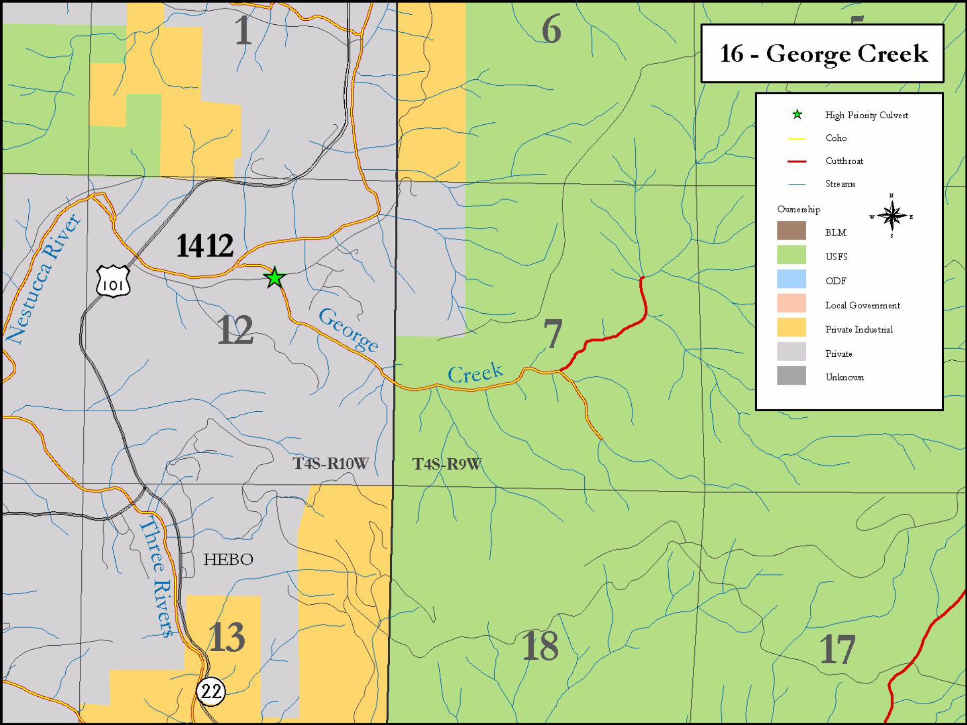

44
17 – THREE RIVERS Total Habitat Gained: 2.3 miles These three culverts reside on private and State owned roads. The potential exists for ODOT to lead an effort in replacing two of the culverts, with potential assistance for partners. One of the limiting factors in this watershed is the Cedar Creek hatchery weir located on the mainstem of Three Rivers. This barrier is being redesigned in an effort led by the US Fish and Wildlife Service. Potential Partners: ODOT, TEP, NNWC, ODFW, private landowners
LOCATION INFO CULVERT # O353 PRIORITY M
Watershed Nestucca Stream Name Woods Creek Township-Range-Section-1/4 5S – 9W – S4 – SW of NW UTM Easting / Northing 436952 / 5001833 Road Name Highway 22 Road/Culvert Owner ODOT Adjacent Landowners Gibbs Family LLC
CULVERT INFO CHANNEL INFO Shape Box Inlet Gradient (%) --- Material Concrete Upstream Gradient (%) 4.0 Length (ft) 50.0 Bankfull Width (ft) --- Width (in) 72.0 Bankfull Ratio --- Height (in) 72.0 Outlet Drop (ft) 0.0 Slope (%) 4.0
PRIORITIZATION ANALYSIS Habitat Length 1.6 miles (1) Habitat Pts 4 Habitat Quality fair (2) Habitat Quality Pts 2 Fish Species ct (3) Fish Pts 2 Barrier Type RED (4) Barrier Pts 3 Prioritization Total Pts 11
LOCATION INFO CULVERT # 1574 PRIORITY M
Watershed Nestucca Stream Name Three Rivers tributary Township-Range-Section-1/4 4S – 9W – S30 – SW of NE UTM Easting / Northing 434705 / 5004948 Road Name 3094 – Big Trout Road Road/Culvert Owner Three Rivers Road District Adjacent Landowners Karl Vogel, Maxine Wright
CULVERT INFO CHANNEL INFO Shape Circular Inlet Gradient (%) 2.0 Material Corrugated metal Upstream Gradient (%) 1.0 Length (ft) 31.0 Bankfull Width (ft) 11.0 Width (in) 60.0 Bankfull Ratio 0.5 Height (in) 60.0 Outlet Drop (ft) 0.9 Slope (%) 2.0
PRIORITIZATION ANALYSIS Habitat Length 0.4 miles (1) Habitat Pts 1 Habitat Quality good (2) Habitat Quality Pts 3 Fish Species co stw chf ct chum (3) Fish Pts 3 Barrier Type RED (4) Barrier Pts 3 Prioritization Total Pts 10
OUTLET
INLET
OUTLET
INLET

45
LOCATION INFO CULVERT # 1724 PRIORITY H
Watershed Nestucca Stream Name Alder Creek Township-Range-Section-1/4 5S – 9W – S17 – NE of SE UTM Easting / Northing 436671 / 4998039 Road Name Highway 22 Road/Culvert Owner ODOT Adjacent Landowners Herbert Crew
CULVERT INFO CHANNEL INFO Shape Circular Inlet Gradient (%) --- Material Corrugated metal Upstream Gradient (%) --- Length (ft) 30.0 Bankfull Width (ft) --- Width (in) 36.0 & 48.0 Bankfull Ratio --- Height (in) 36.0 & 48.0 Outlet Drop (ft) 0.5 & 0.0 Slope (%) ---
PRIORITIZATION ANALYSIS Habitat Length 0.3 miles (1) Habitat Pts 1 Habitat Quality good (2) Habitat Quality Pts 3 Fish Species co stw ct (3) Fish Pts 3 Barrier Type RED (4) Barrier Pts 3 Prioritization Total Pts 10
NOTES: This crossing has two side by side culverts, which equally divert streamflow in the winter (see picture). During the summer, flow is likely concentrated to the larger pipe.
OUTLET
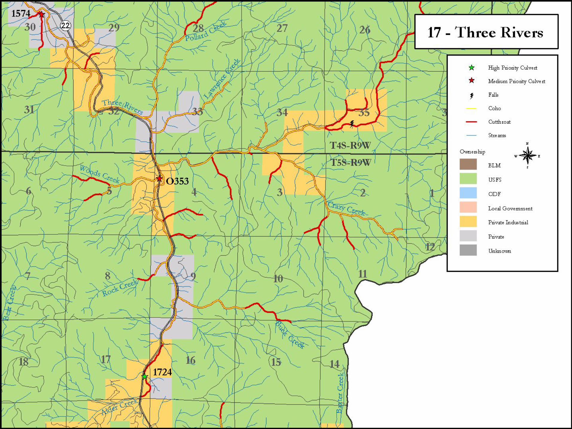

46
18 – HORN CREEK Total Habitat Gained: 5.0 miles
Although within tidal influence, there are no known tidegates on the mainstem of Horn Creek. [One tidegate is located a small tributary.] One culvert is located downstream of #1527, but it is not an adult or juvenile fish barrier. The presence of chum in this watershed should elevate the importance of this culvert replacement. Riparian enhancements should be incorporated with replacing #1527. Potential Partners: NNWC (lead), ODFW, private landowners
LOCATION INFO CULVERT # 1527 PRIORITY H
Watershed Nestucca Stream Name Horn Creek Township-Range-Section-1/4 4S – 10W – S20 – NE of SW UTM Easting / Northing 426612 / 5006208 Road Name Unnamed Road/Culvert Owner Private Adjacent Landowners Carl Hurliman
CULVERT INFO CHANNEL INFO Shape Circular Inlet Gradient (%) 1.0 Material Corrugated metal Upstream Gradient (%) 1.0 Length (ft) 25.0 Bankfull Width (ft) 16.0 Width (in) 72.0 Bankfull Ratio 0.4 Height (in) 72.0 Outlet Drop (ft) 0.0 Slope (%) 0.0
PRIORITIZATION ANALYSIS Habitat Length 5.0 miles (1) Habitat Pts 4 Habitat Quality good (2) Habitat Quality Pts 3 Fish Species co stw ct chum (3) Fish Pts 3 Barrier Type RED (4) Barrier Pts 3 Prioritization Total Pts 13
NOTES: USFS engineering complete. NNWC implementation 2007.
OUTLET
INLET


47
19 – SOURGRASS CREEK Total Habitat Gained: 2.2 miles
This subbasin is one of the most productive tributaries in the Little Nestucca. Despite its productivity, fish passage barriers are watershed concerns. ODOT is scheduled to replace #O355 in 2007 due to failure risks. However, a culvert inhibiting fish passage is located approximately one mile downstream. The replacement of these two projects will be very expensive and partnerships should be an integral planning component. Potential Partners: ODOT, USFS, Green Diamond, TEP, NNWC, ODFW
LOCATION INFO CULVERT # O355 PRIORITY H
Watershed Little Nestucca Stream Name Sourgrass Creek Township-Range-Section-1/4 5S – 9W – S34 – NE of SE UTM Easting / Northing 439952 / 4993262 Road Name Highway 22 Road/Culvert Owner ODOT Adjacent Landowners USFS
CULVERT INFO CHANNEL INFO Shape Circular Inlet Gradient (%) --- Material Corrugated metal Upstream Gradient (%) 2.0 Length (ft) 150.0 Bankfull Width (ft) --- Width (in) 120.0 Bankfull Ratio --- Height (in) 120.0 Outlet Drop (ft) 0.0 Slope (%) 3.0
PRIORITIZATION ANALYSIS Habitat Length 1.2 miles (1) Habitat Pts 3 Habitat Quality good (2) Habitat Quality Pts 3 Fish Species co stw ct (3) Fish Pts 3 Barrier Type GREY (4) Barrier Pts 2 Prioritization Total Pts 11
NOTES: This culvert is located in Yamhill County. ODOT engineering is complete and construction planned for 2007.
OUTLET
INLET

48
LOCATION INFO CULVERT # O356 PRIORITY H
Watershed Little Nestucca Stream Name Sourgrass Creek Township-Range-Section-1/4 5S – 9W – S34 – SE of SW UTM Easting / Northing 438929 / 4994452 Road Name Highway 22 Road/Culvert Owner ODOT Adjacent Landowners Green Diamond
CULVERT INFO CHANNEL INFO Shape Circular Inlet Gradient (%) --- Material Corrugated metal Upstream Gradient (%) 2.0 Length (ft) 120.0 Bankfull Width (ft) --- Width (in) 120.0 Bankfull Ratio --- Height (in) 120.0 Outlet Drop (ft) 2.0 Slope (%) 2.0
PRIORITIZATION ANALYSIS Habitat Length 2.2 miles (1) Habitat Pts 4 Habitat Quality good (2) Habitat Quality Pts 3 Fish Species co stw chf ct (3) Fish Pts 3 Barrier Type RED (4) Barrier Pts 3 Prioritization Total Pts 13
NOTES: This culvert is located in Yamhill County.
LOCATION INFO CULVERT # F734 PRIORITY M
Watershed Little Nestucca Stream Name Sourgrass Creek tributary Township-Range-Section-1/4 5S – 9W – S35 – NW of NE UTM Easting / Northing 440821 / 4993434 Road Name 223411 Road/Culvert Owner USFS Adjacent Landowners USFS
CULVERT INFO CHANNEL INFO Shape Circular Inlet Gradient (%) 4.0 Material Corrugated metal Upstream Gradient (%) 4.0 Length (ft) 70.5 Bankfull Width (ft) 7.6 Width (in) 54.0 Bankfull Ratio 0.6 Height (in) 54.0 Outlet Drop (ft) 0.0 Slope (%) 2.0
PRIORITIZATION ANALYSIS Habitat Length 0.8 miles (1) Habitat Pts 2 Habitat Quality poor (2) Habitat Quality Pts 1 Fish Species ct (3) Fish Pts 2 Barrier Type GREY (4) Barrier Pts 2 Prioritization Total Pts 7
OUTLET
INLET
OUTLET
INLET

49
LOCATION INFO CULVERT # O354 PRIORITY M
Watershed Little Nestucca Stream Name Sourgrass Creek tributary Township-Range-Section-1/4 5S – 9W – S35 – NE of SW UTM Easting / Northing 440738 / 4993143 Road Name Highway 22 Road/Culvert Owner ODOT Adjacent Landowners USFS
CULVERT INFO CHANNEL INFO Shape Circular Inlet Gradient (%) --- Material Concrete Upstream Gradient (%) 3.0 Length (ft) 100.0 Bankfull Width (ft) --- Width (in) 48.0 Bankfull Ratio --- Height (in) 48.0 Outlet Drop (ft) 0.0 Slope (%) 2.0
PRIORITIZATION ANALYSIS Habitat Length 0.7 miles (1) Habitat Pts 2 Habitat Quality poor (2) Habitat Quality Pts 1 Fish Species ct (3) Fish Pts 2 Barrier Type RED (4) Barrier Pts 3 Prioritization Total Pts 8
NOTES: Concrete sill on outlet pool.
OUTLET
INLET


50
20 – LOUIE CREEK / BAXTER CREEK Total Habitat Gained: 4.0 miles
According to the RBA, Louie Creek and its tributaries are the most productive segments of the Little Nestucca basin. The very high densities of coho observed in Louie Creek and its primary tributary Baxter Creek may be initiating density dependent downstream migrations that are contributing significantly to seeding the mainstem Little Nestucca. This observation and the lack of a significant spawning peak in the mainstem, elevate the concern for protection and enhancement of Louie Creek and Baxter Creek. The coho densities observed in Baxter Creek were higher than RBA surveyors had ever observed in any stream corridor in the Midcoast district in the last five years. Only four crossings exist in this watershed. Two are bridges on Louie Creek, downstream of #O3003, and the other two are culverts in this cluster. The lower reach of Louie Creek is identified as a high priority enhancement site by ODFW. Potential Partners: ODOT, Green Diamond, TEP, NNWC, ODFW
LOCATION INFO CULVERT # O3001 PRIORITY M
Watershed Little Nestucca Stream Name Baxter Creek (Louie Creek) Township-Range-Section-1/4 5S – 9W – S28 – SW of NE UTM Easting / Northing 437710 / 4995425 Road Name Highway 22 Road/Culvert Owner ODOT Adjacent Landowners Green Diamond
CULVERT INFO CHANNEL INFO Shape Circular Inlet Gradient (%) --- Material Corrugated metal Upstream Gradient (%) 2.0 Length (ft) 60.0 Bankfull Width (ft) --- Width (in) 112.0 Bankfull Ratio --- Height (in) 112.0 Outlet Drop (ft) 0.0 Slope (%) 1.0
PRIORITIZATION ANALYSIS Habitat Length 2.7 miles (1) Habitat Pts 4 Habitat Quality good (2) Habitat Quality Pts 3 Fish Species co stw chf ct (3) Fish Pts 3 Barrier Type GREY (4) Barrier Pts 2 Prioritization Total Pts 12
NOTES: This culvert is lined with a concrete pad.
OUTLET
INLET

51
LOCATION INFO CULVERT # O3003 PRIORITY H
Watershed Little Nestucca Stream Name Louie Creek Township-Range-Section-1/4 5S – 9W – S28 – SW of NE UTM Easting / Northing 437679 / 4995524 Road Name Highway 22 Road/Culvert Owner ODOT Adjacent Landowners Green Diamond
CULVERT INFO CHANNEL INFO Shape Circular Inlet Gradient (%) --- Material Corrugated metal Upstream Gradient (%) --- Length (ft) --- Bankfull Width (ft) --- Width (in) 60.0 Bankfull Ratio --- Height (in) 60.0 Outlet Drop (ft) 0.2 Slope (%) ---
PRIORITIZATION ANALYSIS Habitat Length 1.3 miles (1) Habitat Pts 3 Habitat Quality good (2) Habitat Quality Pts 3 Fish Species co stw chf ct (3) Fish Pts 3 Barrier Type RED (4) Barrier Pts 3 Prioritization Total Pts 12
OUTLET


52
21 – LITTLE NESTUCCA RIVER RD TRIBUTARIES Total Habitat Gained: 2.0 miles These three culverts are located on tributaries draining into the Little Nestucca River under Highway 130 (Little Nestucca River Road). All three tributaries provide critical summer rearing habitat. The potential exists for ODOT to lead replacement efforts with assistance from partners. Potential Partners: ODOT (lead), TEP, NNWC, ODFW, private landowners
LOCATION INFO CULVERT # O3002 PRIORITY H
Watershed Little Nestucca Stream Name Judson Creek Township-Range-Section-1/4 5S – 9W – S30 – NW of SE UTM Easting / Northing 434450 / 4995100 Road Name Highway 130 Road/Culvert Owner ODOT Adjacent Landowners Kathleen Ziegler, Sashanna Ellinwood
CULVERT INFO CHANNEL INFO Shape Circular Inlet Gradient (%) --- Material Concrete Upstream Gradient (%) 5.0 Length (ft) 60.0 Bankfull Width (ft) --- Width (in) 36.0 Bankfull Ratio --- Height (in) 36.0 Outlet Drop (ft) 0.3 Slope (%) 4.0
PRIORITIZATION ANALYSIS Habitat Length 0.4 miles (1) Habitat Pts 1 Habitat Quality fair (2) Habitat Quality Pts 2 Fish Species co ct (3) Fish Pts 3 Barrier Type RED (4) Barrier Pts 3 Prioritization Total Pts 9
LOCATION INFO CULVERT # O3004 PRIORITY H
Watershed Little Nestucca Stream Name McKnight Creek Township-Range-Section-1/4 5S – 10W – S25 – NE of SE UTM Easting / Northing 433375 / 4995050 Road Name Highway 130 Road/Culvert Owner ODOT Adjacent Landowners Marlon Fessler
CULVERT INFO CHANNEL INFO Shape Circular Inlet Gradient (%) --- Material Corrugated metal Upstream Gradient (%) 3.0 Length (ft) 60.0 Bankfull Width (ft) --- Width (in) 72.0 Bankfull Ratio --- Height (in) 72.0 Outlet Drop (ft) 0.0 Slope (%) 4.0
PRIORITIZATION ANALYSIS Habitat Length 0.8 miles (1) Habitat Pts 2 Habitat Quality poor (2) Habitat Quality Pts 1 Fish Species co stw ct (3) Fish Pts 3 Barrier Type RED (4) Barrier Pts 3 Prioritization Total Pts 9
NOTES: The ODOT survey noted that there is a poor culvert 100’ upstream on private, but GIS layers indicate otherwise.
OUTLET
OUTLET

53
LOCATION INFO CULVERT # O3005 PRIORITY M
Watershed Little Nestucca Stream Name Small Creek Township-Range-Section-1/4 5S – 9W – S30 – NE of SE UTM Easting / Northing 435050 / 4995150 Road Name Highway 130 Road/Culvert Owner ODOT Adjacent Landowners Richard Murray
CULVERT INFO CHANNEL INFO Shape Circular Inlet Gradient (%) --- Material Corrugated metal Upstream Gradient (%) 4.0 Length (ft) 60.0 Bankfull Width (ft) --- Width (in) 48.0 Bankfull Ratio --- Height (in) 48.0 Outlet Drop (ft) 1.7 Slope (%) 2.0
PRIORITIZATION ANALYSIS Habitat Length 0.8 miles (1) Habitat Pts 2 Habitat Quality fair (2) Habitat Quality Pts 2 Fish Species co stw ct (3) Fish Pts 3 Barrier Type RED (4) Barrier Pts 3 Prioritization Total Pts 10
OUTLET
INLET

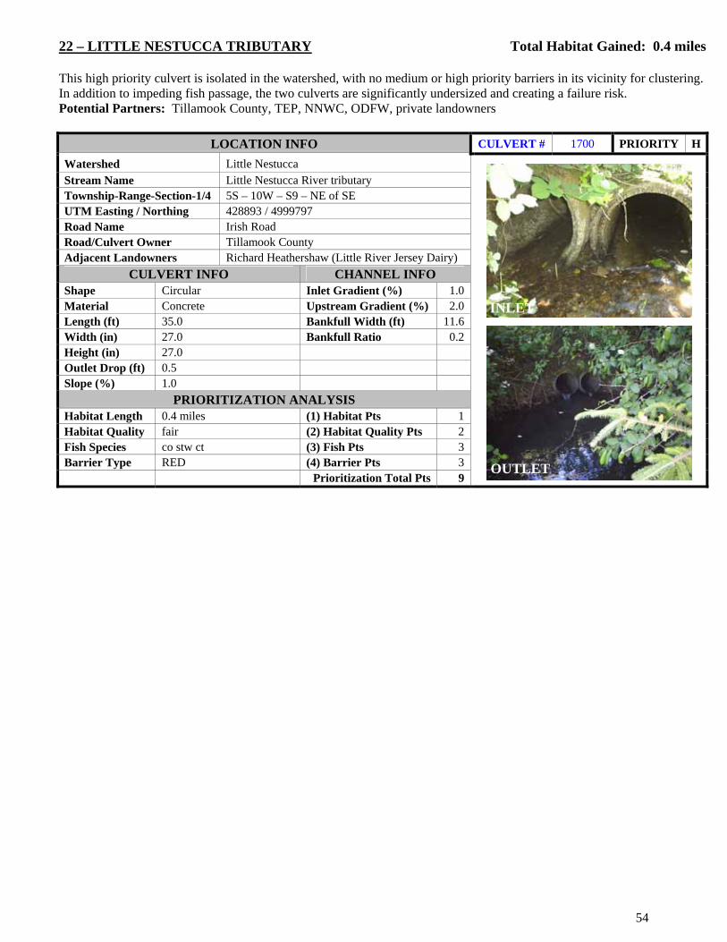
54
22 – LITTLE NESTUCCA TRIBUTARY Total Habitat Gained: 0.4 miles
This high priority culvert is isolated in the watershed, with no medium or high priority barriers in its vicinity for clustering. In addition to impeding fish passage, the two culverts are significantly undersized and creating a failure risk. Potential Partners: Tillamook County, TEP, NNWC, ODFW, private landowners
LOCATION INFO CULVERT # 1700 PRIORITY H
Watershed Little Nestucca Stream Name Little Nestucca River tributary Township-Range-Section-1/4 5S – 10W – S9 – NE of SE UTM Easting / Northing 428893 / 4999797 Road Name Irish Road Road/Culvert Owner Tillamook County Adjacent Landowners Richard Heathershaw (Little River Jersey Dairy)
CULVERT INFO CHANNEL INFO Shape Circular Inlet Gradient (%) 1.0 Material Concrete Upstream Gradient (%) 2.0 Length (ft) 35.0 Bankfull Width (ft) 11.6 Width (in) 27.0 Bankfull Ratio 0.2 Height (in) 27.0 Outlet Drop (ft) 0.5 Slope (%) 1.0
PRIORITIZATION ANALYSIS Habitat Length 0.4 miles (1) Habitat Pts 1 Habitat Quality fair (2) Habitat Quality Pts 2 Fish Species co stw ct (3) Fish Pts 3 Barrier Type RED (4) Barrier Pts 3 Prioritization Total Pts 9
OUTLET
INLET
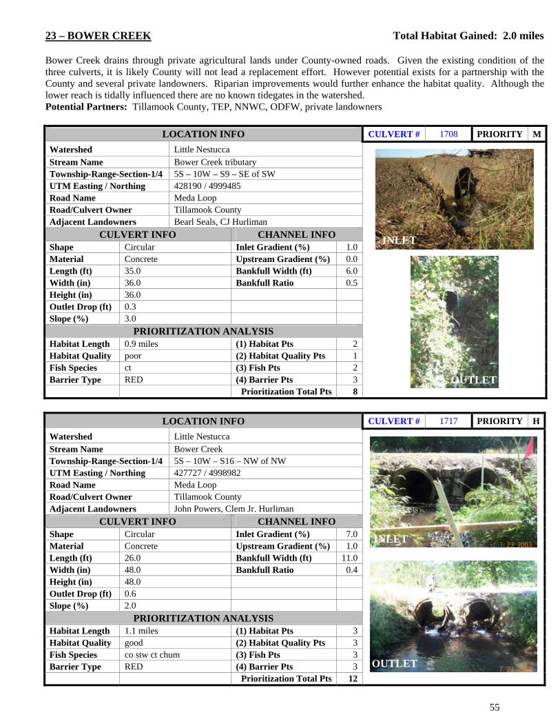
55
23 – BOWER CREEK Total Habitat Gained: 2.0 miles
Bower Creek drains through private agricultural lands under County-owned roads. Given the existing condition of the three culverts, it is likely County will not lead a replacement effort. However potential exists for a partnership with the County and several private landowners. Riparian improvements would further enhance the habitat quality. Although the lower reach is tidally influenced there are no known tidegates in the watershed. Potential Partners: Tillamook County, TEP, NNWC, ODFW, private landowners
LOCATION INFO CULVERT # 1708 PRIORITY M
Watershed Little Nestucca Stream Name Bower Creek tributary Township-Range-Section-1/4 5S – 10W – S9 – SE of SW UTM Easting / Northing 428190 / 4999485 Road Name Meda Loop Road/Culvert Owner Tillamook County Adjacent Landowners Bearl Seals, CJ Hurliman
CULVERT INFO CHANNEL INFO Shape Circular Inlet Gradient (%) 1.0 Material Concrete Upstream Gradient (%) 0.0 Length (ft) 35.0 Bankfull Width (ft) 6.0 Width (in) 36.0 Bankfull Ratio 0.5 Height (in) 36.0 Outlet Drop (ft) 0.3 Slope (%) 3.0
PRIORITIZATION ANALYSIS Habitat Length 0.9 miles (1) Habitat Pts 2 Habitat Quality poor (2) Habitat Quality Pts 1 Fish Species ct (3) Fish Pts 2 Barrier Type RED (4) Barrier Pts 3 Prioritization Total Pts 8
LOCATION INFO CULVERT # 1717 PRIORITY H
Watershed Little Nestucca Stream Name Bower Creek Township-Range-Section-1/4 5S – 10W – S16 – NW of NW UTM Easting / Northing 427727 / 4998982 Road Name Meda Loop Road/Culvert Owner Tillamook County Adjacent Landowners John Powers, Clem Jr. Hurliman
CULVERT INFO CHANNEL INFO Shape Circular Inlet Gradient (%) 7.0 Material Concrete Upstream Gradient (%) 1.0 Length (ft) 26.0 Bankfull Width (ft) 11.0 Width (in) 48.0 Bankfull Ratio 0.4 Height (in) 48.0 Outlet Drop (ft) 0.6 Slope (%) 2.0
PRIORITIZATION ANALYSIS Habitat Length 1.1 miles (1) Habitat Pts 3 Habitat Quality good (2) Habitat Quality Pts 3 Fish Species co stw ct chum (3) Fish Pts 3 Barrier Type RED (4) Barrier Pts 3 Prioritization Total Pts 12
OUTLET
INLET
OUTLET
INLET

56
LOCATION INFO CULVERT # 1719 PRIORITY H
Watershed Little Nestucca Stream Name Bower Creek Township-Range-Section-1/4 5S – 10W – S16 – SW of NW UTM Easting / Northing 427667 / 4998682 Road Name Unnamed Road/Culvert Owner Private Adjacent Landowners John Powers
CULVERT INFO CHANNEL INFO Shape Circular Inlet Gradient (%) 7.0 Material Concrete Upstream Gradient (%) 2.0 Length (ft) 20.0 Bankfull Width (ft) 10.0 Width (in) 36.0 Bankfull Ratio 0.3 Height (in) 36.0 Outlet Drop (ft) 0.7 Slope (%) 7.0
PRIORITIZATION ANALYSIS Habitat Length 0.5 miles (1) Habitat Pts 1 Habitat Quality fair (2) Habitat Quality Pts 2 Fish Species co stw ct chum (3) Fish Pts 3 Barrier Type RED (4) Barrier Pts 3 Prioritization Total Pts 9
OUTLET

57
24 – UPTON SLOUGH Total Habitat Gained: 0.8 miles
There are only two known tidegates on the mainstem of any of the streams in this Action Plan and one of them is the tidegate is at the mouth of Upton Slough. The 2 foot culvert with an aluminum gate and floating arm (‘fish-friendly”) may allow for fish passage at some flows, but the small culvert diameter seems to be undersized. This crossing should be further evaluated before implementing any upstream fish passage improvements. Riparian enhancements would improve the overall habitat quality. Potential Partners: Tillamook County, TEP, NNWC, ODFW, private landowners
LOCATION INFO CULVERT # 1686 PRIORITY M
Watershed Nestucca Stream Name Upton Slough Township-Range-Section-1/4 5S – 10W – S7 – SW of NE UTM Easting / Northing 425220 / 5000645 Road Name Christensen Road Road/Culvert Owner Private Adjacent Landowners Seymour Family, Eula Pearn (life estate), USA
CULVERT INFO CHANNEL INFO Shape Circular Inlet Gradient (%) 0.0 Material Concrete Upstream Gradient (%) 1.0 Length (ft) 30.0 Bankfull Width (ft) 12.0 Width (in) 48.0 Bankfull Ratio 0.3 Height (in) 48.0 Outlet Drop (ft) 0.0 Slope (%) 2.0
PRIORITIZATION ANALYSIS Habitat Length 0.8 miles (1) Habitat Pts 2 Habitat Quality fair (2) Habitat Quality Pts 2 Fish Species ct (3) Fish Pts 2 Barrier Type RED (4) Barrier Pts 3 Prioritization Total Pts 9
LOCATION INFO CULVERT # 1689 PRIORITY M
Watershed Nestucca Stream Name Upton Slough Township-Range-Section-1/4 5S – 10W – S7 – SW of NE UTM Easting / Northing 425093 / 5000440 Road Name Oretown Road Road/Culvert Owner Tillamook County Adjacent Landowners Eula Pearn (life estate)
CULVERT INFO CHANNEL INFO Shape Circular Inlet Gradient (%) 14.0 Material Corrugated metal Upstream Gradient (%) 1.0 Length (ft) 61.0 Bankfull Width (ft) 8.0 Width (in) 66.0 Bankfull Ratio 0.7 Height (in) 66.0 Outlet Drop (ft) 0.4 Slope (%) 6.0
PRIORITIZATION ANALYSIS Habitat Length 0.7 miles (1) Habitat Pts 2 Habitat Quality fair (2) Habitat Quality Pts 2 Fish Species ct (3) Fish Pts 2 Barrier Type RED (4) Barrier Pts 3 Prioritization Total Pts 9
INLET
OUTLET
INLET


58
25 – FALL CREEK Total Habitat Gained: 2.7 miles
This culvert is located under Highway 101 with a huge amount of fill. The likelihood of this culvert being replaced is quite low, but that does not mean it is not a high priority. ODOT has installed log weirs downstream, but fish passage is still inhibited. During the summer, RBA surveyors noted a 4 foot drop from one of the weirs. According to the RBA, excellent habitat exists in Fall Creek with at least one mile of deep pool scours, abundant gravels, and high flows. Water quality (temperature) in this tributary is excellent and the result of an intact late successional canopy. Access may be improved through additional retrofitting. Potential Partners: ODOT, USFS, TEP, NNWC, ODFW
LOCATION INFO CULVERT # O339 PRIORITY H
Watershed Neskowin Stream Name Fall Creek Township-Range-Section-1/4 6S – 10W – S6 – SE of NW UTM Easting / Northing 424405 / 4992548 Road Name Highway 101 Road/Culvert Owner ODOT Adjacent Landowners USFS
CULVERT INFO CHANNEL INFO Shape Box Inlet Gradient (%) --- Material Concrete Upstream Gradient (%) 4.0 Length (ft) 380.0 Bankfull Width (ft) 20.0 Width (in) 60.0 Bankfull Ratio 0.3 Height (in) 60.0 Outlet Drop (ft) 1.0 Slope (%) 3.0
PRIORITIZATION ANALYSIS Habitat Length 2.7 miles (1) Habitat Pts 4 Habitat Quality good (2) Habitat Quality Pts 3 Fish Species co stw ct (3) Fish Pts 3 Barrier Type RED (4) Barrier Pts 3 Prioritization Total Pts 13
NOTES: ODOT installed log weirs below outlet.
OUTLET
DOWNSTREAM


59
26 – UPPER NESKOWIN Total Habitat Gained: 1.4 miles
These three culverts occur on USFS land, one of which is under County-administered Slab Creek Road. Potential exists for USFS to lead the replacement of these culverts, while partnering with the County and others. The County may contribute significantly to the replacement of #F1 and #F181 since they are showing evidence of failure. Potential Partners: USFS (lead), Tillamook County, TEP, NNWC, ODFW, private landowners
LOCATION INFO CULVERT # F6 PRIORITY M
Watershed Neskowin Stream Name Lewis Creek Township-Range-Section-1/4 6S – 10W – S4 – NE of SE UTM Easting / Northing 428890 / 4991981 Road Name 1280 Road/Culvert Owner USFS Adjacent Landowners USFS
CULVERT INFO CHANNEL INFO Shape Circular Inlet Gradient (%) 27.0 Material Corrugated metal Upstream Gradient (%) 3.0 Length (ft) 77.0 Bankfull Width (ft) 22.5 Width (in) 60.0 Bankfull Ratio 0.2 Height (in) 60.0 Outlet Drop (ft) 0.8 Slope (%) 11.0
PRIORITIZATION ANALYSIS Habitat Length 0.8 miles (1) Habitat Pts 2 Habitat Quality fair (2) Habitat Quality Pts 2 Fish Species co stw ct (3) Fish Pts 3 Barrier Type RED (4) Barrier Pts 3 Prioritization Total Pts 10
NOTES: There is a log jam grade control structure downstream 50 feet.
OUTLET
UPSTREAM
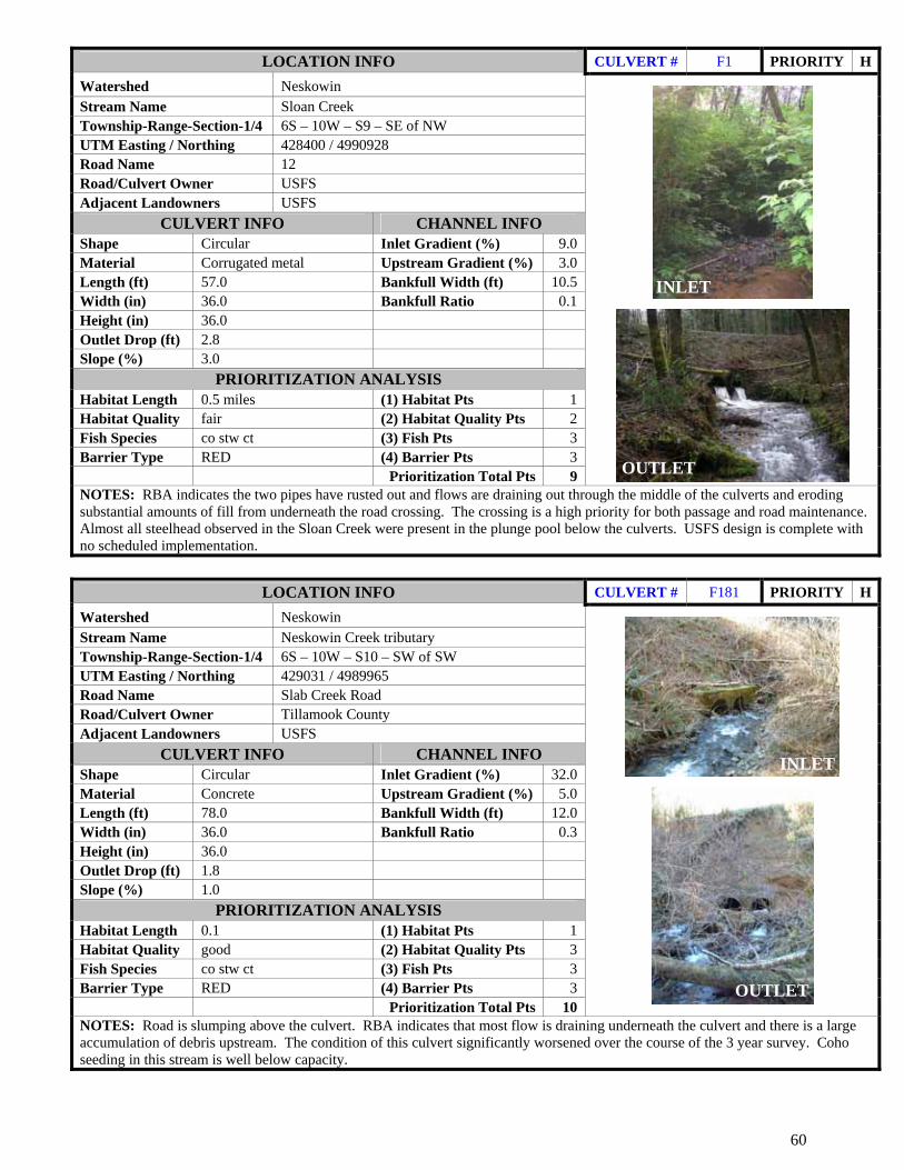
60
LOCATION INFO CULVERT # F1 PRIORITY H
Watershed Neskowin Stream Name Sloan Creek Township-Range-Section-1/4 6S – 10W – S9 – SE of NW UTM Easting / Northing 428400 / 4990928 Road Name 12 Road/Culvert Owner USFS Adjacent Landowners USFS
CULVERT INFO CHANNEL INFO Shape Circular Inlet Gradient (%) 9.0 Material Corrugated metal Upstream Gradient (%) 3.0 Length (ft) 57.0 Bankfull Width (ft) 10.5 Width (in) 36.0 Bankfull Ratio 0.1 Height (in) 36.0 Outlet Drop (ft) 2.8 Slope (%) 3.0
PRIORITIZATION ANALYSIS Habitat Length 0.5 miles (1) Habitat Pts 1 Habitat Quality fair (2) Habitat Quality Pts 2 Fish Species co stw ct (3) Fish Pts 3 Barrier Type RED (4) Barrier Pts 3 Prioritization Total Pts 9
NOTES: RBA indicates the two pipes have rusted out and flows are draining out through the middle of the culverts and eroding substantial amounts of fill from underneath the road crossing. The crossing is a high priority for both passage and road maintenance. Almost all steelhead observed in the Sloan Creek were present in the plunge pool below the culverts. USFS design is complete with no scheduled implementation.
LOCATION INFO CULVERT # F181 PRIORITY H
Watershed Neskowin Stream Name Neskowin Creek tributary Township-Range-Section-1/4 6S – 10W – S10 – SW of SW UTM Easting / Northing 429031 / 4989965 Road Name Slab Creek Road Road/Culvert Owner Tillamook County Adjacent Landowners USFS
CULVERT INFO CHANNEL INFO Shape Circular Inlet Gradient (%) 32.0 Material Concrete Upstream Gradient (%) 5.0 Length (ft) 78.0 Bankfull Width (ft) 12.0 Width (in) 36.0 Bankfull Ratio 0.3 Height (in) 36.0 Outlet Drop (ft) 1.8 Slope (%) 1.0
PRIORITIZATION ANALYSIS Habitat Length 0.1 (1) Habitat Pts 1 Habitat Quality good (2) Habitat Quality Pts 3 Fish Species co stw ct (3) Fish Pts 3 Barrier Type RED (4) Barrier Pts 3 Prioritization Total Pts 10
NOTES: Road is slumping above the culvert. RBA indicates that most flow is draining underneath the culvert and there is a large accumulation of debris upstream. The condition of this culvert significantly worsened over the course of the 3 year survey. Coho seeding in this stream is well below capacity.
OUTLET
INLET
OUTLET
INLET


61
27 – HAWK CREEK / BUTTE CREEK Total Habitat Gained: 3.8 miles
Butte Creek drains into Hawk Creek west of Highway 101 just upstream of Hawk Creek’s confluence with Neskowin Creek. The first half-mile of each stream runs through a golf course, where the channel lacks a healthy riparian area. The RBA indicates that Hawk Creek is the number one producer of salmon in the Neskowin watershed. A 4 foot dam at the Neskowin Regional Water District’s water diversion intake (rivermile 0.8) impedes fish passage. TEP is currently partnering with the District and ODFW to improve passage at the dam and the NNWC is working to restore passage at the first culvert on Hawk Creek (#2078). On the map, the road crossing Hawk Creek just below the dam has been removed. Butte Creek has four primary crossings, the first of which is a tidegate. The two 42” diameter, top-hinged tidegates impede fish passage into Butte Creek. Fish are passing, however, and the landowner has no interest in an upgrade. Potential Partners: ODOT, Tillamook County, NNWC, ODFW, private landowners
LOCATION INFO CULVERT # 2078 PRIORITY H
Watershed Neskowin Stream Name Hawk Creek Township-Range-Section-1/4 5S – 11W – S25 – SW of SW UTM Easting / Northing 422862 / 4994937 Road Name Hawk Street Road/Culvert Owner Private Adjacent Landowners William Clark, Nestucca Fire District, USA
CULVERT INFO CHANNEL INFO Shape Circular Inlet Gradient (%) --- Material Corrugated metal Upstream Gradient (%) --- Length (ft) --- Bankfull Width (ft) --- Width (in) --- Bankfull Ratio --- Height (in) --- Outlet Drop (ft) 0.0 Slope (%) ---
PRIORITIZATION ANALYSIS Habitat Length 1.8 (1) Habitat Pts 4 Habitat Quality good (2) Habitat Quality Pts 3 Fish Species co stw ct chum (3) Fish Pts 3 Barrier Type RED (4) Barrier Pts 3 Prioritization Total Pts 13
NOTES: NNWC is leading a replacement project for implementation in 2008.
OUTLET
INLET

62
LOCATION INFO CULVERT # O336 PRIORITY H
Watershed Neskowin Stream Name Butte Creek Township-Range-Section-1/4 5S – 11W – S25 – SW of NE UTM Easting / Northing 423405 / 4995429 Road Name Highway 101 Road/Culvert Owner ODOT
Adjacent Landowners Russell Jackson, Frank Herbert, Robert Affolter, Margaret Berglund, David Heonpud
CULVERT INFO CHANNEL INFO Shape Circular Inlet Gradient (%) --- Material Corrugated metal Upstream Gradient (%) 4.0 Length (ft) 200.0 Bankfull Width (ft) 20.0 Width (in) 72.0 Bankfull Ratio 0.3 Height (in) 72.0 Outlet Drop (ft) 0.0 Slope (%) 5.0
PRIORITIZATION ANALYSIS Habitat Length 2.0 miles (1) Habitat Pts 4 Habitat Quality good (2) Habitat Quality Pts 3 Fish Species co stw ct (3) Fish Pts 3 Barrier Type RED (4) Barrier Pts 3 Prioritization Total Pts 13
NOTES: Center is sagging.
LOCATION INFO CULVERT # 2080 PRIORITY H
Watershed Neskowin Stream Name Butte Creek Township-Range-Section-1/4 5S – 11W – S25 – SW of NE UTM Easting / Northing 423571 / 4995531 Road Name Sunbow Road Road/Culvert Owner Tillamook County Adjacent Landowners Unknown
CULVERT INFO CHANNEL INFO Shape Circular Inlet Gradient (%) --- Material Corrugated metal Upstream Gradient (%) --- Length (ft) 110.0 Bankfull Width (ft) --- Width (in) 78.0 Bankfull Ratio --- Height (in) 78.0 Outlet Drop (ft) 0.5 Slope (%) 2.0
PRIORITIZATION ANALYSIS Habitat Length 1.8 (1) Habitat Pts 4 Habitat Quality good (2) Habitat Quality Pts 3 Fish Species co stw ct chum (3) Fish Pts 3 Barrier Type RED (4) Barrier Pts 3 Prioritization Total Pts 13
OUTLET
INLET
OUTLET
INLET
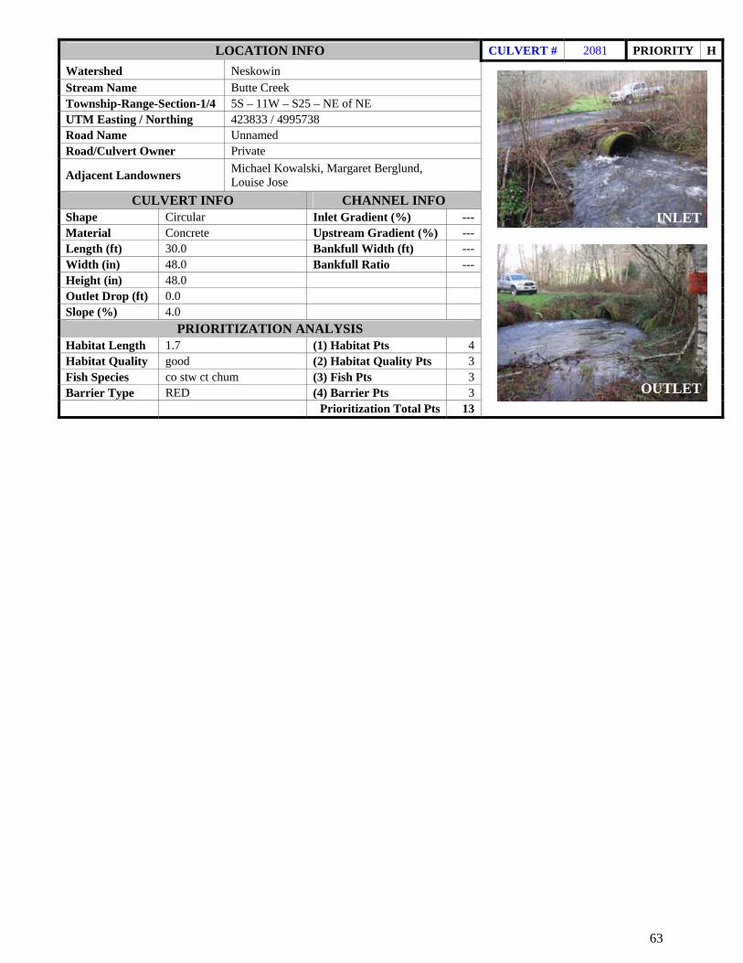
63
LOCATION INFO CULVERT # 2081 PRIORITY H
Watershed Neskowin Stream Name Butte Creek Township-Range-Section-1/4 5S – 11W – S25 – NE of NE UTM Easting / Northing 423833 / 4995738 Road Name Unnamed Road/Culvert Owner Private
Adjacent Landowners Michael Kowalski, Margaret Berglund, Louise Jose
CULVERT INFO CHANNEL INFO Shape Circular Inlet Gradient (%) --- Material Concrete Upstream Gradient (%) --- Length (ft) 30.0 Bankfull Width (ft) --- Width (in) 48.0 Bankfull Ratio --- Height (in) 48.0 Outlet Drop (ft) 0.0 Slope (%) 4.0
PRIORITIZATION ANALYSIS Habitat Length 1.7 (1) Habitat Pts 4 Habitat Quality good (2) Habitat Quality Pts 3 Fish Species co stw ct chum (3) Fish Pts 3 Barrier Type RED (4) Barrier Pts 3 Prioritization Total Pts 13
OUTLET
INLET


64
28 – SUTTON CREEK Total Habitat Gained: 0.3 miles Sutton Creek flows through a private residential area with several culvert crossings. Three crossings were replaced in 2003, as well as the installation of a new trash rack on #2084. The remaining crossings (identified in this cluster) are undersized and facilitate flooding over the small amounts of fill cover. The RBA indicates that the new trash rack installed on #2084 to combat beaver problems is terminating adult and juvenile fish passage. the production potential is excellent because of the stable beaver pond habitat that can rear large numbers of juveniles. Potential Partners: ODOT, Tillamook County, NNWC, ODFW, private landowners
LOCATION INFO CULVERT # 2082 PRIORITY H
Watershed Neskowin Stream Name Sutton Creek Township-Range-Section-1/4 5S – 11W – S36 – NE of NW UTM Easting / Northing 422895 / 4994152 Road Name Proposal Rock Loop Road Road/Culvert Owner Private Adjacent Landowners Unknown
CULVERT INFO CHANNEL INFO Shape Circular Inlet Gradient (%) --- Material Corrugated metal Upstream Gradient (%) --- Length (ft) 24.0 Bankfull Width (ft) --- Width (in) 48.0 Bankfull Ratio --- Height (in) 48.0 Outlet Drop (ft) 0.0 Slope (%) 1.0
PRIORITIZATION ANALYSIS Habitat Length 0.3 (1) Habitat Pts 1 Habitat Quality good (2) Habitat Quality Pts 3 Fish Species co stw ct chum (3) Fish Pts 3 Barrier Type RED (4) Barrier Pts 3 Prioritization Total Pts 10
MOUTH
OUTLET

65
LOCATION INFO CULVERT # 2084 PRIORITY H
Watershed Neskowin Stream Name Sutton Creek Township-Range-Section-1/4 5S – 11W – S36 – SW of NW UTM Easting / Northing 422833 / 4993948 Road Name South Beach Road Road/Culvert Owner Private Adjacent Landowners Unknown
CULVERT INFO CHANNEL INFO Shape Pipe arch Inlet Gradient (%) --- Material Corrugated metal Upstream Gradient (%) --- Length (ft) 26.0 Bankfull Width (ft) --- Width (in) 60.0 Bankfull Ratio --- Height (in) 46.0 Outlet Drop (ft) 0.0 Slope (%) 3.0
PRIORITIZATION ANALYSIS Habitat Length 0.2 (1) Habitat Pts 1 Habitat Quality good (2) Habitat Quality Pts 3 Fish Species co stw ct chum (3) Fish Pts 3 Barrier Type RED (4) Barrier Pts 3 Prioritization Total Pts 10
NOTES: A new trash rack installed in 2003. An 8” waterline at the outlet traps debris and may impede fish passage at some flows.
LOCATION INFO CULVERT # 2085 PRIORITY H
Watershed Neskowin Stream Name Sutton Creek Township-Range-Section-1/4 5S – 11W – S36 – SW of NW UTM Easting / Northing 422683 / 4993860 Road Name South Beach Road Road/Culvert Owner Private Adjacent Landowners Unknown
CULVERT INFO CHANNEL INFO Shape Circular Inlet Gradient (%) --- Material Corrugated metal Upstream Gradient (%) --- Length (ft) 26.0 Bankfull Width (ft) --- Width (in) 36.0 Bankfull Ratio --- Height (in) 36.0 Outlet Drop (ft) 0.0 Slope (%) 1.0
PRIORITIZATION ANALYSIS Habitat Length 0.2 (1) Habitat Pts 1 Habitat Quality good (2) Habitat Quality Pts 3 Fish Species co stw ct chum (3) Fish Pts 3 Barrier Type RED (4) Barrier Pts 3 Prioritization Total Pts 10
OUTLET
INLET
INLET
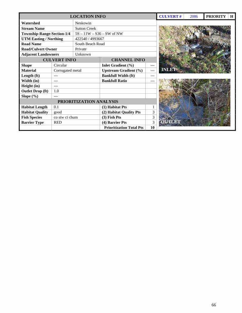
66
LOCATION INFO CULVERT # 2086 PRIORITY H
Watershed Neskowin Stream Name Sutton Creek Township-Range-Section-1/4 5S – 11W – S36 – SW of NW UTM Easting / Northing 422540 / 4993667 Road Name South Beach Road Road/Culvert Owner Private Adjacent Landowners Unknown
CULVERT INFO CHANNEL INFO Shape Circular Inlet Gradient (%) --- Material Corrugated metal Upstream Gradient (%) --- Length (ft) --- Bankfull Width (ft) --- Width (in) --- Bankfull Ratio --- Height (in) --- Outlet Drop (ft) 1.0 Slope (%) ---
PRIORITIZATION ANALYSIS Habitat Length 0.1 (1) Habitat Pts 1 Habitat Quality good (2) Habitat Quality Pts 3 Fish Species co stw ct chum (3) Fish Pts 3 Barrier Type RED (4) Barrier Pts 3 Prioritization Total Pts 10
OUTLET
INLET


67
30 – NON-CLUSTERED CULVERTS
LOCATION INFO CULVERT # 1219 PRIORITY M
Watershed Nestucca Stream Name Hastor Creek (Beaver Creek) Township-Range-Section-1/4 3S – 9W – S29 – NE of NW UTM Easting / Northing 435947 / 5014949 Road Name Beaver-Becker Road (unofficial name) Road/Culvert Owner Green Diamond Adjacent Landowners Green Diamond
CULVERT INFO CHANNEL INFO Shape Circular Inlet Gradient (%) 11.0 Material Corrugated metal Upstream Gradient (%) 2.0 Length (ft) 25.0 Bankfull Width (ft) 9.0 Width (in) 36.0 Bankfull Ratio 0.3 Height (in) 36.0 Outlet Drop (ft) 0.0 Slope (%) 4.0
PRIORITIZATION ANALYSIS Habitat Length 0.6 miles (1) Habitat Pts 2 Habitat Quality fair (2) Habitat Quality Pts 2 Fish Species co stw ct (3) Fish Pts 3 Barrier Type RED (4) Barrier Pts 3 Prioritization Total Pts 10
LOCATION INFO CULVERT # F155 PRIORITY M
Watershed Little Nestucca Stream Name Hiack Creek tributary Township-Range-Section-1/4 6S – 9W – S8 – NE of NE UTM Easting / Northing 436330 / 4991186 Road Name 12 Road/Culvert Owner USFS Adjacent Landowners USFS
CULVERT INFO CHANNEL INFO Shape Circular Inlet Gradient (%) --- Material Corrugated metal Upstream Gradient (%) 2.0 Length (ft) 45.0 Bankfull Width (ft) 3.8 Width (in) 24.0 Bankfull Ratio 0.5 Height (in) 24.0 Outlet Drop (ft) 1.3 Slope (%) 0.0
PRIORITIZATION ANALYSIS Habitat Length 0.5 miles (1) Habitat Pts 1 Habitat Quality fair (2) Habitat Quality Pts 2 Fish Species stw ct (3) Fish Pts 3 Barrier Type RED (4) Barrier Pts 3 Prioritization Total Pts 9
OUTLET
INLET
OUTLET
INLET

68
LOCATION INFO CULVERT # F2055 PRIORITY M
Watershed Nestucca Stream Name Limestone Creek tributary Township-Range-Section-1/4 4S – 8W – S6 – SE of NW UTM Easting / Northing 443825 / 5011140 Road Name 8598 Road/Culvert Owner USFS Adjacent Landowners USFS
CULVERT INFO CHANNEL INFO Shape Circular Inlet Gradient (%) 0.0 Material Concrete Upstream Gradient (%) 2.0 Length (ft) 48.0 Bankfull Width (ft) 7.0 Width (in) 24.0 Bankfull Ratio 0.3 Height (in) 24.0 Outlet Drop (ft) 0.2 Slope (%) 0.0
PRIORITIZATION ANALYSIS Habitat Length 1.5 miles (1) Habitat Pts 3 Habitat Quality poor (2) Habitat Quality Pts 1 Fish Species co stw ct (3) Fish Pts 3 Barrier Type RED (4) Barrier Pts 3 Prioritization Total Pts 10
LOCATION INFO CULVERT # F2060 PRIORITY M
Watershed Nestucca Stream Name Alder Creek Township-Range-Section-1/4 4S – 9W – S1 – NE of NW UTM Easting / Northing 442252 / 5011654 Road Name 8598 Road/Culvert Owner USFS Adjacent Landowners USFS
CULVERT INFO CHANNEL INFO Shape Open bottom arch Inlet Gradient (%) 12.0 Material Corrugated metal Upstream Gradient (%) 6.0 Length (ft) 68.0 Bankfull Width (ft) 16.5 Width (in) 145.0 Bankfull Ratio 0.7 Height (in) 70.0 Outlet Drop (ft) 0.0 Slope (%) 5.0
PRIORITIZATION ANALYSIS Habitat Length 0.6 miles (1) Habitat Pts 2 Habitat Quality fair (2) Habitat Quality Pts 2 Fish Species co stw ct (3) Fish Pts 3 Barrier Type GREY (4) Barrier Pts 2 Prioritization Total Pts 9
OUTLET
INLET
OUTLET
INLET

69
LOCATION INFO CULVERT # O3011 PRIORITY M
Watershed Nestucca Stream Name Beaver Creek tributary Township-Range-Section-1/4 3S – 9W – S18 – SW of SE UTM Easting / Northing 434735 / 5016835 Road Name Highway 101 Road/Culvert Owner ODOT Adjacent Landowners John Payne, Roy Jones, Green Diamond
CULVERT INFO CHANNEL INFO Shape Circular Inlet Gradient (%) --- Material Concrete Upstream Gradient (%) 4.0 Length (ft) 45.0 Bankfull Width (ft) --- Width (in) 36.0 Bankfull Ratio --- Height (in) 36.0 Outlet Drop (ft) 1.5 Slope (%) 2.0
PRIORITIZATION ANALYSIS Habitat Length 0.9 miles (1) Habitat Pts 2 Habitat Quality fair (2) Habitat Quality Pts 2 Fish Species co stw chf ct chum (3) Fish Pts 3 Barrier Type RED (4) Barrier Pts 3 Prioritization Total Pts 10
NOTES: A makeshift weir has been constructed just below the outlet.
LOCATION INFO CULVERT # O3035 PRIORITY M
Watershed Nestucca Stream Name Hartley Creek Township-Range-Section-1/4 4S – 10W – S14 – NE of SW UTM Easting / Northing 431365 / 5007725 Road Name Highway 101 Road/Culvert Owner ODOT Adjacent Landowners Karl Hale, Beatrice Gann, Michael McMillen
CULVERT INFO CHANNEL INFO Shape Circular Inlet Gradient (%) --- Material Corrugated metal Upstream Gradient (%) 5.0 Length (ft) 80.0 Bankfull Width (ft) --- Width (in) 36.0 Bankfull Ratio --- Height (in) 36.0 Outlet Drop (ft) 0.2 Slope (%) 3.0
PRIORITIZATION ANALYSIS Habitat Length 1.8 miles (1) Habitat Pts 4 Habitat Quality poor (2) Habitat Quality Pts 1 Fish Species co ct (3) Fish Pts 3 Barrier Type RED (4) Barrier Pts 3 Prioritization Total Pts 11
NOTES: Outlet has higher gradient than inlet. Culvert access is limited.
OUTLET
OUTLET

70
LOCATION INFO CULVERT # 1610 PRIORITY M
Watershed Nestucca Stream Name Clear Creek Township-Range-Section-1/4 4S – 10W – S34 – NE of NW UTM Easting / Northing 429407 / 5003996 Road Name Jenck Road Road/Culvert Owner Tillamook County Adjacent Landowners Marlene Trent, Ray Jones
CULVERT INFO CHANNEL INFO Shape Pipe arch Inlet Gradient (%) 0.0 Material Corrugated metal Upstream Gradient (%) 2.0 Length (ft) 34.0 Bankfull Width (ft) 14.0 Width (in) 144.0 Bankfull Ratio 0.9 Height (in) 84.0 Outlet Drop (ft) 0.0 Slope (%) 2.0
PRIORITIZATION ANALYSIS Habitat Length 3.3 miles (1) Habitat Pts 4 Habitat Quality good (2) Habitat Quality Pts 3 Fish Species co stw chf ct chum (3) Fish Pts 3 Barrier Type GREY (4) Barrier Pts 2 Prioritization Total Pts 12
NOTES: USFS engineering design complete. No plans for implementation.
OUTLET
INLET
71
IV. NEXT STEPS It is imperative that this Action Plan is not left to gather dust on partners’ bookshelves. As such, TEP will lead the following efforts to ensure that doesn’t happen.
• TEP will maintain and update the Plan, convene annual meetings, and manage efforts to keep the Plan moving forward. TEP will work closely with BLM to maintain GIS layer integrity. Updates will be facilitated through TEP’s annually reporting process, at which time TEP gathers project information from its partners.
• This Plan will be posted on TEP’s website and associated data will be made accessible to all watershed partners. BLM and USFS intend to create an online mapping system with a searchable database and photos.
• Additional field surveys should be conducted to fill data gaps in the Neskowin and Sand Lake watersheds using consistent survey protocols. Tidegates, dams, and other fish passage barriers should be included, although survey protocols may differ.
• Culvert survey protocols were established for the BLM culvert inventory, which collected similar attributes as the USFS inventories. If additional inventories are implemented, BLM or TEP should be contacted to receive the survey protocols and forms to ensure that data collected is consistent with existing data and fulfills the requirements of the prioritization model.
• As fish barriers are replaced, the upper extents of fish distributions should be re-evaluated.

Coarse Screen Filter –Juvenile salmonid passage evaluation criteria V2.2
Structure Green Grey Red
1 Bottomless pipe arch or countersunk pipe arch, substrate 100% coverage through pipe and invert depth greater than 20% of culvert rise.
Culvert installed at channel grade (+/- 1%), culvert span to bankfull width ratio greater than 0.9, no blockage.
Culvert installed at channel grade (+/- 1%), culvert span to bankfull width ratio greater than 0.5, less than or equal to 10% blockage.
Culvert not installed at channel grade (+/- 1%), culvert span to bankfull width ratio less than 0.5, greater than 10% blockage.
2
Pipe arches (1x3 corrugation and larger). Substrate less than 100% coverage through pipe or invert depth less than 20% of culvert rise.
Culvert gradient less than 0.5%, no perch, no blockage, culvert span to bankfull width ratio greater than 0.75.
Culvert gradient between 0.5 to 2.0%, less than 4" perch, less than or equal to 10% blockage, culvert span to bankfull width ratio greater than 0.5.
Culvert gradient greater than 2.0%, greater than 4" perch, greater than 10% blockage, culvert span to bankfull width ratio less than 0.5.
3
Circular CMP or ABS, 48 inch span and smaller, spiral or annular (CMP) corrugations, regardless of substrate coverage.
Culvert gradient less than 0.5%, no perch, no blockage, culvert span to bankfull width ratio greater than 0.75
Culvert gradient 0.5 to 1.0%, perch less than 4 inches, less than or equal to 10% blockage, culvert span to bankfull width ratio greater than 0.5.
Culvert gradient greater than 1.0%, perch greater than 4 inches, blockage greater than 10%, span to bankfull width ratio less than 0.5.
4
Circular CMPs with annular corrugations larger than 1x3 and 1x3 spiral corrugations (>48" span), substrate less than 100% coverage through pipe or invert depth less than 20% culvert rise.
Culvert gradient less than 0.5%, no perch, no blockage, culvert span to bankfull width ratio greater than 0.75.
Culvert gradient between 0.5 to 2.0%, less than 4" perch, less than or equal to 10% blockage, culvert span to bankfull width ratio greater than 0.5.
Culvert gradient greater than 2.0%, greater than 4" perch, greater than 10% blockage, culvert span to bankfull width ratio less than 0.5.
5
Circular CMPs with 1x3 or smaller annular corrugations (all spans) and 1x3 spiral corrugations (>48" span), 100% substrate coverage through pipe and invert depth greater than 20% of culvert rise.
Culvert gradient less than 1%, no perch, no blockage, culvert span to bankfull width ratio greater than 0.75
Culvert gradient 1.0 to 3.0%, perch less than 4 inches, less than or equal to 10% blockage, culvert span to bankfull width ratio greater than 0.5.
Culvert gradient greater than 3.0%, perch greater than 4 inches, blockage greater than 10%, culvert span to bankfull width ratio less than 0.5.
6
Circular CMPs with 2x6 annular corrugations (all spans), 100% substrate coverage through pipe and invert depth greater than 20% of culvert rise.
Culvert gradient less than 2.0%, no perch, no blockage, culvert span to bankfull width ratio greater than 0.75
Culvert gradient 2.0 to 4.0%, less than 4" perch, less than or equal to 10% blockage, culvert span to bankfull width ratio greater than 0.5.
Culvert gradient greater than 4.0%, greater than 4 inch perch, greater than 10% blockage, culvert span to bankfull width ratio less than 0.5.
7 Special items; log stringer or modular bridge, No encroachment on bankfull width. Encroachment on bankfull width (either streambank). Structural collapse.
8 Baffled structure installations (all culvert sizes and configurations).
No perch, no blockage. Culvert span to bankfull width ratio greater than 0.75. 100% substrate in pipe but baffles protruding.
Outlet with less than 6 inch perch, less than or equal to 10% blockage, culvert span to bankfull width ratio greater than 0.5. Less than 100% substrate.
Perch greater than 6 inches, greater than 10% blockage, culvert span to bankfull width ratio less than 0.5. Less than 100% substrate.
9 Weir installations (all culvert sizes and configurations).
No perch, no blockage. Culvert span to bankfull width ratio greater than 0.75. Weirs provide 6 inch minimum pool depth and no jumps exceed 4 inches.
Outlet with less than 6 inch perch, less than or equal to 10% blockage, culvert span to bankfull width ratio greater than 0.5. Weirs with pool depths less than 6 inches. Jumps over weirs greater than 4 inches.
Perch greater than 6 inches, greater than 10% blockage, culvert span to bankfull width ratio less than 0.5. Weirs without pools, no resting areas. Weir Jumps> 4 inches
10 Concrete Box Culverts Culvert backwatered or mostly backwatered w/100% substrate. Culvert span to bankfull width ratio greater than 0.75. No blockage.
Culvert gradient up to 2%. Outlet with less than 4 inch perch. 100% substrate in pipe. Culvert span to bankfull ratio greater than 0.5.
Perch greater than 4 inches. Culvert span to bankfull ratio less than 0.5. Laminar flow. Less than 100% substrate in pipe.
11 Circular concrete and smooth wall ABS culverts.
100% substrate in pipe. Slope less than .5%. No Perch
Less than 100% substrate in pipe. Slope .5-1%. Perch less than 4 inches
No substrate. Slope greater than 1% Perch greater than 4 inches.
Note: 1) For culverts containing baffles but are entirely covered with substrate, evaluate using the criteria for structures 2-8, as appropriate. 2) If culvert does not fit well on this CSF run Fish-Xing. 3) This CSF works well for culverts on public lands, not always well for private landowner culverts due to large variations in construction materials and types of installations. This model was derived from a US Forest Service model.