near real time global lake and river … · [email protected]) (2) european space agency, earth...
TRANSCRIPT

NEAR REAL TIME GLOBAL LAKE AND RIVER MONITORING USING THE ENVISAT RA-2
P.A.M. Berry(1) , J.A. Freeman(1) , R.G. Smith (1) & J. Benveniste(2) (1)EAPRS Laboratory, De Montfort University, Leicester LE9 1BH , UK ([email protected], [email protected],
[email protected]) (2) European Space Agency, Earth Observation Applications Department,ESRIN, Via Galileo Galilei, I-00044, Frascati
(RM), Italy ([email protected]) ABSTRACT Over the past 18 months, a pilot system has been developed which has generated global lake and river level measurements from the Envisat RA-2. These data are produced within 3-5 days of measurement, using retracked Level 1B altimeter echoes merged with data from the IGDR to obtain both orbit and atmospheric/instrument corrections. A global version of this system has now been in operation for over 6 months. This paper presents an analysis of the results from this unique dataset, and demonstrates the current capabilities and future potential of radar altimeter measurements to monitor changing inland water resources in near real time. 1. INTRODUCTION The requirement for near-real-time monitoring of global river and lake levels is increasingly urgent as the number of gauged catchments falls and the requirement for inland water resources continues to grow. Fortunately, the EnviSat RA-2 offers the exciting possibility to measure river and lake heights over hundreds of targets worldwide, and derive these data within 5 days of the satellite overpass [1]. In order to exploit this opportunity, a pilot system is currently running, outlined below. 2. PROCESSING In contrast to the historical SGDR data processing the Near Real Time must fuse the IGDR (Range and Geophysical Corrections) and Level1B (Waveforms) [1] to produce NRT products globally from Envisat, as illustrated in Fig. 1. Two products are output by the
system: the RLH product, containing river and lake height differences and summary information in a format which is straightforward to read and small in size to facilitate retrieval from the ESA website [2]. The RLH product is generated for experienced altimeter users, who may wish to replace fields in the product with their own tailored models for the specific target.
Figure 1 Simplified NRT Processing Overview
Because echoes retrieved from inland water are complex and difficult to retrack, the current system is very conservative in both the echo shapes reprocessed and in the targets selected for inclusion in the NRT processing. Fig. 2 shows the current NRT mask used for target selection. Here, the targets from which waveforms are successfully captured are shown in blue: the targets selected for inclusion appear in red.
_____________________________________________________
Proc. ‘Envisat Symposium 2007’, Montreux, Switzerland 23–27 April 2007 (ESA SP-636, July 2007)
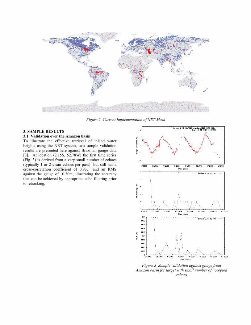
Figure 2 Current Implementation of NRT Mask
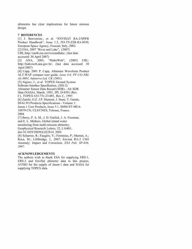
3. SAMPLE RESULTS 3.1 Validation over the Amazon basin To illustrate the effective retrieval of inland water heights using the NRT system, two sample validation results are presented here against Brazilian gauge data [3]. At location (2.15S, 52.78W) the first time series (Fig. 3) is derived from a very small number of echoes (typically 1 or 2 clean echoes per pass) but still has a cross-correlation coefficient of 0.93, and an RMS against the gauge of 0.30m, illustrating the accuracy that can be achieved by appropriate echo filtering prior to retracking.
Figure 3 Sample validation against gauge from
Amazon basin for target with small number of accepted echoes

Figure 4 Sample validation against gauge from Amazon basin for target with large number of accepted echoes
The second validation sequence, from (0.85S 62.92W) shows a crossing where typically a higher number of echoes are accepted by the system and retracked (Fig. 4). With a cross-correlation coefficient of 0.987, and an RMS against the gauge of 0.36m, the height retrieval at this crossing is generally good. However, this validation sequence has been included to illustrate the case where a larger number of waveforms are typically accepted by the system. In this case, off-ranging data from 2003 were not completely removed from the data during selection, probably because the spatial extent of the river itself was reduced, past the maximum of the hydrological cycle and so offranged data from residual flooding were erroneously flagged by the NRT mask for inclusion. Retracking and filtering have minimised the effect of this on the final height estimates, but appear in the higher along-track RMS for two successive cycles.
3.2 Combined Time Series The following figures show a few examples of combined time series from ERS-2 [4], TOPEX [5], Envisat [1] and Jason-1 [6] (where possible) over the ‘NRT’ mask, to illustrate the rationale behind the current mask settings. Fig. 5 shows a sample crossing from the Amazon basin, at a crossover location where data from TOPEX, EnviSat and ERS2 are all available. The data from ERS2 and TOPEX have been retracked using an expert system approach configured for inland water [7]; data from EnviSat were produced through the River and Lake system. The different time series show excellent agreement. Note that no post-filtering has been applied to these data; they are plotted as produced by the system.
Figure 5 Example Amazon Time series from ERS2, EnviSat and TOPEX
A second example is shown below; here, sample data have been successfully retrieved from Jason-1, and have been added to the multiple time series over Lake Malawi (Fig. 6).
Figure 6 Example Time Series over Lake Malawi from ERS2, EnviSat, TOPEX and Jason-1

Note the excellent agreement between Jason-1 (blue) and EnviSat measurements (red), also between the ERS2 (pink) and TOPEX (green) data. The NRT processing has now resumed, following the resolution of the USO issue [8]; data were produced during the period of the USO anomaly by applying a correction. To illustrate this, Fig. 7 shows a sample time series over the Niger River, showing EnviSat SGDR (blue) and NRT data (red) for sample cycles.
Figure 7 Sample time series from EnviSat SGDR (blue) and NRT (red) over the Niger river
4. UNTAPPED POTENTIAL The current NRT system is very conservative and processes approximately 7% of the inland water targets where the RA-2 is a) in lock and b) captures valid waveforms for more than 8 cycles of the reference year. The relevant numbers for a typical cycle are: RA-2 NRT: 1308 valid targets RA-2 Research System: 18850 valid targets There is thus a huge potential to substantially increase the number of targets acquired by the NRT system, both in terms of enhanced waveform retracking, and in the implementation of more sophisticated filtering schemes. The successful retracking of Jason-1 waveforms over a substantial number of targets also opens the door to include Jason-1 NRT processing, with its 10 day repeat cycle. Whilst non-optimal in performance over inland water as many authors have noted, Jason-1 data can be successfully retracked over a substantial number of lake and river systems. Interestingly, Jason-1 sometimes acquired data from targets where TOPEX is not successful. 5. FUTURE MISSION CONSIDERATIONS This analysis of the recovery of echoes over inland water by the current generation of altimeters shows that thousands of targets are successfully acquired by the RA-2 globally. To investigate the typical sampling of inland water, an analysis was carried out for EnviSat
and figures derived for the average numbers of targets acquired in cycle 30. These data are provided in histogram form in Fig. 8.
Figure 8 Histogram of Sampling of Inland Water Targets by the RA-2 in cycle 30
It is evident that a huge number of targets are overflown by the RA-2 and successfully acquired. It should be stressed that the above figures are conservative in the extreme, derived using a mask containing only substantial inland water bodies, and with no inclusion of ephemeral surface water, rivers which do not have continuous flow or wetlands. This has implications for future mission design, with a clear recommendation that the baseline should be to acquire all inland water data regardless of the size of the target, further stimulating the continuing research into new techniques to retrieve heights from smaller water bodies (and the emerging micro-hydrology applications such as Malaria propagation). 6. CONCLUSIONS The current implementation of the NRT system successfully retrieves good time series from EnviSat over many targets with near-global distribution. However, there remains a huge untapped potential which can increasingly be exploited to give NRT monitoring of a vastly greater number of lakes and rivers worldwide. The initial investigation of Jason-1 shows that, excitingly, Jason-1 does retrieve valid waveforms over many targets; the key to deriving good height measurements is retracking the data using tuned algorithms to identify the nadir target from the endemic offranging in Jason-1 waveform data. The huge numbers of inland water targets from which data can successfully be retrieved by the current generation of
altimeters has clear implications for future mission design. 7 REFERENCES [1] J. Benveniste., et al. “ENVISAT RA-2/MWR Product Handbook”, Issue 1.2, PO-TN-ESR-RA-0050, European Space Agency, Frascati, Italy, 2002. [2] ESA, 2007 “River and Lake”, (2007) URL:http://earth.esa.int/riverandlake/, (last date accessed: 30 April 2007) [3] ANA, 2005, “HidroWeb”, (2005) URL: http://hidroweb.ana.gov.br/, (last data accessed: 30 April 2007) [4] Capp, 2001 P. Capp, Altimeter Waveform Product ALT.WAP compact user guide, Issue 4.0, PF-UG-NRL AL-0001, Infoterra Ltd, UK (2001). [5] Algiers, J., et al. TOPEX Ground System Software Interface Specification, (SIS-2) Altimeter Sensor Data Record (SDR) - Alt SDR Data (NASA), March, 1993, JPL D-8591 (Rev. C), TOPEX 633-751-23-001, Rev.C, 1993 [6] Zanife, O.Z. J.P. Dumont, J. Stum, T. Guinle, SSALTO Products Specifications - Volume 1: Jason-1 User Products, Issue 3.1, SMM-ST-MEA- 10879-CN, CLS/CNES, Tolouse, France. 2004 [7] Berry, P. A. M., J. D. Garlick, J. A. Freeman, and E. L. Mathers, Global inland water monitoring from multi-mission altimetry, Geophysical Research Letters, 32, L16401, doi:10.1029/2005GL022814. 2005 [8] Scharroo, R.; Faugère, Y.; Féménias, P.; Martini, A.; Roca, M.; Lillibridge, J., 2007; Envisat RA-2 USO Anomaly: Impact and Correction, ESA Pub. SP-636, 2007. ACKNOWLEDGEMENTS The authors wish to thank ESA for supplying ERS-1, ERS-2 and EnviSat altimeter data to this project, AVISO for the supply of Jason-1 data and NASA for supplying TOPEX data.