navitus bay - national infrastructure planning · pdf file · 2016-04-28useful...
TRANSCRIPT
UsefUl information the photographic panoramas have been taken with a full frame digital camera
fitted with a 50 mm lens and combined together using planar projection.
the turbines illustrated are similar to the model that may be used in the completed scheme.
Both curvature of the earth and light refraction have been taken into account utilising the calculations in technical appendix f of ‘Visual representation of Wind farms: Good Practice Guidance’ published by Scottish Natural Heritage (SNH) (29 March 2006).
in order to view the visualisation at the correct distance to represent the scale of the development the sheet should be printed at the size as indicated and viewed at the stated viewing distance.
In accordance with SNH 2006 (ref Technical Appendix B, Paras B19, B20 and Figure B15) the image should ideally be viewed with both eyes. The image may be viewed either curved or flat. If viewed curved the image should be held at eye level and curved through the angle (width) stated and maintained at the stated viewing distance. If viewed flat ‘the gaze is kept perpendicular to the surface of the image’ and maintained at the viewing distance indicated on the sheet.
Whilst all visualisations are prepared consistent with SNH Guidance 2006 the guidance emphasises that they are a tool to assist in the assessment process and that they ‘can never replicate the experience of seeing a windfarm in the landscape’ (SNH, 2006, p9).
SNH 2006 acknowledges that visualisations ‘will never appear ‘true to life’’ and that ‘they are merely tools to inform an assessment of impacts; and, like any tool, their application requires careful use.’ (SNH, 2006, p10)
if an extract of the visualisation is used the resultant image must be accompanied by the following text: ‘this image has been extracted from a panorama and therefore does not accurately represent the wind farm as it will be seen from the selected viewpoint as it does not include the full context of the view’.
Detailed descriptions of the visualisations can be found in Appendix 5 of the Applicant’s Response to Deadline III.
The SLVIA uses the Petroleum projection in figures and visualisations, and to calculate distances and horizontal extents, in line with the industry standard for offshore development. Other sections of the application documents use OSTN02 projection.
Disclaimerthis document has been prepared to provide information in respect of the proposed Navitus Bay Wind Park and for no other purpose.
in preparation of this document navitus Bay Development limited and their subcontractors have made reasonable efforts to ensure that the content is accurate, up to date and complete for the purpose for which it has been prepared.
Other than any liability detailed in the contracts between the parties for this work, neither navitus Bay Development limited or their subcontractors shall have any liability for any loss, damage, injury, claim, expense, cost or other consequence arising as a result of use or reliance upon any information contained in or omitted from this document.
© Copyright Navitus Bay Development Limited 2014 VP C
VP E
VP DVP F
VP B
VP A
360000 370000 380000 390000 400000 410000 420000 430000 440000 450000 460000 470000
2000
030
000
4000
050
000
6000
070
000
8000
090
000
1000
0011
0000
Path
: X
:\JO
BS\3
844_
Nav
itus
Bay
Win
d Pa
rk_P
ost
Sub
mis
sion
\8gi
s\Pr
ojec
ts\3
844_
00_R
epre
sent
ativ
e_V
iew
poin
ts_a
nd_L
andf
orm
.mxd
Navitus Bay Development Ltd
Legend
Scale@A3:
Ref:
Data Sources:
Date: 30/10/2014
1:400,000
Coordinate System:
Datum:OSGB 1936 App.6 Fig.13
Viewpoints and Landform
OS,Nextmap25
±0 105 NM
0 2010 km
Figure: LP_1
Author: Checked: WWSD Approved: WW
Revision No.: 00
British National Grid
30km15km 45km
Turbine Area
15km, 30km and 45km Radii around Turbine Area
Landform
0m - 50m AOD
50m - 100m AOD
100m - 150mAOD
150m - 200mAOD
300m - 350mAOD
350m - 400mAOD
250m - 300mAOD
200m - 250mAOD
Representative Viewpoint Locations
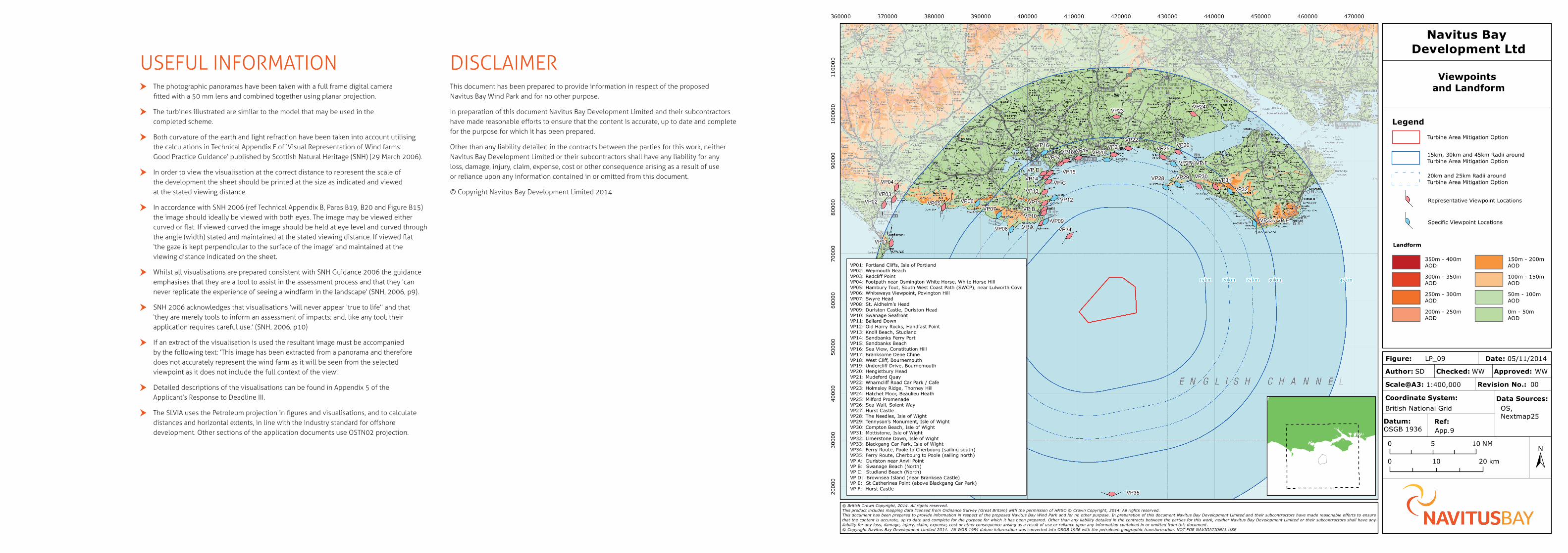
VP A: Durlston near Anvil PointVP B: Swanage Beach (North)VP C: Studland Beach (North)VP D: Brownsea Island (near Branksea Castle)VP E: St Catherines Point (above Blackgang Car Park)VP F: Hurst Castle
Specific Viewpoint Locations
© British Crown Copyright, 2014. All rights reserved.This product includes mapping data licensed from Ordnance Survey (Great Britain) with the permission of HMSO © Crown Copyright, 2014. All rights reserved.This document has been prepared to provide information in respect of the proposed Navitus Bay Wind Park and for no other purpose. In preparation of this document Navitus Bay Development Limited and their subcontractors have made reasonable efforts to ensurethat the content is accurate, up to date and complete for the purpose for which it has been prepared. Other than any liability detailed in the contracts between the parties for this work, neither Navitus Bay Development Limited or their subcontractors shall have anyliability for any loss, damage, injury, claim, expense, cost or other consequence arising as a result of use or reliance upon any information contained in or omitted from this document.© Copyright Navitus Bay Development Limited 2014. All WGS 1984 datum information was converted into OSGB 1936 with the petroleum geographic transformation. NOT FOR NAVIGATIONAL USE
VP C
VP D
VP B
VP01
VP02VP03
VP04
VP05 VP06VP07
VP08VP09
VP10
VP11 VP12
VP13
VP14VP15
VP16
VP17VP18 VP19 VP20
VP21VP22
VP23VP24
VP25 VP26
VP27 / VP F
VP28 VP29 VP30VP31
VP32
VP33 / VP E
VP34
VP35
VP A
360000 370000 380000 390000 400000 410000 420000 430000 440000 450000 460000 470000
2000
030
000
4000
050
000
6000
070
000
8000
090
000
1000
0011
0000
Path
: X
:\JO
BS
\384
4_N
avit
us B
ay W
ind
Park
_Pos
t S
ubm
issi
on\8
gis\
Proj
ects
\384
4_09
_Rep
rese
ntat
ive_
Vie
wpo
ints
_and
_Lan
dfor
m.m
xd
Navitus Bay Development Ltd
Legend
Scale@A3:
Ref:
Data Sources:
Date: 05/11/2014
1:400,000
Coordinate System:
Datum:OSGB 1936 App.9
Viewpoints and Landform
OS,Nextmap25
±0 105 NM
0 2010 km
Figure: LP_09
Author: Checked: WWSD Approved: WW
Revision No.: 00
British National Grid
30km15km 45km
Turbine Area Mitigation Option
15km, 30km and 45km Radii aroundTurbine Area Mitigation Option
Landform
0m - 50m AOD
50m - 100m AOD
100m - 150mAOD
150m - 200mAOD
300m - 350mAOD
350m - 400mAOD
250m - 300mAOD
200m - 250mAOD
© British Crown Copyright, 2014. All rights reserved.This product includes mapping data licensed from Ordnance Survey (Great Britain) with the permission of HMSO © Crown Copyright, 2014. All rights reserved.This document has been prepared to provide information in respect of the proposed Navitus Bay Wind Park and for no other purpose. In preparation of this document Navitus Bay Development Limited and their subcontractors have made reasonable efforts to ensurethat the content is accurate, up to date and complete for the purpose for which it has been prepared. Other than any liability detailed in the contracts between the parties for this work, neither Navitus Bay Development Limited or their subcontractors shall have anyliability for any loss, damage, injury, claim, expense, cost or other consequence arising as a result of use or reliance upon any information contained in or omitted from this document.© Copyright Navitus Bay Development Limited 2014. All WGS 1984 datum information was converted into OSGB 1936 with the petroleum geographic transformation. NOT FOR NAVIGATIONAL USE
Representative Viewpoint Locations
Specific Viewpoint Locations
VP01: Portland Cliffs, Isle of PortlandVP02: Weymouth BeachVP03: Redcliff PointVP04: Footpath near Osmington White Horse, White Horse HillVP05: Hambury Tout, South West Coast Path (SWCP), near Lulworth CoveVP06: Whiteways Viewpoint, Povington HillVP07: Swyre HeadVP08: St. Aldhelm’s HeadVP09: Durlston Castle, Durlston HeadVP10: Swanage SeafrontVP11: Ballard DownVP12: Old Harry Rocks, Handfast PointVP13: Knoll Beach, StudlandVP14: Sandbanks Ferry PortVP15: Sandbanks BeachVP16: Sea View, Constitution HillVP17: Branksome Dene ChineVP18: West Cliff, BournemouthVP19: Undercliff Drive, BournemouthVP20: Hengistbury HeadVP21: Mudeford QuayVP22: Wharncliff Road Car Park / CafeVP23: Holmsley Ridge, Thorney HillVP24: Hatchet Moor, Beaulieu HeathVP25: Milford PromenadeVP26: Sea-Wall, Solent WayVP27: Hurst CastleVP28: The Needles, Isle of WightVP29: Tennyson’s Monument, Isle of WightVP30: Compton Beach, Isle of WightVP31: Mottistone, Isle of WightVP32: Limerstone Down, Isle of WightVP33: Blackgang Car Park, Isle of WightVP34: Ferry Route, Poole to Cherbourg (sailing south)VP35: Ferry Route, Cherbourg to Poole (sailing north)VP A: Durlston near Anvil PointVP B: Swanage Beach (North)VP C: Studland Beach (North)VP D: Brownsea Island (near Branksea Castle)VP E: St Catherines Point (above Blackgang Car Park)VP F: Hurst Castle
20km and 25km Radii aroundTurbine Area Mitigation Option
25km20km