navigation and safety bylaws - gw · 2.12 flashing lights and sound signals 16 ... these bylaws are...
TRANSCRIPT

Attachment 5 to Report 09.74 Page 1 of 50
Navigation and Safety Bylaws (incorporating amendments made 1 July 2009)
Wellington region Purpose: These Bylaws are made for the purpose of navigation and safety
FOR FURTHER INFORMATION
Greater Wellington Regional Council Harbours PO Box 11646 Wellington T 04 381 7760 F 04 471 1373 W www.gw.govt.nz
J/01/02/01
February 2009
#613720


Attachment 5 to Report 09.74 Page 3 of 50
5 MARCH 2009
Contents
1. Preliminary provisions 5
2. General matters 11 2.1 Lifejackets 11 2.2 Persons to avoid swimming or diving around wharves 12 2.3 Use of vessel engine around wharves, ramps 12 2.4 Vessels to be serviceable or removed 13 2.5 Seaplanes 13 2.6 Anchoring and mooring 14 2.7 Prohibited anchorages 14 2.8 Obstructions 14 2.9 Collision Prevention 15 2.10 Notification of collisions or accidents 15 2.11 Damage to buoys 16 2.12 Flashing lights and sound signals 16 2.13 Vessel not to sound whistles 16 2.14 Use of distress signals 16 2.15 Means of attracting attention when in distress 17
3. Operating requirements 17 3.1 Minimum age for operating powered vessels 17 3.2 Speed of vessels 17 3.3 Lights for sailing vessels underway and vessels under oars (including
paddles) 19 3.4 Diving from vessels 20 3.5 Lookouts on vessels used for water skiing and towing any person 20 3.6 Water skiing or towing between sunset and sunrise 20 3.7 Conduct in access lanes 20 3.8 Marking of access lanes 21 3.9 Reserved areas 21 3.10 Flagged areas on beaches 22 3.11 Special events 22 3.12 Moorings 23
4. Commercial operations including hazardous works and cargoes 24 4.1 Vessels carrying explosives 24 4.2 Signals to be displayed by any vessel taking in, or discharging or
carrying Dangerous Goods. 25 4.3 Distance from vessels showing flag B 25 4.4 Duties of master of a tanker 25 4.5 Berthage requirements for tankers and vessels carrying Class 1
explosives 26 4.6 Hot work operations 26 4.7 Loading or Discharge of Cargo 26
5. Administrative matters 27 5.1 Appointment of Harbourmaster and Enforcement Officers 27 5.2 Application to master/owner 27

Attachment 5 to Report 09.74 Page 4 of 50
5 MARCH 2009
5.3 Notifications to Harbourmaster 27 5.4 Vessels to be licensed 28 5.5 Fees and charges 28
6. Wellington Harbour 29 6.1 Directions for transiting Wellington Harbour entrance 29 6.2 General directions for navigating in Wellington Harbour 29 6.6 Navigational documents required for Wellington Harbour 31
Schedule 1 – areas defined 33 Wellington Harbour 33 Porirua Harbour 33 Lake Wairarapa 33 Evans Bay 33 Lambton Harbour 33 Lake Onoke 34
Schedule 2 – location-specific information 35 Prohibited anchorages 35 Explosives anchorage 35 Bulk oil discharges 35 Restricted access area for non-commercial craft 35
Schedule 3 – regional access lanes and reserved areas 36 Part A – Access lanes for use by waterskiers 36 Part B – Reserved areas 40 Part C – Flagged areas 42
Schedule 4 – hot work permit 43
Schedule 5 – fees 44 Mooring licence 44 Commercial vessel licence 44 Public notices 44
Schedule 6 – Recommended tracks 45
Part A Tracks to main wharves, including ferry berths 45 Wellington pilotage waypoints 46 Part B - Tracks to all Centreport wharves 47 Wellington pilotage waypoints 48 Schedule 7 – Narrow Channel 50

Attachment 5 to Report 09.74 Page 5 of 50
5 MARCH 2009
1. Preliminary provisions
1.1 Title and commencement
These Bylaws are the Wellington Regional Navigation and Safety Bylaws 2003.
These Bylaws come into force on 23 December 2003.
(Explanation: These Bylaws replace the Wellington Regional Navigation and Safety Bylaws 2000. The Bylaws incorporate amendments which come into force on 1 July 2009.)
1.2 Areas within which these Bylaws apply
These Bylaws apply to the waters within the Region.
1.3 Definition of terms
In these Bylaws, unless the context otherwise requires:
Access lane means those areas defined by words and maps in part A of Schedule 3 in these Bylaws.
Accident has the same meaning as in the Maritime Transport Act 1994.
Anchorage in relation to vessels, means a place (enclosed or otherwise) used for the anchoring of vessels to the bed of waters, whether the place is reserved for such purposes by the Council or not.
Anchoring means the securing of a vessel to the bed of waters by means of an anchor, cable or other device, that is normally removed with the vessel when it leaves the anchorage.
Beacon means a light or mark set up as a navigation mark or a warning to vessels.
Body board also known as a boogie board. Means a short foam board usually ridden in a prone or kneeling position and not designed to be ridden standing up.
Buoy means an anchored float serving as a navigation or locational mark, or to indicate a mooring, reef or other hazard.
Buoyancy aid means anything that complies with NZ Standard 5823:2001 or a buoyancy aid that the Director of Maritime Safety is satisfied substantially complies with the Standard and that provides a minimum of 53 newtons

Attachment 5 to Report 09.74 Page 6 of 50
5 MARCH 2009
of buoyancy.
Class 3 packing Group I oil products
means oil having an initial boiling point less than or equal to 35 degrees centigrade.
Class 3 packing Group II oil products
means oil having a flashpoint of less than 23 degrees centigrade and an initial boiling point greater than 35 degrees centigrade.
Class 3 packing group III oil products
means oil having a flashpoint equal to or greater than 23 degrees centigrade up to and including 61 degrees centigrade and an initial boiling point greater than 35 degrees centigrade.
Commercial vessel has the same meaning as commercial ship in section 2 of the Maritime Transport Act 1994.
Council means the Wellington Regional Council as constituted under the Local Government (Wellington Region) Reorganisation Order 1989.
Crew means the persons employed or engaged in any capacity on board a vessel, but does not include the master, a pilot, or a person temporarily employed on the vessel while in a harbour.
Dangerous Goods has the same meaning as in the International Maritime Dangerous Goods (IMDG) code.
Director of Maritime Safety
means the person who is for the time being the Director of Maritime Safety under section 439 of the Maritime Transport Act 1994.
Distress signal means a distress signal as prescribed in Maritime Rule 23 Appendix 3.
Enforcement Officer
means a person appointed under subclause 5.1.2 of these Bylaws.
Explosive has the same meaning as in Class 1 Substances under the Hazardous Substances (Classifications) Regulations 2001.
Flag A means flag A of the International Code of Signals, a burgee (swallow-tailed) flag coloured in white and blue with white to the mast, or a rigid equivalent.
Flag B means flag B of the International Code of Signals, a burgee (swallow-tailed) flag coloured in red, or a rigid equivalent.
Gross tonnage in relation to a vessel, means the gross tonnage of that ship determined or recognised in accordance with the

Attachment 5 to Report 09.74 Page 7 of 50
5 MARCH 2009
provisions of the Maritime Transport Act or any Maritime Rules. This number relates to the volume and not the weight or displacement of the vessel.
Harbour means:
(a) Wellington Harbour; and
(b) Porirua Harbour as defined by Order in Council, dated 24 March 1969, New Zealand Gazette, 2 April 1969, page 609 (Schedule 1 of these Bylaws).
Harbourmaster means a person appointed under subclause 5.1.1 of these Bylaws, and shall include any Deputy Harbourmaster.
Honorary Enforcement Officer
means a person appointed under subclause 5.1.3 of these Bylaws.
Kite surfer has the same meaning as sailboard.
Length in relation to a vessel, means overall length.
Lifejacket means a serviceable personal floatation device that meets NZ Standard 5823:2005 or a national or international standard that the Director of Maritime Safety is satisfied substantially complies with that Standard.
Maritime Rules means maritime rules made under the Maritime Transport Act 1994.
Master means any person having command or charge of a vessel, but does not include a pilot.
Mean high water spring
means the average of each pair of successive high waters during that period of about 24 hours in each semi-lunation (approximately 14 days), when the range of tides is the greatest.
Mooring means any weight or article placed in or on the sea bed or lake bed for the purpose of securing a vessel or floating structure; and
(a) includes any wire, rope, buoy or other device attached or connected to the weight; but
(b) does not include an anchor that is removed with the vessel or floating structure when it leaves an anchorage.
Mooring area means any area described as a mooring area in Appendices 5 and 7 of the Regional Coastal Plan for the Wellington region (June 2000).

Attachment 5 to Report 09.74 Page 8 of 50
5 MARCH 2009
Navigate means the act or process of managing or directing the course of a vessel on, through, over or under the water.
Oil has the same meaning as in section 222 of the Maritime Transport Act 1994.
Owner includes:
(a) in relation to a vessel, the agent of the owner and also a charterer; and
(b) in relation to any dock, wharf quay or slipway, includes a lessee of the dock, wharf, quay or slipway.
Personal water craft
has the same meaning as in section 684B (g)(iii) of the Local Government Act 1974.
Person in charge of a vessel
means the master.
Pilot In relation to any vessel means any person not being the master or a member of the crew of the vessel who has the conduct of the vessel.
Pleasure craft has the same meaning as in section 2 of the Maritime Transport Act 1994.
Porirua Harbour as defined in Schedule 1 of these Bylaws.
Powered vessel means any vessel that is not solely powered manually or by sail.
Proper speed means speed through the water.
Public notice means a notice published in a newspaper circulating generally in the area adjacent to the waters to which the subject matter of the notice relates.
Region means the Wellington Region as constituted under the Local Government (Wellington Region) Reorganisation Order 1989.
Reserved area means those areas defined by words and maps in part B of Schedule 3 of these Bylaws.
Reward means the payment to, or for the benefit of, the owner or master of a vessel, of a contribution towards the expenses of a voyage by, or on behalf of, persons; but does not include payment of any contributions by part owners of the vessel or by persons engaged as bona fide crew members.

Attachment 5 to Report 09.74 Page 9 of 50
5 MARCH 2009
Sailboard means any type of board that is propelled by a detachable sail apparatus and operated by a person standing on the board. This includes kite surfers.
Seaplane means a flying boat or any other aircraft designed to manoeuvre on the water.
Seaworthy means being in a fit condition or readiness to safely undertake a voyage.
Shore when referring to distance from shore, means distance from the water’s edge.
Structure means any building, equipment, device or other facility which is fixed to land; and
(a) includes slipways, jetties, pile moorings, swing moorings, rafts, wharves, marine farms and other objects whether or not these are above or below the waterline; but
(b) does not include buoys, beacons or anchored floats.
Sunrise as published in the New Zealand Nautical Almanac, NZ204.
Sunset as published in the New Zealand Nautical Almanac, NZ204.
Surfboard means any type of board that is designed to be used for surf riding and excludes body boards.
Tanker means any vessel which:
(a) is constructed, or has a compartment constructed, for the carriage in bulk of any Class 3 oil products; and
(b) either:
(i) has on board, or is about to take on board, a cargo the whole or any part of which consists of any Class 3 oil products in bulk; or
(ii) has discharged any cargo consisting of any such oil products in bulk, but the holds, tanks and compartments of which have not been rendered and certified gas-free; and
(iii) includes any tanker designed for carriage of bulk liquid harmful

Attachment 5 to Report 09.74 Page 10 of 50
5 MARCH 2009
substances.
Vessel has the same meaning as ship in Section 2 of the Maritime Transport Act 1994, and shall include a seaplane when operating on waters
Waters means all that area of:
(a) seawater in estuaries, fiords, inlets or harbours, the outer boundary being three nautical miles from the shore of the Region and the inner boundary being the water’s edge, except where that line crosses a river, in which case the boundary is a straight line representing the continuation of the line of mean high water spring on each side of the river at the outlet ; and
(b) Lake Wairarapa, as defined by Order in Council (the National Water Conservation (Lake Wairarapa) Order 1989), dated 6 March 1989, New Zealand Gazette 9 March 1989 (Schedule 1 of these Bylaws); and
(c) Lake Onoke, as defined by map in Schedule 1 of these Bylaws, where the river mouth of the Ruamahanga River shall be the landward boundary of Lake Onoke.
Wellington Harbour
means Wellington Harbour as defined by Order in Council, dated 17 January 1985 and amended 1 April 1985, New Zealand Gazette 14 February 1985, page 524 (Schedule 1 of these Bylaws).
Wellington Harbour Radio
Also known as ‘Beacon Hill,’ this is the Council’s Harbour communication station, and is staffed 24 hours a day 365 days a year. The station can be contacted by marine VHF on channels 04 (East Coast approach to Wellington) 14, (Wellington Harbour) 16, International Distress and calling channel) and 62 (Western side of Cook Strait and Porirua, Mana and Kapiti areas). Telephone numbers include 04 388 1911, 04 3885470, Fax 04 388 4319, e-mail: [email protected]. The station is located at 41019.8S, 174049.7E.
Windsurfer has the same meaning as sailboard.

Attachment 5 to Report 09.74 Page 11 of 50
5 MARCH 2009
2. General matters
2.1 Lifejackets
2.1.1 No person in charge of a pleasure craft may use it or allow it to be used unless it carries, at the time of use, in a readily accessible location, lifejackets of an appropriate size for each person on board.
2.1.2 Subclauses 2.1.1 and 2.1.7 shall not apply to:
(a) any surfboard or similar unpowered craft; and
(b) any sailboarder, windsurfer or kite surfer if a wetsuit is worn at all times; and
(c) a diver on a boat of six metres or less in length overall that is used for recreational diving within five nautical miles of shore, if a full body dive suit is worn at all times; and
(d) a person training for or participating in a sporting event, if the training or the event is supervised in accordance with the safety system of a national sporting organisation approved by the Director of Maritime Safety under Maritime Rule 91.4(3); and
(e) a member of a visiting foreign watersports team, if the person carries or wears a lifejacket that is approved by the competent authority for use in that person’s country of residence.
2.1.3 In respect of any sporting event, training activity, ceremonial event or other organised recreational activity, subclause 2.1.1 shall not apply if a support vessel that is capable of providing adequate assistance in the event of an emergency remains in the immediate vicinity of the pleasure craft and the support vessel carries lifejackets or buoyancy aids of an appropriate size for each person on board the support vessel and the pleasure craft.
2.1.4 In respect of any sporting event, training activity or other organised recreational activity, the organising body may, where it is not practical to meet the requirements of subclause 2.1.3, apply for a written exemption to subclause 2.1.1. The Harbourmaster may grant an exemption for a specified time period, provided that the Harbourmaster is satisfied that adequate safety precautions are made for rescuing any persons participating in the event or activity.
2.1.5 No person in charge of a vessel may use it to tow any person and no person may cause himself or herself to be towed by any vessel, unless the person being towed wears a properly secured lifejacket of an appropriate size for that person.
2.1.6 Subclause 2.1.5 does not apply to a person:
(a) training for any trick water skiing element of a sporting event administered by a national sporting organisation approved under Maritime Rule 91.4(3); or

Attachment 5 to Report 09.74 Page 12 of 50
5 MARCH 2009
(b) participating in a sporting event that is administered by a national sporting organisation approved under Maritime Rule 91.4(3).
2.1.7 The person in charge of a pleasure craft that is less than 6 metres in length shall ensure that every person shall wear a properly secured lifejacket unless;
(a) the person in charge of that craft has expressly given permission for lifejackets not to be worn; and
(b) the person in charge of that craft considers that conditions are such that there is no significant increase in the risk to safety to any person through not wearing a lifejacket.
2.1.8 No person in charge of a pleasure craft may use that craft or allow it to be used in circumstances where:
(a) tides, river flows, rough seas; or
(b) adverse weather, adverse visibility or emergencies
cause a danger or a risk to the safety of persons on board, unless each person on board is wearing a lifejacket of an appropriate size.
2.2 Persons to avoid swimming or diving around wharves
2.2.1 Without the permission of the Harbourmaster no person may dive or swim within 50 metres of:
(a) any structure in the commercial port area as defined in the Regional Coastal Plan for the Wellington Region (June 2000); or
(b) any other wharf or boat ramp when a vessel is manoeuvring within 50 metres of the wharf or boat ramp.
2.2.2 Any person given permission under subclause 2.2.1 must display flag A.
2.3 Use of vessel engine around wharves, ramps
2.3.1 No person may operate the propulsion system of a vessel while it is lying at any wharf, or while it is loaded to or from a boat trailer at any ramp, in such a way that it may damage any property, scour the bed of the waters, or injure any person. However, this subclause does not preclude the use of the propulsion system for the safe berthing or unberthing of any vessel at a wharf.

Attachment 5 to Report 09.74 Page 13 of 50
5 MARCH 2009
2.3.2 The master of any commercial vessel must:
(a) ensure that crew members are stationed both forward and aft on any vessel while that vessel is lying at any wharf and about to test or is testing a propulsion system; and
(b) warn all persons or vessels in the immediate vicinity of that vessel that the engines are being tested; and
(c) notify the Harbourmaster before testing a propulsion system while that vessel is lying at any wharf.
2.4 Vessels to be serviceable or removed
2.4.1 The master and the owner of any vessel anchored or moored in any waters must keep the vessel in a seaworthy condition at all times, unless the Harbourmaster has given prior written approval for it to be anchored or moored in an unseaworthy condition and subject to such conditions that the Harbourmaster may determine appropriate to ensure navigation safety.
2.4.2 If any vessel is a hazard to navigation by reason of it being unseaworthy:
(a) the Council may give a written direction to the owner and/or the master of the vessel to move the vessel to an alternative location or to remove it from the waters within a reasonable time as specified in the direction; and
(b) the owner and master are jointly and severally responsible for ensuring the direction is complied with.
2.4.3 If the owner or master of the vessel fails to move the vessel in accordance with a direction given under subclause 2.4.2, the Council may move that vessel to a position where it is no longer a hazard to navigation, or remove it from the water. The costs incurred may be recovered from the owner, master or agent of the vessel in any court of competent jurisdiction as a debt due to the Council.
2.4.4 No person may operate any unseaworthy vessel except to comply with the directions, under these Bylaws, of the Harbourmaster or an Enforcement Officer to move the vessel to an alternative location.
2.5 Seaplanes
2.5.1 No person navigating a vessel may impede a seaplane in the process of landing or taking off.

Attachment 5 to Report 09.74 Page 14 of 50
5 MARCH 2009
2.6 Anchoring and mooring
2.6.1 No person may anchor a vessel so as to:
(a) obstruct the passage of other vessels or obstruct the approach to any wharf, pier or jetty; or
(b) create a hazard to other vessels at anchor.
2.6.2 Except in an emergency involving danger to life or property, no person may cut, break, destroy or unlawfully detach:
(a) the mooring of any vessel; or
(b) the fastening securing any vessel lying in, at or near a wharf, dock or at or near any wharf or landing place.
2.6.3 When a vessel is moored in, at or alongside a wharf or dock or other landing place, the owner or master must ensure that adequate and safe means of access to the vessel is provided, properly installed, secured and adjusted to suit all tidal conditions.
2.6.4 The owner or master of a vessel berthed at a wharf must ensure that it is securely fastened at all times and, if required by the Harbourmaster, maintain a person on board to keep watch.
2.7 Prohibited anchorages
No person may anchor or moor any vessel within any prohibited anchorage as defined by words in Schedule 2 of these Bylaws.
2.8 Obstructions
2.8.1 No person may obstruct the access by waters to any wharf, landing place, boat ramp, slipway or mooring.
2.8.2 No person may place any obstruction, including any fishing apparatus, in any waters that is liable to:
(a) restrict navigation; or
(b) cause loss of life or injury to any person; or
(c) cause damage to any vessel or any property.

Attachment 5 to Report 09.74 Page 15 of 50
5 MARCH 2009
2.9 Collision Prevention
2.9.1 No person shall operate any vessel in breach of Part 22 of the Maritime Rules (Collision Prevention), made under the Maritime Transport Act 1994
2.10 Notification of collisions or accidents
2.10.1 The master of any vessel that:
(a) has been involved in a collision with any vessel or property, or has been sunk or grounded or become stranded in any waters; or
(b) by reason of accident, fire, defect or otherwise is in such a condition as to affect its safe navigation or to give rise to danger to any person, other vessels or property; or
(c) in any manner gives rise to an obstruction; or
(d) causes any damage to any navigation aid or structure, or to anything on the structure;
must, as well as complying with any accident reporting requirements of the Maritime Transport Act 1994, as soon as is practicable report the occurrence to the Harbourmaster and within 48 hours provide the Harbourmaster with full written details of the occurrence.
2.10.2 A report under subclause 2.10.1 must include:
(a) a full description of any injury to persons, and their names and their addresses; and
(b) a full description of any damage to vessels, navigation aids or structures; and
(c) the names and addresses of persons in charge of the vessel; and
(d) the time and date of the occurrence; and
(e) an outline of events relating to the occurrence.
2.10.3 If an incident described in subclause 2.10.1 involves damage to a vessel that affects, or is likely to affect, its seaworthiness, the master may not move the vessel except:
(a) to prevent the vessel from creating a hazard to navigation; or
(b) in accordance with the directions of the Harbourmaster or an Enforcement Officer.

Attachment 5 to Report 09.74 Page 16 of 50
5 MARCH 2009
2.10.4 Nothing in subclause 2.10.1(a) shall apply to any pleasure craft involved in organised racing if there are no serious injuries sustained.
2.11 Damage to buoys
2.11.1 No person may tie a vessel to any buoy, beacon or other device or structure erected as a navigation aid or warning, without the prior written permission of the Harbourmaster.
2.11.2 No person may damage, remove, deface or otherwise interfere with any buoy, beacon or other device or structure erected as a navigation aid or warning.
2.11.3 No person may erect, maintain or display any beacon, buoy or other device, which may be used as, or mistaken for, a recognised navigation aid, without the written permission of the Harbourmaster and the Director of Maritime Safety.
2.12 Flashing lights and sound signals
2.12.1 No person shall use any flashing lights, sirens or other sound or light signals not prescribed in a Maritime Rule for that vessel, without the written permission of the Harbourmaster.
2.12.2 The use of blue flashing lights and/or sirens is restricted to Police, Customs, Harbourmaster or other enforcement vessels authorised by the Harbourmaster.
2.12.3 A vessel authorised to use purple flashing lights by the Harbourmaster shall only display them when:
(a) The use is required to assist the location of a vessel or person in need of assistance.
(b) The use is required to assist the identification of the vessel to an aircraft involved in an incident.
(c) Is otherwise directed to do so by the Police or Harbourmaster.
The lights imply no status or privilege to that vessel.
2.13 Vessel not to sound whistles
No person may blow or sound, or cause to be blown or sounded, the whistle, siren or horn of a vessel, within any harbour, except as a navigation safety signal. However, nothing in these Bylaws precludes the testing of such a whistle, siren or horn before the vessel leaves any wharf.
2.14 Use of distress signals
2.14.1 A person must not make a distress signal, or cause or permit a distress signal to be made, unless that person is satisfied that:
(a) the vessel that is on the water (or any person from that vessel) to which the person belongs is in serious and imminent danger and requires immediate assistance; or

Attachment 5 to Report 09.74 Page 17 of 50
5 MARCH 2009
(b) another vessel (or any person from that vessel) is in serious and imminent danger and cannot itself make the signal and requires immediate assistance.
2.14.2 A person must not use signals which may be confused with the distress signals unless in distress.
2.14.3 The Director of Maritime Safety may, for the purpose of allowing instruction in the use of distress signals, authorise in writing the making of distress signals at such times and places, and subject to such other conditions, as the Director thinks fit.
2.15 Means of attracting attention when in distress
Every person in charge of a vessel must ensure that an appropriate means of communication is carried on board the vessel that:
(a) provides the ability to communicate with land based and/or seaborne parties from any point within the area the vessel will be operated; and
(b) in the case of vessels under 6 metres in length, is able to be operated following submersion in sea water; and
(c) is adequate to provide communications for the duration of the voyage.
3. Operating requirements
3.1 Minimum age for operating powered vessels
3.1.1 No person under the age of 15 years shall be in charge of, or propel or navigate, a power-driven vessel that is capable of a proper speed exceeding 10 knots unless he or she is under the direct supervision of a person over the age of 15 years who is in immediate reach of the controls.
3.1.2 The owner of a powered vessel that is capable of a proper speed exceeding 10 knots must not allow any person who is under the age of 15 years to propel or navigate that vessel in contravention of subclause 3.1.1.
3.1.3 Subclause 3.1.1 does not apply to any person who has a written exemption from the Harbourmaster. Written exemptions may be given for training, competitions or other sporting events, and the Harbourmaster, when considering whether or not to grant such an exemption, shall have regard to the competence of the person, the level of supervision, and awareness of other relevant navigation safety matters.
3.2 Speed of vessels
3.2.1 No person may, without reasonable excuse, propel or navigate a vessel (including a vessel towing a person or some object) at a proper speed exceeding 5 knots:
(a) within 50 metres of any other vessel, floating structure or person in the water; or

Attachment 5 to Report 09.74 Page 18 of 50
5 MARCH 2009
(b) either within 200 metres of the shore or of any structure, or on the inshore side of any buoy(s) demarcating that distance from the shore or structure; or
(c) within 200 metres of any vessel or floating structure that is flying flag A; or
(d) when knowingly or deliberately approaching within 200 metres of a marine mammal.
There are currently DOC rules about not harassing marine mammals and this clarifies them in respect of vessels operation and puts all the rules regarding speed of vessels in the same place.
3.2.2 No person may propel or navigate a powered vessel at a proper speed exceeding 5 knots while any person has any portion of his or her body extending over the fore part, bow or side of that vessel.
3.2.3 No person may cause or allow himself or herself to be towed by a vessel or any other means (whether or not on a water ski, aquaplane or other towed object) at a proper speed exceeding 5 knots in any circumstances specified in any of paragraphs (a) to (c) of subclause 3.2.1.
3.2.4 No person in charge of a vessel may permit the vessel to continue onwards, after any person being towed by that vessel has dropped (whether accidentally or otherwise) any water ski which may cause danger to any other person or vessel, without taking appropriate action to recover that water ski or take measures to ensure that the water ski is visible to other water users.
3.2.5 Subclause 3.2.1(a) shall not apply to:
(a) a vessel over 500 gross tonnage, if the vessel cannot be safely navigated in compliance with subclause 3.2.1(a); or
(b) a vessel powered by sail in relation to any other vessel powered by sail, while the vessels are participating in a yacht race or training administered by:
(i) a club affiliated to Yachting New Zealand; or
(ii) a non-profit organisation involved in sail training or racing; or
(c) a craft training for or participating in competitive rowing or paddling; or
(d) a tug, pilot vessel, harbourmaster vessel, emergency response craft or police vessel, if the vessel’s duties cannot be performed in compliance with subclause 3.2.1(a).
3.2.6 Subclause 3.2.1(b) shall not apply to:
(a) a vessel operating in an access lane or a reserved area for the purpose for which the access lane or reserved area was declared, unless, in the case of a reserved area, a navigation bylaw provides otherwise; or

Attachment 5 to Report 09.74 Page 19 of 50
5 MARCH 2009
(b) a vessel over 500 gross tonnage, if the vessel cannot be safely navigated in compliance with subclause 3.2.1(b); or
(c) a vessel powered by sail in relation to any other vessel powered by sail, while the vessels are participating in a yacht race or training administered by:
(i) a club affiliated to Yachting New Zealand; or
(ii) a non-profit organisation involved in sail training or racing; or
(d) a windsurfer; or
(e) a craft training for or participating in competitive rowing or paddling; or
(f) a tug, pilot vessel, harbourmaster vessel, emergency response craft or police vessel when the vessel’s duties cannot be performed in compliance with subclause 3.2.1(b).
3.2.7 Subclauses 3.2.1(b) and 3.2.2 shall not apply to a craft operated by a Surf Lifesaving Club affiliated to Surf Lifesaving New Zealand, that is being operated in accordance with its Inflatable Rescue Boat training policy that has been approved by the Director of Maritime Safety.
3.2.8 Subject to subclause 3.2.1, every person who propels or navigates a pleasure craft must ensure that its wake does not cause unnecessary danger or risk of damage to other vessels or structures, or of harm to other persons.
3.3 Lights for sailing vessels underway and vessels under oars (including paddles)
3.3.1 Subject to the requirements of Part 22 of the Maritime Rules that stipulate when lights must be exhibited, a sailing vessel of less than seven metres in length must, if practicable, exhibit sidelights and sternlight, but if it does not do so, it must have ready an electric torch or lighted lantern showing a white light which must be exhibited in sufficient time to prevent collision.
3.3.2 A vessel under oars may exhibit the lights prescribed in this subclause for sailing vessels, but if it does not do so, it must have ready an electric torch or lighted lantern showing a white light which must be exhibited in sufficient time to prevent collision.
3.3.3 In Wellington and Porirua Harbours any of the vessels in paragraphs 3.3.1 and 3.3.2 above who are not able to exhibit sidelights and a sternlight must exhibit an all-round white light where it can best be seen.

Attachment 5 to Report 09.74 Page 20 of 50
5 MARCH 2009
3.4 Diving from vessels
3.4.1 Every person diving from a vessel must ensure that flag A is displayed in such a manner that it can be clearly identified by the watchkeeper of another vessel at a distance in excess of 200 metres.
3.4.2 The master of every vessel from which dive operations are in progress must ensure that flag A is displayed in such a manner that it can be clearly identified by the watchkeeper of another vessel at a distance in excess of 200 metres.
3.4.3 The minimum size for a flag that is required under 3.4.1 or 3.4.2 is 60cm by 60cm.
3.5 Lookouts on vessels used for water skiing and towing any person
3.5.1 No person in charge of a vessel may use it to tow any person at a speed exceeding 5 knots unless at least one additional person is on board who is responsible for immediately notifying the person in charge of every mishap that occurs to the person who is being towed.
3.5.2 No person may cause or allow himself or herself to be towed at a speed exceeding 5 knots by or from any vessel unless at least one additional person is on board who is responsible for immediately notifying the person in charge of every mishap that occurs to the person who is being towed.
3.5.3 No person who is under the age of 10 years is permitted to act as the additional person required by subclauses 3.5.1 and 3.5.2.
3.6 Water skiing or towing between sunset and sunrise
3.6.1 No person may operate, between sunset and sunrise, a vessel that is towing any person, whether or not that person is on a water ski, aquaplane, paraglider or other similar object.
3.6.2 No person may allow himself or herself to be towed by a vessel or any other means, between sunset and sunrise.
3.7 Conduct in access lanes
3.7.1 No person may, in any access lane, propel, navigate or manoeuvre a vessel except by the most direct route through the access lane and on that side of the access lane that lies to the starboard or right-hand side of the vessel.
3.7.2 No person may:
(a) while being towed by a vessel in any access lane, cause himself or herself or any water ski, aquaplane or other towed object, on or by which he or she is being towed; or
(b) cause any object that is being towed by a vessel in any access lane
to travel other than by the most direct route through the access lane and on that side of the access lane that lies to the starboard or right-hand side of the vessel.

Attachment 5 to Report 09.74 Page 21 of 50
5 MARCH 2009
3.7.3 No person within an access lane may proceed in any manner that is dangerous in relation to any vessel or other person in the access lane.
3.7.4 No person may obstruct any other person while that other person is using an access lane for the purpose for which it has been declared.
3.7.5 If one or more persons are using an access lane for the purpose for which it is declared, no person may enter, remain in or use the lane for any other purpose.
3.7.6 The access lanes to which these Bylaws apply are those prescribed in Schedule 3 of these Bylaws.
3.8 Marking of access lanes
3.8.1 Every access lane must be marked on shore, by pairs of posts in transit. These posts will be orange with black horizontal bands.
3.8.2 An access lane may also be marked with orange buoys with vertical black stripes.
3.8.3 Each access lane shall have an adequate sign or signs in the vicinity of the access lane that declares the purpose of that lane.
3.9 Reserved areas
3.9.1 No person may obstruct any other person while that other person is using a reserved area for the purpose for which it has been reserved under these Bylaws.
3.9.2 If any person is using a reserved area for the purpose for which it is reserved, no other person may enter, remain in or use the area for any other purpose.
3.9.3 A permanent reserved area must be marked on shore, by pairs of posts in transit. These posts will be white with black horizontal bands.
3.9.4 If the reserved area is marked at sea it is marked by black buoys with white vertical stripes.
3.9.5 Each reserved area shall have an adequate sign or signs in the vicinity of the reserved area that declares the purpose of that area.

Attachment 5 to Report 09.74 Page 22 of 50
5 MARCH 2009
3.10 Flagged areas on beaches
3.10.1 A Surf Life Saving New Zealand Patrol Captain, may, from time to time, subject to 3.10.4, set aside areas of beaches as flagged areas for the purposes of swimming and body boarding only.
3.10.2 No person may carry out any activity other than the activities for which the area has been flagged. This shall not prevent Surf Lifesaving or other rescue services operating in this area in case of an emergency.
3.10.3 The areas on which flagged areas signify swimming only areas are detailed in Part C of Schedule 3.
3.10.4 Flagged swimming areas on beaches shall consist of two red/yellow flags forming the area boundary. These flags shall meet NZ Standard NZS8690:2003 – 5.1 Design of flags and 5.2 Use of flags.
3.11 Special events
3.11.1 Any person intending to conduct a race, speed trial, competition or other organised water activity in any area to which these Bylaws apply should apply to the Harbourmaster to:
(a) temporarily suspend the application of subclauses 3.2.1(a) and (b) and clause 6.8 of these Bylaws in that area during the conduct of the race, speed trial, competition or other organised water activity; and/or
(b) temporarily reserve the area for the purpose of that activity; and/or
(c) temporarily suspend the designation of permanent access lanes or reserved areas.
3.11.2 Where the Harbourmaster is satisfied, on considering an application under these Bylaws, that the application may be granted without endangering the public, he or she may grant the application accordingly, for a period not exceeding 10 days, and on such conditions (if any) as he or she may specify.
3.11.3 Every grant of an application under these Bylaws shall, subject to subclause 3.11.4, have effect according to its tenor.
3.11.4 No grant of an application under these Bylaws shall have effect unless, not less than seven days or more than 14 days before the commencement of the activity, a public notice is given specifying the period of the activity and details of the suspension or reserved area.
3.11.5 The Harbourmaster may recover from the applicant all actual and reasonable costs incurred for the publication of a public notice under subclause 3.11.4.

Attachment 5 to Report 09.74 Page 23 of 50
5 MARCH 2009
3.12 Moorings
3.12.1 No person may place a mooring in any waters, whether in a mooring area or not, unless a licence in terms of subclause 3.12.4 has been obtained.
3.12.2 The Harbourmaster may remove or authorise the removal of any unauthorised mooring and all costs of so doing are a debt by the owner of the mooring to the Council.
3.12.3 No person may anchor any vessel so as to obstruct any licensed mooring unless they are the holders of a current licence to use that mooring.
3.12.4 The Harbourmaster may, subject to the conditions specified in subclause 3.12.6, grant a mooring licence to which subclause 3.12.1 applies.
3.12.5 Every mooring licence issued by the Harbourmaster shall apply only to the vessel and owner(s) named in the licence.
3.12.6 The conditions of any mooring licence issued by the Harbourmaster may include, but are not limited to:
(a) the precise location of the mooring; and
(b) the size and type of any vessel which may be attached to the mooring;
(c) the design and specifications of the mooring; and
(d) a requirement for maintenance and inspections of the mooring; and
(e) the type of buoy or float with which the owner of a mooring must mark the location of the mooring when it is not being used by a vessel; and
(f) a requirement that the owner of the mooring shall be liable in any event for the position, insufficiency or insecurity of any licensed mooring.
3.12.7 The Harbourmaster shall not grant any licence for a mooring unless satisfied that:
(a) there is adequate space in the mooring area for the proposed mooring; and
(b) the mooring is of adequate specifications to accommodate the proposed vessel to be moored.

Attachment 5 to Report 09.74 Page 24 of 50
5 MARCH 2009
3.12.8 No owner of a licensed mooring may leave a mooring vacant or unattended for a period of longer than six months without the written permission of the Harbourmaster.
3.12.9 Where the owner of a mooring has left it vacant or unattended for a period of longer than six months without the written permission of the Harbourmaster, the Harbourmaster may cancel the licence and direct that the mooring be removed.
3.12.10 No owner of a licensed mooring may, except with the written permission of the Harbourmaster:
(a) part with the possession of the mooring; or
(b) assign the mooring to any other person; or
(c) suffer any such other person to have the use of the mooring; or
(d) use the mooring for a vessel other than the vessel named in the licence.
4. Commercial operations including hazardous works and cargoes
4.1 Vessels carrying explosives
4.1.1 The master of a vessel having on board, or intending to load, explosives must ensure that:
(a) the ship remains within the explosives anchorage specified in Schedule 2 of these Bylaws when not underway, except with the written permission of the Harbourmaster; and
(b) no person loads or unloads explosives outside the explosives anchorage, except with the written permission of the Harbourmaster; and
(c) the Harbourmaster is provided with the Dangerous Goods declaration for the explosives at least 48 hours prior to loading or discharging. For weekend loading or discharging documentation shall be provided no later than 12 noon on Friday.
4.1.2 Nothing in clauses 4.1.1 applies to any vessel which:
(a) is carrying not more than 27 kilograms of explosives; or
(b) is carrying or is intending to load, with only explosives of Safety Ammunition Class 1.4S as defined under the Hazardous Substances (Classes 1 to 5 controls) Regulations 2001 or Fireworks of Classes 1.3G; 1.4G and 1.4S as defined under the Hazardous Substances (Fireworks) Regulations 2001 in quantities that do not require an Hazardous Substance and New Organisms Approved Handler.

Attachment 5 to Report 09.74 Page 25 of 50
5 MARCH 2009
4.2 Signals to be displayed by any vessel taking in, or discharging or carrying Dangerous Goods.
On or immediately before the arrival in harbour of any vessel carrying dangerous goods, and for as long as that vessel remains in harbour, the master must display by day flag B and by night a red light at the masthead or where it can best be seen from all directions.
4.3 Distance from vessels showing flag B
Where possible, the master of a vessel on passage must not allow that vessel to approach within 200 metres of an oil tanker or any other vessel, while it is at anchor or underway, that is showing flag B by day or a red all-round light by night. This shall not apply to a vessel acting in accordance with 4.5.1.
4.4 Duties of master of a tanker
4.4.1 While in harbour, the master of an oil tanker must operate in accordance with the International Safety Guide for Oil Tankers and Terminals (ISGOTT).
4.4.2 The master of a tanker must:
(a) berth or moor the tanker only at such wharf or place as specified for bulk oil discharges in Schedule 2 of these Bylaws, or as otherwise permitted in writing by the Harbourmaster; and
(b) keep the tanks containing Class 3 packing groups I and II oil cargo securely closed, except when opened for loading or discharging; and
(c) unless exempted by the Harbourmaster, ensure that sufficient motive power is available at all times to enable the vessel to be moved from the berth in case of fire or other emergency; and
(d) submit to the Harbourmaster a plan showing the layout of the vessel’s tanks and contents, giving the products and approximate quantities that will be on board when arriving at Wellington Harbour, at least 12 hours prior to arrival.

Attachment 5 to Report 09.74 Page 26 of 50
5 MARCH 2009
4.5 Berthage requirements for tankers and vessels carrying Class 1 explosives
4.5.1 The master of a tanker must ensure that, except for the purpose of transhipment, the tanker does not lie within 30 metres of another vessel, unless the permission of the Harbourmaster has first been obtained in writing.
4.5.2 The master of a vessel carrying Class 1 explosives in excess of the quantities that require a test certificate shall berth only at a berth which complies with the Designated Transfer Zone provision of a Dangerous Goods Handling plan approved by the Harbourmaster. Such a plan will illustrate the limits of the Designated Transfer Zones on a case by case basis.
4.6 Hot work operations
4.6.1 Within Wellington Harbour or commercial areas, the person carrying out the hot work and the master or ship’s engineer, if available, of every vessel on board which, or on the hull of which, it is proposed to carry out welding or flame-cutting operations in or from any position, whether on board the vessel or not, must obtain from the Harbourmaster a Hot Work Permit in accordance with the requirements set out in Schedule 4 of these Bylaws, no less than two hours before commencing the work.
4.6.2 The person carrying out the hot work or the master or ship’s engineer, if available, of the vessel must ensure that before any welding operations are commenced, precautions are taken for the detection, prevention and extinguishing of fire on board the vessel or elsewhere during the welding operations, and that the requirements of the Hot Work Permit are met. Provision must be made for the continuance of the precautions until the operations are completed.
4.6.3 No person may commence hot work without having seen and understood a current Hot Work Permit for the work to be undertaken.
4.6.4 The Harbourmaster may grant a written exemption from compliance with subclauses 4.6.1 and 4.6.2 to the master or owner of a vessel lying at any ship-repairing establishment.
4.6.5 No work shall commence until such time as the Harbourmaster is satisfied that the requirements of a Hot Work Permit, as specified in Schedule 4 of these Bylaws, have been met in full.
4.7 Loading or Discharge of Cargo
4.7.1 No person shall discharge, drop, cause or allow to be discharged into the region’s waters any cargo or anything from any vessel, wharf or from land that would or may constitute a danger to navigation safety.
4.7.2 The person who is loading or discharging or drops the cargo, or any other material discharged, into navigable waters shall be liable for the costs of removal.

Attachment 5 to Report 09.74 Page 27 of 50
5 MARCH 2009
4.7.3 Any person that intends to load logs shall ensure that a plan has been submitted to the Harbourmaster that relates to the loading and recovery of lost logs. The loading needs to be monitored so as to immediately identify any logs that have been lost in the harbour and track them until they can be removed.
4.7.4 Wellington Harbour Radio shall be informed of any logs lost into the harbour as soon as they are observed missing and again once they have been recovered.
5. Administrative matters
5.1 Appointment of Harbourmaster and Enforcement Officers
5.1.1 The Council may, by resolution, appoint a Harbourmaster for the purpose of enforcing the provisions of these Bylaws.
5.1.2 The Council may, by resolution, appoint an Enforcement Officer for the purpose of enforcing the provisions of these Bylaws.
5.1.3 The Council may, by resolution, appoint an Honorary Enforcement Officer for the purposes of these Bylaws.
5.1.4 A Harbourmaster, Enforcement Officer and Honorary Enforcement Officer may require the master of any vessel or any other person who is found committing an offence against the Bylaws to supply their name and address.
5.2 Application to master/owner
5.2.1 Where any clause in these Bylaws imposes an obligation or duty on the master of any vessel, that obligation or duty must, in the case of a vessel that has no master, be performed or carried out by the owner.
5.2.2 Where any clause of these Bylaws imposes an obligation or duty on both the master and the owner of a vessel, then, if that clause is not complied with, the master and the owner are deemed severally to have committed an offence against these Bylaws. If any such clause is complied with by either the master or the owner, then, for the purposes of these Bylaws, compliance by one is deemed to be compliance by the other.
5.3 Notifications to Harbourmaster
Any notifications required to be made to the Harbourmaster, that occur outside of normal office hours (Monday to Friday 0830-1700) shall be made to Wellington Harbour Radio.

Attachment 5 to Report 09.74 Page 28 of 50
5 MARCH 2009
5.4 Vessels to be licensed
5.4.1 No person shall operate a vessel that is not subject to Maritime Rules in respect of commercial shipping for hire and reward unless a licence, known as a commercial vessel licence, has been granted in terms of subclause 5.4.3.
5.4.2 No person shall operate a vessel granted a commercial vessel licence while that licence is temporarily suspended by the Harbourmaster in terms of subclause 5.4.5.
5.4.3 The Harbourmaster may, subject to the conditions specified in subclause 5.4.5, grant a commercial vessel licence to a vessel to which subclause 5.4.1 applies.
5.4.4 Every commercial vessel licence issued by the Harbourmaster shall apply only to that vessel and the operator named in the licence, and shall be available for inspection at any time by the Harbourmaster, or Enforcement Officers or Honorary Enforcement Officers.
5.4.5 The Harbourmaster may temporarily suspend a commercial vessel licence for such time as he or she considers necessary where, in the opinion of the Harbourmaster, the conditions of the licence have been breached.
5.4.6 The Council may resolve to cancel a commercial vessel licence if the conditions of that licence have been breached. There will be no refund of fees if a licence is cancelled.
5.4.7 The conditions of any commercial vessel licence issued by the Harbourmaster may include, but are not limited to:
(a) defining points of embarkation/disembarkation; and
(b) defining the area or route of operations; and
(c) limiting the number of passengers or quantity of freight; and
(d) any limitations in respect of weather or operating hours; and
(e) any requirements for rescue craft; and
(f) any requirements for safety equipment; and
(g) the level of instruction to be given to persons hiring a vessel; and
(h) the qualifications required by the person in charge of the vessel.
5.5 Fees and charges
The fees and charges specified in Schedule 5 of these Bylaws for functions undertaken by the Council under these Bylaws must be paid on demand by the specified person to the Council.

Attachment 5 to Report 09.74 Page 29 of 50
5 MARCH 2009
6. Wellington Harbour
6.1 Directions for transiting Wellington Harbour entrance
6.1.1 The Master of any vessel entering Wellington Harbour must call Wellington Harbour Radio on VHF Ch14 and report their intention to enter the harbour. They shall also inform Wellington Harbour Radio of:
a) the number of persons on board, if the vessel is carrying passengers.
b) the name of master, if the master is exercising a Pilotage Exemption
c) the operational status of the vessel.
6.1.2 During the hours of daylight and in good visibility pleasure craft are exempt from 6.1.1.
6.1.3 The master of a vessel not carrying a marine VHF radio and unable to communicate with “Wellington Harbour Radio” satisfactorily by other means (such as a cellular phone), shall not transit the Wellington Harbour entrance during the hours of darkness or during restricted visibility, except in an emergency.
6.1.4 All vessels of 18 metres or more shall follow the recommended tracks as detailed in Part A of Schedule 6. This does not exempt a vessel to which this Bylaw applies that is less than 500 gross tonnage from their obligations under 6.3.1.
6.1.5 The master of an inward-bound vessel that is not under Pilots instructions, and is required to follow the recommended tracks shall join the leading line at least two nautical miles south of the charted position of Barrett Reef buoy, except where it would be unsafe to do so because of extreme weather conditions.
6.1.6 The part of Wellington Harbour, detailed in Schedule 7, is deemed to be a narrow channel in accordance with Part 22.9 of the Maritime Rules (Narrow Channels). All vessels in this area should navigate in accordance with this rule.
6.1.7 Outbound vessels shall continue to monitor VHF Ch 14 until seaward of the position of Barrett Reef Buoy.
6.2 General directions for navigating in Wellington Harbour
6.2.1 All commercial vessels in Wellington Harbour shall maintain a listening watch on VHF Ch 14.
6.2.2 During the hours of darkness or restricted visibility all vessels on Wellington Harbour, that have a VHF radio fitted or carried on board, shall maintain a listening watch on VHF Ch 14.

Attachment 5 to Report 09.74 Page 30 of 50
5 MARCH 2009
6.2.3 The master shall ensure that while within Wellington Harbour:
(a) automatic-steering devices are not to be used, unless a helmsman is standing by in the immediate vicinity of the helm or wheel, otherwise the vessel is to be in the hand-steering mode; and
(b) main engines are to be immediately available for reducing speed, stopping or going astern at all times without delay; and
(c) anchors are to be immediately available for use in an emergency, and capable of being lowered without power; and
(d) all information from aids to navigation and charts is fully monitored; and
(e) an appropriate passage plan is developed and executed.
6.2.4 While within Wellington Harbour all aids to navigation on board vessels, including but not limited to radar, Automatic Identification System (AIS) and depth recording devices, are to be in continuous operation and fully utilised.
6.2.5 The number of persons on the bridge of the vessel shall be sufficient to enable compliance with subclause 6.2.3. and Part 22.5 of the Maritime Rules.
6.2.6 Any vessel required to follow the recommend tracks shall, in a prudent seamanship like manner, unless for reasons of safety of navigation or pressure of weather, follow the relevant track as shown in Schedule 6.
6.2.7 A vessel under Pilots instruction may deviate from the recommended track, for reasons other than in 6.2.6, provided it is safe to do so, and they notify Wellington Harbour Radio by VHF prior to deviating..
6.2.8. No vessel over 18 metres on passage, shall pass less than 3 cables (556 metres) off a line from Point Halswell to Kau Point, and not less than 2.8 cables (519 metres) off a line from Kau Point to Point Gordon.
6.2.9 All vessels over 500 gross tonnage departing from Lambton Harbour during the hours of daylight shall give one blast on their horn immediately prior to leaving the berth.

Attachment 5 to Report 09.74 Page 31 of 50
5 MARCH 2009
6.3 Duties of persons in charge of motor boats, yachts, launches etc. in Wellington Harbour
6.3.1 The master of every vessel in Wellington Harbour, under 500 gross tonnage (including vessels at anchor), shall not impede the navigation of any vessel of 500 gross tonnage or more.
6.3.2 While within Wellington Harbour the master of any vessel should avoid anchoring within 100 metres of the marked inward and outward tracks as shown in Part A of Schedule 6, or if they do so, shall move in good time to avoid impeding any vessel over 500 gross tonnage that is required to follow those tracks.
6.3.3 For the purpose of 6.3.1 and 6.3.2 ‘impede’ shall include, but is not limited to any action or inaction that requires the master of the vessel over 500 gross tonnage, to take avoiding action.
6.4 Wellington Harbour – radio reporting procedures for vessels sailing from wharves or anchorages
6.4.1 At least 10 minutes prior to planned departure the master of any vessel of 18 metres or more shall call Wellington Harbour Radio on VHF Ch 14 to report their intentions, to provide the master’s name and operational status of the vessel and, to obtain information about known shipping traffic movements, and to obtain current weather conditions at the harbour entrance.
6.4.2 After leaving a berth or anchorage, the master of either any vessel 18 metres or more or any or commercial vessel carrying passengers shall, as soon as practicable, call Wellington Harbour Radio on VHF Ch 14 and report that the vessel has cleared the berth or anchorage, and their intentions. The master of any commercial vessel carrying passengers shall advise of the total number of persons on board.
6.4.3 Any vessel to which 6.4.1 or 6.4.2 applies shall advise Wellington Harbour Radio on VHF Ch 14 when secured at a berth or anchorage, or when seaward of the position off Barrett Reef buoy if outward bound.
6.5 Radio reporting for vessels taking part in organised events within Wellington Harbour
During the hours of darkness or during restricted visibility, as defined in Part 22 of the Maritime Rules, when a group of vessels is taking part in an organised event, the controlling officer of that event must advise “Wellington Harbour Radio” of the approximate number of vessels involved, the location and duration of the event, and the radio channel being used.
6.6 Navigational documents required for Wellington Harbour
When navigating in that part of the harbour between Ward (Makaro) Island and Pencarrow Head, all vessels of six metres in length and above shall carry and consult a current copy of Chart NZ4633 (or approved electronic equivalent).

Attachment 5 to Report 09.74 Page 32 of 50
5 MARCH 2009
6.7 Reporting of vessels’ air draught prior to entering Evans Bay
Any vessel with a height of mast or superstructure exceeding 24 metres shall at least 15 minutes prior to entering or before leaving any berth in Evans Bay report to “Wellington Harbour Radio” on VHF Ch 14.
6.8 Speed limits in Lambton Harbour area
6.8.1 In addition to bylaw 3.2, no vessels shall exceed a speed of 12 knots in the Lambton Harbour area (westwards of a line between the Thorndon Container Pile Light and the Carter Fountain in Oriental Bay) unless exempted by the Harbourmaster.
Clarifies that the 5 knot 200 metre Bylaw is still applicable within this area.
6.8.2 Emergency-service vessels are exempted from complying with subclause 6.8.1 when responding to emergencies.
6.8.3 The Harbourmaster may instruct any vessel not to exceed a specified speed, as determined by the Harbourmaster, in certain parts of the harbour for the purposes of ensuring navigational safety.
6.9 Restricted access for non-commercial vessels
Non commercial vessels shall not enter the commercial areas as shown in Schedule 2 without permission from the Harbourmaster.

Attachment 5 to Report 09.74 Page 33 of 50
5 MARCH 2009
Schedule 1 – areas defined
Wellington Harbour
All that area of sea and tidal waters the outer limits being the arc of a circle running from the landward boundary of the foreshore just north of Baring Head and thence into Cook Strait, and thence to the landward boundary of the foreshore south-west of Owhiro Bay, such arc being an arc of a circle of 3.85 nautical miles radius and having its centre at a point on the outer rock in the Harbour of Wellington, such point being in position 41o 20’.96 S, 174o 50’.1 E based on WGS 84.
The inner limits being a straight line across the Hutt River at the seaward side of the Hutt Estuary road bridge and a straight line across the Waiwhetu Stream at the seaward side of Port Road. The above limits are more particularly shown on the plan marked MD 16306 and deposited in the Office of the Ministry of Transport at Wellington.
Porirua Harbour
All that area of water bounded by the line of mean high water spring tides and having as its seaward limit the arc of a circle commencing from the landward boundary of the foreshore of Rocky Bay and thence into Cook Strait and thence to the landward boundary of the foreshore of the coast northwards of Te Rewarewa Point, such arc being the arc of a circle of 1.75 nautical miles radius centred at peg XXIV, Lot 23, D.P.2093, Block 8, Paekakariki S.D.
Lake Wairarapa
The more or less continuous area of water commonly known as Lake Wairarapa, including the Ruamahanga Cut-off, in Featherston County, the shoreline of which is the outer edge of the area within which the vegetation changes from predominantly aquatic to predominantly terrestrial, except at the outlet of the lake, where the shoreline is the lakeward foot of the barrage gates. For the avoidance of doubt it is declared that the shoreline adjacent to the land known as Lots 1 and 2 on Deposited Plan 4547 (Wellington Land District) is the lakeward foot of the stopbank on that land.
Evans Bay
All that area of water in Wellington Harbour south of a line drawn between Point Halswell and Point Jerningham.
Lambton Harbour
All that area of water westwards of a line between the Thorndon Container Pile Light and the Carter Fountain in Oriental Bay.

Attachment 5 to Report 09.74 Page 34 of 50
5 MARCH 2009
Lake Onoke
All that area of water shaded grey on the map.

Attachment 5 to Report 09.74 Page 35 of 50
5 MARCH 2009
Schedule 2 – location-specific information
Prohibited anchorages
Within 500 metres of the underwater cable between Mahanga Bay and Webb Point and between Somes (Matiu) Island and Petone Beach.
Within 100 metres of any other underwater power or telephone cable.
Within 50 metres of the Greta Point sea-water intake which is marked by a white triangle.
Within 70 metres of the floating breakwater at Chaffers Marina.
Note: White triangular beacons on the foreshore mark the ends of the power cables.
Explosives anchorage
Explosives anchorage is an area, radius three cables, centre bearing due north distant 1.45 miles from Point Halswell Light (41o 17’.1 S, 174o 49’.6 E), or as designated by the Harbourmaster, depending on weather conditions.
Bulk oil discharges
Bulk oil discharges are permitted at:
Seaview Wharf
Aotea Quay No 1 or 3
Burnham Wharf
Restricted access area for non-commercial craft
The shaded area as shown on the map, that is immediately north of a line between the south end of Waterloo Quay Wharf and the south-west corner of the container terminal reclamation.

Attachment 5 to Report 09.74 Page 36 of 50
5 MARCH 2009
Schedule 3 –regional access lanes and reserved areas
Part A – Access lanes for use by waterskiers
Seatoun, Wellington
All that area of water on the southern end of Worser Bay as indicated, bounded on the sides by parallel lines approximately 100 metres apart, and extending in a north-easterly direction 200 metres from the edge of the water.
Kau Bay, Wellington
All that area of water on the eastern side of Kau Bay as indicated, bounded on the sides by parallel lines approximately 90 metres apart, and extending in a northerly direction 200 metres from the edge of the water.

Attachment 5 to Report 09.74 Page 37 of 50
5 MARCH 2009
Evans Bay, Wellington
All that area of water at the southern end of Evans Bay as indicated, bounded on the sides by straight lines approximately 50 metres apart at high water mark, divergent at an angle of approximately 60o, and extending in a northerly direction 200 metres from the edge of the water.
Petone Beach (West), Lower Hutt
All that area of water at Petone Beach west of the Korokoro Stream as indicated, bounded on the sides by parallel lines approximately 200 metres apart, and extending in a southerly direction 200 metres from the edge of the water.

Attachment 5 to Report 09.74 Page 38 of 50
5 MARCH 2009
Days Bay, Lower Hutt
All that area of water at the northern end of Days Bay as indicated, bounded on the sides by parallel lines approximately 90 metres apart, and extending in a westerly direction 200 metres from the edge of the water.
Duck Creek, Pauatahanui Inlet
All that area of water at the south-eastern end of Pauatahanui Inlet, bounded on the sides by parallel lines approximately 90 metres apart, and extending in a northerly direction 200 metres from the edge of the water.

Attachment 5 to Report 09.74 Page 39 of 50
5 MARCH 2009
Bradey’s Bay, Pauatahanui Inlet
All that area of water on the eastern side of Bradley’s Bay, bounded on the sides by parallel lines approximately 90 metres apart, and extending in a north westerly direction 200 metres from the edge of the water.
Grays Road, Pauatahanui Inlet
All that area to the south-west of the launching ramp extending south-west towards Camborne as indicated, bounded by parallel lines approximately 500 metres apart, and extending in a south-easterly direction 200 metres from the edge of the water.
Proposed Bradey’s Bay lane

Attachment 5 to Report 09.74 Page 40 of 50
5 MARCH 2009
Part B – Reserved areas
Areas reserved for use by personal water craft
Black and white horizontally striped poles shall mark these areas.
Petone Beach (East), Wellington
All that area of water at the eastern end of Petone Beach as indicated, bounded on the sides by parallel lines approximately 90 metres apart, and extending in a southerly direction 200 metres from the edge of the water.
Onepoto Arm, Porirua Harbour
All that area of water on the north-western side of Porirua Harbour, Onepoto Arm (at the end of Onepoto Road) as indicated, bounded on the sides by parallel lines approximately 200 metres apart, and extending in a south-easterly direction 200 metres from the edge of the water.

Attachment 5 to Report 09.74 Page 41 of 50
5 MARCH 2009
Wellington Powerboat Club, Onepoto Arm, Porirua Harbour
The area adjacent to the Wellington Powerboat Club rooms at Onepoto, only for use on race days as approved by the Harbourmaster, and to be marked by buoys on the water and a notice displayed on the exterior of clubrooms at least 7 days before the event.
Castle Point, Masterton
All that area of water from the road end on the north-eastern side of the beach as indicated, bounded on the sides by parallel lines approximately 200 metres apart, and extending in a north-easterly direction 200 metres from the edge of the water.

Attachment 5 to Report 09.74 Page 42 of 50
5 MARCH 2009
Grays Road, Pauatahanui Inlet
All that area of water to the east of the launching ramp as indicated and bounded on the sides by parallel lines approximately 150 metres apart extending south-east from the shore.
Part C – Flagged areas
The following areas may be marked by flags, in accordance with Bylaw 3.12.
Western end of Lyall Bay beach
Any area within the indicated area may be marked by flags for the purpose of swimming and body boarding only. The outer limits of the area being adjacent to Queens Drive at the western end and Onepu Road at the Eastern end and the area extends from the waters edge to seaward for 100 metres.

Attachment 5 to Report 09.74 Page 43 of 50
5 MARCH 2009
Schedule 4 – hot work permit

Attachment 5 to Report 09.74 Page 44 of 50
5 MARCH 2009
Schedule 5 – fees All fees are exclusive of GST.
Mooring licence
Application fee of $150.00
Annual fee of $120.00
Commercial vessel licence
Vessels under five metres $25.00
Vessels over five metres $100.00
Public notices
Actual cost of advertisements
The fees specified were correct at the time of printing. However, please contact Greater Wellington Regional Council to see if there have been any subsequent changes.

Attachment 5 to Report 09.74 Page 45 of 50
5 MARCH 2009
Schedule 6 – Recommended tracks
Part A Tracks to main wharves, including ferry berths

Attachment 5 to Report 09.74 Page 46 of 50
5 MARCH 2009
Wellington pilotage waypoints
(Based on WGS 84 datum)
Note: The following waypoints may be used for setting tracks on the GPS equipment or ECDIS, Council takes no responsibility for the accuracy of this data
PILOT STATIONS “A” 41 23.89’ S 174 49.47’ E steer 016.5 Pilot Station “Alpha” “B” 41 23.93’ S 174 50.12’ E Pilot Station “Bravo” “C” 41 23.57’ S 174 48.24’ E Pilot Station “Charlie” “D” 41 19.56’ S 174 51.16’ E steer 005 Pilot Station “Delta” INWARDS TO MAIN WHARF “A” 41 23.89’ S 174 49.47’ E steer 016.5 Pilot Station “Alpha” “D” 41 19.56’ S 174 51.16’ E steer 005 Pilot Station “Delta” “E” 41 17.00’ S 174 51.46’ E steer 315 Transit Halswell/Jerningham. “F” 41 16.31’ S 174 50.53’ E steer 264/290 Abeam Halswell OUTWARDS FROM MAIN PORT “G” 41 16.54’ S 174 49.57’ E steer 126 Posn. North of Halswell “H” 41 17.22’ S 174 50.82’ E steer 168 To pass East of Falcon Shoal “I” 41 18.26’ S 174 51.11’ E steer 182 Posn. Abeam Falcon Shoal Lt. “J” 41 19.70’ S 174 51.04’ E steer 197 Posn. Off Steeple Lt. “K” 41 21.22’ S 174 50.41’ E steer 205 Posn. Abm. Barrett Buoy OUTWARDS FROM MAIN PORT CROSSING FALCON SHOAL “G” 41 16.54’ S 174 49.57’ E steer 126 Posn. North of Halswell “X” 41 17.00’ S 174 50.41’ E steer 170 Course to Cross Falcon Shoal “J” 41 19.70’ S 174 51.04’ E steer 197 Posn. Off Steeple Lt. “K” 41 21.22’ S 174 50.41’ E steer 205 Posn. Abm. Barrett Buoy

Attachment 5 to Report 09.74 Page 47 of 50
5 MARCH 2009
Part B - Tracks to all Centreport wharves
Attachment 5 to Report 09.74 Page 48 of 50
5 MARCH 2009
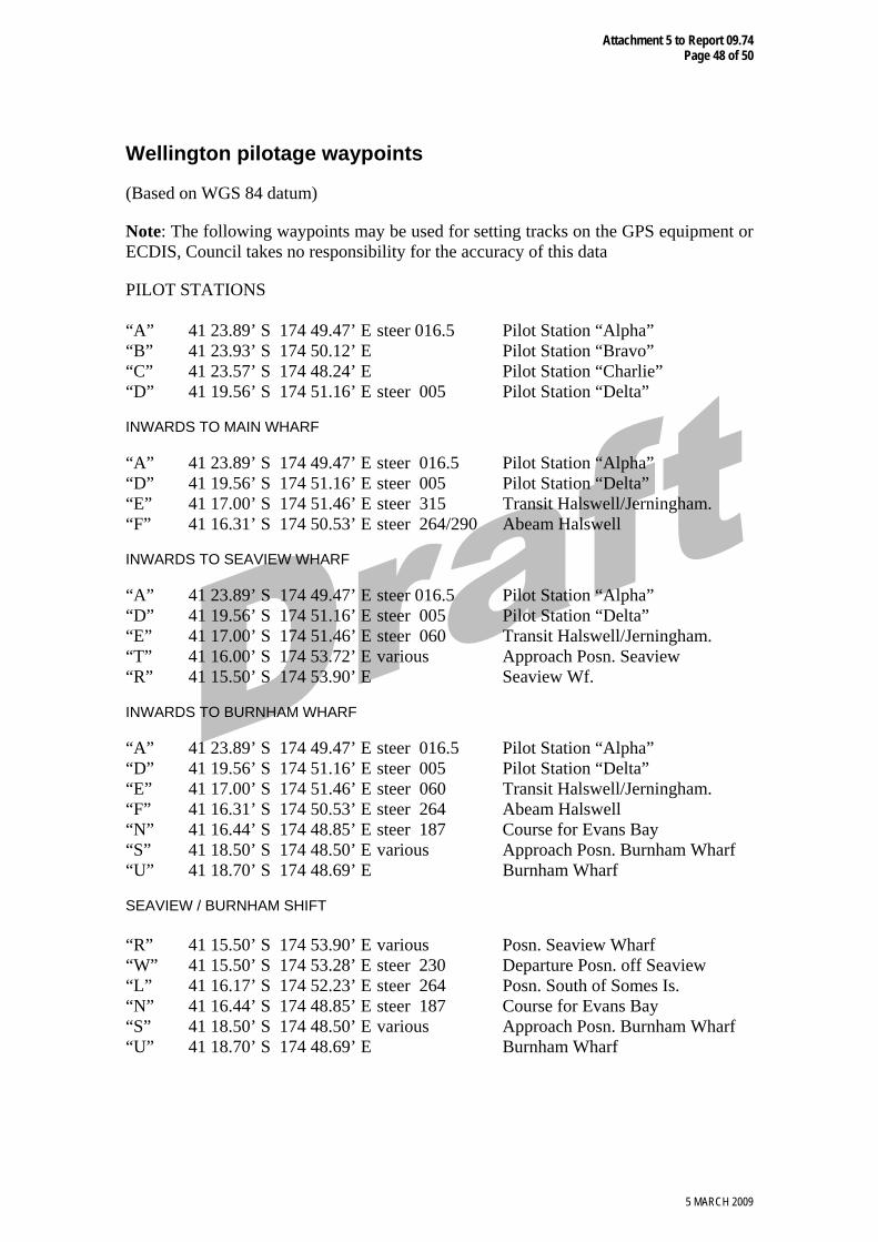
Wellington pilotage waypoints
(Based on WGS 84 datum)
Note: The following waypoints may be used for setting tracks on the GPS equipment or ECDIS, Council takes no responsibility for the accuracy of this data
PILOT STATIONS “A” 41 23.89’ S 174 49.47’ E steer 016.5 Pilot Station “Alpha” “B” 41 23.93’ S 174 50.12’ E Pilot Station “Bravo” “C” 41 23.57’ S 174 48.24’ E Pilot Station “Charlie” “D” 41 19.56’ S 174 51.16’ E steer 005 Pilot Station “Delta” INWARDS TO MAIN WHARF “A” 41 23.89’ S 174 49.47’ E steer 016.5 Pilot Station “Alpha” “D” 41 19.56’ S 174 51.16’ E steer 005 Pilot Station “Delta” “E” 41 17.00’ S 174 51.46’ E steer 315 Transit Halswell/Jerningham. “F” 41 16.31’ S 174 50.53’ E steer 264/290 Abeam Halswell INWARDS TO SEAVIEW WHARF “A” 41 23.89’ S 174 49.47’ E steer 016.5 Pilot Station “Alpha” “D” 41 19.56’ S 174 51.16’ E steer 005 Pilot Station “Delta” “E” 41 17.00’ S 174 51.46’ E steer 060 Transit Halswell/Jerningham. “T” 41 16.00’ S 174 53.72’ E various Approach Posn. Seaview “R” 41 15.50’ S 174 53.90’ E Seaview Wf. INWARDS TO BURNHAM WHARF “A” 41 23.89’ S 174 49.47’ E steer 016.5 Pilot Station “Alpha” “D” 41 19.56’ S 174 51.16’ E steer 005 Pilot Station “Delta” “E” 41 17.00’ S 174 51.46’ E steer 060 Transit Halswell/Jerningham. “F” 41 16.31’ S 174 50.53’ E steer 264 Abeam Halswell “N” 41 16.44’ S 174 48.85’ E steer 187 Course for Evans Bay “S” 41 18.50’ S 174 48.50’ E various Approach Posn. Burnham Wharf “U” 41 18.70’ S 174 48.69’ E Burnham Wharf SEAVIEW / BURNHAM SHIFT “R” 41 15.50’ S 174 53.90’ E various Posn. Seaview Wharf “W” 41 15.50’ S 174 53.28’ E steer 230 Departure Posn. off Seaview “L” 41 16.17’ S 174 52.23’ E steer 264 Posn. South of Somes Is. “N” 41 16.44’ S 174 48.85’ E steer 187 Course for Evans Bay “S” 41 18.50’ S 174 48.50’ E various Approach Posn. Burnham Wharf “U” 41 18.70’ S 174 48.69’ E Burnham Wharf

Attachment 5 to Report 09.74 Page 49 of 50
5 MARCH 2009
OUTWARDS FROM MAIN PORT “G” 41 16.54’ S 174 49.57’ E steer 126 Posn. North of Halswell “H” 41 17.22’ S 174 50.82’ E steer 168 To pass East of Falcon Shoal “I” 41 18.26’ S 174 51.11’ E steer 182 Posn. Abeam Falcon Shoal Lt. “J” 41 19.70’ S 174 51.04’ E steer 197 Posn. Off Steeple Lt. “K” 41 21.22’ S 174 50.41’ E steer 205 Posn. Abm. Barrett Buoy OUTWARDS FROM MAIN PORT CROSSING FALCON SHOAL “G” 41 16.54’ S 174 49.57’ E steer 126 Posn. North of Halswell “X” 41 17.00’ S 174 50.41’ E steer 170 Course to Cross Falcon Shoal “J” 41 19.70’ S 174 51.04’ E steer 197 Posn. Off Steeple Lt. “K” 41 21.22’ S 174 50.41’ E steer 205 Posn. Abm. Barrett Buoy OUTWARDS FROM SEAVIEW WHARF
“R” 41 15.50’ S 174 53.90’ E various Posn. Seaview Wharf “W” 41 15.50’ S 174 53.28’ E steer 230 Departure Posn. off Seaview “M” 41 17.09’ S 174 50.78’ E steer 168 To pass East of Falcon Shoal “I” 41 18.26’ S 174 51.11’ E steer 182 Posn. Abeam Falcon Shoal “J” 41 19.70’ S 174 51.04’ E steer 197 Posn. Of Steeple Lt. “K” 41 21.22’ S 174 50.41’ E steer 205 Posn. Abeam Barrett Buoy OUTWARDS FROM BURNHAM WHARF
“U” 41 18.70’ S 174 48.69’ E steer 000 Burnham Wharf “V” 41 18.00’ S 174 48.69’ E steer 010 Centre Evans Bay “0” 41 16.95’ S 174 48.93’ E various Posn to turn out of E. Bay “G” 41 16.54’ S 174 49.57’ E steer 126 Posn. N. of Halswell (optional) “H” 41 17.22’ S 174 50.82’ E steer 168 To pass East of Falcon Shoal “I” 41 18.26’ S 174 51.11’ E steer 182 Posn. Abeam Falcon Shoal “J” 41 19.70’ S 174 51.04’ E steer 197 Posn. Of Steeple Lt “K” 41 21.22’ S 174 50.41’ E steer 205 Posn. Abeam Barrett Buoy WHARF AND APPROACH POINTS “P” 41 16.78’ S 174 47.42’ E Posn. Off TCW1 “Q” 41 16.50’ S 174 48.05’ E H. O. Anchorage “R” 41 15.50’ S 174 53.90’ E Posn. Seaview Wharf “S” 41 18.50’ S 174 48.50’ E Approach Posn. Burnham Wharf “T” 41 16.00’ S 174 53.72’ E Approach Posn. Seaview “U” 41 18.70’ S 174 48.69’ E Burnham Wharf “V” 41 18.00’ S 174 48.69’ E Centre Evans Bay

Attachment 5 to Report 09.74 Page 50 of 50
5 MARCH 2009
Schedule 7 – Narrow Channel The western boundary
a) extends northward from Steeple Rock light though Falcon Shoal light until it reaches 41 degrees 17.5 minutes South.
b) Extends southward from Steeple Rock light though the position of Barrett Reef buoy until it reaches 41 degrees 21.6 minutes south.
The eastern boundary
The eastern Boundary is from the rear leading light to the point where the eastern side of the intensified lead light meats 41 degrees 21.6 minutes south, adjacent to Pencarrow Head.