navassa island - quick links island . noaa chart 26194 . a reduced -scale noaa nautical chart for...
TRANSCRIPT
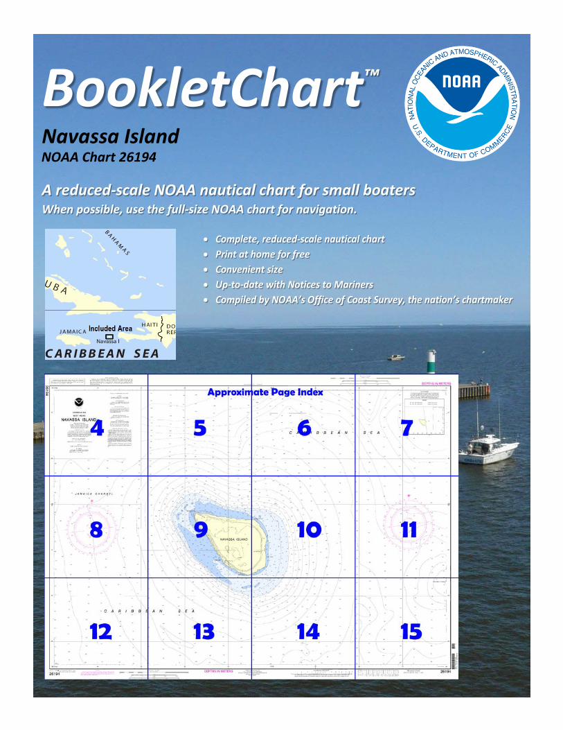
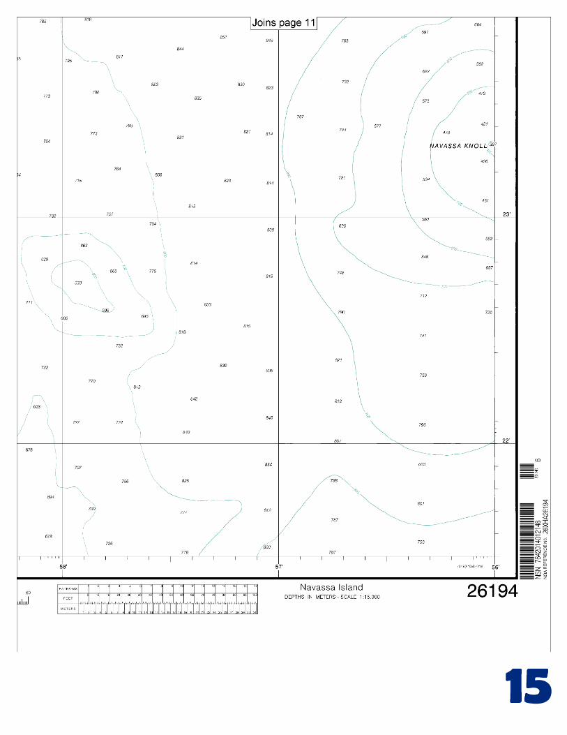
BookletChart™ Navassa Island NOAA Chart 26194
A reduced-scale NOAA nautical chart for small boaters When possible, use the full-size NOAA chart for navigation.
2
Published by the National Oceanic and Atmospheric Administration
National Ocean Service Office of Coast Survey
www.NauticalCharts.NOAA.gov 888-990-NOAA
What are Nautical Charts?
Nautical charts are a fundamental tool of marine navigation. They show water depths, obstructions, buoys, other aids to navigation, and much more. The information is shown in a way that promotes safe and efficient navigation. Chart carriage is mandatory on the commercial ships that carry America’s commerce. They are also used on every Navy and Coast Guard ship, fishing and passenger vessels, and are widely carried by recreational boaters.
What is a BookletChart?
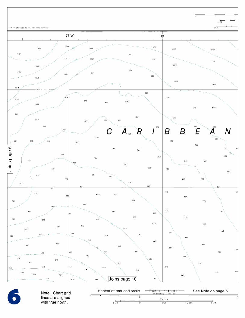
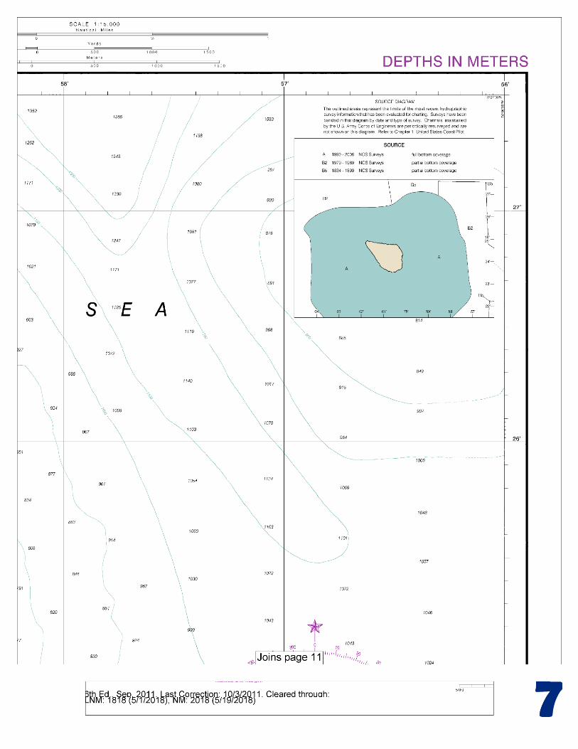
This BookletChart is made to help recreational boaters locate themselves on the water. It has been reduced in scale for convenience, but otherwise contains all the information of the full-scale nautical chart. The bar scales have also been reduced, and are accurate when used to measure distances in this BookletChart. See the Note at the bottom of page 5 for the reduction in scale applied to this chart.
Whenever possible, use the official, full scale NOAA nautical chart for navigation. Nautical chart sales agents are listed on the Internet at http://www.NauticalCharts.NOAA.gov.
This BookletChart does NOT fulfill chart carriage requirements for regulated commercial vessels under Titles 33 and 44 of the Code of Federal Regulations.
Notice to Mariners Correction Status
This BookletChart has been updated for chart corrections published in the U.S. Coast Guard Local Notice to Mariners, the National Geospatial Intelligence Agency Weekly Notice to Mariners, and, where applicable, the Canadian Coast Guard Notice to Mariners. Additional chart corrections have been made by NOAA in advance of their publication in a Notice to Mariners. The last Notices to Mariners applied to this chart are listed in the Note at the bottom of page 7. Coast Pilot excerpts are not being corrected.
For latest Coast Pilot excerpt visit the Office of Coast Survey website at http://www.nauticalcharts.noaa.gov/nsd/searchbychart.php?chart=26194.
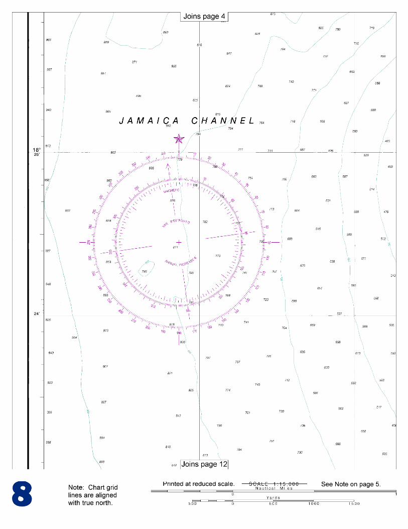
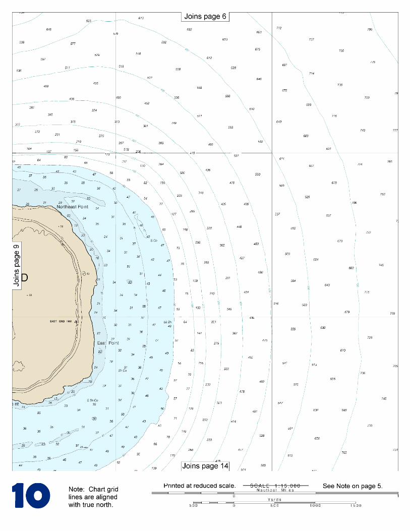
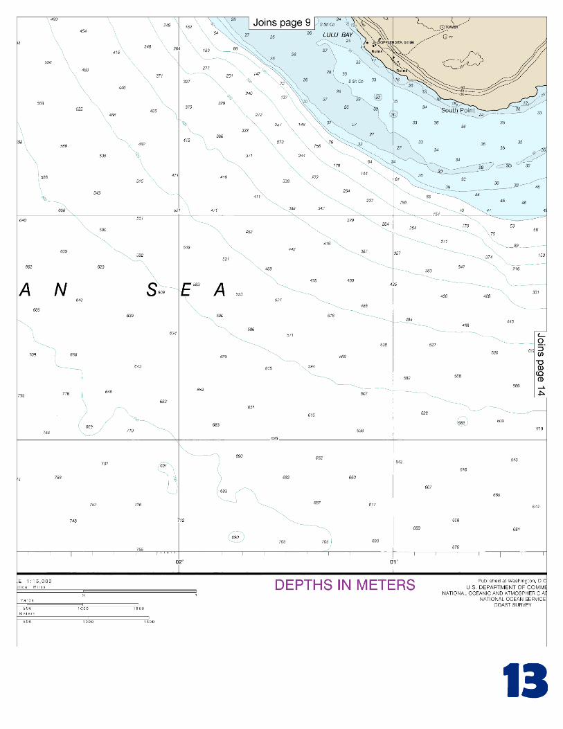
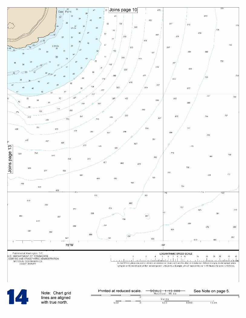
(Selected Excerpts from Coast Pilot) Navassa Island (18°24'N., 75°01'W.), a United States possession claimed in 1857, formally annexed by presidential proclamation in January 1916, and under the jurisdiction of the U.S. Fish and Wildlife Service, is about 527 miles SE of Key West and about 30 miles W of Hispaniola. The island is about 1.9 miles long and 1.1 miles wide. The shoreline consists of steep, jagged, undercut rock formations that rise as much as 50 feet from the sea. The
interior comprises about 1.8 square miles of terrain sloping steeply upward to a lofty, undulating tableland with scattered trees and cactus.
The island is uninhabited except for a few wild goats. There is no water on the island, and the terrain is extremely rugged. The island, reported visible on radar at 22 miles. Lulu Bay, a small indentation on the SW side, fronts the ruins of a former phosphate mining operation. Small craft can anchor here, but caution should be exercised due to the close proximity of the undercut rock and the frequent surge which has been observed to be as much as 7 to 10 feet. In 2006, significant tide rips were reported on the NW and SE points of the island. The rips were most prominent prior to sunrise and after sunset. Vessels can anchor about 0.4 mile WSW of Lulu Bay with the light bearing about 080°; sand and coral bottom. The United States Virgin Islands, separated from the easternmost island of the Puerto Rico group by 8-mile-wide Virgin Passage, were purchased from Denmark in 1917, and United States citizenship conferred upon the islanders in 1927. Under the revised Organic Act of 1954, legislative powers are vested in a Senate, whose members are elected by the islanders for 2-year terms. The Governor, who has certain veto powers, is elected by the people of the U.S. Virgin Islands. The capital is Charlotte Amalie, on the island of St. Thomas. The British Virgin Islands are N and E of the United States group. The United States-United Kingdom boundary extends SE between Hans Lollik and Little Tobago Islands, thence through the narrows between St. John and Tortola Islands, and thence S through Flanagan Passage between Flanagan and Norman Islands. Currents.–The currents among the Virgin Islands, although of considerable importance to navigators, are not well established by observation. The tidal current is said to set SE and NW. In the general vicinity of the islands there is an oceanic current with a velocity of about 0.2 knot that sets in a direction varying from NW to W. Pilotage, U.S. Virgin Islands.–Vessels of and above 100 gross registered tons and those vessels carrying explosives and dangerous cargo must engage for the services of an Insular Government pilot in order to enter, leave, or shift berths in a U.S. Virgin Islands port. Vessels of less tonnage, and vessels of the United States or foreign governments and pleasure craft are exempt from pilotage unless a pilot is actually employed. Exempted vessels when requiring the services of a pilot will be charged the regular rate. Pilots will take all classes of vessels in or out, day or night, unless otherwise noted. Arrangements for pilots are generally made 24 hours prior to the ship’s arrival by the ship’s agents. Quarantine, customs, immigration, and agricultural quarantine.–National quarantine laws are enforced in the U.S. Virgin Islands by officers of the U.S. Public Health Service. All vessels from foreign ports, vessels with sickness on board, and vessels from domestic ports where certain quarantinable diseases prevail are subject to inspection. (See Public Health Service, chapter 1.) The customs collection district of the U.S. Virgin Islands is under the jurisdiction of the U.S. Treasury Department but has its own customs laws. Imports manufactured in the United States enter free of duty. All foreign goods coming into the islands are subject to an import duty of 6 percent, ad valorem, unless specified as free of duty, even if imported from continental United States. Agricultural quarantine laws are enforced by officials at Charlotte Amalie and Christiansted. The United States immigration laws apply in the U.S. Virgin Islands. Passports and visas are required by persons other than U.S. citizens.
U.S. Coast Guard Rescue Coordination Center 24 hour Regional Contact for Emergencies
RCC New Orleans Commander
8th CG District (504) 589-6225 New Orleans, LA

G
NOAA’s navigation managers serve as ambassadors to the maritime community. They help identify navigational challenges facing professional and recreational mariners, and provide NOAA resources and information for safe navigation. For additional information, please visit nauticalcharts.noaa.gov/service/navmanagers
To make suggestions or ask questions online, go to nauticalcharts.noaa.gov/inquiry. To report a chart discrepancy, please use ocsdata.ncd.noaa.gov/idrs/discrepancy.aspx.
Lateral System As Seen Entering From Seaward on navigable waters except Western Rivers
PORT SIDE
ODD NUMBERED AIDS
GREEN LIGHT ONLY
FLASHING (2)
PREFERRED CHANNEL
NO NUMBERS – MAY BE LETTERED
PREFERRED CHANNEL TO
STARBOARD
TOPMOST BAND GREEN
PREFERRED CHANNEL
NO NUMBERS – MAY BE LETTERED
PREFERRED CHANNEL
TO PORT
TOPMOST BAND RED
STARBOARD SIDE
EVEN NUMBERED AIDS
RED LIGHT ONLY
FLASHING (2)
FLASHING FLASHING
OCCULTING GREEN LIGHT ONLY RED LIGHT ONLY OCCULTING QUICK FLASHING QUICK FLASHING
ISO COMPOSITE GROUP FLASHING (2+1) COMPOSITE GROUP FLASHING (2+1) ISO
"1"
Fl G 6s
G "9"
Fl G 4s
GR "A"
Fl (2+1) G 6s
RG "B"
Fl (2+1) R 6s
"2"
Fl R 6s
8
R "8"
Fl R 4s
LIGHT
G
C "1"
LIGHTED BUOY
G
"5"
GR
"U"
GR
C "S"
RG
N "C"
RG
"G"
LIGHT
6
R
N "6"
LIGHTED BUOY
R
"2
"
CAN DAYBEACON
CAN NUN NUN
DAYBEACON
For more information on aids to navigation, including those on Western Rivers, please consult the latest USCG Light List for your area.
These volumes are available online at http://www.navcen.uscg.gov
Navigation Managers Area of Responsibility
Northeast
Lt. Meghan McGovern
Northwest and
Pacific Islands
Crescent Moegling
Great Lakes Region
Tom Loeper
Chesapeake and
Delaware Bay
Steve Soherr
California
Jeff Ferguson
[email protected] Mid-Atlantic
Lt. Ryan Wartick
Alaska
Lt. Timothy M. Smith
Western Gulf Coast
Alan Bunn
Central Gulf Coast
Tim Osborn
[email protected] South Florida
Puerto Rico
U.S. Virgin Islands
Michael Henderson
Southeast
Kyle Ward
2
2 C U 5
1


VHF Marine Radio channels for use on the waterways:Channel 6 – Inter-ship safety communications.Channel 9 – Communications between boats and ship-to-coast.Channel 13 – Navigation purposes at bridges, locks, and harbors.Channel 16 – Emergency, distress and safety calls to Coast Guard and others, and to initiate calls to other
vessels. Contact the other vessel, agree to another channel, and then switch.Channel 22A – Calls between the Coast Guard and the public. Severe weather warnings, hazards to navigation and safety warnings are broadcast here.Channels 68, 69, 71, 72 and 78A – Recreational boat channels.
Getting and Giving Help — Signal other boaters using visual distress signals (flares, orange flag, lights, arm signals); whistles; horns; and on your VHF radio. You are required by law to help boaters in trouble. Respond to distress signals, but do not endanger yourself.
EMERGENCY INFORMATION
Distress Call Procedures
• Make sure radio is on.• Select Channel 16.• Press/Hold the transmit button.• Clearly say: “MAYDAY, MAYDAY, MAYDAY.”• Also give: Vessel Name and/or Description;Position and/or Location; Nature of Emergency; Number of People on Board.• Release transmit button.• Wait for 10 seconds — If no responseRepeat MAYDAY call.
HAVE ALL PERSONS PUT ON LIFE JACKETS!
This Booklet chart has been designed for duplex printing (printed on front and back of one sheet). If a duplex option is not available on your printer, you may print each sheet and arrange them back-to-back to allow for the proper layout when viewing.
QR
Quick ReferencesNautical chart related products and information - http://www.nauticalcharts.noaa.gov
Interactive chart catalog - http://www.charts.noaa.gov/InteractiveCatalog/nrnc.shtmlReport a chart discrepancy - http://ocsdata.ncd.noaa.gov/idrs/discrepancy.aspx
Chart and chart related inquiries and comments - http://ocsdata.ncd.noaa.gov/idrs/inquiry.aspx?frompage=ContactUs
Chart updates (LNM and NM corrections) - http://www.nauticalcharts.noaa.gov/mcd/updates/LNM_NM.html
Coast Pilot online - http://www.nauticalcharts.noaa.gov/nsd/cpdownload.htm
Tides and Currents - http://tidesandcurrents.noaa.gov
Marine Forecasts - http://www.nws.noaa.gov/om/marine/home.htm
National Data Buoy Center - http://www.ndbc.noaa.gov/
NowCoast web portal for coastal conditions - http://www.nowcoast.noaa.gov/
National Weather Service - http://www.weather.gov/
National Hurrican Center - http://www.nhc.noaa.gov/
Pacific Tsunami Warning Center - http://ptwc.weather.gov/
Contact Us - http://www.nauticalcharts.noaa.gov/staff/contact.htm
NOAA’s Office of Coast Survey The Nation’s Chartmaker
For the latest news from Coast Survey, follow @NOAAcharts
NOAA Weather Radio All Hazards (NWR) is a nationwide network of radio stations broadcasting continuous weather information directly from the nearest National Weather Service office. NWR broadcasts official Weather Service warnings, watches, forecasts and other hazard information 24 hours a day, 7 days a week. http://www.nws.noaa.gov/nwr/