navajo community plan - san diego · it does make material available where and when it is needed....
TRANSCRIPT

- i -
NAVAJO
COMMUNITY PLAN
ADOPTION DRAFT
June 2015
Prepared by the
NAVAJO COMMUNITY PLANNERS
and
THE CITY OF SAN DIEGO
CITY OF SAN DIEGO PLANNING DEPARTMENT
Printed on recycled paper.
This information, or this document (or portions thereof), will be made available in alternative formats upon request.

- ii -
NAVAJO COMMUNITY PLAN AMENDMENTS
The following amendments have been incorporated into this February 2008 posting of this plan:
Amendment Date Adopted by
City Council
Resolution
Number
Navajo Community Plan
adopted
December 7, 1982 R-257606
Grantville Amendment-
updates existing conditions,
provides design guidelines,
and establishes supplemental
development regulations
April 4, 1989 R-273164
The Circulation and Public
Transportation Element was
added
August 5, 2002 R-296956
Centerpoint at Grantville May 15, 2007 R-302636
Archstone at Mission Gorge November 18,
2008
R-304443
Pasatiempo February 6, 2012 R-307260
Shawnee – Riverbend October 2, 2012 R-307718
Village at Zion February 26, 2013 R-308010
San Diego River Park
Subdistrict
May 20, 2013 R-308199
Grantville Focused
Plan Amendment
- -

- iii -
MAYOR
Pete Wilson
COUNCIL
Bill Mitchell
Bill Cleator
Susan Golding
Leon William
Ed Struiksma
Mike Gotch
Dick Murphy
Lucy Killea
CITY ATTORNEY
John W. Witt
CITY MANAGER
Ray T. Blair, Jr.
PLANNING COMMISSION
John G. Davies, Chairman
Dorothy Leonard, Vice Chairman
Ron Roberts
Marie Widman
Fil Chavez
Yvonne Larsen
Paula Oquita
PLANNING DEPARTMENT
Jack Van Cleave, Director
Mike Stepner, Assistant Director
James L. Overstreet
Steve Tallian
Mary Holt
Byron Frohn
Tony Pluth
Lisa Goehring
NAVAJO COMMUNITY PLANNERS, INC.
James A. McIntyre, President Bob Osmers
Donald M. Robinson, 1st Vice President Herbert Phillips
Judy McCarty, 2nd Vice President Mary Plichta
Hal Boaz Phyllis Porter
James H. Cusack Lou Quintali
Dave Futch Karen Sue Sweeting
Donald C. Heffner John Todd
Bill Myers Jerry Wetter
Peder Norby Henry Wilson

- iv -
PARK & RECREATION Mason Milliken
TRANSPORTATION PLANNING Allen Holden
ILLUSTRATION CREDITS
Unless otherwise noted, illustrations are by the City of San Diego Planning Department.
Pages 119 Community Design Manual Fremont General Plan Program, Williams Cook and Mocine, City and Regional Planning San Francisco, California, 1967
Page 107 Toward a Better Tomorrow, a Transportation Report for Southern California by the Automobile Club of Southern California, Highway Engineering Department, 1971
Page 120 Lysander, New Community Final Planning Report submitted to the New York Urban Development Corporation by David A. Crane and Associates, January, 1971
2015 GRANTVILLE FOCUSED PLAN AMENDMENT
Mayor Planning Department
Kevin Faulconer Tom Tomlinson, Interim Director
Nancy Bragado, Deputy Director
City Council Brian Schoenfisch, Principal Planner
Sherri Lightner Seth Litchney, Senior Planner
Lorie Zapf Nancy Graham, Senior Planner
Todd Gloria Kurtis Steinert, Senior Planner
Myrtle Cole Rebecca Malone, Associate Planner
Mark Kersey Jenny An, Associate Planner
Chris Kate George Ghossain, Associate Engineer
Scott Sherman Leo DeJesus, Principal Engineering Aid
David Alvarez
Marti Emerald
City Attorney
Jan Goldsmith

- v -
July 29, 1982
The Honorable Mayor and City Council
The City Planning Commission
City of San Diego, California
Herein transmitted is the revision to the Navajo Community Plan. This revision represents a
comprehensive, long-range policy guide for the physical development of this community and is
intended to replace the community plan adopted by the City Council on November 7, 1973.
In June of 1971, the Navajo Community Planners came into existence with the endorsement of
the City Council and City Planning Commission. The Committee's purpose is to represent the
Navajo area, composed of the communities of Allied Gardens, Grantville, Del Cerro and San
Carlos, and to work with the City Manager's office and City Planning Department in a
cooperative effort to develop and maintain a plan reflecting the goals and the aspirations of the
citizens of the community.
The Committee has met regularly with City staff, numerous agencies and individuals directly
concerned with the future of the area, and with the citizens at large in well attended public
meetings, the result of which is a revised document expressing a cross-section of community and
City opinions. Involvement and expertise have been combined to produce a series of working
solutions, all based on the assumption that Navajo will continue to grow as a healthy,
predominantly single-family, yet varied area in which to live and to work.
The Plan is a vitally needed step in realizing the development potential of Navajo for present and
future residents of the community, as well as for the people of the City at large. It is
recommended that the Planning Commission and the City Council adopt the Plan as revised to
serve as a comprehensive policy framework for the long-range development of the Navajo
community area.
Respectfully submitted,
Jack Van Cleave
Planning Director
THE CITY OF
SAN DIEGO CITY ADMINISTRATION BUILDING 202 C STREET SAN DIEGO, CALIF 92101

- vi -
NAVAJO COMMUNITY PLANNERS, INC.
P.O. BOX 20304, SAN DIEGO, CALIFORNIA 92120
Dear Community Resident:
The goal of the Navajo Community Planners is a Plan which provides for the health, safety and
welfare of the existing and future residents and maintains the area as a desirable neighborhood in
which to live.
The Plan is a cross section of community options and desires blended with professional
knowledge and sound planning policy. Throughout many months the volunteer members of the
Community Planning Board met with the City Planning Department Staff in workshops with
representatives of various City, School and State Departments. Many ideas and concepts were
considered and refined to meet the needs of the community, some were rejected. The Plan
presented is a comprehensive, long-range policy guide for the Navajo Community. It discusses
residential, commercial, industrial, open space, circulation, environmental and community
facilities in terms of existing conditions, states projected needs, objectives and proposals for
each.
We hope you will take advantage of the detailed information to better understand the suggestions
for the future of the community. For the Plan to serve as a useful document statements were
made as precise as possible. Often it became necessary to use special phrasing and planning
vocabulary. A section of definitions and concepts has been included to more clearly establish the
concepts as worded in the text. Tables, charts, etc. were included where necessary for
explanation and reference. The end result does give the Plan a technical textbook appearance, but
it does make material available where and when it is needed.
The Navajo Community Plan is simply a first step in the never-ending desire of the citizens to
participate in the destiny of their community. We are grateful for your interest in the community
and hope you will actively support and participate in the community planning process.
Respectfully,
NAVAJO COMMUNITY PLANNERS

- vii -
Table of Contents
INTRODUCTION
Preface....................................................................................................................................... 1
Physiography............................................................................................................................. 3
Background ............................................................................................................................... 5
Existing Land Use and Zoning ................................................................................................. 7
Population characteristics ....................................................................................................... 10
Residential............................................................................................................................... 11
Commerical ............................................................................................................................. 17
Industrial ................................................................................................................................. 22
Community Plan Implementation Overlay Zone (CPIOZ) ..................................................... 24
Shawnee CPIOZ...................................................................................................................... 26
Grantville CPIOZ .................................................................................................................... 31
Mission Gorge Road Industrial CPIOZ .................................................................................. 48
Mission Gorge Road Residential CPIOZ ................................................................................ 55
San Diego River Park Subdistrict CPIOZ ............................................................................... 58
Open Space Retention and utilzation ...................................................................................... 69
Parks & Recreation Facilities.................................................................................................. 76
Public Schools ......................................................................................................................... 93
Other Community Facilities .................................................................................................... 99
Circulation............................................................................................................................. 104
Public Transportation ............................................................................................................ 106
Bicycles ................................................................................................................................. 109
Streets .................................................................................................................................... 113
Community Environment...................................................................................................... 121

- viii -
Implementation ..................................................................................................................... 126
Conclusion ............................................................................................................................ 136
Standards and Definitions ..................................................................................................... 137
TABLES
TABLE 1: Density Ranges ................................................................................................12
TABLE 2: Site and Trade Population Standards For Commercial Centers.......................18
TABLE 3: Grantville CPIOZ Street Tree Plan ..................................................................45
TABLE 4: Mission Gorge Road Industrial CPIOZ Street Tree Plan.................................52
TABLE 5: River Influence Area Setback, Height and Massing ........................................64
TABLE 6: Summary Of Existing And Future Population-Based Parks And Recreation
Facilities ...........................................................................................................84
TABLE 7: Summary Of Population-Based Parks, Recreation Facilities And Park
Equivalencies For Full Community Development ..........................................85
TABLE 8: Optimum School Enrollment And Usable Site Area Standards (San Diego
Unified School District) ...................................................................................94
TABLE 9: Existing Educational Facilities ........................................................................95
- 1 -
INTRODUCTION
The Navajo area of San Diego is approximately 8,000 acres in size and is located in the easterly
portion of the City of San Diego. It includes the community areas of Allied Gardens, Del Cerro,
Grantville and San Carlos. It is bounded on the north by Mission Gorge, on the east by the cities
of El Cajon and La Mesa, on the south by Highway 8 and on the west by the San Diego River
channel.
Navajo is conveniently located within the metropolitan area. Employment and shopping are
readily accessible within the community and in nearby areas. Grantville, a subregional
employment area, is located within the westerly portion of the community. The Kearny Mesa
industrial area, another major employment center, is somewhat farther away, but still convenient
to the residents of Navajo. These areas, plus downtown employment centers, are quite accessible
by major streets and freeways. In addition to the many industrial facilities within and close to the
study area, regional and community shopping centers are located within Navajo and in nearby
Kearny Mesa, Mission Valley, La Mesa, El Cajon and downtown San Diego.
The overriding objectives for the long-range development of Navajo are to retain the residential
character of the area, provide adequate community services such as police and fire protection,
rubbish collection, etc., establish guidelines for the utilization of canyons and hillsides, and
enhance the environment of the area as a pleasant, livable, walkable community. To assist in
accomplishing these objectives, this community plan provides guidelines for public and private
development to the year 2000. The Plan represents a policy framework that will enable the
community and the City to work jointly on more specific studies and action programs. The Plan
is only an initial step.
The need for a flexible document is acknowledged. Nothing can be rigid in view of changing life
styles, needs, and technology. However, the recommendations as expressed in this Plan, together
with the planning principles, should not be allowed to be eroded by individual interpretations but
should be kept intact and followed unless amended by due process.
The Plan discusses the community environment and major land uses: residential, commercial,
open space, industrial, community facilities, and circulation. Elements are presented in terms of
existing conditions, development potential or projected needs, objectives and proposals. A Plan
map presents a composite of all major land use proposals. Finally, the Plan concludes with an
implementation section which sets forth major projects, public and private, needed to carry out
the Plan.
Periodic updating of the Plan will be necessary as conditions in the community change. Once
adopted by Council, any amendments, additions or deletions from the document will require that
the Planning Commission and the City Council follow the same procedure of holding public
hearings as was followed in adopting the Plan originally. Future decisions affecting the
environment of the area will be based on the general objectives above as well as the specific
recommendations that follow.
PREFACE

- 2 -
FIGURE 1: LOCATOR
- 3 -
The community is characterized by a wide variety of natural features typical of many other San
Diego areas, including flat mesas, steep canyons, and rolling hills. The most prominent feature in
the area is Cowles Mountain. Elevations within the community range from a low of around 100
feet above sea level at the westerly edge of Mission Gorge to 1,591 feet at the peak of Cowles
Mountain, the highest point in the City.
Within the slopes of Cowles Mountain, there are approximately 4,250 acres of undeveloped land.
Approximately 2,230 acres of this land are in steep slopes of 35 percent or greater; 1,070 acres
have slopes of 15-35 percent; and the remaining 950 acres are relatively level with slopes of less
than 15 percent. Natural vegetation in the community consists mostly of chaparral, sage, and
other cover typical of semiarid regions, with some oak and sycamore trees in the canyons. The
soil composition is basically alluvium, slope wash and sedimentary rocks. The high quality hard
blue rock located in Mission Gorge is processed into sand and gravel by commercial enterprises.
Three sedimentary formations exist in areas of the community that, when combined, form an
unstable soil condition. This unstable condition can be responsible for groundwater seepage and
landslides. Measures should be taken when development is proposed in these areas that would
reduce the geological hazard impacts to a level of insignificance. One such measure is the
application of the Geologic Hazard Overlay category. The overlay identifies areas that, where
such soil conditions exist, the developer is to provide an as-built geologic report prior to issuance
of building permits by the City, and is required to provide homeowner warranties against
landslides for a period of ten years following the first sale of any developed property (Council
Resolution No. R-254954 adopted August 31, 1981).
There are several unique features in the area. Mission Gorge on the north is the site of the early
Mission Dam and is a state historical landmark. Centered in the southeastern part of the
community is Lake Murray, a City-owned reservoir which also serves as a recreation facility.
The lake, proposed for continued aquatic recreational use, contains 140 surface acres of water
surrounded by approximately 416 acres of City-owned land. A public golf course is located
within this area.
Natural runoff from the community drains into the San Diego River to the north and west and
Alvarado Canyon to the south. The natural groundwater of the San Diego River is being used by
the sand and gravel processors. The river is subject to flooding that, of course, should be
considered when allocating land use for the floodplain. Rainfall in the area is slightly less than
ten inches a year, which is consistent with the overall San Diego average
.
PHYSIOGRAPHY

- 4 -
FIGURE 2: TOPOGRAPHY

- 5 -
The study area is closely tied to early California history. Navajo has always been a prime
location in the San Diego area--near water, in the vicinity of good land for cultivation and at the
crossroads of five major trails: the Mission Trail (now known as Friars Road), Murphy Canyon
Road, Yard Road, Alvarado Trail and Mission Gorge Road. California's first mission was located
on the Rancheria Nipaguay, adjacent to the area, probably because of the choice location.
Formal dedication of the Presidio of San Diego de Alcala by Father Junipero Serra occurred on
July 16, 1769. The City of Saint Didacus began to produce changes on the landscape. The good
Fathers needed a guaranteed supply of water; thus, the first irrigation project in California was
begun. From 1812 to 1816, Indian laborers constructed what is known as the Old Mission Dam
in Mission Gorge with a six-mile transmission ditch to the Mission.
In 1835, the Missions were secularized by the Mexican Government. At that time, Mission
Ranch of San Diego de Alcala encompassed 58,875.38 acres. It was the second largest Rancho in
San Diego County, extending eastward from the San Diego Pueblo boundary to El Cajon
Rancho, and northward from Rancho de la Nacion to what is now Miramar Naval Air Station.
Before secularization, the area (El Cajon Rancho) was included in the lands of the San Diego
Mission and was one of the Mission's most valuable grazing areas. As defined by an early land
commission, this rancho extended northeasterly from La Mesa to a point north of the San Diego
River above EI Monte Park and over the area now occupied by El Cajon, Bostonia, Santee,
Lakeside and Flinn Springs.
In 1887, plans for a town site were laid out by the Junipero Land and Water Company. Plans for
a Soldier's Home to be located at Grant Circle were included. The official name registered with
the post office was Orchard, but the area became known as Grantville in honor of President U. S.
Grant.
In 1948, the so-called Waring Tract, comprising approximately 460 acres, was annexed to the
City of San Diego. Following this, the Southern Title and Trust Company Tract was annexed in
1951. This second annexation covered 1,152 acres and was subsequently developed as Allied
Gardens. Waring Tract No.2 was annexed in 1954. This annexation was one of the largest in the
City of San Diego and consisted of almost 5,000 acres.
The San Carlos and Del Cerro communities have been developed within this area. Since the
Waring Tract No.2 annexation there have been numerous smaller annexations on the northern
periphery lying generally along Mission Gorge. The last annexation was in 1982, with most
annexations occurring between 1953 and 1954.
BACKGROUND

- 6 -
On January 28, 1971, concerned residents
of Allied Gardens, Del Cerro and San
Carlos met to organize a community plan
committee. As a result of that meeting, the
Mission-Navajo-Del Cerro-San Carlos
Community Plan Committee (now Navajo
Community Planners) was formed,
consisting of members representing the
numerous community groups that already
existed in the area.
In June of 1971, the City Council endorsed
the Navajo Community Planners. This
Committee was asked to represent the
Navajo area and to work with the City
Manager's office and Planning Department
in the development of a community plan
consistent with community goals and
objectives.
The role of the Committee was to review
and analyze background information,
formulate community objectives, and to
conduct a program to keep the community
informed of its progress. City staff
provided the necessary technical studies.
Liaison was maintained with area residents
and other groups both inside and outside
the community.

- 7 -
Of the total zoned land in the Navajo area, 4,018 acres, is zoned for single-family homes; 389
acres, is zoned for multiple family use; 315 acres, is zoned for commercial use; and 56 acres, is
zoned for industrial use. The remaining 3,018 acres, located predominantly in the southern and
eastern sections of the area, including Cowles Mountain, is zoned for agriculture and the San
Diego River floodway.
Public and semi-public uses and single-
family homes are the predominant land
uses within the community. Public and
semi-public uses occupy 39.5 percent of the
area or 3,099 acres. Single-family homes
occupy approximately 37.5 percent or
2,924 acres while multifamily, commercial,
and industrial uses comprise only nine
percent of the area or 700 acres.
Approximately 14 percent of the developed
area is in streets and the remaining area is
vacant.1
1 The land uses and zoning shown in this section are dated from the built condition in 1982 when the Community
Plan was written. See the current land use and general plan for additional information.
EXISTING LAND USE AND ZONING

- 8 -
FIGURE 3: ZONING
*See figure 10 for additional information
- 9 -
FIGURE 4: LAND USE

- 10 -
The Navajo community is one of San Diego's established communities. The 1980 census counted
50,005 people in this community. This population count represents an increase of 32,640 people,
or 187 percent, since the 1960 census.
Approximately 82 percent of the dwelling units within Navajo are owner occupied. The
occupancy rate is 95.01 percent. The development of tract homes is subsiding, while
condominium and Planned Residential Development activity in the area is increasing.
The 1975 census shows a decline from 1970 in the number of children in the 0-5 age group
within the area. If the trend continues, the demand for additional elementary grade classrooms
may not be as acute as previous projections have indicated. As the community grows toward
total development, one might expect the age composition to change in the direction of smaller
average family size and an increase in the adult population, a trend which seems to be
established in older developed areas.2
2 NOTE: All statistics compiled by City of San Diego Planning Department.
POPULATION CHARACTERISTICS

- 11 -
PLAN ELEMENTS
EXISTING CONDITIONS
Navajo is a family-oriented community of
attractive single-family homes. In 1968,
approximately 95 percent of the population resided
in single-family homes. These homes accounted
for 92 percent of all dwelling units in the Navajo
area.
In 1970, five percent of the population resided in
multifamily units, which comprised 28 percent of
all dwelling units in the Navajo area. In 1970,
almost 75 percent of all dwelling units were
owner-occupied, compared to 50 percent in the City as a whole. Vacancy rates were
approximately four percent as compared to 5.6 percent for the entire City.
In 1988, single-family homes accounted for 77 percent of all dwelling units in the Navajo area.
Multifamily homes accounted for 21 percent of the dwelling units. Vacancy rates were
approximately 3.4 percent, while the citywide rate was 4.4 percent. According to 1980 census
data, almost 79 percent of all dwelling units are owner-occupied, compared to 50 percent in the
City as a whole.
Densities in the single-family residential areas of the community vary from one to six dwelling
units per acre. In the multifamily areas, densities vary from 16 dwelling units per acre in the
vicinity of Navajo Road and Jackson Drive to 109 dwelling units per acre in Grantville.
At the time the Community Plan was prepared, two mobile home parks were located in the
community in the vicinity of Mission Gorge Road: one is located near the intersection of Old
Cliffs Road and Mission Gorge Road and the other located at the eastern end of Old Cliffs Road.
The Mobile Home Park Overlay Zone was applied to both of these areas. The overlay zone
provides protection for the residents of the mobile home parks against development of the sites
for other uses and ensures the availability of varied housing types to create a more balanced
community. In 2008, an amendment to this Community Plan resulted in removing the Mobile
Home Park Overlay Zone from the site located near the intersection of Old Cliffs Road and
Mission Gorge Road.
RESIDENTIAL

- 12 -
OBJECTIVES
In the course of its deliberations, the Navajo Community Planners adopted objectives for each of
the major Plan elements. The principal or overriding residential objective to guide the long-range
development of Navajo is to: MAINTAIN AND ENHANCE THE QUALITY OF EXISTING
RESIDENCES AND ENCOURAGE THE DEVELOPMENT OF A VARIETY OF NEW
HOUSING TYPES WITH DWELLING UNIT DENSITIES PRIMARILY IN THE LOW TO
LOW-MEDIUM DENSITY RANGE AS SHOWN.
TABLE 1: DENSITY RANGES
Very low density 0-4 dwelling units per acre
Low density 5-9 dwelling units per acre
Low-medium density 10-14 dwelling units per acre
Medium density 15-29 dwelling units per acre
Medium-high density 30-43 dwelling units per acre
High density 44-73 dwelling units per acre
Very high density 44-109 dwelling units per acre
To achieve this principal objective, the following additional objectives were also adopted:
Promote a healthy environment by careful planning and sensitive development of well-
defined, balanced and distinct communities which encompass a variety of residential density
patterns and housing types.
Prevent and/or limit development in proposed open space areas which serve to enhance
community identity--steep slopes and canyons, floodplains, and areas with unique views and
vistas.
Foster techniques of land development that will encourage imagination and variety in
building site layouts, housing types, and costs, and that will capitalize on the unique
topographic assets of the community. All housing developments within the study area should
relate to existing topography in order to minimize grading and preserve the natural terrain of
the area. The use of retaining walls, terraces, split level or cantilevered houses should be
considered in steep terrain.
Assurance that any individual or family may be free to choose accommodations within their
economic capacity from a range of housing varying in type, quality and location.
Continuation of community support for those programs at all governmental levels that would
effectively increase the economic ability of the disadvantaged to obtain adequate housing.
Promotion of site selection for federally assisted housing programs which would ensure
dispersal throughout the community of various ethnic and minority groups.

- 13 -
Encourage enhancement of the existing residential development through the use of
environment and conservation programs such as cleanup, painting and landscaping programs.
Encourage the design of residential areas so as to prevent the encroachment of incompatible
uses and minimize conflict (e.g., traffic noise) with more intensive non-residential uses.
Within each new development and where possible in developed areas, plazas, squares, and
other similar open space areas should be created. Emphasis should be placed on developing
interconnected bikeways and walkways separated from auto traffic as part of the internal
circulation system within the study area.
Parking and storage areas should be screened from the street and other public areas.
PROPOSALS
General
The Navajo Community Planners strongly support City Council Policy 600-19, Fostering of
Balanced Community Development, which states: It shall be the policy of the City Council to
effect the development of economically and racially balanced communities in newly developing
peripheral areas of the City and in all City sponsored or approved redevelopment projects, and
to do what is reasonably and practically possible in all parts of the City.
Housing types and densities should be varied in residential development to create interest and
provide a mix of people with various economic and social characteristics.
Dwelling units should relate to topography and intensity of activity. Where it will provide for
more effective land utilization and high quality living environments, residential development
proposals within the community should be carried out under the Planned Residential
Development or Planned Infill Residential Development concept.
Dwelling units should front on local streets.
Multifamily residential development along major roadways, such as Mission Gorge Road,
should be adequately mitigated for roadway noise impacts associated with high traffic
volumes. If perimeter noise walls are necessary to mitigate noise impacts, they should not be
located in the required setback. Noise walls should be well designed with landscaping
provided on both sides of the wall.
Adequate off-street parking and storage must be provided and screened from living areas and
public areas. Street trees and drought tolerant landscaping should be used in level terrain to
add interest to hide parking and to separate functions. Non-contiguous sidewalks must be
provided even around off street parking and storage areas.
Development of the area north of Highwood Drive and the terminus of Lake Murray
Boulevard should not exceed 168 dwelling units as per Council Resolution No. 257606,
December 7, 1982.
Residential development should conform to the guidelines provided in the Mission Trails
Design District when applicable. The Mission Trails Design District applies to those portions
of the Navajo, Tierrasanta, and East Elliott communities consisting of, and including, all the

- 14 -
commercial and multifamily residential zones; the steep hillsides guidelines and Chapter 14,
Article 3, Division 1, Environmentally Sensitive Lands (previously Hillside Review Overlay
Zone), as well as those non-HR and undeveloped areas contiguous to HR areas; and the two
areas of land in Mission Gorge contiguous to the Mission Trails Regional Park at the east and
west sides of the park. The Design District provides that no structure shall exceed four stories
and in no case shall a structure exceed fifty (50) feet in height.
Mobile home and manufactured housing has limited benefit in high land cost urban
environment like San Diego. The ability to house more people and provide more affordable
units of development multifamily housing. Mobile home parks are not encouraged.
Dwelling Unit Density
Based upon the proposed land use, which assumes that the canyons and sloped areas will remain
open, it is projected that by 1990 the number of dwelling units will increase approximately 32
percent above the 1970 level--an increase of some 4,950 units. Approximately one-half of the
new housing units will be in the medium density range of 15-29 dwelling units per acre. By
1990, medium density housing will comprise approximately 25 percent of all residential units,
compared to eight percent in 1970.
As Navajo continues to evolve, it is proposed that a wide range of residential densities be
permitted to develop in the community. These ranges would include very high to very low
density dwelling units per acre of land. See Table 1. These densities will allow single-family
houses, duplexes, townhouses, condominiums and apartments which will appeal to a wide
segment of the population and provide for a diverse balanced population in the community.
Site Design
The topography of this area is important to preserve and enhance while allowing for new homes.
The site design of any new projects and development should be sensitive to the street and views
to and from existing homes.
Fit house to land rather than land to house. Choose the appropriate house plan to fit the basic
slope type of the site-up, down, or across slope. Correct selection will minimize grading and
preserve the maximum groundcover and trees. Use retaining walls, terraces, split level or
platform houses to minimize grading. This would eliminate the need for flat building pads
involving extensive earth cuts.
If earth moving is necessary, re-contour rather than cut and fill. If a new form must be given
to the land, the final form should have a strong, smoothly flowing character typical of the
existing hills. The basic character of the original site should provide the theme with
adjustments to make the slopes gentle. Particular attention should be paid to the transition
areas where the existing terrain stops and earthwork begins. Additional shaping in some areas
may be necessary due to the unique subsoil and groundwater conditions present.

- 15 -
Outstanding natural physical features such as the highest crest
of a hill, natural rock outcroppings, major tree belts, etc.,
should be preserved at all costs.
If hillsides are developed, they should be designed to
complement the existing terrain. Hillside developments are
usually laid out in a rigid geometrical lot pattern, and thus
fences contrast sharply with the natural terrain. A more logical
pattern would be for front and rear lots lines to follow the
horizontal contours. Under this arrangement, the patchwork
appearance of most hillside developments would be largely
eliminated. Contour fencing could take the form of trellises
with vines and other plant materials growing over the side,
while still providing a barrier between dwelling units.
Create privacy for each house and protect its outdoor spaces
from view and noise. Develop alternate methods of handling
setbacks to increase usable open space such as to minimize narrow, useless side yards, as
well as to create an interesting streetscape.
Cluster developments should be encouraged to minimize tampering with the natural
topography.
Roads should follow natural courses wherever possible to minimize cutting and grading.
Imaginative and innovative building techniques should be encouraged to create buildings
suited to natural hillside surroundings.
Detailed and effective arrangements must be formulated for the preservation, maintenance and
control of open space and recreational lands resulting from Planned Residential Developments.
Create harmonious form relationships among houses rather than endless strings of houses.
Groups of houses should appear to be related to one another rather than jumbled together
without pattern. Strive for consistency within groups of buildings through the use of
recurring shapes and materials. All the houses in one eye span should be designed to tie
together and relate to one another, yet should not be repetitive and monotonous.
Apartment developments should be arranged in such a way as to harmonize with adjacent
single-family developments. They should be designed to present less apparent bulk and to
minimize the clash of scale and activity between apartments and houses.
Variety in apartment design should be facilitated by introducing optional rear and side
setbacks and a front yard requirement based on floor area rather than an absolute dimension.
Variable front yard spaces can give an interesting character to the street in apartment
districts. When used, side yard setbacks should be increased from present regulations to
better provide for daylight and visual privacy. To assure adequate outdoor space for
residents, a minimum percentage of the floor space could be in the form of balconies and
landscaped roof terraces.
The photo shows a contiguous
sidewalk. This is design is
strongly discouraged.

- 16 -
Residential Street Design
Streets should be designed and developed to be pleasant places to
walk as well as drive. The arrangement of houses should create a
pleasant streetscape. Alignment, paving, landscaping and tree
planting should all be designed to enhance the visual effect.
Protect residential areas from the noise, pollution and physical
danger of excessive traffic. The speed and volume of traffic on
residential streets should be limited. Techniques for doing this
include making streets discontinuous to divert traffic from a
straight path, narrowing streets and intersections, creating the
appearance of narrowness through landscaping and other
improvements. Where possible, walkways should pass through
the interior of blocks. Such changes in streets should be designed so that they will not limit
the access of vehicles for police and fire protection and other emergency purposes in the
protected areas. The total effect of these changes in residential streets should be to emphasize
their residential qualities and encourage pedestrian usage. When major streets and other
streets having heavy traffic must go through residential areas, steps should be taken to screen
dwellings from the noise, fumes and other adverse effects of traffic.
Provide buffering for residential properties when heavy traffic cannot be avoided. Heavy
landscaping at the side of streets and in center islands may provide an effective barrier, as
can walls, differences in elevation and the setting back of dwellings from the roadways.
Dwellings along streets with heavy traffic should, where possible, have the main orientation
of their living space and access away from the traffic. In some cases further measures such as
soundproofing may be required. Businesses that attract or produce heavy traffic, such as
service stations, should be screened from nearby residential areas. Screening should be
provided, as well, for all open parking lots within or adjacent to residential areas. All of the
aforementioned considerations should apply to recreation areas as well as to dwellings.
Underground all utilities. This should be done not only in new subdivisions but also
programmed in stages in older parts of the community. With overhead wires out of the way,
it is possible to allow street trees to grow; and thereby, establish a more desirable
environment.
Design all curves, intersections and cul-de-sacs and their relationship to houses for the best
visual effect. Every opportunity should be taken to make street alignment and other street
features contribute positively to good urban design. For example, use should be made of long
radius curves connected by short curves in aligning streets rather than long tangents
connected by short sharp curves. The former gives a much more sweeping, elegant feeling at
eye level while the latter is sharply defined as one enters and leaves the curve.
Provide the maximum street tree planting. One principal characteristic of memorable streets
throughout the world is their tree planting. The finest examples have mature specimens that
arch across the street creating a green canopy. From an urban design standpoint, a various
tree planting program is the most important single thing that the City can do. Trees should be
spaced close enough together to create an effect of enclosure and to provide protection of
trees from hot drying winds and sun scald.
The photo shows non-
contiguous sidewalk that is
encouraged because it separates
pedestrians from the vehicle
roadway.

- 17 -
EXISTING CONDITIONS
As of 1988, approximately 123 acres of the 155 acres of commercially zoned land are being used
for commercial purposes, representing almost two percent of the land in the Navajo community.
An additional 90 acres of industrially zoned land are being used for commercial purposes in the
Grantville area.
Existing development is typified by businesses, stores and offices which provide goods and
services for local consumption. Most commercial development is clustered into shopping centers
and is characterized by its community rather than regional nature. Four neighborhood centers
provide for the daily shopping needs of the residents. Typical establishments include food
markets, service stations, barber shops, beauty parlors, drug, hardware and liquor stores. Sites
vary from less than an acre to almost ten acres.
Three community centers provide convenience goods--personal, professional, financial and
automotive services--and a limited variety of shopping goods. Establishments include variety
stores, apparel and shoe stores, banks,
professional offices plus those establishments
normally found in neighborhood centers. These
centers are located on major streets and are
easily accessible from most points in their
respective trade areas.
The largest community center, which includes
the Navajo and Ralphs shopping centers, is
located at the intersection of Navajo Road and
Lake Murray Boulevard (See top right). The
total complex of over 50 business
establishments and professional offices covers
35 acres.
The other two community centers are located at
Waring Road and Orcutt Street and Navajo
Road and Jackson Drive. The center at Waring
Road and Orcutt Street has over 30 business
establishments and professional offices on 12
acres of land (See middle right).
The Navajo Road and Jackson Drive center is
45 acres and has numerous commercial and
professional uses in addition to multifamily
residential use (See bottom right).
COMMERCIAL

- 18 -
Major concentrations of professional offices are located in the three community shopping
centers. Other professional offices are scattered throughout the area usually in conjunction with
commercial centers.
Visitor-oriented commercial uses are located at Interstate 8 (I-8) and Waring Road. The potential
for visitor-oriented facilities in Navajo is very limited. There are no movie theaters, bowling
alleys or other similar forms of commercial recreation in the community. The centers serve only
commercial functions, rarely being used for community purposes such as art shows and other
cultural events.
Grossmont Center, a regional shopping center readily accessible to area residents, emphasizes
such shopping goods as apparel, major household appliances and furnishings. It is located just
outside the study area in the city of La Mesa. Also easily accessible are Mission Valley
establishments and Parkway Plaza in El Cajon, as well as many other adjacent areas. Time
distance, even to downtown areas, is only about 20 minutes.
Mission Gorge Road, a major entry point into the community, contains strip commercial
development with a mix of land uses. The visual clutter created by numerous curb cuts,
unscreened parking areas, excessive signs and billboards, and above ground utilities, as well as
the condition of much of the development along Mission Gorge Road does not project a positive
impression of the community. In addition, neighborhood centers along Mission Gorge Road have
developed without regard to other development, resulting in a lack of coordinated design.
The commercial centers are constructed for the convenience of the automobile and not the
shopper, which is accentuated by the lack of other forms of transportation within the community.
The commercial buildings, if built by a chain, often follow some standard facade treatment that
may not relate to the character of the particular site in which it is placed. Promotional and store
signs are generally geared to a through traffic, high pressure merchandising situation rather than
a neighborhood situation. Almost without exception landscaping of the sites is at a minimum and
frequently not maintained. In particular, parking lots consist of an expanse of unrelieved asphalt
and are often laid out so that shoppers are forced to thread their way between parked cars.
Table 2 contains site and trade population standards for neighborhood, community, and regional
shopping centers according to the Progress Guide and General Plan for San Diego.
TABLE 2: SITE AND TRADE POPULATION STANDARDS FOR COMMERCIAL
CENTERS
Criteria Neighborhood Community Regional
Population in Trade Area 2,000-10,000 10,000-25,000 100,000 or more
Acres/1000 Population 1.0 .8 .7
Site Area 1-10 acres 8-20 acres 50 acres or more
The development potential for commercial facilities that serve Navajo residents is based on these
standards as applied to the projected 1990 population of 65,000 to 70,000. Accordingly, the area
could support six or seven neighborhood centers with a combined area of approximately 55 acres
and two or three community centers with a combined area of approximately 60 acres.

- 19 -
Commercial facilities in adjacent communities, particularly La Mesa and El Cajon, however,
serve Navajo and reduce the need for commercial land within the planning area.
OBJECTIVES
The principal or overriding objective for long-range commercial development in Navajo is not
only to ENCOURAGE NEIGHBORHOOD AND COMMUNITY SHOPPING FACILITIES
WHICH ARE ADEQUATE TO PROVIDE A WIDE VARIETY OF GOODS AND SERVICES
TO NAVAJO, BUT ALSO BLEND INTO AND ENHANCE THE COMMUNITY
ENVIRONMENT.
To achieve this principal objective, the following additional objectives were also adopted:
Develop commercial areas as centers for community activities. Such centers should include
community facilities, such as cultural, recreational, entertainment and residential facilities, as
well as retail establishments and professional offices.
Develop commercial areas that have desirably distinctive qualities in their design, appearance
and operation.
Provide neighborhood convenience centers that are complementary to adjacent residential
areas and strategically located throughout the residential areas of the community, preferably
near public facilities. These shops should be accessible to pedestrians and bicyclists and be in
scale and character with the neighborhoods they serve. In addition, existing centers should be
encouraged to add safe facilities for pedestrians and bicyclists.
Prevent the overdevelopment of any one type of commercial use (for example, service
stations).
Prohibit the expansion of strip commercial development on Mission Gorge Road north of
Zion Ave.
Restrict retail development to areas designated for commercial and mixed use; limit
commercial office and service uses in the industrially designated areas to those that are
accessory to industrial uses.
Improve the appearance of the existing strip commercial development on Mission Gorge
Road between I-8 and Zion Avenue by reducing signs, improving landscaping and
architectural design, providing consistent building setbacks and providing adequate off-street
parking.
Limit the development of drive-thru restaurants to sites that can accommodate the stacking of
vehicles, as well as accommodate driveways in a manner that will not conflict with the
smooth operation of intersections.
Reduce the number of curb cuts serving individual commercial uses on Mission Gorge Road
to minimize traffic conflicts and provide a continuous sidewalk and landscape strip.

- 20 -
PROPOSALS
General
In addition to retail stores necessary to accommodate the needs of the community,
commercial centers should also provide for professional and business offices, entertainment
and cultural activities, public and semipublic facilities, and residential uses. The existing
centers, due to their location, size, and the character of adjacent development, could easily be
improved to meet these criteria.
All the centers should be accessible by pedestrians, bicycles and adequate public
transportation as well as by car.
The shopping center at Lake Murray Boulevard and Navajo Road, the community shopping
center at Waring Road and Orcutt Avenue, and the center at Navajo Road and Jackson Drive
are to be retained as community commercial centers. These establishments should fulfill the
need for convenience goods and personal, professional, financial and recreational services
through the year 2000.
Neighborhood commercial centers should be retained at the intersections of Golfcrest Drive
and Mission Gorge Road, Conestoga Road at Mission Gorge Road, and Zion Avenue at
Mission Gorge Road. The centers should be an integral part of the residential development
and retrofitted to attract pedestrian and bicycle users in addition to the automobile.
Professional offices are to be retained at existing locations. The expansion of professional
offices is recommended at all community shopping centers.
Visitor-oriented facilities (hotels, motels, and associated uses) should be limited to those
existing at the intersections of I-8 and Waring Road, and Mission Gorge Road and Alvarado
Canyon Road. No additional visitor-oriented facilities should be developed.
The number and location of service stations should continue to be regulated. No more than
one station should be located at an intersection and the overall number of stations should be
based on service to the community. Existing facilities appear to be sufficient to serve
community needs through the year 2000.
The removal of off-premise signs and the consolidation of multiple on-premise signs should
be pursued during project reviews in an effort to reduce sign clutter and enhance the visual
appearance of Mission Gorge Road.
Any rezones or tentative maps for new commercial center development and redevelopment
should require processing in accordance with the planned commercial development
regulations to ensure comprehensive review of the center and its compatibility with adjacent
development.

- 21 -
FIGURE 5: COMMERCIAL PROPOSALS
- 22 -
EXISTING CONDITIONS
Sand and gravel extraction was once the predominant industrial use in Grantville, accounting for
most of the industrially zoned land along the San Diego River as well as most of the
agriculturally zoned land. The manufacturing of cement block, brick, and associated secondary
sand and gravel uses were also prevalent near the river. Most of the sand and gravel activities
have now been discontinued and are being replaced with multi-tenant buildings.
A 250-acre site is still being used for sand and gravel processing on the north side of Mission
Gorge Road, generally between Princess View Drive and Margerum Avenue. This quarry has
been in operation since 1927 and is currently operating under a Conditional Use Permit (CUP)
that expires in 2033. The CUP regulates the mining, processing, storage and sale of natural
resource material. A master reclamation plan for the 250 acres covered within the CUP, as well
as 170 acres from which sand deposits have previously been mined, establishes goals and general
guidelines for the reclamation of the project area upon completion of mining activity. Final
reclamation is to be accomplished in phases with the approval of precise reclamation plans.
PROPOSALS
Based on the existing conditions and objectives identified above, the following general proposals
were established to encourage industrial development that is compatible with the residential
character of the Navajo community.
A Planned Industrial Development (PID) or master PID should be required for any property
rezoned to an industrial zone to ensure quality site design, and compatibility with the San
Diego River environment and surrounding residential areas where appropriate. A master PID
establishes design guidelines and standards to be used in the review of subsequent detailed
site-specific projects. The PID document shall include a conceptual site plan showing the
general location of proposed uses; a list of permitted uses; a preliminary grading plan; and
master circulation, landscaping and sign plans. After approval of the master PID, projects
will be reviewed and approved ministerially by the Planning Department if they are found to
be consistent with the approved master PID. The design guidelines identified in this
Industrial Element shall be consulted in the design and review of the master PID.
Future development of the remaining sand and gravel operation and the previously mined
170 acres should be accomplished under a master Planned Industrial Development (PID)
permit process. This property is bounded on the south by a major element of the regional
transportation network (Mission Gorge Road) and on the north by the San Diego River, a
regionally significant natural resource. A master PID will provide an opportunity for
comprehensive review of the relationship between proposed development and the ultimate
reclamation plan for the San Diego River, coordination of open space and pathways with
Mission Trails Regional Park, traffic impacts to Mission Gorge Road and the proposed State
Highway 52 interchanges.
INDUSTRIAL
- 23 -
The area south of Mission Gorge Road generally between Old Cliffs Road and Princess View
Drive is designated for development as an industrial park complex. This property is highly
visible from Mission Gorge Road, as well as from the residential areas above the river basin
in Allied Gardens and Tierrasanta. Future development under the M-1B Zone is
recommended; however, a planned industrial development permit should be required to
ensure coordinated, quality design and compatibility with the residential uses adjacent to this
site.
In order to implement the San Diego River Park Master Plan, the San Diego River Park
Subdistrict Community Plan Implementation Overlay Zone (CPIOZ-Type B) is applied to all
properties within two subareas of the river, the River Corridor Area and the River Influence
Area. See the San Diego River Park Subdistrict Section of this plan.
- 24 -
FIGURE 6: COMMUNITY PLAN IMPLEMENTATION OVERLAY ZONE (CPIOZ)
AREAS
The Navajo Community Plan contains 5 distinct Community Plan Implementation Overlay Zone
(CPIOZ) areas, as shown on the map above. This chapter includes the supplemental
development regulations for each of these 5 CPIOZ areas.
In the areas designated as CPIOZ-Type A, development that is consistent with the Community
Plan, the base zone regulations, and the supplemental development regulations identified in each
CPIOZ section can be processed ministerially in accordance with the procedures of the
Community Plan Implementation Overlay Zone. Any development that does not comply with the
Community Plan, the base zone regulations, or any of the supplemental development regulations
identified in the CPIOZ section shall be required to obtain a discretionary permit.
COMMUNITY PLAN IMPLEMENTATION OVERLAY ZONE (CPIOZ)

- 25 -
In the areas designated as CPIOZ-Type B, a discretionary permit is required. Applications for a CPIOZ-Type B discretionary permit shall meet the regulations of the underlying zone and the purpose and intent of the supplemental development regulations identified in each CPIOZ section.
Projects that require a discretionary review process should address the design and compatibility of the project in relation to surrounding development as well as the purpose and intent of the applicable CPIOZ section and supplemental development regulations of the applicable section. Projects may propose design solutions that vary, but the design of the project shall be equal or higher in quality to the design concepts identified for these CPIOZ areas.
It is anticipated that the transition from Grantville’s predominantly light industrial and stand-alone commercial land uses to mixed use, transit oriented development will take place through incremental implementation as individual properties are redeveloped. While the shift of land uses occurs over time, Light Manufacturing uses, Research & Development uses, Distribution and Storage uses, Office uses, Retail Sales uses, Personal Vehicle Sales & Rentals and Commercial Services uses may locate or relocate to any tenant space on any premises within Grantville that retains previously conforming status for the IL-2-1 and IL-3-1 zones, regardless of the square footage of the tenant space; however a change in use to a separately regulated use is not permitted. Previously conforming status remains with a premises until such time as all tenant spaces on a premises have been vacant for a period of two years, at such time previously conforming status ceases.

- 26 -
FIGURE 7: COMMUNITY PLAN IMPLEMENTATION CPIOZ-TYPE A (SHAWNEE)
OVERVIEW
Shawnee/CG7600 Master Plan consists of approximately 23 acres and is intended to be
developed pursuant to these Supplemental Regulations, which allow a greater variety and
intensity of uses than base zoning and provides greater flexibility from creative design. This is
envisioned to provide elements of smart growth that reduces automobile dependency, increased
pedestrian activity, restoration of open space and public access to the San Diego River, and the
creation of a high-quality neighborhood.
SHAWNEE CPIOZ

- 27 -
SUPPLEMENTAL DEVELOPMENT REGULATIONS
The primary land use of the site is reserved for multi-family residential. The buildings that front
Mission Gorge Road and Old Cliffs Road are multi-family residential uses with ground floor
commercial. Roadway connections to adjacent properties are an important element that will
provide convenient vehicular and pedestrian circulation. Documentation from a California
Registered Traffic Engineer stating that the proposed project’s traffic volumes are based on the
City’s trip generation rates and are less than the thresholds established in the City of San Diego’s
Traffic Impact Study Manual must be confirmed and accepted by the City Engineer.
River Road will connect the site to the adjacent proposed River Park at Mission Gorge project.
River Road will run almost the entire length of the site and connect to Old Cliffs Road where
primary access to the site will lead to Mission Gorge Road. On the west side of River Road the
principle open space area will be developed and integrated with the San Diego River Park Master
Plan trail corridor.
Adjacent property owners to the north and south are proposing compatible land uses with
Shawnee in scale, intensity of development, uses, landscape and circulation elements.
Integration of the street network and pedestrian paths are a central theme of the master plan that
will encourage pedestrian activity, provide public access to the San Diego River and more
closely link the community.
The existing commercial industrial land uses along “C” Street with Old Cliffs Road and “E”
Street with Mission Gorge Road present a challenge for residential uses. All repair work for
automobiles at the auto body shop is internalized within the concrete walls of the building which
eliminates much of the problems associated with industrial uses such as noise and odor. The
proposed intervening streets and private drive will provide a physical separation and buffer from
potential noise coming from within the building. A fence and landscape shall be placed around
the perimeter of the auto body property’s western and northern boundary and the western and
southern boundaries of the auto dismantling yard at the northeast corner of the site to provide
sufficient visual screening. Street trees shall be planted to provide additional layers of screening
for residential units. The land use plan for Shawnee/CG7600 is shown in Map 3. The following
land use designations apply to the Shawnee/CG7600 site:
Multifamily Residential
Development in this designation would primarily consist of residential uses providing a mix
of dwelling unit sizes and may also include special-purpose occupancy such as seniors,
students, or workforce housing.
Mixed Multifamily Residential/Retail/Commercial
Development in this designation would primarily consist of residential uses providing a mix
of dwelling sizes and may also include special-purpose occupancy such as for seniors,
students, or workforce housing and shall also include residential, office, retail and other
commercial uses per the list of permitted uses below, which shall be located on the ground
floor. These commercial uses are to be located along the Mission Gorge Road and Old Cliffs
Road frontage.

- 28 -
Open Space (Park): The open space west of River Road shall be reserved for open space and
provide population-based parks for the site. Additional open space for passive and active
recreation will be linked throughout the site that will serve as an open space network.
The proposed development shall comply with the following provisions of the CPIOZ and the
RM-3-9, RM-4-10 and OP-2-1 zones.
FIGURE 8: SHAWNEE LAND USE
DEVELOPMENT CONCEPT
Shawnee/CG7600 shall allow the development of a mix of retail, office and residential uses
along the Mission Gorge Road and Old Cliffs Road frontage in compliance with the list of
permitted uses below. Privately owned community open space for public use shall also be
included within the site and shall be maintained to permit public access.
Permitted Uses
Permitted uses within Shawnee/CG7600 shall be those permitted in the applicable base
zone in the Municipal Code as well as residential and commercial uses as follows:
Multiple Dwelling Units

- 29 -
Separately Regulated Residential Uses
o Home Occupations (L – Permitted subject to compliance with Section 141.0308 of the Municipal Code)
o Housing for Senior Citizens (C – Permitted by Conditional Use Permit and subject to compliance with Section 141.0310 of the Municipal Code)
o Shopkeeper Units
o Live/Work Quarters
Sale of
o Food, Beverages and Groceries
o Consumer Goods, Furniture, Appliance Equipment (limited to 2,500 square feet for each premises)
o Sundries, Pharmaceuticals, and Convenience Sales
o Wearing Apparel and Accessories
Commercial Services
o Building Services (limited to 2,500 square feet for each premises)
o Business Support (Hiring Halls are not permitted)
o Eating and Drinking Establishments (the sale of alcoholic beverages is not permitted as a primary use)
o Financial Institutions
o Personal Services
o Pet Grooming and Pet Supplies (Pet Sales or Boarding Kennels are not permitted)
Separately Regulated Commercial Service Uses
o Child Care Centers (L - Permitted subject to compliance with Section 141.0606 of the Municipal Code)
o Instructional Studios
o Outpatient Medical Clinics (N – Permitted with a Neighborhood Use Permit subject to compliance with Section 141.0615(b) of the Municipal Code)
o Private Clubs, Lodges and Fraternal Organizations
o Sidewalk Cafes
Offices
o Business and Professional
o Government
o Medical, Dental and Health Practitioners
Signs
o Allowable Signs

- 30 -
The Shawnee/CG7600 Master Plan will regulate the development of the Shawnee/CG7600 site.
Consult the Shawnee/CG7600 Master Plan for development regulations. Approval of the PDP,
SDP, VTM and Rezone for the site will be concurrent with approval of the Shawnee/CG7600
Master Plan.

- 31 -
FIGURE 9: COMMUNITY PLAN IMPLEMENTATION CPIOZ-A (GRANTVILLE)
OVERVIEW
This Grantville CPIOZ sets the framework for new infill development and provides design
standards to ensure high-quality development that supports walkability, strengthens connectivity,
and enhances community identity. Grantville CPIOZ shall be implemented by Chapter 13 Art 02
Div 14, Community Plan Implementation Overlay Zone. The supplemental development
regulations do not apply to the following projects:
Interior improvements including modifications or repair to an existing building that does
not expand the floor area of the existing building;
Exterior repairs, modifications, or maintenance that does not expand the floor area of the
existing building.
GRANTVILLE CPIOZ

- 32 -
PURPOSE AND INTENT
In 2005, the Grantville Trolley Station opened in the Navajo Community on Alvarado Canyon
Road. As ridership continues to increase, it is anticipated that the trolley station will contribute to
an enhanced quality of life, a reduction in additional traffic congestion, improved local air
quality, and an opportunity for residents and visitors to engage in more frequent pedestrian-
oriented and transit-reliant trips.
Grantville, as described in the figure above, is developed with a mix of mostly older,
underutilized commercial and industrial buildings containing a variety of auto-dependent
commercial service uses. Many properties in the area have outdated and deteriorated buildings,
lack adequate parking and landscaping, and are in need of substantial capital reinvestment to
stimulate economic development and create a more attractive and pleasant environment. Existing
industrial zoning in Grantville has not adequately accomplished the objective of the previous
CPIOZ, which was intended to encourage industrial development and redevelopment that will
capitalize on the area’s central location within the metropolitan area.
Because of the age and declining physical condition of the existing properties coupled with the
frequent conversion of industrial properties to office or storage uses, this area was identified by
the General Plan’s Strategic Framework Element (2002) as prime for neighborhood revitalization
with a more lively mix of land uses better suited to residents and the Navajo Community.
A shift in land uses from industrial to a mix of land uses including employment, commercial,
higher density residential, and civic uses would allow many of the properties to be better utilized.
Grantville is envisioned to include more transit-supported residential, workforce housing, and
local neighborhood retail, as well as new commercial and employment opportunities. The new
development would also provide additional community benefits to the area including pedestrian
and bicycle infrastructure, improvements to Alvarado Creek, and access to the San Diego River.
Over time, underutilized areas of Grantville would shift away from primarily industrial use to a
mix of uses that serve the needs of the current and projected population.

- 33 -
The Grantville CPIOZ is intended to encourage transit-oriented developments, which will
minimize the need for an overreliance on automobiles and emphasize pedestrian orientation and
proximity to public transit. It includes supplemental development regulations that reinforce the
concept of an interconnection between development projects and the surrounding public transit
system. The CPIOZ will encourage the physical and functional integration of project
components, site design, and the provision of pedestrian and bicycle infrastructure. It capitalizes
on Grantville’s proximity to public transit by concentrating new housing density and commercial
uses around public amenities. As development and redevelopment occurs over time, an
elaborate pedestrian and bicycle circulation network that links new development to the Grantville
Trolley Station will be achieved through the guidance provided in the Grantville CPIOZ.
The following urban design framework identified below is intended to become the basis for more
finite design through detailed landscape, enhanced streetscape character, and refined building
architecture. In order to create visually appealing streetscapes, it is envisioned that new
residential, commercial, and mixed-use developments shall design street frontages that increase
pedestrian access and retail activity through high quality street-facing building exteriors. The
purpose of the framework is to foster creative approaches to design and facilitate the transition to
transit-supportive land uses in the project area.
UD-1. Enhance pedestrian and bicycle connectivity by including sidewalks and bike facilities.
UD-2. Create appealing streetscapes through urban design, including defining the human scale
through ground floor architectural scale, and incorporating street furnishings and
lighting.
UD-3. Build attractive buildings, projects, and facades along public and private streets that
create visual interest. Existing Billboards should be removed with all new development.
UD-4. Locate active uses on the ground floor of buildings in order to enliven the pedestrian
experience and engage the streetscape or public realm.
UD-5. Diminish the overall mass of buildings and create variation as viewed by pedestrians on
the sidewalk.
UD-6. Create an active, attractive, and pedestrian-focused, retail environment in Grantville.
UD-7. Design projects that incorporate connections to the Grantville Trolley Station and bus
routes.
UD-8. Revitalize Grantville through transit-oriented developments that provide
interconnectivity through transit.
UD-9. Design larger scale development projects with private streets and private drives that
include parking, sidewalks, planting areas in order to allow multiple routes to
destinations, create a smaller block size, and increase connectivity.
UD-10. Provide the opportunity for a pedestrian/bicycle bridge over Alvarado Creek, which
will allow any development projects adjacent to Alvarado the creek a critical linkage to
the Grantville Trolley Station.

- 34 -
Figure 10 is provided as an inset to Figure 3 and Figure 5.
FIGURE 10: GRANTVILLE CPIOZ-TYPE A ZONING

- 35 -
SUPPLEMENTAL DEVELOPMENT REGULATIONS
For Grantville CPIOZ-Type A, development that is consistent with the base zone regulations and
the following supplemental development regulations will be processed ministerially in
accordance with the procedures of the Community Plan Implementation Overlay Zone
(Municipal Code Chapter 13, Article 2, Division 14.) The supplemental development regulations
do not apply to the following projects:
Interior modifications, repair, exterior repairs, or maintenance that does not expand the
floor area of the existing building.
Any proposal that does not comply with the supplemental development regulations shall require
a discretionary permit. Projects that require a discretionary review process shall meet the purpose
and intent of the supplemental development regulations and should address the design and
compatibility of the project in relation to surrounding development.
SDR 1. In order to establish the trip generation rate for a proposed project, proposed
development shall meet one of the following criteria or apply for a discretionary
permit:
a. Proposed project is greater than or equal to 20 dwelling units per acre and is 165
dwelling units or less; OR
b. Proposed project is mixed-use, greater than or equal to 20 dwelling units per acre,
does not exceed 100 dwelling units, and 10,000 s.f. of commercial use; OR
c. Submit documentation from a California Registered Traffic Engineer, confirmed
and accepted by the City Engineer, stating one of the following:
i. The proposed project’s traffic volumes are based on the City’s trip
generation rates and the proposed project generates less than 1,000
ADT’s; OR
ii. If project generates more than 1,000 ADT’s, documentation must
demonstrate the project has no significant impacts onto the transportation
system.

- 36 -
SDR 2. Based on the City of San Diego interim screening criteria for GHG emission analysis,
all new projects will have greenhouse gas emissions (GHG emissions) less than 900
metric tons of CO2e measure. For projects exceeding 900 metric tons of CO2e, the
greenhouse gas analysis must show how the project will reduce its GHG emissions by
20.5% compared to the business as usual scenario. The reduction measures should
include, but are not limited to, onsite recycling, water use reductions, and
transportation features such as increased transit accessibility, improved pedestrian
networks, and improved bikeability.
a. Prior to adoption of the City of San Diego Climate Action Plan: Projects shall
submit a GHG emissions analysis accepted by the City of San Diego showing
GHG emissions less than 900 metric tons of CO2e measure; OR a GHG emissions
reduction of 20.5%; OR
b. Upon the adoption of the City of San Diego Climate Action Plan: Projects shall
submit a completed Climate Action Plan consistency review checklist.
SDR 3. Any habitable space located within a CNEL of greater than 60 dBA shall require an
acoustical study consistent with Table NE-4 (Acoustical Study Guidelines – General
Plan). The proposed building, wall, and roof-ceiling assemblies shall be designed to
limit intruding noise to the allowable interior noise level with all exterior doors and
windows in the closed position. Documentation of the noise attenuation measures
shall include building assemblies section including, but not limited to, a wall and
roof-ceiling assemblies section. Design of noise attenuation measures shall include
the following:
a. For residential, institutional, and visitor accommodation uses: The allowable
interior noise level is 45 dBA. Wall and roof-ceiling assemblies making up the
building envelope shall attenuate noise to meet applicable building code
requirements.
b. For retail and office uses: The allowable interior noise level is 50 dBA. Wall and
roof-ceiling assemblies making up the building envelope shall attenuate noise to
meet applicable building code requirements.
c. For mixed-use buildings, residential, institutional, and visitor accommodation
spaces must attenuate to (a) and non-residential spaces shall attenuate to (b).

- 37 -
Multi-Modal Connectivity
All improvements identified below shall be required for all new development except as
identified in §142.0611 (Exemptions from Requirement to Provide Public Improvements
Incidental to a Building Permit). The Pedestrian Design section of the City of San Diego Street
Design Manual should be integrated into the site planning and design of new developments.
The separate zones of the pedestrian sidewalk zones are defined in the City of San Diego Street
Design Manual.
SDR 4. All new development shall provide a minimum of one vehicular access way through
the project site. The layout of a private street or private drive should be in a grid
pattern or modified grid pattern, emphasizing interconnected streets and the ability to
reach local destinations through multiple routes. It is desirable to have streets with
block faces of 400 feet in length or less. Private streets or private drives shall be
coordinated and connected to the public street system. Fencing, walls, or gates that
limit access are prohibited. Where possible, streets shall frame vistas of the mixed-use
core, Grantville Trolley Station, San Diego River, and Alvarado Creek.
SDR 5. All new development shall provide a minimum of one pedestrian and bicycle access-
way through the project site. Pedestrian and bicycle access-ways shall be coordinated
and connected to public streets. Fencing, walls, and gates that limit access are
prohibited. Sidewalks shall be separated from the street by landscaped parkways and
shall be provided as follows:
a. Provide a minimum 5-foot landscaped parkway and minimum 5-foot non-
contiguous sidewalk on at least one side of any private drive.
b. Provide a minimum 5-foot landscaped parkway and minimum 10-foot non-
contiguous sidewalk along any public or private street. See Figure 11.
FIGURE 11: LANDSCAPE PARKWAY AND SIDEWALK REQUIREMENT

- 38 -
SDR 6. For all new projects, provide way-finding signage. The signage shall identify the
pedestrian and bicycle routes to and from the Grantville Trolley Station and San
Diego River. Signage shall be submitted for review. The placement of signs and other
public facilities shall be done in a manner so as to provide a clear unobstructed
pedestrian path and continuous parkway design. Submit the following signage for
review:
a. Provide one vertical way-finding signage per 100 feet of street facing building
façade. Examples of vertical way-finding signage include permanent banners,
traditional sign posts, or plaques. Incorporate vertical way-finding signage into
the building elevation as a plaque or install vertical way-finding signage in the
pedestrian zone; OR
b. Provide one horizontal way-finding signage per 100 feet of street facing building
façade. Examples of horizontal way-finding include specialized paving patterns or
inset arrows. Incorporate the horizontal way-finding signage into the hardscape
treatments along public street, private street, and private drive.
SDR 7. Pedestrian paths and sidewalks shall be continuous, clear of obstructions, easily
identifiable, and visually distinguishable from surrounding concrete or hardscape
areas. Pedestrian paths and sidewalks should be separated from parking area by wheel
stops, curbs, landscaping, or other physical barriers.
SDR 8. Provide street trees in all landscaped parkways to establish a shaded pedestrian
environment and give character to the street. Provide street trees shall conform to the
following conditions:
a. The number of trees required for each public street, private street and private
drive frontage shall be calculated at the average rate of one 24 inch box canopy
tree for every 30 feet of frontage. Tree spacing may be varied to accommodate
site conditions or design considerations; however, the total number of trees
calculated for all frontages shall be provided in landscaped parkways as street
trees. Street tree placement can include the use of double row of trees.
b. Each street tree shall receive a minimum of 10 cubic feet of below surface
volume.
c. Street trees in tree grates are allowed; however, if trees in tree grates are selected,
landscaped parkway must incorporate a permeable hardscape that allows water
infiltration.
Street Furnishings
SDR 9. Above-ground utility placement within the sidewalk and/or pedestrian path is
prohibited. Above-ground utilities shall be either: located in landscaped parkways;
OR located adjacent to building, screened from view, and accessible from the
sidewalk or pedestrian path.
SDR 10. A minimum of 25% of all required bike racks must be provided along the project’s
street frontage.

- 39 -
Ground Floor Design
SDR 11. All commercial and mixed-use buildings shall be oriented so that primary and
functional pedestrian entrances for each ground-floor commercial, office, or retail
tenant space and shopkeeper units are individually accessible from an abutting public
street by a pedestrian path.
a. The primary and functional pedestrian entrance requirement identified above shall
also apply to any tenant spaces on private streets.
SDR 12. Shopkeeper units may be used to meet the ground floor commercial requirements. A
minimum depth of 30 feet shall be provided.
SDR 13. All commercial and mixed-use buildings shall provide a minimum floor-to-ceiling
height of 15 feet.
a. For shopkeeper units, the first 15 feet shall meet the minimum floor-to-ceiling
height requirement.
SDR 14. For all commercial and mixed-use buildings: Create activation of the ground floor
and pedestrian zone by providing the following ground floor transparency along the
street wall areas of public and private street frontages:
a. A minimum of 50% of street wall area between 18 inches and 12 feet above the
sidewalk shall be transparent with clear glass visible into a commercial or
residential use; AND
b. Windows or other transparent materials that provide visibility into a parking
garage, non-public commercial area, and similar areas shall not be used to meet
the minimum transparency requirement; AND
c. Transparency requirement shall be applied to the building frontage of shopkeeper
units.
SDR 15. Each residential unit shall be oriented so that functional pedestrian entrances are
accessible from abutting public streets, private streets, and private drives by a
pedestrian path.
Building Articulation
SDR 16. Buildings shall be setback from the property line no further than the minimum
dimension needed to provide a 5-foot landscaped parkway and 10-foot sidewalk for
100% of public street and private street frontage.
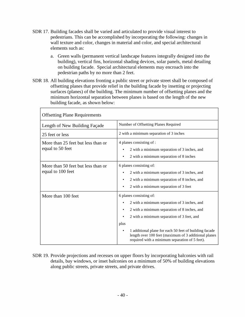
- 40 -
SDR 17. Building facades shall be varied and articulated to provide visual interest to
pedestrians. This can be accomplished by incorporating the following: changes in
wall texture and color, changes in material and color, and special architectural
elements such as:
a. Green walls (permanent vertical landscape features integrally designed into the
building), vertical fins, horizontal shading devices, solar panels, metal detailing
on building facade. Special architectural elements may encroach into the
pedestrian paths by no more than 2 feet.
SDR 18. All building elevations fronting a public street or private street shall be composed of
offsetting planes that provide relief in the building facade by insetting or projecting
surfaces (planes) of the building. The minimum number of offsetting planes and the
minimum horizontal separation between planes is based on the length of the new
building facade, as shown below:
Offsetting Plane Requirements
Length of New Building Façade Number of Offsetting Planes Required
25 feet or less 2 with a minimum separation of 3 inches
More than 25 feet but less than or
equal to 50 feet
4 planes consisting of :
• 2 with a minimum separation of 3 inches, and
• 2 with a minimum separation of 8 inches
More than 50 feet but less than or
equal to 100 feet
6 planes consisting of:
• 2 with a minimum separation of 3 inches, and
• 2 with a minimum separation of 8 inches, and
• 2 with a minimum separation of 3 feet
More than 100 feet 6 planes consisting of:
• 2 with a minimum separation of 3 inches, and
• 2 with a minimum separation of 8 inches, and
• 2 with a minimum separation of 3 feet, and
plus
• 1 additional plane for each 50 feet of building facade
length over 100 feet (maximum of 3 additional planes
required with a minimum separation of 5 feet).
SDR 19. Provide projections and recesses on upper floors by incorporating balconies with rail
details, bay windows, or inset balconies on a minimum of 50% of building elevations
along public streets, private streets, and private drives.

- 41 -
SDR 20. Buildings at controlled intersections
shall include one of the following
gateway features:
a. distinct architecture that includes
material change and enlarged
window fenestration; OR
b. rounded corner with exaggerated
roof element.
SDR 21. Create visual breaks in the roof.
Incorporate staggered roof lines or
shaded roof decks. Up to 20% of the length of the building facade may exceed any
identified height limit per the base zone in order to provide roof decks, green roofs,
facade variations, accents, tower elements, and other similar elements. Usable roof
space shall not be included in the floor area calculation of the structure.
a. Any flat roof shall be designed as an architectural/landscape amenity to enhance
the views of the proposed structure from adjacent structures. Such enhancement
may include roof gardens, architectural features, special paving, patterns, and
other comparable treatments. Roof amenity spaces can be counted towards
common area requirements.
b. Roof surfaces shall be simplified and appurtenances shall be grouped and
screened.
c. A continuous roofline may be provided if the location of the proposed
development optimizes orientation and the roof incorporates angle and orientation
to maximize the capture of solar energy. If a continuous roofline is provided,
design of the roof shall seamlessly integrate solar panels into the building design
and should diminish roof mass.
SDR 22. Exposed roof top parking is not permitted. Top level of parking shall incorporate
solar energy features.

- 42 -
Public/Private Open Space
SDR 23. A paseo can be used to provide a pedestrian connection through development. Figure
12 illustrates the relationship between Plazas and Paseos. A paseo can contribute to
the common area requirement.
FIGURE 12: PASEO ILLUSTRATION
SDR 24. Mixed-use and commercial developments
that exceed 3 stories at controlled
intersections shall incorporate a publicly
accessible plaza with the following
conditions:
a. Plaza as allowed by line of sight study
per transportation engineering section.
Submit site plan for review.
SDR 25. Per SDR 5, an increased setback area beyond
the minimum required for parkway and
sidewalk shall be allowed only if the following conditions are met:
a. the width of the increased setback shall not exceed 30% of the width of the
project’s total public street or private street frontage, AND
b. the setback area is designed as a pedestrian amenity such as plaza with public
seating; AND
c. building(s) surround the plaza.

- 43 -
Parking
SDR 26. Parking ratios shall be calculated based on the reduced parking ratios identified in
Chapter 14, Article 2, Division 5 for all new development.
a. All mixed-use and commercial developments that exceed 3 stories shall provide
the following:
i. A minimum of 2 alternative fuel charging stations.
ii. A minimum of 1 car share parking space.
SDR 27. A minimum of one garage entrance or parking facility shall be accessed from the
alley when available. If alley access is not available, garage entries shall be recessed
from sidewalk and parking shall be screened.
SDR 28. Locate all parking underground or to the rear or side of the building. Parking shall be
provided at-grade only if wrapped with building on public street, private street, and
privates drive frontages. Underground or structured parking shall not be counted as
part of the building floor area ratio.
SDR 29. Dead ends, parking courts, and cul-de-sacs are prohibited.
SDR 30. Enclosure that surrounds a mixed-use or residential development and gated private
drives are prohibited. Fencing can be used to delineate property boundaries, but shall
not be used to create residential enclaves. Chain-link fencing is prohibited.
SDR 31. Drive-through features are prohibited in all new development.
Screening
SDR 32. All heavy work or storage areas shall be contained within an enclosed building area.
Outdoor storage is prohibited unless completely screened. Storage areas shall not be
placed facing a public right-of-way.
SDR 33. Screen all visible building equipment, utilities, trash enclosures and
service/maintenance areas with a wall that uses consistent materials and colors with
the building façade. Landscaping shall also be incorporated.
Specific Design Areas
SDR 34. On Mission Gorge Road, south of Friars Road, the following conditions shall be met:
a. For a single development that includes lot consolidation: one curb cut shall be
permitted for each 150 feet of street frontage. One additional curb cut may be
permitted for each 150 feet of street frontage on Mission Gorge Road.
b. For individually developed lots without lot consolidation, one curb cut per lot
shall be permitted.

- 44 -
SDR 35. For projects located along Alvarado Canyon Road, the following streetscape
treatments shall be provided:
a. A 12-foot landscaped parkway shall be established from the edge of curb. Two
rows of trees must be planted in the landscaped parkway and 10 cubic feet of
below surface volume shall be provided per tree.
b. A 10-foot sidewalk shall be established between the landscaped parkway and
building edge.
c. Balconies are prohibited unless set back a minimum of 20 feet from the property
line.
Alvarado Creek
For properties south of Mission Gorge Place, north of Alvarado Canyon Road and east of
Mission Gorge Road, and west of Mission Gorge Place, the following design regulations shall
apply:
SDR 36. Development along Alvarado Creek shall provide a 10-foot wide multi-use pedestrian
and bicycle trail directly adjacent to the Alvarado Creek.
SDR 37. Developments shall orient buildings, common areas, and dwelling units toward the
Alvarado Creek trail as identified in SDR 36.
SDR 38. Provide direct access to the Alvarado Creek trail as identified in SDR 36 from
common areas and ground floor units.
SDR 39. Surface parking is prohibited within 50 feet of the Alvarado Creek floodway. Parking
shall not be visible from the Alvarado Creek trail as identified in SDR 36.
Landscaping
For street trees in the landscaped parkway of any sidewalk or pedestrian path, trees shall be
chosen from the following species to be consistent with the predominant species in the area.
Double-rows of street trees should be provided along development frontages wherever
feasible.
Root barriers shall be installed to protect water and sewer lines or other facilities.
Tree grates shall be installed along Mission Gorge Road and Fairmount Avenue.
Each street tree shall receive 10 cubic feet of below surface volume for water retention
and growth capacity.
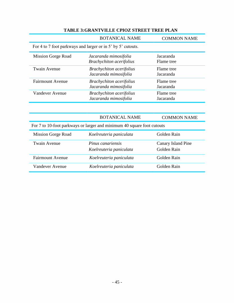
- 45 -
TABLE 3: GRANTVILLE CPIOZ STREET TREE PLAN
STREET BOTANICAL NAME COMMON NAME
For 4 to 7 foot parkways and larger or in 5’ by 5’ cutouts.
Mission Gorge Road Jacaranda mimosifolia
Brachychiton acerifolius
Jacaranda
Flame tree
Twain Avenue Brachychiton acerifolius
Jacaranda mimosifolia
Flame tree
Jacaranda
Fairmount Avenue Brachychiton acerifolius
Jacaranda mimosifolia
Flame tree
Jacaranda
Vandever Avenue Brachychiton acerifolius
Jacaranda mimosifolia
Flame tree
Jacaranda
STREET BOTANICAL NAME COMMON NAME
For 7 to 10-foot parkways or larger and minimum 40 square foot cutouts
Mission Gorge Road Koelreuteria paniculata
Golden Rain
Twain Avenue Pinus canariensis
Koelreuteria paniculata
Canary Island Pine
Golden Rain
Fairmount Avenue Koelreuteria paniculata Golden Rain
Vandever Avenue Koelreuteria paniculata Golden Rain

- 46 -
DEFINITIONS
Active commercial uses mean commercial uses that are accessible to the general public,
generate walk-in clientele, and contribute to a high level of pedestrian activity. Active
commercial uses include retail shops, restaurants, bars, theaters and the performing arts,
commercial recreation and entertainment, personal and convenience services, hotel lobbies,
banks, travel agencies, airline ticket agencies, child care services, libraries, museums, and
galleries.
Alternative Interim Uses means uses permitted under the base land use regulations of this
Division but which are not identified as active commercial uses within the Neighborhood Mixed-
Use Center Land Use District, or the Main Street and Commercial Street Overlay Districts.
Blank wall means any street wall area that is not transparent, including solid doors and
mechanical area wall(s).
Employment uses mean non-residential uses that provide employment opportunities and include
those uses specifically designated in Table 156-0308A.
Eco-roof means an open space area on top of a building roof that is landscaped and maintained
according to the requirements of Section 156.0309(e)(4).
Mixed-use development means development that includes two or more land uses.
Pedestrian entrance means a functional entrance or door that is accessible to the general public
from an enclosed occupied space. Entrances to mechanical equipment or storage areas,
emergency exits, or decorative nonfunctional doors and entrances are not considered pedestrian
entrances.
Performance Path means a way to demonstrate that a development has exceeded the California
Green Building Standards Code (CALGreen) by achieving a targeted level of performance in an
existing voluntary green building rating system.
Plaza means an outdoor area designed to be used as a public space. A plaza can include one or a
combination of paving, play areas, seating areas, water features, useable lawn areas, shrub beds,
and plants in containers.
Paseos are pedestrian ways that connect a plaza with other spaces or uses and are considered a
part of the plaza for purposes of overall calculation of landscape area and point requirements for
each plaza.
Private drive means a nonpublic thoroughfare. Private drives connect public rights-of-way to
multiple locations within a development.

- 47 -
Private open space means an area connected or immediately adjacent to a dwelling unit. Private
open space may include a balcony, porch, at-grade or above-grade patio or roof deck used
exclusively by the occupants of the dwelling unit and their guests.
Public open space means an area owned by the City of San Diego intended for use by the
general public, or an area on private property for which a public park, open space, or similar
easement or covenant has been recorded in favor of the City of San Diego for use by the general
public.
Screen or screening means partial or full enclosure of a space or area by solid materials that are
compatible with the materials and architectural design of the development in order to block
views of the area from nearby development or public rights-of-way.
Setback is the horizontal distance between the property line and the nearest front, side, or rear
building wall.
Shopkeeper OR live/work unit means a dwelling unit with both living quarters and commercial
space that meets all occupancy separation requirements of the Building Code, where the
commercial use is located on the ground floor and operated by the resident of the dwelling unit.
Live/work or shopkeeper unit requires a minimum of 2 parking spaces per unit.
Stepback means the distance measured from a property line to the building walls of the upper
floors of a building above a specified height.
Street wall means the building façade along a property line adjacent to any public street. The
street wall may include arcades, colonnades, recessed entrances, private open space, or urban
open space.
Structured parking means all parking facilities that serve a primary use or are open to the
general public.
Transportation demand management (TDM) means a series of measures that encourage use
of alternative forms of transportation to alleviate traffic demand on area roadways.
Urban open space means any usable space accessible to the general public which is 1,000
square feet or greater in size and includes plazas or parks.

- 48 -
FIGURE 13: COMMUNITY PLAN IMPLEMENTATION CPIOZ-TYPE A (MISSION
GORGE ROAD INDUSTRIAL)
OVERVIEW
In the areas designated as CPIOZ Type A, development that is consistent with the Community
Plan, the base zone regulations, and the supplemental development regulations identified in each
CPIOZ section can be processed ministerially in accordance with the procedures of the
Community Plan Implementation Overlay Zone (Municipal Code Chapter 13, Article 2, Division
14).
Any development that does not comply with the Community Plan, the base zone regulations, or
any of the supplemental development regulations identified in the CPIOZ section shall be
required to obtain a discretionary permit.
MISSION GORGE ROAD INDUSTRIAL CPIOZ

- 49 -
In the areas designated as CPIOZ-Type B, a discretionary permit is required. Applications for a
CPIOZ-Type B discretionary permit shall meet the regulations of the underlying zone and the
purpose and intent of the supplemental development regulations identified in each CPIOZ
section.
Projects that require a discretionary review process should address the design and compatibility
of the project in relation to surrounding development as well as the purpose and intent of the
applicable CPIOZ section and supplemental development regulations of the applicable section.
Projects may propose design solutions that vary, but the design of the project shall be equal or
higher in quality to the design concepts identified for these CPIOZ areas.
SUPPLEMENTAL DEVELOPMENT REGULATIONS
Documentation from a California Registered Traffic Engineer stating that the proposed
project’s traffic volumes are based on the City’s trip generation rates and are less than the
thresholds established in the City of San Diego’s Traffic Impact Study Manual must be
confirmed and accepted by the City Engineer.
Floor Area Ratio (FAR)
New development processed under ministerial (CPIOZ-Type A) review shall not exceed a floor
area ratio of 1.0. Development proposals that exceed a floor area ratio of 1.0 shall apply for a
discretionary permit. The discretionary review process should address:
The design and fit of the project in relation to surrounding development, including
conformance with the design guidelines of this Industrial Element.
The ability of Mission Gorge Road and adjacent streets in Grantville to accommodate
additional travel demand.
The opportunity for instituting travel demand management strategies such as participation in
a transportation management association.
Offsetting Planes and Facade Variations
Any building facade which faces a public street have a minimum of three offset building
planes or three distinct building facade variations, or a combination of offset building planes
and facade variations which meets the intent of this requirement.
An offset building plane is distinguished by an average horizontal or vertical difference of
two feet measured perpendicular to the adjacent plane. Each offset plane shall constitute at
least 20 percent, but not more than 50 percent of each building facade.
A building facade variation is distinguished by a distinct change in materials, textures, colors,
or any combination thereof. Each variation shall constitute at least 20 percent, but not more
than 50 percent of each building facade.

- 50 -
Building Reflectivity
No more than 30 percent of any single elevation of a building's exterior may be constructed
of a material with a light reflectivity factor greater than 25 percent.
Equipment Enclosure
All mechanical equipment and appurtenances shall be screened on all sides so that they
appear to be an integral part of the overall architectural design of the building. The screening
may include grillwork, louvers, or latticework.
Wind generated turbines shall not be screened but shall be painted to match the rooftop color.
No merchandise, material or equipment shall be stored or displayed on the roof of any
building.
Outdoor Storage and Display
Outdoor storage areas shall be located in interior side or rear yards only.
Outdoor storage areas shall be screened with a solid six-foot fence or wall or an enclosed
structure. All such fences, walls or structures shall be of a similar material and color as the
main building. No material or equipment shall exceed the height of the fence, wall or
structure.
Outdoor display of the following merchandise sold on the premises shall not be subject to the
storage requirements above but shall meet the landscaping requirements for vehicular use
areas of the Citywide Landscape Ordinance:
Automobiles (usable) Boats (usable) Trailers Equipment and tools Artwork and pottery Flowers and plants
Refuse Collection Areas
Refuse collection areas shall be located in interior side or rear yards only.
Refuse collection areas shall be screened with a solid six-foot fence or wall or an enclosed
structure. All such fences, walls or structures shall be of a similar material and color as the
main building. Deposited refuse shall not be visible from outside the refuse screening.
Loading Areas
Loading and service areas shall be located in interior side or rear yards only.
Parking Requirements
The below parking requirements shall replace the parking area requirement of the M-1B and
M-1A zones (Municipal Code Sections 101.0435.2E and 101.0436B). If the citywide industrial
parking requirements are revised, the new standards will replace those identified below.
Off-street parking shall be provided by use as follows:

- 51 -
Spaces/Square Feet of Gross Floor Area
For wholesale, distribution and manufacturing uses 1/1500
For business and professional offices 1/300
For medical and dental facilities 1/250
For commercial uses that take access from Mission Gorge Road 1/250
For all other commercial uses 1/300
Curb Cuts and Driveways
On Mission Gorge Road, south of Friars Road, one curb cut shall be permitted for each lot
with frontage on Mission Gorge Road. One additional curb cut may be permitted for each
150 feet of frontage on Mission Gorge Road. No driveway shall exceed a width of 25 feet
measured at the property line.
On Mission Gorge Road, north of Friars Road, curb cuts shall be in conformance with the
Street Design Manual standards for primary arterials.
Signs
Signs shall be in conformance with the Citywide Sign Regulations (Chapter 14 Art 2 Div 12)
with the following exceptions:
Ground signs other than monument signs shall not be permitted in the industrial zones except
on lots that have frontage on Mission Gorge Road or the southerly 500 feet of Fairmount
Avenue (i.e., 500 feet south of the intersection of Mission Gorge Road and Fairmount
Avenue). Monument signs shall not exceed a height of six feet.
On Mission Gorge Road, ground signs shall not exceed the height of the building or the
citywide height limit of 30 feet, whichever is less, unless they meet the definition of freeway
oriented signs in Chapter 14 Art 2 Div 12, § 101.1101.56 – Freeway –Oriented Sign.
A landscaped area shall be provided at the base of all ground signs. The size of the
landscaped area shall be equal to or greater than the area of the sign face.
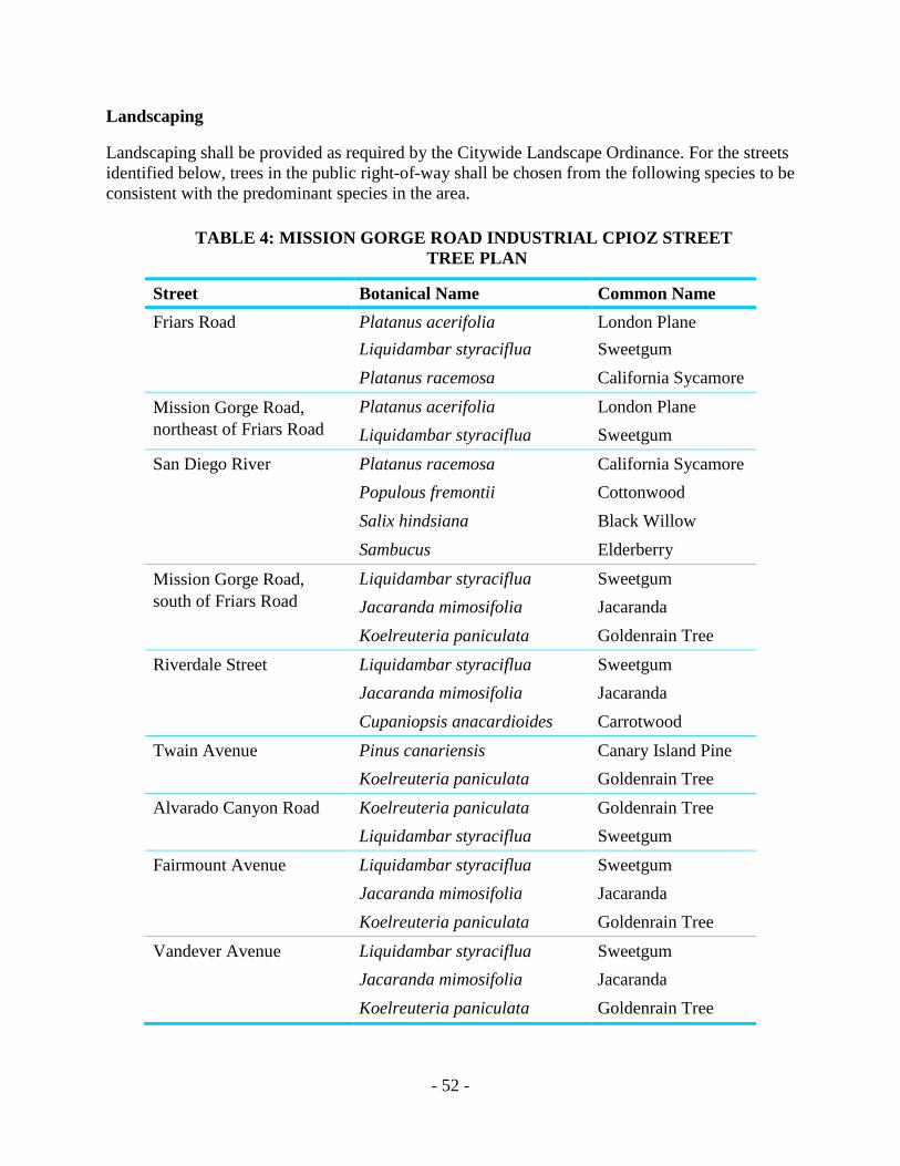
- 52 -
Landscaping
Landscaping shall be provided as required by the Citywide Landscape Ordinance. For the streets
identified below, trees in the public right-of-way shall be chosen from the following species to be
consistent with the predominant species in the area.
TABLE 4: MISSION GORGE ROAD INDUSTRIAL CPIOZ STREET
TREE PLAN
Street Botanical Name Common Name
Friars Road Platanus acerifolia London Plane
Liquidambar styraciflua Sweetgum
Platanus racemosa California Sycamore
Mission Gorge Road,
northeast of Friars Road
Platanus acerifolia London Plane
Liquidambar styraciflua Sweetgum
San Diego River Platanus racemosa California Sycamore
Populous fremontii Cottonwood
Salix hindsiana Black Willow
Sambucus Elderberry
Mission Gorge Road,
south of Friars Road
Liquidambar styraciflua Sweetgum
Jacaranda mimosifolia Jacaranda
Koelreuteria paniculata Goldenrain Tree
Riverdale Street Liquidambar styraciflua Sweetgum
Jacaranda mimosifolia Jacaranda
Cupaniopsis anacardioides Carrotwood
Twain Avenue Pinus canariensis Canary Island Pine
Koelreuteria paniculata Goldenrain Tree
Alvarado Canyon Road Koelreuteria paniculata Goldenrain Tree
Liquidambar styraciflua Sweetgum
Fairmount Avenue Liquidambar styraciflua Sweetgum
Jacaranda mimosifolia Jacaranda
Koelreuteria paniculata Goldenrain Tree
Vandever Avenue Liquidambar styraciflua Sweetgum
Jacaranda mimosifolia Jacaranda
Koelreuteria paniculata Goldenrain Tree

- 53 -
Design Guidelines
The following design guidelines will be used in the review of discretionary projects:
Architecture, building color and texture should be coordinated within larger industrial
developments. In smaller developments similar or complementary architectural elements
should be used to provide continuity between existing and new developments.
Building design should include variations in wall texture, color or material, variations in
upper floor setbacks and the use of varied roof forms. All buildings should incorporate some
form of shadow relief where pop-outs, offsetting planes, overhangs, and recesses are used to
add visual interest. Large, unbroken expanses of wall should be avoided.
Exterior building walls should be constructed of durable, permanent materials such as
textured concrete, stone, brick, stucco, wood or glass. Reflective glass should not be used,
particularly along heavily traveled roadways because of problems with reflected heat and
glare.
Industrial developments should consist of several smaller buildings rather than large building
masses to prevent the appearance of a wall of development along the street, particularly
along Mission Gorge Road.
Building height should be restricted where industrially zoned property abuts residential
property to reduce impacts to the residential areas.
All outdoor storage, refuse collection, and loading areas should be located in interior side or
rear yards. Where industrial development abuts residentially zoned property, special
consideration shall be given to locating these facilities in areas least disruptive to adjacent
residential uses.
Because building roofs are visible from surrounding residential properties, they should be
carefully designed. Roof-mounted equipment should be avoided. If roof-mounted equipment
is provided, all equipment and appurtenances shall be designed so that they appear to be an
integral part of the overall architectural design of the building.
Multi-building industrial development should provide a coordinated sign program. Pole signs
should not be permitted in the industrial zones except on Mission Gorge Road, south of
Twain Avenue, where development is more commercial in nature. Monument and wall signs
should be used instead of pole signs in the industrial areas.
Fences should be constructed of wood, masonry, wrought iron, or a wood-masonry
combination. Fencing should use pilasters, offsets or some other form of visual relief to break
up the linear nature of the fence.
Curb cuts should be minimized by the use of common, joint use driveways and/or
consolidation of lots.
The following additional guidelines are provided for new industrial development on both sides of
Mission Gorge Road, from just south of Old Cliffs Road to Margerum Avenue:
A 25-foot landscaped setback should be provided along Mission Gorge Road. Landscaped
parkways should be provided between the sidewalk and the curb on Mission Gorge Road and

- 54 -
on any interior circulation system. A landscaped median should be provided in Mission
Gorge Road. Paving patterns and landscaping should be consistent with the existing medians
to the south on Mission Gorge Road. Maintenance should be assured through formation of an
assessment district or a similar mechanism.
Access and circulation design should provide continuous pedestrian and bicycle access along
public streets and to uses within the development. Bicycle parking facilities should be
conveniently located near the entrances of buildings, without blocking pedestrian traffic. No
parking areas or driveways should be located between the structures and Mission Gorge
Road.

- 55 -
FIGURE 14: COMMUNITY PLAN IMPLEMENTATION CPIOZ-B (MISSION GORGE
ROAD RESIDENTIAL)
OVERVIEW
In order to ensure quality design along Mission Gorge Road, Community Plan Implementation
Overlay Zone (CPIOZ) –Type B is applied to the residential properties generally located
between Old Cliffs Road and Zion Avenue and abutting Mission Gorge Road. A discretionary
permit is required. Applications for a CPIOZ-Type B discretionary permit shall meet the
regulations of the underlying zone and the purpose and intent of the supplemental development
regulations identified below.
All projects should address the design and compatibility of the project in relation to surrounding
development as well as the purpose and intent of the supplemental development regulations of
MISSION GORGE ROAD RESIDENTIAL CPIOZ

- 56 -
this CPIOZ section. Projects may propose design solutions that vary, but the design of the project
shall be equal or higher in quality to the design concepts identified for this CPIOZ areas.
SUPPLEMENTAL DEVELOPMENT REGULATIONS
Architectural Design
New development shall be compatible in design with the existing neighborhood. The bulk
and scale of new buildings should be similar to the surrounding buildings. Where adjacent
development is single-family, large building masses shall be avoided. Several smaller
buildings should be used to maintain the pattern of development.
Building Height
New development shall be limited to 30 feet in height where adjacent development is single-
family.
Roof Treatment
Roof forms shall be predominantly sloped. Rooftop ventilation or other mechanical
equipment shall be screened from adjacent residential areas and from the public right-of-way.
Setbacks, Landscaping and Noise Walls
An extensively landscaped street yard shall be provided for any new residential development
along Mission Gorge Road except for new residential or commercial development where
commercial retail, office use or shopkeeper units are located on the ground floor. If noise
walls are proposed, the walls should be well-designed, incorporating articulation, pilasters
and other design features to achieve an attractive design. Noise walls shall not be permitted
in the setback. In addition, landscaping should be used to soften the appearance of perimeter
walls and residential structures from Mission Gorge Road and from adjacent uses.
Traffic and Access
New development should be designed to minimize further traffic impacts on Mission Gorge
Road.
Parking
Parking areas shall be well-screened from Mission Gorge Road using a combination of
landscaped berms, tall trees and shrubs. Parking areas shall be located in areas least
disruptive to adjacent single-family uses. Tree plantings shall be incorporated throughout the
parking area.
Streetscape Improvements
New development shall be required to provide non-contiguous sidewalks.
All utilities shall be undergrounded on-site

- 57 -
A median shall be constructed along the Mission Gorge Road frontage. The feasibility of
landscaping the median in Mission Gorge Road should be studied as new development occurs.
Landscaping and paving in the median should continue the pattern established in the existing
median on Mission Gorge Road.
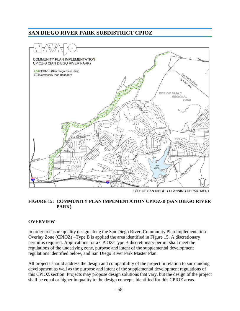
- 58 -
FIGURE 15: COMMUNITY PLAN IMPEMENTATION CPIOZ-B (SAN DIEGO RIVER
PARK)
OVERVIEW
In order to ensure quality design along the San Diego River, Community Plan Implementation
Overlay Zone (CPIOZ) –Type B is applied the area identified in Figure 15. A discretionary
permit is required. Applications for a CPIOZ-Type B discretionary permit shall meet the
regulations of the underlying zone, purpose and intent of the supplemental development
regulations identified below, and San Diego River Park Master Plan.
All projects should address the design and compatibility of the project in relation to surrounding
development as well as the purpose and intent of the supplemental development regulations of
this CPIOZ section. Projects may propose design solutions that vary, but the design of the project
shall be equal or higher in quality to the design concepts identified for this CPIOZ areas.
SAN DIEGO RIVER PARK SUBDISTRICT CPIOZ

- 59 -
Within the area designated as CPIOZ-Type B, no building, improvement, or portion thereof shall
be erected, constructed, converted, altered, enlarged, or established until a discretionary permit is
obtained.
SUPPLEMENTAL DEVELOPMENT REGULATIONS
Boundaries
The San Diego River Park Subdistrict includes the River Corridor Area and the River Influence
Area. The River Corridor Area comprised of the current 100-year floodway (floodway) as
mapped by Federal Emergency Management Agency (FEMA) and the 35-foot wide Path
Corridor on each side of the floodway. Figure 1 illustrates how the River Influence Area is the
200-foot wide area extending outward from the River Corridor Area on each side of the river.
FIGURE 16: SECTION / PLAN VIEW OF RIVER CORRIDOR & INFLUENCE AREA

- 60 -
RIVER CORRIDOR AREA
Permitted Uses and Development
Development within the floodway shall be in accordance with Land Development Code Section
143.0145 (Development Regulations for Special Flood Hazard Areas).
Within the 35-foot wide Path Corridor only the following development shall be allowed: the
San Diego River Pathway, trails, and passive recreational uses, as determined by the City
Manager, including picnic areas, scenic or interpretive overlooks, fitness stations, seating and
educational exhibit areas.
Within locations that are not mapped as Multi-Habitat Planning Area (MHPA), as identified
by the City of San Diego MSCP Subarea Plan, or determined to be wetland buffers in
accordance with Land Development Code Section 143.0141, the following development shall
be allowed; children’s play areas, multi-purpose courts, turf fields and development
determined by the City Manager to be for active recreation use.
Portions of the 35-foot wide Path Corridor that are mapped as MHPA, as identified by the
City of San Diego MSCP Subarea Plan, or determined to be wetland buffers in accordance
with Land Development Code Section 143.0142 shall be developed in accordance with the
MSCP Land Use Considerations and the Environmentally Sensitive Lands Regulations in
Chapter 14, Article 3, Division 1 of the Land Development Code.
Grading
Grading within the floodway shall be conducted in accordance with MSCP Land Use
Considerations and the Environmentally Sensitive Lands Regulations in Chapter 14, Article
3, Division 1 of the Land Development Code.
Grading within the 35-foot wide Path Corridor shall, to the satisfaction of the City Manager;
a) Avoid long continuous engineered slopes with hard edges; b) provide gradual transitions at
the top and bottom of the slopes; c) and stabilize and revegetate slopes with native plants
consistent with the surrounding habitat type.
San Diego River Pathway
Development on a lot located wholly or partially in the River Corridor Area shall include a San
Diego River Pathway and shall meander to the satisfaction of the City Manager.
Where portions of the Path Corridor are mapped as MHPA, as identified by the City of San
Diego MSCP Subarea Plan, or determined to be wetland buffers in accordance with Land
Development Code Section 143.0141, the San Diego River Pathway shall be located outside the
MHPA and the wetland buffer, immediately adjacent to the Path Corridor. See Figure 2, Path
Corridor Realignment for MHPA and Wetland Buffer.
The San Diego River Pathway shall be dedicated with an easement that allows public access and
shall be completed in the first phase of any phased development.
The San Diego River Pathway shall include the following features:

- 61 -
A minimum 10-foot wide pathway of concrete or similar material, in a color that blends with
the surrounding native soil.
A minimum two-foot wide area of decomposed granite or similar material along each side of
the San Diego River Pathway in a color similar to the San Diego River Pathway.
A minimum 10-foot wide landscape area between the floodway and the San Diego River
Pathway.
A minimum 12-foot vertical clearance above finished grade of the San Diego River Pathway.
Trails
Pedestrian-only trails may be located within the River Corridor Area in accordance with the
following:
Trail alignments shall mimic natural conditions and minimize grading and disturbance to
vegetation.
Trails shall be designed to provide continuous loops to the San Diego River Pathway, with no
trail alignment resulting in a dead end.
Trails located in areas mapped MHPA, as identified by the City of San Diego MSCP Subarea
Plan, or determined to be wetland buffers in accordance with Land Development Code
Section 143.0141are subject to the MSCP Land Use Considerations and the Environmentally
Sensitive Lands Regulations in Chapter 14, Article 3, Division 1 of the Land Development
Code.
Trails shall include the following features: i) A maximum eight-foot width; ii) An eight-foot
vertical clearance above finish grade of the trail; and iii) Surface material shall be
decomposed granite or similar material in a color that blends with the surrounding native
soil.
Picnic Areas and Overlooks
Development on a lot located wholly or partially in the River Corridor shall include at least
one picnic area or overlook along the San Diego River Pathway unless either exists less than
one-half mile away. Picnic areas and overlooks shall include a combination of site furniture,
such as picnic tables, trash and recycling receptacles, bicycle racks, shade structures,
benches, interpretive signs and drinking fountains, to the satisfaction of the City Manager.

- 62 -
FIGURE 17: PATH CORRIDOR REALIGNMENT FOR MHPA AND WETLAND
BUFFER
Lighting
Shall be provided along the San Diego River Pathway as necessary to provide for security
and personal safety. Light poles shall not exceed 12 feet in height. All lighting shall be
shielded and directed away from the floodway, the edge of the San Diego River Pathway
fronting the river and the MHPA.
Site Furniture
Shall be designed in accordance with the San Diego River Park Master Plan Design
Guidelines and include the San Diego River Park Logo. Shall be provided along the San
Diego River Pathway at picnic areas, overlooks and other locations that complement the San
Diego River Pathway. Lots that do not have picnic areas or overlooks shall include along the
San Diego River Pathway a minimum of one piece of site furniture for every 200 linear feet
of the San Diego River Pathway.
Signs
Shall be designed in accordance with the San Diego River Park Master Plan Design
Guidelines and include the San Diego River Park Logo. Overlooks shall include, at a
minimum, one interpretive sign. Information Kiosks (as described in the San Diego River
Park Master Plan Design Guidelines) shall be provided at any location where the San Diego
River Pathway intersects a public street.

- 63 -
Fences
Located between the San Diego River Pathway and the River shall be provided only as
required to protect sensitive habitat or historic resources, and shall allow for wildlife
movement. Fences shall be in accordance with the following:
Located a minimum of five feet from the San Diego River Pathway or trails and shall follow
the natural grade.
Consist of horizontal rails of either wood peeler log or steel posts and cables, c) maximum
height of 42 inches, and shall be at least 75 percent open.
For purposed of this subsection, chain link fencing shall not qualify as a 75 percent open
fence.
Plant Materials
The River Corridor Area shall include a mixture of native plants and trees consistent with the
surrounding habitat type.
Non-native grasses and lawn areas shall not be permitted in any areas mapped MHPA, as
identified by the City of San Diego MSCP Subarea Plan, or determined to be wetland buffers
in accordance with the Land Development Code Section 143.0141.
Visual Openings
Views within the River Corridor Area shall be maintained at the pedestrian level along the
San Diego River Pathway by using tall canopy trees, rather than short bushy trees. Plant
materials shall be selected and located in order to provide views to the river along at least 50
percent of the river side of the San Diego River Pathway of each lot.
Plant Material Adjacent to the San Diego River Pathway
On the river side of the San Diego River Pathway and within 10 feet of the non-river side of the
San Diego River Pathway:
Trees shall have a canopy clearance of eight feet above the finish grade of the San Diego
River Pathway
All other plant materials shall not exceed a mature and natural growth habit of 30 inches in
height above the finish grade of the San Diego River Pathway.
Buildings Height and Massing
Maximum building height and massing on lots adjacent to the River Corridor Area shall be
determined by the distance the building is set back from the River Corridor, and shall be in
compliance with Table 2A or the base zone, whichever is more restrictive*. See Figure 3,
River Influence Area Maximum Building Height and Setback.
* Except for properties located along Fairmount Avenue within the Grantville neighborhood, where the
maximum building height allowed shall be 70 feet.
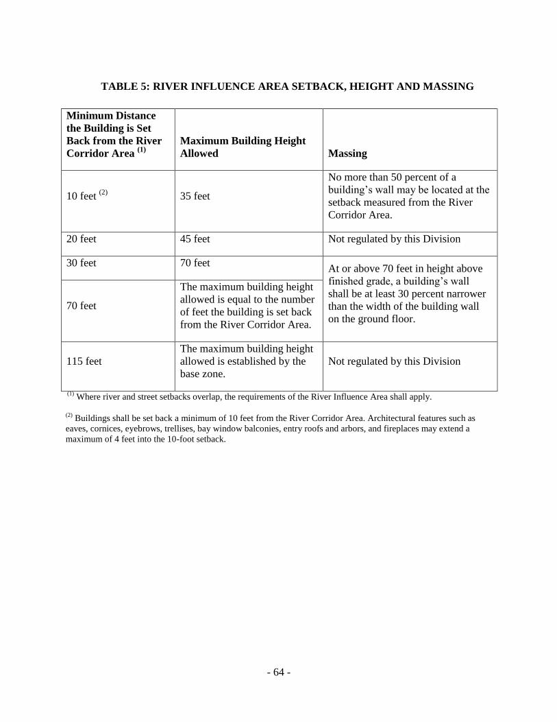
- 64 -
TABLE 5: RIVER INFLUENCE AREA SETBACK, HEIGHT AND MASSING
Minimum Distance
the Building is Set
Back from the River
Corridor Area (1)
Maximum Building Height
Allowed Massing
10 feet (2)
35 feet
No more than 50 percent of a
building’s wall may be located at the
setback measured from the River
Corridor Area.
20 feet 45 feet Not regulated by this Division
30 feet 70 feet At or above 70 feet in height above
finished grade, a building’s wall
shall be at least 30 percent narrower
than the width of the building wall
on the ground floor.
70 feet
The maximum building height
allowed is equal to the number
of feet the building is set back
from the River Corridor Area.
115 feet
The maximum building height
allowed is established by the
base zone.
Not regulated by this Division
(1) Where river and street setbacks overlap, the requirements of the River Influence Area shall apply.
(2) Buildings shall be set back a minimum of 10 feet from the River Corridor Area. Architectural features such as
eaves, cornices, eyebrows, trellises, bay window balconies, entry roofs and arbors, and fireplaces may extend a
maximum of 4 feet into the 10-foot setback.

- 65 -
FIGURE 18: RIVER INFLUENCE AREA MAXIUMU BUILDING HEIGHT AND
SETBACK
Setbacks not identified in Table 2A
Refer to the Base Zone.
Off Setting Planes
Offsetting planes requirements of the Base Zone and the Navajo Community Plan CPIOZ
shall apply.
Building Façade and Entrance
Development that abuts the River Corridor Area shall, provide a river-fronting façade and
entrance that are of substantially equivalent design and quality of materials as the primary
building façade and entrance to the satisfaction of the City Manager.

- 66 -
Building Transparency
Building facades that front the River Corridor Area or building facades that front a street that
abuts and runs parallel to the River Corridor Area shall provide building transparency in
accordance with the following:
The amount of transparency, measured as the visible light transmittance (VLT) shall be at
least 0.65 VTL.
Commercial and Mixed Use Zones, a minimum of 50 percent of the total façade shall be
transparent and a minimum of 70 percent of the ground floor (between finish grade and the
full height of the first floor) shall be transparent,
Industrial Zones a minimum of 25 percent of the total façade shall be transparent.
Building Reflectivity
Building facades that front the River Corridor Area shall not include materials with a visible
light reflectivity (VLR) factor greater than 10 percent.
Exterior Equipment Enclosures, Outdoor Storage, Loading Areas and Refuse Collection
Areas
Shall be in accordance with the following:
Located a minimum of 100 feet from the River Corridor Area.
Shall be screened with landscape and an opaque wall at least 6 feet in height or, if the item to
be screened exceeds 6 feet in height, a wall 1-foot taller than the item, to a maximum wall
height of 10 feet shall be provided. Screening shall be of the same design and materials as the
primary building façade.
Loading areas shall also comply with the requirements of Land Development Code Section
1514.0403(d) Off Street Freight Loading Spaces Required.
Off-Street Surface Parking
Off-street surface parking areas located adjacent to the River Corridor Area shall be set back
and screened for the full height and length of the parking area, with one or more of the
following:
Shall be screened with residential, commercial, industrial, or mixed use development, in
accordance with the base zone; or
Screened with landscape materials, in which case the following shall apply: i) Parking areas
shall be setback a minimum of 20 feet from the River Corridor Area; ii) Parking areas
adjacent to the River Corridor Area shall not exceed 30 percent of the length of the lot
frontage along the River Corridor Area or a maximum of 120 feet of the lot frontage along
the River Corridor Area, whichever is less; iii) Parking areas shall be screened with shrubs
capable of achieving a minimum height of 30 inches along 80 percent of the length of the
parking area along the River Corridor Area frontage within a 2 year period, except that
screening shall not be required at pedestrian access points; and iv) Screening for parking

- 67 -
areas shall include one 24-inch box evergreen tree for every 30-foot of frontage along the
River Corridor Area. The trees shall be spaced apart or in naturalized groupings.
Parking Structures
Parking Structures located adjacent to the River Corridor Area shall be set back and screened for
the full height and length of the parking area, with one or more of the following:
Shall be screened with residential, commercial, industrial, or mixed use development, in
accordance with the base zone; or
Shall be screened with landscape materials in accordance with Section (8)(b) and in which
case the following provisions shall apply; i) Parking structures shall be setback a minimum of
30 feet from the River Corridor Area; and ii) Parking structures adjacent to the River
Corridor Area shall not exceed 50 percent of the length of the lot frontage along the River
Corridor Area.
Streets that Abut and Run Parallel to the River Corridor Area
Shall be the minimum width allowed by the Street Design Manual of the Land Development
Manual. Development shall be designed to minimize the number of curb cuts, to the
satisfaction of the City Manager. On-street parking shall be provided in clusters of parking
bays along the river side of the street.
Building Access to the River Corridor Area
Development on lots that abut the River Corridor Area shall provide building access paths
connecting the primary structure with the San Diego River Pathway in accordance with the
following:
One building access path for every 300 linear feet of river frontage.
The building access path shall be to the primary building entrance or to a secondary entrance
that, to the satisfaction of the City Manager, is of substantially equivalent design and quality
of materials as the primary entrance.
Public Access Pathway Across a Development Site
Development on lots that abut the River Corridor Area shall provide public access pathways
connecting the public street and the San Diego River Pathway in accordance with the following:
At least one public access pathway shall be provided for every 1,000 linear feet of frontage
along the River Corridor Area.
The public access pathway shall be designed to the same quality as the primary on site
pathways, to the satisfaction of the City Manager.
A public access pathway sign shall be provided at the public street and at the intersection of
the San Diego River Pathway to identify the entry to the public access pathway and shall be
placed in a clearly visible location.
An easement for public use shall be required for public access pathways.

- 68 -
Public Access Pathways from Streets that Abut and Run Parallel to the River Corridor
Area
Public access pathways shall connect the street to the San Diego River Pathway at every street
intersection and, at a minimum, provide a connection every 1,000 linear feet of street frontage
along the River Corridor Area.
Lighting
All lighting within 100 feet of the River Corridor Area shall be shielded and directed away from
the River Corridor Area.
Fences
Within the 10-foot building setback area, only the following fences are permitted:
A solid fence not to exceed three feet in height.
A fence that is at least 75 percent open and does not exceed 6 feet in height; or
A combination of a 3-foot tall solid fence topped with a 3-foot tall fence that is at least 75
percent open.
d) For purposes of this Section, chain link fencing shall not qualify as a 75 percent open
fence.
Signs
Within 100 feet of the River Corridor Area, wall signs fronting the river shall not exceed a
height of 15 feet above finish grade.
Ground signs between a building and the River Corridor Area shall be monument signs not to
exceed five feet in height and shall be located within a landscaped area at least equivalent to
the area of the sign face.
Signs fronting the River Corridor Area shall be face lighted or internally lighted.
Plant Material
Plant materials within 15 feet of the River Corridor Area shall be non-invasive low water use
species.

- 69 -
INTRODUCTION
In its broadest sense, the term "open space" refers to all land that is not used for buildings or
structures. It may be either urban or non-urban. Open spaces affect the character of development
and vice versa. Among other things, open space offers aesthetic variety and relief, shapes the
environment, stabilizes other land uses, reduces noise and conserves natural resources.
The reasons for retention of open space are
many. The more important of these were
spelled out by the late President Kennedy in
a special message to Congress: "Open space
must be reserved to provide parks and
recreation, conserve water and other natural
resources, prevent buildings in undesirable
locations, prevent erosion and floods and
avoid the wasteful extension of public
services and control the rate and character of
community development."13
Urbanization is frequently unattractive and
ugly. However, it need not be so; if man
desires, he can remedy the physical blight
and decay within aesthetically offensive
areas by strategically introducing openness
and greenery, thus providing sorely needed
leavening for both visitor and resident.
Open space can serve a most important
function by inhibiting that amorphous type
of development commonly referred to as
"urban sprawl," an affliction visited upon so
many large urban areas. Open space also
serves to limit concentrations of people and
improvements under aircraft flight patterns
or on floodplains. It should be used to minimize development in areas subject to geological
hazards such as earth slippage and landslides.
3 President John F. Kennedy, "Our Nation's Housing," an address to the first session of the 87th Congress, March
9, 1961.
OPEN SPACE RETENTION AND UTILZATION

- 70 -
Open space has economic value and indirect benefits that are not generally recognized. For
example some lands within highly urbanized areas may be more expensive to develop from the
public standpoint than they are worth. As has been pointed out in a recent study, the "direct
public benefits of a regional open space system would include:
Income from leases on open space lands for agricultural, recreational, or other compatible
uses.
User benefits (in terms of dollar values) accruing to the public.
The non-recoverable value of the public’s investment in open space land.”24
Indirect benefits deriving from the impact of the open space program on urban development
patterns would include a series of non-measurable social, economic, and environmental benefits.
In addition, a savings in utility costs might also be realized.
Open space may prove directly profitable in other cases as well. A number of examples have
been reported where urban open space, especially in the form of city parks, has enhanced the
value of surrounding properties to the point where the tax received from those properties exceeds
any tax yield that might have been realized had the area of open space been built upon. A good
example in the City of San Diego is the area surrounding Balboa Park.
This Plan is an attempt at fulfilling our obligation of leaving a meaningful legacy to future
generations. For the long-range good of the entire community, generous expansions of natural
open space must be preserved.
In summary, the case for open space in aggregate is impressive. While specific quantitative
standards, like those utilized in determining needs for neighborhood and community park
facilities, have not been developed for open space systems, the City of San Diego and the Navajo
community have recognized this need.
A unique feature in the Navajo Community Plan is the open space element designed to preserve
the river, scenic canyon and hillside areas, and to link elements of the community. The proposed
open space areas will become green belts and will provide areas for pedestrian, bicycle or
equestrian uses. The open space system conceived for the Navajo community envisions that the
canyon and hillside areas could be used for both active and passive recreational uses. The
majority of open space, however, will probably remain in its natural state, with pathways and
picnic areas.
The study area contains many outstanding examples of open space as defined above. There are
over 700 acres of scenic canyons, including Mission Gorge, which are dominant topographical
features of the Navajo community. These canyons contain a natural reserve of trees and wildlife-
-resources that are quickly vanishing from the San Diego scene.
4 AN OPEN SPACE SYSTEM for the San Diego Region, San Diego Comprehensive Planning Organization,
Open Space Study: Report No. 1,Livingston & Blayney, Royston, Hanamato, Beck and Beck, April 1972.

- 71 -
The San Diego River, another significant feature
of the community, traverses Mission Trails
Regional Park through Mission Gorge and is
responsible for creating much of the existing
topography. That portion of the river located in
the northeast section of the community has been
significantly altered as a result of an ongoing
sand and gravel extraction operation. Much of the
area in and around the river has already been
mined and is currently being used for industrial
and contractor storage and operation uses.
A mix of retail, industrial and industrial office
park uses have been developed along that portion of the river that forms the western boundary of
the Navajo planning area. The existing development has not taken advantage of the aesthetic
qualities of the river environment, nor the passive recreation value of the river and wetlands
abutting these sites, but has instead turned its back on the river. It is critical that future
development proposals along the river be required to incorporate sensitive site design in addition
to providing measures for protecting riparian habitat.
OBJECTIVES
Because there is pressure for intense use of land located within the urban complex, the following
principal or overriding open space objective was adopted:
DESIGNATE AND PRESERVE OPEN SPACE BEFORE DEVELOPMENT TAKES PLACE.
In this way, it is possible for the best land available for recreation and open space to be preserved
to provide a framework for subsequent development. The assignment of a high priority to
recreational open space development requires immediate action if preservation is to take place.
The Navajo community recognizes that there is a need to provide adequate and accessible open
space for the needs of the population and that without positive action the community may lose
this valuable open space through the development of the river area, canyons and hillsides.
Therefore, the following additional objectives were adopted:
Preserve, improve and reconstruct the wetlands and riparian habitat areas in and along both
sides of the San Diego River.
Enhance and maintain the aesthetic and recreational qualities of the San Diego River corridor
as part of the open space system.
Conserve the present amenity of Navajo, Rancho Mission, Mission Gorge and other canyons
for the enjoyment of this generation and as a legacy for succeeding generations.
Establish and preserve a total open space system in perpetuity and guard against its
commercialization. Preserve the natural environment including wildlife, vegetation, and
terrain.

- 72 -
Permit only those uses within the system that are compatible with the open space concept.
Ensure that any public improvements such as roads, drainage channels and utility services
and any private lessee developments be compatible with the objectives of the open space
system.
Ensure that development of properties adjoining the open space system is in a manner
compatible with the natural environment and in conformance with the Mission Trails Design
District Ordinance and Design Manual and the San Diego River Park Master Plan.
PROPOSALS
The overall system entails a network of open space belts connecting larger open space areas.
These areas for the most part are located in the canyons, along the San Diego River, and on
Cowles Mountain as shown on the following map.
The open space areas, including over 700 acres
divided among Navajo Canyon (179 acres), Rancho
Mission Canyon (258 acres), and Mission Gorge
(300 acres), should be preserved in a substantially
open character. Mission Gorge (the San Diego River
System) should be given high priority for acquisition
as a part of the City's open space system.
Open space should initially be maintained in its
natural condition. Studies, however, should be
undertaken to determine uses compatible with the
open space concept. Such uses, designed with
consideration for topography, vegetation and access,
may include archery ranges, hiking, biking trails,
picnic facilities, wildlife preserves, and non-
vehicular camping facilities.
Any public improvements such as roads, drainage
channels and utility services as well as any private
lessee developments should be compatible with the
objectives of the open space system. No through
roads will be permitted except for the extension of
Navajo Road, designed to parkway standards,
through Navajo Canyon and the extension of
Jackson Drive.
Safe, convenient access should be established and
maintained to all open space areas.

- 73 - FIGURE 19: OPEN SPACE PROPOSALS
- 74 -
In the event that those open space areas illustrated on page 77 are not acquired they should be
permitted to develop according to the following guidelines:
Low residential densities not to exceed one dwelling unit per acre in those areas falling
within the Hillside Review (HR) Zone, except as noted below.
In all cases improvements should implement the intent of the HR Zone, which is to “ensure
that development results in minimum disturbance of natural terrain.”
The implication of this requirement is that densities for a given ownership will be transferred
and clustered on the flattest and most developable land.
Development in open space areas, including those in the HR Zone, should be guided by the
following additional criteria:
o Slopes of 0-12 percent should be permitted to develop up to two dwelling units per acre.
o Slopes of 13-24 percent should be permitted to develop up to two dwelling units per acre.
o Slopes of 25 percent and greater should be permitted to develop no more than one dwelling unit per acre.
An exception to the above guidelines is:
o That portion of the Navajo Canyon westerly of Waring Road, which should be limited to residential use of one dwelling unit per acre due to its location, restricted access and projected traffic conditions. A Planned Commercial Development for this area would be considered to allow for uses compatible with the open space concept, such as plant nurseries, etc.
Residential development within the canyons should be designed to preserve natural amenities
such as topography, trees and streams in an open space linkage system. Further studies would
have to be undertaken to minimize problems such as drainage, unattractive hillside cuts,
access, and inadequate public facilities resulting from increased population.
If the canyons adjacent to existing or future school sites are not obtained for open space, a
neighborhood park with a minimum of five acres should be reserved next to each school.
Development along the San Diego River should be regulated to minimize the disturbance to
wetland habitat areas. The San Diego River Park Subdistrict of this Plan contains objectives and
proposals for development of the river located within the Navajo community. These objectives
and proposals have been incorporated into the River Park Subdistrict Community Plan
Implementation Overlay Zone (CPIOZ B). All development proposals for property within the
River Park Subdistrict CPIOZ will be required to comply with the CPIOZ B Supplemental
Development Regulations contained within this Community Plan.
In addition to the CPIOZ for the San Diego River Subdistrict, future development along the river
shall meet the requirements of the Multiple Species Conservation Program (MSCP) Subarea Plan
and the requirements of the Environmentally Sensitive Lands Regulations. The MSCP has been
prepared pursuant to the general outline developed by the United States Fish and Wildlife
Service and the California Department of Fish and Game (herein referred to as the “Wildlife
- 75 -
Agencies”) to meet the requirements of the California Natural Communities Conservation
Planning Act of 1992.
The MSCP is a comprehensive habitat conservation planning program that addresses multiple
species habitat needs and the preservation of native vegetation communities in the San Diego
region and was adopted by City Council in 1997. This Subarea Plan forms the basis for the
Implementing Agreement which is the contract between the City and the Wildlife Agencies that
ensures implementation of the plan and thereby allows the City to issue take permits at the local
level. The MSCP’s core, hardline biological preserve system has been mapped by the City in
cooperation with the Wildlife Agencies, property owners, developers, and environmental groups
and is referred to as the Multi-Habitat Planning Area (MHPA).
The MHPA delineates core biological resource areas and corridors targeted for conservation.
Within the MHPA limited development may occur and all development must meet the MSCP
Section 1.4, Land Use Considerations and the Framework Management Plan guidelines. The
MSCP is implemented by the City through the Environmentally Sensitive Lands (ESL)
Regulations of the City’s Municipal Code. Also contained in the ESL are regulations on impacts
to wetlands. A wetland buffer is required for all wetlands as appropriate to protect the functions
and values of the existing wetland. The width of the wetland buffer is determined at the time of
project proposal and the existing quality of the wetland area. It should be noted that the MHPA
and the wetland buffer requirements take precedence over the San Diego River Subdistrict. The
San Diego River Pathway will be required to be outside the MHPA and the wetland buffer.
Establish regulatory zoning in the form of the Floodway (FV) and Floodplain Fringe (FPF)
Zones along the entire length of the river corridor. The City Engineer should prepare the
studies leading to the application of these zones.
Establish hiking trails in the San Diego River Basin through Mission Gorge, which will
minimize impacts to the riparian habitat. Trails should be located adjacent to the river within
the buffer area in a manner that focuses activity away from sensitive habitat areas. Access to
the habitat area should be discouraged through the design of the trails and the use of
specialized plantings. Because horses can attract the brown-headed cowbird, a least Bell's
vireo nest parasite, it is necessary to mitigate the effects of equestrian activities when they are
near vireo habitat. During nesting season the trails should be closed.
Restoration of the riparian habitat in the floodway should be pursued in lieu of
channelization. If potential impacts to public health or safety clearly necessitate
channelization, the channel should be soft-bottomed and soft-sided, and should be designed
of sufficient width to support riparian vegetation across the width of the channel and to
convey the 100-year flood

- 76 -
OVERVIEW
The park system in the Navajo Community is made up of population-based parks, resource-based
parks and open space lands. Population-based parks and recreation facilities are located within
close proximity to residents and are intended to serve the daily needs of the community. The
City’s General Plan population-based park standard is to provide a minimum of 2.8 useable acres
per 1000 residents. In communities that are built out and where there are land constraints, the
City’s General Plan states that Park Equivalencies should be considered to satisfy some of the
community’s population-based park needs during a community plan update or amendment. Park
equivalencies could include Joint Use Facilities, Trails, Portions of Resource-based parks,
Privately-owned Park Sites, and Non-traditional Park Sites.
Within the redevelopment of the Grantville area, public recreational opportunities should provide
connections to Navajo’s regional recreational and open space areas through linear parks along
Alvarado Creek and the San Diego River. Locating neighborhood parks and/or pocket parks in
centralized locations within Grantville, such as adjacent to the Trolley Station and along the San
Diego River, would foster the re-establishment of the community’s relationship with the San
Diego River and Alvarado Creek. In addition, locating linear and pocket parks within the
Grantville boundaries will enhance the community’s character and create a sense of place by
providing opportunities for social interaction and passive and active recreation for residents,
employees and visitors.
The following is a discussion of the existing and proposed population-based parks and recreation
facilities, including park equivalencies that are consistent with the General Plan’s policies (See
Table 3, Summary of Existing and Future Population-based Parks and Recreation Facilities),
Resource-based parks and open space land are discussed at the end of the Parks and Recreation
Element.
POPULATION-BASED PARKS, RECREATION CENTERS AND AQUATIC
COMPLEXES
Per the General Plan Park standards, population-based parks consist of six facility types: 1)
major park; 2) community park; 3) neighborhood park; 4) mini-park; 5) pocket park or plaza;
and 6) special activity park. Typically, major parks are a minimum of 20 acres and serve single
or multiple communities and provide specialized facilities that serve large populations.
Community parks are a minimum of 13 useable acres, serve a population of 25,000, and provide
a wide range of facilities including active and passive recreation, recreation centers, aquatic
complexes and multi-purpose sports fields. Neighborhood parks are 3 – 13 useable acres; serve a
population of 5,000 persons within approximately one mile radius. These parks generally provide
picnic areas; children’s play areas, multi-purpose courts, multi-purpose turf areas, comfort
stations, walkways and landscaping. Mini parks are 1 to 3 useable acres within a half mile radius;
Pocket parks and plazas are typically less than 1 useable acres within a quarter mile radius from
residents to be served. Special activity parks vary depending upon the activity and population
served.
PARKS & RECREATION FACILITIES

- 77 -
The General Plan also established minimum standards for recreation centers and aquatic
complexes based on population. A recreation center, typically 17,000 square feet in size, should
be provided for every 25,000 residents, and an aquatic complex should be provided for every
50,000 residents. The following existing and future population-based parks, recreation centers
and aquatic complexes are described below:
San Carlos Community Park and Recreation Center
The existing community park, 10.5 acres with 9.41 useable acres, is located on Lake Adlon
Drive and adjacent to the Forward Elementary School. This existing park features a recreation
center, multi-purpose courts, on-site parking, walkways, picnic areas, children’s play area, multi-
purpose fields and passive lawn areas The existing Recreation Center (11,880 square feet)
provides indoor multi-purpose courts and community meeting rooms. Future improvements to
the San Carlos Community Park should include sports field lighting to expand the use of the
fields and the expansion of the recreation center to a 17,000 square foot building.
Allied Gardens Community Park, Recreation Center and Aquatic Complex
The existing community park, 13.5 acre site with 13.5 useable acres, is located on Greenbrier
Drive and adjacent to Lewis Middle School. This existing park features a recreation center, an
aquatic complex, multi-purpose courts, on-site parking, picnic areas, walkways, children’s play
area, and passive lawn areas. The existing recreation center (9,186 square feet) provides indoor
multi-purpose courts and community meeting rooms. Future improvements to the Allied Gardens
Community Park should include the replacement of the existing recreation center and providing
a new 17,000 square foot building. The existing aquatic complex should be expanded to provide
indoor locker rooms and showers, a new therapeutic pool and children’s pool, expansion of the
spectator areas and necessary upgrades to the existing pool. In addition, upgrades to the existing
children’s play areas to meet accessibility standards should be provided.
Lake Murray Community Park
The existing community park, 45.83-acre site with 41.86 useable acres, is located on Murray
Park Drive and contiguous to Lake Murray. This existing park features tennis courts, ball fields,
parking, comfort station, children’s play area, passive lawn areas, walkways and trails through
natural open space areas. Future improvements to the Lake Murray Community Park should
include; the expansion of the parking lot (approximately 200 cars) and roadway adjacent to the
central ball fields; the expansion of the children’s play area with additional play equipment, site
furnishings, picnic shelters and a comfort station; and the design and construction of a ball field
and parking at Cowles Point, as shown on the approved General Development Plan. Synthetic
turf and sports field lighting for several fields should be considered to expand the use of the
fields.

- 78 -
FIGURE 20: PARK AND RECREATION FACILITIES

- 79 -
Qualcomm Major Park and Recreation Center (future)
This future major park is planned to be 30 acres within the Qualcomm Stadium site, located off
of Friars Road and adjacent to the San Diego River. This major park would serve both the
Mission Valley and Navajo communities. Navajo community’s portion would be approximately
10 acres of the 30 acres and provide active and passive recreation needs including lighted sports
fields, picnic areas, children’s play areas, multi-purpose courts, walkways, landscaping, and
parking. In addition special activities such as skateboard, dog off leash and other unique uses
could be located within the park. A Recreation Center of 25,000 square feet is proposed to serve
both communities. The Navajo community’s portion would be approximately 5,000 square feet.
The Recreation Center could provide indoor gymnasium, multi-purpose courts, multi-purpose
rooms, kitchen and other community-serving facilities.
Dailard Neighborhood Park
The existing neighborhood park, 5.1 acre site with 3.30 useable acres, is located on Cibola Road
and is adjacent to the Dailard Elementary School. Park amenities include children’s play area,
walkways and passive turf areas.
Tuxedo Neighborhood Park
The existing neighborhood park, 9.37 acre site with 5.62 useable acres, is located on Tuxedo
Road. Park amenities include passive lawn areas, walkways, volley ball courts and children’s
play area.
Princess Del Cerro Neighborhood Park
The existing neighborhood park, 5.48 acre site with 4.4 useable acres, is located on Wenrich
Drive. Park amenities include basketball courts, walkways, passive lawn areas, picnic areas and
children’s play area.
Grantville Neighborhood Park
The existing neighborhood park, 2.53 acre site with 2.28 useable acres, is located on Vandever
Avenue. Park amenities include passive lawn areas, children’s play area, walkways, and picnic
facilities.
Rancho Mission Neighborhood Park
The existing neighborhood park, 18.84 acre site with 9.42 useable acres is located on Margerum
Avenue. Park amenities include passive lawn areas, walkways through natural open space,
picnic areas and on-site parking.
San Carlos Pocket Park
The existing pocket park, 0.30 useable acres, is located on East Lake Drive. Park amenities
include walkways, seating and landscaping.
- 80 -
Pasatiempo Neighborhood Park (Future)
This future neighborhood park, 10.69 acre site with 5.0 approximate useable acres, is located on
Pasatiempo Avenue. Park amenities could include passive lawn areas, walkways, picnic areas,
small multi-purpose courts, children’s play area, comfort station and on-site parking.
Bedlow Neighborhood Park (Future)
This future neighborhood park, 3.0 acre site with 2.5 approximate useable acres, is located on
Bedlow Avenue. Park amenities could include picnic areas, children’s play areas, passive lawn
areas, walkways and landscaping.
Pasatiempo Open Space Park (Future)
This future open space park, 5.2 acre site with 2.0 approximate useable acres, is located on
Pasatiempo Avenue. Park amenities could include walkways, native landscaping, fitness course
and picnic facilities that take advantage of the panoramic views.
PARK EQUIVALENCIES
The General Plan standards for Park Equivalencies state that they must be easily accessed by the
public, consistent with existing Resource-based Parks Master Plans and include typical
population-based park components and facilities. Categories include; joint use facilities, trails,
portion of resource-based parks, privately owned park with public access easements, non-
traditional park sites and facility expansion or upgrade. The following existing and future park
equivalencies for the Navajo community are described below:
JOINT USE FACILITY – PARK EQUIVALENCY:
Benchley/Weinberger Elementary (Future)
This future joint use facility, 3.40 useable acres, is located on the corner of Twin Lake Drive and
Gloria Lake Avenue. Joint use amenities could include multi-purpose fields, multi-purpose
courts, and walkways. Synthetic turf should be considered to expand the use of the fields.
Dailard Elementary
The existing joint use facility, 2.98 useable acres, is located on Cibola Road. Joint use amenities
include multi-purpose turf field.
Forward Elementary
The existing joint use facility, 4.50 useable acres is located on Boulder Lake Drive adjacent to
San Carlos Community Park. Joint use amenities include multi-purpose fields with two
backstops. Future amenities could include an additional multi-purpose field with School District
approval.

- 81 -
Foster Elementary (Future)
This future joint use facility, 3.0 useable acres, is located on the corner of 51st street and Zion
Avenue. Joint use amenities could include multi-purpose fields, multi-purpose courts, and
walkways. Synthetic turf should be considered to expand the use of the fields.
Gage Elementary (Future)
This future joint use facility, 4.7 useable acres, is located on the corner of Bisby Lake Drive and
Hudson Drive. Joint use amenities could include multi-purpose fields, multi-purpose courts, and
walkways. Synthetic turf should be considered to expand the use of the fields.
Grantville Elementary (Future)
This future joint use facility, 2.2 useable acres, site is located on Decena Drive. Joint use
amenities could include multi-purpose fields, multi-purpose courts, and walkways. Synthetic turf
should be considered to expand the use of the fields.
Green Elementary (Future)
This future joint use facility, 3.2 useable acres, is located on the corner of Wandermere Driver
and Green Gables Avenue. Joint use amenities could include multi-purpose fields, multi-purpose
courts, and walkways. Synthetic turf should be considered to expand the use of the fields.
Hearst Elementary
The existing joint use facility, 4.18 useable acres, is located on Del Cerro Blvd. Joint use
amenities include several sports fields with backstops and a children’s play area.
Lewis Middle School
The existing joint use facility, 9.58 useable acres, is located on Irwin Avenue and adjacent to
Allied Gardens Community Park. Joint use amenities include several sports fields with
backstops. Future improvements should include synthetic turf and sports field lighting on the
upper field and the lower field, known as Skunk Hollow area.
Marvin Elementary (Future)
This future joint use facility, 3.4 useable acres, is located on Brunswick Avenue. Future joint use
amenities could include multi-purpose fields, multi-purpose courts, and walkways. Synthetic turf
should be considered to expand the use of the fields.
Pershing Middle School
The existing joint use facility, 10.0 useable acres, is located on San Carlos Drive. The general
development plan for the joint use facility includes multi-purpose fields, a comfort station, two
shade structures, and a park entry sign. The future Phase I of the design was completed in 2006
and provided 5 acres of the multi-purpose synthetic turf fields. Phase II is to provide the

- 82 -
remaining synthetic turf fields (5 acres), a comfort station, two shade structures, a park sign and
sports lighting on two fields to expand their hours of use.
TRAILS – PARK EQUIVALENCY:
Navajo Canyon Open Space Trails (Existing/Future)
These existing and future trails, approximately 15,300 lineal feet, are located in the center of the
open space canyon and accessed from Waring Road, Lyden Road, Carthage Street and Eldridge
Road. New trail amenities could include 3,200 lineal feet of new trails, trail kiosk, trail makers,
interpretive signs, native landscaping and benches or picnic areas where appropriate.
Rancho Mission Canyon Open Space Trails (Existing)
These existing trails, approximately 21,900 lineal feet, are located throughout the open space
canyon and accessed from Conestoga Street, Margerum Street, Hemingway Street, Cabaret
Street and Navajo Street. In addition, trails within Rancho Mission Neighborhood Park provide
access to the canyon trails. New trail amenities include trail kiosk, trail makers, interpretive
signs, native landscaping and benches or picnic areas where appropriate.
PORTION OF RESOURCE-BASED PARK – PARK EQUIVALENCY
Deerfield Bike Skills Area at Mission Trails Regional Park (Future)
This future park, approximately 12 acres, is located in the western area of Mission Trails
Regional Park. Park amenities could include typical components of bike skills parks, including
overlook areas, picnic areas, walkways, parking, and native landscaping.
Deerfield Canyon Nature Park at Mission Trails Regional Park (Future)
This future park, approximately 2 acres, is located in the western area of Mission Trails Regional
Park. Park amenities could include picnic areas, trails, interpretive panels, fitness course,
children’s play area of natural looking play structures, parking and native landscaping.
San Diego River Park Trail at Mission Trails Regional Park (Future)
The San Diego River Park Trail, approximately 4.3 miles, is located within the Mission Trails
Regional Park. This trail will provide a western connection to Grantville Neighborhood and an
eastern connection to Mission Trails Regional Park East Fortuna Staging area. Of the 4.3 miles
of trail, 1.9 miles, approximate, exists along Father Junipero Serra trail and 2.4 miles,
approximate, of new trail area are proposed. The new trail, depending on site conditions, will be
approximately 4’ to 14’ feet wide and include a 5’ to 10’ feet wide buffer on each side to provide
native landscaping, information kiosks, interpretive signs, identification/directional signs and
benches/picnic tables where appropriate.

- 83 -
PRIVATELY OWNED PARK WITH A RECREATION EASEMENT – PARK
EQUIVALENCY
Shawnee Neighborhood Park (Future)
This privately owned park, 5.3 acres, with a recreation easement for public use, is located on the
north side of Mission Gorge Road and contiguous with the San Diego River Park. This future
park will provide typical neighborhood park amenities, such as multi-purpose fields, multi-
propose courts, walkways, plazas, children’s play area, seating, picnic areas, and landscaping. In
addition the park will also provide a section of the San Diego River Park pathway.

- 84 -
TABLE 6: SUMMARY OF EXISTING AND FUTURE POPULATION-BASED
PARKS AND RECREATION FACILITIES
Existing and Future Population-
based Parks
Existing Useable
Acres
Future
Useable Acres Total Acres
Community Parks:
Allied Gardens 13.35
Lake Murray 41.86
San Carlos 9.14
Qualcomm Major Park (future) 10.00
Total Community Parks: 64.35 10.00 74.35
Neighborhood Parks:
Bedlow (future) 2.50
Dailard 3.30
Grantville 2.28
Pasatiempo (future) 5.00
Pasatiempo Open Space Park (future) 2.00
Princess Del Cerro 4.40
Rancho Mission Canyon 9.42
San Carlos Pocket Park 0.30
Tuxedo 5.62
Total Neighborhood Parks: 25.32 9.50 34.82
Park Equivalencies:
Bench/Weinb Elementary (future) 3.40
Dailard Elementary 2.98
Forward Elementary 4.50
Foster Elementary (future) 3.00
Gage Elementary (future) 4.70
Grantville Elementary (future 2.20
Green Elementary (future) 3.20
Hearst Elementary 4.18
Lewis Middle School 9.58
Marvin Elementary (future) 3.40
Pershing Middle School 5.00 5.00
Navajo Canyon Open Space Trail (11,500 LIN. FT. X 24’ WIDE = 6.33 ACRES
EXISTING)
(3,200 LIN. FT X 24’ WIDE = 1.76 ACRES
FUTURE)
6.33 1.76
Rancho Mission Open Space Trail (21,900 LIN. FT. X 24’ WIDE = 12.00 ACRES
EXISTING) 12.00
Deerfield Bike Skills area at Mission
Trails Regional Park (Future) 12.00

- 85 -
Existing and Future Population-
based Parks
Existing Useable
Acres
Future
Useable Acres Total Acres
Deerfield Canyon Nature Park at
Mission Trails Regional Park (Future) 2.00
San Diego River Trail at Mission Trails (10,032 LIN. FT. X 24’ WIDE = 5.56 ACRES
EXISTING)
(12,672 LIN. FT X 24’ WIDE = 7.00 ACRES
FUTURE)
5.56 7.00
Shawnee Neighborhood Park 5.30
Total Park Equivalencies: 50.13 52.96 107.90
Total Existing and Future Useable
Acres:
139.80 72.46 212.26
Recreation Centers:
Allied Gardens 9,186 SF 7,814 SF 17,000 SF
San Carlos 11,880 SF 5,120 SF 17,000 SF
Qualcomm Major Park (future) 5,000 SF 5,000 SF
Total Existing and Future SF: 21,066 SF 17,934 SF 39,000 SF
Aquatic Complexes:
Allied Gardens
(to be expanded with additional Pools)
1 COMPLEX 0.5 1.5 COMPLEX
Total Existing and Future: 1.5 COMPLEX
The population-based park and recreation facilities requirements for the community are calculated based on the
community plan’s full community development. For the Navajo community, full community development is
projected to be 73,038 residents and will require 204.5 acres of population-based parks. Currently, there are 139.80
acres of existing population-based parks and 72.46 acres of future population-based parks identified, totaling 212.26
acres. This results in a 7.76 acre surplus of population-based parks
TABLE 7: SUMMARY OF POPULATION-BASED PARKS, RECREATION
FACILITIES AND PARK EQUIVALENCIES FOR FULL COMMUNITY
DEVELOPMENT
Existing and Future Population-based Parks
and Park Equivalencies
Full Community
Development
Useable Acreage
Deficit/Surplus
212.26 acres 204.50 acres 7.76 acres Surplus
Existing and Future Recreation Centers SF
39,000 SF 49,666 SF -10,666 SF deficit
Existing and Future Aquatic Complex
1.5 complex 1.46 complex 0.04 Surplus

- 86 -
PARKS AND RECREATION FACILITIES
OBJECTIVES
Provide a sustainable park and recreation system that meets the needs of Navajo residents
and visitors which serves a variety of users, including children, seniors, persons with
disabilities, and the underserved teenage population.
Provide parks and recreation facilities that keep pace with the Navajo Community population
growth through timely acquisitions of available land and development of new facilities.
Protect and enhance the integrity and quality of existing parks, open space and recreational
programs in the Navajo Community.
Provide a comprehensive pedestrian and bikeway connections between parks and open space
lands within the Navajo Community, as well as to surrounding communities.
PROPOSALS
Parks, Recreation Centers and Aquatic Complexes
Expand the hours of use of the fields at San Carlos Community Park by providing sports field
lighting. Expand the existing Recreation Center from 11,880 square feet to 17,000 square feet
building to meet General Plan Park standards.
Demolish the existing Allied Gardens Recreation Center and construct a new 17,000 square
foot building to meet the General Plan Park standards. Expand the Allied Gardens Aquatic
Complex to provide new amenities such as; therapeutic pool, children’s pool, additional
locker rooms, indoor showers, changing areas and equipment. In addition, upgrades to the
existing children’s play areas to meet accessibility standards should be provided.
Within the Lake Murray Community Park provide additional parking and roadway to serve
the multi-purpose fields, expand the children’s play area with additional play equipment, site
furnishings, picnic shelters, and a comfort station. Complete the implementation of the Lake
Murray Community Park General Development Plan by providing parking and a ball field at
Cowles Point. Expand the hours of use of some of the existing fields by providing synthetic
turf and sports field lighting.
Provide a Major Park and Recreation Center at the city-owned site within Qualcomm
Stadium. Site amenities could include active and passive recreation. The Recreation Center
would be shared between the Navajo and Mission Valley community and would be 25,000
square feet. Typical amenities could include gymnasiums, multi-purpose courts, multi-
purpose rooms, kitchen and other community-serving facilities.
Develop the city-owned Pasatiempo Neighborhood Park site with amenities that may include
passive lawn areas, walkways, picnic areas, multi-purpose courts, and children’s play area.
Provide protection and interpretation of vernal pools with fencing and interpretive signs.

- 87 -
Develop the city-owned Bedlow Neighborhood Park site with park amenities that could
include passive recreation such as walkways, fitness courts, picnic areas, small multi-purpose
courts.
Develop the city-owned Pasatiempo Open Space Park with park amenities that could include
walkways, native landscaping, fitness course, interpretive signs, seating areas, and picnic
areas to take advantage of the panoramic views.
Develop linear and pocket parks within the Grantville area along Alvarado Creek and the San
Diego River. Park amenities could include typical neighborhood park amenities, including
passive lawn areas, walkways, picnic areas, small multi-purpose courts, and children’s play
areas.
Park Equivalencies
The City should, in cooperation with the School District, provide joint use facilities at
selected Elementary Schools, such as Benchley/Weinberger, Foster, Gage, Grantville, Green,
and Marvin.
Construct Phase II of the Pershing Middle School to provide the remaining 5 acres of
synthetic turf, comfort station, two shade structures, park sign and sports field lighting to
expand the hours of field use.
Develop 2.4 miles of the San Diego River trail in Mission Trails Regional Park (the entire
trail is 4.3 miles, with 1.9 miles existing) and provide amenities such as native landscaping,
information kiosks, interpretive signs, identification/directional signs and benches/picnic
tables where appropriate. All improvements to be consistent with the Mission Trails Regional
Park Master Plan.
Develop a 12 acre site within Mission Trails Regional Park as a Bike Skills Area by
providing amenities such as Bike Skills trails, viewing areas, picnic areas, walkways,
parking, seating and native landscaping. All improvements to be consistent with the Mission
Trails Regional Park Master Plan.
Develop a 2 acre mini-park, the Deerfield Canyon Nature Park, in Mission Trails Regional
Park with passive recreation including walkways/trails, picnic areas, fitness course and
children’s play area of natural looking play structures, parking and native landscaping. All
improvements to be consistent with the Mission Trails Regional Park Master Plan.
RESOURCE-BASED PARKS AND OPEN SPACE LANDS
Resource-based parks are defined in the General Plan as serving regional residents and/or visitor
populations. These parks are located at sites of distinctive scenic, natural, historical or cultural
features. Developed amenities should not impair the distinctive features or resources within these
parks. These parks typically provide habitat and resource protection. Open Space Lands are
defined as city owned land, canyons, mesas and other natural landforms, exclusive of shorelines.
These areas provide habitat protection and typical components include trails, staging areas,
outlooks, viewpoints, and picnic areas. The current status of Resource-based Parks and Open
Space Lands are described below.

- 88 -
Mission Trails Regional Park
The Mission Trails Regional Park is approximately 8,000 acres and is located in the Navajo,
Tierrasanta and East Elliot community plan areas. The majority of this park is contained in the
Navajo Community and provides hiking, biking, and equestrian trails. A Visitor and Interpretive
Center is located off of Father Junipero Serra Trail. The development of this park is guided by
the Mission Trails Regional Park Master Plan.
San Diego River (Regional) Park
The San Diego River Park is located along the San Diego River on private and public land.
Recommendations within the San Diego River Park Master Plan provide for increasing the
health of the river, unifying the natural habitat, creating a sequence of unique places, revealing
the river valley history and reorienting development toward the river. The development of this
park is guided by the San Diego River Park Master Plan and the San Diego River Park
Subdistrict section of the Navajo Community Plan.
Passive and active uses are planned along the river to increase the recreational potential of the
Navajo community. Some of the San Diego River Park acreage will be considered as a park
equivalency to help address the population-based park deficit of Navajo. Through a Community
Plan Amendment process, as part of a development proposal, the amount of acreage and
locations will be determined. These areas of the river park will be designed to provide
population-based park amenities as defined in the General Plan.
Within the Mission Trails Regional Park, the San Diego River pathway will connect the western
boundary of the park, at the Grantville area, to the eastern boundary of the park. The pathway
from Grantville to the Visitor’s Center will need to be designed and constructed as a new
pathway/trail. From the Visitor’s Center the San Diego River Pathway will be located on the
existing Father Junipero Serra trail. At the Grasslands Crossing within the Mission Gorge area
the San Diego River pathway and then connect to the East Fortuna Staging area. This section of
the pathway will need to be enhanced with interpretive signs and amenities.
Adobe Falls Open Space
Adobe Falls Open Space, approximately 4 acres, located at the foot of Adobe Falls Road
between Waring Road and College Avenue. This site is adjacent to the San Diego State
University land, which together with the City-owned parcel makes up Historical Site No. 80-
Adobe Falls.
Navajo Canyon Open Space
Navajo Canyon Open Space, approximately 153 acres, is located in the southwest area of the
Navajo community and accessed from Waring Road and Lyden Way. This site contains several
trail heads, trail kiosks and trails through natural habitat, see Exhibit A.
- 89 -
Rancho Mission Canyon Open Space
Rancho Mission Canyon Open Space, approximately 237 acres, is located centrally in the Navajo
community, adjacent to Rancho Mission Canyon Park and is accessed from Margerum Avenue.
This site contains several trail heads, trail kiosk and trails through natural habitat, see Exhibit B.
All of the existing trails connect to the Ranch Mission Canyon Neighborhood Park.
Approximately 5,300 lineal feet of existing trails are to be closed for habitat protection.
RESOURCE-BASED PARKS AND OPEN SPACE LANDS
OBJECTIVES
Develop Mission Trails Regional Park in accordance with the Mission Trails Regional Park
Master Plan. The portions of the Master Plan applicable to the Navajo Community Plan
cover the following three major geographical areas: Lake Murray, Cowles Mountain and
Mission Gorge.
Develop the San Diego River Park in accordance with the San Diego River Park Subdistrict
of this plan and the San Diego River Park Master Plan.
Protect and enhance the natural resources of Open Space lands by locating new trails in the
least sensitive areas, re-vegetate with native plants and provide protection of sensitive
habitats.
PROPOSALS
Mission Trails Regional Park
Strengthen the role of Lake Murray and its shoreline as an active, water-oriented recreational
complex. This entails: (1) expanding the scope and quality of water-related facilities; (2)
protecting the lake environment; and (3) transforming the surrounding area into naturally
defined spaces for picnicking, playing and other day uses.
Retain the Navajo Golf Course in perpetuity for recreational use by the public.
Due to the importance of Cowles Mountain as an open space backdrop for urban San Diego,
limit uses to low-intensity activities. Examples include hiking, bicycling and horseback
riding, picnicking, photography and nature study.
Restore the environmental quality of Cowles Mountain by re-vegetation with native plant
species and protection from erosion.
Any new communication facility on Cowles Mountain should blend with the surrounding
area and not be located at the top.
Protect views of and from Cowles Mountain by implementing development controls on urban
development in its vicinity in accordance with the Mission Trails District Design Manual.

- 90 -
The Design District provides that no structure shall exceed four stories and in no case shall a
structure exceed fifty (50) feet in height.
Limit uses in the remainder of Mission Gorge include low-intensity activities such as hiking,
biking, rock climbing and nature study.
San Diego River (Regional) Park
Coordinate with the Mission Trails Regional Park to establish a continuous San Diego River
Pathway through the park.
Provide a kiosk at the west and east entrances to Mission Trails Regional Park along the San
Diego River Pathway and provide park amenities along the trail.
Adobe Falls Open Space
Provide a feasibility study for future uses that could include a trail heads with kiosks,
interpretive signs on the significant history of the area, and public access trails to connect to
the San Diego State University land.
Navajo Canyon Open Space
Enhance the existing trail system by providing; trail heads with kiosk, trail markers,
interpretive signs, overlooks, native landscaping, benches and picnic areas, etc. where
appropriate for the trail type as determined by the City and provide sufficient budget for
staffing and ongoing maintenance. Provide 3,200 lineal feet, approximate, of new trails and
close 1,900 lineal feet, approximate, of existing trails for habitat protection and pursue an
easement over private property to connect the northern trail to the southern trail.
Rancho Mission Canyon Open Space
Enhance the existing trail system by providing; trail heads with kiosk, trail markers,
interpretive signs, overlooks, native landscaping, benches and picnic areas, etc. where
appropriate for the trail type as determined by the City and provide sufficient budget for
staffing and ongoing maintenance. Approximately 5,300 lineal feet of existing trails are to be
closed for habitat protection.

- 91 -
FIGURE 21: NAVAJO CANYON OPEN SPACE

- 92 -
FIGURE 22: RANCHO MISSION CANYON OPEN SPACE

- 93 -
EXISTING CONDITIONS
The first school opened in Navajo in 1890, at Yard and Mission Valley roads in the subdivision
known as Grantville. It contained only one room for all eight grades and was built at a cost of
$1,488. The first year's enrollment was 29, but by the second year, the number of students had
dropped to six, which turned out to be only a temporary setback. In 1916, the earlier one-room
school was replaced by a modern two-room structure. By 1940, enrollment reached 77 students
with two teachers. In 1949, the school was annexed to the San Diego City Schools System, and
in 1954 the present Grantville educational facility was built.
At the present time, public educational facilities from kindergarten through the university level
are located in or immediately adjacent to the Navajo area. These facilities include one senior
high school, two junior high schools, ten elementary schools, the university, and a community
college in El Cajon. In addition, there are three private schools. The Catholic Diocese of San
Diego operates St. Therese Academy, an elementary school for grades one through six. This
school was built in 1960 for an enrollment of 500 and at present time plans to continue operation.
Kinder-Care Learning Center has classes and facilities for children from six months through
grade three. The existing facilities, which were built in 1970, can accommodate 220 students.
The majority of students attending the learning center are from the Navajo area.
Tifereth Israel Synagogue offers classes for children from kindergarten through grade seven. The
existing facilities, which were built in 1979, can accommodate 225 students. In addition to the
regular instruction classes, the synagogue offers a preschool program for ages 18 months to five
years. The San Carlos United Methodist Church and the Del Cerro Baptist Church also provide
preschool and child development programs for the community.
Grossmont Community College, located adjacent to the easterly boundary of the Navajo
community, is operated by the Grossmont Community College District. Navajo is in the San
Diego Community College District; however, students from Navajo may attend Grossmont
Community College by agreement between the two districts.
San Diego State University, located south of the community on College Avenue, has a current
total enrollment of 33,330 students. The University has been at this location since early 1931, at
which time the enrollment was about 1,500 students. The name at that time was the State
Teachers College.
All school structures in the community were built after the 1933 enactment of the Field Act,
which provided minimum standards for structural resistance to horizontal forces, especially
earthquakes and winds.
Single-family residences, which predominate in the area, originally attracted young families with
many school age or younger children. In 1960, the average family size was 3.8. As these children
matured, the average family size decreased to 2.8 in 1980.
PUBLIC SCHOOLS

- 94 -
Enrollment declines experienced in some schools, coupled with current and projected revenue
deficiencies, may make it necessary to discontinue the use of some of these schools. In that
event, the following alternative land uses are proposed:
Other educational programs or institutions, such as special or adult education, university or
community colleges, and private or parochial school purposes.
Use by other governmental agencies.
The community and/or the City should be given the opportunity to acquire the land for
community-oriented purposes before the property is marketed and leased or sold for private
development.
In the event that the property is to be used for private development, the use should be
restricted to a residential land use consistent with the density of the surrounding area.
Table 4 shows the optimum school enrollment and usable site area standards as used by the San
Diego Unified School District. The three secondary schools (Henry, Lewis and Pershing) and
four elementary schools (Forward, Foster, Gage and Dailard) meet the site size standards. Four
elementary schools (Hearst, Green, Weinberger and Marvin) are slightly below standard size but
are considered adequate for their enrollments. One elementary site (Grantville) is substantially
below standard size. Present policy calls for providing permanent buildings sufficient to house
the estimated long-term stable enrollment with allowance for increasing the enrollment capacity
of a permanent school by 20 percent with the use of portable classrooms. The portable
classrooms give the School District flexibility in meeting the fluctuating enrollments at the
schools.
TABLE 8: OPTIMUM SCHOOL ENROLLMENT AND USABLE SITE AREA
STANDARDS (SAN DIEGO UNIFIED SCHOOL DISTRICT)
School Enrollment Usable Site Area
Elementary 750-1,000 10+ acres
Junior High* 1,500-2,100 15-35 acres
Senior High* 1,800-3,000 15-60 acres
Community College 5,000-7,000 in excess of 123
acres
Exception is made for existing school sites.
* Junior and Senior High School site planning based on Planning Guide Standards of 15 usable acres plus
one acre per additional 100 students of predicted ultimate enrollment.

- 95 -
Grantville, Foster, Marvin, Hearst, Gage, Green and Weinberger elementary sites are located on
major streets or have their districts bisected by major streets which creates problems in
determining safe routes for children to follow to get to school. Some of these major streets do not
meet the requirements for marked school crosswalks or for school safety patrol. Walking
distance exceeds one-half mile in the Marvin, Hearst, Dailard and Green elementary school
districts. Many parents drive their children to these schools where the distance is excessive or
where the safety of the child is endangered. Many parents have formed carpools to transport their
children to school at personal expense. Students also attend elementary and secondary schools in
the area through integration programs offered by the school district. Transportation for the
majority of these students is provided by the school district.
All secondary schools and the community college are located on or near major streets. Henry
High School and Lewis Junior High School are easily accessible to public transportation. Henry
can be reached via bus route 115 and Lewis via bus route 13. Pershing is within walking distance
of route 115. However, because of the inadequacy of service, most students use other
transportation for school trips.
TABLE 9: EXISTING EDUCATIONAL FACILITIES
Net Usable Facilities
School Location Acres Class Rooms* Year Built**
PUBLIC
Elementary and Primary
Dailard 6425 Cibola Road 10.00 24 1977
Forward 6460 Boulder Lake 11.92 14 1961
Foster 6550 51st Street 11.11 19 1956
Gage 6811 Bisby Lake 11.68 23 1963
Grantville 6145 Decena Drive 6.04 13 1954
Green 6665 Belle Glade Ave. 8.84 24 1968
Hearst 6230 Del Cerro Blvd. 9.18 14 1959
Marvin 5720 Brunswick Ave. 8.86 19 1958
Weinberger Junior High 6269 Twin Lake Dr. 9.64 14 1963
Junior High
Lewis 5170 Greenbrier 21.42 30 1959
Pershing 8204 San Carlos 25.89 33 1964
Senior High
Patrick Henry 6702 Wandermere 39.72 72 1969
Community College
Grossmont 8880 Grossmont College Dr. 134.00 -- 1961
PRIVATE
Elementary and Primary
St. Therese 5835 Navajo Rd. 3.00 -- 1960
Kinder-Care 7007 Golfcrest Dr. 1.00 -- 1970
Tifereth Israel 6660 Cowles Mountain Blvd. 4.00 -- 1979

- 96 -
* The student enrollment capacity of all permanent public schools may be increased by moving portable
classrooms onto the school site.
** These are the dates of completion of the oldest building on the site.
OBJECTIVES
The principal or overriding educational objective that would guide the long-range development
of Navajo is to: ASSURE THAT EDUCATIONAL FACILITIES ARE CONSTRUCTED AND
MAINTAINED TO SERVE THE POPULATION OF THE COMMUNITY AND THAT THEY
CONFORM TO CURRENT BOARD OF EDUCATION POLICIES.
In addition to the principal objective, the following objectives were also adopted.
Encourage use of school facilities for
recreation, cultural and other activities.
Assure all students direct, safe access to
their school.
Encourage community participation in
identification, implementation and
evaluation of the educational needs of the
community.

- 97 -
FIGURE 23: SCHOOLS

- 98 -
PROPOSALS
When a sustained need exists, schools
should be constructed on available sites
in order to reduce the excessive
crowding at some existing facilities and
provide elementary schools within a
one-half mile radius of 90 percent of all
dwelling units.
All schools in the area should be built
and maintained in accordance with the
current board of education policy and
the highest possible standards.
Elementary school attendance boundaries should generally remain stable. However, changes
should be considered when necessary to ensure safer access and balance school enrollments.
Bus service to junior and senior high schools should be expanded to meet student needs.
If the board of education declares any of the existing school sites surplus property, it is
recommended that the community and/or the City be given the opportunity to acquire the
land for community-oriented purposes before the property is put on the market and leased or
sold for private development. It is further recommended that if such private development
should occur, it should be restricted to a residential land use consistent with the density of the
surrounding area.

- 99 -
EXISTING CONDITIONS
In addition to schools and parks, other community facilities are necessary to provide Navajo with
essential services. These facilities include libraries; police and fire protection; sewer, water and
drainage; and hospitals. Existing facilities do not meet the standards as outlined in the Progress
Guide and General Plan. These inadequacies are the result of the public sector being unable to
keep up with the rapid pace of private development.
Library Services/Facilities:
The City Library Department currently
maintains two branch libraries in the
Navajo community. The Edwin A.
Benjamin Memorial Branch is located at
5188 Zion Street in Allied Gardens.
Opened in 1964, this branch is 3,875
square feet in size and circulated 143,592
books in the fiscal year 1979-80. Although
the original building was planned for a
capacity of 20,000 volumes, the current
collection contains over 26,000 volumes.
The San Carlos Library is located at 7265
Jackson Drive, just northwest of Golfcrest.
Serving the San Carlos and Del Cerro areas, this library was opened in 1974. The building
contains over 8,000 square feet and a collection of 25,000 books, with a circulation of 212,368
books during the 1970-80 fiscal years. While the opening of the San Carlos branch gave a much
better circulation of books and services to the Navajo community, it did not relieve the
overcrowding of the Benjamin branch. If additional facilities are required, alternative solutions to
be considered include the possible expansion of the Benjamin branch as well as a third branch
library in the community.
POLICE SERVICE/FACILITIES
The San Diego Police Department serves the Navajo community from the Eastern Substation in
the Serra Mesa community. In addition to the Navajo community, the substation will be able to
provide complete and immediate service to the community areas of Serra Mesa, Tierrasanta,
State University and that portion of Mid-City lying north of University Avenue.
Patrol units are assigned and continuously operate in the community, in addition to traffic units
that also operate there. The police department considers the community to be a high priority area
for additional police coverage in the future.
OTHER COMMUNITY FACILITIES

- 100 -
Fire Department Facilities
The San Diego Fire Department operates two fire stations in the Navajo community. Fire Station
31 at 6002 Camino Rico, near the intersection of College Avenue and Navajo Road, houses one
engine company. Fire Station 34 at 6565 Cowles Mountain Boulevard, near Navajo Road, also
houses one engine company. These facilities are not adequate to serve Navajo and meet the
standards of the General Plan because the area's topography has created a fragmented street
pattern requiring longer response times.
Water Facilities
The Navajo community includes one of the three
major water supply facilities of the City of San
Diego. This facility is the Alvarado Filtration
Plant with its accompanying appurtenances and
pipeline system that serves approximately
397,000 people in the central portion of the City
including Navajo.
The Alvarado Filtration Plant and Pipeline
System are operating at their maximum capacity.
As the central portion of the City continues to grow, the filter plant and the pipeline system must
be supplemented with a larger supply source from the County Water Authority, increased
filtration plant capacity or imported filtered water, and additional distribution pipelines. These
improvements are now in the planning and design stages and many of them should be
constructed prior to 1990.
The Navajo community itself is served
by three water distribution systems.
They are the Del Cerro, the College
Ranch, and the San Carlos systems. The
existing water system and its planned
improvements should provide water
service to the proposed Navajo
community of 70,000 people.
Sewer Facilities
The Navajo community is bounded by
two major trunk sewers, which serve the
communities in the El Cajon Valley and
the city of La Mesa as well as the
Navajo community and adjacent
communities. One large trunk sewer is
located in Mission Gorge and the other is located in Alvarado Canyon.

- 101 -
The two major trunk sewers are capable of serving a combined population of 300,000 people and
related services. The proposed Navajo community population of 65,000 to 70,000 should not
adversely affect these facilities. The undeveloped property within the community will require
additional collector mains and trunk sewers as a normal subdivision requirement.
Gas and Electric
There are two electric transmission lines and one gas transmission line within the limits of the
Navajo study area. At present, no additional electric transmission lines or electric substations are
planned for the area. It appears that the existing transmission lines will be adequate for some
time to come, however, if additional transmission capacity is required, the existing lines should
be reconducted within the existing easements. Additional electric distribution facilities should be
added to serve additional load in the area as the need occurs.
Floodplains and Flood Control
The Navajo community includes portions of the San Diego River and Alvarado Creek
floodplains and a number of unnamed canyons. The San Diego River enters the community
through Mission Gorge at Padre Dam in the northwesterly section of the community, parallels
Father Junipero Serra Road and Mission Gorge Road, traverses the Navy golf course, and leaves
the community near the Mission de Alcala west of Grantville.
A large portion of the business community in Grantville is subject to inundation from
floodwaters of the San Diego River. A flood control project for the San Diego River (The
Mission Valley Project) was authorized by Congress as a result of a U.S. Army Corps of
Engineers report dated January 10, 1964. This project, which had at its eastern boundary the
Friars Road Bridge just downstream of the Navy golf course, provided for 5.2 miles of concrete
lined channel centrally located in the existing river bed. However, as a result of public opposition
to a concrete lined channel, the Corps reevaluated the project and concluded that the concrete
channel was no longer justified. The project was reclassified to an inactive category in January
1978.
Alvarado Canyon, within the study area, extends from College Avenue westerly to its confluence
with the San Diego River immediately to the west of Fairmount Avenue. The Mission Valley
Project included plans to construct a concrete lined channel along the westerly portion of
Alvarado Creek; however, there are currently no plans for construction of a concrete channel.
Stormwater
The Municipal Storm Water Permit (MS4), issued by the San Diego Regional Water Quality
Control Board (SDRWQCB), requires all development and redevelopment projects to implement
storm water source control and site design practices to minimize the generation of pollutants.
Additionally, the Permit requires new development and significant redevelopment projects that
exceed certain size threshold to implement Structural Storm Water Best Management Practices
(Structural BMPs) to reduce pollutant in storm water runoff and control runoff volume.
The MS4 Permit is re-issued every five years, typically imposing more stringent requirements on
a wider range of development. These requirements are adopted in the City’s Land Development

- 102 -
Manual; Storm Water Standards Manual and apply to both private development and public
improvements.
There is an increased reliance on Low Impact Development (LID) strategies to meet the MS4
Permit requirements and TMDL as well. Examples of LID techniques are bioretention cells,
green streets, green roofs, porous pavement, infiltration basins and biofiltration planters. To
enhance stormwater, the following strategies are encouraged.
Encourage the use of green streets in the right-of-way to reduce pollutant runoff into San
Diego River.
Encourage building roof downspouts to drain to pervious areas such as planter boxes or
adjacent landscaping.
Encourage the use of permeable pavement surface designs in low traffic roads and parking
lots where feasible.
Design parking lots to drain to landscaped areas to provide treatment, retention, or
infiltration, where feasible.
Emergency Medical Service/Facilities
Emergency medical service is provided by three hospitals located in or near to the Navajo
community. These are Grossmont Hospital in the city of La Mesa, the Alvarado Hospital on
Alvarado Road south of I-8, and a 200-bed Kaiser Hospital near Zion Avenue and Mission
Gorge Road, both in the City of San Diego. A portion of the Navajo community (San Carlos, Del
Cerro) is included in the Grossmont Hospital District.
OBJECTIVE
THE COMMUNITY'S OBJECTIVE IS TO ASSURE THAT A HIGH LEVEL OF ALL
PUBLIC SERVICES IS REACHED AND MAINTAINED BY ADHERING TO STANDARDS
SET FORTH IN THE PROGRESS GUIDE AND GENERAL PLAN AS A MINIMUM.
PROPOSALS
Continue evaluation of police and fire services to obtain and ensure adequate coverage in
Navajo.
Conduct periodic studies to obtain and ensure adequate sewer, water and drainage facilities.
Design and implement flood control facilities to ensure adequate protection for the
community, while preserving the natural topography and minimizing the adverse
environmental effects on the community. If channelization is necessary, the channels should
be soft-bottomed and soft-sided, and should be designed of sufficient width to support
riparian vegetation across the width of the channel.
Restrict development and encroachment in the floodplain, except as provided for in the
Floodplain Fringe and Floodway zones.

- 103 -
Proposals relating to flood control and floodplain boundaries should be restudied periodically
and updated to reflect areas subject to inundation and current planning efforts.
The Floodplain Fringe (FPF) and Floodway (FV) zones should be applied to the entire San
Diego River and Alvarado Creek basins within the planning area in order to control land use and
regulate future development to avoid or reduce flood damage. These zones provide controls for
development in the floodplain, and will encourage the preservation of the natural waterways
associated with these two floodplains. Where possible, runoff through the lesser canyons should
also be carried by the natural drainage course and these drainage courses should be maintained as
open space.
FIGURE 24: OTHER COMMUNITY FACILITIES

- 104 -
INTRODUCTION
Traffic circulation is an important concern inasmuch as the movement of people and goods
within the Navajo community is directly related to its future economic, physical and social well-
being. An adequate circulation system is essential to provide necessary services to households
and businesses in the community.
Because the Navajo area has a greatly varying terrain, and because it is adjacent to the cities of
Santee, La Mesa and El Cajon, some of the transportation problems encountered here are unique.
Through the application of sound planning and engineering principles, it is possible to develop a
balanced transportation system that will serve the community's internal travel needs and provide
access to other communities outside the immediately surrounding area.
It is beginning to be realized that, "the effects from pollution, increasing dependency upon a
single mode of transportation (motor driven vehicle) for all uses, and immobility among the
poor, the aging, the young and the handicapped have caused doubt everywhere about the ultimate
wisdom of our expanding roadway systems" (Report on Interim Hearings to the State Senate by
the Senate Select Committee on Rapid Transit, 1971.) It is therefore necessary to make
strenuous efforts to reduce our almost complete dependence on the automobile by providing
efficient alternative methods for moving people. Buses and Light Rail Transit (LRT) service
provide two of the most efficient, alternative and growing modes of transportation in San Diego.
San Diego’s Metropolitan Transit System has an integrated bus/rail system. Currently, a network
of bus routes serves the Navajo area. In October 1997, the MTD Board approved the extension of
LRT through the Navajo community, continuing to San Diego State University and La Mesa.
The extension includes a station in Grantville. The LRT project included the extension of
Alvarado Canyon Road over Waring Road to Adobe Falls Road, which provides a direct
connection between the Navajo Community and the LRT station. Another recent development to
reduce dependence on the automobile is the Employer Transit Assistance Program (ETAP) in
which employers subsidize monthly transit passes for employees to encourage transit use. The
program is administered through MTDB and Ridelink.
Future transportation requirements in the Navajo area are based upon anticipated future traffic
volumes or "travel forecasts". Travel forecasts depend upon many factors, one of the most
important of which is the future land use proposed for a particular area. Any substantial changes
in proposed land uses and/or traffic forecasts in the Navajo area, therefore, may require a
modification of the proposed transportation system, as would any change in present
dependencies on the automobile for transportation. In addition to the local land use projections
for Navajo, future travel demands for the entire region done by the San Diego Association of
Governments (SANDAG) were used in evaluating the year 2000 transportation needs. Based on
review of existing and currently anticipated future transportation needs of the Navajo area, it is
proposed that the road and bikeway systems as indicated be adopted as a guideline for future
street and bikeway development in the area. Additionally, it is strongly recommended that there
be accelerated expansion of public transportation for the area.
CIRCULATION

- 105 -
OBJECTIVES
The basic objective of the circulation system is to provide each member of the community with
safe, ready access around, as well as in and out of the community, by a mode of transportation of
individual choice with minimal environmental damage.
To achieve this purpose will require that a fully integrated system of pedestrian, bicycle, public
transit and automobile facilities be developed. The system should link all sections of the
community--residential, commercial, employment, educational, recreational and cultural--by a
safe mode best suited to the trip being made. With a well-balanced transportation system
available, the necessity for a third or even a second car per household will be greatly reduced,
thus decreasing air pollution and congested streets.
The following additional objectives concerning the circulation element are established for the
Navajo community:
Develop a balanced transportation system that adequately links the Navajo area to nearby
communities as well as regional facilities.
Encourage use of the integrated bus/LRT system to maximize the benefits of the
transportation system and its ability to efficiently move people and goods.
Develop a balanced transportation system that adequately accommodates the community's
internal needs.
Strive to separate automobile, pedestrian and bicycle conflicts and, where safe and practical,
provide specially designated bikeways to accommodate the increased demand for this mode
of travel.
Encourage hillside view preservation in the design of new streets. Fit streets carefully into
the topography to minimize grading to ensure that the street is compatible with the total
landscape. The geology of an area may preclude or minimize grading in some specific cases.
Create the San Diego River Pathway for bicycle and pedestrian users all along the south side
of the San Diego river with connections to Mission Valley and Tierrasanta communities and
Mission Trails Regional Park.

- 106 -
INTRODUCTION
The future improvements in public transportation should be viewed objectively with regard to
requirements to meet Navajo's future
transportation needs. A SANDAG report titled
"Transit Development, Plan and Program,"
completed in June 1970, discussed future transit
improvements for the entire region. Mentioned
as possible problems in expanding service to
areas such as Navajo is the low-density
development, the varying terrain of the area, and
the lack of a grid street pattern. Mentioned as
positive factors for an increase in public
transportation are the future anticipated increases
in automobile congestion, concern over air
pollution caused by automobiles, the increase in
costs of parking for those who work downtown,
and the progressive attitude of the San Diego
Transit Corporation and other governmental
agencies. With increased transit service, many
residents will be given alternatives to multi-car
ownership.
EXISTING CONDITIONS
Currently, there are five bus routes that operate
in the Navajo community areas. Bus Route 13
provides cross-town service on College Avenue,
Waring Road, Zion Avenue, and Mission Gorge
Road. Its southerly terminus is the LRT station at
Euclid Avenue and Market Street in
Southeastern San Diego. At present, this route
provides modified service on weekends and
holidays. Bus Route 115 operates from Fletcher Hills to downtown San Diego with service in the
community along Lake Murray Boulevard, Jackson Drive, Navajo Road, and College Avenue.
Bus Route 115 offers modified service on weekends and holidays. Route 854, County Transit
System, provides limited service to the Navajo community. This route operates between
Grossmont College in El Cajon and Grossmont Shopping Center in La Mesa, via Navajo Road
and Lake Murray Boulevard in the City of San Diego. Bus Route 40 provides service five
days/week during AM/PM peak hours only from Fletcher Hills to downtown San Diego with
service in the community along Navajo Road and Waring Road. A fifth bus route, Bus Route 81,
serves the southeast portion of the Navajo community via Baltimore Drive and Lake Murray
Boulevard.
PUBLIC TRANSPORTATION

- 107 -
A study of Fiscal Year 1997 operating characteristics of the various buses serving Navajo
showed that Route 115 is the most heavily used, carrying over 1,000,000 passengers annually
with ten percent of its daily trips incurring standing loads. Of the five bus routes serving the
Navajo community, Bus Route 40 carries the lowest number of passengers with annual boardings
totaling 41,000.
A survey of transit passengers in San Diego conducted in 1995 by SANDAG, showed that many
people who use routes servicing the Navajo community are transit-dependent. While passengers
on Bus Routes 13, 40 and 81 used the bus for transportation to work (35-87 percent), most
passengers on Bus Routes 115 and 854 used the bus for transportation to school (36-54 percent).
Because of the community’s proximity to San Diego State University and Grossmont College the
percentage of riders using public transit for the home to school trips exceeds the citywide
average.
PROPOSALS
Implied in the transportation recommendations is the realization that circulation systems for
personal vehicles can be designed only to accommodate a desired optimum traffic volume.
Before traffic reaches this point, other modes of transportation must be programmed. In the past
the alternative has been to continually increase rights-of-way or acquire new alignments to
accommodate heavier traffic volumes. This alternative can no longer be considered the only
solution.
The Metropolitan Transit Development Board has embarked on a program to improve bus
service for San Diego. Planned transit improvements and others under consideration include:
Evaluation of rerouting Bus Route 13 to serve the future Grantville LRT station.
Increase service on Bus Route 40 to operate all day, routing midday and selected peak period
trips to the Grantville station. Evaluate effect of marketing efforts, need and possible service
reductions in this route.
Possible elimination of Bus Route 81 to coincide with the opening of the Mission Valley East
Light Rail Extension.
Work with the city of La Mesa to possibly implement Westside Shuttle route operation to
serve the future 70th
Street trolley station.
Extend bus route 13 further north on Mission Gorge Road to service proposed developments
north of Old Cliffs Road up to Princess View Drive and link to the LRT station.
For longer term improvements (up to the year 2000) there should be additional local and express
service similar to that described above, with emphasis on minimizing travel time and wait time,
extending service to provide a greater number of destinations and making transit travel more
pleasing (e.g., modern vehicles and terminals).
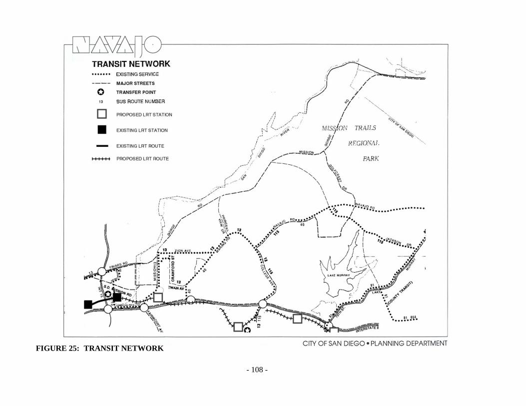
- 108 -
FIGURE 25: TRANSIT NETWORK

- 109 -
INTRODUCTION
Today across the United States the bicycle boom continues. People of all ages are riding bicycles
as never before. People have turned to bicycles for exercise, recreation and transportation.
Schools within a community often generate a high demand for bicycle facilities. Bikes do not
pollute, are energy efficient, and they offer an opportunity to bypass congested streets.
The City has design standards for the construction of bikeways and an ongoing program of
providing a comprehensive bikeway system for City residents that will connect to a regional
bikeway network. Bikeways fall into three categories based on the degree or extent of their
improvements: bicycle paths (Class I), lanes (Class II) and routes (Class III). Four such bikeways
have been constructed in Navajo, and are noted on the bikeways map. They are described in the
following section along with the proposed routes.
PROPOSALS
Regional Bikeway
A regional bike route is proposed from the ocean through Mission Valley to Mission Gorge Road
and northeasterly along Mission Gorge Road. This route will also continue east parallel to the
north side of I-8 from Mission Gorge Road to the vicinity of College Avenue.
Del Cerro Route
This route would be oriented to the Del Cerro area and would utilize Del Cerro Boulevard from
Trinity Way on the west to Linfield Avenue on the east. The intended alignment would provide a
scenic overlook of Mission Valley. Length: 2.0 miles.
Allied Gardens Route
This route would be oriented to Allied Gardens and also provide for the extension of bicycling
opportunities from that community easterly to the Del Cerro area. This existing route utilizes
Barclay Avenue and Brunswick Avenue between Galewood Street and Zion Avenue. Both
streets run through attractive residential areas. College Avenue, the link to Del Cerro, would
provide scenic overlooks of San Diego. Length: 2.0 miles.
Connector - This route provides a connection between the Allied Gardens route and the proposed
San Diego River route in the vicinity of Zion Avenue. The route is aligned along Zion Avenue,
Delbarton Street, Crawford Street, and Twain Avenue. Except for Twain Avenue, this route
exists. Length: 2.0 miles.
BICYCLES

- 110 -
FIGURE 26: BIKE ROUTES

- 111 -
Jackson Drive Extension
An extension of the Jackson Drive route would be a route that lies largely outside the San Diego
City limits. This route would run from the City limits to the San Carlos Community Center by
way of East Lake Avenue, Lake Ashmere, Lake Arrowhead, San Carlos Drive, Boulder Lake
Avenue, and Jackson Drive. The Jackson Drive portion now exists. Length: 3.2 miles.
Lake Murray Boulevard Route
This route would be along Lake Murray Boulevard from Grossmont Community College to a
connection with the Del Cerro route extension at Jackson Drive. This route presently utilizes a
portion of the Lake Murray Boulevard frontage road from Jackson Drive to the Navajo shopping
center. From the shopping center to the college, a portion of Lake Murray Boulevard would be
set aside with appropriate striping for use as a bike route. The southerly portion of the route is a
tree lined boulevard through an attractive residential area. Length: 1.75 miles.
Jackson Drive Route
This route consists of an existing Class III bikeway from the city of La Mesa to Mission Gorge
Road. Total length: 3.0 miles.
Navajo Road Route
This route is along Navajo Road from the intersection of Waring Road and College Avenue,
easterly to the City limits at Fanita Drive with the possibility of extensions into El Cajon. This
route exists except for the most eastern half-mile. Total length: 3.7 miles.
Golfcrest Drive Route
This route would be along Golfcrest Drive from Navajo Road to Mission Gorge Road and would
serve as a connector between the bike routes on those streets. Length: 1.25 miles.
Mission Gorge Road Route
This route would be along Mission Gorge Road from the Santee - San Diego City limits to the
western limit of the community. Although the parallel bikeway along the San Diego River will
remain as a desirable goal for future implementation, its construction is dependent upon further
development along Mission Gorge Road. When private developments along Mission Gorge
north of the Archstone property are initiated, street improvements will include widening and the
inclusion of a bicycle lane. In the meantime, relatively minimal and inexpensive work on
Mission Gorge Road can produce a usable improvement for bicyclists. Total length: 5.2 miles.
Connector - This proposed route provides a connection between the Mission Gorge Road route
and the proposed San Diego River route. The route would be aligned along Father Junipero Serra
Trail. Length: 1.2 miles.

- 112 -
San Diego River Park Pathway
This San Diego River Pathway would be along the entire length of the San Diego River within
the Navajo community on the south side of the river. Bicycle and pedestrian users would be able
to connect to other regional bike routes from the San Diego River Park Pathway. The design of
the pathway should be in accordance with the San Diego River Park Subdistrict of this plan and
consistent with the San Diego River Park Master Plan. Through the development along the river
the San Diego River Pathway location will be determined and an easement to allow for public
access will be required on private land.
The routes shown and described above are bikeway corridors, and not exact alignments. When
this Plan is implemented, minor deviations may be necessary.

- 113 -
INTRODUCTION
The five basic functional categories of streets in San Diego are present in Navajo. They are:
freeways, primary arterials, major streets, collector streets, and local streets.
Street and Highway Standards adopted for the City of San Diego in 1964 and revised in 1980,
are shown in the Standards and Definitions section of this Plan. Although these standards are
applicable primarily to streets in new subdivisions, they also indicate desirable features to be
obtained whenever improvement of an existing street system is undertaken. Also shown on the
table are the maximum Average Daily Volumes (ADT) of traffic desirable for each type of street.
EXISTING CONDITIONS
The Functional Road Network and Traffic Volumes map and the Street Classification map (see
pages 114 and 115) show the existing functional classifications for streets in the Navajo
community, from the primary arterial to the collector street level. Interstate 8 forms the southern
boundary of the area. Friars Road, Mission Gorge Road east of Friars Road, and Navajo Road all
function as primary arterials. The other streets shown on the existing road network map function
as major or collector streets.
The traffic volumes carried by each street in the Navajo roadway network are also shown on the
Functional Road Network and Traffic Volumes map and the Street Classification map (see pages
114 and 115). The volumes listed are in vehicles per average weekday.
Volumes of over 20,000 vehicles per day exist on portions of Mission Gorge Road, Waring
Road, College Avenue, Friars Road, Navajo Road, and Lake Murray Boulevard. The highest
traffic volume recorded on a surface street is on Mission Gorge Road between Friars Road and
Zion Avenue (52,700) where a six-lane facility exists.
There are several streets in the area that are carrying traffic volumes in excess of their design
volume. Fairmount Avenue extension between Mission Gorge Road and Twain Avenue is 50
feet wide, yet carries 7,600 vehicles on an average weekday. The maximum desirable ADT for a
two-lane collector street is 5,000 vehicles per day. Zion Avenue varies in width from 40 to 50
feet and has a maximum desirable ADT of 5,000 yet is currently carrying over 14,300 vehicles
per day. Similarly, College Avenue between I-8 and Del Cerro Boulevard, Twain Avenue
between Mission Gorge Road and 50th Street, Mission Gorge Road between Fairmount Avenue
and Twain Avenue, and Madra Avenue north of Del Cerro Boulevard all carry volumes that
exceed what is desirable for their classifications. (All traffic counts are as of 1987.)
STREETS
- 114 -
PROPOSALS
Freeways and Expressways
A recently completed study by SANDAG concluded that the easterly extension of State
Route 52 (SR-52) is the most critical improvement needed to relieve traffic congestion on
Mission Gorge Road, Friars Road, and I-8. Construction of SR-52 from Santo Road in
Tierrasanta to the city of Santee will be scheduled as soon as environmental clearance is
obtained.
An extension of Route 125 north to SR-52 is proposed. When built, this freeway and/or
expressway would parallel the eastern edge of the Navajo community.
Improvement by Caltrans of Interstate 15 (I-15) to 6-8 lanes between I-8 and State Route 163
(SR-163), and eight or more lanes north of SR-163 is being implemented.
An additional westbound traffic lane on I-8 between College Avenue and I-15 is being
proposed by Caltrans. This improvement will relieve traffic congestion on I-8 and Navajo
community streets that access I-8 (i.e., College Avenue, Waring Road, and Mission Gorge
Road). Caltrans is scheduled to advertise for bids for the widening in 1991.
Streets
The synchronization of traffic signals along Mission Gorge Road, between I-8 and Rainier
Avenue is currently being designed (Fiscal Year 1988). The traffic signals north of Rainier
Avenue cannot be synchronized because they are spaced in excess of one-quarter mile apart,
the maximum practical distance for synchronization.
Friars Road, between Riverdale Street and Santo Road, is planned to be widened to six lanes
to alleviate congestion at the intersection of Mission Gorge Road and Friars Road that is
caused by the three westbound lanes on Friars Road narrowing to two lanes west of
Riverdale. This project is included in the Capital Improvements Program for design in Fiscal
Year 1989.
The easterly extension of Alvarado Canyon Road will be constructed as part of the Mission
Valley East LRT project as a two-lane collector crossing over Waring Road to Adobe Falls
Road. The road will provide improved access to the planned Grantville LRT Station and help
to mitigate traffic impacts on Fairmount Avenue, Mission Gorge Road, and the westbound I-
8 off ramp.
A study of the realignment of Alvarado Canyon Road should be completed and the project
undertaken as soon as feasible. Subject to environmental review, the intersection of Alvarado
Canyon Road with Mission Gorge Road should be moved northward to align with the
Mission Gorge Road/Fairmount Avenue intersection. This realignment will help alleviate
traffic congestion on the westbound I-8 off ramp/Fairmount Avenue intersection.
Consideration should also be given to widening the southbound Fairmount Avenue to
westbound I-8 on-ramp in conjunction with this project.
The circulation plan must be oriented to provide a balanced transportation system for the Navajo
community. Additional streets and alterations to existing streets should be limited to remedial

- 115 -
and corrective measures. Only as a last resort should the widening or addition of streets, as
would be required by the City's street standards, be considered.
Special treatment should be provided as indicated on the Street Classification Map to handle
capacity problems. The special treatment required may take the form of parking prohibitions,
widening at intersections to obtain additional lanes, adding or changing intersection
channelization to facilitate heavy directional moves, and special traffic signal phasing or
interconnection.
In the event the above techniques cannot adequately facilitate traffic, the following
improvements should be considered:
Navajo Road should be widened to a six-lane major street east of Lake Murray Boulevard.
Mission Gorge Road should be widened to a six-lane facility north of Zion Avenue with no
left-turn lanes except at signaled intersections. Between Fairmount Avenue extension and I-8
(at its southerly terminus) Mission Gorge Road should also be improved to be a six-lane
major street.
In preparing this next recommendation, City and state agencies and community interests were
consulted and numerous alternatives were considered and analyzed. The recommendation for the
extension of Navajo Road through Navajo Canyon appears to be the best solution at this time,
but only under the following conditions:
Since this Plan recommends maintaining Navajo Canyon as open space, the extension of Navajo
Road through the canyon should be designed to parkway standards and limited to a two-lane
facility with four lanes at the intersections with College Avenue and Waring Road and no
intermediate access; sufficient capacity must exist on I-8 to accommodate the Navajo Road
traffic; and a reevaluation of the entire recommendation shall be undertaken if at any time before
construction, any curb on automobile traffic, such as the use of gasoline rationing, etc., takes
place in San Diego.

- 116 -
FIGURE 27: STREET CLASSIFICATION

- 117 -
FIGURE 28: FUCTIONAL ROAD NETWORK
- 118 -
Design Principles
One aspect of transportation planning which has been overlooked is that portion of its site
planning which involves the art or form of the transportation facility. It is especially important
that roadways be regarded as an integral part of the landscape in which they are sited. They must
be something more than the standard provision of a surface for moving cars or guiding public
transit vehicles. However, the design of the facility must not override, but be considered equally
with, the safety and capacity of the facility.
Because of topography, many of the City standards for streets are not suitable for the Navajo
community. The following standards are suggested for use in these areas.
Street Widening
Widening and realignment frequently destroys
the visual character and identity of streets by the
removal of mature trees, other landscaping, and
median strips. The approach to street widening
and realignment should be more sensitive to the
character of the street and the quality of adjacent
development. When substantial environmental
damage may result to adjoining properties, the
traffic carrying capacity of the street might be
improved by eliminating on-street parking or
using reverse lanes at peak hours rather than
physical widening. When a street must be
widened and necessarily encroaches on a
dwelling's front or side yard, variations should be permitted in the zoning code requirements that
would permit high walls to give residents privacy from the sight and noise of traffic.
Street Accessories
Standards for street paving and lighting are not varied systematically throughout the City.
Most of the streets and sidewalks in the City are paved in the same materials, and lighting
fixtures often do not reflect the character and scale of the frontage development.
Placement of telephones, police and fire call boxes, mail deposit boxes, street numbers and
newsstands in consistent locations along the street would facilitate their use. These
accessories should not be placed in the path of pedestrians or wheelchair users.
A coordinated system of variation in the use and placement of street trees, lighting, and other
details could give streets better visual continuity and provide differentiation between through
streets and local streets to aid driver orientation and traffic flow. The variations could include
size, spacing and species of street trees and other landscaping, and intensity, spacing, and
design of lighting fixtures. For example, major streets might have tall, widely spaced street
trees; bright, closely spaced street lights; and large street signs. Local streets might have
smaller, dense and more closely spaced trees; compass headings could be indicated by

- 119 -
symbols on light poles or on the
pavement. A more logical and
systematic method of street naming
should be used.
Hillside Streets
Hillside street standards should be
reviewed for compatibility with the
terrain. More restrictive grading
controls, street landscaping, and
limitation of on-street parking to one
side of all hillside roads, should all be
considered. Even under existing
standards however, the use of retaining
walls and horizontally or vertically
split street alignments would make the
road blend into this special
topography. These methods were
common in earlier hillside street
construction.
Pedestrian Walkways (Sidewalks)
Design walkways and parking facilities
to minimize danger to pedestrians.
Pedestrian walkways should be sharply
separated from traffic areas and set
apart where possible to provide a
separate circulation system. Where
necessary and practical, the separation
should include landscaping and other
barriers. Walkways should pass
through the interiors of blocks.
Walkways that cross street corners
should have good sight distances for motorists and pedestrians.
Driveways across sidewalks should be kept to a practical minimum, with control maintained
over the number and width of curb cuts. Barriers should be installed along parking lots to
avoid encroachments on sidewalks, with adequate sight distances maintained at driveways.
Commercial and industrial truck loading should occur on private property rather than in
roadways or on sidewalks. Residential parking should be as close as possible to the dwellings
served, with adequate lighting along the walking route from the parking to the dwellings.

- 120 -

- 121 -
INTRODUCTION
The term "environment" in its broadest sense
refers to all the external dimensions--social and
economic as well as physical--which affect the
life of an individual. This element focuses on
that dimension of traditional concern to urban
planning, and recently of increasing concern to
the public--the quality of the physical
environment, natural and man-made.
The visual form of a community's physical
environment should be comfortable, educational,
rich in variety and highly identifiable, expressive
of the community's functions and social life, and capable of being shaped by its inhabitants. The
primary goal in this area of concern is the improvement, restoration, and protection of the quality
of the natural and built environment. All of this is taken into account in identifying the
opportunities for improvement of the visual environment.
The environment of any community is more than the sum of the homes, shops factories, schools
and parks. The maintenance and improvement of the natural and built environment do much to
determine the quality of particular neighborhoods
and communities to preserve their distinct
identities.
To many individuals, the image of the community
they are most familiar with is the motorist's view
as he passes through. The lack of landscaping on
the perimeter of roadways, the barrenness of
residential and commercial subdivisions and the
seemingly endless areas of pavement are
frequently expressed concerns. Residential
development establishes the dominant
environmental character of Navajo. Relatively
uniform house size and design, parcel area and site layout--a situation typical of many postwar
developments--typifies much of the community. New approaches to site and building design,
however, have provided some interesting variety--an example being the San Carlos townhouse
apartments at Jackson Drive and Golfcrest Avenue.
Visual clutter is a major environmental problem. The numerous signs, billboards, telephone and
electrical distribution poles and lines, and television antennas are distracting and unattractive.
The problem is most evident upon entering the community on Mission Gorge Road from I-8.
Signs are examples of visual nuisances that create a poor environmental image of a community
and its character. Often, these signs are concentrated to appeal to the eye of the motorist.
COMMUNITY ENVIRONMENT

- 122 -
A clutter of signs proliferates in many of the commercial areas. The signs are unsightly,
disorganized, and generally degrading to the entire community. Mission Gorge Road is the most
notorious example of an area blighted by excessive signs. The attempt to compete with larger,
brighter, and gaudier signs not only detracts from the appearance of the area but diminishes the
effectiveness of signs. The problem of sign clutter is also prevalent in the shopping centers.
Other clutter is produced by elements placed in the street areas. The undergrounding of overhead
wires should continue at the most rapid pace possible, with the goal of complete elimination of
such wires within a foreseeable period of time. Every other element in street areas, including
public signs, should be examined with a view toward improvement of design and elimination of
unnecessary elements.
Both public and private efforts in the
installation and maintenance of landscaping
should be increased. In residential areas, side
yards and setbacks provide the best
opportunities for landscaping visible in public
areas. If no such space exists, then trees should
be placed in the sidewalk area, preferably in the
ground rather than in containers. Care should be
taken to select species of trees suitable to each
location. The most visible points, such as street
intersections, should be given special attention.
Other unused opportunities for landscaping
exist on exposed banks, usually along roadways. Where it is feasible, these should be planted and
maintained by the owners of the land.
In addition to landscaping, other features along the streets add to the comfort and interest of
pedestrians. Sidewalk paving and furnishings, if designed in a unified way, make walking more
pleasurable. Gentle changes in level have the same effect. In commercial areas, continuous and
well-appointed shop windows and arcades are invitations to movement. Little used alleys and
easements can be improved as walkways, and new promenades put through blocks in new
developments. Screening of the sand and gravel and industrial areas along Mission Gorge Road
through the use of walls, fences and substantial landscaping can greatly enhance the appearance
of these areas.

- 123 -
OBJECTIVE
TO PRESERVE AND ENHANCE THE NATURAL BEAUTY AND AMENITIES OF THE
NAVAJO COMMUNITY.
PROPOSALS
Programs
Grading and landscaping standards should be improved. Hillside cuts, in particular, must be
better controlled to preserve the natural topography.
Define acceptable noise rating levels for the use of motorized equipment and aircraft.
Restrict heavy truck traffic to certain areas.
Develop new programs and practices for the reclamation of waste water for secondary uses.
Develop new programs and practices for the disposal or recycling of garbage, refuse and
other solid wastes.
Establish restrictions on odor-producing activities based on wind direction, atmospheric
temperature, topography and proximity to built up areas.
Buildings - Structures
Create, through design, harmony between natural features and urbanized areas and activities.
Encourage an orderly transition of height, density, scale and arrangement of buildings to
preserve the identity of each element as well as the cohesion of the whole.
Promote the coordination of building groupings to foster neighborhood and community
identity and unity.
Encourage an overall quality of design by using materials, color and texture to give identity
and focus to groups of structures within the urban landscape.
Cable television should be encouraged throughout the study area to help eliminate the clutter
of individual antennas. Future planned residential developments should include no more than
one master antenna to serve all units.
All telephone and electrical distribution lines should be underground where technically and
economically feasible, in accordance with systematic long-range program establishing
priorities for the Navajo area.
Develop points of visual relief in the urban landscape through the use of open spaces and
landscaping, building setbacks, building materials, location of public facilities, and street and
right-of-way design and maintenance.
Improve the appearance of public and private special use properties such as flood control
channels, power line rights-of-way, mineral extraction operations, and water storage areas.

- 124 -
Improve flood control and storm and sewer installations.
Protect distinct areas and communities from intrusion and encroachment of incompatible
uses.
Minimize nuisances to adjacent uses through the control of noise, odor, pollution, vibration
and glare, and the screening of unaesthetic land uses.
Implement development controls on urban development in accordance with the Mission
Trails District Design Manual, which provides that no structure shall exceed four stories and
in no case shall a structure exceed fifty (50) feet in height.
Signs
The size, placement, design and height of signs should be controlled through reasonable and
uniform regulations utilized to prevent encroachment on the visual form of the community's
physical environment.
Signs should not project above the eave of the building to which the signs are attached.
Signs should not protrude over the sidewalk or street, but be placed against the face of the
building. Freestanding signs should be prohibited.
Signs for the various businesses in any shopping center should be attractively clustered upon
a marquee near the entrance to the center.
Signs with moving parts or flashing lights should not be allowed.
Signs should be limited in size based upon the linear feet of street frontage.
Signs on trucks, autos, or other vehicles used to circumvent sign regulations should be
restricted.
Permitted signs should be kept in good appearance and repair. Nonconforming signs should
be removed.
Landscaping
Use trees and shrubbery along heavily traveled streets to help lessen effects of traffic noise.
Support feasible soundproofing of residential, commercial and industrial structures.
Mission Gorge Road industrial development should be properly screened with landscaping
and other suitable means. The area should be made presentable to the community and
motorists on Mission Gorge Road because of its importance as an entry to the community,
the Old Mission, and Mission Trails Regional Park.
Establish financing programs, such as assessment districts, to provide for and maintain
landscaping in the public right-of-way for major streets within the community.
The following streets should receive first priority for such right-of-way improvements:
Navajo Road, Mission Gorge Road, College Avenue and Waring Road. These improvements
should include the planting of street trees as well as landscaping of the center median.
- 125 -
Natural
Utilize natural elements as points of visual relief in the urbanized areas.
Establish and maintain an open space system to conserve natural resources, preserve scenic
beauty, and define urban form.
Create and preserve open space in and around built-up areas to aid in lessening the effects of
high noise levels.
Strengthen environmental pollution control measures. Support research into causes and
prevention of environmental pollution.
Prevent deterioration of natural watershed areas.
The development of an attractive community is one of the first considerations of the residents of
the Navajo community, not only as a matter of personal pride and stabilization of property
values, but in realization of the natural attractiveness of the area as a desirable place to live.
It is the intent of this community plan that all public facilities be provided commensurate with
the need for such facilities. In some cases, the exact location for such facilities has not yet been
determined. The final site selection of these facilities will be accomplished during the
subdivision map filing process. City policy requires that subdivision maps be reviewed by all
public agencies that may have an interest in the proposal. If through this process it is determined
that a specific parcel of land within the subdivision is needed for public facility purposes, the
parcel in question will be withheld from development for a reasonable period of time to allow the
appropriate agency time for property acquisition. It is also intended that in the event the public
agency does not arrange for the acquisition of the needed property within a reasonable period of
time, private development of the property may occur as consistent with the Plan goals and
objectives. Such private development shall conform to Council Policies 600-4 (standards for
public rights-of-way improvements),
600-10 (adequate public services in connection with development proposals), 600-18
(residential/commercial/industrial developments phasing), or any other present or future policy
of the City of San Diego that may be effective at the time of future development proposals.
Future Study Area
A City-owned parcel adjacent to Pasatiempo Avenue, consisting of ten acres of relatively level
land, has been set aside for additional study. This property has been designated as FUTURE
STUDY AREA to permit studies to be undertaken to determine an appropriate permanent use5
5 For land use types, refer to the General Plan Land Use and Community Planning Element - Table LU-4.

- 126 -
Thus far, the Navajo Community Plan has set forth a wide range of goals, objectives and
proposals aimed at enhancing the community. Based on these, specific actions must be
undertaken to realize the Plan. These actions and the ensuing financial obligations usually are
joint efforts of private citizens and enterprise and local, state and federal governments. Some
implementation programs, however, may be carried out by private initiative only.
Because Navajo is a community developed to relatively high standards and not requiring
extensive redevelopment, implementation will emphasize the retention of those qualities such as
undeveloped canyons and hillsides which have made the community a desirable place in which
to live.
The following is a descriptive list of proposals that includes means of and responsibility for
implementation. Although various governmental agencies are listed as having responsibility for
carrying out the Plan proposals, the City Council has ultimate responsibility. Regardless, the true
burden of the Plan rests with an interested active citizenry. Without constant citizen participation
and concern, the implementation of these proposals will never be a reality.
Proposal
or Activity
Priority
or Timing Action Responsibility
Financing
Method
I ORGANIZATION
A. Maintain community
rapport.
Continuing 1. Arrange publicity,
conduct public
meetings, and provide
information service.
NCP(1)
Not determined
B. Maintain and implement
plan.
Continuing 1. Monitor proposed
plans and other
actions affecting
community plan,
provide input as
appropriate.
2. Arrange annual public
community NCP
meeting (more often,
if needed) to appraise
changing needs and
adjust planning &
implementation
accordingly.
3. Take other steps to
promote community
consciousness and
identity, such as
distribution to each
NCP Not determined
IMPLEMENTATION

- 127 -
Proposal
or Activity
Priority
or Timing Action Responsibility
Financing
Method
new resident (as well
as present residents)
of a pamphlet
describing how
citizens may
participate in
community planning
and development.
II RESIDENTIAL
A. Encourage a wide range
of densities (30-43, 15-
29, 10-14, 5-9, & 0-4
D.U. per acre), develop
and/or maintain these
densities as shown on
the community plan
map.
Continuing Allow no rezoning
that conflicts with
plan proposals.
Planning Dept.
(1) Navajo Community Planners, Inc.
B. Adopt, as City policy,
inclusion of a portion of
low and moderate
income housing in all
major residential
developments based on
objective determination
of need for such
housing.
Continuing 1. Adopt policy.
2. Enforce policy in
working with owners,
realtors, developers.
3. Monitor
implementation.
City Council
Planning Dept.
NCP/
Community
Action
C. Vary housing types and
densities to create
interest and provide a
mix of economic and
social characteristics.
Implement the Mobile-
home Park Overlay
Zone.
Immediate 1. Adopt balanced
community concept.
2. Enforce policy in
working with owners,
developers.
3. Monitor
implementation.
City Council
Planning Dept.
NCP/
Community
Action
D. Require all major
residential development
proposals to be carried
out under a PRD.
Immediate 1. Commission &
Council approval of
policy.
2. Apply policy to major
proposed residential
developments.
Planning Dept.
Planning Dept.

- 128 -
Proposal
or Activity
Priority
or Timing Action Responsibility
Financing
Method
E. Relate dwelling units to
topography.
Immediate Work with property
owners, realtors,
developers to strongly
encourage the use of
PRD, PCD procedures.
F. Provide adequate, off-
street parking.
Immediate Work with property
owners, realtors,
developers to strongly
encourage the use of
PRD, PCD procedures.
Planning Dept.
G. Implementation of the
Mission Trails District
controls.
1. Enforce policy in
working with owners
and developers.
2. Monitor
implementation.
Planning
Dept./NCP
Community
Action
H. Implementation of the
geologic hazard area
controls.
Immediate 1. Enforce policy in
working with owners
and developers.
2. Monitor
implementation.
Planning Dept.
III COMMERCIAL
A. Maintain and/or develop
community commercial
centers at Lake Murray
Blvd. & Navajo Rd.,
Jackson Dr. & Navajo Rd.
& at Waring Rd. & Orcutt
St. to include professional
& business offices,
entertainment & cultural
activities, & public &
semipublic facilities.
According
to need
1. Work with owners,
realtors, developers
using PCD and other
means available.
Planning Dept.
B. Develop neighborhood
commercial centers at
Golfcrest Dr. & Mission
Gorge Rd to supplement 3
existing centers.
According
to need
1. Work with owners,
realtors using PCD
and other means
available.
2. Maintain zoning at
existing centers.
3. Rezone land where
needed to implement
plan.
Planning
Commission/
Planning Dept.

- 129 -
Proposal
or Activity
Priority
or Timing Action Responsibility
Financing
Method
E. Retain visitor-oriented
facilities at I-8 at Waring
Rd. & Mission Gorge Rd.
at Alvarado Canyon Rd.
No additional visitor-
oriented facilities are
proposed.
Immediate &
continuing
Monitor situation. Planning Dept.
F. Regulate number &
location of service
stations.
Immediate 1. Obtain approval for
criteria.
2. Enforce criteria.
Planning
Dept./NCP
Planning Dept.
G. Remove off-premise
signs and consolidate
multiple on-premise
signs.
Continuing 1. Enforce City sign code.
2. Monitor development
projects.
Planning
Dept./NCP
H. Process new commercial
center developments as
PCDs.
Continuing Require PCD with
map or rezone
processing.
Planning Dept.
I. Ensure compliance with
design standards in
Grantville.
Continuing 1. Apply CPIOZ.
2. Monitor development
projects.
Planning
Dept./NCP
J. Implement the Mission
Trails Design District
controls.
1. Enforce policy in
working with owners
and developers.
2. Monitor
implementation.
Planning
Dept./NCP
Community
Action
IV INDUSTRIAL
A. Ensure that property
rezoned to permit
industrial use is
developed in a manner
compatible with the river
and surrounding
residential areas.
Upon
application
for rezone
Require processing of
PID concurrent with
rezone processing.
Planning Dept.
B. Ensure that future
development of the
remaining sand and
gravel facility (VR
Dennis) is reviewed for
compatibility with the
river and Mission Trails
Park, and for traffic
impacts.
Upon
application
for rezone
Require processing of
master PID concurrent
with rezone
application.
Planning Dept.

- 130 -
Proposal
or Activity
Priority
or Timing Action Responsibility
Financing
Method
C. Ensure that future
development complies
with the design standards
for Grantville.
Immediate
& continuing
1. Apply CPIOZ SDRs.
2. Monitor development
projects.
Planning Dept.
D. Implement the Mission
Trails Design District
controls.
Continuing 1. Monitor
implementation.
2. Work with owners,
realtors, developers, &
tenants to solicit
interest and
participation.
V OPEN SPACE RETENTION AND UTILIZATION
A. Acquire open space
system: Mission Gorge
300 ac. (San Diego River
system).
As soon
as possible
Initiate proceedings
for hearing and
Council action on
establishment.
NCP/City
Council/
Community
Action
Not determined,
Assessment District
(see cooperative
arrangement w/
Water Dist. on land
it owns)
B. Redesignate those lands
within the open space
areas to the guidelines
established in the open
space element of this
report.
Contingent
on Open
Space
Implementati
on
1. Initiate rezoning.
2. Monitor development
of plans for
preservation of natural
amenities.
Planning Dept. Not determined
C. Establish hiking trails in
S.D. River Basin through
Mission Gorge linked to
City-County system.
Immediate Schedule into CIP. Park and Rec.
Dept.
To be determined/
CIP or other funds
D. Public access to open
space areas.
Immediate Establish and
maintain.
Park and Rec.
Dept.
E. Establish FW and FPF
zoning along the river.
Immediate Rezone in accordance
with FEMA maps.
Engineering &
Dev’t.
F. Regulate dev’t. adjacent
to the river to minimize
disturbance to the
wetland habitat.
Immediate
& ongoing
1. Apply CPIOZ.
2. Adopt Habitat
Conservation Plan.
Planning Dept./
SANDAG
VI PARKS & RECREATION
Park & Recreation Centers
A. Lake Murray Community
Park & Rec. Center #370)
As soon
as possible
Expanded parking lot,
children’s play area,
site furnishings, and
new ball field.
Park and Rec.
Dept.
CIP, Park Fees,
1973 Bond Issue

- 131 -
Proposal
or Activity
Priority
or Timing Action Responsibility
Financing
Method
B. Allied Gardens
Community Park &
Recreation Center (#380)
As soon
as possible
Expand lockers, new
pools & ADA
updgrades.
Park and Rec.
Dept.
CIP, Park Fees
C. San Carlos Community
Park & Recreation Center
(#360)
As soon
as possible
Ball field lighting. Park and Rec.
Dept.
CIP, Park Fees,
1966 Bond Issue
D. Qualcomm Major Park
and Recreation Center
As soon
as possible
Sports fields, picnic
areas, children’s play
area, passive
recreation areas.
Park and Rec.
Dept.
CIP, Park Fees
Neighborhood Parks
A. Margerum (#383) 1st Develop City-owned
site.
Park and Rec.
Dept.
CIP, Park Fees,
1966 Bond Issue
B. Tuxedo (#373) 2nd Develop City-owned
site.
Park and Rec.
Dept.
CIP, Park Fees
C. Cowles Mountain (#361) 3rd Open Space Park--
Lease & develop
acreage on Gage
Elementary School for
active play fields.
Park and Rec.
Dept.
CIP, Park Fees,
1977 Bond Issue
D. Dailard (#372) 4th Develop City-owned
site.
Park and Rec.
Dept.
CIP, Park Fees,
1973 Bond Issue
E. Pasatiempo Open Space
Park (#371)
5th Develop City-owned
site.
Park and Rec.
Dept.
CIP, Park Fees
F. Princess Del Cerro (#381) 6th Develop City-owned
site.
Park and Rec.
Dept.
CIP, Park Fees
G. Del Cerro (#371) 7th Investigate purchase
of private park.
NCP Private
H. Grantville Neighborhood
Park
As soon
as possible
Develop City-owned
site.
Rancho Mission As soon
as possible
. Small parks & plazas in
community &
neighborhood
Continuing Encourage developers
to include
beautification when
maps are submitted.
Planning Dept. Private
Resource-Based Parks
A. Mission Trails Regional
Park
B. Adobe Falls Open Space
Park
C. Padre Dam

- 132 -
Proposal
or Activity
Priority
or Timing Action Responsibility
Financing
Method
D. San Diego River Park
(SDRP)
Immediate &
ongoing
Apply San Diego River
Subdistrict CPIOZ
Development
Services
Dept.
CIP Private Grants
VII SCHOOLS
Adjust boundaries to
maintain proper balance.
As needed San Diego
Unified School
District
VIII OTHER COMMUNITY FACILITIES
Library
Appraisal of need for
additional service.
Continuing 1. Evaluate effect of new branch.
2. Consider expansion of
Benjamin Branch.
3. Consider adding third
branch in Community.
City Librarian CIP
CIP
Police, Fire, Water, Sewer, Private Facilities
Monitor adequacy of
service.
Continuing Notify appropriate
City staff of unmet
service needs and
follow up as needed
with staff and/or
Council.
NCP/
Community
Action
Flood Control
A. Monitor San Diego River
Control Plan.
Continuing 1. Ensure adequate
control plan is
implemented.
NCP/
Community
Action
B. Monitor Alvarado Creek
Control Plan.
Continuing 2. Apply appropriate
zoning.
NCP/
Community
Action
IX CIRCULATION
Public Transportation
A. Increase frequency &
hours for routes.
Immediately Implement plans. MTDB Not determined
B. Extend routes indicated
on Network Map.
As soon
as possible
Implement plans. MTDB Not determined

- 133 -
Proposal
or Activity
Priority
or Timing Action Responsibility
Financing
Method
C. Provide I-8 express
service--El Cajon to
Downtown with a stop in
Navajo Community.
As soon
as possible
Implement plans. MTDB Not determined
D. Institute area minibus
system.
Long-range Develop and
implement local
service plan, possibly
linked to citywide.
NCP/ through
MTDB or
Private
Not determined
E. Construct LRT system
along the east Mission
Valley corridor.
Short-range Implement plans. MTDB Local, State and
Federal Transit
Funding
Bikeways
F. Develop community
bikeway system
coordinated with regional
system.
As soon
as possible
Follow through for
implementation of
approved plans.
Engineering &
Dev’t.
CIP, Bikeway Fund,
General Fund
Streets
G. Increase I-8 & I-15 traffic
handling capacity.
As soon
as possible
Continuing study and
improvement.
Engineering &
Dev’t./ State
Div. of
Highways
Hwy. Trust Fund,
Gas Tax
H. Extend Navajo Rd. When needed
& conditions
met
Monitor need and I-8
access; schedule into
CIP.
Engineering &
Dev’t.
CIP, Gas Tax
I. Expansion of existing
roads to 6 lanes: Friars
Rd., Mission Gorge Rd.
According
to need
Schedule into CIP
according to need.
Engineering &
Dev’t.
CIP
J. Extend Jackson Dr. to
Mission Gorge Road.
As soon
as possible
Construct according to
CIP.
Engineering &
Dev’t.
CIP, Gas Tax
K. Provide misc. special
treatments.
As needed Monitor & determine
needs and
opportunities to
increase capacity of
road system through
special treatment.
Engineering &
Dev’t.
CIP and/or General
Fund
L. Construct easterly
extension of Alvarado
Canyon Rd.
Concurrent
with LRT
system
Implements plans. Engineering &
Capital Projects
Dept.
Local, State and
Federal Funding
M. Realign Alvarado
Canyon Rd. to
Fairmount/Mission Gorge
Rd.
As soon as
possible
Proceed with design
and environmental
review when funding
has been identified.
Engineering &
Capital Projects
Dept.
Local, State and
Federal Funding

- 134 -
Proposal
or Activity
Priority
or Timing Action Responsibility
Financing
Method
N. San Diego River Bike
Pathway
Implement the bike
route through private
development
Development
Services Dept.
CIP Private Funds
X COMMUNITY ENVIRONMENT
A. Improve grading,
landscaping standards and
control of hillside cuts.
Immediate 1. Proposed amendment
to PRD, PCD, & HR
requirements to
provide better
protection and
enhancement of
environment.
2. Enforce adopted
standards.
Planning Dept.
Planning Dept.
B. Underground utilities. As soon
as possible
Seek scheduling of
undergrounding of
utilities on major
streets not already
undergrounded.
Community
Action/NCP
Utility Co. assume
program or
Assessment District
C. Extend Cable TV. As soon
as possible
Approach franchise
operators re:
expediting service
follow-up.
Community
Action/NCP
D. Require use of master
antenna in PRDs.
Continuing Establish criterion
through City Council
that master antennas
only are allowed in
PRDs.
Planning Dept.
E. Extend sign control. Immediate Adopt proposed
changes in Sign
Control Ordinance.
City Council
F. Screen Mission Gorge
Road industrial
development.
Immediate Persuade property
owners to create
special assessment.
NCP/
Community
Action
Assessment District
G. Plant street trees &
landscaping: Navajo
Road, Mission Gorge
Road, College Ave., &
Waring Road.
Immediate Initiate special
assessment districts as
determined with City
staff.
NCP/
Community
Action
Assessment District
H. Control environmental
pollution.
Immediate
& continuing
Develop new
programs & practices.
Community
Action/City
Council
I. Prepare Urban Design
Plan.
Immediate Planning Dept.

- 135 -
Proposal
or Activity
Priority
or Timing Action Responsibility
Financing
Method
J. Implement the Mission
Trails Design District
controls.
As soon
as possible
Monitor
implementation.
Planning
Dept./NCP/
Community
Action

- 136 -
CONCLUSION
Comprehensive review of the community plan by the Navajo Community Planners and City staff
should be undertaken at periodic intervals to accomplish the following:
Review and analyze the relationship of development trends to the goals and proposals of the
Plan.
Investigate new implementation tools and aids for their application in making sustained
progress towards achievement of the goals of the Plan.
Recommend appropriate Plan amendments to the City Planning Commission and City
Council to ensure the Plan is kept up to date.
Navajo is one of the fastest growing residential areas in the City of San Diego. As such, its future
will be a significant factor in the quality of the City as a whole. As a young community, Navajo
exhibits the promise of youthfulness and the problems of rapid growth. It is paramount that
guidelines be established for the community as a desirable place in which to live.
It is the purpose of the Navajo Community Plan to provide such a framework for the City
Council, Planning Commission, private developers and other people concerned with the area's
future. In essence, the Plan gives rational direction to the recognition that planning must be an
ongoing process supported by the citizens. The continuing vitality of the Navajo Community
Planners will be a key element in the success of planning for this community.
The Navajo Community Plan can only be meaningful if it leads to action-oriented
implementation. The programs outlined previously, both public and private, are necessary tools
for the effectuation of the Plan. They chart a course that embodies the various proposals
presented, and together with the entire Plan, assure the significance which it deserves now and in
the year 2000.

- 137 -
Balanced Transportation System - A transportation network in which the several circulation
subsystems (auto, bus, LRT, bike, etc.) complement and reinforce one another and provide
mobility, accessibility and safety for residents of the community.
Bikeways fall into three general categories based on the degree or extent of their improvements:
Bicycle paths (Class I) are completely separate from vehicle traffic.
Bicycle lanes (Class II) along streets are reserved for bikes only. They may be marked with a
painted stripe on the road (more a psychological than a physical protection) or with curb barriers.
Bicycle routes (Class III) are simply lightly traveled streets marked with signs encouraging
bicycle use and cautioning motorists.
Commercial
Regional Centers emphasize such shopping goods as apparel, major household appliances, and
furnishings. The dominant establishments are usually one or more department stores. Variety and
specialized stores are typical tenants, as are business and professional services. Recently,
automobile agencies and major recreational facilities have made their appearance. In all, more
than forty different kinds of establishments are generally required to provide the range of goods
and services associated with regional centers.
Community Centers provide a wide range of convenience goods as well as some shopping
goods. A variety or junior department store may be the primary facility among the more than
twenty different kinds of establishments normally found in this type of center.
Neighborhood Centers characteristically provide goods and services of a convenience nature,
designed to meet daily needs. The dominant store is usually a supermarket. Other establishments
may include a drug store, liquor store, self-service laundry, beauty and barber shop, shoe repair
and service station. At least fifteen different kinds of establishments are necessary to provide a
complete range of convenience goods and services.
A smaller center is sometimes economically feasible and will provide public convenience where
the distance to the nearest shopping center is at least one mile, or where the local topography
isolates an area of residences. These smaller centers, which can be supported by resident
populations of one to two thousand, consist of a small grocery store, service station, and one or
more service establishments. However, the limited size and composition of such small centers
place them at a competitive disadvantage except under the unusual circumstances noted.
Specialized commercial uses include automobile sales agencies, furniture stores, bowling alleys,
drive-in theaters, hotels, motels and a wide variety of business, personal and repair services.
Their trade areas are normally not easily definable since these establishments may attract
patronage from a metropolitan or regional area. Specialized commercial uses are generally found
STANDARDS AND DEFINITIONS

- 138 -
in strip developments along major streets; however, they occasionally seek to cluster for mutual
support, and sometimes locate within or adjacent to community and regional centers.
Visitor-oriented commercial uses are intended primarily to serve tourists, business travelers, or
those persons attending conventions. Such uses largely include hotels, motels, trailer parks and
convention facilities. Locations are determined by regional access routes and terminals,
specialized recreational facilities, and centers of financial and administrative facilities.
Business and professional office development is often efficiently clustered near such institutional
facilities as hospitals, clinics, and research complexes. In addition, it may be appropriately
located at the periphery, or even within major concentrations of commercial activities.
Planned Commercial Development (PCD) - a Planned Commercial Development is a
predominantly commercial project designed and improved in accordance with a comprehensive
project plan located within any commercial zoning district except CP (Commercial Parking). It
may include residential, office, institutional, cultural, selected light manufacturing and
recreational uses and facilities. A Planned Commercial Development may be subject to a
development phasing program reflecting anticipated needs of project population growth in the
service area of the project.
The PCD regulations provide for a greater variety of goods and services than is normally found
within a center built under typical commercial zone regulations. Included are residential and
certain light industrial or handicraft uses as well as a full range of both light and heavy retail
uses, commercial recreation activities and public services.
An underlying purpose of the Planned Commercial Development is to encourage full-time use of
the center's facilities while minimizing space allocated to parking. Consequently, it is conceived
that reductions in the total off-street parking requirement might be granted by the Planning
Commission where it can be shown that different uses utilize the same parking facilities at
different times of the day. This provision could, in some instances, significantly reduce the vast
parking areas typically required in larger regional and community centers.
The PCD regulations also provide for a program of phased development where it is deemed
desirable. Such a program would be based upon population growth within the potential service
area of a Planned Commercial Development. This provision requires that the developer present
and follow a construction program that will ensure that residents of the service area are provided
with adequate commercial services during development of the center and to ensure that
community and regional shopping centers are not developed in a piecemeal manner with a
resultant loss in design cohesiveness and sensitivity.
Conditional Use Permits are issued for special uses of land which are not included in the
normal range of permitted uses in any zone. Examples include churches, schools, service
stations, etc.
Demography is the science of vital and social statistics, such as the births, deaths, diseases,
marriages, etc.
Density is the ratio between numbers of persons or dwellings and land area.
- 139 -
Density Ranges
Very low density 0-4 dwelling units per acre
Low density 5-9 dwelling units per acre
Low-medium density 10-14 dwelling units per acre
Medium density 15-29 dwellings units per acre
Medium-high density 30-43 dwelling units per acre
High density 44-73 dwelling units per acre
Very high density 44-109 dwelling units per acre
Developed Land is land upon which improvements have been made (grading, structures,
agricultural use).
Dial-A-Bus is a system of small buses on fixed routes or in designated areas. On-call vehicles
will pick up passengers at home and take them to their destination.
Dwelling Unit - a room or suite of rooms in a building or portion thereof, used, intended, or
designed to be used or occupied for living purposes by one family, and containing only one
kitchen.
Express Bus - buses operating nonstop or with limited stops between two points over existing
streets and/or freeways.
Field Act - Long Beach, in 1933, experienced an earthquake that destroyed a large number of
school buildings. As a consequence of this earthquake, the State Legislature enacted legislation
known as the "Field Act" which provided for the establishment of structural standards both in
design and construction of school buildings. This Act was amended in 1968 to provide that any
building classified as unsafe shall not be used for classroom purposes after July 1, 1975.
Fire Stations - require a site size of approximately three-quarters of an acre. This is regarded by
many authorities as appropriate for a fire station. This provides an adequate amount of layout
area for fire hoses.
According to present General Plan standards, fire station service areas should be determined on
the basis of present and proposed land use patterns and freeway and major street systems.
Currently, in newly developing areas, fire stations are being provided on the basis of a four-mile
service area and five-minute response time. Fire stations should be situated so as to permit easy
access to major streets.
Floodplain - the relatively flat area of low lands adjoining, and including, the channel of a river,
stream, water course, bay or other body of water which is subject to inundation by flood waters
of the Standard Project Flood established by the U. S. Army Corps of Engineers.
Floodplain Fringe - all that land in a floodplain not lying within a delineated floodway. Land
within a floodplain fringe is subject to inundation by relatively low velocity flows and shallow
water depths.
Floodway - that land in a floodplain, which is delineated on a map approved by the City
- 140 -
Council, required for passage of a 100-year frequency flood in an unlined channel with a
resultant rise in the natural flood water profile of one foot. The natural flood water profile is the
water surface elevation of a non-confined 100-year frequency flood in the natural undeveloped
floodplain.
Health Care Facilities - Hospitals should be located as near as possible to the center of the
population served. Community hospitals should be located not more than 20 minutes automobile
travel time from any point in the service area.
General hospitals should have frontage on a prime arterial or major street. Specialized hospitals
and long-term care facilities should have frontage on a collector or local street. Community
general hospitals should have public transportation available within one-quarter mile of the
facility. Regional general hospitals, because of the very large area served, should have
convenient access to all forms of transportation.
Hospitals normally should not be located adjacent to lands that create an exceptionally high
degree of activity or generate undue noise such as that emanating from railroads, freight yards,
schools, stadia, or playgrounds. Specialized hospitals and long-term care facilities should be a
part of or in proximity to a community or metropolitan general hospital in order to provide a full
range of medical care for the inpatients.
Site area should be sufficiently large to accommodate the facility, the required off-street parking,
planned future additions, and open space. When fully developed, about 50 percent of the site
should remain uncovered by buildings.
Libraries
Community Branches - Currently, the General Plan standards state that a branch library should
have a minimum of 5,000 square feet of floor area and contain a minimum book collection of
20,000 volumes. The branch library should have a site size of approximately one acre and should
serve a resident population of at least 15,000 persons. Recently, the City Librarian advocated a
system of larger branches or community libraries. Under this proposal, these facilities would be
spaced farther apart and serve larger geographical areas. Large branch libraries would be from
10,000-15,000 square feet in floor area and house 44,000 to 66,000 volumes. The service area
would have a radius of about two miles and include from 33,000 to 45,000 residents. Site size
would be approximately one and one-half acres. In some cases, medium size branch of 8,000-
10,000 square feet of floor space with 35,000-44,000 volumes would be provided to serve a
resident population within a radius of slightly less than two miles. Small branches under 8,000
square feet would be provided for areas between large branches as funding became available and
after there had been an opportunity to observe the effectiveness of the larger unit's operation.
Bookmobiles - Bookmobiles should contain 2,000 to 3,000 books per unit and serve sparsely
populated or inadequately served areas on a once or twice a week basis, as demand indicates.
Bookmobiles should also be used to test future locations for new branch libraries.
Modal Split - the separation of person trips by type of travel used, such as driving automobiles,
riding on transit facilities, or walking.
Multiple Dwelling - a building used or designed to be used for housing three or more families.

- 141 -
Open Space – Is defined in the City’s General Plan as land that provides for the preservation of
land that has distinctive scenic, natural or cultural features that contribute to community
character and form, of that contains environmentally sensitive resources. Applies to land or water
areas that are undeveloped, generally free from development, or developed with very low-
intensity uses that respect natural environmental characteristics and are compatible with the open
space use. Open Space may have utility for; primarily passive park and recreation uses;
conservation of land, water, or other natural resources; historic or scenic purposes; visual relief;
or landform preservation.
Parks
Population-Based Parks1 - those intended to serve the recreational needs of the immediately
surrounding residential population. The two categories of such parks are discussed below.
Neighborhood Parks and Playgrounds - Neighborhood parks should contain a minimum usable
area of three to thirteen acres. They should serve a resident population of 5,000 persons within
approximately one mile. The arrangement of space and the type of facilities located within each
park must be related to the population and use characteristics of the neighborhood served.
However, each park should have at least a play area, multipurpose courts, picnic facilities, lawn
area and landscaping.
Community Park and Recreation Centers - Community parks Recreation Centers should serve a
population of 25,000. Community Parks to be 13 acres minimum. Community parks should
provide a wide range of facilities including athletic fields and multipurpose courts, picnic
facilities, a variety of play areas, a recreation center building, lawn areas, and landscaping.
Resource-Based Parks2 - Resource-based parks and recreation areas should be located in areas
notable for scenic, natural, or cultural attractions. The two subcategories of resource-based parks
are Regional Park and Shoreline Parks and Beaches. Resource-Based parks serve regional
residents and/or visitor populations. Developed amenities should not impair the distinctive
features or resources.
River Corridor Area - The area comprised of the current 100-year floodway as mapped by the
Federal Emergency Management Agency (FEMA) and the 35-foot wide Path Corridor on each
side of the floodway.
River Influence Area - The 200-foot wide area extending outward from the River Corridor Area
on each side of the river.
Mini-Parks - Small areas used for open space or recreation. They may be used as play areas for
small children, in which case they supplement individual backyards. They may serve senior
citizens only, older children, or all age groups, depending on the needs in the neighborhood.
They may include play apparatus, paved areas, sand pits, wading pools or simply be planted in
grass. Their size usually ranges from one acre to 3 acres, although in the past the size and
location generally depended more on availability of vacant parcels of land than on other factors.
Mini-parks serve population within ½ mile and are accessible primarily be bicycling and
walking.

- 142 -
Park-and-Ride - Terminals where passengers may leave their cars and transfer to public
transportation.
Planned Residential Development - A predominately residential development improved in
accordance with an overall project plan and characterized by the following:
1. The density regulations of the zone in which the Planned Residential Development is located
are applied to the total area of the Planned Residential Development rather than separately to
individual lots or building sites.
2. The right to use and enjoy any privately-owned common open space areas and recreational
facilities provided on the site of the Planned Residential Development shall be coupled with
the severalty interests of the owners of the dwelling units. Ownership may be of lots or
condominiums or both.
3. A Planned Residential Development may include accessory commercial, office and
recreational facilities limited in size and capacity to the needs of the occupants of the
development and their guests.
Public Transportation, Mass Transit, Mass Transportation - General terms, often used
interchangeably to describe a system of common carrier facilities offering transportation service
on a fare payment basis and operating on established schedules along designated routes with
specific stops.
1. LRT-Light Rail Transit is a mode of urban transportation utilizing predominantly reserved
but not necessarily grade-separated rights-of-way. Electrically propelled rail vehicles operate
singly or in trains. The LRT provides a wide range of passenger capabilities and performance
characteristics.
2. Bus Transit is a mode of urban transportation operating primarily in 40-foot transit vehicles
on public rights-of-way. Buses operate on clean diesel or Compressed Natural Gas (CNG).
Bus transit is characterized by route and planning flexibility to allow service modifications as
community dynamics change.
Rapid Transit - Mass transportation either by rail or bus, distinguished from other transit by its
operating at high average speeds over exclusive, grade separated rights-of-way.
Street Classifications - The five basic functional categories of streets in San Diego are present
in Navajo. They are freeways, prime arterial, major streets, collector streets and local streets.
Freeways (usually under the jurisdiction of the California Division of Highways) - are designed
to carry large volumes of through traffic and are always divided highways. They have no at-
grade intersections and traffic may cross, enter, or leave it only via the ramps of an interchange.
Prime arterials also are intended to facilitate the movement of large volumes of traffic and are
usually, but not always, divided highways. Most street crossings will be at-grade, but there may
be a few interchanges. There will be no driveways from abutting property, and traffic may cross,
enter, or leave the road only at an interchange or intersection.

- 143 -
Major streets are designed primarily to carry traffic through an area but will generally also
provide access to abutting property. They may be divided but normally all street crossings will
be at-grade and there will be little or no restriction of driveway access.
Collector streets function both to distribute traffic from arterial thoroughfares and to provide
access to abutting property. They are rarely divided, all street crossings will be at-grade, and
there will be no restriction of driveway access.
Local streets are designed primarily to provide access to abutting property. They normally are
not divided, but have all street crossings at-grade and have no restriction on driveway access.
Parkways are limited access roads that traverse a corridor within which all natural scenic
resources and aesthetic values are protected and enhanced.