nautical studies for the installation of a lng fsru in parana de las
TRANSCRIPT

“SMART RIVERS 2015” Buenos Aires, Argentina, 7-11 September 2015
SMART RIVERS 2015 (www.pianc.org.ar/sr2015) Paper 156 - Page 1/9
Nautical Studies for the Installation of a LNG FSRU in Parana de Las Palmas River (Project "LNG Escobar", Argentina)
Cal, Carlos; Iribarren, Jose R.; Atienza, Raul; Perez, Rosa Siport21, Madrid, Spain
Weis, Carlos; Oms, Martín YPF, Buenos Aires, Argentina
Email (1st author): [email protected]
ABSTRACT: Escobar LNG project started operations in May 2011. This is the second LNG receiving terminal in Argentina after Bahia Blanca, aimed at increasing the supply and getting closer to the main consumption areas. On the initiative of YPF and ENARSA a new berth was designed and built in River Parana de Las Palmas (km. 75) to host a FSRU (regasification vessel) and carry out ship-to-ship LNG transfer operations.
LNG safety requirements are well known. This is the most demanding traffic regarding risk analysis both for the design and operation. The result is an extremely high standard in overall safety. On the other hand, Escobar LNG terminal is located in a river, which means unfrequent and specific conditions that have to be analyzed and solved in an innovative manner. Very large specialized seagoing vessels must navigate River Plate and a long section of Parana River. This implies a large number of issues to deal with both in the design and operation phase.
1 INTRODUCTION
In May 2011 the second LNG receiving terminal in Argentina entered service, aimed at increasing the supply and getting closer to the main consumption centers (Buenos Aires and its metropolitan area) as well as to the national gas network. On the initiative of YPF and ENARSA (Energía Argentina SA), a new berth was designed and built in River Parana de Las Palmas (km. 75). The special location and the characteristics of LNG traffic forced to develop a particularly complex process.
Figure 1: Escobar LNG Terminal
At the request of YPF and ENARSA a wide range
of studies was developed for the installation of a regasification system (Project "Escobar LNG") from
the point of view of ship manoeuvrability, operations and safety of a regasification vessel (FSRU) and supply LNG carriers. The main objective was to confirm the viability of the facility, in a pre-defined location in the River, for a 151,000 m3 FSRU (floating storage and regasification unit) and define the operating procedures. A preliminary design of the structure and manoeuvring area was defined and optimized in further phases.
Accessibility of LNG carriers up to 173,000 m3 supplying the FSRU and LNG transfer operations between the two vessels was also evaluated. The operating strategy considers navigating Rio de La Plata, Canal Ingeniero Mitre and the Parana River upstream to the location of the FSRU, together with access and departure manoeuvres to/from the moored regasification unit. Besides this, the conditions for "Ship-to-Ship" transfer operations between the LNGCs and the FSRU were analyzed and survival limits established for stay at berth.
An area in the river bank was dredged in order to build the FSRU berth, minimizing the interference of the installation and operations on existing traffic in the area. Safety conditions were thoroughly analyzed during the whole project.
The work was developed in five phases to cover different aspects of feasibility assessment of the new facility:

“SMART RIVERS 2015” Buenos Aires, Argentina, 7-11 September 2015
SMART RIVERS 2015 (www.pianc.org.ar/sr2015) Paper 156 - Page 2/9
• Ship Manoeuvring study. Navigation between the common area of Rio de La Plata and the intended location.
• Ship Manoeuvring study. Approach and docking to the FSRU.
• Moored Ship Response (dynamic response, single ship-two ships STS)
• "Passing ships" analysis • Training of Pilots and Captains in different
navigation areas
2 GENERAL DESCRIPTION
2.1 Terminal location
The Escobar LNG Terminal has a dredged dock on the right side of the “Parana de las Palmas” River between kilometres 74 and 75. In addition a turning basin was dredged in the river bed at km 76. The terminal has the necessary installations for the operation of methane carriers. A floating storage and regasification unit (the 151000 m3 FSRU Exemplar) is permanently moored there to receive LNG carriers alongside. These vessels discharge the liquid natural gas, which is then regasified. A high-pressure arm then conveys the gas and injects it into a gas distribution network owned by TGN (Transportador de Gas del Norte).
The access to Escobar LNG Terminal involves sailing from the sea into River Plate, then upstream into Ingeniero Emilio Mitre Channel and finally along Parana de Las Palmas river up to km. 75.
Figure 2: Complete track from the sea:
River Plate - Mitre Channel – Parana river
Figure 3: Detail of Mitre Channel and Parana river
Figure 4: Layout of the terminal and turning area
2.2 Terminal layout
The terminal consists of a conventional jetty on piles, with four berthing dolphins and four mooring dolphins (two fore and two aft). The jetty was built inside a dredged area on the South bank of the river in order to gain distance to the main channel, so that the FSRU stays away from the traffic flow and is subject to lees current intensity.
Figure 5: Escobar LNG Terminal and FSRU

“SMART RIVERS 2015” Buenos Aires, Argentina, 7-11 September 2015
SMART RIVERS 2015 (www.pianc.org.ar/sr2015) Paper 156 - Page 3/9
2.3 Meteo and current data
Wind conditions in River Plate area can typically be described by three sectors: “Nortes” (North winds): sea winds, especially
stronger in the hot season, with a typical speed of about 8 knots but they can reach up to 30 knots.
“Sudestada” (south-east blow): they correspond to the most demanding conditions. Longer period waves are generated at sea in this scenario which penetrate River Plate.
“Pampero”: generally moderate SW winds. Waves in River Plate are caused by local winds
from all directions. Sea waves are only significant for outer areas. Mainly because of SE wave storms.
Tidal current is a very important factor during the manoeuvres. In River Plate, flood and ebb tides are almost opposite. However as one gets closer to Parana de Las Palmas, river discharges become relevant and affect the current pattern significantly. Wind related currents are also very relevant, because River Plate, even if very wide and extense, is a large area of shallow water.
Water level varies because of astronomical tide, but variations caused by wind are also important, known as storm tides. The duration of these waves varies between a few hours to 2 or 3 days.
A strong and sustained “Sudestada” (SE wind) will accumulate water in the inner area of the estuary, increasing water level and reducing outflow. North wind has an opposite effect, reduced water depth and increased outflow.
In general the influence of winds on the water level is a rise caused by ENE to SSW winds and a fall during SW to NE winds. A cardioid diagram is displayed below. It shows scale of the phenomenon in a graphic manner:
Figure 6: Water elevation related to wind speed-
direction in River Plate
Currents in “Parana de Las Palmas” River are mainly due to the river’s discharge although during dry seasons the tide can affect the terminal area, producing current in the opposite direction to the flow of the river. Statistical information was available from recording tide gauges in the river and from a measurement campaign carried out for this purpose in 2010. Current profiles are shown below:
Figure 7: Current measurements in Parana mouth
Figure 8: Current measurements in the terminal
location
2.4 Design ships
A 151.000 m3 FSRU was installed (Exemplar from Exmar). The LNG carriers to supply LNG ranged from 87.600 m3 to 173.000 m3. This means length overall from 250 m up to 300 m, with corresponding beams of 40 m to 46 m.
Access draught is limited because of depth limitations in River Plate channel.
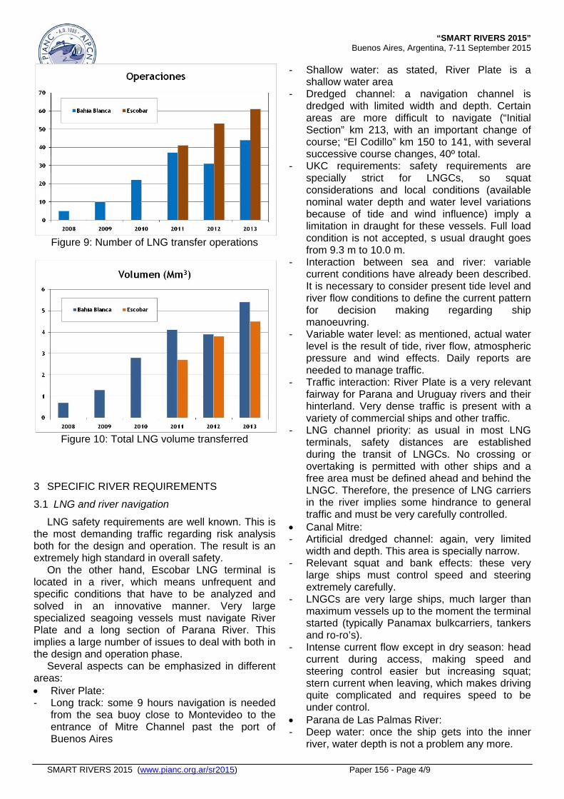
2.5 Evolution
From 2011, both the number of LNG transfer operations and the total volume has been increasing responding to a growing demand. 41-53-61 ship calls occurred 2011-2012-2013, for 2.7-3.8-4.5 million m3 of LNG.
These figures continue increasing. The number of 200 operations was reached August 2014.
“SMART RIVERS 2015” Buenos Aires, Argentina, 7-11 September 2015
SMART RIVERS 2015 (www.pianc.org.ar/sr2015) Paper 156 - Page 4/9
Figure 9: Number of LNG transfer operations
Figure 10: Total LNG volume transferred
3 SPECIFIC RIVER REQUIREMENTS
3.1 LNG and river navigation
LNG safety requirements are well known. This is the most demanding traffic regarding risk analysis both for the design and operation. The result is an extremely high standard in overall safety.
On the other hand, Escobar LNG terminal is located in a river, which means unfrequent and specific conditions that have to be analyzed and solved in an innovative manner. Very large specialized seagoing vessels must navigate River Plate and a long section of Parana River. This implies a large number of issues to deal with both in the design and operation phase.
Several aspects can be emphasized in different areas: River Plate: - Long track: some 9 hours navigation is needed
from the sea buoy close to Montevideo to the entrance of Mitre Channel past the port of Buenos Aires
- Shallow water: as stated, River Plate is a shallow water area
- Dredged channel: a navigation channel is dredged with limited width and depth. Certain areas are more difficult to navigate (“Initial Section” km 213, with an important change of course; “El Codillo” km 150 to 141, with several successive course changes, 40º total.
- UKC requirements: safety requirements are specially strict for LNGCs, so squat considerations and local conditions (available nominal water depth and water level variations because of tide and wind influence) imply a limitation in draught for these vessels. Full load condition is not accepted, s usual draught goes from 9.3 m to 10.0 m.
- Interaction between sea and river: variable current conditions have already been described. It is necessary to consider present tide level and river flow conditions to define the current pattern for decision making regarding ship manoeuvring.
- Variable water level: as mentioned, actual water level is the result of tide, river flow, atmospheric pressure and wind effects. Daily reports are needed to manage traffic.
- Traffic interaction: River Plate is a very relevant fairway for Parana and Uruguay rivers and their hinterland. Very dense traffic is present with a variety of commercial ships and other traffic.
- LNG channel priority: as usual in most LNG terminals, safety distances are established during the transit of LNGCs. No crossing or overtaking is permitted with other ships and a free area must be defined ahead and behind the LNGC. Therefore, the presence of LNG carriers in the river implies some hindrance to general traffic and must be very carefully controlled.
Canal Mitre: - Artificial dredged channel: again, very limited
width and depth. This area is specially narrow. - Relevant squat and bank effects: these very
large ships must control speed and steering extremely carefully.
- LNGCs are very large ships, much larger than maximum vessels up to the moment the terminal started (typically Panamax bulkcarriers, tankers and ro-ro’s).
- Intense current flow except in dry season: head current during access, making speed and steering control easier but increasing squat; stern current when leaving, which makes driving quite complicated and requires speed to be under control.
Parana de Las Palmas River: - Deep water: once the ship gets into the inner
river, water depth is not a problem any more.
“SMART RIVERS 2015” Buenos Aires, Argentina, 7-11 September 2015
SMART RIVERS 2015 (www.pianc.org.ar/sr2015) Paper 156 - Page 5/9
- Rather wide navigation area: Parana river is quite wide and straight in this area, except for the connection to Mitre Channel.
- Current gradient in curves (river mouth): this area is critical because of the course change and the varying current. Departure conditions are more demanding.
- Long 75 kilometers navigation: again, a long demanding navigation leg is very different from most of the maritime LNG terminals, where port access is usually much shorter.
- Traffic interaction (channel priority) and safety distances: already described for River Plate. Encounter and overtaking rules for commercial traffic cannot be applied for LNGCs. The rest of the vessels must wait for LNGC access, turning and departure keeping a predefined safe distance.
- Design of the terminal: it is a conventional jetty on piles, but it was necessary to dredge a certain area inside the bank to gain distance to the main channel in order to increase safety with relation to other traffic.
- Sedimentation issues: river conditions and layout of the terminal imply some maintenance dredging, not usual in most maritime terminals. However, this is not a critical aspect in Escobar.
- Vessels berthed bow-in (heading the current): this is opposite to the usual strategy in most LNG terminals. Bow-out berthing makes emergency departure easier, but in this case current influence is paramount.
- Two large ships moored side-by-side: unconventional situation in most river terminals. LNG transfer is developed ship-to-ship by means of special cryogenic hoses. The ships are moored using special mooring layouts and floating Yokohama fenders.
- Access manoeuvres in current (eventually intense 2-3 knots): these is not usual in most LNG terminals.
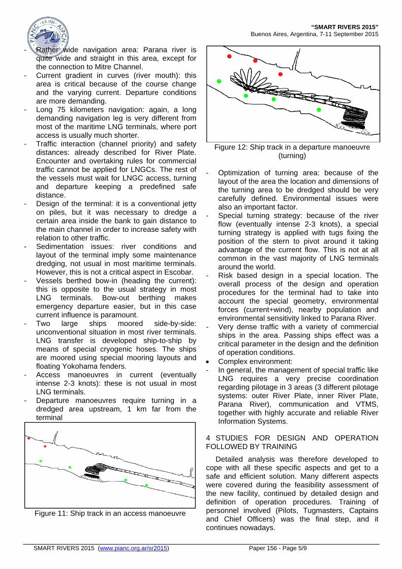
- Departure manoeuvres require turning in a dredged area upstream, 1 km far from the terminal
Figure 11: Ship track in an access manoeuvre
Figure 12: Ship track in a departure manoeuvre
(turning)
- Optimization of turning area: because of the layout of the area the location and dimensions of the turning area to be dredged should be very carefully defined. Environmental issues were also an important factor.
- Special turning strategy: because of the river flow (eventually intense 2-3 knots), a special turning strategy is applied with tugs fixing the position of the stern to pivot around it taking advantage of the current flow. This is not at all common in the vast majority of LNG terminals around the world.
- Risk based design in a special location. The overall process of the design and operation procedures for the terminal had to take into account the special geometry, environmental forces (current+wind), nearby population and environmental sensitivity linked to Parana River.
- Very dense traffic with a variety of commercial ships in the area. Passing ships effect was a critical parameter in the design and the definition of operation conditions.
Complex environment: - In general, the management of special traffic like
LNG requires a very precise coordination regarding pilotage in 3 areas (3 different pilotage systems: outer River Plate, inner River Plate, Parana River), communication and VTMS, together with highly accurate and reliable River Information Systems.
4 STUDIES FOR DESIGN AND OPERATION FOLLOWED BY TRAINING
Detailed analysis was therefore developed to cope with all these specific aspects and get to a safe and efficient solution. Many different aspects were covered during the feasibility assessment of the new facility, continued by detailed design and definition of operation procedures. Training of personnel involved (Pilots, Tugmasters, Captains and Chief Officers) was the final step, and it continues nowadays.

“SMART RIVERS 2015” Buenos Aires, Argentina, 7-11 September 2015
SMART RIVERS 2015 (www.pianc.org.ar/sr2015) Paper 156 - Page 6/9
The following can be mentioned: • Ship Manoeuvring study. Navigation between
the common area of Rio de La Plata and the terminal location.
• Ship Manoeuvring study. Approach and docking to the FSRU in Escobar.
• Moored Ship Response (dynamic response, single ship-two ships STS).
• "Passing ships" analysis. • Training of Pilots and Captains in different
navigation areas.
3.2 Ship Manoeuvring study
The access and departure of different types of FSRUs and LNGCs in the most relevant areas of the channel and terminal were simulated using both a numerical manoeuvring model and a real-time simulator, depending on the phase of the study.
SHIPMA is a numerical autopilot model for ship manoeuvring developed by Delft Hydraulics and MARIN (The Netherlands). The mathematical model computes the track and course angle of a vessel, taking into account the influence of wind, waves, currents, current gradient, shallow water and bank suction. SHIPMA is a “fast-time” autopilot manoeuvring model, different from a real-time bridge simulator. Rudder, engine and bow-thruster control is done by a track-keeping autopilot that anticipates deviations from the desired track.
Figure 13: Typical SHIPMA layout
Siport21’s real-time ship manoeuvre simulator,
developed by MARIN-MSCN (The Netherlands) was used in most phases to evaluate manoeuvring conditions in detail, both in normal and emergency conditions. This system reproduces the behaviour of a specific vessel during navigation and manoeuvring. The system takes into account the environmental forces (wind, current, waves, limited depth, bank suction, etc.). The Captain or Pilot commands a bridge with real instruments and synthetic radar. The movement of the ship is perceived in real-time on a 260º wide screen, 12 m in diameter, together with ambient sound.
The objective was to define navigation limits, tug requirements, manoeuvring strategies, evaluate eventual interferences of the new terminal with other
traffic, marking recommendations, optimization of navigable areas and dredging works.
Figure 14: Siport21 Simulation Centre
Figure 15: Simulated approach manoeuvre
Figure 16: Simulated berthing manoeuvre
The simulation program covered many different
ships (FSRU and LNGCs, both with spherical Moss and prismatic tanks, steam turbine or diesel propulsion, single or twin propellers).
3.3 Moored Ship Response
A preliminary analysis was done for the design of the terminal, based on the calculation of the design berthing and mooring loads.
The objective of the detailed dynamic analysis was to verify and establish operational limits for the FSRU and for the LNGC when discharging to the FSRU (definition of the operational limits and staying limits at berth). Optimization of the mooring

“SMART RIVERS 2015” Buenos Aires, Argentina, 7-11 September 2015
SMART RIVERS 2015 (www.pianc.org.ar/sr2015) Paper 156 - Page 7/9
layout for each ship type and downtime calculation was part of the study.
Figure 17: Reference mooring layout
The dynamic response of the moored FSRU and
the combination LNGC-FSRU was simulated using the numerical model SHIP-MOORINGS developed by Alkyon, Hydraulic Consultancy & Research, The Netherlands. This is a computer program that simulates the behaviour of a moored ship or a floating moored object under conditions of wind, waves and current. The equations of motion for the ship are solved considering 6 degrees of freedom (surge, sway, heave, roll, pitch, yaw). Time domain approach is used and no limitations exist for motion amplitudes.
Figure 18: Ship-Moorings model
3.4 "Passing ships" analysis
Taking into account that the terminal is located close to the main channel in Parana River, the purpose of this phase was to assess the effect caused by vessels sailing close to the terminal on the LNG transfer operations of the FSRU and the corresponding LNGC. Several representative vessels were selected, mainly Panamax bulkcarriers and ro-ro's.
In a first step, the suction forces on the FSRU and the LNGC caused by other passing vessels were calculated using a numerical model (ROPES) developed by Pinkster Marine Hydrodynamics (PMH BV), MARIN, Svašek Hydraulics and Deltares. It calculates the forces produced by nearby passing vessels through hydrodynamic interaction between the two hulls and the waves generated. It considers the geometry of the channel and the shape of both ships.
The following factors define the interaction forces and are taken into account in the numerical model: Hydrodynamic characteristics of the vessels, speed
of the passing ship, course with respect to the centerline of the moored vessels, depth of the channel, distance between vessels and cross-section of the channel (vertical walls, side-slopes, etc).
Once the results of ROPES model were obtained (time series of forces (longitudinal, transverse and vertical) and moments (yawing, pitching and rolling) on the moored vessel), the dynamic response was simulated using SHIP-MOORINGS model, so that the movements of the moored ships and the resulting loads on mooring lines and fenders were calculated. The interaction between vessels combined with wind from the most adverse direction was considered.
Figure 19: Passing Ships model
The results of this analysis allowed to identify the
most critical situations and establish rules regarding maximum passing speed and minimum passing distance for several ship classes.
3.5 Training of Pilots and Captains
During the development of the studies, Pilots had a very relevant role applying all their knowledge of the different navigation areas. After the design and the definition of operation procedures, simulator training sessions were developed with Pilots from all three areas in order to verify the conclusions reached on the previous stages and transfer all this knowledge to them.
The aim of the simulations was the familiarization of Local Pilots with the new ships operating in navigation and manoeuvring areas in the new Terminal. Sessions included most critical navigable areas, from anchorage to the FSRU location, including final phase of the manoeuvre (berthing side-by-side to the regasification vessel), and departure with turning in current.
The simulations included manoeuvres with LNGC and FSRU both in mild, medium and demanding weather conditions. Tugs were of course part of the simulations and different towing strategies and tug formations were tested.
“SMART RIVERS 2015” Buenos Aires, Argentina, 7-11 September 2015
SMART RIVERS 2015 (www.pianc.org.ar/sr2015) Paper 156 - Page 8/9
At a certain point, combined training involving tugmasters together with the Pilots was executed, using both the main bridge and one or two auxiliary bridges. Taking into account the dimensions of the design vessels and the characteristics of the navigation areas, tug assistance is a paramount factor in these manoeuvres. Therefore, combined tugmaster-pilot provided best coordination in the execution of access manoeuvres for the new ships.
Figure 20: Pilots training in the Simulator Bridge
Since operations started in Escobar LNG
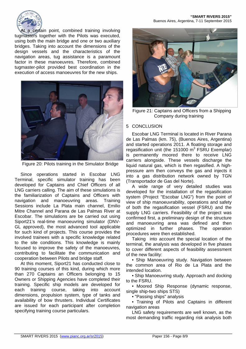
Terminal, specific simulator training has been developed for Captains and Chief Officers of all LNG carriers calling. The aim of these simulations is the familiarization of Captains and Officers with navigation and manoeuvring areas. Training Sessions include La Plata main channel, Emilio Mitre Channel and Parana de Las Palmas River at Escobar. The simulations are be carried out using Siport21’s real-time manoeuvring simulator (DNV-GL approved), the most advanced tool applicable for such kind of projects. This course provides the involved trainees with a specific knowledge related to the site conditions. This knowledge is mainly focused to improve the safety of the manoeuvres, contributing to facilitate the communication and cooperation between Pilots and bridge staff.
At this moment, Siport21 has conducted close to 90 training courses of this kind, during which more than 270 Captains an Officers belonging to 15 Owners or Shipping Agencies have completed their training. Specific ship models are developed for each training course, taking into account dimensions, propulsion system, type of tanks and availability of bow thrusters. Individual Certificates are issued for each participant after completion specifying training course particulars.
Figure 21: Captains and Officers from a Shipping
Company during training
5 CONCLUSION
Escobar LNG Terminal is located in River Parana de Las Palmas (km. 75), (Buenos Aires, Argentina) and started operations 2011. A floating storage and regasification unit (the 151000 m3 FSRU Exemplar) is permanently moored there to receive LNG carriers alongside. These vessels discharge the liquid natural gas, which is then regasified. A high-pressure arm then conveys the gas and injects it into a gas distribution network owned by TGN (Transportador de Gas del Norte).
A wide range of very detailed studies was developed for the installation of the regasification system (Project "Escobar LNG") from the point of view of ship manoeuvrability, operations and safety of both the regasification vessel (FSRU) and the supply LNG carriers. Feasibility of the project was confirmed first, a preliminary design of the structure and manoeuvring area was defined and then optimized in further phases. The operation procedures were then established.
Taking into account the special location of the terminal, the analysis was developed in five phases to cover different aspects of feasibility assessment of the new facility:
• Ship Manoeuvring study. Navigation between the common area of Rio de La Plata and the intended location.
• Ship Manoeuvring study. Approach and docking to the FSRU.
• Moored Ship Response (dynamic response, single ship-two ships STS)
• "Passing ships" analysis • Training of Pilots and Captains in different
navigation areas LNG safety requirements are well known, as the
most demanding traffic regarding risk analysis both

“SMART RIVERS 2015” Buenos Aires, Argentina, 7-11 September 2015
SMART RIVERS 2015 (www.pianc.org.ar/sr2015) Paper 156 - Page 9/9
for the design and operation. The result is an extremely high standard in overall safety.
On the other hand, Escobar LNG terminal is located in a river, which means unfrequent and specific conditions that had to be analyzed and solved in an innovative manner. Very large specialized seagoing vessels must navigate River Plate and a long section of Parana River. This implies a large number of issues to deal with both in the design and operation phase.
The most outstanding aspects are referred to a long track (18 hours transit along River Plate and Parana River) in restricted areas (dredged channels with shallow water and river environment strongly influenced by wind effects) which implies draught limitations; traffic interaction is also a relevant issue in a very important fairway (very dense traffic with a variety of commercial ships and other craft for a huge hinterland) especially regarding LNG channel priority and safety distances (no crossing or overtaking is permitted with other ships and a free area must be defined ahead and behind each LNGC); LNG traffic means that very large ships incorporate to the area, a new type of ship much larger than previous maximum vessels (typically Panamax bulkcarriers, tankers and ro-ro’s); the manoeuvring strategy (berthing bow-in heading the current, turning in current with special tug assistance) is quite different to that usually applied in most LNG terminals.
In general, a risk based design procedure was applied in a very special location, quite different from most maritime LNG terminals. The overall process of the design and operation procedures for the terminal had to take into account the special geometry, environmental forces (current+wind), nearby population and environmental sensitivity linked to Parana River.
On the other hand, the management of special traffic like LNG requires a very precise coordination regarding 3 different pilotage systems (outer River Plate, inner River Plate, Parana River), communication and VTMS, together with highly accurate and reliable River Information Systems.