nato automated meteorological … · zation (nato) operations and how it will serve as a redundant...
TRANSCRIPT
NOTICE: This publication is available digitally on the AFDPO WWW site at: http://www.e-publishing.af.mil.
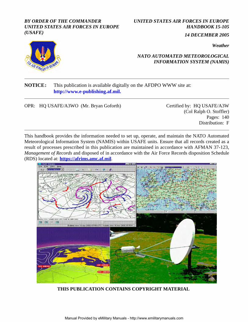
BY ORDER OF THE COMMANDERUNITED STATES AIR FORCES IN EUROPE (USAFE)
UNITED STATES AIR FORCES IN EUROPEHANDBOOK 15-105
14 DECEMBER 2005
Weather
NATO AUTOMATED METEOROLOGICALINFORMATION SYSTEM (NAMIS)
OPR: HQ USAFE/A3WO (Mr. Bryan Goforth) Certified by: HQ USAFE/A3W(Col Ralph O. Stoffler)
Pages: 140Distribution: F
This handbook provides the information needed to set up, operate, and maintain the NATO AutomatedMeteorological Information System (NAMIS) within USAFE units. Ensure that all records created as aresult of processes prescribed in this publication are maintained in accordance with AFMAN 37-123,Management of Records and disposed of in accordance with the Air Force Records disposition Schedule(RDS) located at: https://afrims.amc.af.mil.
THIS PUBLICATION CONTAINS COPYRIGHT MATERIAL
Manual Provided by eMilitary Manuals - http://www.emilitarymanuals.com
2 USAFEH15-105 14 DECEMBER 2005
1. General ....................................................................................................................... 3
2. Description ................................................................................................................. 3
Figure 1. NAMIS METOC Data Server Flow. ........................................................................ 4
3. Operations. ................................................................................................................. 5
4. NAMIS Deployment .................................................................................................. 6
5. Set up and Maintenance ............................................................................................. 6
Table 1. Dedicated Phone Lines. ............................................................................................ 7
Figure 2. Dedicated Phone Line Structure. .............................................................................. 8
Attachment 1— GLOSSARY OF REFERENCES AND SUPPORTING INFORMATION 9
Attachment 2— PES INSTALLATION GUIDE FOR PES 5000 11
Attachment 3— NAMIS VISUALIZATION V5.0 USER GUIDE 23
Attachment 4— EUTELSAT FOOTPRINT 140
Manual Provided by eMilitary Manuals - http://www.emilitarymanuals.com

USAFEH15-105 14 DECEMBER 2005 3
1. General
1.1. Purpose. The purpose of this handbook is to provide USAFE units an all inclusive source ofinformation on how the NAMIS is used to support USAFE weather support operations. Specifically,this document will address how the NAMIS will be utilized to support North Atlantic Treaty Organi-zation (NATO) operations and how it will serve as a redundant communications capability for USAFEweather support operations. NAMIS fills the following three main functions within USAFE Weather:
1.1.1. Primary NATO weather dissemination system. USAFE weather units supporting NATOoperations will require access to the NAMIS to access pertinent weather bulletins weather obser-vations, satellite data, lightning data, radar data and other meteorological data. The NAMIS sys-tem receives and displays observations for many more locations than other systems USAFEemploys.
1.1.2. Back-up USAFE weather dissemination system. In the event that the primary disseminationsystems (i.e. Very Small Aperture Terminal/Tactical Very Small Aperture Terminal (VSAT/T-VSAT)) and backup dissemination system (i.e. Non-Secure Internet Protocol Router Network -Joint Air Force and Army Weather Information Network (NIPRNET-JAAWIN)) are down,NAMIS will be used to disseminate surface weather observations. With the eventual terminationof the VSAT contract, USAFE VSAT/T-VSAT systems will no longer be supported, thereby mak-ing NAMIS the primary back-up when NIPRNET-JAAWIN fails.
1.1.3. Receiving Lightning and Radar imagery. NAMIS is the only way to receive NAMIS origi-nated lightning and radar imagery.
1.2. Background. To ensure the rapid exchange of meteorological information between the AlliedCommand Operations (ACO) and deployed NATO and national military units, NATO established anintegrated network of national and NATO funded meteorological telecommunications circuits. Thisnetwork consists of landlines, a satellite broadcast, the NAMIS Meteorological and Oceanographic(METOC) data server, and the Operational Weather Squadron (OWS) NAMIS File Transfer Protocol(FTP) Server. NAMIS is comprised of this weather communication network in conjunction with aPersonal Earth Stations (PES) and associated desktop or notebook computers. This system is the pri-mary weather information dissemination system for NATO’s Allied Command Operations WeatherInformation Exchange (ACOWEX), ensuring the exchange of meteorological data required to provideoptimum support of NATO Commands and Forces.
2. Description
2.1. Communications.
2.1.1. NAMIS Satellite Communications (SATCOM).
2.1.1.1. NAMIS users within the satellite footprint (Attachment 4) are supplied with METOCdata via SATCOM. The SATCOM stream is simplex to receive only stations and duplex forreceive and transmit stations.
2.1.1.2. The Bundeswehr Geo Information Office (BGIO) communication center is linked tothe satellite hub of PLENEXIS in Hameln-Aerzen (19.2 kbps). From there, the data is trans-mitted to and received from the Eutelsat W3 satellite.
2.1.2. NAMIS METOC Data Server.
Manual Provided by eMilitary Manuals - http://www.emilitarymanuals.com
4 USAFEH15-105 14 DECEMBER 2005
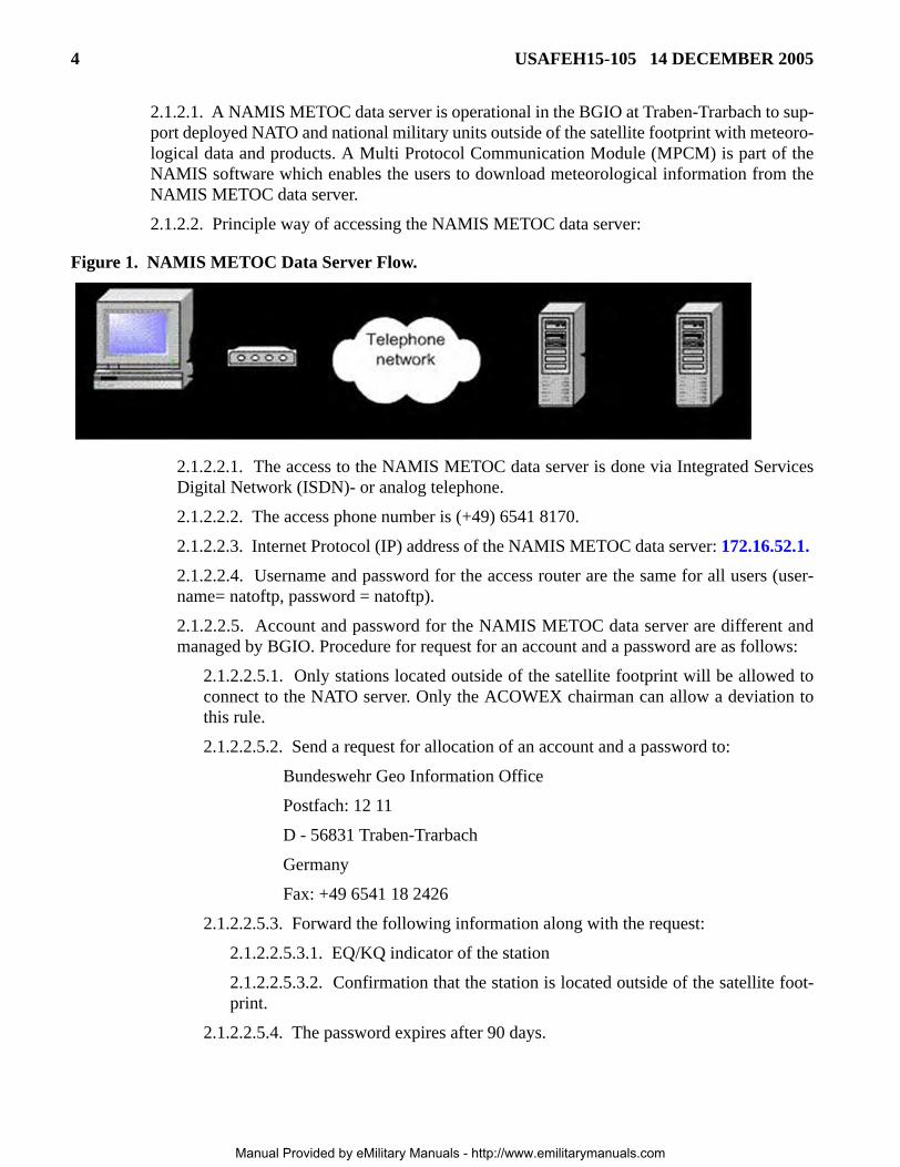
2.1.2.1. A NAMIS METOC data server is operational in the BGIO at Traben-Trarbach to sup-port deployed NATO and national military units outside of the satellite footprint with meteoro-logical data and products. A Multi Protocol Communication Module (MPCM) is part of theNAMIS software which enables the users to download meteorological information from theNAMIS METOC data server.
2.1.2.2. Principle way of accessing the NAMIS METOC data server:
Figure 1. NAMIS METOC Data Server Flow.
2.1.2.2.1. The access to the NAMIS METOC data server is done via Integrated ServicesDigital Network (ISDN)- or analog telephone.
2.1.2.2.2. The access phone number is (+49) 6541 8170.
2.1.2.2.3. Internet Protocol (IP) address of the NAMIS METOC data server: 172.16.52.1.
2.1.2.2.4. Username and password for the access router are the same for all users (user-name= natoftp, password = natoftp).
2.1.2.2.5. Account and password for the NAMIS METOC data server are different andmanaged by BGIO. Procedure for request for an account and a password are as follows:
2.1.2.2.5.1. Only stations located outside of the satellite footprint will be allowed toconnect to the NATO server. Only the ACOWEX chairman can allow a deviation tothis rule.
2.1.2.2.5.2. Send a request for allocation of an account and a password to:
Bundeswehr Geo Information Office
Postfach: 12 11
D - 56831 Traben-Trarbach
Germany
Fax: +49 6541 18 2426
2.1.2.2.5.3. Forward the following information along with the request:
2.1.2.2.5.3.1. EQ/KQ indicator of the station
2.1.2.2.5.3.2. Confirmation that the station is located outside of the satellite foot-print.
2.1.2.2.5.4. The password expires after 90 days.
Manual Provided by eMilitary Manuals - http://www.emilitarymanuals.com

USAFEH15-105 14 DECEMBER 2005 5
2.1.3. NAMIS FTP Server.
2.1.3.1. A NAMIS FTP (Internet Protocol - IP) data server is operational in the USAFE OWSat Sembach Air Base (AB) to provide an additional data source for deployed NATO andnational military units outside of the satellite. A Multi Protocol Communication Module(MPCM) is part of the NAMIS software which enables the users to download meteorologicalinformation from the NAMIS FTP data server.
2.1.3.2. The access to the NAMIS FTP data server is done through an IP connection via anyInternet Service Provider (ISP).
2.1.3.3. IP address of the NAMIS FTP data server is 131.54.124.12.
2.1.3.4. Accounts and passwords for the NAMIS FTP data server are different from theMETOC data server and managed by the USAFE OWS. To establish an FTP account:
2.1.3.4.1. Email the helpdesk: [email protected] or,
2.1.3.4.2. Telephone the helpdesk: (DSN) 496-6156 (Commercial) 06302-676156.
2.1.3.5. The password expires after 90 days.
2.1.4. Dedicated Landlines--Dedicated phone lines exist between the various METOC centerswithin NATO. See Table 1. for a listing of the dedicated phone lines supporting NAMIS.
2.2. Personal Earth Station (PES)/Computer --The NAMIS user will have the following compo-nents:
2.2.1. Satellite Comm equipment. Satellite dish, radio frequency unit, and coax cable.
2.2.2. PES--The PES is a digital interface unit which enable the user to transmit and receive datavia the satellite dish.
2.2.3. NAMIS software.
2.2.4. Computer. User provided desktop or laptop computer with the following specifications:
2.2.4.1. Pentium 4 or better with a minimum speed of 1.3 GHz.
2.2.4.2. RAM: 512 MByte.
2.2.4.3. Video RAM: 32 MByte.
2.2.4.4. Dual Headed video card.
2.2.4.5. Small Computer System Interface (SCSI) hard drive with 40 GBytes of memory.
2.2.4.6. Monitor capable of 1200x1024 resolution.
3. Operations. NAMIS is used to perform the following functions:
3.1. Alphanumeric data. NAMIS can compose, send, and receive alphanumeric data (i.e. Observa-tion (Obs), Terminal Aerodrome Forecast (TAF), synoptic discussion bulletins).
3.2. Weather graphic files. Ability to display weather graphics in the form of Computer GraphicMetafiles (CGM), Joint Photographic Experts Group (JPEG), and non-compressed Tagged Image FileFormat (TIFF) files.
Manual Provided by eMilitary Manuals - http://www.emilitarymanuals.com
6 USAFEH15-105 14 DECEMBER 2005
3.3. Weather imagery. Ability to display satellite, radar, computer model, observation, SignificantMeteorological Advisory (SIGMET), and Minimum Altimeter Setting (QNH) data. The applicationallows the ability to overlay and cross-section data.
3.4. Skew T-Log P Diagrams. Capability to view USAF Log-P Diagram (Skew-T) and hodographdiagrams.
3.5. Animation. Ability to animate graphics and imagery.
3.6. Operating Instructions. Refer to the NAMIS Visualization V5.0 User Guide at Attachment 3for specific operating instructions.
3.7. Available Bulletins. A current database of available bulletins can be found on the USAFE OWSNAMIS webpage (https://ows.sembach.af.mil/common/Met/namisgrp/main.asp).
4. NAMIS Deployment
4.1. In Garrison System. Each Combat Weather Team (CWT) is authorized one NAMIS system tosupport in-garrison operations. This system consists of a satellite reception dish, a PES, and a NAMISdisplay computer.
4.2. Deployed System. Some CWTs will have additional NAMIS systems to support deployed oper-ations. These systems consist of a satellite reception dish, a PES, and a NAMIS laptop. The CWT isresponsible for maintaining this system and ensuring all personnel are trained to set up and operate thesystem in a deployed environment. NAMIS systems will only be deployed to support NATO opera-tions
5. Set up and Maintenance
5.1. USAFE Weather Systems Support Cadre (WSSC). The WSSC will perform initial installa-tion and set up of the NAMIS PES (refer to Attachment 2 for installation procedures).
5.1.1. Installations requirements. The satellite dish location must meet the following require-ments:
5.1.1.1. Flat area with a clear view (no trees, walls, or building) toward the south east.
5.1.1.2. The satellite receiver will need to be no more than 120 meters from the dish.
5.1.2. Set up time. Usually, two days are required for set up.
5.2. WSSC Maintenance. Contact the WSSC if there are any maintenance related problems. Mainte-nance problems with the computer hardware (i.e. bad hard drive) are the responsibility of the user. Allother non-computer problems will be handled by the WSSC working with the contractor.
Manual Provided by eMilitary Manuals - http://www.emilitarymanuals.com

USAFEH15-105 14 DECEMBER 2005 7
Table 1. Dedicated Phone Lines.
EBWM – EHWX A national funded duplex digital circuit between the Belgian Air Force (BAF) Military Center at Beauvechain (EBWM) and the Royal Netherland Air Force (RNLAF) Military Meteorological Grp at Woensdrecht (EHWX) (64kbps).
EGRR – KGWC A national funded duplex digital circuit between World Analysis Center (WAC) Exeter and Air force Weather Agency (HQ AFWA) Offutt.
EHWX – EGRR A national funded duplex digital circuit between RNLAF Military Meteorological Group at Woensdrecht and RHQ AFNORTH (128kbps).
EHWX – EQAM A national funded duplex digital circuit between RNLAF Military Meteorological Group at Woensdrecht and RHQ AFNORTH (128kbps).
ENMI – ENZV A national funded duplex circuit between WAC Oslo and Joint Weather Center (JWC) Stavanger (64kbps).
ETGT – EBWM A national funded duplex digital circuit between BGIO at Traben-Trarbach and the BAF Military Met Center at Beauvechain (EBWM) (64kbps).
ETGT – EDZW A national funded duplex digital circuit between BGIO at Traben-Trarbach and WAC Offenbach (34Mbps).
ETGT – EHWX A national funded duplex digital circuit between BGIO at Traben-Trarbach and the RNLAF Military Grp at Woensdrecht (64kbps).
ETGT – ETAX A national funded duplex digital circuit between BGIO at Traben-Trarbach and 21st OWS (64kbps).
ETGT – KGWC A national funded duplex digital circuit between BGIO at Traben-Trarbach and HQ AFWA Offutt (9.6kbps).
ETGT – LFYF A national funded duplex digital circuit between BGIO at Traben-Trarbach and the French Air Force (AF) National Meteorological Center at Taverny (64kbps).
ETGT – SOPR A national funded duplex digital circuit between BGIO at Traben-Trarbach and the Polish National Weather Service (PAADF) HQ Warsaw (64kbps).
KGWC – ETAR A national funded communication service between HQ AFWA Offutt and Component Command (HQ CC) Air – Ramstein.
KGWC – ETIE A national funded communication service between HQ AFWA Offutt and Land Forces Central Europe (LANDCENT) at Heidelberg.
LFPW – LEMM
A Regional Meteorological Data Communications Network (RMDCN) duplex digital link between the Communications Center Toulouse SCEM and National Meteorological Institute Madrid (32kbps from LFPW to LEMM, 32kbps from LEMM to LFPW).
LFPW – LPMG A RMDCN duplex digital link between the Communications Center Toulouse SCEM and Communications/Meteorological (COM/MET) Center Lisbon (64kbps from LFPW to LPMG, 32kbps from LPMG to LFPW).
LFYF – LFPW A national funded duplex digital circuit between the French AF National Meteorological Center at Taverny and Communications Center Toulouse SCEM (256kbps).
Manual Provided by eMilitary Manuals - http://www.emilitarymanuals.com

8 USAFEH15-105 14 DECEMBER 2005
Figure 2. Dedicated Phone Line Structure.
BOB D. DULANEY, Major General, USAF Director of Air and Space Operations
LGAT – LGLR A national funded duplex digital circuit between WAC Athens and JHQ Southcent at Larissa.
LIIB – EDZW A World Meteorological Organization (WMO) – Government Telephone Circuit (GTS) duplex circuit between WAC Rome and WAC Offenbach (9.6kbps).
LIIB – LIPK A national funded duplex digital circuit between WAC Rome and Combined Air Operations Center (CAOC) at Poggio Renatico (64kbps).
LIIB – EQAQ A national funded duplex digital circuit between WAC Rome and Joint Forces Command (JFC) Naples (64kbps)
LTAA – LTBJ A national funded duplex digital circuit between WAC Ankara and JHQ Southeast at Izmir.
Manual Provided by eMilitary Manuals - http://www.emilitarymanuals.com
USAFEH15-105 14 DECEMBER 2005 9
Attachment 1
GLOSSARY OF REFERENCES AND SUPPORTING INFORMATION
References
AFMAN 37-123, Management of Records
WMO Manual on Codes
International Codes Volume I1, Part A
Abbreviations and Acronyms
ACOWEX—Allied command Operations Weather Information Exchange
AF—Air Force
AFWA—Air Force Weather Agency
AMDAR—Automated Unit Data from Aircraft
Amp—Ampere
BAF—Belgian Air Force
BGIO—Bundeswehr Geo Information Office
BMP—Bitmap
CGM—Computer Graphic Metafiles
COM/MET—Communications/Meteorological
CWT—Combat Weather Team
degs—degrees
DIU—Digital Indoor Unit
DIUCE—DIU Configuration Editor
EUTELSAT—European Telecommunications Satellite
FTP—File Transfer Protocol
GRIB—Gridded Binary
GTS—Government Telephone Circuit
ICAO—International Civil Aviation Organization
IP—Internet Protocol
JAAWIN—Joint Air Force and Army Weather Information Network
JHQ—Joint Headquarters
JPEG—Joint Photographic Experts Group
METAR—Meteorological Aerodrome
METOC—Meteorological and Oceanographic
Manual Provided by eMilitary Manuals - http://www.emilitarymanuals.com
10 USAFEH15-105 14 DECEMBER 2005
MPCM—Multi Protocol Communication Module
MSLP—Mean Sea Level Pressure
NAMIS—NATO Automated Meteorological Information System
NATO—North Atlantic Treaty Organization
NCM—National Climatological Messages
NIPRNET—Non-secure Internet Protocol Router Network
NWP—Numerical Weather Products
ODLC—Outboard Data Link Control
OWS—Operational Weather Squadron
PES—Personal Earth Stations
QNH—Minimum Altimeter Setting
RF—Radio Frequency
RH—Relative Humidity
RHQ—Royal Headquarters
RMDCN—Regional Meteorological Data Communications Network
RNLAF—Royal Netherlands Air Force
SATCOM—Satellite Communications
SIGMET—Significant Meteorological Advisory
SKEW-T—USAF Log-P Diagram
SQL—Structured Query Language
SYNOP—Land Surface Data
TAF—Terminal Aerodrome Forecast
TIFF—Tagged Image File Format
T-VSAT—Tactical Very Small Aperture Terminal
USAF—United States Air Force
USAFE—United States Air Forces in Europe
VDC—Video distribution controller
VSAT—Very Small Aperture Terminal
WAC—World Analysis Center
WMO—World Meteorological Organization
WS—Weather Squadron
WSSC—Weather Systems Support Cadre
Manual Provided by eMilitary Manuals - http://www.emilitarymanuals.com
USAFEH15-105 14 DECEMBER 2005 11
Attachment 2
PES INSTALLATION GUIDE FOR PES 5000
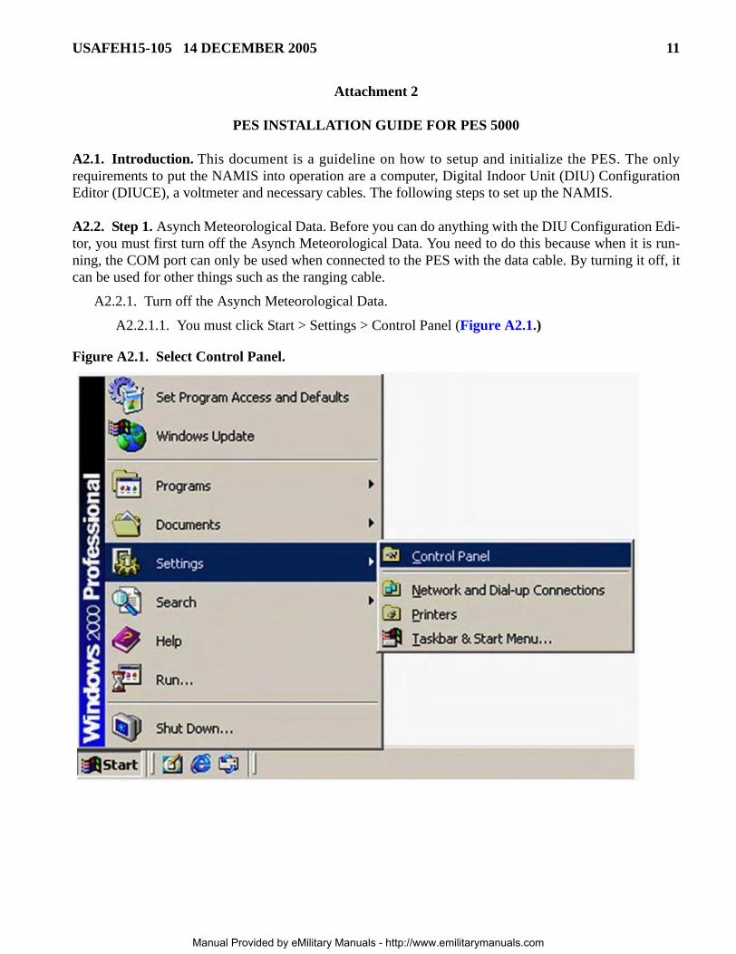
A2.1. Introduction. This document is a guideline on how to setup and initialize the PES. The onlyrequirements to put the NAMIS into operation are a computer, Digital Indoor Unit (DIU) ConfigurationEditor (DIUCE), a voltmeter and necessary cables. The following steps to set up the NAMIS.
A2.2. Step 1. Asynch Meteorological Data. Before you can do anything with the DIU Configuration Edi-tor, you must first turn off the Asynch Meteorological Data. You need to do this because when it is run-ning, the COM port can only be used when connected to the PES with the data cable. By turning it off, itcan be used for other things such as the ranging cable.
A2.2.1. Turn off the Asynch Meteorological Data.
A2.2.1.1. You must click Start > Settings > Control Panel (Figure A2.1.)
Figure A2.1. Select Control Panel.
Manual Provided by eMilitary Manuals - http://www.emilitarymanuals.com
12 USAFEH15-105 14 DECEMBER 2005
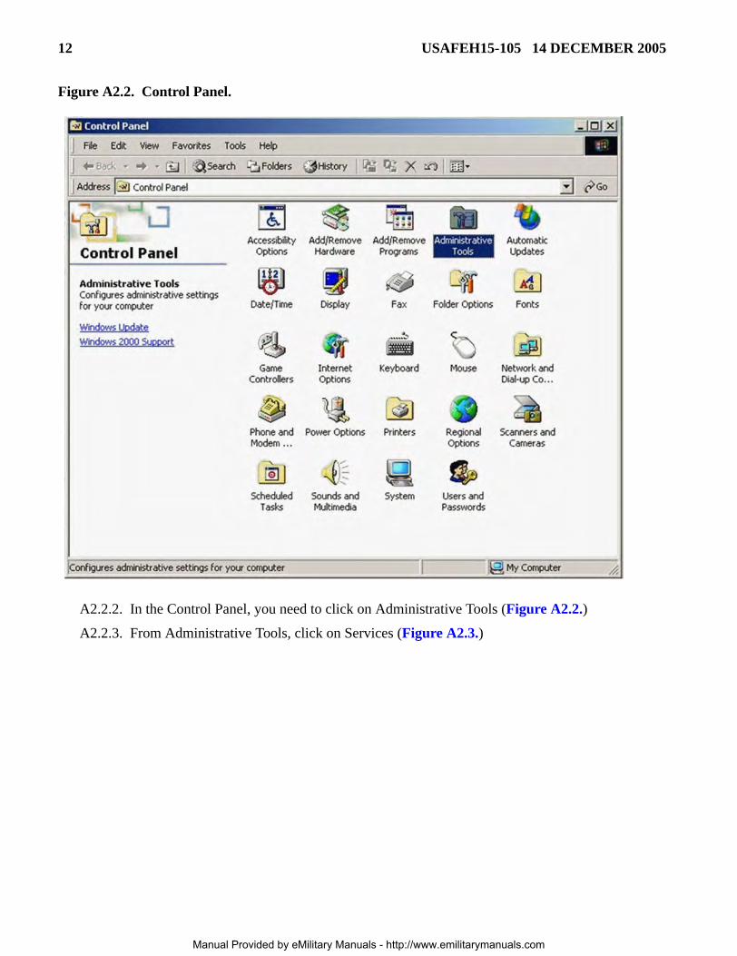
Figure A2.2. Control Panel.
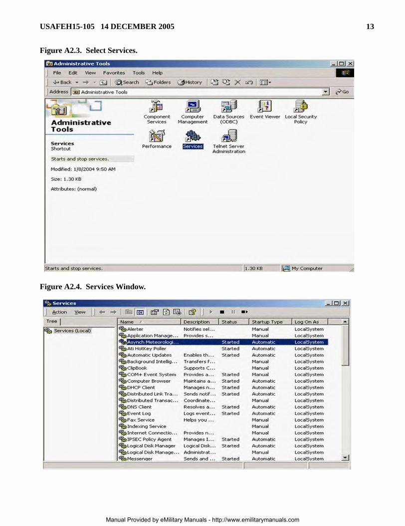
A2.2.2. In the Control Panel, you need to click on Administrative Tools (Figure A2.2.)
A2.2.3. From Administrative Tools, click on Services (Figure A2.3.)
Manual Provided by eMilitary Manuals - http://www.emilitarymanuals.com
USAFEH15-105 14 DECEMBER 2005 13
Figure A2.3. Select Services.
Figure A2.4. Services Window.
Manual Provided by eMilitary Manuals - http://www.emilitarymanuals.com
14 USAFEH15-105 14 DECEMBER 2005
A2.2.4. From Services, click on Asynch Meteorological Data and click the black stop button at thetop (Figure A2.4.).
A2.2.5. Once the Asynch Meteorolgical Data has stopped, you can close the Services window.
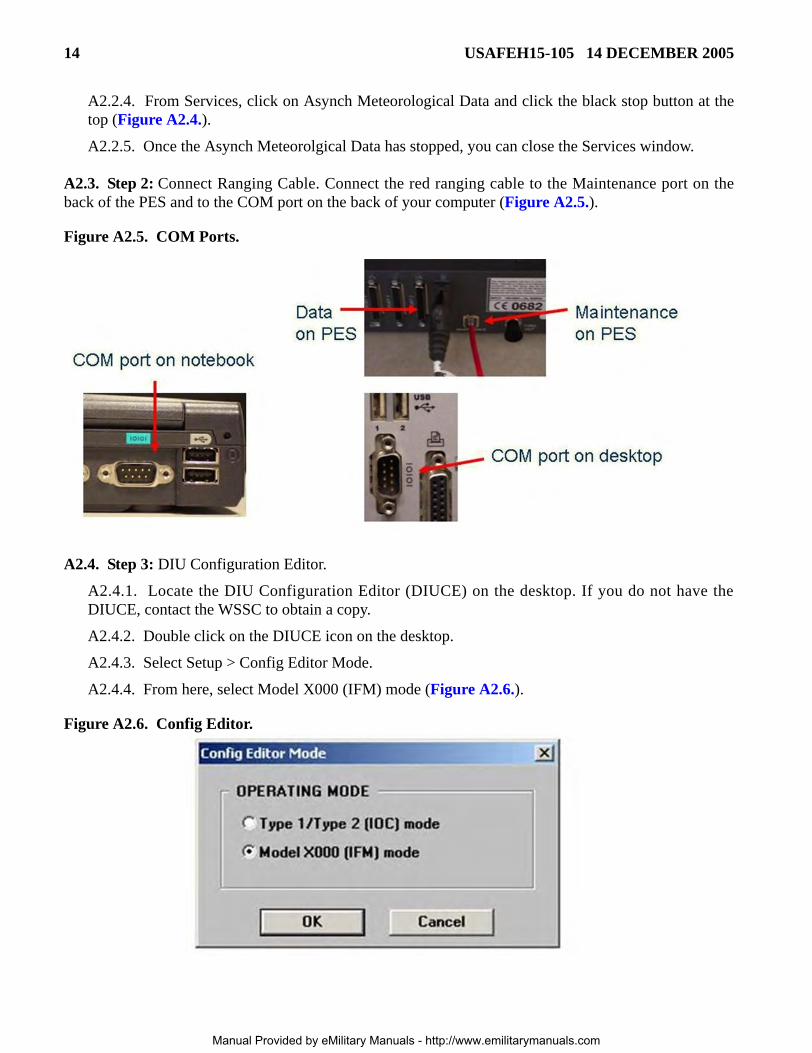
A2.3. Step 2: Connect Ranging Cable. Connect the red ranging cable to the Maintenance port on theback of the PES and to the COM port on the back of your computer (Figure A2.5.).
Figure A2.5. COM Ports.
A2.4. Step 3: DIU Configuration Editor.
A2.4.1. Locate the DIU Configuration Editor (DIUCE) on the desktop. If you do not have theDIUCE, contact the WSSC to obtain a copy.
A2.4.2. Double click on the DIUCE icon on the desktop.
A2.4.3. Select Setup > Config Editor Mode.
A2.4.4. From here, select Model X000 (IFM) mode (Figure A2.6.).
Figure A2.6. Config Editor.
Manual Provided by eMilitary Manuals - http://www.emilitarymanuals.com
USAFEH15-105 14 DECEMBER 2005 15
A2.4.5. Next, select Setup > Com Port.
A2.4.6. Select COM PORT 1 and click OK.
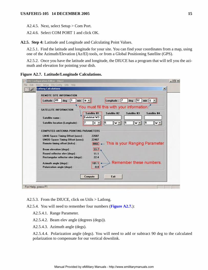
A2.5. Step 4: Latitude and Longitude and Calculating Point Values.
A2.5.1. Find the latitude and longitude for your site. You can find your coordinates from a map, usingone of the Azimuth/Elevation (Az/El) tools, or from a Global Positioning Satellite (GPS).
A2.5.2. Once you have the latitude and longitude, the DIUCE has a program that will tell you the azi-muth and elevation for pointing your dish.
Figure A2.7. Latitude/Longitude Calculations.
A2.5.3. From the DIUCE, click on Utils > Latlong.
A2.5.4. You will need to remember four numbers (Figure A2.7.):
A2.5.4.1. Range Parameter.
A2.5.4.2. Beam elev angle (degrees (degs)).
A2.5.4.3. Azimuth angle (degs).
A2.5.4.4. Polarization angle (degs). You will need to add or subtract 90 deg to the calculatedpolarization to compensate for our vertical downlink.
Manual Provided by eMilitary Manuals - http://www.emilitarymanuals.com